JP7399177B2 - Navigation using dynamic regrouping points - Google Patents
Navigation using dynamic regrouping pointsDownload PDFInfo
- Publication number
- JP7399177B2 JP7399177B2JP2021546342AJP2021546342AJP7399177B2JP 7399177 B2JP7399177 B2JP 7399177B2JP 2021546342 AJP2021546342 AJP 2021546342AJP 2021546342 AJP2021546342 AJP 2021546342AJP 7399177 B2JP7399177 B2JP 7399177B2
- Authority
- JP
- Japan
- Prior art keywords
- user
- users
- data
- tracking session
- joint
- Prior art date
- Legal status (The legal status is an assumption and is not a legal conclusion. Google has not performed a legal analysis and makes no representation as to the accuracy of the status listed.)
- Active
Links
Images


Classifications
- G—PHYSICS
- G01—MEASURING; TESTING
- G01C—MEASURING DISTANCES, LEVELS OR BEARINGS; SURVEYING; NAVIGATION; GYROSCOPIC INSTRUMENTS; PHOTOGRAMMETRY OR VIDEOGRAMMETRY
- G01C21/00—Navigation; Navigational instruments not provided for in groups G01C1/00 - G01C19/00
- G01C21/26—Navigation; Navigational instruments not provided for in groups G01C1/00 - G01C19/00 specially adapted for navigation in a road network
- G01C21/28—Navigation; Navigational instruments not provided for in groups G01C1/00 - G01C19/00 specially adapted for navigation in a road network with correlation of data from several navigational instruments
- G—PHYSICS
- G01—MEASURING; TESTING
- G01C—MEASURING DISTANCES, LEVELS OR BEARINGS; SURVEYING; NAVIGATION; GYROSCOPIC INSTRUMENTS; PHOTOGRAMMETRY OR VIDEOGRAMMETRY
- G01C21/00—Navigation; Navigational instruments not provided for in groups G01C1/00 - G01C19/00
- G01C21/26—Navigation; Navigational instruments not provided for in groups G01C1/00 - G01C19/00 specially adapted for navigation in a road network
- G01C21/34—Route searching; Route guidance
- G01C21/3407—Route searching; Route guidance specially adapted for specific applications
- G01C21/3438—Rendezvous; Ride sharing
- G—PHYSICS
- G01—MEASURING; TESTING
- G01C—MEASURING DISTANCES, LEVELS OR BEARINGS; SURVEYING; NAVIGATION; GYROSCOPIC INSTRUMENTS; PHOTOGRAMMETRY OR VIDEOGRAMMETRY
- G01C21/00—Navigation; Navigational instruments not provided for in groups G01C1/00 - G01C19/00
- G01C21/20—Instruments for performing navigational calculations
- G—PHYSICS
- G01—MEASURING; TESTING
- G01C—MEASURING DISTANCES, LEVELS OR BEARINGS; SURVEYING; NAVIGATION; GYROSCOPIC INSTRUMENTS; PHOTOGRAMMETRY OR VIDEOGRAMMETRY
- G01C21/00—Navigation; Navigational instruments not provided for in groups G01C1/00 - G01C19/00
- G01C21/26—Navigation; Navigational instruments not provided for in groups G01C1/00 - G01C19/00 specially adapted for navigation in a road network
- G01C21/34—Route searching; Route guidance
- G01C21/3453—Special cost functions, i.e. other than distance or default speed limit of road segments
- G01C21/3484—Personalized, e.g. from learned user behaviour or user-defined profiles
- G—PHYSICS
- G01—MEASURING; TESTING
- G01C—MEASURING DISTANCES, LEVELS OR BEARINGS; SURVEYING; NAVIGATION; GYROSCOPIC INSTRUMENTS; PHOTOGRAMMETRY OR VIDEOGRAMMETRY
- G01C21/00—Navigation; Navigational instruments not provided for in groups G01C1/00 - G01C19/00
- G01C21/26—Navigation; Navigational instruments not provided for in groups G01C1/00 - G01C19/00 specially adapted for navigation in a road network
- G01C21/34—Route searching; Route guidance
- G01C21/36—Input/output arrangements for on-board computers
- G01C21/3605—Destination input or retrieval
- G01C21/3617—Destination input or retrieval using user history, behaviour, conditions or preferences, e.g. predicted or inferred from previous use or current movement
- G—PHYSICS
- G01—MEASURING; TESTING
- G01C—MEASURING DISTANCES, LEVELS OR BEARINGS; SURVEYING; NAVIGATION; GYROSCOPIC INSTRUMENTS; PHOTOGRAMMETRY OR VIDEOGRAMMETRY
- G01C21/00—Navigation; Navigational instruments not provided for in groups G01C1/00 - G01C19/00
- G01C21/26—Navigation; Navigational instruments not provided for in groups G01C1/00 - G01C19/00 specially adapted for navigation in a road network
- G01C21/34—Route searching; Route guidance
- G01C21/36—Input/output arrangements for on-board computers
- G01C21/3697—Output of additional, non-guidance related information, e.g. low fuel level
- G—PHYSICS
- G08—SIGNALLING
- G08G—TRAFFIC CONTROL SYSTEMS
- G08G1/00—Traffic control systems for road vehicles
- G08G1/20—Monitoring the location of vehicles belonging to a group, e.g. fleet of vehicles, countable or determined number of vehicles
- H—ELECTRICITY
- H04—ELECTRIC COMMUNICATION TECHNIQUE
- H04W—WIRELESS COMMUNICATION NETWORKS
- H04W4/00—Services specially adapted for wireless communication networks; Facilities therefor
- H04W4/02—Services making use of location information
- H04W4/023—Services making use of location information using mutual or relative location information between multiple location based services [LBS] targets or of distance thresholds
- H—ELECTRICITY
- H04—ELECTRIC COMMUNICATION TECHNIQUE
- H04W—WIRELESS COMMUNICATION NETWORKS
- H04W4/00—Services specially adapted for wireless communication networks; Facilities therefor
- H04W4/02—Services making use of location information
- H04W4/024—Guidance services
- G—PHYSICS
- G08—SIGNALLING
- G08G—TRAFFIC CONTROL SYSTEMS
- G08G1/00—Traffic control systems for road vehicles
- G08G1/22—Platooning, i.e. convoy of communicating vehicles
- H—ELECTRICITY
- H04—ELECTRIC COMMUNICATION TECHNIQUE
- H04W—WIRELESS COMMUNICATION NETWORKS
- H04W4/00—Services specially adapted for wireless communication networks; Facilities therefor
- H04W4/02—Services making use of location information
- H—ELECTRICITY
- H04—ELECTRIC COMMUNICATION TECHNIQUE
- H04W—WIRELESS COMMUNICATION NETWORKS
- H04W4/00—Services specially adapted for wireless communication networks; Facilities therefor
- H04W4/02—Services making use of location information
- H04W4/029—Location-based management or tracking services
- H—ELECTRICITY
- H04—ELECTRIC COMMUNICATION TECHNIQUE
- H04W—WIRELESS COMMUNICATION NETWORKS
- H04W4/00—Services specially adapted for wireless communication networks; Facilities therefor
- H04W4/20—Services signaling; Auxiliary data signalling, i.e. transmitting data via a non-traffic channel
- H04W4/21—Services signaling; Auxiliary data signalling, i.e. transmitting data via a non-traffic channel for social networking applications
Landscapes
- Engineering & Computer Science (AREA)
- Radar, Positioning & Navigation (AREA)
- Remote Sensing (AREA)
- Physics & Mathematics (AREA)
- General Physics & Mathematics (AREA)
- Automation & Control Theory (AREA)
- Signal Processing (AREA)
- Computer Networks & Wireless Communication (AREA)
- Health & Medical Sciences (AREA)
- General Health & Medical Sciences (AREA)
- Social Psychology (AREA)
- Navigation (AREA)
- Traffic Control Systems (AREA)
Description
Translated fromJapanese本開示は、概して、コンピュータベースのナビゲーションに関する。より詳細には、本開示は、複数のユーザおよび/または複数の車両を追跡するためのジョイント位置追跡プロセスを可能にするナビゲーションアプリケーションに関する。 TECHNICAL FIELD This disclosure relates generally to computer-based navigation. More particularly, the present disclosure relates to navigation applications that enable joint position tracking processes for tracking multiple users and/or multiple vehicles.
コンピュータ技術が向上するにつれて、ユーザに提供され得るサービスの数およびタイプは劇的に増大した。コンピュータ技術を介して提供されるサービスは、ナビゲーションサービスを含む。ナビゲーションサービスは、ユーザが現在位置から目的位置までナビゲートすることを可能にし得る。ユーザは、ナビゲーションサービスに関連するアプリケーションを通して目的地(たとえば、住所)を提出し得る。ナビゲーションサービスは、地理的エリアに関するマップデータを使用して、目的地までの計画されたルートを生成し得る。いくつかの例では、計画されたルートは、1つまたは複数のターンバイターンナビゲーション指示を含む。ナビゲーションサービスは、ユーザの現在位置を追跡し、ユーザの実際の動きに基づいて、計画されたルートを更新することも可能である。 As computer technology has improved, the number and types of services that can be provided to users has increased dramatically. Services provided via computer technology include navigation services. A navigation service may allow a user to navigate from a current location to a destination location. A user may submit a destination (eg, address) through an application associated with a navigation service. A navigation service may use map data about a geographic area to generate a planned route to a destination. In some examples, the planned route includes one or more turn-by-turn navigation instructions. The navigation service may also track the user's current location and update the planned route based on the user's actual movements.
本開示の実施形態の態様および利点は、以下の発明を実施するための形態に一部記載されるか、もしくは発明を実施するための形態から知られ得るか、または実施形態の実施を通して知られ得る。 Aspects and advantages of embodiments of the present disclosure are described in part in the detailed description below, or may be learned from the detailed description, or may be learned through practice of the embodiments. obtain.
本開示の1つの例示的な態様は、ジョイント位置追跡セッション内のユーザに対する動的再グループ化(re-grouping)を提供するためのコンピュータ実装方法に関する。この方法は、1つまたは複数のコンピューティングデバイスが、ジョイント位置追跡セッション内の第1のユーザおよび複数のユーザのうちの少なくとも1人の他のユーザに関連する位置データをジョイント位置追跡セッション内の複数のユーザから受信するステップを含む。この方法は、1つまたは複数のコンピューティングデバイスが、第1のユーザおよび複数のユーザのうちの少なくとも1人の他のユーザに関連する、受信された位置データに基づいて、第1のユーザに関連する間隔(separation)パラメータがしきい間隔値を超えたと判定するステップであって、第1のユーザに関連する間隔パラメータが、第1のユーザと複数のユーザのうちの1人の他のユーザとの間の距離を表す、判定するステップを含む。この方法は、1つまたは複数のコンピューティングデバイスが、ジョイント位置追跡セッション内の第1のユーザと1人の他のユーザとの間の間隔パラメータをしきい間隔値未満に低減するためのナビゲーションデータを自動的に生成するステップを含む。この方法は、1つまたは複数のコンピューティングデバイスが、ナビゲーションデータをジョイント位置追跡セッション内の少なくとも第1のユーザに送信するステップを含む。 One example aspect of the present disclosure relates to a computer-implemented method for providing dynamic re-grouping for users within a joint position tracking session. The method includes one or more computing devices transmitting location data related to a first user and at least one other user of the plurality of users within a joint location tracking session. and receiving from a plurality of users. The method includes one or more computing devices providing information to a first user based on received location data related to the first user and at least one other user of the plurality of users. determining that a separation parameter associated with the first user exceeds a threshold separation value, wherein the separation parameter associated with the first user and determining the distance between the two. The method provides navigation data for one or more computing devices to reduce a spacing parameter between a first user and one other user within a joint position tracking session to less than a threshold spacing value. including the step of automatically generating. The method includes one or more computing devices transmitting navigation data to at least a first user in a joint position tracking session.
本開示の他の態様は、様々なシステム、装置、非一時的コンピュータ可読媒体、ユーザインターフェース、および電子デバイスに関する。 Other aspects of the disclosure relate to various systems, apparatus, non-transitory computer-readable media, user interfaces, and electronic devices.
本開示の様々な実施形態のこれらのおよび他の特徴、態様、および利点は、以下の発明を実施するための形態および特許請求の範囲を参照するとより理解されよう。本明細書に組み込まれ、その一部をなす、添付の図面は、本開示の例示的な実施形態を示し、発明を実施するための形態とともに、関連する原理を説明するのに役立つ。 These and other features, aspects, and advantages of various embodiments of the disclosure will be better understood with reference to the following detailed description and claims. The accompanying drawings, which are incorporated in and constitute a part of this specification, illustrate exemplary embodiments of the disclosure and, together with the detailed description, serve to explain related principles.
当業者を対象とする実施形態の詳細な議論は、添付の図面を参照する本明細書に記載される。 A detailed discussion of embodiments intended for those skilled in the art is provided herein with reference to the accompanying drawings.
次に、その1つまたは複数の例を図面に示す本開示の実施形態を詳細に参照する。各例は、本開示の限定ではなく、本開示の説明のために提供される。実際に、本開示の範囲および趣旨から逸脱せずに、様々な修正および変更が本開示に行われ得ることは当業者に明らかであろう。たとえば、1つの実施形態の一部として示される、または説明される特徴は、さらなる実施形態を生み出すために別の実施形態とともに使用され得る。したがって、本開示は、添付の請求項およびそれらの均等物の範囲内に入るそのような修正および変更を網羅する。 Reference will now be made in detail to the embodiments of the disclosure, one or more examples of which are illustrated in the drawings. Each example is provided by way of illustration of the disclosure, rather than limitation of the disclosure. Indeed, it will be apparent to those skilled in the art that various modifications and changes can be made to this disclosure without departing from the scope and spirit of this disclosure. For example, features shown or described as part of one embodiment can be used with another embodiment to yield a further embodiment. Accordingly, this disclosure covers such modifications and changes as come within the scope of the appended claims and their equivalents.
概して、本開示は、ナビゲーションサービス内でジョイント位置追跡プロセスを可能にすることに関する。ジョイント位置追跡プロセスは、複数のユーザが、ナビゲーションサービスを使用して共有される目的地にナビゲートしながら、互いと位置データを共有することを可能にし得る。ナビゲーションサービスは、ジョイント位置追跡セッション内に含まれたユーザのうちの1人または複数が他のユーザからのしきい間隔値を超えるときにそのことを判定し、ユーザをしきい間隔値内に戻すためのナビゲーションデータを自動的に生成し得る。 Generally, the present disclosure relates to enabling joint position tracking processes within navigation services. A joint location tracking process may allow multiple users to share location data with each other while navigating to a shared destination using navigation services. The navigation service determines when one or more of the users included in the joint position tracking session exceeds a threshold separation value from other users and brings the users back within the threshold separation value. can automatically generate navigation data for.
たとえば、2人以上のユーザを含むジョイント位置追跡セッションは、ナビゲーションサービスに関連するサーバコンピューティングシステムにおいて開始され得る。ジョイント位置追跡セッションが開始されると、各々がジョイント位置追跡セッション(ジョイント位置追跡プロセスグループと呼ばれることもある)に参加しているユーザに関連する複数のコンピューティングデバイスは、自らの現在位置を周期的に判定し、その位置を表す位置データをサーバコンピューティングシステムにアップロードし得る。 For example, a joint location tracking session involving two or more users may be initiated at a server computing system associated with a navigation service. When a joint location tracking session is initiated, multiple computing devices, each associated with a user participating in the joint location tracking session (sometimes referred to as a joint location tracking process group), periodically update their current location. and upload location data representative of the location to a server computing system.
サーバコンピューティングシステムは、1人または複数の参加ユーザに表示するために、受信された位置データを各コンピューティングデバイスに送信し得る。このようにして、ユーザは、ジョイント位置追跡セッション内の他のユーザの現在位置を閲覧し得る。受信された位置データを使用して、サーバコンピューティングシステムは、第1のユーザに関連する間隔パラメータが(たとえば、ユーザに関連するコンピューティングデバイスを介して)所定の距離しきい値を超えたと判定し得る。それに応じて、サーバコンピューティングシステムは、更新されたナビゲーションデータを生成し、更新されたナビゲーションデータをジョイント位置追跡サービスセッション内に含まれた1人または複数のユーザに送信し得る。更新されたナビゲーションデータは、1つまたは複数の追加の中間地点を現在のナビゲーションルートに追加するデータを含み得る。追加の中間地点(たとえば、立寄り(stop)地点)を追加することは、ユーザが、自らの移動を続ける前に、共通の立寄り地点において再グループ化することを可能にし得る。 The server computing system may transmit the received location data to each computing device for display to one or more participating users. In this way, a user may view the current location of other users within a joint position tracking session. Using the received location data, the server computing system determines that a spacing parameter associated with the first user (e.g., via a computing device associated with the user) exceeds a predetermined distance threshold. It is possible. In response, the server computing system may generate updated navigation data and transmit the updated navigation data to one or more users included within the joint location tracking service session. The updated navigation data may include data that adds one or more additional waypoints to the current navigation route. Adding additional waypoints (eg, stop points) may allow users to regroup at a common stop before continuing their journey.
より具体的には、ジョイント位置追跡プロセスは、1つまたは複数のサーバコンピューティングシステムおよび個々のユーザに関連する1つまたは複数のコンピューティングデバイス上で実装されるナビゲーションサービスによって可能にされる。いくつかの例では、ユーザに関連するコンピューティングデバイスは、ディスプレイを含み得る。ディスプレイは、ナビゲーション情報をユーザに表示するためにコンピューティングデバイス上にインストールされたナビゲーションアプリケーションによって使用され得る。ナビゲーション情報は、限定はしないが、地理的エリアのマップ、地理的エリア内のコンピューティングデバイスの位置、マップ上に指定された地理的エリアを通るルート、1つもしくは複数のナビゲーション指示(たとえば、地理的エリアを通るターンバイターン指示)、および/または地理的エリア内の1つもしくは複数の関心ポイントを含み得る。 More specifically, the joint position tracking process is enabled by navigation services implemented on one or more server computing systems and one or more computing devices associated with individual users. In some examples, a computing device associated with a user may include a display. The display may be used by a navigation application installed on the computing device to display navigation information to a user. Navigational information may include, but is not limited to, a map of a geographic area, the location of a computing device within the geographic area, a route through the geographic area designated on the map, one or more navigational instructions (e.g., (turn-by-turn directions through a geographical area) and/or one or more points of interest within a geographical area.
ユーザがジョイント位置追跡セッションに加わるための招待を受け入れるとき、ナビゲーションアプリケーションは、ジョイント位置追跡セッション内に含まれた1人または複数の他のユーザの位置をコンピューティングデバイスに関連するディスプレイ内に表示し始めることができる。このようにして、ユーザは、地理的エリア内の、かつそれらのユーザに対する、ジョイント位置追跡セッションの他のメンバーの現在位置を迅速かつ容易に判定し得る。いくつかの例では、他のユーザに対する位置情報は、ナビゲーションサービスに関連するサーバコンピューティングシステムから受信され得る。いくつかの例では、他のユーザに関する位置情報は、ピアツーピア通信プロトコルまたは他のワイヤレス通信プロトコルを介してそれらのユーザに関連するコンピューティングデバイスから直接受信され得る。 When a user accepts an invitation to join a joint location tracking session, the navigation application displays the location of one or more other users included within the joint location tracking session in a display associated with the computing device. You can start. In this way, users may quickly and easily determine the current location of other members of the joint location tracking session within a geographic area and with respect to those users. In some examples, location information for other users may be received from a server computing system associated with the navigation service. In some examples, location information about other users may be received directly from computing devices associated with those users via peer-to-peer communication protocols or other wireless communication protocols.
いくつかの例では、ナビゲーションアプリケーションまたはナビゲーションサービスは、1人または複数のユーザからの要求に応じて、ジョイント位置追跡セッションを開始し得る。たとえば、2人のユーザが共通の目的地に向けて同じルートを追うことを計画し、グループまたはキャラバン内で一緒に移動することを望む場合、ユーザのうちの1人は、そのそれぞれのコンピューティングデバイスを介してナビゲーションサービスにアクセスし、その移動に対してジョイント位置追跡セッションが作成されることを要求し得る。それに応じて、ナビゲーションサービスは、2人のユーザを含む新しいジョイント位置追跡セッションを生成し得る。いくつかの例では、第1のユーザは、ジョイント位置追跡セッションが作成されることを要求し、次いで、ジョイント位置追跡セッションに加わるための招待を1人または複数の他のユーザに送ることができる。 In some examples, a navigation application or service may initiate a joint position tracking session in response to a request from one or more users. For example, if two users plan to follow the same route to a common destination and wish to travel together in a group or caravan, one of the users will A navigation service may be accessed through the device and may request that a joint position tracking session be created for that movement. In response, the navigation service may generate a new joint position tracking session involving the two users. In some examples, a first user may request that a joint location tracking session be created and then send an invitation to one or more other users to join the joint location tracking session. .
いくつかの例では、ジョイント位置追跡セッションに加わるための招待は、ユーザのコンピューティングデバイス上のナビゲーションアプリケーション内に表示され得る。したがって、招待は、ナビゲーションサービスに関連するサーバコンピューティングシステムから特定のユーザのコンピューティングデバイスに送られ得る。招待は、ジョイント位置追跡セッションに対して計画された目的地、ジョイント位置追跡セッション内にすでに含まれている1人または複数のユーザの識別情報、特定のジョイント位置追跡セッションの識別子、およびジョイント位置追跡セッションがいつ始まることになるかを説明する日時インジケータを記述するデータを含み得る。ユーザインターフェース要素は、招待および関連情報をユーザに表示するために作成され得る。ユーザは、次いで、ユーザインターフェース要素と対話すること(たとえば、「加わる」ボタン上をクリックまたはタップすること)によって、ジョイント位置追跡セッションに加わることができる。 In some examples, an invitation to join a joint location tracking session may be displayed within a navigation application on a user's computing device. Accordingly, an invitation may be sent to a particular user's computing device from a server computing system associated with the navigation service. The invitation includes the planned destination for the joint position tracking session, the identity of one or more users already included within the joint position tracking session, an identifier for the particular joint position tracking session, and the joint position tracking session. It may include data describing a date and time indicator that describes when the session is to begin. User interface elements may be created to display invitations and related information to users. The user can then join the joint position tracking session by interacting with the user interface elements (eg, clicking or tapping on the "Join" button).
ジョイントナビゲーション追跡プロセスセッションが開始すると、ジョイントナビゲーション追跡プロセスセッション内に含まれた各ユーザは、関連するコンピューティングデバイスを有することができ、このコンピューティングデバイスは、各ユーザの現在位置を(たとえば、GPSセンサーまたは他の方法を使用して)周期的に判定し、コンピューティングデバイスを介して、その判定された現在位置の更新をナビゲーションサービスに関連するサーバコンピューティングシステムに送る。ユーザの現在位置が更新されるとき、その更新された位置は、ジョイントナビゲーション追跡プロセスセッションに関連する位置データ内で対応して更新され得る。結果として、所与のジョイント位置追跡セッションに参加している各ユーザは、更新された位置情報を受信することもできる。このようにして、ジョイント位置追跡セッションに参加しているユーザは、1人または複数の他のユーザに対する現在のロケーションを閲覧し得る。いくつかの例では、ナビゲーションサービスに関連するサーバコンピューティングシステムは、新しいジョイント位置追跡プロセスセッションを表すために、データベース内に新しいデータ構造を作成し得る。 When a joint navigation tracking process session begins, each user included within the joint navigation tracking process session may have an associated computing device that is able to track each user's current location (e.g., GPS (using sensors or other methods) and transmits updates of the determined current location via the computing device to a server computing system associated with the navigation service. When the user's current location is updated, the updated location may be correspondingly updated in location data associated with the joint navigation tracking process session. As a result, each user participating in a given joint location tracking session may also receive updated location information. In this way, users participating in a joint location tracking session may view their current location relative to one or more other users. In some examples, a server computing system associated with a navigation service may create a new data structure within a database to represent a new joint position tracking process session.
いくつかの例では、ジョイントナビゲーション追跡プロセスセッションは、ナビゲーションサービスに関連するサーバコンピューティングシステムによって自動的に生成され得る。たとえば、ナビゲーションサービスは、ナビゲーションサービスにアクセスする複数のユーザに関するユーザデータに対するアクセスを有し得る。ナビゲーションサービスは、ユーザデータを分析して、1人または複数のユーザに対する予測移動データを生成し得る。たとえば、ナビゲーションサービスは、ユーザに関する現在位置および進行方向(heading)データにアクセスし得る。ユーザの現在位置および進行方向に基づいて、ナビゲーションサービスは、ユーザに対する可能性のある目的地を推定し得る。現在位置および可能性のある目的地に基づいて、ナビゲーションサービスは、現在位置から可能性のある目的地までのユーザに対する予測ルートを含む予測移動データを生成し得る。 In some examples, a joint navigation tracking process session may be automatically generated by a server computing system associated with a navigation service. For example, a navigation service may have access to user data regarding multiple users accessing the navigation service. A navigation service may analyze user data to generate predictive movement data for one or more users. For example, a navigation service may access current location and heading data about a user. Based on the user's current location and heading, the navigation service may estimate possible destinations for the user. Based on the current location and potential destinations, the navigation service may generate predicted travel data that includes a predicted route for the user from the current location to the potential destinations.
別の例では、ナビゲーションサービスは、1人または複数のユーザに関するカレンダー情報にアクセスし得る。ユーザに関するカレンダー情報は、1つまたは複数のスケジュールされた予定を含み得る。ナビゲーションサービスは、各予定のロケーションに関する情報にアクセスし、それをユーザの現在のロケーションと比較し得る。次いで、予定の時間およびロケーション、ならびにユーザが所与の時点でその予定に到達するために取ることになる可能性があるルートに基づいて、予測移動データが生成され得る。いくつかの例では、可能性があるルートは、ユーザに関する過去の移動データに基づき得る。 In another example, a navigation service may access calendar information about one or more users. Calendar information about a user may include one or more scheduled events. The navigation service may access information about each appointment location and compare it to the user's current location. Predicted travel data may then be generated based on the time and location of the appointment and the route that the user is likely to take to reach the appointment at a given point in time. In some examples, potential routes may be based on past travel data about the user.
いくつかの例では、ナビゲーションサービスは、ユーザが行った1つまたは複数の過去の移動を識別するために過去の動きデータを分析し得る。ユーザデータのこの分析に基づいて、ナビゲーションサービスは、ユーザに関する移動データを予測し得る。たとえば、ユーザが日常的に特定の移動を行う場合、ナビゲーションサービスは、将来の同様の移動に関する予測移動データを生成し得る。たとえば、特定のユーザが所与の時間期間中、大抵土曜日にNew York CityからNew York北部の町に移動する場合、ナビゲーションサービスは、次の土曜日にNew York北部への移動を表す予測移動データを生成し得る。 In some examples, a navigation service may analyze past movement data to identify one or more past movements made by a user. Based on this analysis of user data, the navigation service may predict movement data regarding the user. For example, if a user makes a particular trip on a daily basis, the navigation service may generate predictive travel data for similar trips in the future. For example, if a particular user travels from New York City to a town in upstate New York during a given time period, most Saturdays, the navigation service may generate predictive travel data representing a trip to upstate New York on the following Saturday. can be generated.
上記の説明に加えて、ユーザが、本明細書で説明するシステム、プログラム、または特徴がユーザ情報(たとえば、ユーザのソーシャルネットワーク、ユーザのカレンダーデータ、ユーザの過去の動き、ユーザの選好、またはユーザの現在のロケーションに関する情報)の収集および分析を可能にし得るかどうか、いつ可能にし得るか、の両方、またコンテンツまたは通信がサーバからユーザに送られるかどうか、について選択することを可能にする制御がユーザに提供され得る。ユーザがそのようなデータの分析を可能にすることを選定する場合のみ、予測移動データの上記の生成が実装され得る。加えて、ユーザがいくつかのデータが分析されることを可能にする場合ですら、そのデータは、そのデータが記憶または使用される前に、個人的に識別可能な情報が除去されるように、1つまたは複数の方法で扱われてよい。たとえば、ユーザの識別情報は、ユーザに関する個人的に識別可能な情報を判定することができないように扱われてよく、またはユーザの地理的ロケーションは、ロケーション情報(市、郵便番号、または州レベルに関してなど)が取得される場合、ユーザの特定のロケーションを判定することができないように、一般化されてよい。したがって、ユーザは、ユーザに関して何の情報が収集されるか、その情報がどのように使用または分析されるか、また何の情報がユーザに提供されるか、に対して制御を有し得る。 In addition to the foregoing, if the user agrees that the system, program, or features described herein may provide information about the user (e.g., the user's social networks, the user's calendar data, the user's past movements, the user's preferences, or the user's Controls that allow you to make choices about both whether and when information about your current location (information about your current location) may be collected and analyzed, and whether content or communications are sent from the server to the user. may be provided to the user. The above generation of predictive movement data may be implemented only if the user chooses to enable analysis of such data. In addition, even if the user allows some data to be analyzed, that data must be provided in such a way that personally identifiable information is removed before it is stored or used. , may be treated in one or more ways. For example, a user's identity may be treated such that no personally identifiable information about the user can be determined, or a user's geographic location may be treated as etc.) may be generalized such that the user's specific location cannot be determined. Accordingly, a user may have control over what information is collected about the user, how that information is used or analyzed, and what information is provided to the user.
いくつかの例では、予測移動データは、初期位置(たとえば、開始場所および時間)、目的位置(たとえば、終了場所および時間)、および初期位置と目的位置との間のルートを含み得る。ルートは、共通の移動パターンまたはユーザの履歴移動選好に基づいて、ナビゲーションサービスによって生成された予測移動ルートであり得る。いくつかの例では、ナビゲーションサービスが第1のユーザに関する予測移動データを生成すると、サービスは、予測移動データを1人または複数の他のユーザの予測移動データと比較し得る。いくつかの例では、ナビゲーションサービスは、第1のユーザの予測移動データをナビゲーションサービスによって選択された1人または複数のユーザの予測移動データと比較し得る。1人または複数の選択されたユーザは、第1のユーザに関するソーシャルネットワークデータに基づいて選択され得る。たとえば、ナビゲーションサービスは、社会的なつながりを通して互いにつながっていることがすでに知られているユーザ間の予測移動データのみを比較し得る。 In some examples, the predicted movement data may include an initial location (eg, starting location and time), a destination location (eg, ending location and time), and a route between the initial location and the destination location. The route may be a predicted travel route generated by the navigation service based on common travel patterns or the user's historical travel preferences. In some examples, once the navigation service generates predicted movement data for a first user, the service may compare the predicted movement data to predicted movement data of one or more other users. In some examples, the navigation service may compare the first user's predicted movement data to the predicted movement data of one or more users selected by the navigation service. The one or more selected users may be selected based on social network data regarding the first user. For example, a navigation service may only compare predicted movement data between users that are already known to be connected to each other through social connections.
いくつかの例では、ナビゲーションサービスは、1つまたは複数のローカルコンピューティングデバイスからの通信を受信するサーバコンピューティングシステムを含む。いくつかの例では、ローカルコンピューティングデバイスは、限定はしないが、スマートフォン、ラップトップコンピュータ、タブレットコンピューティングデバイス、およびスタンドアロンGPSシステムを含む、1つまたは複数のモバイルコンピュータデバイスを含み得る。ナビゲーションシステムは、マップデータのデータベースを含んでよく、マップデータは、建物、道路、および他の中間地点を含めて、1つまたは複数の地理的エリアに関連する情報を含む。ユーザが特定のロケーションに移動することを望むとき、ユーザは、ナビゲーションサービスに関連するナビゲーションアプリケーションにアクセスし得る。ユーザは、目的地の住所とともにナビゲーション要求を提出し得る。それに応じて、ナビゲーションサービスは、現在のロケーションから目的地の住所までのルートを生成し得る。 In some examples, the navigation service includes a server computing system that receives communications from one or more local computing devices. In some examples, a local computing device may include one or more mobile computing devices, including, but not limited to, smartphones, laptop computers, tablet computing devices, and standalone GPS systems. A navigation system may include a database of map data that includes information related to one or more geographic areas, including buildings, roads, and other waypoints. When a user desires to navigate to a particular location, the user may access a navigation application associated with a navigation service. A user may submit a navigation request along with a destination address. In response, the navigation service may generate a route from the current location to the destination address.
ナビゲーションサービスは、第1のユーザに関する予測移動データを第2のユーザの予測移動データと比較し得る。比較の少なくとも一部として、ナビゲーションサービスは、第1のユーザの予測移動データの時間および目的地が第2のユーザの予測移動データの時間および目的地と整合する程度を表す整合スコアを生成し得る。第1のユーザの予測移動データと第2のユーザの予測移動データとの間の整合スコアがしきい値を超える場合、ナビゲーションサービスは、第1のユーザの予測移動データが第2のユーザの予測移動データと関連性を有すると判定し得る。たとえば、2人のユーザの予測移動時間が高い整合スコアを有する場合、ナビゲーションサービスは、2人のユーザがほぼ同じ時点で同じ目的地に向かって同じ経路で移動していると予測し得る。 The navigation service may compare predicted movement data for the first user with predicted movement data for the second user. As at least part of the comparison, the navigation service may generate a alignment score representing the degree to which the time and destination of the first user's predicted travel data aligns with the time and destination of the second user's predicted travel data. . If the alignment score between the first user's predicted movement data and the second user's predicted movement data exceeds a threshold, the navigation service determines whether the first user's predicted movement data matches the second user's predicted movement data. It can be determined that there is a relationship with movement data. For example, if the predicted travel times of two users have a high matching score, the navigation service may predict that the two users are traveling along the same route toward the same destination at approximately the same time.
ナビゲーションサービスが2人のユーザの移動データが関連性を有すると判定すると、ナビゲーションサービスは、潜在的なジョイント位置追跡セッションを開始し得る。潜在的なジョイント位置追跡セッションを開始する一部として、ナビゲーションサービスは、少なくとも第1のユーザおよび第2のユーザに招待を送信し得る。招待は、潜在的なジョイント位置追跡セッションの識別子、およびユーザが潜在的なジョイント位置追跡セッションに加わるオプションを含む。2人以上のユーザがジョイント位置追跡セッションに加わるオプションを選択したとの判定に応じて、ナビゲーションサービスは、ジョイント位置追跡セッションの開始を完了し、第1のユーザと第2のユーザとの間で位置データの共有を始めることができる。いくつかの例では、ナビゲーションサービスは、関連する予測移動データを有する複数のユーザを識別し、それらのユーザのすべてに招待を送り得る。 Once the navigation service determines that the two users' movement data are related, the navigation service may initiate a potential joint location tracking session. As part of initiating a potential joint location tracking session, the navigation service may send an invitation to at least the first user and the second user. The invitation includes an identifier of the potential joint location tracking session and an option for the user to join the potential joint location tracking session. In response to determining that two or more users have selected the option to join the joint position tracking session, the navigation service completes the initiation of the joint position tracking session between the first user and the second user. You can start sharing your location data. In some examples, the navigation service may identify multiple users with associated predicted movement data and send an invitation to all of those users.
いくつかの例では、ナビゲーションサービスは、各メンバーが関連するコンピューティングデバイス(たとえば、スマートフォン、タブレットコンピュータ、など)を介して位置データを周期的にアップロードするにつれて、ジョイント位置追跡セッションのユーザを監視し続ける。いくつかの例では、ナビゲーションサービスは、各ユーザに対する間隔パラメータを計算し得る。計算された間隔パラメータは、ジョイント位置追跡セッション内のそれぞれのユーザと1人または複数の他のユーザとの間の距離の測定値を含み得る。1人または複数の他のユーザは、ジョイント位置追跡セッションに参加している最も近い他のユーザであり得る。たとえば、3人のユーザがジョイント位置追跡プロセス内に含まれる場合、ナビゲーションサービスは、ジョイント位置追跡サービスセッション内の最も近い他のユーザからの各それぞれのユーザの距離を判定することによって、それらのユーザに関する間隔パラメータを計算し得る。 In some examples, the navigation service monitors users for joint location tracking sessions as each member periodically uploads location data via an associated computing device (e.g., smartphone, tablet computer, etc.). continue. In some examples, the navigation service may calculate spacing parameters for each user. The calculated spacing parameters may include measurements of distance between each user and one or more other users within the joint position tracking session. The one or more other users may be the closest other users participating in the joint position tracking session. For example, if three users are included in a joint location tracking process, the navigation service would identify each of those users by determining their distance from the closest other user in the joint location tracking service session. may calculate spacing parameters for .
いくつかの例では、間隔パラメータは、第1のユーザの位置を判定し、ジョイント位置追跡セッション内のすべての他のユーザの平均位置を判定することによって、測定され得る。次いで、第1のユーザの位置と他のユーザの平均位置との間の差異を計算することによって、間隔パラメータが生成され得る。いくつかの例では、間隔パラメータは、目的地までの予測時間を表し得る。 In some examples, the spacing parameter may be measured by determining the location of the first user and determining the average location of all other users within the joint location tracking session. A spacing parameter may then be generated by calculating the difference between the first user's location and the average location of other users. In some examples, the interval parameter may represent the expected time to the destination.
ナビゲーションサービスは、それぞれのユーザの目的地までの時間をジョイントナビゲーション追跡プロセスセッション内に含まれた他のユーザに対する目的地までの平均時間と比較することによって、それぞれのユーザに対する間隔パラメータを計算し得る。目的地までのそれぞれのユーザの時間が、判定されたしきい値だけ、他のユーザに対する目的地までの時間を超える場合、ナビゲーションサービスは、それぞれのユーザが、それぞれのユーザをグループの残りのユーザから離した問題に遭遇した可能性があると判定し得る。いくつかの例では、ナビゲーションサービスは、将来の間隔の予測に基づいて、間隔パラメータを計算し得る。たとえば、ジョイント位置追跡セッション内の2人のユーザは電車を使用している。第1のユーザは、計画された電車が駅を去る直前に鉄道の駅に到着すると推定される。第2のユーザは、計画された電車が駅を去る直後に鉄道の駅に到着すると推定される。これらの2人のユーザは物理的に近い距離にあり得るが、ナビゲーションサービスは、第1のユーザは電車に乗ることになり、第2のユーザは乗らないことになるとの推定に基づいて、しきい値を超える間隔パラメータを依然として計算し得る。 The navigation service may calculate an interval parameter for each user by comparing each user's time to destination with an average time to destination for other users included within the joint navigation tracking process session. . If each user's time to the destination exceeds the time to the destination relative to the other users by the determined threshold, the navigation service will It can be determined that there is a possibility that a problem separate from the above has been encountered. In some examples, the navigation service may calculate the spacing parameters based on predictions of future spacing. For example, two users in a joint position tracking session are using a train. The first user is assumed to arrive at the railway station just before the planned train leaves the station. The second user is assumed to arrive at the railway station immediately after the planned train leaves the station. Although these two users may be in close physical proximity, the navigation service may not be able to do so based on the assumption that the first user will board the train and the second user will not. Spacing parameters above the threshold may still be calculated.
ナビゲーションサービスがジョイント位置追跡セッション内の各ユーザに対する間隔パラメータを計算すると、ナビゲーションサービスは、ユーザのうちのいずれかがしきい間隔値を超える間隔パラメータを有するかどうかを判定し得る。しきい間隔値は、ユーザがジョイント位置追跡セッションから離されると見なされるしきい値を表す。ナビゲーションサービスが、ユーザがしきい間隔値を超えることによって、ジョイント位置追跡セッションを去ったと判定するとき、ナビゲーションサービスは、ジョイント位置追跡サービスセッションの他のメンバーにアラートし得る。いくつかの例では、ナビゲーションサービスは、しきい間隔値を前に超えたユーザに対する間隔パラメータを低減するように設計されたナビゲーションデータを自動的に生成し得る。 Once the navigation service calculates the spacing parameter for each user in the joint location tracking session, the navigation service may determine whether any of the users have a spacing parameter that exceeds the threshold spacing value. The threshold interval value represents a threshold at which a user is considered to be removed from a joint position tracking session. When the navigation service determines that the user has left the joint location tracking session by exceeding a threshold interval value, the navigation service may alert other members of the joint location tracking service session. In some examples, the navigation service may automatically generate navigation data designed to reduce the spacing parameter for users who have previously exceeded the threshold spacing value.
たとえば、ナビゲーションサービスが、ユーザがしきい間隔値を超えたと判定する場合、ナビゲーションサービスは、ジョイント位置追跡サービスセッションのユーザが再招集し得る追加の中間地点を選択し得る。いくつかの例では、中間地点は、移動距離、駐車の容易さ、ユーザの関心、時刻、および他の要因を含めて、1つまたは複数の要因に基づいて選択され得る。たとえば、ナビゲーションサービスは、アクセスが容易であり、駐車場が利用可能であることにより、ジョイント位置ナビゲーションセッションのユーザを再招集するための高速パーキングエリアを選択し得る。他の例では、ナビゲーションサービスは、現在の時刻に基づいて(たとえば、その時間が昼食または夕食時間に近いとき)レストランを選択し得る。いくつかの例では、ナビゲーションサービスは、複数の潜在的なオプションを生成し、ユーザのコンピューティングデバイス上にインストールされたナビゲーションアプリケーションを介してそれらをユーザに表示し得る。ユーザは、次いで、複数のオプションのうちの1つまたは複数を選択し得る。 For example, if the navigation service determines that the user has exceeded a threshold interval value, the navigation service may select additional waypoints at which the user of the joint location tracking service session may reconvene. In some examples, waypoints may be selected based on one or more factors, including distance traveled, ease of parking, user interests, time of day, and other factors. For example, the navigation service may select a fast parking area to reconvene users for a joint location navigation session due to ease of access and parking availability. In other examples, the navigation service may select a restaurant based on the current time (eg, when the time is near lunch or dinner time). In some examples, the navigation service may generate multiple potential options and display them to the user via a navigation application installed on the user's computing device. The user may then select one or more of multiple options.
いくつかの例では、ナビゲーションデータは、ジョイント位置追跡サービスセッション内のユーザのうちの1人または複数に対する代替ルート(たとえば、迂回路)を含む。たとえば、ナビゲーションサービスは、代替ルートが、その間隔パラメータがしきい間隔値を超えたユーザが、特に立寄りをする必要なく、他のユーザに再び加わることを可能にすることになると判定し得る。この判定に基づいて、ナビゲーションサービスは、各ユーザのルートを代替ルートに更新し、それにより、ジョイント位置追跡サービスセッションの1人または複数の他のユーザから離れているユーザが距離を縮め、そのセッションに再び加わることを可能にし得る。 In some examples, the navigation data includes alternative routes (eg, detours) for one or more of the users within the joint location tracking service session. For example, the navigation service may determine that an alternate route would allow a user whose spacing parameter exceeds a threshold spacing value to rejoin other users without having to make a specific stop. Based on this determination, the navigation service updates each user's route to an alternate route so that a user who is far from one or more other users in a joint location tracking service session can reduce distance and may be able to rejoin.
一例示的な実施形態では、ナビゲーションサービスが1人または複数のユーザに関連する間隔パラメータがしきい間隔値を超えたと判定するとき、ナビゲーションサービスは、ジョイント位置追跡セッション内の1人または複数のユーザに通知を送信し得る。いくつかの例では、通知は、セッション内の各ユーザがこの課題を解決するための自らの選好を述べることを可能にするプロンプトを含み得る。たとえば、通知は、旅程に立寄りが追加されるべきかどうかを尋ね、追加されるべきである場合、何の立寄りが好ましいことになるかを尋ねるプロンプトを含み得る。ナビゲーションサービスは、この質問に対する応答を収集し、ユーザ応答に基づいてオプションを選択し得る。 In one example embodiment, when the navigation service determines that an interval parameter associated with one or more users exceeds a threshold interval value, the navigation service determines that the interval parameter associated with one or more users exceeds a threshold interval value. may send notifications to. In some examples, the notification may include a prompt that allows each user in the session to state their preferences for solving this challenge. For example, the notification may include a prompt asking whether a stop should be added to the itinerary, and if so, what stop would be preferred. The navigation service may collect responses to this question and select options based on the user responses.
いくつかの例では、ナビゲーションサービスは、現在のナビゲーションルートに対する1つまたは複数の調整が将来行われる必要があり得ると判定し得る。たとえば、ナビゲーションサービスは、1つまたは複数の要因を考慮して、現在のナビゲーションルートに対していつ調整が行われるべきか、また調整が行われるべきであるかどうかを判定し得る。要因は、限定はしないが、1台または複数の車両に対する燃料計測データ、エンジン警告灯、タイヤ圧の低下、ランドマーク(たとえば、関心ポイント)、国境通過、潜在的な食事の必要性、推定される運転手の疲労、および/または規制上の休憩時間を含み得る。これらの要因に基づいて、ナビゲーションサービスは、現在のナビゲーションルートを更新し得る。いくつかの例では、ナビゲーションサービスは、ジョイントナビゲーションプロセスセッションのユーザに警告または通知を提供し、ユーザが提出したフィードバックおよび選好に基づいて、現在のナビゲーションルートを更新し得る。 In some examples, the navigation service may determine that one or more adjustments to the current navigation route may need to be made in the future. For example, the navigation service may consider one or more factors to determine when and whether adjustments should be made to the current navigation route. Factors may include, but are not limited to, fuel metering data for one or more vehicles, engine warning lights, low tire pressure, landmarks (e.g., points of interest), border crossings, potential dietary needs, estimated may include driver fatigue and/or regulatory rest periods. Based on these factors, the navigation service may update the current navigation route. In some examples, the navigation service may provide alerts or notifications to users of the joint navigation process session and update the current navigation route based on user-submitted feedback and preferences.
いくつかの例では、ジョイント位置追跡セッション内のユーザは、追加の中間地点を加えるために、または代替ルートを生成するために、現在のナビゲーションルートを変更することをナビゲーションサービスに要求し得る。いくつかの例では、ユーザは、追加の中間地点または代替ルートを提案するためのメッセージを(関連するコンピューティングデバイス上のナビゲーションアプリケーションを介して)ジョイント位置追跡セッションの他のユーザに送信し得る。ユーザは、特定の立寄りロケーションまたは代替ルートを選択するためにナビゲーションアプリケーションを介して通信し得る。特定の立寄りロケーションがジョイント位置追跡サービスセッションのユーザによって選択されると、ナビゲーションサービスは、選択された立寄りロケーション(または、代替ルート)を含めるようにナビゲーションルートを更新し得る。このようにして、ルートは、ナビゲーションが課題(たとえば、ユーザのうちの1人がグループから離れていること)を検出するとき、またはユーザ入力に基づいて(たとえば、1人または複数のユーザが現在のルートに対する変更を要求するとき)、のいずれかで自動的にカスタマイズされ得る。 In some examples, a user within a joint location tracking session may request the navigation service to modify the current navigation route to add additional waypoints or to generate an alternate route. In some examples, a user may send messages to other users of the joint location tracking session (via a navigation application on an associated computing device) to suggest additional waypoints or alternative routes. A user may communicate via a navigation application to select particular stop locations or alternative routes. When a particular stop location is selected by a user of a joint location tracking service session, the navigation service may update the navigation route to include the selected stop location (or alternative route). In this way, routes can be routed when navigation detects an issue (e.g., one of the users is leaving the group) or based on user input (e.g., one or more users are currently (when requesting changes to the route), the route can be automatically customized either
いくつかの例では、ユーザまたはナビゲーションサービスのいずれかがセッションはもはや必要でないと判定するとき、ジョイント位置追跡セッションは終了し得る。たとえば、ジョイント位置追跡セッション内の1人または複数のユーザは、ジョイント位置追跡セッションが終了すること(たとえば、セッションが終了し、他のユーザに関する位置情報がもはや共有されないこと)を要求し得る。ジョイント位置追跡セッションの他のユーザが(たとえば、ナビゲーションアプリケーションのユーザインターフェース内のディスプレイを取り消す要求を受け入れることによって)合意する場合、ナビゲーションサービスは、ジョイント位置追跡セッションを終了し得る。いくつかの例では、各ユーザは、任意の時点でジョイント位置追跡セッションから脱退し得る。ナビゲーションサービスが1人以下のユーザがジョイント位置追跡セッション内にいると判定する場合、ナビゲーションサービスは、ジョイント位置追跡セッションを自動的に終了し得る。 In some examples, a joint position tracking session may end when either the user or the navigation service determines that the session is no longer needed. For example, one or more users in a joint location tracking session may request that the joint location tracking session be terminated (eg, that the session be terminated and location information about other users is no longer shared). If the other users of the joint location tracking session agree (e.g., by accepting a request to cancel the display within the navigation application's user interface), the navigation service may terminate the joint location tracking session. In some examples, each user may leave the joint position tracking session at any time. If the navigation service determines that less than one user is in the joint position tracking session, the navigation service may automatically terminate the joint position tracking session.
いくつかの例では、ナビゲーションサービスは、ジョイント位置追跡サービス内のユーザがジョイント位置追跡セッションのターゲット目的地に達したかどうか判定し得る。ジョイント位置追跡サービス内の各ユーザがターゲット目的地に達したとの判定に応じて、ナビゲーションサービスは、ジョイント位置追跡サービスがもはや必要ではないと判定し、ジョイント位置追跡セッションを自動的に終了し得る。 In some examples, the navigation service may determine whether a user within the joint location tracking service has reached the target destination of the joint location tracking session. In response to determining that each user within the joint location tracking service has reached the target destination, the navigation service may determine that the joint location tracking service is no longer needed and automatically terminate the joint location tracking session. .
いくつかの実施形態では、ナビゲーションサービスは、ナビゲーションデータを1つまたは複数のユーザコンピューティングデバイスに提供するサーバコンピューティングシステムを含む。ユーザコンピューティングデバイスは、パーソナルコンピュータ、スマートフォン、タブレットコンピュータ、全地球測位サービスデバイス、スマートウォッチ、などを含み得る。ユーザコンピューティングデバイスは、ナビゲーションサービスに関連する専用アプリケーションを含み得る。ユーザコンピューティングデバイスは、特にナビゲーションサービス専用でなしに、ナビゲーションサービスに(たとえば、ウェブページを介して)アクセスし得る多機能アプリケーション(たとえば、ウェブブラウザ)を含んでもよい。いくつかの例では、ユーザコンピューティングデバイスは、ナビゲーション要求(たとえば、目的地を含む)を提出し、ナビゲーションサービスに関連するサーバコンピューティングシステムからナビゲーションデータ(たとえば、ターンバイターン命令データを含む)を受信する。いくつかの例では、ユーザコンピューティングデバイスは、ナビゲーションサービスから受信されたマップデータを記憶し得る。したがって、ユーザコンピューティングデバイスは、状況によっては、特にナビゲーションサービスに連絡する必要なしに、局所的に記憶されたマップデータに基づいて、ナビゲーションデータを生成し得る。 In some embodiments, a navigation service includes a server computing system that provides navigation data to one or more user computing devices. User computing devices may include personal computers, smartphones, tablet computers, global positioning services devices, smart watches, and the like. A user computing device may include dedicated applications related to navigation services. A user computing device may include a multifunctional application (eg, a web browser) that may access navigation services (eg, via a web page) without being specifically dedicated to navigation services. In some examples, a user computing device submits a navigation request (e.g., including a destination) and receives navigation data (e.g., including turn-by-turn instruction data) from a server computing system associated with the navigation service. Receive. In some examples, a user computing device may store map data received from a navigation service. Accordingly, a user computing device may generate navigation data based on locally stored map data, in some circumstances, without the need to specifically contact a navigation service.
いくつかの例では、ユーザコンピューティングデバイスは、サーバコンピューティングシステムから受信されたデータを介してジョイント位置追跡セッションに参加し得る。サーバコンピューティングシステムは、特定のジョイント位置追跡セッションを表すデータ構造を生成し、ジョイント位置追跡サービスセッション内に含まれた各ユーザの位置を追跡し、位置データをジョイント位置追跡セッション内の各ユーザに送信し、必要であるとき(たとえば、ユーザが他のユーザから離れていることを検出すること、またはユーザからの要求に基づいて)、ナビゲーションデータを更新し得る。 In some examples, a user computing device may participate in a joint location tracking session via data received from a server computing system. The server computing system generates a data structure representing a particular joint location tracking session, tracks the location of each user included within the joint location tracking service session, and transmits location data to each user within the joint location tracking service session. The navigation data may be transmitted and updated when necessary (eg, based on detecting that the user is separated from other users or based on a request from the user).
いくつかの例では、ユーザコンピューティングデバイスは、ナビゲーションアプリケーションを使用して、サーバコンピューティングシステムに連絡する必要なしに、1人または複数の他のユーザとのジョイント位置追跡サービスセッションを管理し得る。たとえば、サーバコンピューティングシステムとの連絡が利用可能でないか、または中断される場合、1つまたは複数のユーザコンピューティングデバイスは、ローカルワイヤレス通信方法を使用してジョイント位置追跡セッションを作成し管理し得る。この例では、ユーザのグループからの1つのユーザコンピューティングデバイスは、ユーザ位置データを収集し、表示のためにそれを他のユーザコンピューティングデバイスの各々に配信し得る管理デバイスとして、自動的に、またはユーザ選択に基づいて、のいずれかで選択され得る。加えて、選択された管理デバイスは、ナビゲーションデータおよび/またはルート更新を生成し、そのデータをジョイント位置追跡サービスセッション内の1人または複数の他のユーザに関連するコンピューティングデバイスに送信し得る。 In some examples, a user computing device may use a navigation application to manage joint location tracking service sessions with one or more other users without the need to contact a server computing system. For example, if contact with a server computing system is unavailable or interrupted, one or more user computing devices may create and manage joint location tracking sessions using local wireless communication methods. . In this example, one user computing device from the group of users automatically acts as a management device that may collect user location data and distribute it to each of the other user computing devices for display. or based on user selection. Additionally, the selected management device may generate navigation data and/or route updates and transmit that data to computing devices associated with one or more other users within the joint location tracking service session.
いくつかの例では、選択された管理デバイスは、他のユーザコンピューティングデバイスが通信距離内にあるかどうかを判定し得る(たとえば、ユーザコンピューティングデバイスが管理デバイスと通信し得るかどうかを検出し得る)。ユーザコンピューティングデバイスがもはや通信範囲内にないとの検出に従って、管理デバイスは、ユーザコンピューティングデバイスがジョイント位置追跡セッションから離れている(たとえば、ユーザがしきい間隔値を超えた)と判定し得る。この判定に応じて、管理デバイスは、依然として通信範囲内にある、1つまたは複数の他のユーザコンピューティングデバイスに通知し得る。いくつかの例では、管理デバイスは、離れたユーザコンピューティングデバイスとの接続を再確立するために、1つまたは複数の調整された、計画されたルートを生成し得る。 In some examples, the selected management device may determine whether other user computing devices are within communication range (e.g., detecting whether the user computing device may communicate with the management device). obtain). Following the detection that the user computing device is no longer within communication range, the management device may determine that the user computing device has left the joint location tracking session (e.g., the user has exceeded a threshold interval value). . In response to this determination, the management device may notify one or more other user computing devices that are still within communication range. In some examples, the management device may generate one or more coordinated planned routes to reestablish connectivity with a remote user computing device.
本明細書で説明するシステムおよび方法は、いくつかの技術的効果および利点を提供する。より具体的には、本開示のシステムおよび方法は、ナビゲーションサービス内の効率的なグループナビゲーションを可能にするために複数のユーザおよび/または車両にグループナビゲーションオプションを提供するための改善された技法を提供する。たとえば、ナビゲーションサービスは、1人または複数のユーザがグループから離れるとき、グループに対して計画されたルートを自動的に変更し得る。そうすることは、ナビゲーションの課題を解決するための、個々のナビゲーションデバイスの時間がかかる冗長な使用の必要性を低減することによって、ナビゲーションサービスに対する効率性の改善をもたらす。問題を解決するためにナビゲーションデータを自動的に更新することによって、ナビゲーションサービスは、通信システム、処理電力、およびメモリの使用を低減することができる。したがって、開示するグループナビゲーションプロセスによって生み出される効率性は、結果として実世界の節電をもたらし、ナビゲーションシステムを提供するために必要なコストを低減する。 The systems and methods described herein provide several technical effects and advantages. More specifically, the systems and methods of the present disclosure provide improved techniques for providing group navigation options to multiple users and/or vehicles to enable efficient group navigation within navigation services. provide. For example, a navigation service may automatically change the route planned for a group when one or more users leave the group. Doing so provides efficiency improvements to navigation services by reducing the need for time-consuming and redundant use of individual navigation devices to solve navigation problems. By automatically updating navigation data to resolve problems, navigation services can reduce communication system, processing power, and memory usage. Accordingly, the efficiencies created by the disclosed group navigation process result in real-world power savings and reduce the cost required to provide a navigation system.
加えて、1人または複数のユーザに対する予測移動データに基づいて、将来のジョイント位置追跡セッションの識別子を自動的に確立する能力は、ジョイント位置追跡セッション内のユーザ間で位置データの共有を制御するための効率的な機構を可能にする。これに基づいて識別される特定のセッションの開始時点において、ユーザは、セッションへの参加を単に確認または受け入れるだけでよく、セッションに関するパラメータはすでに事前に構成されている。ユーザがセッションへの参加を受け入れる可能性は、セッションの識別子がユーザの可能性のある移動計画に関連する情報に基づいて確立されている場合、増大し、したがって、ナビゲーションサービスに関連するサーバシステムは、ユーザに関連する可能性がより高いジョイント位置追跡セッションを確立する際にそのリソースをより効率的に使用し得る。加えて、たとえば、加わることが可能なジョイント位置追跡システムの識別子に関するアラートをユーザのコンピューティングデバイスに提供することは、識別されるジョイント位置追跡システムを予測される移動情報に基づかせることによってアラートの関連性が増大する場合、ユーザのデバイスへのアラートの送信、ユーザのデバイス上のインターフェース上でのアラートの提示、およびユーザのデバイス上の他のアプリケーションの中断、に関連するリソースの点でより効率的にされ得る。 In addition, the ability to automatically establish identifiers for future joint location tracking sessions based on predicted movement data for one or more users controls the sharing of location data among users within a joint location tracking session. enables an efficient mechanism for At the start of a particular session identified on this basis, the user only has to confirm or accept participation in the session, and the parameters for the session are already preconfigured. The likelihood that a user will accept to join a session is increased if the session's identifier is established based on information related to the user's likely travel plans, and therefore the server system associated with the navigation service , may use its resources more efficiently in establishing joint position tracking sessions that are more likely to be relevant to the user. In addition, for example, providing a user's computing device with an alert regarding the identifier of a joint position tracking system that can participate may be possible by basing the identified joint position tracking system on predicted movement information. When relevance increases, it becomes more efficient in terms of resources associated with sending alerts to the user's device, presenting the alert on the interface on the user's device, and disrupting other applications on the user's device. can be targeted.
次に図を参照しながら、本開示の例示的な実施形態がさらに詳細に論じられる。 Exemplary embodiments of the disclosure will now be discussed in more detail with reference to the figures.
例示的なデバイスおよびシステム
図1は、本開示の例示的な実施形態による一例示的なクライアント-サーバ環境100を示す。クライアント-サーバ環境100は、ネットワーク180によって接続され、かつネットワーク180を介して通信する、ローカルコンピューティングデバイス102およびサーバコンピューティングシステム130を含む。単一のローカルコンピューティングデバイス102が示されているが、任意の数のローカルコンピューティングデバイス102が、クライアント-サーバ環境100内に含まれ、ネットワーク180を介してサーバコンピューティングシステム130に接続され得る。Exemplary Devices and Systems FIG. 1 illustrates an exemplary client-
いくつかの例示的な実施形態では、ローカルコンピューティングデバイス102は、限定はしないが、スマートフォン、タブレット、ラップトップ、デスクトップコンピュータ、全地球測位システム(GPS)デバイス、または人物がサーバコンピューティングシステムにおいてナビゲーションサービスにアクセスすることを可能にし得るように構成された任意の他のコンピュータデバイスを含む、任意の好適なデバイスであってよい。ローカルコンピューティングデバイス102は、1つまたは複数のプロセッサ112、メモリ114、ナビゲーションアプリケーション120、および位置判定デバイス126を含み得る。 In some exemplary embodiments, the local computing device 102 may be, but is not limited to, a smartphone, a tablet, a laptop, a desktop computer, a Global Positioning System (GPS) device, or a person navigating at a server computing system. It may be any suitable device, including any other computing device configured to allow access to the service. Local computing device 102 may include one or more processors 112, memory 114, navigation application 120, and position determination device 126.
1つまたは複数のプロセッサ112は、マイクロプロセッサ、マイクロコントローラ、集積回路、または他の好適な処理デバイスなど、任意の好適な処理デバイスであってよい。メモリ114は、限定はしないが、非一時的コンピュータ可読媒体、RAM、ROM、ハードディスク、フラッシュドライブ、または他のメモリデバイスを含めて、任意の好適なコンピューティングシステムまたは媒体を含み得る。メモリ114は、1つまたは複数のプロセッサ112によって実行され得る命令を含めて、1つまたは複数のプロセッサ112によってアクセス可能な情報を記憶し得る。これらの命令は、1つまたは複数のプロセッサ112によって実行されると、1つまたは複数のプロセッサ112に所望の機能性を提供させる命令の任意のセットであり得る。 One or more processors 112 may be any suitable processing device, such as a microprocessor, microcontroller, integrated circuit, or other suitable processing device. Memory 114 may include any suitable computing system or medium, including, but not limited to, non-transitory computer-readable media, RAM, ROM, hard disk, flash drive, or other memory device. Memory 114 may store information accessible by one or more processors 112, including instructions that may be executed by one or more processors 112. These instructions may be any set of instructions that, when executed by one or more processors 112, cause the one or more processors 112 to provide the desired functionality.
具体的には、いくつかのデバイス内で、メモリ114は、ナビゲーションアプリケーション120および位置判定デバイス126を実装するための命令を記憶し得る。ローカルコンピューティングデバイス102は、サーバコンピューティングシステム130との通信を指示すること、およびナビゲーションサービス(たとえば、ターンバイターン指示、ジョイント位置追跡プロセス、地理ベースの探索、など)をユーザに提供することを含めて、本開示の態様を実行するためにナビゲーションアプリケーション120を実装し得る。 Specifically, within some devices, memory 114 may store instructions for implementing navigation application 120 and position determination device 126. Local computing device 102 is configured to direct communications with
「システム」または「エンジン」という用語は、特殊化されたハードウェア、より一般的なプロセッサ上で実行するコンピュータ論理、またはそれらの何らかの組合せを指し得ることを諒解されよう。したがって、システムまたはエンジンは、ハードウェア、特定用途向け回路、ファームウェア、および/または汎用プロセッサを制御するソフトウェアで実装され得る。1つの実施形態では、システムは、記憶デバイス上に記憶されたプログラムコードファイルとして実装され、メモリ内にロードされ、プロセッサによって実行され得るか、またはRAM、ハードディスク、または光もしくは磁気媒体など、一時的コンピュータ可読記憶媒体内に記憶されたコンピュータプログラム製品、たとえば、コンピュータ実行可能命令から提供され得る。 It will be appreciated that the terms "system" or "engine" may refer to specialized hardware, computer logic running on a more general processor, or some combination thereof. Accordingly, a system or engine may be implemented in hardware, application specific circuitry, firmware, and/or software controlling a general purpose processor. In one embodiment, the system is implemented as a program code file stored on a storage device that can be loaded into memory and executed by a processor, or a temporary storage device such as RAM, a hard disk, or an optical or magnetic medium. It may be provided from a computer program product, eg, computer-executable instructions, stored in a computer-readable storage medium.
メモリ114は、1つまたは複数のプロセッサ112によって取り出され、操作され、作成され、または記憶され得る、ナビゲーションアプリケーション120に関連するマップデータ(たとえば、サービスシステム130から受信された、重要な1つまたは複数の道路および1つまたは複数のロケーションを含む、地理的エリアを表すデータ)などのデータ116を含んでもよい。いくつかの例示的な実施形態では、そのようなデータは、必要に応じて、(たとえば、ナビゲーションアプリケーション120の使用中)ローカルコンピューティングデバイス102の1人または複数のユーザによってアクセスされ、当該ユーザに表示され得るか、またはサーバコンピューティングシステム130に送信され得る。 Memory 114 includes map data related to navigation application 120 (e.g., a significant or may include data 116, such as data representing a geographic area, including multiple roads and one or more locations. In some exemplary embodiments, such data is accessed and provided to one or more users of local computing device 102 as needed (e.g., while using navigation application 120). It may be displayed or transmitted to
いくつかの例示的な実施形態では、ローカルコンピューティングデバイス102は、ナビゲーションアプリケーション120を含む。ナビゲーションアプリケーション120は、ナビゲーションサービスをユーザに提供し得る。いくつかの例では、ナビゲーションアプリケーション120は、ナビゲーションサービスを提供するサーバコンピューティングシステム130に対するユーザのアクセスを円滑にし得る。いくつかの例示的な実施形態では、ナビゲーションサービスは、特定のロケーションに対する指示を提供することを含む。たとえば、ユーザは目的地のロケーション(たとえば、住所)を入力し得る。それに応じて、ナビゲーションアプリケーション120は、特定の地理的エリアに対して局所的に記憶されたマップデータを使用して、ユーザが目的地のロケーションにナビゲートすることを可能にするナビゲーション情報を提供し得る。ナビゲーション情報は、現在のロケーション(または、提供されたロケーション)から目的地のロケーションまでのターンバイターン指示を含み得る。 In some example embodiments, local computing device 102 includes navigation application 120. Navigation application 120 may provide navigation services to users. In some examples, navigation application 120 may facilitate user access to
ナビゲーションアプリケーション120は、地理的エリアの視覚的記述をディスプレイ内に提供し得る。地理的エリアの視覚的記述は、1つまたは複数の街路、1つまたは複数の関心ポイント(建物、ランドマーク、などを含む)、および計画されたルートの強調表示を含み得る。いくつかの例では、ナビゲーションアプリケーション120は、所与の地理的エリア内の1つまたは複数の探索可能な関心ポイントを識別するためのロケーションベースの探索オプションを提供することも可能である。いくつかの例では、ナビゲーションアプリケーション120は、関連マップデータのローカルコピーを含み得る。他の例では、ナビゲーションアプリケーション120は、必要とされるナビゲーションサービスを提供するためにリモートサーバコンピューティングシステム130において情報にアクセスする。 Navigation application 120 may provide a visual description of a geographic area within a display. A visual description of a geographic area may include highlighting one or more streets, one or more points of interest (including buildings, landmarks, etc.), and a planned route. In some examples, navigation application 120 may also provide location-based search options for identifying one or more searchable points of interest within a given geographic area. In some examples, navigation application 120 may include a local copy of related map data. In other examples, navigation application 120 accesses information at remote
いくつかの例では、ナビゲーションアプリケーション120は、ナビゲーションサービスを提供するように具体的に設計された専用アプリケーションであってよい。他の例では、ナビゲーションアプリケーションは、汎用アプリケーション(たとえば、ウェブブラウザ)であってよく、ネットワーク180を介してナビゲーションサービスを含む様々な異なるサービスに対するアクセスを提供し得る。 In some examples, navigation application 120 may be a specialized application specifically designed to provide navigation services. In other examples, the navigation application may be a general purpose application (eg, a web browser) and may provide access to a variety of different services over
ナビゲーションアプリケーション120は、ジョイント位置追跡セッションを提供し得る。いくつかの例では、ユーザは、ナビゲーションアプリケーション120を介してジョイント位置追跡セッションの作成を要求し得る。いくつかの例では、ナビゲーションアプリケーション120は、ジョイント位置追跡プロセスを作成する要求をサーバコンピューティングシステム130に送信し得る。それに応じて、サーバコンピューティングシステム130は、特定のジョイント位置追跡セッションを作成し得る。いくつかの例では、ジョイント位置追跡セッションを作成する要求は、ナビゲーションサービスの他のユーザに対する1つまたは複数のユーザ識別子を含み得る。サーバコンピューティングシステム130は、1つまたは複数のユーザ識別子を使用して、1人または複数の他のユーザをジョイント位置追跡セッションに招待し得る。 Navigation application 120 may provide joint position tracking sessions. In some examples, a user may request creation of a joint position tracking session via navigation application 120. In some examples, navigation application 120 may send a request to
いくつかの例では、ナビゲーションアプリケーションは、ジョイント位置追跡セッションへの招待をサーバコンピューティングシステム130から受信し得る。たとえば、招待は、ナビゲーションアプリケーション120に関連するユーザインターフェース内でユーザに表示され得る。招待は、ジョイント位置追跡プロセス内にすでに含まれている、1人または複数の他のユーザを識別する情報を含み得る。いくつかの例では、招待は、提案される目的位置および時間を含み得る。招待は、特定のジョイント位置追跡セッションの識別子を含み得る。招待は、招待を受け入れるオプション、および招待を拒否する選択可能オプションを含み得る。 In some examples, the navigation application may receive an invitation to a joint location tracking session from
ユーザがジョイント位置追跡セッションに加わると、ナビゲーションアプリケーション120は、1人または複数の他のユーザに関する位置データをジョイント位置追跡セッション内に表示し得る。いくつかの例では、ナビゲーションアプリケーションのユーザインターフェースは、地理的マップおよび地理的マップロケーション内の1人または複数のユーザの強調表示された位置を含み得る。ナビゲーションアプリケーション120は、ジョイント位置追跡セッション内の1人または複数の他のユーザに関する更新された位置情報を受信し続け、ジョイント位置追跡セッション内の他のユーザの現在位置を表示するためにディスプレイを更新し続けることができる。 When a user joins a joint position tracking session, navigation application 120 may display position data about one or more other users within the joint position tracking session. In some examples, a navigation application user interface may include a geographic map and a highlighted location of one or more users within the geographic map location. The navigation application 120 continues to receive updated location information about the one or more other users in the joint location tracking session and updates the display to display the current location of the other users in the joint location tracking session. can continue to do so.
ユーザがジョイント位置追跡セッションに参加している間、ナビゲーションアプリケーション120は、ジョイント位置追跡セッション内の1人または複数の他のユーザと通信するオプションを提供し得る。たとえば、1人のユーザは、ジョイント位置追跡セッション内の1人または複数の他のユーザにメッセージを送信し得る。加えて、ユーザは、計画されたナビゲーションルート内の1つまたは複数の追加の立寄りを示唆し得る。たとえば、ユーザがガソリンスタンドまたはレストランに立ち寄ることを望む場合、ユーザは、ジョイント位置追跡セッション内に含まれた他のユーザに追加の立寄りを示唆し得る。各他のユーザは、その場合、示唆を受け入れること、示唆を拒否すること、または代替案を提供することによって、その示唆に応答し得る。 While a user is participating in a joint position tracking session, navigation application 120 may provide an option to communicate with one or more other users within the joint position tracking session. For example, one user may send a message to one or more other users within a joint location tracking session. Additionally, the user may suggest one or more additional stops within the planned navigation route. For example, if a user wants to stop at a gas station or restaurant, the user may suggest an additional stop to other users included in the joint location tracking session. Each other user may then respond to the suggestion by accepting the suggestion, rejecting the suggestion, or providing an alternative.
いくつかの例示的な実施形態では、ユーザは、ジョイント位置追跡セッション内の1人または複数のユーザがジョイント位置追跡セッションに対して確立された境界を去ったという通知を受信し得る。たとえば、特定のユーザは、不正確なルートを取ること、または停止信号により停止することによって、ジョイント位置追跡セッション内のユーザのグループから離れることがある。それに応じて、ナビゲーションサービスに関連するサーバコンピューティングシステム130は、1人のユーザがジョイント位置追跡セッション内の他のユーザから離れたことを1人または複数の他のユーザに通知し得る。加えて、ナビゲーションアプリケーション120は、ジョイント位置追跡プロセス内のユーザを再招集させることを意図する更新されたルート情報を受信し得る。 In some example embodiments, a user may receive a notification that one or more users in a joint location tracking session have left the boundaries established for the joint location tracking session. For example, a particular user may leave a group of users in a joint position tracking session by taking an incorrect route or stopping at a stop signal. Accordingly, the
位置判定デバイス126は、ローカルコンピューティングデバイス102に対する現在位置を生成し得る。いくつかの例では、位置判定デバイス126は、全地球測位システム(GPS)技術を使用して、ローカルコンピューティングデバイス102に対する現在位置を判定し得る。いくつかの例では、(たとえば、推測航法システムまたは同様のシステムに基づく)他のロケーション判定システムが使用され得る。位置判定デバイス126によって生成された現在位置データは、分析のためにサーバコンピューティングシステム130に送信され得る。 Location determining device 126 may generate a current location for local computing device 102. In some examples, location determining device 126 may use Global Positioning System (GPS) technology to determine the current location relative to local computing device 102. In some examples, other location determination systems (eg, based on dead reckoning or similar systems) may be used. Current location data generated by location determining device 126 may be transmitted to
いくつかの例示的な実施形態によれば、サーバコンピューティングシステム130は、1つまたは複数のプロセッサ132、メモリ134、ナビゲーションサービスプロバイダ140、ジョイント位置追跡システム142、移動予測システム144、ナビゲーションデータストア170、およびユーザデータストア172を含み得る。メモリ134は、プロセッサによって実行され得る命令138、およびデータ136を含めて、1つまたは複数のプロセッサ132によってアクセス可能な情報を記憶し得る。 According to some example embodiments,
サーバコンピューティングシステム130は、図示されていないネットワーク通信デバイスを使用して、ネットワークシステム180を介して1つまたは複数のローカルコンピューティングデバイス102と通信していることがある。いくつかの例示的な実施形態では、ナビゲーションサービスプロバイダ140は、ネットワークシステム180を介してナビゲーションサービスを1つまたは複数のローカルコンピューティングデバイス102に提供し得る。ナビゲーションサービスプロバイダ140によって提供されるサービスは、ロケーションベースのサービス、特定のロケーションへのルート生成、ターンバイターンナビゲーション命令、地理的マップ表示サービス、衛星画像オーバーレイサービス、位置追跡サービス、および他のナビゲーションサービスを含み得る。ユーザは、要求をサーバコンピューティングシステム130に提出することができ、ナビゲーションサービスプロバイダ140は、それらの要求を処理して、要求されたナビゲーションサービスを提供することができる。たとえば、ユーザは、特定のロケーションへの指示に対する要求を送信し得る。それに応じて、ナビゲーションサービスプロバイダ140は、ナビゲーションデータストア170にアクセスし、ナビゲーションデータストア170内のデータに基づいて、要求されたロケーションへの1つまたは複数のルートを計算し、1つまたは複数のルートを記述する情報をローカルコンピューティングデバイス102に送信し得る。
いくつかの例示的な実施形態では、サーバコンピューティングシステム130によって提供されるサービスは、ジョイント位置追跡システム142によって提供され得る。いくつかの例では、ジョイント位置追跡システム142は、ユーザ要求に応じて、ジョイント位置追跡セッション(または、グループ)を開始し得る。ジョイント位置追跡プロセスは、複数のユーザが、ナビゲーションサービスを使用して共有される目的地までナビゲートしながら、互いと位置データを共有することを可能にし得る。たとえば、複数のユーザは各々、各々がディスプレイおよびインストールされたナビゲーションアプリケーション120を有する、関連するローカルコンピューティングデバイス102を有する。 In some example embodiments, services provided by
ジョイント位置追跡セッションが開始されると、各ローカルコンピューティングデバイス102は、ロケーションをジョイント位置追跡システム142に送信し得る。ジョイント位置追跡システム142は、ローカルコンピューティングデバイス102のうちのいくつかまたはすべてから受信された位置データをジョイント位置追跡セッション内のユーザに関連する各ローカルコンピューティングデバイス102と共有し得る。各ローカルコンピューティングデバイス102は、ジョイント位置追跡セッション内に含まれた他のユーザのうちの数人またはすべてのロケーションをナビゲーションアプリケーションに関連するユーザインターフェース内に表示し得る。このようにして、ユーザは、ジョイント位置追跡セッション内の他のユーザの現在位置を閲覧し得る。したがって、共通の目的地まで一緒に(たとえば、車両キャラバンまたは均等物で)移動することを意図するユーザは、グループ内の各他のユーザの進捗状況および現在のロケーションを認識し得る。 Once a joint location tracking session is initiated, each local computing device 102 may send its location to the joint
いくつかの例では、ジョイント位置追跡システム142は、1人または複数のユーザからの要求に応じて、ジョイント位置追跡セッションを開始し得る。たとえば、2人のユーザが共通の目的地まで同じルートをたどることを計画し、グループまたはキャラバンで一緒に移動することを望む場合、ユーザのうちの1人は、それらのユーザのそれぞれのローカルコンピューティングデバイス102を介して要求をジョイント位置追跡システム142に送信し、それらのユーザの移動に対してジョイント位置追跡セッションが作成されることを要求し得る。それに応じて、ジョイント位置追跡システム142は、それらの2人のユーザを含む新しいジョイント位置追跡セッションを生成し得る。いくつかの例では、第1のユーザは、ジョイント位置追跡セッションが作成されることを要求し、次いで、ジョイント位置追跡セッションに加わるための招待を1人または複数の他のユーザに送ることをジョイント位置追跡システム142に要求し得る。それに応じて、ジョイント位置追跡システム142は、(たとえば、招待側のユーザから受信されたユーザ識別子に基づいて)招待を1つまたは複数のローカルコンピューティングデバイス102に送信し得る。 In some examples, joint
いくつかの例では、ジョイントナビゲーション追跡プロセスセッションは、移動予測システム144から受信されたデータに基づいて、サーバコンピューティングシステム130においてジョイント位置追跡システム142によって自動的に生成され得る。いくつかの例では、移動予測システム144は、サーバコンピューティングシステム130によって提供されるナビゲーションサービスにアクセスする複数のユーザに対してユーザデータストア172に対するアクセスを有し得る。移動予測システム144は、ユーザデータストア172内のユーザデータを分析して、1人または複数のユーザに関する予測移動データを生成し得る。たとえば、移動予測システム144は、ユーザに関する現在位置および進行方向データにアクセスし得る。ユーザの現在位置および進行方向に基づいて、移動予測システム144は、ユーザに対して可能性がある目的地を推定し得る。現在位置および可能性がある目的地に基づいて、移動予測システム144は、現在位置から可能性がある目的地までのユーザに対する予測ルートを含む予測移動データを生成し得る。 In some examples, joint navigation tracking process sessions may be automatically generated by joint
別の例では、移動予測システム144は、ユーザデータストア172からの1人または複数のユーザに関するカレンダー情報にアクセスし得る。ユーザに関するカレンダー情報は、1つまたは複数のスケジュールされた予定を含み得る。移動予測システム144は、各予定のロケーションに関する情報にアクセスし、それをユーザの現在のロケーションと比較し得る。移動予測システム144は、ナビゲーションデータストア170にアクセスして、予定の時間およびロケーション、ならびにユーザが所与の時点でその予定に到着するために取る可能性があるルートに基づいて、予測移動データを生成し得る。いくつかの例では、可能性があるルートは、ユーザに関する(ユーザデータストア172内に記憶された)過去の移動データに基づき得る。 In another example,
いくつかの例では、移動予測システム144は、過去の動きデータを分析して、ユーザが行った1つまたは複数の過去の移動を識別し得る。ユーザデータのこの分析に基づいて、移動予測システム144は、ユーザに関する移動データを予測し得る。たとえば、ユーザが定期的に特定の移動を行う場合、移動予測システム144は、将来の同様の移動に関する予測移動データを生成し得る。たとえば、特定のユーザが所与の時間期間中、大抵土曜日にNew York CityからNew York北部の町に移動する場合、移動予測システム144は、次の土曜日にNew York北部への移動を表す予測移動データを生成し得る。 In some examples,
いくつかの例では、予測移動データは、初期位置(たとえば、開始場所および時間)、目的位置(たとえば、終了場所および時間)、および初期位置と目的位置との間のルートを含み得る。ルートは、共通の移動パターンまたはユーザの履歴移動選好、およびナビゲーションデータストア170内に含まれたマップデータに基づいて、移動予測システム144によって生成された予測移動ルートであり得る。いくつかの例では、移動予測システム144が第1のユーザに関する予測移動データを生成すると、移動予測システム144は、予測移動データを1人または複数の他のユーザの予測移動データと比較し得る。いくつかの例では、移動予測システム144は、第1のユーザの予測移動データをナビゲーションサービスによって選択された1人または複数のユーザの予測移動データと比較し得る。1人または複数の選択されたユーザは、第1のユーザに関してユーザデータストア172内に記憶されたソーシャルネットワークデータに基づいて選択され得る。たとえば、移動予測システム144は、社会的なつながりを通して互いにつながっていることがすでに知られているユーザ間の予測移動データのみを比較し得る。 In some examples, the predicted movement data may include an initial location (eg, starting location and time), a destination location (eg, ending location and time), and a route between the initial location and the destination location. The route may be a predicted travel route generated by the
移動予測システム144は、第1のユーザに関する予測移動データを第2のユーザの予測移動データと比較し得る。この比較の少なくとも一部として、移動予測システム144は、第1のユーザの予測移動データの時間および目的地が第2のユーザの予測移動データの時間および目的地と整合する程度を表す整合スコアを生成し得る。第1のユーザの予測移動データと第2のユーザの予測移動データとの間の整合スコアがしきい値を超える場合、移動予測システム144は、第1のユーザの予測移動データが第2のユーザの予測移動データと関連性を有すると判定し得る。たとえば、2人のユーザの予測移動時間が高い整合スコアを有する場合、移動予測システム144は、2人のユーザがほぼ同じ時点で同じ目的地に向かって同じ経路で移動していると予測し得る。
移動予測システム144が2人のユーザの移動データが関連性を有すると判定すると、ジョイント位置追跡システム142は、潜在的なジョイント位置追跡セッションを開始し得る。潜在的なジョイント位置追跡セッションを開始する一部として、ジョイント位置追跡システム142は、少なくとも第1のユーザおよび第2のユーザに関連するローカルコンピューティングデバイスに招待を送信し得る。招待は、潜在的なジョイント位置追跡セッションの識別子、およびユーザが潜在的なジョイント位置追跡セッションに加わるオプションを含む。2人以上のユーザがジョイント位置追跡セッションに参加するオプションを選択したとの判定に応じて、ジョイント位置追跡システム142は、ジョイント位置追跡セッションの開始を完了し、第1のユーザと第2のユーザとの間で位置データの共有を始めることができる。いくつかの例では、ジョイント位置追跡システム142は、関連する予測移動データを有する複数のユーザを識別し、それらのユーザのすべてに招待を送り得る。 If
いくつかの例では、ジョイント位置追跡システム142は、各ユーザが関連するローカルコンピューティングデバイス102(たとえば、スマートフォン、タブレットコンピュータ、など)を介して位置データを周期的にアップロードするにつれて、ジョイント位置追跡セッションのユーザを監視し続けることができる。いくつかの例では、ジョイント位置追跡システム142は、各ユーザに対する間隔パラメータを計算し得る。計算された間隔パラメータは、ジョイント位置追跡セッション内のそれぞれのユーザと1人または複数の他のユーザとの間の距離の測定値を含み得る。1人または複数の他のユーザは、ジョイント位置追跡セッションに参加している最も近い他のユーザであり得る。たとえば、3人のユーザがジョイント位置追跡セッション内に含まれる場合、ジョイント位置追跡システム142は、ジョイント位置追跡セッション内の最も近い他のユーザからの各それぞれのユーザの距離を判定することによって、それらのユーザに対する間隔パラメータを計算し得る。 In some examples, the joint
いくつかの例では、間隔パラメータは、第1のユーザの位置を判定し、ジョイント位置追跡セッション内のすべての他のユーザの平均位置を判定することによって、測定され得る。次いで、第1のユーザの位置と他のユーザの平均位置との間の差異を計算することによって、間隔パラメータが生成され得る。いくつかの例では、間隔パラメータは、目的地までの予測時間を表し得る。ジョイント位置追跡システム142は、それぞれのユーザの目的地までの時間をジョイントナビゲーション追跡プロセスセッション内に含まれた他のユーザに対する目的地までの平均時間と比較することによって、それぞれのユーザに対する間隔パラメータを計算し得る。目的地までのそれぞれのユーザの時間が、判定されたしきい値だけ、他のユーザに対する目的地までの時間を超える場合、ジョイント位置追跡システム142は、それぞれのユーザが、そのそれぞれのユーザをグループの残りのユーザから離した問題に遭遇した可能性があると判定し得る。 In some examples, the spacing parameter may be measured by determining the location of the first user and determining the average location of all other users within the joint location tracking session. A spacing parameter may then be generated by calculating the difference between the first user's location and the average location of other users. In some examples, the interval parameter may represent the expected time to the destination. Joint
ジョイント位置追跡システム142がジョイント位置追跡セッション内の各ユーザに対する間隔パラメータを計算すると、ジョイント位置追跡システム142は、ユーザのうちのいずれかがしきい間隔値を超える間隔パラメータを有するかどうかを判定し得る。しきい間隔値は、ユーザがジョイント位置追跡セッションから離れていると見なされるしきい値を表す。ジョイント位置追跡システム142が、ユーザがしきい間隔値を超えることによってジョイント位置追跡セッションから離れていると判定するとき、ジョイント位置追跡システム142は、ジョイント位置追跡サービスセッションの他のメンバーにアラートし得る。いくつかの例では、ジョイント位置追跡システム142は、再グループ化システム146を採用して、しきい間隔値を前に超えたユーザに対する間隔パラメータを低減するように設計されたナビゲーションデータを自動的に生成し得る。 Once the joint
たとえば、ジョイント位置追跡システム142は、あるユーザがしきい間隔値を超えたことをジョイント位置追跡サービス内の他のユーザにアラートすることができ、再グループ化システム146は、ジョイント位置追跡サービスセッションのユーザが再招集し得る追加の中間地点を選択し得る。再グループ化システムは、ナビゲーションデータストア170にアクセスして、ナビゲーションデータを生成または更新し得る。いくつかの例では、中間地点は、移動距離、駐車の容易さ、ユーザの関心、時刻、および他の要因を含めて、1つまたは複数の要因に基づいて、再グループ化システム146によって選択され得る。たとえば、再グループ化システム146は、アクセスが容易であり、駐車場が利用可能であることにより、ジョイント位置ナビゲーションセッションのユーザを再招集するために高速パーキングエリアを選択し得る。他の例では、再グループ化システム146は、現在の時刻に基づいて(たとえば、その時間が昼食時間または夕食時間に近いとき)レストランを選択し得る。いくつかの例では、再グループ化システム146は、複数の潜在的オプションを生成し、ユーザのコンピューティングデバイス上にインストールされたナビゲーションアプリケーションを介してそれらをユーザに表示し得る。ユーザは、次いで、複数のオプションのうちの1つまたは複数を選択し得る。いくつかの例では、再グループ化システム146は、2つ以上の中間地点を選択し、ユーザを2つ以上のステップで再グループ化し得る。たとえば、ユーザのうちの2人は、地点Bにおいて他のユーザに再び加わる前に、最初に地点Aに合流し得る。 For example, the joint
いくつかの例では、ナビゲーションデータは、ジョイント位置追跡サービスセッション内のユーザのうちの1人または複数に対する代替ルート(たとえば、迂回路)を含む。たとえば、再グループ化システム146は、代替ルートが、その間隔パラメータがしきい間隔値を超えたユーザが、特に立ち寄る必要なく、他のユーザに再び加わることを可能にすることになると判定し得る。この判定に基づいて、再グループ化システム146は、代替ルートまでの各ユーザのルートを更新し、それにより、ジョイント位置追跡サービスセッションの1人または複数の他のユーザから離れているユーザが距離を縮め、セッションに再び加わることを可能にし得る。 In some examples, the navigation data includes alternative routes (eg, detours) for one or more of the users in the joint location tracking service session. For example, regrouping
一例示的な実施形態では、ジョイント位置追跡システム142が1人または複数のユーザに関連する間隔パラメータがしきい間隔値を超えたと判定するとき、ジョイント位置追跡システム142は、ジョイント位置追跡セッション内の1人または複数のユーザに通知を送信し得る。いくつかの例では、通知は、セッション内の各ユーザがこの課題を解決するための自らの選好を述べることを可能にするプロンプトを含み得る。たとえば、通知は、旅程に立寄りが追加されるべきかどうかを尋ね、追加されるべきである場合、何の立寄りが好ましいことになるかを尋ねるプロンプトを含み得る。ジョイント位置追跡システム142は、ネットワーク180を介してこの質問に対する応答を1つまたは複数のローカルコンピューティングデバイス102から収集し、ユーザ応答に基づいて、オプションを選択し得る。 In one exemplary embodiment, when joint
いくつかの例では、ジョイント位置追跡システム142は、現在のナビゲーションルートに対する1つまたは複数の調整が将来行われる必要があり得ると判定し得る。たとえば、ジョイント位置追跡システム142は、1つまたは複数の要因を考慮して、現在のナビゲーションルートに対していつ調整が行われるべきか、また調整が行われるべきであるかどうかを判定し得る。要因は、限定はしないが、1台または複数の車両に関する燃料計測データ、エンジン警告灯、タイヤ圧の低下、ランドマーク(たとえば、関心ポイント)、国境通過、潜在的な食事の必要性、推定される運転手の疲労、および/または規制上の休憩時間を含み得る。これらの要因に基づいて、ジョイント位置追跡システム142は、現在のナビゲーションルートを更新し得る。いくつかの例では、ジョイント位置追跡システム142は、ジョイントナビゲーションプロセスセッションのユーザに警告または通知を提供し、ユーザが提出したフィードバックおよび選好に基づいて、現在のナビゲーションルートを更新し得る。 In some examples, joint
いくつかの例示的な実施形態では、ナビゲーションデータストア170は、様々なナビゲーションデータを記憶し得る。たとえば、ナビゲーションデータストア170は、マップデータを含み得る。いくつかの例では、マップデータは、一連のサブマップを含んでよく、各サブマップは、対象(たとえば、建物または他の静的特徴)、移動の経路(たとえば、道路、高速、公共交通機関路線、歩道、など)、および関心がある他の特徴を含む地理的エリアに関するデータを含む。ナビゲーションデータストア170は、1つまたは複数の地理的エリアに関連する画像データを含んでもよい。ナビゲーションデータストアは、1つまたは複数の地理的エリアに関連する衛星画像データを含んでもよい。 In some example embodiments,
いくつかの例示的な実施形態では、ユーザデータストア172は、単一のデータベースを表し得る。いくつかの実施形態では、ユーザデータストア172は、サーバコンピューティングシステム130によりアクセス可能な複数の異なるデータベースを表す。いくつかの例では、ユーザデータストア172は、現在のユーザの位置および進行方向データを含み得る。いくつかの例では、ユーザデータストア172は、ユーザのカレンダーデータ、ユーザのソーシャルネットワークデータ、ユーザの履歴移動データ、およびユーザの選好データを含めて、様々なユーザデータを含み得る。 In some example embodiments,
ネットワーク180は、ローカルエリアネットワーク(たとえば、イントラネット)、広域ネットワーク(たとえば、インターネット)、またはそれらの何らかの組合せなど、任意のタイプの通信ネットワークであってよい。概して、ローカルコンピューティングデバイス102とサーバコンピューティングシステム130との間の通信は、様々な通信プロトコル(たとえば、TCP/IP、HTTP)、符号化もしくはフォーマット(たとえば、HTML、XML)、および/または保護方式(たとえば、VPN、セキュアHTTP、SSL)を使用して、任意のタイプのワイヤードおよび/またはワイヤレス接続を使用して、ネットワークインターフェースを介して搬送され得る。
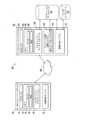
図2は、本開示の例示的な実施形態による一例示的なジョイント位置追跡システム142を示す。この例では、ジョイント位置追跡システム142は、図1に表示した構成とは異なる構成の1つまたは複数の構成要素を含む。たとえば、ジョイント位置追跡システム142は、移動予測システム144、ロケーション識別システム202、再グループ化システム146、ルート更新システム204、ユーザデータストア172、およびナビゲーションデータストア170を含み得る。 FIG. 2 illustrates one example joint
いくつかの例示的な実施形態では、ジョイント位置追跡システム142は、移動予測システム144を含み得る。移動予測システム144は、上記で説明したように、ユーザデータストア172内のユーザデータにアクセスして、1つまたは複数の予測移動計画を生成し得る。予測移動計画を使用して、移動予測システム144は、整合する予測移動計画を有する2人以上のユーザを判定し得る。この判定に基づいて、移動予測システム144は、2人以上のユーザに対するジョイント位置追跡セッションを開始し得る。 In some example embodiments, joint
いくつかの例示的な実施形態では、ジョイント位置追跡セッションが開始されると、ロケーション識別システム202は、1人または複数のユーザに関連する1つまたは複数のローカルコンピューティングデバイスから位置情報を受信し得る。ロケーション識別システム202は、受信された位置情報を分析して、特定のユーザに関連する間隔パラメータがしきい間隔値を超えたかどうかを判定し得る。間隔パラメータは、ナビゲーションデータストア170内に記憶されたデータに少なくとも部分的に基づいて生成され得る。 In some example embodiments, once a joint location tracking session is initiated, location identification system 202 receives location information from one or more local computing devices associated with one or more users. obtain. Location identification system 202 may analyze the received location information to determine whether an interval parameter associated with a particular user exceeds a threshold interval value. The spacing parameters may be generated based at least in part on data stored within
ロケーション識別システム202が少なくとも1人のユーザがしきい間隔値を超えたと判定すると、再グループ化システム146は、離れたユーザが他のユーザと再グループ化することを可能にするための更新されたナビゲーション計画を生成し得る。たとえば、再グループ化システム146は、1つまたは複数の追加の立寄りを計画されたルートに追加し得る。その場合、ユーザは、立ち寄り、すべてのユーザが再び加わるとき、計画されたルートを続けることができる。 When the location identification system 202 determines that at least one user has exceeded the threshold interval value, the
ルート更新システム204は、更新されたナビゲーション計画をジョイント位置追跡セッション内のユーザに関連する1つまたは複数のローカルコンピューティングデバイスに送り得る。 Route update system 204 may send the updated navigation plan to one or more local computing devices associated with users within the joint location tracking session.
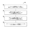
図3は、本開示の例示的な実施形態による、予測システムの実行に関する一例示的なブロック図を示す。この例に見られるように、移動予測システム(たとえば、図1の移動予測システム144)は、複数のユーザ(たとえば、ユーザA、ユーザB、ユーザC、およびユーザD)に関連するユーザデータにアクセスし得る。いくつかの例では、ユーザに関するソーシャルネットワークデータに基づいて特定のユーザが選択され得る。たとえば、複数のユーザ(たとえば、ユーザA、ユーザB、ユーザC、およびユーザD)はすべて、移動予測システム(たとえば、図1のユーザデータストア172)にアクセス可能なソーシャルネットワークデータ内でつながれ得る。 FIG. 3 depicts one example block diagram of the execution of a prediction system, according to an example embodiment of the present disclosure. As seen in this example, a movement prediction system (e.g.,
この例では、移動予測システムは、4人のユーザに関するカレンダーデータにアクセスし得る。ユーザA、ユーザB、ユーザC、およびユーザDに関するカレンダーデータ302、304、306、および308は、それぞれ、1つまたは複数のカレンダー予定を含み得る。移動予測システムは、1つまたは複数のカレンダー予定に基づいて各ユーザに関する予測移動データを生成し得る。たとえば、移動予測システムは、ユーザAに対して予測移動計画A 312、ユーザBに対して予測移動計画B 314、ユーザCに対して予測移動計画C 316、およびユーザDに対して予測移動計画D 318を生成する。 In this example, the travel prediction system may access calendar data for four users.
各予測移動計画(たとえば、312~318)は、マルチユーザ比較システム310に送信され得る。いくつかの例では、マルチユーザ比較システム310は、移動予測システム内に含まれ得る。 Each predicted movement plan (eg, 312-318) may be sent to
この例では、3人のユーザ(ユーザA、ユーザB、およびユーザD)に対する予測移動計画は、Warriorのバスケットボールの試合に行く計画を含み得る。したがって、マルチユーザ比較システム310は、予測移動計画A 312、予測移動計画B 314、および予測移動計画D 318が互いに関連し、ユーザはジョイント位置追跡セッションに加わることに関心を有し得ると判定し得る。いくつかの例では、この判定に基づいて、マルチユーザ比較システム310は、ユーザA、B、およびDをジョイント位置追跡セッションに招待するための招待を生成し得る。 In this example, the predicted travel plans for three users (User A, User B, and User D) may include a plan to go to a Warrior basketball game. Accordingly,
図4A~図4Cは、本開示の例示的な実施形態による一例示的なユーザインターフェースを示す。この例では、3人のユーザがジョイント位置追跡セッション内に含まれ、彼らの位置は地理的マップ上に表示されている。加えて、この例示的なマップは、一例示的な距離境界402をやはり示す。図4Aでは、3人のユーザはすべて、同じ経路上におり、例示的な距離境界内にいる。示された距離境界402は、ジョイント位置追跡セッション内に含まれたすべてのユーザの平均位置からの距離に基づいて計算され得る。 4A-4C illustrate one example user interface according to an example embodiment of the present disclosure. In this example, three users are included in a joint location tracking session and their locations are displayed on a geographic map. Additionally, this example map also shows one
図4Bは、ジョイント位置追跡セッション内に含まれた3人のユーザのうちの1人404がジョイント位置追跡セッションの他のユーザから離れ、したがって、例示的な距離境界402を超えた一例示的な状況を示す。 FIG. 4B shows an example example in which one of the three users included within the joint
図4Cは、再グループ化システム146が再グループ化ポイント406を自動的に生成した一例示的な状況を示す。3台の車両すべての計画移動ルートは、生成された再グループ化ポイント406を含むように構成されている。したがって、各ユーザは、再グループ化ポイント406に向かって移動し得る。車両がすべて再グループ化ポイント406に達すると、それらの車両はその既存のルートを続けることができる。 FIG. 4C illustrates one example situation in which
例示的な方法
図5は、本開示の例示的な実施形態によるグループナビゲーションの方法に関する一例示的な流れ図を示す。方法(500)は図1のサーバコンピューティングシステム130を参照しながら論じられるが、方法(500)は、任意の好適なコンピューティングシステムによって実行され得る。Exemplary Method FIG. 5 illustrates an example flowchart for a method of group navigation according to an example embodiment of the present disclosure. Although method (500) is discussed with reference to
加えて、図5は、示し論じるために特定の順序で実行されるステップを示す。当業者は、方法(500)の様々なステップは、本明細書で提供される開示を使用して、本開示の範囲から逸脱せずに、様々な方法で省かれ、適応され、かつ/または再配置され得ることを理解されよう。 Additionally, FIG. 5 depicts steps performed in a specific order for purposes of illustration and discussion. Those skilled in the art will appreciate that, using the disclosure provided herein, various steps of method (500) can be omitted, adapted, and/or in various ways without departing from the scope of this disclosure. It will be understood that it may be rearranged.
いくつかの例示的な実施形態では、サーバコンピューティングシステム(たとえば、図1のサーバコンピューティングシステム130)は、複数のユーザを含むジョイント位置追跡セッションを開始し得る。いくつかの例では、ジョイント位置追跡セッションは、ユーザに関連するコンピューティングデバイスから受信された、ジョイント位置追跡セッションを生成する要求に応じて開始される。要求は、ジョイント位置追跡セッションに招待されることになる少なくとも1人の他のユーザに関連する識別子を含み得る。 In some example embodiments, a server computing system (eg,
いくつかの例では、サーバコンピューティングシステムは、複数のユーザに関する予測移動データを取得し得る。サーバコンピューティングシステムは、複数のユーザのうちの個々のユーザに関するそれぞれの予測移動データを比較し得る。サーバコンピューティングシステムは、ユーザのサブセットに関する予測移動データ間の対応に基づいて、複数のユーザのうちのユーザのサブセット間の関連性を識別する。 In some examples, a server computing system may obtain predictive movement data for multiple users. The server computing system may compare respective predicted movement data for individual users of the plurality of users. The server computing system identifies associations between subsets of users of the plurality of users based on correspondences between predicted movement data for the subsets of users.
いくつかの例示的な実施形態では、サーバコンピューティングシステムは、潜在的なジョイント位置追跡セッションの識別子をユーザのサブセットに関連する複数のデバイスに提供する。ユーザのサブセット内のユーザに関連する少なくとも2つのデバイスからの応答の受信に応じて、サーバコンピューティングシステムは、複数のデバイスに対するジョイント位置追跡セッションを開始する。 In some example embodiments, a server computing system provides identifiers of potential joint location tracking sessions to multiple devices associated with a subset of users. In response to receiving responses from at least two devices associated with users within the subset of users, the server computing system initiates a joint location tracking session for the plurality of devices.
いくつかの例では、サーバコンピューティングシステムは、サーバコンピューティングシステムに関連する1つまたは複数のデータベースからの複数のユーザに関するユーザデータにアクセスし得る。サーバコンピュータシステムは、それぞれのユーザに関連するユーザデータに基づいて、それぞれのユーザに対する予測される目的位置および時間を含めて、それぞれのユーザに関する予測移動データを生成し得る。それぞれのユーザに関するユーザデータは、それぞれのユーザの今後のスケジュールに関連するカレンダーデータを含み得、予測される目的位置および時間は、それぞれのユーザのカレンダーデータ内に含まれた予定データに基づいて判定される。いくつかの例示的な実施形態では、カレンダーデータは、単にユーザのカレンダー内の現在スケジュールされている予定以上のものを指すことがある。たとえば、ユーザが特定の劇場における、かつ特定の時間における映画チケットの購入を確認する電子メールを有する場合、サーバコンピューティングシステムは、ユーザが特定の時間に特定の劇場に行くことを計画していると判定し得る。同様に、カレンダーデータは、ソーシャルメディアデータ(たとえば、特定の計画を示す掲示)、金融データ(たとえば、チケット購入)、過去のナビゲーション探索(たとえば、特定のロケーションまでの指示を見出す)、などに基づいて収集された、推論されるカレンダーデータを指すことがある。 In some examples, a server computing system may access user data about multiple users from one or more databases associated with the server computing system. The server computer system may generate predicted movement data for each user, including a predicted destination location and time for each user, based on user data associated with each user. The user data regarding each user may include calendar data related to the respective user's upcoming schedule, and the predicted destination location and time is determined based on appointment data included within the respective user's calendar data. be done. In some example embodiments, calendar data may refer to more than just currently scheduled events in a user's calendar. For example, if a user has an email confirming the purchase of a movie ticket at a particular theater and at a particular time, the server computing system may indicate that the user plans to go to a particular theater at a particular time. It can be determined that Similarly, calendar data can be based on social media data (e.g., a sign indicating a particular plan), financial data (e.g., ticket purchases), past navigational exploration (e.g., finding directions to a particular location), etc. may refer to inferred calendar data collected by
それぞれのユーザに関するユーザデータは、それぞれのユーザに関する現在位置データおよび現在の移動方向を含んでよく、予測される目的位置および時間は、それぞれのユーザの現在位置データおよび現在の移動方向に少なくとも部分的に基づいて判定される。それぞれのユーザに関するユーザデータは、それぞれのユーザの移動履歴に関連する履歴データを含んでよく、予測される目的位置および時間は、それぞれのユーザに関連する1つまたは複数の記録された過去の目的地に基づいて判定される。 The user data for each user may include current location data and current direction of travel for each user, and the predicted destination location and time depends at least in part on the current location data and current direction of travel for each user. Judgment is made based on. The user data regarding each user may include historical data related to the respective user's movement history, and the predicted destination location and time may include one or more recorded past destinations associated with the respective user. Judgment is based on the ground.
いくつかの例示的な実施形態では、サーバコンピューティングシステムは、複数のユーザのうちのそれぞれのユーザに関連するソーシャルデータにアクセスし得る。サーバコンピューティングシステムは、それぞれのユーザに関連するソーシャルデータに基づいて、それぞれのユーザに関連するユーザのサブセットを識別し得る。サーバコンピューティングシステムは、それぞれのユーザに関連する予測移動データをユーザのサブセット内の各ユーザに関連する予測移動データと比較し得る。識別子は、ユーザのサブセット内のユーザに関連するコンピューティングデバイスに送られる、ジョイント位置追跡セッションに加わるための要求内に含まれ得る。サーバコンピューティングシステムは、ジョイント位置追跡セッション内の1人または複数のユーザに関連する位置データを周期的に受信し得る。サーバコンピューティングシステムは、受信された位置データをジョイント位置追跡セッション内の1人または複数のユーザに送信し得る。 In some example embodiments, the server computing system may access social data associated with each of the plurality of users. The server computing system may identify a subset of users related to each user based on social data related to each user. The server computing system may compare the predicted movement data associated with each user to the predicted movement data associated with each user within the subset of users. The identifier may be included in a request to participate in a joint location tracking session sent to computing devices associated with users within the subset of users. The server computing system may periodically receive location data related to one or more users within a joint location tracking session. The server computing system may transmit the received location data to one or more users within a joint location tracking session.
いくつかの例示的な実施形態では、サーバコンピューティングシステム(たとえば、図1のサーバコンピューティングシステム130)は、502において、ジョイント位置追跡セッション内の第1のユーザおよび複数のユーザのうちの少なくとも1人の他のユーザに関連する位置データをジョイント位置追跡セッション内の複数のユーザから受信する。サーバコンピューティングシステムは、504において、第1のユーザおよび複数のユーザのうちの少なくとも1人の他のユーザに関連する、受信された位置データに基づいて、第1のユーザに関連する間隔パラメータがしきい間隔値を超えたと判定し、第1のユーザに関連する間隔パラメータは、第1のユーザと複数のユーザのうちの1人の他のユーザとの間の距離を表す。 In some example embodiments, the server computing system (e.g.,
いくつかの例では、第1のユーザに関連する間隔パラメータは、第1のユーザに関連する、受信された位置データとジョイント位置追跡セッション内の複数のユーザのうちの最も近い他のユーザに関連する、受信された位置データとの間の距離を表す。 In some examples, the spacing parameter related to the first user is related to the received location data related to the first user and the closest other user of the plurality of users in the joint location tracking session. represents the distance between the location data and the received location data.
いくつかの例では、第1のユーザに関連する間隔パラメータは、第1のユーザに関連する、受信された位置データと、ジョイント位置追跡セッション内の複数のユーザのうちの1人または複数の他のユーザに関連する、受信された位置データの平均との間の距離を表す。いくつかの例では、間隔パラメータは、第1のユーザに対する予想到着時間とジョイント位置追跡セッション内の複数のユーザのうちの少なくとも1人の他のユーザに対する平均予想到着時間との間の差異を表し得る。 In some examples, the interval parameter associated with the first user includes received location data associated with the first user and one or more other of the plurality of users in the joint location tracking session. represents the distance between the average of the received location data associated with the users of . In some examples, the interval parameter represents a difference between an expected time of arrival for the first user and an average expected time of arrival for at least one other user of the plurality of users in the joint location tracking session. obtain.
いくつかの例示的な実施形態では、サーバコンピューティングシステムは、506において、ジョイント位置追跡セッション内の第1のユーザと1人の他のユーザとの間の間隔パラメータをしきい間隔値未満に低減するためのナビゲーションデータを自動的に生成する。いくつかの例では、ナビゲーションデータは、追加のナビゲーション中間地点を含めるように、ジョイント位置追跡セッション内の複数のユーザに関連する1つまたは複数のコンピューティングデバイスにおける現在の経路データを変更するためのナビゲーション命令を含み得る。 In some example embodiments, the server computing system reduces, at 506, a spacing parameter between the first user and one other user in the joint location tracking session below a threshold spacing value. Automatically generate navigation data for In some examples, the navigation data includes information for modifying current route data at one or more computing devices associated with multiple users within a joint location tracking session to include additional navigation waypoints. May include navigation instructions.
いくつかの例示的な実施形態では、ナビゲーションデータは、第1のユーザに関連する間隔パラメータをしきい間隔値未満の値に低減するように、ジョイント位置追跡セッション内の複数のユーザに関連する1つまたは複数のコンピューティングデバイスにおける現在の経路データを変更させる命令を含み得る。 In some exemplary embodiments, the navigation data is configured to reduce the spacing parameter associated with the first user to a value less than a threshold spacing value. The instructions may include instructions for modifying current route data at one or more computing devices.
いくつかの例示的な実施形態では、サーバコンピューティングシステムは、508において、ナビゲーションデータをジョイント位置追跡セッション内の少なくとも第1のユーザに送信する。サーバコンピューティングシステムは、第1のユーザに関連する間隔パラメータがしきい間隔値を超えたという通知をジョイント位置追跡セッション内の1人または複数のユーザに送信し得る。 In some example embodiments, the server computing system transmits navigation data to at least a first user in the joint location tracking session at 508. The server computing system may send a notification to one or more users in the joint location tracking session that an interval parameter associated with the first user has exceeded a threshold interval value.
追加の開示
本明細書で論じた技法は、サーバ、データベース、ソフトウェアアプリケーション、および他のコンピュータベースのシステム、ならびに取られる行動およびそのようなシステム間で送られる情報を参照する。コンピュータベースのシステム固有の柔軟性は、構成要素間のタスクおよび機能性の多種多様な考えられる構成、組合せ、および分割を可能にする。たとえば、本明細書で論じたプロセスは、単一のデバイスまたは構成要素、または組み合わせて動作する複数のデバイスまたは構成要素を使用して実装され得る。データベースおよびアプリケーションは、単一のシステム上で実装されても、または複数のシステムにわたって分散されてもよい。分散された構成要素は、連続的にまたは同時に動作し得る。Additional Disclosures The techniques discussed herein refer to servers, databases, software applications, and other computer-based systems, and actions taken and information sent between such systems. The inherent flexibility of computer-based systems allows for a wide variety of possible configurations, combinations, and divisions of tasks and functionality between components. For example, the processes discussed herein may be implemented using a single device or component, or multiple devices or components operating in combination. Databases and applications may be implemented on a single system or distributed across multiple systems. Distributed components may operate sequentially or simultaneously.
本開示の主題について、その様々な特定の例示的な実施形態に関して詳細に論じてきたが、各例は、本開示の限定ではなく、例として提供される。当業者は、前述の理解に達すると、そのような実施形態に対する代替案、そのような実施形態の変形形態、およびそのような実施形態に対する等価物を容易に生み出すことが可能である。したがって、当業者に容易に明らかになるように、主題の開示は、本主題に対するそのような修正、変形形態、および/または追加の包含を排除しない。たとえば、1つの実施形態の一部として示される、または説明される特徴は、またさらなる実施形態を生み出すために別の実施形態とともに使用され得る。したがって、本開示はそのような代替案、変形形態、および均等物を網羅することを意図する。 Although the subject matter of this disclosure has been discussed in detail with respect to various specific exemplary embodiments thereof, each example is provided by way of illustration and not as a limitation of this disclosure. Once those skilled in the art have reached the foregoing understanding, they can readily develop alternatives to, variations on, and equivalents to such embodiments. Accordingly, a disclosure of the subject matter does not exclude the inclusion of such modifications, variations, and/or additions to the present subject matter, as will be readily apparent to those skilled in the art. For example, features shown or described as part of one embodiment can also be used with another embodiment to yield a further embodiment. Accordingly, this disclosure is intended to cover such alternatives, modifications, and equivalents.
具体的には、図5は、それぞれ、示し論じるために特定の順序で実行されるステップを示すが、本開示の方法は、特に示された順序または配置に限定されない。方法500の様々なステップは、本開示の範囲から逸脱せずに、様々な方法で省かれ、再構成され、組み合わされ、かつ/または適用され得る。 In particular, although FIG. 5 each depicts steps performed in a particular order for purposes of illustration and discussion, the methods of the present disclosure are not limited to the specifically depicted order or arrangement. Various steps of
100 クライアント-サーバ環境
102 ローカルコンピューティングデバイス
112 プロセッサ
114 メモリ
120 ナビゲーションアプリケーション
126 位置判定デバイス
130 サーバコンピューティングシステム、サービスシステム
132 プロセッサ
134 メモリ
136 データ
138 命令
140 ナビゲーションサービスプロバイダ
142 ジョイント位置追跡システム
144 移動予測システム
146 再グループ化システム
170 ナビゲーションデータストア
172 ユーザデータストア
180 ネットワーク、ネットワークシステム
202 ロケーション識別システム
204 ルート更新システム
302 カレンダーデータ
304 カレンダーデータ
306 カレンダーデータ
308 カレンダーデータ
310 マルチユーザ比較システム
312 予測移動計画A
314 予測移動計画B
316 予測移動計画C
318 予測移動計画D
402 距離境界
404 3人のユーザのうちの1人
406 再グループ化ポイント
500 方法100 client-server environment
102 Local Computing Device
112 processor
114 Memory
120 navigation application
126 Position determination device
130 Server computing system, service system
132 processor
134 Memory
136 data
138 Command
140 Navigation Service Provider
142 Joint position tracking system
144 Movement prediction system
146 Regrouping System
170 Navigation data store
172 User data store
180 Network, Network System
202 Location Identification System
204 Route update system
302 Calendar data
304 Calendar data
306 Calendar data
308 Calendar data
310 Multi-user comparison system
312 Predicted movement plan A
314 Predicted movement plan B
316 Predicted movement plan C
318 Predicted movement plan D
402 Distance Boundary
404 1 of 3 users
406 Regroup Point
500 ways
Claims (19)
Translated fromJapanese1つまたは複数のコンピューティングデバイスが、複数のユーザを含むジョイント位置追跡セッションを開始するステップと、
前記1つまたは複数のコンピューティングデバイスが、前記ジョイント位置追跡セッション内の第1のユーザおよび前記複数のユーザのうちの少なくとも1人の他のユーザに関連する位置データを受信するステップと、
前記1つまたは複数のコンピューティングデバイスが、前記第1のユーザおよび前記複数のユーザのうちの前記少なくとも1人の他のユーザに関連する、前記受信された位置データに少なくとも部分的に基づいて、前記第1のユーザに関連する間隔パラメータがしきい間隔値を超えたと判定するステップであって、
前記第1のユーザに関連する前記間隔パラメータが、前記第1のユーザと前記複数のユーザのうちの前記1人の他のユーザとの間の距離を表す、ステップと、
前記1つまたは複数のコンピューティングデバイスが、前記第1のユーザと前記複数のユーザのうちの前記1人の他のユーザとの間の前記間隔パラメータを前記しきい間隔値未満に低減するためのナビゲーションデータを自動的に生成するステップと、
前記1つまたは複数のコンピューティングデバイスが、前記ナビゲーションデータを前記ジョイント位置追跡セッション内の少なくとも前記第1のユーザに送信するステップと
を含み、
前記ジョイント位置追跡セッションを前記開始するステップが、
前記1つまたは複数のコンピューティングデバイスが、前記複数のユーザに関する予測移動データを取得するステップと、
前記1つまたは複数のコンピューティングデバイスが、前記複数のユーザのうちの個々のユーザに関するそれぞれの予測移動データを比較するステップと、
前記1つまたは複数のコンピューティングデバイスが、前記複数のユーザのうちのユーザのサブセットに関する前記予測移動データ間の対応に基づいて、ユーザの前記サブセット間の関連性を識別するステップと、
前記1つまたは複数のコンピューティングデバイスが、ユーザの前記サブセットのうちの各ユーザに関する前記予測移動データが関連していることに基づいて、前記ジョイント位置追跡セッションに加わるための招待をユーザの前記サブセットに関連する複数のデバイスに送信するステップと
をさらに含む、コンピュータ実装方法。A computer-implemented method for managing a joint position tracking session, the method comprising:
one or more computing devices initiate a joint position tracking session involving multiple users;
the one or more computing devices receiving location data related to the first user and at least one other user of the plurality of users in the joint location tracking session;
the one or more computing devices based at least in part on the received location data related to the first user and the at least one other user of the plurality of users; determining that an interval parameter associated with the first user exceeds a threshold interval value;
the distance parameter associated with the first user represents a distance between the first user and the one other user of the plurality of users;
the one or more computing devices for reducing the spacing parameter between the first user and the one other user of the plurality of users below the threshold spacing value; automatically generating navigation data;
the one or more computing devices transmitting the navigation data to at least the first user in the joint position tracking session;
the step of initiating the joint position tracking session comprises:
the one or more computing devices obtaining predictive movement data regarding the plurality of users;
the one or more computing devices comparing respective predicted movement data for individual users of the plurality of users;
the one or more computing devices identifying an association between the subset of usersbased on a correspondence between the predicted movement data for the subsetof users of the plurality of users ;
The one or more computing devices may extend an invitationto join the joint location tracking session to the subset of users based on the predictive movement data for each user of the subset of users being relevant. and transmitting to a plurality of devices associated with the computer-implemented method.
前記1つまたは複数のコンピューティングデバイスが、潜在的なジョイント位置追跡セッションの識別子をユーザの前記サブセットに関連する複数のデバイスに提供するステップと、
ユーザの前記サブセット内のユーザに関連する少なくとも2つのデバイスからの応答の受信に応じて、前記1つまたは複数のコンピューティングデバイスが、前記複数のデバイスに対する前記ジョイント位置追跡セッションを開始するステップと
をさらに含む、請求項1に記載のコンピュータ実装方法。the step of initiating the joint position tracking session comprises:
the one or more computing devices providing an identifier of a potential joint location tracking session to a plurality of devices associated with the subset of users;
in response to receiving responses from at least two devices associated with users in the subset of users, the one or more computing devices initiating the joint location tracking session for the plurality of devices; 2. The computer-implemented method of claim 1, further comprising:
前記1つまたは複数のコンピューティングデバイスが、前記複数のユーザに関するユーザデータにアクセスするステップ
を含む、請求項4に記載のコンピュータ実装方法。the step of acquiring the predicted movement data,
5. The computer-implemented method of claim 4, comprising the one or more computing devices accessing user data about the plurality of users.
をさらに含む、請求項5に記載のコンピュータ実装方法。the one or more computing devices generating predicted movement data for the respective users, including a predicted destination location and time for the respective users, based on user data associated with the respective users; 6. The computer-implemented method of claim 5, further comprising:
前記予測される目的位置および時間が、前記それぞれのユーザのカレンダーデータ内に含まれた予定データに基づいて判定される、請求項6に記載のコンピュータ実装方法。the user data regarding each user includes calendar data related to the respective user's upcoming schedule;
7. The computer-implemented method of claim 6, wherein the predicted destination location and time is determined based on appointment data included within calendar data of the respective users.
前記予測される目的位置および時間が、前記それぞれのユーザの現在位置データおよび現在の移動方向に少なくとも部分的に基づいて判定される、請求項6に記載のコンピュータ実装方法。the user data regarding each user includes current location data and current direction of movement regarding the each user;
7. The computer-implemented method of claim 6, wherein the predicted destination location and time are determined based at least in part on current location data and current direction of travel of the respective users.
前記予測される目的位置および時間が、前記それぞれのユーザに関連する1つまたは複数の記録された過去の目的地に基づいて判定される、請求項6に記載のコンピュータ実装方法。the user data regarding each user includes historical data related to the movement history of the respective user;
7. The computer-implemented method of claim 6, wherein the predicted destination location and time is determined based on one or more recorded past destinations associated with the respective users.
前記1つまたは複数のコンピューティングデバイスが、前記複数のユーザのうちのそれぞれのユーザに関連するソーシャルデータにアクセスするステップと、
前記1つまたは複数のコンピューティングデバイスが、前記それぞれのユーザに関連する前記ソーシャルデータに基づいて、前記それぞれのユーザに関連するユーザのサブセットを識別するステップと、
前記1つまたは複数のコンピューティングデバイスが、前記それぞれのユーザに関連する前記予測移動データを、ユーザの前記サブセット内の各ユーザに関連する前記予測移動データと比較するステップと
をさらに含む、請求項4に記載のコンピュータ実装方法。the step of comparing the respective predicted movement data regarding each user of the plurality of users;
the one or more computing devices accessing social data associated with each of the plurality of users;
the one or more computing devices identifying a subset of users associated with the respective users based on the social data associated with the respective users;
the one or more computing devices further comprising: comparing the predicted movement data associated with the respective users with the predicted movement data associated with each user in the subset of users. The computer implementation method described in 4.
前記1つまたは複数のコンピューティングデバイスが、前記受信された位置データを前記ジョイント位置追跡セッション内の前記1人または複数のユーザに送信するステップと
をさらに含む、請求項1に記載のコンピュータ実装方法。the one or more computing devices periodically receiving location data related to one or more users in the joint location tracking session;
the one or more computing devices transmitting the received location data to the one or more users in the joint location tracking session. .
複数のユーザを含むジョイント位置追跡セッションを開始するステップと、
前記ジョイント位置追跡セッション内の第1のユーザおよび前記複数のユーザのうちの少なくとも1人の他のユーザに関連する位置データを、前記ジョイント位置追跡セッション内の前記複数のユーザから受信するステップと、
前記第1のユーザおよび前記複数のユーザのうちの前記少なくとも1人の他のユーザに関連する、前記受信された位置データに基づいて、前記第1のユーザに関連する間隔パラメータがしきい間隔値を超えたと判定するステップであって、
前記第1のユーザに関連する前記間隔パラメータが、前記第1のユーザと前記複数のユーザのうちの前記1人の他のユーザとの間の距離を表す、ステップと、
前記ジョイント位置追跡セッション内の前記第1のユーザと前記1人の他のユーザとの間の前記間隔パラメータを前記しきい間隔値未満に低減するためのナビゲーションデータを自動的に生成するステップと、
前記ナビゲーションデータを前記ジョイント位置追跡セッション内の少なくとも前記第1のユーザに送信するステップと
を含み、
前記ジョイント位置追跡セッションを前記開始するステップが、
前記複数のユーザに関する予測移動データを取得するステップと、
前記複数のユーザのうちの個々のユーザに関するそれぞれの予測移動データを比較するステップと、
前記複数のユーザのうちのユーザのサブセットに関する前記予測移動データ間の対応に基づいて、ユーザの前記サブセット間の関連性を識別するステップと、
ユーザの前記サブセットのうちの各ユーザに関する前記予測移動データが関連していることに基づいて、前記ジョイント位置追跡セッションに加わるための招待をユーザの前記サブセットに関連する複数のデバイスに送信するステップと
をさらに含む、非一時的コンピュータ可読記録媒体。A non-transitory computer-readable storage medium having instructions stored thereon, the instructions, when executed by one or more computing devices, causing the one or more computing devices to perform an operation; but,
initiating a joint position tracking session involving multiple users;
receiving from the plurality of users in the joint location tracking session location data related to a first user and at least one other user of the plurality of users in the joint location tracking session;
Based on the received location data associated with the first user and the at least one other user of the plurality of users, an interval parameter associated with the first user has a threshold interval value. a step for determining that the
the distance parameter associated with the first user represents a distance between the first user and the one other user of the plurality of users;
automatically generating navigation data to reduce the spacing parameter between the first user and the one other user within the joint position tracking session below the threshold spacing value;
transmitting the navigation data to at least the first user within the joint position tracking session;
the step of initiating the joint position tracking session comprises:
obtaining predicted movement data regarding the plurality of users;
comparing respective predicted movement data for individual users of the plurality of users;
identifying an association between the subset of users based on a correspondence between the predicted movement data for the subset ofusersof the plurality of users ;
Sending an invitationto join the joint location tracking session to a plurality of devices associated with the subset of users based on the predictive movement data for each user of the subset of users being relevant; a non-transitory computer-readable storage medium further comprising:
Applications Claiming Priority (1)
| Application Number | Priority Date | Filing Date | Title |
|---|---|---|---|
| PCT/US2019/038997WO2020263233A1 (en) | 2019-06-25 | 2019-06-25 | Navigation with dynamic regrouping points |
Publications (2)
| Publication Number | Publication Date |
|---|---|
| JP2022538708A JP2022538708A (en) | 2022-09-06 |
| JP7399177B2true JP7399177B2 (en) | 2023-12-15 |
Family
ID=67211979
Family Applications (1)
| Application Number | Title | Priority Date | Filing Date |
|---|---|---|---|
| JP2021546342AActiveJP7399177B2 (en) | 2019-06-25 | 2019-06-25 | Navigation using dynamic regrouping points |
Country Status (6)
| Country | Link |
|---|---|
| US (1) | US20220120573A1 (en) |
| EP (1) | EP3903066B1 (en) |
| JP (1) | JP7399177B2 (en) |
| KR (1) | KR102800351B1 (en) |
| CN (1) | CN113544466B (en) |
| WO (1) | WO2020263233A1 (en) |
Families Citing this family (3)
| Publication number | Priority date | Publication date | Assignee | Title |
|---|---|---|---|---|
| CN113177561B (en)* | 2021-04-27 | 2022-06-24 | 深圳市慧鲤科技有限公司 | Multi-user aggregation method and device, electronic equipment and storage medium |
| CN116257196A (en)* | 2021-12-09 | 2023-06-13 | 华为技术有限公司 | A method, electronic device and system for sharing navigation information |
| WO2023177403A1 (en)* | 2022-03-18 | 2023-09-21 | Google Llc | Navigation groups with dynamic destination changes |
Citations (10)
| Publication number | Priority date | Publication date | Assignee | Title |
|---|---|---|---|---|
| JP2002135830A (en) | 2000-10-26 | 2002-05-10 | Seiko Epson Corp | Mobile management system, method of controlling mobile management system, and management server |
| JP2003087845A (en) | 2001-09-13 | 2003-03-20 | Sanyo Electric Co Ltd | Information providing server, information providing method, and information acquisition method |
| JP2003141682A (en) | 2001-11-01 | 2003-05-16 | Nissan Motor Co Ltd | Navigation device, navigation information providing device, and navigation information providing system |
| JP2005055220A (en) | 2003-08-07 | 2005-03-03 | Ntt Docomo Inc | Server |
| JP2008070377A (en) | 2004-07-13 | 2008-03-27 | Matsushita Electric Ind Co Ltd | Destination display device and destination display method |
| JP2010117241A (en) | 2008-11-13 | 2010-05-27 | Panasonic Corp | Sps receiving terminal |
| JP2013122379A (en) | 2011-12-09 | 2013-06-20 | Alpine Electronics Inc | Navigation device |
| WO2014112124A1 (en) | 2013-01-21 | 2014-07-24 | 三菱電機株式会社 | Destination prediction device, destination prediction method, and destination display method |
| US20150168150A1 (en) | 2013-12-12 | 2015-06-18 | Microsoft Corporation | Predicted travel intent |
| JP2017536532A (en) | 2014-10-01 | 2017-12-07 | マイクロソフト テクノロジー ライセンシング,エルエルシー | Content presentation based on movement patterns |
Family Cites Families (20)
| Publication number | Priority date | Publication date | Assignee | Title |
|---|---|---|---|---|
| JP3560761B2 (en)* | 1997-04-01 | 2004-09-02 | 富士通テン株式会社 | Navigation system |
| JP4130828B2 (en)* | 2004-07-13 | 2008-08-06 | 松下電器産業株式会社 | Destination display device and destination display method |
| CA2710269C (en)* | 2009-08-11 | 2012-05-22 | Certusview Technologies, Llc | Locating equipment communicatively coupled to or equipped with a mobile/portable device |
| EP3614361B1 (en)* | 2010-08-24 | 2024-02-14 | BlackBerry Limited | Mobile tracking |
| DE102012208256A1 (en)* | 2012-05-16 | 2013-11-21 | Continental Teves Ag & Co. Ohg | Method and system for autonomously tracking a follower vehicle on the track of a Leader vehicle |
| US9141112B1 (en)* | 2013-10-16 | 2015-09-22 | Allstate Insurance Company | Caravan management |
| DE102013224342A1 (en)* | 2013-11-28 | 2015-05-28 | Robert Bosch Gmbh | A method for supporting a common driving experience of drivers of a plurality of mobile units and a corresponding mobile unit |
| US11182870B2 (en)* | 2014-12-24 | 2021-11-23 | Mcafee, Llc | System and method for collective and collaborative navigation by a group of individuals |
| EP3040682B1 (en)* | 2015-01-05 | 2020-02-26 | Harman International Industries, Incorporated | Learning and predictive navigation system |
| US10899350B2 (en)* | 2016-05-20 | 2021-01-26 | Ge Global Sourcing Llc | Vehicle handling system and method |
| CN106303409B (en)* | 2016-07-27 | 2019-04-02 | 阔地教育科技有限公司 | A kind of target object combined tracking method and target object combine tracking device |
| US10288444B2 (en)* | 2017-01-10 | 2019-05-14 | Microsoft Technology Licensing, Llc | Generating instructions for shared travel experiences |
| US10760916B2 (en)* | 2017-06-07 | 2020-09-01 | International Business Machines Corporation | Methods and systems for determining shared routes |
| US11561105B2 (en)* | 2017-11-29 | 2023-01-24 | International Business Machines Corporation | Optimized route planning for multiple travelers with the same destination |
| EP3738327B1 (en)* | 2018-01-08 | 2021-08-25 | Nokia Technologies Oy | Target vehicle selection and message delivery in vehicular systems |
| US10818190B2 (en)* | 2018-01-09 | 2020-10-27 | Ford Global Technologies, Llc | System and method for vehicle travelling in caravan mode |
| WO2020035249A1 (en)* | 2018-08-13 | 2020-02-20 | British Telecommunications Public Limited Company | Vehicle platooning |
| US20200080853A1 (en)* | 2018-09-06 | 2020-03-12 | Peloton Technology, Inc. | Systems and methods for rendezvousing |
| US10971018B2 (en)* | 2018-11-30 | 2021-04-06 | Ford Global Technologies, Llc | Vehicular platoon subscription and management system |
| US10895234B2 (en)* | 2019-03-18 | 2021-01-19 | Toyota Motor Engineering & Manufacturing North America, Inc. | Systems and methods for managing freshness of fuel in a vehicle |
- 2019
- 2019-06-25WOPCT/US2019/038997patent/WO2020263233A1/ennot_activeCeased
- 2019-06-25JPJP2021546342Apatent/JP7399177B2/enactiveActive
- 2019-06-25EPEP19737453.1Apatent/EP3903066B1/enactiveActive
- 2019-06-25USUS17/422,664patent/US20220120573A1/ennot_activeAbandoned
- 2019-06-25CNCN201980093827.2Apatent/CN113544466B/enactiveActive
- 2019-06-25KRKR1020217027910Apatent/KR102800351B1/enactiveActive
Patent Citations (10)
| Publication number | Priority date | Publication date | Assignee | Title |
|---|---|---|---|---|
| JP2002135830A (en) | 2000-10-26 | 2002-05-10 | Seiko Epson Corp | Mobile management system, method of controlling mobile management system, and management server |
| JP2003087845A (en) | 2001-09-13 | 2003-03-20 | Sanyo Electric Co Ltd | Information providing server, information providing method, and information acquisition method |
| JP2003141682A (en) | 2001-11-01 | 2003-05-16 | Nissan Motor Co Ltd | Navigation device, navigation information providing device, and navigation information providing system |
| JP2005055220A (en) | 2003-08-07 | 2005-03-03 | Ntt Docomo Inc | Server |
| JP2008070377A (en) | 2004-07-13 | 2008-03-27 | Matsushita Electric Ind Co Ltd | Destination display device and destination display method |
| JP2010117241A (en) | 2008-11-13 | 2010-05-27 | Panasonic Corp | Sps receiving terminal |
| JP2013122379A (en) | 2011-12-09 | 2013-06-20 | Alpine Electronics Inc | Navigation device |
| WO2014112124A1 (en) | 2013-01-21 | 2014-07-24 | 三菱電機株式会社 | Destination prediction device, destination prediction method, and destination display method |
| US20150168150A1 (en) | 2013-12-12 | 2015-06-18 | Microsoft Corporation | Predicted travel intent |
| JP2017536532A (en) | 2014-10-01 | 2017-12-07 | マイクロソフト テクノロジー ライセンシング,エルエルシー | Content presentation based on movement patterns |
Also Published As
| Publication number | Publication date |
|---|---|
| US20220120573A1 (en) | 2022-04-21 |
| CN113544466B (en) | 2024-10-11 |
| KR20210120093A (en) | 2021-10-06 |
| KR102800351B1 (en) | 2025-04-25 |
| CN113544466A (en) | 2021-10-22 |
| JP2022538708A (en) | 2022-09-06 |
| WO2020263233A1 (en) | 2020-12-30 |
| EP3903066B1 (en) | 2025-06-25 |
| EP3903066A1 (en) | 2021-11-03 |
Similar Documents
| Publication | Publication Date | Title |
|---|---|---|
| US10663313B2 (en) | Providing traffic warnings to a user based on return journey | |
| US11145023B2 (en) | Graphical interface of a driver application in ride-sharing system | |
| US9207092B1 (en) | Displaying navigation information within a secondary user interface of a mobile device | |
| US10094678B2 (en) | Systems and methods for initiating mapping exit routines and rating highway exits | |
| JP7399177B2 (en) | Navigation using dynamic regrouping points | |
| WO2017040260A1 (en) | Determining improved pick-up locations | |
| US20190034948A1 (en) | Targeted Sensor Data Collection for Generating Map Information | |
| US20190096250A1 (en) | Systems and Methods for Determining Whether an Autonomous Vehicle Can Provide a Requested Service for a Rider | |
| US12066295B2 (en) | Using sensor data for coordinate prediction | |
| US20190390971A1 (en) | Determining cumulative estimated time for requested services | |
| US20200134525A1 (en) | On-Demand Transport Selection Process Facilitating Third-Party Autonomous Vehicles | |
| US20190392054A1 (en) | System and method for pre-fetching map data | |
| US20150094096A1 (en) | Location and event based information exchange and control system | |
| Korkmaz et al. | A smart school bus tracking system | |
| US20240346615A1 (en) | Clickable access point | |
| KR20240089363A (en) | Technology for delivering experience-centric navigation sessions | |
| JP2021157542A (en) | Information processing device, information processing method, and system | |
| KR20190073033A (en) | Method and system for occupying space based on geofencing | |
| US20240175691A1 (en) | Methods and apparatuses for providing trip plan based on user intent | |
| JP2022105212A (en) | Information processing terminal, information processing method and program | |
| WO2025203549A1 (en) | Information processing device, information processing method, and information processing program | |
| CN115855098A (en) | Navigation method, electronic device and program product |
Legal Events
| Date | Code | Title | Description |
|---|---|---|---|
| A621 | Written request for application examination | Free format text:JAPANESE INTERMEDIATE CODE: A621 Effective date:20211005 | |
| A131 | Notification of reasons for refusal | Free format text:JAPANESE INTERMEDIATE CODE: A131 Effective date:20221205 | |
| A521 | Request for written amendment filed | Free format text:JAPANESE INTERMEDIATE CODE: A523 Effective date:20230303 | |
| A131 | Notification of reasons for refusal | Free format text:JAPANESE INTERMEDIATE CODE: A131 Effective date:20230710 | |
| A521 | Request for written amendment filed | Free format text:JAPANESE INTERMEDIATE CODE: A523 Effective date:20231010 | |
| TRDD | Decision of grant or rejection written | ||
| A01 | Written decision to grant a patent or to grant a registration (utility model) | Free format text:JAPANESE INTERMEDIATE CODE: A01 Effective date:20231106 | |
| A61 | First payment of annual fees (during grant procedure) | Free format text:JAPANESE INTERMEDIATE CODE: A61 Effective date:20231205 | |
| R150 | Certificate of patent or registration of utility model | Ref document number:7399177 Country of ref document:JP Free format text:JAPANESE INTERMEDIATE CODE: R150 |