JP6561199B2 - Urban road recognition method, apparatus, storage medium and equipment based on laser point cloud - Google Patents
Urban road recognition method, apparatus, storage medium and equipment based on laser point cloudDownload PDFInfo
- Publication number
- JP6561199B2 JP6561199B2JP2018506153AJP2018506153AJP6561199B2JP 6561199 B2JP6561199 B2JP 6561199B2JP 2018506153 AJP2018506153 AJP 2018506153AJP 2018506153 AJP2018506153 AJP 2018506153AJP 6561199 B2JP6561199 B2JP 6561199B2
- Authority
- JP
- Japan
- Prior art keywords
- point cloud
- laser point
- laser
- road surface
- height
- Prior art date
- Legal status (The legal status is an assumption and is not a legal conclusion. Google has not performed a legal analysis and makes no representation as to the accuracy of the status listed.)
- Expired - Fee Related
Links
Images


Classifications
- G—PHYSICS
- G06—COMPUTING OR CALCULATING; COUNTING
- G06V—IMAGE OR VIDEO RECOGNITION OR UNDERSTANDING
- G06V20/00—Scenes; Scene-specific elements
- G06V20/60—Type of objects
- G06V20/64—Three-dimensional objects
- G—PHYSICS
- G06—COMPUTING OR CALCULATING; COUNTING
- G06V—IMAGE OR VIDEO RECOGNITION OR UNDERSTANDING
- G06V20/00—Scenes; Scene-specific elements
- G06V20/50—Context or environment of the image
- G06V20/56—Context or environment of the image exterior to a vehicle by using sensors mounted on the vehicle
- G—PHYSICS
- G06—COMPUTING OR CALCULATING; COUNTING
- G06F—ELECTRIC DIGITAL DATA PROCESSING
- G06F18/00—Pattern recognition
- G06F18/20—Analysing
- G06F18/21—Design or setup of recognition systems or techniques; Extraction of features in feature space; Blind source separation
- G06F18/213—Feature extraction, e.g. by transforming the feature space; Summarisation; Mappings, e.g. subspace methods
- G06F18/2132—Feature extraction, e.g. by transforming the feature space; Summarisation; Mappings, e.g. subspace methods based on discrimination criteria, e.g. discriminant analysis
- G—PHYSICS
- G06—COMPUTING OR CALCULATING; COUNTING
- G06F—ELECTRIC DIGITAL DATA PROCESSING
- G06F18/00—Pattern recognition
- G06F18/20—Analysing
- G06F18/24—Classification techniques
- G06F18/241—Classification techniques relating to the classification model, e.g. parametric or non-parametric approaches
- G06F18/2411—Classification techniques relating to the classification model, e.g. parametric or non-parametric approaches based on the proximity to a decision surface, e.g. support vector machines
- G—PHYSICS
- G06—COMPUTING OR CALCULATING; COUNTING
- G06T—IMAGE DATA PROCESSING OR GENERATION, IN GENERAL
- G06T15/00—3D [Three Dimensional] image rendering
- G06T15/10—Geometric effects
- G06T15/20—Perspective computation
- G06T15/205—Image-based rendering
- G—PHYSICS
- G06—COMPUTING OR CALCULATING; COUNTING
- G06T—IMAGE DATA PROCESSING OR GENERATION, IN GENERAL
- G06T17/00—Three dimensional [3D] modelling, e.g. data description of 3D objects
- G—PHYSICS
- G06—COMPUTING OR CALCULATING; COUNTING
- G06T—IMAGE DATA PROCESSING OR GENERATION, IN GENERAL
- G06T17/00—Three dimensional [3D] modelling, e.g. data description of 3D objects
- G06T17/05—Geographic models
- G—PHYSICS
- G06—COMPUTING OR CALCULATING; COUNTING
- G06V—IMAGE OR VIDEO RECOGNITION OR UNDERSTANDING
- G06V10/00—Arrangements for image or video recognition or understanding
- G06V10/10—Image acquisition
- G06V10/12—Details of acquisition arrangements; Constructional details thereof
- G06V10/14—Optical characteristics of the device performing the acquisition or on the illumination arrangements
- G06V10/147—Details of sensors, e.g. sensor lenses
- G—PHYSICS
- G06—COMPUTING OR CALCULATING; COUNTING
- G06V—IMAGE OR VIDEO RECOGNITION OR UNDERSTANDING
- G06V10/00—Arrangements for image or video recognition or understanding
- G06V10/40—Extraction of image or video features
- G06V10/46—Descriptors for shape, contour or point-related descriptors, e.g. scale invariant feature transform [SIFT] or bags of words [BoW]; Salient regional features
- G06V10/462—Salient features, e.g. scale invariant feature transforms [SIFT]
- G—PHYSICS
- G06—COMPUTING OR CALCULATING; COUNTING
- G06V—IMAGE OR VIDEO RECOGNITION OR UNDERSTANDING
- G06V10/00—Arrangements for image or video recognition or understanding
- G06V10/70—Arrangements for image or video recognition or understanding using pattern recognition or machine learning
- G06V10/74—Image or video pattern matching; Proximity measures in feature spaces
- G06V10/75—Organisation of the matching processes, e.g. simultaneous or sequential comparisons of image or video features; Coarse-fine approaches, e.g. multi-scale approaches; using context analysis; Selection of dictionaries
- G06V10/757—Matching configurations of points or features
- G—PHYSICS
- G06—COMPUTING OR CALCULATING; COUNTING
- G06V—IMAGE OR VIDEO RECOGNITION OR UNDERSTANDING
- G06V10/00—Arrangements for image or video recognition or understanding
- G06V10/70—Arrangements for image or video recognition or understanding using pattern recognition or machine learning
- G06V10/764—Arrangements for image or video recognition or understanding using pattern recognition or machine learning using classification, e.g. of video objects
- G—PHYSICS
- G06—COMPUTING OR CALCULATING; COUNTING
- G06V—IMAGE OR VIDEO RECOGNITION OR UNDERSTANDING
- G06V20/00—Scenes; Scene-specific elements
- G06V20/35—Categorising the entire scene, e.g. birthday party or wedding scene
- G06V20/38—Outdoor scenes
- G06V20/39—Urban scenes
- G—PHYSICS
- G06—COMPUTING OR CALCULATING; COUNTING
- G06V—IMAGE OR VIDEO RECOGNITION OR UNDERSTANDING
- G06V20/00—Scenes; Scene-specific elements
- G06V20/50—Context or environment of the image
- G06V20/56—Context or environment of the image exterior to a vehicle by using sensors mounted on the vehicle
- G06V20/58—Recognition of moving objects or obstacles, e.g. vehicles or pedestrians; Recognition of traffic objects, e.g. traffic signs, traffic lights or roads
- G—PHYSICS
- G06—COMPUTING OR CALCULATING; COUNTING
- G06V—IMAGE OR VIDEO RECOGNITION OR UNDERSTANDING
- G06V20/00—Scenes; Scene-specific elements
- G06V20/50—Context or environment of the image
- G06V20/56—Context or environment of the image exterior to a vehicle by using sensors mounted on the vehicle
- G06V20/588—Recognition of the road, e.g. of lane markings; Recognition of the vehicle driving pattern in relation to the road
- G—PHYSICS
- G06—COMPUTING OR CALCULATING; COUNTING
- G06T—IMAGE DATA PROCESSING OR GENERATION, IN GENERAL
- G06T2207/00—Indexing scheme for image analysis or image enhancement
- G06T2207/10—Image acquisition modality
- G06T2207/10028—Range image; Depth image; 3D point clouds
- G—PHYSICS
- G06—COMPUTING OR CALCULATING; COUNTING
- G06T—IMAGE DATA PROCESSING OR GENERATION, IN GENERAL
- G06T2207/00—Indexing scheme for image analysis or image enhancement
- G06T2207/30—Subject of image; Context of image processing
- G06T2207/30248—Vehicle exterior or interior
- G06T2207/30252—Vehicle exterior; Vicinity of vehicle
- G06T2207/30256—Lane; Road marking
Landscapes
- Engineering & Computer Science (AREA)
- Theoretical Computer Science (AREA)
- Physics & Mathematics (AREA)
- General Physics & Mathematics (AREA)
- Multimedia (AREA)
- Computer Vision & Pattern Recognition (AREA)
- Software Systems (AREA)
- Evolutionary Computation (AREA)
- Artificial Intelligence (AREA)
- General Health & Medical Sciences (AREA)
- Health & Medical Sciences (AREA)
- Data Mining & Analysis (AREA)
- Geometry (AREA)
- Computing Systems (AREA)
- Computer Graphics (AREA)
- Databases & Information Systems (AREA)
- Medical Informatics (AREA)
- Bioinformatics & Cheminformatics (AREA)
- Evolutionary Biology (AREA)
- General Engineering & Computer Science (AREA)
- Bioinformatics & Computational Biology (AREA)
- Life Sciences & Earth Sciences (AREA)
- Vascular Medicine (AREA)
- Remote Sensing (AREA)
- Length Measuring Devices By Optical Means (AREA)
- Traffic Control Systems (AREA)
- Image Analysis (AREA)
Description
Translated fromJapanese本願は2015年8月4日に提出された、出願番号が201510472372.9で、出願人が百度オンラインネットワーク技術(北京)有限公司で、発明の名称が「レーザ点群に基づく都市道路の認識方法及び装置」である中国特許出願に基づく優先権を主張し、当該出願の全文を引用により本願に組み込む。 The present application was filed on August 4, 2015, the application number is 201510472372.9, the applicant is Baidu Online Network Technology (Beijing) Co., Ltd., and the name of the invention is “Recognition method of city road based on laser point cloud” Claiming priority based on the Chinese patent application “and device”, the entire text of which is incorporated herein by reference.
本開示の実施形態はインテリジェント交通の技術分野に属し、レーザ点群に基づく都市道路の認識方法、装置、記憶媒体及び装置に関する。 Embodiments of the present disclosure belong to the technical field of intelligent transportation, and relate to an urban road recognition method, apparatus, storage medium, and apparatus based on laser point clouds.
移動キャリア(例えば車両)に取り付けられるレーザセンサによって周囲環境を感知してセンサ情報を処理し、移動キャリアの位置する環境、例えば位置する車道、道路範囲、障害物位置等の情報を取得することは、レーザ点群技術である。 It is possible to sense the surrounding environment by a laser sensor attached to a moving carrier (for example, a vehicle), process sensor information, and acquire information such as the environment where the moving carrier is positioned, for example, the roadway, road range, and obstacle position. Laser point cloud technology.
従来技術では、道路情報の抽出は主に以下のように実施され、即ち、レーザ点群に基づいて道沿いモデルを構築し、回帰アルゴリズムの初期入力閾値をランダムに設定することによってレーザ点群に対応する路面モデルを構築し、次に、レーザ点群に対応するレーザ点群クラスタを取得して、点群分割及び点群認識によってレーザ点群クラスタに対応する物体を取得する。 In the prior art, road information is extracted mainly as follows: a roadside model is constructed based on the laser point cloud, and the initial input threshold value of the regression algorithm is set at random to the laser point cloud. A corresponding road surface model is constructed, and then a laser point group cluster corresponding to the laser point group is acquired, and an object corresponding to the laser point group cluster is acquired by point group division and point group recognition.
上記形態では、ランダムに設定された初期入力閾値を用いてレーザ点群に対応する路面モデルを構築することによって、路面モデルの構築効率が低く、誤差が大きいので、物体の認識効率が低く、誤差が大きくなることをもたらす。 In the above form, by building a road surface model corresponding to the laser point group using a randomly set initial input threshold, the road surface model construction efficiency is low and the error is large, so the object recognition efficiency is low and the error Will lead to an increase.
本開示の実施形態はレーザ点群に基づく都市道路の認識方法、装置、記憶媒体及び装置を提供し、道路認識の効率と正確性とを向上させることを目的とする。
第1態様によれば、本開示の実施形態は、レーザ点群に基づく都市道路の認識方法を提供し、この方法は、
レーザセンサにより収集されたレーザ点群に基づいて対応する道沿いモデルを構築するステップと、
前記レーザセンサが設置された移動キャリアの高さを決定し、前記高さとレーザ点群とに基づいて対応する路面モデルを構築するステップと、
前記道沿いモデルと前記路面モデルとに基づいて、前記レーザ点群における路面点群及び道沿い点群を除去し、点群分割アルゴリズムによって残りのレーザ点群を分割し、分割結果に対応する物体を認識するステップと、を含む。An embodiment of the present disclosure provides an urban road recognition method, apparatus, storage medium, and apparatus based on a laser point cloud, and an object thereof is to improve road recognition efficiency and accuracy.
According to a first aspect, an embodiment of the present disclosure provides an urban road recognition method based on laser point clouds, the method comprising:
Building a corresponding roadside model based on the laser point cloud collected by the laser sensor;
Determining the height of the mobile carrier on which the laser sensor is installed, and building a corresponding road surface model based on the height and the laser point cloud;
Based on the roadside model and the road surface model, the road surface point cloud and the roadside point cloud in the laser point cloud are removed, the remaining laser point cloud is divided by a point cloud division algorithm, and the object corresponding to the division result Recognizing.
第2態様では、本開示の実施形態は、レーザ点群に基づく都市道路の認識装置を提供し、この装置は、
レーザセンサにより収集されたレーザ点群に基づいて対応する道沿いモデルを構築する道沿いモデルユニットと、
前記レーザセンサが設置された移動キャリアの高さを決定し、前記高さとレーザ点群にと基づいて対応する路面モデルを構築する路面モデルユニットと、
前記道沿いモデルと前記路面モデルとに基づいて、前記レーザ点群における路面点群及び道沿い点群を除去する点群除去ユニットと、
点群分割アルゴリズムによって残りのレーザ点群を分割する点群分割ユニットと、
前記点群分割ユニットの分割結果に対応する物体を認識する物体認識ユニットと、を備える。In a second aspect, embodiments of the present disclosure provide a city road recognition device based on laser point clouds, the device comprising:
A roadside model unit that builds a corresponding roadside model based on the laser point cloud collected by the laser sensor;
A road surface model unit that determines the height of the moving carrier on which the laser sensor is installed, and constructs a corresponding road surface model based on the height and the laser point cloud;
Based on the roadside model and the road surface model, a point cloud removal unit that removes the road surface point cloud and the roadside point cloud in the laser point cloud;
A point cloud splitting unit that splits the remaining laser point cloud by a point cloud splitting algorithm;
An object recognition unit for recognizing an object corresponding to the division result of the point group division unit.
第3態様では、本開示の実施形態は、コンピュータ実行可能命令を含む記憶媒体を提供し、前記コンピュータ実行可能命令がコンピュータプロセッサで実行される場合、レーザ点群に基づく都市道路の認識方法を実行し、当該方法は、
レーザセンサにより収集されたレーザ点群に基づいて対応する道沿いモデルを構築するステップと、
前記レーザセンサが設置された移動キャリアの高さを決定し、前記高さとレーザ点群とに基づいて対応する路面モデルを構築するステップと、
前記道沿いモデルと前記路面モデルとに基づいて、前記レーザ点群における路面点群及び道沿い点群を除去し、点群分割アルゴリズムによって残りのレーザ点群を分割し、分割結果に対応する物体を認識するステップと、を含む。In a third aspect, an embodiment of the present disclosure provides a storage medium that includes computer-executable instructions, and when the computer-executable instructions are executed by a computer processor, performs an urban road recognition method based on a laser point cloud And the method is
Building a corresponding roadside model based on the laser point cloud collected by the laser sensor;
Determining the height of the mobile carrier on which the laser sensor is installed, and building a corresponding road surface model based on the height and the laser point cloud;
Based on the roadside model and the road surface model, the road surface point cloud and the roadside point cloud in the laser point cloud are removed, the remaining laser point cloud is divided by a point cloud division algorithm, and the object corresponding to the division result Recognizing.
第4態様では、本開示の実施形態は、機器を提供し、この機器は
1つ又は複数のプロセッサと、
メモリと、
前記メモリに記憶される1つ又は複数のプログラムと、を備えており、
前記1つ又は複数のプログラムが、前記1つ又は複数のプロセッサで実行される場合、
レーザセンサにより収集されたレーザ点群に基づいて対応する道沿いモデルを構築し、
前記レーザセンサが設置された移動キャリアの高さを決定し、前記高さとレーザ点群とに基づいて対応する路面モデルを構築し、
前記道沿いモデルと前記路面モデルとに基づいて、前記レーザ点群における路面点群及び道沿い点群を除去し、点群分割アルゴリズムによって残りのレーザ点群を分割し、分割結果に対応する物体を認識する。In a fourth aspect, embodiments of the present disclosure provide an apparatus, the apparatus comprising one or more processors;
Memory,
One or more programs stored in the memory,
When the one or more programs are executed by the one or more processors,
Build a corresponding roadside model based on the laser point cloud collected by the laser sensor,
Determine the height of the mobile carrier on which the laser sensor is installed, build a corresponding road surface model based on the height and the laser point cloud,
Based on the roadside model and the road surface model, the road surface point cloud and the roadside point cloud in the laser point cloud are removed, the remaining laser point cloud is divided by a point cloud division algorithm, and the object corresponding to the division result Recognize
本開示の実施形態に係る技術案では、レーザ点群に基づいて移動キャリアの高さを推定し、前記高さで対応する路面モデルを構築することによって、路面モデルの構築効率と正確性とを向上させ、さらに、物体の認識効率と正確性とを向上させる。 In the technical solution according to the embodiment of the present disclosure, the height of the moving carrier is estimated based on the laser point cloud, and the road surface model corresponding to the height is constructed. And further improve the recognition efficiency and accuracy of the object.
本発明の実施例における技術案をより明確的に説明するために、以下、実施例の記述に使用される添付図面について簡単に紹介し、無論、下記の説明される添付図面は、ただ本発明のいくつかの実施例であり、当業者にとって、創造的労働なしに、これらの添付図面を修正したり、置き換えたりしてもよい。
以下、図面と実施例を参照しながら、本発明における技術案を明らかで完全に説明する。明らかに、説明される実施例は、ただ本発明の一部の実施例であり、全部の実施例ではなく、ただ本発明の原理を解釈するためのものであり、本発明をこれらの一部の実施例に限定するためのものではない。本発明で開示されている実施例に基づいて、当業者にとっては、創造的労働なしに得られる全ての他の実施例が、本発明で保護される範囲に属する。
[第1実施例]
図1は、本開示の第1実施例に係るレーザ点群に基づく都市道路の認識方法のフロー概略図である。本実施例は、レーザ点群に基づいて都市道路に含まれる物体を認識する場合に適用することができる。図1に示されるように、本実施例に係るレーザ点群に基づく都市道路の認識方法は、具体的にS11〜S13を含む。The technical solutions in the present invention will be described below clearly and completely with reference to the drawings and embodiments. Apparently, the described embodiments are merely some embodiments of the present invention, not all embodiments, but merely for interpreting the principles of the present invention. It is not intended to limit the present embodiment. Based on the embodiments disclosed in the present invention, for those skilled in the art, all other embodiments obtained without creative labor fall within the scope protected by the present invention.
[First embodiment]
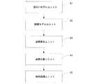
FIG. 1 is a schematic flow diagram of an urban road recognition method based on a laser point group according to a first embodiment of the present disclosure. The present embodiment can be applied when an object included in an urban road is recognized based on a laser point group. As shown in FIG. 1, the city road recognition method based on the laser point group according to the present embodiment specifically includes S11 to S13.
S11:レーザセンサにより収集されたレーザ点群に基づいて対応する道沿いモデルを構築する。
本実施例では、レーザセンサは、移動キャリアに設置されるレーザレーダーであってもよく、移動キャリアは、通常、車両であってもよく、レーザ点群は、移動キャリアが位置する環境の特徴点セットであってもよく、各特徴点の座標と反射率とを含み、当該反射率は0〜255の整数であってもよい。S11: A corresponding roadside model is constructed based on the laser point cloud collected by the laser sensor.
In this embodiment, the laser sensor may be a laser radar installed on a moving carrier, the moving carrier may be a vehicle, and the laser point group is a characteristic point of the environment where the moving carrier is located. It may be a set, including the coordinates of each feature point and the reflectance, and the reflectance may be an integer from 0 to 255.
例示的に、レーザレーダーは、レーザ点群を収集して、GPS(Global Positioning System、全地球測位システム)/IMU(Inertial measurement unit、慣性測定ユニット)によって、収集されたレーザ点群を世界座標系に変換して、世界座標系におけるレーザ点群をレジストレーションして密な点群にし、具体的に動的粒子ツリー(Simultaneous Localization And Mapping、SLAM)アルゴリズムによって密な点群のレジストレーション精度を向上させることができ、それによって、世界座標系においてレジストレーションして取得した密な点群と、1フレームを単位とする疎な規則的な点群との二種類の点群分類用生データを取得する。 For example, the laser radar collects the laser point cloud, and uses the global coordinate system (GPS) (Global Positioning System) / IMU (Inertial Measurement Unit) to collect the laser point cloud collected in the world coordinate system. , The laser point cloud in the world coordinate system is registered into a dense point cloud, and the registration accuracy of the dense point cloud is improved by a dynamic particle tree (Simultaneous Localization And Mapping, SLAM) algorithm. As a result, two types of raw data for classification of point groups, a dense point cloud obtained by registration in the world coordinate system and a sparse regular point cloud in units of one frame, are obtained. To do.
本実施例では、道沿いは道路の端を意味する。例示的に、密な点群とマルチフレームの疎な規則的な点群とを取得した後に、マルチフレームの疎な規則的な点群を処理して可能な道沿い点を取得して、可能な道沿い点に三次元スプライン(spline)曲線フィッティングを行って、マルチフレームの疎な規則的な点群に基づいてレーザ点群に対応する道沿いモデルを構築する。 In this embodiment, the roadside means the end of the road. For example, after acquiring dense point cloud and multi-frame sparse regular point cloud, multi-frame sparse regular point cloud can be processed to obtain possible roadside points A three-dimensional spline curve fitting is performed on a point along the road, and a roadside model corresponding to the laser point cloud is constructed based on the sparse regular point cloud of the multiframe.
S12:前記レーザセンサが設置された移動キャリアの高さを決定し、前記高さとレーザ点群とに基づいて対応する路面モデルを構築する。
本実施例では、路面は車両が走行するための道路表面を意味する。例示的に、疎な規則的な点群に回帰処理を行って移動キャリアの高さを取得し、移動キャリアの高さを回帰アルゴリズムの初期入力閾値として、各フレームの疎な規則的な点群に回帰処理を行って各フレームの疎な規則的な点群に対応する候補路面点群を取得して、連続的なマルチフレームの疎な規則的な点群に対応する候補路面点群をマージし、移動キャリアの走行軌跡の垂直方向に沿って1次元スプライン曲線フィッティングを行い、フィッティングして取得されたスプライン方程式パラメータを記憶し、レーザ点群に対応する路面モデルを取得する。S12: The height of the moving carrier on which the laser sensor is installed is determined, and a corresponding road surface model is constructed based on the height and the laser point group.
In this embodiment, the road surface means a road surface on which the vehicle travels. Illustratively, a regression process is performed on a sparse regular point cloud to obtain the height of the mobile carrier, and the sparse regular point cloud of each frame is obtained using the height of the mobile carrier as the initial input threshold of the regression algorithm. The candidate road surface point group corresponding to the sparse regular point group of each frame is obtained by performing a regression process, and the candidate road surface point group corresponding to the sparse regular point group of continuous multi-frame is merged. Then, one-dimensional spline curve fitting is performed along the vertical direction of the traveling locus of the moving carrier, the spline equation parameters obtained by the fitting are stored, and a road surface model corresponding to the laser point group is obtained.
S13:前記道沿いモデルと前記路面モデルとに基づいて、前記レーザ点群における路面点群及び道沿い点群を除去し、点群分割アルゴリズムによって残りのレーザ点群を分割し、分割結果に対応する物体を認識する。 S13: Based on the roadside model and the road surface model, the road surface point group and the roadside point group in the laser point group are removed, and the remaining laser point group is divided by a point group division algorithm, and the division result is supported. Recognizes the object
本実施例では、レーザ点群に対応する物体は、通行人、車両、木、建物等の障害物であってもよく、路標、地標等であってもよい。例示的に、道沿いモデルと路面モデルにと基づいて、S11で取得された密な点群における道沿い点群と路面点群とを除去し、残りのレーザ点群をクラスタリングしてほとんど分離したレーザ点群クラスタを取得して、点群分割アルゴリズムによってレーザ点群クラスタをサブレーザ点群クラスタに分割する。分割後のサブレーザ点群クラスタを取得した後に、あらかじめトレーニングしたサポートベクタマシンによって各サブレーザ点群クラスタを認識し、さらにサブレーザ点群クラスタに対応する物体を認識する。 In the present embodiment, the object corresponding to the laser point group may be an obstacle such as a passerby, a vehicle, a tree, or a building, or may be a road marker, a landmark, or the like. Illustratively, based on the roadside model and the road surface model, the roadside point cloud and the road surface point cloud in the dense point cloud acquired in S11 are removed, and the remaining laser point clouds are clustered and almost separated. A laser point cloud cluster is acquired, and the laser point cloud cluster is divided into sub-laser point cloud clusters by a point cloud division algorithm. After acquiring the divided sub-laser point group clusters, each sub-laser point group cluster is recognized by a support vector machine trained in advance, and an object corresponding to the sub-laser point group cluster is recognized.
本実施例に係るレーザ点群に基づく都市道路の認識方法は、レーザ点群に基づいて移動キャリアの高さを推定し、前記高さを用いて対応する路面モデルを構築することによって、路面モデルの構築効率と正確性とを向上させ、これにより、レーザ点群に対応する物体の認識効率と正確性とを向上させる。
[第2実施例]
本実施例は、上記実施例を基礎として、道沿いモデル、路面モデルの構築方式を更に限定するレーザ点群に基づく新たな都市道路の認識方法を提供する。図2は、本開示の第2実施例に係るレーザ点群に基づく都市道路の認識方法のフロー概略図である。図2に示されるように、本実施例に係るレーザ点群に基づく都市道路の認識方法は、具体的にS21〜S23を含む。The city road recognition method based on the laser point cloud according to the present embodiment estimates the height of the mobile carrier based on the laser point cloud, and constructs a corresponding road surface model using the height, thereby creating a road surface model. This improves the construction efficiency and accuracy of the object, thereby improving the recognition efficiency and accuracy of the object corresponding to the laser point cloud.
[Second Embodiment]
The present embodiment provides a new urban road recognition method based on a laser point group that further limits the construction method of the roadside model and the road surface model based on the above embodiment. FIG. 2 is a flow schematic diagram of an urban road recognition method based on a laser point cloud according to the second embodiment of the present disclosure. As shown in FIG. 2, the city road recognition method based on the laser point group according to the present embodiment specifically includes S21 to S23.
S21:レーザセンサにより収集されたレーザ点群に基づいて、対応する道沿いモデルを構築する。
オプションとして、レーザセンサにより収集されたレーザ点群に基づいて対応する道沿いモデルを構築するステップにおいては、具体的に、コーナー検出アルゴリズムによって前記レーザ点群を認識し、レーザ点群に対応する道沿い角点を取得するステップと、取得した道沿い角点に基づいて前記道沿いモデルを構築するステップと、を含む。S21: Build a corresponding roadside model based on the laser point cloud collected by the laser sensor.
As an option, in the step of constructing the corresponding roadside model based on the laser point cloud collected by the laser sensor, specifically, the laser point cloud is recognized by the corner detection algorithm, and the road corresponding to the laser point cloud is detected. Obtaining a roadside corner and building the roadside model based on the obtained roadside corner.
例示的に、各フレームの疎な規則的な点群を処理して候補道沿い点を取得する。具体的に、各フレームの疎な規則的な点群は、32本の線を含んでもよく、各フレームの疎な規則的な点群に対して、当該フレームの各線のデータにスライディングウィンドウの処理を行い、レーザ点群の勾配、密度、反射率の3つの特性によって道沿いを含む可能性がある候補ウィンドウを検出し、さらにコーナー検出アルゴリズムによって候補ウィンドウから候補道沿い角点を取得して、車の高さ等の予備知識に基づいて誤った候補角点をフィルタリングし、当該フレームにおけるすべての線について取得された候補角点を移動キャリアの走行方向に垂直な軸に投影し、投影点をクラスタリングし、加重ガウス畳み込みの投票アルゴリズムによって当該フレームの疎な点群に対応する道沿い角点を取得する。上記操作を繰り返して各フレームの疎な点群に対応する道沿い角点を取得した後に、あらゆる疎な点群に対応する道沿い角点を世界座標系に変換して、マージした後に統計フィルタリング技術でノイズを除去し、点群間引き技術でデータ量を減少させ、移動車両走行軌跡に沿ってカルマンフィルタリング技術で道沿いを修復し、次に、不規則的な角点を三次元スプライン曲線にフィッティングしてレーザ点群に対応する道沿いモデルを取得する。 Illustratively, sparse regular point clouds of each frame are processed to obtain points along the candidate road. Specifically, the sparse regular point cloud of each frame may include 32 lines, and for the sparse regular point cloud of each frame, the processing of the sliding window is performed on the data of each line of the frame. To detect candidate windows that may include roadsides by the three characteristics of the laser point cloud gradient, density, and reflectance, and to obtain candidate roadside corner points from the candidate window by the corner detection algorithm, Filter the wrong candidate corner points based on prior knowledge such as the height of the car, project the candidate corner points obtained for all the lines in the frame on the axis perpendicular to the traveling direction of the moving carrier, and Clustering is performed, and roadside corner points corresponding to sparse point groups of the frame are obtained by a weighted Gaussian convolution voting algorithm. Repeat the above operation to obtain roadside corner points corresponding to sparse point clouds in each frame, then convert roadside corner points corresponding to all sparse point clouds to the world coordinate system, merge them, and then perform statistical filtering The technology removes noise, the point cloud thinning technology reduces the amount of data, the road along the moving vehicle trajectory is repaired along the road with Kalman filtering technology, and then irregular corner points are converted into 3D spline curves. A model along the road corresponding to the laser point cloud is obtained by fitting.
なお、レーザ点群に対応する道沿いを直接認識する従来技術に比べて、本実施例は、まずコーナー検出方法でレーザ点群に対応する角点を取得し、次に角点をフィッティングして道沿いモデルを構築することによって、道沿いモデルの正確性を向上させる。 Compared to the conventional technology that directly recognizes the road corresponding to the laser point cloud, this embodiment first obtains the corner point corresponding to the laser point cloud by the corner detection method, and then fits the corner point. Improve the accuracy of the roadside model by building the roadside model.
S22:前記レーザセンサが設置された移動キャリア近傍の前記レーザ点群に基づいて前記移動キャリアの高さを推定し、前記高さを予め設定された回帰アルゴリズムの初期入力閾値とし、前記レーザ点群に基づいて対応する路面モデルを構築する。 S22: The height of the moving carrier is estimated based on the laser point group in the vicinity of the moving carrier where the laser sensor is installed, and the height is set as an initial input threshold value of a preset regression algorithm. The corresponding road surface model is constructed based on
オプションとして、前記レーザセンサが設置された移動キャリア近傍の前記レーザ点群に基づいて前記移動キャリアの高さを推定するステップにおいては、具体的に、前記レーザ点群を前記レーザセンサの座標を原点とする極座標グリッドに投影するステップと、レーザセンサ近傍のレーザ点群に対応する投影グリッドにRansac(ランダムサンプルコンセンサス、Random Sample Consensus)回帰を行って前記レーザセンサの高さを推定するステップと、を含む。 As an option, in the step of estimating the height of the moving carrier based on the laser point group in the vicinity of the moving carrier where the laser sensor is installed, specifically, the laser point group is set to the origin of the coordinates of the laser sensor. Projecting onto a polar coordinate grid, and estimating the height of the laser sensor by performing a Random Sample Consensus (Random Sample Consensus) regression on a projection grid corresponding to a laser point cloud near the laser sensor. Including.
例示的に、移動キャリア座標を原点とする極座標グリッド(Polar Grid Map)を作成し、1フレームの疎な点群における各点を極座標グリッドに投影し、レーザセンサ近傍のレーザ点群に対応する投影グリッドにRansac回帰を行ってレーザセンサの高さを推定し、推定したレーザセンサの高さを移動キャリアの高さとする。 Illustratively, a polar grid with a moving carrier coordinate as an origin is created, and each point in a sparse point group of one frame is projected onto the polar coordinate grid, and a projection corresponding to a laser point group near the laser sensor. Ransac regression is performed on the grid to estimate the height of the laser sensor, and the estimated height of the laser sensor is set as the height of the moving carrier.
オプションとして、前記回帰アルゴリズムがガウス過程回帰である場合、前記高さを予め設定された回帰アルゴリズムの初期入力閾値とし、前記レーザ点群に基づいて対応する路面モデルを構築するステップにおいては、具体的に、前記初期入力閾値に基づいて各フレームの前記レーザ点群に対応する投影グリッドにガウス過程回帰を行い、対応する候補路面点群を取得するステップと、前記候補路面点群にマージ及びサンプル回帰処理を行って前記路面モデルを取得するステップと、を含む。 As an option, when the regression algorithm is a Gaussian process regression, the height is set as an initial input threshold value of a preset regression algorithm, and a step of constructing a corresponding road surface model based on the laser point group is Performing a Gaussian process regression on the projection grid corresponding to the laser point group of each frame based on the initial input threshold to obtain a corresponding candidate road surface point group; and merging and sample regression to the candidate road surface point group Performing a process to obtain the road surface model.
例示的に、移動キャリアの高さを予め設定された回帰アルゴリズムの初期入力閾値(即ち閾値選択シード)とし、各フレームの疎な規則的な点群に回帰処理を行って各フレームの疎な規則的な点群の候補路面点群を取得して、連続的なマルチフレームの疎な規則的な点群に対応する候補路面点群をマージし、移動キャリア走行軌跡の垂直方向に沿って1次元スプラインフィッティングを行い、フィッティングして取得されたサンプル方程式パラメータを記憶し、完全な近似路面モデルを取得する。 Exemplarily, the height of the mobile carrier is set as an initial input threshold (that is, a threshold selection seed) of a preset regression algorithm, and regression processing is performed on a sparse regular point group of each frame to determine a sparse rule of each frame. Candidate point points of a typical point group, merge candidate point points corresponding to sparse, regular point groups of continuous multi-frame, one dimension along the vertical direction of the moving carrier travel locus Spline fitting is performed, sample equation parameters obtained by fitting are stored, and a complete approximate road surface model is obtained.
S23:前記道沿いモデルと前記路面モデルとに基づいて、前記レーザ点群における路面点群及び道沿い点群を除去し、点群分割アルゴリズムによって残りのレーザ点群を分割し、分割結果に対応する物体を認識する。 S23: Based on the roadside model and the road surface model, the road surface point cloud and the roadside point cloud in the laser point cloud are removed, the remaining laser point cloud is divided by a point cloud division algorithm, and the division result is supported. Recognizes the object
本実施例に係るレーザ点群に基づく都市道路の認識方法は、移動キャリアの高さをガウス過程回帰の初期入力閾値として対応する路面モデルを構築することによって、路面モデルの構築効率と正確性とを向上させ、また、コーナー検出アルゴリズムによって道沿いモデルを構築することによって、道沿いモデルの正確性を向上させ、これにより、レーザ点群に対応する物体の認識効率と正確性とを向上させる。
[第3実施例]
本実施例は、上記実施例を基礎として、点群分割方式を更に限定する別のレーザ点群に基づく都市道路の認識方法を提供する。図3は、本開示の第3実施例に係るレーザ点群に基づく都市道路の認識方法のフロー概略図である。図3に示されるように、本実施例に係るレーザ点群に基づく都市道路の認識方法は、具体的にS31〜S35を含む。The urban road recognition method based on the laser point cloud according to the present embodiment constructs a road surface model by using the height of the moving carrier as an initial input threshold value for Gaussian process regression, thereby improving the road surface model construction efficiency and accuracy. In addition, the accuracy of the roadside model is improved by constructing the roadside model by the corner detection algorithm, thereby improving the recognition efficiency and accuracy of the object corresponding to the laser point cloud.
[Third embodiment]
The present embodiment provides an urban road recognition method based on another laser point cloud that further limits the point cloud division method based on the above embodiment. FIG. 3 is a flow schematic diagram of an urban road recognition method based on a laser point cloud according to the third embodiment of the present disclosure. As shown in FIG. 3, the city road recognition method based on the laser point group according to the present embodiment specifically includes S31 to S35.
S31:レーザセンサにより収集されたレーザ点群に基づいて、対応する道沿いモデルを構築する。
S32:前記レーザセンサが設置された移動キャリアの高さを決定し、前記高さとレーザ点群とに基づいて対応する路面モデルを構築する。S31: A corresponding roadside model is constructed based on the laser point cloud collected by the laser sensor.
S32: The height of the moving carrier on which the laser sensor is installed is determined, and a corresponding road surface model is constructed based on the height and the laser point group.
S33、前記道沿いモデルと前記路面モデルとに基づいて、前記レーザ点群における路面点群及び道沿い点群を除去する。
例示的に、世界座標系における密な点群に対応する平均グリッドマップ(Mean Grid Map)、最小グリッドマップ(Min Grid Map)及び最大グリッドマップ(Max Grid Map)を作成し、閾値を選択して隣接グリッド間の勾配を特徴として無向グラフモデルを作成し、最大の2つの連通領域を取得し、最大の2つの連通領域を候補路面として候補路面近傍の路面グリッドを検索し、閾値を選択して路面グリッドにおける路面点群を取得して、これらの路面点群をフィルタリングし、即ち、密な点群における路面点群と道沿い点群とを除去する。S33, removing the road surface point group and the roadside point group in the laser point group based on the roadside model and the road surface model.
Illustratively, an average grid map (Mean Grid Map), a minimum grid map (Min Grid Map), and a maximum grid map (Max Grid Map) corresponding to dense points in the world coordinate system are created, and a threshold value is selected. Create an undirected graph model with the gradient between adjacent grids, obtain the maximum two communication areas, search for road grids near the candidate road surface using the two largest communication areas as candidate road surfaces, and select a threshold The road surface point group in the road surface grid is acquired, and these road surface point groups are filtered, that is, the road surface point group and the roadside point group in the dense point group are removed.
S34:点群分割アルゴリズムによって残りのレーザ点群を分割する。
オプションとして、点群分割アルゴリズムによって残りのレーザ点群を分割するステップは、以下のA、B及びCを含む。S34: The remaining laser point group is divided by the point group division algorithm.
Optionally, dividing the remaining laser point cloud by the point cloud splitting algorithm includes the following A, B and C:
A:残りのレーザ点群をクラスタリングして対応するレーザ点群クラスタを取得する。
例示的に、残りのレーザ点群にオイラークラスタリングを行って、ほとんど分離した点群クラスタを取得する。A: The remaining laser point cloud is clustered to obtain a corresponding laser point cloud cluster.
Illustratively, Euler clustering is performed on the remaining laser point clouds to obtain almost separate point cloud clusters.
B:前記レーザ点群クラスタに対応するスーパーボクセル(supervoxel)を作成する。
オプションとして、前記レーザ点群クラスタに対応するスーパーボクセルを作成するステップにおいては、具体的に、前記レーザ点群クラスタに対応する空間座標と反射率とに基づいて前記レーザ点群クラスタに対応するスーパーボクセルを作成するステップを含む。例示的に、各レーザ点群クラスタに対して、当該レーザ点群クラスタの空間座標と反射率とに基づいて当該レーザ点群クラスタのスーパーボクセルを作成する。B: A supervoxel corresponding to the laser point cloud cluster is created.
Optionally, in the step of creating a super voxel corresponding to the laser point cloud cluster, specifically, the super voxel corresponding to the laser point cloud cluster is based on spatial coordinates and reflectance corresponding to the laser point cloud cluster. Creating a voxel. Illustratively, for each laser point group cluster, a super voxel of the laser point group cluster is created based on the spatial coordinates and reflectance of the laser point group cluster.
C:前記スーパーボクセルを分割してサブレーザ点群クラスタを取得し、前記サブレーザ点群クラスタにマージ処理を行う。
レーザ点群クラスタを直接分割する従来技術の方法に比べて、本実施例は、レーザ点群クラスタに対応するスーパーボクセルを取得し、スーパーボクセルを分割してサブレーザ点群クラスタを取得することによって、点群分割の効率及び確率を向上させ、特に本実施例は、従来の点群分割方法のように移動キャリアが高速道路で走行している時に、路標がガードレールと密着する原因で点群分割効果が悪くなることを避ける。C: The super voxel is divided to acquire a sub laser point group cluster, and merge processing is performed on the sub laser point group cluster.
Compared to the prior art method of directly dividing the laser point cloud cluster, this embodiment obtains a super voxel corresponding to the laser point cloud cluster, and divides the super voxel to obtain a sub laser point cloud cluster. The efficiency and probability of point group division is improved, and in particular, this embodiment is a point group division effect due to the fact that the signpost is in close contact with the guardrail when the mobile carrier is traveling on the highway as in the conventional point group division method. Avoid getting worse.
オプションとして、前記サブレーザ点群クラスタにマージ処理を行うステップにおいては、主成分分析によって前記サブレーザ点群クラスタの形状特徴を取得するステップと、取得した形状特徴に基づいて前記サブレーザ点群クラスタにマージ処理を行うステップと、を含む。 As an option, in the step of performing merge processing on the sub-laser point cloud cluster, a step of acquiring a shape feature of the sub-laser point cloud cluster by principal component analysis, and a merge processing on the sub-laser point cloud cluster based on the acquired shape feature Performing the steps.
例示的に、各スーパーボクセルにランダムウォーカー(Random Walker)分割を行い、遷移分割したサブレーザ点群クラスタを取得して、各サブレーザ点群クラスタに主成分分析(Principal Component Analysis、PCA)を行ってサブレーザ点群クラスタの形状特徴を取得し、類似した形状特徴を有する隣接サブレーザ点群クラスタをマージして、最終的な点群分割結果を取得して、例えば、垂直方向において2つの形状が同じサブレーザ点群クラスタをマージする。本実施例は、サブレーザ点群クラスタにマージ処理を行うことによって、同じ物体が異なるサブレーザ点群クラスタに分割されることを避け、点群分割の合理性を向上させる。 For example, each super voxel is divided into random walker (Random Walker), a transition-divided sub-laser point cloud cluster is obtained, and a principal component analysis (Principal Component Analysis, PCA) is performed on each sub-laser point cloud cluster. Acquire shape characteristics of point cloud clusters, merge adjacent sublaser point cloud clusters having similar shape characteristics, and obtain final point cloud division results, for example, sublaser points with the same shape in the vertical direction Merge cluster clusters. In the present embodiment, the merge processing is performed on the sub-laser point group clusters, so that the same object is not divided into different sub-laser point group clusters, and the rationality of the point group division is improved.
S35:分割結果に対応する物体を認識する。
例示的に、分割後の点群クラスタを取得した後に、あらかじめトレーニングしたサポートベクタマシンによって各点群クラスタを認識し、最終的にレーザ点群に対応する物体を取得する。S35: Recognize an object corresponding to the division result.
Illustratively, after acquiring the divided point cloud clusters, each point cloud cluster is recognized by a support vector machine trained in advance, and finally an object corresponding to the laser point cloud is acquired.
本開示の実施例に係るレーザ点群に基づく都市道路の認識方法は、レーザ点群に対応する道沿い方程式、路面点群を取得することができ、レーザ点群に対応する路標、道標、障害物等の都市道路での物体を認識することができ、これらの結果を用いて高精度マップを製作することで、高精度マップの製作速度と製作精度とを向上させる。
[第4実施例]
図4は、本開示の第4実施例に係るレーザ点群に基づく都市道路の認識装置の構造模式図である。本実施例は、レーザ点群に基づいて都市道路に含まれる物体を認識する場合に適用することができる。図4に示されるように、当該レーザ点群に基づく都市道路の認識装置は、具体的に、
レーザセンサにより収集されたレーザ点群に基づいて対応する道沿いモデルを構築する道沿いモデルユニット41と、
前記レーザセンサが設置された移動キャリアの高さを決定し、前記高さとレーザ点群とに基づいて対応する路面モデルを構築する路面モデルユニット42と、
前記道沿いモデルと前記路面モデルとに基づいて、前記レーザ点群における路面点群及び道沿い点群を除去する点群除去ユニット43と、
点群分割アルゴリズムによって残りのレーザ点群を分割する点群分割ユニット44と、
前記点群分割ユニットの分割結果に対応する物体を認識する物体認識ユニット45と、を備える。A method for recognizing an urban road based on a laser point cloud according to an embodiment of the present disclosure can acquire a roadside equation and a road surface point group corresponding to the laser point cloud, and a road marker, a signpost, and an obstacle corresponding to the laser point cloud. An object on an urban road such as an object can be recognized, and the production speed and production accuracy of the high-precision map are improved by producing a high-precision map using these results.
[Fourth embodiment]
FIG. 4 is a structural schematic diagram of a city road recognition device based on a laser point group according to the fourth embodiment of the present disclosure. The present embodiment can be applied when an object included in an urban road is recognized based on a laser point group. As shown in FIG. 4, the urban road recognition device based on the laser point cloud specifically includes:
A
A road
Based on the roadside model and the road surface model, a point
A point
An
好ましくは、前記路面モデルユニット42は、
前記レーザセンサが設置された移動キャリア近傍の前記レーザ点群に基づいて前記移動キャリアの高さを推定する高度推定サブユニットと、
前記高さを予め設定された回帰アルゴリズムの初期入力閾値とし、前記レーザ点群に基づいて対応する路面モデルを構築する路面構築サブユニットと、を備える。Preferably, the road
An altitude estimation subunit that estimates the height of the mobile carrier based on the laser point cloud in the vicinity of the mobile carrier where the laser sensor is installed;
A road surface construction subunit that uses the height as an initial input threshold value of a preset regression algorithm and constructs a corresponding road surface model based on the laser point group.
好ましくは、前記高度推定サブユニットは、具体的に、
前記レーザ点群を前記レーザセンサの座標を原点とする極座標グリッドに投影し、
レーザセンサ近傍のレーザ点群に対応する投影グリッドにRansac回帰を行って、前記レーザセンサの高さを推定する。Preferably, the altitude estimation subunit is specifically:
Projecting the laser point cloud onto a polar coordinate grid with the coordinates of the laser sensor as the origin,
Ransac regression is performed on the projection grid corresponding to the laser point group near the laser sensor to estimate the height of the laser sensor.
オプションとして、回帰アルゴリズムがガウス過程回帰である場合、前記路面構築サブユニットは、具体的に、
前記初期入力閾値に基づいて各フレームの前記レーザ点群に対応する投影グリッドにガウス過程回帰を行い、対応する候補路面点群を取得し、
前記候補路面点群にマージ及びサンプル回帰処理を行って前記路面モデルを取得する。Optionally, if the regression algorithm is Gaussian process regression, the road surface building subunit is specifically:
Performing a Gaussian process regression on the projection grid corresponding to the laser point cloud of each frame based on the initial input threshold to obtain a corresponding candidate road surface point cloud;
The road surface model is obtained by performing merge and sample regression processing on the candidate road surface point group.
オプションとして、前記道沿いモデルユニット41は、
コーナー検出アルゴリズムによって前記レーザ点群を認識し、レーザ点群に対応する道沿い角点を取得する角点取得サブユニットと、
取得した道沿い角点に基づいて前記道沿いモデルを構築する道沿い構築サブユニットと、を備える。As an option, the
Recognizing the laser point cloud by a corner detection algorithm, and obtaining a corner point along the road corresponding to the laser point cloud;
A roadside building subunit that builds the roadside model based on the acquired roadside corner points.
オプションとして、点群分割ユニット44は、
残りのレーザ点群をクラスタリングして対応するレーザ点群クラスタを取得する点群クラスタサブユニットと、
前記レーザ点群クラスタに対応するスーパーボクセルを作成するスーパーボクセルサブユニットと、
前記スーパーボクセルを分割してサブレーザ点群クラスタを取得するサブ点群クラスタサブユニットと、
前記サブレーザ点群クラスタにマージ処理を行うマージ処理サブユニットとを備える。As an option, the point
A point cloud cluster subunit that clusters the remaining laser point clouds to obtain the corresponding laser point cloud clusters;
A super voxel subunit that creates a super voxel corresponding to the laser point cloud cluster;
A sub-point cloud cluster subunit that obtains a sub-laser point cloud cluster by dividing the super voxel; and
A merge processing subunit that performs merge processing on the sub-laser point cloud cluster.
オプションとして、スーパーボクセルサブユニットは具体的に、前記レーザ点群クラスタに対応する空間座標と反射率とに基づいて前記レーザ点群クラスタに対応するスーパーボクセルを作成する。 Optionally, the super voxel subunit specifically creates a super voxel corresponding to the laser point cloud cluster based on spatial coordinates and reflectance corresponding to the laser point cloud cluster.
オプションとして、マージ処理サブユニットは具体的に、
主成分分析によって前記サブレーザ点群クラスタの形状特徴を取得し、
取得した形状特徴に基づいて前記サブレーザ点群クラスタにマージ処理を行う。Optionally, the merge processing subunit is specifically
Obtain the shape characteristics of the sub-laser point cloud cluster by principal component analysis,
Based on the acquired shape feature, a merge process is performed on the sub-laser point cloud cluster.
上記製品は、本開示のいずれかの実施例に係るレーザ点群に基づく都市道路の認識方法を実行でき、実行方法に対応する機能モジュールと有益な効果を有する。本実施例において詳しく説明されていない技術的詳細は、本開示のいずれかの実施例に係るレーザ点群に基づく都市道路の認識方法を参照すればよい。
[第5実施例]
本開示の実施例は、コンピュータ実行可能命令を含む記憶媒体を提供し、前記コンピュータ実行可能命令がコンピュータプロセッサで実行される場合、レーザ点群に基づく都市道路の認識方法を実行し、当該方法は、
レーザセンサにより収集されたレーザ点群に基づいて対応する道沿いモデルを構築するステップと、
前記レーザセンサが設置された移動キャリアの高さを決定し、前記高さとレーザ点群とに基づいて対応する路面モデルを構築するステップと、
前記道沿いモデルと前記路面モデルとに基づいて、前記レーザ点群における路面点群及び道沿い点群を除去し、点群分割アルゴリズムによって残りのレーザ点群を分割し、分割結果に対応する物体を認識するステップと、を含む。The above product can execute a method for recognizing a city road based on a laser point cloud according to any embodiment of the present disclosure, and has a beneficial effect with a functional module corresponding to the execution method. For technical details not described in detail in the present embodiment, a method for recognizing a city road based on a laser point group according to any embodiment of the present disclosure may be referred to.
[Fifth embodiment]
Embodiments of the present disclosure provide a storage medium that includes computer-executable instructions, and when the computer-executable instructions are executed by a computer processor, perform a method for recognizing city roads based on laser point clouds, ,
Building a corresponding roadside model based on the laser point cloud collected by the laser sensor;
Determining the height of the mobile carrier on which the laser sensor is installed, and building a corresponding road surface model based on the height and the laser point cloud;
Based on the roadside model and the road surface model, the road surface point cloud and the roadside point cloud in the laser point cloud are removed, the remaining laser point cloud is divided by a point cloud division algorithm, and the object corresponding to the division result Recognizing.
上記記憶媒体が前記方法を実行する時に、前記レーザセンサが設置された移動キャリアの高さを決定し、前記高さとレーザ点群とに基づいて対応する路面モデルを構築するステップにおいては、さらに具体的に、
前記レーザセンサが設置された移動キャリア近傍の前記レーザ点群に基づいて前記移動キャリアの高さを推定し、前記高さを予め設定された回帰アルゴリズムの初期入力閾値とし、前記レーザ点群に基づいて対応する路面モデルを構築するステップを含んでもよい。In the step of determining the height of the moving carrier on which the laser sensor is installed when the storage medium executes the method, and constructing a corresponding road surface model based on the height and the laser point group, more specifically, The
The height of the moving carrier is estimated based on the laser point group in the vicinity of the moving carrier where the laser sensor is installed, the height is set as an initial input threshold value of a preset regression algorithm, and based on the laser point group And building a corresponding road surface model.
上記記憶媒体が前記方法を実行する時に、前記レーザセンサが設置された移動キャリア近傍の前記レーザ点群に基づいて前記移動キャリアの高さを推定するステップにおいては、さらに具体的に、
前記レーザ点群を前記レーザセンサの座標を原点とする極座標グリッドに投影するステップと、
レーザセンサ近傍のレーザ点群に対応する投影グリッドにRansac回帰を行って、前記レーザセンサの高さを推定するステップと、を含んでもよい。More specifically, in the step of estimating the height of the moving carrier based on the laser point group in the vicinity of the moving carrier where the laser sensor is installed when the storage medium executes the method,
Projecting the laser point cloud onto a polar coordinate grid with the coordinates of the laser sensor as the origin;
Performing a Ransac regression on a projection grid corresponding to a laser point group near the laser sensor to estimate the height of the laser sensor.
上記記憶媒体が前記方法を実行する時に、前記回帰アルゴリズムはガウス過程回帰であり、
前記高さを予め設定された回帰アルゴリズムの初期入力閾値とし、前記レーザ点群に基づいて対応する路面モデルを構築するステップにおいては、さらに具体的に、
前記初期入力閾値に基づいて各フレームの前記レーザ点群に対応する投影グリッドにガウス過程回帰を行い、対応する候補路面点群を取得するステップと、
前記候補路面点群にマージ及びサンプル回帰処理を行って前記路面モデルを取得するステップと、を含んでもよい。When the storage medium performs the method, the regression algorithm is a Gaussian process regression;
In the step of setting the height as an initial input threshold value of a preset regression algorithm and constructing a corresponding road surface model based on the laser point cloud, more specifically,
Performing a Gaussian process regression on the projection grid corresponding to the laser point cloud of each frame based on the initial input threshold to obtain a corresponding candidate road surface point cloud;
Performing a merge and sample regression process on the candidate road surface point group to obtain the road surface model.
上記記憶媒体が前記方法を実行する時に、レーザセンサにより収集されたレーザ点群に基づいて対応する道沿いモデルを構築するステップにおいては、さらに具体的に、
コーナー検出アルゴリズムによって前記レーザ点群を認識し、レーザ点群に対応する道沿い角点を取得するステップと、
取得した道沿い角点に基づいて前記道沿いモデルを構築するステップと、を含んでもよい。In the step of building a corresponding roadside model based on the laser point cloud collected by the laser sensor when the storage medium performs the method, more specifically,
Recognizing the laser point cloud by a corner detection algorithm and obtaining a roadside corner point corresponding to the laser point cloud;
Building the roadside model based on the acquired roadside corner points.
上記記憶媒体が前記方法を実行する時に、点群分割アルゴリズムによって残りのレーザ点群を分割するステップにおいては、さらに具体的に、
残りのレーザ点群をクラスタリングして対応するレーザ点群クラスタを取得するステップと、
前記レーザ点群クラスタに対応するスーパーボクセルを作成するステップと、
前記スーパーボクセルを分割してサブレーザ点群クラスタを取得し、前記サブレーザ点群クラスタにマージ処理を行うステップと、を含んでもよい。In the step of dividing the remaining laser point cloud by the point cloud division algorithm when the storage medium executes the method, more specifically,
Clustering the remaining laser point clouds to obtain corresponding laser point cloud clusters;
Creating a super voxel corresponding to the laser point cloud cluster;
Dividing the super voxel to obtain a sub-laser point cloud cluster, and performing a merge process on the sub-laser point cloud cluster.
上記記憶媒体が前記方法を実行する時に、前記レーザ点群クラスタに対応するスーパーボクセルを作成するステップにおいては、さらに具体的に、
前記レーザ点群クラスタに対応する空間座標と反射率とに基づいて前記レーザ点群クラスタに対応するスーパーボクセルを作成するステップを含んでもよい。In the step of creating a super voxel corresponding to the laser point cloud cluster when the storage medium performs the method, more specifically,
A step of creating a super voxel corresponding to the laser point group cluster based on a spatial coordinate and a reflectance corresponding to the laser point group cluster may be included.
上記記憶媒体が前記方法を実行する時に、前記サブレーザ点群クラスタにマージ処理を行うステップにおいては、さらに具体的に、
主成分分析によって前記サブレーザ点群クラスタの形状特徴を取得するステップと、
取得した形状特徴に基づいて前記サブレーザ点群クラスタにマージ処理を行うステップと、を含んでもよい。
[第6実施例]
図5は本開示の第6実施例に係るレーザ点群に基づく都市道路の認識方法を実行する機器のハードウェアの構造模式図である。図5に示されるように、当該機器は、
1つ又は複数のプロセッサ510(図5中、1つを例とする)と、
メモリ520と、
1つ又は複数のモジュールとを備える。More specifically, in the step of performing a merge process on the sub-laser point cloud cluster when the storage medium executes the method,
Obtaining a shape feature of the sub-laser point cloud cluster by principal component analysis;
Performing a merge process on the sub-laser point cloud cluster based on the acquired shape feature.
[Sixth embodiment]
FIG. 5 is a schematic diagram of the hardware structure of a device that executes an urban road recognition method based on a laser point group according to the sixth embodiment of the present disclosure. As shown in FIG.
One or more processors 510 (one in FIG. 5 as an example);
A
One or more modules.
前記機器はさらに、入力装置530と出力装置540と、を備えてもよい。前記装置のプロセッサ510、メモリ520、入力装置530及び出力装置540はバス又はその他の方式によって接続されることができ、図5において、バス接続を例にする。 The device may further include an
メモリ520はコンピュータ読み取り可能な記録媒体として、ソフトウェアプログラム、コンピュータ実行可能プログラム及びモジュール、例えば、本開示の実施例におけるレーザ点群に基づく都市道路の認識方法に対応するプログラム命令/モジュール(例えば、図4に示されるレーザ点群に基づく都市道路の認識装置の道沿いモデルユニット41、路面モデルユニット42、点群除去ユニット43、点群分割ユニット44及び物体認識ユニット45)を記憶することに用いられてもよい。プロセッサ510は、メモリ520に記憶されるソフトウェアプログラム、コマンド及びモジュールを実行することによって、機器の各種の機能アプリケーション及びデータ処理を実行し、即ち、上記方法の実施例に係るレーザ点群に基づく都市道路の認識方法を実現する。 The
メモリ520は、オペレーティングシステム、少なくとも1つ機能に必要なアプリケーションプログラムを記憶可能なプログラム記憶領域と、端末装置の使用に応じて作成するデータ等を記憶可能なデータ記憶領域とを含んでもよい。この他、メモリ520は高速ランダム・アクセス・メモリを含んでもよく、さらに不揮発性メモリ、例えば少なくとも1つの磁気ディスク記憶デバイス、フラッシュメモリデバイスや、又はほかの不揮発性ソリッドステートメモリデバイスを含んでもよい。いくつかの実施例では、メモリ520は更に、プロセッサ510に対して遠隔に設置されたメモリを含んでもよく、これらリモートメモリは、ネットワークを介して端末装置に接続されてもよい。上記ネットワークの例は、インターネット、企業イントラネット、ローカルエリアネットワーク、移動体通信ネットワーク及びそれらの組合せを含むが、これらに限定されない。 The
入力装置530は、入力したデジタルまたは文字情報を受信し、及び端末のユーザ設定及び機能制御に関連するキー信号入力を生成することに用いられ取得する。出力装置540はディスプレイスクリーン等の表示装置を含んでもよい。 The
前記1つ又は複数のモジュールは前記メモリ520に記憶され、前記1つ又は複数のプロセッサ510で実行される場合、
レーザセンサにより収集されたレーザ点群に基づいて対応する道沿いモデルを構築する操作と、
前記レーザセンサが設置された移動キャリアの高さを決定し、前記高さとレーザ点群とに基づいて対応する路面モデルを構築する操作と、
前記道沿いモデルと前記路面モデルとに基づいて、前記レーザ点群における路面点群及び道沿い点群を除去し、点群分割アルゴリズムによって残りのレーザ点群を分割し、分割結果に対応する物体を認識する操作と、を実行する。When the one or more modules are stored in the
Building a corresponding roadside model based on the laser point cloud collected by the laser sensor;
The operation of determining the height of the moving carrier on which the laser sensor is installed, and constructing a corresponding road surface model based on the height and the laser point cloud,
Based on the roadside model and the road surface model, the road surface point cloud and the roadside point cloud in the laser point cloud are removed, the remaining laser point cloud is divided by a point cloud division algorithm, and the object corresponding to the division result And an operation for recognizing.
更に、前記レーザセンサが設置された移動キャリアの高さを決定し、前記高さとレーザ点群とに基づいて対応する路面モデルを構築するステップにおいては、
前記レーザセンサが設置された移動キャリア近傍の前記レーザ点群に基づいて前記移動キャリアの高さを推定し、前記高さを予め設定された回帰アルゴリズムの初期入力閾値とし、前記レーザ点群に基づいて対応する路面モデルを構築するステップを含んでもよい。Further, in the step of determining the height of the moving carrier on which the laser sensor is installed and constructing a corresponding road surface model based on the height and the laser point cloud,
The height of the moving carrier is estimated based on the laser point group in the vicinity of the moving carrier where the laser sensor is installed, the height is set as an initial input threshold value of a preset regression algorithm, and based on the laser point group And building a corresponding road surface model.
更に、前記レーザセンサが設置された移動キャリア近傍の前記レーザ点群に基づいて前記移動キャリアの高さを推定するステップにおいては、
前記レーザ点群を前記レーザセンサの座標を原点とする極座標グリッドに投影するステップと、
レーザセンサ近傍のレーザ点群に対応する投影グリッドに対してRansac回帰を行って前記レーザセンサの高さを推定するステップと、を含んでもよい。Further, in the step of estimating the height of the moving carrier based on the laser point group in the vicinity of the moving carrier where the laser sensor is installed,
Projecting the laser point cloud onto a polar coordinate grid with the coordinates of the laser sensor as the origin;
Performing a ransac regression on the projection grid corresponding to the laser point group near the laser sensor to estimate the height of the laser sensor.
更に、前記回帰アルゴリズムがガウス過程回帰である場合、
前記高さを予め設定された回帰アルゴリズムの初期入力閾値とし、前記レーザ点群に基づいて対応する路面モデルを構築するステップにおいては、
前記初期入力閾値に基づいて各フレームの前記レーザ点群に対応する投影グリッドにガウス過程回帰を行い、対応する候補路面点群を取得するステップと、
前記候補路面点群にマージ及びサンプル回帰処理を行って前記路面モデルを取得するステップと、を含んでもよい。Further, when the regression algorithm is a Gaussian process regression,
In the step of setting the height as an initial input threshold value of a preset regression algorithm and constructing a corresponding road surface model based on the laser point cloud,
Performing a Gaussian process regression on the projection grid corresponding to the laser point cloud of each frame based on the initial input threshold to obtain a corresponding candidate road surface point cloud;
Performing a merge and sample regression process on the candidate road surface point group to obtain the road surface model.
更に、レーザセンサにより収集されたレーザ点群に基づいて対応する道沿いモデルを構築するステップにおいては、
コーナー検出アルゴリズムによって前記レーザ点群を認識し、レーザ点群に対応する道沿い角点を取得するステップと、
取得した道沿い角点に基づいて前記道沿いモデルを構築するステップと、を含んでもよい。Furthermore, in the step of building a corresponding roadside model based on the laser point cloud collected by the laser sensor,
Recognizing the laser point cloud by a corner detection algorithm and obtaining a roadside corner point corresponding to the laser point cloud;
Building the roadside model based on the acquired roadside corner points.
更に、点群分割アルゴリズムによって残りのレーザ点群を分割するステップにおいては、
残りのレーザ点群をクラスタリングして対応するレーザ点群クラスタを取得するステップと、
前記レーザ点群クラスタに対応するスーパーボクセルを作成するステップと、
前記スーパーボクセルを分割してサブレーザ点群クラスタを取得し、前記サブレーザ点群クラスタにマージ処理を行うステップと、を含んでもよい。Further, in the step of dividing the remaining laser point cloud by the point cloud division algorithm,
Clustering the remaining laser point clouds to obtain corresponding laser point cloud clusters;
Creating a super voxel corresponding to the laser point cloud cluster;
Dividing the super voxel to obtain a sub-laser point cloud cluster, and performing a merge process on the sub-laser point cloud cluster.
更に、前記レーザ点群クラスタに対応するスーパーボクセルを作成するステップにおいては、具体的に、
前記レーザ点群クラスタに対応する空間座標と反射率とに基づいて前記レーザ点群クラスタに対応するスーパーボクセルを作成するステップを含んでもよい。Further, in the step of creating a super voxel corresponding to the laser point cloud cluster, specifically,
A step of creating a super voxel corresponding to the laser point group cluster based on a spatial coordinate and a reflectance corresponding to the laser point group cluster may be included.
更に、前記サブレーザ点群クラスタにマージ処理を行うステップにおいては、
主成分分析によって前記サブレーザ点群クラスタの形状特徴を取得するステップと、
取得した形状特徴に基づいて前記サブレーザ点群クラスタにマージ処理を行うステップとを含んでもよい。Furthermore, in the step of performing a merge process on the sub laser point cloud cluster,
Obtaining a shape feature of the sub-laser point cloud cluster by principal component analysis;
Performing a merge process on the sub-laser point cloud cluster based on the acquired shape feature.
上記実施形態の説明によれば、当業者は、本発明がソフトウェア、および必要な汎用ハードウェアにより実現されてもよく、勿論ハードウェアにより実現されてもよいが、多くの場合、前者が好ましい実施形態であると理解すべきである。このような理解に基づいて、本発明の技術案は、実質的な部分、または従来技術を改良する部分をソフトウェア製品の形態で実現してもよい。当該コンピュータソフトウェア製品は、コンピュータ読み取り可能な記録媒体、例えばコンピュータのフロッピーディスク、光ディスク、読み出し専用メモリ(Read−Only Memor、ROM)、ランダムアクセスメモリ(Random Access Memory、RAM)などに記憶されてもよく、且つコンピュータ機器(パソコン、サーバ、またはネットワーク機器などであってもよく)に本発明の各実施例に係る方法を実行させる複数の命令を含む。 According to the description of the above embodiment, those skilled in the art will understand that the present invention may be realized by software and necessary general-purpose hardware, and of course by hardware, but in many cases, the former is preferable. It should be understood as a form. Based on this understanding, the technical solution of the present invention may realize a substantial part or a part improving the conventional technique in the form of a software product. The computer software product may be stored in a computer-readable recording medium such as a computer floppy disk, optical disk, read-only memory (Read-Only Memory, ROM), random access memory (Random Access Memory, RAM), and the like. And a plurality of instructions for causing a computer device (which may be a personal computer, a server, or a network device) to execute the method according to each embodiment of the present invention.
注意すべきは、上記レーザ点群に基づく都市道路の認識装置の実施例中に含まれる各モジュールとサブモジュールとが、機能ロジックのみに応じて区画されるが、上記区画に限定されない。対応する機能を実現することができればよい。また、各機能ユニットの具体的な名称は、単に区別を容易にするためのものであり、本発明の保護範囲を限定するものではない。 It should be noted that each module and sub-module included in the embodiment of the city road recognition apparatus based on the laser point cloud are partitioned according to only the functional logic, but are not limited to the partition. It suffices if the corresponding function can be realized. Further, the specific names of the functional units are merely for facilitating the distinction and do not limit the protection scope of the present invention.
以上で説明したのは、本発明の具体的な実施形態だけであり、本発明の保護範囲は、これらに限定されるものではない。いかなる当業者が本発明に開示された技術範囲内に容易に想到できる変更または置換の全ては、本発明の保護範囲内に入るべきである。従って、本発明の保護範囲は、添付される特許請求の範囲を基準としているものである。 What has been described above is only a specific embodiment of the present invention, and the protection scope of the present invention is not limited thereto. All modifications or substitutions readily conceivable by any person skilled in the art within the technical scope disclosed in the present invention should fall within the protection scope of the present invention. Accordingly, the protection scope of the present invention shall be based on the appended claims.
Claims (16)
Translated fromJapanese前記レーザセンサが設置された移動キャリアの高さを決定し、前記高さとレーザ点群とに基づいて対応する路面モデルを構築するステップと、
前記道沿いモデルと前記路面モデルとに基づいて、前記レーザ点群における路面点群及び道沿い点群を除去し、点群分割アルゴリズムによって残りのレーザ点群を分割し、分割結果に対応する物体を認識するステップと、を含み、
前記レーザセンサが設置された移動キャリアの高さを決定し、前記高さとレーザ点群に基づいて対応する路面モデルを構築するステップにおいては、
前記レーザセンサが設置された移動キャリア近傍の前記レーザ点群に基づいて、前記移動キャリアの高さを推定し、前記高さを予め設定された回帰アルゴリズムの初期入力閾値とし、前記レーザ点群に基づいて対応する路面モデルを構築するステップを含む
ことを特徴とするレーザ点群に基づく都市道路の認識方法。Building a corresponding roadside model based on the laser point cloud collected by the laser sensor;
Determining the height of the mobile carrier on which the laser sensor is installed, and building a corresponding road surface model based on the height and the laser point cloud;
Based on the roadside model and the road surface model, the road surface point cloud and the roadside point cloud in the laser point cloud are removed, the remaining laser point cloud is divided by a point cloud division algorithm, and the object corresponding to the division result and the step of recognizing,only including,
In the step of determining the height of the moving carrier on which the laser sensor is installed and constructing a corresponding road surface model based on the height and the laser point cloud,
Based on the laser point group in the vicinity of the moving carrier where the laser sensor is installed, the height of the moving carrier is estimated, and the height is set as an initial input threshold value of a preset regression algorithm. recognition method of urban road basedthe step of constructing the corresponding road model based on the laser point cloud, whereinincluding that.
前記レーザ点群を、前記レーザセンサの座標を原点とする極座標グリッドに投影するステップと、
レーザセンサ近傍のレーザ点群に対応する投影グリッドにRansac回帰を行って前記レーザセンサの高さを推定するステップと、を含む
ことを特徴とする請求項1に記載の方法。In the step of estimating the height of the moving carrier based on the laser point group in the vicinity of the moving carrier where the laser sensor is installed,
Projecting the laser point cloud onto a polar coordinate grid with the coordinates of the laser sensor as the origin;
The method according to claim1, characterized in that it comprises the steps of estimating the height of said laser sensor to the projection grid corresponding to the laser point cloud near the laser sensor performs Ransac regression, a.
前記高さを予め設定された回帰アルゴリズムの初期入力閾値とし、前記レーザ点群に基づいて対応する路面モデルを構築するステップにおいては、
前記初期入力閾値に基づいて各フレームの前記レーザ点群に対応する投影グリッドにガウス過程回帰を行って、対応する候補路面点群を取得するステップと、
前記候補路面点群にマージ及びサンプル回帰処理を行って前記路面モデルを取得するステップと、を含む
ことを特徴とする請求項1に記載の方法。The regression algorithm is Gaussian process regression;
In the step of setting the height as an initial input threshold value of a preset regression algorithm and constructing a corresponding road surface model based on the laser point cloud,
Performing a Gaussian process regression on the projection grid corresponding to the laser point cloud of each frame based on the initial input threshold to obtain a corresponding candidate road surface point cloud;
The method according to claim1 , further comprising: performing merge and sample regression processing on the candidate road surface point group to obtain the road surface model.
コーナー検出アルゴリズムによって前記レーザ点群を認識し、レーザ点群に対応する道沿い角点を取得するステップと、
取得した道沿い角点に基づいて前記道沿いモデルを構築するステップと、を含む
ことを特徴とする請求項1に記載の方法。In building the corresponding roadside model based on the laser point cloud collected by the laser sensor,
Recognizing the laser point cloud by a corner detection algorithm and obtaining a roadside corner point corresponding to the laser point cloud;
The method of claim 1, comprising building the roadside model based on the acquired roadside corner points.
残りのレーザ点群をクラスタリングして対応するレーザ点群クラスタを取得するステップと、
前記レーザ点群クラスタに対応するスーパーボクセルを作成するするステップと、
前記スーパーボクセルを分割してサブレーザ点群クラスタを取得し、前記サブレーザ点群クラスタにマージ処理を行うステップと、を含む
ことを特徴とする請求項1に記載の方法。In the step of dividing the remaining laser point cloud by the point cloud division algorithm,
Clustering the remaining laser point clouds to obtain corresponding laser point cloud clusters;
Creating a super voxel corresponding to the laser point cloud cluster;
The method according to claim 1, further comprising: dividing the super voxel to obtain a sub-laser point cloud cluster and performing a merge process on the sub-laser point cloud cluster.
前記レーザ点群クラスタに対応する空間座標と反射率とに基づいて、前記レーザ点群クラスタに対応するスーパーボクセルを作成するステップを含む
ことを特徴とする請求項5に記載の方法。In the step of creating a super voxel corresponding to the laser point cloud cluster,
6. The method of claim5 , comprising creating a super voxel corresponding to the laser point cloud cluster based on spatial coordinates and reflectance corresponding to the laser point cloud cluster.
主成分分析によって前記サブレーザ点群クラスタの形状特徴を取得するステップと、
取得した形状特徴に基づいて前記サブレーザ点群クラスタにマージ処理を行うステップと、を含む
ことを特徴とする請求項5に記載の方法。In the step of performing a merge process on the sub-laser point cloud cluster,
Obtaining a shape feature of the sub-laser point cloud cluster by principal component analysis;
The method according to claim5, characterized in that it comprises a step of performing a merge process on the Sabureza point group clusters based on the acquired shape feature.
前記レーザセンサが設置された移動キャリアの高さを決定し、前記高さとレーザ点群とに基づいて対応する路面モデルを構築する路面モデルユニットと、
前記道沿いモデルと前記路面モデルとに基づいて、前記レーザ点群における路面点群及び道沿い点群を除去する点群除去ユニットと、
点群分割アルゴリズムによって残りのレーザ点群を分割する点群分割ユニットと、
前記点群分割ユニットの分割結果に対応する物体を認識する物体認識ユニットと、を備え、
前記路面モデルユニットは
前記レーザセンサが設置された移動キャリア近傍の前記レーザ点群に基づいて前記移動キャリアの高さを推定する高度推定サブユニットと、
前記高さを予め設定された回帰アルゴリズムの初期入力閾値とし、前記レーザ点群に基づいて対応する路面モデルを構築する路面構築サブユニットと、を備える
ことを特徴とするレーザ点群に基づく都市道路の認識装置。A roadside model unit that builds a corresponding roadside model based on the laser point cloud collected by the laser sensor;
A road surface model unit that determines the height of the mobile carrier on which the laser sensor is installed, and constructs a corresponding road surface model based on the height and the laser point cloud;
Based on the roadside model and the road surface model, a point cloud removal unit that removes the road surface point cloud and the roadside point cloud in the laser point cloud;
A point cloud splitting unit that splits the remaining laser point cloud by a point cloud splitting algorithm;
An object recognition unit for recognizing an object corresponding to the division result of the point group division unit,
The road surface model unit is
An altitude estimation subunit that estimates the height of the mobile carrier based on the laser point cloud in the vicinity of the mobile carrier where the laser sensor is installed;
City as an initial input threshold of a preset regression algorithm the height, based on the laser point cloud ofthe road surface constructed subunit to construct a road surface model corresponding based on the laser point cloud, characterized in that Ruprovided with Road recognition device.
前記レーザ点群を、前記レーザセンサの座標を原点とする極座標グリッドに投影し、
レーザセンサ近傍のレーザ点群に対応する投影グリッドにRansac回帰を行って前記レーザセンサの高さを推定する
ことを特徴とする請求項8に記載の装置。The altitude estimation subunit is:
The laser point cloud is projected onto a polar coordinate grid with the coordinates of the laser sensor as the origin,
The apparatus according to claim8 , wherein the height of the laser sensor is estimated by performing Ransac regression on a projection grid corresponding to a laser point group in the vicinity of the laser sensor.
前記初期入力閾値に基づいて各フレームの前記レーザ点群に対応する投影グリッドにガウス過程回帰を行い、対応する候補路面点群を取得し、
前記候補路面点群にマージ及びサンプル回帰処理を行って前記路面モデルを取得する
ことを特徴とする請求項8に記載の装置。When the regression algorithm is Gaussian process regression, the road surface building subunit is
Performing a Gaussian process regression on the projection grid corresponding to the laser point cloud of each frame based on the initial input threshold to obtain a corresponding candidate road surface point cloud;
The apparatus according to claim8 , wherein the road surface model is acquired by performing merge and sample regression processing on the candidate road surface point group.
コーナー検出アルゴリズムによって前記レーザ点群を認識し、レーザ点群に対応する道沿い角点を取得する角点取得サブユニットと、
取得した道沿い角点に基づいて前記道沿いモデルを構築する道沿い構築サブユニットと、を備える
ことを特徴とする請求項8に記載の装置。The model unit along the road is
Recognizing the laser point cloud by a corner detection algorithm, and obtaining a corner point along the road corresponding to the laser point cloud;
Apparatus according to claim8, characterized in that and a road along construct subunit to build the road along the model on the basis of the acquired road along the corner point.
残りのレーザ点群をクラスタリングして対応するレーザ点群クラスタを取得する点群クラスタサブユニットと、
前記レーザ点群クラスタに対応するスーパーボクセルを作成するスーパーボクセルサブユニットと、
前記スーパーボクセルを分割してサブレーザ点群クラスタを取得するサブ点群クラスタサブユニットと、
前記サブレーザ点群クラスタにマージ処理を行うマージ処理サブユニットと、を備える
ことを特徴とする請求項8に記載の装置。Point cloud division unit is
A point cloud cluster subunit that clusters the remaining laser point clouds to obtain the corresponding laser point cloud clusters;
A super voxel subunit that creates a super voxel corresponding to the laser point cloud cluster;
A sub-point cloud cluster subunit that obtains a sub-laser point cloud cluster by dividing the super voxel; and
The apparatus according to claim8 , further comprising: a merge processing subunit that performs a merge process on the sub laser point cloud cluster.
前記レーザ点群クラスタに対応する空間座標と反射率とに基づいて、前記レーザ点群クラスタに対応するスーパーボクセルを作成する
ことを特徴とする請求項12に記載の装置。Super voxel subunit
Based on the reflectivity and spatial coordinates corresponding to the laser point cloud cluster apparatus according to claim 12, characterized in that to create a super-voxel corresponding to the laser point cloud cluster.
主成分分析によって前記サブレーザ点群クラスタの形状特徴を取得し、
取得した形状特徴に基づいて前記サブレーザ点群クラスタにマージ処理を行う
ことを特徴とする請求項12に記載の装置。The merge processing subunit is
Obtain the shape characteristics of the sub-laser point cloud cluster by principal component analysis,
The apparatus of claim 12, characterized in that a merge process on the Sabureza point group clusters based on the acquired shape feature.
レーザセンサにより収集されたレーザ点群に基づいて対応する道沿いモデルを構築するステップと、
前記レーザセンサが設置された移動キャリアの高さを決定し、前記高さとレーザ点群とに基づいて対応する路面モデルを構築するステップと、
前記道沿いモデルと前記路面モデルとに基づいて、前記レーザ点群における路面点群及び道沿い点群を除去し、点群分割アルゴリズムによって残りのレーザ点群を分割し、分割結果に対応する物体を認識するステップと、を含み、
前記レーザセンサが設置された移動キャリアの高さを決定し、前記高さとレーザ点群に基づいて対応する路面モデルを構築するステップにおいては、
前記レーザセンサが設置された移動キャリア近傍の前記レーザ点群に基づいて、前記移動キャリアの高さを推定し、前記高さを予め設定された回帰アルゴリズムの初期入力閾値とし、前記レーザ点群に基づいて対応する路面モデルを構築するステップを含む
ことを特徴とする記憶媒体。A storage medium containing computer-executable instructions, when the computer-executable instructions are executed by a computer processor, execute a city road recognition method based on laser point clouds,
Building a corresponding roadside model based on the laser point cloud collected by the laser sensor;
Determining the height of the mobile carrier on which the laser sensor is installed, and building a corresponding road surface model based on the height and the laser point cloud;
Based on the roadside model and the road surface model, the road surface point cloud and the roadside point cloud in the laser point cloud are removed, the remaining laser point cloud is divided by a point cloud division algorithm, and the object corresponding to the division result and the step of recognizing,only including,
In the step of determining the height of the moving carrier on which the laser sensor is installed and constructing a corresponding road surface model based on the height and the laser point cloud,
Based on the laser point group in the vicinity of the moving carrier where the laser sensor is installed, the height of the moving carrier is estimated, and the height is set as an initial input threshold value of a preset regression algorithm. storage medium characterizedincluding thatthe step of constructing a corresponding road surface model based.
メモリと、
前記メモリに記憶される1つ又は複数のプログラムと、を備えており、
前記1つ又は複数のプログラムが、前記1つ又は複数のプロセッサで実行される場合、
レーザセンサにより収集されたレーザ点群に基づいて対応する道沿いモデルを構築することと、
前記レーザセンサが設置された移動キャリアの高さを決定し、前記高さとレーザ点群とに基づいて対応する路面モデルを構築することと、
前記道沿いモデルと前記路面モデルとに基づいて、前記レーザ点群における路面点群及び道沿い点群を除去し、点群分割アルゴリズムによって残りのレーザ点群を分割し、分割結果に対応する物体を認識することとを実行し、
前記レーザセンサが設置された移動キャリアの高さを決定し、前記高さとレーザ点群に基づいて対応する路面モデルを構築することにおいては、
前記レーザセンサが設置された移動キャリア近傍の前記レーザ点群に基づいて、前記移動キャリアの高さを推定し、前記高さを予め設定された回帰アルゴリズムの初期入力閾値とし、前記レーザ点群に基づいて対応する路面モデルを構築することを含む
ことを特徴とする機器。One or more processors;
Memory,
One or more programs stored in the memory,
When the one or more programs are executed by the one or more processors,
Buildinga corresponding roadside model based on the laser point cloud collected by the laser sensor;
Determining the height of the mobile carrier on which the laser sensor is installed, and buildinga corresponding road surface model based on the height and the laser point cloud;
Based on the roadside model and the road surface model, the road surface point cloud and the roadside point cloud in the laser point cloud are removed, the remaining laser point cloud is divided by a point cloud division algorithm, and the object corresponding to the division result Recognizingand performing
In determining the height of the moving carrier on which the laser sensor is installed and constructing a corresponding road surface model based on the height and the laser point cloud,
Based on the laser point group in the vicinity of the moving carrier where the laser sensor is installed, the height of the moving carrier is estimated, and the height is set as an initial input threshold value of a preset regression algorithm. An apparatuscomprising building a corresponding road surface model based on .
Applications Claiming Priority (3)
| Application Number | Priority Date | Filing Date | Title |
|---|---|---|---|
| CN201510472372.9ACN105184852B (en) | 2015-08-04 | 2015-08-04 | A kind of urban road recognition methods and device based on laser point cloud |
| CN201510472372.9 | 2015-08-04 | ||
| PCT/CN2015/096621WO2017020466A1 (en) | 2015-08-04 | 2015-12-08 | Urban road recognition method, apparatus, storage medium and device based on laser point cloud |
Publications (2)
| Publication Number | Publication Date |
|---|---|
| JP2018534647A JP2018534647A (en) | 2018-11-22 |
| JP6561199B2true JP6561199B2 (en) | 2019-08-14 |
Family
ID=54906902
Family Applications (1)
| Application Number | Title | Priority Date | Filing Date |
|---|---|---|---|
| JP2018506153AExpired - Fee RelatedJP6561199B2 (en) | 2015-08-04 | 2015-12-08 | Urban road recognition method, apparatus, storage medium and equipment based on laser point cloud |
Country Status (6)
| Country | Link |
|---|---|
| US (1) | US10430659B2 (en) |
| EP (1) | EP3321887A4 (en) |
| JP (1) | JP6561199B2 (en) |
| KR (1) | KR102062680B1 (en) |
| CN (1) | CN105184852B (en) |
| WO (1) | WO2017020466A1 (en) |
Families Citing this family (137)
| Publication number | Priority date | Publication date | Assignee | Title |
|---|---|---|---|---|
| CN105184852B (en)* | 2015-08-04 | 2018-01-30 | 百度在线网络技术(北京)有限公司 | A kind of urban road recognition methods and device based on laser point cloud |
| CN105631459B (en)* | 2015-12-31 | 2019-11-26 | 百度在线网络技术(北京)有限公司 | Protective fence data reduction method and device |
| CN105701449B (en)* | 2015-12-31 | 2019-04-23 | 百度在线网络技术(北京)有限公司 | The detection method and device of lane line on road surface |
| CN107192994A (en)* | 2016-03-15 | 2017-09-22 | 山东理工大学 | Multi-line laser radar mass cloud data is quickly effectively extracted and vehicle, lane line characteristic recognition method |
| KR102671067B1 (en)* | 2016-04-08 | 2024-05-30 | 팅크웨어(주) | Method and apparatus for generating road surface, method and apparatus for processing point cloud data, computer program and computer readable recording medium |
| CN105844995B (en)* | 2016-05-20 | 2018-11-09 | 中铁第一勘察设计院集团有限公司 | Rail track operation maintenance measurement method based on vehicle-mounted LiDAR technologies |
| CN106022381B (en)* | 2016-05-25 | 2020-05-22 | 厦门大学 | Automatic extraction method of street lamp pole based on vehicle-mounted laser scanning point cloud |
| CN106199558A (en)* | 2016-08-18 | 2016-12-07 | 宁波傲视智绘光电科技有限公司 | Barrier method for quick |
| CN107742091B (en)* | 2016-08-22 | 2019-01-29 | 腾讯科技(深圳)有限公司 | A kind of method and device that road shoulder extracts |
| US10066946B2 (en)* | 2016-08-26 | 2018-09-04 | Here Global B.V. | Automatic localization geometry detection |
| CN107818288B (en)* | 2016-09-13 | 2019-04-09 | 腾讯科技(深圳)有限公司 | Signboard information acquisition method and device |
| CN106530380B (en)* | 2016-09-20 | 2019-02-26 | 长安大学 | A ground point cloud segmentation method based on 3D lidar |
| CN108021844B (en)* | 2016-10-31 | 2020-06-02 | 阿里巴巴(中国)有限公司 | Road edge identification method and device |
| CN106707293B (en) | 2016-12-01 | 2019-10-29 | 百度在线网络技术(北京)有限公司 | Obstacle recognition method and device for vehicle |
| CN106705962B (en)* | 2016-12-27 | 2019-05-07 | 首都师范大学 | A method and system for obtaining navigation data |
| CN108345822B (en)* | 2017-01-22 | 2022-02-01 | 腾讯科技(深圳)有限公司 | Point cloud data processing method and device |
| CN108509820B (en)* | 2017-02-23 | 2021-12-24 | 百度在线网络技术(北京)有限公司 | Obstacle segmentation method and device, computer equipment and readable medium |
| CN107093210B (en)* | 2017-04-20 | 2021-07-16 | 北京图森智途科技有限公司 | A kind of laser point cloud labeling method and device |
| EP3631755B1 (en)* | 2017-05-25 | 2023-11-01 | Bayerische Motoren Werke Aktiengesellschaft | Method and apparatus for representing environmental elements, system, and vehicle/robot |
| CN109139893B (en)* | 2017-06-27 | 2020-06-16 | 广西大学 | AGV forklift bumpy road surface identification method |
| CN107679498A (en)* | 2017-10-11 | 2018-02-09 | 防灾科技学院 | A kind of airborne laser point cloud downtown roads recognition methods |
| US10528851B2 (en)* | 2017-11-27 | 2020-01-07 | TuSimple | System and method for drivable road surface representation generation using multimodal sensor data |
| CN108171131B (en)* | 2017-12-15 | 2022-01-14 | 湖北大学 | Improved MeanShift-based method for extracting Lidar point cloud data road marking line |
| US11093759B2 (en) | 2018-03-06 | 2021-08-17 | Here Global B.V. | Automatic identification of roadside objects for localization |
| CN108957432B (en)* | 2018-04-09 | 2021-01-12 | 深圳一清创新科技有限公司 | Road edge detection method and device, computer equipment and storage medium |
| CN110363847B (en)* | 2018-04-10 | 2023-06-23 | 北京京东尚科信息技术有限公司 | Map model construction method and device based on point cloud data |
| WO2019237319A1 (en)* | 2018-06-15 | 2019-12-19 | Bayerische Motoren Werke Aktiengesellschaft | Incremental segmentation of point cloud |
| CN110618413A (en)* | 2018-06-19 | 2019-12-27 | 北京京东尚科信息技术有限公司 | Passable area detection method and device based on multi-line laser radar |
| CN108986162B (en)* | 2018-06-28 | 2022-02-22 | 杭州吉吉知识产权运营有限公司 | Dish and background segmentation method based on inertial measurement unit and visual information |
| US10887574B2 (en) | 2018-07-31 | 2021-01-05 | Intel Corporation | Selective packing of patches for immersive video |
| US11178373B2 (en) | 2018-07-31 | 2021-11-16 | Intel Corporation | Adaptive resolution of point cloud and viewpoint prediction for video streaming in computing environments |
| US11212506B2 (en) | 2018-07-31 | 2021-12-28 | Intel Corporation | Reduced rendering of six-degree of freedom video |
| US10893299B2 (en) | 2018-07-31 | 2021-01-12 | Intel Corporation | Surface normal vector processing mechanism |
| US10762394B2 (en) | 2018-07-31 | 2020-09-01 | Intel Corporation | System and method for 3D blob classification and transmission |
| US10685476B2 (en)* | 2018-07-31 | 2020-06-16 | Intel Corporation | Voxels sparse representation |
| CN108717540B (en)* | 2018-08-03 | 2024-02-06 | 浙江梧斯源通信科技股份有限公司 | Method and device for distinguishing pedestrians and vehicles based on 2D laser radar |
| CN109188459B (en)* | 2018-08-29 | 2022-04-15 | 东南大学 | Ramp small obstacle identification method based on multi-line laser radar |
| CN109190573B (en) | 2018-09-12 | 2021-11-12 | 阿波罗智能技术(北京)有限公司 | Ground detection method applied to unmanned vehicle, electronic equipment and vehicle |
| CN109212541A (en)* | 2018-09-20 | 2019-01-15 | 同济大学 | High-precision vehicle detecting system based on vehicle perpendicular type feature and laser radar |
| CN109270543A (en)* | 2018-09-20 | 2019-01-25 | 同济大学 | A kind of system and method for pair of target vehicle surrounding vehicles location information detection |
| CN109271944B (en)* | 2018-09-27 | 2021-03-12 | 百度在线网络技术(北京)有限公司 | Obstacle detection method, obstacle detection device, electronic apparatus, vehicle, and storage medium |
| US11057631B2 (en) | 2018-10-10 | 2021-07-06 | Intel Corporation | Point cloud coding standard conformance definition in computing environments |
| DE102019127349A1 (en) | 2018-10-10 | 2020-04-16 | Intel Corporation | POINT CLOUD CODE STANDARD CONFORMITY DEFINITION IN COMPUTER ENVIRONMENTS |
| US10878282B2 (en)* | 2018-10-15 | 2020-12-29 | Tusimple, Inc. | Segmentation processing of image data for LiDAR-based vehicle tracking system and method |
| CN109359614B (en)* | 2018-10-30 | 2021-06-11 | 百度在线网络技术(北京)有限公司 | Laser point cloud plane identification method, device, equipment and medium |
| CN111175775A (en)* | 2018-11-09 | 2020-05-19 | 阿里巴巴集团控股有限公司 | Positioning data generation method and device and electronic equipment |
| KR102242653B1 (en) | 2018-11-16 | 2021-04-21 | 한국과학기술원 | Matching Method for Laser Scanner Considering Movement of Ground Robot and Apparatus Therefor |
| WO2020101424A1 (en)* | 2018-11-16 | 2020-05-22 | 한국과학기술원 | Strong laser scanner matching method and apparatus considering movement of ground robot |
| EP3894788A4 (en)* | 2018-12-13 | 2022-10-05 | Continental Automotive GmbH | METHOD AND SYSTEM FOR GENERATION OF ENVIRONMENTAL MODEL FOR POSITIONING |
| CN111353969B (en)* | 2018-12-20 | 2023-09-26 | 长沙智能驾驶研究院有限公司 | Method and device for determining road drivable area and computer equipment |
| CN112020722B (en) | 2018-12-29 | 2024-01-09 | 北京嘀嘀无限科技发展有限公司 | Three-dimensional sensor data-based road shoulder identification |
| CN109752701B (en)* | 2019-01-18 | 2023-08-04 | 中南大学 | Road edge detection method based on laser point cloud |
| CN109816682B (en)* | 2019-01-22 | 2022-12-06 | 西南交通大学 | A Wrist-Arm System Segmentation and Parameter Detection Method Based on Concavity and Convexity |
| CN111771206B (en)* | 2019-01-30 | 2024-05-14 | 百度时代网络技术(北京)有限公司 | Map partitioning system for an autonomous vehicle |
| CN111626288B (en)* | 2019-02-28 | 2023-12-01 | 深圳市速腾聚创科技有限公司 | Data processing method, device, computer equipment and storage medium |
| CN111664845B (en)* | 2019-03-05 | 2023-06-16 | 千寻位置网络有限公司 | Traffic sign positioning and visual map making method and device and positioning system |
| CN110009718B (en)* | 2019-03-07 | 2021-09-24 | 深兰科技(上海)有限公司 | Three-dimensional high-precision map generation method and device |
| CN109961440B (en)* | 2019-03-11 | 2021-06-18 | 重庆邮电大学 | A 3D LiDAR Point Cloud Target Segmentation Method Based on Depth Map |
| CN111694903B (en)* | 2019-03-11 | 2023-09-12 | 北京地平线机器人技术研发有限公司 | Map construction method, device, equipment and readable storage medium |
| CN111695379B (en)* | 2019-03-13 | 2023-09-26 | 长沙智能驾驶研究院有限公司 | Ground segmentation method, device, vehicle-mounted equipment and storage medium based on stereo vision |
| CN109934868B (en)* | 2019-03-18 | 2021-04-06 | 北京理工大学 | Vehicle positioning method based on matching of three-dimensional point cloud and satellite map |
| CN111316285A (en)* | 2019-03-19 | 2020-06-19 | 深圳市大疆创新科技有限公司 | Object detection method, electronic device, and computer storage medium |
| CN109993748B (en)* | 2019-03-30 | 2023-06-20 | 华南理工大学 | Three-dimensional grid object segmentation method based on point cloud processing network |
| JP7251328B2 (en)* | 2019-06-05 | 2023-04-04 | 株式会社デンソー | Object recognition device and object recognition method |
| CN110310298A (en)* | 2019-06-21 | 2019-10-08 | 西安电子科技大学 | A real-time 3D point cloud segmentation method for road targets based on cyclic conditional random fields |
| CN111507982B (en)* | 2019-06-28 | 2022-04-26 | 浙江大学 | A point cloud semantic segmentation method based on deep learning |
| CN110275153B (en)* | 2019-07-05 | 2021-04-27 | 上海大学 | A method for detection and tracking of water surface targets based on lidar |
| CN110544201B (en)* | 2019-08-30 | 2023-01-13 | 武汉中海庭数据技术有限公司 | Large-range splicing method and device for vehicle-mounted laser scanning point cloud |
| CN110782531A (en)* | 2019-09-16 | 2020-02-11 | 华为技术有限公司 | Method and computing device for processing three-dimensional point cloud data |
| CN112634181B (en)* | 2019-09-24 | 2024-06-14 | 阿波罗智能技术(北京)有限公司 | Method and device for detecting ground point cloud points |
| CN112578404B (en)* | 2019-09-27 | 2022-10-04 | 北京地平线机器人技术研发有限公司 | Method and device for determining driving path |
| CN112204568B (en)* | 2019-09-30 | 2025-06-10 | 深圳市卓驭科技有限公司 | Pavement marker recognition method and device |
| CN110866449A (en)* | 2019-10-21 | 2020-03-06 | 北京京东尚科信息技术有限公司 | Method and device for identifying target object in road |
| CN110807412B (en)* | 2019-10-30 | 2022-09-23 | 驭势科技(北京)有限公司 | Vehicle laser positioning method, vehicle-mounted equipment and storage medium |
| KR102775219B1 (en)* | 2019-10-30 | 2025-02-27 | 에스케이텔레콤 주식회사 | Apparatus and method for creating map |
| CN110807439B (en)* | 2019-11-12 | 2022-11-25 | 银河水滴科技(北京)有限公司 | Method and device for detecting obstacle |
| CN111080682B (en)* | 2019-12-05 | 2023-09-01 | 北京京东乾石科技有限公司 | Registration method and device for point cloud data |
| US11657532B2 (en)* | 2019-12-11 | 2023-05-23 | Nvidia Corporation | Surface profile estimation and bump detection for autonomous machine applications |
| KR102312892B1 (en)* | 2019-12-20 | 2021-10-15 | 재단법인대구경북과학기술원 | Apparatus and method for detecting road curb |
| CN111210488B (en)* | 2019-12-31 | 2023-02-03 | 武汉中海庭数据技术有限公司 | High-precision extraction system and method for road upright rod in laser point cloud |
| CN111260668B (en)* | 2020-01-20 | 2023-05-26 | 南方电网数字电网研究院有限公司 | A power line extraction method, system and terminal |
| CN111815776B (en)* | 2020-02-04 | 2024-10-25 | 深圳留形科技有限公司 | Fine geometric reconstruction method for three-dimensional building integrating airborne and vehicle-mounted three-dimensional laser point clouds and street view images |
| US11957974B2 (en) | 2020-02-10 | 2024-04-16 | Intel Corporation | System architecture for cloud gaming |
| CN111339876B (en)* | 2020-02-19 | 2023-09-01 | 北京百度网讯科技有限公司 | Method and device for identifying types of regions in a scene |
| US12373714B2 (en) | 2020-04-08 | 2025-07-29 | Qualcomm Incorporated | Coding of laser angles for angular and azimuthal modes in geometry-based point cloud compression |
| JP7407648B2 (en)* | 2020-04-15 | 2024-01-04 | 株式会社日立製作所 | Object recognition device and object recognition method |
| CN111524127B (en)* | 2020-04-29 | 2022-05-27 | 中国电子科技集团公司第五十四研究所 | Urban road surface extraction method for low-altitude airborne laser radar data |
| CN111681172A (en)* | 2020-06-17 | 2020-09-18 | 北京京东乾石科技有限公司 | Method, device and system for collaborative construction of point cloud map |
| CN111724323B (en)* | 2020-06-19 | 2024-01-26 | 武汉海达数云技术有限公司 | Method and device for removing sunlight noise of laser radar point cloud |
| JP7163342B2 (en) | 2020-06-29 | 2022-10-31 | 京セラ株式会社 | ELECTRONIC DEVICE, ELECTRONIC DEVICE CONTROL METHOD, AND PROGRAM |
| CN113866779B (en)* | 2020-06-30 | 2025-06-06 | 上海商汤智能科技有限公司 | Point cloud data fusion method, device, electronic device and storage medium |
| CN112034482A (en)* | 2020-08-24 | 2020-12-04 | 北京航天发射技术研究所 | Road boundary real-time extraction and measurement method and device |
| WO2022047744A1 (en)* | 2020-09-04 | 2022-03-10 | 华为技术有限公司 | Road surface extraction method and device for map |
| CN112184736B (en)* | 2020-10-10 | 2022-11-11 | 南开大学 | Multi-plane extraction method based on European clustering |
| CN112417965B (en)* | 2020-10-21 | 2021-09-14 | 湖北亿咖通科技有限公司 | Laser point cloud processing method, electronic device and storage medium |
| CN112683262A (en)* | 2020-11-30 | 2021-04-20 | 浙江商汤科技开发有限公司 | Positioning method and device, electronic equipment and storage medium |
| CN112508912B (en)* | 2020-12-07 | 2024-07-12 | 中联重科股份有限公司 | Ground point cloud data filtering method and device, and arm support anti-collision method and system |
| CN112597937B (en)* | 2020-12-29 | 2025-04-04 | 广州极飞科技股份有限公司 | Obstacle clustering method, device, electronic device and storage medium |
| CN112802041B (en)* | 2021-02-05 | 2025-02-07 | 北京工业大学 | A method for extracting building contours from ground laser point clouds based on an improved Alpha Shapes algorithm |
| CN113160143B (en)* | 2021-03-23 | 2022-05-24 | 中南大学 | Method and system for measuring liquid level of material in material stirring tank |
| CN112907746B (en)* | 2021-03-25 | 2024-10-29 | 上海商汤临港智能科技有限公司 | Electronic map generation method and device, electronic equipment and storage medium |
| CN113218310B (en)* | 2021-04-16 | 2022-08-12 | 华中师范大学 | Method and system for extracting important parameters of tailings pond dry beach based on 3D laser point cloud |
| CN113139975B (en)* | 2021-04-19 | 2023-11-17 | 国交空间信息技术(北京)有限公司 | Road feature-based pavement segmentation method and device |
| CN113076922B (en)* | 2021-04-21 | 2024-05-10 | 北京经纬恒润科技股份有限公司 | Object detection method and device |
| CN113379923B (en)* | 2021-06-22 | 2025-02-18 | 北醒(北京)光子科技有限公司 | Track identification method, device, storage medium and equipment |
| CN113536957B (en)* | 2021-06-23 | 2023-04-07 | 达闼机器人股份有限公司 | A system for obtaining object point cloud data |
| CN114397877A (en)* | 2021-06-25 | 2022-04-26 | 南京交通职业技术学院 | Intelligent automobile automatic driving system |
| CN113538383B (en)* | 2021-07-19 | 2023-07-07 | 长安大学 | A 3D Laser-Based Simultaneous Gravel Sealing Peeling Recognition Method |
| KR102656646B1 (en)* | 2021-08-26 | 2024-04-12 | (주)서울로보틱스 | Method for detecting installation abnormality of sensing device and sensing device of performing the same |
| US11608084B1 (en)* | 2021-08-27 | 2023-03-21 | Motional Ad Llc | Navigation with drivable area detection |
| CN114119866B (en)* | 2021-11-12 | 2025-01-03 | 东南大学 | A visual evaluation method for urban road intersections based on point cloud data |
| CN114202684B (en)* | 2021-11-29 | 2023-06-16 | 哈尔滨工程大学 | Point cloud data projection method, system and device suitable for water surface environment |
| CN114119998B (en)* | 2021-12-01 | 2023-04-18 | 成都理工大学 | Vehicle-mounted point cloud ground point extraction method and storage medium |
| CN114359707A (en)* | 2021-12-03 | 2022-04-15 | 广州极飞科技股份有限公司 | Obstacle identification method and identification device, user terminal and unmanned equipment |
| CN114494733B (en)* | 2021-12-29 | 2025-01-10 | 河海大学 | Pothole extraction method from vehicle-borne road point cloud based on light intensity and statistical characteristics |
| CN114488073B (en)* | 2022-02-14 | 2025-04-15 | 中国第一汽车股份有限公司 | Processing method of point cloud data acquired by laser radar |
| CN114494609B (en)* | 2022-04-02 | 2022-09-06 | 中国科学技术大学 | A method, device and electronic device for constructing a 3D target detection model |
| US20250267272A1 (en)* | 2022-04-24 | 2025-08-21 | Lg Electronics Inc. | Point cloud data transmission device, point cloud data transmission method, point cloud data reception device, and point cloud data reception method |
| CN114973191B (en)* | 2022-05-12 | 2025-04-15 | 桂林电子科技大学 | Dynamic threshold determination method based on point cloud density and spacing and Euclidean clustering method |
| CN114863048B (en)* | 2022-05-17 | 2025-05-30 | 亿咖通(湖北)技术有限公司 | Vectorized data generation method and electronic device for road boundary line |
| CN115131499B (en)* | 2022-06-24 | 2024-09-10 | 深圳市规划和自然资源数据管理中心 | Zebra stripes three-dimensional reconstruction method and system based on vehicle-mounted laser point cloud |
| CN115164880A (en)* | 2022-07-04 | 2022-10-11 | 中联重科股份有限公司 | Method, device, controller and movable equipment for identifying obstacle |
| CN115810082A (en)* | 2022-07-21 | 2023-03-17 | 中国能源建设集团江苏省电力设计院有限公司 | A Reality Modeling Method Considering Entity Attributes for 3D Design of Power Transmission Project |
| CN115249354A (en)* | 2022-07-26 | 2022-10-28 | 上海仙途智能科技有限公司 | A point cloud data processing method, device, equipment and storage medium |
| CN116299530A (en)* | 2022-09-09 | 2023-06-23 | 云鲸智能(深圳)有限公司 | Method, apparatus and computer readable storage medium for detecting obstacle |
| CN117911482B (en)* | 2022-10-18 | 2024-10-25 | 北京三快在线科技有限公司 | Image processing method and device |
| CN116012338B (en)* | 2023-01-09 | 2025-09-16 | 雄狮汽车科技(南京)有限公司 | Point cloud ground detection method, medium, equipment and device |
| CN116543129B (en)* | 2023-05-06 | 2024-04-16 | 中交第二公路勘察设计研究院有限公司 | Highway cross section ground line parallel generation algorithm based on laser point cloud |
| CN116777934B (en)* | 2023-07-21 | 2025-09-09 | 长沙万为机器人有限公司 | Ground segmentation method for laser point cloud |
| CN116740156B (en)* | 2023-08-10 | 2023-11-03 | 西南交通大学 | Registration method of arbitrary pose construction element based on Gaussian sphere and principal plane distribution |
| CN116994226B (en)* | 2023-08-14 | 2025-01-21 | 苏州同睿兴科技有限公司 | A method for extracting track area based on laser point cloud data |
| CN116740307A (en)* | 2023-08-15 | 2023-09-12 | 青岛星邦光电科技有限责任公司 | Smart city three-dimensional model construction method |
| CN117315488B (en)* | 2023-11-03 | 2024-07-05 | 云南师范大学 | Urban street tree extraction method based on point cloud features and morphological features |
| CN117455927B (en)* | 2023-12-21 | 2024-03-15 | 万灵帮桥医疗器械(广州)有限责任公司 | Method, device, equipment and storage medium for dividing light spot array and calculating light spot offset |
| CN117970286B (en)* | 2024-03-29 | 2024-07-16 | 陕西欧卡电子智能科技有限公司 | Unmanned ship obstacle recognition method and device, unmanned ship and storage medium |
| CN118351514B (en)* | 2024-06-17 | 2024-09-20 | 福龙马城服机器人科技有限公司 | Method and system for detecting drivable boundary of road sweeper |
| CN119309570B (en)* | 2024-11-12 | 2025-06-20 | 武汉大学 | Laser inertial point cloud map construction method and equipment combined with multiple constraints |
Family Cites Families (15)
| Publication number | Priority date | Publication date | Assignee | Title |
|---|---|---|---|---|
| CN101617197B (en)* | 2007-02-16 | 2011-06-22 | 三菱电机株式会社 | Measuring device, measuring method and ground feature recognition device |
| JP4232167B1 (en)* | 2007-08-27 | 2009-03-04 | 三菱電機株式会社 | Object identification device, object identification method, and object identification program |
| CN102138163B (en)* | 2008-08-29 | 2014-04-30 | 三菱电机株式会社 | Bird's-eye view image generation device and bird's-eye view image generation method |
| JP5796947B2 (en)* | 2010-10-08 | 2015-10-21 | 三菱重工業株式会社 | Autonomous traveling control device and autonomous traveling vehicle equipped with the same |
| US8605998B2 (en)* | 2011-05-06 | 2013-12-10 | Toyota Motor Engineering & Manufacturing North America, Inc. | Real-time 3D point cloud obstacle discriminator apparatus and associated methodology for training a classifier via bootstrapping |
| JP6060682B2 (en)* | 2012-12-28 | 2017-01-18 | 朝日航洋株式会社 | Road surface image generation system, shadow removal apparatus, method and program |
| CN103390169B (en)* | 2013-07-19 | 2016-08-31 | 武汉大学 | A kind of city terrain classification method of Vehicle-borne Laser Scanning cloud data |
| DE102013114821B3 (en)* | 2013-12-23 | 2014-10-23 | Jenoptik Robot Gmbh | Method for aligning a laser scanner to a roadway |
| CN103778429B (en)* | 2014-01-24 | 2017-03-08 | 青岛秀山移动测量有限公司 | Automatic extraction method for road information in a kind of Vehicle-borne Laser Scanning point cloud |
| CN104766058B (en)* | 2015-03-31 | 2018-04-27 | 百度在线网络技术(北京)有限公司 | A kind of method and apparatus for obtaining lane line |
| CN105184852B (en)* | 2015-08-04 | 2018-01-30 | 百度在线网络技术(北京)有限公司 | A kind of urban road recognition methods and device based on laser point cloud |
| DE102016223556B4 (en)* | 2015-12-09 | 2023-09-28 | Ford Global Technologies, Llc | Motor vehicle with a dust sensor and method for reducing the raising of dust by a motor vehicle |
| KR102671067B1 (en)* | 2016-04-08 | 2024-05-30 | 팅크웨어(주) | Method and apparatus for generating road surface, method and apparatus for processing point cloud data, computer program and computer readable recording medium |
| US10066946B2 (en)* | 2016-08-26 | 2018-09-04 | Here Global B.V. | Automatic localization geometry detection |
| TWI652449B (en)* | 2017-12-11 | 2019-03-01 | 財團法人車輛研究測試中心 | Dynamic ground detection method for three-dimensional sensor |
- 2015
- 2015-08-04CNCN201510472372.9Apatent/CN105184852B/enactiveActive
- 2015-12-08EPEP15900235.1Apatent/EP3321887A4/ennot_activeCeased
- 2015-12-08KRKR1020187005933Apatent/KR102062680B1/ennot_activeExpired - Fee Related
- 2015-12-08JPJP2018506153Apatent/JP6561199B2/ennot_activeExpired - Fee Related
- 2015-12-08WOPCT/CN2015/096621patent/WO2017020466A1/ennot_activeCeased
- 2015-12-08USUS15/750,106patent/US10430659B2/enactiveActive
Also Published As
| Publication number | Publication date |
|---|---|
| KR20180036753A (en) | 2018-04-09 |
| US10430659B2 (en) | 2019-10-01 |
| JP2018534647A (en) | 2018-11-22 |
| US20180225515A1 (en) | 2018-08-09 |
| CN105184852A (en) | 2015-12-23 |
| EP3321887A1 (en) | 2018-05-16 |
| KR102062680B1 (en) | 2020-01-06 |
| WO2017020466A1 (en) | 2017-02-09 |
| EP3321887A4 (en) | 2018-08-15 |
| CN105184852B (en) | 2018-01-30 |
Similar Documents
| Publication | Publication Date | Title |
|---|---|---|
| JP6561199B2 (en) | Urban road recognition method, apparatus, storage medium and equipment based on laser point cloud | |
| US11709058B2 (en) | Path planning method and device and mobile device | |
| JP6664470B2 (en) | High-accuracy map data processing method, apparatus, storage medium, and device | |
| KR102198724B1 (en) | Method and apparatus for processing point cloud data | |
| JP6595182B2 (en) | Systems and methods for mapping, locating, and attitude correction | |
| WO2018068653A1 (en) | Point cloud data processing method and apparatus, and storage medium | |
| WO2018133851A1 (en) | Point cloud data processing method and apparatus, and computer storage medium | |
| WO2022016311A1 (en) | Point cloud-based three-dimensional reconstruction method and apparatus, and computer device | |
| CN110674705B (en) | Small-sized obstacle detection method and device based on multi-line laser radar | |
| CN105701798A (en) | Point cloud extraction method and device for columnar object | |
| WO2017041396A1 (en) | Driving lane data processing method, device, storage medium and apparatus | |
| CN106920278B (en) | Flyover three-dimensional modeling method based on Reeb graph | |
| WO2024149060A1 (en) | Free space and road edge detection method and apparatus, and related device | |
| CN114779206A (en) | Method and device for identifying road boundary, storage medium and equipment | |
| CN114407919B (en) | Collision detection method and system based on automatic driving | |
| CN113325389A (en) | Unmanned vehicle laser radar positioning method, system and storage medium | |
| CN114092660A (en) | High-precision map generation method and device and vehicle for generating map | |
| JP2025508060A (en) | Road obstacle detection method, device, equipment, and storage medium | |
| CN114332819A (en) | Lane sideline detection method and device, storage medium and electronic equipment | |
| CN112819700B (en) | Denoising method and device for point cloud data and readable storage medium | |
| CN115909262A (en) | Parking space detection method and device, electronic equipment and storage medium | |
| CN113189610B (en) | Map-enhanced autopilot multi-target tracking method and related equipment | |
| CN117953451B (en) | Road boundary detection method, device, equipment and medium | |
| CN114625823B (en) | Lane line data processing method, device, equipment and storage medium | |
| CN115164924A (en) | Fusion positioning method, system, equipment and storage medium based on visual AI |
Legal Events
| Date | Code | Title | Description |
|---|---|---|---|
| A977 | Report on retrieval | Free format text:JAPANESE INTERMEDIATE CODE: A971007 Effective date:20190318 | |
| A131 | Notification of reasons for refusal | Free format text:JAPANESE INTERMEDIATE CODE: A131 Effective date:20190326 | |
| RD02 | Notification of acceptance of power of attorney | Free format text:JAPANESE INTERMEDIATE CODE: A7422 Effective date:20190402 | |
| RD04 | Notification of resignation of power of attorney | Free format text:JAPANESE INTERMEDIATE CODE: A7424 Effective date:20190409 | |
| A521 | Request for written amendment filed | Free format text:JAPANESE INTERMEDIATE CODE: A523 Effective date:20190625 | |
| TRDD | Decision of grant or rejection written | ||
| A01 | Written decision to grant a patent or to grant a registration (utility model) | Free format text:JAPANESE INTERMEDIATE CODE: A01 Effective date:20190709 | |
| A61 | First payment of annual fees (during grant procedure) | Free format text:JAPANESE INTERMEDIATE CODE: A61 Effective date:20190722 | |
| R150 | Certificate of patent or registration of utility model | Ref document number:6561199 Country of ref document:JP Free format text:JAPANESE INTERMEDIATE CODE: R150 | |
| R250 | Receipt of annual fees | Free format text:JAPANESE INTERMEDIATE CODE: R250 | |
| R250 | Receipt of annual fees | Free format text:JAPANESE INTERMEDIATE CODE: R250 | |
| LAPS | Cancellation because of no payment of annual fees |