JP6460064B2 - Common position information management system for moving objects - Google Patents
Common position information management system for moving objectsDownload PDFInfo
- Publication number
- JP6460064B2 JP6460064B2JP2016163261AJP2016163261AJP6460064B2JP 6460064 B2JP6460064 B2JP 6460064B2JP 2016163261 AJP2016163261 AJP 2016163261AJP 2016163261 AJP2016163261 AJP 2016163261AJP 6460064 B2JP6460064 B2JP 6460064B2
- Authority
- JP
- Japan
- Prior art keywords
- information
- smartphone
- information processing
- beacon
- position information
- Prior art date
- Legal status (The legal status is an assumption and is not a legal conclusion. Google has not performed a legal analysis and makes no representation as to the accuracy of the status listed.)
- Active
Links
Images


Classifications
- G—PHYSICS
- G06—COMPUTING OR CALCULATING; COUNTING
- G06F—ELECTRIC DIGITAL DATA PROCESSING
- G06F13/00—Interconnection of, or transfer of information or other signals between, memories, input/output devices or central processing units
- G—PHYSICS
- G06—COMPUTING OR CALCULATING; COUNTING
- G06Q—INFORMATION AND COMMUNICATION TECHNOLOGY [ICT] SPECIALLY ADAPTED FOR ADMINISTRATIVE, COMMERCIAL, FINANCIAL, MANAGERIAL OR SUPERVISORY PURPOSES; SYSTEMS OR METHODS SPECIALLY ADAPTED FOR ADMINISTRATIVE, COMMERCIAL, FINANCIAL, MANAGERIAL OR SUPERVISORY PURPOSES, NOT OTHERWISE PROVIDED FOR
- G06Q10/00—Administration; Management
- G06Q10/10—Office automation; Time management
- H—ELECTRICITY
- H04—ELECTRIC COMMUNICATION TECHNIQUE
- H04W—WIRELESS COMMUNICATION NETWORKS
- H04W4/00—Services specially adapted for wireless communication networks; Facilities therefor
- H04W4/02—Services making use of location information
- H04W4/023—Services making use of location information using mutual or relative location information between multiple location based services [LBS] targets or of distance thresholds
- H—ELECTRICITY
- H04—ELECTRIC COMMUNICATION TECHNIQUE
- H04W—WIRELESS COMMUNICATION NETWORKS
- H04W4/00—Services specially adapted for wireless communication networks; Facilities therefor
- H04W4/02—Services making use of location information
- H04W4/025—Services making use of location information using location based information parameters
- G—PHYSICS
- G01—MEASURING; TESTING
- G01S—RADIO DIRECTION-FINDING; RADIO NAVIGATION; DETERMINING DISTANCE OR VELOCITY BY USE OF RADIO WAVES; LOCATING OR PRESENCE-DETECTING BY USE OF THE REFLECTION OR RERADIATION OF RADIO WAVES; ANALOGOUS ARRANGEMENTS USING OTHER WAVES
- G01S19/00—Satellite radio beacon positioning systems; Determining position, velocity or attitude using signals transmitted by such systems
- G01S19/01—Satellite radio beacon positioning systems transmitting time-stamped messages, e.g. GPS [Global Positioning System], GLONASS [Global Orbiting Navigation Satellite System] or GALILEO
- G01S19/03—Cooperating elements; Interaction or communication between different cooperating elements or between cooperating elements and receivers
- G01S19/05—Cooperating elements; Interaction or communication between different cooperating elements or between cooperating elements and receivers providing aiding data
- G—PHYSICS
- G06—COMPUTING OR CALCULATING; COUNTING
- G06Q—INFORMATION AND COMMUNICATION TECHNOLOGY [ICT] SPECIALLY ADAPTED FOR ADMINISTRATIVE, COMMERCIAL, FINANCIAL, MANAGERIAL OR SUPERVISORY PURPOSES; SYSTEMS OR METHODS SPECIALLY ADAPTED FOR ADMINISTRATIVE, COMMERCIAL, FINANCIAL, MANAGERIAL OR SUPERVISORY PURPOSES, NOT OTHERWISE PROVIDED FOR
- G06Q10/00—Administration; Management
- G06Q10/10—Office automation; Time management
- G06Q10/101—Collaborative creation, e.g. joint development of products or services
- G—PHYSICS
- G06—COMPUTING OR CALCULATING; COUNTING
- G06Q—INFORMATION AND COMMUNICATION TECHNOLOGY [ICT] SPECIALLY ADAPTED FOR ADMINISTRATIVE, COMMERCIAL, FINANCIAL, MANAGERIAL OR SUPERVISORY PURPOSES; SYSTEMS OR METHODS SPECIALLY ADAPTED FOR ADMINISTRATIVE, COMMERCIAL, FINANCIAL, MANAGERIAL OR SUPERVISORY PURPOSES, NOT OTHERWISE PROVIDED FOR
- G06Q50/00—Information and communication technology [ICT] specially adapted for implementation of business processes of specific business sectors, e.g. utilities or tourism
- G06Q50/40—Business processes related to the transportation industry
- G—PHYSICS
- G08—SIGNALLING
- G08G—TRAFFIC CONTROL SYSTEMS
- G08G1/00—Traffic control systems for road vehicles
- G08G1/20—Monitoring the location of vehicles belonging to a group, e.g. fleet of vehicles, countable or determined number of vehicles
- G08G1/202—Dispatching vehicles on the basis of a location, e.g. taxi dispatching
- H—ELECTRICITY
- H04—ELECTRIC COMMUNICATION TECHNIQUE
- H04L—TRANSMISSION OF DIGITAL INFORMATION, e.g. TELEGRAPHIC COMMUNICATION
- H04L12/00—Data switching networks
- H—ELECTRICITY
- H04—ELECTRIC COMMUNICATION TECHNIQUE
- H04L—TRANSMISSION OF DIGITAL INFORMATION, e.g. TELEGRAPHIC COMMUNICATION
- H04L67/00—Network arrangements or protocols for supporting network services or applications
- H04L67/50—Network services
- H04L67/52—Network services specially adapted for the location of the user terminal
- H—ELECTRICITY
- H04—ELECTRIC COMMUNICATION TECHNIQUE
- H04W—WIRELESS COMMUNICATION NETWORKS
- H04W28/00—Network traffic management; Network resource management
- H04W28/02—Traffic management, e.g. flow control or congestion control
- H04W28/06—Optimizing the usage of the radio link, e.g. header compression, information sizing, discarding information
- H—ELECTRICITY
- H04—ELECTRIC COMMUNICATION TECHNIQUE
- H04W—WIRELESS COMMUNICATION NETWORKS
- H04W64/00—Locating users or terminals or network equipment for network management purposes, e.g. mobility management
- H04W64/006—Locating users or terminals or network equipment for network management purposes, e.g. mobility management with additional information processing, e.g. for direction or speed determination
- H—ELECTRICITY
- H04—ELECTRIC COMMUNICATION TECHNIQUE
- H04W—WIRELESS COMMUNICATION NETWORKS
- H04W8/00—Network data management
- H04W8/18—Processing of user or subscriber data, e.g. subscribed services, user preferences or user profiles; Transfer of user or subscriber data
- H04W8/20—Transfer of user or subscriber data
- H04W8/205—Transfer to or from user equipment or user record carrier
- G—PHYSICS
- G06—COMPUTING OR CALCULATING; COUNTING
- G06Q—INFORMATION AND COMMUNICATION TECHNOLOGY [ICT] SPECIALLY ADAPTED FOR ADMINISTRATIVE, COMMERCIAL, FINANCIAL, MANAGERIAL OR SUPERVISORY PURPOSES; SYSTEMS OR METHODS SPECIALLY ADAPTED FOR ADMINISTRATIVE, COMMERCIAL, FINANCIAL, MANAGERIAL OR SUPERVISORY PURPOSES, NOT OTHERWISE PROVIDED FOR
- G06Q10/00—Administration; Management
- G06Q10/08—Logistics, e.g. warehousing, loading or distribution; Inventory or stock management
Landscapes
- Engineering & Computer Science (AREA)
- Business, Economics & Management (AREA)
- Human Resources & Organizations (AREA)
- Strategic Management (AREA)
- Entrepreneurship & Innovation (AREA)
- Physics & Mathematics (AREA)
- General Physics & Mathematics (AREA)
- Theoretical Computer Science (AREA)
- Computer Networks & Wireless Communication (AREA)
- Tourism & Hospitality (AREA)
- Economics (AREA)
- General Business, Economics & Management (AREA)
- Marketing (AREA)
- Signal Processing (AREA)
- Operations Research (AREA)
- Quality & Reliability (AREA)
- Data Mining & Analysis (AREA)
- Radar, Positioning & Navigation (AREA)
- Remote Sensing (AREA)
- Primary Health Care (AREA)
- Health & Medical Sciences (AREA)
- General Health & Medical Sciences (AREA)
- Databases & Information Systems (AREA)
- General Engineering & Computer Science (AREA)
- Traffic Control Systems (AREA)
- Navigation (AREA)
- Information Transfer Between Computers (AREA)
- Management, Administration, Business Operations System, And Electronic Commerce (AREA)
- Telephonic Communication Services (AREA)
Description
Translated fromJapanese本発明は、複数の移動体とそれぞれ一緒に移動する複数の位置情報発信体が発信する位置情報を受信し且つ情報端末から位置情報を取得したい旨のリクエストを受けたときに位置情報を情報端末へ送信する移動体の位置情報共通管理システムに関する。 The present invention is directed to an information terminal that receives position information transmitted from a plurality of position information transmitters that move together with a plurality of mobile bodies and receives a request to acquire position information from an information terminal. The present invention relates to a position information common management system for a mobile body to be transmitted to a mobile phone.
例えば、民間事業者が、特定の地域を移動する複数の移動体(例えば、歩行者及び車両)とそれぞれ一緒に移動する複数の位置情報発信体の無線信号をそれぞれの位置情報と一緒に取得する位置情報管理システムを運営することがある。 For example, a private business operator acquires radio signals of a plurality of position information transmitters that move together with a plurality of moving bodies (for example, pedestrians and vehicles) that move in a specific area together with the respective position information. A location information management system may be operated.
民間事業者としては、例えば、バス運営会社及びタクシー運営会社がある。 For example, there are bus operators and taxi operators as private businesses.
例えば、バス運営会社の位置情報管理システムは、自社のバスの位置情報(例えば、GPS位置情報。以下同じ。)をこのバスのID情報と一緒に、バスと一体化した情報端末から所定時間が経過する毎に繰り返し受信する。さらにこの位置情報管理システムは、この位置情報管理システムに登録済の会員(例えば歩行者)が所持する位置情報発信体(例えば、スマートフォン。以下、同じ。)から、この会員の位置情報及びこの位置情報発信体のID情報を所定時間が経過する毎に繰り返し受信する。位置情報管理システムは、位置情報発信体から受信したID情報を、会員の個人情報(例えば、氏名、年齢、及び/又は住所)と照合することにより、この位置情報発信体の所持者を特定可能である。
従って、バス運営会社は、位置情報管理システムによって収集された多数のバスの位置情報及び多数の会員の位置情報に基づいて自社のバスの運行可能である。即ち、バス運営会社は、できる限り多くの乗客が自社のバスを利用するように、各バスのルートや運転スケジュールを決定できる。For example, the location information management system of a bus operating company has the location information of its own bus (for example, GPS location information; the same applies hereinafter) from the information terminal integrated with the bus along with the bus ID information for a predetermined time. Repeatedly receive every time. Further, the position information management system receives the position information of the member and the position from a position information transmitter (for example, a smartphone, the same applies hereinafter) possessed by a member (for example, a pedestrian) registered in the position information management system. The ID information of the information transmitter is repeatedly received every predetermined time. The location information management system can identify the owner of this location information transmitter by checking the ID information received from the location information transmitter with the member's personal information (for example, name, age, and / or address). It is.
Accordingly, the bus operating company can operate its own bus based on the location information of a large number of buses and the location information of a large number of members collected by the location information management system. That is, the bus operating company can determine the route and driving schedule of each bus so that as many passengers as possible can use their bus.
同様に、タクシー運営会社も、位置情報管理システムによって収集された多数のタクシーの位置情報(及びタクシーと一体化した情報端末のID情報)並びに、多数の会員の位置情報(及び会員が所持する位置情報発信体のID情報)に基づいて、自社のタクシーをそれぞれ運行可能である。
またタクシー運営会社の位置情報管理システムも、位置情報発信体から受信したID情報を、会員の個人情報(例えば、氏名、年齢、及び/又は住所)と照合することにより、この位置情報発信体の所持者を特定可能である。Similarly, the taxi operating company also has a lot of taxi location information (and ID information of an information terminal integrated with the taxi) collected by the location information management system, and a lot of member location information (and locations owned by the members). Each company taxi can be operated based on the information transmitter ID information).
The taxi management company's location information management system also checks the ID information received from the location information transmitter with the personal information of the member (for example, name, age, and / or address). The owner can be specified.
また、例えば、地方自治体が位置情報管理システムを運営することがある。
地方自治体が運営する位置情報管理システムは、例えば、地元で行われる祭りの参加者(例えば、神輿を担ぐ者及び/又は山車を引く者)が所持する位置情報発信体から、この位置情報発信体の位置情報及びID情報を所定時間が経過する毎に繰り返し受信する。
この地方自治体は、例えば、位置情報管理システムに集められた多数の祭りの参加者の位置情報をWeb上で公開する。従って、不特定多数の人が情報端末を利用してこの位置情報を閲覧することにより、現在の祭りの状況を認識できる。
また、この地方自治体の位置情報管理システムも、位置情報発信体から受信したID情報を、祭りの参加者の個人情報(例えば、氏名、年齢、及び/又は住所)と照合することにより、この位置情報発信体の所持者を特定可能である。For example, a local government may operate a location information management system.
A location information management system operated by a local government is, for example, from a location information transmitter possessed by a participant of a local festival (for example, a person who carries a shrine and / or a person who pulls a float). Position information and ID information are repeatedly received each time a predetermined time elapses.
This local government, for example, publishes the location information of many festival participants collected on the location information management system on the Web. Therefore, an unspecified number of people can recognize the current state of the festival by browsing the position information using the information terminal.
In addition, the local government location information management system also matches the ID information received from the location information transmitter with the personal information (eg, name, age, and / or address) of the festival participants. The owner of the information transmitter can be specified.
これまでは、同じ地域における各移動体の位置情報を、様々な民間事業者及び地方自治体の位置情報管理システムがそれぞれ別々に収集していた。
そのため、例えば、バス運営会社が集めた位置情報を利用できるのは、このバス運営会社のみであった。同様に、他の民間事業者が集めた位置情報を利用できるのは、この民間事業者のみであった。さらに、地方自治体が収集した位置情報を、民間事業者が利用できなかった。Until now, location information management systems of various private enterprises and local governments have collected the location information of each mobile unit in the same region separately.
Therefore, for example, only the bus operating company can use the location information collected by the bus operating company. Similarly, the location information collected by other private operators could only be used by this private operator. In addition, the location information collected by local governments was not available to private operators.
しかし、各民間事業者及び地方自治体がそれぞれ収集した各位置情報を互いに利用可能な位置情報管理システムである位置情報共通管理システムが構築されれば、各民間事業者及び地方自治体は大きなメリットを得られる。 However, if a location information common management system, which is a location information management system that can use each location information collected by each private business operator and local government, is constructed, each private business operator and local government will gain great benefits. It is done.
例えば、タクシー運営会社が、バス運営会社の会員の位置情報及び祭りの参加者の位置情報を取得できれば、これらの位置情報を自社のタクシーの運行に利用できる。即ち、タクシー運営会社は、バス運営会社の会員であり且つ現在時刻において最寄りのバス停までの距離が遠い位置に位置する者の近くに自社のタクシーを移動させることにより、この会員に自社のタクシーを利用してもらうことが可能になる。また、タクシー運営会社は、祭りの参加者の現在位置の近くに自社のタクシーを移動させることにより、例えば、祭りの見物客に自社のタクシーを利用してもらうことが可能になる。 For example, if the taxi operating company can acquire the position information of the members of the bus operating company and the position information of the participants of the festival, these position information can be used for the operation of their taxi. In other words, the taxi operating company moves its taxi to a member of the bus operating company who is located far away from the nearest bus stop at the current time. It can be used. In addition, the taxi operating company can move its taxi near the current location of the festival participants, for example, so that festival visitors can use their taxi.
また、各民間事業者及び地方自治体がそれぞれ別々に位置情報管理システムを構築する場合の合計コストよりも、一つの位置情報共通管理システムを構築する場合のコストの方が低くなる。即ち、コスト面においても、各民間事業者及び地方自治体はメリットを得られる。 In addition, the cost of constructing one common location information management system is lower than the total cost of constructing the location information management system by each private business operator and local government separately. That is, in terms of cost, each private business operator and local government can benefit.
しかしながら、これまでは各位置情報に対応する人々の個人情報が、位置情報共通管理システムを構築することにとっての障害になっていた。 However, until now, people's personal information corresponding to each position information has been an obstacle to constructing a position information common management system.
即ち、例えばバス運営会社は、氏名、年齢、及び/又は住所を含む会員の個人情報を収集していた。そして、会員の位置情報発信体の上記ID情報が個人情報と関連付けながら位置情報管理システムに登録されていた。
そのため、バス運営会社が自社の会員の位置情報発信体の位置情報を位置情報共通管理システムに提供すると、会員の個人情報も一緒に位置情報共通管理システムに提供される。That is, for example, a bus operating company collects personal information of members including name, age, and / or address. Then, the ID information of the member's location information transmitter is registered in the location information management system in association with the personal information.
Therefore, when the bus operating company provides the location information of the member's location information transmitter to the location information common management system, the member's personal information is also provided to the location information common management system.
しかし、この位置情報共通管理システムにはバス運営会社とは別の民間事業者及び地方自治体も参加する。そのため、バス運営会社及びその会員は、会員の個人情報が、バス運営会社とは別の民間事業者及び地方自治体に流出するおそれを感じることになる。それ故、バス運営会社が位置情報共通管理システムへ積極的に参加するのは難しかった。
同様の理由により、タクシー運営会社及び地方自治体も、位置情報共通管理システムへ積極的に参加するのは難しかった。However, private operators and local governments other than the bus operator also participate in this location information common management system. Therefore, the bus operating company and its members feel that the personal information of the members may be leaked to a private business operator and a local government other than the bus operating company. Therefore, it was difficult for bus operators to actively participate in the location information common management system.
For the same reason, it has been difficult for taxi operators and local governments to actively participate in the common location information management system.
本発明は上述した課題に対処するためになされたものである。即ち、本発明の目的の一つは、移動体に関連する個人情報を収集することを要せずに、多数の移動体の位置情報を収集し且つこの位置情報を情報端末に送信することが可能な移動体の位置情報共通管理システムを提供することにある。 The present invention has been made to address the above-described problems. That is, one of the objects of the present invention is to collect position information of a large number of mobile objects and transmit this position information to an information terminal without the need to collect personal information related to the mobile objects. The object is to provide a common position information common management system for moving objects.
前記目的を達成するための本発明による移動体の位置情報共通管理システムは、
複数の移動体(P1、P2、B、T)とそれぞれ一緒に移動する複数の位置情報発信体(20、25)及び特定の前記位置情報発信体の所有者に関する情報である所有者関連情報が記録された前記位置情報発信体とは別体の管理サーバー(34、41、51)と無線通信可能であり且つ前記所有者関連情報を記録しない位置情報共通管理システム(10)であって、
前記複数の位置情報発信体が位置情報及びハッシュタグを一つのセットとして無線送信したときに、前記位置情報及び前記ハッシュタグを受信する受信部(16)と、
前記管理サーバーである情報端末(34、41、51)及び/又は前記管理サーバーではない情報端末(25)から特定の前記ハッシュタグと一つのセットを構成する前記位置情報を送信して欲しい旨のリクエストを受けたときに、前記特定のハッシュタグを検索する検索部(16)と、
前記管理サーバーから前記所有者関連情報を受信することなく、前記検索部によって検索された前記特定のハッシュタグと一つのセットを構成する前記位置情報を前記情報端末に対して送信する送信部(16)と、
を備える。
In order to achieve the above-mentioned object, the position information common management system for moving objects according to the present invention is
Owner-related information, which is information related to a plurality of position information transmitters (20, 25) that move together with a plurality of mobile bodies (P1, P2, B, T) and a specific owner of the position information transmitter. A location information common management system (10) capable of wireless communication with a management server (34, 41, 51) separate from the recorded location information transmitter, and not recording the owner-related information,
A receiver (16) for receiving the position information and thehash tag when theplurality of position information transmitters wirelessly transmit the position information and thehash tag as one set;
The location information that constitutes one set with thespecific hash tag is transmitted from the information terminal(34, 41, 51) that is the management server and / or the information terminal (25) that is not the management server . A search unit (16) for searching for the specifichash tag when receiving the request;
A transmitting unit (16) that transmits the location information constituting one set with the specifichash tag searched by the search unit to the information terminalwithout receiving the owner-related information from the management server. )When,
Is provided.
本発明では、位置情報発信体が一つのセットとして発信した位置情報及びハッシュタグを、位置情報共通管理システムの受信部が受信する。
検索部は、前記管理サーバーである情報端末及び/又は前記管理サーバーではない情報端末からから特定のハッシュタグと一つのセットを構成する位置情報を送信して欲しい旨のリクエストを受けると、この特定のハッシュタグを検索する。
そして検索部がこの特定のハッシュタグを検索すると、送信部が、この特定のハッシュタグと一つのセットを構成する位置情報を、リクエストを要求した情報端末に対して送信する。
In the present invention, the receiving unit of the position information common management system receives the position information and thehash tag transmitted by the position information transmitter as one set.
Search unit receives a request indicating that I want to transmit the location information to configurethe management server a is information terminaland / or the management information terminal or Rakara particularhash tag and one setis not a server, this Search for a specifichashtag .
Then, when the search unit searches for this specifichash tag , the transmission unit transmits position information constituting one set with the specific hash tag to the information terminal that has requested the request.
このように本発明の位置情報共通管理システムは、位置情報発信体が発信するハッシュタグを利用しながら、情報端末からリクエストを受けた特定の位置情報発信体の位置情報を情報端末に送信する。即ち、位置情報共通管理システムは、移動体に関連する個人情報(所有者関連情報)を収集する必要がない。
そのため、本位置情報管理システム、位置情報発信体及び情報端末を含む位置情報管理機構への参加者(例えば、民間事業者及び地方自治体)は、個人情報の流出を心配する必要がない。従って、多数の参加者が本位置情報管理機構へ参加することが期待できる。換言すると、本位置情報共通管理システムは、多数の移動体の位置情報を収集可能である。
As described above, the position information common management system of the present invention transmits the position information of the specific position information transmitter that receives the request from the information terminal to the information terminal while using thehash tag transmitted by the position information transmitter. That is, the positional information common management system does not need to collect personal information(owner related information) related to the mobile object.
Therefore, participants (for example, private business operators and local governments) in the location information management mechanism including the location information management system, the location information transmitter, and the information terminal do not need to worry about the leakage of personal information. Therefore, it can be expected that a large number of participants participate in the location information management mechanism. In other words, the position information common management system can collect position information of a large number of moving objects.
本発明の一態様において、
前記受信部が、
前記位置情報発信体が一つのセットとして無線送信した前記位置情報、前記ハッシュタグ、及び前記位置情報発信体を識別するためのID情報を受信するように構成され、
前記送信部が、
前記位置情報及び前記ID情報を一つのセットとして前記情報端末に対して送信するように構成される。
In one embodiment of the present invention,
The receiving unit is
The location information transmitter is configured to receive the location information wirelessly transmitted as a set, thehash tag , and ID information for identifying the location information transmitter,
The transmitter is
The position information and the ID information are transmitted to the information terminal as one set.
本発明をこの態様で実施すれば、位置情報共通管理システムは、各位置情報発信体からID情報と位置情報を関連付けて取得できるようになる。
従って、位置情報共通管理システム、並びに、位置情報共通管理システムからID情報及び位置情報を受信した情報端末は、各位置情報発信体の位置情報を時系列的に取得及び認識できるようになる。If the present invention is implemented in this manner, the position information common management system can acquire ID information and position information in association with each other from each position information transmitter.
Therefore, the location information common management system and the information terminal that has received the ID information and the location information from the location information common management system can acquire and recognize the location information of each location information transmitter in time series.
本発明の一態様において、
前記ハッシュタグが、
特定の前記位置情報発信体である特定位置情報発信体のみが無線送信可能な特定ハッシュタグと、
全ての前記位置情報発信体が無線送信可能な非特定ハッシュタグと、
を有する。
In one embodiment of the present invention,
Thehashtag is
A specifichash tag that can be wirelessly transmitted only by the specific position information transmitter that is the specific position information transmitter;
A non-specifichash tag capable of wireless transmission by all the location information transmitters;
Have
公共性の高い文字(例えば、移動体が位置する地域の地名)がハッシュタグとして使用される可能性がある。しかし、民間事業者が管理する位置情報発信体が公共性の高い文字をハッシュタグとして使用すると、この位置情報発信体の位置情報を取得した情報端末のユーザーが、この位置情報発信体が地方自治体と関連すると誤認するおそれがある。
しかし本発明をこの態様で実施すれば、例えば、移動体が位置する地域の地名を表すハッシュタグを、例えば地方自治体が管理する位置情報発信体である特定位置情報発信体のみが使用可能とすることが可能になる。そのため、特定位置情報発信体とは別の位置情報発信体の位置情報を取得した情報端末のユーザーが、この位置情報発信体が地方自治体と関連すると誤認するおそれはない。
There is a possibility thatcharacters having high publicity (for example, a place name of a region where the mobile object is located) are used as a hash tag. However, if a location information transmitter managed by a private company uses highly public characters as a hash tag, the user of the information terminal that acquired the location information of this location information transmitter will be There is a risk of misunderstanding that it is related.
However, if the present invention is implemented in this manner, for example, only a specific location information transmitter that is a location information transmitter managed by a local government can use a hash tag that represents a place name of a region where the mobile body is located. It becomes possible. Therefore, there is no possibility that the user of the information terminal who has acquired the position information of the position information transmitter different from the specific position information transmitter will misidentify that the position information transmitter is related to the local government.
前記説明においては、本発明の理解を助けるために、後述する実施形態に対応する発明の構成に対し、その実施形態で用いた名称及び/又は符号を括弧書きで添えている。しかしながら、本発明の各構成要素は、前記符号によって規定される実施形態に限定されるものではない。本発明の他の目的、他の特徴及び付随する利点は、以下の図面を参照しつつ記述される本発明の実施形態についての説明から容易に理解されるであろう。 In the above description, in order to help understanding of the present invention, names and / or symbols used in the embodiment are attached to the configuration of the invention corresponding to the embodiment described later in parentheses. However, each component of the present invention is not limited to the embodiment defined by the reference numerals. Other objects, other features and attendant advantages of the present invention will be readily understood from the description of the embodiments of the present invention described with reference to the following drawings.
以下、本発明の一実施形態に係る移動体の位置情報共通管理システム10(以下、「位置情報共通管理システム10」と呼ぶ)について添付図面を参照しながら説明する。
本実施形態の位置情報共通管理システム10は、図1に示すデータセンター15に設置(固定)されている。
データセンター15は、情報処理装置16(コンピューターサーバー)及びディスプレイ18を備えている。この情報処理装置16及びディスプレイ18が、位置情報共通管理システム10の構成要素である。Hereinafter, a position information common management system 10 (hereinafter, referred to as “position information
The position information
The
図1に示すようにデータセンター15の情報処理装置16は、ネットワークを介して、後述するスマートフォン25、並びに、地方自治体の庁舎33、タクシー運営会社の社屋40及びバス運営会社の社屋50の情報処理装置34、41、51とデータ通信を行う。
このネットワークは、通信事業者の通信網及びインターネット網を含んでいる。
各スマートフォン25は、通信事業者の基地局と無線通信(データ通信)を行う。この基地局は、通信事業者の通信網を介してインターネット網に接続されている。
情報処理装置16、34、41、51はインターネット網との間でデータ通信を行う。
さらに後述するように、各スマートフォン25はビーコン20が発信した電波を受信可能である。As shown in FIG. 1, the
This network includes a communication network of a communication carrier and an Internet network.
Each
The
Further, as will be described later, each
データセンター15の情報処理装置16、ビーコン20、スマートフォン25、庁舎33の情報処理装置34、社屋40の情報処理装置41、及び社屋50の情報処理装置51は、図1に示す位置情報管理機構1の構成要素である。 The
データセンター15の建物内に設置された情報処理装置16はCPU、ROM、RAM及びインターフェース等を含むマイクロコンピュータを主要構成部品として有する電子制御回路である。CPUは、メモリ(ROM)に格納されたインストラクションを実行することにより後述する各種機能を実現する。このメモリには、後述する地図データ及び各種のソフトウェアが記録されている。周知のようにCPUは、各ソフトウェアのインストラクションを実行することにより後述する各動作を実行する。 The
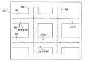
情報処理装置16に接続されたディスプレイ18には、図2に示すダイナミックマップDMが表示される。このダイナミックマップDMは、互いに重ねられた複数のレイヤー(層)によって構成されている。各レイヤーが表す情報の時間変化に応じた変化の度合いは、各レイヤー毎に異なる。
時間変化に応じた変化が最も小さい(実質的に変化しない)レイヤーは、上記地図データに基づく地図画像である。この地図画像は、例えば、後述する道路R1、R2、R3、R4、川、及び鉄道の線路などを表す画像を含んでいる。
他のレイヤーは、時間変化に応じて変化する情報を表している。例えば、一つのレイヤーは、後述するビーコン20及びスマートフォン25の位置情報を表している。A dynamic map DM shown in FIG. 2 is displayed on the
The layer with the smallest change (substantially does not change) according to the time change is a map image based on the map data. This map image includes, for example, images representing roads R1, R2, R3, R4, rivers, railroad tracks, and the like described later.
The other layers represent information that changes with time. For example, one layer represents position information of a
なお、この地図画像は多数のグリッド(格子状の最小単位)によって構成されている。このグリッドの各辺の長さは、実際の地理の2mに対応する距離である。
従って、後述するように地図画像上におけるビーコン20の現在位置(推定位置A−C)及びスマートフォン25の現在位置を求める場合、これらの現在位置は一つのグリッドに対応する位置となる。In addition, this map image is comprised by many grids (grid-like minimum unit). The length of each side of this grid is a distance corresponding to 2 m of actual geography.
Therefore, when obtaining the current position of the beacon 20 (estimated position A-C) and the current position of the
ビーコン20は小型且つ軽量のタグである。
ビーコン20の外形を構成するケース21の内部には、ICチップ22、バッテリ23、及びアンテナ24が設けられている。The
An
ICチップ22は、一つの基板、及び、この基板上に実装された多数の電子部品(例えば、トランジスタ、抵抗、コンデンサ、及びダイオード)を有する小型の電子部品である。ICチップ22は無線信号(電波)を生成する機能を有している。ICチップ22が生成する電波の規格はBluetooth Low Energyである。即ち、ICチップ22は2.4GHz帯の電波を生成する。ICチップ22は所定時間毎(例えば100ミリ秒毎)に無線信号を生成する。さらにICチップ22は、無線信号を生成する毎に、ビーコン20を他のビーコンと識別するためのビーコンID信号及び後述するメタデータを生成する。以下、ビーコン20が生成するメタデータを「ビーコンメタデータ」と称する場合がある。 The
バッテリ23はボタン式バッテリである。バッテリ23は、容量がゼロになるまで常に電力をICチップ22及びアンテナ24へ供給する。ICチップ22が生成する電波の規格がBluetooth Low Energyであるため、バッテリ23の単位時間当たりの消費電力は小さい。 The
アンテナ24はICチップ22に接続されている。
さらにICチップ22は、電波を生成するときに(即ち、例えば100ミリ秒毎に)、電波強度の大きさを表すリファレンス強度信号を生成する。リファレンス強度信号が表す電波強度(リファレンス強度)は、アンテナ24が発信した電波を、ビーコン20から1m離れた位置で受信機(例えば、スマートフォン)が受信する場合の、この受信機が受信した電波の電波強度を表す。The
Further, when the
バッテリ23の電力が供給されたICチップ22が無線信号を生成すると、アンテナ24は生成された無線信号をビーコンID信号、ビーコンメタデータ、及びリファレンス強度信号と一緒に外部に向けて所定時間毎(例えば100ミリ秒毎)に繰り返し送信する。以下、ビーコン20による無線信号の送信周期を「ビーコン送信周期」と称する。 When the
各々一つのリファレンス強度信号、ビーコンID信号及びビーコンメタデータは一つのセットとして、ICチップ22が生成した無線信号に重畳される。リファレンス強度信号、ビーコンID信号及びビーコンメタデータを有する一セットは、例えばペイロードとして無線信号に重畳可能である。 Each one of the reference strength signal, the beacon ID signal, and the beacon metadata is superimposed on the radio signal generated by the
本実施形態では、図2に示す複数の対象歩行者P1がビーコン20を所持している。
対象歩行者P1は祭りの参加者である。即ち、対象歩行者P1は、図示を省略した神輿を担ぐ者及び/又は図示を省略した山車を引く者である。
さらに、本実施形態の祭りは、この祭りが実施される地域の地方自治体であるXYZ市によって管理されている。In the present embodiment, a plurality of target pedestrians P1 shown in FIG.
The target pedestrian P1 is a festival participant. That is, the target pedestrian P1 is a person who carries a shrine that is not shown and / or a person who pulls a float that is not shown.
Furthermore, the festival of this embodiment is managed by XYZ City, which is a local government in the area where the festival is held.
図1に示すように地方自治体(XYZ市)の庁舎33は、庁舎33内において固定された情報処理装置34(コンピューターサーバー)及びディスプレイ35を備えている。情報処理装置34及びディスプレイ35の構成は、データセンター15の情報処理装置16及びディスプレイ18とそれぞれ実質的に同一である。情報処理装置34のメモリには、図2と同様の地図画像を表すデータが記録されている。従って、図6に示すように、ディスプレイ35には図2と同様の地図画像が表示される。但し、この地図画像にはバス停B1は含まれていない。 As shown in FIG. 1, a local government office (XYZ city) 33 has an information processing device 34 (computer server) and a
なお、情報処理装置34のROMには、各ビーコン20の所有者の氏名、年齢、住所等の個人情報がビーコンID信号と関連付けて記録されている。
さらに情報処理装置34のROMには、後述する「待ち合わせ用アプリケーション」がインストールされているスマートフォン25の所有者の氏名、年齢、住所等の個人情報が端末ID信号と関連付けて記録されている。Note that personal information such as the name, age, and address of the owner of each
Further, in the ROM of the
図1に示すスマートフォン25の外形を構成するケース26の内部にはECU27、バッテリ28、無線通信用アンテナ29及びGPS用受信アンテナ30が設けられている。 An ECU 27, a
ECU27(エレクトリックコントロールユニット)は、CPU、ROM、RAM及びインターフェース等を含むマイクロコンピュータを主要構成部品として有する電子制御回路である。CPUは、メモリ(ROM)に格納されたインストラクションを実行することにより後述する各種機能を実現する。さらにECU27のメモリには、様々なソフトウェア(アプリケーション)がインストールされている。 The ECU 27 (electric control unit) is an electronic control circuit having a microcomputer including a CPU, a ROM, a RAM, an interface, and the like as main components. The CPU implements various functions to be described later by executing instructions stored in a memory (ROM). Further, various software (applications) are installed in the memory of the ECU 27.
ECU27は無線信号を生成可能である。
さらにECU27は、各スマートフォン25を他のスマートフォン25と識別するための端末ID信号を、所定時間毎に繰り返し生成可能である。
さらにECU27はメタデータを繰り返し生成可能である。ECU27は、後述するように所定のアプリケーションの指示に従って自動的にメタデータを生成してもよいし、又は、後述する入力手段によって特別な操作が行われた場合のみメタデータを生成してもよい。なお、以下の説明では、ECU27が生成するメタデータを「スマホメタデータ」と称する場合がある。The ECU 27 can generate a radio signal.
Further, the ECU 27 can repeatedly generate a terminal ID signal for identifying each
Further, the ECU 27 can repeatedly generate metadata. The ECU 27 may automatically generate metadata in accordance with an instruction of a predetermined application as will be described later, or may generate metadata only when a special operation is performed by an input means to be described later. . In the following description, the metadata generated by the ECU 27 may be referred to as “smartphone metadata”.
バッテリ28は充電式バッテリであり、その容量がゼロになるまで常に電力をECU27、無線通信用アンテナ29、GPS用受信アンテナ30、及びディスプレイ31へ供給する。 The
無線通信用アンテナ29はECU27に接続されている。スマートフォン25がビーコン20が送信する無線信号が届く範囲内に位置するとき、無線通信用アンテナ29は、ビーコン20が発信した無線信号、リファレンス強度信号、ビーコンID信号及びビーコンメタデータを所定時間毎(例えば、100ミリ秒毎)に繰り返し受信する。以下、無線通信用アンテナ29によるビーコン20が発信した無線信号、リファレンス強度信号、ビーコンID信号及びビーコンメタデータの受信周期を「ビーコン送信情報受信周期」と称する。このビーコン送信情報受信周期は、例えばビーコン送信周期と同一にすることが可能である。
さらにECU27は、受信したリファレンス強度信号、ビーコンID信号及びビーコンメタデータをRAMに時系列的に記録する。The
Further, the ECU 27 records the received reference strength signal, beacon ID signal, and beacon metadata in the RAM in time series.
GPS用受信アンテナ30はECU27に接続されている。周知のようにGPS用受信アンテナ30は、GPS衛星から送信されたGPS信号を受信することにより、GPS用受信アンテナ30(スマートフォン25)の位置に関する情報(以下、「GPS位置情報」と称する)を所定時間毎(例えば、1秒毎)に繰り返し取得する。以下、GPS用受信アンテナ30によるGPS位置情報の受信周期を「GPS情報受信周期」と称する。
さらにECU27は、受信したGPS位置情報を、例えばGPS情報受信周期と同じ周期でRAMに時系列的に記録する。The
Further, the ECU 27 records the received GPS position information in the RAM in time series, for example, at the same cycle as the GPS information reception cycle.
さらに無線通信用アンテナ29は後述するように、ECU27からの指令により、RAMに記録されたビーコンID信号、GPS位置情報及び端末ID信号等を、例えば、GPS情報受信周期と同じ周期で繰り返し外部に無線送信する。
さらに無線通信用アンテナ29は、基地局が発信した無線信号を受信可能である。Further, as will be described later, the
Furthermore, the
さらにケース26の表面にはディスプレイ31が設けられている。このディスプレイ31もECU27に接続されている。
さらにスマートフォン25の表面には、ECU27に接続された入力手段(図示略)が設けられている。この入力手段の形式は問わない。即ち、入力手段は、例えば、ケース26に対して相対移動可能な機械式ボタンであってもよいし、又は、ディスプレイ31の一部をなすタッチパネルであってもよい。Further, a
Furthermore, input means (not shown) connected to the ECU 27 is provided on the surface of the
本実施形態では、スマートフォン25は対象歩行者P2(P2−B、P2−F、P2−M、P2−Tを含む)、バスBの運転手、及びタクシーTの運転手によって所持されている。 In the present embodiment, the
図1に示すようにタクシーTの運営会社の社屋40は、いずれも社屋40内において固定された情報処理装置41(コンピューターサーバー)及びディスプレイ43を備えている。情報処理装置41及びディスプレイ43の構成は、データセンター15の情報処理装置16及びディスプレイ18とそれぞれ実質的に同一である。情報処理装置41のメモリには、図2と同様の地図画像を表すデータが記録されている。従って、図9に示すように、ディスプレイ43には図2と同様の地図画像が表示される。但し、この地図画像にはバス停B1は含まれていない。 As shown in FIG. 1, the company building 40 of the taxi T operating company includes an information processing device 41 (computer server) and a
なお、情報処理装置41のROMには、後述する「タクシー専用アプリケーション」がインストールされているスマートフォン25の所有者の氏名、年齢、住所等の個人情報が端末ID信号と関連付けて記録されている。さらに、このROMには、このスマートフォン25と一緒に移動するタクシーTの車両情報が、端末ID信号と関連付けて記録されている。
さらに、情報処理装置41のROMには、後述する「タクシー会員用アプリケーション」がインストールされているスマートフォン25の所有者の氏名、年齢、住所等の個人情報が端末ID信号と関連付けて記録されている。In the ROM of the
Further, in the ROM of the
バスBの運営会社の社屋50は、いずれも社屋50内において固定された情報処理装置51(コンピューターサーバー)及びディスプレイ53を備えている。情報処理装置51及びディスプレイ53の構成は、情報処理装置16及びディスプレイ18とそれぞれ実質的に同一である。情報処理装置51のメモリには、図2と同様の地図画像を表すデータが記録されている。従って、図11に示すように、ディスプレイ53には図2と同様の地図画像が表示される。この地図画像にはバス停B1が含まれている。 The company building 50 of the company that operates the bus B includes an information processing device 51 (computer server) and a
なお、情報処理装置51のROMには、後述する「バス専用アプリケーション」がインストールされているスマートフォン25の所有者の氏名、年齢、住所等の個人情報が端末ID信号と関連付けて記録されている。さらに、このROMには、このスマートフォン25と一緒に移動するバスBの車両情報が、端末ID信号と関連付けて記録されている。
さらに、情報処理装置51のROMには、後述する「バス会員用アプリケーション」がインストールされているスマートフォン25の所有者の氏名、年齢、住所等の個人情報が端末ID信号と関連付けて記録されている。In the ROM of the
Further, in the ROM of the
続いて位置情報共通管理システム10の動作について説明する。なお、以下の説明は、以下の状態1乃至状態3が実現されていることを前提にしている。
状態1:ビーコン20のバッテリ23及びスマートフォン25のバッテリ28の容量がゼロではない。
状態2:スマートフォン25の電源スイッチがON状態にある。
状態3:複数のスマートフォン25が、ビーコン20を中心とする所定半径の円内(所定エリア)に位置する。Next, the operation of the location information
State 1: The capacities of the
State 2: The power switch of the
State 3: A plurality of
データセンターのディスプレイ18には、図2に示す地図画像が表示される。この地図画像は、データセンター15が位置する地域の中の一部の特定地域を表している。
この地図画像には、互いに平行をなす二本の道路R1、R2及び道路R1、R2に対して直交する2本の道路R3、R4が表示されている。各道路R1、R2、R3、R4は、二点鎖線で描かれた中央分離線によって左側車線と右側車線とに区切られている。なお、車両(例えば、バスB及びタクシーT)は道路R1、R2、R3、R4の左側車線を通行する。さらに図示は省略してあるが、道路R1、R2、R3、R4の両側縁部には、各道路R1、R2、R3、R4に沿って延びる歩道が設けられている。本実施形態の対象歩行者P2(P2−B、P2−F、P2−M、P2−Tを含む)は原則として歩道を歩く。即ち、対象歩行者P2は道路R1、R2、R3、R4を横断する場合等を除いて歩道を歩く。一方、対象歩行者P1は車道(即ち、道路R1、R2、R3、R4の歩道以外の部分)を歩く。さらに地図画像には、バスBの運営会社が設置したバス停B1が表示されている。
さらに図5に示すように、この地図画像には川及び建物が表示されている。さらに図示は省略してあるが、この地図画像には鉄道の線路が表示されている。A map image shown in FIG. 2 is displayed on the
In this map image, two roads R1 and R2 parallel to each other and two roads R3 and R4 orthogonal to the roads R1 and R2 are displayed. Each road R1, R2, R3, R4 is divided into a left lane and a right lane by a center separation line drawn with a two-dot chain line. Vehicles (for example, bus B and taxi T) pass on the left lane of roads R1, R2, R3, and R4. Further, although not shown, sidewalks extending along the roads R1, R2, R3, and R4 are provided at both side edges of the roads R1, R2, R3, and R4. In principle, the target pedestrian P2 (including P2-B, P2-F, P2-M, and P2-T) of the present embodiment walks on the sidewalk. That is, the target pedestrian P2 walks on the sidewalk except when crossing the roads R1, R2, R3, and R4. On the other hand, the target pedestrian P1 walks on a roadway (that is, a portion other than the sidewalks on the roads R1, R2, R3, and R4). Furthermore, the bus stop B1 installed by the operating company of the bus B is displayed on the map image.
Furthermore, as shown in FIG. 5, rivers and buildings are displayed in this map image. Furthermore, although illustration is abbreviate | omitted, the railroad track is displayed on this map image.
上述のように、各対象歩行者P1が所持するビーコン20のアンテナ24は、所定時間毎に無線信号を繰り返し発信する。この無線信号には、各々一つのビーコンID信号、ビーコンメタデータ及びリファレンス強度信号が一つのセットとして含まれる。
このビーコンメタデータはハッシュタグである。具体的には、このビーコンメタデータは「#XYZ−MATSURI」というハッシュタグである。As described above, the
This beacon metadata is a hash tag. Specifically, this beacon metadata is a hash tag “# XYZ-MATURI”.
なお、ビーコン20が発信するハッシュタグとしてどのような文字データを使用するかについては、原則として規制はない。しかし、本実施形態の祭りは上記地方自治体(XYZ市)の監督下にある。そのため、「#XYZ−MATSURI」というハッシュタグを、この地方自治体と無関係の者又は組織が自由に使用可能にすると、そのハッシュタグと関連する情報がこの地方自治体と関係があると、多くの人が誤認するおそれがある。
そのため本実施形態では、上記地方自治体から許可を受けた者又は組織のみが、「#XYZ−MATSURI」というハッシュタグを設定可能としている。即ち、ビーコン20の製造者は、上記地方自治体から許可を受けた上でビーコン20を製造している。
なお、このように特定の位置情報発信体(ビーコン20)である特定位置情報発信体のみが送信可能なメタデータは「特定メタデータ」と称される。
その一方で、スマートフォン25が発信する無線信号に含まれるハッシュタグ(例えば、後述する「#〇〇TAXI」)は、スマートフォン25の製造者及び使用者等が自由に設定可能である。このようなメタデータは「非特定メタデータ」と称される。In principle, there is no restriction on what character data is used as the hash tag transmitted by the
Therefore, in the present embodiment, only a person or organization who has received permission from the local government can set a hash tag “# XYZ-MATSURI”. That is, the manufacturer of the
Note that the metadata that can be transmitted only by the specific position information transmitter (beacon 20) as described above is referred to as “specific metadata”.
On the other hand, a manufacturer and a user of the
ビーコン20が発信する無線信号、リファレンス強度信号、ビーコンID信号及びビーコンメタデータを、スマートフォン25の無線通信用アンテナ29が受信すると、ECU27は実際に受信した無線信号の強度(以下、「実強度」と称する)及びリファレンス強度信号が表すリファレンス強度を比較する。そしてECU27は、実強度及びリファレンス強度に基づいて、スマートフォン25とビーコン20との距離である推定距離を演算(推定)する。 When the
具体的にはECU27は、以下のように推定距離を演算する。
例えば、実強度がリファレンス強度より大幅に大きい場合は、ECU27は「推定距離はimmediately領域にある」と推定する。このimmediately領域は、ビーコン20とスマートフォン25との距離が極めて近い領域(例えば、1m以下の領域)である。
実強度がリファレンス強度より僅かに大きい場合は、ECU27は「推定距離はnear領域にある」と推定する。このnear領域は、ビーコン20とスマートフォン25との距離が近く且つimmediately領域よりは遠い領域(例えば、1mより大きく且つ3m以下の領域)である。
実強度がリファレンス強度より小さい場合は、ECU27は「推定距離はfar領域にある」と推定する。このfar領域は、ビーコン20とスマートフォン25との距離がnear領域よりも遠い領域(例えば、3mより大きく且つ10m以下の領域)である。
但し、実強度とリファレンス強度との大小関係と、3つの推定距離との関係は、この関係には限定されない。Specifically, the ECU 27 calculates the estimated distance as follows.
For example, when the actual intensity is significantly larger than the reference intensity, the ECU 27 estimates that “the estimated distance is in the immediate area”. This immediate area is an area where the distance between the
When the actual intensity is slightly larger than the reference intensity, the ECU 27 estimates that “the estimated distance is in the near region”. The near region is a region where the distance between the
When the actual intensity is smaller than the reference intensity, the ECU 27 estimates that “the estimated distance is in the far region”. This far area is an area where the distance between the
However, the magnitude relationship between the actual intensity and the reference intensity and the relation between the three estimated distances are not limited to this relation.
所定時間毎(例えば、100ミリ秒毎)にスマートフォン25のECU27が推定距離を繰り返し演算すると、ECU27は演算した推定距離をリファレンス強度信号、ビーコンID信号及びビーコンメタデータと一緒に所定時間毎(例えば、100ミリ秒毎)にRAMに時系列的に記録する。 When the ECU 27 of the
ところで、上述のようにECU27は、受信したGPS位置情報をGPS情報受信周期と同じ周期でRAMに時系列的に記録する。
そしてECU27は、一つのGPS位置情報をRAMに記録するとき、このGPS位置情報がGPS用受信アンテナ30によって受信されたときのGPS情報受信周期の間にECU27が演算した推定距離、並びに、無線通信用アンテナ29が受信したリファレンス強度信号、ビーコンID信号及びビーコンメタデータを、このGPS位置情報とセットとしてRAMに記録する。上述のように、GPS情報受信周期はビーコン送信情報受信周期より長く、一つのGPS情報受信周期が経過する間に複数のビーコン送信情報受信周期が経過する。従って、一つのGPS位置情報と、複数の推定距離、複数のリファレンス強度信号、複数のビーコンID信号、及び複数のビーコンメタデータと、が一つのセットとしてRAMに記録される。なお、例えばGPS情報受信周期が1秒且つビーコン送信情報受信周期が100ミリ秒の場合は、一つのGPS位置情報、10個の推定距離、10個のリファレンス強度信号、10個のビーコンID信号、及び10個のビーコンメタデータが一つのセットとしてRAMに記録される。以下、この一つのセットを「推定距離及びGPS情報セット」と称する。By the way, as described above, the ECU 27 records the received GPS position information in the RAM in time series in the same cycle as the GPS information reception cycle.
When the ECU 27 records one GPS position information in the RAM, the estimated distance calculated by the ECU 27 during the GPS information reception period when the GPS position information is received by the
さらに無線通信用アンテナ29はECU27からの指令に基づいて、推定距離及びGPS情報セット、並びに、端末ID信号を一つのセットとして一緒にデータセンター15の情報処理装置16へ、例えばGPS情報受信周期と同一の所定周期(例えば、1秒)で繰り返し送信する。 Further, based on the command from the ECU 27, the
なお、ECU27がハッシュタグ(スマホメタデータ)を生成するときがある。
この場合は、無線通信用アンテナ29はECU27からの指令に基づいて、推定距離及びGPS情報セット、端末ID信号、並びにハッシュタグ(スマホメタデータ)を一つのセットとして一緒にデータセンター15の情報処理装置16へ所定周期(例えば、1秒)で繰り返し送信する。The ECU 27 sometimes generates a hash tag (smartphone metadata).
In this case, the
情報処理装置16は、例えばGPS情報受信周期と同じ長さのセンター受信周期毎に、複数のスマートフォン25から推定距離及びGPS情報セット、並びに、端末ID信号を受信し、且つ、所定周期(例えば、センター受信周期と同じ周期)で推定距離及びGPS情報セット、並びに、端末ID信号をRAMに記録する。なお、スマートフォン25がスマホメタデータを発信した場合は、情報処理装置16は、推定距離及びGPS情報セット、端末ID信号、並びに、スマホメタデータを受信し且つRAMに記録する。
すると各スマートフォン25から受信した複数の推定距離に関する情報に基づいて、情報処理装置16は、受信したビーコンID信号と対応するビーコン20(対象歩行者P1、P2)の現在位置を、以下の原理に沿って推定する。The
Then, based on the information regarding the plurality of estimated distances received from each
例えば、一つのセンター受信周期において2つのスマートフォン25(25−1、25−2)のみから推定距離及びGPS情報セットを対応する端末ID信号と一緒に受信したときは、情報処理装置16は図3に示した原理に基づいてビーコン20の現在位置が含まれると推定される範囲を求める。
即ち、情報処理装置16は、スマートフォン25−1を中心とし且つスマートフォン25−1が算出した推定距離L1(far領域)の上限値を外径とし且つ下限値を内径とする環状帯C1と、スマートフォン25−2を中心とし且つスマートフォン25−2が算出した推定距離L2(far領域)の上限値を外径とし且つ下限値を内径とする環状帯C2と、が重なる仮推定領域A−2を求める。この仮推定領域A−2が、ビーコン20の現在位置が含まれると推定される範囲である。なお、例えば推定距離L1がimmediately領域の場合は、この推定距離L1の上限値を半径とする円C1と、環状帯C2と、が重なる領域が仮推定領域A−2となる。For example, when the estimated distance and the GPS information set are received together with the corresponding terminal ID signal from only the two smartphones 25 (25-1, 25-2) in one center reception cycle, the
That is, the
なお、情報処理装置16が各スマートフォン25−1、25−2から受信した一つの推定距離及びGPS情報セットの中には、通常、複数の推定距離が含まれる。そのため、情報処理装置16は各スマートフォン25−1、25−2から一つの推定距離及びGPS情報セットを受信したときに、通常、4つ以上の仮推定領域A−2を演算する。
これらの仮推定領域A−2は、ビーコン20が発信した同じ電波強度の無線信号に基づいて演算されたものである。そのため、これらの仮推定領域A−2の形状は互いにほぼ同一である。In addition, a plurality of estimated distances are usually included in one estimated distance and GPS information set received by the
These temporary estimation areas A-2 are calculated based on a radio signal having the same radio wave intensity transmitted from the
また、一つのセンター受信周期において3つのスマートフォン25(25−1、25−2、25−3)から推定距離及びGPS情報セットを対応する端末ID信号と一緒に受信したときは、情報処理装置16は図4に示した原理に基づいてビーコン20の現在位置が含まれると推定される範囲を求める。
即ち、情報処理装置16は、環状帯C1と、環状帯C2と、スマートフォン25−3を中心とし且つスマートフォン25−3が算出した推定距離L3の上限値を外径とし且つ下限値を内径とする環状帯C3(near領域)とが重なる仮推定領域A−3を求める。この仮推定領域A−3が、ビーコン20の現在位置が含まれると推定される範囲である。
仮推定領域A−3は、3つの推定距離に基づく領域であるため、仮推定領域A−2よりもビーコン20の現在位置をより正確に表している可能性が高い。
またこの場合も、通常情報処理装置16はセンター受信周期毎に3つのスマートフォン25から複数の推定距離を受信するので、センター受信周期毎に情報処理装置16は通常6つ以上の仮推定領域A−3を求める。When the estimated distance and the GPS information set are received together with the corresponding terminal ID signal from the three smartphones 25 (25-1, 25-2, 25-3) in one center reception cycle, the
That is, the
Since the temporary estimation area A-3 is an area based on three estimated distances, there is a high possibility that the current position of the
Also in this case, since the normal
なお、一つのセンター受信周期において情報処理装置16が4つ以上のスマートフォン25から推定距離及びGPS情報セットを対応する端末ID信号と一緒に受信したときは、情報処理装置16は、4つのスマートフォン25から受信した推定距離及びGPS情報セットに基づいて仮推定領域A−2、A−3に相当する領域を求める。
推定距離及びGPS情報セットを情報処理装置16に対して送信するスマートフォン25の数が多くなればなる程、情報処理装置16はビーコン20の現在位置が含まれると推定される範囲をより正確に求めることが可能となる。When the
As the number of
さらに、各スマートフォン25が情報処理装置16へ送信する推定距離の少なくとも一つが「near領域」又は「far領域」の場合は、仮推定領域は大きな領域となる。特にいずれかの推定距離が「far領域」の場合は、仮推定領域は極めて大きな領域となるおそれがある。換言すると、これらの場合は、仮推定領域は一つのグリッドより(かなり)広い領域を表す可能性が高い。そのため、これらの場合は、この仮推定領域をビーコン20(対象歩行者P1、P2)の現在位置として扱うのは不適切である。
従って、情報処理装置16は、求めた仮推定領域に対して以下のフィルタリング処理を実行する。Furthermore, when at least one of the estimated distances transmitted from each
Therefore, the
図5には、一人の歩行者(対象歩行者P1又は対象歩行者P2)が所持するビーコン20の仮推定領域Aが示されている。
この仮推定領域Aは川の一部及び一部の建物と重なっている。
しかし、歩行者が川の中にいる可能性は低いと考えられる。さらに、ビーコン20のビーコンID信号が表すこの歩行者の住所とは異なる住所の建物内に歩行者がいる可能性も低いと考えられる。
そのため、情報処理装置16は仮推定領域Aの中で川及び建物と重なる領域を仮推定領域Aから排除した、排除後領域A−eを演算する。この排除後領域A−eは、図5にハッチングで示した領域である。
情報処理装置16によるフィルタリング処理は、このようにして実行される。FIG. 5 shows a temporary estimation area A of the
This temporary estimation area A overlaps part of the river and part of the building.
However, it is unlikely that pedestrians are in the river. Furthermore, it is considered that there is a low possibility that a pedestrian is in a building having an address different from the address of the pedestrian represented by the beacon ID signal of the
Therefore, the
The filtering process by the
さらに情報処理装置16は、排除後領域A−eの中心位置である推定位置A−Cを演算する。即ち、情報処理装置16は算出された推定位置A−Cを、この歩行者(ビーコン20)の現在位置として扱う。
そして情報処理装置16は、図5に示すように、各ビーコン20推定位置A−CをビーコンID信号と関連付けてディスプレイ18上の一つのグリッドに表示させる。Further, the
Then, the
情報処理装置16は、推定位置A−Cの演算作業を、例えばセンター受信周期と同じ周期で繰り返し実行する。さらに情報処理装置16はセンター受信周期と同じ周期で、演算した各推定位置A−Cを時系列的にRAMに記録する。
そしてディスプレイ18は、例えばセンター受信周期と同じ周期で、図2に示すように、対象歩行者P1の現在位置(即ち、推定位置A−C)を繰り返し表示する。即ち、対象歩行者P1が移動すると、地図画像上の対象歩行者P1の位置が変化する。The
The
データセンター15の情報処理装置16のROMには、各スマートフォン25の端末IDが記録されている。
そのため情報処理装置16は、受信した端末ID信号と対応するスマートフォン25のGPS位置情報に基づく位置を、ダイナミックマップDMの地図画像上に重ねて表示させる。即ち、地図画像上のGPS位置情報が表す位置に、対応するスマートフォン25の位置が重ねて表示される。The terminal ID of each
Therefore, the
その一方で、データセンター15の情報処理装置16のROMには、各ビーコン20の所有者の個人情報は記録されていない。さらに情報処理装置16のROMには、「待ち合わせ用アプリケーション」がインストールされているスマートフォン25の所有者の個人情報は記録されていない。
また、情報処理装置16のROMには、「タクシー専用アプリケーション」がインストールされているスマートフォン25の所有者の個人情報及びこのスマートフォン25と一緒に移動するタクシーTの車両情報は記録されていない。同様に、情報処理装置16のROMには、「タクシー会員用アプリケーション」がインストールされているスマートフォン25の所有者の個人情報は記録されていない。
また、情報処理装置16のROMには、「バス専用アプリケーション」がインストールされているスマートフォン25の所有者の個人情報及びこのスマートフォン25と一緒に移動するバスBの車両情報は記録されていない。同様に、情報処理装置16のROMには、「バス会員用アプリケーション」がインストールされているスマートフォン25の所有者の個人情報は記録されていない。On the other hand, the personal information of the owner of each
In addition, in the ROM of the
In addition, in the ROM of the
このように各移動体(ビーコン20及びスマートフォン25)の位置情報は、各スマートフォン25からデータセンター15の情報処理装置16に集められる。
さらに情報処理装置16に集められた各移動体の位置情報は、以下に説明するように、庁舎33の情報処理装置34、社屋40の情報処理装置41、社屋50の情報処理装置51、及び各スマートフォン25が取得可能である。Thus, the positional information of each mobile body (the
Further, the position information of each moving object collected in the
例えば、あるスマートフォン25の所持者が祭りの見物客である対象歩行者P2−Mの場合、この対象歩行者P2−Mは所持しているスマートフォン25の入力手段を利用して、このスマートフォン25にインストールされている「祭り情報取得アプリケーション」を起動させる。そしてこの対象歩行者P2−Mが、スマートフォン25の入力手段を利用して、祭り情報取得アプリケーションによってディスプレイ31上に生成された画像の中に形成された「祭り現在位置取得ボタン」画像を選択し且つ入力手段のEnterボタンを押す。すると、それまでOFF状態であった祭り現在位置取得ボタンがON状態となり、このスマートフォン25のディスプレイ31上に図7に示す地図画像が表示される。この地図画像はバス停B1を除いて図2の地図画像と実質的に同一である。なお、ディスプレイ31上に生成された画像の中に形成された「OFFボタン」画像を選択し且つEnterボタンを押すと、祭り現在位置取得ボタンはOFF状態になる。すると、ディスプレイ31が地図画像を表示しなくなる。 For example, when the owner of a
さらに祭り現在位置取得ボタンがON状態になると、スマートフォン25のECU27はデータセンター15の情報処理装置16に向けて、所定時間毎に繰り返し無線信号を送信する。この無線信号には「#XYZ−MATSURIというハッシュタグと関連付けられた位置情報が欲しい」というリクエスト情報が含まれている。 Further, when the festival current position acquisition button is turned on, the ECU 27 of the
このリクエスト情報を受信する毎に、情報処理装置16は「#XYZ−MATSURI」というハッシュタグが付加された位置情報をRAMから検索する。そして、データセンター15の情報処理装置16が、「#XYZ−MATSURI」というハッシュタグが付加されたビーコン20の位置情報を、対応するビーコンID信号と一緒に、このスマートフォン25に対して送信する。 Each time this request information is received, the
そして、情報処理装置16が送信したビーコン20の位置情報及びビーコンID信号をこのスマートフォン25が受信すると、このスマートフォン25のディスプレイ31に表示された地図画像上に、対象歩行者P1が所持するビーコン20の現在位置が表示される。
さらにこのスマートフォン25が取得したGPS位置情報に基づいて、ECU27が対象歩行者P2−Mが所持するスマートフォン25の現在位置を地図画像上に表示させる。
そのため、対象歩行者P2−Mは自身のスマートフォン25のディスプレイ31を見ることにより、祭りの参加者である対象歩行者P1(神輿及び山車)が現在どこに位置するか、及び、自身の現在位置から対象歩行者P1が位置する場所までの道順を確実に認識できる。And if this
Further, based on the GPS position information acquired by the
Therefore, the target pedestrian P2-M looks at the
また、二つのスマートフォン25のそれぞれの所持者である二人の対象歩行者P2−Fどうしは互いに知り合いである。さらに、これらの対象歩行者P2−Fは、この地図画像上の特定の場所で会うために移動中である。また、これらの対象歩行者P2−Fが所持しているスマートフォン25には、XYZ市が作成及び不特定多数人に配布した「待ち合わせ用アプリケーション」がインストールされている。 Moreover, the two target pedestrians P2-F who are the owners of the two
これらの対象歩行者P2−Fがそれぞれ所持するスマートフォン25の入力手段を利用して「待ち合わせ用アプリケーション」を起動させる。そして対象歩行者P2−Fが、スマートフォン25の入力手段を利用して、待ち合わせ用アプリケーションによってディスプレイ31上に生成された画像の中に形成された「知人現在位置取得ボタン」画像を選択し且つ入力手段のEnterボタンを押す。すると、それまでOFF状態であった知人現在位置取得ボタンがON状態となり、このスマートフォン25のディスプレイ31上に図8に示す地図画像が表示される。この地図画像は図7の地図画像と実質的に同一である。なお、ディスプレイ31上に生成された画像の中に形成された「OFFボタン」画像を選択し且つEnterボタンを押すと、知人現在位置取得ボタンはOFF状態になる。すると、ディスプレイ31が地図画像を表示しなくなる。 The “waiting application” is activated using the input means of the
さらに知人現在位置取得ボタンがON状態になると、対象歩行者P2−Fが所持するスマートフォン25のECU27が「MACHIAWASE」というハッシュタグをスマホメタデータとして所定時間毎に生成する。
ECU27はこのハッシュタグを所定時間毎(例えば、1秒毎)にRAMに時系列的に記録する。
さらに無線通信用アンテナ29はECU27からの指令に基づいて、このハッシュタグ、GPS位置情報(又は推定距離及びGPS情報セット)、並びに、端末ID信号を一つのセットとして一緒に情報処理装置16へ、例えばGPS情報受信周期と同一の所定周期(例えば、1秒)で繰り返し送信する。When the acquaintance current position acquisition button is turned on, the ECU 27 of the
The ECU 27 records the hash tag in the RAM in time series at predetermined time intervals (for example, every second).
Further, the
このハッシュタグを受信する毎に、情報処理装置16はRAMから「#MACHIAWASE」というハッシュタグが付加されたGPS位置情報を検索する。そして情報処理装置16が、「#MACHIAWASE」を送信したスマートフォン25の端末ID信号とは異なる端末ID信号及び「#MACHIAWASE」を発信しているスマートフォン25と対応するGPS位置情報及び端末ID信号を、各スマートフォン25に対してそれぞれ送信する。
即ち、各スマートフォン25が情報処理装置16に向けて送信するハッシュタグ「#MACHIAWASE」は、実質的に「#MACHIAWASEというハッシュタグと関連付けられた位置情報が欲しい」というリクエスト情報でもある。Each time this hash tag is received, the
That is, the hash tag “#MACHIAWASE” that each
そして、情報処理装置16が送信したGPS位置情報及び対応する端末ID信号を各スマートフォン25が受信すると、これらのスマートフォン25のディスプレイ31に表示された地図画像上に、各対象歩行者P2−Fが所持するスマートフォン25の現在位置がそれぞれ表示される。
さらに各スマートフォン25が取得したGPS位置情報に基づいて、それぞれのECU27が自身のスマートフォン25の現在位置を地図画像上に表示させる。
そのため、各対象歩行者P2−Fは自身のスマートフォン25のディスプレイ31を見ることにより、両者が現在どこに位置するかを確実に認識できる。And if each
Further, based on the GPS position information acquired by each
Therefore, each target pedestrian P2-F can surely recognize where they are currently located by looking at the
さらに庁舎33の情報処理装置34は、情報処理装置16に対して所定時間毎に繰り返し所定の信号を送信する。この信号には「#XYZ−MATSURIというハッシュタグと関連付けられた位置情報、及び、#MACHIAWASEというハッシュタグを発信しているスマートフォン25の位置情報が欲しい」というリクエスト情報が含まれている。 Further, the
データセンター15の情報処理装置16はこのリクエスト情報を受信する毎に、「#XYZ−MATSURI」というハッシュタグを発信しているビーコン20の位置情報及び「#MACHIAWASE」というハッシュタグを発信しているスマートフォン25のGPS位置情報を情報処理装置34に対して所定時間毎に繰り返し送信する。
すると情報処理装置34は図6に示すディスプレイ35に表示された地図画像上に、所定時間毎に繰り返し「#XYZ−MATSURI」というハッシュタグを発信しているビーコン20及び「#MACHIAWASE」というハッシュタグを発信しているスマートフォン25の現在位置をそれぞれ表示させる。Each time the
Then, the
そのためXYZ市の職員はディスプレイ35を見ることにより、各ビーコン20(対象歩行者P1)及び各スマートフォン25(対象歩行者P2−F)の現在位置を把握できる。 Therefore, the staff of XYZ city can grasp the current positions of each beacon 20 (target pedestrian P1) and each smartphone 25 (target pedestrian P2-F) by looking at the
また、各タクシーTと一緒に移動するスマートフォン25には「タクシー専用アプリケーション」がインストールされている。このスマートフォン25がタクシー専用アプリケーションを起動させると、ECU27が「#〇〇TAXI」というハッシュタグをスマホメタデータとして所定時間毎に生成する。
ECU27はこのハッシュタグを所定時間毎(例えば、1秒毎)にRAMに時系列的に記録する。
さらに無線通信用アンテナ29はECU27からの指令に基づいて、このハッシュタグ、GPS位置情報(又は推定距離及びGPS情報セット)、並びに、端末ID信号を一つのセットとして一緒に情報処理装置16へ、例えばGPS情報受信周期と同一の所定周期(例えば、1秒)で繰り返し送信する。A “taxi-only application” is installed in the
The ECU 27 records the hash tag in the RAM in time series at predetermined time intervals (for example, every second).
Further, the
このスマートフォン25が発信したGPS位置情報、端末ID信号及びスマホメタデータは、情報処理装置16によって所定時間毎に繰り返し受信される。すると、図2に示すように、情報処理装置16はディスプレイ18に表示された地図画像上に所定時間毎に繰り返し各タクシーTと一緒に移動するスマートフォン25を表示させる。 The GPS position information, the terminal ID signal, and the smartphone metadata transmitted from the
さらに、タクシーTの運営会社に登録されている会員であり且つ道路R4上に位置する対象歩行者P2−Tが所持しているスマートフォン25には「タクシー会員用アプリケーション」がインストールされている。
タクシーを探している対象歩行者P2−Tがスマートフォン25の入力手段を利用してタクシー会員用アプリケーションを起動させる。そして対象歩行者P2−Tが、スマートフォン25の入力手段を利用して、タクシー会員用アプリケーションによってディスプレイ31上に生成された画像の中に形成された「タクシー要求ボタン」画像を選択し且つ入力手段のEnterボタンを押す。すると、それまでOFF状態であったタクシー要求ボタンがON状態となり、このスマートフォン25のディスプレイ31上に図10に示す地図画像が表示される。この地図画像は図9の地図画像と実質的に同一である。なお、ディスプレイ31上に生成された画像の中に形成された「OFFボタン」画像を選択し且つEnterボタンを押すと、タクシー要求ボタンはOFF状態になる。すると、ディスプレイ31が地図画像を表示しなくなる。Furthermore, a “taxi member application” is installed on the
The target pedestrian P2-T who is looking for a taxi uses the input means of the
さらにタクシー要求ボタンがON状態になると、このスマートフォン25のECU27が「#TAXIKAIIN」というハッシュタグをスマホメタデータとして自動的に所定時間毎に繰り返し生成する。
さらにECU27はこのハッシュタグを所定時間毎(例えば、1秒毎)にRAMに時系列的に記録する。
さらに無線通信用アンテナ29はECU27からの指令に基づいて、このハッシュタグ、GPS位置情報(又は推定距離及びGPS情報セット)、並びに、端末ID信号を一つのセットとして一緒に情報処理装置16へ、例えばGPS情報受信周期と同一の所定周期(例えば、1秒)で繰り返し送信する。Further, when the taxi request button is turned on, the ECU 27 of the
Further, the ECU 27 records this hash tag in the RAM in a time series every predetermined time (for example, every second).
Further, the
さらに社屋40の情報処理装置41は、情報処理装置16に対して所定の信号を所定時間毎に繰り返し送信する。この信号には、「#〇〇TAXIというハッシュタグと関連付けられた位置情報及び#TAXIKAIINというハッシュタグと関連付けられた位置情報が欲しい」というリクエスト情報が含まれている。 Furthermore, the
このリクエスト情報を受信する毎に、情報処理装置16は「#〇〇TAXI」というハッシュタグを発信しているスマートフォン25のGPS位置情報及び端末ID信号、並びに、「#TAXIKAIIN」というハッシュタグを発信しているスマートフォン25のGPS位置情報及び端末ID信号を情報処理装置41に対して所定時間毎に繰り返し送信する。
すると情報処理装置41は図9に示すディスプレイ43に表示された地図画像上に、所定時間毎に繰り返し、「#〇〇TAXI」を発信している各スマートフォン25及び「#TAXIKAIIN」を発信している各スマートフォン25の現在位置を表示させる。Each time this request information is received, the
Then, the
そのため、タクシーTの運営会社の社員はディスプレイ43を見ることにより、各タクシーT及び各対象歩行者P2−Tの現在位置を把握できる。
従って、例えば、情報処理装置41からタクシーTと一緒に移動するスマートフォン25へ信号を送って、各対象歩行者P2−Tの現在位置に関する情報をこれらのスマートフォン25へ伝えれば、各タクシーTの運転手はタクシーを探している各対象歩行者P2−Tの現在位置を把握できる。
なお情報処理装置41がタクシーTと一緒に移動するスマートフォン25へ送る信号は、音声信号であってよいし、画像データを含む信号であってもよい。画像データを含む信号がこのスマートフォン25へ送信される場合は、このスマートフォン25のディスプレイ31に図9と同様の地図画像を表示させ且つこの地図画像上に対象歩行者P2−Tと一緒に移動するスマートフォン25の現在位置を表示させてもよい。Therefore, the employees of the taxi T operating company can grasp the current position of each taxi T and each target pedestrian P2-T by looking at the
Therefore, for example, if a signal is sent from the
The signal sent from the
さらに情報処理装置16は、「#〇〇TAXI」というハッシュタグを発信しているスマートフォン25のGPS位置情報及び端末ID信号を、タクシー会員用アプリケーションが起動しているスマートフォン25へ所定時間毎に繰り返し送信する。
すると、対象歩行者P2−Tが所持しているスマートフォン25のディスプレイ31の地図画像上に各タクシーTと一緒に移動するスマートフォン25の現在位置が所定時間毎に繰り返し表示される。
さらにこのスマートフォン25が取得したGPS位置情報に基づいて、ECU27がこのスマートフォン25の現在位置をディスプレイ31の地図画像上に表示させる。
従って、対象歩行者P2−Tはスマートフォン25のディスプレイ31を見ることにより、タクシーTの現在位置を確実に認識できる。Furthermore, the
Then, the current position of the
Further, based on the GPS position information acquired by the
Therefore, the target pedestrian P2-T can reliably recognize the current position of the taxi T by looking at the
また、各バスBと一緒に移動する各スマートフォン25には「バス専用アプリケーション」がインストールされている。このスマートフォン25がバス専用アプリケーションを起動させると、ECU27が「#〇〇BUS」というハッシュタグをスマホメタデータとして所定時間毎に生成する。
ECU27はこのハッシュタグを所定時間毎(例えば、1秒毎)にRAMに時系列的に記録する。
さらに無線通信用アンテナ29はECU27からの指令に基づいて、このハッシュタグを、GPS位置情報(又は推定距離及びGPS情報セット)、並びに、端末ID信号を一つのセットとして一緒に情報処理装置16へ、例えばGPS情報受信周期と同一の所定周期(例えば、1秒)で繰り返し送信する。In addition, a “bus dedicated application” is installed in each
The ECU 27 records the hash tag in the RAM in time series at predetermined time intervals (for example, every second).
Further, the
このスマートフォン25が発信したGPS位置情報、端末ID信号及びスマホメタデータは、情報処理装置16によって所定時間毎に繰り返し受信される。すると、図2に示すように、情報処理装置16はディスプレイ18に表示された地図画像上に所定時間毎に繰り返し各バスBと一緒に移動するスマートフォン25を表示させる。 The GPS position information, the terminal ID signal, and the smartphone metadata transmitted from the
さらに、バスBの運営会社に登録されている会員である対象歩行者P2−Bが所持しているスマートフォン25には「バス会員用アプリケーション」がインストールされている。
バスBに乗ることを希望している対象歩行者P2−Bがスマートフォン25の入力手段を利用してバス会員用アプリケーションを起動させる。そして対象歩行者P2−Bが、スマートフォン25の入力手段を利用して、バス会員用アプリケーションによってディスプレイ31上に生成された画像の中に形成された「バス待ちボタン」画像を選択し且つ入力手段のEnterボタンを押す。すると、それまでOFF状態であったバス待ちボタンがON状態となり、このスマートフォン25のディスプレイ31上に図12に示す地図画像が表示される。この地図画像は図11の地図画像と実質的に同一である。なお、ディスプレイ31上に生成された画像の中に形成された「OFFボタン」画像を選択し且つEnterボタンを押すと、バス待ちボタンはOFF状態になる。すると、ディスプレイ31が地図画像を表示しなくなる。Furthermore, a “bus member application” is installed in the
The target pedestrian P2-B who wants to get on the bus B uses the input means of the
さらにバス待ちボタンがON状態になると、このスマートフォン25のECU27が「#BUSKAIIN」というハッシュタグをメタデータとして自動的に所定時間毎に繰り返し生成する。
さらにECU27はこのハッシュタグを所定時間毎(例えば、1秒毎)にRAMに時系列的に記録する。
さらに無線通信用アンテナ29はECU27からの指令に基づいて、このハッシュタグを、GPS位置情報(又は推定距離及びGPS情報セット)、並びに、端末ID信号を一つのセットとして一緒に情報処理装置16へ、例えばGPS情報受信周期と同一の所定周期(例えば、1秒)で繰り返し送信する。Further, when the bus waiting button is turned on, the ECU 27 of the
Further, the ECU 27 records this hash tag in the RAM in a time series every predetermined time (for example, every second).
Further, the
さらに社屋50の情報処理装置51は、情報処理装置16に対して所定の信号を所定時間毎に繰り返し送信する。この信号には、「#〇〇BUSというハッシュタグと関連付けられた位置情報及び#BUSKAIINというハッシュタグと関連付けられた位置情報が欲しい」というリクエスト情報が含まれている。 Furthermore, the
このリクエスト情報を受信する毎に、情報処理装置16は「#〇〇BUS」というハッシュタグを発信しているスマートフォン25のGPS位置情報及び端末ID信号、並びに、「#BUSKAIIN」というハッシュタグを発信しているスマートフォン25のGPS位置情報及び端末ID信号を情報処理装置51に対して所定時間毎に繰り返し送信する。
すると情報処理装置51は図11に示すディスプレイ43に表示された地図画像上に、所定時間毎に繰り返し、「#〇〇BUS」を発信している各スマートフォン25及び「#BUSKAIIN」を発信している各スマートフォン25を表示させる。Each time this request information is received, the
Then, the
そのため、バスBの運営会社の社員はディスプレイ53を見ることにより、各バスB及び各対象歩行者P2−Bの現在位置を把握できる。
従って、バスBの運営会社は、多数のバスBの位置情報及び多数の対象歩行者P2−Bの位置情報を集めることにより、これらの情報に基づいて自社のバスBを運行可能である。即ち、バスBの運営会社は、できる限り多くの乗客が自社のバスBを利用するように、各バスBのルートや運転スケジュールを決定できる。Therefore, the employees of the operating company of the bus B can grasp the current position of each bus B and each target pedestrian P2-B by looking at the
Therefore, the operating company of the bus B can operate its own bus B based on these information by collecting the position information of a large number of buses B and the position information of a large number of target pedestrians P2-B. That is, the operating company of the bus B can determine the route and operation schedule of each bus B so that as many passengers as possible can use the bus B of the company.
さらに情報処理装置16は、「#〇〇BUS」というハッシュタグを送信しているスマートフォン25のGPS位置情報及び端末ID信号を、バス会員用アプリケーションが起動しているスマートフォン25へ所定時間毎に繰り返し送信する。
すると、対象歩行者P2−Bが所持しているスマートフォン25のディスプレイ31の地図画像上に各バスBと一緒に移動するスマートフォン25の現在位置が所定時間毎に繰り返し表示される。
さらにこのスマートフォン25が取得したGPS位置情報に基づいて、ECU27がこのスマートフォン25の現在位置をディスプレイ31の地図画像上に表示させる。
従って、対象歩行者P2−Bはスマートフォン25のディスプレイ31を見ることにより、バスBの現在位置及び現在の時刻における自身の位置とバスBとの距離を確実に認識できる。換言すると、対象歩行者P2−Bは、バスBがあとどの位の時間が経過したときにバス停B1に到着するかを認識できる。Furthermore, the
Then, the current position of the
Further, based on the GPS position information acquired by the
Therefore, the target pedestrian P2-B can reliably recognize the current position of the bus B and the distance between the own position and the bus B at the current time by looking at the
なお、社屋40の情報処理装置41及び/又は社屋50の情報処理装置51が情報処理装置16に対して、「#XYZ−MATSURIというハッシュタグと関連付けられた位置情報が欲しい」というリクエスト情報を含む信号を情報処理装置16に対して所定時間毎に繰り返し送信してもよい。
この場合は情報処理装置16が、ビーコン20(対象歩行者P1)の位置情報を情報処理装置41及び/又は情報処理装置51に対して所定時間毎に繰り返し送信する。そのため、社屋40のディスプレイ43及び/又は社屋50のディスプレイ43、53に、対象歩行者P1と一緒に移動するビーコン20の現在位置が所定時間毎に繰り返し表示される。
従って、タクシーTの運営会社及び/又はバスBの運営会社は、対象歩行者P1(神輿及び山車)が通っている場所及びその周辺部において道路R1が渋滞している可能性があることを認識可能となる。In addition, the
In this case, the
Therefore, the operating company of taxi T and / or the operating company of bus B recognizes that road R1 may be congested in the place where the target pedestrian P1 (shrine and floats) passes and the surrounding area. It becomes possible.
さらに、社屋40の情報処理装置41が情報処理装置16に対して、「#〇〇BUSというハッシュタグと関連付けられた位置情報及び#BUSKAIINというハッシュタグと関連付けられた位置情報が欲しい」というリクエスト情報を含む信号を情報処理装置16に対して所定時間毎に繰り返し送信してもよい。
この場合は、ディスプレイ43に表示される地図画像にバス停B1が表示される。さらに情報処理装置16が、各バスB及び各対象歩行者P2−Bと一緒に移動するスマートフォン25の位置情報を情報処理装置41に対して所定時間毎に繰り返し送信する。そのため、社屋40のディスプレイ43に各バスB及び各対象歩行者P2−Bと一緒に移動するスマートフォン25の現在位置が所定時間毎に繰り返し表示される。
従って、タクシーTの運営会社は、例えば、バス停B1から遠く離れた位置に位置し且つバスBに乗ることを希望している対象歩行者P2−Bがいる場合に、このことを認識できる。そしてタクシーTの運営会社は、いずれかのタクシーTと一緒に移動するスマートフォン25に対してこの情報を伝えて、このタクシーTをこの対象歩行者P2−Bが位置する場所に向かわせることが可能である。Further, the
In this case, the bus stop B1 is displayed on the map image displayed on the
Accordingly, the taxi T operating company can recognize this when, for example, there is a target pedestrian P2-B who is located far from the bus stop B1 and desires to get on the bus B. The operator of the taxi T can transmit this information to the
また、社屋50の情報処理装置51が情報処理装置16に対して、「#〇〇TAXIというハッシュタグと関連付けられた位置情報及び#TAXIKAIINというハッシュタグと関連付けられた位置情報が欲しい」というリクエスト情報を含む信号を情報処理装置16に対して所定時間毎に繰り返し送信してもよい。
この場合は情報処理装置16が、各タクシーT及び各対象歩行者P2−Tと一緒に移動するスマートフォン25の位置情報を社屋50の情報処理装置51に対して所定時間毎に繰り返し送信する。そのため、社屋50のディスプレイ53に、各タクシーT及び各対象歩行者P2−Tと一緒に移動するスマートフォン25の現在位置が所定時間毎に繰り返し表示される。
従って、バスBの運営会社は、例えば、各タクシーT及び対象歩行者P2−Tの位置情報に基づいて、各バスBのルートや運転スケジュールを決定できる。Further, the
In this case, the
Therefore, the operating company of the bus B can determine the route and the driving schedule of each bus B based on the position information of each taxi T and the target pedestrian P2-T, for example.
以上説明したように本実施形態では、位置情報共通管理システム10の情報処理装置16が、位置情報発信体(ビーコン20、スマートフォン25)のメタデータを利用しながら、情報端末(スマートフォン25、情報処理装置34、41、51)からリクエストを受けた特定の位置情報発信体(ビーコン20、スマートフォン25)の位置情報を情報端末に送信する。即ち、データセンター15(情報処理装置16)は、上述したように、移動体に関連する個人情報を収集しない(する必要がない)。
そのため位置情報管理機構1への参加者(例えば、民間事業者及び地方自治体)は、個人情報の流出を心配する必要がない。従って、多数の参加者が位置情報管理機構1へ参加することが期待できる。換言すると、位置情報共通管理システム10は、多数の移動体の位置情報を収集可能である。即ち、位置情報共通管理システム10は、多数の移動体の位置情報を収集可能である。As described above, in the present embodiment, the
Therefore, participants in the location information management mechanism 1 (for example, private business operators and local governments) do not need to worry about leakage of personal information. Therefore, a large number of participants can be expected to participate in the location
続いて図13乃至図30のフローチャートを用いながら、データセンター15の情報処理装置16、各スマートフォン25のECU27、庁舎33の情報処理装置34、社屋40の情報処理装置41、及び社屋50の情報処理装置51が実行する具体的な動作について説明する。 Subsequently, the
ビーコン20のICチップ22は所定時間が経過する毎に図13のフローチャートが示すルーチンを繰り返し実行する。 The
ICチップ22はステップ1301においてビーコンID信号を生成する。
さらにICチップ22はステップ1302に進み、ハッシュタグ「#XYZ−MATSURI」を生成する。
さらにICチップ22はステップ1303に進み、リファレンス強度信号を生成する。
さらにICチップ22はステップ1304に進みアンテナ24を制御する。その結果、ビーコンID信号、ビーコンメタデータ(ハッシュタグ)及びリファレンス強度信号が一つのセットとしてアンテナ24から外部へ送信される。In
Further, the
Further, the
Further, the
祭りの見物客である対象歩行者P2−Mが所持しているスマートフォン25のECU27は所定時間が経過する毎に図14に示すフローチャートの処理を繰り返し実行する。 The ECU 27 of the
ECU27はステップ1401において、無線通信用アンテナ29がビーコン20からビーコンID信号、リファレンス強度信号、及びビーコンメタデータを受信したか否かを判定する。 In
ステップ1401でYesと判定した場合、ECU27はステップ1402へ進み、このスマートフォン25から受信したビーコンID信号に対応するビーコン20までの推定距離を演算する。 When it determines with Yes at
ステップ1402の処理を終えたECU27はステップ1403へ進み、ビーコンID信号、リファレンス強度信号、ビーコンメタデータ及び推定距離を一緒にRAMに記録する。 The ECU 27 that has finished the process of
ステップ1403の処理を終えたECU27及びステップ1401でNoと判定したECU27はステップ1404へ進み、GPS用受信アンテナ30がGPS位置信号を受信しているか否かを判定する。
ステップ1404でNoと判定した場合、ECU27は本ルーチンを一旦終了する。The ECU 27 that has completed the processing of
If it is determined No in
ステップ1404でYesと判定した場合、ECU27はステップ1405へ進み、端末ID信号を生成する。 When it determines with Yes at
ステップ1405の処理を終えたECU27はステップ1406へ進み、祭り情報取得アプリケーションが起動中且つ祭り現在位置取得ボタンがON状態にあるか否かを判定する。 The ECU 27, which has finished the process of
ステップ1406でYesと判定すると、ECU27はステップ1407へ進み、「#XYZ−MATSURIというスマホメタデータと関連付けられた位置情報が欲しい」というリクエスト情報を生成する。 If the determination in
ステップ1407の処理を終えたECU27はステップ1408へ進み無線通信用アンテナ29を制御する。その結果、前回GPS位置信号を受信してから本ルーチンのステップ1404でGPS位置信号を受信するまでの間にRAMに記録(蓄積)された推定距離及びGPS情報セット(又はGPS位置情報)、端末ID信号、並びにリクエスト情報が無線通信用アンテナ29から送信される。
ステップ1408の処理を終えたECU27は本ルーチンを一旦終了する。After completing the processing in
After completing the processing in step 1408, the ECU 27 once ends this routine.
また、ステップ1406でNoと判定した場合、ECU27はステップ1409へ進み無線通信用アンテナ29を制御する。その結果、前回GPS位置信号を受信してから本ルーチンのステップ904でGPS位置信号を受信するまでの間にRAMに記録(蓄積)された推定距離及びGPS情報セット(又はGPS位置情報)、並びに、端末ID信号が一つのセットとして無線通信用アンテナ29から送信される。
ステップ1409の処理を終えたECU27は本ルーチンを一旦終了する。If it is determined No in
The ECU 27 that has finished the processing of
知人と待ち合わせ中の対象歩行者P2−Fが所持しているスマートフォン25のECU27は所定時間が経過する毎に図15に示すフローチャートの処理を繰り返し実行する。 The ECU 27 of the
ステップ1501乃至1505は、ステップ1401乃至1405とそれぞれ同一の処理であるため、これらの処理の説明は省略する。
ステップ1505の処理を終えたECU27はステップ1506へ進み、待ち合わせ用アプリケーションが起動中且つ知人現在位置取得ボタンがON状態にあるか否かを判定する。 The ECU 27, which has finished the processing in
ステップ1506でYesと判定すると、ECU27はステップ1507へ進み、スマホメタデータ「#MACHIAWASE」を生成する。 If the determination in
ステップ1507の処理を終えたECU27はステップ1508へ進み無線通信用アンテナ29を制御する。その結果、前回GPS位置信号を受信してから本ルーチンのステップ1504でGPS位置信号を受信するまでの間にRAMに記録(蓄積)された推定距離及びGPS情報セット(又はGPS位置情報)、端末ID信号、並びにスマホメタデータ(ビーコン20のハッシュタグ)が無線通信用アンテナ29から送信される。 After completing the processing in
ステップ1509はステップ1409と同一の処理であるため、この処理の説明は省略する。 Since
タクシーTの運転手が所持しているスマートフォン25のECU27は所定時間が経過する毎に図16に示すフローチャートの処理を繰り返し実行する。 The ECU 27 of the
ステップ1601乃至1605は、ステップ1401乃至1405とそれぞれ同一の処理であるため、これらの処理の説明は省略する。
ステップ1605の処理を終えたECU27はステップ1606へ進み、タクシー専用アプリケーションが起動中か否かを判定する。 After completing the processing in
ステップ1606でYesと判定すると、ECU27はステップ1607へ進み、スマホメタデータ「#〇〇TAXI」を生成する。 If the determination in
ステップ1608及び1609は、ステップ1508及び1509とそれぞれ同一の処理であるため、これらの処理の説明は省略する。
タクシー運営会社の会員である対象歩行者P2−Tが所持しているスマートフォン25のECU27は所定時間が経過する毎に図17に示すフローチャートの処理を繰り返し実行する。 The ECU 27 of the
ステップ1701乃至1705は、ステップ1401乃至1405とそれぞれ同一の処理であるため、これらの処理の説明は省略する。
ステップ1705の処理を終えたECU27はステップ1706へ進み、タクシー会員用アプリケーションが起動中且つタクシー要求ボタンがON状態にあるか否かを判定する。 The ECU 27 that has finished the processing of
ステップ1706でYesと判定すると、ECU27はステップ1707へ進み、スマホメタデータ「#TAXIKAIIN」を生成する。 If the determination in
ステップ1708及び1709は、ステップ1508及び1509とそれぞれ同一の処理であるため、これらの処理の説明は省略する。
バスBの運転手が所持しているスマートフォン25のECU27は所定時間が経過する毎に図18に示すフローチャートの処理を繰り返し実行する。 The ECU 27 of the
ステップ1801乃至1805は、ステップ1401乃至1405とそれぞれ同一の処理であるため、これらの処理の説明は省略する。
ステップ1805の処理を終えたECU27はステップ1806へ進み、バス専用アプリケーションが起動中か否かを判定する。 After completing the processing in
ステップ1806でYesと判定すると、ECU27はステップ1807へ進み、スマホメタデータ「#〇〇BUS」を生成する。 If the determination in
ステップ1808及び1809は、ステップ1508及び1509とそれぞれ同一の処理であるため、これらの処理の説明は省略する。 Since
バス運営会社の会員である対象歩行者P2−Bが所持しているスマートフォン25のECU27は所定時間が経過する毎に図19に示すフローチャートの処理を繰り返し実行する。 The ECU 27 of the
ステップ1901乃至1905は、ステップ1401乃至1405とそれぞれ同一の処理であるため、これらの処理の説明は省略する。
ステップ1905の処理を終えたECU27はステップ1906へ進み、バス会員用アプリケーションが起動中且つバス待ちボタンがON状態にあるか否かを判定する。 The ECU 27 that has completed the processing of
ステップ1906でYesと判定すると、ECU27はステップ1907へ進み、スマホメタデータ「#BUSKAIIN」を生成する。 If the determination in
ステップ1908及び1909は、ステップ1508及び1509とそれぞれ同一の処理であるため、これらの処理の説明は省略する。
XYZ市の庁舎33の情報処理装置34は、所定時間が経過する毎に図20に示すフローチャートの処理を繰り返し実行する。 The
情報処理装置34はステップ2001において、「#XYZ−MATSURIというハッシュタグと関連付けられた位置情報、及び、#MACHIAWASEというハッシュタグを発信しているスマートフォン25が欲しい」というリクエスト情報を生成し且つこのリクエスト情報を情報処理装置16へ送信する。
ステップ2001の処理を終えた情報処理装置34は本ルーチンを一旦終了する。In
The
タクシー運営会社の社屋40の情報処理装置41は、所定時間が経過する毎に図21に示すフローチャートの処理を繰り返し実行する。 The
情報処理装置41はステップ2101において、「#〇〇TAXIというスマホメタデータと関連付けられた位置情報及び#TAXIKAIINというスマホメタデータと関連付けられた位置情報が欲しい」というリクエスト情報を生成し且つこのリクエスト情報を情報処理装置16へ送信する。
ステップ2101の処理を終えた情報処理装置41は本ルーチンを一旦終了する。In
The
バス運営会社の社屋50の情報処理装置51は所定時間が経過する毎に図22に示すフローチャートの処理を繰り返し実行する。 The
情報処理装置51はステップ2201において、「#〇〇BUSというスマホメタデータと関連付けられた位置情報及び#BUSKAIINというスマホメタデータと関連付けられた位置情報が欲しい」というリクエスト情報を生成し且つこのリクエスト情報を情報処理装置16へ送信する。
ステップ2201の処理を終えた情報処理装置51は本ルーチンを一旦終了する。In
The
データセンター15の情報処理装置16は、所定時間が経過する毎に図23に示すフローチャートの処理を繰り返し実行する。 The
情報処理装置16はステップ2301において、複数のスマートフォン25から推定距離及びGPS情報セット、並びに、端末ID信号を受信したか否かを判定する。
ステップ2301でNoと判定した場合、情報処理装置16は本ルーチンを一旦終了する。In
If it is determined No in
ステップ2301でYesと判定した場合、情報処理装置16はステップ2302へ進み、上述の手順に従ってビーコン20の推定位置A−Cを求める。 When it determines with Yes at
ステップ2302の処理を終えた情報処理装置16はステップ2303へ進み、ディスプレイ18上の地図画像に推定位置A−Cを表示させる。 The
ステップ2303の処理を終えた情報処理装置16はステップ2304へ進み、少なくとも一つのスマートフォン25から推定距離及びGPS情報セット(又はGPS位置情報)、並びに、端末ID信号を受信したか否かを判定する。
ステップ2304でNoと判定した場合、情報処理装置16は本ルーチンを一旦終了する。The
If it is determined No in
ステップ2304でYesと判定した場合、情報処理装置16はステップ2305へ進み、推定距離及びGPS情報セット(又はGPS位置情報)、並びに、端末ID信号をRAMに記録する。
さらに情報処理装置16は、GPS位置情報に基づくスマートフォン25の位置を地図画像上に表示する。If it is determined Yes in
Further, the
ステップ2305の処理を終えた情報処理装置16はステップ2306へ進み、スマートフォン25からスマホメタデータ(ハッシュタグ)を受信したか否かを判定する。 The
ステップ2306でYesと判定した場合、情報処理装置16はステップ2307へ進み、受信したスマホメタデータを、推定距離及びGPS情報セット(又はGPS位置情報)並びに端末ID信号と関連付てメモリ(RAM)に記録する。
ステップ2306でNoと判定した場合、情報処理装置16は本ルーチンを一旦終了する。If YES in
If it is determined No in
ステップ2307の処理を終えた情報処理装置16はステップ2308へ進み、スマートフォン25、庁舎33の情報処理装置34、社屋40の情報処理装置41、及び社屋50の情報処理装置51のいずれかからリクエスト情報(「#MACHIAWASE」によって代替されたリクエスト情報を含む)を受信したか否かを判定する。 The
ステップ2308でYesと判定した場合、情報処理装置16はステップ2309へ進み、リクエスト情報の送信元であるスマートフォン25、情報処理装置34、情報処理装置41及び情報処理装置51の少なくとも一つに対して、このリクエスト情報に対応するビーコン20又は/及びスマートフォン25の位置情報及びID情報(ビーコンID信号、及び/又は、端末ID情報)を送信する。
ステップ2309の処理を終えた情報処理装置16は本ルーチンを一旦終了する。If it is determined Yes in
The
祭りの見物客である対象歩行者P2−Mが所持しているスマートフォン25のECU27はさらに、所定時間が経過する毎に図24に示すフローチャートの処理を繰り返し実行する。 The ECU 27 of the
ECU27はステップ2401において、祭り情報取得アプリケーションが起動中且つ祭り現在位置取得ボタンがON状態にあるか否かを判定する。 In
ステップ2401でYesと判定した場合、ECU27はステップ2402へ進んで、情報処理装置16からビーコン20の位置情報及びビーコンID信号を受信したか否かを判定する。 When it is determined Yes in
ステップ2402でYesと判定した場合、ECU27はステップ2403へ進んで、受信した位置情報及びビーコンID信号に基づいてディスプレイ31にビーコン20の現在位置を表示させる。 When it determines with Yes at
ステップ2403の処理を終えた場合、及びステップ2401又は2402でNoと判定した場合、ECU27は本ルーチンを一旦終了する。 When the processing of
知人と待ち合わせ中である対象歩行者P2−Fが所持しているスマートフォン25のECU27はさらに、所定時間が経過する毎に図25に示すフローチャートの処理を繰り返し実行する。 The ECU 27 of the
ECU27はステップ2501において、待ち合わせ用アプリケーションが起動中且つ知人現在位置取得ボタンがON状態にあるか否かを判定する。 In
ステップ2501でYesと判定した場合、ECU27はステップ2502へ進んで、情報処理装置16から知人のスマートフォン25(即ち、#MACHIAWASEを発信しているスマートフォン25)の位置情報及び端末ID信号を受信したか否かを判定する。 If the determination in
ステップ2502でYesと判定した場合、ECU27はステップ2503へ進んで、受信した位置情報及び端末ID信号に基づいて知人のスマートフォン25の現在位置を表示させる。 When it determines with Yes at
ステップ2503の処理を終えた場合、及びステップ2501又は2502でNoと判定した場合、ECU27は本ルーチンを一旦終了する。 When the processing of
庁舎33の情報処理装置34はさらに、所定時間が経過する毎に図26に示すフローチャートの処理を繰り返し実行する。 Further, the
情報処理装置34はステップ2601において、情報処理装置16から、ビーコンメタデータ「#XYZ−MATSURI」を送信しているビーコン20、及び/又は、スマホメタデータ「#MACHIAWASE」を送信しているスマートフォン25の位置情報及びID情報(ビーコンID信号及び/又は端末ID信号)を受信したか否かを判定する。 In
ステップ2601でYesと判定した場合、情報処理装置34はステップ2602へ進んで、受信した位置情報及びID情報に基づいて、ディスプレイ35に「#XYZ−MATSURI」を送信しているビーコン20、及び/又は、スマホメタデータ「#MACHIAWASE」を送信しているスマートフォン25の現在位置を表示させる。 If YES in
ステップ2601でNoと判定した場合、又は、ステップ2602の処理を終えた場合、情報処理装置34は本ルーチンを一旦終了する。 When it is determined No in
タクシー運営会社の社屋40の情報処理装置41はさらに、所定時間が経過する毎に図27に示すフローチャートの処理を繰り返し実行する。 Further, the
情報処理装置41はステップ2701において、スマホメタデータ「#〇〇TAXI」を送信しているスマートフォン25の位置情報及び端末ID信号を情報処理装置16から受信したか否かを判定する。 In
ステップ2701でYesと判定した場合、情報処理装置41はステップ2702へ進んで、受信した位置情報及び端末ID信号に基づいて、ディスプレイ43に「#〇〇TAXI」を送信しているスマートフォン25の現在位置を表示させる。 If it is determined Yes in
ステップ2702の処理を終えた場合、又は、ステップ2701でNoと判定した場合、情報処理装置41はステップ2703へ進んで、スマホメタデータ「#TAXIKAIIN」を送信しているスマートフォン25の位置情報及び端末ID信号を情報処理装置16から受信したか否かを判定する。 When the process of
ステップ2703でYesと判定した情報処理装置41はステップ2704へ進んで、受信した位置情報及び端末ID信号に基づいて、ディスプレイ43に「#TAXIKAIIN」を送信しているスマートフォン25の現在位置を表示させる。 The
ステップ2704の処理を終えた場合又はステップ2703でNoと判定した場合、情報処理装置41は本ルーチンを一旦終了する。 When the process of
タクシー運営会社の会員である対象歩行者P2−Tが所持しているスマートフォン25のECU27はさらに、所定時間が経過する毎に図28に示すフローチャートの処理を繰り返し実行する。 The ECU 27 of the
ECU27はステップ2801において、タクシー会員用アプリケーションが起動中且つタクシー要求ボタンがON状態か否かを判定する。 In
ステップ2801でYesと判定した場合、ECU27はステップ2802へ進んで、「#〇〇TAXI」を送信しているスマートフォン25の位置情報及び端末ID信号を情報処理装置16から受信したか否かを判定する。 If the determination in
ステップ2802でYesと判定した場合、ECU27はステップ2803へ進んで、受信した位置情報及び端末ID信号に基づいて、ディスプレイ31に「#〇〇TAXI」を送信しているスマートフォン25の現在位置を表示させる。 If it is determined Yes in
ステップ2803の処理を終えた場合、及びステップ2801又は2802でNoと判定した場合、ECU27は本ルーチンを一旦終了する。 When the processing of
バス運営会社の社屋50の情報処理装置51はさらに、所定時間が経過する毎に図29に示すフローチャートの処理を繰り返し実行する。 Further, the
情報処理装置51はステップ2901において、スマホメタデータ「#〇〇BUS」を送信しているスマートフォン25の位置情報及び端末ID信号を情報処理装置16から受信したか否かを判定する。 In
ステップ2901でYesと判定した場合、情報処理装置51はステップ2902へ進んで、受信した位置情報及び端末ID信号に基づいて、ディスプレイ53に「#〇〇BUS」を送信しているスマートフォン25の現在位置を表示させる。 If it is determined Yes in
ステップ2902の処理を終えた場合、又は、ステップ2901でNoと判定した場合、情報処理装置51はステップ2903へ進んで、スマホメタデータ「#BUSKAIIN」を送信しているスマートフォン25の位置情報及び端末ID信号を情報処理装置16から受信したか否かを判定する。 When the process of
ステップ2903でYesと判定した情報処理装置51はステップ2904へ進んで、受信した位置情報及び端末ID信号に基づいて、ディスプレイ53に「#BUSKAIIN」を送信しているスマートフォン25の現在位置を表示させる。 The
ステップ2904の処理を終えた場合又はステップ2903でNoと判定した場合、情報処理装置51は本ルーチンを一旦終了する。 When the processing of
バス運営会社の会員である対象歩行者P2−Bが所持しているスマートフォン25のECU27はさらに、所定時間が経過する毎に図30に示すフローチャートの処理を繰り返し実行する。 The ECU 27 of the
ECU27はステップ3001において、バス会員用アプリケーションが起動中且つバス待ちボタンがON状態か否かを判定する。 In
ステップ3001でYesと判定した場合、ECU27はステップ3002へ進んで、「#〇〇BUS」を送信しているスマートフォン25の位置情報及び端末ID信号を情報処理装置16から受信したか否かを判定する。 If it is determined as Yes in
ステップ3002でYesと判定した場合、ECU27はステップ3003へ進んで、受信した位置情報及び端末ID信号に基づいて、ディスプレイ31に「#〇〇BUS」を送信しているスマートフォン25の現在位置を表示させる。 When it determines with Yes at
ステップ3003の処理を終えた場合、及びステップ3001又は3002でNoと判定した場合、ECU27は本ルーチンを一旦終了する。 When the processing of
本発明は以上説明した実施形態に限定されることはなく、本発明の範囲内において種々の変形例を採用することができる。 The present invention is not limited to the embodiment described above, and various modifications can be employed within the scope of the present invention.
位置情報発信体と一緒に移動する移動体の種類は、上記実施形態のものには限定されない。例えば、位置情報発信体と一緒に移動する鉄道及び自転車等を移動体としてもよい。 The type of the moving body that moves together with the position information transmitter is not limited to that of the above embodiment. For example, a railway or a bicycle that moves together with the position information transmitter may be used as the moving body.
位置情報発信体はビーコン20及びスマートフォン25には限定されない。例えば、タブレットコンピュータ及び/又はノート型パーソナルコンピュータを位置情報発信体として利用可能である。また、例えば車両と一体化した電子機器を位置情報発信体として利用してもよい。
また、情報端末はスマートフォン25、情報処理装置34、情報処理装置41及び情報処理装置51には限定されない。例えば、タブレットコンピュータ及び/又はノート型パーソナルコンピュータを情報端末として利用可能である。The location information transmitter is not limited to the
The information terminals are not limited to the
一つの位置情報発信体が複数種類のメタデータを発信しもよい。 One position information transmitter may transmit a plurality of types of metadata.
メタデータとしてハッシュタグ以外のものを利用してもよい。 Other than the hash tag may be used as the metadata.
情報処理装置16が、各位置情報発信体(例えば、スマートフォン25)に対して、その位置情報発信体自身の移動履歴情報(時系列的な位置情報)を送信してもよい。 The
複数のタクシー運営会社のタクシーTの運転手が所持する各情報端末が同一のメタデータ(例えば「#〇〇TAXI」)を発信し且つ各タクシー運営会社の会員が所持している各情報端末が同一のメタデータ(例えば「#TAXIKAIIN」)を発信してもよい。このようにすれば、各タクシー運営会社の会員が、より短時間のうちにタクシーTに乗ることが可能になる。
同様に、複数のバス運営会社のバスBの運転手が所持する各情報端末が同一のメタデータ(例えば「#〇〇BUS」)を発信し且つ各バス運営会社の会員が所持している各情報端末が同一のメタデータ(例えば「#BUSKAIIN」)を発信してもよい。Each information terminal possessed by a driver of a taxi T of a plurality of taxi operators transmits the same metadata (for example, “#OO TAXI”) and each information terminal possessed by a member of each taxi operator The same metadata (for example, “#TAXIKAIIN”) may be transmitted. In this way, members of each taxi operating company can get on the taxi T in a shorter time.
Similarly, each information terminal possessed by a bus B driver of a plurality of bus operating companies transmits the same metadata (for example, “#OOBUS”), and each bus operating company has a member The information terminal may transmit the same metadata (for example, “#BUSKAIIIN”).
位置情報発信体(例えば、スマートフォン25)が、GPS以外の全地球航法衛星システム(例えばガリレオ)の衛星からの情報を受信可能なアンテナを備えてもよい。 The position information transmitter (for example, the smartphone 25) may include an antenna capable of receiving information from a satellite of a global navigation satellite system (for example, Galileo) other than GPS.
位置情報発信体(例えばスマートフォン25)及び情報端末(例えばスマートフォン25)が、その文字入力手段に対する操作に応じてハッシュタグを生成してもよい。 A position information transmitter (for example, smartphone 25) and an information terminal (for example, smartphone 25) may generate a hash tag in response to an operation on the character input means.
さらにメタデータとしてハッシュタグを利用する場合は、位置情報発信体(例えば、ビーコン20)がハッシュタグを暗号化(コード)してもよい。この場合は、位置情報共通管理システム10及び情報端末(例えば、スマートフォン25)が、この暗号化されたハッシュタグを符号化(エンコード)する機能を有する必要がある。
なお、暗号化しないハッシュタグを利用する場合に、ハッシュタグを構成する文字列を特定の利用者(例えば、タクシー運営会社の社員)のみに知らせ且つこの文字列を多数の文字によって構成してもよい。このようにすれば、実質的にこの特定の利用者以外の者(例えば、タクシー運営会社とは別の民間事業者の社員)が、このハッシュタグがメタデータとして付された移動体の位置情報を収集することはできなくなる。Further, when a hash tag is used as metadata, a location information transmitter (for example, beacon 20) may encrypt (code) the hash tag. In this case, the position information
In addition, when using an unencrypted hash tag, it is possible to notify only a specific user (for example, an employee of a taxi operating company) a character string that constitutes the hash tag and to configure this character string with a large number of characters. Good. In this way, a person other than the specific user (for example, an employee of a private company different from the taxi operating company) can obtain information about the location of the mobile object with the hash tag as metadata. Can no longer collect.
ビーコン20が発信する電波情報に基づいてビーコン20までの推定距離を演算し且つ推定距離に関する情報を情報処理装置16へ送信する手段として固定式送受信手段を用いてもよい。この固定式送受信手段の一例としては、ダイナミックマップDMが表す地域に設置され且つ電波の送受信機能を有する防犯カメラがある。 A fixed transmission / reception unit may be used as a unit that calculates an estimated distance to the
1・・・位置情報管理機構、10・・・位置情報共通管理システム、
15・・・データセンター、16・・・情報処理装置(受信部)(検索部)(送信部)、20・・・ビーコン(位置情報発信体)、25・・・スマートフォン(情報端末)(位置情報発信体)、33・・・地方自治体の庁舎、34・・・情報処理装置(情報端末)、40・・・タクシー運営会社の社屋、41・・・情報処理装置(情報端末)、50・・・バス運営会社の社屋、51・・・情報処理装置(情報端末)、B・・・バス(移動体)、DM・・・ダイナミックマップ、P1・・・対象歩行者(移動体)、P2・・・対象歩行者(移動体)、T・・・タクシー(移動体)。DESCRIPTION OF
15 ... Data center, 16 ... Information processing device (reception unit) (search unit) (transmission unit), 20 ... Beacon (position information transmitter), 25 ... Smartphone (information terminal) (position Information transmission body), 33 ... Local government office, 34 ... Information processing device (information terminal), 40 ... Taxi company building, 41 ... Information processing device (information terminal), 50. ..Bus operating company building, 51 ... Information processing device (information terminal), B ... Bus (moving body), DM ... Dynamic map, P1 ... Target pedestrian (moving body), P2 ... Target pedestrian (moving body), T ... Taxi (moving body).
Claims (3)
Translated fromJapanese前記複数の位置情報発信体が位置情報及びハッシュタグを一つのセットとして無線送信したときに、前記位置情報及び前記ハッシュタグを受信する受信部と、
前記管理サーバーである情報端末及び/又は前記管理サーバーではない情報端末から特定の前記ハッシュタグと一つのセットを構成する前記位置情報を送信して欲しい旨のリクエストを受けたときに、前記特定のハッシュタグを検索する検索部と、
前記管理サーバーから前記所有者関連情報を受信することなく、前記検索部によって検索された前記特定のハッシュタグと一つのセットを構成する前記位置情報を前記情報端末に対して送信する送信部と、
を備える移動体の位置情報共通管理システム。A plurality of position information transmitters that move together with a plurality of mobile bodies, and a separate management from the position information transmitter in which owner-related information that is information related to the owner of the specific position information transmitter is recorded A position information common management system capable of wireless communication with a server and not recording the owner-related information,
A receiver that receives the position information and thehash tag when theplurality of position information transmitters wirelessly transmit the position information and thehash tag as one set;
When a request is received to the effect that I want to transmit the location information that constitutesthe management server a is information terminaland / or the management server that is not the information terminal or al particularthe hash tag and one of the set, the specific A search unit that searches forhashtags of
A transmitting unit that transmits the position information that constitutes one set with the specifichash tag searched by the search unit to the information terminalwithout receiving the owner-related information from the management server ;
A position information common management system for a moving body.
前記受信部が、
前記位置情報発信体が一つのセットとして無線送信した前記位置情報、前記ハッシュタグ、及び前記位置情報発信体を識別するためのID情報を受信するように構成され、
前記送信部が、
前記位置情報及び前記ID情報を一つのセットとして前記情報端末に対して送信するように構成された、
移動体の位置情報共通管理システム。The positional information common management system of the moving body according to claim 1,
The receiver is
The location information transmitter is configured to receive the location information wirelessly transmitted as a set, thehash tag , and ID information for identifying the location information transmitter,
The transmitter is
The position information and the ID information are configured to be transmitted to the information terminal as one set.
Common location information management system for moving objects.
前記ハッシュタグが、
特定の前記位置情報発信体である特定位置情報発信体のみが無線送信可能な特定ハッシュタグと、
全ての前記位置情報発信体が無線送信可能な非特定ハッシュタグと、
を有する、
移動体の位置情報共通管理システム。
In the positional information common management system of the moving body of Claim 1 or Claim 2,
Thehashtag is
A specifichash tag that can be wirelessly transmitted only by the specific position information transmitter that is the specific position information transmitter;
A non-specifichash tag capable of wireless transmission by all the location information transmitters;
Having
Common location information management system for moving objects.
Priority Applications (8)
| Application Number | Priority Date | Filing Date | Title |
|---|---|---|---|
| JP2016163261AJP6460064B2 (en) | 2016-08-24 | 2016-08-24 | Common position information management system for moving objects |
| BR102017017138-8ABR102017017138A2 (en) | 2016-08-24 | 2017-08-10 | COMMON MOBILE POSITION INFORMATION MANAGEMENT SYSTEM |
| RU2017128715ARU2676027C1 (en) | 2016-08-24 | 2017-08-11 | General information management system for the mobile object location |
| CN201710696748.3ACN107801148B (en) | 2016-08-24 | 2017-08-15 | Location Information Common Management System for Moving Objects |
| EP17186508.2AEP3287968A1 (en) | 2016-08-24 | 2017-08-16 | Position information common management system for mobile object |
| SG10201706690RASG10201706690RA (en) | 2016-08-24 | 2017-08-16 | Position information common management system for mobile object |
| US15/678,627US10527733B2 (en) | 2016-08-24 | 2017-08-16 | Position information common management system for mobile object |
| KR1020170105262AKR101981860B1 (en) | 2016-08-24 | 2017-08-21 | Position information common management system for mobile object |
Applications Claiming Priority (1)
| Application Number | Priority Date | Filing Date | Title |
|---|---|---|---|
| JP2016163261AJP6460064B2 (en) | 2016-08-24 | 2016-08-24 | Common position information management system for moving objects |
Publications (2)
| Publication Number | Publication Date |
|---|---|
| JP2018032181A JP2018032181A (en) | 2018-03-01 |
| JP6460064B2true JP6460064B2 (en) | 2019-01-30 |
Family
ID=59677067
Family Applications (1)
| Application Number | Title | Priority Date | Filing Date |
|---|---|---|---|
| JP2016163261AActiveJP6460064B2 (en) | 2016-08-24 | 2016-08-24 | Common position information management system for moving objects |
Country Status (8)
| Country | Link |
|---|---|
| US (1) | US10527733B2 (en) |
| EP (1) | EP3287968A1 (en) |
| JP (1) | JP6460064B2 (en) |
| KR (1) | KR101981860B1 (en) |
| CN (1) | CN107801148B (en) |
| BR (1) | BR102017017138A2 (en) |
| RU (1) | RU2676027C1 (en) |
| SG (1) | SG10201706690RA (en) |
Families Citing this family (5)
| Publication number | Priority date | Publication date | Assignee | Title |
|---|---|---|---|---|
| KR20150073825A (en)* | 2013-12-20 | 2015-07-01 | 삼성전자주식회사 | Method and apparatus for reducing voice call setup time in mobile communication network |
| EP4336878A1 (en) | 2013-12-20 | 2024-03-13 | Samsung Electronics Co., Ltd. | Method and device for controlling congestion in mobile communication system |
| JP6731439B2 (en)* | 2018-03-26 | 2020-07-29 | 株式会社竹中工務店 | Management system and management program |
| CN113473483B (en)* | 2021-06-29 | 2024-05-14 | 航天海鹰机电技术研究院有限公司 | Positioning method and system for full-quantity users |
| JP7552626B2 (en)* | 2022-01-27 | 2024-09-18 | トヨタ自動車株式会社 | Information processing system, information processing method, and program |
Family Cites Families (19)
| Publication number | Priority date | Publication date | Assignee | Title |
|---|---|---|---|---|
| RU2126174C1 (en)* | 1997-10-22 | 1999-02-10 | Саломатин Андрей Аркадьевич | Method determining coordinates of mobile object, method of identification of subscribers and fixing their positions, radio communication system of subscribers with central station with identification of subscribers and fixing their positions |
| JP3721001B2 (en)* | 1999-03-12 | 2005-11-30 | 富士通株式会社 | Mobile object discovery / guidance information provision system, mobile object discovery / guidance information provision method, mobile object discovery / guidance information provision system management center and mobile terminal, and program recording medium thereof |
| JP2002199433A (en)* | 2000-10-18 | 2002-07-12 | Sony Corp | Communication method, communication unit and its system, positional information providing method and its system |
| JP2002132645A (en) | 2000-10-27 | 2002-05-10 | Nippon Telegr & Teleph Corp <Ntt> | Information providing method and information providing system |
| JP2002312381A (en)* | 2001-04-10 | 2002-10-25 | Megafusion Corp | Positional information system |
| US7327258B2 (en)* | 2004-02-04 | 2008-02-05 | Guardian Mobile Monitoring Systems | System for, and method of, monitoring the movements of mobile items |
| EP2035670A2 (en)* | 2006-06-16 | 2009-03-18 | Droplet Technology, Inc. | System, method and apparatus of video processing and applications |
| CN101814070B (en) | 2009-02-19 | 2013-07-03 | 上海众恒信息产业股份有限公司 | Method and system for realizing geographic information data sharing |
| JP5297900B2 (en)* | 2009-06-04 | 2013-09-25 | Kddi株式会社 | POSITION INFORMATION MANAGEMENT SYSTEM, POSITION INFORMATION MANAGEMENT METHOD, AND PROGRAM |
| US9218360B2 (en) | 2009-12-11 | 2015-12-22 | Microsoft Technology Licensing, Llc | User-selected tags for annotating geographic domains containing points-of-interest |
| US20120078717A1 (en)* | 2010-09-23 | 2012-03-29 | Sony Corporation | System and method for effectively performing an advertisement selection procedure |
| KR101719992B1 (en)* | 2010-11-16 | 2017-03-27 | 엘지전자 주식회사 | Mobile terminal and Method for applying metadata thereof |
| JP5863255B2 (en) | 2011-02-25 | 2016-02-16 | Necパーソナルコンピュータ株式会社 | Mobile terminal device, control method for mobile terminal device, and program |
| EP2684145A4 (en)* | 2011-03-07 | 2014-09-03 | Kba2 Inc | Systems and methods for analytic data gathering from image providers at an event or geographic location |
| FR2975811B1 (en)* | 2011-05-20 | 2018-04-27 | Apple Inc | DYNAMIC SIGNALING BASED ON POSITION |
| JP5573859B2 (en)* | 2012-02-09 | 2014-08-20 | コニカミノルタ株式会社 | Air tag information registration device, air tag information registration system and program |
| JP5279057B1 (en)* | 2012-11-09 | 2013-09-04 | 株式会社Kpiソリューションズ | Information processing system and information processing method |
| JP5852053B2 (en) | 2013-06-21 | 2016-02-03 | 京セラドキュメントソリューションズ株式会社 | Device registration system |
| JP6359899B2 (en) | 2013-07-31 | 2018-07-18 | 技研商事インターナショナル株式会社 | Action log analysis system and program thereof |
- 2016
- 2016-08-24JPJP2016163261Apatent/JP6460064B2/enactiveActive
- 2017
- 2017-08-10BRBR102017017138-8Apatent/BR102017017138A2/ennot_activeApplication Discontinuation
- 2017-08-11RURU2017128715Apatent/RU2676027C1/enactive
- 2017-08-15CNCN201710696748.3Apatent/CN107801148B/enactiveActive
- 2017-08-16SGSG10201706690RApatent/SG10201706690RA/enunknown
- 2017-08-16EPEP17186508.2Apatent/EP3287968A1/ennot_activeWithdrawn
- 2017-08-16USUS15/678,627patent/US10527733B2/enactiveActive
- 2017-08-21KRKR1020170105262Apatent/KR101981860B1/enactiveActive
Also Published As
| Publication number | Publication date |
|---|---|
| US20180059249A1 (en) | 2018-03-01 |
| RU2676027C1 (en) | 2018-12-25 |
| US10527733B2 (en) | 2020-01-07 |
| BR102017017138A2 (en) | 2018-05-02 |
| EP3287968A1 (en) | 2018-02-28 |
| KR20180022585A (en) | 2018-03-06 |
| KR101981860B1 (en) | 2019-05-23 |
| CN107801148A (en) | 2018-03-13 |
| CN107801148B (en) | 2020-08-11 |
| JP2018032181A (en) | 2018-03-01 |
| SG10201706690RA (en) | 2018-03-28 |
Similar Documents
| Publication | Publication Date | Title |
|---|---|---|
| JP6460064B2 (en) | Common position information management system for moving objects | |
| JP2020528598A (en) | Vehicle positioning method, equipment and terminal equipment | |
| KR20190017171A (en) | Electronic device for transmitting communication signal associated with pedestrian safety and method for operating thereof | |
| CN107036614A (en) | Navigation data between the computing device of coexistence is shared | |
| WO2017159419A1 (en) | Movement means dispatch system | |
| JP2019109783A (en) | Parking agency service management device and control method thereof | |
| Korbel et al. | Mobile applications aiding the visually impaired in travelling with public transport | |
| Papageorgiou et al. | Towards the development of intelligent pedestrian mobility systems (ipms) | |
| KR102054550B1 (en) | Apparatus and method for providing road construction information | |
| CN102984654B (en) | Mobile terminal group tracking service method based on internet of things resource sharing platform | |
| CN103198694A (en) | System using various networks for navigation | |
| CN113450466A (en) | Management device for automatic passenger-substituting parking lot | |
| Balzano et al. | PAM-SAD: ubiquitous car parking availability model based on V2V and smartphone activity detection | |
| JP2016212056A (en) | Notification system, server device, communication terminal device, program, and notification method | |
| US10540890B2 (en) | Construction-related information estimation system | |
| KR20120079660A (en) | Method of estimating location of mobile device in public transpotation using wifi | |
| CN112498370A (en) | Vehicle control method and device and electronic equipment | |
| Manikandan et al. | Bus identification system for visually impaired using Zigbee technology | |
| Montes et al. | MOVIDIS: first steps toward help the mobility of people with visual disability in Panama | |
| Darqaoui et al. | Cellular-V2X and VANET (DSRC) Based End-to-End Guidance for Smart Parking | |
| JP2018031635A (en) | Moving beacon location estimation system | |
| JP2018032180A (en) | Transportation support system | |
| CN112312377A (en) | Distributed wireless network assisted object positioning | |
| Ben Khadra | Road Traffic Management using Vehicle-to-Everything (V2X) Communication | |
| Rudra et al. | Cyber-Physical Systems: Historical Evolution and Role in Future Autonomous Transportation |
Legal Events
| Date | Code | Title | Description |
|---|---|---|---|
| A977 | Report on retrieval | Free format text:JAPANESE INTERMEDIATE CODE: A971007 Effective date:20180710 | |
| A131 | Notification of reasons for refusal | Free format text:JAPANESE INTERMEDIATE CODE: A131 Effective date:20180717 | |
| A521 | Request for written amendment filed | Free format text:JAPANESE INTERMEDIATE CODE: A523 Effective date:20180907 | |
| TRDD | Decision of grant or rejection written | ||
| A01 | Written decision to grant a patent or to grant a registration (utility model) | Free format text:JAPANESE INTERMEDIATE CODE: A01 Effective date:20181204 | |
| A61 | First payment of annual fees (during grant procedure) | Free format text:JAPANESE INTERMEDIATE CODE: A61 Effective date:20181217 | |
| R151 | Written notification of patent or utility model registration | Ref document number:6460064 Country of ref document:JP Free format text:JAPANESE INTERMEDIATE CODE: R151 |