JP6352877B2 - MAP GENERATION DEVICE, MAP GENERATION METHOD, AND MAP GENERATION PROGRAM - Google Patents
MAP GENERATION DEVICE, MAP GENERATION METHOD, AND MAP GENERATION PROGRAMDownload PDFInfo
- Publication number
- JP6352877B2 JP6352877B2JP2015185294AJP2015185294AJP6352877B2JP 6352877 B2JP6352877 B2JP 6352877B2JP 2015185294 AJP2015185294 AJP 2015185294AJP 2015185294 AJP2015185294 AJP 2015185294AJP 6352877 B2JP6352877 B2JP 6352877B2
- Authority
- JP
- Japan
- Prior art keywords
- measurement
- unit
- map generation
- movement
- map
- Prior art date
- Legal status (The legal status is an assumption and is not a legal conclusion. Google has not performed a legal analysis and makes no representation as to the accuracy of the status listed.)
- Active
Links
Images


Classifications
- G—PHYSICS
- G01—MEASURING; TESTING
- G01C—MEASURING DISTANCES, LEVELS OR BEARINGS; SURVEYING; NAVIGATION; GYROSCOPIC INSTRUMENTS; PHOTOGRAMMETRY OR VIDEOGRAMMETRY
- G01C21/00—Navigation; Navigational instruments not provided for in groups G01C1/00 - G01C19/00
- G01C21/20—Instruments for performing navigational calculations
- G01C21/206—Instruments for performing navigational calculations specially adapted for indoor navigation
- G—PHYSICS
- G01—MEASURING; TESTING
- G01C—MEASURING DISTANCES, LEVELS OR BEARINGS; SURVEYING; NAVIGATION; GYROSCOPIC INSTRUMENTS; PHOTOGRAMMETRY OR VIDEOGRAMMETRY
- G01C21/00—Navigation; Navigational instruments not provided for in groups G01C1/00 - G01C19/00
- G01C21/10—Navigation; Navigational instruments not provided for in groups G01C1/00 - G01C19/00 by using measurements of speed or acceleration
- G01C21/12—Navigation; Navigational instruments not provided for in groups G01C1/00 - G01C19/00 by using measurements of speed or acceleration executed aboard the object being navigated; Dead reckoning
- G01C21/16—Navigation; Navigational instruments not provided for in groups G01C1/00 - G01C19/00 by using measurements of speed or acceleration executed aboard the object being navigated; Dead reckoning by integrating acceleration or speed, i.e. inertial navigation
- G—PHYSICS
- G01—MEASURING; TESTING
- G01C—MEASURING DISTANCES, LEVELS OR BEARINGS; SURVEYING; NAVIGATION; GYROSCOPIC INSTRUMENTS; PHOTOGRAMMETRY OR VIDEOGRAMMETRY
- G01C21/00—Navigation; Navigational instruments not provided for in groups G01C1/00 - G01C19/00
- G01C21/04—Navigation; Navigational instruments not provided for in groups G01C1/00 - G01C19/00 by terrestrial means
- G01C21/08—Navigation; Navigational instruments not provided for in groups G01C1/00 - G01C19/00 by terrestrial means involving use of the magnetic field of the earth
Landscapes
- Engineering & Computer Science (AREA)
- Remote Sensing (AREA)
- Radar, Positioning & Navigation (AREA)
- Automation & Control Theory (AREA)
- Physics & Mathematics (AREA)
- General Physics & Mathematics (AREA)
- Navigation (AREA)
- Life Sciences & Earth Sciences (AREA)
- Environmental & Geological Engineering (AREA)
- General Life Sciences & Earth Sciences (AREA)
- Geology (AREA)
Description
Translated fromJapanese本発明は、自律航法等の移動測定を用いる端末により地図データと地磁気データとを対応付けたマップを生成するための技術に関する。 The present invention relates to a technique for generating a map in which map data and geomagnetic data are associated with each other using a terminal using movement measurement such as autonomous navigation.
従来、GPS電波が届かない場所でも、地球上の場所に応じて異なる地磁気による位置測位が提案されている(例えば、特許文献1)。 Conventionally, even in locations where GPS radio waves do not reach, position positioning by different geomagnetism has been proposed depending on the location on the earth (for example, Patent Document 1).
しかし、地磁気による位置測位を行おうとする場所では、場所ごとの地磁気や、移動に伴うその変化を実測した照合用データの事前準備を要する。また、地磁気データと対応付けて、建物内で人が通行できる廊下や空間などを表わす地図データも事前に用意しておく必要がある。これらデータの事前準備は、現場に出向く多数の作業者の人件費など、負担が大きかった。特に多数の駅や建物、国土が広い国など広範囲への適用は、データの事前準備の負担が膨大で現実的ではなかった。 However, in a place where position measurement is to be performed by geomagnetism, it is necessary to prepare preparatory data for actual measurement of the geomagnetism for each place and the changes associated with movement. It is also necessary to prepare map data representing corridors and spaces where people can pass in the building in association with the geomagnetic data. The preparation of these data was heavy, including labor costs for many workers who went to the site. In particular, application to a wide range such as a large number of stations, buildings, and countries with a large land area is not practical because the burden of data preparation is enormous.
そこで、上記課題を解決するための手段の一つとして、磁場を測定する磁場測定部と、動きを測定する移動測定部と、測定された磁場と、移動測定部の測定結果とを関連付けて出力する出力部と、を有する情報処理装置を提供する。また、測定開始位置及び測定終了位置を取得する開始終了位置取得部と、上記構成の情報処理装置にて取得された測定開始位置から取得された測定終了位置に至る間に移動測定部にて測定された測定結果に基づいて得られた位置を連ねた線を通行可能部分として取得する通行可能部分取得部と、を有する情報処理装置などを提供する。 Therefore, as one of means for solving the above problems, a magnetic field measurement unit that measures a magnetic field, a movement measurement unit that measures movement, a measured magnetic field, and a measurement result of the movement measurement unit are output in association with each other. An information processing apparatus having an output unit is provided. In addition, the measurement is performed by the start / end position acquisition unit that acquires the measurement start position and the measurement end position, and the movement measurement unit between the measurement start position acquired by the information processing apparatus configured as described above and the measurement end position. Provided is an information processing apparatus having a passable part acquisition unit that acquires a line connecting positions obtained based on the measurement results as a passable part.
本発明によれば、事前に用意した地図データ上の場所(例えば、測定開始位置と測定終了位置)を予め宣言したうえ移動することによりその移動に伴う地磁気変化に代表される地磁気データを収集する作業を場所毎に繰り返す、非効率な活動が不要となる。この結果、例えば、地図データの事前準備なしで、専門スタッフでなくても本装置を組み込んだスマートフォンなどを一般の人が持って移動(「測定移動」や「スキャン」とも呼ぶこととする)するだけで、地磁気データを対応付けた地図データを容易かつ低コストで生成することができる。 According to the present invention, the location on the map data prepared in advance (for example, the measurement start position and the measurement end position) is declared in advance and moved to collect geomagnetic data typified by geomagnetic changes associated with the movement. Inefficient activities that repeat work from place to place are unnecessary. As a result, for example, a general person moves a smartphone (such as a “measurement move” or “scan”) that incorporates the device without preparing map data in advance, even if it is not a specialist staff. The map data associated with the geomagnetic data can be generated easily and at a low cost.
以下、本発明の実施の形態について、添付図面を用いて説明する。なお、本発明は、これら実施形態に何ら限定されるべきものではなく、その要旨を逸脱しない範囲において、種々なる態様で実施し得る。
<1.機能的構成>
<1−1.機能の実現手段>Hereinafter, embodiments of the present invention will be described with reference to the accompanying drawings. In addition, this invention should not be limited to these embodiments at all, and can be implemented in various modes without departing from the gist thereof.
<1. Functional configuration>
<1-1. Function realization means>
図1は、本実施形態の情報処理装置の機能ブロックの一例を示すブロック図である。なお、以下に記載する本装置の機能ブロックは、ハードウェア及びソフトウェアの組み合わせとして実現され得る。具体的には、コンピュータを利用するものであれば、CPU(中央演算装置)や主メモリ、システムバス、あるいは二次記憶装置(ハードディスクドライブや不揮発性メモリ、CDやDVDなどの記憶メディアとそれらメディアの読取ドライブなど)、情報入力に利用される入力デバイス、表示装置、その他の外部周辺装置などのハードウェア構成部、またその外部周辺装置用のインターフェース、通信用インターフェース、それらハードウェアを制御するためのドライバプログラムやその他アプリケーションプログラム、ユーザ・インターフェース用アプリケーションなどが挙げられる。また特に移動測定部11に関するハードウェアとしては、ジャイロセンサ、加速度センサ、地理的RFタグの読取装置、画像認識による現在地の認識装置、赤外線無線通信やそのほかの近距離無線によって現在地を認識する装置が含まれうる。 FIG. 1 is a block diagram illustrating an example of functional blocks of the information processing apparatus according to the present embodiment. Note that the functional blocks of the apparatus described below can be realized as a combination of hardware and software. Specifically, if a computer is used, a CPU (Central Processing Unit), a main memory, a system bus, or a secondary storage device (a storage medium such as a hard disk drive, a non-volatile memory, a CD or a DVD, and those media) To control the hardware components such as input devices used for information input, display devices, other external peripheral devices, interfaces for external peripheral devices, communication interfaces, and hardware. Driver programs, other application programs, user interface applications, and the like. In particular, hardware relating to the
そして主メモリ上に展開したプログラムに従ったCPUの演算処理によって、入力デバイスやその他インターフェースなどから入力され、メモリやハードディスク上に保持されているデータなどが加工、蓄積されたり、上記各ハードウェアやソフトウェアを制御するための命令が生成されたりする。あるいは本装置の機能ブロックは専用ハードウェアによって実現されてもよい。また、本装置は一つのハードウェアやソフトウェアにより構成される場合に限られず、複数のハードウェアやソフトウェアの組み合わせによって構成されてもよく、ネットワークを介在したサーバ装置を含んで構成されてもよい。 Then, by CPU processing according to the program developed on the main memory, the data input from the input device or other interface and held in the memory or hard disk is processed and stored, An instruction for controlling the software is generated. Alternatively, the functional blocks of this apparatus may be realized by dedicated hardware. Further, the present apparatus is not limited to being configured by a single piece of hardware or software, and may be configured by a combination of a plurality of pieces of hardware or software, or may be configured including a server apparatus via a network.
また、本発明は装置として実現できるのみでなく、方法としても実現可能である。また、このような発明の一部をソフトウェアとして構成することができる。さらに、そのようなソフトウェアをコンピュータに実行させるために用いるプログラム、及びプログラムを固定した記録媒体も、当然にこの発明の技術的な範囲に含まれる(本明細書の全体を通じて同様である)。
<1−2.実現する機能の要素>In addition, the present invention can be realized not only as an apparatus but also as a method. A part of the invention can be configured as software. Furthermore, a program used for causing a computer to execute such software and a recording medium on which the program is fixed are naturally included in the technical scope of the present invention (the same applies throughout this specification).
<1-2. Elements of functions to be realized>
図1に示すように、本実施形態における情報処理装置1は、ユーザ端末10と、ユーザ端末10とネットワーク40を介して接続可能なサーバ装置20とからなる。なお、サーバ装置20と接続されるユーザ端末は複数であってよい(ユーザ端末30、図示しないユーザ端末nなど)。なお、本実施形態における情報処理装置は情報処理システムと読み替えることができ、また、本情報処理装置の構成要素となる部は手段として読み替えることもできる。 As illustrated in FIG. 1, the
ユーザ端末10は、移動測定部11、磁場測定部12、加重部13、出力部14、特典情報取得部15を有する。また、サーバ装置20は、開始終了位置取得部21、通行可能部分取得部22、複数取得部23、通路取得部24、整形部25、特典情報付与部26を有する。なお、本実施形態で示される発明は、上記すべての構成により成立する発明だけでなく、その一部の構成を組み合わせることによって成立する発明もある。 The
移動測定部11は、動きを測定する機能を果たす。動きとは、移動測定部11を備えるユーザ端末10の動く態様であり、瞬間的な加速度、速度及び方位、それらの加速度、速度及び方位などに基づく位置の変遷などを意味する。動きを測定するための手段としては、加速度センサ、ジャイロセンサ及び方位計などのセンサ、GPS、IMES(Indoor MEssaging System)、近距離無線測位技術及び無線LAN測位技術などがある。また、移動測定部11は、動きを測定するための手段(移動測定手段)を複数備えていてもよい。 The
加重部13は、移動測定部11が複数の移動測定手段を有する場合、複数の移動測定手段から得られる測定結果に移動測定手段別の重みづけをする。重み付けは、例えば、各移動測定手段の測定精度や信頼性に応じてなされる。例えば、移動測定手段として加速度センサと無線LANによる測位手段が備わる場合に、加速度センサによる測定結果に対して無線LANによる測位手段の測定結果に「0.8」などの重みを付す。なお、加重部13は、サーバ装置20が備えるものとしてもよい。 When the
磁場測定部12は、磁場を測定する機能を果たす。測定対象となる磁場は地磁気に由来することを前提としているが、地磁気以外にもその場所固有の磁場発生原因があり、その磁場発生原因は比較的不変なのでそのような場所固有の磁場発生原因によるものも重畳して測定対象とする。磁場の固有発生原因としては高圧電線、携帯電話の基地局、電力を利用する大型装置、電車などの電線、送発電設備など磁場を積極的に発生するもののほか、鉄筋コンクリートの建物の鉄筋、鉄橋の構成材料、信号機の鉄柱、鉄製の柵、鉄製のドアなど磁場を乱す要因も含まれる。 The magnetic
磁場はベクトル量であるので、ある場所の磁場を表わすためには少なくとも3つの要素を用いる。例えば、偏角、伏角及び水平分力などを測定することで、その場所の磁場を表わすことができる。磁場を測定するための具体的手段としては、例えば、3軸の磁気センサを備える電子コンパスなどがある。電子コンパスには、さらに加速度センサを備えるものもあり、移動測定部11と磁場測定部12の機能を一の具体的手段が果たす場合もある。 Since the magnetic field is a vector quantity, at least three elements are used to represent the magnetic field at a certain location. For example, the magnetic field at the location can be represented by measuring the declination, the dip, the horizontal component force, and the like. Specific means for measuring the magnetic field includes, for example, an electronic compass equipped with a three-axis magnetic sensor. Some electronic compass further includes an acceleration sensor, and one specific means may serve the functions of the
出力部14は、測定された磁場と、移動測定部11の測定結果とを関連付けて出力する。例えば時間を基準として測定された磁場と時間を基準とした移動測定部11の測定結果とを関連付けることで、ある時におけるユーザ端末10の動きとその動きをした場所における磁場とが結び付けられ、ユーザ端末10の移動に伴う位置の変遷と、変遷する位置ごとの磁場を取得することができる。 The
地磁気による位置測位の対象領域内の地図データと、地図データにおける位置ごとの、磁場の変遷である地磁気データとが所定のサービス用サーバ装置に格納され、地磁気による位置測位(「サービス」と呼んでおく)に供される。すなわち、サービス用サーバが、地下などGPS圏外で位置を特定しようとする端末から、その時点で測定される磁場の変遷(例えば、図8の破線A)を受信し、地磁気データと照合することにより、最も近似した地磁気データ(例えば、図8の実線B)と対応付けられている地図データの位置を、その端末の推定位置とする。推定位置は端末に返信され、地図表示や経路案内などに活用される。なお、地磁気データは、ある位置における3軸(x軸、y軸、z軸)の磁場強度で表わしてもよい。 Map data in the target region for geolocation and geomagnetism data, which is the transition of the magnetic field for each location in the map data, is stored in a predetermined server device for service, and geolocation (referred to as “service”). To be provided. That is, the service server receives the transition of the magnetic field measured at that time (for example, the broken line A in FIG. 8) from a terminal whose location is to be specified outside the GPS area such as underground, and collates it with the geomagnetic data. The position of the map data associated with the most approximate geomagnetic data (for example, the solid line B in FIG. 8) is set as the estimated position of the terminal. The estimated position is returned to the terminal and used for map display and route guidance. The geomagnetic data may be represented by magnetic field strengths of three axes (x axis, y axis, z axis) at a certain position.
開始終了位置取得部21は、測定開始位置及び測定終了位置を取得する。例えばGPS電波の受信が不可能となった位置(その直前にGPSによって特定し得る位置など)などを測定開始位置として取得する。また、途絶えていたGPS電波の受信が再開された位置(再開された受信によって特定し得る位置など)などを測定終了位置として取得する。 The start / end
通行可能部分取得部22は、ユーザ端末10にて取得された測定開始位置から取得された測定終了位置に至る間に移動測定部にて測定された測定結果に基づいて得られた位置を連ねた線(例えば、ポリライン)を通行可能部分として取得する機能を果たす。この線を構成する位置は、例えば、GPSで取得した測定開始位置を基準とし、3軸の加速度センサによる測定結果に基づき所定の演算を施すことなどにより得ることができる。
<1−3.測定の例>The passable
<1-3. Example of measurement>
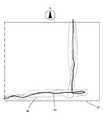
図2は、通行可能部分取得部22により取得された通行可能部分を示す概念図である。なお、図中の方位は説明のために示した。移動測定部11にて測定された測定結果に基づいて得られた位置を連ねた線を、図中の実線41で表わしている。また、図中の四角形の囲み42は建物の外郭を示している。 FIG. 2 is a conceptual diagram showing the passable part acquired by the passable
ユーザ端末10は、建物の南西の隅から建物内に入っている(点線)。この場所43からGPS電波の受信が不可能となり、測定開始位置として取得される。以後の測定結果に基づいて得られた位置を連ねた線が、図中における実線である。この実線は、建物に入ってから東に進み、西に少し転回した後、北に進み建物の外に進んでいる。建物の外に出たところでGPS電波の受信が再開され、この場所44が測定終了位置となる。このように得られた線を通行可能部分として取得する。なお、移動測定部11による測定結果が加重部13により重み付けがなされている場合についても同様である。 The
ここで、通行可能部分の取得に供される移動測定部11による測定結果は、磁場測定部12による測定結果と関連付けられている。したがって、取得された通行可能部分を構成する各位置も、その位置における磁場と対応付けられている。磁場と対応付けられた通行可能部分は、磁場データを対応付けた地図データとなる。すなわち、通行可能部分又は通行可能部分の集積は、磁場の測定が可能な携帯端末などに対して、GPS電波が届かない屋内において磁場に基づくナビゲーションをサービスとして提供するための磁場データと対応付けられた地図データ(以下、磁場対応屋内マップということがある)となる。後述する通行可能部分や通路及びそれらの集積したものなども上記の磁場対応屋内マップとなる。 Here, the measurement result by the moving
また、通行可能部分取得部22は、ユーザ端末10にて取得された測定開始位置から取得された測定終了位置に至る間に移動測定部11にて測定された測定結果に基づいて得られた位置を基準とした所定範囲を通行可能部分として取得してもよい。 In addition, the passable
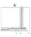
図3は、上述の所定範囲を通行可能部分として取得した一例を示す概念図である。図2の例で示した測定結果に基づいて得られた位置を中心とした所定半径の円45(破線円)を連ね、その外縁に沿った線46、47との間の領域を通行可能部分として得ている。 FIG. 3 is a conceptual diagram showing an example acquired as a passable portion of the predetermined range. A circle 45 (broken circle) having a predetermined radius centered on the position obtained based on the measurement result shown in the example of FIG. 2 is connected, and a region between the
複数取得部23は、通行可能部分取得部22から得られた通行可能部分を複数取得する機能を果たす。複数取得部23が複数取得する通行可能部分は、一のユーザ端末から出力された測定結果に基づき複数取得されたものでもよいし、複数のユーザ端末から出力された測定結果に基づき取得された個々の通行可能部分を併せて複数取得したものであってもよい。 The
通路取得部24は、複数取得部23が取得した複数の通行可能部分に基づいて一の通路を取得する機能を果たす。図4は、通路取得部24により取得される通路の一例を示す概念図である。図示するように、点線48で示される線として取得された通行可能部分が複数取得部32によって4本取得されている。そして、通路取得部24は、例えば4本の通行可能部分を平均化するなどして、一の通路49を取得する。なお、一の通路を取得するための処理は、平均化の他に各通行可能部分の重心を求めて取得したり、各通行可能部分の分散や偏差を考慮して取得したりしてよい。複数の通行可能部分に基づいて一の通路を取得することにより、個々の通行可能部分の誤差が抑制され通行可能な通路を高精度に得ることができる。また、図3で例示したように幅を持った通行可能部分を複数取得して一の通路を得るようにしてもよい。なお、加重部13により重み付けされた測定結果に基づき通行可能部分を取得した場合も、同様に一の通路を取得する。 The
また、取得する複数の通行可能分部分は、逆向きに進む通行可能部分が含まれるように構成することも好ましい。例えば、図2から図4に示した例において、建物42の北東の出入口を測定開始位置とし南西の隅を測定終了位置とする通行可能部分を、一の通路を取得するために取得する通行可能部分に含めるようにする。公共の通路などにおいては進行方向に応じて通路の右側又は左側の一方を通行することが多い。したがって、進行方向が相対する通行可能部分を併せて複数取得したうえで一の通路を取得することで、より実態に即した高精度の通路を取得することができる。 Moreover, it is also preferable that the plurality of passable portions to be acquired include a passable portion that proceeds in the reverse direction. For example, in the example shown in FIGS. 2 to 4, the passable part having the northeast entrance of the
整形部25は、通路取得部24が取得した通路を整形する機能を果たす。例えば、取得した通路を方形に整形する。建物内の実際の通路は概ね直線と直角の組み合わせで形成されていることが多いため、実際の通路と整合させるために通路取得部25が取得した通路を整形する。 The shaping
図5は、図4で示した通路を整形した一例を示す概念図である。図示するように、整形部25により、通路取得部24により取得された通路49を方形にて整形することで、実際の建物において想定し得る態様で通路50(図中、斜線領域)を取得することができる。
<1−4.インセンティブの例>FIG. 5 is a conceptual diagram showing an example of shaping the passage shown in FIG. As shown in the drawing, the passage 50 (shaded area in the figure) is acquired in a manner that can be assumed in an actual building by shaping the
<1-4. Examples of incentives>
特典情報付与部26は、移動測定部での測定結果(例えば、測定移動の量)に応じて特典のための情報である特典情報を付与する機能を果たす。ユーザ端末10に備わる磁場測定部12、移動測定部11及び出力部14による機能は、例えば、サーバ装置20が配信するアプリケーションをインストールし実行するなどして実現し得る。この場合、かかるアプリケーションがユーザ端末10により実行されることで、サーバ装置20は、ユーザ端末10から出力される互いに対応付けられた磁場データと移動測定部11による測定結果とを取得し、通行可能部分や通路を取得することができる。サーバ装置20は、取得した通行可能部分や通路に基づき前述の磁場対応屋内マップを生成し、磁場の測定が可能な携帯端末など(ユーザ端末10も含む)に対して、磁場対応屋内マップによるナビゲーションをサービスとして提供することができる。 The privilege
そこで、サービス提供に資する情報を提供するユーザ端末10に対して特典を付与するよう構成し、特典のための情報である特典情報を付与する。この特典情報は移動測定部での測定結果に応じたものであり、例えば、測定結果の量の多寡や測定した位置が様々な場所に及んでいるか否かなどに応じる。すなわち測定結果の量が多ければ取得する通行可能部分の精度向上に資するし、様々な場所での測定結果は様々な場所での地図データを生成することに資するため、相応の特典を当該ユーザ端末に対して提供する。特典情報の取得は、出力した測定結果の累積量に応じて取得してもよいし、所定期間(一ヶ月など)において出力した測定結果の量などに応じて取得してもよい。 Then, it comprises so that a privilege may be provided with respect to the
ユーザ端末10は、上記のような特典のための情報である特典情報を、移動測定部での測定結果に応じて取得する特典情報取得部15を有する。
また、ユーザ端末10が磁場対応屋内マップによるナビゲーションサービスを利用している場合には、そのナビゲーションサービスを享受し得るエリア(利用範囲権限)を測定結果に応じて拡大することなどを特典としてもよい(利用範囲権限取得手段16)。測定結果に応じて利用範囲権限を付与することで、ユーザ端末10による測定結果の出力のインセンティブとなり、サーバ装置20においては磁場対応屋内マップの拡充を図ることができる。 In addition, when the
上記のような特典は、地磁気による位置測位が、GPSとは異なり、サーバに依存の測位であることを活かしたものである。
<2.ハードウェア構成>The privilege as described above makes use of the fact that position positioning by geomagnetism is positioning dependent on a server, unlike GPS.
<2. Hardware configuration>
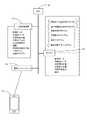
図6は、上記機能的な各構成要件をハードウェアとして実現した際の、情報処理装置の構成の一例を表す概略図である。ここでは、とくにサーバ装置20を例にあげてハードウェア構成の働きについて説明する。 FIG. 6 is a schematic diagram illustrating an example of the configuration of the information processing apparatus when the functional components are realized as hardware. Here, the operation of the hardware configuration will be described by taking the
この図にあるように、サーバ装置は、各種演算処理を実行するためのCPU61と、主メモリ62と、二次記憶装置63と、通信インターフェース64などを備える。二次記憶装置にはユーザ端末10が出力した互いに対応付けられた磁場データと加速度データなどの各種データ、開始終了位置取得プログラムをはじめとする各種プログラムなどが格納されている。CPUはこれら各種プログラムを主メモリに展開したうえで実行する。前記の各ハードウェア構成はシステムバスなどのデータ通信経路によって相互に接続され、情報の送受信や処理を行う。 As shown in this figure, the server device includes a
まず、CPUは、開始終了位置取得プログラムを実行し、格納されている測定開始位置と測定終了位置を読出す。そして、通行可能部分取得プログラムを実行し、測定開始位置から測定終了位置に至る間に取得された加速度データなどを順次読出し、さらにそれらのデータに基づき移動に伴う位置情報群を取得する。そして、得られた各位置を連ねた線を通行可能部分として取得する。取得した通行可能部分は二次記憶装置に格納される。 First, the CPU executes a start / end position acquisition program and reads the stored measurement start position and measurement end position. Then, the passable part acquisition program is executed, acceleration data acquired during the period from the measurement start position to the measurement end position, and the like are sequentially read, and a position information group associated with movement is acquired based on these data. And the line which connected each obtained position is acquired as a part which can be passed. The acquired passable part is stored in the secondary storage device.
さらに、複数取得プログラムを実行し、通行可能部分取得プログラムにより得られた通行可能部分と近い場所に位置する他の通行可能部分が二次記憶装置に格納されているかを検索する。他の通行可能部分が存在するとの検索結果が得られた場合には、その通行可能部分を取得する。そして、通路取得プログラムを実行し、それぞれの通行可能部分を平均化するための演算処理等を実行し、一の通路を取得する。さらに整形プログラムを実行し、取得された通路を整形する処理を行う場合もある。 Further, a plurality of acquisition programs are executed, and it is searched whether or not other passable parts located near the passable part obtained by the passable part acquisition program are stored in the secondary storage device. If a search result indicating that another passable part exists is obtained, the passable part is acquired. Then, the passage acquisition program is executed, and an arithmetic process for averaging each passable portion is executed to acquire one passage. Furthermore, a shaping program may be executed to perform processing for shaping the acquired passage.
また、特典情報取得プログラムを実行し、一のユーザ端末と紐付けられた加速度データなどを集計し、集計結果と特典情報とを対応付けたテーブルなどを参照し、当該ユーザ端末に対する特典情報を取得する。さらに取得した特典情報を当該ユーザ端末へ送信する処理を行ってもよい。 Also, the privilege information acquisition program is executed, the acceleration data associated with one user terminal is aggregated, and the privilege information for the user terminal is obtained by referring to a table in which the aggregation result and the privilege information are associated with each other. To do. Furthermore, you may perform the process which transmits the acquired privilege information to the said user terminal.
なお、ユーザ端末10についてのハードウェア構成についての図示は省略するが、CPU、主メモリ、二次記憶装置の他に加速度センサや磁場センサ、通信回路などを備え、各種プログラムを保持するとともに、それらのプログラムを適宜実行することで、互いに対応付けられた加速度データと磁場データとをサーバ装置20に出力する。 In addition, although illustration about the hardware constitutions about the
また、上述のハードウェア構成は一例にすぎず、各機能的構成をユーザ端末10とサーバ装置20とで分け合う態様は他にもあり得る。また、ユーザ端末10あるいはサーバ装置20のいずれか一方が、すべての機能的構成を実現し得るハードウェア構成を備えるものとしてもよい。これは、以下に述べる処理の流れにおいても同様である。
<3.処理の流れ>The above-described hardware configuration is merely an example, and there may be other modes in which each functional configuration is shared between the
<3. Process flow>
図7は、本実施形態の情報処理装置における処理の流れの一例を表すフロー図である。ここではサーバ装置20における処理の流れを示す。なお、以下に示すステップは、上記のような計算機の各ハードウェア構成によって実行されるステップであっても良いし、媒体に記録され計算機を制御するためのプログラムを構成する処理ステップであっても構わない。 FIG. 7 is a flowchart illustrating an example of a processing flow in the information processing apparatus of the present embodiment. Here, the flow of processing in the
図示するように、まず、磁場データと対応付けられた移動測定部による測定結果を取得したか否かの判断を行う(S71)。取得していないとの判断結果を得た場合には処理は終了する。測定結果を取得したとの判断結果を得た場合には、複数の移動測定手段による測定結果があるか否かの判断を行う(S72)。あるとの判断結果を得た場合には、測定結果に移動測定手段別の重み付けを行う(S73)。一方ないとの判断結果を得た場合には、重み付けの処理を経ず次のステップに移行する。 As shown in the figure, first, it is determined whether or not the measurement result by the movement measurement unit associated with the magnetic field data has been acquired (S71). If the determination result that it has not been obtained is obtained, the process ends. If a determination result indicating that the measurement result has been acquired is obtained, it is determined whether there is a measurement result by a plurality of movement measurement means (S72). When the determination result is obtained, the measurement result is weighted for each moving measurement means (S73). If it is determined that there is no one, the process proceeds to the next step without performing the weighting process.
そして、測定結果に基づいて得られた位置を連ねた線を通行可能部分として取得する(S74)。続いて、複数の通行可能部分を取得したか否かの判断を行う(S75)。取得していないとの判断結果を得た場合には、先に取得した通行可能部分を所定の記憶装置に格納するなどしてから、再び測定結果を取得したか否かの判断処理(S71)に戻る。複数の通行可能部分を取得したとの判断結果を得た場合には、複数の通行可能部分から一の通路を取得する(S76)。そして、取得した一の通路を所定の記憶装置に格納するなどしてから、再び測定結果を取得したか否かの判断処理(S71)に戻る。 And the line which connected the position obtained based on the measurement result is acquired as a part which can be passed (S74). Subsequently, it is determined whether or not a plurality of passable portions have been acquired (S75). If a determination result indicating that the measurement result is not acquired is obtained, a process for determining whether or not the measurement result is acquired again after storing the previously acquired passable part in a predetermined storage device (S71) Return to. When a determination result indicating that a plurality of passable portions has been acquired is obtained, one passage is acquired from the plurality of passable portions (S76). Then, after storing the acquired one passage in a predetermined storage device, the process returns to the determination process (S71) as to whether or not the measurement result has been acquired again.
なお、ユーザ端末10における処理の流れを図示することは省略するが、例えば、磁場を測定する処理及び動きを測定する処理を行い、それぞれの測定で得られた測定結果を対応付ける処理を行い、さらに対応付けられた測定結果をサーバ装置20に出力する処理などを行う。
<4.効果>Although illustration of the flow of processing in the
<4. Effect>
本実施形態の情報処理装置によれば、地図データの事前準備なしで、専門スタッフでなくても本装置を組み込んだ機器を持って移動するだけで、磁場データを対応付けた地図データを容易かつ低コストで生成することができる。
<5.他の例>According to the information processing apparatus of the present embodiment, map data associated with magnetic field data can be easily and simply moved by holding a device in which the apparatus is incorporated even without a specialist staff without prior preparation of map data. It can be produced at low cost.
<5. Other examples>
図9は、情報処理装置の他の例における機能ブロック図である。また、図10は本例における情報処理装置のハードウェア構成の一例を示す図である。本例は、図1などを用いて説明した実施形態に準じて構成される。したがって、同名で示す構成についての説明は省略する。 FIG. 9 is a functional block diagram of another example of the information processing apparatus. FIG. 10 is a diagram illustrating an example of a hardware configuration of the information processing apparatus in this example. This example is configured according to the embodiment described with reference to FIG. Therefore, the description of the configuration indicated by the same name is omitted.
一般ユーザによる測定移動(スキャン)を促進するインセンティブは、特典などの報酬に限らず、測定移動を伴うゲームなど競技への参加や勝敗でもよい。これにより、ユーザ間の対抗意識により我先にスキャンが行われ、より迅速ないし低コストに地磁気データと地図データが整備できる。 Incentives for promoting measurement movement (scanning) by a general user are not limited to rewards such as benefits, but may be participation in competitions such as games involving measurement movement, or wins and losses. As a result, a scan is performed on our own by the sense of opposition between the users, and geomagnetic data and map data can be prepared more quickly or at a lower cost.
この場合、例えば、サーバ装置20は、測定結果が所定以下である領域(例えば、未スキャンの領域や、スキャン回数が少ない領域)の測定を伴う競技(陣取りゲーム、所定領域ごとに一筆書きでの踏破に挑戦するものなど)及び参加者について、所定期間内における移動測定部での測定結果に応じて競技の結果(個々のユーザやユーザの所属チームの順位、勝敗、受賞者など)を決定する競技結果決定部27を備える。 In this case, for example, the
また、測定移動(スキャン)において、周囲の映像を撮影して磁場測定時の動き、現在位置、周囲の壁や棚などの構造を特定してもよい。これにより、加速度センサなど物理的センサのみの場合より高精度なデータ整備が実現できる。 Further, in measurement movement (scanning), surrounding images may be taken to identify the movement at the time of magnetic field measurement, the current position, and the structure such as surrounding walls and shelves. Thereby, it is possible to realize data maintenance with higher accuracy than in the case of using only physical sensors such as acceleration sensors.
この場合、例えば、ユーザ端末10は、移動測定部として又は移動測定部に代えて前記磁場の測定に係る場所の映像(その場所の周囲の映像も含む)を撮影する撮影手段を有する。具体的手段としては、例えば、スマートフォンやタブレットPCなどに内蔵されるカメラなどがある。また、撮影する映像は、静止画だけでなく動画も含まれる。 In this case, for example, the
そして、サーバ装置20は、撮影された前記映像に基いて前記動き又は周囲の構造の少なくとも一方を特定する映像処理部28を有する。動き又は周囲の構造の特定は、例えば、撮像された壁や床に対応する平面や矩形などを認識するオブジェクト認識その他画像処理技術により行うことができる。 The
また、磁場測定時に撮影した周囲の映像は、サービスの提供時、端末から送信される磁場の変遷と近似した磁場の変遷と地磁気データ中で対応付けられている映像を抽出してもよい。これにより、サービス提供時、端末が位置する同じ場所で過去に撮影された映像を、位置座標を経由することなく、地磁気(磁場)同士の照合で容易に抽出可能となる。過去の撮影された映像の見ることで、同じ場所の過去の様子(例えば、災害以前、開発や再開発以前、トラブル以前、戦乱以前、気象変動以前など)を把握したり、同じ場所を過去に撮影者が移動した際の様子を把握できる。 Moreover, the surrounding image | video image | photographed at the time of a magnetic field measurement may extract the image | video matched with the transition of the magnetic field approximated with the transition of the magnetic field transmitted from a terminal at the time of service provision. As a result, at the time of service provision, it is possible to easily extract images captured in the past at the same location where the terminal is located by collating geomagnetism (magnetic fields) without passing through position coordinates. By viewing past images, you can see the past situation of the same place (for example, before disaster, before development or redevelopment, before trouble, before war, before weather change, etc.) You can see how the photographer moved.
この場合、ユーザ端末10は、撮影された前記映像を前記磁場と対応付けて記憶する手段を備える。そして、サーバ装置20は、キーとして与えられる磁場と適合する前記磁場に対応付けられている前記映像を抽出する映像抽出部29を備える。 In this case, the
1 情報処理装置
10 ユーザ端末
11 移動測定部
12 磁場測定部
13 加重部
14 出力部
15 特典情報取得部
16 利用範囲権限取得手段
20 サーバ装置
21 開始終了位置取得部
22 通行可能部分取得部
23 複数取得部
24 通路取得部
25 整形部
26 特典情報付与部
27 競技結果決定部
28 映像処理部
29 映像抽出部
30 ユーザ端末
40 ネットワークDESCRIPTION OF
Claims (22)
Translated fromJapanese磁場を測定する磁場測定部と、
動きを測定する移動測定部と、
測定された磁場と、移動測定部の測定結果とを関連付けて出力する出力部と、
を有するマップ生成装置。A map generation device for generating a map in which geomagnetic data and map data are associated with each other,
A magnetic field measurement unit for measuring the magnetic field;
A movement measuring unit for measuring movement;
An output unit that associates and outputs the measured magnetic field and the measurement result of the moving measurement unit;
Amap generation device having:
請求項1から3のいずれか一に記載された装置にて測定開始位置から測定終了位置に至る間に移動測定部にて測定された測定結果に基づいて得られた位置を連ねた線を通行可能部分として取得する通行可能部分取得部と、
を有するマップ生成装置。A start / end position acquisition unit for acquiring a measurement start position and a measurement end position;
A line connecting positions obtained on the basis of measurement results measured by the moving measurement unit between the measurement start position and the measurement end position in the apparatus according to any one of claims 1 to 3. A passable part acquisition unit that acquires as a possible part;
Amap generation device having:
請求項1から3のいずれか一に記載された装置にて測定開始位置から測定終了位置に至る間に移動測定部にて測定された測定結果に基づいて得られた位置を基準とした所定範囲を通行可能部分として取得する通行可能部分取得部と、
を有するマップ生成装置。A start / end position acquisition unit for acquiring a measurement start position and a measurement end position;
A predetermined range based on a position obtained based on a measurement result measured by the moving measurement unit during the period from the measurement start position to the measurement end position in the apparatus according to any one of claims 1 to 3. A passable part acquisition unit for acquiring a passable part;
Amap generation device having:
取得した複数の通行可能部分に基づいて一の通路を取得する通路取得部と、
を有する請求項4又は5に記載のマップ生成装置。A plurality of acquisition units for acquiring a plurality of passable parts obtained from the passable part acquisition unit;
A passage acquisition unit that acquires one passage based on the acquired plurality of accessible parts;
Themap generation device according to claim 4, comprising:
前記通行可能部分取得部は、前記加重部での加重結果に基づいて前記通行可能部分の取得を行う請求項4から7のいずれか一項に記載のマップ生成装置。A weighting unit that weights the measurement results obtained from the plurality of movement measurementunits of the movement measurement unit of themap generation device according to claim 8 for each movement measurement unit,
Themap generation device according to any one of claims 4 to 7, wherein the passable part acquisition unit acquires the passable part based on a weighted result in the weighting part.
請求項4から7、9、10、12又は14に記載のマップ生成装置は、キーとして与えられる磁場と適合する前記磁場に対応付けられている前記映像を抽出する映像抽出部と、
を備えたことを特徴とする請求項15に記載のマップ生成装置。Themap generation device according to claim 15, further comprising means for storing the captured image in association with the magnetic field,
Themap generation device according to any one of claims 4 to 7, 9, 10, 12, or 14, an image extraction unit that extracts the image associated with the magnetic field that matches a magnetic field given as a key;
Themap generation apparatus according to claim 15, further comprising:
磁場測定部が、磁場を測定する磁場測定ステップと、
移動測定部が、動きを測定する移動測定ステップと、
出力部が、測定された磁場と、測定された動きの測定結果とを関連付けて出力する出力ステップと、
を有するマップ生成方法。Amap generation method executed bya map generation device for generating a map in which geomagnetic data and map data are associated with each other,
A magnetic field measurement unit for measuring a magnetic field;
A movement measuring unit for measuring movement, and a movement measuring step;
An output step in which the output unit associates and outputs the measured magnetic field and the measurement result of the measured movement;
Amap generation method comprising:
開始終了位置取得部が、測定開始位置及び測定終了位置を取得する開始終了位置取得ステップと、
通行可能部分取得部が、請求項1から3のいずれか一に記載された装置にて測定開始位置から測定終了位置に至る間に移動測定部にて測定された測定結果に基づいて得られた位置を連ねた線を通行可能部分として取得する通行可能部分取得ステップと、
を有するマップ生成方法。Amap generation method executed bya map generation device for generating a map in which geomagnetic data and map data are associated with each other,
A start / end position acquisition unit for acquiring a measurement start position and a measurement end position;
The passable part acquisition unit is obtained based on the measurement result measured by the moving measurement unit from the measurement start position to the measurement end position by the apparatus according to any one of claims 1 to 3. An accessible part acquisition step of acquiring a line connecting positions as an accessible part;
Amap generation method comprising:
開始終了位置取得部が、測定開始位置及び測定終了位置を取得する開始終了位置取得ステップと、
通行可能部分取得部が、請求項1から3のいずれか一に記載された装置にて測定開始位置から測定終了位置に至る間に移動測定部にて測定された測定結果に基づいて得られた位置を基準とした所定範囲を通行可能部分として取得する通行可能部分取得ステップと、
を有するマップ生成方法。Amap generation method executed bya map generation device for generating a map in which geomagnetic data and map data are associated with each other,
A start / end position acquisition unit for acquiring a measurement start position and a measurement end position;
The passable part acquisition unit is obtained based on the measurement result measured by the moving measurement unit from the measurement start position to the measurement end position by the apparatus according to any one of claims 1 to 3. A passable part acquisition step for acquiring a predetermined range as a passable part based on the position;
Amap generation method comprising:
複数取得部が、請求項18又は請求項19に記載のマップ生成装置の通行可能部分取得ステップから得られた通行可能部分を複数取得する複数取得ステップと、
通路取得部が、取得した複数の通行可能部分に基づいて一の通路を取得する通路取得ステップと、
を有するマップ生成方法。Amap generation method executed by amap generation device ,
A plurality of acquisition units, wherein the plurality of acquisition units acquire a plurality of passable parts obtained from the passable part acquisition step of themap generation device according to claim 18 or claim 19,
A passage acquisition step in which the passage acquisition unit acquires one passage based on the acquired plurality of accessible portions;
Amap generation method comprising:
磁場測定部が、磁場を測定する磁場測定ステップと、
移動測定部が、動きを測定するステップと、
出力部が、測定された磁場と、測定された動きの測定結果とを関連付けて出力する出力ステップと、
を計算機に実行させるプログラム。A program for operating amap generation device ,
A magnetic field measurement unit for measuring a magnetic field;
A movement measuring unit measuring the movement;
An output step in which the output unit associates and outputs the measured magnetic field and the measurement result of the measured movement;
A program that causes a computer to execute.
Priority Applications (2)
| Application Number | Priority Date | Filing Date | Title |
|---|---|---|---|
| JP2015185294AJP6352877B2 (en) | 2015-09-18 | 2015-09-18 | MAP GENERATION DEVICE, MAP GENERATION METHOD, AND MAP GENERATION PROGRAM |
| US15/224,879US10107629B2 (en) | 2015-09-18 | 2016-08-01 | Information processing system, information processing method, and non-transitory computer readable storage medium |
Applications Claiming Priority (1)
| Application Number | Priority Date | Filing Date | Title |
|---|---|---|---|
| JP2015185294AJP6352877B2 (en) | 2015-09-18 | 2015-09-18 | MAP GENERATION DEVICE, MAP GENERATION METHOD, AND MAP GENERATION PROGRAM |
Publications (2)
| Publication Number | Publication Date |
|---|---|
| JP2017058321A JP2017058321A (en) | 2017-03-23 |
| JP6352877B2true JP6352877B2 (en) | 2018-07-04 |
Family
ID=58277014
Family Applications (1)
| Application Number | Title | Priority Date | Filing Date |
|---|---|---|---|
| JP2015185294AActiveJP6352877B2 (en) | 2015-09-18 | 2015-09-18 | MAP GENERATION DEVICE, MAP GENERATION METHOD, AND MAP GENERATION PROGRAM |
Country Status (2)
| Country | Link |
|---|---|
| US (1) | US10107629B2 (en) |
| JP (1) | JP6352877B2 (en) |
Families Citing this family (6)
| Publication number | Priority date | Publication date | Assignee | Title |
|---|---|---|---|---|
| KR20180045510A (en)* | 2016-10-26 | 2018-05-04 | 삼성에스디에스 주식회사 | Method and apparatus for geomagnetic signal processing |
| CN107883948B (en)* | 2017-10-23 | 2021-03-23 | 石家庄铁道大学 | Variable-step ICCP geomagnetic matching method |
| JP6379271B1 (en)* | 2017-12-04 | 2018-08-22 | ソフィア総合研究所株式会社 | Watch system, watch method, watch terminal, server, and program |
| KR20210112664A (en) | 2020-03-05 | 2021-09-15 | 삼성전자주식회사 | Method for determining a location and electronic device supporting the same |
| CN112304317B (en)* | 2020-10-28 | 2022-04-12 | 中国矿业大学 | Indoor positioning method based on indoor multidimensional geomagnetic features |
| WO2022138222A1 (en) | 2020-12-24 | 2022-06-30 | ソニーグループ株式会社 | Information processing device, information processing method, and program |
Family Cites Families (32)
| Publication number | Priority date | Publication date | Assignee | Title |
|---|---|---|---|---|
| JPH06180236A (en)* | 1992-12-15 | 1994-06-28 | Nippondenso Co Ltd | Navigation apparatus utilizing geomagnetism |
| JP3510720B2 (en)* | 1995-10-13 | 2004-03-29 | 株式会社エヌ・ティ・ティ・ドコモ | Mobile data communication system |
| US7474896B2 (en)* | 2000-07-14 | 2009-01-06 | Norman Mohi | Locating system and method |
| JP2002159742A (en)* | 2000-11-27 | 2002-06-04 | Jatco Transtechnology Ltd | Navigation device |
| JP4040391B2 (en)* | 2002-08-21 | 2008-01-30 | 三菱電機株式会社 | Map information processing device and map information distribution center |
| US9304412B2 (en)* | 2007-08-24 | 2016-04-05 | Nikon Corporation | Movable body drive method and movable body drive system, pattern formation method and apparatus, exposure method and apparatus, device manufacturing method, and measuring method |
| US8761751B2 (en)* | 2008-03-14 | 2014-06-24 | William J. Johnson | System and method for targeting data processing system(s) with data |
| US8577595B2 (en) | 2008-07-17 | 2013-11-05 | Memsic, Inc. | Location and path-map generation data acquisition and analysis systems |
| JP5712530B2 (en)* | 2010-09-02 | 2015-05-07 | カシオ計算機株式会社 | POSITIONING DEVICE, POSITIONING METHOD, AND PROGRAM |
| EP2646775B1 (en)* | 2010-12-01 | 2015-10-14 | Commissariat à l'Énergie Atomique et aux Énergies Alternatives | Method and system for estimating a path of a mobile element or body |
| GB201103822D0 (en)* | 2011-03-07 | 2011-04-20 | Isis Innovation | System for providing locality information and associated devices |
| JP5741115B2 (en) | 2011-03-25 | 2015-07-01 | ソニー株式会社 | POSITIONING DEVICE, POSITIONING METHOD, PROGRAM, AND RECORDING MEDIUM |
| JP5838758B2 (en)* | 2011-03-31 | 2016-01-06 | 富士通株式会社 | Calibration method, information processing apparatus and calibration program |
| KR20130018079A (en)* | 2011-08-10 | 2013-02-20 | 삼성전자주식회사 | Beam fixing device and method in wireless communication system |
| KR101810985B1 (en)* | 2011-09-02 | 2017-12-21 | 삼성전자주식회사 | A method and an apparatus for measuring location of terminal using a magnetic field |
| US20130080120A1 (en)* | 2011-09-23 | 2013-03-28 | Honeywell International Inc. | Method for Optimal and Efficient Guard Tour Configuration Utilizing Building Information Model and Adjacency Information |
| JP6123151B2 (en)* | 2011-09-30 | 2017-05-10 | カシオ計算機株式会社 | POSITIONING PLACE IDENTIFICATION DEVICE, POSITIONING PLACE IDENTIFICATION METHOD, PROGRAM, AND POSITIONING PLACE IDENTIFICATION SYSTEM |
| US9702707B2 (en)* | 2011-12-22 | 2017-07-11 | AppLabz, LLC | Systems, methods, and apparatus for providing indoor navigation using optical floor sensors |
| FI20116342L (en)* | 2011-12-30 | 2013-07-01 | Rdnet Oy | Method and arrangement for determining the position and/or speed of an object adapted to move and use of the arrangement |
| US20130253880A1 (en)* | 2012-03-25 | 2013-09-26 | Benjamin E. Joseph | Managing Power Consumption of a Device with a Gyroscope |
| US9228842B2 (en)* | 2012-03-25 | 2016-01-05 | Sensor Platforms, Inc. | System and method for determining a uniform external magnetic field |
| JP2014053884A (en)* | 2012-08-06 | 2014-03-20 | Ricoh Co Ltd | Positioning device, program, and apparatus control system |
| US9730029B2 (en)* | 2012-11-08 | 2017-08-08 | Duke University | Unsupervised indoor localization and heading directions estimation |
| US9175963B2 (en)* | 2013-01-10 | 2015-11-03 | MCube Inc. | Dead reckoning based initialization of position and heading using discrete position indicators |
| US20140274114A1 (en)* | 2013-03-14 | 2014-09-18 | Qualcomm Incorporated | Positioning based on signals injected into concealed infrastructure |
| JP6293458B2 (en)* | 2013-11-15 | 2018-03-14 | 株式会社日立製作所 | Probe information management apparatus, probe information management system, and probe information management method |
| US9719787B2 (en)* | 2015-02-26 | 2017-08-01 | Invensense, Inc. | Method and system for multiple pass smoothing |
| US9955359B2 (en)* | 2015-05-19 | 2018-04-24 | Cisco Technology, Inc. | Location services with multiple devices |
| US20170031925A1 (en)* | 2015-07-27 | 2017-02-02 | Cisco Technology, Inc. | Mapping dynamic spaces and way finding related to the mapping |
| US10967872B2 (en)* | 2015-08-27 | 2021-04-06 | Truemotion, Inc. | Methods and systems for presenting collected driving data |
| US11162791B2 (en)* | 2015-12-22 | 2021-11-02 | Invensense, Inc. | Method and system for point of sale ordering |
| US10281279B2 (en)* | 2016-10-24 | 2019-05-07 | Invensense, Inc. | Method and system for global shape matching a trajectory |
- 2015
- 2015-09-18JPJP2015185294Apatent/JP6352877B2/enactiveActive
- 2016
- 2016-08-01USUS15/224,879patent/US10107629B2/enactiveActive
Also Published As
| Publication number | Publication date |
|---|---|
| JP2017058321A (en) | 2017-03-23 |
| US20170082440A1 (en) | 2017-03-23 |
| US10107629B2 (en) | 2018-10-23 |
Similar Documents
| Publication | Publication Date | Title |
|---|---|---|
| JP6352877B2 (en) | MAP GENERATION DEVICE, MAP GENERATION METHOD, AND MAP GENERATION PROGRAM | |
| Renaudin et al. | Evaluating indoor positioning systems in a shopping mall: The lessons learned from the IPIN 2018 competition | |
| EP3213031B1 (en) | Simultaneous localization and mapping by using earth's magnetic fields | |
| Potorti et al. | The IPIN 2019 indoor localisation competition—Description and results | |
| Ng et al. | Design of a mobile augmented reality-based indoor navigation system | |
| CN110246235B (en) | A method and system for on-site inspection of power distribution room based on Hololens mixed reality technology | |
| Kasprzak et al. | Feature-based indoor navigation using augmented reality | |
| CN107194969A (en) | The pick up calibration determined based on end point and location estimation | |
| US20090106126A1 (en) | Information presentation system of visual field agreement type, and portable information terminal and server for use in the system | |
| EP3190581B1 (en) | Interior map establishment device and method using cloud point | |
| Feng et al. | Augmented reality markers as spatial indices for indoor mobile AECFM applications | |
| KR20130091908A (en) | Apparatus and method for providing indoor navigation service | |
| CN105190239A (en) | Directional and X-ray view techniques for navigation using a mobile device | |
| KR101413011B1 (en) | Augmented Reality System based on Location Coordinates and Augmented Reality Image Providing Method thereof | |
| JP2016164518A (en) | Indoor positional information positioning system and indoor positional information positioning method | |
| Han et al. | KAILOS: KAIST indoor locating system | |
| Ramesh et al. | Indoor navigation using augmented reality for mobile application | |
| Moayeri et al. | PerfLoc (Part 2): Performance evaluation of the smartphone indoor localization apps | |
| Elhamshary et al. | JustWalk: A crowdsourcing approach for the automatic construction of indoor floorplans | |
| Verma et al. | A smartphone based indoor navigation system | |
| Ahmad et al. | WI-FI RSS fingerprinting for indoor localization using augmented reality | |
| Burigat et al. | Mobile three-dimensional maps for wayfinding in large and complex buildings: Empirical comparison of first-person versus third-person perspective | |
| Kaiser et al. | A maps-based angular PDF for navigation systems in indoor and outdoor environments | |
| Qian et al. | Optical flow-based gait modeling algorithm for pedestrian navigation using smartphone sensors | |
| Yeh et al. | Research on calibration‐free fingerprinting positioning techniques based on terrestrial magnetism databases for indoor environments |
Legal Events
| Date | Code | Title | Description |
|---|---|---|---|
| A621 | Written request for application examination | Free format text:JAPANESE INTERMEDIATE CODE: A621 Effective date:20170228 | |
| A871 | Explanation of circumstances concerning accelerated examination | Free format text:JAPANESE INTERMEDIATE CODE: A871 Effective date:20170228 | |
| A975 | Report on accelerated examination | Free format text:JAPANESE INTERMEDIATE CODE: A971005 Effective date:20170418 | |
| A131 | Notification of reasons for refusal | Free format text:JAPANESE INTERMEDIATE CODE: A131 Effective date:20170619 | |
| A521 | Request for written amendment filed | Free format text:JAPANESE INTERMEDIATE CODE: A523 Effective date:20170817 | |
| A131 | Notification of reasons for refusal | Free format text:JAPANESE INTERMEDIATE CODE: A131 Effective date:20171106 | |
| A02 | Decision of refusal | Free format text:JAPANESE INTERMEDIATE CODE: A02 Effective date:20180112 | |
| A521 | Request for written amendment filed | Free format text:JAPANESE INTERMEDIATE CODE: A523 Effective date:20180406 | |
| A911 | Transfer to examiner for re-examination before appeal (zenchi) | Free format text:JAPANESE INTERMEDIATE CODE: A911 Effective date:20180416 | |
| TRDD | Decision of grant or rejection written | ||
| A01 | Written decision to grant a patent or to grant a registration (utility model) | Free format text:JAPANESE INTERMEDIATE CODE: A01 Effective date:20180510 | |
| A61 | First payment of annual fees (during grant procedure) | Free format text:JAPANESE INTERMEDIATE CODE: A61 Effective date:20180607 | |
| R150 | Certificate of patent or registration of utility model | Ref document number:6352877 Country of ref document:JP Free format text:JAPANESE INTERMEDIATE CODE: R150 | |
| S533 | Written request for registration of change of name | Free format text:JAPANESE INTERMEDIATE CODE: R313533 | |
| R350 | Written notification of registration of transfer | Free format text:JAPANESE INTERMEDIATE CODE: R350 | |
| S111 | Request for change of ownership or part of ownership | Free format text:JAPANESE INTERMEDIATE CODE: R313111 | |
| R350 | Written notification of registration of transfer | Free format text:JAPANESE INTERMEDIATE CODE: R350 | |
| R250 | Receipt of annual fees | Free format text:JAPANESE INTERMEDIATE CODE: R250 | |
| R250 | Receipt of annual fees | Free format text:JAPANESE INTERMEDIATE CODE: R250 |