JP6166294B2 - Automatic driving system, automatic driving method and computing device - Google Patents
Automatic driving system, automatic driving method and computing deviceDownload PDFInfo
- Publication number
- JP6166294B2 JP6166294B2JP2015030372AJP2015030372AJP6166294B2JP 6166294 B2JP6166294 B2JP 6166294B2JP 2015030372 AJP2015030372 AJP 2015030372AJP 2015030372 AJP2015030372 AJP 2015030372AJP 6166294 B2JP6166294 B2JP 6166294B2
- Authority
- JP
- Japan
- Prior art keywords
- geographic
- features
- geographic features
- ground plane
- feature map
- Prior art date
- Legal status (The legal status is an assumption and is not a legal conclusion. Google has not performed a legal analysis and makes no representation as to the accuracy of the status listed.)
- Active
Links
Images


Classifications
- G—PHYSICS
- G06—COMPUTING OR CALCULATING; COUNTING
- G06V—IMAGE OR VIDEO RECOGNITION OR UNDERSTANDING
- G06V20/00—Scenes; Scene-specific elements
- G06V20/50—Context or environment of the image
- G06V20/56—Context or environment of the image exterior to a vehicle by using sensors mounted on the vehicle
- G—PHYSICS
- G01—MEASURING; TESTING
- G01C—MEASURING DISTANCES, LEVELS OR BEARINGS; SURVEYING; NAVIGATION; GYROSCOPIC INSTRUMENTS; PHOTOGRAMMETRY OR VIDEOGRAMMETRY
- G01C21/00—Navigation; Navigational instruments not provided for in groups G01C1/00 - G01C19/00
- G01C21/26—Navigation; Navigational instruments not provided for in groups G01C1/00 - G01C19/00 specially adapted for navigation in a road network
- G01C21/28—Navigation; Navigational instruments not provided for in groups G01C1/00 - G01C19/00 specially adapted for navigation in a road network with correlation of data from several navigational instruments
- G01C21/30—Map- or contour-matching
- G—PHYSICS
- G06—COMPUTING OR CALCULATING; COUNTING
- G06T—IMAGE DATA PROCESSING OR GENERATION, IN GENERAL
- G06T7/00—Image analysis
- G06T7/70—Determining position or orientation of objects or cameras
- G06T7/73—Determining position or orientation of objects or cameras using feature-based methods
- G—PHYSICS
- G06—COMPUTING OR CALCULATING; COUNTING
- G06F—ELECTRIC DIGITAL DATA PROCESSING
- G06F2218/00—Aspects of pattern recognition specially adapted for signal processing
- G06F2218/08—Feature extraction
- G—PHYSICS
- G06—COMPUTING OR CALCULATING; COUNTING
- G06T—IMAGE DATA PROCESSING OR GENERATION, IN GENERAL
- G06T2207/00—Indexing scheme for image analysis or image enhancement
- G06T2207/30—Subject of image; Context of image processing
- G06T2207/30248—Vehicle exterior or interior
- G06T2207/30252—Vehicle exterior; Vicinity of vehicle
Landscapes
- Engineering & Computer Science (AREA)
- Radar, Positioning & Navigation (AREA)
- Remote Sensing (AREA)
- Physics & Mathematics (AREA)
- General Physics & Mathematics (AREA)
- Theoretical Computer Science (AREA)
- Automation & Control Theory (AREA)
- Computer Vision & Pattern Recognition (AREA)
- Multimedia (AREA)
- Navigation (AREA)
- Traffic Control Systems (AREA)
Description
Translated fromJapanese本発明は、自動運転システム、自動運転の方法及びコンピューティング装置に関する。 The present invention relates to an automatic driving system, an automatic driving method, and a computing device.
高度に自動化された運転システムは、ドライバーとのやりとり、又はその他の外部からの制御を用いない道路上の乗り物、例えば自動運転車両、例えば自律走行車両を操作するように設計されている。 Highly automated driving systems are designed to operate vehicles on the road, such as autonomous driving vehicles, such as autonomous vehicles, without interaction with the driver or other external controls.
自律走行車両又は乗り物(autonomous vehicles)向けのナビゲーションシステムは、乗り物の場所を充分な正確度で決定できることが望ましい。周囲にあるものの表示に対して、乗り物の正確な物理的位置を計算することを、位置決定(localization)と称することができる。自律走行車両向けの位置決定は、様々なタイプの地理的特徴(geographic features)に対して、乗り物の現時点における位置の表示を、詳細な仮想マップに記録された同一の地理的特徴と比較することにより実行することができる。 A navigation system for autonomous vehicles or vehicles should be able to determine the location of the vehicle with sufficient accuracy. Computing the exact physical position of the vehicle relative to the display of what is around can be referred to as localization. Location determination for autonomous vehicles is to compare the current position indication of the vehicle with the same geographical features recorded in a detailed virtual map for various types of geographic features. Can be executed.
地理的特徴に基づいて自律走行車両の位置決定を行う、システム、装置、及び方法が開示される。様々な地理的特徴は、予めマップ化された経路を乗り物が走行する間に識別することができる。これらの地理的特徴は、水平空間、例えば接地面、又は鉛直空間、例えば接地面上の物理的空間に関連付け、続いて、経路の地理的特徴マップの範囲内に存在する地理的特徴と比較することができる。乗り物の位置決定を行うためにマップ比較の間になされる照合には、関連の地理的特徴の空間の関連付けに少なくとも部分的に基づいて重みづけ(weighted)することができ、この地理的特徴は、照合処理に影響する可能性のある多様な環境条件を考慮に入れるために比較されるものである。これらの環境条件には、例えば、天候条件、及び道路建設を挙げることができる。 Disclosed are systems, devices, and methods for determining the position of an autonomous vehicle based on geographic features. Various geographic features can be identified while the vehicle travels a pre-mapped route. These geographic features are associated with a horizontal space, such as a ground plane, or a physical space on a vertical space, such as a ground plane, and subsequently compared to the geographic features that are within the geographic feature map of the route. be able to. Matches made during map comparisons to make vehicle location determinations can be weighted based at least in part on the spatial association of related geographic features, To be compared to take into account various environmental conditions that may affect the matching process. These environmental conditions can include, for example, weather conditions and road construction.
一実施例では、自動運転システムが開示される。システムは、乗り物上に配置された1又は複数のセンサと、これらの1又は複数のセンサと通信しているコンピューティング装置とを備えている。コンピューティング装置は、コンピューティング装置の動作を制御するための1又は複数のプロセッサと、1又は複数のプロセッサにより使用されるデータ及びプログラム指令を記憶するためのメモリとを備えている。1又は複数のプロセッサは、メモリに記憶された命令を実行して、乗り物が経路を走行する際に、1又は複数のセンサから受け取る情報に基づいて1又は複数の地理的特徴を識別し、水平空間及び鉛直空間の一つを、1又は複数の地理的特徴のそれぞれに関連付けるように構成されている。プロセッサはさらに、1又は複数の地理的特徴を地理的特徴マップと比較し、位置決定された乗り物位置を、1又は複数の地理的特徴と地理的特徴マップとの間の比較に基づいて生成するように構成されている。1又は複数の地理的特徴を地理的特徴マップと比較することには、1又は複数の地理的特徴のそれぞれについての空間の関連付けに部分的に基づいて、1又は複数の地理的特徴に重み付けすることが含まれていてもよい。 In one embodiment, an automated driving system is disclosed. The system includes one or more sensors located on the vehicle and a computing device in communication with the one or more sensors. The computing device includes one or more processors for controlling the operation of the computing device and a memory for storing data and program instructions used by the one or more processors. The one or more processors execute instructions stored in the memory to identify one or more geographic features based on information received from the one or more sensors as the vehicle travels along the route, One of the space and the vertical space is configured to be associated with each of the one or more geographic features. The processor further compares the one or more geographic features with the geographic feature map and generates a located vehicle position based on the comparison between the one or more geographic features and the geographic feature map. It is configured as follows. Comparing the one or more geographic features with the geographic feature map weights the one or more geographic features based in part on the spatial association for each of the one or more geographic features. May be included.
別の実施例では、コンピュータにより実行される自動運転の方法が、開示される。この方法には、1又は複数の地理的特徴を、乗り物が経路を走行する際に、乗り物上に配置された1又は複数のセンサから受けた情報に基づいて識別すること、そして水平空間及び鉛直空間の一つを、1又は複数の地理的特徴のそれぞれに関連付けることが含まれる。方法にはさらに、1又は複数の地理的特徴を地理的特徴マップと比較すること、そして1又は複数の地理的特徴と地理的特徴マップとの間の比較に基づいて、位置決定された乗り物位置を生成することが含まれる。1又は複数の地理的特徴を地理的特徴マップと比較することには、1又は複数の地理的特徴についての空間の関連付けに部分的に基づいて、1又は複数の地理的特徴に重み付けすることが含まれていてもよい。 In another embodiment, a method of automated driving performed by a computer is disclosed. The method includes identifying one or more geographic features based on information received from one or more sensors located on the vehicle as the vehicle travels along the route, and horizontal space and vertical. Associate one of the spaces with each of the one or more geographic features. The method further includes comparing the one or more geographic features with the geographic feature map, and a vehicle position determined based on the comparison between the one or more geographic features and the geographic feature map. Is included. Comparing the one or more geographic features with the geographic feature map may include weighting the one or more geographic features based in part on a spatial association for the one or more geographic features. It may be included.
別の実施例では、コンピューティング装置が開示される。コンピューティング装置は、コンピューティング装置の動作を制御する1又は複数のプロセッサと、1又は複数のプロセッサにより使用されるデータ及びプログラム指令を記憶するメモリとを備えている。1又は複数のプロセッサは、メモリに記憶された命令を実行して、1又は複数の地理的特徴を、乗り物が経路を走行する際に、乗り物上に配置された1又は複数のセンサから受けた情報に基づいて識別し、水平空間及び鉛直空間の一つを、1又は複数の地理的特徴のそれぞれに関連付けるように構成される。1又は複数のプロセッサはさらに、1又は複数の地理的特徴を地理的特徴マップと比較し、位置決定された乗り物位置を、1又は複数の地理的特徴と地理的特徴マップとの間の比較に基づいて生成するように構成される。1又は複数の地理的特徴を地理的特徴マップと比較することには、1又は複数の地理的特徴についての空間の関連付けに部分的に基づいて、1又は複数の地理的特徴に重み付けすることが含まれていてもよい。 In another embodiment, a computing device is disclosed. The computing device includes one or more processors that control the operation of the computing device and a memory that stores data and program instructions used by the one or more processors. The one or more processors execute instructions stored in the memory and receive one or more geographic features from one or more sensors located on the vehicle as the vehicle travels along the route. It is configured to identify based on the information and associate one of the horizontal space and the vertical space with each of the one or more geographic features. The one or more processors further compare the one or more geographic features with the geographic feature map and the located vehicle position for comparison between the one or more geographic features and the geographic feature map. Configured to generate based on. Comparing the one or more geographic features with the geographic feature map may include weighting the one or more geographic features based in part on a spatial association for the one or more geographic features. It may be included.
本記載は、付随の図面を参照するが、いくつかの図全体にわたる類似の参照番号は、類似の部分を指している。 This description refers to the accompanying drawings, wherein like reference numerals refer to like parts throughout the several views.
地理的特徴に基づく、自律走行車両の位置決定を、ここに記載する。乗り物の位置を位置決定する代表的な一方法には、乗り物が経路を走行する間に地理的特徴を識別し、水平空間及び鉛直空間の一つを各地理的特徴に関連付けすることが含まれる。代表的方法にはさらに、地理的特徴を、同一経路について予め生成された地理的特徴マップと比較し、地理的特徴と地理的特徴マップとの間の比較に基づいて、位置決定された乗り物の位置を生成することが含まれる。現時点で取り込まれる地理的特徴を、地理的特徴マップと比較することには、地理的特徴についての空間の関連付けに部分的に基づいて、地理的特徴に重み付けすることが含まれていてもよく、これにより例えば、地理的特徴マップが生成された後から、外部環境条件の変化が考慮される。これらの外部環境条件には、天気に基づく、そして建設に基づく条件が含まれていてもよい。 The location of autonomous vehicles based on geographical features is described here. One exemplary method of locating a vehicle includes identifying geographic features while the vehicle travels a route and associating one of the horizontal and vertical spaces with each geographic feature. . The exemplary method further includes comparing the geographic features with a pre-generated geographic feature map for the same route, and based on the comparison between the geographic features and the geographic feature map, Generating a position is included. Comparing the currently captured geographic features with the geographic feature map may include weighting the geographic features based in part on the spatial association of the geographic features, Thus, for example, changes in external environmental conditions are taken into account after the geographic feature map is generated. These external environmental conditions may include conditions based on weather and based on construction.
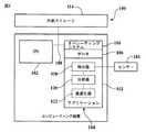
図1は、コンピューティング装置100のブロック図である。コンピューティング装置100は、乗り物に設置される、コンパクトな、デスクトップの、若しくは単一コンピューティング装置のその他の形態をとる、あらゆるタイプのものであってもよく、又は複数のコンピューティング装置から成っていてもよい。コンピューティング装置100中のCPU102は、従来型の中央演算部、又は情報を操作する、若しくは処理することが可能な、その他のタイプのあらゆる装置、若しくは複数の装置であってもよい。コンピューティング装置100中のメモリ104は、ランダムアクセスメモリ装置(RAM)、又はその他の好適なあらゆるタイプの記憶装置であってもよい。メモリ104は、CPU102がバス108を使用してアクセスするデータ106を含んでいてもよい。メモリ104はまた、オペレーティングシステム110と、インストールされたアプリケーション112とを含んでいてもよく、インストールされたアプリケーション112は、本明細書に記載の地理的特徴に基づく位置決定方法をCPU102に実行させるプログラムを含んでいる。 FIG. 1 is a block diagram of a
コンピューティング装置100は、さらなる、すなわち第2の記憶装置114、例えば、メモリカード、フラッシュドライブ、又はコンピュータで読み取り可能なその他のあらゆる形態の媒体を備えていてもよい。インストールされたアプリケーション112は、全体又は一部が第2の記憶装置114に記憶され、メモリ104に、処理の必要に応じて読み込むことができる。コンピューティング装置100はまた、1又は複数のセンサ116を備えているか、又はそれらに結合されてもよい。センサ116は、データ及び/又は信号を取り込むことができ、これらのデータ及び/又は信号は、慣性測定部(IMU)、自律測位システム、全地球航法衛星システム(GNSS)、光検出及び測距(LIDAR)システム、レーダーシステム、ソナーシステム、画像に基づくセンサシステム、又は、乗り物を取り巻く環境に特有の情報、例えば乗り物のナビゲーション経路に近接したその他の乗り物、歩行者、乗り物が走行する経路の地理的特徴、若しくはその他の位置決定された位置のデータ及び/若しくは信号を取り込み、対応するデータ及び/若しくは信号をCPU102に出力することが可能な、その他のあらゆるタイプのシステムにより処理される。 The
センサ116は、乗り物の、x、y、及びz軸線の位置、速度、加速度、回転角、及び回転角速度の変化を表すデータを取り込むこともできる。もしセンサ116が、自律測位システム用のデータを取り込む場合であれば、ホイール回転速度、走行距離、ステアリング角、及びステアリング角の変化速度に関係するデータを取り込むことができる。もしセンサ116が、GNSS用の信号を取り込む場合であれば、レシーバーは、グローバル座標において見積もられる乗り物の位置及び乗り物の速度を計算することができる。複数の人工衛星を用い、三次元での三角測量及び時間評価を使用して、乗り物の位置及び速度を評価することができる。 The
センサ116が、LIDARシステムのためのデータを収集した場合、乗り物周辺の環境の強度(intensity)又は反射戻り(reflectivity returns)測距データ(ranging data)が得られる。以下に記載の例では、センサ116は、少なくとも:自律測位システム、又は、乗り物の速度、加速度、減速度、位置、及び向きを評価するその他のシステム用のデータ;GNSS、又は、乗り物の位置及び速度を評価するその他のシステム用の信号;及びLIDARシステム、又は、乗り物が走行しているナビゲーション経路沿いの地理的特徴、障害物、若しくは対象からの乗り物の距離を決定するその他のシステム用のデータ、を取り込むことができる。図1に記載の代表的なコンピューティング装置100では、メモリ104に記憶されたアプリケーション112は、少なくとも、特徴検出器118、特徴分析器120、及び乗り物の位置最適化器122を含む。これらのアプリケーション112のそれぞれは、さらなる詳細が以下に記載される。概して、センサ116により取り込まれたデータを、これらのアプリケーション112の1又は複数によって使用することにより、乗り物を取り巻く環境を理解し、乗り物の位置正確度を向上させることができる。 When the
図2には、図1に記載のコンピューティング装置100を備えた乗り物200の概略を示す。コンピューティング装置100は、図2に示すように乗り物200の内部に位置してもよく、又は代わりの場所(図示せず)において乗り物200から離れて位置していてもよい。もしコンピューティング装置100が乗り物200から離れて位置している場合であれば、乗り物200は、コンピューティング装置100と通信する機能を備えていてもよい。 FIG. 2 schematically shows a
乗り物200は、複数のセンサ、例えば、図1を参照して記載されるセンサ116を含んでいてもよい。示されている1又は複数のセンサ116は、速度、加速度、ホイール回転速度、及び、取り巻く環境内の、対象又は地理的特徴までの距離の変化を保存するように構成されてもよく、これらの変化は、コンピューティング装置100により使用されて、対象又は地理的特徴に対しての乗り物200の位置及び向き、自律測位システムのためのステアリング角、イメージセンサによる処理のための画像、複数の人口衛星からの信号に基づいた、グローバル座標における乗り物の位置、又は、乗り物200の現時点での状態を決定する、若しくは環境に対する乗り物200の位置を決定し得るその他のあらゆるデータ及び/若しくは信号が評価される。 The
例えば、もしセンサ116が、LIDARシステムにより使用されるデータを取り込むように構成されている場合であれば、センサ116は、乗り物200を取り巻く領域にある物理的対象から戻るレーザーに関連するデータを取り込むことができる。続いて、コンピューティング装置100におけるアプリケーション112の一つ、例えば、特徴検出器118は、乗り物200を取り巻く領域にある様々な対象までの測距離又は地理的特徴を、信号がセンサ116に戻るまでの時間を測定することにより計算することができる。レーザー帰還(Laser returns)には、センサ116、又は乗り物200上又はその近傍にある別の発生源により放射される光源、例えばレーザー光が当たる対象又は地理的特徴によって反射された後方散乱光が含まれていてもよい。この後方散乱光は、強度値の形で測定することができ、これらの強度値は、特徴検出器118により識別される地理的特徴に関連付けられる。 For example, if the
特徴検出器118は、コンピューティング装置100中のその他のアプリケーション112、例えば特徴分析器120と通信することもできる。特徴分析器120は、例えば、ノイズを除去すること、検出された様々な地理的特徴に関連付けられる形状を決定すること、検出された様々な地理的特徴に関連付けられる地球物理学的場所を決定すること、及び、物理的空間、例えば水平空間又は鉛直空間内の地理的特徴を分類することにより、データ及び/又は信号を解析するように構成することができる。特徴分析器120は、自動運転システムを実装するのに使用されるその他のアプリケーション112、例えば、さらに以下に記載の乗り物の位置最適化器122と通信するようにも構成することがでる。 The
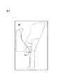
図3は、多様な地理的特徴を含む代表的な経路の一部分を走行している図2の乗り物200の斜視図を示す。代表的な経路の一部分は、四つの明瞭に異なる車線300、302、304、306を含み、乗り物200が車線300内を走行している。車線300、302、304、306のそれぞれは、多様な境界により画定することができ、これらの境界は地理的特徴としての役割を果たす。この例における境界には、車線マーキング、例えば中央線308、310、及び縁線312、314、及び車線縁特徴部、例えば縁石316、318が含まれる。例えば、車線300は、縁石316と中央線308の間に延びており、車線304は、縁線314と中央線310との間に延びている。車線マーキング、及び車線縁特徴部はそれぞれ、特徴分析器120によって水平空間に関連付けることができる。つまり、車線マーキング、及び車線縁特徴部は概して、物理的環境の範囲内で接地面に沿って位置しており、したがって、特徴分析器120によって水平空間の地理的特徴として分類することができる。 FIG. 3 shows a perspective view of the
図3における代表的経路の一部分には、鉛直空間、つまり、特徴分析器120によって、乗り物200を取り巻く環境における接地面の上方に拡がる地理的特徴に関連付けることができる、様々な地理的特徴も含まれる。鉛直空間に関連付けることができる地理的特徴の例には、標識、支柱、建物、及び樹木が含まれる。図3では、道路標識320及び道路標識322が、車線300及び車線306に隣接してそれぞれ位置している。さらに、ランプ支柱324及びランプ支柱326が、道路標識320及び道路標識322にそれぞれ隣接して位置している。地理的特徴のぞれぞれは、図3の代表的な経路部分に示される車線マーキング、車線縁特徴部、標識、及び支柱を含んでおり、上の図2に関して記載される1又は複数の様々なセンサ116により、これらの各地理的特徴に関連するデータが取り込まれた後、特徴検出器118により最初に識別される。 Part of the representative path in FIG. 3 also includes various geographic features that can be associated by the vertical space, that is, feature features 120, that are associated with geographic features that extend above the ground plane in the environment surrounding the
地理的特徴は、特徴検出器118により識別し、特徴分析器120により鉛直空間又は水平空間のいずれかに関連付けた上で、特徴分析器120により地球物理学的場所に関連付けて、例えばその後に、地理的特徴それぞれの地球物理学的場所を含む地理的特徴マップと比較することができる。さらに、地理的特徴のそれぞれは、形状に関連付けて、その後に地理的特徴マップと比較することができる。例えば、車線マーキングは、線形状(例えば縁線312、314)に関連付けることができ、車線縁特徴部は、線形状の途切れ(例えば縁石316、318)に関連付けることができ、標識の特徴は、平面形状(例えば道路標識320、322)に関連付けることができ、そして支柱の特徴は、円筒形状(例えばランプ支柱324、326)に関連付けることができる。 Geographic features are identified by
このように、地理的特徴のそれぞれは、地理的特徴を固有の方法で記述する様々な特徴:強度値、地球物理学的場所、空間の関連付け(例えば水平空間及び鉛直空間)、及び形状関連付け(例えば線、平面、及び円筒)に関連付けることができる。地理的特徴のそれぞれをこれらの特徴に関連付けることにより、マッピング及び位置決定のよりロバスト性の高い方法が可能になる。例えば、地理的特徴のいろいろな特徴は、物理的環境に存在する条件が地理的特徴マップに予め記録されたものとは異なる場合に、地理的特徴に加える重みを増加させる又は低減させるかどうかを決定する際に有用となりうる。地理的特徴の様々な特徴を使用して、幾何学的特徴マップと比較し、乗り物200の自己位置測定を向上させることを、さらに以下に記載する。 Thus, each of the geographic features is a variety of features that describe the geographic features in a unique way: intensity values, geophysical locations, spatial associations (eg, horizontal and vertical spaces), and shape associations ( For example, lines, planes, and cylinders). By associating each of the geographic features with these features, a more robust method of mapping and positioning is possible. For example, various features of a geographic feature may determine whether to increase or decrease the weight applied to a geographic feature if the conditions present in the physical environment are different from those previously recorded in the geographic feature map. Can be useful in making decisions. The use of various features of the geographic features to improve self-localization of the
図4Aは、図3に示す代表的経路の一部を含む地理的特徴マップ400の二次元表示を示す。図3に示す代表的経路の一部分も、図4Bに関してさらに記載する。この例における地理的特徴マップ400は、強度の帰還データ(intensity return data)、例えば様々な地理的特徴に関連付けられた強度値を、現時点で表示している。別の例では、地理的特徴マップ400を構築するのに使用される地理的特徴のいくつかを、地理的特徴の形状(例えば線、平面、又は円筒形)に基づいて検出することができる。さらに、検出された地理的特徴を、グローバル座標系に射影して、地球物理学的場所に関連付けることができる。検出された地理的特徴のそれぞれは、水平空間又は鉛直空間のいずれかに関連付けることもできる。 FIG. 4A shows a two-dimensional representation of a
強度値、地球物理学的場所(geophysical location)、形状、及び空間の検出は、複数回のデータラン(data run)、つまり経路の複数回の走行にわたって拡張することができ、センサ116は、各データランの間にデータを取り込む。複数回のランの間に取り込まれたデータは、一つにまとめて処理して、例えば、マッピング及び位置決定を同時に行う技術(SLAM)を使用して、様々なランの間の重複を平滑化することができる。加えて、地理的特徴マップ400を処理して、1回のランの間には取り込まれても通常は経路沿いに存在しないであろう障害物、例えばその他の乗り物、人、又は動物を表す、場所、形状、空間、又は強度値へのいかなる関連付けも除去することができる。 Detection of intensity values, geophysical location, shape, and space can be extended over multiple data runs, ie, multiple runs of the path, and
結果として得られた地理的特徴マップ400は、強度値、地球物理学的場所、空間、及び/又は形状に関連付けられる地理的特徴を含んでおり、引き続く経路の自律ナビゲーションの間、乗り物200の位置決定における手助けに使用することができる。さらには、このタイプの地理的特徴マップ400は、あまりに多くのリソースを費やすことも無く、コンピューティング装置100の様々なアプリケーション112に記憶して使用することができるが、その理由は、マップが小さくまとまっており、地理的特徴に関連する情報だけを含むように構成することができるからである。図4Aの地理的特徴マップ400の詳細な図は、強度値の表示を含み、形状は図4Bに示される。 The resulting
図4Bは、図4Aの地理的特徴マップ400の分解図を示し、図3に示されている代表的な経路の一部分を強調しているものである。この図は、車線300、302、304、306の上面図である。上面図には、水平空間の特徴、例えば中央線308、310、312、314、及び縁石316、318が、強度値及び線形状により表され、鉛直空間の地理的特徴、例えば道路標識320、322は、平面形状により、又はこの上面図の場合では長方形形状により表されている。同様に、鉛直空間の地理的特徴、例えばランプ支柱324、326は、円筒形状、又はこの上面図の場合では円により表されている。地理的特徴マップ400のこの代表的分解図には、いくつかのさらに毛羽立った線(fuzzier lines)も含まれており、これらの線は、車線302、304の間にある中央の路肩から、そして、例えば道路標識320、322の向こうにある草地表面の遠い側の縁から取り込まれた強度値を示している。路肩及び草地の集まりを示すこれらの地理的特徴は、ここでは強度値を使用して示されているが、もしそれらが、後の比較目的に有用でない場合には、地理的特徴マップ400から取り除くことができる。車線マーキング、又は車線縁特徴部が存在しない経路沿いのいくつかの場所では、草地又は路肩と車線との縁を示す強度値が、水平な地理的特徴の参照としての役割を果たすことがある。 FIG. 4B shows an exploded view of the
図5は、地理的特徴に基づく位置決定を使用して自動運転を行う代表的処理500を示す。処理500に関連して記載される演算は、コンピューティング装置100において、例えば、特徴検出器118、特徴分析器120、及び乗り物の位置最適化器122というアプリケーションを使用して実行することができる。処理500に関連して記載される演算は、コンピュータで読み取り可能な非一時的記憶媒体として実体化することもでき、媒体は、1又は複数のプロセッサにより実行可能なプログラム指令を含み、プログラム指令が実行されると、1又は複数のプロセッサが演算を実行することになる。例えば、処理500に関連して記載される演算は、コンピューティング装置100のメモリ104に記憶することができ、CPU102により実行することができる。 FIG. 5 shows an
演算502では、1又は複数の地理的特徴を、乗り物200が経路を走行する際に、1又は複数のセンサ116から受け取られる情報に基づいて識別する。上に記載のとおり、特徴検出器118は、1又は複数のセンサ116からデータを受け取ることができ、特徴分析器120は、強度値のグループ分け、又は形状若しくは空間への関連付けに基づいて、様々な地理的特徴を識別することができる。例えば、図3に示すとおり、乗り物200が予めマップ化された経路の一部分に沿って走行している間、センサ116は、強度の帰還、画像、又は特徴検出器118、及び/若しくは特徴分析器120により処理することができるその他のデータを取り込むことができるが、その目的は、以下の地理的特徴:中央線308、310、縁線312、314、縁石316、318、道路標識320、322、及びランプ支柱324、326を識別することである。いくつかの例では、地理的特徴は強度値に関連付けられる。その他の例では、地理的特徴は形状に関連付けられ、形状には、線、平面、及び円筒が含まれる。その他の例では、地理的特徴は、それらの地球物理学的場所によって識別される。 In
演算504では、地理的特徴のそれぞれは、水平空間又は鉛直空間のいずれかに関連付けることができる。例えば、車線マーキングとして認識される地理的特徴、例えば中央線308、310、及び縁線312、314、及び車線縁特徴部、例えば縁石316、318は、水平空間に関連付けることができる。つまり、これらの地理的特徴は、乗り物200に近接する接地面に沿った物理的空間に関連付けることができる。別の実施例では、標識、支柱、建物、又は樹木として識別される地理的特徴、例えば道路標識320、322、及びランプ支柱324、326は、鉛直空間に関連付けることができる。つまり、これらの地理的特徴は、乗り物200に近接する接地面上方の物理的空間に関連付けることができる。地理的特徴のそれぞれを、形状、強度値、又は地球物理学的場所への様々な関連付けに加えて、空間に関連付けることにより、来たる比較ステップにおいて、地理的特徴にさらに容易に重み付けして、環境条件の変化を考慮に入れることができる。 In
演算506では、識別されて鉛直空間又は水平空間のいずれかに関連付けられた地理的特徴は、地理的特徴マップと比較することができる。例えば、特徴分析器120は、関連付けられたその強度値、形状、空間、及び/又は地球物理学的場所に基づいて、地理的特徴マップに存在する様々な地理的特徴と、検出され識別された地理的特徴とを比較して、一致が存在するかどうかを判定することができる。例えば、もし地理的特徴間に、所与の閾値(例えば、地球物理学的場所に基づく)より小さい距離が存在し、且つそれらの特徴が、同様な特徴の性質(例えば強度値、形状、及び/又は空間)を有していれば、一致が存在する。比較をさらに効率的にするには、位置決定された最新の乗り物の位置、又は、もし利用可能な位置決定された乗り物の位置がない場合には、GLASSにより収集された情報に基づく乗り物の位置のいずれかを使用して、地理的特徴マップ内の探索比較範囲を限定することができる。 In
図3及び4Bを、現時点での乗り物の位置、及び比較目的のための地理的特徴マップ400の一部分の例として使用して、道路標識322を特徴検出器118により識別することができ、特徴分析器120により、鉛直空間、平面形状の地球物理学的場所、及び強度値のセットに関連付けることができる。乗り物の位置最適化器122は、所与の地球物理学的場所での鉛直空間における平面形状である、現時点で取り込まれた道路標識322の属性を、地理的特徴マップ400の範囲の様々な地理的特徴と比較することができる。図4Bに示すとおり道路標識322に一致を見いだすことができるが、その理由は、この地理的特徴が同一の地球物理学的位置、平面関連付け、及び鉛直空間の関連付けを有しているからである。同様な比較を、例えば、中央線308、310、縁線312、314、及び縁石316、318について行うことができる。これらの地理的特徴はすべて、水平空間、線形状、及び相対的な地球物理学的位置、及び強度値に関連付けられる。 3 and 4B can be used as an example of a current vehicle location and a portion of a
経路に沿って乗り物が現時点で走行する間に取り込まれる地理的特徴と、地理的特徴マップに関連付けられた地理的特徴との直接比較を用いることに加えて、演算506には、地理的特徴についての空間の関連付けに少なくとも部分的に基づいて、地理的特徴の比較に重み付けすることが含まれていてもよい。空間の関連付けに少なくとも部分的に基づいた重み付けを使用することによって、この比較では、現時点で取り込まれた地理的特徴と地理的特徴マップに記憶されたものとの間でなされることになる照合に悪影響を及ぼす可能性のある様々な環境条件を考慮することが可能になる。例えば、降雨及び降雪の条件は、水平空間の地理的特徴、例えば車線マーキングを見えにくくする可能性があるが、その他の水平空間の地理的特徴、例えば縁石には影響を及ぼさない可能性がある。さらに鉛直空間の特徴、例えば標識又は支柱は、降雨又は降雪の天気条件により通常見えにくくなるということはないであろう。 In addition to using a direct comparison of the geographic features captured while the vehicle is currently traveling along the route and the geographic features associated with the geographic feature map, the
乗り物200が、例えば、雨センサ、フロントガラスのワイパーが動作しているという表示、又はコンピューティング装置100が利用できる外部の天気予報からの入力に基づいて降雨の条件を識別することが可能である代表的な場合では、乗り物の位置最適化器122は、水平空間の特徴、例えば車線マーキングの間でなされる比較への重み付けを低減し、鉛直空間の特徴、例えば標識及び支柱の間でなされる比較への重み付けを増加させることができる。同様に、もし乗り物200が、降雪の条件で運転される場合には、乗り物の位置最適化器122は、鉛直空間の特徴、例えば道路標識320、322、及びランプ支柱324、326に加えて、特定タイプの水平空間の特徴、例えば縁石316、318のみを用いて、地理的特徴マップ400との比較を行い、比較の実行においては水平空間のいかなる車線マーキングも完全に無視することができるが、その理由は、これらの特徴が雪により完全に隠されてしまう可能性があるからである。もし、さらなる水平空間の特徴、例えば縁石316、318も、雪により隠されてしまうならば、乗り物の位置最適化器122は、地理的特徴マップ400との比較において、これらの地理的特徴を無視することもできる。 The
天気条件、例えば現時点で取り込まれる地理的特徴とマップに基づく地理的特徴との間での比較に影響する雨及び雪に加えて、地理的特徴の重みづけを使用しなければならないかもしれない他に可能な外部条件が存在する。例えば、道路建設の条件は、車線マーキングの位置が変更になること、車線縁特徴部が除去されること、又はさらなる鉛直空間の特徴、例えばトラフィック・バレル(traffic barrel)が加わることによって、現時点で取り込まれる地理的特徴と地理的特徴マップに保存されている特徴との間の比較に、悪影響を及ぼす可能性がある。乗り物の位置最適化器122は、建設が識別された場合に水平空間の特徴(例えば車線マーキング)の重みを変化させるように、そして地理的特徴マップ上には存在しない追加された鉛直空間の特徴(例えばトラフィック・バレル)は無視するように構成されてもよい。雨、雪、及び建設について与えられた例は、単なる例示であり、空間の関連付けに基づいて様々な地理的特徴に与えられる重み付けに影響を及ぼす可能性のある、その他多くの環境条件を識別することができる。 Other than weather conditions, such as rain and snow that affect the comparison between currently captured geographic features and map-based geographic features, geographic feature weights may have to be used There are possible external conditions. For example, road construction conditions are currently determined by changing the position of lane markings, removing lane edge features, or adding additional vertical space features, such as traffic barrels. The comparison between the captured geographic features and the features stored in the geographic feature map can be adversely affected. The
地理的特徴の重み付けは、地球物理学的場所の関連付け、又は形状関連付けに基づいて、現時点で取り込まれる地理的特徴と、地理的特徴マップに存在する地理的特徴とを比較している間にも使用することができる。例えば、霧の多い環境条件では、地球物理学的場所において乗り物200にさらに近い地理的特徴には、乗り物200からさらに遠いものに与えるよりも高い重み付けを与えることができる。降雨の別の環境条件の例においては、円筒形状又は平面形状の関連付けを有する地理的特徴には、線形状の関連付けを有するものに与えるよりも高い重み付けを与えることができる。地理的特徴に重み付けする場合、少なくとも二つの範疇に分かれる所与のタイプの地理的特徴が存在することによって、これらの範疇が識別されるべきである。例えば、鉛直空間の関連付けを有する地理的特徴にさらに高い重み付けを与えるには、さらに低い重み付けを与えられる水平空間の関連付けも存在すべきである。加えて、地理的特徴マップは、506の演算の間に正確な比較を行うために、地理的特徴それぞれに関連付けられた少なくとも二つのタイプの情報を含んでいるべきである。様々なタイプの情報には、地球物理学的場所の関連付け、形状関連付け、空間の関連付け、及び強度値関連付けを含まれていてもよい。 Geographic feature weighting is based on geophysical location associations or shape associations, while comparing the currently captured geographic features to those present in the geographic feature map. Can be used. For example, in foggy environmental conditions, geographic features that are closer to the
演算508では、位置決定された乗り物の位置は、現時点で取り込まれる地理的特徴を、地理的特徴マップに存在する地理的特徴と重み付け比較することに基づいて、生成することができる。位置決定された乗り物の位置を生成することには、乗り物の位置最適化器122を使用する様々なフィルタリング方法を適用することが含まれていてもよい。一例では、現時点で取り込まれる地理的特徴を、粒子フィルタリングを使用して精密化し、その後に、地理的特徴マップに存在する地理的特徴と比較して、位置決定された乗り物の位置をこの比較に基づいて生成することができる。位置決定された乗り物の位置を生成することには、現時点で位置決定される乗り物の位置が、直近で計算された位置決定された乗り物の位置に近接しているという仮定が含まれていてもよく、つまり、処理500は、その更新の際に反復実行される。演算508の後、処理500は終了する。 In
前述の記載は、本明細書で最も実用的な実施形態とみなされるものに関連する。しかしながら本開示は、これらの実施形態に限定されるものではなく、反対に、添付された請求項の精神及び範囲の範囲に含まれる、様々な修正及び均等な構成を対象にするものであって、その範囲は、法の下にそのまま許容されるそのような修正及び均等な構造すべてを包含するように、最も広い解釈に一致するものと理解されるものとする。 The foregoing description relates to what is considered to be the most practical embodiment herein. However, the present disclosure is not limited to these embodiments, but on the contrary is intended to cover various modifications and equivalent arrangements that fall within the spirit and scope of the appended claims. It is to be understood that the scope is consistent with the broadest interpretation so as to encompass all such modifications and equivalent structures that are permissible under the law.
100 コンピューティング装置
104 メモリ
106 データ
108 バス
110 オペレーティングシステム
112 インストールされたアプリケーション
114 第2の記憶装置
116 センサ
118 特徴検出器
120 特徴分析器
122 乗り物の位置最適化器100
Claims (15)
Translated fromJapanese乗り物に配置された1又は複数のセンサと、
該1又は複数のセンサと通信するコンピューティング装置であって、
当該コンピューティング装置の操作を制御するための1又は複数のプロセッサと、
前記1又は複数のプロセッサによって使用されるデータ及びプログラム指令を記憶するためのメモリとを有するコンピューティング装置と、を具備し、
前記1又は複数のプロセッサが、
前記乗り物が経路を走行するときに、前記1又は複数のセンサから受信された情報に基づいて、1又は複数の地理的特徴を識別させ、また、該1又は複数の地理的特徴の各々が、接地面に沿った物理的空間または接地面の上方の物理的空間のいずれにあるのかを識別させ、
前記1又は複数の地理的特徴の各々に対して、接地面に沿った物理的空間にあると識別された場合には水平空間と関連付け、接地面の上方の物理的空間にあると識別された場合には鉛直空間と関連付け、
前記1又は複数の地理的特徴の各々と、経路に沿った地理的特徴であって予め記録された各地理的特徴との間の一致を識別するために、前記1又は複数の地理的特徴の各々を、経路を表示する地理的特徴マップであって予め記録された地理的特徴を含む地理的特徴マップと比較し、
前記地理的特徴マップと前記1又は複数の地理的特徴の各々との間のそれぞれの比較に、前記1又は複数の地理的特徴のそれぞれの空間の関連付けに少なくとも部分的に基づいた重み付けをし、
前記1又は複数の地理的特徴と前記地理的特徴マップとの間の重み付けされた比較に基づいて位置決定された乗り物の位置を生成するために、前記メモリに記憶された指令を実行するように構成された、
自動運転システム。An automatic driving system,
One or more sensors arranged on the vehicle;
A computing device in communication with the one or more sensors,
One or more processors for controlling the operation of the computing device;
A computing device having a memory for storing data and program instructions used by the one or more processors,
The one or more processors are:
When the vehicle is traveling theroute, based on the information received from the one or more sensors, to identify one or more geographic features,also each of the one or more geographic features, Identify whether it is in physical space along or above the ground plane,
For each of the one or more geographic features, if identified as being in physical space along the ground plane, it is associated with horizontal space and identified as being in physical space above the ground plane In some cases associated with vertical space,
To identify a match between each of the one or more geographic features and each pre-recorded geographic feature along the route, the one or more geographic features Comparing each with a geographic feature map that displays a route and includes a pre-recorded geographic feature;
Weighting each comparison between the geographic feature map and each of the one or more geographic features based at least in part on a spatial association of each of the one or more geographic features;
To produce aweighted position determined vehicle position based on the comparison between the one or more geographic features with the geographical featuremap, so as to execute the instructions stored in the memory Configured,
Automated driving system.
前記1又は複数の地理的特徴が、前記接地面に沿った物理的空間における車線マーキング及び車線縁特徴部と、前記接地面の上方の物理的空間における標識、柱、ビル及び木を含む、請求項1に記載の自動運転システム。The one or more geographical features are at least one horizontal spacein physical space along the ground plane and at least one vertical spacein physical space above the ground plane.Including
The one or more geographic features include lane markings and lane edge features in physical space along the ground plane, and signs, pillars, buildings, and trees in physical space above the ground plane. Item 2. The automatic driving system according to item 1.
乗り物が経路を走行するときに前記乗り物に配置された1又は複数のセンサから情報を受信し、Receiving information from one or more sensors located on the vehicle as the vehicle travels along a route;
1又は複数のプロセッサにより、By one or more processors
前記1又は複数のセンサから受信された情報に基づいて、1又は複数の地理的特徴を識別させ、また、該1又は複数の地理的特徴の各々が、接地面に沿った物理的空間または接地面の上方の物理的空間のいずれにあるのかを識別させ、One or more geographic features are identified based on information received from the one or more sensors, and each of the one or more geographic features is a physical space or contact along the ground plane. Identify the physical space above the ground,
前記1又は複数の地理的特徴の各々に対して、接地面に沿った物理的空間にあると識別された場合には水平空間と関連付け、接地面の上方の物理的空間にあると識別された場合には鉛直空間と関連付け、For each of the one or more geographic features, if identified as being in physical space along the ground plane, it is associated with horizontal space and identified as being in physical space above the ground plane In some cases associated with vertical space,
前記1又は複数の地理的特徴の各々と、経路に沿った地理的特徴であって予め記録された各地理的特徴との間の一致を識別するために、前記1又は複数の地理的特徴の各々を、経路を表示する地理的特徴マップであって予め記録された地理的特徴を含む地理的特徴マップと比較し、To identify a match between each of the one or more geographic features and each pre-recorded geographic feature along the route, the one or more geographic features Comparing each with a geographic feature map that displays a route and includes a pre-recorded geographic feature;
前記地理的特徴マップと前記1又は複数の地理的特徴の各々との間のそれぞれの比較に、前記1又は複数の地理的特徴のそれぞれの空間の関連付けに少なくとも部分的に基づいた重み付けをし、Weighting each comparison between the geographic feature map and each of the one or more geographic features based at least in part on a spatial association of each of the one or more geographic features;
前記1又は複数の地理的特徴と前記地理的特徴マップとの間の重み付けされた比較に基づいて位置決定された乗り物の位置を生成する、方法。Generating a position of a vehicle located based on a weighted comparison between the one or more geographic features and the geographic feature map.
前記1又は複数の地理的特徴が、前記接地面に沿った物理的空間における車線マーキング及び車線縁特徴部と、前記接地面の上方の物理的空間における標識、柱、ビル及び木を含む、請求項6に記載の方法。The one or more geographic features include lane markings and lane edge features in physical space along the ground plane, and signs, pillars, buildings, and trees in physical space above the ground plane. Item 7. The method according to Item 6.
当該コンピューティング装置の操作を制御するための1又は複数のプロセッサと、One or more processors for controlling the operation of the computing device;
該1又は複数のプロセッサによって使用されるデータ及びプログラム指令を記憶するためのメモリと、を具備し、A memory for storing data and program instructions used by the one or more processors,
前記1又は複数のプロセッサが、The one or more processors are:
前記乗り物が経路を走行するときに、乗り物に配置された1又は複数のセンサから受信された情報に基づいて、1又は複数の地理的特徴を識別させ、また、該1又は複数の地理的特徴の各々が、接地面に沿った物理的空間または接地面の上方の物理的空間のいずれにあるのかを識別させ、When the vehicle travels a route, the vehicle identifies one or more geographic features based on information received from one or more sensors located on the vehicle, and the one or more geographic features Each of which is in physical space along or above the ground plane,
前記1又は複数の地理的特徴の各々に対して、接地面に沿った物理的空間にあると識別された場合には水平空間と関連付け、接地面の上方の物理的空間にあると識別された場合には鉛直空間と関連付け、For each of the one or more geographic features, if identified as being in physical space along the ground plane, it is associated with horizontal space and identified as being in physical space above the ground plane In some cases associated with vertical space,
前記1又は複数の地理的特徴の各々と、経路に沿った地理的特徴であって予め記録された各地理的特徴との間の一致を識別するために、前記1又は複数の地理的特徴の各々を、経路を表示する地理的特徴マップであって予め記録された地理的特徴を含む地理的特徴マップと比較し、To identify a match between each of the one or more geographic features and each pre-recorded geographic feature along the route, the one or more geographic features Comparing each with a geographic feature map that displays a route and includes a pre-recorded geographic feature;
前記地理的特徴マップと前記1又は複数の地理的特徴の各々との間のそれぞれの比較に、前記1又は複数の地理的特徴のそれぞれの前記空間の関連付けに少なくとも部分的に基づいた重み付けをし、Each comparison between the geographic feature map and each of the one or more geographic features is weighted based at least in part on the spatial association of each of the one or more geographic features. ,
前記1又は複数の地理的特徴と前記地理的特徴マップとの間の重み付けされた比較に基づいて位置決定された乗り物の位置を生成するために、前記メモリに記憶された指令を実行するように構成された、Executing instructions stored in the memory to generate a position of the vehicle located based on a weighted comparison between the one or more geographic features and the geographic feature map. Configured,
コンピューティング装置。Computing device.
Applications Claiming Priority (2)
| Application Number | Priority Date | Filing Date | Title |
|---|---|---|---|
| US14/185,391 | 2014-02-20 | ||
| US14/185,391US9298992B2 (en) | 2014-02-20 | 2014-02-20 | Geographic feature-based localization with feature weighting |
Publications (3)
| Publication Number | Publication Date |
|---|---|
| JP2015155903A JP2015155903A (en) | 2015-08-27 |
| JP2015155903A5 JP2015155903A5 (en) | 2017-06-01 |
| JP6166294B2true JP6166294B2 (en) | 2017-07-19 |
Family
ID=53797840
Family Applications (1)
| Application Number | Title | Priority Date | Filing Date |
|---|---|---|---|
| JP2015030372AActiveJP6166294B2 (en) | 2014-02-20 | 2015-02-19 | Automatic driving system, automatic driving method and computing device |
Country Status (2)
| Country | Link |
|---|---|
| US (1) | US9298992B2 (en) |
| JP (1) | JP6166294B2 (en) |
Families Citing this family (31)
| Publication number | Priority date | Publication date | Assignee | Title |
|---|---|---|---|---|
| US9519061B2 (en)* | 2014-12-26 | 2016-12-13 | Here Global B.V. | Geometric fingerprinting for localization of a device |
| US9536176B2 (en)* | 2015-03-23 | 2017-01-03 | International Business Machines Corporation | Environmental-based location monitoring |
| DE102016205867A1 (en)* | 2016-04-08 | 2017-10-12 | Robert Bosch Gmbh | Method for determining a pose of an at least partially automated vehicle using different types of landmarks |
| DE102016214868A1 (en)* | 2016-08-10 | 2018-02-15 | Volkswagen Aktiengesellschaft | Method and device for creating or supplementing a map for a motor vehicle |
| DE102016220249A1 (en)* | 2016-10-17 | 2018-04-19 | Robert Bosch Gmbh | Method and system for locating a vehicle |
| US10515390B2 (en) | 2016-11-21 | 2019-12-24 | Nio Usa, Inc. | Method and system for data optimization |
| JP6989284B2 (en)* | 2017-05-01 | 2022-01-05 | 株式会社Soken | Vehicle position estimation device and program |
| US10289115B2 (en)* | 2017-06-01 | 2019-05-14 | Aptiv Technologies Limited | Automated vehicle map localization based on observed geometries of roadways |
| DE102017211626A1 (en)* | 2017-07-07 | 2019-01-10 | Robert Bosch Gmbh | Method for operating a higher automated vehicle (HAF), in particular a highly automated vehicle |
| DE102017213628A1 (en)* | 2017-08-07 | 2019-02-07 | Robert Bosch Gmbh | System and method for determining a position of a vehicle |
| DE102017214729A1 (en)* | 2017-08-23 | 2019-02-28 | Robert Bosch Gmbh | Method and device for determining a highly accurate position and for operating an automated vehicle |
| JP6747405B2 (en)* | 2017-08-25 | 2020-08-26 | トヨタ自動車株式会社 | Own vehicle position confidence calculator |
| US10635109B2 (en) | 2017-10-17 | 2020-04-28 | Nio Usa, Inc. | Vehicle path-planner monitor and controller |
| US10935978B2 (en)* | 2017-10-30 | 2021-03-02 | Nio Usa, Inc. | Vehicle self-localization using particle filters and visual odometry |
| US10859384B2 (en)* | 2017-11-15 | 2020-12-08 | Uatc, Llc | Lightweight vehicle localization systems and methods |
| CN111656135A (en)* | 2017-12-01 | 2020-09-11 | 迪普迈普有限公司 | Positioning optimization based on high-definition map |
| KR102421856B1 (en)* | 2017-12-20 | 2022-07-18 | 삼성전자주식회사 | Method and apparatus for processing image interaction |
| DE102018206067A1 (en)* | 2018-04-20 | 2019-10-24 | Robert Bosch Gmbh | Method and device for determining a highly accurate position of a vehicle |
| CN112534209B (en)* | 2018-08-08 | 2024-06-18 | 日产自动车株式会社 | Self-position estimation method and self-position estimation device |
| US11340355B2 (en) | 2018-09-07 | 2022-05-24 | Nvidia Corporation | Validation of global navigation satellite system location data with other sensor data |
| KR102627453B1 (en)* | 2018-10-17 | 2024-01-19 | 삼성전자주식회사 | Method and device to estimate position |
| EP3696507B1 (en)* | 2019-02-12 | 2022-04-20 | Veoneer Sweden AB | Representing an environment by cylindrical and planar structures |
| CN113424243B (en) | 2019-02-18 | 2023-09-08 | 索尼集团公司 | Information processing device, information processing method, and information processing program |
| US11151394B2 (en)* | 2019-06-24 | 2021-10-19 | Nvidia Corporation | Identifying dynamic objects in a point cloud |
| US10904851B1 (en)* | 2020-01-21 | 2021-01-26 | Cisco Technology, Inc. | Systems and methods for determining locations of access points |
| US11620831B2 (en)* | 2020-04-29 | 2023-04-04 | Toyota Research Institute, Inc. | Register sets of low-level features without data association |
| CN113723141B (en)* | 2020-05-25 | 2022-09-06 | 阿波罗智能技术(北京)有限公司 | Vehicle positioning method and device, electronic equipment, vehicle and storage medium |
| US11702111B2 (en)* | 2020-08-19 | 2023-07-18 | Here Global B.V. | Method and apparatus for estimating object reliability |
| DE102020214327A1 (en) | 2020-11-13 | 2022-05-19 | Continental Automotive Gmbh | Method and system for determining a position of a traffic lane |
| US12031829B2 (en)* | 2020-12-03 | 2024-07-09 | Motional Ad Llc | Localization based on surrounding vehicles |
| JP7635036B2 (en)* | 2021-03-23 | 2025-02-25 | 株式会社Nttデータグループ | MATCHING DEVICE, MATCHING METHOD, AND PROGRAM |
Family Cites Families (15)
| Publication number | Priority date | Publication date | Assignee | Title |
|---|---|---|---|---|
| US7610146B2 (en)* | 1997-10-22 | 2009-10-27 | Intelligent Technologies International, Inc. | Vehicle position determining system and method |
| JPH10300494A (en)* | 1997-04-28 | 1998-11-13 | Fujitsu Ten Ltd | Vehicle position detecting device and method and route guide device and method |
| DE19855400A1 (en)* | 1998-12-01 | 2000-06-15 | Bosch Gmbh Robert | Method and device for determining a future course range of a vehicle |
| US6429789B1 (en)* | 1999-08-09 | 2002-08-06 | Ford Global Technologies, Inc. | Vehicle information acquisition and display assembly |
| JP3575352B2 (en)* | 1999-10-25 | 2004-10-13 | 株式会社デンソー | Vehicle position locating device and recording medium |
| US20080033645A1 (en)* | 2006-08-03 | 2008-02-07 | Jesse Sol Levinson | Pobabilistic methods for mapping and localization in arbitrary outdoor environments |
| US8699754B2 (en)* | 2008-04-24 | 2014-04-15 | GM Global Technology Operations LLC | Clear path detection through road modeling |
| US8478493B2 (en)* | 2008-09-11 | 2013-07-02 | Deere & Company | High integrity perception program |
| US9052207B2 (en)* | 2009-10-22 | 2015-06-09 | Tomtom Polska Sp. Z O.O. | System and method for vehicle navigation using lateral offsets |
| JP2012127896A (en)* | 2010-12-17 | 2012-07-05 | Kumamoto Univ | Mobile object position measurement device |
| JP5714940B2 (en)* | 2011-03-04 | 2015-05-07 | 国立大学法人 熊本大学 | Moving body position measuring device |
| US9140792B2 (en)* | 2011-06-01 | 2015-09-22 | GM Global Technology Operations LLC | System and method for sensor based environmental model construction |
| KR20130068249A (en) | 2011-12-15 | 2013-06-26 | 한국전자통신연구원 | Apparatus and method for strongness of tie evalution apparatus and method |
| KR102028720B1 (en)* | 2012-07-10 | 2019-11-08 | 삼성전자주식회사 | Transparent display apparatus for displaying an information of danger element and method thereof |
| US8706417B2 (en)* | 2012-07-30 | 2014-04-22 | GM Global Technology Operations LLC | Anchor lane selection method using navigation input in road change scenarios |
- 2014
- 2014-02-20USUS14/185,391patent/US9298992B2/enactiveActive
- 2015
- 2015-02-19JPJP2015030372Apatent/JP6166294B2/enactiveActive
Also Published As
| Publication number | Publication date |
|---|---|
| JP2015155903A (en) | 2015-08-27 |
| US20150233720A1 (en) | 2015-08-20 |
| US9298992B2 (en) | 2016-03-29 |
Similar Documents
| Publication | Publication Date | Title |
|---|---|---|
| JP6166294B2 (en) | Automatic driving system, automatic driving method and computing device | |
| US11703879B2 (en) | All weather autonomously driven vehicles | |
| US20190147320A1 (en) | "Matching Adversarial Networks" | |
| JP6317230B2 (en) | Vehicle detection method based on image and map at intersection | |
| Chen et al. | Gaussian-process-based real-time ground segmentation for autonomous land vehicles | |
| US9037403B2 (en) | Intensity map-based localization with adaptive thresholding | |
| US10203409B2 (en) | Method and device for the localization of a vehicle from a fixed reference map | |
| KR102037820B1 (en) | High precision map data processing methods, devices, storage media and devices | |
| US9915951B2 (en) | Detection of overhanging objects | |
| KR102614323B1 (en) | Create a 3D map of a scene using passive and active measurements | |
| US8972093B2 (en) | Lane-based localization | |
| CN115950440A (en) | Systems and methods for vehicle navigation | |
| US12044535B2 (en) | Map selection for vehicle pose system | |
| US20170369051A1 (en) | Occluded obstacle classification for vehicles | |
| JP2019527832A (en) | System and method for accurate localization and mapping | |
| RU2744012C1 (en) | Methods and systems for automated determination of objects presence | |
| US11961272B2 (en) | Long range localization with surfel maps | |
| CN110674705A (en) | Small-sized obstacle detection method and device based on multi-line laser radar | |
| US12298400B2 (en) | False positive object removal with surfel maps | |
| Chen et al. | A real-time relative probabilistic mapping algorithm for high-speed off-road autonomous driving | |
| CN114212106A (en) | Method and device for determining safety probability in driving area of vehicle | |
| KR102373733B1 (en) | Positioning system and method for operating a positioning system for a mobile unit | |
| Jiang | Semi-automated Generation of Road Transition Lines Using Mobile Laser Scanning Data |
Legal Events
| Date | Code | Title | Description |
|---|---|---|---|
| A521 | Request for written amendment filed | Free format text:JAPANESE INTERMEDIATE CODE: A523 Effective date:20170417 | |
| A621 | Written request for application examination | Free format text:JAPANESE INTERMEDIATE CODE: A621 Effective date:20170417 | |
| A871 | Explanation of circumstances concerning accelerated examination | Free format text:JAPANESE INTERMEDIATE CODE: A871 Effective date:20170417 | |
| A975 | Report on accelerated examination | Free format text:JAPANESE INTERMEDIATE CODE: A971005 Effective date:20170519 | |
| TRDD | Decision of grant or rejection written | ||
| A01 | Written decision to grant a patent or to grant a registration (utility model) | Free format text:JAPANESE INTERMEDIATE CODE: A01 Effective date:20170523 | |
| A61 | First payment of annual fees (during grant procedure) | Free format text:JAPANESE INTERMEDIATE CODE: A61 Effective date:20170622 | |
| R150 | Certificate of patent or registration of utility model | Ref document number:6166294 Country of ref document:JP Free format text:JAPANESE INTERMEDIATE CODE: R150 | |
| S111 | Request for change of ownership or part of ownership | Free format text:JAPANESE INTERMEDIATE CODE: R313113 | |
| R350 | Written notification of registration of transfer | Free format text:JAPANESE INTERMEDIATE CODE: R350 |