JP6098419B2 - Traffic information guidance system, traffic information guidance device, traffic information guidance method, and computer program - Google Patents
Traffic information guidance system, traffic information guidance device, traffic information guidance method, and computer programDownload PDFInfo
- Publication number
- JP6098419B2 JP6098419B2JP2013156824AJP2013156824AJP6098419B2JP 6098419 B2JP6098419 B2JP 6098419B2JP 2013156824 AJP2013156824 AJP 2013156824AJP 2013156824 AJP2013156824 AJP 2013156824AJP 6098419 B2JP6098419 B2JP 6098419B2
- Authority
- JP
- Japan
- Prior art keywords
- traffic information
- section
- traffic
- specified
- icon
- Prior art date
- Legal status (The legal status is an assumption and is not a legal conclusion. Google has not performed a legal analysis and makes no representation as to the accuracy of the status listed.)
- Expired - Fee Related
Links
Images


Classifications
- G—PHYSICS
- G01—MEASURING; TESTING
- G01C—MEASURING DISTANCES, LEVELS OR BEARINGS; SURVEYING; NAVIGATION; GYROSCOPIC INSTRUMENTS; PHOTOGRAMMETRY OR VIDEOGRAMMETRY
- G01C21/00—Navigation; Navigational instruments not provided for in groups G01C1/00 - G01C19/00
- G01C21/26—Navigation; Navigational instruments not provided for in groups G01C1/00 - G01C19/00 specially adapted for navigation in a road network
- G01C21/34—Route searching; Route guidance
- G01C21/36—Input/output arrangements for on-board computers
- G01C21/3691—Retrieval, searching and output of information related to real-time traffic, weather, or environmental conditions
- G01C21/3694—Output thereof on a road map
- G—PHYSICS
- G08—SIGNALLING
- G08G—TRAFFIC CONTROL SYSTEMS
- G08G1/00—Traffic control systems for road vehicles
- G08G1/01—Detecting movement of traffic to be counted or controlled
- G08G1/0104—Measuring and analyzing of parameters relative to traffic conditions
- G08G1/0137—Measuring and analyzing of parameters relative to traffic conditions for specific applications
- G08G1/0141—Measuring and analyzing of parameters relative to traffic conditions for specific applications for traffic information dissemination
- G—PHYSICS
- G06—COMPUTING OR CALCULATING; COUNTING
- G06F—ELECTRIC DIGITAL DATA PROCESSING
- G06F3/00—Input arrangements for transferring data to be processed into a form capable of being handled by the computer; Output arrangements for transferring data from processing unit to output unit, e.g. interface arrangements
- G06F3/01—Input arrangements or combined input and output arrangements for interaction between user and computer
- G06F3/048—Interaction techniques based on graphical user interfaces [GUI]
- G06F3/0481—Interaction techniques based on graphical user interfaces [GUI] based on specific properties of the displayed interaction object or a metaphor-based environment, e.g. interaction with desktop elements like windows or icons, or assisted by a cursor's changing behaviour or appearance
- G06F3/04817—Interaction techniques based on graphical user interfaces [GUI] based on specific properties of the displayed interaction object or a metaphor-based environment, e.g. interaction with desktop elements like windows or icons, or assisted by a cursor's changing behaviour or appearance using icons
- G—PHYSICS
- G06—COMPUTING OR CALCULATING; COUNTING
- G06F—ELECTRIC DIGITAL DATA PROCESSING
- G06F3/00—Input arrangements for transferring data to be processed into a form capable of being handled by the computer; Output arrangements for transferring data from processing unit to output unit, e.g. interface arrangements
- G06F3/01—Input arrangements or combined input and output arrangements for interaction between user and computer
- G06F3/048—Interaction techniques based on graphical user interfaces [GUI]
- G06F3/0484—Interaction techniques based on graphical user interfaces [GUI] for the control of specific functions or operations, e.g. selecting or manipulating an object, an image or a displayed text element, setting a parameter value or selecting a range
- G06F3/04842—Selection of displayed objects or displayed text elements
- G—PHYSICS
- G06—COMPUTING OR CALCULATING; COUNTING
- G06F—ELECTRIC DIGITAL DATA PROCESSING
- G06F3/00—Input arrangements for transferring data to be processed into a form capable of being handled by the computer; Output arrangements for transferring data from processing unit to output unit, e.g. interface arrangements
- G06F3/01—Input arrangements or combined input and output arrangements for interaction between user and computer
- G06F3/048—Interaction techniques based on graphical user interfaces [GUI]
- G06F3/0484—Interaction techniques based on graphical user interfaces [GUI] for the control of specific functions or operations, e.g. selecting or manipulating an object, an image or a displayed text element, setting a parameter value or selecting a range
- G06F3/04847—Interaction techniques to control parameter settings, e.g. interaction with sliders or dials
- G—PHYSICS
- G08—SIGNALLING
- G08G—TRAFFIC CONTROL SYSTEMS
- G08G1/00—Traffic control systems for road vehicles
- G08G1/01—Detecting movement of traffic to be counted or controlled
- G08G1/0104—Measuring and analyzing of parameters relative to traffic conditions
- G08G1/0125—Traffic data processing
- G08G1/0133—Traffic data processing for classifying traffic situation
- G—PHYSICS
- G08—SIGNALLING
- G08G—TRAFFIC CONTROL SYSTEMS
- G08G1/00—Traffic control systems for road vehicles
- G08G1/09—Arrangements for giving variable traffic instructions
- G08G1/0962—Arrangements for giving variable traffic instructions having an indicator mounted inside the vehicle, e.g. giving voice messages
- G08G1/0967—Systems involving transmission of highway information, e.g. weather, speed limits
- G08G1/096708—Systems involving transmission of highway information, e.g. weather, speed limits where the received information might be used to generate an automatic action on the vehicle control
- G08G1/096716—Systems involving transmission of highway information, e.g. weather, speed limits where the received information might be used to generate an automatic action on the vehicle control where the received information does not generate an automatic action on the vehicle control
- G—PHYSICS
- G08—SIGNALLING
- G08G—TRAFFIC CONTROL SYSTEMS
- G08G1/00—Traffic control systems for road vehicles
- G08G1/09—Arrangements for giving variable traffic instructions
- G08G1/0962—Arrangements for giving variable traffic instructions having an indicator mounted inside the vehicle, e.g. giving voice messages
- G08G1/0967—Systems involving transmission of highway information, e.g. weather, speed limits
- G08G1/096733—Systems involving transmission of highway information, e.g. weather, speed limits where a selection of the information might take place
- G08G1/096741—Systems involving transmission of highway information, e.g. weather, speed limits where a selection of the information might take place where the source of the transmitted information selects which information to transmit to each vehicle
- G—PHYSICS
- G08—SIGNALLING
- G08G—TRAFFIC CONTROL SYSTEMS
- G08G1/00—Traffic control systems for road vehicles
- G08G1/09—Arrangements for giving variable traffic instructions
- G08G1/0962—Arrangements for giving variable traffic instructions having an indicator mounted inside the vehicle, e.g. giving voice messages
- G08G1/0967—Systems involving transmission of highway information, e.g. weather, speed limits
- G08G1/096766—Systems involving transmission of highway information, e.g. weather, speed limits where the system is characterised by the origin of the information transmission
- G08G1/096775—Systems involving transmission of highway information, e.g. weather, speed limits where the system is characterised by the origin of the information transmission where the origin of the information is a central station
- G—PHYSICS
- G08—SIGNALLING
- G08G—TRAFFIC CONTROL SYSTEMS
- G08G1/00—Traffic control systems for road vehicles
- G08G1/09—Arrangements for giving variable traffic instructions
- G08G1/0962—Arrangements for giving variable traffic instructions having an indicator mounted inside the vehicle, e.g. giving voice messages
- G08G1/0968—Systems involving transmission of navigation instructions to the vehicle
- G08G1/0969—Systems involving transmission of navigation instructions to the vehicle having a display in the form of a map
- G—PHYSICS
- G06—COMPUTING OR CALCULATING; COUNTING
- G06F—ELECTRIC DIGITAL DATA PROCESSING
- G06F3/00—Input arrangements for transferring data to be processed into a form capable of being handled by the computer; Output arrangements for transferring data from processing unit to output unit, e.g. interface arrangements
- G06F3/01—Input arrangements or combined input and output arrangements for interaction between user and computer
- G06F3/048—Interaction techniques based on graphical user interfaces [GUI]
- G06F3/0487—Interaction techniques based on graphical user interfaces [GUI] using specific features provided by the input device, e.g. functions controlled by the rotation of a mouse with dual sensing arrangements, or of the nature of the input device, e.g. tap gestures based on pressure sensed by a digitiser
- G06F3/0488—Interaction techniques based on graphical user interfaces [GUI] using specific features provided by the input device, e.g. functions controlled by the rotation of a mouse with dual sensing arrangements, or of the nature of the input device, e.g. tap gestures based on pressure sensed by a digitiser using a touch-screen or digitiser, e.g. input of commands through traced gestures
Landscapes
- Engineering & Computer Science (AREA)
- Physics & Mathematics (AREA)
- General Physics & Mathematics (AREA)
- General Engineering & Computer Science (AREA)
- Theoretical Computer Science (AREA)
- Radar, Positioning & Navigation (AREA)
- Remote Sensing (AREA)
- Life Sciences & Earth Sciences (AREA)
- Atmospheric Sciences (AREA)
- Human Computer Interaction (AREA)
- Chemical & Material Sciences (AREA)
- Analytical Chemistry (AREA)
- Biodiversity & Conservation Biology (AREA)
- Ecology (AREA)
- Environmental & Geological Engineering (AREA)
- Environmental Sciences (AREA)
- Automation & Control Theory (AREA)
- Navigation (AREA)
- Instructional Devices (AREA)
- User Interface Of Digital Computer (AREA)
Description
Translated fromJapanese本発明は、交通情報を提供する交通情報案内システム、交通情報案内装置、交通情報案内方法及びコンピュータプログラムに関する。 The present invention relates to a traffic information guidance system, a traffic information guidance device, a traffic information guidance method, and a computer program that provide traffic information.
従来より、車載用のナビゲーション装置、携帯電話、スマートフォン、タブレット型端末、パーソナルコンピュータ等の各種情報端末(以下、ナビゲーション装置等という)では、道路網や施設に関する情報を含む地図情報を各種記憶デバイスに記憶するか、又はサーバ等からダウンロードすることにより取得し、利用者に対して提供することが可能である。また、ナビゲーション装置等では、ユーザの現在位置をGPS等の現在位置測定システムを用いることによって特定し、地図上で案内することや、ユーザによって設定された目的地までの経路を探索し、案内することについても行われていた。 Conventionally, various information terminals (hereinafter referred to as navigation devices, etc.) such as in-vehicle navigation devices, mobile phones, smartphones, tablet terminals, and personal computers use various storage devices for map information including information on road networks and facilities. It can be stored or acquired by downloading from a server or the like and provided to the user. Further, in a navigation device or the like, the current position of the user is specified by using a current position measurement system such as GPS, and is guided on a map, or a route to a destination set by the user is searched and guided. It was also done about.
更に、従来のナビゲーション装置等では地図画像やユーザの現在位置を表示するのみでなく、ユーザの利便性をより向上させる為に表示された道路の渋滞状況や道路で発生した事故等の交通情報を提供することについても行われていた。交通情報を提供する方法としては様々な方法が考えられるが、例えば特開2000−99883号公報には、地図画像上に交通情報を示す記号マーク(例えば、渋滞であれば矢印マーク)を表示し、ユーザによって表示された記号マークが選択された場合に、選択された記号マークに対応する交通情報の詳細をテキストにより案内する技術について開示されている。また、特開2012−154882号公報には、交通事象(例えば、渋滞、事故、通行止め、工事、車線規制等)の内容を示すアイコンの画像と、該交通事象が生じている区間を特定する矢印の画像を地図画像上にそれぞれ表示することによって交通情報を案内する技術について開示されている。 Furthermore, in a conventional navigation device or the like, not only the map image and the current position of the user are displayed, but also the traffic information such as a traffic jam situation displayed on the road and an accident occurring on the road is displayed in order to further improve the convenience for the user. It was also about providing. Various methods can be considered as a method for providing traffic information. For example, Japanese Patent Laid-Open No. 2000-99883 displays a symbol mark indicating traffic information (for example, an arrow mark in a traffic jam) on a map image. In addition, there is disclosed a technique for guiding the details of traffic information corresponding to a selected symbol mark by text when the symbol mark displayed by the user is selected. Japanese Patent Laid-Open No. 2012-154882 discloses an icon image indicating the contents of a traffic event (for example, traffic jam, accident, traffic stop, construction, lane regulation, etc.) and an arrow that identifies the section in which the traffic event occurs A technique for guiding traffic information by displaying each image on a map image is disclosed.
しかしながら、上記特許文献1に記載された技術では、テキストによって交通情報の詳細が表示される為、地図画像との対応関係が分かり難く、ユーザは地図画像上のどの区間においてどのような交通事象が生じているのかを理解するのに時間がかかるという問題があった。特に、ユーザが車両の運転中である場合には、より素早く且つ容易に交通情報の内容をユーザに理解させる必要がある。 However, in the technique described in
一方で、上記特許文献2の技術では、交通情報毎にアイコンと矢印の画像がそれぞれ表示されるので、同一地点付近に複数の交通情報が集中した場合(例えば、工事が行われている区間において事故や渋滞が発生した場合等)には、複数のアイコンや矢印の画像が互いに重複して表示されることとなり、正確な交通情報をユーザに提供することができなくなる問題があった。 On the other hand, in the technique of the above-mentioned Patent Document 2, icons and arrows images are displayed for each traffic information. Therefore, when a plurality of traffic information is concentrated near the same point (for example, in a section where construction is being performed). In the case of an accident or traffic jam), a plurality of icons and arrow images are displayed overlapping each other, which makes it impossible to provide accurate traffic information to the user.
本発明は前記従来における問題点を解消するためになされたものであり、同一地点付近に複数の交通情報が集中した場合であっても、内容を理解し易く且つ正確な交通情報をユーザに提供することを可能にした交通情報案内システム、交通情報案内装置、交通情報案内方法及びコンピュータプログラムを提供することを目的とする。 The present invention has been made to solve the above-described conventional problems, and even when a plurality of traffic information is concentrated near the same point, it is easy to understand the contents and provide accurate traffic information to the user. It is an object of the present invention to provide a traffic information guidance system, a traffic information guidance device, a traffic information guidance method, and a computer program that can be performed.
前記目的を達成するため本発明に係る交通情報案内システム(1)、交通情報案内装置(1)、交通情報案内方法及びコンピュータプログラムは、交通事象の内容と交通事象の生じている区間を特定する交通情報を提供するシステム、装置、並びに該システムや装置を用いて交通情報の提供を行う交通情報提供方法、更に該装置に対して以下を実現させるコンピュータプログラムである。具体的には、交通事象の内容と該交通事象が生じている区間を特定する情報を含む交通情報を取得する交通情報取得手段(41)と、表示装置(15)に地図画像を表示する地図画像表示手段(41)と、前記交通情報取得手段により取得した前記交通情報に基づいて、前記交通情報によって特定される交通事象の内容を示したアイコン(54、56、60)を、前記交通情報によって特定される区間内の該当する前記地図画像上の箇所に表示するアイコン表示手段(41)と、前記交通情報によって特定される区間の開始点から終点までを結ぶ区間特定画像(55、57、61)を前記地図画像上に表示する区間特定画像表示手段(41)と、を有し、前記区間特定画像表示手段は、前記交通情報取得手段によって取得された前記交通情報が複数種類あって、且つ各交通情報において特定される区間の少なくとも一部が重複する場合に、区間が重複する前記複数種類の交通情報の内、一の交通情報については、前記アイコンをユーザが選択する操作を受け付けたか否かに関わらず、前記区間特定画像を前記地図画像上に表示し、他の前記交通情報については、前記アイコンをユーザが選択する操作を受け付けた場合に、前記区間特定画像を前記地図画像上に表示する。In order to achieve the above object, a traffic information guidance system (1), a traffic information guidance device (1), a traffic information guidance method, and a computer program according to the present invention specify the contents of a traffic event and the section where the traffic event occurs. A system and apparatus for providing traffic information, a traffic information providing method for providing traffic information using the system and apparatus, and a computer program for realizing the following for the apparatus. Specifically, a traffic information acquisition means (41) for acquiring traffic information including information specifying the content of the traffic event and the section where the traffic event occurs, and a map for displaying a map image on the display device (15) Based on the traffic information acquired by the image display means (41) and the traffic information acquisition means, an icon (54, 56, 60) indicating the contents of the traffic event specified by the traffic information is displayed on the traffic information. corresponding the map icon display means for displaying a position on the image(41), before Symbol traffic information by connecting to the end point from the start point of the section specified section identifying image in the interval specified by (55, 57 , the section identifying image display means for displaying a 61) on the map image (41),have a, the section identifying image display means, the traffic information acquired by the traffic information acquiring means When there are a plurality of types and at least a part of a section specified in each traffic information overlaps, the user selects the icon for one traffic information among the plurality of types of traffic information in which the sections overlap. Regardless of whether or not an operation to perform is received, the section specifying image is displayed on the map image, and for the other traffic information, the section specifying image is received when an operation for selecting the icon is received by the user. Is displayed on the map image.
前記構成を有する本発明に係る交通情報案内システム、交通情報案内装置、交通情報案内方法及びコンピュータプログラムによれば、交通事象の内容を示したアイコンと交通事象が生じている区間の開始点から終点までを結ぶ区間特定画像をそれぞれ地図画像上に表示することによって、ユーザに対して容易且つ迅速に交通情報を理解させることが可能となる。また、区間特定画像については一の交通情報を除いて、アイコンがユーザに選択された場合に表示するので、同一地点付近に複数の交通情報が集中した場合であっても、交通情報に係る画像の重複を抑えることが可能であり、必要な交通情報を分かりやすく案内することが可能となる。更に、ユーザが必要とする状況では区間特定画像を表示することができるので、より正確な交通情報をユーザに提供することも可能となる。According to the traffic information guidance system, the traffic information guidance device, the traffic information guidance method and the computer program according to the present invention having the above-described configuration, the icon indicating the contents of the traffic event and the start point to the end point of the section where the traffic event occurs By displaying the section specifying images connecting each of the above on the map image, the user can easily and quickly understand the traffic information. In addition, since the section specific image is displayed whenthe icon is selected by the userexcept for one piece of traffic information, even if a plurality of pieces of traffic information are concentrated near the same point, the image related to the traffic information is displayed. It is possible to suppress duplication of traffic information and to provide necessary traffic information in an easy-to-understand manner. Furthermore, since the section specific image can be displayed in a situation required by the user, more accurate traffic information can be provided to the user.
以下、本発明に係る交通情報案内システム及び交通情報案内装置についてナビゲーション装置1に具体化した一実施形態に基づき図面を参照しつつ詳細に説明する。先ず、本実施形態に係るナビゲーション装置1の概略構成について図1を用いて説明する。図1は本実施形態に係るナビゲーション装置1を示したブロック図である。 Hereinafter, a traffic information guidance system and a traffic information guidance device according to the present invention will be described in detail based on an embodiment embodied in a
図1に示すように本実施形態に係るナビゲーション装置1は、ナビゲーション装置1が搭載された車両の現在位置を検出する現在位置検出部11と、各種のデータが記録されたデータ記録部12と、入力された情報に基づいて、各種の演算処理を行うナビゲーションECU13と、ユーザからの操作を受け付ける操作部14と、ユーザに対して車両周辺の地図や施設の関する施設情報を表示する液晶ディスプレイ15と、経路案内に関する音声ガイダンスを出力するスピーカ16と、記憶媒体であるDVDを読み取るDVDドライブ17と、プローブセンタやVICS(登録商標:Vehicle Information and Communication System)センタ等の情報センタとの間で通信を行う通信モジュール18と、から構成されている。 As shown in FIG. 1, the
以下に、ナビゲーション装置1を構成する各構成要素について順に説明する。
現在位置検出部11は、GPS21、車速センサ22、ステアリングセンサ23、ジャイロセンサ24等からなり、現在の車両の位置、方位、車両の走行速度、現在時刻等を検出することが可能となっている。ここで、特に車速センサ22は、車両の移動距離や車速を検出する為のセンサであり、車両の駆動輪の回転に応じてパルスを発生させ、パルス信号をナビゲーションECU13に出力する。そして、ナビゲーションECU13は発生するパルスを計数することにより駆動輪の回転速度や移動距離を算出する。尚、上記4種類のセンサをナビゲーション装置1が全て備える必要はなく、これらの内の1又は複数種類のセンサのみをナビゲーション装置1が備える構成としても良い。Below, each component which comprises the
The current
また、データ記録部12は、外部記憶装置及び記録媒体としてのハードディスク(図示せず)と、ハードディスクに記録された地図情報DB31や交通情報DB32や所定のプログラム等を読み出すとともにハードディスクに所定のデータを書き込む為のドライバである記録ヘッド(図示せず)とを備えている。尚、データ記録部12をハードディスクの代わりにメモリーカードやCDやDVD等の光ディスクにより構成しても良い。また、地図情報DB31は外部のサーバに格納させ、ナビゲーション装置1が通信により取得する構成としても良い。 In addition, the
ここで、地図情報DB31は、例えば、道路(リンク)に関するリンクデータ、ノード点に関するノードデータ、施設等の地点に関する地点データ、各交差点に関する交差点データ、地図を表示するための地図表示データ、経路を探索するための探索データ、地点を検索するための検索データ等が記憶された記憶手段である。 Here, the
また、交通情報DB32は、VICSセンタ等の外部の交通情報センタから受信した交通情報が格納されるDBである。尚、交通情報としてはVICS情報以外に、TPEG(Transport Protocol Expert Group)やプローブ情報であっても良い。 The traffic information DB 32 is a DB that stores traffic information received from an external traffic information center such as a VICS center. In addition to the VICS information, the traffic information may be TPEG (Transport Protocol Expert Group) or probe information.
例えば交通情報センタは、路上に設置された感知器を用いて、路上を走行する車両を検出した検出結果や特定の機関(例えば警察庁)等から提供された情報を収集するとともに、その検出結果や提供情報に基づいて交通情報を生成し、生成した交通情報をFM多重放送、光ビーコン、電波ビーコン等によりナビゲーション装置1に提供する情報提供センタである。尚、提供される交通情報としては、“渋滞の区間と渋滞の度合いを特定する渋滞情報”の他に、“通行止め、車線規制、チェーン規制等の交通規制情報”や、“故障車、事故、工事等の交通障害情報”等がある。交通情報センタは、例えば渋滞に関する交通情報を生成する場合には、路上に設置された感知器を用いて車両の平均車速を取得し、道路種別毎に規定された判定条件に基づいて渋滞度を決定する。また、交通情報センタは所定時間毎(例えば5分毎)に最新の交通情報をナビゲーション装置1へと送信する。 For example, the traffic information center collects detection results obtained by detecting a vehicle traveling on the road using a sensor installed on the road and information provided from a specific organization (for example, the National Police Agency), and the detection result. It is an information providing center that generates traffic information based on the provided information and provides the generated traffic information to the
ここで、図2は交通情報センタからナビゲーション装置1へと配信される交通情報の一例を示した図である。図2に示す交通情報は、2013年7月6日の13時56分から14時1分までの5分間に生成され14時1分に配信される情報であり、交通事象の内容と該交通事象が生じている区間を特定する情報をそれぞれ含む。交通事象としては、渋滞、通行止め、車線規制、チェーン規制、故障車、事故、工事等がある。例えば、図2に示す交通情報では、地点Aから地点Bまでの区間において車線規制が生じていることを示し、地点Cから地点Dまでの区間において渋滞が生じていることを示している。また、図2に示す例では、交通事象の生じている区間を、区間の開始点と終点により特定しているが、リンクにより特定しても良い。また、開始点と区間の長さにより特定しても良い。
そして、ナビゲーションECU13は、交通情報DB32に記憶された交通情報に基づいて、後述のように液晶ディスプレイ15やスピーカ16を介してユーザに対して交通情報の提供を行う。Here, FIG. 2 is a diagram showing an example of traffic information distributed from the traffic information center to the
And navigation ECU13 provides traffic information with respect to a user via the
一方、ナビゲーションECU(エレクトロニック・コントロール・ユニット)13は、ナビゲーション装置1の全体の制御を行う電子制御ユニットであり、演算装置及び制御装置としてのCPU41、並びにCPU41が各種の演算処理を行うにあたってワーキングメモリとして使用されるとともに、経路が探索されたときの経路データ等が記憶されるRAM42、制御用のプログラムのほか、後述の交通情報案内処理プログラム(図3)等が記録されたROM43、ROM43から読み出したプログラムを記憶するフラッシュメモリ44等の内部記憶装置を備えている。尚、ナビゲーションECU13は、処理アルゴリズムとしての各種手段を構成する。例えば、交通情報取得手段は、交通事象の内容と該交通事象が生じている区間を特定する情報を含む交通情報を取得する。地図画像表示手段は、液晶ディスプレイ15に地図画像を表示する。アイコン表示手段は、取得した交通情報に基づいて、交通情報によって特定される交通事象の内容を示したアイコンを、地図画像の交通情報によって特定される区間内に表示する。区間特定画像表示手段は、アイコンをユーザが選択する操作を受け付けた場合に、交通情報によって特定される区間の開始点から終点までを結ぶ区間特定画像を地図画像上に表示する。 On the other hand, the navigation ECU (Electronic Control Unit) 13 is an electronic control unit that controls the
操作部14は、走行開始地点としての出発地及び走行終了地点としての目的地を入力する際等に操作され、各種のキー、ボタン等の複数の操作スイッチ(図示せず)から構成される。そして、ナビゲーションECU13は、各スイッチの押下等により出力されるスイッチ信号に基づき、対応する各種の動作を実行すべく制御を行う。尚、操作部14は液晶ディスプレイ15の前面に設けたタッチパネルによって構成することもできる。また、マイクと音声認識装置によって構成することもできる。特に本実施形態では、地図画像上に表示された交通情報を示すアイコンを選択する際にも用いられる。 The
また、液晶ディスプレイ15には、道路を含む地図画像、交通情報、操作案内、操作メニュー、キーの案内、出発地から目的地までの走行予定経路、走行予定経路に沿った案内情報、ニュース、天気予報、時刻、メール、テレビ番組等が表示される。尚、液晶ディスプレイ15の代わりに、HUDやHMDを用いても良い。特に本実施形態では、交通情報を表示する際には、交通事象の内容を示したアイコンを、地図画像の交通情報によって特定される区間内に表示する。また、交通情報によって特定される区間(即ち、交通事象が生じている区間)の開始点から終点までを結ぶ区間特定画像(例えば矢印の画像)を地図画像上に表示する。 The
また、スピーカ16は、ナビゲーションECU13からの指示に基づいて走行予定経路に沿った走行を案内する音声ガイダンスや、交通情報の案内を出力する。 Further, the
また、DVDドライブ17は、DVDやCD等の記録媒体に記録されたデータを読み取り可能なドライブである。そして、読み取ったデータに基づいて音楽や映像の再生、地図情報DB31の更新等が行われる。 The
また、通信モジュール18は、上述した交通情報センタ、例えば、VICSセンタやプローブセンタ等から送信された交通情報を受信する為の通信装置であり、例えば携帯電話機やDCMが該当する。 The
次に、前記構成を有するナビゲーション装置1において実行する交通情報案内処理プログラムについて図3に基づき説明する。図3は本実施形態に係る交通情報案内処理プログラムのフローチャートである。ここで、交通情報案内処理プログラムは車両のACCがONされた後に実行され、交通情報センタから取得した交通情報の案内を行うプログラムである。尚、以下の図3にフローチャートで示されるプログラムは、ナビゲーション装置1が備えているRAM42やROM43に記憶されており、CPU41により実行される。 Next, a traffic information guidance processing program executed in the
交通情報案内処理プログラムではステップ(以下、Sと略記する)1において、CPU41は、VICSセンタ等の外部の交通情報センタから送信された交通情報を取得する。尚、前記したように交通情報は、交通事象(渋滞、通行止め、車線規制、チェーン規制、故障車、事故、工事等)の内容と該交通事象が生じている区間を特定する情報をそれぞれ含む(図2参照)。尚、交通情報センタは、所定時間毎(例えば5分毎)に最新の交通情報をナビゲーション装置1へと送信する。また、前記S1で取得した交通情報は交通情報DB32に格納される。 In step (hereinafter abbreviated as S) 1 in the traffic information guidance processing program, the
次に、S2においてCPU41は、交通情報において特定される区間(即ち、交通事象が生じている区間)を、前記S1で取得した交通情報毎に比較し、前記S1で取得した交通情報が複数種類あって、且つ各交通情報において特定される区間の少なくとも一部が重複するか否か判定する。尚、区間が重複するか否かの判定は異なる種類の交通情報間で比較して行われる。ここで、交通情報の種類は、交通事象の種類であり、例えば同じ交通事象に関する交通情報であれば同じ種類の交通情報とする。即ち、同じ交通事象(例えば渋滞)に関する交通情報は、複数あったとしても基本的に区間が重複することはないので、前記S2では異なる交通事象(例えば渋滞と工事)に関する交通情報間で区間が重複するか否か判定されることとなる。また、前記S1で1種類の交通情報のみしか取得できなかった場合には、交通情報において特定される区間が重複することはないので、S3へと移行することとなる。 Next, in S2, the
そして、前記S1で取得した交通情報が複数種類あって、各交通情報において特定される区間の少なくとも一部が重複すると判定された場合(S2:YES)には、S4へと移行する。それに対して、前記S1で取得した交通情報が1種類のみである、又は複数種類あっても各交通情報において特定される区間が重複しないと判定された場合(S2:NO)には、S3へと移行する。 If there are a plurality of types of traffic information acquired in S1 and it is determined that at least a part of the section specified in each traffic information overlaps (S2: YES), the process proceeds to S4. On the other hand, if it is determined that there is only one type of traffic information acquired in S1 or there is no section specified in each traffic information even if there are multiple types (S2: NO), go to S3 And migrate.
S3においてCPU41は、液晶ディスプレイ15に対して地図画像とともに前記S1で取得した交通情報を表示する。尚、表示対象となる地図画像は車両の現在位置周辺の地図画像でも良いし、ユーザによって指定された任意のエリアの地図画像でも良い。また、交通情報を表示する場合にCPU41は、先ず交通事象と描画データ(アイコンや矢印)とを対応付けたテーブル(図示せず)を用いて表示対象となる交通情報を示すアイコンと矢印(区間特定画像)を決定する。そして、決定されたアイコンと矢印に対応する描画データをメモリから読み出して、地図画像上の該当する箇所に重畳して描画する。具体的には交通情報によって特定される区間の開始点から終点までに矢印を描画し、区間の開始点にアイコンを描画する。尚、矢印の色は交通事象の種類毎に変更することが望ましい。また、アイコンの色は対応する矢印の色と同色とすることが望ましい。それによって、ユーザは表示されたアイコンがどの矢印と対応するのかを容易に把握することが可能となる。 In S3, the
また、交通情報は、基本的に液晶ディスプレイ15に表示される地図画像内に含まれる交通情報を表示対象とする。また、表示される地図画像の縮尺によっても表示対象となる交通情報を変化させるのが望ましい。例えば、より広いエリアを表示対象とする縮尺(例えば1/10万)では、高速道路や国道等の主要道路に関する交通情報のみを表示対象とし、より狭いエリアを表示対象とする縮尺(例えば1/1万)では、高速道路や国道等の主要道路に加えて他の一般道に関する交通情報についても表示対象とする。 The traffic information basically includes traffic information included in the map image displayed on the
ここで、図4は前記S3においてナビゲーション装置1の液晶ディスプレイ15に表示される案内画面51を示した図である。尚、図4に示す例では交通情報として、渋滞に関する交通情報と工事に関する交通情報をそれぞれ表示する例について説明する。
図4に示すように、案内画面51には、車両周辺の地図画像52とともに、自車の現在位置を示す自車マーク53と、渋滞を示すアイコン54と、渋滞の区間を示す矢印55と、工事を示すアイコン56と、工事の区間を示す矢印57とが表示される。その結果、ユーザは、案内画面51を視認することによって矢印55が表示された区間で渋滞が生じており、矢印57が表示された区間で工事が行われていることを容易且つ迅速に把握することが可能となる。Here, FIG. 4 is a diagram showing a
As shown in FIG. 4, the
一方、S4においてCPU41は、前記S2において区間が重複すると判定された各交通情報の優先度を特定する。ここで、交通情報の優先度は、交通事象の種類によって特定される。図5は交通事象の種類と優先度の対応関係を示した図である。
図5に示すように、優先度はユーザの走行により大きく影響を与える交通事象程、高く設定される。具体的には、“通行止め”が最も優先度が高く、“渋滞”、“車線規制”、“事故”、“チェーン規制”、“工事”、“その他”の順となる。尚、図5に示す交通事象の種類と優先度の対応関係は予め装置側で設定され、ROM43等に記憶される。また、図5に示す交通事象の種類と優先度の対応関係は一例であり、適宜変更しても良い。例えば、“渋滞”を最も優先度を高くなるように設定しても良い。On the other hand, in S4, the
As shown in FIG. 5, the priority is set higher for a traffic event that greatly affects the user's travel. Specifically, “No traffic” has the highest priority, followed by “traffic jam”, “lane regulation”, “accident”, “chain regulation”, “construction”, “others”. The correspondence relationship between the types of traffic events and the priorities shown in FIG. 5 is set in advance on the device side and stored in the
次に、S5においてCPU41は、液晶ディスプレイ15に対して地図画像とともに前記S1で取得した交通情報を表示する。但し、区間が重複する交通情報については、前記S4で特定した優先度を考慮して表示する。具体的には、最も優先度が高い交通情報については、交通情報によって特定される区間の開始点にアイコンを表示するとともに、交通情報によって特定される区間の開始点から終点までの全区間に対して矢印を表示する。一方、他の交通情報については、アイコンは表示する一方で、矢印については自分より優先度が高い交通情報と重複する区間については表示せず、重複しない区間のみを対象として表示する。 Next, in S5, the
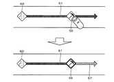
例えば、図6に示すように車線規制の交通情報と工事の交通情報の区間が重複する場合であって、且つ優先度が低い工事の交通情報の全区間が優先度の高い車線規制の交通情報の区間に含まれる場合には、車線規制を示すアイコン60を表示するとともに車線規制の交通情報の区間を示す矢印61については区間の開始点から終点までの全区間に対して表示する。一方、工事の交通情報の区間を示す矢印57については表示されず、工事を示すアイコン56のみが表示されることとなる。 For example, as shown in FIG. 6, traffic information for traffic lane regulation and traffic information for construction overlap, and traffic information for construction traffic information with low priority is traffic information with traffic lane regulation with high priority. In this case, an
また、図7に示すように車線規制の交通情報と工事の交通情報の区間が重複する場合であって、且つ優先度が低い工事の交通情報の一部区間のみが優先度の高い車線規制の交通情報の区間に含まれる場合には、車線規制を示すアイコン60を表示するとともに車線規制の交通情報の区間を示す矢印61については区間の開始点から終点までの全区間に対して表示する。一方、工事の交通情報の区間を示す矢印57については車線規制の交通情報の区間と重複する区間については表示されず、重複しない区間についてのみ表示されることとなる。 In addition, as shown in FIG. 7, traffic information for lane control and traffic information for construction overlap, and only a part of traffic information for construction with low priority is subject to lane control with high priority. When included in the section of traffic information, an
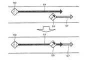
また、図8は前記S5においてナビゲーション装置1の液晶ディスプレイ15に表示される案内画面51を示した図である。尚、図8に示す例では交通情報として、渋滞に関する交通情報と車線規制に関する交通情報と工事に関する交通情報をそれぞれ表示し、且つ車線規制に関する交通情報によって特定される区間と工事に関する交通情報によって特定される区間とが重複する例について説明する。
図8に示すように、案内画面51には、車両周辺の地図画像52とともに、自車の現在位置を示す自車マーク53と、渋滞を示すアイコン54と、渋滞の区間を示す矢印55が表示される。一方で、重複する交通情報の内、優先度が高い車線規制に関する交通情報については、車線規制を示すアイコン60と、車線規制の区間を示す矢印61が表示される。一方で、優先度が低い工事に関する交通情報については、全区間が優先度の高い車線規制の交通情報の区間に含まれるので、工事を示すアイコン56は表示されるが、工事の区間を示す矢印については表示されない。その結果、ユーザは、案内画面51を視認することによって矢印55が表示された区間で渋滞が生じていることや矢印61が表示された区間で車線規制が生じていることを容易且つ迅速に把握することが可能となる。また、工事の区間の詳細については把握できないものの、アイコンの位置から工事の区間の開始位置は特定でき、少なくとも車線規制が生じている区間内において工事の区間が存在することについては把握することが可能となる。また、矢印が重複して表示されないので、ユーザにとって重要な交通情報を明確に把握することが可能となる。FIG. 8 is a diagram showing a
As shown in FIG. 8, the
次に、S6においてCPU41は、操作部14から送信された操作信号に基づいて、前記S5において地図画像上に表示されたアイコンのいずれかをユーザが選択する操作を受け付けたか否か判定する。例えば、操作部14がタッチパネルである場合には、タッチパネルから送信されたタッチ座標とアイコンの表示領域とが一致した場合に、アイコンをユーザが選択する操作を受け付けたと判定する。 Next, in S6, based on the operation signal transmitted from the
そして、前記S5において地図画像上に表示されたアイコンのいずれかをユーザが選択する操作を受け付けたと判定された場合(S6:YES)には、S7へと移行する。それに対して、前記S5において地図画像上に表示されたアイコンのいずれかをユーザが選択する操作を受け付けていないと判定された場合(S6:NO)には、当該交通情報案内処理プログラムを終了する。 If it is determined in S5 that the user has accepted an operation of selecting any of the icons displayed on the map image (S6: YES), the process proceeds to S7. On the other hand, if it is determined in S5 that the user has not accepted an operation for selecting any of the icons displayed on the map image (S6: NO), the traffic information guidance processing program is terminated. .
S7においてCPU41は、ユーザが選択したアイコンが、矢印の少なくとも一部が非表示となっている交通情報(即ち、区間が重複する交通情報であって優先度が低い方の交通情報)に対応するアイコンであるか否か判定する。 In S <b> 7, the
そして、ユーザが選択したアイコンが、矢印の少なくとも一部が非表示となっている交通情報に対応するアイコンであると判定された場合(S7:YES)には、S8へと移行する。それに対して、ユーザが選択したアイコンが、矢印の少なくとも一部が非表示となっている交通情報に対応するアイコンでないと判定された場合(S7:NO)には、当該交通情報案内処理プログラムを終了する。 If it is determined that the icon selected by the user is an icon corresponding to traffic information in which at least a part of the arrow is hidden (S7: YES), the process proceeds to S8. On the other hand, when it is determined that the icon selected by the user is not an icon corresponding to the traffic information in which at least a part of the arrow is hidden (S7: NO), the traffic information guidance processing program is executed. finish.
S8においてCPU41は、ユーザによって選択されたアイコンを強調表示するとともに、選択されたアイコンの交通情報に対応する矢印を、区間の開始点から終点までの全区間を対象として表示する。但し、選択されてから所定時間(例えば5sec)経過すると、アイコンの強調表示を解除し、矢印の表示態様も選択前の状態に戻す。尚、アイコンの強調表示は、例えば、アイコンの枠を太くすることや、アイコンの色を変更することにより行う。その結果、通常時において矢印が非表示となっている交通情報についても、必要時には正確な交通情報をユーザに提供することが可能となる一方で、ユーザに交通情報を把握させた後には再度矢印が非表示となるので、交通情報に係る画像の重複を可能な限り抑えることが可能となる。 In S8, the
尚、上記アイコンの強調表示及び矢印の全区間表示を行う期間は適宜設定することが可能である。例えば、アイコンの選択を継続する状態(タッチパネルではアイコンをタッチした状態)において、アイコンの強調表示及び矢印の全区間表示を継続して行い、選択が解除された時点(例えばアイコンをタッチオフした時点)で、アイコンの強調表示を解除し、矢印の表示態様も選択前の状態に戻すように構成しても良い。 It should be noted that the period during which the icon is highlighted and the entire section of the arrow is displayed can be set as appropriate. For example, in a state in which the selection of the icon is continued (a state in which the icon is touched on the touch panel), when the highlighting of the icon and the entire section of the arrow are continuously displayed and the selection is released (for example, when the icon is touched off) Thus, the highlighted display of the icon may be canceled and the display mode of the arrow may be returned to the state before selection.
例えば、図9は、車線規制の交通情報と工事の交通情報の区間が重複し、且つ優先度が低い工事の交通情報の全区間が優先度の高い車線規制の交通情報の区間に含まれる場合であって、工事を示すアイコン56が選択された場合について示す。図9に示すように、工事を示すアイコン56が選択されると、工事を示すアイコン56が強調表示される。また、非表示となっていた工事の交通情報の区間を示す矢印57が区間の開始点から終点までの全区間に対して表示される。その結果、ユーザは工事が行われている区間の詳細について把握することが可能となる。 For example, FIG. 9 shows a case in which the traffic information section of lane regulation overlaps with the section of construction traffic information, and all sections of construction traffic information with low priority are included in the section of traffic information with high priority lane regulation. The case where the
また、図10は、車線規制の交通情報と工事の交通情報の区間が重複し、且つ優先度が低い工事の交通情報の一部区間のみが優先度の高い車線規制の交通情報の区間に含まれる場合であって、工事を示すアイコン56が選択された場合について示す。図10に示すように、工事を示すアイコン56が選択されると、工事を示すアイコン56が強調表示される。また、一部のみ表示されていた工事の交通情報の区間を示す矢印57が区間の開始点から終点までの全区間に対して表示される。その結果、ユーザは工事が行われている区間の詳細について把握することが可能となる。尚、図10に示す例では矢印61と矢印57の重複区間において矢印61の一部についても表示しているが、矢印57のみを表示する構成としても良い。 In addition, FIG. 10 includes a section of traffic information for lane regulation and a section for traffic information for construction overlapping, and only a section of construction traffic information for construction with low priority is included in the section of traffic information for lane regulation with high priority. This is a case where the
以上詳細に説明した通り、本実施形態に係るナビゲーション装置1、ナビゲーション装置1による交通情報案内方法及びナビゲーション装置1で実行されるコンピュータプログラムでは、交通情報センタから取得した交通情報を案内する場合において、取得した交通情報によって特定される交通事象の内容を示したアイコンを、地図画像の交通情報によって特定される区間内に表示し(S3、S5)、表示されたアイコンをユーザが選択する操作を受け付けた場合に、交通情報によって特定される区間の開始点から終点までを結ぶ矢印を地図画像上に表示する(S8)ので、交通事象の内容を示したアイコンと交通事象が生じている区間の開始点から終点までを結ぶ矢印をそれぞれ地図画像上に表示することによって、ユーザに対して容易且つ迅速に交通情報を理解させることが可能となる。また、矢印についてはアイコンがユーザに選択された場合に表示するので、同一地点付近に複数の交通情報が集中した場合であっても、交通情報に係る画像の重複を抑えることが可能であり、必要な交通情報を分かりやすく案内することが可能となる。更に、ユーザが必要とする状況では矢印を表示することができるので、正確な交通情報をユーザに提供することも可能となる。 As explained in detail above, in the
尚、本発明は前記実施形態に限定されるものではなく、本発明の要旨を逸脱しない範囲内で種々の改良、変形が可能であることは勿論である。
例えば、本実施形態では交通情報によって特定される区間の開始点から終点までを結ぶ区間特定画像として、矢印の画像を表示しているが矢印以外の画像としても良い。例えば、区間の開始点から終点までを結ぶ線分の画像としても良い。Note that the present invention is not limited to the above-described embodiment, and various improvements and modifications can be made without departing from the scope of the present invention.
For example, in the present embodiment, an arrow image is displayed as the section specifying image that connects the start point to the end point of the section specified by the traffic information, but an image other than the arrow may be used. For example, an image of a line segment connecting the start point to the end point of the section may be used.
また、本実施形態では、交通情報によって特定される区間の開始点に、該交通情報の交通事象を示すアイコンを表示することとしているが、アイコンを表示する位置は交通情報によって特定される区間内であればどの位置でも良い。例えば、区間の中点に表示するように構成しても良い。 In this embodiment, an icon indicating the traffic event of the traffic information is displayed at the start point of the section specified by the traffic information. The position where the icon is displayed is within the section specified by the traffic information. Any position is acceptable. For example, it may be configured to display at the midpoint of the section.
また、本実施形態では、優先度が低い交通情報の一部区間のみが優先度の高い交通情報の区間に含まれる場合には、優先度の低い交通情報の区間を示す矢印については、優先度の高い交通情報と重複する区間については表示せず、重複しない区間についてのみ表示することとしているが、重複しない区間についても表示しない構成としても良い。 In this embodiment, when only a part of traffic information with low priority is included in the traffic information with high priority, the arrow indicating the traffic information with low priority has priority Sections overlapping with high traffic information are not displayed, but only sections that do not overlap are displayed. However, sections that do not overlap may not be displayed.
また、本発明はナビゲーション装置以外に、地図画像や交通情報を表示する機能を有する各種装置に対して適用することが可能である。例えば、携帯電話機、スマートフォン、タブレット型端末、パーソナルコンピュータ等(以下、携帯端末等という)に適用することも可能である。また、サーバと携帯端末等から構成されるシステムに対しても適用することが可能となる。その場合には、上述した交通情報案内処理プログラム(図3)の各ステップは、サーバと携帯端末等のいずれが実施する構成としても良い。 In addition to the navigation device, the present invention can be applied to various devices having a function of displaying a map image and traffic information. For example, the present invention can be applied to a mobile phone, a smartphone, a tablet terminal, a personal computer (hereinafter referred to as a mobile terminal). Further, the present invention can be applied to a system including a server and a mobile terminal. In that case, each step of the above-mentioned traffic information guidance processing program (FIG. 3) may be configured to be implemented by either a server or a portable terminal.
また、本発明に係る交通情報案内システムを具体化した実施例について上記に説明したが、交通情報案内システムは以下の構成を有することも可能であり、その場合には以下の効果を奏する。 Moreover, although the Example which actualized the traffic information guidance system which concerns on this invention was described above, the traffic information guidance system can also have the following structures, and there exists the following effect in that case.
例えば、第1の構成は以下のとおりである。
交通事象は内容によって優先度が設定され、前記区間特定画像表示手段は、交通情報取得手段によって取得された交通情報が複数種類あって、且つ各交通情報において特定される区間の少なくとも一部が重複する場合に、区間が重複する前記複数種類の交通情報の内、最も優先度が高い前記交通事象に関する交通情報については、前記アイコンをユーザが選択する操作を受け付けたか否かに関わらず、前記区間特定画像を前記地図画像上に表示し、他の前記交通情報については、前記アイコンをユーザが選択する操作を受け付けた場合に、前記区間特定画像を前記地図画像上に表示する。
尚、「交通情報の種類」とは、交通情報によって特定される交通事象の種類であり、例えば同じ交通事象に関する交通情報であれば同じ種類の交通情報とする。
上記構成を有する交通情報案内システムによれば、優先度が高いユーザにとって重要な交通情報については区間特定画像により正確な情報を案内することが可能となる一方、それ以外の交通情報についてもユーザの要求に応じて正確な交通情報をユーザに提供することが可能となる。また、区間特定画像を表示しない状況においても、アイコンについてはユーザの操作に関わらず表示されるので、少なくとも交通事象が生じているおよその位置についてはユーザに把握させることが可能となる。For example, the first configuration is as follows.
Traffic eventis setpriority depending on the contents,the section identifying image display means, there traffic information are several kinds obtained by the traffic information acquiring section, and at least partially overlapping sections identified in the traffic information When the traffic information related to the traffic event having the highest priority among the plurality of types of traffic information with overlapping sections, the section is used regardless of whether or not an operation for selecting the icon is accepted by the user. display certain images on the map image, for the other of the traffic information, the icon when the user receives an operation ofselecting, to display theprevious SL section identifying image on the map image.
The “type of traffic information” is the type of traffic event specified by the traffic information. For example, if the traffic information is related to the same traffic event, the same type of traffic information is used.
According to the traffic information guidance system having the above-described configuration, it is possible to provide accurate information on the traffic information important for the user with high priority by using the section specifying image, while it is also possible to provide the user with other traffic information. It becomes possible to provide accurate traffic information to the user upon request. Further, even in a situation where the section specifying image is not displayed, the icon is displayed regardless of the user's operation, so that the user can grasp at least the approximate position where the traffic event occurs.
また、第2の構成は以下のとおりである。
前記区間特定画像表示手段は、交通情報取得手段によって取得された交通情報が複数種類あって、一方の交通情報によって特定される区間に他方の交通情報によって特定される全区間が含まれるとともに、前記一方の交通情報が特定する交通事象よりも前記他方の交通情報が特定する交通事象の優先度が低い場合に、他方の交通情報については、アイコンをユーザが選択する操作を受け付ける前は、他方の交通情報によって特定される全区間において区間特定画像を表示しない。
上記構成を有する交通情報案内システムによれば、より優先度の高い交通情報に他方の交通情報が完全に被覆される場合には、通常時は他方の交通情報の区間特定画像を非表示とすることによって、優先度が高いユーザにとって重要な交通情報については正確な情報を案内することが可能となる。一方で、他方の交通情報についてもユーザの要求に応じて区間特定画像を表示させることにより、必要時には正確な交通情報をユーザに提供することが可能となる。The second configuration is as follows.
The section specifying image display means includes a plurality of types of traffic information acquired bythe traffic information acquiring means, and the section specified by one traffic information includes all sections specified by the other traffic information, When the priority of the traffic event specified by the other traffic information is lower than the traffic event specified by the other traffic information, the other traffic information, before accepting the operation for the user to select an icon, The section specifying image is not displayed in all sections specified by the traffic information.
According to the traffic information guide system having the above configuration, when the other traffic information is completely covered with higher priority traffic information, the section identification image of the other traffic information is normally hidden. Thus, it is possible to provide accurate information on traffic information important for a user with high priority. On the other hand, for the other traffic information, it is possible to provide the user with accurate traffic information when necessary by displaying the section specifying image according to the user's request.
また、第3の構成は以下のとおりである。
前記区間特定画像表示手段は、交通情報取得手段によって取得された交通情報が複数種類あって、一方の交通情報によって特定される区間に他方の交通情報によって特定される区間の一部が含まれるとともに、前記一方の交通情報が特定する交通事象よりも前記他方の交通情報が特定する交通事象の優先度が低い場合に、他方の交通情報については、アイコンをユーザが選択する操作を受け付ける前は、他方の交通情報によって特定される区間の内、一方の交通情報によって特定される区間と重複しない区間のみを対象として区間特定画像を表示する。
上記構成を有する交通情報案内システムによれば、より優先度の高い交通情報に他方の交通情報の一部が被覆される場合には、通常時は他方の交通情報の区間特定画像を重複区間において非表示とすることによって、優先度が高いユーザにとって重要な交通情報については正確な情報を案内することが可能となる。一方で、他方の交通情報についてもユーザの要求に応じて非表示となっている区間の区間特定画像を表示させることにより、必要時には正確な交通情報をユーザに提供することが可能となる。また、通常時においても他方の交通情報は、優先度の高い交通情報と重複しない区間については区間特定画像を表示することにより、優先度の高い交通情報の案内を阻害しない範囲で、より正確な交通情報を提供することが可能となる。The third configuration is as follows.
The section specifying image display means includes a plurality of types of traffic information acquired bythe traffic information acquiring means, and the section specified by one traffic information includes a part of the section specified by the other traffic information. In the case where the priority of the traffic event specified by the other traffic information is lower than the traffic event specified by the one traffic information, before accepting the operation for the user to select an icon for the other traffic information, Of the sections specified by the other traffic information, the section specifying image is displayed only for the sections that do not overlap with the sections specified by the one traffic information.
According to the traffic information guidance system having the above-described configuration, when a part of the other traffic information is covered with higher-priority traffic information, the section identification image of the other traffic information is normally displayed in the overlapping section. By not displaying, it is possible to provide accurate information on traffic information important for a user with high priority. On the other hand, it is possible to provide the user with accurate traffic information when necessary by displaying the section specifying image of the section that is not displayed in response to the user's request for the other traffic information. In addition, even during normal times, the other traffic information is more accurate within a range that does not hinder the guidance of traffic information with high priority by displaying a section specific image for sections that do not overlap with traffic information with high priority. It is possible to provide traffic information.
また、第4の構成は以下のとおりである。
前記交通事象のユーザの走行に与える影響によって優先度が設定され、ユーザの走行に与える影響の大きい交通事象は、与える影響の小さい交通事象よりも優先度が高く設定される。
上記構成を有する交通情報案内システムによれば、ユーザに対して案内を行うことがより重要と予測される交通情報について、優先的に区間特定画像を表示するので、ユーザに行わせる操作を最小限として必要な交通情報をユーザに提供することが可能となる。The fourth configuration is as follows.
A priority is set according to the influence of the traffic event on the user's travel, and a traffic event having a large influence on the user's travel has a higher prioritythan a traffic event having a small influence .
According to the traffic information guidance system having the above-described configuration, the section specifying image is preferentially displayed for traffic information that is predicted to be more important to guide the user. It is possible to provide necessary traffic information to the user.
また、第5の構成は以下のとおりである。
区間特定画像表示手段は、アイコンをユーザが選択する操作を受け付けた場合に、該操作を受け付けてから所定時間が経過するまでの間、区間特定画像を表示する。
上記構成を有する交通情報案内システムによれば、通常時において区間特定画像が非表示となっている交通情報についても、必要時には正確な交通情報をユーザに提供することが可能となる一方で、ユーザに交通情報を把握させた後には再度区間特定画像が非表示となるので、交通情報に係る画像の重複を可能な限り抑えることが可能となる。The fifth configuration is as follows.
When the operation for selecting the icon is received by the user, the section specific image display means displays the section specific image until a predetermined time elapses after the operation is received.
According to the traffic information guidance system having the above-described configuration, it is possible to provide accurate traffic information to the user when necessary even for the traffic information in which the section specific image is not displayed in the normal time. After the traffic information is grasped, the section specifying image is not displayed again, so that it is possible to suppress duplication of images related to the traffic information as much as possible.
1 ナビゲーション装置
15 液晶ディスプレイ
41 CPU
42 RAM
43 ROM
51 案内画面
54、56、60 アイコン
55、57、61 矢印1
42 RAM
43 ROM
51
Claims (9)
Translated fromJapanese表示装置に地図画像を表示する地図画像表示手段と、
前記交通情報取得手段により取得した前記交通情報に基づいて、前記交通情報によって特定される交通事象の内容を示したアイコンを、前記交通情報によって特定される区間内の該当する前記地図画像上の箇所に表示するアイコン表示手段と、
前記交通情報によって特定される区間の開始点から終点までを結ぶ区間特定画像を前記地図画像上に表示する区間特定画像表示手段と、を有し、
前記区間特定画像表示手段は、
前記交通情報取得手段によって取得された前記交通情報が複数種類あって、且つ各交通情報において特定される区間の少なくとも一部が重複する場合に、
区間が重複する前記複数種類の交通情報の内、一の交通情報については、前記アイコンをユーザが選択する操作を受け付けたか否かに関わらず、前記区間特定画像を前記地図画像上に表示し、
他の前記交通情報については、前記アイコンをユーザが選択する操作を受け付けた場合に、前記区間特定画像を前記地図画像上に表示することを特徴とする交通情報案内システム。Traffic information acquisition means for acquiring traffic information including information specifying the content of the traffic event and the section in which the traffic event occurs;
Map image display means for displaying a map image on the display device;
Based on the traffic information acquired by the traffic information acquisition means, an icon indicating the content of the traffic event specified by the traffic information is displayed on the corresponding map image in the section specified by the traffic information. Icon display means to be displayed on,
Possessprevious SL and section identification image display means for displaying the section identifying image connecting to the end point from the start point of the section specified on the map image by the traffic information,and
The section specifying image display means includes
When there are a plurality of types of the traffic information acquired by the traffic information acquisition means and at least a part of the section specified in each traffic information overlaps,
Of the multiple types of traffic information with overlapping sections, for one piece of traffic information, the section specifying image is displayed on the map image regardless of whether the user has received an operation of selecting the icon,
For the other traffic information, the section specifying image is displayed on the map image when an operation for selecting the icon by the user is received .
前記区間特定画像表示手段は、
前記交通情報取得手段によって取得された前記交通情報が複数種類あって、且つ各交通情報において特定される区間の少なくとも一部が重複する場合に、
区間が重複する前記複数種類の交通情報の内、最も優先度が高い前記交通事象に関する交通情報については、前記アイコンをユーザが選択する操作を受け付けたか否かに関わらず、前記区間特定画像を前記地図画像上に表示し、
他の前記交通情報については、前記アイコンをユーザが選択する操作を受け付けた場合に、前記区間特定画像を前記地図画像上に表示することを特徴とする請求項1に記載の交通情報案内システム。The trafficevent priorityis set by the contents,
The section specifying image display means includes
When there are a plurality of types of the traffic information acquired by the traffic information acquisition means and at least a part of the section specified in each traffic information overlaps,
For the traffic information related to the traffic event having the highest priority among the plurality of types of traffic information with overlapping sections, the section specifying image is selected regardless of whether or not an operation for selecting the icon is accepted by the user. Displayed on the map image,
For other of the traffic information, traffic information guidance system according to claim 1, characterized in that displaying the icon when the user accepts an operation of selectinga pre-Symbol section identifying image on the map image .
前記交通情報取得手段によって取得された前記交通情報が複数種類あって、一方の交通情報によって特定される区間に他方の交通情報によって特定される全区間が含まれるとともに、前記一方の交通情報が特定する交通事象よりも前記他方の交通情報が特定する交通事象の優先度が低い場合に、
前記他方の交通情報については、前記アイコンをユーザが選択する操作を受け付ける前は、前記他方の交通情報によって特定される全区間において前記区間特定画像を表示しないことを特徴とする請求項2に記載の交通情報案内システム。The section specifying image display means includes
There are a plurality of types of the traffic information acquired by the traffic information acquisition means, and the section specified by one traffic information includes all sections specified by the other traffic information, and the one traffic information is specified If the priority of the traffic event specified by the other traffic information is lower than the traffic event to be
3. The section specifying image is not displayed in all sections specified by the other traffic information before accepting an operation for the user to select the icon for the other traffic information. Traffic information guidance system.
前記交通情報取得手段によって取得された前記交通情報が複数種類あって、一方の交通情報によって特定される区間に他方の交通情報によって特定される区間の一部が含まれるとともに、前記一方の交通情報が特定する交通事象よりも前記他方の交通情報が特定する交通事象の優先度が低い場合に、
前記他方の交通情報については、前記アイコンをユーザが選択する操作を受け付ける前は、前記他方の交通情報によって特定される区間の内、前記一方の交通情報によって特定される区間と重複しない区間のみを対象として前記区間特定画像を表示することを特徴とする請求項2に記載の交通情報案内システム。The section specifying image display means includes
There are a plurality of types of the traffic information acquired by the traffic information acquisition means, and the section specified by one traffic information includes a part of the section specified by the other traffic information, and the one traffic information If the priority of the traffic event specified by the other traffic information is lower than the traffic event specified by
For the other traffic information, before accepting an operation for the user to select the icon, only a section that does not overlap with a section specified by the one traffic information is specified among the sections specified by the other traffic information. The traffic information guidance system according to claim 2, wherein the section specifying image is displayed as a target.
ユーザの走行に与える影響の大きい交通事象は、与える影響の小さい交通事象よりも優先度が高く設定されることを特徴とする請求項2乃至請求項4のいずれかに記載の交通情報案内システム。Priority is set according to the degree of influence of the traffic event on the user's travel,
The traffic information guide system according to any one of claims 2 to 4, wherein a traffic event having a large influence on the travel of the user is set to have a higher priority than a traffic event having a small influence.
表示装置に地図画像を表示する地図画像表示手段と、
前記交通情報取得手段により取得した前記交通情報に基づいて、前記交通情報によって特定される交通事象の内容を示したアイコンを、前記交通情報によって特定される区間内の該当する前記地図画像上の箇所に表示するアイコン表示手段と、
前記交通情報によって特定される区間の開始点から終点までを結ぶ区間特定画像を前記地図画像上に表示する区間特定画像表示手段と、を有し、
前記区間特定画像表示手段は、
前記交通情報取得手段によって取得された前記交通情報が複数種類あって、且つ各交通情報において特定される区間の少なくとも一部が重複する場合に、
区間が重複する前記複数種類の交通情報の内、一の交通情報については、前記アイコンをユーザが選択する操作を受け付けたか否かに関わらず、前記区間特定画像を前記地図画像上に表示し、
他の前記交通情報については、前記アイコンをユーザが選択する操作を受け付けた場合に、前記区間特定画像を前記地図画像上に表示することを特徴とする交通情報案内装置。Traffic information acquisition means for acquiring traffic information including information specifying the content of the traffic event and the section in which the traffic event occurs;
Map image display means for displaying a map image on the display device;
Based on the traffic information acquired by the traffic information acquisition means, an icon indicating the content of the traffic event specified by the traffic information is displayed on the corresponding map image in the section specified by the traffic information. Icon display means to be displayed on,
Possessprevious SL and section identification image display means for displaying the section identifying image connecting to the end point from the start point of the section specified on the map image by the traffic information,and
The section specifying image display means includes
When there are a plurality of types of the traffic information acquired by the traffic information acquisition means and at least a part of the section specified in each traffic information overlaps,
Of the multiple types of traffic information with overlapping sections, for one piece of traffic information, the section specifying image is displayed on the map image regardless of whether the user has received an operation of selecting the icon,
Regarding the other traffic information, the section specifying image is displayed on the map image when an operation for selecting the icon by the user is received .
地図画像表示手段が、表示装置に地図画像を表示するステップと、
アイコン表示手段が、前記交通情報取得手段により取得した前記交通情報に基づいて、前記交通情報によって特定される交通事象の内容を示したアイコンを、前記交通情報によって特定される区間内の該当する前記地図画像上の箇所に表示するステップと、
区間特定画像表示手段が、前記交通情報によって特定される区間の開始点から終点までを結ぶ区間特定画像を前記地図画像上に表示するステップと、を有し、
前記区間特定画像表示手段は、
前記交通情報取得手段によって取得された前記交通情報が複数種類あって、且つ各交通情報において特定される区間の少なくとも一部が重複する場合に、
区間が重複する前記複数種類の交通情報の内、一の交通情報については、前記アイコンをユーザが選択する操作を受け付けたか否かに関わらず、前記区間特定画像を前記地図画像上に表示し、
他の前記交通情報については、前記アイコンをユーザが選択する操作を受け付けた場合に、前記区間特定画像を前記地図画像上に表示することを特徴とする交通情報案内方法。A traffic information acquisition means for acquiring traffic information including information specifying a content of a traffic event and a section in which the traffic event occurs;
A map image display means for displaying a map image on a display device;
Based on the traffic information acquired by the traffic information acquisition unit, an icon display unit displays an icon indicating the content of the traffic event specified by the traffic information, and the corresponding icon in the section specified by the traffic information. A step of displaying it at a location on the map image;
Section identifying image displaymeans,possess displaying apre Symbol section identifying image connecting to the end point from the start point of the section specified by the traffic information on the map image,and
The section specifying image display means includes
When there are a plurality of types of the traffic information acquired by the traffic information acquisition means and at least a part of the section specified in each traffic information overlaps,
Of the multiple types of traffic information with overlapping sections, for one piece of traffic information, the section specifying image is displayed on the map image regardless of whether the user has received an operation of selecting the icon,
For the other traffic information, the section specifying image is displayed on the map image when an operation for selecting the icon by the user is received .
交通事象の内容と該交通事象が生じている区間を特定する情報を含む交通情報を取得する交通情報取得手段と、
表示装置に地図画像を表示する地図画像表示手段と、
前記交通情報取得手段により取得した前記交通情報に基づいて、前記交通情報によって特定される交通事象の内容を示したアイコンを、前記交通情報によって特定される区間内の該当する前記地図画像上の箇所に表示するアイコン表示手段と、
前記交通情報によって特定される区間の開始点から終点までを結ぶ区間特定画像を前記地図画像上に表示する区間特定画像表示手段と、
して機能させる為のコンピュータプログラムであって、
前記区間特定画像表示手段は、
前記交通情報取得手段によって取得された前記交通情報が複数種類あって、且つ各交通情報において特定される区間の少なくとも一部が重複する場合に、
区間が重複する前記複数種類の交通情報の内、一の交通情報については、前記アイコンをユーザが選択する操作を受け付けたか否かに関わらず、前記区間特定画像を前記地図画像上に表示し、
他の前記交通情報については、前記アイコンをユーザが選択する操作を受け付けた場合に、前記区間特定画像を前記地図画像上に表示するコンピュータプログラム。Computer
Traffic information acquisition means for acquiring traffic information including information specifying the content of the traffic event and the section in which the traffic event occurs;
Map image display means for displaying a map image on the display device;
Based on the traffic information acquired by the traffic information acquisition means, an icon indicating the content of the traffic event specified by the traffic information is displayed on the corresponding map image in the section specified by the traffic information. Icon display means to be displayed on,
Before SL and section identification image display means for displaying the section identifying image connecting to the end point from the start point of the section specified on the map image by the traffic information,
Acomputer program to make it function,
The section specifying image display means includes
When there are a plurality of types of the traffic information acquired by the traffic information acquisition means and at least a part of the section specified in each traffic information overlaps,
Of the multiple types of traffic information with overlapping sections, for one piece of traffic information, the section specifying image is displayed on the map image regardless of whether the user has received an operation of selecting the icon,
As for the other traffic information, a computer programfor displaying the section specifying image on the map image when an operation for selecting the icon by the user is accepted .
Priority Applications (5)
| Application Number | Priority Date | Filing Date | Title |
|---|---|---|---|
| JP2013156824AJP6098419B2 (en) | 2013-07-29 | 2013-07-29 | Traffic information guidance system, traffic information guidance device, traffic information guidance method, and computer program |
| EP14832458.5AEP2990764B1 (en) | 2013-07-29 | 2014-06-30 | Traffic information notification system, traffic information notification device, traffic information notification method, and computer program |
| PCT/JP2014/067346WO2015015978A1 (en) | 2013-07-29 | 2014-06-30 | Traffic information notification system, traffic information notification device, traffic information notification method, and computer program |
| US14/902,210US20160148503A1 (en) | 2013-07-29 | 2014-06-30 | Traffic information guide system, traffic information guide device, traffic information guide method, and computer program |
| CN201480036918.XACN105339760B (en) | 2013-07-29 | 2014-06-30 | Transport information guiding system, transport information bootstrap technique and recording medium |
Applications Claiming Priority (1)
| Application Number | Priority Date | Filing Date | Title |
|---|---|---|---|
| JP2013156824AJP6098419B2 (en) | 2013-07-29 | 2013-07-29 | Traffic information guidance system, traffic information guidance device, traffic information guidance method, and computer program |
Publications (2)
| Publication Number | Publication Date |
|---|---|
| JP2015025784A JP2015025784A (en) | 2015-02-05 |
| JP6098419B2true JP6098419B2 (en) | 2017-03-22 |
Family
ID=52431519
Family Applications (1)
| Application Number | Title | Priority Date | Filing Date |
|---|---|---|---|
| JP2013156824AExpired - Fee RelatedJP6098419B2 (en) | 2013-07-29 | 2013-07-29 | Traffic information guidance system, traffic information guidance device, traffic information guidance method, and computer program |
Country Status (5)
| Country | Link |
|---|---|
| US (1) | US20160148503A1 (en) |
| EP (1) | EP2990764B1 (en) |
| JP (1) | JP6098419B2 (en) |
| CN (1) | CN105339760B (en) |
| WO (1) | WO2015015978A1 (en) |
Cited By (1)
| Publication number | Priority date | Publication date | Assignee | Title |
|---|---|---|---|---|
| KR20190049230A (en)* | 2017-11-01 | 2019-05-09 | 주식회사 와이씨이엔지 | Bending device and screw fastening device for hose fastening band |
Families Citing this family (10)
| Publication number | Priority date | Publication date | Assignee | Title |
|---|---|---|---|---|
| JP5762656B2 (en)* | 2013-03-01 | 2015-08-12 | 三菱電機株式会社 | Vehicle position display control device and vehicle position specifying program |
| JP5599959B1 (en)* | 2013-05-20 | 2014-10-01 | 楽天株式会社 | Information processing device |
| CN105957378B (en)* | 2016-05-04 | 2021-11-26 | 深圳市凯立德科技股份有限公司 | Traffic information prompting method and equipment |
| JP6654538B2 (en)* | 2016-09-27 | 2020-02-26 | 本田技研工業株式会社 | Traffic obstacle risk display |
| CN108021420B (en)* | 2016-12-23 | 2021-04-23 | 北京车和家信息技术有限责任公司 | Message display method and device, central control display system and vehicle |
| CN109410621A (en)* | 2017-05-09 | 2019-03-01 | 高德信息技术有限公司 | A kind of event methods of exhibiting and device |
| CN111462490B (en)* | 2020-04-03 | 2022-06-21 | 海信集团有限公司 | Road network visualization method and device based on multistage subregion division |
| JP7400688B2 (en)* | 2020-10-19 | 2023-12-19 | トヨタ自動車株式会社 | Display device and display method |
| CN115221251A (en)* | 2021-04-19 | 2022-10-21 | 阿里巴巴新加坡控股有限公司 | Traffic incident display method and program product |
| CN117496736A (en)* | 2022-07-25 | 2024-02-02 | 北京嘀嘀无限科技发展有限公司 | Method and device for presenting traffic event information |
Family Cites Families (18)
| Publication number | Priority date | Publication date | Assignee | Title |
|---|---|---|---|---|
| JPH09236439A (en)* | 1996-02-29 | 1997-09-09 | Kenwood Corp | Load traffic information display device |
| JP3174265B2 (en)* | 1996-04-19 | 2001-06-11 | 三菱電機株式会社 | Traffic information display device |
| DE19945431A1 (en)* | 1999-09-22 | 2001-04-05 | Siemens Ag | Method for arranging route information within a road map and navigation device |
| JP3214564B2 (en) | 1999-10-13 | 2001-10-02 | 株式会社デンソー | Traffic information display device |
| JP2002048583A (en)* | 2000-08-03 | 2002-02-15 | Pioneer Electronic Corp | Display device |
| JP3921080B2 (en)* | 2001-11-20 | 2007-05-30 | アルパイン株式会社 | Map display device and navigation device |
| JP4528528B2 (en)* | 2003-01-10 | 2010-08-18 | 株式会社日立製作所 | Navigation server, navigation display method |
| KR20040064634A (en)* | 2003-01-10 | 2004-07-19 | 가부시끼가이샤 히다치 세이사꾸쇼 | Display method of naviserver and navigation |
| US7161504B2 (en)* | 2003-01-31 | 2007-01-09 | Alpine Electronics, Inc. | Navigation system for finding optimum route using traffic incidents information |
| EP1730471B1 (en)* | 2004-03-15 | 2015-07-01 | TomTom International B.V. | Navigation device displaying dynamic travel information |
| JP2006079483A (en)* | 2004-09-13 | 2006-03-23 | Hitachi Ltd | Traffic information providing apparatus and traffic information providing method |
| JP4681313B2 (en)* | 2005-02-10 | 2011-05-11 | クラリオン株式会社 | Navigation device |
| JP4802531B2 (en)* | 2005-03-28 | 2011-10-26 | 日産自動車株式会社 | Traffic information display apparatus and method |
| US7609172B2 (en)* | 2006-10-12 | 2009-10-27 | Garmin Ltd. | System and method for providing real-time traffic information |
| AU2007343390A1 (en)* | 2007-01-10 | 2008-07-17 | Tomtom International B.V. | Navigation device and method for displaying navigation information |
| CN101583845B (en)* | 2007-01-10 | 2013-08-21 | 通腾科技股份有限公司 | Method of indicating traffic delays, computer program and navigation system therefor |
| JP2010181160A (en)* | 2009-02-03 | 2010-08-19 | Alpine Electronics Inc | Navigation device |
| JP5693261B2 (en) | 2011-01-28 | 2015-04-01 | アルパイン株式会社 | Navigation device |
- 2013
- 2013-07-29JPJP2013156824Apatent/JP6098419B2/ennot_activeExpired - Fee Related
- 2014
- 2014-06-30WOPCT/JP2014/067346patent/WO2015015978A1/ennot_activeCeased
- 2014-06-30USUS14/902,210patent/US20160148503A1/ennot_activeAbandoned
- 2014-06-30CNCN201480036918.XApatent/CN105339760B/ennot_activeExpired - Fee Related
- 2014-06-30EPEP14832458.5Apatent/EP2990764B1/ennot_activeNot-in-force
Cited By (2)
| Publication number | Priority date | Publication date | Assignee | Title |
|---|---|---|---|---|
| KR20190049230A (en)* | 2017-11-01 | 2019-05-09 | 주식회사 와이씨이엔지 | Bending device and screw fastening device for hose fastening band |
| KR102012042B1 (en)* | 2017-11-01 | 2019-10-21 | 주식회사 와이씨이엔지 | Bending device and screw fastening device for hose fastening band |
Also Published As
| Publication number | Publication date |
|---|---|
| CN105339760A (en) | 2016-02-17 |
| JP2015025784A (en) | 2015-02-05 |
| US20160148503A1 (en) | 2016-05-26 |
| WO2015015978A1 (en) | 2015-02-05 |
| CN105339760B (en) | 2018-02-23 |
| EP2990764A1 (en) | 2016-03-02 |
| EP2990764A4 (en) | 2016-06-15 |
| EP2990764B1 (en) | 2018-06-20 |
Similar Documents
| Publication | Publication Date | Title |
|---|---|---|
| JP6098419B2 (en) | Traffic information guidance system, traffic information guidance device, traffic information guidance method, and computer program | |
| US10071745B2 (en) | Automated drive assisting system, automated drive assisting method, and computer program | |
| JP6172283B2 (en) | Route search system, route search method and computer program | |
| US10315664B2 (en) | Automatic driving assistance system, automatic driving assistance method, and computer program | |
| EP2453207B1 (en) | Travel guidance device, travel guidance method, and computer program | |
| JP5565296B2 (en) | Route guidance device, route guidance method and computer program | |
| JP5565203B2 (en) | Intersection information acquisition apparatus, intersection information acquisition method, and computer program | |
| JP6558129B2 (en) | Driving support system, driving support method, and computer program | |
| JP6160364B2 (en) | Map information update system, map information update device, map information update method, and computer program | |
| EP2543969B1 (en) | Travel guidance system, travel guidance method, and computer program product | |
| JP5966675B2 (en) | Probe information collection system | |
| JP2014199587A (en) | Deceleration-end geographic point storage system, drive support system, drive support method, and computer program | |
| JP5953981B2 (en) | Probe information collection system | |
| JP2017032440A (en) | Driving assistance system, driving assistance method, and computer program | |
| JP5768750B2 (en) | Vehicle control apparatus, vehicle control method, and computer program | |
| JP4697160B2 (en) | Traffic information guidance device | |
| JP2011033402A (en) | Apparatus and method for guidance of congestion degree, and computer program | |
| JP2009085738A (en) | Drive information device, drive information method, and computer program | |
| JP5752966B2 (en) | Turntable parking lot detection system, turntable parking lot detection method, and computer program | |
| JP2019190831A (en) | Traffic information guiding device and computer program | |
| JP5831016B2 (en) | Movement guidance system, movement guidance apparatus, movement guidance method, and computer program | |
| US20220090934A1 (en) | Guide generation method and guide system | |
| JP5786522B2 (en) | Movement guidance system, movement guidance apparatus, movement guidance method, and computer program | |
| JP2013003042A (en) | Movement guide system, movement guide device, movement guide method, and computer program | |
| JP2020190467A (en) | Traffic information providing system, traffic information providing device and computer program |
Legal Events
| Date | Code | Title | Description |
|---|---|---|---|
| A621 | Written request for application examination | Free format text:JAPANESE INTERMEDIATE CODE: A621 Effective date:20150611 | |
| A131 | Notification of reasons for refusal | Free format text:JAPANESE INTERMEDIATE CODE: A131 Effective date:20160412 | |
| A521 | Request for written amendment filed | Free format text:JAPANESE INTERMEDIATE CODE: A523 Effective date:20160601 | |
| A02 | Decision of refusal | Free format text:JAPANESE INTERMEDIATE CODE: A02 Effective date:20160809 | |
| A521 | Request for written amendment filed | Free format text:JAPANESE INTERMEDIATE CODE: A523 Effective date:20161109 | |
| A711 | Notification of change in applicant | Free format text:JAPANESE INTERMEDIATE CODE: A711 Effective date:20161109 | |
| A521 | Request for written amendment filed | Free format text:JAPANESE INTERMEDIATE CODE: A523 Effective date:20161118 | |
| A521 | Request for written amendment filed | Free format text:JAPANESE INTERMEDIATE CODE: A821 Effective date:20161118 | |
| A911 | Transfer to examiner for re-examination before appeal (zenchi) | Free format text:JAPANESE INTERMEDIATE CODE: A911 Effective date:20161212 | |
| TRDD | Decision of grant or rejection written | ||
| A01 | Written decision to grant a patent or to grant a registration (utility model) | Free format text:JAPANESE INTERMEDIATE CODE: A01 Effective date:20170124 | |
| A61 | First payment of annual fees (during grant procedure) | Free format text:JAPANESE INTERMEDIATE CODE: A61 Effective date:20170206 | |
| R150 | Certificate of patent or registration of utility model | Ref document number:6098419 Country of ref document:JP Free format text:JAPANESE INTERMEDIATE CODE: R150 | |
| LAPS | Cancellation because of no payment of annual fees |