JP5428189B2 - Navigation device - Google Patents
Navigation deviceDownload PDFInfo
- Publication number
- JP5428189B2 JP5428189B2JP2008107578AJP2008107578AJP5428189B2JP 5428189 B2JP5428189 B2JP 5428189B2JP 2008107578 AJP2008107578 AJP 2008107578AJP 2008107578 AJP2008107578 AJP 2008107578AJP 5428189 B2JP5428189 B2JP 5428189B2
- Authority
- JP
- Japan
- Prior art keywords
- point
- display
- displayed
- mark
- map
- Prior art date
- Legal status (The legal status is an assumption and is not a legal conclusion. Google has not performed a legal analysis and makes no representation as to the accuracy of the status listed.)
- Expired - Fee Related
Links
Images


Classifications
- G—PHYSICS
- G01—MEASURING; TESTING
- G01C—MEASURING DISTANCES, LEVELS OR BEARINGS; SURVEYING; NAVIGATION; GYROSCOPIC INSTRUMENTS; PHOTOGRAMMETRY OR VIDEOGRAMMETRY
- G01C21/00—Navigation; Navigational instruments not provided for in groups G01C1/00 - G01C19/00
- G01C21/26—Navigation; Navigational instruments not provided for in groups G01C1/00 - G01C19/00 specially adapted for navigation in a road network
- G01C21/34—Route searching; Route guidance
- G01C21/36—Input/output arrangements for on-board computers
- G—PHYSICS
- G06—COMPUTING OR CALCULATING; COUNTING
- G06F—ELECTRIC DIGITAL DATA PROCESSING
- G06F3/00—Input arrangements for transferring data to be processed into a form capable of being handled by the computer; Output arrangements for transferring data from processing unit to output unit, e.g. interface arrangements
- G06F3/01—Input arrangements or combined input and output arrangements for interaction between user and computer
- G06F3/048—Interaction techniques based on graphical user interfaces [GUI]
- G06F3/0487—Interaction techniques based on graphical user interfaces [GUI] using specific features provided by the input device, e.g. functions controlled by the rotation of a mouse with dual sensing arrangements, or of the nature of the input device, e.g. tap gestures based on pressure sensed by a digitiser
- G06F3/0488—Interaction techniques based on graphical user interfaces [GUI] using specific features provided by the input device, e.g. functions controlled by the rotation of a mouse with dual sensing arrangements, or of the nature of the input device, e.g. tap gestures based on pressure sensed by a digitiser using a touch-screen or digitiser, e.g. input of commands through traced gestures
- G—PHYSICS
- G09—EDUCATION; CRYPTOGRAPHY; DISPLAY; ADVERTISING; SEALS
- G09B—EDUCATIONAL OR DEMONSTRATION APPLIANCES; APPLIANCES FOR TEACHING, OR COMMUNICATING WITH, THE BLIND, DEAF OR MUTE; MODELS; PLANETARIA; GLOBES; MAPS; DIAGRAMS
- G09B29/00—Maps; Plans; Charts; Diagrams, e.g. route diagram
- G09B29/10—Map spot or coordinate position indicators; Map reading aids
- G09B29/106—Map spot or coordinate position indicators; Map reading aids using electronic means
Landscapes
- Engineering & Computer Science (AREA)
- Physics & Mathematics (AREA)
- Theoretical Computer Science (AREA)
- Remote Sensing (AREA)
- General Physics & Mathematics (AREA)
- Radar, Positioning & Navigation (AREA)
- General Engineering & Computer Science (AREA)
- Educational Administration (AREA)
- Business, Economics & Management (AREA)
- Educational Technology (AREA)
- Mathematical Physics (AREA)
- Human Computer Interaction (AREA)
- Automation & Control Theory (AREA)
- Navigation (AREA)
- Instructional Devices (AREA)
- User Interface Of Digital Computer (AREA)
- Traffic Control Systems (AREA)
Description
Translated fromJapanese本発明は、所望の出発地から目的地までの案内経路を探索し、表示部に表示した地図上に案内経路や現在位置を表示して経路案内を行うナビゲーション装置に関するものであり、特に、表示された地図上の地点を指定して、その地点を目的地や経由地として設定する際、地図上における指定された地点に地点設定マークを表示するとともに、地点マークの表示領域を判別し、地点マークが表示された表示領域の上下、または左右の対向する表示領域側に地点設定メニュー画像を表示するようにしたナビゲーション装置に関するものである。 The present invention relates to a navigation device that searches for a guidance route from a desired departure point to a destination, displays a guidance route and a current position on a map displayed on a display unit, and performs route guidance. When specifying a point on the map and setting the point as a destination or waypoint, a point setting mark is displayed at the specified point on the map, and the display area of the point mark is determined. The present invention relates to a navigation apparatus in which a point setting menu image is displayed on the upper and lower sides of a display area where a mark is displayed, or on the left and right opposing display areas.
従来、自動車等で道路を走行する場合に、目的地に至るまで現在位置を求め、表示画面上に道路地図とともに現在位置を表示し、ユーザが道に迷うことなく目的地に到達できるように誘導する車載用のナビゲーション装置が知られている。また、携帯電話などの携帯端末装置を用いた歩行者用ナビゲーションシステムも提供されている。このナビゲーションシステムは携帯端末装置と経路探索サーバとから構成された通信型のナビゲーションシステムである。 Conventionally, when driving on a road such as a car, the current position is obtained until the destination is reached, and the current position is displayed on the display screen together with the road map, so that the user can reach the destination without getting lost. A vehicle-mounted navigation device is known. A pedestrian navigation system using a mobile terminal device such as a mobile phone is also provided. This navigation system is a communication-type navigation system composed of a mobile terminal device and a route search server.
車載用ナビゲーション装置においては、運転操作を妨げることなく操作できるように表示部にタッチパネルを備え、各種操作を行えるように考慮されているものも提供されている。このようなナビゲーション装置においては、表示部に表示されたメニュー画面上で所望の選択項目を選択して機能選択や切替え処理をしたり、表示部に表示された地図画像上で所望の地点を指定したりして、目的地や経由地を設定することができる。 Some in-vehicle navigation devices are provided with a touch panel in the display unit so that they can be operated without hindering driving operation, and are considered so that various operations can be performed. In such a navigation device, a desired selection item is selected on a menu screen displayed on the display unit to perform function selection or switching processing, or a desired point is specified on a map image displayed on the display unit You can set the destination and waypoint.
例えば、下記の特許文献1(特開平6−66584号公報)には、表示部に表示された地図画像上で所望の地点をタッチ操作により指定して、目的地や経由地を設定する車両用経路誘導装置の発明が開示されている。この車両用経路誘導装置は、地名索引による地図表示画面において、「登録」、「目的地」の操作キー表示を行い、この「登録」キーがタッチされた場合には、そのときの地図表示上で地点登録の処理を行い、また、「目的地」キーがタッチされた場合には、そのときの地図表示上で目的地設定が行えるように構成されたものである。For example,
同様に、下記の特許文献2(特開2003−157135号公報)には、タッチパネルを併設したナビゲーション装置の発明が開示されている。このナビゲーション装置は、タッチパネルを併設し、表示された複数の選択項目からタッチ操作により所定の項目を選択可能な情報表示装置において、表示画面上に表示された複数の選択項目の座標とタッチ位置座標から選択項目を選択する選択手段と、前記選択手段により選択された選択項目を表示画面中心に表示する制御手段と、を備えるように構成されたものである。 Similarly, the following Patent Document 2 (Japanese Patent Laid-Open No. 2003-157135) discloses an invention of a navigation device provided with a touch panel. This navigation device is provided with a touch panel, and in an information display device capable of selecting a predetermined item from a plurality of displayed selection items by a touch operation, the coordinates of the plurality of selection items displayed on the display screen and the touch position coordinates Selection means for selecting a selection item from the above, and control means for displaying the selection item selected by the selection means at the center of the display screen.
更に、下記の特許文献3(特開2002−328028公報)には、直観的な操作でマークの生成を行うことが可能なナビゲーション装置の発明が開示されている。このナビゲーション装置は、表示部に地図とともに特定の処理と関連付けられたマーク設定ボタン、目的地設定ボタン、経由地設定ボタン、消去ボタン等のコントロールボタンを表示させる。そして、タッチパネルにて特定のマーク設定ボタンと地図M上の任意の座標とがドラッグ操作によって指定されたときに、指定された座標に対応する地図M上の位置にマーク生成処理部がマークオブジェクトを生成し、表示することで所望の地点を設定できるように構成されたものである。
一般的に表示手段に表示された地図画像を用いて所望の地点を目的地などとして設定しようとする場合、先ず、地図画像をスクロールさせたり、所望の地点の周辺の目標となるランドマーク検索により地図画像を表示させたりして、次に所望の地点をタッチパネル上で指定する操作を行うようにされる。 Generally, when trying to set a desired point as a destination using a map image displayed on the display means, first, by scrolling the map image or searching for landmarks around the desired point. A map image is displayed, and then an operation for designating a desired point on the touch panel is performed.
地点設定にあたっては、出発地の設定、目的地の設定、経由地の設定、地点の登録などいくつかの設定処理の項目があり、従来は上記特許文献1〜特許文献3に開示された技術のように、それらの選択を行う選択項目ボタンを表示し、項目選択を行った後にタッチパネルを用いて地図画像上で所望の地点を指定したり、逆に所望の地点を指定した後、選択項目ボタンを操作して地点設定の処理を行ったりする。 In the point setting, there are several setting processing items such as the setting of the departure point, the setting of the destination, the setting of the waypoint, and the registration of the point. Conventionally, the techniques disclosed in
しかしながら、上記特許文献1〜特許文献3に開示された技術を適用した場合、選択項目ボタンの表示位置は、画面上の固定された位置に表示されるため、地図画像上で指定しようとする地点(位置)に対して、選択項目ボタンの表示位置が離れて表示される場合もあり、操作性が必ずしもよくないという問題点があった。 However, when the techniques disclosed in
本願の発明者は上記の問題点を解消すべく種々検討を重ねた結果、表示手段に表示された地図上で目的地や経由地を設定する際、指定された地点に地点設定マークを表示するとともに、地点マークの表示領域を判別し、地点マークが表示された表示領域の上下、または左右の対向する表示領域側に地点設定メニュー画像を表示するようになせば、上記の問題点を解消し得ることに想到して本発明を完成するに至ったものである。 As a result of various studies to solve the above problems, the inventors of the present application display a point setting mark at a designated point when setting a destination or waypoint on the map displayed on the display means. At the same time, if the point mark display area is discriminated and the point setting menu image is displayed above or below the display area where the point mark is displayed, or on the opposite display area side, the above problem is solved. The present invention has been completed with the idea of obtaining the present invention.
すなわち、本発明は上記の問題点を解消することを課題とし、表示手段に表示された地図上で所望の地点を指定して地点設定を行う際、指定された地点の近傍に地点設定メニュー画像を表示し操作性を改善したナビゲーション装置を提供することを目的とするものである。 That is, the present invention has an object to solve the above-mentioned problems, and when setting a point by specifying a desired point on the map displayed on the display means, a point setting menu image is displayed in the vicinity of the specified point. It is an object of the present invention to provide a navigation device with improved operability.
前記課題を解決するために、本願の請求項1にかかる発明は、
地図を表示する表示手段と、前記表示手段上で指定された地図上の地点を検出する地点位置検出手段と、マーク表示手段を含む表示制御手段とを備え、前記地点位置検出手段は指定された地点を検出し、前記表示制御手段は前記地点位置検出手段によって検出された地点にカーソルを表示し、前記マーク表示手段は、前記カーソルの近傍に地点設定することを示す地点設定マークを表示するとともに前記地点設定マークと前記カーソルを囲う枠を表示し、前記表示制御手段は、前記枠内のタッチ操作に対し、前記カーソル近傍に地点設定のメニュー画像を表示することを特徴とする。In order to solve the above-mentioned problem, the invention according to
A display means for displaying a map; a spot position detecting means for detecting a spot on the map designated on the display means; and a display control means including a mark display means, wherein the spot position detecting means is designated. The point is detected, the display control unit displays a cursor at the point detected by the point position detection unit, and the mark display unit displays a point setting mark indicating that a point is set in the vicinity of the cursor. The point setting mark and a frame surrounding the cursor are displayed, and the display control means displays a point setting menu image in the vicinity of the cursor in response to a touch operation in the frame .
また、本願の請求項2にかかる発明は、請求項1にかかるナビゲーション装置において、前記メニュー画像は、前記地点設定マークから吹き出し表示されることを特徴とする。 The invention according to
請求項1にかかる発明においては、地点設定したい所望の地点に地点設定マークと地点設定のメニュー画像が近接して表示されるから、使い勝手が良く、地点設定の操作性を改善することができるようになる。In the invention according to
また、請求項2にかかる発明においては、請求項1にかかるナビゲーション装置において、メニュー画像は、地点設定マークから吹き出し表示されるから、地点設定マークと地点設定のメニュー画像が近接して表示され、使い勝手が良く、地点設定の操作性を改善することができるようになる。 In the invention according to
以下、本発明の具体例を実施例及び図面を用いて詳細に説明する。 Hereinafter, specific examples of the present invention will be described in detail with reference to examples and drawings.
但し、以下に示す実施例は、本発明の技術思想を具体化するためのナビゲーション装置を例示するものであって、本発明をこのナビゲーション装置に特定することを意図するものではなく、特許請求の範囲に含まれるその他の実施形態のナビゲーション装置にも等しく適用し得るものである。 However, the embodiments shown below exemplify a navigation device for embodying the technical idea of the present invention, and are not intended to specify the present invention for this navigation device. The present invention is equally applicable to navigation devices of other embodiments included in the scope.
図1は、本発明の実施例にかかる車載用のナビゲーション装置の構成を示すブロック図である。ナビゲーション装置1は、自動車等の車両のダッシュボード上に載置されることにより車載用として使用されるナビゲーション装置であってもよく、また、車両から取り外されユーザが携帯し使用できるタイプのものであってもよい。以下の説明においては、これらを総称してナビゲーション装置1という。 FIG. 1 is a block diagram showing a configuration of an in-vehicle navigation device according to an embodiment of the present invention. The
ナビゲーション装置1は、制御手段10、現在位置検出手段11、地図記憶手段12、入力手段13、表示手段14、経路探索手段15、地点位置検出手段16、メニュー表示位置決定手段17、マーク表示手段18を含む表示制御手段19などを備えて構成されている。 The
制御手段10は、CPU、RAM、ROMからなるプロセッサで構成され、RAM、ROMに記録された制御プログラムに従ってナビゲーション装置1の各部の動作を制御する。 The control means 10 is constituted by a processor including a CPU, a RAM, and a ROM, and controls the operation of each unit of the
現在位置検出手段11は、例えばGPS受信機等で構成され、地球上空を周回している複数のGPS衛星からの時刻情報を含む電波を受信し、それをもとに現在位置情報を算出するものである。 The current position detection means 11 is composed of, for example, a GPS receiver and receives radio waves including time information from a plurality of GPS satellites orbiting the earth and calculates current position information based on the received radio waves. It is.
さらに、現在位置検出手段11は、舵角センサ、加速度センサ、距離センサや方位センサなどからなる自立航法手段を併用するようにしてもよい。この場合、車両の走行距離と走行方位とをそれぞれ検出し、これらの値を基準位置に対して積算することによって現在位置を求める。この現在位置検出方法は、GPS受信と組み合わせることで、GPS電波を受信できないトンネル内や、誤差が生じやすい高層ビル街において効果を発揮する。 Further, the current position detection means 11 may be used in combination with a self-contained navigation means comprising a rudder angle sensor, an acceleration sensor, a distance sensor, a direction sensor, and the like. In this case, the travel distance and travel direction of the vehicle are detected, and the current position is obtained by adding these values to the reference position. This current position detection method, when combined with GPS reception, is effective in tunnels where GPS radio waves cannot be received or in high-rise buildings where errors are likely to occur.
地図記憶手段12は、各道路の交差点や分岐点などの結節点をノードとし、それぞれのノード間を結ぶ経路をリンクとした道路ノードデータと道路リンクデータを含む道路データを記憶する。道路ノードデータには、道路ノードの番号、位置座標、接続リンク本数、交差点名称などが含まれる。また、道路リンクデータには起点および終点となる道路ノードの番号、道路種別、リンク長(リンクコスト)、所要時間、車線数、車道幅などが含まれる。道路リンクデータにはさらに、リンク属性として橋、トンネル、踏切、料金所などのデータが付与される。道路種別は、高速道路や有料道路の別および国道や都道府県道などの別を含む情報である。 The map storage means 12 stores road node data including road node data and road link data in which nodes such as intersections and branch points of roads are nodes and links between the nodes are links. The road node data includes road node numbers, position coordinates, the number of connection links, intersection names, and the like. The road link data includes the number of road nodes as starting and ending points, road type, link length (link cost), required time, number of lanes, road width, and the like. Further, data such as bridges, tunnels, railroad crossings, and toll gates are added to the road link data as link attributes. The road type is information including a distinction between an expressway and a toll road and a distinction such as a national road or a prefectural road.
道路データは、高速道路においてはそれぞれの高速道路に設けられたパーキングエリアやサービスエリアなどの特定エリアの位置情報、各特定エリアごとに該特定エリアへの進入路、該特定エリアからの脱出路の情報が含まれる。また、道路データは、高速道路、国道、県道、市区町村道などの道路種別や道路幅員、車線数などの属性情報を備え、上り、下りの進行方向別に地図データとして記憶される。 The road data includes the location information of a specific area such as a parking area and a service area provided on each expressway in the expressway, the entry path to the specific area, and the exit path from the specific area for each specific area. Contains information. The road data includes attribute information such as road types such as expressways, national roads, prefectural roads, and municipal roads, road width, and the number of lanes, and is stored as map data for each direction of traveling up and down.
地図記憶手段12に記憶された地図データは、図示しない通信手段を用いてインターネットを介してサーバに接続し、サーバから最新の地図データをダウンロードして更新することができる。 The map data stored in the map storage means 12 can be updated by downloading the latest map data from the server by connecting to the server via the Internet using a communication means (not shown).
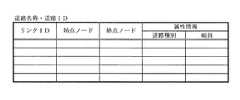
図2は、地図データに含まれる道路のデータのデータ構成の一例を示す図である。道路のデータは、図2に示すように、道路(道路名称や道路ID)ごとに、各道路リンクのリンクID、始点ノード、終点ノード、道路の属性情報が記憶される。属性情報には、高速道路や国道、都道府県道などの道路種別や道路の幅員などの情報が記憶される。 FIG. 2 is a diagram illustrating an example of a data configuration of road data included in the map data. As shown in FIG. 2, the road data stores, for each road (road name or road ID), the link ID of each road link, the start point node, the end point node, and road attribute information. The attribute information stores information such as the type of road such as an expressway, a national road, a prefectural road, and the width of the road.
入力手段13は、各種キーやスイッチ等から構成され、ナビゲーション装置1における入力操作を行うものである。また、入力手段13は、後述する表示手段14にタッチパネルを設けることで、このタッチパネルを用いて入力操作を行うこともできる。 The input unit 13 includes various keys, switches, and the like, and performs input operations in the
表示手段14は、経路案内時に地図画像や地図画像上の案内経路を他の道路と識別可能に表示するものであり、例えば液晶ディスプレイ等で構成される。 The display unit 14 displays a map image or a guide route on the map image so as to be distinguishable from other roads at the time of route guidance, and includes, for example, a liquid crystal display.
なお、本実施例においては、タッチパネルを用いた入力操作を行うものとする。 In this embodiment, it is assumed that an input operation using a touch panel is performed.
経路探索手段15は、入力手段13を介しユーザによって出発地や目的地が指定されると、地図記憶手段12に記憶されている道路データを参照し、出発地から目的地に至る最適経路を探索し、案内経路データを作成するものである。この最適経路の探索は、現在位置またはユーザによって指定された出発地に対応する道路ノードからユーザによって指定された目的地に対応する道路ノードまでに至るリンクとノードをダイクストラ法などの各種の手法によって探索し、リンク長(リンクコスト)や所要時間などを累積し、総リンク長または総所要時間などが最短となる経路を案内経路とし、当該経路に属する道路ノードやリンクを案内経路データとして提供するものである。 The route search means 15 searches for the optimum route from the departure place to the destination by referring to the road data stored in the map storage means 12 when the departure place and the destination are designated by the user via the input means 13. The guide route data is created. The search for the optimum route is performed by various methods such as Dijkstra's method for linking and nodes from the road node corresponding to the current position or the starting point designated by the user to the road node corresponding to the destination designated by the user. Search, accumulate link length (link cost) and required time, etc., provide the route with the shortest total link length or total required time as a guide route, and provide road nodes and links belonging to the route as guide route data Is.
探索された経路は、表示手段14に地図画像とともに表示され、また、車両の現在位置を示す現在位置マークが地図画像上に重ね合わされて表示される。地図画像は車両の走行に伴ってスクロールされ、現在位置が表示画面の中心となるよう表示される。 The searched route is displayed on the display means 14 together with the map image, and a current position mark indicating the current position of the vehicle is superimposed on the map image. The map image is scrolled as the vehicle travels, and the current position is displayed at the center of the display screen.
なお、現在位置検出手段11が検出する位置情報には誤差が含まれるため、現在位置が道路からずれている場合には、図示しないマッチング処理手段によってマッチング処理され、道路上または経路上に位置修正される。 Since the position information detected by the current position detection unit 11 includes an error, when the current position is deviated from the road, matching processing is performed by a matching processing unit (not shown) to correct the position on the road or the route. Is done.
地点位置検出手段16は、ユーザがタッチパネルを操作して表示手段14に表示されている地図画像上の所望の地点を指定したとき、ユーザが指定したタッチパネル上の地点と道路データとを比較することで指定された地点を特定する。 When the user operates the touch panel and designates a desired point on the map image displayed on the display unit 14, the point
表示手段14に地図画像を表示して、地図画像上で所望の位置(地点)を指定して目的地や経由地を設定する場合、入力手段13を介して地点入力モードを選択し、設定したい地点が含まれる地図画像を表示する。所望の地点を含む地図画像を表示するには、スクロールカーソルを用いて地図をスクロールさせるか、あるいは近傍のランドマークになる施設を検索してその場所を含む地図画像を表示させればよい。 When a map image is displayed on the display means 14, a desired position (point) is specified on the map image and a destination or waypoint is set, the point input mode is selected via the input means 13 and set. A map image including the point is displayed. In order to display a map image including a desired point, the map may be scrolled using a scroll cursor, or a facility that becomes a nearby landmark may be searched and a map image including the location may be displayed.
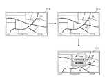
図3は、この手順の概念を示す画面遷移図である。 FIG. 3 is a screen transition diagram showing the concept of this procedure.
図3に示すように、所望の地点32を含む地図画像が表示されるようにスクロールさせると、表示画像31aから表示画像31bに示すように画面遷移し、所望の地点32の位置にカーソル34及びカーソル34の近傍に地点設定マーク36が表示され、地点設定マーク36をタッチすると地点設定操作を実行すると、表示画面は31cに遷移して地点設定マーク36の近傍に地点設定のメニュー画像38が表示される。地点設定のメニュー画像38は地点設定マーク36から吹き出しにより表示される態様であり、メニュー画像38において目的地設定や地点登録などの選択項目の1つを選択すると、地点設定マーク36が指していた位置が地点として設定される。 As shown in FIG. 3, when scrolling is performed so that a map image including the desired
ここで、地点設定マーク36が指す位置は、カーソル34の表示位置であり、地図画像を大まかにスクロールした段階では、地点設定マーク36が指す位置が地点設定しようとする所望の位置を正しく指していない場合がある。この場合、ユーザは表示されている地図画像上の所望位置にカーソル34を移動させ、あるいは地点設定マーク36をドラッグして移動させる。 Here, the position indicated by the
そのようにすれば移動先の位置が地点設定しようとする位置であるから、ここで利用者が地点設定マーク36をタッチ操作して地点設定操作を実行すると、移動先に表示された地点設定マーク36の近傍に、地点設定のメニュー画像38が表示され、目的地設定や地点登録などの選択項目の1つを選択すると、地点設定マーク36が指していた位置が地点として設定される。 In this case, since the position of the destination is the position where the point is to be set, when the user performs a point setting operation by touching the
このように、地点設定したい所望の位置に地点設定マーク36と、地点設定マーク36から吹き出し表示される地点設定のメニュー画像38が表示されるから、使い勝手が良く、地点設定の操作性が改善される。 In this manner, the
ところで、地点設定マーク36は表示された地図画像の中央など固定された位置に表示されるものでなく、利用者が地点設定したい位置に表示されるものであるから、地点設定のメニュー画像38を表示画面のどの表示領域に吹き出し表示するかはその都度異なる。そこで、本発明においては、地点設定マーク36の表示位置に応じてメニュー画像38の表示位置を制御する。 By the way, the
図4は、この表示位置制御の概念を示す図である。 FIG. 4 is a diagram showing the concept of this display position control.
表示画面は、図4(a)に示すように4つの象限、左上から時計回りに第1象限、第2象限、第3象限、第4象限に区分される。そして、地点位置検出手段17は、地点設定マーク36の指す位置、すなわち、カーソル34が表示される位置が表示画面のどの象限にあるかを検出する。 As shown in FIG. 4A, the display screen is divided into four quadrants, the first quadrant, the second quadrant, the third quadrant, and the fourth quadrant clockwise from the upper left. Then, the spot position detection means 17 detects in which quadrant of the display screen the position indicated by the
地点位置検出手段17は、ユーザがタッチパネルを操作して表示手段14に表示されている地図画像上の所望の地点を指定したときのユーザが指定したタッチパネル上の地点と道路データとを比較して特定した地点に地点設定マーク36の指す位置、すなわち、カーソル34が表示されているものと判定する。 The point
メニュー表示位置決定手段18は、地点設定マーク36が表示される象限に応じて、地点設定のメニュー画像38の吹き出し表示の位置や表示方向を決定する。例えば、図3に示す例では、地点設定マーク36が第2象限に表示されているから、メニー画像38は、第1象限、第4象限の方向に吹き出し表示される。 The menu display position determining means 18 determines the balloon display position and display direction of the point
この決定は、図4(b)のデータテーブルに従って判断される。図4(b)に示すように、地点設定マーク36の表示位置が第1象限であったら、メニュー画像38の表示位置、方向は、右側および下側方向である第2象限、第3象限とする。また、地点設定マーク36の表示位置が第2象限であったら、メニュー画像38の表示位置、方向は、下側および左側方向である第1象限、第4象限とする。以下、同様に決定される。 This determination is determined according to the data table of FIG. As shown in FIG. 4B, if the display position of the
図5に示す例では、地点設定マーク36が第1象限に表示されているから、メニー画像38は、第2象限、第3象限の方向に吹き出し表示される。 In the example shown in FIG. 5, since the
図6に示す例では、地点設定マーク36が第4象限に表示されているから、メニー画像38は、第2象限、第3象限の方向に吹き出し表示される。 In the example shown in FIG. 6, since the
また、地点設定マークの表示態様は図7に示すようにすることもできる。図7において地点設定マーク36は、図3に示す地点設定マーク36と同様のマーク(指の形状)の周囲を枠で囲った態様で表示される。この表示態様によれば、指の形状の部分が正しくタッチ操作されなくても、枠内のどこがタッチ操作されても地点設定マークが操作されたものと判定することができる。 Further, the display mode of the point setting mark can be as shown in FIG. In FIG. 7, the
なお、メニュー画像38の表示位置は、その画像の大きさに基づいて、地点設定マーク36が表示された位置に対して、表示画面の他の表示領域に表示できればよく、図4に示す処理でなくてもよい。表示領域内における2つの画像の位置関係を相対的に判断して両方の画像が表示領域内に表示できるように決定すればよい。 The display position of the
次に、本発明の実施例にかかるナビゲーション装置1における地点設定時の動作手順を説明する。 Next, an operation procedure at the time of setting a point in the
図8は、ナビゲーション装置1における地点設定時の動作手順を示すフローチャートである。 FIG. 8 is a flowchart showing an operation procedure when a point is set in the
表示手段14に地図画像を表示して、地図画像上で所望の位置(地点)を指定して目的地や経由地を設定する場合、ユーザは、入力手段13を介して地点入力モードを選択し(ステップS101)、設定したい地点が含まれる地図画像を表示する。所望の地点を含む地図画像を表示するためにはタッチパネル上を指でタッチしてカーソルを移動させて地図をスクロールさせたり、リモコンに設けられたジョイスティックを用いて地図をスクロールさせることができる。 When a map image is displayed on the display means 14 and a desired position (point) is specified on the map image to set a destination or waypoint, the user selects a point input mode via the input means 13. (Step S101), a map image including the point to be set is displayed. In order to display a map image including a desired point, it is possible to scroll the map by touching the touch panel with a finger to move the cursor, or to scroll the map using a joystick provided on the remote control.
ステップS102において地点が指定されると、地点位置検出手段16は、指定された地点を特定し、表示制御手段19は、地点位置検出手段16により特定された地点に対応した地図画像上にカーソルを表示してステップS103の処理に進む。ステップS103の処理では、表示制御手段19のマーク表示手段18は、地点位置検出手段16が特定し表示制御手段19により表示されたカーソル位置に基づいて、カーソル近傍にその位置を地点設定することを示す地点設定マーク36(図3参照)を表示する。 When a point is specified in step S102, the point
次に、ステップS104の処理に進み、表示された地点設定マーク36がタッチ操作されたか否かを判別する。地点設定マーク36がタッチ操作されたならば、地点設定マーク36が指す位置、すなわち、カーソル位置が地点として指定されたことになるので、ステップS105の処理に進み、メニュー表示位置決定手段17は地点マーク36の表示位置に基づきメニュー画像の表示位置を決定し、表示制御手段19は、決定された位置に地点設定のメニュー画像38(図3参照)を表示する。 Next, the process proceeds to step S104, and it is determined whether or not the displayed
ステップS106の判定処理では表示したメニュー画像38の選択項目が操作されたか否かを判定する。操作がなければステップS106の処理を繰り返し、項目選択の操作があったと判定されればステップS107の処理に進み、選択された地点設定の項目に従って、地点設定マーク36が指す位置を地点設定し、ステップS108の処理に進む。地図画像上の地点の特定は、前述したようにユーザがタッチパネルを操作して表示手段14に表示されている地図画像上の所望の地点を指定したときのユーザが指定したタッチパネル上の地点と道路データとを比較して行われる。 In the determination process of step S106, it is determined whether or not the selection item of the displayed
一方、ステップS104判定処理において、地点設定マーク36のタッチ操作が判定されなければ、地点設定マーク36の指す位置がユーザの所望する地点設定の位置でないことになるからステップS109の判定処理に進み、地点変更のタッチ操作が有るか否かを判定する。地点変更の操作は指やカーソル移動により表示されている地図画像の所望の地点を操作することにより行われる。 On the other hand, if the touch operation of the
ステップS109の判定処理で地点変更タッチ操作が検出されるとステップS103の処理に戻り、その近傍に地点設定マーク36を表示し、ステップS104以降の処理を繰り返す。地点変更タッチ操作が検出されなければステップS108の処理に進む。ステップS108の処理ではナビゲーションの終了が判定され、終了していなければステップS108の処理を繰り返し、ナビゲーションの終了が判定されればナビゲーション装置1の処理は終了する。 When the point change touch operation is detected in the determination process of step S109, the process returns to step S103, the
以上説明したように、本発明によれば、地点設定したい所望の位置に地点設定マーク36と、地点設定マークから吹き出し表示される地点設定のメニュー画像38が表示されるから、使い勝手が良く、地点設定の操作性が改善される。 As described above, according to the present invention, the
1: ナビゲーション装置
10: 制御手段
11: 現在位置検出手段
12: 地図記憶手段
13: 入力手段
14: 表示手段
15: 経路探索手段
16: 地点位置検出手段
17: メニュー表示位置決定手段
18: マーク表示手段
19: 表示制御手段1: navigation device 10: control means 11: current position detection means 12: map storage means 13: input means 14: display means 15: route search means 16: point position detection means 17: menu display position determination means 18: mark display means 19: Display control means
Claims (2)
Translated fromJapaneseマーク表示手段を含む表示制御手段とを備え、
前記地点位置検出手段は指定された地点を検出し、
前記表示制御手段は前記地点位置検出手段によって検出された地点にカーソルを表示し、
前記マーク表示手段は、前記カーソルの近傍に地点設定することを示す地点設定マークを表示するとともに前記地点設定マークと前記カーソルを囲う枠を表示し、
前記表示制御手段は、前記枠内のタッチ操作に対し、前記カーソル近傍に地点設定のメニュー画像を表示することを特徴とするナビゲーション装置。Display means for displaying a map; spot position detecting means for detecting a spot on the map designated on the display means;
Display control means including mark display means,
The point position detecting means detects a designated point,
The display control means displays a cursor at the point detected by the point position detecting means,
The mark display means displays a spot setting mark indicating that a spot is set in the vicinity of the cursor and displays a frame surrounding the spot setting mark and the cursor,
The navigation apparatus accordingto claim 1, wherein the display control means displays a menu image for setting a point in the vicinity of the cursor in response to a touch operation within the frame .
Priority Applications (6)
| Application Number | Priority Date | Filing Date | Title |
|---|---|---|---|
| JP2008107578AJP5428189B2 (en) | 2008-04-17 | 2008-04-17 | Navigation device |
| US12/937,619US8442757B2 (en) | 2008-04-17 | 2009-04-16 | Navigation device |
| KR1020137005092AKR20130045370A (en) | 2008-04-17 | 2009-04-16 | Navigation device |
| PCT/JP2009/057643WO2009128496A1 (en) | 2008-04-17 | 2009-04-16 | Navigation device |
| CN200980113056.5ACN102007374B (en) | 2008-04-17 | 2009-04-16 | Navigation device |
| KR1020107023112AKR20100121703A (en) | 2008-04-17 | 2009-04-16 | Navigation device |
Applications Claiming Priority (1)
| Application Number | Priority Date | Filing Date | Title |
|---|---|---|---|
| JP2008107578AJP5428189B2 (en) | 2008-04-17 | 2008-04-17 | Navigation device |
Publications (2)
| Publication Number | Publication Date |
|---|---|
| JP2009257939A JP2009257939A (en) | 2009-11-05 |
| JP5428189B2true JP5428189B2 (en) | 2014-02-26 |
Family
ID=41199183
Family Applications (1)
| Application Number | Title | Priority Date | Filing Date |
|---|---|---|---|
| JP2008107578AExpired - Fee RelatedJP5428189B2 (en) | 2008-04-17 | 2008-04-17 | Navigation device |
Country Status (5)
| Country | Link |
|---|---|
| US (1) | US8442757B2 (en) |
| JP (1) | JP5428189B2 (en) |
| KR (2) | KR20130045370A (en) |
| CN (1) | CN102007374B (en) |
| WO (1) | WO2009128496A1 (en) |
Families Citing this family (56)
| Publication number | Priority date | Publication date | Assignee | Title |
|---|---|---|---|---|
| KR101398134B1 (en)* | 2007-10-04 | 2014-05-20 | 엘지전자 주식회사 | Apparatus and method for playing moving-picture in mobile terminal |
| JP4522475B1 (en)* | 2009-03-19 | 2010-08-11 | Smk株式会社 | Operation input device, control method, and program |
| WO2011148612A1 (en)* | 2010-05-24 | 2011-12-01 | 三菱電機株式会社 | Navigation device |
| US9001055B2 (en) | 2010-11-26 | 2015-04-07 | Htc Corporation | Portable device and method for operating portable device |
| JP5779422B2 (en)* | 2011-06-28 | 2015-09-16 | シャープ株式会社 | Display system and display program |
| US9417754B2 (en) | 2011-08-05 | 2016-08-16 | P4tents1, LLC | User interface system, method, and computer program product |
| WO2013021654A1 (en) | 2011-08-11 | 2013-02-14 | 株式会社デンソー | Display control device |
| US20130254689A1 (en)* | 2011-08-31 | 2013-09-26 | Creative Realities, Llc | Wayfinding System and Method |
| US20130061147A1 (en)* | 2011-09-07 | 2013-03-07 | Nokia Corporation | Method and apparatus for determining directions and navigating to geo-referenced places within images and videos |
| JP5505482B2 (en) | 2011-10-24 | 2014-05-28 | 株式会社デンソー | Display control device |
| JP5454654B1 (en)* | 2011-10-24 | 2014-03-26 | 株式会社デンソー | Display control apparatus and display image allocation method |
| JP5796566B2 (en) | 2011-12-28 | 2015-10-21 | 株式会社デンソー | Display control device |
| EP3410287B1 (en) | 2012-05-09 | 2022-08-17 | Apple Inc. | Device, method, and graphical user interface for selecting user interface objects |
| WO2013169843A1 (en) | 2012-05-09 | 2013-11-14 | Yknots Industries Llc | Device, method, and graphical user interface for manipulating framed graphical objects |
| WO2013169875A2 (en) | 2012-05-09 | 2013-11-14 | Yknots Industries Llc | Device, method, and graphical user interface for displaying content associated with a corresponding affordance |
| HK1208275A1 (en) | 2012-05-09 | 2016-02-26 | 苹果公司 | Device, method, and graphical user interface for moving and dropping a user interface object |
| AU2013259630B2 (en) | 2012-05-09 | 2016-07-07 | Apple Inc. | Device, method, and graphical user interface for transitioning between display states in response to gesture |
| EP2847662B1 (en) | 2012-05-09 | 2020-02-19 | Apple Inc. | Device, method, and graphical user interface for providing feedback for changing activation states of a user interface object |
| WO2013169849A2 (en) | 2012-05-09 | 2013-11-14 | Industries Llc Yknots | Device, method, and graphical user interface for displaying user interface objects corresponding to an application |
| CN108958550B (en) | 2012-05-09 | 2021-11-12 | 苹果公司 | Device, method and graphical user interface for displaying additional information in response to user contact |
| WO2013169851A2 (en) | 2012-05-09 | 2013-11-14 | Yknots Industries Llc | Device, method, and graphical user interface for facilitating user interaction with controls in a user interface |
| WO2013169845A1 (en) | 2012-05-09 | 2013-11-14 | Yknots Industries Llc | Device, method, and graphical user interface for scrolling nested regions |
| CN108241465B (en) | 2012-05-09 | 2021-03-09 | 苹果公司 | Method and apparatus for providing haptic feedback for operations performed in a user interface |
| WO2013169865A2 (en) | 2012-05-09 | 2013-11-14 | Yknots Industries Llc | Device, method, and graphical user interface for moving a user interface object based on an intensity of a press input |
| WO2013169842A2 (en) | 2012-05-09 | 2013-11-14 | Yknots Industries Llc | Device, method, and graphical user interface for selecting object within a group of objects |
| US9182233B2 (en)* | 2012-05-17 | 2015-11-10 | Robert Bosch Gmbh | System and method for autocompletion and alignment of user gestures |
| US10119831B2 (en) | 2012-06-10 | 2018-11-06 | Apple Inc. | Representing traffic along a route |
| US11935190B2 (en) | 2012-06-10 | 2024-03-19 | Apple Inc. | Representing traffic along a route |
| KR102001332B1 (en) | 2012-12-29 | 2019-07-17 | 애플 인크. | Device, method, and graphical user interface for determining whether to scroll or select contents |
| KR101755029B1 (en) | 2012-12-29 | 2017-07-06 | 애플 인크. | Device, method, and graphical user interface for forgoing generation of tactile output for a multi-contact gesture |
| CN105144057B (en) | 2012-12-29 | 2019-05-17 | 苹果公司 | For moving the equipment, method and graphic user interface of cursor according to the cosmetic variation of the control icon with simulation three-dimensional feature |
| WO2014105279A1 (en) | 2012-12-29 | 2014-07-03 | Yknots Industries Llc | Device, method, and graphical user interface for switching between user interfaces |
| WO2014105276A1 (en) | 2012-12-29 | 2014-07-03 | Yknots Industries Llc | Device, method, and graphical user interface for transitioning between touch input to display output relationships |
| CN105264479B (en) | 2012-12-29 | 2018-12-25 | 苹果公司 | Apparatus, method and graphical user interface for navigating a user interface hierarchy |
| CN104034327B (en)* | 2013-03-04 | 2016-08-31 | 华为技术有限公司 | Pedestrian navigation processing method, terminal unit and system |
| KR102411890B1 (en) | 2014-09-02 | 2022-06-23 | 삼성전자주식회사 | A mehtod for processing contents and an electronic device therefor |
| US9632664B2 (en) | 2015-03-08 | 2017-04-25 | Apple Inc. | Devices, methods, and graphical user interfaces for manipulating user interface objects with visual and/or haptic feedback |
| US9645732B2 (en) | 2015-03-08 | 2017-05-09 | Apple Inc. | Devices, methods, and graphical user interfaces for displaying and using menus |
| US10095396B2 (en) | 2015-03-08 | 2018-10-09 | Apple Inc. | Devices, methods, and graphical user interfaces for interacting with a control object while dragging another object |
| US9990107B2 (en) | 2015-03-08 | 2018-06-05 | Apple Inc. | Devices, methods, and graphical user interfaces for displaying and using menus |
| US10048757B2 (en) | 2015-03-08 | 2018-08-14 | Apple Inc. | Devices and methods for controlling media presentation |
| US9639184B2 (en) | 2015-03-19 | 2017-05-02 | Apple Inc. | Touch input cursor manipulation |
| US10152208B2 (en) | 2015-04-01 | 2018-12-11 | Apple Inc. | Devices and methods for processing touch inputs based on their intensities |
| US20170045981A1 (en) | 2015-08-10 | 2017-02-16 | Apple Inc. | Devices and Methods for Processing Touch Inputs Based on Their Intensities |
| US10200598B2 (en) | 2015-06-07 | 2019-02-05 | Apple Inc. | Devices and methods for capturing and interacting with enhanced digital images |
| US9891811B2 (en) | 2015-06-07 | 2018-02-13 | Apple Inc. | Devices and methods for navigating between user interfaces |
| US9830048B2 (en) | 2015-06-07 | 2017-11-28 | Apple Inc. | Devices and methods for processing touch inputs with instructions in a web page |
| US9860451B2 (en) | 2015-06-07 | 2018-01-02 | Apple Inc. | Devices and methods for capturing and interacting with enhanced digital images |
| US10346030B2 (en) | 2015-06-07 | 2019-07-09 | Apple Inc. | Devices and methods for navigating between user interfaces |
| US10235035B2 (en) | 2015-08-10 | 2019-03-19 | Apple Inc. | Devices, methods, and graphical user interfaces for content navigation and manipulation |
| US9880735B2 (en) | 2015-08-10 | 2018-01-30 | Apple Inc. | Devices, methods, and graphical user interfaces for manipulating user interface objects with visual and/or haptic feedback |
| US10248308B2 (en) | 2015-08-10 | 2019-04-02 | Apple Inc. | Devices, methods, and graphical user interfaces for manipulating user interfaces with physical gestures |
| US10416800B2 (en) | 2015-08-10 | 2019-09-17 | Apple Inc. | Devices, methods, and graphical user interfaces for adjusting user interface objects |
| USD847836S1 (en) | 2016-08-24 | 2019-05-07 | Caterpillar Inc. | Display panel with graphical user interface |
| JP2019114195A (en)* | 2017-12-26 | 2019-07-11 | シャープ株式会社 | Photographic information display device, multifunction printer, and photographic information display method |
| CN115729414A (en)* | 2022-11-29 | 2023-03-03 | 长城汽车股份有限公司 | Menu bar display control method and device, storage medium and vehicle |
Family Cites Families (23)
| Publication number | Priority date | Publication date | Assignee | Title |
|---|---|---|---|---|
| DE68918115T2 (en)* | 1989-06-08 | 1995-01-05 | Bosch Gmbh Robert | VEHICLE NAVIGATION SYSTEM. |
| EP0775891B1 (en)* | 1992-02-18 | 1999-05-12 | Pioneer Electronic Corporation | Navigation apparatus with enhanced positional display function |
| JP3065180B2 (en) | 1992-08-19 | 2000-07-12 | トヨタ自動車株式会社 | Route guidance device for vehicles |
| JP3069661B2 (en)* | 1993-11-12 | 2000-07-24 | 本田技研工業株式会社 | Mobile object map display device |
| JPH11148836A (en)* | 1993-12-29 | 1999-06-02 | Aisin Aw Co Ltd | Route information providing device |
| JP3753753B2 (en)* | 1995-01-20 | 2006-03-08 | 三菱電機株式会社 | Mobile information map information display device |
| JP3402836B2 (en)* | 1995-03-30 | 2003-05-06 | アルパイン株式会社 | Navigation apparatus and navigation processing method |
| JP2003157135A (en) | 1996-07-31 | 2003-05-30 | Aisin Aw Co Ltd | Information display unit with touch panel, navigation device, and recording medium |
| KR100260760B1 (en) | 1996-07-31 | 2000-07-01 | 모리 하루오 | Information display device with a touch panel |
| JPH10197263A (en)* | 1997-01-10 | 1998-07-31 | Sumitomo Electric Ind Ltd | Navigation display device |
| JPH10260628A (en)* | 1997-03-18 | 1998-09-29 | Canon Inc | Map display method and apparatus, and storage medium |
| JP2000268548A (en)* | 1999-03-15 | 2000-09-29 | Sony Corp | Audio and video apparatus |
| JP2002090169A (en)* | 2000-09-21 | 2002-03-27 | Alpine Electronics Inc | Navigation device |
| JP5109212B2 (en) | 2001-05-01 | 2012-12-26 | ソニー株式会社 | Navigation device, information display device, object generation method, and storage medium |
| JP4071123B2 (en)* | 2003-02-04 | 2008-04-02 | アルパイン株式会社 | Map display device |
| JP4133570B2 (en)* | 2003-05-15 | 2008-08-13 | アルパイン株式会社 | Navigation device |
| JP3915741B2 (en)* | 2003-06-19 | 2007-05-16 | 株式会社日立製作所 | Data input support device and data input support method |
| JP2006092513A (en)* | 2004-08-25 | 2006-04-06 | Denso Corp | Item search device |
| JP5049477B2 (en)* | 2005-09-05 | 2012-10-17 | クラリオン株式会社 | Navigation device |
| JP5118813B2 (en)* | 2005-12-08 | 2013-01-16 | クラリオン株式会社 | Navigation device |
| JP5129478B2 (en)* | 2006-03-24 | 2013-01-30 | 株式会社デンソーアイティーラボラトリ | Screen display device |
| JP4450000B2 (en)* | 2007-03-14 | 2010-04-14 | アイシン・エィ・ダブリュ株式会社 | Route selection support device and route selection support method |
| JP5333321B2 (en)* | 2009-09-30 | 2013-11-06 | アイシン・エィ・ダブリュ株式会社 | Navigation device |
- 2008
- 2008-04-17JPJP2008107578Apatent/JP5428189B2/ennot_activeExpired - Fee Related
- 2009
- 2009-04-16KRKR1020137005092Apatent/KR20130045370A/ennot_activeWithdrawn
- 2009-04-16USUS12/937,619patent/US8442757B2/enactiveActive
- 2009-04-16WOPCT/JP2009/057643patent/WO2009128496A1/enactiveApplication Filing
- 2009-04-16KRKR1020107023112Apatent/KR20100121703A/ennot_activeCeased
- 2009-04-16CNCN200980113056.5Apatent/CN102007374B/enactiveActive
Also Published As
| Publication number | Publication date |
|---|---|
| CN102007374B (en) | 2014-07-02 |
| KR20100121703A (en) | 2010-11-18 |
| US20110035145A1 (en) | 2011-02-10 |
| JP2009257939A (en) | 2009-11-05 |
| KR20130045370A (en) | 2013-05-03 |
| CN102007374A (en) | 2011-04-06 |
| WO2009128496A1 (en) | 2009-10-22 |
| US8442757B2 (en) | 2013-05-14 |
Similar Documents
| Publication | Publication Date | Title |
|---|---|---|
| JP5428189B2 (en) | Navigation device | |
| US6836723B2 (en) | Navigation method and system | |
| JP4251931B2 (en) | Navigation destination input method and apparatus | |
| US8095308B2 (en) | Navigation apparatus | |
| JP3397146B2 (en) | Route setting device and navigation device | |
| JP5050815B2 (en) | Facility information output device, facility information output method, facility information output program | |
| JP4934452B2 (en) | Vehicle map display device | |
| JP4760792B2 (en) | Vehicle navigation device | |
| JP4622676B2 (en) | Car navigation system | |
| JP2013097411A (en) | Navigation device for vehicle | |
| JP4328381B2 (en) | Moving path search device, method thereof, program thereof, recording medium recording the program, and guidance guidance device | |
| JP2006214980A (en) | Navigation device | |
| US6691027B1 (en) | Method and apparatus for finding shortest overall path of multiple destinations by navigation system | |
| JP5162178B2 (en) | Navigation device | |
| JP2008089483A (en) | Navigation device for vehicle | |
| JP4983576B2 (en) | Facility information display device, facility information display method, facility information display program | |
| JP2008128928A (en) | Vehicle-mounted map display apparatus and navigation apparatus | |
| JP2005283395A (en) | On-vehicle navigation device, navigation system | |
| JP5091751B2 (en) | Navigation device | |
| EP1406064A1 (en) | Map display system | |
| JP2009156851A (en) | Navigator | |
| JP4062180B2 (en) | Virtual movement guidance device | |
| JP4847839B2 (en) | Map display device | |
| JP4661336B2 (en) | Navigation device, display method, and information retrieval method | |
| JP4621976B2 (en) | Vehicle navigation device |
Legal Events
| Date | Code | Title | Description |
|---|---|---|---|
| A621 | Written request for application examination | Free format text:JAPANESE INTERMEDIATE CODE: A621 Effective date:20110330 | |
| RD02 | Notification of acceptance of power of attorney | Free format text:JAPANESE INTERMEDIATE CODE: A7422 Effective date:20111115 | |
| RD04 | Notification of resignation of power of attorney | Free format text:JAPANESE INTERMEDIATE CODE: A7424 Effective date:20111125 | |
| A711 | Notification of change in applicant | Free format text:JAPANESE INTERMEDIATE CODE: A712 Effective date:20120528 | |
| A131 | Notification of reasons for refusal | Free format text:JAPANESE INTERMEDIATE CODE: A131 Effective date:20130108 | |
| A521 | Request for written amendment filed | Free format text:JAPANESE INTERMEDIATE CODE: A523 Effective date:20130212 | |
| A131 | Notification of reasons for refusal | Free format text:JAPANESE INTERMEDIATE CODE: A131 Effective date:20130423 | |
| A521 | Request for written amendment filed | Free format text:JAPANESE INTERMEDIATE CODE: A523 Effective date:20130614 | |
| RD01 | Notification of change of attorney | Free format text:JAPANESE INTERMEDIATE CODE: A7421 Effective date:20130628 | |
| A131 | Notification of reasons for refusal | Free format text:JAPANESE INTERMEDIATE CODE: A131 Effective date:20130806 | |
| A521 | Request for written amendment filed | Free format text:JAPANESE INTERMEDIATE CODE: A523 Effective date:20130930 | |
| TRDD | Decision of grant or rejection written | ||
| A01 | Written decision to grant a patent or to grant a registration (utility model) | Free format text:JAPANESE INTERMEDIATE CODE: A01 Effective date:20131105 | |
| A61 | First payment of annual fees (during grant procedure) | Free format text:JAPANESE INTERMEDIATE CODE: A61 Effective date:20131118 | |
| R151 | Written notification of patent or utility model registration | Ref document number:5428189 Country of ref document:JP Free format text:JAPANESE INTERMEDIATE CODE: R151 | |
| LAPS | Cancellation because of no payment of annual fees |