JP4559415B2 - Positionable mobile handset - Google Patents
Positionable mobile handsetDownload PDFInfo
- Publication number
- JP4559415B2 JP4559415B2JP2006509344AJP2006509344AJP4559415B2JP 4559415 B2JP4559415 B2JP 4559415B2JP 2006509344 AJP2006509344 AJP 2006509344AJP 2006509344 AJP2006509344 AJP 2006509344AJP 4559415 B2JP4559415 B2JP 4559415B2
- Authority
- JP
- Japan
- Prior art keywords
- call
- mobile
- mobile handset
- location
- handset
- Prior art date
- Legal status (The legal status is an assumption and is not a legal conclusion. Google has not performed a legal analysis and makes no representation as to the accuracy of the status listed.)
- Expired - Fee Related
Links
- 230000005540biological transmissionEffects0.000claimsdescription4
- 239000004165Methyl ester of fatty acidsSubstances0.000abstractdescription26
- 108010007100Pulmonary Surfactant-Associated Protein AProteins0.000abstractdescription8
- 102100027773Pulmonary surfactant-associated protein A2Human genes0.000abstractdescription8
- 238000000034methodMethods0.000description14
- 238000004891communicationMethods0.000description9
- 238000005259measurementMethods0.000description7
- 238000010295mobile communicationMethods0.000description7
- 230000008901benefitEffects0.000description6
- 238000012545processingMethods0.000description4
- 230000001413cellular effectEffects0.000description3
- 238000004458analytical methodMethods0.000description1
- 230000009286beneficial effectEffects0.000description1
- 238000010586diagramMethods0.000description1
- 239000000446fuelSubstances0.000description1
- 230000008439repair processEffects0.000description1
- 230000004083survival effectEffects0.000description1
- 238000012360testing methodMethods0.000description1
Images


Classifications
- G—PHYSICS
- G01—MEASURING; TESTING
- G01S—RADIO DIRECTION-FINDING; RADIO NAVIGATION; DETERMINING DISTANCE OR VELOCITY BY USE OF RADIO WAVES; LOCATING OR PRESENCE-DETECTING BY USE OF THE REFLECTION OR RERADIATION OF RADIO WAVES; ANALOGOUS ARRANGEMENTS USING OTHER WAVES
- G01S5/00—Position-fixing by co-ordinating two or more direction or position line determinations; Position-fixing by co-ordinating two or more distance determinations
- G01S5/0009—Transmission of position information to remote stations
- G01S5/0018—Transmission from mobile station to base station
- G01S5/0027—Transmission from mobile station to base station of actual mobile position, i.e. position determined on mobile
- G—PHYSICS
- G01—MEASURING; TESTING
- G01S—RADIO DIRECTION-FINDING; RADIO NAVIGATION; DETERMINING DISTANCE OR VELOCITY BY USE OF RADIO WAVES; LOCATING OR PRESENCE-DETECTING BY USE OF THE REFLECTION OR RERADIATION OF RADIO WAVES; ANALOGOUS ARRANGEMENTS USING OTHER WAVES
- G01S19/00—Satellite radio beacon positioning systems; Determining position, velocity or attitude using signals transmitted by such systems
- G01S19/01—Satellite radio beacon positioning systems transmitting time-stamped messages, e.g. GPS [Global Positioning System], GLONASS [Global Orbiting Navigation Satellite System] or GALILEO
- G01S19/13—Receivers
- G01S19/14—Receivers specially adapted for specific applications
- G01S19/17—Emergency applications
- H—ELECTRICITY
- H04—ELECTRIC COMMUNICATION TECHNIQUE
- H04W—WIRELESS COMMUNICATION NETWORKS
- H04W4/00—Services specially adapted for wireless communication networks; Facilities therefor
- H04W4/90—Services for handling of emergency or hazardous situations, e.g. earthquake and tsunami warning systems [ETWS]
- H—ELECTRICITY
- H04—ELECTRIC COMMUNICATION TECHNIQUE
- H04W—WIRELESS COMMUNICATION NETWORKS
- H04W76/00—Connection management
- H04W76/50—Connection management for emergency connections
- G—PHYSICS
- G01—MEASURING; TESTING
- G01S—RADIO DIRECTION-FINDING; RADIO NAVIGATION; DETERMINING DISTANCE OR VELOCITY BY USE OF RADIO WAVES; LOCATING OR PRESENCE-DETECTING BY USE OF THE REFLECTION OR RERADIATION OF RADIO WAVES; ANALOGOUS ARRANGEMENTS USING OTHER WAVES
- G01S2205/00—Position-fixing by co-ordinating two or more direction or position line determinations; Position-fixing by co-ordinating two or more distance determinations
- G01S2205/001—Transmission of position information to remote stations
- G01S2205/006—Transmission of position information to remote stations for emergency situations
- H—ELECTRICITY
- H04—ELECTRIC COMMUNICATION TECHNIQUE
- H04W—WIRELESS COMMUNICATION NETWORKS
- H04W64/00—Locating users or terminals or network equipment for network management purposes, e.g. mobility management
Landscapes
- Engineering & Computer Science (AREA)
- Radar, Positioning & Navigation (AREA)
- Remote Sensing (AREA)
- Computer Networks & Wireless Communication (AREA)
- Physics & Mathematics (AREA)
- General Physics & Mathematics (AREA)
- Signal Processing (AREA)
- Business, Economics & Management (AREA)
- Health & Medical Sciences (AREA)
- Emergency Management (AREA)
- Environmental & Geological Engineering (AREA)
- Public Health (AREA)
- Mobile Radio Communication Systems (AREA)
- Telephonic Communication Services (AREA)
- Nitrogen Condensed Heterocyclic Rings (AREA)
- Television Systems (AREA)
Abstract
Description
Translated fromJapanese本発明は、一般的に通信装置に関する。より詳細には、本発明はモバイル携帯通信装置に関する。 The present invention generally relates to communication devices. More particularly, the present invention relates to mobile portable communication devices.
一部の国家では、公式に定められた国家非常電話番号を所有する。例えばアメリカ合衆国およびカナダでは、その電話番号は911である。911がダイヤルされると、利用者は緊急通報受付センター(Public Safety Answering Point)(PSAP)の通話管理者(dispatcher)に接続される。非常通話管理者はその非常呼び出し通話(emergency call)を、地域の救急医療施設、消防署および法律執行機関に回送する。現在は、呼び出し通話(call)が地上通信線電話を使用してなされるときには、電話番号および住所情報が、通常は自動的に通話管理者に報告される。 Some countries have official national emergency telephone numbers. For example, in the United States and Canada, the telephone number is 911. When 911 is dialed, the user is connected to a call manager (displacer) of an emergency call receiving center (PSAP). The emergency call manager routes the emergency call to the local emergency medical facility, fire department and law enforcement. Currently, when a call is made using a landline telephone, the phone number and address information is usually automatically reported to the call manager.
基本的な無線911サービスは、電話加入者および非加入者のいずれからであっても何らかの利用可能なサービスを使用して、その911呼び出し通話をPSAPに送信することを要求する。しかしながら、基本的な無線911サービスは、地上通信線電話がする場合とは異なり、位置情報を通話管理者に提供しない。米国連邦通信委員会(Federal Communications Commission)(FCC)は携帯電話サービス所有者に対して、携帯電話使用可能エリア内で非常呼び出し通話が発生した場合には、位置情報を伝えることを要求するプログラムを確立している。このプログラムは拡張型(Enhanced)911(E911)として知られている。E911の要求は、アメリカ合衆国内で動作可能な全ての移動携帯電話の免許所有者、ブロードバンドの個人通信サービス(Personal Communications Services)(PCS)免許所有者および一定の特殊移動無線(Specialized Mobile Radio)(SMR)免許所有者に対して適用される。これらのモバイル電話サービスの所有者は、E911サービスの履行を始めつつあるところである。 The basic wireless 911 service requires that the 911 call be sent to the PSAP using any available service, whether from a telephone subscriber or a non-subscriber. However, the basic wireless 911 service does not provide location information to the call manager, unlike the case of a landline telephone. The Federal Communications Commission (FCC) is a program that requires mobile phone service owners to provide location information when an emergency call occurs in a mobile phone service area. Established. This program is known as Enhanced 911 (E911). E911 requirements include license holders for all mobile mobile phones that can operate in the United States, Personal Communications Services (PCS) license holders, and certain Specialized Mobile Radio (SMR) ) Applies to license holders. These mobile phone service owners are starting to implement the E911 service.
FCCのE911規則は、非常時のサービス要員に位置情報を提供しようとするものであり、それは彼らが位置を確認し、無線911呼び出し通話者に対してより効率的に援助を提供することを可能にする。E911の要求する位置情報を決定するための、1つの可能性のある方法は、モバイルハンドセットに全地球測位システム(Grobal Positioning System)(GPS)受信機を追加することである。GPSは非常時のサービス要員に位置情報を提供することが出来る。GPS測定により決定された位置は、使用される測定装置の精度に依存して、実際の地理的な位置から異なることがあり得る。GPS受信機は、他の位置決定システムに対して一部の利点を有する。GPS受信機は補助としての通信ネットワークを必要としない。例えば、GPS受信機は通信ネットワークからの支援なしに、必要に応じて天体暦データを更新することが出来る。GPS天体暦はGPS人工衛星の軌道を記述するデータである。 FCC's E911 regulations are intended to provide location information to emergency service personnel, which allows them to locate and provide more efficient assistance to wireless 911 callers To. One possible way to determine the location information required by E911 is to add a Global Positioning System (GPS) receiver to the mobile handset. GPS can provide location information to emergency service personnel. The position determined by GPS measurement can differ from the actual geographical position depending on the accuracy of the measuring device used. GPS receivers have some advantages over other positioning systems. The GPS receiver does not require an auxiliary communication network. For example, a GPS receiver can update ephemeris data as needed without assistance from a communications network. The GPS ephemeris is data describing the orbit of a GPS artificial satellite.
GPS受信機は一部の欠点を有する。例えば、GPS受信機は、最初にパワースイッチを入れた時には、位置を決定するまでに数分間を要することがある。非常時のサービスを含む用途に対しては、この時間遅れは一般には長すぎると考えられる。GPS受信機は一部の欠点を有するものの、後に検討される一部の実施形態に対してはGPS受信機の使用が好適であることに留意すべきである。しかしながら、アシスト型(Assisted)GPS(AGPS)受信機もまた、様々な実施形態において使用することが出来る。AGPSは以下において検討される。 GPS receivers have some drawbacks. For example, a GPS receiver may take several minutes to determine its position when it is first turned on. For applications involving emergency services, this time delay is generally considered too long. It should be noted that although GPS receivers have some drawbacks, the use of GPS receivers is preferred for some embodiments that will be discussed later. However, Assisted GPS (AGPS) receivers can also be used in various embodiments. AGPS is discussed below.
一般的にはAGPSは、モバイル電話システムと結合されたGPS受信機を使用して、モバイルハンドセットがその位置を決定することを支援する。モバイル電話システムは、ハンドセットが使用されているセルサイト(cell site)を決定することにより、モバイルハンドセットの位置を推定することが出来る。基準局からの方向および距離を推定することにより、位置の推定値の精度をさらに改善することが出来る。モバイルハンドセットの最初に推定された位置、およびモバイル電話システムと結合されたGPS受信機とを使用することにより、モバイル電話システムはモバイルハンドセットが受信することが出来るGPS衛星の信号を予告することが出来る。予告されたGPS衛星の信号に関する情報は、モバイルハンドセットに伝送される。この情報を使用することにより、モバイルハンドセットは、初期測位時間(time−to−first−fix)(TTFF)を大幅に減らすことが出来る。AGPSによるTTFFは、分ではなく秒のオーダーとなる。AGPSのその他の利点は、AGPSを使用しないGPS受信機が必要とするよりも弱い信号を、AGPS受信機は受信し復調することである。さらにAGPSの使用は、実施(implementation)の消費電力および寸法と共にコストの削減を可能とする。モバイルハンドセットは、スタンドアローンのGPS電気回路を必要としない。それ故に、コストは一般的に低く、回路の消費電力および寸法は一般的に小さい。AGPSは一部の欠点を有する。モバイルハンドセットがモバイル電話サービス領域の外部に位置する場合には、モバイルハンドセットに対するAGPSによる支援は、有効ではないことがあり得る。寸法、消費電力、およびコストを最小にするためのAGPSの利点を全て活用した機器は、利用者がモバイル電話サービス領域の外部にいる場合には、利用者に位置情報を提供することは出来ない。 In general, AGPS uses a GPS receiver coupled with a mobile telephone system to help a mobile handset determine its location. The mobile phone system can estimate the location of the mobile handset by determining the cell site where the handset is used. By estimating the direction and distance from the reference station, the accuracy of the position estimate can be further improved. By using the mobile phone's initially estimated location and a GPS receiver coupled with the mobile phone system, the mobile phone system can predict the GPS satellite signals that the mobile handset can receive. . Information regarding the signal of the GPS satellite notified in advance is transmitted to the mobile handset. By using this information, the mobile handset can significantly reduce the initial positioning time (time-to-first-fix) (TTFF). TTFF by AGPS is on the order of seconds instead of minutes. Another advantage of AGPS is that the AGPS receiver receives and demodulates signals that are weaker than those required by GPS receivers that do not use AGPS. In addition, the use of AGPS allows for cost savings along with the power consumption and dimensions of implementation. Mobile handsets do not require stand-alone GPS circuitry. Therefore, costs are generally low and circuit power consumption and dimensions are generally small. AGPS has some drawbacks. If the mobile handset is located outside the mobile phone service area, AGPS support for the mobile handset may not be effective. Devices that take full advantage of AGPS to minimize size, power consumption, and cost cannot provide location information to the user when the user is outside the mobile phone service area. .
上述したように、モバイルハンドセットの位置情報は、E911呼び出し通話が完了たときに、PSAP管理者に送信される。しかしながら、非常呼び出し通話が完了したときの、モバイルハンドセットの位置情報は、非常事態の位置ではないことがあり得る。非常呼び出し通話完了位置と実際の非常事態位置との間の距離は、非常事態がモバイルハンドセットの通話可能エリアの外部で発生するときには、一般に大きくなる。
アメリカ合衆国特許番号第5,479,482号は公衆非常呼び出し通話の位置情報を提供するのためのセルラーターミナルについて公開している。この特許は非常呼び出し通話の間に利用者の位置を送信するための、GPS装置とセルラー電話機との基本的な組み合わせを公開している。ヨーロッパ特許出願番号第EP0789492A2号は乗り物用の非常メッセージシステムについて公開しており、この特許出願は同様にGPS装置とセルラーハンドセットとを結合するが、非常呼び出し通話の間の乗り物の位置を送信する。このように、改良された位置測定の可能なモバイルハンドセットに対する技術的な強い要求が存在する。As described above, the mobile handset location information is sent to the PSAP administrator when the E911 call is complete. However, the location information of the mobile handset when the emergency call is complete may not be the emergency location. The distance between the emergency call call completion location and the actual emergency location is generally large when the emergency occurs outside the callable area of the mobile handset.
United States Patent No. 5,479,482 discloses a cellular terminal for providing location information for public emergency calls. This patent discloses a basic combination of a GPS device and a cellular telephone for transmitting the user's location during an emergency call. European Patent Application No. EP 0 789 492 A2 discloses an emergency message system for vehicles, which also combines a GPS device and a cellular handset, but transmits the position of the vehicle during an emergency call. Thus, there is a strong technical need for a mobile handset capable of improved position measurement.
非常時の呼び出し通話がなされた時に、他の通話受信者に位置情報を提供することは、広く知られている。非常呼び出し通話の例は、家族および友人に援助を頼む通話を含むもののそれに限定はされず、支援のための牽引のサービスのための通話や、行政組織の非常事態サービスへの通話を含む。さらに、E911のモバイル通話を完了するまでの間に、緊急通報受付センター(PSAP)の通話管理者に位置情報を提供することが、知られている。しかしながら、非常事態がモバイルハンドセットの通話可能エリアの外部で発生し、そしてモバイル非常呼び出し通話が後になされた場合、当初の非常事態の位置は通話管理者には報告されない。通話管理者に報告される位置は、一般にはE911呼び出し通話が正常に完了した時に、モバイルハンドセットが存在した位置である。 It is well known to provide location information to other call recipients when an emergency call is made. Examples of emergency call calls include, but are not limited to, calls that ask family and friends for assistance, and include calls for towing service for assistance and calls to emergency services of administrative organizations. Further, it is known to provide location information to a call manager of an emergency call reception center (PSAP) before completing a mobile call of E911. However, if an emergency occurs outside the callable area of the mobile handset and a mobile emergency call is made later, the initial emergency location is not reported to the call manager. The location reported to the call manager is generally the location where the mobile handset was present when the E911 call was successfully completed.
要するに、位置測定の可能なモバイルハンドセットが利用者に、不完全な非常呼び出し通話であってもその発信位置を通話受信者に提供することを可能とする。ある特殊な例として、PSAP管理者へのE911呼び出し通話であり得る場合、しかしながらその通話が家族あるいは友人からの援助を要請するものであり得ると認識されることがある。さらに、その通話が牽引サービスのためのものでもあり得る。その呼び出し通話は、モバイルハンドセットの利用者が呼び出しを受けた団体に対して、位置情報を送ることを欲する如何なる通話でもあり得る。E911呼び出し通話の例にもどり、通話管理者に報告される位置情報は、最初のE911通話の位置、正常なE911通話の間の現時点の位置、あるいは最初の位置から現時点の位置までの地上の軌跡(track)の情報を含むことが出来る。E911呼び出し通話の試みが成功しなかった場合には、モバイルハンドセットはその時点のモバイルハンドセットの位置を蓄える。この情報は後に、モバイルハンドセットが通話可能なエリア内に位置したときに、送信されることが出来る。さらに、モバイルハンドセットは、E911呼び出し通話の試みが成功しなかった後に、サービスエリア内に入るとすぐに、911を自動ダイヤルすることが出来る。代替案として、モバイルハンドセットがサービスエリア内に入る時に、利用者はE911呼び出し通話を開始するように促されることが出来る。 In short, a mobile handset capable of position measurement enables the user to provide the call recipient with the call location even for an imperfect emergency call. As a special example, if it can be an E911 call to a PSAP administrator, it may be recognized that the call may be asking for help from a family member or friend. In addition, the call can be for a tow service. The call can be any call that the mobile handset user wants to send location information to the party that received the call. Returning to the example of an E911 call, the location information reported to the call manager is the location of the first E911 call, the current location during a normal E911 call, or the ground trajectory from the first location to the current location. (Track) information can be included. If the E911 call attempt is unsuccessful, the mobile handset stores the current location of the mobile handset. This information can later be transmitted when the mobile handset is located in an area where calls can be made. In addition, the mobile handset can autodial 911 as soon as it enters the service area after an unsuccessful E911 call attempt. Alternatively, when the mobile handset enters the service area, the user can be prompted to initiate an E911 call.
E911呼び出し通話の例を続けると、通話管理者に最初のE911呼び出し通話が試みられた位置、あるいは地上の軌跡情報を提供することは、多数の利点を有する。通話管理者はしばしば非常時の生命が危機にさらされる状況の下で働く。このような状況下では、非常事態要員を非常事態の場所に送ることは、生存の可能性を非常に高める。非常事態の場所を知ることは、非常事態要員をその場所に送るための重要なステップである。多くの生命の危険のない非常事態においても、非常事態要員を現場にすばやく送ることはやはり重要である。例えば消防隊員が火災の現場により速く到着するときには、一般には火災はより速く消火され得る。非常事態要員を非常事態により速く送ることを可能にすることに加えて、非常事態の位置または地上の軌跡を通話管理者に提供することは、非常時のサービスがより一層効率的に実施されることを可能にする。E911呼び出し通話に対して非常時サービスがよりすばやく対応することが出来るときは、一般的にはその他の非常呼び出し通話に対応してより速く、非常時サービスが得られる。さらに、他の形式の非常呼び出し通話に対して正確な位置情報を提供することは、モバイルハンドセット利用者および非常呼び出し通話に対して応答を試みるその他の者にとって役に立つことが出来る。 Continuing with the E911 call example, providing the call manager with the location at which the first E911 call was attempted, or ground trajectory information, has a number of advantages. Call managers often work in situations where emergency life is at risk. Under these circumstances, sending emergency personnel to the location of the emergency greatly increases the chances of survival. Knowing the location of an emergency is an important step in sending emergency personnel to that location. Even in many life-threatening emergency situations, it is still important to send emergency personnel to the scene quickly. For example, when a firefighter arrives more quickly at a fire scene, the fire can generally be extinguished faster. In addition to allowing emergency personnel to be sent more quickly to an emergency, providing emergency location or ground trajectory to call managers makes emergency services much more efficient Make it possible. When an emergency service can respond more quickly to an E911 call, it is generally faster and more emergency service is available for other emergency calls. Further, providing accurate location information for other types of emergency call calls can be useful for mobile handset users and others who attempt to answer emergency call calls.
本発明をより完全に理解するために、およびその利益のために、添付する図面、表および付属物と関連付けられた、以下の記述が参考とされる。 For a more complete understanding of the present invention and for its benefits, reference is made to the following description, taken in conjunction with the accompanying drawings, tables and appendages.
図1によれば、位置測定の可能なモバイルハンドセット118が一般的に示されている。モバイルハンドセット118は地理的なエリア100の中で使用されている。地理的なエリア100は通話可能エリア103を含む。通話可能エリアは、移動可能電話システムのサービスが得られるエリアである。通話可能エリアの外側のエリアは、非サービスエリアとして参照される。複数の基準局105、107、109、112、114が通話可能エリア103の中に位置している。基準局は、モバイルハンドセットがモバイル呼び出し通話を送信しそこから受信することにより通話を完了するための、固定された装置である。一般的に通話可能エリア103は、特定のモバイル電話システムに適合した少なくとも1つの基準局を含み、非サービスエリアは一般的に、特定のモバイル電話システムに適合したいかなる基準局も含まない。 Referring generally to FIG. 1, a
モバイルハンドセット118は、第1の位置120に示されている。第1の位置120の近くに非常事態の生じた位置126がある。非常事態は、自動車事故、火災、あるいはモバイルハンドセット利用者が通報することを欲するいかなる非常事態でもあり得る。利用者は、例えばモバイルハンドセット118での911ダイヤルによる、非常呼び出し通話発信を試みる。モバイルハンドセット118は、それが通話可能エリア103の外側にあるために、呼び出し通話を発信することは不可能である。呼び出し通話は出来ないものの、モバイルハンドセット118は位置を取得し、そして蓄える。モバイルハンドセット118は通話可能エリア103の外側のエリアから、第2の位置122にまで移動する。第2の位置122は通話可能エリア103の内側にある。移動経路124もまた図1に示されている。
モバイルハンドセット118が通話可能エリア103の内側のエリアに到達した時に、非常電話番号を開始し接続することが可能となる。モバイル呼び出し通話が接続された時に、モバイルハンドセットの第1の位置120に関する位置情報が送信される。任意ではあるが、第2の位置122に対する現在の位置情報が送信されることが出来る。非常事態管理者に位置を伝えるために、通常のプロセスが用いられる。位置情報は位置決定装置を用いて決定される。位置決定装置は図4に関連してより詳細に検討される。 When the
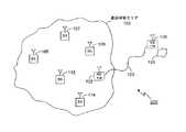
図2によれば、地理的なエリア200が示されている。図2は図1に類似している。しかし図2は、他の移動経路128を示す。移動経路128は、図1に示された移動経路124と比較して直線的ではない。移動経路128は山道に沿って移動するパッチコードに似ていると言える。例えば二人の男、カイルとトニーが夜間に山岳地域でオートバイを運転し、その山岳地域は非サービスエリアの中にある。トニーはオートバイ事故を起こし、カイルは良く知ったモバイルハンドセットを使用してモバイル非常呼び出し通話を試みる。呼び出し通話は正常に完了せず、その時点では事故は通報されることが出来ない。 According to FIG. 2, a
カイルは経路128に沿って通話可能エリア103に到達するまで、彼のオートバイ運転を続ける。通話可能エリア103はカイルとトニーが最初に運転をしていた山岳地域から極めて遠方にある。さらにカイルは今や事故の正確な位置について確信がない。モバイル非常呼び出し通話が試みられた位置を蓄えることが出来る、モバイルハンドセットを使用することが、一般には非常時の支援がより早くトニーのもとに到達することを可能にする。 Kyle continues his motorcycle driving until he reaches
図3はハンドセット118を操作するプロセスを示す流れ図300である。流れ図300は302から始まる。ステップ304では、モバイルハンドセットを用いて呼び出し通話が試みられる。ステップ306は、呼び出し通話が不成立かを調べる。呼び出し通話が不成立の場合には、ステップ309がモバイルハンドセットの位置の決定を試みる。 FIG. 3 is a
位置が正常に決定された場合には、示されているようにステップ313で蓄えられる。位置を蓄えるステップは、記憶装置への書き込みを含み得ることは理解される。さらに、記憶装置はランダムアクセス記憶装置であり得ることが理解される。サービスが利用可能な時には、ステップ316でモバイルハンドセット118を用いて、呼び出し通話が再度試みられる。ステップ318は呼び出し通話が成立したかを調べる。呼び出し通話が不成立の場合には、試み、即ちステップ316が繰り返される。ステップ313で位置が蓄えられた場合には、呼び出し通話が成立した後に、位置がステップ321で送信される。呼び出し通話はステップ324で継続し、蓄えられた位置情報を使用して位置を決定327し、プロセスが終了331する。 If the position is successfully determined, it is stored at
ステップ304で試みられた呼び出し通話が成立したある場合には、ステップ330が位置の決定を試みる。ステップ332は位置の決定が成功であるかを調べ、テストする。ステップ330の位置の決定が成功であるときには、ステップ337で位置は送信される。位置が送信337された後も、呼び出し通話は継続340される。ステップ342では、蓄えられた位置情報を用いて地理的な位置が決定される。345でプロセスが終了する。ステップ330の位置の決定が不成功の場合には、呼び出し通話は継続335され、ステップ330の位置の決定が繰り返される。 If the ring call attempted at
例えば、多くのモバイルハンドセットにおいて、ステップ309、330の位置の決定を試みているときに、モバイルハンドセットを通じて会話することは不可能である。別の実施形態においては、利用者がモバイルハンドセットを通じて会話することが出来るようにするために、位置決定のステップ330は繰り返されないか、あるいは繰り返し回数が制限されることがあり得る。 For example, in many mobile handsets it is impossible to talk through the mobile handset when trying to determine the location of
モバイル呼び出し通話が緊急通報受付センターへの通話、あるいは無線911通話である可能性があることは、同業者に理解されるであろう。さらに、呼び出し通話が道路脇の支援サービスへの通話である可能性もあり得る。道路脇の支援サービスは一部のドライバーによって、牽引サービスを派遣すること、およびパンク修理または燃料切れを生じた車への給油などの、その他の道路脇のサービスに対して使用されている。 One skilled in the art will appreciate that the mobile call may be a call to an emergency call reception center or a wireless 911 call. Furthermore, the call may be a call to a roadside support service. Roadside assistance services are used by some drivers for other roadside services, such as dispatching traction services and refueling puncture repairs or out-of-fuel vehicles.
位置決定の試みのステップ309、330は、擬似距離情報の決定を含み得ることは、同業者によって理解されるであろう。さらに、位置決定の試みのステップは、全地球測位システムの信号の使用を含み得る。位置決定の試みのステップ309、330は、緯度、経度、および高度の情報を含み得ることは、同業者によってまた理解されるであろう。さらに、位置決定の試みのステップ309、330は、基準局から送信された信号を測定することにより、基準局からの距離および方向を推定することを含み得る。 It will be appreciated by those skilled in the art that the location attempt steps 309, 330 may include determining pseudorange information. Further, the step of positioning attempt may include the use of a global positioning system signal. It will also be appreciated by those skilled in the art that the location attempt steps 309, 330 may include latitude, longitude, and altitude information. Further, the positioning attempt steps 309, 330 may include estimating the distance and direction from the reference station by measuring the signal transmitted from the reference station.
図4によれば、モバイルハンドセット118の形式による、モバイル通信装置が示されている。モバイルハンドセット118はアンテナ402を含む。アンテナ402は無線周波数の信号を送信および受信するために使用され、トランシーバ406に接続されている。トランシーバ406はアンテナから取り込まれる無線信号を、モバイルハンドセットの利用者に有用な音響またはその他の形に変換する。さらに、トランシーバ406は、搬送波を生成し、また搬送波を変調し、アンテナを使用して情報を送信する。電池409はトランシーバ406にパワーを与える。 According to FIG. 4, a mobile communication device in the form of a
ハンドセット118はさらに、位置決定装置412に接続されている第2のアンテナ404を含むが、しかしながら、一部のハンドセットでは、1つのアンテナを位置決定装置とトランシーバとで共用するシステムを採用することがあり得る。ハンドセット118の中の位置決定装置412は、全地球測位システム(GPS)の受信機の形式をなす。GPS受信機は、GPS衛星からの擬似距離情報を決定するために使用することが出来る。擬似距離情報は地理的位置を示す位置情報であり、さらなる処理のために基準局に送信されることが出来る、位置情報である。さらに、擬似距離データのさらなる処理のために、その他の装置が使用されることが出来る。例えば、擬似距離データは緯度、経度、および高度を決定するためにモバイル通信装置によって処理されることが出来る。 The
位置決定装置412はまた、基準局からの距離および方向を決定する装置であることも出来る。例えば、基準局からの方向はセクターに基づいて推定され、距離はチップ遅れを使用して推定される。 The
アンテナ402および第2のアンテナ404が1つのアンテナになり得ることは、同業者にとって明らかであろう。位置決定装置412は記憶装置414に接続されている。記憶装置414は位置決定装置412によって計算された位置情報を蓄える。蓄えられた位置情報は、記憶装置414とトランシーバ406とに接続されている前位置(prior location)送信回路417によって送信される。前位置送信回路は、処理装置とそのソフトウエア、または他の類似の回路であり得る。 It will be apparent to those skilled in the art that
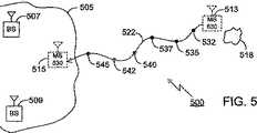
図5によれば、別の実施形態が示される。図5は図1および図2に類似している。図5は別の地理的なエリア500を示す。地理的なエリア500は通話可能エリア505を含み、通話可能エリア505は基準局507、509を含む。図5はまた、第1の場所513にあり、経路522に沿って第2の場所515に移動する、モバイルハンドセット530を含む。図2と同様に、図5の経路522は図1の経路と比較して直線的でない。さらに、図1および図2と同様に、非常事態が図5の場所518で生じる。 According to FIG. 5, another embodiment is shown. FIG. 5 is similar to FIGS. FIG. 5 shows another
図5はまた、移動経路に沿って決定された位置(location determinations)532、535、537、540、542を含む。モバイルハンドセット530が位置513と515との間を移動するとき、その位置は測定されハンドセット530の中に蓄えられる。蓄えられた移動経路情報は非常時サービス要員によって、非常事態の場所への最も効率よく移動する道を決定することを助けるために、使用されることが出来る。例えば非常事態は、はっきりと記録されていないハイキングコースで生じ得る。経路情報によって、非常事態要員は通話者が使用したのと同じ経路をたどることが出来、非常事態が生じた場所518に行くことが出来る。 FIG. 5 also includes
位置の測定をいつ行うのかを決定するために、複数の異なる方法が使用されることが出来る。位置の測定は、特定の時間間隔で行われ、蓄えられることが出来る。例えば位置の測定は、10秒ごとに行われ蓄えられることも出来る。また位置の測定は、移動距離に基づいて行われることも出来る。例えばモバイルハンドセットが10フィートより多く移動すれば何時でも、その位置データを蓄える。一般に時間または距離において、よりしばしばデータが蓄えられると、経路情報はより正確になる。ハンドセット530が移動を停止するときには、ハンドセットは経路情報を蓄えることを停止し得る。 A number of different methods can be used to determine when to make position measurements. Position measurements can be made and stored at specific time intervals. For example, position measurements can be made and stored every 10 seconds. The position can also be measured based on the moving distance. For example, whenever a mobile handset moves more than 10 feet, its location data is stored. In general, route information becomes more accurate as data is stored more often in time or distance. When the
モバイルハンドセット530は経路情報をハンドセット530の中の記憶装置に蓄える。モバイルハンドセット530が位置513から位置515まで運ばれるとき、モバイルハンドセット530の中の記憶装置は一杯になり得る。モバイルハンドセット530の中の記憶装置が一杯になったときには、記憶装置の中に蓄えられた一部の位置データを削除することが必要となり得る。
どのデータを削除するかを決定するために、いくつかの方法が使用されることが出来る。ある方法では、モバイルハンドセットは新しい位置情報を蓄えることを単に停止し得て、経路情報は位置513から記憶装置が一杯になった位置までとなる。別の方法では、モバイルハンドセット530は、経路の始まりからの位置データを削除する。経路の始まりからのデータを削除することは、実際の非常事態の場所を不明確にする恐れがあるので、この方法は好ましい方法であるとは考えられない。モバイルハンドセット530から位置データを削除する別の方法は、記憶装置がほぼ一杯になる、またはほぼ一杯である時に、概括的な経路情報は損なわずに残すものの、粗さの程度は増加するという手法で、多数の位置データを削除することである。例えばモバイルハンドセット530が位置545のデータを蓄えた後に、その記憶装置が一杯となり、532、537、および542の位置データが記憶装置から削除された場合には、記憶装置上の3個の位置が貯蔵のために使用できるが、一部の経路情報は失われたままである。そして経路はより粗いものとなる。さらに、この新しい粗さの程度に基づいて、先を読み取ることは好都合である。 Several methods can be used to determine which data to delete. In one method, the mobile handset can simply stop storing new location information, and the path information goes from
図6は、通話可能エリア605、および通話可能エリア605の内側から通話可能エリアの外側のエリアに移動し、さらに通話可能エリア605の内側に戻るモバイルハンドセット625を、示す。経路情報が蓄えられている場合には、モバイルハンドセット625の利用者が通話可能エリア605に戻ることを助けるために、その経路情報は使用されることが出来る。 FIG. 6 shows a
図5と同様に、図6は地理的なエリア600を含む。地理的なエリア600は通話可能エリア605および基準局607、609を含む。さらに、モバイルハンドセット625は第1の位置630および第2の位置632が示されている。モバイルハンドセット625は経路619に沿って移動する。ある時刻に、モバイルハンドセット625は第1の位置630にある。モバイルハンドセット625は、第1の方向610に移動し、通話可能エリア605を離れる。位置632でモバイルハンドセット625の利用者は、位置650で生じた非常事態を目撃する。しかしながら、モバイルハンドセット625が通話可能エリアの外側にあるために、モバイルハンドセット625の利用者は、非常呼び出し通話をすることが出来ない。移動経路619の実例が蓄えられている場合には、622を例にとり、モバイルハンドセット625の利用者は移動経路619を615の方向にたどることにより、通話可能エリアに戻ることが出来る。 Similar to FIG. 5, FIG. 6 includes a
さらに、モバイルハンドセット625は、通話可能エリア605のような通話可能エリアを絶えず注意し得て、利用者に直近の通話可能エリアへの方向と距離を指示し得る。道路位置を含む地図表示能力を付加することにより、モバイルハンドセットは移動経路に依存することなく、直近の通話可能エリアに行く方法を決定することが出来る。 Furthermore, the mobile handset 625 can constantly pay attention to a callable area such as the
一部の場合において、モバイル無線通信装置は、位置情報をモバイル無線通信装置の利用者に提供することが出来ないことがあり得る。位置情報がPSAP管理者のような移動可能呼び出し通話の受信者に提供されることが可能であるにもかかわらず、このことは事実であり得る。これらの場合には、モバイル通信装置が通話可能エリアの外側にあった時間を絶えず注意するためのタイマーを使用することが、好都合であり得る。これはモバイル通信装置の利用者に、通話可能エリアに戻るために如何ほどの時間を要するかを示すことができる。しかしながら、これは粗い推定値にすぎないことは、同業者にとっては明らかであろう。多くの場合、モバイル通信装置が離れた最後の通話可能エリアよりも、他の通話可能エリアの方がより近いことがある。さらに、モバイル無線通信装置の使用者に対して位置情報を提供することが出来る、モバイル通信装置にタイマーが付加され得て、その利用者に通話可能エリアに戻るために如何ほどの時間を要するかの別の指示を与える。 In some cases, the mobile wireless communication device may not be able to provide location information to a user of the mobile wireless communication device. This can be true even though location information can be provided to a recipient of a mobile call call, such as a PSAP administrator. In these cases, it may be advantageous to use a timer to keep track of the time that the mobile communication device was outside the callable area. This can indicate to the user of the mobile communication device how long it will take to return to the callable area. However, it will be apparent to those skilled in the art that this is only a rough estimate. In many cases, other callable areas may be closer than the last callable area in which the mobile communication device is remote. In addition, a timer can be added to the mobile communication device that can provide location information to the user of the mobile wireless communication device, and how long does it take for the user to return to the callable area Give another instruction.
さらに、非常時のサービス、PSAP管理者、およびE911非常呼び出し通話を含む実例は、実例の中で広範囲に使用されている。ほかの形式の呼び出し通話が、上述された方法およびモバイルハンドセットから利益を得ることがあることは理解される。例えば自動車牽引手配者は上述された方法を使用し得る。この実例についてさらに示すならば、モバイルハンドセットの通話可能エリアによってカバーされないエリアにおいて、自動車が故障で動けなくなる場合を想定する。車の運転手は牽引サービスの呼び出し通話をするために、別の位置まで歩く決心をするかもしれない。牽引トラックが正確な位置に送られるようにするために、牽引手配者に位置情報を送信することは、有益であり得る。 Further, examples including emergency services, PSAP administrators, and E911 emergency call are widely used in the examples. It will be appreciated that other types of call calls may benefit from the methods and mobile handsets described above. For example, an automobile tow arranger may use the method described above. To further illustrate this example, suppose that the vehicle is unable to move due to a failure in an area that is not covered by the callable area of the mobile handset. The car driver may decide to walk to a different location to make a tow service call. In order to ensure that the tow truck is sent to the correct location, it may be beneficial to send the position information to the tow arranger.
発明の他の実施形態は、同業者によって想起されるであろう。本明細書の中の例は、単なる例示に過ぎない。GPS受信機およびAGPS受信機が検討されてきたが、他の位置決定方法も可能である。一部の例においては、上述したとおり、モバイルハンドセットが通話可能エリアの中にあるときには、ネットワークによる処理のために、擬似距離が蓄えられる必要があり得る。他の場合には、モバイルハンドセットは複数のGPS解析を実行することを得る。例えば通話可能エリアの外側ではスタンドアローンなGPS受信機が使用され、通話可能エリアの内側ではAGPSが使用されることを得る。他の組み合わせが可能であることは、同業者にとって明らかであろう。 Other embodiments of the invention will occur to those skilled in the art. The examples in this specification are merely illustrative. While GPS receivers and AGPS receivers have been considered, other location determination methods are possible. In some examples, as described above, when the mobile handset is in a callable area, pseudoranges may need to be stored for processing by the network. In other cases, the mobile handset gets to perform multiple GPS analyses. For example, a stand-alone GPS receiver is used outside the callable area, and AGPS is used inside the callable area. It will be apparent to those skilled in the art that other combinations are possible.
Claims (8)
Translated fromJapaneseモバイルハンドセットの地理的な位置を提供する位置決定装置(412)と、
記憶装置(414)と、
ユーザインターフェースと
を備えたモバイルハンドセットであって、
該モバイルハンドセットは、該トランシーバ(406)と該位置決定装置(412)と該記憶装置(414)と該ユーザインターフェースとに結合された前位置送信回路(417)によって特徴付けられ、
該前位置送信回路(417)は、
モバイルサービスの通話可能エリアの外側にいる該モバイルハンドセットに対するユーザ入力に応答して該モバイルハンドセットによってなされたが不成功に終わった第1回目のモバイル呼び出し通話を検知することと、
該第1回目のモバイル呼び出し通話が不成功に終わった時点での該モバイルハンドセットの位置に最も近い地理的な位置を示す第1の位置情報を受け取ることと、
該第1の位置情報を格納することと、
該第1回目のモバイル呼び出し通話が不成功に終わった後に、特定の時間間隔で、現在の位置情報を受け取ることにより、移動経路を示す複数の他の位置情報データを作成することと、
該モバイルサービスの通話可能エリアの外側にいる間に、該複数の他の位置情報データを格納することであって、該記憶装置が一杯になった場合には、該移動経路内の位置情報データが削除されることにより、該第1の位置情報と該現在の位置との間の概括的な移動経路を決定するために十分な位置情報データを維持しつつ、該移動経路の粗さの程度を増大させる、ことと、
該モバイルハンドセットが該モバイルサービスの通話可能エリアの内側にいるときを検知することと、
該モバイルハンドセットが該モバイルサービスの通話可能エリアの内側にいると検知されたときに、第2回目のモバイル呼び出し通話を試みることと、
該第2回目のモバイル呼び出し通話を確立することを成功させることと、
該第2回目のモバイル呼び出し通話の間に、該第1回目のモバイル呼び出し通話が不成功に終わった後に格納された該第1の位置情報および該概括的な移動経路を示す該複数の他の位置情報データを送信することと
を行うように構成されている、モバイルハンドセット。A transceiver (406) coupled to the antenna (402) for transmitting and receiving radio frequency signals;
A position determination device (412)that provides a geographical position of the mobile handset ;
A storage device (414);
A mobile handset with a user interface,
The mobile handset is characterized by a front position transmission circuit (417) coupled to the transceiver (406), the position determination device (412), the storage device (414) and the user interface;
The front position transmission circuit (417)
Detecting a first unsuccessful mobile call made by the mobile handsetin response to user input to the mobile handset that is outside a mobile service callable area;
Receiving first location information indicating a geographic location closest to the location of the mobile handset at the time of the first mobile call call being unsuccessful;
Storing the first location information;
And thatafter the said first mobile call call is unsuccessful, at specific time intervals, by receiving the current position information,to create a plurality of other location information data indicative ofthe movement path,
Storing the plurality of other location information data while outside the callable area of the mobile service, and the storage device is full, the location information data in the movement path Is deleted so that the degree of roughness of the movement path is maintained while maintaining sufficient position information data to determine a general movement path between the first position information and the current position. Increasing, and
Detecting when the mobile handset is inside the callable area of the mobile service;
Attempting a second mobile call when the mobile handset is detected to be within the callable area of the mobile service;
Successfully establishing the second mobile call;
During the second mobile call call, the first location informationstored after the first mobile call call is unsuccessfuland the plurality of otherindicating the general travel path A mobile handset configuredto transmit location information data.
Applications Claiming Priority (2)
| Application Number | Priority Date | Filing Date | Title |
|---|---|---|---|
| US10/402,608US6973298B2 (en) | 2003-03-27 | 2003-03-27 | Location capable mobile handset |
| PCT/US2004/009301WO2004089032A2 (en) | 2003-03-27 | 2004-03-26 | Location capable mobile handset |
Publications (2)
| Publication Number | Publication Date |
|---|---|
| JP2007525055A JP2007525055A (en) | 2007-08-30 |
| JP4559415B2true JP4559415B2 (en) | 2010-10-06 |
Family
ID=32989748
Family Applications (1)
| Application Number | Title | Priority Date | Filing Date |
|---|---|---|---|
| JP2006509344AExpired - Fee RelatedJP4559415B2 (en) | 2003-03-27 | 2004-03-26 | Positionable mobile handset |
Country Status (10)
| Country | Link |
|---|---|
| US (1) | US6973298B2 (en) |
| EP (1) | EP1609332B1 (en) |
| JP (1) | JP4559415B2 (en) |
| KR (1) | KR101145064B1 (en) |
| CN (1) | CN100594742C (en) |
| AT (1) | ATE349875T1 (en) |
| CA (1) | CA2519242C (en) |
| DE (1) | DE602004003923T2 (en) |
| ES (1) | ES2279410T3 (en) |
| WO (1) | WO2004089032A2 (en) |
Families Citing this family (32)
| Publication number | Priority date | Publication date | Assignee | Title |
|---|---|---|---|---|
| US8427303B1 (en) | 2002-06-27 | 2013-04-23 | Geomass Limited Liability Company | System and method for providing media content having attributes matching a user's stated preference |
| AU2003253765A1 (en) | 2002-06-27 | 2004-01-19 | Small World Productions, Inc. | System and method for locating and notifying a user of a person, place or thing having attributes matching the user's stated prefernces |
| US8102253B1 (en) | 2002-06-27 | 2012-01-24 | Earthcomber, Llc | System and method for notifying a user of people, places or things having attributes matching a user's stated preference |
| JP4030507B2 (en)* | 2004-02-06 | 2008-01-09 | 三洋電機株式会社 | Mobile phone equipment. |
| FR2869190B1 (en)* | 2004-04-19 | 2006-07-21 | Alcatel Sa | METHOD FOR USING A WIRELESS TELEPHONE TERMINAL TO ESTABLISH AN EMERGENCY CONNECTION IN A LOCAL NETWORK; TERMINAL AND SERVER FOR IMPLEMENTING SAID METHOD |
| CN101116359B (en)* | 2004-12-07 | 2014-10-29 | 夏普株式会社 | Portable telephone |
| KR20060082586A (en)* | 2005-01-13 | 2006-07-19 | 엘지전자 주식회사 | Location tracking method of mobile communication terminal |
| US7747258B2 (en)* | 2005-02-04 | 2010-06-29 | Qualcomm Incorporated | Method and apparatus for performing position determination with pre-session action |
| WO2006135798A2 (en)* | 2005-06-09 | 2006-12-21 | Boma Systems, Incorporated | Personal notification and broadcasting |
| US10178522B2 (en)* | 2005-08-02 | 2019-01-08 | Qualcomm Incorporated | VoIP emergency call support |
| KR100706379B1 (en)* | 2005-08-23 | 2007-04-10 | 주식회사 팬택앤큐리텔 | How to Connect Forced Call with Mobile Device |
| US8126423B2 (en)* | 2006-07-26 | 2012-02-28 | Kyocera Corporation | E911 location reporting without PSAP support |
| WO2008027948A2 (en)* | 2006-08-29 | 2008-03-06 | Satellite Tracking Of People Llc | Active wireless tag and auxiliary device for use with monitoring center for tracking individuals or objects |
| US8761718B2 (en)* | 2006-11-30 | 2014-06-24 | West Corporation | Verification of communications network-derived location information |
| US20080254810A1 (en)* | 2006-12-05 | 2008-10-16 | Kenny Fok | Methods and Apparatus for Location Determination In A Wireless Communication Device |
| US20080153455A1 (en)* | 2006-12-20 | 2008-06-26 | International Business Machines Corporation | System, method and program for managing voip calls such as 911 calls from mobile devices |
| US7933610B2 (en)* | 2007-05-21 | 2011-04-26 | Andrew Llc | Method and apparatus to select an optimum site and/or sector to provide geo-location data |
| US8086398B2 (en) | 2007-10-25 | 2011-12-27 | Research In Motion Limited | Sending location information from within a communication application |
| DE112007003763A5 (en)* | 2008-01-15 | 2010-12-30 | Reinhard Maetzel | Method for transmitting position data |
| US8213955B2 (en)* | 2008-05-01 | 2012-07-03 | Andrew, Llc | Network measurement report caching for location of mobile devices |
| US8401565B2 (en)* | 2008-05-22 | 2013-03-19 | Nokia Corporation | Delayed emergency position determination and transmission |
| US8195384B1 (en) | 2008-10-02 | 2012-06-05 | United Services Automobile Association | Systems and methods for a social network for roadside assistance |
| WO2011057000A1 (en)* | 2009-11-04 | 2011-05-12 | Maxlinear, Inc. | Gps baseband controller architecture |
| USD642940S1 (en) | 2010-06-04 | 2011-08-09 | Jacob Daniels | Cell phone with GPS screen |
| US9197278B2 (en)* | 2011-11-04 | 2015-11-24 | Broadcom Corporation | Reference oscillator arbitration and scheduling for multiple wireless subsystems |
| CN102843661B (en)* | 2012-08-10 | 2015-04-08 | 东莞宇龙通信科技有限公司 | Emergency contact method and communication terminal |
| US10082568B1 (en)* | 2013-01-22 | 2018-09-25 | Hoyt Mac Layson, JR. | Detailed description |
| CN104219625A (en)* | 2014-08-25 | 2014-12-17 | 小米科技有限责任公司 | Position information processing method, device and mobile terminal |
| CN104883455A (en)* | 2015-05-05 | 2015-09-02 | 广东小天才科技有限公司 | Method and device for reporting telephone call information |
| US9786146B2 (en)* | 2015-05-22 | 2017-10-10 | 3Si Security Systems, Inc. | Asset tracking device configured to selectively retain information during loss of communication |
| CN111050284A (en)* | 2019-12-13 | 2020-04-21 | 紫光展讯通信(惠州)有限公司 | Position saving and obtaining method and device based on emergency call |
| US12352590B2 (en)* | 2021-07-28 | 2025-07-08 | Ford Global Technologies, Llc | Stranded motorist assistance system |
Family Cites Families (16)
| Publication number | Priority date | Publication date | Assignee | Title |
|---|---|---|---|---|
| DE3143876A1 (en)* | 1981-11-05 | 1983-05-11 | Boehringer Ingelheim KG, 6507 Ingelheim | NEUE1-FURYL-3,4-DIHYDROISOCHINOLINE, MEDICINAL PRODUCTS CONTAINING IT, AND METHOD FOR THE PRODUCTION AND USE THEREOF |
| US5479482A (en)* | 1993-08-30 | 1995-12-26 | At&T Corp. | Cellular terminal for providing public emergency call location information |
| US5797093A (en)* | 1996-01-30 | 1998-08-18 | Telefonaktiebolaget Lm Ericsson | Routing of an emergency cellular telephone call |
| US5890061A (en) | 1996-02-09 | 1999-03-30 | Ford Motor Company | Vehicular emergency message system with call restriction defeating |
| US6233445B1 (en)* | 1997-01-14 | 2001-05-15 | Ericsson, Inc. | Establishing emergency calls within a mobile telecommunications network |
| US6240285B1 (en)* | 1998-12-29 | 2001-05-29 | Bell Atlantic Mobile, Inc. | Alternative carrier selection on repeat emergency calls |
| US6295454B1 (en)* | 1999-03-18 | 2001-09-25 | Ericsson Inc. | System and method for providing chronicled location information for terminal-based position calculation |
| JP2000306181A (en) | 1999-04-22 | 2000-11-02 | Matsushita Electric Ind Co Ltd | Emergency call device |
| JP2001023068A (en)* | 1999-07-09 | 2001-01-26 | Mitsubishi Electric Corp | Abnormal alarm device |
| JP3671795B2 (en)* | 2000-01-26 | 2005-07-13 | 松下電工株式会社 | Reporting system |
| JP2001218250A (en) | 2000-01-31 | 2001-08-10 | Nec Corp | Position information service system |
| JP2001218271A (en)* | 2000-02-03 | 2001-08-10 | Hitachi Kokusai Electric Inc | Mobile communication system |
| US6415018B1 (en)* | 2000-02-08 | 2002-07-02 | Lucent Technologies Inc. | Telecommunication system and method for handling special number calls having geographic sensitivity |
| JP2001230883A (en) | 2000-02-18 | 2001-08-24 | Denso Corp | Mobile communication terminal and on-vehicle emergency report terminal |
| FI110558B (en)* | 2000-05-24 | 2003-02-14 | Nokia Corp | Method for processing location information of a terminal connected to a packet data network via a cellular network |
| JP2003217060A (en)* | 2002-01-21 | 2003-07-31 | Nec Commun Syst Ltd | Security system using mobile phone |
- 2003
- 2003-03-27USUS10/402,608patent/US6973298B2/ennot_activeExpired - Fee Related
- 2004
- 2004-03-26ATAT04758393Tpatent/ATE349875T1/ennot_activeIP Right Cessation
- 2004-03-26CNCN200480008407Apatent/CN100594742C/ennot_activeExpired - Fee Related
- 2004-03-26ESES04758393Tpatent/ES2279410T3/ennot_activeExpired - Lifetime
- 2004-03-26CACA2519242Apatent/CA2519242C/ennot_activeExpired - Fee Related
- 2004-03-26WOPCT/US2004/009301patent/WO2004089032A2/enactiveIP Right Grant
- 2004-03-26KRKR1020057017793Apatent/KR101145064B1/ennot_activeExpired - Fee Related
- 2004-03-26EPEP04758393Apatent/EP1609332B1/ennot_activeExpired - Lifetime
- 2004-03-26JPJP2006509344Apatent/JP4559415B2/ennot_activeExpired - Fee Related
- 2004-03-26DEDE602004003923Tpatent/DE602004003923T2/ennot_activeExpired - Lifetime
Also Published As
| Publication number | Publication date |
|---|---|
| CN100594742C (en) | 2010-03-17 |
| WO2004089032A2 (en) | 2004-10-14 |
| CN1833455A (en) | 2006-09-13 |
| US20040192346A1 (en) | 2004-09-30 |
| KR20060021289A (en) | 2006-03-07 |
| EP1609332A2 (en) | 2005-12-28 |
| EP1609332B1 (en) | 2006-12-27 |
| JP2007525055A (en) | 2007-08-30 |
| CA2519242A1 (en) | 2004-10-14 |
| DE602004003923D1 (en) | 2007-02-08 |
| WO2004089032A3 (en) | 2004-11-25 |
| ATE349875T1 (en) | 2007-01-15 |
| US6973298B2 (en) | 2005-12-06 |
| CA2519242C (en) | 2011-04-12 |
| KR101145064B1 (en) | 2012-05-11 |
| ES2279410T3 (en) | 2007-08-16 |
| DE602004003923T2 (en) | 2007-10-18 |
Similar Documents
| Publication | Publication Date | Title |
|---|---|---|
| JP4559415B2 (en) | Positionable mobile handset | |
| US5736962A (en) | Time since last fix annunciation system for GPS-based wireless rescue system | |
| US6643516B1 (en) | Telephone system and method with background location response capability | |
| US5914675A (en) | Emergency locator device transmitting location data by wireless telephone communications | |
| US7848763B2 (en) | Method for pulling geographic location data from a remote wireless telecommunications mobile unit | |
| US7822391B1 (en) | Mobile station emergency beacon system | |
| JP2005510157A (en) | Emergency rescue support | |
| US10063686B2 (en) | Systems and methods for locating a mobile communication device | |
| US20030054837A1 (en) | Telephone call routing system and method | |
| US20020004720A1 (en) | Personal monitoring system | |
| Zhao | Efficient and reliable data transmission for cellular-and-GPS-based mayday systems | |
| JPH06188819A (en) | Position detecting system | |
| KR100606783B1 (en) | Rescue service provision system using a mobile phone and rescue service provision method using the same | |
| JPH1056522A (en) | Mobile phone emergency call system | |
| JP2001266294A (en) | Vehicle accident notification device | |
| KR100488177B1 (en) | System and method for informing location | |
| GB2379835A (en) | Routing of call to nearby mobile resource | |
| US20030157922A1 (en) | Emergency location of wireless call originators | |
| JP2002247642A (en) | Mobile phone mode switching system and method | |
| JP2005332263A (en) | Emergency vehicle notification method and emergency vehicle notification system | |
| JPH11118902A (en) | Mobile reporting device and system | |
| AU769023B2 (en) | Personal monitoring system | |
| FR2749732A1 (en) | Mobile portable emergency call system e.g. for hill walkers | |
| JPH073097U (en) | Vehicle position information collection facility | |
| AU2002321641A1 (en) | Telephone call routing system and method |
Legal Events
| Date | Code | Title | Description |
|---|---|---|---|
| A131 | Notification of reasons for refusal | Free format text:JAPANESE INTERMEDIATE CODE: A131 Effective date:20090507 | |
| A521 | Request for written amendment filed | Free format text:JAPANESE INTERMEDIATE CODE: A523 Effective date:20090807 | |
| A131 | Notification of reasons for refusal | Free format text:JAPANESE INTERMEDIATE CODE: A131 Effective date:20090904 | |
| A601 | Written request for extension of time | Free format text:JAPANESE INTERMEDIATE CODE: A601 Effective date:20091203 | |
| A602 | Written permission of extension of time | Free format text:JAPANESE INTERMEDIATE CODE: A602 Effective date:20091210 | |
| A521 | Request for written amendment filed | Free format text:JAPANESE INTERMEDIATE CODE: A523 Effective date:20091228 | |
| A02 | Decision of refusal | Free format text:JAPANESE INTERMEDIATE CODE: A02 Effective date:20100222 | |
| A521 | Request for written amendment filed | Free format text:JAPANESE INTERMEDIATE CODE: A523 Effective date:20100622 | |
| A911 | Transfer to examiner for re-examination before appeal (zenchi) | Free format text:JAPANESE INTERMEDIATE CODE: A911 Effective date:20100706 | |
| TRDD | Decision of grant or rejection written | ||
| A01 | Written decision to grant a patent or to grant a registration (utility model) | Free format text:JAPANESE INTERMEDIATE CODE: A01 Effective date:20100715 | |
| A01 | Written decision to grant a patent or to grant a registration (utility model) | Free format text:JAPANESE INTERMEDIATE CODE: A01 | |
| A61 | First payment of annual fees (during grant procedure) | Free format text:JAPANESE INTERMEDIATE CODE: A61 Effective date:20100722 | |
| R150 | Certificate of patent or registration of utility model | Free format text:JAPANESE INTERMEDIATE CODE: R150 | |
| FPAY | Renewal fee payment (event date is renewal date of database) | Free format text:PAYMENT UNTIL: 20130730 Year of fee payment:3 | |
| S111 | Request for change of ownership or part of ownership | Free format text:JAPANESE INTERMEDIATE CODE: R313113 | |
| FPAY | Renewal fee payment (event date is renewal date of database) | Free format text:PAYMENT UNTIL: 20130730 Year of fee payment:3 | |
| R371 | Transfer withdrawn | Free format text:JAPANESE INTERMEDIATE CODE: R371 | |
| FPAY | Renewal fee payment (event date is renewal date of database) | Free format text:PAYMENT UNTIL: 20130730 Year of fee payment:3 | |
| S111 | Request for change of ownership or part of ownership | Free format text:JAPANESE INTERMEDIATE CODE: R313113 | |
| FPAY | Renewal fee payment (event date is renewal date of database) | Free format text:PAYMENT UNTIL: 20130730 Year of fee payment:3 | |
| R350 | Written notification of registration of transfer | Free format text:JAPANESE INTERMEDIATE CODE: R350 | |
| LAPS | Cancellation because of no payment of annual fees |