JP4480113B2 - Portable navigation device - Google Patents
Portable navigation deviceDownload PDFInfo
- Publication number
- JP4480113B2 JP4480113B2JP2000313063AJP2000313063AJP4480113B2JP 4480113 B2JP4480113 B2JP 4480113B2JP 2000313063 AJP2000313063 AJP 2000313063AJP 2000313063 AJP2000313063 AJP 2000313063AJP 4480113 B2JP4480113 B2JP 4480113B2
- Authority
- JP
- Japan
- Prior art keywords
- guide
- map
- numeric keypad
- displayed
- display
- Prior art date
- Legal status (The legal status is an assumption and is not a legal conclusion. Google has not performed a legal analysis and makes no representation as to the accuracy of the status listed.)
- Expired - Fee Related
Links
Images


Landscapes
- Navigation (AREA)
- Traffic Control Systems (AREA)
- Instructional Devices (AREA)
Description
Translated fromJapanese【0001】
【発明の属する技術分野】
本発明は、携帯端末と通信し該携帯端末の画面に地図を表示して経路を案内する携帯用ナビゲーション装置に関する。
【0002】
【従来の技術及び発明が解決しようとする課題】
車両用ナビゲーション装置は、GPSや車速センサ等を使って現在位置を追跡し、設定入力された出発地や現在地から目的地までの経路を案内するものであるが、大型で重量があり、携帯には全く適していない。
【0003】
このような車両に搭載するものではなく、軽量、小型で携帯に便利な携帯用ナビゲーション装置も提案されている。このようなナビゲーション装置では、現在位置を検出する機能がないため、例えば繁華街のように近接して幾つもの交差点がある経路では、目的地までの経路案内を地図上に表示しても、曲がるべき角が正確に判断できなかったり、曲がるべき交差点を間違えてしまうことは起こりやすい。また、地図を拡大した時に、目印がなかったり、少なかったりすると、ユーザにとって現在位置が分かりにくいという問題も生じている。
【0004】
【課題を解決するための手段】
本発明は、上記課題を解決するものであって、小型の携帯端末で地図及び経路の表示、適切な案内地点における目印情報の表示を可能にするものである。
【0005】
そのために本発明は、テンキーの操作で、地図全体及び案内地点の拡大図を切り替えて表示する携帯用ナビゲーション装置であって、前記案内地点は複数のブロックに分類され、前記テンキーの一部は、前記案内地点に付与された番号と対応させて該案内地点の拡大図を表示する操作を付与され、前記テンキーの他の一部は、前記ブロックを切り替えるとともに、該ブロックに対応する地図全体を表示する操作を付与されることを特徴とするものである。
【0006】
さらに、地図全体または案内地点の拡大図を表示する案内図表示領域と、前記テンキーの操作に対応する表示を説明するメッセージ領域を表示することを特徴とし、前記メッセージ領域は、8つの案内地点を1つのブロックとし、テンキーの0と9を前後のブロックに切り替える機能のテンキーとして表示することを特徴とし、前記案内地点は、現在地付近、目的地付近、曲がるべき交差点又は案内を必要とする地点のいずれかであることを特徴とし、前記番号は、現在地から目的地までの経路の順に付与されることを特徴とするものである。
【0007】
また、画面を案内図表示領域とメッセージ領域に分割して、前記メッセージ領域にテンキーの切り替え機能を表示し、前記案内図表示領域に案内地点の番号を付与した案内経路の全体地図又は案内地点の拡大図をテンキーの操作により切り替えて表示して、目的地までの経路案内を行う携帯用ナビゲーション装置であって、前記メッセージ領域に表示するテンキーの切り替え機能として、前記案内図表示領域に前記全体地図を表示しているときは、前記案内図表示領域の表示を各案内地点の拡大図に切り替える機能のテンキーおよび前記メッセージ領域の表示を次のブロックに切り替える機能のテンキーを表示し、前記案内図表示領域に前記拡大図を表示しているときは、前記案内図表示領域の表示を各案内地点の拡大図に切り替える機能のテンキーおよび前記全体図に切り替える機能のテンキーおよび前記メッセージ領域の表示を前後のブロックに切り替える機能のテンキーを表示することにより、テンキーの操作によりテンキーの数以上の複数の案内地点の拡大図と全体図とを切り替え表示可能にしたことを特徴とするものである。
【0008】
【発明の実施の形態】
以下、本発明の実施の形態を図面を参照しつつ説明する。図1は本発明に係る携帯ナビゲーションシステムの実施の形態を示す図、図2は携帯端末の正面図を示す図、図3は地図データの構成例を示す図である。図中、1はナビセンタ、2は通信回線、3は携帯端末、4は処理部、5は通信部、6は地図データ、7は入力処理部、8は検索処理部、9は探索処理部、10は表示処理部、11はディスプレイ表示部、12はテンキー入力部を示す。
【0009】
図1において、ナビセンタ1は、経路探索、案内のための処理を行う処理部4、通信回線2を介して各携帯端末3と各種情報を送受信する通信部5、各種地図データ6からなる。処理部4は、現在地や出発地と目的地、案内地点の入力、目的地までの経路の探索、探索した経路の表示、案内地点の指定に基づく検索、検索した案内地点の拡大表示等の処理を行い、通信部5は、携帯端末3から処理部4への入力、指示等の情報を受信し、処理部4から携帯端末3への出力情報を送信するため、通信回線2を介して携帯端末3との通信を行い、地図データ6は、道路、交差点、地点、地点名称、地点電話番号など、経路探索、案内を行うのに必要な情報を有する。
【0010】
携帯端末3は、図2に示すような地図検索リスト、メニューなどを表示することができるディスプレイ表示部11、英数字やかな漢字を入力し画面スクロール指示等を入力することができるテンキー入力部12を有し、通信機能を有する、例えば携帯電話である。そして、通信回線2を介してナビセンタ1と通信を行い、テンキー入力部12から現在地や出発地と目的地を入力することにより、ディスプレイ表示部11にナビセンタ1で探索された目的地までの経路案内の地図を表示したり、案内地点の入力によりその案内地点の拡大図を表示したりする。
【0011】
処理部4は、入力処理部7、検索処理部8、探索処理部9、表示処理部10からなる。入力処理部7は、通信部5で受信したデータを認識し、携帯端末3からの現在地や出発地と目的地、案内地点の入力処理、案内指示、探索指示その他の入力処理を行うものである。検索処理部8は、入力処理されたデータを基に、地図データ6から所定のデータを検索するものであり、案内地点の入力に基づきその地点の検索を行う。探索処理部9は、現在地や出発地、目的地が入力された場合に、地図データ8に基づき目的地までの経路を探索し、経路上の案内地点に番号を設定するものである。表示処理部10は、携帯端末3に対して、各種メニューの表示、検索リストの表示、案内地図の表示、地図の拡大縮小表示の処理を行うものである。
【0012】
地図データ6は、例えば図3に示すように少なくとも道路データ及び地点データを有する。道路データは、各道路毎に、図3(A)に示すように道路番号、その長さ、始点の名称・座標(緯度、経度)、終点の名称・座標、交差点名称や道路名称からなる案内データなどを有し、地点データは、各地点毎に、図3(B)に示すように地点名称、地点座標、住所、電話番号、地点区分、表示順位などからなる。具体的には、図3(C)に示すように地点名称にビル名や店名、施設名などを登録し、地点区分にジャンルなどに基づく区分情報を登録し、表示順位に全ルート表示で表示する地点「1」、拡大図表示で表示する「2」、「3」のように表示画面に応じて表示するもの、その優先順位を登録する。例えば拡大図表示で表示する「2」、「3」の文字が重なる場合、ここでは、「2」の表示順位の地点を優先する。
【0013】
次に、本発明に係る携帯ナビゲーションシステムによる処理の内容を説明する。図4は全体の処理と目的地設定処理の流れの例を示す図、図5は現在地からの経路の表示処理と現在地の設定処理の流れの例を示す図、図6は経路表示処理の流れの例を示す図、図7は経路表示画面及び拡大図表示画面の例を示す図、図8は拡大図表示画面の他の例を示す図である。
【0014】
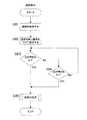
本発明に係る携帯ナビゲーションシステムでは、全体として図4(A)に示すように目的地設定を行って(ステップS11)、目的地までの経路を探索して現在地からの経路の表示を行う(ステップS12)。
【0015】
上記処理のうち、ステップS11の目的地設定処理では、図4(B)に示すように目的地を入力して(ステップS21)、その目的地を検索し(ステップS22)、検索結果を表示することにより(ステップS23)、表示された目的地を確定する(ステップS24)。
【0016】
そして、ステップS12の現在地からの経路の表示処理では、図5(A)に示すようにまず、現在地の設定を行い(ステップS31)、現在地から目的地までの経路探索を行い(ステップS32)、探索した経路を表示する(ステップS32)。
【0017】
上記ステップS31の現在地の設定処理では、図5(B)に示すように現在地の入力画面を表示して(ステップS41)、現在地の検索を行い(ステップS42)、現在地を確定する(ステップS43)。
【0018】
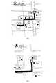
上記ステップS33の経路を表示する処理では、図6に示すように現在地から目的地まで探索した経路を表示すると共に(ステップS51)、図7(A)に示すようにその経路の曲がり角、つまり交差点に番号▲1▼、▲2▼を付与して表示する(ステップS52)。そして、曲がり角に付与した番号が▲1▼、▲2▼の2つあるとすると、テンキー入力部からそれらの番号▲1▼、▲2▼に対応するいずれのテンキーが押されたかを判定し(ステップS53、S54)、図7(B)に示すように押されたテンキーに対応する番号の曲がり角付近の拡大図を表示する(ステップS55、S56)。
【0019】
上記のように本発明に係る携帯用ナビゲーション装置では、曲がり角を案内地点として、それぞれに番号を付与して表示し、テンキーからの番号の指定によりその案内地点付近の拡大図を表示することにより、表示画面の小さい携帯端末でも経路全体の案内情報を提供すると共に、要求に応じて経路途中における有用な案内地点の情報を提供できるようにしている。したがって、案内地点は、その地点や、経路、進行方向等が容易に判定ができる情報を提供するためのものであるので、曲がり角だけでなく、直進する交差点であっても、大きな交差点、直線距離が長い経路では、大きな施設等を通過する地点を案内地点として設定し、番号を付与してもよい。したがって、表示する拡大図の向きも、図7に示すように北向きにするだけでなく、図8(A)、(B)に示すように案内地点に向かう方向が上になる向きに切り換えるようにしてもよい。
【0020】
図9は経路表示処理の流れの他の例を示す図、図10は案内地点の検索処理の流れの例を示す図、図11は経路表示処理の流れのさらに他の例を示す図、図12は地図の拡大処理の流れの例を示す図である。
【0021】
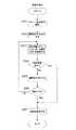
上記ステップS33の経路を表示する処理として、図9に示すように予め案内地点の検索を行って(ステップS61)、経路を表示すると共に(ステップS62)、案内地点と交差点を表示し(ステップS63)、曲がり角に番号を付与して表示し(ステップS64)、図6に示す処理と同様に拡大図の表示を行うように処理としてもよい(ステップS65〜S68)。
【0022】
この場合の案内地点の検索処理では、図10に示すように現在地付近及び目的地付近で目印となる建物・施設等を案内地点として検索し(ステップS71、S72)、さらに曲がり角やY字路、T字路、大きなカーブなどを含む体道があるか否かを調べて(ステップS73、S74)、それらの交差点名を検索する(ステップS75)。
【0023】
また、上記ステップS33の経路を表示する処理として、図11に示すように現在地から目的地まで探索した経路を表示すると共に(ステップS81)、経路の曲がり角に番号を付与して表示し(ステップS82)、テンキー入力部からそれらの番号に対応するいずれのテンキーが押されたかを判定し(ステップS83)、押されたテンキーに対応する番号の曲がり角付近の地図を拡大するように処理してもよい(ステップS85)。
【0024】
この地図の拡大処理では、図12に示すようにまず拡大前の縮尺をPreに登録し(ステップS91)、新たな縮尺を5千分の1とする(ステップS92)。そして、新たな縮尺の表示範囲でビル名、コンビニ名、交差点などの目印情報を検索して(ステップS93)、検索された目印情報があるか否かを判定し(ステップS94)、検索された目印情報があればその縮尺で地図を表示する(ステップS97)。しかし、検索された目印情報がなければ、縮尺を1段大きくし(ステップS95)、その縮尺がPreと同じ縮尺まで大きくなったか否かを判定し(ステップS96)、Preの縮尺になるまで、ステップS93に戻って同様の処理を繰り返し実行する。しかし、縮尺がPreまで広域になっても検索された目印情報がない場合には、そのまま地図を表示する(ステップS97)。
【0025】
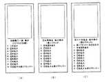
図13は案内地点の数が多い場合のテンキーを用いた拡大地図表示のための操作例を説明するための図である。上記実施の形態では、テンキーを経路の曲がり角に付与した番号(案内地点の番号)をテンキー入力部から指定したが、携帯端末では、0〜9までのテンキーしかないので、2桁の番号がある場合には、テンキーを押した後にエンターキーのような特殊キーを押すか、特殊のキーを押したときに2桁と認識して入力できるようにするなどの特殊操作が必要になる。すなわち、案内地点が10地点以上ある場合には、テンキー(0〜9)をそのま使用することができない。そこで、以下の要領で案内地点とテンキーとを対応させ、10個以上の案内地点がある場合も使用できるようにしてもよい。
【0026】
まず、▲1▼から全ての案内地点に番号を付与し、例えば20地点あれば▲1▼〜○20の番号を地図上に表示する。ただし、番号が重なる場合には、番号が小さい方を優先して表示し、大きい方は表示しない。そして、図13に示すように8つの案内地点を1つのブロックとし、テンキーの1〜8の操作で拡大地図表示を行い、テンキーの0の操作で前ブロックへの切り替え、テンキーの9の操作で次ブロックへの切り替えを行う。
【0027】
そのため、図13に示すように画面を案内図表示領域(図示上半分の矩形内)とメッセージ領域(図示した半分)の2つに分割する。そして、全体地図を表示する場合には、図13(A)に示すようにテンキーの1〜8は、▲1▼〜▲8▼の案内地点の拡大地図表示キーとし、テンキーの9は、図13(C)に示すような▲9▼案内地点の拡大表示キー及び次ブロック(▲9▼〜○16案内地点)への切り替えキーの2機能とする。また、図13(A)に示す画面において、テンキー1〜8のいずれかを操作した場合には、図13(B)に示すようにその地点の拡大地図を表示すると共に、その地点の番号に対応するテンキー、図示ではテンキー1を元の全体図表示キーとする。
【0028】
つまり、図13(A)に示す画面において、テンキー1を操作すると、図13(B)に示す画面になり、ここで、テンキー1を操作すると、図13(A)に示す画面に戻る。また、図13(A)及び(B)に示す画面において、テンキー9を操作すると、図13(C)に示す画面になり、ここで、テンキー1を操作すると、図13(A)に示す画面に戻る。
【0029】
図13(C)に示す画面において、案内図表示領域には▲9▼の案内地点の拡大図を表示して、テンキー0を操作すると、前ブロック(▲1▼〜▲8▼)に戻って案内図表示領域には▲8▼の案内地点の拡大図を表示する。また、テンキー9は、○17案内地点の拡大表示キー及び次ブロック(○16以降案内地点)への切り替えキーとなる。ここで、テンキー1〜8は、▲9▼〜○16案内地点の拡大地図表示キーとなり案内地点の番号と一致しなくなる。したがって、案内地点が10個以上となる場合には、メッセージ領域を、地図の説明や番号操作の説明を表示する領域として註釈をつけておくため必ず必要となる。しかし、10個未満であれば必ずしも表示しなくてもよい。
【0030】
なお、本発明は、上記実施の形態に限定されるものではなく、種々の変形が可能である。例えば上記実施の形態では、インターネット回線を介して携帯電話と通信を行うサーバ(ナビセンタ)を利用したシステムとして説明したが、インターネット回線以外の有線、無線の通信回線を利用して携帯端末がナビセンタと通信を行い小画面で経路案内を行うシステムにおいても同様に適用可能である。また、案内地点に付与する番号は、現在地から目的地までの経路順に設定されるが、現在地が経路に沿って進行することにより、例えば案内地点に到着したときに、ユーザが確認の信号を入力することにより新たな現在地から番号を更新して付与し直すようにしてもよい。
【0031】
【発明の効果】
以上の説明から明らかなように、本発明によれば、テンキーの操作で、地図全体及び案内地点の拡大図を切り替えて表示する携帯用ナビゲーション装置であって、案内地点は複数のブロックに分類され、テンキーの一部は、案内地点に付与された番号と対応させて該案内地点の拡大図を表示する操作を付与され、テンキーの他の一部は、ブロックを切り替えるとともに、該ブロックに対応する地図全体を表示する操作を付与されるので、番号が付与された案内地点に到達した時に、ユーザがその番号のテンキーを操作するだけで、案内地点の詳細な情報が含まれる拡大地図が表示され、案内地点、曲がるべき方向を間違えずに確認できるようにすることができる。
【0032】
さらに、地図全体または案内地点の拡大図を表示する案内図表示領域と、テンキーの操作に対応する表示を説明するメッセージ領域を表示し、メッセージ領域は、8つの案内地点を1つのブロックとし、テンキーの0と9を前後のブロックに切り替える機能のテンキーとして表示するので、地図専用のキーがなくても、携帯電話のテンキーをそのまま使用できる。特に小型でスペースが限定されているので、新たなキーを付加することはしにくい携帯電話を機種に関係なく汎用のものをそのまま使用することができる。案内地点は、現在地付近、目的地付近又は曲がるべき交差点のいずれかとすることにより、ユーザの間違いやすいこれらの地点で詳細な情報を有する拡大地図を表示させることができる。案内地点に付与する番号は、現在地から目的地までの経路の順に付与されるので、ユーザが進む順番の番号になり、使いやすくなる。
【0033】
また、画面を案内図表示領域とメッセージ領域に分割して、メッセージ領域にテンキーの切り替え機能を表示し、案内図表示領域に案内地点の番号を付与した案内経路の全体地図又は案内地点の拡大図をテンキーの操作により切り替えて表示して、目的地までの経路案内を行う携帯用ナビゲーション装置であって、メッセージ領域に表示するテンキーの切り替え機能として、案内図表示領域に全体地図を表示しているときは、案内図表示領域の表示を各案内地点の拡大図に切り替える機能のテンキーおよびメッセージ領域の表示を次のブロックに切り替える機能のテンキーを表示し、案内図表示領域に拡大図を表示しているときは、案内図表示領域の表示を各案内地点の拡大図に切り替える機能のテンキーおよび全体図に切り替える機能のテンキーおよびメッセージ領域の表示を前後のブロックに切り替える機能のテンキーを表示することにより、テンキーの操作によりテンキーの数以上の複数の案内地点の拡大図と全体図とを切り替え表示可能にしたので、番号が付与された案内地点に到達した時に、ユーザがその番号のテンキーを操作するだけで、案内地点の詳細な情報が含まれる拡大地図が表示され、案内地点、曲がるべき方向を間違えずに確認できるようにすることができる。
【図面の簡単な説明】
【図1】 本発明に係る携帯ナビゲーションシステムの実施の形態を示す図である。
【図2】 携帯端末の正面図を示す図である。
【図3】 地図データの構成例を示す図である。
【図4】 全体の処理と目的地設定処理の流れの例を示す図である。
【図5】 現在地からの経路の表示処理と現在地の設定処理の流れの例を示す図である。
【図6】 経路表示処理の流れの例を示す図である。
【図7】 経路表示画面及び拡大図表示画面の例を示す図である。
【図8】 拡大図表示画面の他の例を示す図である。
【図9】 経路表示処理の流れの他の例を示す図である。
【図10】 案内地点の検索処理の流れの例を示す図である。
【図11】 経路表示処理の流れのさらに他の例を示す図である。
【図12】 地図の拡大処理の流れの例を示す図である。
【図13】 案内地点の数が多い場合のテンキーを用いた拡大地図表示のための操作例を説明するための図である。
【符号の説明】
1…ナビセンタ、2…通信回線、3…携帯端末、4…処理部、5…通信部、6…地図データ、7…入力処理部、8…検索処理部、9…探索処理部、10…表示処理部、11…ディスプレイ表示部、12…テンキー入力部[0001]
BACKGROUND OF THE INVENTION
The present invention relates to a portable navigation device that communicates with a mobile terminal and displays a map on the screen of the mobile terminal to guide a route.
[0002]
[Prior art and problems to be solved by the invention]
A vehicle navigation device tracks the current position using a GPS, a vehicle speed sensor, etc., and guides the route from the set starting point and the current position to the destination. Is not at all suitable.
[0003]
A portable navigation device that is not mounted on such a vehicle but is light, small, and convenient to carry has also been proposed. Since such a navigation device does not have a function of detecting the current position, for example, in a route having a number of intersections close to each other like a busy street, even if the route guidance to the destination is displayed on the map, it bends. It is likely that the power corner cannot be accurately determined or the wrong intersection is to be bent. In addition, when the map is enlarged, there is a problem that it is difficult for the user to understand the current position if there are no or few landmarks.
[0004]
[Means for Solving the Problems]
The present invention solves the above-described problem, and enables display of a map and a route and display of landmark information at an appropriate guide point with a small portable terminal.
[0005]
Therefore, the present invention isa portable navigation device that displays the entire map and an enlarged view of the guide point by operating thenumeric keypad, wherein the guide point is classified into a plurality of blocks, and a part of the numeric keypad is An operation for displaying an enlarged view of the guide point corresponding to the number assigned to the guide point is given, and another part of the numeric keypad switches the block and displays the entire map corresponding to the block. The operation to perform is given .
[0006]
Further,a guide map display area for displaying the entire map or an enlarged view of the guide point, and a message area for explaining the display corresponding to the operation of the numeric keypad are displayed. Themessage area includes eight guide points. It is a single block and is displayed as a numeric keypad with the function of switching the
[0007]
In addition, thescreen is divided into a guide map display area and a message area, a ten-key switching function is displayed in the message area, and a guide map whole map or a guide point of the guide spot number assigned to the guide map display area is displayed. A portable navigation device for switching and displaying an enlarged map by operating a numeric keypad to guide a route to a destination, wherein the whole map is displayed in the guidance map display area as a tenkey switching function displayed in the message area. Is displayed, a numeric keypad for switching the display of the guide map display area to an enlarged view of each guide point and a numeric keypad for switching the display of the message area to the next block are displayed, and the guide map display is displayed. When the enlarged map is displayed in the area, the function of switching the display of the guide map display area to the enlarged map of each guide point And an enlarged view and a general view of a plurality of guide points more than the number of the numeric keys by operating the numeric keypad. And can be switched and displayed .
[0008]
DETAILED DESCRIPTION OF THE INVENTION
Hereinafter, embodiments of the present invention will be described with reference to the drawings. FIG. 1 is a diagram showing an embodiment of a portable navigation system according to the present invention, FIG. 2 is a diagram showing a front view of a portable terminal, and FIG. 3 is a diagram showing a configuration example of map data. In the figure, 1 is a navigation center, 2 is a communication line, 3 is a portable terminal, 4 is a processing unit, 5 is a communication unit, 6 is map data, 7 is an input processing unit, 8 is a search processing unit, 9 is a search processing unit,
[0009]
In FIG. 1, the
[0010]
The
[0011]
The processing unit 4 includes an
[0012]
The
[0013]
Next, the contents of processing by the portable navigation system according to the present invention will be described. FIG. 4 is a diagram showing an example of the flow of the entire process and the destination setting process, FIG. 5 is a diagram showing an example of the flow of the process of displaying the route from the current location and the process of setting the current location, and FIG. FIG. 7 is a diagram showing examples of a route display screen and an enlarged map display screen, and FIG. 8 is a diagram showing another example of the enlarged map display screen.
[0014]
In the portable navigation system according to the present invention, the destination is set as shown in FIG. 4A as a whole (step S11), the route to the destination is searched and the route from the current location is displayed (step). S12).
[0015]
Among the above processes, in the destination setting process of step S11, as shown in FIG. 4B, the destination is input (step S21), the destination is searched (step S22), and the search result is displayed. (Step S23), the displayed destination is confirmed (Step S24).
[0016]
In the process of displaying the route from the current location in step S12, as shown in FIG. 5A, first, the current location is set (step S31), and the route search from the current location to the destination is performed (step S32). The searched route is displayed (step S32).
[0017]
In the current location setting process in step S31, the current location input screen is displayed as shown in FIG. 5B (step S41), the current location is searched (step S42), and the current location is determined (step S43). .
[0018]
In the process of displaying the route in step S33, the route searched from the current position to the destination is displayed as shown in FIG. 6 (step S51), and the corner of the route, that is, the intersection as shown in FIG. The numbers {circle over (1)} and {circle over (2)} are assigned and displayed (step S52). If there are two numbers (1) and (2) given to the corner, it is determined which ten key corresponding to the numbers (1) and (2) has been pressed from the ten key input section ( Steps S53 and S54), as shown in FIG. 7B, an enlarged view near the corner of the number corresponding to the pressed numeric keypad is displayed (Steps S55 and S56).
[0019]
As described above, in the portable navigation device according to the present invention, a turn point is used as a guide point, a number is given to each, and an enlarged view of the vicinity of the guide point is displayed by specifying a number from the numeric keypad. A portable terminal with a small display screen provides guidance information for the entire route, and can provide useful guidance point information along the route upon request. Therefore, the guide point is for providing information that can easily determine the point, the route, the traveling direction, etc. Therefore, not only a turning corner, but also a straight ahead intersection, a large intersection, a straight distance In a long route, a point passing through a large facility or the like may be set as a guide point and given a number. Therefore, the direction of the enlarged view to be displayed is not only oriented north as shown in FIG. 7, but also switched to the direction where the direction toward the guide point is upward as shown in FIGS. 8A and 8B. It may be.
[0020]
FIG. 9 is a diagram showing another example of the flow of the route display processing, FIG. 10 is a diagram showing an example of the flow of the guide point search processing, and FIG. 11 is a diagram showing still another example of the flow of the route display processing. 12 is a diagram showing an example of the flow of map enlargement processing.
[0021]
As a process of displaying the route in step S33, the guide point is searched in advance as shown in FIG. 9 (step S61), the route is displayed (step S62), and the guide point and the intersection are displayed (step S63). ), A number is added to the corner (step S64), and an enlarged view may be displayed in the same manner as the process shown in FIG. 6 (steps S65 to S68).
[0022]
In the guide point search process in this case, as shown in FIG. 10, a building / facility or the like that is a landmark in the vicinity of the current position and the destination is searched as a guide point (steps S71, S72), and further, a corner, a Y-junction, It is checked whether or not there is a body path including a T-junction, a large curve, etc. (steps S73 and S74), and their intersection names are searched (step S75).
[0023]
Further, as the process of displaying the route in step S33, the route searched from the current location to the destination is displayed as shown in FIG. 11 (step S81), and a number is given to the corner of the route and displayed (step S82). ), It is determined from the numeric keypad input unit which numeric keypad corresponding to the number is pressed (step S83), and processing may be performed to enlarge the map near the corner of the number corresponding to the pressed numeric keypad. (Step S85).
[0024]
In this map enlargement process, as shown in FIG. 12, the scale before enlargement is first registered in Pre (step S91), and the new scale is set to 1 / 5,000 (step S92). Then, landmark information such as a building name, a convenience store name, and an intersection is searched in the new scale display range (step S93), and it is determined whether or not the searched landmark information exists (step S94). If there is mark information, the map is displayed at that scale (step S97). However, if there is no searched landmark information, the scale is increased by one step (step S95), it is determined whether or not the scale has increased to the same scale as Pre (step S96), and until the scale of Pre is reached. Returning to step S93, the same processing is repeated. However, if there is no searched landmark information even if the scale is wide up to Pre, the map is displayed as it is (step S97).
[0025]
FIG. 13 is a diagram for explaining an operation example for displaying an enlarged map using a numeric keypad when the number of guide points is large. In the above-described embodiment, the number (guidance point number) assigned to the corner of the route is specified from the numeric keypad input unit. However, in the portable terminal, there are only numeric keys from 0 to 9, so there are two-digit numbers. In such a case, a special operation such as pressing a special key such as the enter key after pressing the numeric keypad or recognizing that the digit is input when the special key is pressed becomes necessary. That is, when there are 10 or more guide points, the numeric keypad (0 to 9) cannot be used as it is. Therefore, the guide points may be associated with the numeric keypad in the following manner, and may be used even when there are ten or more guide points.
[0026]
First, numbers are assigned to all guide points from (1). For example, if there are 20 points, numbers (1) to (20) are displayed on the map. However, when numbers overlap, the smaller number is displayed with priority, and the larger number is not displayed. Then, as shown in FIG. 13, eight guide points are set as one block, an enlarged map is displayed by the operation of the
[0027]
Therefore, as shown in FIG. 13, the screen is divided into a guide map display area (in the upper half of the rectangle shown in the figure) and a message area (shown in the half). When the entire map is displayed, as shown in FIG. 13A, the
[0028]
That is, when the
[0029]
In the screen shown in FIG. 13C, an enlarged view of the guide point of (9) is displayed in the guide map display area, and when the
[0030]
In addition, this invention is not limited to the said embodiment, A various deformation | transformation is possible. For example, in the above-described embodiment, the system using a server (navigation center) that communicates with a mobile phone via an Internet line has been described. However, a portable terminal is connected to the navigation center using a wired or wireless communication line other than the Internet line. The same applies to a system that performs communication and provides route guidance on a small screen. The number assigned to the guide point is set in the order of the route from the current location to the destination. When the current location advances along the route, for example, when the user arrives at the guide location, the user inputs a confirmation signal. By doing so, the number may be updated and re-assigned from the new current location.
[0031]
【The invention's effect】
As is clear from the above description, according to the present invention,a portable navigation device that switches and displays the entire map and an enlarged view of the guide point by operating thenumeric keypad, and the guide point is classified into a plurality of blocks. A part of the numeric keypad is given an operation for displaying an enlarged view of the guidance point in correspondence with the number given to the guidance point, and another part of the numeric keypad corresponds to the block while switching the block. An operation to display the entire map is given, so when the user reaches the numbered guide point, an enlarged map containing detailed information on the guide point is displayed just by operating the numeric keypad for that number. It is possible to check the guidance point and the direction to be bent without making a mistake.
[0032]
Furthermore,a guide map display area for displaying the entire map or an enlarged view of the guide point and a message area for explaining the display corresponding to the operation of the numeric keypad are displayed. The message area includes eight guide points as one block. Since 0 and 9 are displayed as numeric keys for switching to the previous andnext blocks, the numeric keypad of the mobile phone can be used as it is even without a dedicated map key. In particular, since it is small and space is limited, a general-purpose mobile phone that is difficult to add a new key can be used as it is regardless of the model. By setting the guide point as one of the vicinity of the current location, the vicinity of the destination, or the intersection to be turned, an enlarged map having detailed information can be displayed at these points where the user is likely to make a mistake. Since the number given to the guide point is given in the order of the route from the current location to the destination, it becomes the number in the order in which the user proceeds and is easy to use.
[0033]
In addition, thescreen is divided into a guide map display area and a message area, a ten-key switching function is displayed in the message area, and a guide map whole map or an enlarged view of the guide point is assigned a guide spot number in the guide map display area. Is a portable navigation device that performs route guidance to the destination by switching the display by operating the numeric keypad, and displays the entire map in the guide map display area as a function of switching the numeric keypad displayed in the message area When displaying the map of the guide map display area to the enlarged view of each guide point, the numeric keypad of the function to switch the display of the message area to the next block, and display the enlarged view in the guide map display area The function keypad for switching the display of the guide map display area to an enlarged view of each guide point and the function map for switching to the general view. By displaying the numerical keypad function for switching the display of the key and the message area before and after the block, since the switch can display the enlarged view and a overall view of the number or more of the plurality of guide point numeric keypad by operating the ten-key pad, number When the user reaches the guide point where the number is assigned, the user can operate the numeric keypad of that number to display an enlarged map that includes detailed information on the guide point, so that the user can check the guide point and the direction to turn without making a mistake. Can be.
[Brief description of the drawings]
FIG. 1 is a diagram showing an embodiment of a portable navigation system according to the present invention.
FIG. 2 is a diagram showing a front view of the mobile terminal.
FIG. 3 is a diagram illustrating a configuration example of map data.
FIG. 4 is a diagram illustrating an example of the flow of overall processing and destination setting processing;
FIG. 5 is a diagram illustrating an example of a flow of a process for displaying a route from the current location and a process for setting the current location.
FIG. 6 is a diagram illustrating an example of a flow of route display processing.
FIG. 7 is a diagram illustrating an example of a route display screen and an enlarged view display screen.
FIG. 8 is a diagram showing another example of an enlarged view display screen.
FIG. 9 is a diagram illustrating another example of the flow of route display processing.
FIG. 10 is a diagram illustrating an example of a flow of guide point search processing.
FIG. 11 is a diagram showing still another example of the flow of route display processing.
FIG. 12 is a diagram illustrating an example of a flow of map enlargement processing.
FIG. 13 is a diagram for explaining an operation example for displaying an enlarged map using a numeric keypad when the number of guide points is large.
[Explanation of symbols]
DESCRIPTION OF
Claims (6)
Translated fromJapanese前記案内地点は複数のブロックに分類され、
前記テンキーの一部は、前記案内地点に付与された番号と対応させて該案内地点の拡大図を表示する操作を付与され、
前記テンキーの他の一部は、前記ブロックを切り替えるとともに、該ブロックに対応する地図全体を表示する操作を付与されることを特徴とする携帯用ナビゲーション装置。A portable navigation device for switching and displaying an entire map and an enlarged view of a guide point by operating a numeric keypad,
The guide points are classified into a plurality of blocks.
A part of the numeric keypad is given an operation for displaying an enlarged view of the guide point in correspondence with the number assigned to the guide point.
Another part of the numeric keypad is given an operation of switching the block and displaying the entire map corresponding to the block .
前記メッセージ領域に表示するテンキーの切り替え機能として、前記案内図表示領域に前記地図全体を表示しているときは、前記案内図表示領域の表示を各案内地点の拡大図に切り替える機能のテンキーおよび前記メッセージ領域の表示を次のブロックに切り替える機能のテンキーを表示し、前記案内図表示領域に前記拡大図を表示しているときは、前記案内図表示領域の表示を各案内地点の拡大図に切り替える機能のテンキーおよび前記地図全体に切り替える機能のテンキーおよび前記メッセージ領域の表示を前後のブロックに切り替える機能のテンキーを表示することにより、テンキーの操作によりテンキーの数以上の複数の案内地点の拡大図と地図全体とを切り替え表示可能にしたことを特徴とする携帯用ナビゲーション装置。Dividing the screen into a guide map display area and a message area, displaying a numeric keypad switching function in the message area, and providing a guide map number in the guide map display area, or an enlarged view of the guide route map Is a portable navigation device that switches the display by operating the numeric keypad and provides route guidance to the destination,
As a function of switching the numeric keypad displayed in the message area, when the entire map is displayed in the guide map display area, the numeric keypad for switching the display of the guide map display area to an enlarged view of each guide point, and When the numeric keypad for switching the message area display to the next block is displayed and the enlarged map is displayed in the guide map display area, the display of the guide map display area is switched to the enlarged map of each guide point. By displaying the function numeric keypad and the numeric keypad for switching to the entire map and the numeric keypad for switching the display of the message area to the previous and next blocks, an enlarged view of a plurality of guide points more than the number of numeric keys by operating the numeric keypad A portable navigation device characterizedin that the entire map can be switched and displayed .
Priority Applications (1)
| Application Number | Priority Date | Filing Date | Title |
|---|---|---|---|
| JP2000313063AJP4480113B2 (en) | 2000-10-13 | 2000-10-13 | Portable navigation device |
Applications Claiming Priority (1)
| Application Number | Priority Date | Filing Date | Title |
|---|---|---|---|
| JP2000313063AJP4480113B2 (en) | 2000-10-13 | 2000-10-13 | Portable navigation device |
Publications (2)
| Publication Number | Publication Date |
|---|---|
| JP2002122442A JP2002122442A (en) | 2002-04-26 |
| JP4480113B2true JP4480113B2 (en) | 2010-06-16 |
Family
ID=18792539
Family Applications (1)
| Application Number | Title | Priority Date | Filing Date |
|---|---|---|---|
| JP2000313063AExpired - Fee RelatedJP4480113B2 (en) | 2000-10-13 | 2000-10-13 | Portable navigation device |
Country Status (1)
| Country | Link |
|---|---|
| JP (1) | JP4480113B2 (en) |
Families Citing this family (4)
| Publication number | Priority date | Publication date | Assignee | Title |
|---|---|---|---|---|
| JP2003329479A (en)* | 2002-05-16 | 2003-11-19 | Matsushita Electric Ind Co Ltd | Portable navigation device |
| EP1611416B1 (en)* | 2003-02-26 | 2007-05-30 | TomTom International B.V. | Navigation device and method for displaying alternative routes |
| JPWO2005005927A1 (en)* | 2003-07-10 | 2007-09-20 | 株式会社アプリコット | Road guidance system and road guidance method |
| JP6764735B2 (en)* | 2016-09-08 | 2020-10-07 | 株式会社ゼンリンデータコム | Route guidance devices, route guidance methods, and computer programs |
- 2000
- 2000-10-13JPJP2000313063Apatent/JP4480113B2/ennot_activeExpired - Fee Related
Also Published As
| Publication number | Publication date |
|---|---|
| JP2002122442A (en) | 2002-04-26 |
Similar Documents
| Publication | Publication Date | Title |
|---|---|---|
| JP4251931B2 (en) | Navigation destination input method and apparatus | |
| JP4277746B2 (en) | Car navigation system | |
| JP2780521B2 (en) | Map display control device | |
| US6732047B1 (en) | Display method and apparatus for navigation system | |
| US6415224B1 (en) | Display method and apparatus for navigation system | |
| JP4145028B2 (en) | POI icon display method and navigation device | |
| US6897861B2 (en) | Map image display device, map image display method and map image display program | |
| JP2011191577A (en) | Map display device, map display method and program | |
| WO2002055961A1 (en) | Map display/control device and map display/control method | |
| JP2013097411A (en) | Navigation device for vehicle | |
| JP4251780B2 (en) | Destination specifying method and navigation apparatus | |
| JP2001091283A (en) | Bypass route search method of navigation device | |
| JPH10281787A (en) | Method for guiding vehicle of navigation apparatus | |
| JP4480113B2 (en) | Portable navigation device | |
| JPH07121562A (en) | Navigation system | |
| JP2002116040A (en) | Navigation device | |
| JP2001116579A (en) | Navigation device and recording medium | |
| JP4433952B2 (en) | Navigation device | |
| JP3915646B2 (en) | Map display device | |
| JP2002116044A (en) | Navigation device | |
| JP5163427B2 (en) | In-vehicle navigation destination search apparatus and in-vehicle navigation destination search method | |
| JP3580272B2 (en) | Navigation device | |
| JP4822575B2 (en) | Navigation device | |
| JP2004318483A (en) | Information terminal device and method for acquiring information | |
| JP2013029373A (en) | Information display apparatus, information display method and program |
Legal Events
| Date | Code | Title | Description |
|---|---|---|---|
| A621 | Written request for application examination | Free format text:JAPANESE INTERMEDIATE CODE: A621 Effective date:20070326 | |
| A977 | Report on retrieval | Free format text:JAPANESE INTERMEDIATE CODE: A971007 Effective date:20090625 | |
| A131 | Notification of reasons for refusal | Free format text:JAPANESE INTERMEDIATE CODE: A131 Effective date:20090701 | |
| A521 | Written amendment | Free format text:JAPANESE INTERMEDIATE CODE: A523 Effective date:20090828 | |
| A521 | Written amendment | Free format text:JAPANESE INTERMEDIATE CODE: A523 Effective date:20090828 | |
| A131 | Notification of reasons for refusal | Free format text:JAPANESE INTERMEDIATE CODE: A131 Effective date:20100203 | |
| A521 | Written amendment | Free format text:JAPANESE INTERMEDIATE CODE: A523 Effective date:20100215 | |
| TRDD | Decision of grant or rejection written | ||
| A01 | Written decision to grant a patent or to grant a registration (utility model) | Free format text:JAPANESE INTERMEDIATE CODE: A01 Effective date:20100310 | |
| A01 | Written decision to grant a patent or to grant a registration (utility model) | Free format text:JAPANESE INTERMEDIATE CODE: A01 | |
| A61 | First payment of annual fees (during grant procedure) | Free format text:JAPANESE INTERMEDIATE CODE: A61 Effective date:20100315 | |
| FPAY | Renewal fee payment (prs date is renewal date of database) | Free format text:PAYMENT UNTIL: 20130326 Year of fee payment:3 | |
| R150 | Certificate of patent (=grant) or registration of utility model | Free format text:JAPANESE INTERMEDIATE CODE: R150 | |
| FPAY | Renewal fee payment (prs date is renewal date of database) | Free format text:PAYMENT UNTIL: 20130326 Year of fee payment:3 | |
| FPAY | Renewal fee payment (prs date is renewal date of database) | Free format text:PAYMENT UNTIL: 20140326 Year of fee payment:4 | |
| LAPS | Cancellation because of no payment of annual fees |