JP4198513B2 - MAP INFORMATION PROCESSING DEVICE, MAP INFORMATION PROCESSING SYSTEM, POSITION INFORMATION DISPLAY DEVICE, ITS METHOD, ITS PROGRAM, AND RECORDING MEDIUM CONTAINING THE PROGRAM - Google Patents
MAP INFORMATION PROCESSING DEVICE, MAP INFORMATION PROCESSING SYSTEM, POSITION INFORMATION DISPLAY DEVICE, ITS METHOD, ITS PROGRAM, AND RECORDING MEDIUM CONTAINING THE PROGRAMDownload PDFInfo
- Publication number
- JP4198513B2 JP4198513B2JP2003114893AJP2003114893AJP4198513B2JP 4198513 B2JP4198513 B2JP 4198513B2JP 2003114893 AJP2003114893 AJP 2003114893AJP 2003114893 AJP2003114893 AJP 2003114893AJP 4198513 B2JP4198513 B2JP 4198513B2
- Authority
- JP
- Japan
- Prior art keywords
- information
- map
- display
- map information
- area
- Prior art date
- Legal status (The legal status is an assumption and is not a legal conclusion. Google has not performed a legal analysis and makes no representation as to the accuracy of the status listed.)
- Expired - Fee Related
Links
Images


Classifications
- G—PHYSICS
- G01—MEASURING; TESTING
- G01C—MEASURING DISTANCES, LEVELS OR BEARINGS; SURVEYING; NAVIGATION; GYROSCOPIC INSTRUMENTS; PHOTOGRAMMETRY OR VIDEOGRAMMETRY
- G01C21/00—Navigation; Navigational instruments not provided for in groups G01C1/00 - G01C19/00
- G01C21/26—Navigation; Navigational instruments not provided for in groups G01C1/00 - G01C19/00 specially adapted for navigation in a road network
- G01C21/34—Route searching; Route guidance
- G01C21/36—Input/output arrangements for on-board computers
- G01C21/3667—Display of a road map
- G01C21/367—Details, e.g. road map scale, orientation, zooming, illumination, level of detail, scrolling of road map or positioning of current position marker
- G—PHYSICS
- G01—MEASURING; TESTING
- G01C—MEASURING DISTANCES, LEVELS OR BEARINGS; SURVEYING; NAVIGATION; GYROSCOPIC INSTRUMENTS; PHOTOGRAMMETRY OR VIDEOGRAMMETRY
- G01C21/00—Navigation; Navigational instruments not provided for in groups G01C1/00 - G01C19/00
- G01C21/20—Instruments for performing navigational calculations
- G—PHYSICS
- G01—MEASURING; TESTING
- G01S—RADIO DIRECTION-FINDING; RADIO NAVIGATION; DETERMINING DISTANCE OR VELOCITY BY USE OF RADIO WAVES; LOCATING OR PRESENCE-DETECTING BY USE OF THE REFLECTION OR RERADIATION OF RADIO WAVES; ANALOGOUS ARRANGEMENTS USING OTHER WAVES
- G01S5/00—Position-fixing by co-ordinating two or more direction or position line determinations; Position-fixing by co-ordinating two or more distance determinations
- G01S5/0009—Transmission of position information to remote stations
- G01S5/0018—Transmission from mobile station to base station
Landscapes
- Engineering & Computer Science (AREA)
- Radar, Positioning & Navigation (AREA)
- Remote Sensing (AREA)
- Physics & Mathematics (AREA)
- General Physics & Mathematics (AREA)
- Automation & Control Theory (AREA)
- Navigation (AREA)
- Controls And Circuits For Display Device (AREA)
- Traffic Control Systems (AREA)
- Instructional Devices (AREA)
Description
Translated fromJapanese【0001】
【発明の属する技術分野】
本発明は、表示手段に現在位置を地図に重畳して表示させる地図情報を処理する地図情報処理装置、地図情報処理システム、位置情報表示装置、それらの方法、それらのプログラム、および、それらのプログラムを記録した記録媒体に関する。
【0002】
【従来技術】
従来、例えば車載用や携帯用などのナビゲーション装置、PDA(Personal Digital Assistant)、携帯電話、PHS(Personal Handyphone System)、携帯型パーソナルコンピュータなどの移動通信端末を用いて、サーバ装置に蓄積された地図情報を通信により取得し、現在位置に関する情報や目的地までのルート探索、最寄りの店舗に関する情報などの検索などを実施する通信型のナビゲーションシステムが知られている。この通信型のナビゲーションシステムは、情報量が膨大な地図情報をサーバ装置で一括管理するので、移動通信端末に地図情報を記憶させておく大容量の記憶手段が不要となり、構成の簡略化および軽量小型化が容易に図れるとともに、最新の地図情報の提供が容易となる。そして、この通信型のナビゲーションシステムにおいて、現在位置を地図情報とともに表示させる際に、表示する地図内に実際の現在位置が位置するように、測位した現在位置に関する情報の精度に基づいて、表示する地図の縮尺を適宜設定した地図情報に現在位置を重畳させて表示させる構成が知られている(例えば、特許文献1参照)。
【0003】
この特許文献1に記載のものは、利用者が携帯無線端末装置で測位要求を設定すると、測位サーバ装置でGPS衛星からの航法電波に基づいて測位処理を実施し、補助情報を取得する。この補助情報を測位サーバ装置から携帯無線端末装置で取得すると、補助情報に基づいて航法電波を取得して処理し、生成した処理結果を測位サーバへ送信する。測位サーバ装置は、処理結果に基づいて携帯無線端末装置の位置を演算して位置情報を生成するとともに、位置情報および処理結果に基づいて測位精度に関する精度情報を生成し、地図情報の縮尺を設定する。この設定した縮尺に基づく地図情報を、地図情報を格納する地図サーバから携帯無線端末装置へ送信させる構成が採られている。
【0004】
【特許文献1】
特開2002−351767号公報(第4頁左欄−第7頁左欄)
【0005】
【発明が解決しようとする課題】
しかしながら、上記特許文献1では、測位精度に対応して地図情報の縮尺を設定し、その設定した縮尺の地図情報を携帯無線端末装置へ送信しているが、表示される所定の縮尺の地図において、実際に端末装置が位置する領域に対応した表示でない場合、利用者は表示される地図のどこに位置するのかの判断が困難となる。具体的には、端末装置が実際に位置する領域が表示される地図に対して小さすぎる場合には、表示される地図の縮尺が大きすぎ、地図から十分な情報が認識できずに、自位置判断が困難である。また、端末装置が実際に位置する領域が表示される地図に対して大きすぎる、すなわち位置する領域の一部が欠け落ちて表示される場合では、表示される地図と周囲の状況とが異なり、自位置を判断できなくなる。
【0006】
本発明は、このような点に鑑みて、現在位置が適切に地図表示される地図情報処理装置、地図情報処理システム、位置情報表示装置、それらの方法、それらのプログラム、および、それらのプログラムを記録した記録媒体を提供することを目的とする。
【0007】
請求項1に記載の発明は、現在位置が重畳されて前記現在位置を報知するために表示手段に表示される地図に関する地図情報を処理する地図情報処理装置であって、地物を表示するための文字情報を有し、前記地図の縮尺率が異なる複数の地図情報を記憶する記憶手段と、測位により生成された前記現在位置に関する位置情報を取得する位置情報取得手段と、前記現在位置の測位精度に対応する複数のレベルに関する精度情報を取得する精度情報取得手段と、前記表示手段に前記地図を表示する矩形の表示領域に関する表示領域情報を取得する表示領域情報取得手段と、前記位置情報および前記精度情報に基づいて前記現在位置を中心とした円形で前記現在位置に位置し得る地図上での領域の誤差領域を演算する誤差領域演算手段と、前記精度情報のレベルに対応する縮尺率の前記地図情報を前記記憶手段から選択し、前記表示領域情報に基づいて前記誤差領域の最大寸法が、前記表示手段の表示領域で表示させた場合の最小寸法より小さく、かつ、前記誤差領域が前記表示領域に表示された状態で前記表示領域の最小寸法方向での前記誤差領域の外側に前記文字情報の1文字が認識可能に表示される状態に前記選択した地図情報を縮尺した縮尺領域となる前記地図情報に処理する地図情報処理手段と、を備え、前記地図情報処理手段は、前記認識可能に表示される前記文字情報の1文字の大きさの違いに応じて前記選択した地図情報を縮尺した縮尺領域となる前記地図情報に処理することを特徴とした地図情報処理装置である。
【0008】
請求項10に記載の発明は、地図を表示する表示手段と、前記地図を所定の矩形の表示領域で前記表示手段に表示させる表示制御手段と、現在位置を測位する測位手段にて生成した現在位置に関する位置情報を取得する位置情報取得手段と、前記測位手段にて生成した測位精度に対応する複数のレベルに関する精度情報を取得する精度情報取得手段と、前記位置情報および前記精度情報に基づいて前記現在位置を中心とした円形で前記現在位置に位置し得る前記地図上での領域の誤差領域を演算させ、前記精度情報のレベルに対応する縮尺率であるとともに、前記誤差領域の最大寸法が前記表示領域で表示させた場合の最小寸法より小さく、かつ、前記誤差領域が前記表示領域に表示された状態で前記表示領域の最小寸法方向での前記誤差領域の外側に前記文字情報の1文字が認識可能に表示される状態に前記選択した地図情報を縮尺した縮尺領域となる地図に関する地図情報をこの地図情報を記憶する装置で読み取らせて前記表示制御手段にて表示可能に取得する要求を出力する地図情報取得要求手段と、を備え、前記地図情報取得要求手段は、前記認識可能に表示される前記文字情報の1文字の大きさの違いに応じて前記選択した地図情報を縮尺した縮尺領域となる前記地図情報を、前記表示制御手段にて表示可能に取得する要求を出力することを特徴とした位置情報表示装置である。
【0009】
請求項11に記載の発明は、請求項1ないし請求項9のいずれかに記載の地図情報処理装置と、この地図情報処理装置に送受信可能に接続され、前記地図情報処理装置で取得した前記地図情報を表示させる前記表示手段を備えた端末装置と、を具備したことを特徴とした地図情報処理システムである。
【0010】
請求項12に記載の発明は、請求項10に記載の位置情報表示装置と、この位置情報表示装置に送受信可能に接続され、前記位置情報表示装置から出力される要求に基づいて前記地図情報を取得して前記位置情報表示装置に出力する前記地図情報を記憶する装置としての請求項1ないし請求項9のいずれかに記載の地図情報処理装置と、を具備したことを特徴とした地図情報処理システムである。
【0011】
請求項13に記載の発明は、地図に関する地図情報を格納するサーバ装置に送受信可能に接続する端末装置の表示手段に、前記端末装置の現在位置を前記地図に重畳した状態で表示させる地図情報処理システムであって、前記端末装置は、測位により生成された前記現在位置に関する位置情報と前記現在位置の測位精度に関する精度情報を取得して前記サーバ装置に送信し、前記サーバ装置は、前記端末装置から送信された前記位置情報および前記精度情報に基づいて前記現在位置を中心とした円形で前記現在位置に位置し得る前記地図上での領域の誤差領域を演算し、前記精度情報のレベルに対応する縮尺率であるとともに、前記誤差領域の最大寸法が前記端末装置の表示手段で前記地図を表示させる矩形の表示領域で表示させた場合の最小寸法より小さく、かつ、前記誤差領域が前記表示領域に表示された状態で前記表示領域の最小寸法方向での前記誤差領域の外側に前記文字情報の1文字が認識可能に表示される状態に前記選択した地図情報を縮尺した縮尺領域となる前記地図情報を取得して前記端末装置へ送信するに際し、前記認識可能に表示される前記文字情報の1文字の大きさの違いに応じて前記選択した地図情報を縮尺した縮尺領域となる前記地図情報に処理することを特徴とした地図情報処理システムである。
【0012】
請求項14に記載の発明は、演算手段により、現在位置が重畳されて前記現在位置を報知するために表示手段に表示される地図に関する地図情報を処理する地図情報処理方法であって、前記演算手段は、前記現在位置に関する位置情報および前記現在位置の測位精度に関する精度情報に基づいて、前記現在位置を中心とした円形で前記現在位置に位置し得る前記地図上での領域の誤差領域を演算し、前記精度情報のレベルに対応する縮尺率であるとともに、前記誤差領域の最大寸法が前記表示手段に前記地図を表示する矩形の表示領域で表示させた場合の最小寸法より小さく、かつ、前記誤差領域が前記表示領域に表示された状態で前記表示領域の最小寸法方向での前記誤差領域の外側に前記文字情報の1文字が認識可能に表示される状態に前記選択した地図情報を縮尺した縮尺領域となる前記地図情報をこの地図情報を記憶する記憶手段から取得するに際し、前記認識可能に表示される前記文字情報の1文字の大きさの違いに応じて前記選択した地図情報を縮尺した縮尺領域となる前記地図情報を前記記憶手段から取得することを特徴とする地図情報処理方法である。
【0013】
請求項15に記載の発明は、演算手段により、地図に関する地図情報を格納するサーバ装置に送受信可能に接続する端末装置の表示手段に、前記端末表示の現在位置を前記地図に重畳した状態で表示させる地図情報処理方法であって、前記演算手段は、前記端末装置にて測位により生成された前記現在位置に関する位置情報および前記現在位置の測位精度に関する精度情報を取得させて前記サーバ装置に送信させるとともに、この端末装置から送信された前記位置情報および前記精度情報に基づいて前記サーバ装置にて前記現在位置を中心とした円形で前記現在位置に位置し得る前記地図上での領域の誤差領域を演算させ、前記精度情報のレベルに対応する縮尺率であるとともに、前記誤差領域の最大寸法が前記端末装置の表示手段で前記地図を表示させる矩形の表示領域で表示させた場合の最小寸法より小さく、かつ、前記誤差領域が前記表示領域に表示された状態で前記表示領域の最小寸法方向での前記誤差領域の外側に前記文字情報の1文字が認識可能に表示される状態に前記選択した地図情報を縮尺した縮尺領域となる前記地図情報を取得させて前記端末装置へ送信させ前記表示手段に表示させる処理をするに際し、前記認識可能に表示される前記文字情報の1文字の大きさの違いに応じて前記選択した地図情報を縮尺した縮尺領域となる前記地図情報を取得させることを特徴とする地図情報処理方法である。
【0014】
請求項16に記載の発明は、演算手段により、現在位置が重畳されて前記現在位置を報知するために表示手段に地図を表示させる位置情報表示方法であって、前記演算手段は、現在位置を測位する測位手段にて生成した現在位置に関する位置情報および測位精度に関する精度情報を取得し、この取得した前記位置情報および前記精度情報を出力させ、これら位置情報および精度情報に基づいて前記現在位置を中心とした円形で前記現在位置に位置し得る前記地図上での領域の誤差領域を演算させて、前記精度情報のレベルに対応する縮尺率であるとともに、前記誤差領域の最大寸法が前記表示手段に前記地図を表示させる矩形の表示領域で表示させた場合の最小寸法より小さく、かつ、前記誤差領域が前記表示領域に表示された状態で前記表示領域の最小寸法方向での前記誤差領域の外側に前記文字情報の1文字が認識可能に表示される状態に前記選択した地図情報を縮尺した縮尺領域となる地図に関する地図情報を、この地図情報を記憶する装置で読み取らせて前記表示手段に表示可能に取得させる処理をするに際し、前記認識可能に表示される前記文字情報の1文字の大きさの違いに応じて前記選択した地図情報を縮尺した縮尺領域となる前記地図情報を読み取らせて前記表示手段に表示可能に取得させることを特徴とする位置情報表示方法である。
【0015】
請求項17に記載の発明は、請求項14または請求項15に記載の地図情報処理方法を演算手段に実行させることを特徴とした地図情報処理プログラムである。
【0016】
請求項18に記載の発明は、請求項16に記載の位置情報表示方法を演算手段に実行させることを特徴とした位置情報表示プログラムである。
【0017】
請求項19に記載の発明は、請求項17に記載の地図情報処理プログラムが演算手段にて読み取り可能に記録されたことを特徴とした地図情報処理プログラムを記録した記録媒体である。
【0018】
請求項20に記載の発明は、請求項18に記載の位置情報表示プログラムが演算手段にて読み取り可能に記録されたことを特徴とした位置情報表示プログラムを記録した記録媒体である。
【0019】
【発明の実施の形態】
以下に、本発明の一実施の形態を図面に基づいて説明する。本実施の形態では、本発明の地図情報処理システムとして通信型のナビゲーションシステムを例示して説明する。図1は、本実施の形態におけるナビゲーションシステムの概略構成を示すブロック図である。図2は、端末装置の概略構成を示すブロック図である。図3は、サーバ装置の概略構成を示すブロック図である。図4は、地図情報の表示用データのテーブル構造を模式的に示す概念図である。図5は、地図情報のマッチングデータのテーブル構造を模式的に示す概念図である。図6は、地図情報の測位精度に対応し異なる縮尺率となる階層状の表示用データの構造を表示領域に表示させた状態について模式的に示す概念図である。
【0020】
〔ナビゲーションシステムの構成〕
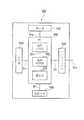
図1において、100は地図情報処理システムとしての通信型のナビゲーションシステムで、このナビゲーションシステム100は、例えば車両や航空機、船舶などの移動体の現在位置に対応して案内を報知、すなわち現在位置を地図表示により報知するシステムである。そして、このナビゲーションシステム100は、ネットワーク200と、位置情報処理システム300と、地図情報処理装置としても機能する位置情報表示手段としての端末装置400と、地図情報処理装置としても機能するサーバ装置500と、を備えている。
【0021】
ネットワーク200には、位置情報処理システム300、端末装置400およびサーバ装置500が接続されている。そして、ネットワーク200は、例えば位置情報処理システム300と端末装置400とを情報が送受信可能に接続するとともに、端末装置400およびサーバ装置500とを情報が送受信可能に接続する。このネットワーク200は、例えば、TCP/IPなどの汎用のプロトコルに基づくインターネット、イントラネット、LAN(Local Area Network)、無線媒体により情報が送受信可能な複数の基地局がネットワークを構成する通信回線網や放送網などのネットワーク、さらには、位置情報処理システム300、端末装置400およびサーバ装置500間で情報を直接送受信するための媒体となる無線媒体自体などが例示できる。ここで、無線媒体としては、電波、光、音波、電磁波などのいずれの媒体をも適用できる。
【0022】
位置情報処理システム300は、人工衛星であるGPS衛星310と、位置情報処理装置320と、を備えている。GPS衛星310は、ネットワークの一部を構成する無線媒体である航法電波を出力する。位置情報処理装置320は、例えばコンピュータシステムで、ネットワーク200の一部を構成する通信回線網の基地局に設置され、ネットワーク200の通信回線網を介して端末装置400と情報を送受信可能にネットワーク200に接続されている。
【0023】
そして、位置情報処理装置320は、この位置情報処理装置320全体の動作を制御するOS(Operating System)上に展開されるプログラムとしての基地演算部321を備えている。この基地演算部321は、ネットワーク200の通信回線網を介して端末装置400と各種情報を送受信する基地送受信手段321Aを備えている。また、基地演算部321は、位置情報生成手段321B1と精度情報生成手段321B2とを有した測位手段321Bを備えている。位置情報生成手段321B1は、端末装置400からネットワーク200の通信回線網を介して取得する所定の情報である擬似座標情報に基づいて、端末装置400の現在位置に関する緯度・経度についての位置情報を生成する。精度情報生成手段321B2は、位置情報生成手段321B1で生成する位置情報の測位精度に関する精度情報を生成する。ここで、精度情報としては、例えば測位精度を複数のレベルにて表したものである。具体的には、測位精度が高くなるにしたがって、レベルを表す数値が大きくなる状態で設定されている。本実施の形態では、1〜3の3つのレベルを用いて説明するがこれに限られない。そして、測位手段321Bは、位置情報および精度情報を基地送受信手段321Aへ出力し、擬似座標情報を送信した端末装置400へネットワーク200の通信回線網を介して送信させる。
【0024】
なお、位置情報および精度情報の送信は、詳細は後述するが、端末装置400から擬似座標情報とともに端末固有情報が送信され、この端末固有情報に基づいて送信先の端末装置400を判別することで所定の端末装置400に送信される。また、この送信の際、基地演算部321は、位置情報および精度情報とともに、端末装置400がネットワーク200を介して情報を送受信可能にサーバ装置500へ接続するための接続情報を合わせて送信する。
【0025】
さらに、位置情報処理装置320は、各端末装置400の保有者である通信回線の利用者に関する情報を記憶する基地記憶手段322を備えている。この基地記憶手段322に記憶される利用者に関する情報としては、例えば氏名や住所などの個人情報、あるいは、端末装置400に情報を送信するための回線番号である電話番号やアドレス情報、機種情報などの端末装置400を特定する端末固有情報などで、これらを1つのレコードとして記憶するテーブル構造に基地記憶手段322が構成されている。
【0026】
端末装置400は、例えば携帯電話、PHS(Personal Handyphone System)、PDA(Personal Digital Assistant)、携帯型パーソナルコンピュータ、移動体としての車両に搭載される車載型のカーナビゲーション装置、携帯型のポータブルナビゲーション装置などが例示できる。この端末装置400は、ネットワーク200を介して、位置情報処理システム300から端末装置400の位置情報およびその精度情報を取得するとともに、サーバ装置500から後述する地図情報を取得し、地図情報に基づいて現在位置を表示などにより報知する。この端末装置400は、図2に示すように、端末通信手段としての送受信器410と、測位手段としてのセンサ部420と、端末操作手段としての端末入力部430と、端末表示手段としての端末表示部440と、音声出力部450と、端末記憶手段としてのメモリ460と、処理手段としての処理部470と、などを備えている。
【0027】
送受信器410は、ネットワーク200を介して位置情報処理システム300およびサーバ装置500に接続されるとともに、処理部470に接続されている。そして、送受信器410は、ネットワーク200を介して位置情報処理システム300およびサーバ装置500から端末信号Stを受信可能で、この端末信号Stの取得によりあらかじめ設定されている入力インターフェース処理を実施し、処理端末信号Sttとして処理部に出力する。また、送受信器410は、処理部470から処理端末信号Sttが入力可能で、この入力される処理端末信号Sttの取得によりあらかじめ設定されている出力インターフェース処理を実施し、端末信号Stとしてネットワーク200を介して位置情報処理システム300およびサーバ装置500に送信する。
【0028】
センサ部420は、例えば図示しないGPS(Global Positioning System)受信部を備えている。GPS受信部は、図1に示す人工衛星であるGPS衛星310から出力される無線媒体である航法電波を図示しないGPSアンテナにて受信する。そして、GPS受信部は、受信した航法電波を処理してGPSデータとして処理部470に出力する。なお、センサ部420は、例えば車載用のカーナビゲーション装置などのように、図示しない速度センサ、方位角センサおよび加速度センサなどの各種センサをも備え、車両の速度や走行方向などを検出してセンサデータとして処理部470に出力させてもよい。
【0029】
端末入力部430は、例えばキーボードやマウスなどで、入力操作される図1に示すような各種操作ボタン431などを有している。これら操作ボタン431などの入力操作としては、端末装置400における動作内容を設定するための設定事項である。具体的には、ネットワーク200を介して各種情報を取得する旨の取得要求情報としての通信要求情報である通信動作の実行命令、取得する情報の内容や取得する条件などの設定、各種情報の検索などが例示できる。そして、端末入力部430は、設定事項の入力操作により、所定の信号Sinを処理部470へ適宜出力して設定させる。なお、この端末入力部430としては、操作ボタン431などの操作に限らず、例えば端末表示部440に設けられたタッチパネルによる入力操作や、音声による入力操作などにより、各種設定事項を処理部470で設定入力させる構成としてもよい。
【0030】
端末表示部440は、処理部470にて制御され処理部470からの画像データの信号Sdpを画面表示させる。画像データとしては、位置情報処理システム300から送信される各種情報に関する画像データや、サーバ装置500から送信される後述する地図情報あるいは検索情報などの画像データの他、図示しないTV受信機で受信したTV画像データ、外部装置など光ディスクや磁気ディスクなどの記録媒体に記録されドライブにて読み取った画像データ、メモリ460からの画像データなどである。この端末表示部440は、具体的に、液晶や有機EL(electoroluminescence)パネル、PDP(Plasma Display Panel)、CRT(Cathode-Ray Tube)などの各種表示装置が例示できる。
【0031】
音声出力部450は、例えば図示しないスピーカなどの発音手段を有する。この音声出力部450は、処理部470にて制御され、処理部470からの音声データなどの各種信号Sadを発音手段から音声により出力して報知する。音声により出力する情報としては、例えば通信回線網を介して送受信する通話内容の他、車両の走行方向や走行状況などで車両の走行を案内する上で運転者などの搭乗者に報知する。なお、発音手段は、例えばTV受信機で受信したTV音声データや光ディスクや磁気ディスクなどに記録された音声データなどをも適宜出力可能である。また、音声出力部450は、発音手段を設けた構成に限らず、例えば車載用のカーナビゲーション装置などの場合では、車両に配設されている発音手段を利用する構成としてもよい。
【0032】
メモリ460は、ネットワーク200を介して取得した各種情報や、端末入力部430で入力操作される設定事項、あるいは音楽データや画像データなどを適宜記憶する。また、メモリ460には、端末装置400全体を動作制御するOS(Operating System)上に展開される各種プログラムなどを記憶している。さらに、メモリ460には、例えばID(identification)番号や電話番号である通信回線の回線番号、パスワードなどの端末装置400を特定する端末固有情報とともに、氏名などの利用者に関する個人情報などを記憶している。なお、メモリ460としては、IC(Integrated Circuit)カードなどの他、HD(Hard Disc)や光ディスクなどの記録媒体に読み出し可能に記憶するドライブやドライバなどを備えた構成としてもよい。
【0033】
処理部470は、図示しない各種入出力ポート、例えば送受信器410が接続される通信ポート、GPS受信部が接続されるGPS受信ポート、端末入力部430が接続されるキー入力ポート、端末表示部440が接続される表示部制御ポート、音声出力部450が接続される音声制御ポート、メモリ460が接続される記憶ポートなどを有する。センサ部420として各種センサを備える構成の場合、これら各種センサがそれぞれ接続されるセンサポートも有している。そして、処理部470は、各種プログラムとして、擬似座標情報取得手段471と、位置情報取得手段および精度情報取得手段として機能する位置・精度情報取得手段472と、地図情報取得手段473と、表示制御手段474と、情報検索手段475と、などを備えている。また、処理部470は、内蔵時計を備え、現在日時に関する時間情報を取得可能となっている。
【0034】
擬似座標情報取得手段471は、端末入力部430による所定の入力操作を認識すると、センサ部420を動作させてGPS衛星310からの航法電波を取得させてGPSデータを取得する。なお、センサ部420として各種センサを備えた構成では、これらセンサからセンサデータをも取得する。そして、擬似座標情報取得手段471は、取得したGPSデータに基づいて、擬似座標情報を生成する。この擬似座標情報としては、例えば、航法電波を取得できたか否か、航法電波を取得できたGPS衛星310の数、航法電波の受信強度、擬似座標情報取得手段471で演算した擬似座標値などに関する情報を有している。なお、センサ部420として各種センサを備えた構成では、センサデータを取得できたか否か、演算した擬似座標値としてGPSデータとともにセンサデータをも利用したか否かなどの情報をも擬似座標情報として加えた構成としてもよい。そして、擬似座標情報取得手段471は、取得した擬似座標情報を位置・精度情報取得手段472に出力する。
【0035】
位置・精度情報取得手段472は、擬似座標情報取得手段471から出力される擬似座標情報を取得し、この擬似座標情報を適宜処理、例えば擬似座標情報を構成する各種情報が所定の順番となる形式にプロトコル変換するなどし、送受信器410を動作させて位置情報処理システム300の位置情報処理装置320に送信させる。この送信の際、例えば端末装置400を特定する端末固有情報と合わせて送信する。また、位置・精度情報取得手段472は、ネットワーク200を介して位置情報処理装置320から送信される位置情報および精度情報とともに接続情報を取得する。そして、位置・精度情報取得手段472は、接続情報に基づいて送受信器410を動作させてサーバ装置500へネットワーク200を介して送受信可能に接続させ、取得した位置情報および精度情報をサーバ装置500へ送信する。この位置情報および精度情報の送信の際、端末固有情報を合わせて送信する。
【0036】
地図情報取得手段473は、サーバ装置500からネットワークを介して送信される地図情報を取得する。そして、地図情報取得手段473は、取得した地図情報をメモリ460に出力して記憶させるとともに、表示制御手段474へ出力する。
【0037】
表示制御手段474は、あらかじめメモリ460に記憶された各種フォームに基づいて、端末表示部440を適宜制御して地図情報などの各種情報を端末表示部440で表示させる。
【0038】
情報検索手段475は、端末入力部430の所定の入力操作に基づいて、各種情報を取得する。具体的には、サーバ装置500から地図情報に基づいて店舗に関する店舗情報や店舗までのルート探索結果を取得したり、各種ウエッブサイトに接続して音楽情報や画像情報などを取得したりするなどが例示できる。なお、これら端末入力部430の所定の入力操作としては、例えばあらかじめメモリ460に記憶され端末表示部440で表示された各種フォームを利用し、フォームにしたがって適宜入力操作することで情報検索をする旨や検索条件などが設定入力され、適宜送受信器410からネットワーク200を介して出力させる。
【0039】
サーバ装置500は、ネットワーク200を介して端末装置400と情報の送受信が可能となっている。また、サーバ装置500は、気象庁や警視庁などの各種官庁、民間団体、道路交通情報通信システム(Vehicle Information and Communication System:VICS)、企業などの各種機関に設置された図示しないサーバなどから、ネットワーク200を介して各種情報を取得可能となっている。取得する情報としては、例えば気象情報や、渋滞、交通事故、工事、交通規制などの交通情報、ガソリンスタンドや飲食店などの各種店舗に関する店舗情報など、車両の移動に関する情報、すなわち車両の移動の際に利用される各種の移動関連情報である。そして、サーバ装置500は、図3に示すように、インターフェース510と、入力部520と、表示部530と、記憶手段540と、演算手段としてのCPU(Central Processing Unit)550と、などを備えている。
【0040】
インターフェース510は、ネットワーク200を介して入力されるサーバ信号Ssvに対してあらかじめ設定されている入力インターフェース処理を実行し、処理サーバ信号ScとしてCPU550へ出力する。また、インターフェース510は、CPU550から端末装置400に対して送信すべき処理サーバ信号Scが入力されると、入力された処理サーバ信号Scに対してあらかじめ設定されている出力インターフェース処理を実行し、サーバ信号Ssvとしてネットワーク200を介して端末装置400へ出力する。なお、サーバ信号Ssvは、処理サーバ信号Scに記載された情報に基づいて、適宜所定の端末装置400のみに出力させることも可能である。
【0041】
入力部520は、端末入力部430と同様に、例えばキーボードやマウスなどで、入力操作される図示しない各種操作ボタンなどを有している。この操作ボタンなどの入力操作により、サーバ装置500の動作内容の設定や、記憶手段540に記憶する情報の設定入力、記憶手段540に記憶された情報の更新などの設定事項が設定入力される。そして、入力部520は、設定事項の入力操作により、設定事項に対応する信号SinをCPU550へ適宜出力して設定入力させる。なお、入力操作としては、端末装置400と同様に、操作ボタンなどの操作に限らず、例えば表示部530に設けられたタッチパネルによる入力操作や、音声による入力操作などにより、各種設定事項を設定入力する構成としてもできる。
【0042】
表示部530は、端末表示部440と同様に、CPU550にて制御されCPU550からの画像データの信号Sdpを画面表示させる。この画像データとしては、記憶手段540からの画像データや各サーバから取得した画像データなどである。
【0043】
記憶手段540は、端末装置400あるいは外部のサーバなどから受信した各種情報や地図情報を格納、すなわち読み出し可能に記憶する。具体的には、記憶手段540は、情報を記憶する図示しない記憶媒体、および、この記憶媒体から情報を読み出し可能に記憶させる読取手段としての図示しないドライブやドライバなどを有している。なお、格納する情報としては、例えば入力部520の入力操作により設定入力された各種情報をも記憶可能となっている。また、記憶手段540には、サーバ装置500全体を動作制御するOS(Operating System)上に展開される各種プログラムなどをも情報として記憶している。
【0044】
ここで、情報としての地図情報は、例えば図4に示すようないわゆるPOI(Point Of Interest)データである表示用データVMと、例えば図5に示すようなマッチングデータMMと、移動経路探索用地図データと、などを備えている。
【0045】
そして、図4に示す表示用データVMは、例えばそれぞれ固有の番号が付加された複数の表示用メッシュ情報VMxを備えている。すなわち、表示用データVMは、一部の領域に関する表示用メッシュ情報VMxに複数分割され、表示用メッシュ情報VMxが縦横に複数連続して構成されている。なお、表示用メッシュ情報VMxは、適宜一部の領域に関する下層の表示用メッシュ情報VMxにさらに複数分割、すなわちより小さい縮尺率の複数の表示用メッシュ情報VMxにて構成されている。具体的には、表示用データVMは、縮尺率の異なる複数の階層の表示用メッシュ情報VMxにて構成されている。なお、表示用データVMは、複数の階層構造としなくてもよい。そして、各表示用メッシュ情報VMxは、設定された一辺の長さ、すなわち実際の地形上の長さを地図の縮尺に応じて短縮した長さで矩形状に分割され、所定の角部分に地図情報の全体、例えば地球の地図における絶対座標ZPの情報を有している。
【0046】
また、表示用メッシュ情報VMxは、例えば交差点の名称などの名称情報VMxAと、道路情報VMxBと、背景情報VMxCと、にて構成されている。名称情報VMxAは、その領域における例えば交差点の名称や地域の名称などの文字情報を絶対座標ZPとの位置関係で所定の位置に配置表示されるデータのテーブル構造に構成されている。道路情報VMxBは、その領域における道路を絶対座標ZPとの位置関係で所定の位置に配置表示させるデータのテーブル構造に構成されている。背景情報VMxCは、著名な場所や建造物などを示すマークや、その著名な場所や建造物などを示す画像情報などを絶対座標ZPとの位置関係で所定の位置に配置表示されるデータのテーブル構造に構成されている。
【0047】
一方、図5に示すマッチングデータMMは、例えば車両の移動状態を地図情報に重畳させて表示させる際に、車両を表す表示が道路上ではなく建物上に位置するなどの誤表示を防止するため、車両を示す表示が道路上に位置するように表示を修正するマップマッチング処理に利用される。そして、マッチングデータMMは、表示用データVMと同様に、例えばそれぞれ固有の番号が付加された一部の領域に関するマッチングメッシュ情報MMxに複数分割され、マッチングメッシュ情報MMxが縦横に複数連続して構成されている。なお、マッチングメッシュ情報MMxは、表示用データVMと同様に、縮尺率の異なる複数の階層構造に構成してもよい。各マッチングメッシュ情報MMxは、設定された一辺の長さ、すなわち実際の地形上の長さを地図の縮尺に対応して短縮した長さで矩形状に分割され、所定の角部分に地図情報の全体、例えば地球の地図における絶対座標ZPの情報を有している。なお、マッチングメッシュ情報MMxは、表示用メッシュ情報VMxと異なる領域を表すデータ構造、すなわち分割される領域の縮尺が異なっていてもよい。ここで、縮尺が同一であれば固有の番号の情報を用いてデータを関連付けておけばよく、また縮尺が異なる場合であれば例えば絶対座標を用いてデータを関連付けるなどすればよい。
【0048】
そして、マッチングデータMMは、複数のリンク列ブロック情報を有している。リンク列ブロック情報は、道路を構成し地点を表す地点情報としてのノードN(図5中の黒丸)を結ぶ線分である線分情報としてのリンクLが、所定の規則性で複数関連付けられたデータのテーブル構造である。そして、リンクLは、各リンク列L毎に付加された固有の番号である線分固有情報(以下、リンクIDという。)と、リンクLが結ぶ2つのノードNを表す固有の番号などのノード情報とを有している。
【0049】
また、ノードNは、各道路の交差点や屈曲点、分岐点、合流点などの結節点に相当する。そして、ノードNに関する情報は、リンク列ブロック情報におけるノードN毎に付加された固有の番号である地点固有情報と、各ノードNが存在する位置の座標情報と、交差点や分岐点などの複数のリンクLが交差する分岐位置か否かの分岐情報と、などを有している。
【0050】
一方、移動経路探索用地図データは、例えばマッチングデータのように、道路を表すノードNのように地点を表す地点情報とリンクLのように地点を結ぶ線分情報とを有したテーブル構造で、移動経路を探索するために道路を表すための情報構造となっている。
【0051】
また、記憶手段540には、例えば地図情報における所定の地点の情報を取得するための検索情報が記憶されている。すなわち、検索情報は、地図情報上で順次細分化される領域となる都道府県名、市町村名、地区名、地点名などの内容やガイダンスなどの各種情報や、地点としての店舗に関する各種情報など、端末装置400からの検索要求に対する情報で、例えば階層状に項目情報が関連付けられたツリー構造のテーブル構造となっている。
【0052】
さらに、記憶手段540には、端末装置400を用いてナビゲーションシステム100を利用する利用者に関する情報である個人情報が記憶されている。個人情報としては、氏名、住所、利用者毎に付与されるIDナンバやパスワードなどで、ナビゲーションシステム100を利用する端末装置400の形態、端末装置400と情報を送受信するためのアドレス番号や回線番号などの端末固有情報が関連付けられている。その他、記憶手段540には、ナビゲーション処理の実行に利用される各種情報を、CPU550にて適宜読み取り可能に記憶する。
【0053】
CPU550は、記憶手段540に記憶された各種プログラムにより、位置情報取得手段および精度情報取得手段に対応し誤差領域演算手段および地図情報処理手段として機能する地図出力部551と、探索手段としての経路処理部552と、検索部553と、などを構成する。
【0054】
地図出力部551は、入力された処理サーバ信号Scに基づいて、この処理サーバ信号Scに記載された地図情報に関する情報の配信を要求する旨の情報により、記憶手段540に記憶された地図情報のうちの要求された情報、例えば所定の領域に対応した表示用データVMやマッチングデータMMなどを検索してメモリ信号Smとして読み出す。そして、読み出したメモリ信号Smを処理サーバ信号Scとして適宜変換し、インターフェース510およびネットワーク200を介して処理サーバ信号Scに基づいて所定のあるいは全ての端末装置400に出力し、地図情報の要求された情報を配信する。
【0055】
具体的には、地図出力部551は、端末装置400から送信される位置情報、精度情報および端末固有情報を取得する。そして、地図出力部551は、精度情報に基づいて記憶手段540に記憶されたレベル情報に関連付けられた地図情報の表示用データVMの縮尺率を選定する。例えば、図6に示すように、精度情報のレベル情報として測位精度が高いレベル3であれば図6(A)に示すように比較的に詳細な狭い範囲の表示用メッシュ情報VMxとなる最下層の縮尺率を選定し、測位精度が中程度のレベル2であれば図6(B)に示すように中程度に詳細な表示用メッシュ情報VMxとなる中層の縮尺率を選定し、測位精度が低いレベル1であれば図6(C)に示すように比較的に粗い広範囲の表示用メッシュ情報VMxとなる情報の縮尺率を選定する。
【0056】
また、地図出力部551は、精度情報に基づいて記憶手段540に記憶されたレベル情報に関連付けられた誤差値である誤差半径を選定し、端末装置400の現在位置を含む誤差領域を演算する。ここで、誤差領域としては、例えば円形の領域として演算する。例えば、位置情報の緯度・経度情報を中心として、誤差半径に「2」を乗算して得られた直径となる円形領域RA内が端末装置400の位置し得る誤差領域となる。さらに、地図出力部551は、直径に後述する所定の定数を乗算して端末装置400の端末表示部440で誤差領域を表示領域に表示させる基準値を演算する。
【0057】
また、地図出力部551は、端末装置400からの端末固有情報に基づいて、端末表示部440で地図を表示させる表示領域の大きさを認識する。そして、地図出力部551は、誤差領域の基準値が表示領域の最小寸法、例えば図7に示すように、表示領域VSの横寸法となる縮尺状態を演算し、円形の誤差領域RAが中央に位置する状態で表示領域VSの縦寸法に基づいて表示用データVMから表示領域VSに対応する地図を切り出す状態に読み取り、端末装置400へ送信する地図情報Mを生成する。この生成した地図情報Mを端末固有情報に基づいて対応する所定の端末装置400へ送信させる処理をする。
【0058】
ここで、誤差領域に定数を乗算しているが、測位精度により実際に端末装置400が現在位置する領域は円形領域RAであるが、円形領域RAの直径に基づいて表示領域VSで表示させる地図情報を生成すると、端末装置400が実際には円形領域RAの外周に位置する場合、半分切れた状態で地図が表示されることとなる。このため、図7に示すように、円形領域RAの直径に所定の定数を乗算して一回り大きい誤差領域を演算させる。この定数の乗算により、円形領域RAの外周に端末装置400が位置してもその場所の周囲が表示されるので、利用者に確実に現在位置が報知されることとなる。そして、定数としては、円形領域RAの外周側に地物情報である名称や方位を表す文字情報を利用者が認識可能な1文字の約60%以上が表示される範囲、より好ましくは1文字全体が表示される状態が得られる値に設定される。
【0059】
すなわち、以下の表1に示すように、端末表示部440で表示させる表示領域VSの短い横寸法方向における画素数をaピクセルとし、この横寸法方向で表示させる文字数をbとした場合、円形領域RAの直径が表示領域の最小寸法に対して(100−(1/b*2*100))%以上の縮尺寸法に対応する縮尺領域の地図を表示領域VSに表示させるようにする。すなわち、直径に縮尺する上式の百分率の逆数となる所定の定数を乗算した値が表示領域VSの横寸法となればよい。
【0060】
【表1】
具体的には、例えば端末装置400が携帯電話などの場合について例示すると、端末表示部440で表示させる表示領域VSが短い横寸法において100〜140ピクセルで表示させているのが一般的である。また、文字は、視認性や表示情報量などにより、表示領域VSの短い寸法方向で、最大で8文字、最小で24文字表示されるサイズ、例えば4ピクセル〜32ピクセル程度で表示させるのが一般的である。そして、表1に示す関係で表示領域VSに対する円形領域RAの大きさの関係に基づくと、円形領域RAの両脇に1文字分が表示されるためには、以下の表2ないし表4に示すようになる。
【0062】
【表2】
【表3】
【表4】
これら表2ないし表4に示すように、文字が最大フォントとなる8文字表示させる大きさの場合、文字が表示領域VSの短い寸法方向で12.5%を占めることとなる。また、文字が最小フォントとなる24文字表示させる大きさの場合、文字が占める割合は約4.2%となる。なお、最小フォントで文字が60%表示される状態では文字が占める割合は約2.5%となる。したがって、誤差領域となる円形領域RAの直径が表示領域VSの横寸法に対する割合は、最大フォントでは75%、最小フォントでは約91.7%、文字を60%で表示させる場合には最大となる最小フォントの場合で約95%となる。このことから、表2ないし表4に示すように、例えば表示領域VSの横寸法が一般的な120ピクセルの場合、文字のピクセル数を視認性および表示情報量などに鑑みると、73%以上98%以下、好ましくは1文字全部が表示される73%以上93%以下の割合となればよいことがわかる。よって、円形領域RAの直径に乗算する定数は、73%以上98%以下の逆数である1.02以上1.37以下、好ましくは1.08以上1.37以下とすればよい。このようにして、表示領域VSに表示させる地図情報Mの縮尺寸法が求められ、表示させる地図情報Mが生成される。
【0066】
経路処理部552は、入力された処理サーバ信号Scに基づいて、この処理サーバ信号Scに記載された経路の探索要求に関する情報により、記憶手段540に記憶された地図情報を用いて移動経路を演算して探索し、メモリ信号Smを生成させる。そして、生成したメモリ信号Smを処理サーバ信号Scとして適宜変換し、インターフェース510およびネットワーク200を介して処理サーバ信号Scに基づいて所定の端末装置400に出力し、移動経路を通知する。
【0067】
具体的には、経路処理部552は、端末装置400から送信される位置情報、目的地に関する目的地情報および移動経路を設定するための設定事項情報などを取得する。そして、経路処理部552は、地図情報の移動経路探索用地図データを利用し、例えば設定事項情報に含まれる端末固有情報、すなわち例えば車載用のカーナビゲーション装置である場合には、車両が通行可能な道路を検索し、所要時間が短い経路、あるいは移動経路が短い経路、または交通渋滞や交通規制場所を回避した経路などを設定し、メモリ信号Smとして移動経路情報を生成する。なお、この移動経路を探索する際、移動経路探索用地図データの他、地図情報のマッチングデータMMを用いてもよい。また、移動経路情報には、例えば車両の走行の際に誘導して走行を補助する経路案内情報をも有する。この経路案内情報は、端末装置400で適宜表示あるいは音声出力され、走行が補助される。
【0068】
検索部553は、入力された処理サーバ信号Scに基づいて、この処理サーバ信号Scに記載された検索情報の検索要求に関する情報により、記憶手段540に記憶された検索情報を例えば項目情報に基づいて階層状に検索し、メモリ信号Smとして読み出す。読み出したメモリ信号Smを処理サーバ信号Scとして適宜変換し、インターフェース510およびネットワーク200を介して処理サーバ信号Scに基づいて所定の端末装置400に出力し、検索情報を配信する。
【0069】
また、CPU550は、入力部520の入力操作により入力部520から入力される信号Sinに基づいて、入力操作に対応する内容で適宜演算し、信号Sdpなどを適宜生成する。そして、生成した各種信号を表示部530やインターフェース510、記憶手段540に適宜出力して動作させ、入力された内容を実施させる。
【0070】
〔ナビゲーションシステムの動作〕
次に、上記ナビゲーションシステム100の動作について図面を参照して説明する。なお、動作説明は、端末装置400として携帯電話を用いて説明するが、端末装置400は上述したいずれの構成でもよく、各構成上で動作する各種フォームが利用されることで、適宜同様に動作させればよい。図8は、ナビゲーションシステムにおける端末装置の現在位置を表示させるための動作を示すフローチャートである。図9は、地図表示ができない旨を表示する画面表示のフォームを示す概念図である。図10は、地図情報所得処理の動作を示すフローチャートである。図11は、表示領域に表示する地図情報を示す概念図である。図12は、地図情報を表示する地図表示フォームの画面表示を示す概念図である。図13は、表示領域に表示する地図情報の表示形態を切り替えた状態を示す概念図である。図14は、駐車場に関して情報検索を実行するための画面表示の検索実行フォームを示す概念図である。
【0071】
まず、利用者は、端末入力部430を用いて所定の入力操作をする。この所定の入力操作を処理部470が認識することで、処理部470はメモリ460に記憶された図示しない所定のフォームのメニュー画面を端末表示部440に表示させる。このメニュー画面には、図示しない複数のコマンドボタンが設けられている。これらコマンドボタンは、端末入力部430にて選択決定する入力操作が可能に構成され、各コマンドボタンの入力操作によりメモリ460に記憶された対応する所定のフォームが端末表示部440に表示される。これらコマンドボタンのうち、端末装置400の現在位置を報知すなわち表示させるために現在位置を測位する旨のコマンドボタンが設けられている。
【0072】
そして、この現在位置の測位に関するコマンドボタンが入力操作にて選択決定されることで、図8に示すように、端末装置400の処理部470は自位置である現在位置に関する情報を取得する(ステップS1)。すなわち、センサ部420にてGPS衛星310から航法電波を取得させ、処理部470の擬似座標情報取得手段471にて擬似座標情報を生成させ、位置・精度情報取得手段472に出力する。さらに、位置・精度情報取得手段472は、取得した擬似座標情報とともに端末固有情報を送受信器410に出力し、送受信器410を動作させて位置情報処理システム300の位置情報処理装置320に送信させる。
【0073】
また、位置情報処理装置320では、取得した擬似座標情報に基づいて、基地演算部321の位置情報生成手段321B1にて端末装置400の現在地に関する緯度・経度情報を有した位置情報を生成するとともに、精度情報生成手段321B2にて現在位置の測位精度を認識して精度に対応したレベルに関する情報を有する精度情報を生成する。この後、基地演算部321は、基地送受信手段321Aを動作させて、擬似座標情報とともに取得した端末固有情報に基づいて対応する端末装置400へ位置情報および精度情報を接続情報と合わせて送信する。この位置情報処理装置320から送信された位置情報および精度情報を端末装置400の位置・精度情報取得手段472が取得することで、端末装置400は自位置である現在位置に関する情報を取得する。
【0074】
なお、このステップS1において、航法電波を取得できず、基地局とも回線の接続ができずに位置情報および精度情報を取得できない状態、あるいは回線が接続できずに後述するサーバ装置500に接続できない状態が、例えば複数回連続する場合、位置・精度情報取得手段472は、表示制御手段474にて所定のフォームを表示させる。具体的には、例えば図9に示す画面表示で表示されるフォーム590のように、地図表示ができない旨を表示させる。この表示により、利用者は、例えば航法電波を取得できる位置あるいは回線が接続できる場所へ移動して、上述した同様の操作により現在位置を表示させる設定入力を実施すればよい。
【0075】
このステップS1における位置情報および精度情報の取得後、端末装置400は、位置・精度情報取得手段472が位置情報処理装置320から位置情報および精度情報とともに送信された接続情報に基づいて送受信器410を動作させ、図8に示すように、位置情報および精度情報をサーバ装置500へネットワーク200を介して送信する(ステップS2)。このステップS2における送信の際、端末固有情報も合わせて送信する。
【0076】
そして、サーバ装置500が端末装置400から位置情報および精度情報を取得すなわち受信すると(ステップS3)、CPU550の地図出力部551により、地図情報を取得する処理をする(ステップS4)。すなわち、図10に示すように、地図出力部551は、スケール計算、すなわち精度情報に基づいて表示用データVMの縮尺率を選定、例えば図6に示すように、表示用メッシュ情報VMxの階層を選定する(ステップS41)。
【0077】
さらに、地図出力部551は、端末装置400で表示させるための地図を取得する処理をする(ステップS42)。すなわち、精度情報に基づいて端末装置400が位置する領域となる誤差領域RAの演算をする。具体的には、記憶手段540から測位精度のレベルに対応する誤差半径を読み取り、位置情報の緯度・経度情報を中心として、誤差半径に「2」を乗算して得られた直径となる円形領域RAを認識する。そして、この端末装置400が位置し得る誤差領域となる円形領域RAの直径に、定数を演算し、端末装置400に表示させる一回り大きい誤差領域の直径となる基準値を演算する。この後、地図出力部551は、位置情報および精度情報とともに取得した端末固有情報に基づいて、端末表示部440で地図を表示させる表示領域VSの大きさを認識する。そして、地図出力部551は、誤差領域の基準値が表示領域VSの短い横寸法となる縮尺状態を演算するとともに、表示領域VSの横寸法に対する縦寸法の比率に基づいて縦方向の縮尺距離を演算し、これら演算した縮尺距離で囲まれる表示領域VSに対応する地図を表示メッシュデータVMxから切り出すように読み取る。
【0078】
この後、地図出力部551は、例えば図11に示すように、読み取った地図情報に、位置情報の緯度・経度に対応する中心位置に現在位置を示すアイコンなどの記号MKを重畳し、端末装置400で表示させる地図情報Mを生成する(ステップS43)。
【0079】
そして、上記ステップS4の地図情報取得処理で地図情報Mを生成して処理が終了した後、サーバ装置500は、端末固有情報に基づいて位置情報などを送信してきた対応する端末装置400へ地図情報Mを送信させる(ステップS5)。このステップS5でサーバ装置500から送信された地図情報Mを端末装置400で受信すると(ステップS6)、地図情報取得手段473が表示制御手段474にて所定のフォーム、例えば図12に示すように、地図表示フォーム600の表示領域VSに地図を重ねて端末表示部440に表示させる(ステップS7)。
【0080】
この図12に示す画面表示で表示される地図表示フォーム600には、サーバ装置500から送信される地図情報Mを表示する表示領域VSが設けられている。また、この表示領域VSに隣接して、精度情報のレベル情報を表示するテキストボックス601と、表示領域VSに表示される地図情報Mの縮尺スケールを表示するリストボックス602と、が設けられている。このリストボックス602に表示される縮尺スケールは、取得した地図情報Mに対応して表示される。そして、リストボックス602は端末入力部430の入力操作にて他の縮尺スケールに切替可能で、リストボックス602に隣接して縮尺スケールを決定するコマンドボタン603の入力操作により、地図情報取得手段473が対応する縮尺の地図情報、すなわち縮尺に対応する階層の表示用メッシュ情報VMxをサーバ装置500から取得する処理をする。
【0081】
さらに、図12に示す地図表示フォーム600には、現在位置を表示するテキストボックス604が設けられている。また、地図表示フォーム600には、端末入力部430の操作ボタン431であるテンキーの操作内容を表示する操作説明表示画像領域605と、テンキー操作にて地図を移動させる量をリスト表示するリストボックス606と、このリストボックス606に表示される移動量を決定するコマンドボタン607とが設けられている。そして、コマンドボタン607の入力操作により、地図情報取得手段473がリストボックス606で選択された移動量の領域に対応する地図情報Mをサーバ装置500から取得する処理をする。
【0082】
また、地図表示フォーム600には、位置情報をメール送信するためのコマンドボタン608A、現在位置の周辺に存在する店舗や観光スポットなどを検索するためのコマンドボタン608B、現在位置付近の天気に関する情報を取得するためのコマンドボタン608C、位置情報を別途記憶させておくコマンドボタン608Dなどが設けられている。
【0083】
そして、ステップS7で地図情報Mを表示した後、図示しないコマンドボタンを入力操作することで、表示制御手段474は、例えば図11に示すように、現在位置が存在し得る円形領域である誤差領域RAの範囲を示す円RAaを重畳表示させたり、図13に示すように、誤差領域RA外の部分を暗く表示させたりし、誤差領域RAを表示させる処理をする。なお、これらの誤差領域RAの表示は、サーバ装置500から送信する地図情報Mとしてはじめからこれらの地図情報Mを送信するのみとしたり、あらかじめ図11および図13の状態に加工した地図情報Mを上述した地図情報Mを送信する際に合わせて端末装置400に送信して、図示しないコマンドボタンにより表示を切り替えるようにしたりしてもよい。さらには、これらの表示をしなくてもよい。
【0084】
また、ステップS7で地図情報Mを表示した後、例えば図12に示すコマンドボタン608Bの入力操作、あるいは、メニュー画面に戻って所定のコマンドボタンが操作されると、メモリ460に記憶された所定の周辺検索用のフォームが表示制御手段474にて端末表示部440に表示される。そして、フォームにしたがって各種条件などを端末入力部430の入力操作にて適宜設定入力し、例えば図14に示す画面表示で表示される検索実行フォーム610に基づいて検索の実行を促すコマンドボタン611の入力操作などにより、情報検索手段475が設定入力した各種内容とともに、位置情報および端末固有情報をサーバ装置500に送信させる。なお、この図14は、駐車場に関して情報検索を実行するための検索実行フォームの画面表示である。そして、サーバ装置500は、地図情報に基づいて周辺の店舗や観光スポットなどを検索し、端末装置400へ送信して表示させる。
【0085】
上述したように、上記実施の形態では、位置情報処理システム300による測位にて生成した端末装置400の現在位置に関する位置情報および測位精度に関する精度情報を、端末装置400を介してサーバ装置500の地図出力部551で取得し、地図出力部551により、位置情報および精度情報に基づいて現在位置の誤差領域RAを演算し、端末装置400の端末表示部440に地図を表示させる表示領域VSに関する表示領域情報に基づいて演算した誤差領域RAの最大寸法が表示領域VSの最小寸法に対応する縮尺領域の地図情報Mを記憶手段540から取得する。このため、現在位置する誤差領域RAが欠け落ちることなく地図情報Mが詳細に表示されることとなり、表示される地図情報Mに基づく現在位置の判断が容易となり、現在位置を適切に地図表示できる。
【0086】
そして、地図出力部551は、誤差領域RAの最大寸法である直径が表示領域VSの最小寸法である横寸法に対して80%以上の縮尺寸法に対応する縮尺領域の地図情報Mを記憶手段540から読み出して取得する。このため、現在位置が誤差領域RAの最大寸法となる外周上に位置しても、その周囲が表示されるので、表示される地図情報Mに基づく現在位置を確実に判断できる。
【0087】
また、測位精度に関する精度情報として測位精度に対応する複数のレベルで表す情報を設けている。このため、測位精度を数値化して表すことができ、測位精度に基づく地図情報Mの領域設定が容易にできる。
【0088】
そして、この測位精度に基づく地図情報Mの領域設定として、地図出力部551により精度情報のレベル情報に対応する縮尺率となる表示用メッシュ情報VMxの階層を選択し、この階層における表示用メッシュ情報VMxのうちの誤差領域RAに対応する領域を表示領域VSに合わせて読み取って地図情報Mを取得している。このため、地図情報の縮尺率の設定がレベル情報と地図情報の階層とを関連付ける簡単なデータ構造ででき、適切な地図情報Mが容易に取得できる。
【0089】
また、地図出力部551は、現在位置を中心とする円形領域RAを誤差領域として演算する。このため、現在位置する誤差領域RAが位置情報に基づいて容易に演算でき、測位を実行する入力操作から地図情報Mが表示されるまでの時間を短縮でき、使い勝手が向上して利用の拡大が容易に図れる。
【0090】
さらに、地図出力部551は、精度情報の測位精度に対応する誤差情報の誤差半径を記憶手段540から読み取って、位置情報に基づく現在位置を中心として読み取った誤差半径から円形領域RAを演算することで円形の誤差領域として演算する。このため、精度情報と誤差情報の誤差半径とを関連付ける簡単なデータ構造で誤差領域RAを容易に演算でき、この誤差領域RAに基づいて表示領域VSに対応する地図情報Mを読み取ることが容易にでき、地図情報Mを表示させるまでの時間を短縮でき、使い勝手が向上して利用の拡大が容易に図れる。
【0091】
そしてさらに、地図出力部551は、円形領域RAに所定の定数を乗算した領域を誤差領域として取得する。このため、例えば定数の乗算により一回り大きくなる領域を演算して誤差領域とすることで、この誤差領域に基づいて表示領域VSに対応した地図情報Mを表示させても、円形領域RAの外周上に位置する現在位置の周囲が欠け落ちることなく表示され、表示される地図情報Mに基づく現在位置を確実に判断できる。
【0092】
また、表示領域VSに対応する地図情報Mを読み取る基準となる誤差領域の最大寸法を、地図出力部551により誤差半径に基づいて円形領域RAの直径を演算し、この直径に定数を乗算して演算する。このため、容易に地図情報Mの領域を設定でき、地図情報Mを表示させるまでの時間を短縮でき、使い勝手が向上して利用の拡大が容易に図れる。
【0093】
そして、現在位置する円形領域RAを誤差領域として欠け落ちることなく詳細に地図表示させるべく、定数を1以上1.32以下としている。このため、1では最も詳細に表示され、1.02以上1.37以下では詳細さを損なうことなく現在位置が円形領域RAの外周上に位置したとしても周囲の地図が表示される領域で地図情報Mが設定され、簡単な数値を乗算する簡単な構成で良好な現在位置の地図表示ができる。特に、1.37までとしているので、円形領域RAの周囲に1文字分が表示されることとなり、名称情報などの判断も可能となり、詳細さを損なうことなくより現在位置を良好に判断できる。
【0094】
また、地図情報Mを表示させる表示領域VSを矩形領域としているので、最小寸法となる横寸法に基づいて表示領域VSに対応した地図情報Mを読み取ることが容易にできる。すなわち、横寸法に対する縦寸法に基づいて読み取る地図情報Mの領域を認識することができ、地図情報Mを容易に取得でき、地図情報Mを表示させるまでの時間を短縮でき、使い勝手が向上して利用の拡大が容易に図れる。さらに、携帯電話などの特に表示領域VSを大きく確保できない場合でも、端末表示部440の表示画面一杯に表示領域VSを設定することで、地図情報Mを限られた表示画面に余白無く最大限に表示させることが容易にでき、良好に地図表示できる。
【0095】
そして、現在位置に対応する記号MKを地図情報に重畳させて表示領域VSに表示させる地図情報Mとしている。このため、端末装置400では単に表示させる処理のみでよく、例えば特に小型化が要求されている携帯電話などの携帯の端末装置400で現在位置を示す記号MKを含む地図情報Mを表示させる処理負荷が低減でき、端末装置400の限られた処理能力を有効活用できる。さらには、あらかじめ記号MKを重畳させて加工や処理が必要ない地図情報Mを端末装置400へ送信する構成としているため、地図情報Mとして例えば広く利用されているHTML(Hyper Text Mark-up Language)形式を利用することもでき、ネットワーク200を介した地図情報Mの送受信として各種方法が利用でき、ナビゲーションシステム100の構築および制御するプログラムの構築なども容易にでき、利用の拡大が容易にできる。
【0096】
また、端末装置400では、GPS衛星310から航法電波を取得して基地局の位置情報処理装置320にて端末装置400の位置情報および精度情報を生成させ、この位置情報および精度情報を取得してサーバ装置500へ転送する処理をしている。このため、端末装置400で位置情報および精度情報を生成する必要がなく、処理負荷を低減でき、端末装置400の限られた処理能力を有効活用できる。
【0097】
そして、例えば図12の地図表示フォーム600に示すようなコマンドボタン608B,608Cなどを設けて、周辺スポットの検索や付近の天気予報などの情報検索をも実施可能にしているため、取得した位置情報を有効利用でき、より利便性を向上できる。
【0098】
また、サーバ装置500で一括して地図情報を管理する構成としている。このため、地図情報の一部が変更されても、サーバ装置500の記憶手段540に記憶された地図情報を変更するのみでよく、更新した地図情報をネットワーク200を介して端末装置400に配信するシステム構成とすることで、全ての端末装置400で更新された地図情報に基づいて現在位置を地図表示させることができ、運用管理が容易にできる。
【0099】
さらに、地図情報としてマッチングデータMMを備えた構成としているため、例えば端末装置400がカーナビゲーション装置などの場合でルート探索や移動中の案内を端末装置400で実行させることも可能となり、より利便性を向上できる。
【0100】
そしてさらに、記憶手段540と位置情報に基づく検索処理、例えば周辺検索やルート探索などを実行する経路処理部552や検索部553を1つのサーバ装置500として構成している。このため、例えば地図情報を利用した探索が迅速で円滑にでき、検索時間を容易に短縮できる。なお、上述したが、サーバ装置500で各種検索処理をしなくてもよい。
【0101】
〔実施形態の変形〕
なお、本発明は、上述した各実施の形態に限定されるものではなく、本発明の目的を達成できる範囲で以下に示される変形をも含むものである。
【0102】
すなわち、端末装置400と、位置情報処理システム300と、サーバ装置500との間でネットワーク200を介して適宜情報を送受信させて、端末装置400の端末表示部440で表示させる地図情報Mを取得するナビゲーションシステム100の構成について説明したが、この構成に限られない。例えば、位置情報処理システム300における位置情報および精度情報の生成と、サーバ装置500における地図情報Mの取得との双方を1つの装置で実施する構成としたり、位置情報および精度情報をそれぞれ異なる装置で実施したりするなど、いずれの組み合わせ構成としてもよい。
【0103】
そして、位置情報は、航法電波を利用する構成に限らず、例えば複数の基地局からの距離に基づいて現在位置を認識するなどいずれの方法をも利用できる。さらには、精度情報についても、測位精度をレベルにて表す方法に限らず、いずれの方法でもできる。
【0104】
また、地図情報を階層構造とし、測位精度のレベルに合わせて階層を選択して縮尺率を設定して説明したが、例えば1つの地図情報の縮尺率を測位精度に対応して変更し、この変更した縮尺率の地図情報に基づいて表示させる地図情報Mを切り出すように読み出すなどしてもよい。すなわち、記憶手段540に記憶する地図情報の構成としては、上述したデータ構造のものに限られない。
【0105】
そして、誤差領域としては、円形に限らず、いずれの形状の領域としてもよい。また、誤差領域として立ち入ることができない領域が含まれる場合には、その部分を除外した領域を誤差領域とするなどしてもよい。
【0106】
また、定数としては、1.02以上1.37以下の範囲に限らない。例えば、1文字分が表示される領域が得られるような定数としてもよい。
【0107】
そして、表示領域VSを矩形で説明したが、例えば円形の誤差領域に対応して円形の領域とするなど、いずれの形状の領域で地図情報Mを表示させてもよい。
【0108】
また、情報を検索できる構成としたが、この検索としては、ルート探索などをも含めるなど、いずれの内容で検索してもよい。さらには検索する構成を設けなくてもよい。
【0109】
そして、各処理を実行する構成をプログラムとして構築したが、例えば回路基板などのハードウェアあるいは1つのIC(Integrated Circuit)などの素子にて構成するなどしてもよい。なお、プログラムや別途記録媒体から読み取らせる構成とすることにより、取扱が容易で、利用の拡大が容易に図れる。そして、本発明における演算手段としては、1つのコンピュータに限らず、複数のコンピュータをネットワーク状に組み合わせた構成、CPUやマイクロコンピュータなどの素子、あるいは複数の電子部品が搭載された回路基板などをも含む。
【0110】
その他、本発明の実施の際の具体的な構造および手順は、本発明の目的を達成できる範囲で他の構造などに適宜変更できる。
【0111】
〔実施の形態の効果〕
上述したように、上記実施の形態では、測位により生成された現在位置情報に関する位置情報および現在位置の測位精度に関する精度情報を取得し、これら位置情報および精度情報に基づいて現在位置の誤差領域を演算するとともに、誤差領域の最大寸法が表示領域VSの最小寸法に対応する縮尺領域となる地図情報Mを取得する。このため、現在位置する誤差領域が欠け落ちることなく詳細に地図表示でき、表示される地図情報Mに基づいて現在位置を容易に判断でき、現在位置を適切に地図表示できる。
【図面の簡単な説明】
【図1】 本発明の一実施の形態に係るナビゲーションシステムの概略構成を示すブロック図である。
【図2】 前記一実施の形態における端末装置の概略構成を示すブロック図である。
【図3】 前記一実施の形態におけるサーバ装置の概略構成を示すブロック図である。
【図4】 前記一実施の形態における地図情報の表示用データのテーブル構造を模式的に示す概念図である。
【図5】 前記一実施の形態における地図情報のマッチングデータのテーブル構造を模式的に示す概念図である。
【図6】 前記一実施の形態における階層状の表示用データの構造を表示領域に表示させた状態について模式的に示す概念図である。
(A):測位精度が高いレベル3に対応する詳細な縮尺率の地図情報の画面表示
(B):測位精度が中程度のレベル2に対応する縮尺率の地図情報の画面表示
(C):測位精度が低いレベル1に対応する広範囲の縮尺率の地図情報の画面表示
【図7】 前記一実施の形態における地図出力部で演算する誤差領域と表示領域との関係を示す説明図である。
【図8】 前記一実施の形態におけるナビゲーションシステムにおける端末装置の現在位置を表示させるための動作を示すフローチャートである。
【図9】 前記一実施の形態における地図表示ができない旨を表示する画面表示のフォームを示す概念図である。
【図10】 前記一実施の形態における地図情報所得処理の動作を示すフローチャートである。
【図11】 前記一実施の形態における表示領域に表示する地図情報を示す概念図である。
【図12】 前記一実施の形態における地図情報を表示する地図表示フォームの画面表示を示す概念図である。
【図13】 前記一実施の形態における表示領域に表示する地図情報の表示形態を切り替えた状態を示す概念図である。
【図14】 前記一実施の形態における駐車場に関して情報検索を実行するための画面表示の検索実行フォームを示す概念図である。
【符号の説明】
100 地図情報処理システムとしてのナビゲーションシステム
200 ネットワーク
321B 測位手段
400 地図情報処理装置としても機能する位置情報表示手段としての端末装置
472 位置情報取得手段および精度情報取得手段として機能する位置・精度情報取得手段
500 地図情報処理装置としても機能するサーバ装置
540 記憶手段
550 演算手段としてのCPU
551 位置情報取得手段、精度情報取得手段、表示領域情報取得手段、誤差領域演算手段および地図情報処理手段として機能する地図出力部
M 地図情報
MK 記号
RA 円形領域である誤差領域
VS 表示領域[0001]
BACKGROUND OF THE INVENTION
The present invention relates to a map information processing apparatus, a map information processing system, a position information display apparatus, a method thereof, a program thereof, and a program thereof for processing map information to be displayed on a map with a current position superimposed on a display means. The present invention relates to a recording medium that records
[0002]
[Prior art]
Conventionally, a map stored in a server device using a mobile communication terminal such as an in-vehicle or portable navigation device, a PDA (Personal Digital Assistant), a mobile phone, a PHS (Personal Handyphone System), or a portable personal computer. 2. Description of the Related Art A communication type navigation system is known that acquires information through communication and performs searches such as information on the current position, route search to a destination, information on the nearest store, and the like. Since this communication-type navigation system collectively manages map information with a large amount of information by a server device, a large-capacity storage means for storing the map information in the mobile communication terminal is unnecessary, and the configuration is simplified and lightweight. Miniaturization can be facilitated and the latest map information can be easily provided. In this communication-type navigation system, when displaying the current position together with the map information, display is performed based on the accuracy of the information regarding the measured current position so that the actual current position is located in the displayed map. A configuration is known in which the current position is superimposed and displayed on map information in which the scale of the map is appropriately set (see, for example, Patent Document 1).
[0003]
In the device described in
[0004]
[Patent Document 1]
JP 2002-351767 (
[0005]
[Problems to be solved by the invention]
However, in
[0006]
In view of such a point, the present invention provides a map information processing apparatus, a map information processing system, a position information display apparatus, a method thereof, a program thereof, and a program in which the current position is appropriately displayed. It is an object to provide a recorded recording medium.
[0007]
The invention according to
[0008]
The invention described in claim 10 is a display means for displaying a map, a display control means for displaying the map on the display means in a predetermined rectangular display area, and a current position generated by a positioning means for positioning the current position. Based on the position information acquisition means for acquiring position information relating to the position, the accuracy information acquisition means for acquiring accuracy information relating to a plurality of levels corresponding to the positioning accuracy generated by the positioning means, the position information and the accuracy information An error area of the area on the map that can be located at the current position in a circle centered on the current position is calculated, a scale ratio corresponding to the level of the accuracy information, and a maximum dimension of the error area is The error area in the minimum dimension direction of the display area is smaller than the minimum dimension when displayed in the display area and the error area is displayed in the display area. The display control means is configured to cause the map information related to the map to be a scaled area obtained by reducing the selected map information in a state where one character of the character information is recognizablely displayed on the outside of the map information by a device that stores the map information. A map information acquisition requesting means for outputting a request for acquisition to be displayed atThe map information acquisition request means includes the map information to be a scale area in which the selected map information is scaled according to a difference in size of one character of the character information displayed in a recognizable manner, Output a request to obtain displayable by the display control meansThis is a position information display device characterized by this.
[0009]
Claim 11The invention described in
[0010]
Claim 12The invention described in claim10The position information display device according to
[0011]
According to a thirteenth aspect of the present invention, there is provided map information processing for causing a display means of a terminal device connected so as to be able to transmit and receive to a server device storing map information relating to a map to display the current position of the terminal device in a state superimposed on the map. In the system, the terminal device acquires position information relating to the current position generated by positioning and accuracy information relating to positioning accuracy of the current position, and transmits the accuracy information to the server device. Based on the position information and the accuracy information transmitted from the position, the error area of the area on the map that can be located at the current position in a circle centered on the current position is calculated, and corresponds to the level of the accuracy information And when the maximum size of the error area is displayed in a rectangular display area for displaying the map on the display means of the terminal device. In a state where one character of the character information is displayed in a recognizable manner outside the error area in the minimum dimension direction of the display area in a state where the error area is smaller than the dimension and the error area is displayed in the display area. Acquires the map information to be a scale area obtained by reducing the selected map information, and transmits it to the terminal deviceAt the time, the map information to be a reduced scale area of the selected map information is processed according to a difference in size of one character of the character information displayed in a recognizable manner.This is a map information processing system characterized by this.
[0012]
The invention according to claim 14 is a map information processing method for processing map information relating to a map displayed on a display means in order to notify the current position by superimposing the current position by a computing means, wherein the computing information The means calculates an error area of the area on the map that can be located at the current position in a circle centered on the current position, based on the position information about the current position and the accuracy information about the positioning accuracy of the current position. And the scale factor corresponding to the level of the accuracy information, the maximum size of the error region is smaller than the minimum size when displayed in the rectangular display region for displaying the map on the display means, and the When the error area is displayed in the display area, one character of the character information is displayed in a recognizable manner outside the error area in the minimum dimension direction of the display area. Acquires the map information to be serial to scale the selected map information scale area from the storage means for storing map informationAt the time, the map information to be a scale area obtained by reducing the selected map information according to the difference in size of one character of the character information displayed in a recognizable manner is acquired from the storage means.This is a map information processing method.
[0013]
Claim 15According to the invention described in the above, map information that causes the display means of the terminal device connected to the server device that stores the map information related to the map to be transmitted and received by the calculation means is displayed in a state where the current position of the terminal display is superimposed on the map. In the processing method, the calculation unit obtains position information related to the current position and accuracy information related to positioning accuracy of the current position generated by positioning in the terminal device, and transmits the acquired position information to the server device. Based on the position information and the accuracy information transmitted from the terminal device, the server device calculates an error area of the area on the map that can be located at the current position in a circle centered on the current position, It is a scale factor corresponding to the level of the accuracy information, and the maximum size of the error area is displayed on the display unit of the terminal device. The character information is smaller than the minimum dimension when displayed in a rectangular display area, and outside the error area in the minimum dimension direction of the display area with the error area displayed in the display area. A process of acquiring the map information that becomes a scaled area obtained by scaling the selected map information in a state where one character is displayed in a recognizable manner, transmitting the map information to the terminal device, and displaying the map information on the display unit.At the time, the map information to be a scale region obtained by reducing the selected map information according to the difference in size of one character of the character information displayed in a recognizable manner is acquired.This is a map information processing method.
[0014]
The invention according to claim 16 is a position information display method for displaying a map on a display means in order to notify the current position by superimposing the current position by the calculating means, wherein the calculating means calculates the current position. Position information relating to the current position generated by the positioning means for positioning and accuracy information relating to positioning accuracy are acquired, and the acquired position information and accuracy information are output, and the current position is determined based on the position information and accuracy information. An error area of the area on the map that can be located at the current position in a circle as a center is calculated, and the scale factor corresponding to the level of the accuracy information is obtained, and the maximum size of the error area is the display means The display area is smaller than the minimum size when displayed in a rectangular display area for displaying the map and the error area is displayed in the display area. Map information relating to a map, which is a scale area obtained by reducing the selected map information in a state where one character of the character information is recognizablely displayed outside the error area in the minimum dimension direction of the area, Read the image with a storage device and obtain the display means so that it can be displayedAt the time, the map information which is a scaled area obtained by reducing the selected map information according to the difference in size of one character of the character information displayed so as to be recognizable is read and acquired so as to be displayed on the display means. MakeThis is a position information display method characterized by this.
[0015]
Claim17The invention described in claim 14Or claim 15A map information processing program that causes a calculation means to execute the map information processing method described in 1.
[0016]
Claim18The invention described in claim16A position information display program that causes a calculation means to execute the position information display method described in (1).
[0017]
Claim19The invention described in claim17The map information processing program described in 1 is recorded so as to be readable by the calculation means.
[0018]
Claim 20The invention described in claim18The position information display program described in (1) is recorded so as to be readable by the calculation means.
[0019]
DETAILED DESCRIPTION OF THE INVENTION
Hereinafter, an embodiment of the present invention will be described with reference to the drawings. In the present embodiment, a communication navigation system will be described as an example of the map information processing system of the present invention. FIG. 1 is a block diagram showing a schematic configuration of the navigation system in the present embodiment. FIG. 2 is a block diagram illustrating a schematic configuration of the terminal device. FIG. 3 is a block diagram illustrating a schematic configuration of the server apparatus. FIG. 4 is a conceptual diagram schematically showing a table structure of map information display data. FIG. 5 is a conceptual diagram schematically showing a table structure of matching data of map information. FIG. 6 is a conceptual diagram schematically showing a state in which the structure of hierarchical display data having different scale ratios corresponding to the positioning accuracy of the map information is displayed in the display area.
[0020]
[Configuration of navigation system]
In FIG. 1,
[0021]
A location
[0022]
The position
[0023]
The position
[0024]
Although details of the transmission of the position information and accuracy information will be described later, terminal specific information is transmitted from the
[0025]
Furthermore, the position
[0026]
The
[0027]
The
[0028]
The
[0029]
The
[0030]
The
[0031]
The
[0032]
The
[0033]
The
[0034]
When the pseudo-coordinate
[0035]
The position / accuracy
[0036]
The map
[0037]
The display control means 474 controls the
[0038]
The
[0039]
The
[0040]
The
[0041]
The
[0042]
The
[0043]
The
[0044]
Here, the map information as information includes display data VM which is so-called POI (Point Of Interest) data as shown in FIG. 4, for example, matching data MM as shown in FIG. Data and so on.
[0045]
The display data VM illustrated in FIG. 4 includes, for example, a plurality of display mesh information VMx each having a unique number added thereto. That is, the display data VM is divided into a plurality of display mesh information VMx related to a part of the region, and a plurality of display mesh information VMx is continuously formed vertically and horizontally. Note that the display mesh information VMx is appropriately divided into a plurality of lower display mesh information VMx for a partial region, that is, a plurality of display mesh information VMx having a smaller scale ratio. Specifically, the display data VM is composed of display mesh information VMx of a plurality of layers having different scale ratios. Note that the display data VM may not have a plurality of hierarchical structures. Each display mesh information VMx is divided into a rectangular shape with a length of one side set, that is, a length on an actual terrain shortened according to the scale of the map, and a map is formed at a predetermined corner portion. The entire information, for example, information on absolute coordinates ZP in the map of the earth is included.
[0046]
The display mesh information VMx is composed of name information VMxA such as an intersection name, road information VMxB, and background information VMxC. The name information VMxA is configured in a data table structure in which character information such as intersection names and area names in the area is arranged and displayed at a predetermined position in relation to the absolute coordinates ZP. The road information VMxB is configured in a data table structure in which a road in the area is arranged and displayed at a predetermined position in a positional relationship with the absolute coordinate ZP. The background information VMxC is a data table in which marks indicating famous places and buildings, image information showing the famous places and buildings, etc. are arranged and displayed at predetermined positions in relation to the absolute coordinates ZP. It is structured into a structure.
[0047]
On the other hand, the matching data MM shown in FIG. 5 prevents erroneous display such as when the display representing the vehicle is located on a building rather than on a road when the moving state of the vehicle is displayed superimposed on map information. It is used for map matching processing for correcting the display so that the display indicating the vehicle is positioned on the road. The matching data MM is divided into a plurality of pieces of matching mesh information MMx related to a part of the region to which each unique number is added, for example, like the display data VM, and a plurality of pieces of matching mesh information MMx are continuously arranged vertically and horizontally. Has been. Note that the matching mesh information MMx may be configured in a plurality of hierarchical structures with different scale ratios, similarly to the display data VM. Each matching mesh information MMx is divided into rectangles with the length of one side set, that is, the length on the actual terrain shortened according to the scale of the map, and the map information is displayed at predetermined corners. It has information on absolute coordinates ZP on the whole, for example, the map of the earth. Note that the matching mesh information MMx may have a different data structure representing an area different from the display mesh information VMx, that is, the scale of the divided area may be different. Here, if the scales are the same, the data may be associated using information of a unique number, and if the scales are different, the data may be associated using absolute coordinates, for example.
[0048]
The matching data MM has a plurality of link string block information. RinTheThe column block information is data in which a plurality of links L as line segment information, which is a line segment connecting nodes N (black circles in FIG. 5) that constitute a road and represent points, are associated with a predetermined regularity. This is the table structure. The link L is a line segment unique information (hereinafter referred to as a link ID) that is a unique number added to each link row L and two links L.NoNode information such as a unique number representing the node N.
[0049]
The node N corresponds to a nodal point such as an intersection, a turning point, a branching point, or a merging point of each road. The information related to the node N includes a plurality of point-specific information that is a unique number added to each node N in the link string block information, coordinate information of a position where each node N exists, and intersections and branch points. And branch information indicating whether or not the link L is at a branching position.
[0050]
On the other hand, travel route search mapdataIs a table structure having point information representing points such as node N representing roads and line segment information connecting points such as links L, such as matching data. Is an information structure for representing
[0051]
The
[0052]
In addition, the
[0053]
The
[0054]
Based on the input processing server signal Sc, the
[0055]
Specifically, the
[0056]
Further, the
[0057]
Further, the
[0058]
Here, although the error area is multiplied by a constant, the area where the
[0059]
That is, as shown in Table 1 below, when the number of pixels in the short horizontal dimension of the display area VS displayed on the
[0060]
[Table 1]
Specifically, for example, when the
[0062]
[Table 2]
[Table 3]
[Table 4]
As shown in Tables 2 to 4, when the characters are displayed in a size that can display eight characters, which is the maximum font, the characters occupy 12.5% in the short dimension direction of the display area VS. Further, in the case of a size for displaying 24 characters, which is the minimum font, the proportion of the characters is about 4.2%. In the state where 60% of characters are displayed in the minimum font, the ratio of characters is about 2.5%. Accordingly, the ratio of the diameter of the circular area RA serving as the error area to the horizontal dimension of the display area VS is 75% for the maximum font, about 91.7% for the minimum font, and maximum when displaying characters at 60%. The minimum font is about 95%. From this, as shown in Tables 2 to 4, for example, when the horizontal dimension of the display area VS is 120 pixels in general, the number of characters is 73% or more and 98% in view of the visibility and the amount of display information. % Or less, preferably 73% or more and 93% or less in which all one character is displayed. Therefore, the constant multiplied by the diameter of the circular area RA may be 1.02 to 1.37, preferably 1.08 to 1.37, which is the reciprocal of 73% to 98%. In this way, the scale size of the map information M to be displayed in the display area VS is obtained, and the map information M to be displayed is generated.
[0066]
Based on the input processing server signal Sc, the
[0067]
Specifically, the
[0068]
Based on the input processing server signal Sc, the
[0069]
Further, the
[0070]
[Operation of navigation system]
Next, the operation of the
[0071]
First, the user performs a predetermined input operation using the
[0072]
Then, when the command button related to the positioning of the current position is selected and determined by the input operation, the
[0073]
Further, in the position
[0074]
In this step S1, the navigation radio wave cannot be acquired, and the base station cannot be connected to the line and the position information and accuracy information cannot be acquired, or the line cannot be connected and the
[0075]
After acquiring the position information and accuracy information in step S1, the
[0076]
Then, when the
[0077]
Furthermore, the
[0078]
Thereafter, the
[0079]
Then, after the map information M is generated in the map information acquisition process in step S4 and the process ends, the
[0080]
A
[0081]
Furthermore, the
[0082]
The
[0083]
Then, after displaying the map information M in step S7, the display control means 474 performs an input operation on a command button (not shown) so that the display control means 474 is an error area which is a circular area where the current position can exist as shown in FIG. A process of displaying the error region RA by superimposing the circle RAa indicating the range of RA or displaying the portion outside the error region RA darkly as shown in FIG. In addition, the display of these error area | region RA only transmits these map information M from the beginning as the map information M transmitted from the
[0084]
Further, after the map information M is displayed in step S7, for example, when an input operation of the
[0085]
As described above, in the above-described embodiment, the position information related to the current position of the
[0086]
Then, the
[0087]
In addition, information represented by a plurality of levels corresponding to the positioning accuracy is provided as the accuracy information regarding the positioning accuracy. For this reason, the positioning accuracy can be expressed numerically, and the area setting of the map information M based on the positioning accuracy can be easily performed.
[0088]
Then, as a region setting of the map information M based on the positioning accuracy, the
[0089]
Further, the
[0090]
Further, the
[0091]
Further, the
[0092]
In addition, the
[0093]
The constant is set to 1 or more and 1.32 or less so that the circular area RA at the current position can be displayed as a map in detail without missing as an error area. For this reason, 1 is the most detailed display, and 1.02 to 1.37 is the area where the surrounding map is displayed even if the current position is located on the outer periphery of the circular area RA without loss of detail. The information M is set, and a good map display of the current position can be performed with a simple configuration that multiplies simple numerical values. In particular, since it is set to 1.37, one character is displayed around the circular area RA, name information and the like can be determined, and the current position can be determined better without losing details.
[0094]
Further, since the display area VS for displaying the map information M is a rectangular area, the map information M corresponding to the display area VS can be easily read based on the horizontal dimension which is the minimum dimension. That is, the area of the map information M to be read can be recognized based on the vertical dimension relative to the horizontal dimension, the map information M can be easily acquired, the time until the map information M is displayed can be shortened, and the usability is improved. The use can be easily expanded. Furthermore, even when a large display area VS such as a mobile phone cannot be secured, the map information M can be maximized on a limited display screen by setting the display area VS to fill the display screen of the
[0095]
The map information M to be displayed on the display area VS is superimposed on the map information with the symbol MK corresponding to the current position. For this reason, the
[0096]
In the
[0097]
For example, the map display format of
[0098]
In addition, the
[0099]
Further, since the configuration includes the matching data MM as the map information, for example, when the
[0100]
And further storage means540, a
[0101]
[Modification of Embodiment]
In addition, this invention is not limited to each embodiment mentioned above, The deformation | transformation shown below is included in the range which can achieve the objective of this invention.
[0102]
That is, the map information M to be displayed on the
[0103]
The position information is not limited to a configuration using navigation radio waves, and any method such as recognizing the current position based on distances from a plurality of base stations can be used. Furthermore, the accuracy information is not limited to the method of expressing the positioning accuracy by level, and any method can be used.
[0104]
In addition, the map information has a hierarchical structure, and the scale is selected according to the level of positioning accuracy and the scale ratio is set. However, for example, the scale ratio of one map information is changed according to the positioning accuracy. You may read out so that the map information M displayed based on the map information of the changed scale ratio may be cut out. That is, the configuration of the map information stored in the
[0105]
The error region is not limited to a circular shape, and may be any shape region. Further, when an area that cannot be entered as an error area is included, an area excluding that part may be set as an error area.
[0106]
Moreover, as a constant, it is not restricted to the range of 1.02 or more and 1.37 or less. For example, the constant may be such that an area for displaying one character can be obtained.
[0107]
The display area VS is described as a rectangle, but the map information M may be displayed in an area of any shape, for example, a circular area corresponding to the circular error area.
[0108]
In addition, the information can be searched, but this search may be performed using any content such as route search. Furthermore, it is not necessary to provide a configuration for searching.
[0109]
The configuration for executing each process is constructed as a program, but may be configured by hardware such as a circuit board or an element such as one integrated circuit (IC). In addition, by adopting a configuration that allows reading from a program or a separate recording medium, handling is easy, and usage can be easily expanded. The calculation means in the present invention is not limited to a single computer, but may include a configuration in which a plurality of computers are combined in a network, an element such as a CPU or a microcomputer, or a circuit board on which a plurality of electronic components are mounted. Including.
[0110]
In addition, the specific structure and procedure for carrying out the present invention can be appropriately changed to other structures and the like within a range in which the object of the present invention can be achieved.
[0111]
[Effect of the embodiment]
As described above, in the above embodiment, the position information related to the current position information generated by positioning and the accuracy information related to the positioning accuracy of the current position are acquired, and the error region of the current position is determined based on the position information and the accuracy information. In addition to the calculation, map information M is acquired in which the maximum dimension of the error area is a scale area corresponding to the minimum dimension of the display area VS. For this reason, it is possible to display the map in detail without losing the error region at the current position, easily determine the current position based on the displayed map information M, and display the current position appropriately.
[Brief description of the drawings]
FIG. 1 is a block diagram showing a schematic configuration of a navigation system according to an embodiment of the present invention.
FIG. 2 is a block diagram showing a schematic configuration of a terminal device in the embodiment.
FIG. 3 is a block diagram showing a schematic configuration of a server device in the embodiment.
FIG. 4 is a conceptual diagram schematically showing a table structure of map information display data in the embodiment.
FIG. 5 is a conceptual diagram schematically showing a table structure of map data matching data in the embodiment.
6 is a conceptual diagram schematically showing a state in which a structure of hierarchical display data in the embodiment is displayed in a display area. FIG.
(A): Detailed scale map information display corresponding to
(B): Screen display of map information at a scale corresponding to level 2 where the positioning accuracy is medium
(C): Screen display of a wide range of scale map information corresponding to
FIG. 7 is an explanatory diagram showing a relationship between an error area calculated by a map output unit and a display area in the embodiment.
FIG. 8 is a flowchart showing an operation for displaying a current position of a terminal device in the navigation system according to the embodiment;
FIG. 9 is a conceptual diagram showing a screen display form for displaying that map display is not possible in the embodiment.
FIG. 10 is a flowchart showing an operation of map information income processing in the embodiment.
FIG. 11 is a conceptual diagram showing map information displayed in the display area in the embodiment.
FIG. 12 is a conceptual diagram showing a screen display of a map display form for displaying map information in the embodiment.
FIG. 13 is a conceptual diagram showing a state in which the display form of map information displayed in the display area in the embodiment is switched.
FIG. 14 is a conceptual diagram showing a search execution form of a screen display for executing an information search regarding a parking lot in the embodiment.
[Explanation of symbols]
100 Navigation system as a map information processing system
200 network
321B PositionerSteps
400 Terminal device as position information display means that also functions as a map information processing device
472 Position / accuracy information acquisition means that functions as position information acquisition means and accuracy information acquisition means
500 Also functions as a map information processing deviceServer device
540 storage means
550 CPU as arithmetic means
551 Map output unit that functions as position information acquisition means, accuracy information acquisition means, display area information acquisition means, error area calculation means, and map information processing means
M Map information
MK symbol
RA Error area that is a circular area
VS display area
Claims (20)
Translated fromJapanese地物を表示するための文字情報を有し、前記地図の縮尺率が異なる複数の地図情報を記憶する記憶手段と、
測位により生成された前記現在位置に関する位置情報を取得する位置情報取得手段と、
前記現在位置の測位精度に対応する複数のレベルに関する精度情報を取得する精度情報取得手段と、
前記表示手段に前記地図を表示する矩形の表示領域に関する表示領域情報を取得する表示領域情報取得手段と、
前記位置情報および前記精度情報に基づいて前記現在位置を中心とした円形で前記現在位置に位置し得る地図上での領域の誤差領域を演算する誤差領域演算手段と、
前記精度情報のレベルに対応する縮尺率の前記地図情報を前記記憶手段から選択し、前記表示領域情報に基づいて前記誤差領域の最大寸法が、前記表示手段の表示領域で表示させた場合の最小寸法より小さく、かつ、前記誤差領域が前記表示領域に表示された状態で前記表示領域の最小寸法方向での前記誤差領域の外側に前記文字情報の1文字が認識可能に表示される状態に前記選択した地図情報を縮尺した縮尺領域となる前記地図情報に処理する地図情報処理手段と、を備え、
前記地図情報処理手段は、前記認識可能に表示される前記文字情報の1文字の大きさの違いに応じて前記選択した地図情報を縮尺した縮尺領域となる前記地図情報に処理する
ことを特徴とした地図情報処理装置。A map information processing apparatus for processing map information relating to a map displayed on a display means for superimposing a current position and notifying the current position,
Storage means for storing a plurality of pieces of map information having character information for displaying features and having different scale ratios of the map;
Position information acquisition means for acquiring position information relating to the current position generated by positioning;
Accuracy information acquisition means for acquiring accuracy information regarding a plurality of levels corresponding to the positioning accuracy of the current position;
Display area information acquisition means for acquiring display area information relating to a rectangular display area for displaying the map on the display means;
An error area calculation means for calculating an error area of a region on a map that can be located at the current position in a circle centered on the current position based on the position information and the accuracy information;
The map information of the scale corresponding to the level of the accuracy information is selected from the storage means, and the maximum size of the error area based on the display area information is displayed in the display area of the display means. In a state where one character of the character information is displayed in a recognizable manner outside the error area in the minimum dimension direction of the display area with the error area being displayed in the display area smaller than the dimension. Map information processing means for processing the selected map information into the map information to be a reduced scale area,
The map information processing means processes the map information to be a reduced scale area of the selected map information according to a difference in size of one character of the character information displayed in a recognizable manner. Map information processing device.
前記地図情報処理手段は、前記表示領域の短い寸法方向で前記文字情報の文字を表示させる文字数をbとした条件において、(100−(1/b*2*100))%以上(但し、b≧8)の縮尺寸法に前記選択した地図情報を縮尺した縮尺領域となる前記地図情報に処理する
ことを特徴とした地図情報処理装置。The map information processing apparatus according to claim 1,
The map information processing means is (100− (1 / b * 2 * 100))% or more(provided b A map information processing apparatus characterized by processing the map information to be a scale area obtained by scaling the selected map information to a scale size of≧ 8) .
前記表示領域の最小寸法に対する前記誤差領域の最大寸法は、73%以上である
ことを特徴とした地図情報処理装置。The map information processing apparatus according to claim 2,
The map information processing apparatus, wherein a maximum dimension of the error area with respect to a minimum dimension of the display area is 73% or more.
前記記憶手段は、前記精度情報の測位精度に対応する誤差半径に関する誤差情報を記憶し、
前記誤差領域演算手段は、前記精度情報に対応する前記誤差情報に基づいて現在位置を中心とした円形領域を演算して前記誤差領域を認識する
ことを特徴とした地図情報処理装置。The map information processing apparatus according to any one of claims 1 to 3,
The storage means stores error information regarding an error radius corresponding to the positioning accuracy of the accuracy information,
The map information processing apparatus, wherein the error area calculation means calculates a circular area centered on a current position based on the error information corresponding to the accuracy information to recognize the error area.
前記誤差領域演算手段は、前記円形領域に所定の定数を乗算した領域を誤差領域として取得する
ことを特徴とした地図情報処理装置。The map information processing apparatus according to claim 4,
The map information processing apparatus, wherein the error area calculation means acquires an area obtained by multiplying the circular area by a predetermined constant as an error area.
前記誤差領域演算手段は、前記誤差半径に基づいて前記円形領域の直径を演算し、この直径に前記定数を乗算して誤差領域の最大寸法を演算する
ことを特徴とした地図情報処理装置。The map information processing apparatus according to claim 4,
The map information processing apparatus, wherein the error area calculation means calculates a diameter of the circular area based on the error radius, and calculates the maximum dimension of the error area by multiplying the diameter by the constant.
前記定数は、1.02以上1.37以下である
ことを特徴とした地図情報処理装置。In the map information processing apparatus according to claim 5 or 6,
The constant is not less than 1.02 and not more than 1.37.
前記地図情報処理手段は、前記位置情報に基づいて前記記憶手段から取得した前記地図情報の地図上に前記現在位置を重畳させた情報を前記表示手段に表示させる地図情報として取得する
ことを特徴とした地図情報処理装置。The map information processing apparatus according to any one of claims 1 to 7,
The map information processing means acquires, as map information to be displayed on the display means, information obtained by superimposing the current position on a map of the map information acquired from the storage means based on the position information. Map information processing device.
前記地図情報処理手段は、前記誤差領域の範囲を示す円を地図に重畳表示、または誤差領域外の部分を暗く表示させる処理をする
ことを特徴とした地図情報処理装置。The map information processing apparatus according to any one of claims 1 to 8,
The map information processing apparatus, wherein the map information processing means performs a process of displaying a circle indicating the range of the error area superimposed on a map or displaying a portion outside the error area darkly.
前記地図を所定の矩形の表示領域で前記表示手段に表示させる表示制御手段と、
現在位置を測位する測位手段にて生成した現在位置に関する位置情報を取得する位置情報取得手段と、
前記測位手段にて生成した測位精度に対応する複数のレベルに関する精度情報を取得する精度情報取得手段と、
前記位置情報および前記精度情報に基づいて前記現在位置を中心とした円形で前記現在位置に位置し得る前記地図上での領域の誤差領域を演算させ、前記精度情報のレベルに対応する縮尺率であるとともに、前記誤差領域の最大寸法が前記表示領域で表示させた場合の最小寸法より小さく、かつ、前記誤差領域が前記表示領域に表示された状態で前記表示領域の最小寸法方向での前記誤差領域の外側に前記文字情報の1文字が認識可能に表示される状態に前記選択した地図情報を縮尺した縮尺領域となる地図に関する地図情報をこの地図情報を記憶する装置で読み取らせて前記表示制御手段にて表示可能に取得する要求を出力する地図情報取得要求手段と、を備え、
前記地図情報取得要求手段は、前記認識可能に表示される前記文字情報の1文字の大きさの違いに応じて前記選択した地図情報を縮尺した縮尺領域となる前記地図情報を、前記表示制御手段にて表示可能に取得する要求を出力する
ことを特徴とした位置情報表示装置。Display means for displaying a map;
Display control means for displaying the map on the display means in a predetermined rectangular display area;
Position information acquisition means for acquiring position information relating to the current position generated by the positioning means for measuring the current position;
Accuracy information acquisition means for acquiring accuracy information regarding a plurality of levels corresponding to the positioning accuracy generated by the positioning means;
Based on the position information and the accuracy information, an error area of the area on the map that can be located at the current position in a circle centered on the current position is calculated, and at a scale ratio corresponding to the level of the accuracy information And the maximum size of the error region is smaller than the minimum size when displayed in the display region, and the error in the minimum size direction of the display region in a state where the error region is displayed in the display region. The display control is performed by causing the device that stores the map information to read map information related to a map that is a scaled area obtained by reducing the selected map information in a state where one character of the character information is recognizablely displayed outside the area.and a map information acquisition requesting means for outputting a request can be acquired displayed onunit,
The map information acquisition request unit is configured to display the map information that is a scaled area obtained by reducing the selected map information according to a difference in size of one character of the character information displayed in a recognizable manner. A position information display device characterizedby outputting a request to be obtained in a displayable manner.
この地図情報処理装置に送受信可能に接続され、前記地図情報処理装置で取得した前記地図情報を表示させる前記表示手段を備えた端末装置と、
を具備したことを特徴とした地図情報処理システム。A map information processing apparatus according to any one of claims 1 to 9,
A terminal device comprising the display means connected to the map information processing apparatus so as to be able to transmit and receive, and displaying the map information acquired by the map information processing apparatus;
A map information processing system characterized by comprising:
この位置情報表示装置に送受信可能に接続され、前記位置情報表示装置から出力される要求に基づいて前記地図情報を取得して前記位置情報表示装置に出力する前記地図情報を記憶する装置としての請求項1ないし請求項9のいずれかに記載の地図情報処理装置と、
を具備したことを特徴とした地図情報処理システム。The position information display device according to claim 10;
A device that is connected to the position information display device so as to be able to transmit and receive, and that stores the map information that is acquired and output to the position information display device based on a request output from the position information display device. The map information processing apparatus according to any one of claims 1 to 9,
A map information processing system characterized by comprising:
前記端末装置は、測位により生成された前記現在位置に関する位置情報と前記現在位置の測位精度に関する精度情報を取得して前記サーバ装置に送信し、
前記サーバ装置は、前記端末装置から送信された前記位置情報および前記精度情報に基づいて前記現在位置を中心とした円形で前記現在位置に位置し得る前記地図上での領域の誤差領域を演算し、前記精度情報のレベルに対応する縮尺率であるとともに、前記誤差領域の最大寸法が前記端末装置の表示手段で前記地図を表示させる矩形の表示領域で表示させた場合の最小寸法より小さく、かつ、前記誤差領域が前記表示領域に表示された状態で前記表示領域の最小寸法方向での前記誤差領域の外側に前記文字情報の1文字が認識可能に表示される状態に前記選択した地図情報を縮尺した縮尺領域となる前記地図情報を取得して前記端末装置へ送信するに際し、前記認識可能に表示される前記文字情報の1文字の大きさの違いに応じて前記選択した地図情報を縮尺した縮尺領域となる前記地図情報に処理する
ことを特徴とした地図情報処理システム。A map information processing system for displaying the current position of the terminal device in a state of being superimposed on the map on the display means of the terminal device connected so as to be able to transmit and receive to a server device that stores map information about the map,
The terminal device acquires position information relating to the current position generated by positioning and accuracy information relating to the positioning accuracy of the current position, and transmits the accuracy information to the server device,
The server device calculates an error area of a region on the map that can be located at the current position in a circle centered on the current position based on the position information and the accuracy information transmitted from the terminal device. , The scale factor corresponding to the level of accuracy information, and the maximum size of the error region is smaller than the minimum size when displayed in a rectangular display region for displaying the map on the display unit of the terminal device, and The selected map information is displayed in a state in which one character of the character information is recognizablely displayed outside the error region in the minimum dimension direction of the display region in a state where the error region is displayed in the display region.upon transmitting to the terminal device acquires the map information to be scaled with scalearea, the selection according to a difference in 1 character size of the character information to be the recognizable display The map information processingsystem, comprisingtreating the map information to be scaled with scale area map information.
前記演算手段は、前記現在位置に関する位置情報および前記現在位置の測位精度に関する精度情報に基づいて、前記現在位置を中心とした円形で前記現在位置に位置し得る前記地図上での領域の誤差領域を演算し、前記精度情報のレベルに対応する縮尺率であるとともに、前記誤差領域の最大寸法が前記表示手段に前記地図を表示する矩形の表示領域で表示させた場合の最小寸法より小さく、かつ、前記誤差領域が前記表示領域に表示された状態で前記表示領域の最小寸法方向での前記誤差領域の外側に前記文字情報の1文字が認識可能に表示される状態に前記選択した地図情報を縮尺した縮尺領域となる前記地図情報をこの地図情報を記憶する記憶手段から取得するに際し、前記認識可能に表示される前記文字情報の1文字の大きさの違いに応じて前記選択した地図情報を縮尺した縮尺領域となる前記地図情報を前記記憶手段から取得する
ことを特徴とする地図情報処理方法。A map information processing method for processing map information relating to a map displayed on a display means in order to notify the current position by superimposing the current position by an arithmetic means,
The calculation means is an error region of the region on the map that can be located at the current position in a circle centered on the current position based on the position information regarding the current position and the accuracy information regarding the positioning accuracy of the current position. And the scale factor corresponding to the level of the accuracy information, and the maximum size of the error region is smaller than the minimum size when the display means is displayed in a rectangular display region for displaying the map, and The selected map information is displayed in a state in which one character of the character information is recognizablely displayed outside the error region in the minimum dimension direction of the display region in a state where the error region is displayed in the display region. the map information to be scaled with the scale areaupon obtaining from the storage means for storing mapinformation, a difference of 1 character size of the character information to be the recognizable display Map information processingmethod characterized byobtaining the map information to be scaled regions scale the selected map information in response from the storage means.
前記演算手段は、前記端末装置にて測位により生成された前記現在位置に関する位置情報および前記現在位置の測位精度に関する精度情報を取得させて前記サーバ装置に送信させるとともに、この端末装置から送信された前記位置情報および前記精度情報に基づいて前記サーバ装置にて前記現在位置を中心とした円形で前記現在位置に位置し得る前記地図上での領域の誤差領域を演算させ、前記精度情報のレベルに対応する縮尺率であるとともに、前記誤差領域の最大寸法が前記端末装置の表示手段で前記地図を表示させる矩形の表示領域で表示させた場合の最小寸法より小さく、かつ、前記誤差領域が前記表示領域に表示された状態で前記表示領域の最小寸法方向での前記誤差領域の外側に前記文字情報の1文字が認識可能に表示される状態に前記選択した地図情報を縮尺した縮尺領域となる前記地図情報を取得させて前記端末装置へ送信させ前記表示手段に表示させる処理をするに際し、前記認識可能に表示される前記文字情報の1文字の大きさの違いに応じて前記選択した地図情報を縮尺した縮尺領域となる前記地図情報を取得させる
ことを特徴とする地図情報処理方法。A map information processing method for displaying the current position of the terminal display in a state of being superimposed on the map on a display means of a terminal device that is connected to a server device that stores map information about the map by a computing means,
The calculation means causes the server device to acquire position information related to the current position generated by positioning in the terminal device and accuracy information related to the positioning accuracy of the current position, and to transmit the information to the server device. Based on the position information and the accuracy information, the server device calculates an error area of the area on the map that can be located at the current position in a circle centered on the current position, and at the level of the accuracy information The corresponding scale factor, the maximum size of the error region is smaller than the minimum size when the display unit of the terminal device displays the map in a rectangular display region, and the error region is the display A state in which one character of the character information is displayed in a recognizable manner outside the error region in the minimum dimension direction of the display region in a state of being displayed in the region.1 character of theupon selected by obtaining the map information to be scaled region scaled map information is transmitted to the terminal device processing to be displayed on said displaymeans, said character information is the recognizably displayed A map information processing method characterizedby causing the map information to be a scaled area obtained by scaling the selected map information according to a difference in size .
前記演算手段は、現在位置を測位する測位手段にて生成した現在位置に関する位置情報および測位精度に関する精度情報を取得し、この取得した前記位置情報および前記精度情報を出力させ、これら位置情報および精度情報に基づいて前記現在位置を中心とした円形で前記現在位置に位置し得る前記地図上での領域の誤差領域を演算させて、前記精度情報のレベルに対応する縮尺率であるとともに、前記誤差領域の最大寸法が前記表示手段に前記地図を表示させる矩形の表示領域で表示させた場合の最小寸法より小さく、かつ、前記誤差領域が前記表示領域に表示された状態で前記表示領域の最小寸法方向での前記誤差領域の外側に前記文字情報の1文字が認識可能に表示される状態に前記選択した地図情報を縮尺した縮尺領域となる地図に関する地図情報を、この地図情報を記憶する装置で読み取らせて前記表示手段に表示可能に取得させる処理をするに際し、前記認識可能に表示される前記文字情報の1文字の大きさの違いに応じて前記選択した地図情報を縮尺した縮尺領域となる前記地図情報を読み取らせて前記表示手段に表示可能に取得させる
ことを特徴とする位置情報表示方法。A position information display method for displaying a map on a display means for notifying the current position by superimposing the current position by a calculation means,
The calculation means acquires position information related to the current position and accuracy information related to positioning accuracy generated by the positioning means that measures the current position, and outputs the acquired position information and the accuracy information. Based on the information, the error area of the area on the map that can be located at the current position in a circle centered on the current position is calculated, the scale ratio corresponding to the level of the accuracy information, and the error The maximum dimension of the display area is smaller than the minimum dimension when displayed in the rectangular display area for displaying the map on the display means, and the minimum dimension of the display area is displayed in the state where the error area is displayed in the display area. A map that becomes a reduced scale area in which the selected map information is scaled so that one character of the character information is displayed in a recognizable manner outside the error area in the direction. The map information,when the process of displayable to be acquired on the display means to read the apparatus for storing the mapinformation, according to a difference in 1 character size of the character information to be the recognizable display The position information display method is characterizedin that the map information, which is a reduced scale area of the selected map information, is read and acquired by the display means soas to be displayed.
ことを特徴とした地図情報処理プログラム。A map information processing program that causes a calculation means to execute the map information processing method according to claim 14 or 15.
ことを特徴とした位置情報表示プログラム。A position information display program for causing a calculation means to execute the position information display method according to claim 16.
ことを特徴とした地図情報処理プログラムを記録した記録媒体。A recording medium recording the map information processing program, wherein the map information processing program according to claim 17 is recorded so as to be readable by a calculation means.
ことを特徴とした位置情報表示プログラムを記録した記録媒体。19. A recording medium on which a position information display program is recorded, wherein the position information display program according to claim 18 is recorded so as to be readable by an arithmetic means.
Priority Applications (3)
| Application Number | Priority Date | Filing Date | Title |
|---|---|---|---|
| JP2003114893AJP4198513B2 (en) | 2003-04-18 | 2003-04-18 | MAP INFORMATION PROCESSING DEVICE, MAP INFORMATION PROCESSING SYSTEM, POSITION INFORMATION DISPLAY DEVICE, ITS METHOD, ITS PROGRAM, AND RECORDING MEDIUM CONTAINING THE PROGRAM |
| EP04251552AEP1469287A3 (en) | 2003-04-18 | 2004-03-18 | Device for map information processing and position display |
| US10/819,305US20040225436A1 (en) | 2003-04-18 | 2004-04-07 | Map information processing device, its system, its method, its program, recording medium storing the program, position information display device, its method, its program and recording medium storing the program |
Applications Claiming Priority (1)
| Application Number | Priority Date | Filing Date | Title |
|---|---|---|---|
| JP2003114893AJP4198513B2 (en) | 2003-04-18 | 2003-04-18 | MAP INFORMATION PROCESSING DEVICE, MAP INFORMATION PROCESSING SYSTEM, POSITION INFORMATION DISPLAY DEVICE, ITS METHOD, ITS PROGRAM, AND RECORDING MEDIUM CONTAINING THE PROGRAM |
Publications (2)
| Publication Number | Publication Date |
|---|---|
| JP2004317442A JP2004317442A (en) | 2004-11-11 |
| JP4198513B2true JP4198513B2 (en) | 2008-12-17 |
Family
ID=32906106
Family Applications (1)
| Application Number | Title | Priority Date | Filing Date |
|---|---|---|---|
| JP2003114893AExpired - Fee RelatedJP4198513B2 (en) | 2003-04-18 | 2003-04-18 | MAP INFORMATION PROCESSING DEVICE, MAP INFORMATION PROCESSING SYSTEM, POSITION INFORMATION DISPLAY DEVICE, ITS METHOD, ITS PROGRAM, AND RECORDING MEDIUM CONTAINING THE PROGRAM |
Country Status (3)
| Country | Link |
|---|---|
| US (1) | US20040225436A1 (en) |
| EP (1) | EP1469287A3 (en) |
| JP (1) | JP4198513B2 (en) |
Families Citing this family (66)
| Publication number | Priority date | Publication date | Assignee | Title |
|---|---|---|---|---|
| JP4071643B2 (en)* | 2003-01-22 | 2008-04-02 | インクリメント・ピー株式会社 | GUIDANCE GUIDE DEVICE, ITS SYSTEM, ITS METHOD, ITS PROGRAM, AND RECORDING MEDIUM CONTAINING THE PROGRAM |
| US7323982B2 (en) | 2004-11-05 | 2008-01-29 | Wirelesswerx International, Inc. | Method and system to control movable entities |
| US7657368B2 (en)* | 2004-11-08 | 2010-02-02 | General Motors Company | System and method for large route data handling within a telematics communication system |
| KR20060096729A (en)* | 2005-03-02 | 2006-09-13 | 삼성전자주식회사 | Route guidance method in personal navigation system and personal navigation system |
| FR2882846B1 (en)* | 2005-03-07 | 2009-05-29 | Telediffusion Fse | METHOD OF LOCALIZING WITHIN A NETWORK OF AN ELEMENT ASSOCIATED WITH A GEOGRAPHICAL POSITION, LOCATION SERVER AND CORRESPONDING COMPUTER PROGRAM |
| US7353034B2 (en) | 2005-04-04 | 2008-04-01 | X One, Inc. | Location sharing and tracking using mobile phones or other wireless devices |
| US7698061B2 (en) | 2005-09-23 | 2010-04-13 | Scenera Technologies, Llc | System and method for selecting and presenting a route to a user |
| US7702456B2 (en) | 2006-04-14 | 2010-04-20 | Scenera Technologies, Llc | System and method for presenting a computed route |
| US8600668B2 (en) | 2007-01-10 | 2013-12-03 | Tomtom International B.V. | Navigation device and method for display of position in text readible form |
| AU2007343390A1 (en)* | 2007-01-10 | 2008-07-17 | Tomtom International B.V. | Navigation device and method for displaying navigation information |
| EP3177046A1 (en) | 2007-03-07 | 2017-06-07 | Wirelesswerx International, Inc. | Method and system for providing area specific messaging |
| US8385946B2 (en) | 2007-06-28 | 2013-02-26 | Apple Inc. | Disfavored route progressions or locations |
| US8180379B2 (en) | 2007-06-28 | 2012-05-15 | Apple Inc. | Synchronizing mobile and vehicle devices |
| US8275352B2 (en) | 2007-06-28 | 2012-09-25 | Apple Inc. | Location-based emergency information |
| US9109904B2 (en) | 2007-06-28 | 2015-08-18 | Apple Inc. | Integration of map services and user applications in a mobile device |
| US9066199B2 (en) | 2007-06-28 | 2015-06-23 | Apple Inc. | Location-aware mobile device |
| US8204684B2 (en) | 2007-06-28 | 2012-06-19 | Apple Inc. | Adaptive mobile device navigation |
| US8108144B2 (en) | 2007-06-28 | 2012-01-31 | Apple Inc. | Location based tracking |
| US8290513B2 (en) | 2007-06-28 | 2012-10-16 | Apple Inc. | Location-based services |
| US8175802B2 (en) | 2007-06-28 | 2012-05-08 | Apple Inc. | Adaptive route guidance based on preferences |
| US8762056B2 (en) | 2007-06-28 | 2014-06-24 | Apple Inc. | Route reference |
| US8311526B2 (en) | 2007-06-28 | 2012-11-13 | Apple Inc. | Location-based categorical information services |
| US8463238B2 (en) | 2007-06-28 | 2013-06-11 | Apple Inc. | Mobile device base station |
| US8332402B2 (en) | 2007-06-28 | 2012-12-11 | Apple Inc. | Location based media items |
| US8774825B2 (en) | 2007-06-28 | 2014-07-08 | Apple Inc. | Integration of map services with user applications in a mobile device |
| US7447588B1 (en)* | 2007-07-16 | 2008-11-04 | Wenshine Technology Ltd. | Method and system for partitioning a continental roadway network for an intelligent vehicle highway system |
| US8428867B2 (en) | 2007-08-30 | 2013-04-23 | Wirelesswerx International, Inc. | Configuring and using multi-dimensional zones |
| US8315203B2 (en)* | 2007-08-30 | 2012-11-20 | Wirelesswerx International, Inc. | Mapping in a multi-dimensional space |
| US8612278B1 (en) | 2013-03-06 | 2013-12-17 | Wirelesswerx International, Inc. | Controlling queuing in a defined location |
| US8285245B2 (en) | 2007-08-30 | 2012-10-09 | Wirelesswerx International, Inc. | Messaging in a multi-dimensional space |
| US8200186B2 (en)* | 2007-08-30 | 2012-06-12 | Wirelesswerx International, Inc. | Emergency control in a multi-dimensional space |
| DE102007046284A1 (en)* | 2007-09-27 | 2009-04-09 | Siemens Ag | Map displaying method for navigational purpose in e.g. automobile, involves implementing automatic selection of display sections or detailed representation of map from mobile terminal based on relative position of terminal to target |
| US8127246B2 (en) | 2007-10-01 | 2012-02-28 | Apple Inc. | Varying user interface element based on movement |
| US8671355B2 (en) | 2007-10-05 | 2014-03-11 | Mapquest, Inc. | Methods and systems for decluttering icons representing points of interest on a map |
| US8977294B2 (en) | 2007-10-10 | 2015-03-10 | Apple Inc. | Securely locating a device |
| JP5057924B2 (en)* | 2007-10-15 | 2012-10-24 | 株式会社エヌ・ティ・ティ・ドコモ | Distribution server, communication system, and communication method |
| JP2009103521A (en)* | 2007-10-22 | 2009-05-14 | Fujitsu Ten Ltd | Navigation system, portable terminal device, and onboard equipment |
| WO2009083685A1 (en)* | 2007-12-18 | 2009-07-09 | France Telecom | Visualization of the location of an object |
| US8355862B2 (en)* | 2008-01-06 | 2013-01-15 | Apple Inc. | Graphical user interface for presenting location information |
| US8452529B2 (en) | 2008-01-10 | 2013-05-28 | Apple Inc. | Adaptive navigation system for estimating travel times |
| US8213389B2 (en) | 2008-04-15 | 2012-07-03 | Apple Inc. | Location determination using formula |
| US20090326815A1 (en)* | 2008-05-02 | 2009-12-31 | Apple Inc. | Position Fix Indicator |
| US9250092B2 (en) | 2008-05-12 | 2016-02-02 | Apple Inc. | Map service with network-based query for search |
| US8644843B2 (en) | 2008-05-16 | 2014-02-04 | Apple Inc. | Location determination |
| US8369867B2 (en) | 2008-06-30 | 2013-02-05 | Apple Inc. | Location sharing |
| US8359643B2 (en) | 2008-09-18 | 2013-01-22 | Apple Inc. | Group formation using anonymous broadcast information |
| US8260320B2 (en) | 2008-11-13 | 2012-09-04 | Apple Inc. | Location specific content |
| US8219316B2 (en) | 2008-11-14 | 2012-07-10 | Google Inc. | System and method for storing and providing routes |
| US20120047087A1 (en) | 2009-03-25 | 2012-02-23 | Waldeck Technology Llc | Smart encounters |
| US8666367B2 (en) | 2009-05-01 | 2014-03-04 | Apple Inc. | Remotely locating and commanding a mobile device |
| US8670748B2 (en) | 2009-05-01 | 2014-03-11 | Apple Inc. | Remotely locating and commanding a mobile device |
| US8660530B2 (en) | 2009-05-01 | 2014-02-25 | Apple Inc. | Remotely receiving and communicating commands to a mobile device for execution by the mobile device |
| US20110010650A1 (en)* | 2009-07-09 | 2011-01-13 | Mapquest, Inc. | Systems and methods for decluttering electronic map displays |
| US9507027B2 (en)* | 2010-08-06 | 2016-11-29 | Qualcomm Incorporated | Determining location of a target device based on relative change in location information |
| US8527200B2 (en)* | 2010-11-29 | 2013-09-03 | Microsoft Corporation | Visual aid for assisting a user in interpreting a digital map |
| EP2712212A4 (en)* | 2011-07-01 | 2014-10-29 | Huawei Device Co Ltd | Communication terminal, system and method for location-based service |
| KR101951198B1 (en)* | 2011-09-26 | 2019-02-25 | 삼성전자주식회사 | A calculating method and acalculating device for accuracy of measuring location, and a method and an apparatus for measuring location of terminal using the accuracy of measuring location |
| TWI625706B (en)* | 2012-06-05 | 2018-06-01 | 蘋果公司 | Method, machine-readable medium and electronic device for presenting a map |
| US9052199B2 (en)* | 2013-03-15 | 2015-06-09 | Google Inc. | System and method for indicating user location and facing direction on a digital map |
| US10509096B2 (en)* | 2014-05-09 | 2019-12-17 | Microsoft Technology Licensing, Llc | Location error radius determination |
| US10402835B2 (en)* | 2014-07-16 | 2019-09-03 | Raytheon Company | Agricultural situational awareness tool |
| JP6695269B2 (en)* | 2016-12-19 | 2020-05-20 | ヤフー株式会社 | Information processing apparatus, information processing method, and program |
| US10921133B2 (en) | 2017-12-07 | 2021-02-16 | International Business Machines Corporation | Location calibration based on movement path and map objects |
| CN112085814B (en)* | 2020-09-07 | 2024-05-14 | 北京百度网讯科技有限公司 | Electronic map display method, device, equipment and readable storage medium |
| CN112539757B (en)* | 2020-12-08 | 2023-07-21 | 北京嘀嘀无限科技发展有限公司 | Target map determination method, system, device, equipment and readable storage medium |
| CN115248045A (en)* | 2021-04-25 | 2022-10-28 | 华为技术有限公司 | A map, a method for generating a map, a method for using a map, and a device |
Family Cites Families (4)
| Publication number | Priority date | Publication date | Assignee | Title |
|---|---|---|---|---|
| US5202829A (en)* | 1991-06-10 | 1993-04-13 | Trimble Navigation Limited | Exploration system and method for high-accuracy and high-confidence level relative position and velocity determinations |
| JP3512069B2 (en)* | 1999-08-24 | 2004-03-29 | 日本電気株式会社 | GPS terminal, positioning system, and map display method using the same |
| JP4453796B2 (en)* | 2001-05-29 | 2010-04-21 | 日本電気株式会社 | Map display method and system for position information display terminal |
| JP3575451B2 (en)* | 2001-09-07 | 2004-10-13 | 株式会社デンソー | Mobile communication terminal device and its program |
- 2003
- 2003-04-18JPJP2003114893Apatent/JP4198513B2/ennot_activeExpired - Fee Related
- 2004
- 2004-03-18EPEP04251552Apatent/EP1469287A3/ennot_activeCeased
- 2004-04-07USUS10/819,305patent/US20040225436A1/ennot_activeAbandoned
Also Published As
| Publication number | Publication date |
|---|---|
| EP1469287A3 (en) | 2006-05-03 |
| JP2004317442A (en) | 2004-11-11 |
| EP1469287A2 (en) | 2004-10-20 |
| US20040225436A1 (en) | 2004-11-11 |
Similar Documents
| Publication | Publication Date | Title |
|---|---|---|
| JP4198513B2 (en) | MAP INFORMATION PROCESSING DEVICE, MAP INFORMATION PROCESSING SYSTEM, POSITION INFORMATION DISPLAY DEVICE, ITS METHOD, ITS PROGRAM, AND RECORDING MEDIUM CONTAINING THE PROGRAM | |
| JP4334464B2 (en) | Information update device, information distribution device, information processing system, method thereof, program thereof, and recording medium recording the program | |
| JP4159372B2 (en) | GUIDANCE GUIDANCE SYSTEM, TERMINAL DEVICE, GUIDANCE GUIDANCE METHOD, PROGRAM THEREOF, AND RECORDING MEDIUM CONTAINING THE PROGRAM | |
| US7613331B2 (en) | Recording medium storing map information, map information processing device, map information processing system, map information processing method, map information processing program and recording medium storing the map information processing program | |
| JP4071643B2 (en) | GUIDANCE GUIDE DEVICE, ITS SYSTEM, ITS METHOD, ITS PROGRAM, AND RECORDING MEDIUM CONTAINING THE PROGRAM | |
| US20110010085A1 (en) | Navigation device, program for the same and method for indicating information of the same | |
| JP2005308543A (en) | Electronic equipment with map display function and program | |
| JP5204734B2 (en) | Navigation system, navigation device, navigation server, and navigation method | |
| JP6943791B2 (en) | Route information transmission method, route information transmission system, in-vehicle terminal | |
| JP2008241800A (en) | Map display system, device, and method, and information distribution server | |
| EP1406065A2 (en) | Recording medium storage hierarchical information, device, system, method, and computer program, and recording medium storing such computer program | |
| JP3641947B2 (en) | Vehicle navigation apparatus and navigation method | |
| JP2020160010A (en) | Program, navigation system, navigation device | |
| JP2009053149A (en) | Map information generating device, navigation device, map information generating method and map image display device | |
| JP4996833B2 (en) | Traffic information processing apparatus, system thereof, method thereof, program thereof, recording medium recording the program, and guidance guidance apparatus | |
| JP4696253B2 (en) | Travel route setting device, travel route notification device, and travel route notification system | |
| JP3414224B2 (en) | Communication type navigation system | |
| JP4533586B2 (en) | Map information processing system, method thereof, program thereof, and recording medium recording the program | |
| JP4036762B2 (en) | MAP INFORMATION PROCESSING DEVICE, ITS SYSTEM, ITS METHOD, ITS PROGRAM, AND RECORDING MEDIUM CONTAINING THE PROGRAM | |
| JP4547686B2 (en) | Map display device and program | |
| JP2013152500A (en) | Navigation system, information processing apparatus, information processing server, navigation method and navigation program | |
| JPH08145702A (en) | Map display device | |
| JP4355499B2 (en) | MAP INFORMATION PROCESSING DEVICE, ITS SYSTEM, ITS METHOD, ITS PROGRAM, AND RECORDING MEDIUM CONTAINING THE PROGRAM | |
| JP2004245580A (en) | Information display device | |
| JP3952937B2 (en) | Map data, map data storage device, map data utilization device, program |
Legal Events
| Date | Code | Title | Description |
|---|---|---|---|
| A621 | Written request for application examination | Free format text:JAPANESE INTERMEDIATE CODE: A621 Effective date:20060324 | |
| RD02 | Notification of acceptance of power of attorney | Free format text:JAPANESE INTERMEDIATE CODE: A7422 Effective date:20070705 | |
| RD02 | Notification of acceptance of power of attorney | Free format text:JAPANESE INTERMEDIATE CODE: A7422 Effective date:20070814 | |
| A977 | Report on retrieval | Free format text:JAPANESE INTERMEDIATE CODE: A971007 Effective date:20080306 | |
| A131 | Notification of reasons for refusal | Free format text:JAPANESE INTERMEDIATE CODE: A131 Effective date:20080318 | |
| A521 | Request for written amendment filed | Free format text:JAPANESE INTERMEDIATE CODE: A523 Effective date:20080509 | |
| A02 | Decision of refusal | Free format text:JAPANESE INTERMEDIATE CODE: A02 Effective date:20080617 | |
| A521 | Request for written amendment filed | Free format text:JAPANESE INTERMEDIATE CODE: A523 Effective date:20080811 | |
| A911 | Transfer to examiner for re-examination before appeal (zenchi) | Free format text:JAPANESE INTERMEDIATE CODE: A911 Effective date:20080819 | |
| TRDD | Decision of grant or rejection written | ||
| A01 | Written decision to grant a patent or to grant a registration (utility model) | Free format text:JAPANESE INTERMEDIATE CODE: A01 Effective date:20080916 | |
| A01 | Written decision to grant a patent or to grant a registration (utility model) | Free format text:JAPANESE INTERMEDIATE CODE: A01 | |
| A61 | First payment of annual fees (during grant procedure) | Free format text:JAPANESE INTERMEDIATE CODE: A61 Effective date:20081001 | |
| FPAY | Renewal fee payment (event date is renewal date of database) | Free format text:PAYMENT UNTIL: 20111010 Year of fee payment:3 | |
| R150 | Certificate of patent or registration of utility model | Free format text:JAPANESE INTERMEDIATE CODE: R150 | |
| FPAY | Renewal fee payment (event date is renewal date of database) | Free format text:PAYMENT UNTIL: 20111010 Year of fee payment:3 | |
| FPAY | Renewal fee payment (event date is renewal date of database) | Free format text:PAYMENT UNTIL: 20121010 Year of fee payment:4 | |
| FPAY | Renewal fee payment (event date is renewal date of database) | Free format text:PAYMENT UNTIL: 20121010 Year of fee payment:4 | |
| FPAY | Renewal fee payment (event date is renewal date of database) | Free format text:PAYMENT UNTIL: 20131010 Year of fee payment:5 | |
| LAPS | Cancellation because of no payment of annual fees |