JP4197790B2 - Navigation device, navigation system, and weather information providing server - Google Patents
Navigation device, navigation system, and weather information providing serverDownload PDFInfo
- Publication number
- JP4197790B2 JP4197790B2JP6743299AJP6743299AJP4197790B2JP 4197790 B2JP4197790 B2JP 4197790B2JP 6743299 AJP6743299 AJP 6743299AJP 6743299 AJP6743299 AJP 6743299AJP 4197790 B2JP4197790 B2JP 4197790B2
- Authority
- JP
- Japan
- Prior art keywords
- weather
- route
- arrival time
- destination
- information
- Prior art date
- Legal status (The legal status is an assumption and is not a legal conclusion. Google has not performed a legal analysis and makes no representation as to the accuracy of the status listed.)
- Expired - Fee Related
Links
- 238000004364calculation methodMethods0.000claimsdescription80
- 238000000034methodMethods0.000claimsdescription42
- 238000013500data storageMethods0.000claimsdescription39
- 230000005540biological transmissionEffects0.000claimsdescription4
- 238000010586diagramMethods0.000description30
- 238000007405data analysisMethods0.000description23
- 238000001556precipitationMethods0.000description12
- 238000012545processingMethods0.000description9
- 238000004891communicationMethods0.000description8
- 238000007796conventional methodMethods0.000description1
- 239000004973liquid crystal related substanceSubstances0.000description1
- 238000010295mobile communicationMethods0.000description1
- 238000012986modificationMethods0.000description1
- 230000004048modificationEffects0.000description1
Images


Classifications
- G—PHYSICS
- G01—MEASURING; TESTING
- G01C—MEASURING DISTANCES, LEVELS OR BEARINGS; SURVEYING; NAVIGATION; GYROSCOPIC INSTRUMENTS; PHOTOGRAMMETRY OR VIDEOGRAMMETRY
- G01C21/00—Navigation; Navigational instruments not provided for in groups G01C1/00 - G01C19/00
- G01C21/26—Navigation; Navigational instruments not provided for in groups G01C1/00 - G01C19/00 specially adapted for navigation in a road network
- G01C21/34—Route searching; Route guidance
- G01C21/36—Input/output arrangements for on-board computers
- G01C21/3691—Retrieval, searching and output of information related to real-time traffic, weather, or environmental conditions
- G01C21/3694—Output thereof on a road map
Landscapes
- Engineering & Computer Science (AREA)
- Radar, Positioning & Navigation (AREA)
- Remote Sensing (AREA)
- Environmental Sciences (AREA)
- Ecology (AREA)
- Environmental & Geological Engineering (AREA)
- Life Sciences & Earth Sciences (AREA)
- Biodiversity & Conservation Biology (AREA)
- Atmospheric Sciences (AREA)
- Automation & Control Theory (AREA)
- Physics & Mathematics (AREA)
- General Physics & Mathematics (AREA)
- Navigation (AREA)
- Traffic Control Systems (AREA)
- Instructional Devices (AREA)
Description
Translated fromJapanese【0001】
【発明の属する技術分野】
本発明は、ナビゲーション装置や、ネットワークを介して情報を閲覧する端末に、地図情報と気象情報を併せて表示するための技術に関する。
【0002】
【従来の技術】
近年、自動車に搭載し、地図の表示や音声により目的地までの道案内をするナビゲーションシステムが用いられるようになってきている。カーナビゲーションシステムには、VICS(Vehicle Information and Communication System)とよばれる交通情報提供システムが運用されているものも多く、道路の混雑状況を加味した経路選択や、目的地への到着時刻の予測等に用いられている。また、インターネットと接続することにより、目的地の天気予報やレジャー情報等を取得できるものもある。
【0003】
【発明が解決しようとする課題】
しかしながら、従来のナビゲーションシステムを用いて取得できる気象情報は各地域のポイント情報であり、面的な気象情報は得られにくい。しかも、これらの気象情報は表形式で文字表示されるため、地図上の位置と天気との関係が把握しにくい。このような気象情報は、自動車の利用者にとっては充分に有益な情報であるとは言い難い。利用者が気象情報を充分活用するためには、目的地の気象情報はもちろんのこと、移動する際に通過する地域の面的な気象情報を得られることが必要である。
【0004】
また、天気は道路状況等に大きく影響するため、より的確な経路の検索や目的地への到着時刻の予測を行うためには、気象情報を考慮する必要がある。
そこで、目的地までの道案内を行うための地図上に面的な気象情報を提供することにより、目的地までの天気を視覚的に表示することができ、しかも、気象情報を加味した経路探索や交通情報の提供を行うことができる技術を提供することを本発明の課題とする。
【0005】
【課題を解決するための手段】
上記課題を解決するため、本発明のナビゲーション装置は、現在位置における緯度,経度,高度を計測する位置情報取得手段と、地図データを格納した地図データ格納手段と、前記現在位置を含む所定領域に関する気象情報を取得する気象情報取得手段と、前記地図データ格納手段に格納された地図データ上の対応する位置に、前記気象情報取得手段によって取得された気象情報を重ねて表示する表示手段とを備える(請求項1に対応)。
【0006】
より具体的には、本発明のナビゲーション装置の第1の態様は、現在位置における緯度,経度,高度を計測する位置情報取得手段と、地図データを格納した地図データ格納手段と、前記現在位置を含む一定領域について、所定面積単位に区分された各地域の気象予測値を含む気象情報を取得する気象情報取得手段と、前記地図データ格納手段に格納された地図データ上の対応する位置に、前記気象情報取得手段によって取得された各地域の気象予測値を重ねて表示する表示手段とを備える(請求項2に対応)。
【0007】
すなわち、第1態様のナビゲーション装置は、地図データの対応する位置に、気象予測値を重ねて表示するため、現在位置を含む領域の気象予報の面的な情報を提供することができる。
【0008】
ここで、気象情報取得手段は、FM放送局等の情報発信基地から発信される気象情報を受信する手段であってもよいし、情報提供サーバに格納された気象情報を、インターネットなどの電話回線網を介して取得する手段であってもよい。また、気象情報には、天気,気温,風向,風速,降水量,日照,積雪,潮位などの実況情報や、天気予報,降水確率,予想気温などの予報、および、注意報,警報,海上情報が含まれる。
【0009】
また、本発明のナビゲーション装置の第2の態様は、現在位置における緯度,経度,高度を計測する位置情報取得手段と、地図データを格納した地図データ格納手段と、前記現在位置から所定面積単位に区分された各地域への到着時刻を演算する到着時刻演算手段と、前記現在位置を含む所定領域に関する気象情報を取得する気象情報取得手段と、前記到着時刻演算手段によって得られた前記各地域への推定到着時刻における気象予測値を、前記気象情報取得手段によって得られた気象情報に基づいて取得する気象予測値演算手段と、前記地図データ格納手段に格納された地図データ上の対応する位置に、前記気象予測値演算手段によって取得された前記各地域の推定到着時刻における気象予測値を重ねて表示する表示手段とを備える(請求項3に対応)。
【0010】
すなわち、第2態様のナビゲーション装置は、現在位置からの各地域への到着時刻における気象予測値の分布を地図上に示すため、目的地や経路設定に有効な気象情報を提供することができる。
【0011】
また、本発明のナビゲーション装置の第3の態様は、現在位置における緯度,経度,高度を計測する位置情報取得手段と、地図データを格納した地図データ格納手段と、前記現在位置を含む所定領域に関する気象情報を取得する気象情報取得手段と、目的地への経路を設定する経路設定手段と、前記経路設定手段によって設定された経路上の各経由地および前記目的地への推定到着時刻を演算する到着時刻演算手段と、前記到着時刻演算手段によって得られた前記各経由地および前記目的地への推定到着時刻における気象予測値を、前記気象情報取得手段によって得られた気象情報に基づいて演算する気象予測値演算手段と、前記地図データ格納手段に格納された地図データ上の対応する位置に、前記経路設定手段によって設定された経路,前記到着時刻演算手段によって得られた前記各経由地および前記目的地への推定到着時刻,および前記気象予測値演算手段によって得られた前記経路上の気象予測値を重ねて表示する表示手段とを備える(請求項4に対応)。
【0012】
すなわち、第3態様のナビゲーション装置は、到着時刻における目的地の気象予測値や、経路上の気象予測値を取得して、地図上に表示するものである。従って、ユーザは経路上の気象情報を容易に把握することができる。
【0013】
なお、上記第3態様のナビゲーション装置は、前記到着時刻演算手段は前記現在位置および前記各経由地における気象の状態に基づいて設定された移動速度を用いて、次の経由地または前記目的地への推定到着時刻を演算するものであってもよい(請求項5に対応)。このような構成のナビゲーション装置においては、到着時刻演算手段は、気象予測値演算手段によって得られた現在位置および各経由地点の気象状態に基づいて設定された移動速度を用いて、次の経由地点または目的地への到着時刻を演算する。また、気象予測値演算手段は、到着時刻演算手段によって得られた現在地,各経由地点,および目的地への到着時刻における気象予測値を、気象情報取得手段によって取得された気象情報に基づいて取得する。
【0014】
また、本発明のナビゲーション装置の第4の態様は、現在位置における緯度,経度,高度を計測する位置情報取得手段と、地図データを格納した地図データ格納手段と、前記現在位置を含む所定領域に関する気象情報を取得する気象情報取得手段と、目的地への複数の経路を探索する経路探索手段と、前記経路探索手段によって探索された複数の経路のそれぞれについて、経路上の各経由地および前記目的地への推定到着時刻を演算する到着時刻演算手段と、前記到着時刻演算手段によって得られた前記各経由地および前記目的地への推定到着時刻における気象予測値を、前記気象情報取得手段によって得られた気象情報に基づいて演算する気象予測値演算手段と、前記複数の経路について得られた前記目的地への推定到着時刻および前記各経路上の気象予測値に基づいて、前記複数の経路から最適な経路を選択する経路選択手段と、前記地図データ格納手段に格納された地図データ上の対応する位置に、前記経路選択手段によって選択された経路,前記選択経路を用いた際の前記目的地への推定到着時刻,および前記選択経路上の前記気象予測値を重ねて表示する表示手段とを備える(請求項6に対応)。
【0015】
すなわち、第4態様のナビゲーション装置は、目的地までの所要時間や経路上の気象状態を考慮して最適な経路を検索するものである。従って、ユーザに最も安全で経済的な経路を提供することができる。
【0016】
また、本発明のナビゲーションシステムは、車両等に搭載されるナビゲーション装置に気象情報を提供するためのナビゲーションシステムであって、(a)現在位置における緯度,経度,高度を計測する位置情報取得手段と、地図データを格納した地図データ格納手段と、前記現在位置を含む所定領域に関する気象情報を取得する気象情報取得手段と、前記地図データ格納手段に格納された地図データ上の対応する位置に、前記気象情報取得手段によって取得された気象情報を重ねて表示する表示手段とを備えるナビゲーション装置と、(b)前記ナビゲーション装置に対して気象情報を送信する気象情報送信装置とを備える(請求項7に対応)。
【0017】
また、本発明による情報提供サーバは、ネットワークを介して情報閲覧端末に情報を提供するための情報提供サーバであって、地図データを格納した地図データ格納手段と、気象情報を格納する気象情報格納手段と、前記気象情報格納手段に格納された気象情報を所定時間毎に更新する気象情報更新手段と、前記地図データ格納手段に格納された地図データ上の対応する位置に、前記気象情報格納手段によって取得された気象情報を重ねて表示する表示画像を生成する表示画像生成手段と、情報閲覧端末に前記表示画像を送信する送信手段とを備える(請求項10に対応)。
【0018】
【発明の実施の形態】
本発明の第1〜第5実施形態は、自動車等に搭載し、モニタ上に地図の表示を行うことにより目的地までの道案内をするカーナビゲーション装置に関し、第6実施形態は、インターネットを介して、パーソナルコンピュータ等に地図情報および気象情報を提供するための情報提供サーバに関する。以下、図面を参照して、本発明の実施の形態を説明する。
【0019】
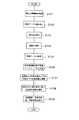
〈第1実施形態〉
図1は、本発明の第1実施形態によるナビゲーション装置の概要図である。また、図2は、本実施形態によるナビゲーション装置のシステム構成図である。まず、図1および図2を用いて、本実施形態のナビゲーション装置のシステム構成を説明する。なお、このナビゲーション装置のシステム構成は、後述する第2〜第5実施形態に共通である。
【0020】
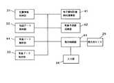
本実施形態のナビゲーションシステムは、ナビゲーションユニット10と、このナビゲーションユニット10にそれぞれ接続されたGPSアンテナ21,FMアンテナ22,パルスセンサ23,および表示用モニタ25、そして、地図データ等が格納されたCD−ROM24から構成される。ナビゲーションユニット10は、GPS受信機11,FM多重受信機12,CPU13,ROM14,RAM15,およびジャイロ17とを有している。
【0021】
CPU13は、ナビゲーションシステム全体の制御を行うための制御装置であり、RAM15は、CPU13の作業領域である。そして、ROM14には、CPU13が制御を行うためのプログラムが格納されている。
【0022】
GPSアンテナ21およびGPS受信機11は、自動車の現在位置を測位するために、GPS(Global Positioning System)衛星からの信号を受信する。パルスセンサ23は、自動車の車輪の回転に応じて発生されたパルスを感知するセンサであり、自動車の移動距離を計測するために用いられる。そして、ジャイロ17は、自動車の移動方向を計測するための装置である。これらの各機器により、自動車の現在位置情報や移動情報等が得られる。
【0023】
FMアンテナ22およびFM多重受信機は、FM放送局から発信された電波を受信する。FM放送局から放送される情報には、気象に関する各種のデータや、交通情報提供システム、具体的には、VICS(Vehicle Information and Communication System)による交通情報等が含まれる。
【0024】
表示用モニタ25は、液晶パネルやCRT等からなる表示装置であり、ナビゲーションユニット10の制御内容に従って、地図や各種の情報を表示する。この表示用モニタ25の画面の下部には、自動車の利用者(以下、「ユーザ」という)がナビゲーションシステムに対して命令や入力を行うための入力装置16が備えられている。CD−ROM24には、地図データやこの地図データを用いるために必要なプログラムが格納されている。
【0025】
図3は、本第1実施形態の機能ブロック図である。本実施形態のナビゲーション装置は、位置情報取得部31、地図データ格納部32、気象データ取得部33、気象データ解析部34、表示制御部35、入力部36、および表示用モニタ25を有している。
【0026】
位置情報取得手段としての位置情報取得部31は、GPS衛星から発信される電波や、ジャイロ17、およびパルスセンサ23によって得られる情報から、自動車の現在位置の緯度や経度,高度、および自動車の移動距離や移動方向など、自動車の位置に関する情報を取得する。地図データ格納手段としての地図データ格納部32は、ユーザに現在位置や経路案内を行うために、表示用モニタ25に表示されるべき地図データを格納する。
【0027】
気象データ取得部33は、FM放送局から発信される各種情報のうち、気象情報を取得する。この気象データ33によって取得される気象データには、各地域における気温,風向,風速,降水量,日照,積雪,潮位などの実況情報や、天気予報,気温,降水確率などの予報、所定面積単位に区分された各地域の一定時間毎の天気,降水量,降水確率,気温などのガイダンスと呼ばれる情報、注意報、警報、海上情報などが含まれる。これらの気象情報は定期的に更新される。
【0028】
気象データ解析部34は、気象データ取得部33によって取得された各気象データを解析し、所定面積単位に格子状に区分された各領域(以下、これを「格子領域」という)の気象(天気,降水量,降水確率,気温など)データを各格子領域の座標に対応させた格子気象データに変換する。気象情報取得手段は、これら気象データ取得部33および気象データ解析部34によって構成される。
【0029】
表示制御部35は、ROM14およびCD−ROM24に格納されたプログラムに従って、表示用モニタ25への表示を制御する。すなわち、本実施形態では、表示制御部34は、位置情報取得部31によって取得された自動車の現在位置を地図データ格納部32に格納された地図データ上に表して、表示用モニタ25上に表示する。また、表示制御部34は、気象データ解析部34によって得られた格子気象データを地図データ上に表示するために、地図上の各格子領域を気象データの値によって色分けした表示画像データを生成して、表示用モニタ25に表示する。さらに、表示制御部21は、入力部36から入力された命令に従った処理の制御も行う。入力装置36からは、ユーザによってナビゲーションシステムの操作を行うためのコマンドやデータの入力が行われる。
【0030】
なお、本実施形態では、位置情報取得部31は、GPSアンテナ21,GPS受信機11,ジャイロ17,およびパルスセンサ23、そして、ROM14に格納されたプログラムをCPU13が実行することによって実現される。また、地図データ格納部32は、CD−ROM24によって実現される。
【0031】
また、気象データ取得部33はFMアンテナ22およびFM多重受信機12、そして、ROM14に格納されたプログラムをCPU13が実行することによって実現される。さらに、気象データ解析部34および表示制御部35はROM14およびCD−ROM24に格納されたプログラムをCPU13が実行することによって実現され、入力部36は入力装置16によって実現される。
【0032】
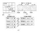
図4は、本第1実施形態のナビゲーションシステムのCPU13がプログラムを実行することによって実現される制御の内容を示すフローチャートであり、図5は、本実施形態において用いられるデータおよび生成される表示画像の一例を示す模式図である。ここでは、各地の天気予報を、ナビゲーションシステムの地図上に面的に表示することを例とする。
【0033】
以下、図1ないし図5を用いて、本実施形態によるナビゲーションシステムの情報提供方法を説明する。まず、ステップS101において、位置情報取得部31によって自動車の現在位置が認識される。すると、現在位置を含む所定範囲の地図データ203が地図データ格納部32から取得される(ステップS102)。
【0034】
次に、ステップS103において、上述した各種の気象データが気象情報取得部33によって取得される。すると、気象データ解析部34は、取得された気象データを解析し、各格子領域における予想天気を数値化したものと各格子領域の座標(緯度,経度等)を対応させた格子気象データテーブルを生成する(ステップS104)。これにより、図5に示すような、各格子領域毎の天気が数値化された格子気象データテーブル201がRAM15上に展開される。この格子気象データテーブルにおいて、1は晴れ,2は曇り,3は雨を、それぞれ示している。
【0035】
表示制御部35は、気象データ解析部34によって生成された格子気象データテーブル201を参照して、図5に示すように、各格子領域を天気によって色分けしたメッシュ画像データ202を生成する(ステップS105)。例えば、格子気象データテーブル201の数値が“1”(晴れ)の領域は赤色,“2”(曇り)の領域は灰色,また“3”(雨)の領域は青色に色分けされる(図5中では、“1”は無地,“2”は斜線,“3”は網目が付されている)。なお、このとき、メッシュ画像データ202は、各格子領域の大きさや座標が、地図データ203の縮尺や座標と一致するように生成される。
【0036】
表示制御部35は、さらに、ステップS102で読み出された地図データ203にステップS104で生成されたメッシュ画像データ202を重ね合わせた画像合成処理を行い、表示画像データ204を生成する(ステップS106)。これにより、表示画像データ204が表示用モニタ25上に表示される(ステップS107)。
【0037】
従って、本実施形態を用いれば、通常のナビゲーション装置で用いられる地図上に各地の天気予報が2次元的に表示される。このため、利用者は、天気予報をはじめとする気象現象の面的分布を容易に把握することができる。また、このような2次元的な天気予報を得ることにより、利用者は、目的地までのルート決定に天気予報を充分活用することができる。
【0038】
なお、ここでは、地図上に天気予報のメッシュデータを重ねて表示する場合を例に挙げて説明したが、これに限らず、他の気象情報を表示することも可能である。例えば、天気の代わりに降水確率や予想気温などの分布を表示してもよい。また、気象データ取得部33によって取得された実況情報を使用して、天気や気温,降水量,風量,積雪,海上の波の高さなどのデータを地図上に表示することもできる。このような気象情報を地図上に重ねて表示することにより、運転のための気象情報だけでなく、スキーやゴルフ,マリンスポーツなどのレジャー情報としても有効に利用することができる。
【0039】
〈第2実施形態〉
図6は、本発明の第2実施形態によるナビゲーションシステムの機能ブロック図である。本実施形態のナビゲーションシステムは、現在地から各格子領域までの推定到着時刻を演算する格子領域到着時刻演算部41と、この格子領域到着時刻演算部41によって得られた各時刻における各格子領域の天気の予測値を求める気象予測値演算部42とを備えることを特徴とする。以下、この図6を用いて本実施形態のナビゲーションシステムの機能構成を説明するが、前述した他の各実施形態と同一の部分に関してはその説明を省略する。
【0040】
気象データ解析部44は、気象データ取得部33によって取得された気象データを解析し、各時間毎の各格子領域の天気を各格子領域の座標に対応させた格子気象データテーブルに変換する。
【0041】
到着時刻演算手段としての格子領域到着時刻演算部41は、現在地から各格子領域に移動した場合の各格子領域への推定到着時刻を演算する。また、気象予測値演算手段としての気象予測値演算部42は、格子領域到着時刻演算部41により得られた演算結果および気象データ解析部44より得られた格子気象データテーブルに基づいて、各到着時刻における各格子領域の予測天気を演算する。そして、表示用モニタ25の表示を制御する表示制御部45は、気象予測値演算部58によって得られた予測天気を地図データ上に示した表示画像データを生成する。
【0042】
なお、本実施形態では、気象データ解析部44,格子領域到着時刻演算部57,気象予測値演算部58は、ROM14およびCD−ROM24に格納されたプログラムを、CPU13が実行することによって実現される。
【0043】
図7は、本第2実施形態によるナビゲーション装置のCPU13がプログラムを実行することによって実現される制御の内容を示すフローチャートである。また、図8は、本実施形態で用いられる各種のデータおよび表示画像の一例を示す模式図である。以下、図6ないし図8を用いて、本実施形態によるナビゲーション装置の情報提供方法を説明する。
【0044】
まず、前述した第1実施形態と同様に、位置情報取得部31により自動車の現在位置が取得され(ステップS111)、この現在位置を含む所定範囲の地図データが地図データ格納部32から読み出される(ステップS112)。次に、格子領域到着時刻演算部41は、自動車の現在位置からの各格子領域の中心点との距離と自動車の平均速度から、各格子領域への推定到着時刻を演算する(ステップS113)。ここで、自動車の平均速度は、予め一定の値に設定されたものであってもよいし、ユーザが任意に設定する値であってもよい。また、本実施形態のナビゲーションシステムをVICSなどの交通情報提供システムと併せて用いる際には、VICSにより得られた交通情報を参照して、自動車の平均速度や各格子領域への推定到着時刻が求められてもよい。図8に、格子領域到着時刻演算部41により得られた各格子領域への推定到着時刻の分布図211を示す。この分布図221において、無地の領域(a)は推定到着時刻が12時〜15時の領域であり、斜線で示された領域(b)は推定到着時刻が15時〜18時の領域、そして、網掛けで示された領域(c)は、推定到着時刻が18時〜21時の領域である。
【0045】
次に、気象データ取得部33により、各種の気象データが取得される(ステップS114)。そして、気象データ解析部44は、得られた気象データを解析し、所定面積単位に区分された各地域の所定時間毎(本実施形態では3時間毎)の天気の予測値を示す格子気象データテーブルを生成する(ステップS115)。図8に、気象データ解析部44により得られた3時間毎の天気の予測値を示す格子気象データテーブル212a〜212cを示す。各テーブル212a〜212cは、それぞれ、12時〜15時,15時〜18時,および18時〜21時の各時間における各格子領域の天気の実況値または予測値を示している。このテーブル212中においても、第1実施形態と同様に、1は晴れ,2は曇り,3は雨を表している。なお、このテーブル212の各格子領域は、分布図211の各格子領域に対応しているものとする。
【0046】
次に、気象予測値演算部42は、得られた格子気象データテーブル212に基づいて、各格子領域の推定到着時刻における天気の予測値を求める(ステップS116)。まず、分布図211の領域(a)の推定到着時刻(12時〜15時)における天気は、気象データテーブル212aにおいて対応する領域(a’)の予測値を参照して求められる。同様に、領域(b)の推定到着時刻(15時〜18時)における天気は、気象データテーブル212bにおいて対応する領域(b’)の値を参照して求められる。同様に、領域(c)の推定到着時刻(18時〜21時)における天気は気象データテーブル212cの領域(c’)の値から求められる。このようにして、各格子領域ごとに、それぞれの推定到着時刻における気象予測値データ213(図8参照)が得られる。すなわち、各格子領域への到着時刻における気象予測値は、当該到着時刻の気象予測値を示す格子気象データテーブルの、対応する領域の予測値を参照して求められる。
【0047】
そして、表示制御部45は、得られた気象予測値データ213より各格子領域を値(天気)毎に色分けしたメッシュ画像データと、地図データ格納部32より読み出された地図データとを重ね合わせた表示画像データを生成し、表示用モニタ25に表示する(ステップS117)。なお、このステップS117における処理は、第1実施形態におけるステップS105〜ステップS107(図4参照)の処理と同様である。
【0048】
このように、本実施形態では、単に天気予報を地図上に面的に示すのではなく、現在地からの各領域への推定到着時刻における天気予測値を、地図上に重ねて表示している。すなわち、本実施形態は、地図上の任意の地域の到着時刻における天気を推定し、地図上に面的に表示することにより、「行く先の天気」の分布が一目でわかるようにするものである。このため、移動時間を考慮した各地域での天気予報を一目で把握することができる。よって、本実施形態によれば、目的地や経路を決める際の判断基準として気象条件を利用することが可能となる。例えば「スキーへ行きたいが、東北方面と信州方面のどちらがよいか」などという場合に、それぞれの到着時刻や移動中の天気をひと目で比較することができるため、判断材料として非常に有効な気象情報を提供することができる。
【0049】
〈第3実施形態〉
図9は、本発明の第3実施形態によるナビゲーション装置の機能ブロック図である。本実施形態のナビゲーション装置は、目的地までの経路を設定する経路設定部51と、設定された経路に沿って移動した場合の経由地点および目的地への到着時間を演算する到着時刻演算部52と、各経由地点,および目的地における天気の予測値を演算する気象予測値演算部53とを備えることを特徴とする。以下、この図9を用いて本実施形態のナビゲーション装置の機能構成を説明するが、システム構成など第1実施形態と同一の部分はその説明を省略する。
【0050】
経路設定手段としての経路設定部51は、ユーザによって指定された目的地までの経路を設定する。ここで設定される経路は、通常のナビゲーションシステムに用いられるルート検索機能によって設定されるものでもよいし、ユーザが任意に設定するものであってもよい。
【0051】
到着時刻演算手段としての到着時刻演算部52は、経路設定部47によって設定された経路上の各経由地点および目的地への到着時刻を演算する。そして、気象予測値演算手段としての気象予測値演算部53は、到着時刻演算部52によって得られた各経由地点および目的地への到着時刻における天気を、気象データ解析部44で得られた格子気象データテーブルに基づいて演算する。
【0052】
本実施形態では、表示制御部55は、表示用モニタ25に表示するための自動車の現在位置を地図データ上に示した画像を生成するとともに、経路設定部51および到着時刻演算部52で得られた目的地までの経路や到着時刻,および経路上の天気等を表示するための表示画像データを生成する。
【0053】
なお、本実施形態では、経路設定部51,到着時刻演算部52,および気象予測値演算部53は、ROM14およびCD−ROM24に格納されたプログラムをCPU13が実行することによって実現される。
【0054】
図10は、本第3実施形態によるナビゲーション装置のCPU13がプログラムを実行することによって実現される制御の内容を示すフローチャートである。また、図11は、本実施形態で用いられる各種のデータの一例を示す図であり、図12は、表示用モニタ25に表示される表示画像の一例を示す模式図である。以下、図9ないし図12を用いて、本実施形態によるナビゲーション装置の情報提供方法を説明する。
【0055】
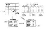
まず、第1実施形態と同様に、位置情報取得部31により自動車の現在位置が取得され(ステップS121)、この現在位置を含む所定範囲の地図データが地図データ格納部42から読み出される(ステップS122)。次に、ユーザからの目的地の指定がなされると(ステップS123)、経路設定部51は現在地から目的地への経路設定を行う(ステップS124)。図11に、経路設定部51によって設定された経路図221を示している(図11中では、地図の表示を省略している)。なお、図11の経路図221の各格子は、取得される気象データの格子領域に対応している。
【0056】
次に、到着時刻演算部52は、自動車の現在位置からの各地点までの距離と自動車の平均速度から、経路設定部51によって設定された経路の各経由地点および目的地までの到着時刻を算出する(ステップS125)。ここで、自動車の平均速度は、予め一定の値に設定されたものであってもよいし、ユーザが任意に設定する値であってもよい。また、本実施形態のナビゲーションシステムをVICSと併せて用いる際には、VICSにより得られた交通情報を参照して、自動車の平均速度や各格子領域への推定到着時刻が求められてもよい。ここで、現在地における時刻を12:00とした場合、図11に示すような各経由地点および目的地への推定到着時刻データ222が得られる。
【0057】
次に、気象データ取得部33により、各種の気象データが取得される(ステップS126)。そして、気象データ解析部44は、得られた気象データを解析して各時間毎の格子気象データテーブルに変換する(ステップS127)。図11に、気象データ解析部44により得られた格子気象データテーブル223a〜223cを示す。各テーブル223a〜223cは、それぞれ、12時〜15時,15〜18時,18時〜21時の各時間における各格子領域の実況値または予測値を表している。なお、このテーブル223の各格子領域は、経路図221の各格子領域に対応しているものとする。これら各テーブル223中では、第1実施形態と同様に、1は晴れ,2は曇り,3は雨を、それぞれ示している。
【0058】
次に、気象予測値演算部53は、気象データ解析部44により得られた格子気象データテーブルを参照して、経路設定部51と到着時刻演算部52によって得られた各経由地点および目的地への到着時刻における気象予測値を演算する(ステップS128)。例えば、現在地における時刻は12:00なので、テーブル223aを参照する。このテーブル223a中の該当するデータは“1”なので、12:00における現在地の天気は「晴れ」であることがわかる(図中該当する数値に○印が付されている)。同様に、経由地点1へは15:30,経由地点2へは17:30に到着するので、それぞれテーブル223bを参照すると、経由地点1における天気は晴れであり、経由地点2における天気は曇りであることが分かる。さらに、目的地へは19:00に到着するので、テーブル223cを参照することにより、目的地の天気は雨であることが分かる。このような作業により、図11に示すような各経由地点,目的地への到着時刻における予測天気のデータ224が得られる。
【0059】
そして、表示制御部55は各ステップで得られた目的地への経路(221),各経由地点および目的地への到着時刻データ(222),そして各経由地点および目的地での到着時刻における天気(224)を、ステップS122で得られた地図データ上に示した表示画像データを生成し、表示用モニタ25に表示する(ステップS129)。これにより、図12(a)に示すような表示画像が、表示用モニタ25に表示される。また、図12(b)に示すように、各地点への到着時刻および天気を表形式で示してもよい。
【0060】
このように、本第3実施形態では、天気は地域と時間によって連続的に変化するものであることに着目し、これら2つの条件をパラメータとして、設定された経路の各経由地点および目的地における天気予報を地図上に表示している。このため、目的地までの各地点における天気予報を一目で知ることができる。しかも、本実施形態では、各地点への到着時刻に基づいた天気予報が表示されるため、ユーザは、より的確な情報を得ることができる。従って、ユーザは、運転計画などに気象情報をより有効に活用することができる。
【0061】
〈第4実施形態〉
図13は、本発明の第4実施形態によるナビゲーション装置の機能ブロック図である。本実施形態のナビゲーションシステムでは、到着時刻演算部62は、経由地点および目的地の到着時刻を自動演算する際に、気象予測値演算部63によって得られる各領域の予想天気に応じて到着時刻を補正することを特徴とし、その他の部分を第3実施形態と同一とする。
【0062】
図14は、本第4実施形態のナビゲーション装置のCPU13がプログラムを実行することによって実現される制御の内容を示すフローチャートである。また、図15は、本実施形態で用いられる各種データの一例を示す図であり、図16は、到着時刻演算部62および気象予測値演算部63によって行われる処理の詳細を示す図である。以下、図13ないし図16を用いて、本実施形態のナビゲーション装置による情報提供方法を説明する。
【0063】
まず、前述の各実施形態と同様に、位置情報取得部31により自動車の現在位置情報が取得され(ステップS131)、この現在位置を含む所定範囲の地図データが地図データ格納部32から読み出される(ステップS132)。次に、ユーザからの目的地の指定がなされると(ステップS133)、経路設定部61は現在地から目的地までの経路設定を行う(ステップS134)。経路設定部61により設定された経路図231を図15(a)に示す。この図15(a)において、各格子は取得される気象データの各格子領域に対応しており、地図の表示は省略されている。また、図15(a)では、現在地から30km毎に経由地点が設定されており、経由地点2から目的地までの距離も30kmであるとする。なお、ステップS131〜ステップS134までの処理は、第3実施形態と同様である。
【0064】
次に、気象データ取得部33により、各種の気象データが取得される(ステップS135)。そして、気象データ解析部44は得られた気象データを解析し、所定時間毎、ここでは3時間毎の格子気象データテーブルを生成する。この処理によって得られた格子気象データテーブル232a〜232cを図15(b)に示す。なお、格子気象データ232a〜232cは経路図231の各格子領域に対応する各領域の天気を示している。
【0065】
以下、図15(c)および図16に示す処理手順で、各経由地点および目的地までの推定到着時刻およびそのときの各地点における予想天気が求められる。まず、気象予測値演算部62は、格子気象データテーブル232aを参照して、出発地における天気を取得する(ステップS137)。図15(c)に示すように、現在地における時刻を14:30とすると、格子気象データ232aの現在地に対応する数値(232a中○印で囲まれた数値)は“1”であるので天気は「晴れ」である。従って、気象予測値演算部63は、現在地の14:30における天気は「晴れ」であると認識する。
【0066】
次に、到着時刻演算部62によって、経由地点1への到着時刻を演算する(ステップS138)。本実施形態では、到着時刻を演算するために用いられる平均速度は天気によって変化する。本実施形態では、到着時刻演算部62は、ROM14内に保持される平均速度テーブル233を参照して、晴れまたは曇りの場合の平均時速を30km/時、雨の場合の平均速度を20km/時と設定する。ここでは、気象予測値演算部63によって得られた現在地の天気は晴れであるので、平均時速を30km/時として経由地点1への到着時刻が計算される。現在地から経由地点1までの距離は30kmであるから、経由地点1間での所要時間は1時間、すなわち、経由地点1への到着時刻は15:30であると認識される。
【0067】
次に、気象予測値演算部63によって到着時刻15:30における天気が求められる(ステップS139)。格子気象データテーブル232bより、このときの経由地点1の気象予測値は3、すなわち雨と認識であることがわかる。このようにして目的地への到着時刻が得られるまで、同様の処理が繰り返される(ステップS140;NO)。
【0068】
すなわち、到着時刻演算部62によって、経由地点1から経由地点2までの距離を30km,平均時速を20km/時とした場合の、経由地点2への到着時刻が計算される。すなわち、この間の所要時間は90分であるので、経由地点2へは17:00に到着すると判断される。このとき、気象予測値演算部63は格子気象データ232bを参照して、経由地点2における予測値は“3”、すなわち天気は雨であると認識する。従って、到着時刻演算部62は、目的地までの平均時速を20km/時として、目的地への到着時刻を計算する。経由地点2から目的地までの距離は30kmであるので、目的地までの所要時間は90分、すなわち目的地への到着時刻は18:30であると判断される。そして、気象予測値演算部63は、格子気象データテーブル231cを参照して、このときの目的地における予測値は“2”、すなわち天気は曇りであると認識する。
【0069】
このようにして、目的地への到着時刻およびそのときの天気が取得されると(ステップS140;YES)、第2実施形態と同様に、目的地への経路,各地点への推定到着時刻,および各地点での到着時刻における天気を、ステップS132で得られた地図データ上に示した表示画像データが、表示制御部65により生成される。そして、図12に示すような表示画像データが表示用モニタ25上に表示される(ステップS141)。
【0070】
すなわち、本実施形態では、到着時刻演算部62は、気象予測値演算部63によって得られた現在位置および各経由地点の気象状態に基づいて設定された移動速度を用いて、次の経由地点または目的地への到着時刻を演算する。また、気象予測値演算部63は、到着時刻演算部62によって得られた現在地,各経由地点,および目的地への到着時刻における気象予測値を、気象データテーブル232を参照して取得する。
【0071】
このように、本実施形態では、目的地までの経路上の気象条件をも考慮して、推定到着時刻を求めているので、第3実施形態よりもさらに正確な到着時刻情報および気象情報をユーザに提供することができる。
【0072】
〈第5実施形態〉
図17は、本発明の第5実施形態によるナビゲーション装置の機能ブロック図である。本実施形態のナビゲーション装置は、目的地への複数の経路を探索する経路探索部71,目的地および経由地点への到着時刻を演算する到着時刻演算部72,目的地および各経由地点における予測気象を求める気象予測値演算部73,および目的地への複数の経路から最適な経路を選択する最適経路選択部74を有し、目的地までの経路探索を行なった際に、探索された複数の経路の中から、気象条件を含めた最も「快適」な経路を選択するものである。
【0073】
以下、図17を用いて本実施形態のナビゲーションシステムの機能構成を説明する。経路探索手段としての経路探索部71は、ユーザによって指定された目的地までの経路を探索する。通常、目的地までの経路は複数存在するので、経路探索部71によって探索される経路も複数である。このような経路探索機能は、ナビゲーションシステムに一般的に用いられているものである。
【0074】
気象予測値演手段としての気象予測値演算部73は、気象データ解析部44によって生成された格子気象データテーブルから、経路探索部71によって探索された各経路について、目的地および各経由地点における気象の予測値を演算する。また、到着時刻演算部72は、経路探索部71によって設定された各経路について、気象予測値演算部73によって得られる各地点の気象予測値を参照して、目的地および各経由地点までの推定到着時刻を演算する。そして、経路選択手段としての最適経路選択部74は、探索された各経路を用いた場合の目的地への推定到着時刻や気象予測値から、ユーザにとって最適な経路を選択する。なお、本実施形態では、経路探索部71,到着時刻演算部72,気象予測値演算部73,および最適経路選択部74は、ROM14およびCD−ROM24に格納されたプログラムをCPU13が実行することによって実現される。
【0075】
図18は、本第5実施形態によるナビゲーションシステムのCPU13がプログラムを実行することによって実現される制御の内容を示すフローチャートである。また、図19は、本実施形態で用いられる各種データの一例を示す図である。以下、図17ないし図19を用いて、本実施形態による情報提供方法を説明する。
【0076】
まず、位置情報取得部31により自動車の現在位置が取得され(ステップS151)、この現在位置を含む所定範囲の地図データが取得される(ステップS152)。
【0077】
次に、ユーザにより目的地の指定がなされる(ステップS153)と、経路探索部71は、現在地から目的地までの経路を探索する(ステップS154)。すると、図19(a)に示すように、現在地から目的地までの3通りの経路が得られる。この図19(a)において、各格子は後のステップで取得される気象データの格子領域に対応しており、地図の表示は省略されている。また、図19(a)では、得られた各経路のそれぞれに、現在地から30km毎に経由地点が設定されており、各経由地点13,22,34から目的地までの距離はいずれも30kmであるとする。
【0078】
次に、気象データ取得部33により、各種の気象データが取得される(ステップS155)。そして、気象データ解析部44により、得られた気象データが解析され、図19(b)に示すような所定時間毎、ここでは、3時間毎の格子気象データテーブル241a〜241cが生成される(ステップS156)。
【0079】
次に、到着時刻演算部72および気象予測値演算部73は、各経路のそれぞれについて、目的地への到着時刻および経路上の天気を求める(ステップS157)。このときの、各経路を用いた際の目的地への到着時刻および経路上の天気の取得方法は、第4実施形態のステップS138〜ステップS140の処理(図14参照)と同様である。これにより、図19(c)に示すような各経路における天気および推定到着時刻が得られる。
【0080】
そして、最適経路選択部74は、探索された3通りの経路の中から、「経路上の天気」と「目的地の到着時刻」の2つの条件に基づいて最適な経路を選択する(ステップS158)。経路の選択にあたっては、経路上の天気を優先する方式(方式Aとする)と、目的地への到着時刻を優先する方式(方式Bとする)とがある。ユーザは、方式Aと方式Bのどちらを採用するかを選択することができる。
【0081】
ユーザが方式Aを選択した場合、最適経路選択部74は、第1の条件である「経路上の天気」に着目し、なるべく雨の少ない地点を経由する経路を選択する。図19(c)に示すように、現在地から目的地までの経路上で雨が予想される経由地点の数は、経路1が0,経路2が2,そして経路3が0である。すなわち、雨の経由地点が最も少ない経路は、経路1と経路3である。続いて、最適経路選択部74は、第2の条件である「目的地の到着時刻」に着目する。経路1と経路3とをそれぞれ用いた場合の目的地への到着時刻を比較すると、経路1が18:30、経路3が19:30であるから、経路1のほうが目的地への到着時刻が早い。この結果、経路1が最適な経路として選択されることになる。
【0082】
また、ユーザが方式Bを選択した場合、最適経路選択部74は、第1の条件である「目的地の到着時刻」に着目し、最も早く目的地に到着する経路を選択する。すると、図19(c)より、経路1を用いた場合の到着時刻は18:30、経路2では18:30、そして、経路3では19:30である。従って、目的地への到着時刻が最も早い経路は、経路1と経路2である。続いて、最適経路選択部74は、第2の条件である「経路上の天気」に着目する。経路1と経路2の経路上の雨の経由地点の数を比較すると、経路1が0であり、経路2が2であるから、雨の経由地点の数は、経路1のほうが少ない。この結果、経路1が最適な経路として選択されることになる。
【0083】
本実施形態では、方式A,Bのいずれを用いた場合でも最適経路として選択される経路は同じであったが、各経路上での天気やその他の条件などにより、選択結果が異なる場合もある。また、方式A,Bともに、第1の条件と第2の条件を用いた場合でも、最適経路が1通りに限定されない場合には、目的地までの道のりや他の交通条件を参考にして最適経路が選択されてもよいし、ユーザがいずれかの経路を選択するものであってもよい。
【0084】
このようにして、目的地までの最適経路が選択されると、第3実施形態と同様に、目的地への最適経路,各地点への推定到着時刻,および経路上の天気を地図データ上に示した表示画像データが表示制御部75によって生成される。そして、図12に示すような表示画像が表示用モニタ25上に表示される(ステップS159)。
【0085】
このように、本実施形態では、経路選択の際に気象条件を取り入れることにより、従来の方法に比べ、より快適で経済的な経路選択が可能となる。
〈第6実施形態〉
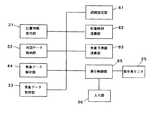
図20は、本発明の第6実施形態による気象情報提供サーバを用いた情報提供システムの概要図であり、図21は、気象情報提供サーバ80の機能ブロック図である。本実施形態は、前述した各実施形態のナビゲーション装置の機能を情報提供サーバに備えることにより、インターネットを介して閲覧端末に地図情報や気象情報を提供するものである。ここでは、第5実施形態の機能を気象情報提供サーバに適用した場合を例として説明する。
【0086】
気象情報提供サーバ80は、インターネット76を介してパーソナルコンピュータなどの情報閲覧端末77に接続されており、通信制御部81を介してデータの授受を行っている。この気象情報提供サーバ80は、通信制御部81の他に、地図データ格納部82,探索条件取得部83,気象データ解析部84,気象データ格納部85,経路探索部86,到着時刻演算部87,気象予測値演算部88,最適経路選択部89,および制御部90を備える。
【0087】
地図データ格納手段としての地図データ格納部82は、閲覧端末77に地図情報を提供するための地図データを格納している。気象情報格納手段および気象情報更新手段としての気象データ格納部85は、放送局や通信基地局等から発信された気象情報を随時取得して格納する。従って、放送局から発信される気象情報が更新されると、気象データ格納部85に格納された気象情報も更新される。気象データ解析部84は、気象データ格納部85に格納された気象情報を解析して、所定時間毎の格子気象データテーブルを生成する。
【0088】
探索条件取得部83は、閲覧端末77によって指定された検索条件(出発地,目的地,経路選択条件など)を取得する。経路選択条件とは、目的地までの経路検索を行う際に、優先される条件(経路上の天気,到着時刻など)を示す。経路設定手段としての経路探索部86は、探索条件取得部83によって取得された出発地から目的地までの複数の経路を探索する。到着時刻演算手段としての到着時刻演算部87は、経路探索部86によって得られた各経路の経由地点および目的地への推定到着時刻を演算する。また、気象予測値演算手段としての気象予測値演算部88は、格子気象データテーブルおよび各経路上の推定到着時刻から、各経路上の気象の予測値を演算する。
【0089】
そして、最適経路選択部89は、情報閲覧端末77から得られた経路選択条件に従って、複数の経路からユーザ(情報閲覧端末77の利用者)の条件に適した経路を選択する。制御部90は、地図データ格納部82に格納された地図データ上に、最適経路や目的地への到着時刻、経路上の天気などを示した画像データを生成し、送信手段としての通信制御部81を介して情報閲覧端末77に送信する。この制御部90に表示画像生成手段が含まれる。
【0090】
なお、本実施形態の気象情報提供サーバ80において、通信制御部81は通信制御装置によって実現され、地図データ格納部82および気象データ格納部85はハードディスク等の記録装置によって実現される。また、探索条件取得部83,気象データ解析部84,経路探索部86,到着時刻演算部87,気象予測値演算部88,最適経路選択部89,および制御部90は、ROMおよびハードディスクに格納されたプログラムをCPUが実行することによって実現される。
【0091】
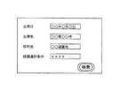
図22および図23は、本実施形態が用いられた際の情報閲覧端末77のディスプレイ上に表示される内容を示す。以下、本実施形態の気象情報提供サーバ80による情報提供方法を説明する。まず、ユーザが、情報閲覧端末77からインターネット76を介して、気象情報提供サーバ80に対して経路検索を行う旨の要求を行うと、図22に示すような表示画像が得られる。ユーザは、キーボード等の入力装置から出発日,出発地,目的地,経路選択条件等を入力することにより、これらのデータを気象情報提供サーバ80へ送信する。
【0092】
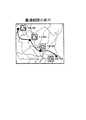
気象情報提供サーバ80は、検索要求および経路探索を行うために必要なデータを情報閲覧端末77から取得すると、前述した第5実施形態の情報提供方法に従って、目的地までの最適経路およびその経路上での天気の予測値などを取得する。気象情報提供サーバ80は、この探索結果を地図上に表示した画像データを生成し、この画像データを、経路探索結果として情報閲覧端末77に返却する。
【0093】
そして、図23に示すように、気象情報提供サーバ80から取得された画像データは、情報閲覧端末77のディスプレイ上に表示される。
このように、本実施形態の気象情報提供サーバを用いれば、屋内においてもユーザが手軽に目的地までの経路探索を行ったり、経路上の気象情報を取得することができる。従って、ユーザは、ドライブやレジャーの計画を立てる際に、気象情報を有効に活用することができる。
【0094】
〈変形例〉
上述した各実施形態は、種々の変更が可能である。例えば、上記各実施形態のナビゲーション装置では、ユーザに対する気象情報の伝達は、表示モニタ25への表示のみにより行われているが、これに限らず、経路上の天気に関する情報を音声でユーザに伝える音声出力機能を備えてもよい。例えば、現在地の天気が晴れであるのに対して、途中経路上に雨の領域があれば、ユーザに対して「この先、雨になります。」といった内容を音声によって伝えることもできる。
【0095】
また、第1〜第5実施形態では、FM放送局から発信された電波をFMアンテナおよびFM多重受信機により受信することにより気象情報を取得している。しかし、ナビゲーションユニット10に携帯電話等の移動通信機器を接続して、インターネット上のサーバに格納された気象情報を取得してもよい。
【0096】
また、第2〜第5実施形態では、3時間ごとの天気の予報のデータを使用して気象予測値の演算を行っているが、他の気象要素、すなわち、気温、降水量、降水確率などの予報データも同様に使用することができる。
【0097】
なお、第1〜第5実施形態は、車載型のナビゲーション装置を想定したものであったが、船舶や航空機に搭載するナビゲーション装置に適用することにより、最適な航路を選定する上で有効となるほか、漁業における安全操業、スカイスポーツやマリンレジャーで必要な気象情報の収集など、様々な方面で有効活用することができる。また、上記各実施形態のナビゲーション装置を携帯型のナビゲーション装置に適用すれば、気象条件によって活動を左右される登山者や、広範囲にわたる気象情報を必要とする農林業従事者などにとって非常に利用価値の高いものとなる。
【0098】
【発明の効果】
本発明によれば、経路上や目的地における面的な気象情報を地図上に併せて表示することができるため、自動車等の運転を行う上で必要な気象情報を的確にユーザに提供することができる。
【図面の簡単な説明】
【図1】 本発明の第1〜第5実施形態によるナビゲーション装置の概要図
【図2】 本発明の第1〜第5実施形態によるナビゲーション装置のシステム構成図
【図3】 本発明の第1実施形態によるナビゲーション装置の機能ブロック図
【図4】 本発明の第1実施形態のナビゲーション装置による情報提供方法を示すフローチャート
【図5】 本発明の第1実施形態において用いられるデータおよび生成される表示画像データを示す模式図
【図6】 本発明の第2実施形態によるナビゲーション装置の機能ブロック図
【図7】 本発明の第2実施形態のナビゲーション装置による情報提供方法を示すフローチャート
【図8】 本発明の第2実施形態において用いられるデータの内容を示す図
【図9】 本発明の第3実施形態によるナビゲーション装置の機能ブロック図
【図10】 本発明の第3実施形態のナビゲーション装置による情報提供方法を示すフローチャート
【図11】 本発明の第3実施形態において用いられるデータの内容を示す図
【図12】 本発明の第3実施形態において生成される表示画像データを示す模式図
【図13】 本発明の第4実施形態によるナビゲーション装置の機能ブロック図
【図14】 本発明の第4実施形態のナビゲーション装置による情報提供方法を示すフローチャート
【図15】 本発明の第4実施形態において用いられるデータの内容を示す図
【図16】 本発明の第4実施形態において、到着時刻演算部62および気象予測値演算部63によって行われる処理の詳細を示す図
【図17】 本発明の第5実施形態によるナビゲーション装置の機能ブロック図
【図18】 本発明の第5実施形態のナビゲーション装置による情報提供方法を示すフローチャート
【図19】 本発明の第5実施形態において用いられるデータの内容を示す図
【図20】 本発明の第6実施形態による気象情報提供サーバを用いた情報提供システムの概要図
【図21】 本発明の第6実施形態による気象情報提供サーバの機能ブロック図
【図22】 本発明の第6実施形態において情報閲覧端末77に表示されるデータを示す図
【図23】 本発明の第6実施形態において情報閲覧端末77に表示される画像データを示す図
【符号の説明】
10 ナビゲーションユニット
11 GPS受信機
12 FM多重受信機
13 CPU
14 ROM
15 RAM
16 入力装置
17 ジャイロ
21 GPSアンテナ
22 FMアンテナ
23 パルスセンサ
24 CD−ROM
25 表示用モニタ
31 位置情報取得部
32 地図データ格納部
33,44 気象データ取得部
34 気象データ解析部
35,45,55,65,75 表示制御部
41 格子領域到着時刻演算部
42,53,63,73 気象予測値演算部
51,61 経路設定部
52,62,72 到着時刻演算部
71 経路探索部
74 最適経路選択部
76 インターネット
77 情報閲覧端末
80 気象情報提供サーバ[0001]
BACKGROUND OF THE INVENTION
The present invention relates to a technique for displaying map information and weather information together on a navigation device or a terminal that browses information via a network.
[0002]
[Prior art]
In recent years, navigation systems that are installed in automobiles and that guide directions to a destination by means of map display or voice have come to be used. Many of the car navigation systems use a traffic information provision system called VICS (Vehicle Information and Communication System), such as route selection taking into account the congestion of roads and prediction of arrival time at the destination. It is used for. In addition, there are those that can acquire a weather forecast of a destination, leisure information, and the like by connecting to the Internet.
[0003]
[Problems to be solved by the invention]
However, weather information that can be acquired using a conventional navigation system is point information of each region, and it is difficult to obtain surface weather information. In addition, since these weather information is displayed in a tabular form, it is difficult to grasp the relationship between the position on the map and the weather. It is difficult to say that such weather information is sufficiently useful information for automobile users. In order for users to make full use of weather information, it is necessary to obtain not only the weather information of the destination but also the surface weather information of the area through which it passes when moving.
[0004]
In addition, since weather greatly affects road conditions and the like, it is necessary to consider weather information in order to search for a more accurate route and predict the arrival time at the destination.
Therefore, by providing area-specific weather information on the map to guide the way to the destination, the weather to the destination can be visually displayed, and the route search taking into account the weather information It is an object of the present invention to provide a technique capable of providing traffic information.
[0005]
[Means for Solving the Problems]
In order to solve the above problems, a navigation device according to the present invention relates to position information acquisition means for measuring latitude, longitude, and altitude at a current position, map data storage means for storing map data, and a predetermined area including the current position. Weather information acquisition means for acquiring weather information, and display means for displaying the weather information acquired by the weather information acquisition means in a superimposed manner at corresponding positions on the map data stored in the map data storage means. (Corresponding to claim 1).
[0006]
More specifically, the first aspect of the navigation device according to the present invention includes position information acquisition means for measuring latitude, longitude, and altitude at the current position, map data storage means for storing map data, and the current position. The meteorological information acquisition means for acquiring weather information including the weather forecast value of each area divided into predetermined area units for the constant area including, and the corresponding position on the map data stored in the map data storage means, Display means for displaying the weather forecast value of each area acquired by the weather information acquisition means in an overlapping manner (corresponding to claim 2).
[0007]
That is, since the navigation device of the first aspect displays the weather forecast value superimposed on the corresponding position of the map data, it can provide the surface information of the weather forecast of the area including the current position.
[0008]
Here, the weather information acquisition means may be means for receiving weather information transmitted from an information transmission base such as an FM broadcast station, or the weather information stored in the information providing server may be used as a telephone line such as the Internet. It may be a means for obtaining via a network. In addition, weather information includes actual information such as weather, temperature, wind direction, wind speed, precipitation, sunshine, snow cover, tide level, forecasts such as weather forecast, precipitation probability, and predicted temperature, and warning information, warnings, and maritime information. Is included.
[0009]
A second aspect of the navigation device of the present invention is a position information acquisition unit that measures latitude, longitude, and altitude at the current position, a map data storage unit that stores map data, and a predetermined area unit from the current position. Arrival time calculation means for calculating the arrival time to each divided area, weather information acquisition means for acquiring weather information regarding the predetermined area including the current position, and each area obtained by the arrival time calculation means A predicted weather value at the estimated arrival time based on the weather information obtained by the weather information acquisition means, and a corresponding position on the map data stored in the map data storage means. And display means for displaying the weather forecast value at the estimated arrival time of each area obtained by the weather forecast value calculation means in a superimposed manner (claim) Corresponding to 3).
[0010]
That is, since the navigation apparatus of the second aspect shows the distribution of the weather forecast value at the arrival time from the current position to each region on the map, it can provide weather information effective for destination and route setting.
[0011]
A third aspect of the navigation device according to the present invention relates to position information acquisition means for measuring latitude, longitude, and altitude at the current position, map data storage means for storing map data, and a predetermined area including the current position. Meteorological information acquisition means for acquiring weather information, route setting means for setting a route to the destination, each waypoint on the route set by the route setting means, and an estimated arrival time at the destination are calculated. An arrival time calculation means and a weather forecast value at the estimated arrival time at each waypoint and the destination obtained by the arrival time calculation means are calculated based on the weather information obtained by the weather information acquisition means. A route set by the route setting unit at a corresponding position on the map data stored in the map data storage unit; Display means for displaying the estimated arrival times at the transit points and destinations obtained by the arrival time calculating means and the weather predicted values on the route obtained by the weather predicted value calculating means in an overlapping manner; Provided (corresponding to claim 4).
[0012]
That is, the navigation device according to the third aspect acquires the weather forecast value of the destination at the arrival time and the weather forecast value on the route and displays them on the map. Therefore, the user can easily grasp the weather information on the route.
[0013]
In the navigation device of the third aspect, the arrival time calculating means uses the moving speed set based on the current position and the weather condition at each waypoint to the next waypoint or the destination. May be calculated (corresponding to claim 5). In the navigation device having such a configuration, the arrival time calculating means uses the current position obtained by the weather forecast value calculating means and the moving speed set based on the weather condition of each via point, and Alternatively, the arrival time at the destination is calculated. Further, the weather forecast value calculation means acquires the weather forecast value at the current location obtained by the arrival time calculation means, each waypoint, and the arrival time at the destination based on the weather information acquired by the weather information acquisition means. To do.
[0014]
A fourth aspect of the navigation device of the present invention relates to position information acquisition means for measuring latitude, longitude and altitude at the current position, map data storage means for storing map data, and a predetermined area including the current position. Weather information acquisition means for acquiring weather information, route search means for searching for a plurality of routes to a destination, and for each of a plurality of routes searched by the route search means, each waypoint on the route and the destination An arrival time calculating means for calculating an estimated arrival time at the ground, and a weather forecast value at the estimated arrival time at each waypoint and the destination obtained by the arrival time calculating means is obtained by the weather information acquiring means. Meteorological prediction value computing means for computing based on the meteorological information, estimated arrival times to the destination obtained for the plurality of routes, and the respective Based on the weather forecast value on the road, the route selection means for selecting the optimum route from the plurality of routes and the corresponding position on the map data stored in the map data storage means are selected by the route selection means. And a display means for displaying the estimated arrival time at the destination when the selected route is used and the weather forecast value on the selected route in an overlapping manner (corresponding to claim 6).
[0015]
That is, the navigation device according to the fourth aspect searches for an optimum route in consideration of the required time to the destination and the weather condition on the route. Therefore, the safest and most economical route can be provided to the user.
[0016]
The navigation system of the present invention is a navigation system for providing weather information to a navigation device mounted on a vehicle or the like, and (a) a position information acquisition unit that measures latitude, longitude, and altitude at the current position; Map data storage means storing map data, weather information acquisition means for acquiring weather information relating to a predetermined area including the current position, and corresponding positions on the map data stored in the map data storage means, A navigation device comprising display means for displaying weather information acquired by the weather information acquisition means in an overlapping manner; and (b) a weather information transmission device for transmitting weather information to the navigation device. Correspondence).
[0017]
An information providing server according to the present invention is an information providing server for providing information to an information browsing terminal via a network, and includes map data storage means for storing map data, and weather information storage for storing weather information. Means, weather information update means for updating the weather information stored in the weather information storage means every predetermined time, and the weather information storage means at a corresponding position on the map data stored in the map data storage means Display information generating means for generating a display image for displaying the weather information obtained by overlapping, and transmitting means for transmitting the display image to the information browsing terminal (corresponding to claim 10).
[0018]
DETAILED DESCRIPTION OF THE INVENTION
1st-5th Embodiment of this invention is mounted in a motor vehicle etc., and relates to the car navigation apparatus which guides the way to the destination by displaying a map on a monitor, 6th Embodiment is via the internet. The present invention relates to an information providing server for providing map information and weather information to a personal computer or the like. Embodiments of the present invention will be described below with reference to the drawings.
[0019]
<First Embodiment>
FIG. 1 is a schematic diagram of a navigation device according to a first embodiment of the present invention. FIG. 2 is a system configuration diagram of the navigation apparatus according to the present embodiment. First, the system configuration of the navigation device of the present embodiment will be described with reference to FIGS. 1 and 2. The system configuration of this navigation device is common to second to fifth embodiments described later.
[0020]
The navigation system of the present embodiment includes a
[0021]
The
[0022]
The
[0023]
The
[0024]
The display monitor 25 is a display device including a liquid crystal panel, a CRT, and the like, and displays a map and various types of information according to the control content of the
[0025]
FIG. 3 is a functional block diagram of the first embodiment. The navigation device of this embodiment includes a position
[0026]
The position
[0027]
The meteorological
[0028]
The meteorological
[0029]
The
[0030]
In the present embodiment, the position
[0031]
The meteorological
[0032]
FIG. 4 is a flowchart showing the contents of control realized by the
[0033]
Hereinafter, the information providing method of the navigation system according to the present embodiment will be described with reference to FIGS. First, in step S101, the position
[0034]
Next, in step S103, the various weather data described above is acquired by the weather
[0035]
The
[0036]
Further, the
[0037]
Therefore, if this embodiment is used, the weather forecast of each place is displayed two-dimensionally on the map used with a normal navigation apparatus. For this reason, the user can easily grasp the surface distribution of weather phenomena including the weather forecast. Also, by obtaining such a two-dimensional weather forecast, the user can fully utilize the weather forecast for determining the route to the destination.
[0038]
Here, the case where the weather forecast mesh data is displayed over the map has been described as an example. However, the present invention is not limited to this, and other weather information can also be displayed. For example, instead of the weather, a distribution such as the probability of precipitation and the predicted temperature may be displayed. Further, by using the actual condition information acquired by the weather
[0039]
Second Embodiment
FIG. 6 is a functional block diagram of a navigation system according to the second embodiment of the present invention. The navigation system of this embodiment includes a lattice area arrival
[0040]
The meteorological
[0041]
The lattice area arrival
[0042]
In the present embodiment, the weather
[0043]
FIG. 7 is a flowchart showing the contents of control realized by the
[0044]
First, as in the first embodiment described above, the current position of the vehicle is acquired by the position information acquisition unit 31 (step S111), and a predetermined range of map data including the current position is read from the map data storage unit 32 ( Step S112). Next, the lattice area arrival
[0045]
Next, various weather data are acquired by the weather data acquisition part 33 (step S114). Then, the meteorological
[0046]
Next, the weather forecast
[0047]
Then, the
[0048]
Thus, in this embodiment, the weather forecast is not simply shown on the map, but the weather forecast value at the estimated arrival time from the current location to each area is displayed on the map. That is, in this embodiment, the weather at the arrival time of an arbitrary area on the map is estimated and displayed on the map so that the distribution of the “destination weather” can be known at a glance. . For this reason, it is possible to grasp at a glance the weather forecast in each region considering the travel time. Therefore, according to the present embodiment, it is possible to use weather conditions as a determination criterion when determining a destination and a route. For example, if you want to go skiing, which is better, Tohoku or Shinshu, you can compare the arrival time and moving weather at a glance. Information can be provided.
[0049]
<Third Embodiment>
FIG. 9 is a functional block diagram of the navigation device according to the third embodiment of the present invention. The navigation device of this embodiment includes a
[0050]
A
[0051]
An arrival
[0052]
In the present embodiment, the
[0053]
In this embodiment, the
[0054]
FIG. 10 is a flowchart showing the contents of control realized by the
[0055]
First, as in the first embodiment, the current position of the car is acquired by the position information acquisition unit 31 (step S121), and a predetermined range of map data including the current position is read from the map data storage unit 42 (step S122). ). Next, when the destination is designated by the user (step S123), the
[0056]
Next, the arrival
[0057]
Next, various types of weather data are acquired by the weather data acquisition unit 33 (step S126). Then, the meteorological
[0058]
Next, the weather forecast
[0059]
The
[0060]
Thus, in the third embodiment, paying attention to the fact that the weather changes continuously depending on the region and time, these two conditions are used as parameters for each waypoint and destination at the set route. The weather forecast is displayed on the map. For this reason, the weather forecast at each point to the destination can be known at a glance. In addition, in the present embodiment, since the weather forecast based on the arrival time at each point is displayed, the user can obtain more accurate information. Therefore, the user can use the weather information more effectively in the operation plan and the like.
[0061]
<Fourth embodiment>
FIG. 13 is a functional block diagram of a navigation device according to the fourth embodiment of the present invention. In the navigation system of the present embodiment, the arrival
[0062]
FIG. 14 is a flowchart showing the contents of control realized by the
[0063]
First, as in the above-described embodiments, the current position information of the vehicle is acquired by the position information acquisition unit 31 (step S131), and a predetermined range of map data including the current position is read from the map data storage unit 32 ( Step S132). Next, when the destination is specified by the user (step S133), the
[0064]
Next, various types of weather data are acquired by the weather data acquisition unit 33 (step S135). Then, the meteorological
[0065]
Hereinafter, the estimated arrival time to each waypoint and the destination and the expected weather at each point at that time are obtained by the processing procedure shown in FIG. First, the weather forecast
[0066]
Next, the arrival
[0067]
Next, the weather at the arrival time 15:30 is obtained by the weather forecast value calculation unit 63 (step S139). From the lattice weather data table 232b, it can be seen that the weather forecast value of the
[0068]
That is, the arrival
[0069]
Thus, when the arrival time at the destination and the weather at that time are acquired (step S140; YES), the route to the destination, the estimated arrival time at each point, as in the second embodiment, The
[0070]
In other words, in the present embodiment, the arrival
[0071]
As described above, in the present embodiment, the estimated arrival time is obtained in consideration of the weather conditions on the route to the destination, so that more accurate arrival time information and weather information than the third embodiment can be obtained by the user. Can be provided.
[0072]
<Fifth Embodiment>
FIG. 17 is a functional block diagram of a navigation device according to the fifth embodiment of the present invention. The navigation device of this embodiment includes a
[0073]
Hereinafter, the functional configuration of the navigation system of this embodiment will be described with reference to FIG. A
[0074]
A weather forecast
[0075]
FIG. 18 is a flowchart showing the contents of control realized by the
[0076]
First, the current position of the vehicle is acquired by the position information acquisition unit 31 (step S151), and map data in a predetermined range including the current position is acquired (step S152).
[0077]
Next, when the destination is specified by the user (step S153), the
[0078]
Next, various weather data are acquired by the weather data acquisition part 33 (step S155). Then, the meteorological
[0079]
Next, the arrival
[0080]
Then, the optimum
[0081]
When the user selects method A, the optimum
[0082]
When the user selects method B, the optimum
[0083]
In this embodiment, the route selected as the optimum route is the same regardless of which method A or B is used. However, the selection result may differ depending on the weather on the route or other conditions. . In both cases A and B, even if the first and second conditions are used, if the optimal route is not limited to one, the route to the destination and other traffic conditions may be used as a reference. A route may be selected, or the user may select one of the routes.
[0084]
When the optimum route to the destination is selected in this way, the optimum route to the destination, the estimated arrival time at each point, and the weather on the route are displayed on the map data as in the third embodiment. The displayed display image data is generated by the
[0085]
As described above, in the present embodiment, it is possible to select a route more comfortably and economically than the conventional method by incorporating the weather condition at the time of route selection.
<Sixth Embodiment>
FIG. 20 is a schematic diagram of an information providing system using a weather information providing server according to a sixth embodiment of the present invention, and FIG. 21 is a functional block diagram of the weather
[0086]
The weather
[0087]
The map
[0088]
The search
[0089]
Then, the optimum
[0090]
In the weather
[0091]
22 and 23 show the contents displayed on the display of the
[0092]
When the weather
[0093]
Then, as shown in FIG. 23, the image data acquired from the weather
As described above, by using the weather information providing server of the present embodiment, the user can easily search for a route to the destination or acquire the weather information on the route even indoors. Therefore, the user can effectively use the weather information when planning driving and leisure.
[0094]
<Modification>
Each embodiment mentioned above can change variously. For example, in the navigation device of each of the above embodiments, the weather information is transmitted to the user only by display on the
[0095]
In the first to fifth embodiments, weather information is acquired by receiving radio waves transmitted from an FM broadcast station using an FM antenna and an FM multiplex receiver. However, weather information stored in a server on the Internet may be acquired by connecting a mobile communication device such as a mobile phone to the
[0096]
In the second to fifth embodiments, weather forecast values are calculated using weather forecast data every three hours, but other weather elements, that is, temperature, precipitation, precipitation probability, etc. The forecast data can be used in the same way.
[0097]
The first to fifth embodiments are assumed to be on-vehicle navigation devices, but are effective in selecting an optimum route by applying to a navigation device mounted on a ship or an aircraft. In addition, it can be effectively used in various fields such as safe operation in fisheries and collection of weather information necessary for sky sports and marine leisure. In addition, if the navigation device of each of the above embodiments is applied to a portable navigation device, it is very useful for mountaineers whose activities are affected by weather conditions and agricultural and forestry workers who need extensive weather information. Will be expensive.
[0098]
【The invention's effect】
According to the present invention, since the surface weather information on the route and the destination can be displayed together on the map, the weather information necessary for driving a car or the like is accurately provided to the user. Can do.
[Brief description of the drawings]
FIG. 1 is a schematic diagram of a navigation apparatus according to first to fifth embodiments of the present invention.
FIG. 2 is a system configuration diagram of a navigation apparatus according to first to fifth embodiments of the present invention.
FIG. 3 is a functional block diagram of the navigation device according to the first embodiment of the present invention.
FIG. 4 is a flowchart showing an information providing method by the navigation device according to the first embodiment of the present invention.
FIG. 5 is a schematic diagram showing data used in the first embodiment of the present invention and display image data to be generated.
FIG. 6 is a functional block diagram of a navigation device according to a second embodiment of the present invention.
FIG. 7 is a flowchart showing an information providing method by the navigation device according to the second embodiment of the present invention.
FIG. 8 is a view showing the contents of data used in the second embodiment of the present invention.
FIG. 9 is a functional block diagram of a navigation device according to a third embodiment of the present invention.
FIG. 10 is a flowchart showing an information providing method by the navigation device according to the third embodiment of the present invention.
FIG. 11 is a view showing the contents of data used in the third embodiment of the present invention.
FIG. 12 is a schematic diagram showing display image data generated in the third embodiment of the present invention.
FIG. 13 is a functional block diagram of a navigation device according to a fourth embodiment of the present invention.
FIG. 14 is a flowchart showing an information providing method by the navigation device according to the fourth embodiment of the present invention.
FIG. 15 is a view showing the contents of data used in the fourth embodiment of the present invention.
FIG. 16 is a diagram showing details of processing performed by an arrival
FIG. 17 is a functional block diagram of a navigation device according to a fifth embodiment of the present invention.
FIG. 18 is a flowchart showing an information providing method by the navigation device according to the fifth embodiment of the present invention.
FIG. 19 is a view showing the contents of data used in the fifth embodiment of the present invention.
FIG. 20 is a schematic diagram of an information providing system using a weather information providing server according to a sixth embodiment of the present invention.
FIG. 21 is a functional block diagram of a weather information providing server according to a sixth embodiment of the present invention.
FIG. 22 is a diagram showing data displayed on the
FIG. 23 is a diagram showing image data displayed on the
[Explanation of symbols]
10 Navigation unit
11 GPS receiver
12 FM multiplex receiver
13 CPU
14 ROM
15 RAM
16 input devices
17 Gyro
21 GPS antenna
22 FM antenna
23 Pulse sensor
24 CD-ROM
25 Display monitor
31 Location information acquisition unit
32 Map data storage
33,44 Weather data acquisition unit
34 Meteorological Data Analysis Department
35, 45, 55, 65, 75 Display control unit
41 Lattice region arrival time calculator
42, 53, 63, 73 Weather forecast value calculator
51, 61 Route setting unit
52, 62, 72 Arrival time calculator
71 Route search unit
74 Optimal route selector
76 Internet
77 Information browsing terminal
80 Weather information server
Claims (8)
Translated fromJapanese地図データを格納した地図データ格納手段と、
前記現在位置を含む所定領域に関する気象情報を取得する気象情報取得手段と、
目的地への複数の経路を探索する経路探索手段と、
前記経路探索手段によって探索された複数の経路のそれぞれについて、経路上の各経由地および前記目的地への推定到着時刻を演算する到着時刻演算手段と、
前記到着時刻演算手段によって得られた前記各経由地および前記目的地への推定到着時刻における気象予測値を、前記気象情報取得手段によって得られた気象情報に基づいて演算する気象予測値演算手段と、
前記目的地の到着時刻を優先して選択する方式と前記各経路上の天気を優先して選択する方式とを有し、前記複数の経路について得られた前記目的地への推定到着時刻および前記各経路上の気象予測値に基づいて、前記複数の経路から最適な経路を選択する経路選択手段と、
前記地図データ格納手段に格納された地図データ上の対応する位置に、前記経路選択手段によって選択された選択経路,前記選択経路を用いた際の前記目的地への推定到着時刻,および前記選択経路上の前記気象予測値を重ねて表示する表示手段とを備えるナビゲーション装置。Position information acquisition means for measuring latitude, longitude and altitude at the current position;
Map data storage means for storing map data;
Weather information acquisition means for acquiring weather information relating to a predetermined area including the current position;
Route search means for searching for a plurality of routes to the destination;
For each of the plurality of routes searched by the route search means, arrival time calculation means for calculating an estimated arrival time at each waypoint on the route and the destination;
A weather prediction value calculation means for calculating a weather prediction value at the estimated arrival time at each waypoint and the destination obtained by the arrival time calculation means based on the weather information obtained by the weather information acquisition means; ,
A method of preferentially selecting the arrival time of the destination and a method of preferentially selecting the weather on each route , the estimated arrival times at the destination obtained for the plurality of routes, and the Route selection means for selecting an optimum route from the plurality of routes based on a weather forecast value on each route;
Wherein the corresponding position on the map data storage unit stored in the map data, selectedselected path by the path selection unit, the estimated time of arrival at the destination when using the selected path, and the selected route A navigation device comprising display means for displaying the weather forecast value above in a superimposed manner.
前記請求項1又は2に記載のナビゲーション装置と、
前記ナビゲーション装置に対して気象情報を送信する気象情報送信装置とを備えるナビゲーションシステム。A navigation system for providing weather information to a navigation device mounted on a vehicle or the like,
The navigation device accordingto claim 1 or 2 ,
A navigation system comprising a weather information transmitting device that transmits weather information to the navigation device.
現在位置における緯度,経度,高度を計測するステップと、
前記現在位置を含む所定領域に関する気象情報を取得するステップと、
目的地への複数の経路を探索するステップと、
前記複数の経路を探索するステップにおいて探索された複数の経路のそれぞれについて、経路上の各経由地および前記目的地への推定到着時刻を演算するステップと、
前記気象情報を取得するステップにおいて得られた気象情報に基づいて、前記推定到着時刻を演算するステップにおいて得られた前記各経由地および前記目的地への推定到着時刻における気象予測値を演算するステップと、
前記目的地の到着時刻を優先して選択する方式と前記各経路上の天気を優先して選択する方式とを有し、前記複数の経路について得られた前記目的地への推定到着時刻および前記各経路上の気象予測値に基づいて、前記複数の経路から最適な経路を選択するステップと、
地図データ上の対応する位置に、前記最適な経路を選択するステップにおいて選択された選択経路,前記選択経路を用いた際の前記目的地への推定到着時刻,および前記選択経路上の前記気象予測値を重ねて表示するステップをコンピュータに実行させるためのプログラムを格納したコンピュータが読み取り可能な記録媒体。A computer-readable recording medium storing a programforcausing a computer to execute astep of providing traffic information and weather information to a user such as an automobile,
Measuring the latitude, longitude and altitude at the current position;
Obtaining weather information relating to a predetermined area including the current position;
Searching for multiple routes to the destination;
For each of the plurality of routes searched in the step of searching for the plurality of routes, calculating an estimated arrival time at each waypoint on the route and the destination;
A step of calculating a weather forecast value at the estimated arrival time at each waypoint and at the destination obtained in the step of calculating the estimated arrival time based on the weather information obtained in the step of acquiring the weather information When,
A method of preferentially selecting the arrival time of the destination and a method of preferentially selecting the weather on each route, the estimated arrival times at the destination obtained for the plurality of routes, and the Selecting an optimal route from the plurality of routes based on weather forecast values on each route;
Theselected route selected in the step of selecting the optimum route at the corresponding position on the map data, the estimated arrival time at the destination when using the selected route, and the weather forecast on the selected route A computer-readable recording medium storinga program forcausing a computer to execute a stepof displayingvalues superimposed.
現在位置における緯度,経度,高度を計測するステップと、
前記現在位置を含む所定領域に関する気象情報を取得するステップと、
目的地への複数の経路を探索するステップと、
前記複数の経路を探索するステップにおいて探索された複数の経路のそれぞれについて、経路上の各経由地および前記目的地への推定到着時刻を演算するステップと、
前記気象情報を取得するステップにおいて得られた気象情報に基づいて、前記推定到着時刻を演算するステップにおいて得られた前記各経由地および前記目的地への推定到着時刻における気象予測値を演算するステップと、
前記目的地の到着時刻を優先して選択する方式と前記各経路上の天気を優先して選択する方式とを有し、前記複数の経路について得られた前記目的地への推定到着時刻および前記各経路上の気象予測値に基づいて、前記複数の経路から最適な経路を選択するステップと
地図データ上の対応する位置に、前記最適な経路を選択するステップにおいて選択された選択経路,前記選択経路を用いた際の前記目的地への推定到着時刻,および前記選択経路上の前記気象予測値を重ねて表示するステップとを含む情報提供方法。An information providing method for providing traffic information and weather information to users such as automobiles,
Measuring the latitude, longitude and altitude at the current position;
Obtaining weather information relating to a predetermined area including the current position;
Searching for multiple routes to the destination;
For each of the plurality of routes searched in the step of searching for the plurality of routes, calculating an estimated arrival time at each waypoint on the route and the destination;
A step of calculating a weather forecast value at the estimated arrival time at each waypoint and at the destination obtained in the step of calculating the estimated arrival time based on the weather information obtained in the step of acquiring the weather information When,
A method of preferentially selecting the arrival time of the destination and a method of preferentially selecting the weather on each route, the estimated arrival times at the destination obtained for the plurality of routes, and the The selection route selected in the step of selecting the optimum route from the plurality of routes and the step of selecting the optimum route at the corresponding position on the map databased on the weather forecast value on each route, theselection An information providing methodincluding the step of displayingthe estimated arrival time at the destination when using a route and the weather forecast value on the selected route in an overlapping manner.
現在位置における緯度,経度,高度を計測する位置情報取得手段と、
地図データを格納した地図データ格納手段と、
前記現在位置を含む所定領域に関する気象情報を格納する気象情報格納手段と、
前記気象情報格納手段に格納された気象情報を所定時間毎に更新する気象情報更新手段と、
情報閲覧端末により指定された目的地への複数の経路を探索する経路探索手段と、
前記経路探索手段によって探索された複数の経路のそれぞれについて、経路上の各経由地および前記目的地への推定到着時刻を演算する到着時刻演算手段と、
前記到着時刻演算手段によって得られた前記各経由地および前記目的地への推定到着時刻における気象予測値を、前記気象情報格納手段に格納された気象情報に基づいて取得する気象予測値演算手段と、
前記目的地の到着時刻を優先して選択する方式と前記各経路上の天気を優先して選択する方式とを有し、前記複数の経路について得られた前記目的地への推定到着時刻および前記各経路上の気象予測値に基づいて、前記複数の経路から最適な経路を選択する経路選択手段と、
前記地図データ格納手段に格納された地図データ上の対応する位置に、前記経路選択手段によって選択された選択経路,前記選択経路を用いた際の前記到着時刻演算手段によって得られた前記各経由地および前記目的地への推定到着時刻,および前記気象予測値演算手段によって得られた前記選択経路上の気象予測値を重ねて表示する表示画像を生成する表示画像生成手段と、
前記情報閲覧端末に前記表示画像を送信する送信手段とを備える気象情報提供サーバ。An information providing server for providing information to an information browsing terminal via a network,
Position information acquisition means for measuring latitude, longitude and altitude at the current position;
Map data storage means for storing map data;
Weather information storage means for storing weather informationrelating to a predetermined area including the current position ;
Weather information updating means for updating the weather information stored in the weather information storage means every predetermined time;
Route search means for searching for aplurality of routes to the destination designated by the information browsing terminal;
For each of the plurality of routes searched by the route search means, arrival time calculation means for calculating an estimated arrival time at each waypoint on the route and the destination;
A weather prediction value calculation means for obtaining a weather prediction value at the estimated arrival time at each waypoint and the destination obtained by the arrival time calculation means based on the weather information stored in the weather information storage means; ,
A method of preferentially selecting the arrival time of the destination and a method of preferentially selecting the weather on each route, the estimated arrival times at the destination obtained for the plurality of routes, and the Route selection means for selecting an optimum route from the plurality of routes based on a weather forecast value on each route;
At the corresponding position on the map data stored in the map data storage means, theselected route selected by the route selection means, and each waypoint obtained by the arrival time calculation meanswhen using the selected route Display image generation means for generating a display image for displaying the estimated arrival time at the destination and the weather forecast value on theselected route obtained by the weather forecast value calculation means;
A weather information providing server comprising: a transmission unit that transmits the display image to the information browsing terminal.
現在位置における緯度,経度,高度を計測するステップと、
前記現在位置を含む所定領域に関する気象情報を取得するステップと、
前記気象情報を所定時間毎に更新するステップと、
情報閲覧端末により指定された目的地への複数の経路を探索するステップと、
前記複数の経路を探索するステップにおいて探索された複数の経路のそれぞれについて、経路上の各経由地および前記目的地への推定到着時刻を演算するステップと、
前記気象情報を取得するステップにおいて得られた気象情報に基づいて、前記推定到着時刻を演算するステップにおいて得られた前記各経由地および前記目的地への推定到着時刻における気象予測値を取得するステップと、
前記目的地の到着時刻を優先して選択する方式と前記各経路上の天気を優先して選択する方式とを有し、前記複数の経路について得られた前記目的地への推定到着時刻および前記各経路上の気象予測値に基づいて、前記複数の経路から最適な経路を選択するステップと、
地図データ上の対応する位置に、前記最適な経路を選択するステップにおいて選択された経路,前記選択経路を用いた際の前記推定到着時刻を演算するステップにおいて得られた前記各経由地および前記目的地への推定到着時刻,および前記気象予測値を取得するステップにおいて得られた前記選択経路上の気象予測値を重ねて表示する表示画像を生成するステップと、
報閲覧端末に前記表示画像を送信するステップとを備える気象情報提供方法。An information providing method for providing information to an information browsing terminal via a network,
Measuring the latitude, longitude and altitude at the current position;
Obtaining weather informationrelating to a predetermined area including the current position ;
Updating the weather information every predetermined time;
Searching for multiple routes to the destination specified by the information viewing terminal;
For each of the plurality of routes searched in the step of searching for the plurality of routes, calculating an estimated arrival time at each waypoint on the route and the destination;
A step of acquiring a weather prediction value at the estimated arrival time at each waypoint and at the destination obtained in the step of calculating the estimated arrival time based on the weather information obtained in the step of acquiring the weather information. When,
A method of preferentially selecting the arrival time of the destination and a method of preferentially selecting the weather on each route, the estimated arrival times at the destination obtained for the plurality of routes, and the Selecting an optimal route from the plurality of routes based on weather forecast values on each route;
Theroute selected in the step of selecting the optimum route at the corresponding position on the map data, therespective transit points obtained in the step of calculating the estimated arrival time when using the selected route, and the purpose Generating a display image for displayingthe estimated arrival time on the ground and the weather forecast value on the selected route obtained in the step of obtaining the weather forecast value ;
A weather information providing method comprising: transmitting the display image to a report browsing terminal.
現在位置における緯度,経度,高度を計測するステップと、
前記現在位置を含む所定領域に関する気象情報を取得するステップと、
前記気象情報を所定時間毎に更新するステップと、
情報閲覧端末により指定された目的地への複数の経路を探索するステップと、
前記複数の経路を探索するステップにおいて探索された複数の経路のそれぞれについて、経路上の各経由地および前記目的地への推定到着時刻を演算するステップと、
前記気象情報を格納するステップにおいて得られた気象情報に基づいて、前記推定到着時刻を演算するステップにおいて得られた前記各経由地および前記目的地への推定到着時刻における気象予測値を取得するステップと、
前記目的地の到着時刻を優先して選択する方式と前記各経路上の天気を優先して選択する方式とを有し、前記複数の経路について得られた前記目的地への推定到着時刻および前記各経路上の気象予測値に基づいて、前記複数の経路から最適な経路を選択するステップと、
地図データ上の対応する位置に、前記最適な経路を選択するステップにおいて選択された経路,前記選択経路を用いた際の前記到着時刻を演算するステップにおいて得られた前記各経由地および前記目的地への推定到着時刻,および前記気象予測値を取得するステップにおいて得られた前記選択経路上の気象予測値を重ねて表示する表示画像を生成するステップと、
情報閲覧端末に前記表示画像を送信するステップとをコンピュータに実行させるためのプログラムを格納したコンピュータが読み取り可能な記録媒体。A computer-readable recording medium storing a programforcausing a computer to execute astep of providing information to an information browsing terminal via a network,
Measuring the latitude, longitude and altitude at the current position;
Obtaining weather informationrelating to a predetermined area including the current position ;
Updating the weather information every predetermined time;
Searching for multiple routes to the destination specified by the information viewing terminal;
For each of the plurality of routes searched in the step of searching for the plurality of routes, calculating an estimated arrival time at each waypoint on the route and the destination;
A step of obtaining a weather forecast value at the estimated arrival time at each waypoint and at the destination obtained in the step of calculating the estimated arrival time based on the weather information obtained in the step of storing the weather information. When,
A method of preferentially selecting the arrival time of the destination and a method of preferentially selecting the weather on each route, the estimated arrival times at the destination obtained for the plurality of routes, and the Selecting an optimal route from the plurality of routes based on weather forecast values on each route;
Theroute selected in the step of selecting the optimum route at the corresponding position on the map data,each of the waypoints and the destination obtained in the step of calculating the arrival time when using the selected route Generating a display image for displayingthe estimated arrival time at and the weather forecast value on the selected route obtained in the step of obtaining the weather forecast value ;
A computer-readable recording medium storinga program forcausing a computer to execute the step of transmitting the display image to an information browsing terminal.
Priority Applications (1)
| Application Number | Priority Date | Filing Date | Title |
|---|---|---|---|
| JP6743299AJP4197790B2 (en) | 1999-03-12 | 1999-03-12 | Navigation device, navigation system, and weather information providing server |
Applications Claiming Priority (1)
| Application Number | Priority Date | Filing Date | Title |
|---|---|---|---|
| JP6743299AJP4197790B2 (en) | 1999-03-12 | 1999-03-12 | Navigation device, navigation system, and weather information providing server |
Publications (2)
| Publication Number | Publication Date |
|---|---|
| JP2000258174A JP2000258174A (en) | 2000-09-22 |
| JP4197790B2true JP4197790B2 (en) | 2008-12-17 |
Family
ID=13344759
Family Applications (1)
| Application Number | Title | Priority Date | Filing Date |
|---|---|---|---|
| JP6743299AExpired - Fee RelatedJP4197790B2 (en) | 1999-03-12 | 1999-03-12 | Navigation device, navigation system, and weather information providing server |
Country Status (1)
| Country | Link |
|---|---|
| JP (1) | JP4197790B2 (en) |
Cited By (1)
| Publication number | Priority date | Publication date | Assignee | Title |
|---|---|---|---|---|
| JP2019090728A (en)* | 2017-11-15 | 2019-06-13 | クラリオン株式会社 | Server, onboard device, information providing system, information providing method, and information device |
Families Citing this family (64)
| Publication number | Priority date | Publication date | Assignee | Title |
|---|---|---|---|---|
| JP4779257B2 (en)* | 2001-08-09 | 2011-09-28 | 三菱電機株式会社 | Navigation device |
| US6922629B2 (en) | 2001-08-10 | 2005-07-26 | Aisin Aw Co., Ltd. | Traffic information retrieval method, traffic information retrieval system, mobile communication device, and network navigation center |
| JP4194108B2 (en) | 2001-10-12 | 2008-12-10 | オムロン株式会社 | Information processing apparatus, sensor network system, information processing program, and computer-readable recording medium on which information processing program is recorded |
| JP2003130660A (en)* | 2001-10-23 | 2003-05-08 | Alpine Electronics Inc | Facility information providing device |
| JP3687592B2 (en)* | 2001-11-14 | 2005-08-24 | 株式会社エクォス・リサーチ | Weather information display device |
| JP4035813B2 (en)* | 2002-05-21 | 2008-01-23 | アイシン・エィ・ダブリュ株式会社 | Moving body position recognition system |
| JP4035814B2 (en)* | 2002-05-21 | 2008-01-23 | アイシン・エィ・ダブリュ株式会社 | Mobile object position presentation system |
| EP1566665B1 (en) | 2004-02-20 | 2010-08-11 | Harman Becker Automotive Systems GmbH | Apparatus and method for providing ambient parameter data and for determining weather information |
| JP2006046913A (en)* | 2004-07-30 | 2006-02-16 | Aisin Aw Co Ltd | Information providing system and program of information providing method |
| JP4492277B2 (en)* | 2004-09-28 | 2010-06-30 | ノーリツ鋼機株式会社 | Navigation album system |
| JP2006300595A (en)* | 2005-04-18 | 2006-11-02 | Advics:Kk | Navigation system |
| JP2006337182A (en)* | 2005-06-02 | 2006-12-14 | Xanavi Informatics Corp | Car navigation system, traffic information providing device, car navigation device, traffic information providing method, and traffic information providing program |
| JP2007047148A (en)* | 2005-07-13 | 2007-02-22 | Mitsubishi Electric Corp | Navigation device, information center device, and navigation system using them |
| JP2007040912A (en)* | 2005-08-05 | 2007-02-15 | Aisin Aw Co Ltd | Navigation system |
| JP2007064653A (en)* | 2005-08-29 | 2007-03-15 | Matsushita Electric Ind Co Ltd | Arrival information notification system |
| JP4878160B2 (en)* | 2006-01-04 | 2012-02-15 | クラリオン株式会社 | Traffic information display method and navigation system |
| JP4682865B2 (en) | 2006-02-17 | 2011-05-11 | アイシン・エィ・ダブリュ株式会社 | Route search system, route guidance method in route guidance system, and navigation apparatus |
| JP2007292566A (en)* | 2006-04-24 | 2007-11-08 | Onepass:Kk | Weather forecast display system |
| US8793066B2 (en) | 2006-06-27 | 2014-07-29 | Microsoft Corporation | Route monetization |
| US7610151B2 (en) | 2006-06-27 | 2009-10-27 | Microsoft Corporation | Collaborative route planning for generating personalized and context-sensitive routing recommendations |
| WO2008047449A1 (en)* | 2006-10-20 | 2008-04-24 | Pioneer Corporation | Image display device, image display method, image display program, and recording medium |
| JP4952516B2 (en)* | 2006-11-30 | 2012-06-13 | 株式会社デンソー | Weather information notification device, program |
| JP2008145312A (en)* | 2006-12-12 | 2008-06-26 | Universal Shipbuilding Corp | Optimum route search method |
| KR100756545B1 (en)* | 2006-12-21 | 2007-09-07 | 팅크웨어(주) | Route search method and system using weather information and estimated traffic information |
| JP5102501B2 (en)* | 2007-01-24 | 2012-12-19 | クラリオン株式会社 | Map display device |
| JP4837623B2 (en)* | 2007-03-30 | 2011-12-14 | 公益財団法人鉄道総合技術研究所 | Railway operation management method in strong winds |
| JP4365429B2 (en) | 2007-07-24 | 2009-11-18 | トヨタ自動車株式会社 | Navigation device for displaying charging information and vehicle equipped with the device |
| US8180502B2 (en) | 2007-07-31 | 2012-05-15 | Denso Corporation | Apparatus and program for navigation |
| JP4471025B2 (en)* | 2007-07-31 | 2010-06-02 | 株式会社デンソー | Navigation device, program |
| JP4525722B2 (en) | 2007-09-20 | 2010-08-18 | 株式会社デンソー | Weather information display device, program |
| JP5004130B2 (en) | 2007-09-28 | 2012-08-22 | 本田技研工業株式会社 | Information processing system, information processing program |
| US8473198B2 (en)* | 2007-12-14 | 2013-06-25 | Microsoft Corporation | Additional content based on intended travel destination |
| JP4692559B2 (en)* | 2008-03-04 | 2011-06-01 | 株式会社デンソー | Weather information notification device and program for weather information notification device |
| US20110025683A1 (en)* | 2008-04-04 | 2011-02-03 | Clarion Co., Ltd. | Map Display Device |
| US9103693B2 (en) | 2008-04-07 | 2015-08-11 | Clarion Co., Ltd. | Map display device |
| JP4780225B2 (en)* | 2009-09-14 | 2011-09-28 | 三菱電機株式会社 | Navigation device |
| JP4780226B2 (en)* | 2009-09-14 | 2011-09-28 | 三菱電機株式会社 | Navigation device |
| US8386169B2 (en)* | 2010-04-29 | 2013-02-26 | Telenav, Inc. | Navigation system with route planning and method of operation thereof |
| JP5685010B2 (en)* | 2010-06-25 | 2015-03-18 | 株式会社ナビタイムジャパン | NAVIGATION SYSTEM, SERVER DEVICE, TERMINAL DEVICE, NAVIGATION DEVICE, NAVIGATION METHOD, AND PROGRAM |
| GB201018815D0 (en)* | 2010-11-08 | 2010-12-22 | Tomtom Int Bv | High-definition weather for improved routing and navigation systems |
| EP2659231B1 (en)* | 2010-12-31 | 2019-04-24 | TomTom Navigation B.V. | Navigation apparatus and method of providing weather condition information |
| JP2013221828A (en)* | 2012-04-16 | 2013-10-28 | Seiko Epson Corp | Information processing apparatus, power supply support system of moving body provided with electric power and power supply support method of the same |
| JP2014044661A (en)* | 2012-08-28 | 2014-03-13 | Nippon Telegr & Teleph Corp <Ntt> | Keyword output device, keyword output method and program |
| DE102013100504A1 (en)* | 2013-01-18 | 2014-07-24 | Andreas F. Durst | Method for an improved navigation system and a device for carrying out the improved method |
| US10495785B2 (en) | 2013-04-04 | 2019-12-03 | Sky Motion Research, Ulc | Method and system for refining weather forecasts using point observations |
| US20140372038A1 (en)* | 2013-04-04 | 2014-12-18 | Sky Motion Research, Ulc | Method for generating and displaying a nowcast in selectable time increments |
| US10324231B2 (en) | 2013-04-04 | 2019-06-18 | Sky Motion Research, Ulc | Method and system for combining localized weather forecasting and itinerary planning |
| US10330827B2 (en) | 2013-04-04 | 2019-06-25 | Sky Motion Research, Ulc | Method and system for displaying weather information on a timeline |
| US10203219B2 (en) | 2013-04-04 | 2019-02-12 | Sky Motion Research Ulc | Method and system for displaying nowcasts along a route on a map |
| TWI684022B (en) | 2013-06-26 | 2020-02-01 | 加拿大商天勢研究無限公司 | Method and system for displaying weather information on a timeline |
| JP6245351B2 (en)* | 2014-03-31 | 2017-12-13 | 富士通株式会社 | Information processing system and information processing method |
| KR101653747B1 (en)* | 2015-12-08 | 2016-09-09 | (주)한국해양기상기술 | Method, server and computer-readable recording media for providing weather information |
| CN110069578A (en)* | 2017-08-23 | 2019-07-30 | 富士通株式会社 | Update the method, apparatus and electronic equipment of cartographic information |
| US11194043B2 (en)* | 2018-01-18 | 2021-12-07 | Analog Devices International Unlimited Company | Radar for weather detection and dynamic control and actuation of vehicle systems |
| KR101982470B1 (en)* | 2018-03-21 | 2019-05-27 | 한국전력공사 | Marine activity risk forecasting system |
| KR101984546B1 (en)* | 2018-03-23 | 2019-05-31 | 부경대학교 산학협력단 | Weather monitoring system for marine accidents and weather monitoring method using the same |
| CN109159782B (en)* | 2018-08-21 | 2022-08-26 | 上海博泰悦臻网络技术服务有限公司 | Power mode adjusting method of vehicle and server |
| CN109099934A (en)* | 2018-09-10 | 2018-12-28 | 贵州民族大学 | A kind of weather forecast navigation system based on mark |
| CN110954127A (en)* | 2019-11-19 | 2020-04-03 | 上海博泰悦臻电子设备制造有限公司 | Vehicle, user terminal and navigation map theme automatic adjusting method thereof |
| CN110986995A (en)* | 2019-11-19 | 2020-04-10 | 上海博泰悦臻电子设备制造有限公司 | Vehicle, vehicle-mounted equipment and vehicle-mounted navigation-based weather forecasting method thereof |
| JP7501235B2 (en)* | 2020-08-27 | 2024-06-18 | 株式会社Jvcケンウッド | Terminal device and method for determining recommended moving direction |
| CN114234997A (en)* | 2021-12-28 | 2022-03-25 | 佛山沐朝科技有限公司 | Path planning method, device, electronic device and storage medium |
| JP2024042573A (en)* | 2022-09-15 | 2024-03-28 | Lineヤフー株式会社 | Information processing device, information processing method, and information processing program |
| CN115938149B (en)* | 2022-11-18 | 2025-03-07 | 深圳市沃特沃德信息有限公司 | Route planning method, device, equipment and medium based on low-lying waterlogging information |
- 1999
- 1999-03-12JPJP6743299Apatent/JP4197790B2/ennot_activeExpired - Fee Related
Cited By (1)
| Publication number | Priority date | Publication date | Assignee | Title |
|---|---|---|---|---|
| JP2019090728A (en)* | 2017-11-15 | 2019-06-13 | クラリオン株式会社 | Server, onboard device, information providing system, information providing method, and information device |
Also Published As
| Publication number | Publication date |
|---|---|
| JP2000258174A (en) | 2000-09-22 |
Similar Documents
| Publication | Publication Date | Title |
|---|---|---|
| JP4197790B2 (en) | Navigation device, navigation system, and weather information providing server | |
| US7898438B2 (en) | Integrated weather display and travel and navigation decision system | |
| CA2460270C (en) | Rotating map and user-centric weather prediction | |
| US8775069B1 (en) | Methods, systems, and devices for condition specific alerts | |
| US20090088965A1 (en) | Enhancement for navigation systems for using weather information when predicting a quickest travel path | |
| CA2158500C (en) | Navigation system for an automotive vehicle | |
| US8185299B2 (en) | Route search device and route search method | |
| US8180502B2 (en) | Apparatus and program for navigation | |
| US8560227B2 (en) | Route planning apparatus and method for navigation system | |
| US6775614B2 (en) | Vehicle navigation system using live images | |
| US20050251334A1 (en) | Electronic device having map display function and program for the same | |
| US20150032368A1 (en) | Navigation device and method | |
| EP1571419A2 (en) | Navigation routing system and method | |
| US20040239550A1 (en) | Weather incident prediction | |
| US7971153B2 (en) | Weather information display apparatus and program | |
| JPH10307042A (en) | Navigator | |
| US20110066315A1 (en) | On-Vehicle Information Terminal and Information Distribution System | |
| US8046710B2 (en) | Weather information display device with display icon | |
| JP4886421B2 (en) | Navigation device and display method thereof | |
| JP2011021997A (en) | Navigation system, information center, and guide system | |
| US8825349B2 (en) | On-vehicle information terminal and information distribution system | |
| JP2006047246A (en) | Route searching method for navigation system | |
| US20070273559A1 (en) | Adaptive traffic flow indicia for navigation systems | |
| JPH08287393A (en) | Travel time provision device and route calculation device | |
| JPH1137778A (en) | Interpolating method for link traveling time |
Legal Events
| Date | Code | Title | Description |
|---|---|---|---|
| A621 | Written request for application examination | Free format text:JAPANESE INTERMEDIATE CODE: A621 Effective date:20060310 | |
| A977 | Report on retrieval | Free format text:JAPANESE INTERMEDIATE CODE: A971007 Effective date:20080522 | |
| A131 | Notification of reasons for refusal | Free format text:JAPANESE INTERMEDIATE CODE: A131 Effective date:20080527 | |
| A521 | Written amendment | Free format text:JAPANESE INTERMEDIATE CODE: A523 Effective date:20080728 | |
| TRDD | Decision of grant or rejection written | ||
| A01 | Written decision to grant a patent or to grant a registration (utility model) | Free format text:JAPANESE INTERMEDIATE CODE: A01 Effective date:20080902 | |
| A01 | Written decision to grant a patent or to grant a registration (utility model) | Free format text:JAPANESE INTERMEDIATE CODE: A01 | |
| A61 | First payment of annual fees (during grant procedure) | Free format text:JAPANESE INTERMEDIATE CODE: A61 Effective date:20080930 | |
| FPAY | Renewal fee payment (event date is renewal date of database) | Free format text:PAYMENT UNTIL: 20111010 Year of fee payment:3 | |
| R150 | Certificate of patent or registration of utility model | Free format text:JAPANESE INTERMEDIATE CODE: R150 | |
| FPAY | Renewal fee payment (event date is renewal date of database) | Free format text:PAYMENT UNTIL: 20111010 Year of fee payment:3 | |
| FPAY | Renewal fee payment (event date is renewal date of database) | Free format text:PAYMENT UNTIL: 20141010 Year of fee payment:6 | |
| R250 | Receipt of annual fees | Free format text:JAPANESE INTERMEDIATE CODE: R250 | |
| LAPS | Cancellation because of no payment of annual fees |