JP3758958B2 - Navigation device - Google Patents
Navigation deviceDownload PDFInfo
- Publication number
- JP3758958B2 JP3758958B2JP2000273225AJP2000273225AJP3758958B2JP 3758958 B2JP3758958 B2JP 3758958B2JP 2000273225 AJP2000273225 AJP 2000273225AJP 2000273225 AJP2000273225 AJP 2000273225AJP 3758958 B2JP3758958 B2JP 3758958B2
- Authority
- JP
- Japan
- Prior art keywords
- data
- additional information
- route
- display
- destination
- Prior art date
- Legal status (The legal status is an assumption and is not a legal conclusion. Google has not performed a legal analysis and makes no representation as to the accuracy of the status listed.)
- Expired - Fee Related
Links
- 230000006870functionEffects0.000description19
- 238000000034methodMethods0.000description14
- 238000001514detection methodMethods0.000description3
- 238000010586diagramMethods0.000description3
- 239000004973liquid crystal related substanceSubstances0.000description2
- 239000000470constituentSubstances0.000description1
- 238000012986modificationMethods0.000description1
- 230000004048modificationEffects0.000description1
Images


Landscapes
- Navigation (AREA)
- Traffic Control Systems (AREA)
- Management, Administration, Business Operations System, And Electronic Commerce (AREA)
- Instructional Devices (AREA)
Description
Translated fromJapanese【0001】
【発明の属する技術分野】
本発明は、計算により得た目的地までの経路を示す案内経路データや一度通過した経路を示す軌跡データを登録(記憶)できる機能を有したナビゲーション装置に関する。
【0002】
【従来の技術】
例えばカーナビゲーション装置においては、現在地から目的地までの経路設定のために、目的地や経由地点などの地点データが入力されたときに、その地点データ及び道路地図データに基づいた計算により現在位置から目的地までの経路を探索する動作を行うと共に、これにより算出された案内経路データを案内経路として地図画面上に表示する構成となっている。この場合、上記案内経路データには、そのタイトルを示すテキストデータが付随して記録されるものであり、次回の経路設定時に、登録されている案内経路データを上記タイトルに基づいて呼び出して表示できる構成とすることが行われている。
【0003】
【発明が解決しようとする課題】
上記従来構成のカーナビゲーション装置では、登録した案内経路データに関連した情報として、そのタイトルを示すテキストデータのみが記録される構成であるため、案内経路データにより示される案内経路を実際に走行した後において、当該経路がどのような状況であったかという情報(例えば、案内経路を走行中にどのような風景や建築物を見たかという情報や、道路が渋滞していたか否かなどの情報)について、ユーザ側の記憶に頼るしかなかった。このため、同一の目的地に向けて走行する場合でも、前回と同じ経路(登録されている案内経路データに対応した経路)を選ぶべきか否かの判断に迷うなど、ユーザ側の使い勝手を十分に考慮したものとはいえず、この点が未解決の課題となっていた。
【0004】
本発明は上記事情に鑑みてなされたものであり、その目的は、経路を示すデータを登録可能で且つその登録データを呼び出して表示装置に表示できる構成とする場合において、上記登録データにより示される経路に関連した付加情報を選択的に記憶及び表示することができて、使い勝手の向上を実現できるようになるナビゲーション装置を提供することにある。
【0005】
【課題を解決するための手段】
上記目的を達成するために請求項1に記載した手段を採用できる。この手段によれば、算出された目的地までの案内経路を示す案内経路データ及び実際に通過した経路を示す軌跡データの少なくとも一方を登録データとして登録データ毎に識別可能なタイトルと共に保存し、且つその登録データを呼び出して表示装置に表示可能な制御手段を備えているから、案内経路データに基づいた案内経路や、その案内経路とは無関係に一度通過した経路を画面上に再表示することが可能となり、実際の使用上において便利になる。この場合、制御手段は、上記登録データにより示される経路がどのような状況にあったかを確認可能な付加情報を当該登録データに対応した出発地、経由地、目的地毎に区分した状態で記憶する編集機能を備えているから、その登録データに基づいて表示される経路に関する情報量を増やすことができる。また、制御手段は、上記登録データを前記表示装置に表示する際に、前記登録データと関連付けた状態で記憶されている付加情報のうち、登録データを表示している画面から地点選択操作にて選択された出発地、経由地、目的地の何れかに対応する付加情報を呼び出して表示する表示機能を備えているから、ユーザ側では、登録データに対応した経路を再表示した場合に、その経路がどのような状況にあったかを上記付加情報に基づいて容易に確認できるようになる。このため、例えば、前回の通過経路と同じ経路(登録データに対応した経路)を選ぶべきか否かの判断を容易に行うことができるなど、ユーザ側の使い勝手が向上するようになる。
【0006】
請求項2記載の手段のように、前記付加情報が、前記制御手段がアクセス可能な記憶手段中に予め記憶された情報群の中から選択される構成となっている場合には、付加情報を登録データに対応付けるための編集作業を容易に行い得るようになる。
【0007】
この場合、請求項3記載のように、上記記憶手段として、地図表示用のデータを記録した情報記録媒体が用いられる場合には、記憶手段を別途に用意する必要がなくなるから全体構成の複雑化を未然に防止できる。
【0008】
請求項4記載の手段によれば、制御手段に、ユーザ側が用意した任意の付加情報の入力を受け付けると共に、入力された付加情報を登録データと対応付けて記憶する編集機能が設けられているから、ユーザ側において、登録データにより示される経路に関連付けて多様な付加情報を記憶させることができ、実用上の有用性を高め得るようになる。
【0010】
請求項5記載の手段によれば、付加情報を、テキストデータ、画像データ、音声データの中から任意に選ぶことができるから、その付加情報の多様化を実現できる。
【0011】
【発明の実施の形態】
以下、本発明をカーナビゲーション装置に適用した一実施例について図1ないし図5を参照しながら説明する。
全体の電気的構成を概略的に示す図1において、カーナビゲーション装置1は、制御回路2(制御手段に相当)、及びこの制御回路2にぞれぞれ接続された位置検出器3、地図データ入力器4、操作スイッチ群5、外部メモリ6、表示装置7、リモコンセンサ8、リモコン9を備えた構成となっている。
【0012】
制御回路2は、カーナビゲーション装置1の動作全般を制御する機能を有したもので、マイクロコンピュータを主体にして構成されている。即ち、制御回路2は、CPU、ROM、RAM、I/Oインタフェース及びこれらを接続するバスなど(何れに図示せず)を備えた構成となっている。これらのうち、ROMは、カーナビゲーション用のプログラムデータなどが格納され、RAMにはプログラム実行に必要なデータや地図データ入力器4から取得した地図データなどが一時的に格納される。
【0013】
位置検出器3は、周知構成の地磁気センサ10、ジャイロスコープ11、距離センサ12及びGPS受信機13を有しており、車両の現在位置情報を算出する部分である。この位置検出器3は、各構成要素が性質の異なる検出誤差を有するため、前記制御回路2は、位置検出器3からの各入力信号を互いに補間しながら使用することにより、車両の現在位置、進行方向、速度や走行距離などを高精度で検出するようになっている。尚、位置検出器3において、要求される検出精度で現在位置を算出可能であれば全部の構成要素を備える必要ない。また、ステアリングホイールの回転センサや各タイヤの回転を検出する車輪センサなどを組み合わせて位置検出器3を構成しても良い。
【0014】
地図データ入力器4は、例えばCD−ROMやDVD−ROMなどの情報記録媒体からなる地図ディスク14(本発明でいう記憶手段に相当)からデータを読み取るためのものである。この場合、上記地図ディスク14には、多種類の道路地図データ(地図描画用データ)や位置検出精度向上のためのマップマッチング用データ、施設名称を例えば50音順に並べた施設名称データベース、この施設名称データベース内の各施設についての具体的情報を網羅した施設データベース、電話番号と施設の対応を示す電話番号データベースなどの他に、本発明の要旨に関係した付加情報として、例えば道路沿いの特徴的な景色、建築物、道路情報などを表現したテキストデータ、それらの景色や建築物などの写真に対応した画像データが、地図上の多数の地点と対応付けた状態で記憶されている。
【0015】
外部メモリ6は、フラッシュメモリカードなどにより構成されたもので、例えば、後述する制御回路2による経路探索動作により算出した目的地までの案内経路データを記憶したり、ユーザが用意した任意の付加情報(例えば、道路沿いの特徴的な景色、建築物、道路情報などを表現したテキストデータ、それらの景色や建築物などをデジタルカメラなどにより取り込んだ画像データなど)を記憶するために設けられている。尚、この外部メモリ6の機能を制御回路2内の記憶要素により実現することも可能であり、この場合には外部メモリ6を必要に応じて設ければ良いものである。但し、外部メモリ6を設けない場合には、付加情報などのデータを入力するためのインタフェースを設ける必要がある。
【0016】
表示装置7は、地図画面を表示するための例えばカラー液晶ディスプレイ(図示せず)を含んで構成されており、車両の運転席近傍に設置される。また、操作スイッチ群5は、メカニカルスイッチ及び表示装置7のカラー液晶ディスプレイ上に形成されたタッチスイッチなどから成り、各種のデータや設定事項などの操作入力を制御回路2に与えるために設けられている。リモコンセンサ8も操作入力手段として設けられたもので、リモコン9からの操作入力を受信して制御回路2に与えるようになっている。
【0017】
制御回路2は、現在位置を地図上に位置付けるマップマッチング処理を実行する機能、操作スイッチ群5やリモコン9を通じて目的地や経由地点などの地点データが入力されたときに、その地点データ及び道路地図データに基づいて現在位置から目的地までの案内経路データを算出するという経路探索動作を行うと共に、その案内経路データにより示される経路を表示装置7による地図画面上に表示する機能、上記案内経路データを登録データとして保存すると共に、その登録データを必要に応じて呼び出して地図画面上に表示するなどの機能を備えている。この場合、制御回路2は、上記のような各制御機能の他に、上記登録データにより示される案内経路に関連した付加情報をユーザ側の操作に応じて当該登録データと対応付けて記憶するという編集機能、並びにその登録データを地図画面上に表示する際に対応する付加情報を選択的に呼び出して表示するという表示機能を備えた構成となっている。
【0018】
図2及び図3には、制御回路2による上記編集機能及び表示機能に関連した制御内容の概要がそれぞれ示されており、以下これについて関連した作用と共に説明する。
制御回路2による編集機能及びこれに関連した制御ルーチンを示す図2においては、まず、最初に、登録対象の案内経路データが存在するか否かを判断する(ステップA1)。登録対象データが存在しない場合にはそのままリターンするが、存在する場合には、表示装置7に対し当該登録対象データにより示される案内経路の概要(例えば、目的地、経由地点などについて記述したデータ)を含む画面を表示する(ステップA2)。
【0019】
次いで、表示されている経路の登録操作若しくはキャンセル操作がユーザによって行われるまで待機する(ステップA3、A4)。尚、このような登録操作及びキャンセル操作の判断は、例えば表示装置7による表示画面中に「登録」及び「キャンセル」の各アイコンを表示すると共に、そのアイコンが指により押圧操作された状態を操作スイッチ群5中の図示しないタッチスイッチにより検出することにより行う。
【0020】
キャンセル操作が行われたときにはそのままリターンするが、登録操作が行われたときには、登録対象データのタイトル名を入力するための画面を表示し(ステップA5)、この後にタイトル名の入力操作若しくはキャンセル操作がユーザによって行われるまで待機する(ステップA6、A7)。尚、このようなタイトル名入力操作及びキャンセル操作の判断は、例えば表示装置7による表示画面中に周知の「文字入力画面」及び「キャンセル」の各アイコンをそれぞれ表示すると共に、その「文字入力画面」による文字入力操作が完了したこと及び上記アイコンが指により押圧操作された状態を操作スイッチ群5中の図示しないタッチスイッチにより検出することにより行う。
【0021】
このキャンセル操作が行われたときにはそのままリターンするが、タイトル名入力操作が行われたときには、入力タイトル名と登録対象の案内経路データを例えば外部メモリ6に記憶し(ステップA8)、この後に、付加情報を記憶するか或いは記憶しないかの選択操作が行われるまで待機する(ステップA9)。尚、このような選択操作の有無の判断は、例えば表示装置7による表示画面中に「付加情報を記憶する」及び「付加情報を記憶しない」の各アイコンを表示すると共に、そのアイコンが指により押圧操作された状態を操作スイッチ群5中の図示しないタッチスイッチにより検出することにより行う。
【0022】
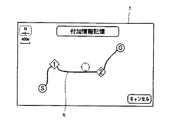
「付加情報を記憶しない」場合にはそのままリターンするが、「付加情報を記憶する」場合には、出発地(現在地)、目的地、通過点(経由地点)の選択のための処理ルーチンA10を実行する。このルーチンA10では、まず、表示装置7に図4に一例を示す「付加情報記憶画面」を表示する。この図4の例では、「付加情報記憶画面」中に前述のように記憶した案内経路データに対応した経路Rを概略的な地図形式で表示すると共に、その経路Rの出発地「S」、目的地「G」、通過点「1」、「2」をアイコンにて表示する。さらに、その画面中には、「キャンセル」アイコンが表示される。そして、出発地「S」、目的地「G」、通過点「1」、「2」のアイコンが操作された各場合には、次のステップA11へ移行するが、「キャンセル」アイコンが操作された場合にはそのままリターンする。
【0023】
ステップA11では、地図ディスク14中のデータ(道路沿いの特徴的な景色、建築物、道路情報などを表現したテキストデータ、それらの景色や建築物などの写真に対応した画像データ)を付加情報として記憶するのか、或いはユーザーが用意したオリジナルデータを付加情報として記憶するのかを判断する。尚、この判断は、例えば表示装置7による表示画面中に「地図ディスクのデータ」及び「オリジナルデータ」の各アイコンを表示すると共に、そのアイコンが指により押圧操作された状態を操作スイッチ群5中の図示しないタッチスイッチにより検出することにより行う。
【0024】
「地図ディスクのデータ」が選択された場合には、地図ディスク14中のデータのうち、前述のように処理ルーチンA10において選択された地点(出発地「S」、目的地「G」、通過点「1」、「2」)に関連したデータを検索すると共に、ヒットしたデータを外部メモリ6中に前記ステップA8で記憶された案内経路データと関連付けた状態の付加情報として記憶する(ステップA12)。これに対して、「オリジナルデータ」が選択された場合には、ユーザが用意した付加情報(前述のように選択された地点に対応したテキストデータ、写真データなど)の入力・編集を行うと共に、その入力・編集データを外部メモリ6中に前記ステップA8で記憶された案内経路データと関連付けた状態の付加情報として記憶する処理を行う(ステップA13)。尚、ユーザが用意する付加情報は、外部メモリ6に予め記憶しておくことになるが、入力インタフェースを通じて制御回路2に直接入力する構成としても良い。
【0025】
上記のような各ステップA12、A13の実行後には、付加情報の設定が完了したか否かを判断し(ステップA14)、完了と判断したときにはそのままリターンし、完了していないと判断したときには、前記処理ルーチンA10へ戻って上述のような付加情報記憶ための制御を再実行する。尚、このような付加情報の設定完了の有無の判断は、例えば表示装置7による表示画面中に「完了」及び「次の付加情報」の各アイコンを表示すると共に、そのアイコンが指により押圧操作された状態を操作スイッチ群5中の図示しないタッチスイッチにより検出することにより行う。
【0026】
一方、制御回路2による前記表示機能及びこれに関連した制御ルーチンを示す図3においては、まず、登録されている案内経路データが存在するか否かを判断する(ステップB1)。登録されている案内経路データが存在しない場合にはそのままリターンするが、存在する場合には、表示装置7に対し当該案内経路データのタイトルを一覧表示する(ステップB2)。
【0027】
次いで、表示されている案内経路データの選択操作若しくはキャンセル操作がユーザによって行われるまで待機する(ステップB3、B4)。尚、このような選択操作及びキャンセル操作の判断は、例えば表示装置7による表示画面中に「登録」及び「キャンセル」の各アイコンを表示すると共に、そのアイコンが指により押圧操作された状態を操作スイッチ群5中の図示しないタッチスイッチにより検出することにより行う。
【0028】
キャンセル操作が行われたときにはそのままリターンするが、選択操作が行われたときには、付加情報を表示するか或いは表示しないかの選択操作が行われるまで待機する(ステップB5)。尚、このような選択操作の有無の判断は、例えば表示装置7による表示画面中に「付加情報を表示する」及び「付加情報を表示しない」の各アイコンを表示すると共に、そのアイコンが指により押圧操作された状態を操作スイッチ群5中の図示しないタッチスイッチにより検出することにより行う。
【0029】
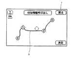
「付加情報を表示しない」場合には、表示装置7に表示する経路として、前記ステップB3で選択された案内経路を選択・決定するステップB13を実行した後にリターンする。これに対して、「付加情報を表示する」場合には、「付加情報呼び出し画面」を表示する(ステップB6)。この「付加情報呼び出し画面」は、図5に一例を示すように、選択された案内経路データに対応した経路Rを概略的な地図形式で表示すると共に、その経路Rの出発地「S」、目的地「G」、通過点「1」、「2」をアイコンにて表示する。さらに、その画面中には、「戻る」アイコン及び「決定」アイコンが表示される。そして、この表示状態で、出発地「S」、目的地「G」、通過点「1」、「2」のアイコン、「戻る」アイコン、「決定」アイコンの何れかが操作されるまで待機する(ステップB7、B8、B9)。
【0030】
「決定」アイコンが操作された場合には、前記経路決定ステップB13を実行してリターンし、「戻る」アイコンが操作された場合には、前記タイトル一覧表示ステップB2へ戻る。これに対して、地点選択操作が行われた場合(出発地「S」、目的地「G」、通過点「1」、「2」のアイコンの何れかが操作された場合)には、外部メモリ6中に選択された案内経路データと関連付けた状態で記憶されている付加情報群のうち、上記選択された地点に対応した情報を検索し、ヒットした付加情報を表示装置7に表示する(ステップB10)。
【0031】
この後には、次の地点の選択操作若しくは終了操作がユーザによって行われるまで待機する(ステップB11、B12)。尚、このような次の地点の選択操作及び終了操作の判断は、例えば表示装置7による表示画面中に「次の地点選択」及び「終了」の各アイコンを表示すると共に、そのアイコンが指により押圧操作された状態を操作スイッチ群5中の図示しないタッチスイッチにより検出することにより行う。そして、次の地点の選択操作が行われたときには前記ステップB6へ戻って上述のような付加情報表示のための制御を再実行し、また、終了操作が行われたときには前記ステップB13を実行した後にリターンする。
【0032】
以上要するに、上記した本実施例の構成によれば、制御回路2において、経路探索動作により算出された目的地までの案内経路に対応したデータを登録データとして保存可能で、且つその登録データを呼び出して表示装置7に表示可能な構成となっているから、上記案内経路データに基づいた案内経路を一旦走行した後においても、必要に応じて表示装置7により再表示することが可能となり、実際の使用上において便利になる。この場合、制御回路2は、上記登録データにより示される案内経路に関連した付加情報を当該登録データと対応付けて記憶する編集機能、並びにその登録データを表示装置7に表示する際に対応する付加情報を選択的に呼び出して表示する表示機能を備えているから、ユーザ側では、登録データに対応した案内経路を再表示した場合に、その経路がどのような状況にあったかを上記付加情報に基づいて容易に確認できるようになる。このため、例えば、前回の通過経路と同じ経路(登録データに対応した経路)を選ぶべきか否かの判断を容易に行うことができるなど、ユーザ側の使い勝手が向上するようになる。
【0033】
また、上記付加情報は、制御回路2がアクセス可能な地図ディスク14中に予め記憶された情報群の中から選択される構成となっているから、付加情報を登録データに対応付けるための編集作業を容易に行うことができる。しかも、上記地図ディスク14は、カーナビゲーション装置1に不可欠の構成要素であり、このような地図ディスク14中に付加情報を記憶する構成とした場合には、記憶手段を別途に用意する必要がなくなって全体構成の複雑化を未然に防止できるようになる。しかも、制御回路2には、ユーザ側が用意したオリジナルデータを付加情報として記憶できる編集機能が設けられているから、ユーザ側において、登録データにより示される経路に関連付けて多様な付加情報を記憶させることができ、実用上の有用性を高め得るようになる。さらに、上記のような地図ディスク14に記憶された付加情報やユーザ側が用意したオリジナルデータに対応した付加情報を、登録データに対応した出発地(現在地)、目的地、通過点(経由地点)毎に区分した状態で記憶できるから、登録データに基づいて表示される経路に関する情報量を増やすことができて実用上便利になる。加えて、記憶する付加情報として、テキストデータ、画像データの中から任意に選ぶことができるから、その付加情報の多様化を実現できる。尚、付加情報として、上記テキストデータ及び画像データの他に音声データを対象としても良く、このように構成した場合には、付加情報のさらなる多様化を実現できる。
【0034】
尚、本発明は上記した実施例に限定されるものではなく、次のような変形または拡張が可能である。
上記実施例における「付加情報呼び出し画面」は、図5に示す例に限られるものではなく、その変形例を示す図6に示すような「付加情報呼び出し画面」を表示する構成としても良い。この図6に示した「付加情報呼び出し画面」中には、選択された案内経路データに対応した経路Rが模式的な記号形式で表示されると共に、その経路Rの出発地「S」、目的地「G」、通過点「1」、「2」をアイコンにて表示する(但し、図6中の表示例では、目的地「G」は隠れた状態となっているが、スクロールバーSBの操作に応じて画面に現れる)。さらに、経路Rに対応して具体的な地名がテキスト形式で表示される共に、対応する地点の地図画面を表示するときに操作する「地図」アイコン、対応する地点に関連した付加情報を表示するときに操作する「情報」アイコン、案内経路データのタイトル一覧を表示する状態に戻るときに操作する「戻る」アイコンが表示される。勿論、図4に示した「付加情報記憶画面」も、上記図6のような「付加情報呼び出し画面」と同等の形態とすることができる。
制御回路2による経路探索動作により算出した目的地までの案内経路データを登録データとして保存する構成としたが、実際に走行(通過)した経路を示す軌跡データをも登録データとして保存すると共に、その登録データに関連した付加情報を上記実施例と同様に記憶できる構成とすることができる。カーナビゲーション装置に限らず、個人が携帯するモバイル型のナビゲーション装置にも適用できる。
【図面の簡単な説明】
【図1】本発明の第1実施例を示す全体の機能ブロック図
【図2】制御回路の制御内容を示すフローチャートその1
【図3】制御回路の制御内容を示すフローチャートその
【図4】付加情報記憶画面の表示例を示す図
【図5】付加情報呼び出し画面の表示例を示す図
【図6】他の実施例における付加情報呼び出し画面の表示例を示す図
【符号の説明】
1はカーナビゲーション装置、2は制御回路(制御手段)、3は位置検出器、4は地図データ入力器、5は操作スイッチ群、6は外部メモリ、7は表示装置、14は地図ディスク(記憶手段を示す)。[0001]
BACKGROUND OF THE INVENTION
The present invention relates to a navigation apparatus having a function of registering (storing) guide route data indicating a route to a destination obtained by calculation and trajectory data indicating a route once passed.
[0002]
[Prior art]
For example, in a car navigation device, when point data such as a destination or a waypoint is input for setting a route from the current location to the destination, the current location is calculated by calculation based on the location data and road map data. While performing the operation | movement which searches the path | route to the destination, it becomes the structure which displays on the map screen the guidance route data calculated by this as a guidance route. In this case, the guide route data is recorded with text data indicating the title, and the registered guide route data can be called up and displayed based on the title at the next route setting. It is done to make a configuration.
[0003]
[Problems to be solved by the invention]
In the car navigation device having the above-described conventional configuration, only text data indicating the title is recorded as information related to the registered guide route data. Therefore, after actually traveling on the guide route indicated by the guide route data, , Information on what the route was like (for example, information on what landscapes and buildings were seen while traveling along the guidance route, information on whether the road was congested, etc.) I had to rely on user memory. For this reason, even when traveling to the same destination, the user's convenience is sufficient, such as deciding whether or not to select the same route (the route corresponding to the registered guide route data) as before. However, this was an unresolved issue.
[0004]
The present invention has been made in view of the above circumstances, and the object thereof is indicated by the registration data when the data indicating the route can be registered and the registration data can be called and displayed on the display device. It is an object of the present invention to provide a navigation device capable of selectively storing and displaying additional information related to a route and realizing improved usability.
[0005]
[Means for Solving the Problems]
In order to achieve the above object, the means described in
[0006]
If the additional information is selected from a group of information stored in advance in the storage means accessible by the control means, the additional information is stored as in the means described in claim 2. Editing work for associating with registered data can be easily performed.
[0007]
In this case, when an information recording medium in which data for map display is recorded is used as the storage means as described in claim 3, it is not necessary to prepare the storage means separately, so that the overall configuration is complicated. Can be prevented.
[0008]
According to the fourth aspect of the present invention, the control means is provided with an editing function for receiving input of arbitrary additional information prepared by the user and storing the input additional information in association with the registration data. On the user side, a variety of additional information can be stored in association with the route indicated by the registration data, and practical utility can be improved.
[0010]
According to the means described in
[0011]
DETAILED DESCRIPTION OF THE INVENTION
Hereinafter, an embodiment in which the present invention is applied to a car navigation apparatus will be described with reference to FIGS.
In FIG. 1 schematically showing the entire electrical configuration, a
[0012]
The control circuit 2 has a function of controlling the overall operation of the
[0013]
The position detector 3 includes a geomagnetic sensor 10, a
[0014]
The map
[0015]
The
[0016]
The
[0017]
The control circuit 2 has a function of executing a map matching process for positioning the current position on the map. When point data such as a destination or a waypoint is input through the
[0018]
2 and 3 show the outline of the control contents related to the editing function and the display function by the control circuit 2, respectively, and this will be described below together with related actions.
In FIG. 2, which shows the editing function by the control circuit 2 and the control routine related thereto, first, it is determined whether or not the guide route data to be registered exists (step A1). If the registration target data does not exist, the process returns as it is. If there is, the outline of the guide route indicated by the registration target data to the display device 7 (for example, data describing the destination, the waypoint, etc.) Is displayed (step A2).
[0019]
Next, the process waits until the user performs a registration operation or a cancel operation for the displayed route (steps A3 and A4). The determination of the registration operation and the cancel operation is performed by, for example, displaying “registration” and “cancel” icons on the display screen of the
[0020]
When the cancel operation is performed, the process returns as it is. However, when the registration operation is performed, a screen for inputting the title name of the registration target data is displayed (step A5), and thereafter the title name input operation or cancel operation is performed. Is waited for by the user (steps A6 and A7). The determination of the title name input operation and the cancel operation is performed by, for example, displaying each of the well-known “character input screen” and “cancel” icons on the display screen of the
[0021]
When the cancel operation is performed, the process returns as it is. However, when the title name input operation is performed, the input title name and the guide route data to be registered are stored in, for example, the external memory 6 (step A8). The system waits until an operation for selecting whether information is stored or not is performed (step A9). The determination of the presence / absence of such a selection operation is performed, for example, by displaying the icons “store additional information” and “do not store additional information” on the display screen of the
[0022]
If “additional information is not memorized”, the process returns as it is, but if “additional information is memorized”, processing routine A10 for selecting a departure point (current location), a destination, and a passing point (via point) is executed. Execute. In this routine A10, first, the “additional information storage screen” shown in FIG. In the example of FIG. 4, the route R corresponding to the guide route data stored as described above is displayed in the “additional information storage screen” in a schematic map format, and the departure place “S” of the route R, The destination “G” and the passing points “1” and “2” are displayed as icons. Further, a “cancel” icon is displayed in the screen. In each case where the icons of the departure point “S”, the destination “G”, the passing point “1”, and “2” are operated, the process proceeds to the next step A11, but the “cancel” icon is operated. If it does, return directly.
[0023]
In step A11, the data in the map disk 14 (text data representing characteristic scenery along the road, buildings, road information, etc., and image data corresponding to photographs of those views, buildings, etc.) are used as additional information. It is determined whether to store the original data prepared by the user as additional information. This determination is made, for example, by displaying each icon of “map disc data” and “original data” on the display screen of the
[0024]
When “map disc data” is selected, the points (departure point “S”, destination “G”, passing point) selected in the processing routine A10 as described above among the data in the map disc 14 are selected. The data related to “1”, “2”) is searched, and the hit data is stored in the
[0025]
After execution of steps A12 and A13 as described above, it is determined whether or not the setting of additional information has been completed (step A14). Returning to the processing routine A10, the control for storing additional information as described above is executed again. The determination of whether or not the additional information has been set is performed by, for example, displaying “complete” and “next additional information” icons on the display screen of the
[0026]
On the other hand, in FIG. 3 showing the display function by the control circuit 2 and the control routine related thereto, it is first determined whether or not registered guide route data exists (step B1). If the registered guide route data does not exist, the process returns as it is. If it exists, the titles of the guide route data are displayed as a list on the display device 7 (step B2).
[0027]
Next, it waits until the user performs a selection operation or a cancel operation on the displayed guide route data (steps B3 and B4). The determination of the selection operation and the cancel operation is performed by, for example, displaying the “Register” and “Cancel” icons on the display screen of the
[0028]
When the cancel operation is performed, the process returns as it is, but when the selection operation is performed, the process waits until the selection operation for displaying or not displaying the additional information is performed (step B5). The determination of the presence / absence of such a selection operation is performed, for example, by displaying the icons “display additional information” and “do not display additional information” on the display screen of the
[0029]
In the case of “not displaying additional information”, the process returns after executing Step B13 for selecting and determining the guide route selected in Step B3 as the route to be displayed on the
[0030]
When the “determine” icon is operated, the route determination step B13 is executed and the process returns. When the “return” icon is operated, the process returns to the title list display step B2. On the other hand, when a point selection operation is performed (when any of the icons of the departure point “S”, the destination “G”, the passing point “1”, and “2” is operated), the external In the additional information group stored in the state associated with the selected guide route data in the
[0031]
After this, the system waits until the next point selection operation or end operation is performed by the user (steps B11 and B12). The determination of the next point selection operation and the end operation is performed by displaying, for example, the “next point selection” and “end” icons on the display screen of the
[0032]
In short, according to the configuration of the present embodiment described above, the control circuit 2 can store data corresponding to the guide route to the destination calculated by the route search operation as registered data, and call the registered data. Since the
[0033]
Further, since the additional information is selected from a group of information stored in advance in the map disk 14 accessible by the control circuit 2, an editing operation for associating the additional information with registered data is performed. It can be done easily. Moreover, the map disk 14 is an indispensable component for the
[0034]
The present invention is not limited to the above-described embodiment, and the following modifications or expansions are possible.
The “additional information call screen” in the above embodiment is not limited to the example shown in FIG. 5, and may be configured to display an “additional information call screen” as shown in FIG. In the “additional information call screen” shown in FIG. 6, the route R corresponding to the selected guide route data is displayed in a schematic symbol form, and the departure place “S” of the route R, the purpose earth "G", passing point "1", and displays at the "2" icon (however, in thetable示例in FIG. 6, the destination "G" is a hidden state, the scroll bar SB Appears on screen according to operation). Moreover, both the specific place name is displayed in a text format in correspondence with the path R, the corresponding "map" icon operated to display a mapscreen point, displaying additional information associated with the corresponding point An “information” icon to be operated at the time of operation and a “return” icon to be operated at the time of returning to the state of displaying the title list of the guide route data are displayed. Of course, the “additional information storage screen” shown in FIG. 4 can also have the same form as the “additional information call screen” as shown in FIG.
The guide route data up to the destination calculated by the route search operation by the control circuit 2 is stored as registration data, but the trajectory data indicating the actually traveled (passed) route is also stored as registration data, Additional information related to the registration data can be stored in the same manner as in the above embodiment. The present invention can be applied not only to car navigation devices but also to mobile navigation devices carried by individuals.
[Brief description of the drawings]
FIG. 1 is an overall functional block diagram showing a first embodiment of the present invention. FIG. 2 is a
FIG. 3 is a flowchart showing the control contents of the control circuit. FIG. 4 is a diagram showing a display example of an additional information storage screen. FIG. 5 is a diagram showing a display example of an additional information call screen. Figure showing a display example of the additional information call screen [Explanation of symbols]
1 is a car navigation device, 2 is a control circuit (control means), 3 is a position detector, 4 is a map data input device, 5 is an operation switch group, 6 is an external memory, 7 is a display device, 14 is a map disk (memory) Means).
Claims (5)
Translated fromJapanese前記制御手段は、前記登録データにより示される経路がどのような状況にあったかを確認可能な付加情報を当該登録データに対応した出発地、経由地、目的地毎に区分した状態で記憶する編集機能、並びにその登録データを前記表示装置に表示する際に、前記登録データと関連付けた状態で記憶されている付加情報群のうち、登録データを表示している画面から地点選択操作にて選択された出発地、経由地、目的地の何れかに対応する付加情報を呼び出して表示する表示機能を備えた構成とされることを特徴とするナビゲーション装置。Control thatstores at least one of the calculated guide route data to the destination and the trajectory data indicating the route actually passedalong with a title that can be identified for each registered data as registered data, and calls the registered data to display on the display device In a navigation device provided with a control means for performing
The control means is an editing function for storing additional information capable of confirming in what state the route indicated by the registration data is classified into a starting point, a transit point, and a destination corresponding to the registration data. In addition, when the registration data is displayed on the display device, the additional data group stored in a state associated with theregistration data is selected by apoint selection operation from the screen displaying theregistration data . A navigation device comprising a display function for calling and displaying additional information corresponding to any of a departure point, a transit point, and a destination.
Priority Applications (1)
| Application Number | Priority Date | Filing Date | Title |
|---|---|---|---|
| JP2000273225AJP3758958B2 (en) | 2000-09-08 | 2000-09-08 | Navigation device |
Applications Claiming Priority (1)
| Application Number | Priority Date | Filing Date | Title |
|---|---|---|---|
| JP2000273225AJP3758958B2 (en) | 2000-09-08 | 2000-09-08 | Navigation device |
Publications (2)
| Publication Number | Publication Date |
|---|---|
| JP2002081955A JP2002081955A (en) | 2002-03-22 |
| JP3758958B2true JP3758958B2 (en) | 2006-03-22 |
Family
ID=18759213
Family Applications (1)
| Application Number | Title | Priority Date | Filing Date |
|---|---|---|---|
| JP2000273225AExpired - Fee RelatedJP3758958B2 (en) | 2000-09-08 | 2000-09-08 | Navigation device |
Country Status (1)
| Country | Link |
|---|---|
| JP (1) | JP3758958B2 (en) |
Families Citing this family (7)
| Publication number | Priority date | Publication date | Assignee | Title |
|---|---|---|---|---|
| JP2004053351A (en)* | 2002-07-18 | 2004-02-19 | Fujitsu Ten Ltd | Navigation system |
| JP4133570B2 (en) | 2003-05-15 | 2008-08-13 | アルパイン株式会社 | Navigation device |
| EP1598638A2 (en) | 2004-05-20 | 2005-11-23 | Noritsu Koki Co., Ltd. | Image processing system and navigaton system for correlating position data with image data |
| JP4915343B2 (en) | 2007-12-21 | 2012-04-11 | ソニー株式会社 | Electronic device apparatus and navigation method |
| JP5610921B2 (en)* | 2010-08-24 | 2014-10-22 | アルパイン株式会社 | Travel history display device, travel history display method, and travel history display program |
| JP2014132240A (en)* | 2013-01-07 | 2014-07-17 | Denso Corp | Navigation system, terminal device, and navigation device |
| GB201306944D0 (en)* | 2013-04-17 | 2013-05-29 | Tomtom Int Bv | Methods, devices and computer software for facilitating searching and display of locations relevant to a digital map |
- 2000
- 2000-09-08JPJP2000273225Apatent/JP3758958B2/ennot_activeExpired - Fee Related
Also Published As
| Publication number | Publication date |
|---|---|
| JP2002081955A (en) | 2002-03-22 |
Similar Documents
| Publication | Publication Date | Title |
|---|---|---|
| JP2780521B2 (en) | Map display control device | |
| US6278940B1 (en) | Input method for selecting destination, navigation system using the same, and information storage medium for use therewith | |
| US6836723B2 (en) | Navigation method and system | |
| JP4145028B2 (en) | POI icon display method and navigation device | |
| JP5259898B2 (en) | Display device and display processing method | |
| US7490004B2 (en) | Vehicle navigation apparatus and method of searching for and displaying neighborhood facilities | |
| JP5311990B2 (en) | Parking information display device | |
| US20060256094A1 (en) | In-vehicle display apparatus | |
| CN100578150C (en) | Navigation device | |
| JP4809979B2 (en) | Navigation device and route search program | |
| US6968510B2 (en) | Function executing apparatus and menu item displaying method therefor | |
| EP2023089B1 (en) | Navigation apparatus and navigation program | |
| JP2001174273A (en) | Map display apparatus | |
| JP3758958B2 (en) | Navigation device | |
| JP2002328031A (en) | Navigation system | |
| US8423566B2 (en) | Facility retrieval device | |
| JP3967218B2 (en) | Navigation device | |
| JP4933196B2 (en) | In-vehicle information terminal | |
| JP3864846B2 (en) | Navigation device | |
| JP2000266550A (en) | Navigation device and recording medium | |
| JP5283321B2 (en) | Navigation device | |
| JP2006080579A (en) | Information terminal | |
| JP2007010549A (en) | Navigation system | |
| JP5626934B2 (en) | Input device and input method | |
| JPH07190789A (en) | Navigation device |
Legal Events
| Date | Code | Title | Description |
|---|---|---|---|
| A521 | Request for written amendment filed | Free format text:JAPANESE INTERMEDIATE CODE: A523 Effective date:20031215 | |
| A02 | Decision of refusal | Free format text:JAPANESE INTERMEDIATE CODE: A02 Effective date:20040127 | |
| A521 | Request for written amendment filed | Free format text:JAPANESE INTERMEDIATE CODE: A523 Effective date:20040326 | |
| A911 | Transfer to examiner for re-examination before appeal (zenchi) | Free format text:JAPANESE INTERMEDIATE CODE: A911 Effective date:20040331 | |
| A912 | Re-examination (zenchi) completed and case transferred to appeal board | Free format text:JAPANESE INTERMEDIATE CODE: A912 Effective date:20040430 | |
| A521 | Request for written amendment filed | Free format text:JAPANESE INTERMEDIATE CODE: A523 Effective date:20051118 | |
| A61 | First payment of annual fees (during grant procedure) | Free format text:JAPANESE INTERMEDIATE CODE: A61 Effective date:20051227 | |
| R150 | Certificate of patent or registration of utility model | Free format text:JAPANESE INTERMEDIATE CODE: R150 | |
| FPAY | Renewal fee payment (event date is renewal date of database) | Free format text:PAYMENT UNTIL: 20100113 Year of fee payment:4 | |
| FPAY | Renewal fee payment (event date is renewal date of database) | Free format text:PAYMENT UNTIL: 20110113 Year of fee payment:5 | |
| FPAY | Renewal fee payment (event date is renewal date of database) | Free format text:PAYMENT UNTIL: 20120113 Year of fee payment:6 | |
| FPAY | Renewal fee payment (event date is renewal date of database) | Free format text:PAYMENT UNTIL: 20130113 Year of fee payment:7 | |
| FPAY | Renewal fee payment (event date is renewal date of database) | Free format text:PAYMENT UNTIL: 20140113 Year of fee payment:8 | |
| R250 | Receipt of annual fees | Free format text:JAPANESE INTERMEDIATE CODE: R250 | |
| R250 | Receipt of annual fees | Free format text:JAPANESE INTERMEDIATE CODE: R250 | |
| R250 | Receipt of annual fees | Free format text:JAPANESE INTERMEDIATE CODE: R250 | |
| LAPS | Cancellation because of no payment of annual fees |