JP3698886B2 - E-mail transmission system and transmission method - Google Patents
E-mail transmission system and transmission methodDownload PDFInfo
- Publication number
- JP3698886B2 JP3698886B2JP5462098AJP5462098AJP3698886B2JP 3698886 B2JP3698886 B2JP 3698886B2JP 5462098 AJP5462098 AJP 5462098AJP 5462098 AJP5462098 AJP 5462098AJP 3698886 B2JP3698886 B2JP 3698886B2
- Authority
- JP
- Japan
- Prior art keywords
- map
- information
- image data
- sender terminal
- map image
- Prior art date
- Legal status (The legal status is an assumption and is not a legal conclusion. Google has not performed a legal analysis and makes no representation as to the accuracy of the status listed.)
- Expired - Lifetime
Links
Images


Landscapes
- Document Processing Apparatus (AREA)
- Information Retrieval, Db Structures And Fs Structures Therefor (AREA)
- Data Exchanges In Wide-Area Networks (AREA)
- Information Transfer Between Computers (AREA)
- Computer And Data Communications (AREA)
Description
Translated fromJapanese【0001】
【発明の属する技術分野】
本発明は、例えばインターネットによりメール情報を送信する電子メール送信技術に関する。
【0002】
【従来の技術】
現在、インターネットを利用して任意の端末間でメール情報の送受信を行う電子メールが広く普及している。電子メールの送信においては、インターネットに接続された1つの端末のユーザがメール情報を作成し、これをメールの受取人のメールサーバ宛に送信する。メールサーバは、受信したメール情報をメールボックスに保存しておく。メールの受取人である端末ユーザは、メールサーバにアクセスして自分宛のメールがメールサーバ内に保存されているか否かを確認し、保存されていればその情報をダウンロードして内容を読むことができる。このようにして、インターネットを介して複数の端末間で相互にメール情報の送受信が可能となっている。
【0003】
一方、現在、インターネットプロトコルを使用したインターネット上には、WWW(World Wide Web)サーバにより世界中から多種多様な情報が提供されており、ユーザはインターネットに接続された端末を操作し、検索を行うことにより所望の情報を得ることができる。
【0004】
このようなインターネットを介して提供される情報サービスは多種多様に存在するが、その一つとして地図情報検索表示サービスがある。これは、地図データベースを備え、インターネットに接続されたWWWサーバにアクセスすることにより、所望の地図情報を取得して端末上に表示することができるサービスである。具体的には、ユーザが端末から住所、地名、又は駅名、若しくは各種施設名、店舗名などを入力すると、その場所及びその周辺の地図が画像情報として端末上に表示される。よって、ユーザは表示された地図情報を参照して、目的の駅、施設などがどこにあるのかを容易に認識できる。
【0005】
このような地図情報の有効な利用用途の一つに、電子メールによる地図情報の送信が考えられる。即ち、あるユーザが検索の結果表示させた地図情報を電子メールとして所望の相手先に電子メールで送信する。送信相手は、このメールを開封し、それに含まれる地図情報を端末上に表示し、内容を確認する。例えば相手先に自宅周辺又は待ち合わせ場所周辺の地図情報を送信することにより、地理的情報を地図の表示により容易かつ正確に伝達することが可能となる。
【0006】
【発明が解決しようとする課題】
しかし、単に地図情報のみを送信しても、そのメールの受取人は受信した地図情報が何を意味するかが不明な場合があり、相手先に正確な情報を伝えにくいことがある。よって、別途電子メールによりメッセージなどの情報交換を行わなければならない場合がある。
【0007】
そこで、そのような不都合を解消するため、送信側ユーザは地図情報検索表示サービスにより取得した地図情報を一端自己の端末のメモリに記憶させ、文書作成用アプリケーションにより相手側に伝達したいメッセージをメール文書として作成し、このメール文書に予め記憶していた地図情報を添付して電子メールとして送信していた。
【0008】
しかし、このような電子メール送信方法では、端末において入力処理画面を切り換えたり、地図情報を添付したりという編集作業を行う必要があり、送信者側のメール情報作成作業が非常に煩雑で時間を要するものとなるという欠点がある。また、そのように地図情報とメッセージとを送信した場合でも、受取人は地図情報上で目的地を探したりする必要があり、依然として分かりにくい場合が多い。
【0009】
本発明は、以上の点に鑑みてなされたものであり、地図情報を含む伝達情報を、地図上の目的地などがより明確となるような態様でメール情報として作成し、これを電子メールとして送信可能とする電子メールシステムおよびその送信方法を提供することを課題とする。
【0010】
【課題を解決するための手段】
上記の課題を解決するため、請求項1記載の発明は、各々がネットワークに接続された送信者端末及び地図情報提供システムを含み、受取人のメールサーバへ電子メールを送信する電子メール送信システムにおいて、前記地図情報提供システムは、地図画像データを前記送信者端末に送信する手段を備え、前記送信者端末は、前記送信された地図画像データを受信する手段と、ユーザにより手書きされた情報であって前記受信された地図画像データ上の任意の目的地又は任意の目的地までの経路の少なくとも一方を示す線図の情報を手書き入力情報として入力する手段と、前記受信された地図画像データを、当該地図画像データの画像の上に前記入力された手書き入力情報が加えられた手書き入力付きの地図画像データに変換する手段と、ユーザにより作成された任意の文書情報を入力する手段と、前記変換された手書き入力付きの地図画像データ及び前記入力された文書情報を前記地図情報提供システムに送信する手段と、を備え、前記地図情報提供システムは、前記送信された手書き入力付きの地図画像データ及び文書情報を受信して、電子メール情報として受取人のメールサーバへ送信する手段と、を更に備えるように構成する。
【0011】
上記のように構成されたシステムによれば、地図情報提供システムは、地図画像データを送信者端末に送信し、送信者端末は、地図画像データを受信する。次に、前記取得された地図画像データ上に任意の目的地又は任意の目的地までの経路の少なくとも一方を示す線図をユーザが手書きすると、送信者端末は、地図画像データが当該地図画像データの画像の上に手書き入力が加えられた手書き入力付きの地図画像データに変換される。さらに、ユーザが任意の文書情報を作成すると、その後、送信者端末は、前記手書き入力付きの地図画像データ及び前記文書情報を地図情報提供システムに送信し、地図情報提供システムがこれらの情報を受信して、電子メール情報として前記受取人のメールサーバへ送信する。また、これにより、送信相手に地図画像上の目的地や経路などをより明確に伝えることができる。
【0012】
請求項2に記載の発明は、請求項1に記載の電子メール送信システムにおいて、前記地図情報提供システムは、描画プログラムを前記送信者端末に送信する手段を更に備え、前記送信者端末は、前記送信された描画プログラムを受信する手段を更に備え、前記送信者端末は、前記受信された描画プログラムを実行することにより前記手書き入力情報を入力し、前記地図画像データを変換するように構成する。これにより、送信者端末における地図画像データに手書き入力を加える処理は地図情報提供システムから取得したプログラムの実行により可能となる。
【0013】
請求項3に記載の発明は、請求項1に記載の電子メール送信システムにおいて、前記地図情報提供システムは、前記ネットワークに接続され、地図データベースを有する地図データベースセンタを備えるように構成する。これにより、地図情報提供システムは、地図データベースにアクセスして任意の地図情報を取得する。
【0014】
請求項4に記載の発明は、請求項1に記載の電子メール送信システムにおいて、前記文書情報は、前記電子メール情報として同時に送信される地図画像データに関連するメッセージである。これにより、地図画像及び手書き入力と関連する情報を文書でも作成し、送信することができる。
【0015】
請求項5に記載の発明は、請求項3に記載の電子メール送信システムにおいて、前記送信者端末は、ユーザにより入力された目的地情報を前記地図情報提供システムに送信する手段を更に備え、前記地図画像データを前記送信者端末に送信する手段は、前記地図情報提供システムが、前記送信された目的地情報を受信して、前記地図データベースセンタにより当該目的地情報に対応する前記地図画像データを前記地図データベースから検索して前記送信者端末に送信するように構成する。これにより、送信者端末は、ユーザにより指定した目的地に対応する地図画像を取得することができる。
請求項6に記載の発明は、請求項1に記載の電子メール送信システムにおいて、前記送信者端末は、前記受信された地図画像データを表示するとともに前記文書情報が表示される領域を表示する手段と、前記表示された地図画像データの画像の上に前記入力された手書き情報を表示する手段と、前記表示された領域に前記入力された文書情報を表示する手段と、を更に備えるように構成する。これにより、ユーザは作成中の文書とともに相手先に送信される地図画像を確認することができる。
【0016】
請求項7に記載の発明は、各々がネットワークに接続された送信者端末及び地図情報提供システムを含むシステム内で前記送信者端末から受取人のメールサーバへ電子メールを送信する方法において、前記地図情報提供システムが、地図画像データを前記送信者端末に送信する工程と、前記送信者端末が、前記送信された地図画像データを受信する工程と、前記送信者端末が、ユーザにより手書きされた情報であって前記受信された地図画像データ上の任意の目的地又は任意の目的地までの経路の少なくとも一方を示す線図の情報を手書き入力情報として入力する工程と、前記送信者端末が、前記受信された地図画像データを、当該地図画像データの画像の上に前記入力された手書き入力情報が加えられた手書き入力付きの地図画像データに変換する工程と、前記送信者端末が、ユーザにより作成された任意の文書情報を入力する工程と、前記送信者端末が、前記変換された手書き入力付きの地図画像データ及び前記入力された文書情報を前記地図情報提供システムに送信する工程と、前記地図情報提供システムが、前記送信された手書き入力付きの地図画像データ及び文書情報を受信して、電子メール情報として受取人のメールサーバへ送信する工程と、を備えるように構成する。
【0017】
上記のように構成された電子メールの送信方法によれば、地図情報提供システムは、地図画像データを送信者端末に送信し、送信者端末は、地図画像データを受信する。次に、前記取得された地図画像データ上に任意の目的地又は任意の目的地までの経路の少なくとも一方を示す線図をユーザが手書きすると、送信者端末は、地図画像データが当該地図画像データの画像の上に手書き入力が加えられた手書き入力付きの地図画像データに変換される。さらに、ユーザが任意の文書情報を作成すると、その後、送信者端末は、前記手書き入力付きの地図画像データ及び前記文書情報を地図情報提供システムに送信し、地図情報提供システムがこれらの情報を受信して、電子メール情報として前記受取人のメールサーバへ送信する。また、これにより、送信相手に地図画像上の目的地や経路などをより明確に伝えることができる。
【0018】
請求項8に記載の発明は、請求項7に記載の電子メールの送信方法において、前記地図情報提供システムが、描画プログラムを前記送信者端末に送信する工程と、前記送信者端末が、前記送信された描画プログラムを受信する工程と、を更に備え、前記送信者端末が、前記受信された描画プログラムを実行することにより前記手書き入力情報を入力し、前記地図画像データを変換するように構成する。これにより、送信者端末における地図画像データに手書き入力を加える処理は地図情報提供システムから取得したプログラムの実行により可能となる。
請求項9に記載の発明は、請求項7に記載の電子メールの送信方法において、前記送信者端末が、ユーザにより入力された目的地情報を前記地図情報提供システムに送信する工程を更に備え、前記地図画像データを前記送信者端末に送信する工程は、前記地図情報提供システムが、前記送信された目的地情報を受信して、前記地図情報提供システムが有する地図データベースセンタにより当該目的地情報に対応する前記地図画像データを当該地図データベースセンタが有する地図データベースから検索して前記送信者端末に送信するように構成する。これにより、ユーザは作成中の文書とともに相手先に送信される地図画像を確認することができる。
請求項10に記載の発明は、請求項7に記載の電子メールの送信方法において、前記送信者端末が手書き入力情報を入力する工程より前に、前記送信者端末が、前記受信された地図画像データを表示するとともに前記文書情報が表示される領域を表示する工程と、前記送信者端末が地図画像データを変換する工程より前に、前記送信者端末が、前記表示された地図画像データの画像の上に前記入力された手書き情報を表示する工程と、前記送信者端末が前記変換された手書き入力付きの地図画像データ及び前記入力された文書情報を前記地図情報提供システムに送信する工程より前に、前記送信者端末が、前記表示された領域に前記入力された文書情報を表示する工程と、を更に備えるように構成する。これにより、ユーザは作成中の文書とともに相手先に送信される地図画像を確認することができる。
【0019】
【発明の実施の形態】
本発明は、地図情報提供サービスによって取得した地図情報上に送信者が自由に文字、記号などを上書きし、その地図情報を含むメール情報を電子メールとして送信可能とすることを特徴とする。以下、図面を参照して本発明の好適な実施の形態について説明する。
【0020】
[1]システム構成
図1に、本発明の実施形態にかかる電子メールシステムの概略的構成を示す。図1において、地図データベースセンタ10及び地図情報提供サイト20がインターネット5に接続されている。さらに、端末A及び端末Bがインターネット5に接続されている。
【0021】
地図データベースセンタ10は、インターネット上で地図検索表示サービスを実施するためのセンタであり、地図サーバ12と地図データベース14を備える。地図データベース14は、地図上の位置情報(座標情報)、例えば、緯度及び経度の情報と、その位置情報に対応する地図情報の画像データを含んでいる。地図情報の画像データは、縮尺に応じて複数の階層構造に構成されている。即ち、日本全体の図、都道府県レベルの図というように、複数の縮尺の画像データが用意され、夫々にその画像データを特定する地図ファイル名が付されている。縮尺情報と地図ファイルとが対応付けされている。
【0022】
地図サーバ12は、ユーザ端末からの指定、指示などに応じて対応する地図情報の画像データを地図データベース14から検索、取得し、インターネット5を介してユーザ端末に送信する。また、地図サーバ12は、WWWサーバからの要求に応じて地図情報の検索、送信も行う。
【0023】
地図情報提供サイト20はWWWサイトである。WWWは、ハイパーテキストを使用して文字情報、画像情報、音声情報などのマルチメディア情報を提供するインターネット上の広域情報システムである。WWWサーバはWWWによりリンクされたインターネット上のサーバであり、WWWによりサービスを行うサイトをWWWサイトという。地図情報提供サイト20は、WWWサーバ22及びランドマークデータベース24を備える。
【0024】
ランドマークデータベース24は、ある特定の住所、駅名、ランドマーク(施設、遊技場、遊園地、店舗など)と、それらの位置情報との対応を示すデータを記憶している。よって、WWWサーバ22は、ランドマークデータベース24にアクセスすることにより、特定の位置情報からそれに対応する住所、駅名、ランドマークを特定することができる。また、逆に、特定の住所、駅名、ランドマーク名などから対応する位置情報を取得することもできる。
【0025】
端末A、Bはユーザ端末であり、WWWブラウザと呼ばれるアプリケーションプログラムを使用することによりWWWのサービスを受けることができる。図1の例では、端末A,及びBはWWWブラウザを使用して地図情報提供サイト20に接続し、そのホームページを閲覧することにより地図情報の提供サービスを受けることが可能となる。
【0026】
[2]地図情報提供の基本動作
次に、地図情報の提供のための基本動作について、図2乃至4を参照して説明する。図2は、地図情報の提供動作を示すフローチャートであり、図3乃び図4は、各段階における地図表示画面の例である。以下、端末AのユーザAが地図情報提供サイトに接続して、地図情報を取得する場合を例にとって説明する。
【0027】
先ず、ユーザAは端末AのWWWブラウザを使用して、地図情報提供サイトのURL(Uniform Resource Locator)を指定する(ステップS2)。URLとは、WWW上の特定のリンク先を指定するアドレス情報である。これにより、端末Aは、インターネット5を介して地図情報提供サイト20のWWWサーバ22に接続する。
【0028】
これに応答し、WWWサーバ22は地図情報提供サイトのホームページのHTML(Hypertext Markup Language)テキストを端末Aに送る。HTMLテキストとは、HTMLと呼ばれる言語で記述されたテキストファイルであり、関連付けされた画像情報、音声情報などの保存先の情報を含めることができる。端末AのWWWブラウザは、このHTMLテキストを表示する(ステップS4)。
【0029】
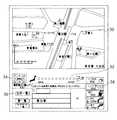
図3に、こうして表示される当該ホームページの初期画面の例を示す。図3において、表示画面の上部には地図表示部30があり、そこに地図画像が表示される。また、地図表示部30の直ぐ下には、縮尺指定部32があり、これが地図表示部30内に表示されている地図の縮尺(スケール)を示している。縮尺指定部32内の各ボタン(この例では11段階)は異なる縮尺に対応している。図3の例では、最も大きい(左側の日本地図マークに近い)縮尺で地図の表示がなされている。表示された地図画像を拡大したい場合には、縮尺指定部32中の右寄り(“street”に近い)のボタンをクリックすると、縮尺の小さい地図画像が表示される。
【0030】
縮尺指定部32の左側には、スクロール部34が表示される。スクロール部34は、現在表示されている地図の周辺部を表示したい場合に使用され、現在の表示位置を中心として8方向へ向けた矢印が表示されている。例えば、ユーザがスクロール部34内の上向きの矢印をクリックすると、現在表示されている場所の直ぐ北に位置する周辺部の地図が表示される。
【0031】
縮尺指定部32の下には、検索したい場所を指定又は入力するための入力欄36が表示される。入力欄36の左側には、「住所一覧」、「駅一覧」及び「ランドマーク一覧」のボタンが表示されており、これらをクリックすることにより住所、駅名、ランドマーク名の候補一覧が表示される、ユーザはそれらの中から所望の候補を選択することによりその場所の地図画像を表示させることができる。また、入力欄36の右側には住所、駅名、ランドマーク名の入力ボックスが表示され、ユーザは所望の住所、駅名などをキーボードを使用して直接入力することができる。例えば、ユーザが入力欄36の駅名入力ボックス内に「蒲田駅」と入力すると、図4に示すように蒲田駅を中心とする地図画像が地図表示部30内に表示される。
【0032】
入力欄36の右側には種々の特殊機能ボタンが表示されている。本発明による地図情報付き電子メールを送信する場合は上から2つ目のメール処理ボタン38を使用することになるが、その送信処理の詳細については後述する。
【0033】
このようにホームページが表示された状態で、ユーザは表示させたい目的地を指定、入力する。この指定は、入力欄36の左側の一覧から候補を指定することにより行っても良く、入力ボックス内に住所などを直接タイプ入力して行ってもよい。こうして指定された目的地情報は、端末Aからインターネット5を介してWWWサーバ22へ送られる(ステップS6)。これと同時に、現在選択されている縮尺情報もWWWサーバ22へ送られる。
【0034】
WWWサーバ22は、この情報を受け取り、ランドマークデータベース24を参照して当該目的地に対応する位置情報(座標情報)を取得し、この位置情報を含むHTMLテキストを作成して端末Aへ送信する(ステップS8)。このHTMLテキストには、さらにそれを受け取った端末Aがアクセスすべきサーバ名(即ち、地図サーバ12)、現在選択されている縮尺に応じて選択される地図ファイル名、端末A上に表示すべき文などが含まれている。
【0035】
端末AのWWWブラウザは、このHTMLテキストを受け取り、それに含まれる文を表示する。また、当該HTMLテキスト中に記述された地図サーバ12へ地図ファイル名、位置情報、サイズ情報、縮尺情報などの情報を送る(ステップS10)。
【0036】
地図サーバ12は、地図データベース14にアクセスし、縮尺情報及び位置情報により特定される地図ファイルの画像データのうち、位置情報を中心とし、サイズ情報により決定される範囲に対応する画像データを取得し、これを地図画像データ(GIFデータ)として端末Aへ送信する(ステップS12)。
【0037】
端末Aは、地図サーバ12から送信された地図画像データを、先にWWWサーバから送信されたHTMLテキストで指定された表示個所に表示する(ステップS14)。こうして、ユーザが指定した目的地の地図画像データが端末Aの地図表示部30内に表示される。なお、ユーザの入力欄36への再指定、再入力により目的地が変更された場合は、ステップS6乃至S14の処理を変更後の位置情報などに基づいて繰返して地図表示の更新を行う。
【0038】
また、地図画像が表示された状態で、縮尺の変更、表示位置の変更などがあった場合も、処理はステップS6へ戻り、変更後の位置情報、縮尺情報などをWWWサーバ22へ送信する。以後、WWWサーバ22、地図サーバ12及び端末Aは変更後の情報に基づいて同様の処理を行い、地図表示の変更を行う。
【0039】
例えば、ユーザが縮尺指定部32を操作することにより縮尺情報が変更された場合は、地図サーバ12がアクセスすべき地図ファイルが変更されるか、あるいは同一の地図ファイルのうち端末Aへ送信される地図画像データの範囲が変更される。一方、ユーザが地図表示部30内に表示された地図上で関心のある場所をクリックすると、その場所の位置情報が送信され、地図サーバ12はその場所を中心とする地図画像データを端末Aに送信する。その結果、地図表示部30内の地図は、ユーザがクリックした場所を中心とする表示に変更される。
【0040】
なお、前述の説明において、地図サーバ12は地図ファイルをそのファイル名によって直接指定するようにしたが、地図サーバ12の地図ファイルは独自の管理体系に従って構築されるようにしてもよい。その場合には、地図ファイル名を直接指定するのに代えて、WWWサーバとサーバ上で動くプログラムとのインターフェースを果たすCGI(Common Gateway Interface)を利用して地図ファイルをアクセスする。例えば、ステップS10では、地図サーバ12に対して地図表示用CGI名を送るようにする。
【0041】
[3]電子メール送信処理
次に、図5乃至7を参照して、本発明に係る電子メール送信処理について説明する。図5は、電子メール送信処理を示すフローチャートである。また、図6及び7は、電子メール送信処理において端末上に表示されるメール作成画面の例を示す。
【0042】
以下、端末AのユーザAが端末BのユーザBに対して、本発明に係る地図情報付電子メールを送信する処理を説明する。今、ユーザAが地図情報提供サイトに接続しているものとする。ここで、先ずユーザAは、先に述べた手順によりユーザBに送信したい地図画像を端末A上に表示させる(ステップS20)。これは、図2のフローチャートを参照して説明した方法により行われる。即ち、端末A上に表示された地図情報提供サイトのページにおいて、住所、駅名などを入力することにより所望の場所の地図情報を地図表示部30に表示させる。また、必要であれば、縮尺指定部32内のボタンをクリックすることにより適切な縮尺を選択する。
【0043】
次に、ユーザAはメール処理ボタン38をクリックする(ステップS22)。すると、端末Aは、現在表示されている地図画像の位置情報(表示の中心位置)、サイズ情報、及び縮尺情報を、当該HTMLテキストのリンク先URLであるWWWサーバ22へ送る(ステップS24)。WWWサーバ22はこのデータを地図サーバ12に送る(ステップS26)。地図サーバ12は地図データベース14を参照し、縮尺情報に基づいて地図ファイルを選択し、位置情報及びサイズ情報によって決定される範囲の地図画像を取得する。そして、この地図画像をGIFデータとしてWWWサーバ22へ送る(ステップS28)。WWWサーバ22は、この地図画像データをファイル名(例えば、「画像C」とする。)を付けて保存する。
【0044】
次に、WWWサーバ22は、その画像データのファイル名(「画像C」)、位置情報、縮尺情報、並びに、端末Aで手書き入力のために使用する描画プログラム(JAVAアプレット)の名称の記述を含むHTMLテキストを作成し、これを端末Aに送信する(ステップS30)。
【0045】
端末AはWWWサーバ22から送信されたこのHTMLテキストを受け取り、その内容を読取る。また、そこに記述された名称のプログラムをWWWサーバ22に要求し、当該プログラムをダウンロードする(ステップS32)。
【0046】
次に、端末AはHTMLテキストから地図画像データのファイル名、位置情報、縮尺情報などを取得し、WWWサーバからその地図画像ファイルを取得し、表示する。また、ダウンロードした描画プログラムを起動する。この結果、端末A上に図6に示すメール作成画面40が現れる(ステップS34)。
【0047】
メール作成画面40では、その右側に宛先入力ボックス46、件名入力ボックス48、メッセージ入力ボックス50が表示される。これは、通常の電子メールソフトウェアと同様である。よって、ユーザAは、キーボードを使用して送信相手のメールアドレス、件名、メッセージをこれらの入力ボックス内に入力する。
【0048】
これに加え、メール作成画面40においては、先に決定された地図画像が地図表示部42内に表示される。これにより、ユーザAは作成中の電子メールと共に相手先に送信される地図画像を確認することができる。
【0049】
地図表示部42の下には、手書き入力ツール44が表示される。本発明の一つの大きな特徴は、送信される地図画像上に任意の手書き入力ができることである。即ち、単に電子メールに地図画像を添付して送信できるというだけでなく、その地図画像上にメール送信者が任意の手書き入力を行い、そのような手書き入力が重畳された地図画像を電子メールで送信できるのである。
【0050】
ユーザAはメール作成画面40上でメール作成作業を行う(ステップS34)。今、例えば、ユーザAがユーザBとの待ち合わせに関する電子メールを送信すると仮定する。この場合、ユーザAは、ユーザBのメールアドレスを宛先入力ボックス46内に入力し、件名及びメッセージをそれぞれ件名入力ボックス48及びメッセージ入力ボックス50に入力する。例えば、件名を「3/3の待ち合わせ」とし、メッセージ欄に「3/3、午後7時にJR蒲田駅西口の○○バーガーで待ってます。地図を見てね。」と入力する。
【0051】
次に、ユーザAは手書き入力ツール44を使用して、地図表示部42内に表示された地図画像上で手書き入力を行う。即ち、図7に示すように、JR蒲田駅から○○バーガーまでの道順を線でつなぎ、○○バーガーを線で囲んで示す。手書き入力が完了すると、ユーザAは送信ボタン52をクリックする。これにより、作成されたメール文書及び地図情報が確定する。なお、地図画像を指定し直したい場合やメールの送信を中止したい場合は、リセットボタン52をクリックすることにより、端末A上の表示は図4に示すメイン画面に戻る。
【0052】
送信ボタン52が押されると、端末A内の描画プログラムは、ユーザAの手書き入力が加えられた地図画像をGIFフォーマットの画像データに変換する。端末Aは変換された地図画像データ、並びに入力された相手先メールアドレス、件名、メッセージなどのデータをWWWサーバへ22へ送信する(ステップS36)。WWWサーバ22は、受信した地図画像データを保存し、これらのメール情報を相手先メールアドレスへ送る(ステップS38)。
【0053】
ユーザBは端末Bでこのメールを受信し、表示する。このメールにはユーザAの手書き入力が重畳された地図画像データ(図7の地図表示部42内の画像)が添付されており、ユーザBはメッセージと共にその地図画像を見ることができる。こうして、手書き入力を含む地図画像が電子メールとして送信される。
【0054】
上記の実施形態では、メール送信者が地図画像上に手書き入力を行うための描画プログラムは、JAVAアプレットとしてWWWサーバからメール送信者の端末にダウンロードしている。その代わりに、各端末内に予め用意された描画ソフトウェアを使用して手書き入力及び手書き入力後の地図画像のデータ化を行うように構成することも可能である。本実施形態においてJAVAアプレットを使用した理由は、各端末に適当な互換性を有する描画ソフトウェアが存在するとは限らないこと、セキュリティ面の問題、などによる。
【0055】
このように、本発明によれば、送信者の手書き入力を加えた地図画像を、通常のメッセージなどと共に電子メールとして相手先に送信することができる。従って、地図情報に基づいて、容易に、より正確な情報を相手に伝えることが可能となる。
【0056】
【発明の効果】
以上説明したように、請求項1又は7に記載の発明によれば、ユーザが任意の目的地又は任意の目的地までの経路の少なくとも一方を示す線図の手書き入力を加えた地図画像データを、通常の文書情報と共に電子メールとして送信することができる。よって、メール受信者は文書とともに手書き入力がされた地図画像情報をメールにより受け取ることができ、地図画面上における待ち合わせ場所などの目的地や経路などを容易且つ正確に伝えることができる。
【0057】
請求項2又は8に記載の発明によれば、送信者端末における地図画像データに手書き入力を加える処理は地図情報提供システムから取得した描画プログラムの実行により可能となるので、送信者端末において特別の描画プログラムを用意する必要が無い。また、当該システムの使用者が使用する描画プログラムを統一できるので、描画プログラムの非互換性に起因する各端末における手書き入力付きのデータ処理のエラーなどを減らすことができる。
【0058】
請求項3に記載の発明によれば、地図データベースの更新などを地図情報提供処理と独立に管理することができ、システム管理が簡素化される。
【0059】
請求項4に記載の発明によれば、地図画像及び手書き入力と関連する情報を文書でも作成し、送信することができる。よって、伝達すべき内容をより正確に相手に伝達することができる。
【0060】
請求項5又は9に記載の発明によれば、送信者端末は、ユーザにより指定した目的地に対応する地図画像を取得することができる。
請求項6又は10に記載の発明によれば、ユーザは作成中の文書とともに相手先に送信される地図画像を確認することができる。
【図面の簡単な説明】
【図1】本発明の実施形態にかかる電子メールシステムの概略的構成を示すブロック部である。
【図2】地図情報の提供動作を示すフローチャートである。
【図3】地図情報提供サイトの表示画面の例を示す図である。
【図4】地図情報提供サイトの表示画面の例を示す他の図である。
【図5】地図情報付き電子メールの送信処理を示すフローチャートである。
【図6】メール作成画面の例を示す図である。
【図7】手書き入力後のメール作成画面の例を示す図である。
【符号の説明】
1、2…端末
5…インターネット
10…地図データベースセンタ
12…地図サーバ
14…地図データベース
20…地図情報提供サイト
22…WWWサーバ
24…ランドマークデータベース
30、42…地図表示部
32…縮尺指定部
34…スクロール部
36…入力欄
38…メール処理ボタン
40…メール作成画面
44…手書き入力ツール
46…宛先入力ボックス
48…件名入力ボックス
50…メッセージ入力ボックス
52…送信ボタン
54…リセットボタン[0001]
BACKGROUND OF THE INVENTION
The present invention relates to an e-mail transmission technique for transmitting e-mail information over the Internet, for example.
[0002]
[Prior art]
Currently, electronic mail that transmits and receives mail information between arbitrary terminals using the Internet is widely used. In the transmission of electronic mail, a user of one terminal connected to the Internet creates mail information and transmits it to the mail server of the mail recipient. The mail server stores the received mail information in a mailbox. The terminal user who is the recipient of the mail accesses the mail server, checks whether the mail addressed to him is stored in the mail server, and if it is stored, downloads the information and reads the contents. Can do. In this manner, mail information can be transmitted and received between a plurality of terminals via the Internet.
[0003]
On the other hand, on the Internet using the Internet protocol, a wide variety of information is provided from all over the world by a WWW (World Wide Web) server, and a user operates a terminal connected to the Internet to perform a search. Thus, desired information can be obtained.
[0004]
There are various types of information services provided via the Internet, and one of them is a map information search and display service. This is a service that has a map database and can acquire desired map information and display it on a terminal by accessing a WWW server connected to the Internet. Specifically, when the user inputs an address, a place name, a station name, various facility names, a store name, or the like from the terminal, the location and the surrounding map are displayed on the terminal as image information. Therefore, the user can easily recognize where the target station or facility is located by referring to the displayed map information.
[0005]
One effective use of such map information is transmission of map information by electronic mail. That is, the map information displayed as a result of a search by a certain user is transmitted as an e-mail to a desired destination by e-mail. The transmission partner opens this mail, displays the map information included in the mail, and confirms the contents. For example, by transmitting the map information around the home or the meeting place to the other party, it is possible to easily and accurately convey the geographical information by displaying the map.
[0006]
[Problems to be solved by the invention]
However, even if only map information is transmitted, the recipient of the mail may not know what the received map information means, and it may be difficult to convey accurate information to the other party. Therefore, there are cases where information such as messages must be exchanged separately by e-mail.
[0007]
Therefore, in order to eliminate such inconvenience, the transmission side user once stores the map information acquired by the map information search and display service in the memory of his / her terminal, and the message to be transmitted to the other side by the document creation application is sent to the mail document. The map information created in advance and stored in advance in this mail document is sent as an e-mail.
[0008]
However, in such an e-mail transmission method, it is necessary to perform an editing operation such as switching the input processing screen or attaching map information on the terminal, and the e-mail information creation work on the sender side is very complicated and time-consuming. There is a drawback that it becomes necessary. Even when the map information and the message are transmitted in this way, the recipient needs to search for the destination on the map information, and it is still difficult to understand.
[0009]
The present invention has been made in view of the above points. Communication information including map information is created as mail information in such a manner that the destination on the map becomes clearer, and this is used as electronic mail. It is an object of the present invention to provide an electronic mail system that enables transmission and a transmission method thereof.
[0010]
[Means for Solving the Problems]
In order to solve the above-mentioned problems, an invention according to claim 1 is an electronic mail transmission system including a sender terminal and a map information providing system each connected to a network, and transmitting an electronic mail to a mail server of a recipient. ,The map information providing system comprises means for transmitting map image data to the sender terminal,The sender terminal isMeans for receiving the transmitted map image data;,Means for inputting handwritten input information as handwritten input information, which is information handwritten by a user and indicating at least one of an arbitrary destination on the received map image data or a route to an arbitrary destination;SaidReceiveMap image dataThe input handwritten input information is added to the image of the map image data.Map image data with handwriting inputConversion toMeans toCreated by userAny documentinformationMeans for inputtingConvertedMap image data with handwritten input and the aboveEntereddocumentsinformationThe aboveMap information providing systemMeans for transmitting;The map information providing system receives the transmitted map image data with handwritten input and document information, and transmits the received map image data to a recipient's mail server as e-mail information;TheMoreConfigure to include.
[0011]
According to the system configured as above,The map information providing system sends map image data to the sender terminal., Sender terminalIs, Map image dataReceiveTo do. Next, any arbitrary map image data is obtained.The user can draw a diagram showing at least one of the destination or the route to any destinationWhen handwritten,In the sender terminal, the map image data has been handwritten on the map image data image.Map image data with handwriting inputConversion toIs done. In addition, the user can select any documentCreate informationDoWhen,After that, the sender terminal, the map image data with handwritten input and the documentinformationTheThis information is sent to the map information providing system, and the map information providing system receives these information as e-mail information.Send to the recipient's mail server.In addition, this makes it possible to more clearly convey the destination or route on the map image to the transmission partner.
[0012]
The invention according to
[0013]
A third aspect of the present invention is the electronic mail transmission system according to the first aspect, wherein the map information providing system includes a map database center connected to the network and having a map database. Thereby, a map information provision system accesses map database and acquires arbitrary map information.
[0014]
According to a fourth aspect of the present invention, in the electronic mail transmission system according to the first aspect, the documentinformationIs a message related to map image data transmitted simultaneously as the e-mail information. As a result, information related to the map image and the handwritten input can be created and transmitted even in the document.
[0015]
The invention according to claim 5 is the claim.3In the email sending system described inThe sender terminal further includes means for transmitting destination information input by a user to the map information providing system, and means for transmitting the map image data to the sender terminal includes the map information providing system, The transmitted destination information is received, the map database center retrieves the map image data corresponding to the destination information from the map database, and transmits the map image data to the sender terminal.As a result, the sender terminalThe map image corresponding to the destination designated by the user can be acquired.
A sixth aspect of the present invention is the electronic mail transmission system according to the first aspect, wherein the sender terminal displays the received map image data and a region for displaying the document information. And means for displaying the input handwritten information on the image of the displayed map image data, and means for displaying the input document information in the displayed area. To do. Thereby, the user can confirm the map image transmitted to the other party together with the document being created.
[0016]
Claim7The invention described in claim 1 is a method for transmitting an e-mail from the sender terminal to a recipient's mail server in a system including a sender terminal and a map information providing system each connected to a network.The map information providing system transmitting map image data to the sender terminal; and the transmitter terminal receiving the transmitted map image data;,The sender terminal is information handwritten by a user, and information on a diagram indicating at least one of an arbitrary destination on the received map image data or a route to an arbitrary destination is used as handwritten input information. The input step and the sender terminalSaidReceiveMap image dataThe input handwritten input information is added to the image of the map image data.Map image data with handwriting inputConversion toAnd a process ofThe sender terminal was created by the userAny documentinformationA process of inputtingThe sender terminal isSaidConvertedMap image data with handwritten input and the aboveEntereddocumentsinformationThe aboveMap information providing systemSending, andThe map information providing system receives the transmitted map image data with handwritten input and document information, and transmits it as e-mail information to a recipient's mail server;It comprises so that it may be provided.
[0017]
According to the e-mail transmission method configured as described above,The map information providing system sends map image data to the sender terminal., Sender terminalIs, Map image dataReceiveTo do. Next, any arbitrary map image data is obtained.The user can draw a diagram showing at least one of the destination or the route to any destinationWhen handwritten,In the sender terminal, the map image data has been handwritten on the map image data image.Map image data with handwriting inputConversion toIs done. In addition, the user can select any documentCreate informationDoWhen,After that, the sender terminal, the map image data with handwritten input and the documentinformationTheThis information is sent to the map information providing system, and the map information providing system receives these information as e-mail information.Send to the recipient's mail server.In addition, this makes it possible to more clearly convey the destination or route on the map image to the transmission partner.
[0018]
Claim8The invention described in claim 17In the e-mail transmission method described inThe map information providing system transmits a drawing program to the sender terminal, and the sender terminal is transmitted.Drawing programReceiveDoAnd further comprising a process,The sender terminal isSaidReceivedDrawing programIs configured to input the handwritten input information and convert the map image data.. As a result, the sender terminalProcessing to add handwritten input to map image dataIs a program obtained from the map information systemofExecutionMade possible by.
The invention according to claim 9 further comprises the step of transmitting the destination information input by the user to the map information providing system, wherein the sender terminal is the electronic mail transmission method according to claim 7, In the step of transmitting the map image data to the sender terminal, the map information providing system receives the transmitted destination information, and the map database center of the map information providing system converts the destination information into the destination information. The corresponding map image data is searched from the map database of the map database center and transmitted to the sender terminal. Thereby, the user can confirm the map image transmitted to the other party together with the document being created.
The invention according to
[0019]
DETAILED DESCRIPTION OF THE INVENTION
The present invention is characterized in that a sender can freely overwrite characters, symbols, and the like on map information acquired by a map information providing service, and mail information including the map information can be transmitted as an electronic mail. Preferred embodiments of the present invention will be described below with reference to the drawings.
[0020]
[1] System configuration
FIG. 1 shows a schematic configuration of an electronic mail system according to an embodiment of the present invention. In FIG. 1, a
[0021]
The
[0022]
The map server 12 retrieves and acquires image data of corresponding map information from the map database 14 according to the designation, instruction, etc. from the user terminal, and transmits it to the user terminal via the Internet 5. The map server 12 also searches for and transmits map information in response to a request from the WWW server.
[0023]
The map
[0024]
The
[0025]
Terminals A and B are user terminals, and can receive a WWW service by using an application program called a WWW browser. In the example of FIG. 1, the terminals A and B can receive a map information providing service by connecting to the map
[0026]
[2] Basic operation for providing map information
Next, a basic operation for providing map information will be described with reference to FIGS. FIG. 2 is a flowchart showing the map information providing operation, and FIGS. 3 and 4 are examples of map display screens at each stage. Hereinafter, a case where the user A of the terminal A connects to the map information providing site and acquires map information will be described as an example.
[0027]
First, the user A designates the URL (Uniform Resource Locator) of the map information providing site using the WWW browser of the terminal A (step S2). The URL is address information that designates a specific link destination on the WWW. Thereby, the terminal A connects to the
[0028]
In response to this, the
[0029]
FIG. 3 shows an example of the initial screen of the home page displayed in this way. In FIG. 3, there is a
[0030]
On the left side of the
[0031]
Below the
[0032]
Various special function buttons are displayed on the right side of the
[0033]
With the home page displayed in this way, the user designates and inputs a destination to be displayed. This designation may be performed by designating candidates from the list on the left side of the
[0034]
The
[0035]
The WWW browser of terminal A receives this HTML text and displays a sentence included therein. Further, information such as a map file name, position information, size information, and scale information is sent to the map server 12 described in the HTML text (step S10).
[0036]
The map server 12 accesses the map database 14 and obtains image data corresponding to a range determined by the size information, centered on the position information, among the image data of the map file specified by the scale information and the position information. This is transmitted to the terminal A as map image data (GIF data) (step S12).
[0037]
The terminal A displays the map image data transmitted from the map server 12 at a display location designated by the HTML text previously transmitted from the WWW server (step S14). Thus, the map image data of the destination designated by the user is displayed in the
[0038]
Further, when the map image is displayed and the scale is changed or the display position is changed, the process returns to step S6, and the changed position information, scale information, and the like are transmitted to the
[0039]
For example, when the scale information is changed by the user operating the
[0040]
In the above description, the map server 12 directly designates the map file by its file name, but the map file of the map server 12 may be constructed according to its own management system. In this case, instead of directly specifying the map file name, the map file is accessed using a CGI (Common Gateway Interface) that serves as an interface between the WWW server and a program running on the server. For example, in step S10, the map display CGI name is sent to the map server 12.
[0041]
[3] E-mail transmission processing
Next, an e-mail transmission process according to the present invention will be described with reference to FIGS. FIG. 5 is a flowchart showing the e-mail transmission process. 6 and 7 show examples of mail creation screens displayed on the terminal in the electronic mail transmission process.
[0042]
Hereinafter, the process in which the user A of the terminal A transmits the electronic mail with map information according to the present invention to the user B of the terminal B will be described. Assume that user A is connected to the map information providing site. Here, first, the user A displays a map image to be transmitted to the user B on the terminal A according to the procedure described above (step S20). This is performed by the method described with reference to the flowchart of FIG. That is, on the page of the map information providing site displayed on the terminal A, the map information of a desired place is displayed on the
[0043]
Next, the user A clicks the mail processing button 38 (step S22). Then, the terminal A sends the position information (display center position), size information, and scale information of the currently displayed map image to the
[0044]
Next, the
[0045]
Terminal A receives the HTML text transmitted from
[0046]
Next, the terminal A acquires the file name, position information, scale information, and the like of the map image data from the HTML text, acquires the map image file from the WWW server, and displays it. The downloaded drawing program is started. As a result, the
[0047]
On the right side of the
[0048]
In addition, on the
[0049]
A
[0050]
User A performs an email creation operation on the email creation screen 40 (step S34). Now, for example, suppose user A sends an email regarding a meeting with user B. In this case, the user A inputs the mail address of the user B in the
[0051]
Next, the user A uses the
[0052]
When the
[0053]
User B receives this mail at terminal B and displays it. This mail is attached with map image data (an image in the
[0054]
In the above embodiment, the drawing program for the mail sender to perform handwritten input on the map image is downloaded as a JAVA applet from the WWW server to the mail sender's terminal. Instead, it is also possible to use a drawing software prepared in advance in each terminal to perform handwriting input and map image data after handwriting input. The reason why the JAVA applet is used in this embodiment is that there is no guarantee that drawing software having appropriate compatibility exists in each terminal, and a security problem.
[0055]
Thus, according to the present invention, the map image to which the sender's handwriting input is added can be transmitted to the other party as an e-mail together with a normal message or the like. Accordingly, it is possible to easily convey more accurate information to the other party based on the map information.
[0056]
【The invention's effect】
As described above, claim 1 or7According to the invention described in the above, the user can arbitrarilyDiagram showing at least one of the route to the destination or any destinationMap image data with handwritten input of an ordinary documentinformationAnd can be sent as an email. Therefore, the mail recipient can receive the map image information handwritten with the document by mail,On the map screenMeeting placeDestinations and routesCan be transmitted easily and accurately.
[0057]
[0058]
According to the third aspect of the present invention, updating of the map database and the like can be managed independently of the map information providing process, and system management is simplified.
[0059]
According to invention of
[0060]
Claim 5Or 9According to the invention described in the above, the sender terminal isThe map image corresponding to the destination designated by the user can be acquired.
According to invention of
[Brief description of the drawings]
FIG. 1 is a block diagram showing a schematic configuration of an electronic mail system according to an embodiment of the present invention.
FIG. 2 is a flowchart showing an operation for providing map information.
FIG. 3 is a diagram showing an example of a display screen of a map information providing site.
FIG. 4 is another diagram showing an example of a display screen of a map information providing site.
FIG. 5 is a flowchart showing transmission processing of an e-mail with map information.
FIG. 6 is a diagram illustrating an example of a mail creation screen.
FIG. 7 is a diagram showing an example of a mail creation screen after handwritten input.
[Explanation of symbols]
1,2 ... terminal
5 ... Internet
10 ... Map database center
12 ... Map server
14 ... Map database
20 ... Map information site
22 ... WWW server
24 ... Landmark database
30, 42 ... Map display section
32 ... Scale designation part
34 ... Scroll part
36 ... Input field
38 ... Mail processing button
40 ... Mail creation screen
44 ... Handwriting input tool
46 ... Destination input box
48 ... Subject input box
50 ... Message input box
52 ... Send button
54 ... Reset button
Claims (10)
Translated fromJapanese前記地図情報提供システムは、
地図画像データを前記送信者端末に送信する手段を備え、
前記送信者端末は、
前記送信された地図画像データを受信する手段と、
ユーザにより手書きされた情報であって前記受信された地図画像データ上の任意の目的地又は任意の目的地までの経路の少なくとも一方を示す線図の情報を手書き入力情報として入力する手段と、
前記受信された地図画像データを、当該地図画像データの画像の上に前記入力された手書き入力情報が加えられた手書き入力付きの地図画像データに変換する手段と、
ユーザにより作成された任意の文書情報を入力する手段と、
前記変換された手書き入力付きの地図画像データ及び前記入力された文書情報を前記地図情報提供システムに送信する手段と、を備え、
前記地図情報提供システムは、
前記送信された手書き入力付きの地図画像データ及び文書情報を受信して、電子メール情報として受取人のメールサーバへ送信する手段と、を更に備えることを特徴とする電子メール送信システム。In an e-mail transmission system that includes a sender terminal and a map information providing system each connected to a network, and transmits an e-mail to a recipient's mail server,
The map information providing system includes:
Means for transmitting map image data to the sender terminal;
The sender terminal is
Means for receiving the transmitted map image data ;
Means for inputting handwritten input information as handwritten input information, which is information handwritten by a user and indicating at least one of an arbitrary destination on the received map image data or a route to an arbitrary destination;
Means forconvertingthe map image data that has beenreceived;the map image data with a handwriting inputby the input handwritten input information is applied over the image of the map image data,
Means for inputting arbitrary documentinformationcreated by the user ;
Meansfor transmitting theconverted map image data with handwritten input and theinput documentinformation to themap information providing system,
The map information providing system includes:
An e-mail transmission systemfurther comprising:means for receiving the transmitted map image data with handwriting input and document information and transmitting the received map image data and e-mail information to a recipient's mail server .
前記送信者端末は、前記送信された描画プログラムを受信する手段を更に備え、
前記送信者端末は、前記受信された描画プログラムを実行することにより前記手書き入力情報を入力し、前記地図画像データを変換することを特徴とする請求項1に記載の電子メール送信システム。The map information providing system further comprises means for transmitting a drawing program to the sender terminal,
The sender terminalfurther comprises means forreceiving the transmitted drawing program,
The e-mail transmission system according to claim 1,wherein the sender terminalinputs the handwritten input information by executing thereceived drawing program, and converts themap image data .
前記地図画像データを前記送信者端末に送信する手段は、前記地図情報提供システムが、前記送信された目的地情報を受信して、前記地図データベースセンタにより当該目的地情報に対応する前記地図画像データを前記地図データベースから検索して前記送信者端末に送信することを特徴とする請求項3に記載の電子メール送信システム。The means for transmitting the map image data to the sender terminal is such that the map information providing system receives the transmitted destination information, and the map database center corresponds to the destination information by the map database center. The e-mail transmission system according to claim 3, wherein the e-mail is retrieved from the map database and transmitted to the sender terminal.
前記表示された地図画像データの画像の上に前記入力された手書き情報を表示する手段と、Means for displaying the input handwritten information on an image of the displayed map image data;
前記表示された領域に前記入力された文書情報を表示する手段と、を更に備えることを特徴とする請求項1に記載の電子メール送信システム。The e-mail transmission system according to claim 1, further comprising means for displaying the input document information in the displayed area.
前記地図情報提供システムが、地図画像データを前記送信者端末に送信する工程と、
前記送信者端末が、前記送信された地図画像データを受信する工程と、
前記送信者端末が、ユーザにより手書きされた情報であって前記受信された地図画像データ上の任意の目的地又は任意の目的地までの経路の少なくとも一方を示す線図の情報を手書き入力情報として入力する工程と、
前記送信者端末が、前記受信された地図画像データを、当該地図画像データの画像の上に前記入力された手書き入力情報が加えられた手書き入力付きの地図画像データに変換する工程と、
前記送信者端末が、ユーザにより作成された任意の文書情報を入力する工程と、
前記送信者端末が、前記変換された手書き入力付きの地図画像データ及び前記入力された文書情報を前記地図情報提供システムに送信する工程と、
前記地図情報提供システムが、前記送信された手書き入力付きの地図画像データ及び文書情報を受信して、電子メール情報として受取人のメールサーバへ送信する工程と、を備えることを特徴とする電子メール送信方法。In a method for transmitting an email from the sender terminal to a recipient's mail server in a system including a sender terminal and a map information providing system each connected to a network,
The map information providing system transmitting map image data to the sender terminal; and
The sender terminal receiving the transmitted map image data ;
The sender terminal,handwriting input information of the diagram indicating at least one of any destination or any route to the destination on themap imagedata that is the received a handwritten information by the userInput as information,
A stepof said sender terminal,convertsthe map image data that has beenreceived;the map image data with a handwriting inputby the input handwritten input information is applied over the image of the map image data,
The sender terminal inputting arbitrary documentinformationcreated by a user ;
The sender terminal transmitting theconverted map image data with handwritten input and theinput documentinformation to themap information providing system ;
The map information providing system comprises the step of receiving the transmitted map image data with handwritten input and document information and transmitting the received map image data to the recipient's mail server as e-mail information. Transmission method.
前記送信者端末が、前記送信された描画プログラムを受信する工程と、を更に備え、
前記送信者端末が、前記受信された描画プログラムを実行することにより前記手書き入力情報を入力し、前記地図画像データを変換することを特徴とする請求項7に記載の電子メール送信方法。The map information providing system transmitting a drawing program to the sender terminal;
The sender terminalfurther comprising thestep ofreceiving thetransmitted drawing program;
The e-mail transmission method according to claim7 ,wherein the sender terminalinputs the handwritten input information by executing thereceived drawing programand converts the map image data .
前記地図画像データを前記送信者端末に送信する工程は、前記地図情報提供システムが、前記送信された目的地情報を受信して、前記地図情報提供システムが有する地図データベースセンタにより当該目的地情報に対応する前記地図画像データを当該地図データベースセンタが有する地図データベースから検索して前記送信者端末に送信することを特徴とする請求項7に記載の電子メール送信方法。In the step of transmitting the map image data to the sender terminal, the map information providing system receives the transmitted destination information, and the map database center of the map information providing system converts the destination information into the destination information. 8. The e-mail transmission method according to claim 7, wherein the corresponding map image data is retrieved from a map database of the map database center and transmitted to the sender terminal.
前記送信者端末が地図画像データを変換する工程より前に、前記送信者端末が、前記表示された地図画像データの画像の上に前記入力された手書き情報を表示する工程と、Before the step of converting the map image data by the sender terminal, the sender terminal displaying the input handwritten information on the image of the displayed map image data;
前記送信者端末が前記変換された手書き入力付きの地図画像データ及び前記入力された文書情報を前記地図情報提供システムに送信する工程より前に、前記送信者端末が、前記表示された領域に前記入力された文書情報を表示する工程と、を更に備えることを特徴とする請求項7に記載の電子メール送信方法。Prior to the step in which the sender terminal transmits the converted map image data with handwritten input and the input document information to the map information providing system, the sender terminal is placed in the displayed area. The e-mail transmission method according to claim 7, further comprising a step of displaying the input document information.
Priority Applications (1)
| Application Number | Priority Date | Filing Date | Title |
|---|---|---|---|
| JP5462098AJP3698886B2 (en) | 1998-03-06 | 1998-03-06 | E-mail transmission system and transmission method |
Applications Claiming Priority (1)
| Application Number | Priority Date | Filing Date | Title |
|---|---|---|---|
| JP5462098AJP3698886B2 (en) | 1998-03-06 | 1998-03-06 | E-mail transmission system and transmission method |
Publications (2)
| Publication Number | Publication Date |
|---|---|
| JPH11259390A JPH11259390A (en) | 1999-09-24 |
| JP3698886B2true JP3698886B2 (en) | 2005-09-21 |
Family
ID=12975792
Family Applications (1)
| Application Number | Title | Priority Date | Filing Date |
|---|---|---|---|
| JP5462098AExpired - LifetimeJP3698886B2 (en) | 1998-03-06 | 1998-03-06 | E-mail transmission system and transmission method |
Country Status (1)
| Country | Link |
|---|---|
| JP (1) | JP3698886B2 (en) |
Families Citing this family (7)
| Publication number | Priority date | Publication date | Assignee | Title |
|---|---|---|---|---|
| US6304898B1 (en)* | 1999-10-13 | 2001-10-16 | Datahouse, Inc. | Method and system for creating and sending graphical email |
| JP2001188734A (en)* | 1999-12-28 | 2001-07-10 | Honda Motor Co Ltd | E-mail sending and receiving system |
| JP3895096B2 (en)* | 2000-05-17 | 2007-03-22 | パイオニア株式会社 | System and method for adding advertisement information to e-mail |
| AU2001282627A1 (en)* | 2000-09-06 | 2002-03-22 | Sharp Kabushiki Kaisha | Transmission terminal, data server device and reception terminal used in electronic message transmission/reception system |
| JP4740462B2 (en)* | 2001-01-11 | 2011-08-03 | クラリオン株式会社 | Map display control device, map information update device, map information update system, and control program |
| JP5058734B2 (en)* | 2007-09-13 | 2012-10-24 | 株式会社リコー | Information providing system, image forming apparatus, information processing apparatus, information providing method, image forming apparatus program, and information processing apparatus program |
| CN102148770A (en)* | 2010-02-09 | 2011-08-10 | 宏碁股份有限公司 | Method and system for sharing moving path |
Family Cites Families (3)
| Publication number | Priority date | Publication date | Assignee | Title |
|---|---|---|---|---|
| WO1994011980A1 (en)* | 1992-11-09 | 1994-05-26 | Patoroma Research Yugenkaisha | Portable communicator |
| JP3244939B2 (en)* | 1994-04-21 | 2002-01-07 | アルプス電気株式会社 | Patrol terminal device |
| JPH09311873A (en)* | 1996-01-11 | 1997-12-02 | Sony Corp | Information providing data structure, information providing method, and information receiving terminal |
- 1998
- 1998-03-06JPJP5462098Apatent/JP3698886B2/ennot_activeExpired - Lifetime
Also Published As
| Publication number | Publication date |
|---|---|
| JPH11259390A (en) | 1999-09-24 |
Similar Documents
| Publication | Publication Date | Title |
|---|---|---|
| JP3254422B2 (en) | Web page browsing method and apparatus using this method | |
| JP3490261B2 (en) | E-mail transmission / reception system and recording medium recording e-mail display program | |
| US6842612B2 (en) | Method of connecting network URL addresses through cellular network | |
| RU2245577C2 (en) | Electronic message board and mail server | |
| EP1329056B1 (en) | User terminal capable of processing geographical location data and method therefor | |
| US6917968B2 (en) | System for providing location information from a remote terminal and displaying on a map display as a URL | |
| US7370079B2 (en) | System for sending and receiving e-mail to which a plurality of positional data are attachable | |
| JP2002202936A (en) | Information collecting server, information collecting method and recording medium | |
| JPH1125015A (en) | Hypertext transmission method and hypertext transmission server device | |
| JPH11296540A (en) | Map information providing system and method | |
| KR19990037575A (en) | Communication terminal device and communication control method | |
| JPH10260821A (en) | Automatic generation system of start page for www browser | |
| JP2000076280A (en) | Information retrieval system using geographical information | |
| JP3698886B2 (en) | E-mail transmission system and transmission method | |
| JP4711577B2 (en) | Map information display program | |
| KR20010106180A (en) | The method providing geographical and commercial information by Web-based Vector Map | |
| EP2193648B1 (en) | System and method for providing navigational information | |
| JP2002049307A (en) | Method for providing geographical information and advertisement information by means of vector map using internet | |
| JP2013036748A (en) | Car navigation device, car navigation system, car navigation method, and car navigation program | |
| JP2000311126A (en) | Network system using cable television line | |
| JP2000330909A (en) | Web information providing method and web information providing apparatus | |
| JP2005141161A (en) | Electronic map display method, electronic map display program, and electronic map display device | |
| JP4006108B2 (en) | Information providing apparatus and control method thereof | |
| US6782267B1 (en) | Method and system for providing regional information | |
| JP2006268488A (en) | Image display system, terminal and program thereof |
Legal Events
| Date | Code | Title | Description |
|---|---|---|---|
| A131 | Notification of reasons for refusal | Free format text:JAPANESE INTERMEDIATE CODE: A131 Effective date:20050412 | |
| A521 | Written amendment | Free format text:JAPANESE INTERMEDIATE CODE: A523 Effective date:20050609 | |
| TRDD | Decision of grant or rejection written | ||
| A01 | Written decision to grant a patent or to grant a registration (utility model) | Free format text:JAPANESE INTERMEDIATE CODE: A01 Effective date:20050705 | |
| A61 | First payment of annual fees (during grant procedure) | Free format text:JAPANESE INTERMEDIATE CODE: A61 Effective date:20050706 | |
| R150 | Certificate of patent or registration of utility model | Free format text:JAPANESE INTERMEDIATE CODE: R150 | |
| FPAY | Renewal fee payment (event date is renewal date of database) | Free format text:PAYMENT UNTIL: 20080715 Year of fee payment:3 | |
| FPAY | Renewal fee payment (event date is renewal date of database) | Free format text:PAYMENT UNTIL: 20090715 Year of fee payment:4 | |
| FPAY | Renewal fee payment (event date is renewal date of database) | Free format text:PAYMENT UNTIL: 20090715 Year of fee payment:4 | |
| FPAY | Renewal fee payment (event date is renewal date of database) | Free format text:PAYMENT UNTIL: 20100715 Year of fee payment:5 | |
| FPAY | Renewal fee payment (event date is renewal date of database) | Free format text:PAYMENT UNTIL: 20110715 Year of fee payment:6 | |
| FPAY | Renewal fee payment (event date is renewal date of database) | Free format text:PAYMENT UNTIL: 20120715 Year of fee payment:7 | |
| FPAY | Renewal fee payment (event date is renewal date of database) | Free format text:PAYMENT UNTIL: 20130715 Year of fee payment:8 | |
| EXPY | Cancellation because of completion of term |