JP2021099489A - Map generation method, map generation apparatus, electronic apparatus, non-transitory computer-readable storage medium, and computer program - Google Patents
Map generation method, map generation apparatus, electronic apparatus, non-transitory computer-readable storage medium, and computer programDownload PDFInfo
- Publication number
- JP2021099489A JP2021099489AJP2020213102AJP2020213102AJP2021099489AJP 2021099489 AJP2021099489 AJP 2021099489AJP 2020213102 AJP2020213102 AJP 2020213102AJP 2020213102 AJP2020213102 AJP 2020213102AJP 2021099489 AJP2021099489 AJP 2021099489A
- Authority
- JP
- Japan
- Prior art keywords
- candidate
- information
- median
- median strip
- map
- Prior art date
- Legal status (The legal status is an assumption and is not a legal conclusion. Google has not performed a legal analysis and makes no representation as to the accuracy of the status listed.)
- Granted
Links
Images


Classifications
- G—PHYSICS
- G01—MEASURING; TESTING
- G01C—MEASURING DISTANCES, LEVELS OR BEARINGS; SURVEYING; NAVIGATION; GYROSCOPIC INSTRUMENTS; PHOTOGRAMMETRY OR VIDEOGRAMMETRY
- G01C21/00—Navigation; Navigational instruments not provided for in groups G01C1/00 - G01C19/00
- G01C21/26—Navigation; Navigational instruments not provided for in groups G01C1/00 - G01C19/00 specially adapted for navigation in a road network
- G01C21/28—Navigation; Navigational instruments not provided for in groups G01C1/00 - G01C19/00 specially adapted for navigation in a road network with correlation of data from several navigational instruments
- G01C21/30—Map- or contour-matching
- G01C21/32—Structuring or formatting of map data
- G—PHYSICS
- G06—COMPUTING OR CALCULATING; COUNTING
- G06V—IMAGE OR VIDEO RECOGNITION OR UNDERSTANDING
- G06V20/00—Scenes; Scene-specific elements
- G06V20/50—Context or environment of the image
- G06V20/56—Context or environment of the image exterior to a vehicle by using sensors mounted on the vehicle
- G06V20/588—Recognition of the road, e.g. of lane markings; Recognition of the vehicle driving pattern in relation to the road
- G—PHYSICS
- G06—COMPUTING OR CALCULATING; COUNTING
- G06T—IMAGE DATA PROCESSING OR GENERATION, IN GENERAL
- G06T11/00—2D [Two Dimensional] image generation
- G06T11/60—Editing figures and text; Combining figures or text
- G—PHYSICS
- G09—EDUCATION; CRYPTOGRAPHY; DISPLAY; ADVERTISING; SEALS
- G09B—EDUCATIONAL OR DEMONSTRATION APPLIANCES; APPLIANCES FOR TEACHING, OR COMMUNICATING WITH, THE BLIND, DEAF OR MUTE; MODELS; PLANETARIA; GLOBES; MAPS; DIAGRAMS
- G09B29/00—Maps; Plans; Charts; Diagrams, e.g. route diagram
- G09B29/10—Map spot or coordinate position indicators; Map reading aids
- G09B29/106—Map spot or coordinate position indicators; Map reading aids using electronic means
Landscapes
- Engineering & Computer Science (AREA)
- Physics & Mathematics (AREA)
- Theoretical Computer Science (AREA)
- General Physics & Mathematics (AREA)
- Radar, Positioning & Navigation (AREA)
- Remote Sensing (AREA)
- Multimedia (AREA)
- Educational Administration (AREA)
- Educational Technology (AREA)
- Business, Economics & Management (AREA)
- Mathematical Physics (AREA)
- Automation & Control Theory (AREA)
- Navigation (AREA)
- Instructional Devices (AREA)
- Traffic Control Systems (AREA)
Abstract
Description
Translated fromJapanese本発明は、データ処理技術におけるスマート交通技術分野に関し、特に、地図生成方法、地図生成装置、電子機器、非一時的なコンピュータ読み取り可能な記憶媒体及びコンピュータプログラムに関する。 The present invention relates to the field of smart transportation technology in data processing technology, and more particularly to map generation methods, map generators, electronic devices, non-temporary computer-readable storage media and computer programs.
コンピュータ技術の発展に伴い、電子地図はますますユーザに必要とされ、関連技術において、地図はシンプルなルート標識を使用してユーザの外出を案内したことがあり、ルート標識は主に道路及び進行方向などに適用される。 With the development of computer technology, electronic maps are increasingly needed by users, and in related technologies, maps have used simple route signs to guide users out, route signs are mainly roads and travel. Applies to directions and so on.
しかしながら、実際の外出の過程において、安全を保証するために、地図の精細化サービスに対するニーズがますます高くなり、現在、道路自体の情報に集中している地図表示だけでは、精細化の需要を満たすことができない。 However, in the process of actually going out, the need for map refinement services is increasing more and more in order to guarantee safety, and the demand for refinement is met only by the map display that is currently concentrated on the information of the road itself. Can't meet.
本発明の第1の目的は地図生成方法を提供することである。 A first object of the present invention is to provide a map generation method.
本発明の第2の目的は地図生成装置を提供することである。 A second object of the present invention is to provide a map generator.
本発明の第3の目的は電子機器を提供することである。 A third object of the present invention is to provide an electronic device.
本発明の第4の目的はコンピュータ命令が記憶されている非一時的なコンピュータ読み取り可能な記憶媒体を提供することである。 A fourth object of the present invention is to provide a non-temporary computer-readable storage medium in which computer instructions are stored.
上記目的を達成するために、本発明の第1態様は、目標道路に対応するストリートビュー画像を取得するステップと、前記ストリートビュー画像を予め設定された識別モデルに入力して、前記ストリートビュー画像に対応する、候補分離帯情報及び対応する確率を含む候補分離帯データを取得するステップと、予め設定された修正ポリシー及び前記確率に基づいて前記候補分離帯情報を修正して目標分離帯情報を取得するステップと、前記目標道路を含む地図ベースマップにおいて、地図を生成するように前記目標分離帯情報に対応するアイコンをマークするステップとを含む地図生成方法である。 In order to achieve the above object, the first aspect of the present invention is a step of acquiring a street view image corresponding to a target road, and inputting the street view image into a preset identification model to obtain the street view image. The step of acquiring the candidate separation zone data including the candidate separation zone information and the corresponding probability corresponding to the above, and modifying the candidate separation zone information based on the preset modification policy and the probability to obtain the target separation zone information. This is a map generation method including a step of acquiring and a step of marking an icon corresponding to the target separation zone information so as to generate a map in a map base map including the target road.
上記目的を達成するために、本発明の第2態様は、目標道路に対応するストリートビュー画像を取得する第1の取得モジュールと、前記ストリートビュー画像を予め設定された識別モデルに入力して、前記ストリートビュー画像に対応する、候補分離帯情報及び対応する確率を含む候補分離帯データを取得する第2の取得モジュールと、予め設定された修正ポリシー及び前記確率に基づいて前記候補分離帯情報を修正して目標分離帯情報を取得する第3の取得モジュールと、前記目標道路を含む地図ベースマップにおいて、地図を生成するように前記目標分離帯情報に対応するアイコンをマークする生成モジュールとを備える地図生成装置である。 In order to achieve the above object, the second aspect of the present invention is to input a first acquisition module for acquiring a street view image corresponding to a target road and the street view image into a preset identification model. A second acquisition module that acquires candidate separation zone data including candidate separation zone information and corresponding probability corresponding to the street view image, and the candidate separation zone information based on a preset modification policy and the probability. It includes a third acquisition module that modifies and acquires target separation zone information, and a generation module that marks an icon corresponding to the target separation zone information so as to generate a map in a map base map including the target road. It is a map generator.
上記目的を達成するため、本発明の第3態様は、少なくとも1つのプロセッサと、少なくとも1つの前記プロセッサに通信可能に接続するメモリとを備え、前記メモリに少なくとも1つの前記プロセッサによって実行可能な命令が記憶され、前記命令は、少なくとも1つの前記プロセッサが上記の地図生成方法を実行するように、少なくとも1つのプロセッサによって実行される電子機器である。 In order to achieve the above object, a third aspect of the present invention includes at least one processor and a memory communicably connected to the at least one processor, and an instruction that can be executed by the at least one processor in the memory. Is stored and the instruction is an electronic device executed by at least one processor such that at least one of the processors performs the map generation method described above.
上記目的を達成するために、本発明の第4態様は、コンピュータ命令が記憶されている非一時的なコンピュータ読み取り可能な記憶媒体であって、前記コンピュータ命令は、前記コンピュータに上記の地図生成方法を実行させることに用いられる非一時的なコンピュータ読み取り可能な記憶媒体である。 In order to achieve the above object, the fourth aspect of the present invention is a non-temporary computer-readable storage medium in which computer instructions are stored, and the computer instructions are used in the computer to generate the map. It is a non-temporary computer-readable storage medium used to execute the above.
本発明は、以下の利点または有益な効果を有する。
目標道路に対応するストリートビュー画像を取得し、ストリートビュー画像を予め設定された識別モデルに入力して、ストリートビュー画像に対応する、候補分離帯情報及び対応する確率を含む候補分離帯データを取得し、予め設定された修正ポリシー及び確率に基づいて候補分離帯情報を修正して目標分離帯情報を取得し、されに、目標道路を含む地図ベースマップにおいて、地図を生成するように目標分離帯情報に対応するアイコンをマークする。これにより、地図上で分離帯情報を正確にマークすることを実現し、地図のナビゲーション性能を向上させる。The present invention has the following advantages or beneficial effects.
Acquire the street view image corresponding to the target road, input the street view image into the preset identification model, and acquire the candidate median data including the candidate median information and the corresponding probability corresponding to the street view image. Then, the candidate median information is modified based on the preset modification policy and probability to acquire the target median information, and the target median strip is generated so as to generate a map in the map base map including the target road. Mark the icon corresponding to the information. This makes it possible to accurately mark the median strip information on the map and improve the navigation performance of the map.
上記選択可能な態様が有する他の効果については、具体的な実施例と併せて以下に説明する。 Other effects of the selectable embodiments will be described below along with specific examples.
図面は、本発明の構成をより良く理解するためのものであり、本発明を限定するものではない。
本発明の例示的な実施例について、図面を参照して以下に説明する。理解を容易にするために、その中に本発明の実施例の様々な詳細が含まれ、それらは単なる例示と見なされるべきである。したがって、当業者は、本発明の範囲及び精神から逸脱しない限り、本明細書に記載の実施例に様々な変更及び修正を加えることができることを認識すべきである。また、明確さ及び簡潔さのために、周知の機能及び構成の説明は、以下の説明では省略される。 An exemplary embodiment of the present invention will be described below with reference to the drawings. For ease of understanding, it contains various details of the embodiments of the present invention, which should be considered merely exemplary. Therefore, one of ordinary skill in the art should be aware that various changes and modifications can be made to the examples described herein without departing from the scope and spirit of the invention. Also, for clarity and brevity, well-known features and configuration descriptions are omitted in the following description.
本発明の実施例の地図生成の有効性識別方法及び装置について、図面を参照して以下に説明する。 The method and apparatus for identifying the effectiveness of map generation according to the embodiment of the present invention will be described below with reference to the drawings.
地図の精細化サービスを高めるため、本発明の実施例において、分離帯情報を識別して、分離帯情報を地図上に示す精細化地図生成方式を提供している。ここで、分離帯は、緑地帯、フェンスなど道路上で分離作用を奏する実物、または黄色い線など仮想分離帯情報を含む。 In order to enhance the map refinement service, in the embodiment of the present invention, a refined map generation method for identifying the median strip information and displaying the median strip information on the map is provided. Here, the median strip includes real median strips, fences, and other real medians that act as a median strip, or virtual median strip information, such as yellow lines.
具体的には、図1は本発明の一実施例に係る地図生成方法のフローチャートである。図1に示すように、地図生成方法は以下のステップ101〜ステップ104を含む。 Specifically, FIG. 1 is a flowchart of a map generation method according to an embodiment of the present invention. As shown in FIG. 1, the map generation method includes the following
ステップ101は、目標道路に対応するストリートビュー画像を取得する。 Step 101 acquires a street view image corresponding to the target road.
具体的には、正確に分離帯情報を識別するために、撮影したストリートビュー画像を目標道路の画像とする。例えば、予め設定された収集間隔によってストリートビュー画像を収集してもよく、当該収集間隔は時間間隔であってよく、道路距離間隔であってもいい。 Specifically, in order to accurately identify the median strip information, the captured street view image is used as the image of the target road. For example, Street View images may be collected at a preset collection interval, and the collection interval may be a time interval or a road distance interval.
ここで、撮影した結晶画像が目標道路の分離帯画像をカバーできるように保証するために、現在の目標道路の進行方向(南直行、北直行など)及び道路タイプ(本道かまたは側道かなど)に基づいて、ストリートビュー撮影パラメータを決定することができ、当該撮影パラメータはストリートビュー画像を収集する車両の進行方向MoveDirと、撮影ロール角Rollと、撮影画角Fovとを含み、ストリートビュー撮影パラメータに基づいてストリートビュー画像を撮影する。 Here, in order to ensure that the captured crystal image covers the median image of the target road, the current direction of travel of the target road (direct south, direct north, etc.) and road type (main road or side road, etc.) ), The street view shooting parameters can be determined, and the shooting parameters include the traveling direction MoveDir of the vehicle for collecting the street view image, the shooting roll angle Roll, and the shooting angle of view Fov. Take a street view image based on the parameters.
上記方式を用いてストリートビュー画像を撮影するのは、分離帯の設置方式が道路進行方向及び道路タイプに関わるためであり、例えば、図2に示すように、本道間の分離帯は進行方向の左側にあり、主道と側道との間の分離帯は本道進行方向の右側、側道進行方向の左側にあり、ストリートビューデータによって道路の両側を切り取ることを保証するために、最近収集したストリートビューデータを可能な限り切り取るように対応するストリートビュー撮影パラメータを決定し、もちろん、実際のストリートビュー画像の収集過程において、隣接するストリート画像の収集時間が長くなりすぎないようにし、上下2つのストリートビュースポットの路側データが接続できるようにする必要がある(道路のいくつかの特徴情報を失わない)。 The reason why the street view image is taken by using the above method is that the installation method of the median strip is related to the road traveling direction and the road type. For example, as shown in FIG. 2, the median strip between the main roads is in the traveling direction. On the left side, the median strip between the main road and the frontage road is on the right side of the main road and on the left side of the frontage road, and was recently collected to ensure that street view data cuts both sides of the road. Determine the corresponding street view shooting parameters so that the street view data is cut out as much as possible, and of course, in the actual street view image collection process, make sure that the collection time of adjacent street images does not become too long, and the upper and lower two It is necessary to allow the roadside data of the street view spot to be connected (without losing some characteristic information of the road).
実際の撮影過程において、収集したストリートビュー画像に多すぎる天空シーン及び地面シーンの画像を含むことを避けるために、さらに目標道路の幅などに基づいてストリートビュー撮影パラメータを設定することができ、収集した視角範囲にノイズ情報をあまり多く含まないことを保証する。 In order to avoid including too many images of sky scenes and ground scenes in the collected street view images in the actual shooting process, street view shooting parameters can be set based on the width of the target road, etc., and collected. Guarantee that the viewing angle range does not contain too much noise information.
ステップ102は、ストリートビュー画像を予め設定された識別モデルに入力して、ストリートビュー画像に対応する、候補分離帯情報及び対応する確率を含む候補分離帯データを取得する。 Step 102 inputs the Street View image into a preset discriminative model to acquire candidate median data including candidate median information and corresponding probabilities corresponding to the Street View image.
なお、予め設定された識別モデルは予めトレーニングされた深層学習モデルであってもよく、深層学習モデルはトレーニング段階において、人工でマークされたストリートビュー画像サンプルを入力してもよく、出力された結果とマーク情報との比較結果に基づいて当該深層学習モデルを繰り返してトレーニングする。ここで、トレーニングされたモデルにオーバーフィットという状況の発生を避けるために、予め入力された人工標準のサンプルが複数のタイプの分離帯情報をカバーすることを保証し、各タイプの分離帯情報の比較結果に対してモデルトレーニングを行い、あるタイプの比較結果に基づいてモデルに対応する正確率が比較的低いと決定した場合に、タイプのストリートビュー画像サンプルを補充してモデルのトレーニングを行ってもよい。もちろん、モデルの堅牢性をさらに高めるために、異なる日差し条件、路面条件などに対してストリートビュー画像サンプルを決定することができる。 The preset discriminative model may be a pre-trained deep learning model, and the deep learning model may be an artificially marked street view image sample input at the training stage, and the output result. The deep learning model is repeatedly trained based on the comparison result between the image and the mark information. Here, in order to avoid the occurrence of an overfit situation in the trained model, we ensure that the pre-populated artificial standard sample covers multiple types of median information and that of each type of median information. Model training is performed on the comparison results, and if it is determined based on the comparison results of a certain type that the accuracy rate corresponding to the model is relatively low, the model is trained by supplementing the street view image sample of the type. May be good. Of course, in order to further increase the robustness of the model, Street View image samples can be determined for different sunshine conditions, road surface conditions, and so on.
具体的には、深層学習モデルトレーニングを終えた後、ストリートビュー画像を予め設定された深層学習モデルに入力してストリートビュー画像に対応する、候補分離帯情報及び対応する確率を含む分離帯データを取得し、候補分離帯情報は分離帯タイプ、分離帯位置などを含むことができ、上記確率は分離帯情報の信頼度に対応しており、確率が高いほど信頼度が高い。 Specifically, after completing the deep learning model training, the street view image is input to the preset deep learning model to input the median strip data including the candidate median strip information and the corresponding probability corresponding to the street view image. The candidate median information acquired can include the median type, the median position, and the like, and the above probability corresponds to the reliability of the median information, and the higher the probability, the higher the reliability.
もちろん、本発明の一例において、畳み込みニューラルネットワークモデルを予めトレーニングされたモデルとしてもよく、モデルトレーニングはPaddle深層学習プラットフォームに依存し、畳み込みニューラルネットワークを用いてモデルトレーニングを行う。トレーニングサンプルから複数の道路の分離帯データサンプルをランダムで抽出してモデルトレーニングを行う。1つのトレーニングサンプルのトレーニングを終えるたびに、畳み込みニューラルネットワークモデルを利用してテストセット精度評価を行い、モデル精度の変化傾向を分析する。畳み込みニューラルネットワークの精度が明らかな向上がない場合、トレーニングを停止し、畳み込みニューラルネットワークの精度を分析し、分離帯データサンプルを追加し、畳み込みニューラルネットワークの精度を繰り返して向上させる。 Of course, in one example of the present invention, the convolutional neural network model may be a pre-trained model, and the model training depends on the Paddle deep learning platform, and the model training is performed using the convolutional neural network. Model training is performed by randomly extracting median strip data samples of multiple roads from the training sample. After each training of one training sample, a test set accuracy evaluation is performed using a convolutional neural network model, and a change tendency of the model accuracy is analyzed. If there is no obvious improvement in the accuracy of the convolutional neural network, stop training, analyze the accuracy of the convolutional neural network, add a separation band data sample, and iteratively improve the accuracy of the convolutional neural network.
ステップ103は、予め設定された修正ポリシー及び確率に基づいて候補分離帯情報を修正して目標分離帯情報を取得する。 In
具体的には、ストリートビュー画像が収集される時、カメラの視線が遮られるなどの問題が存在する可能性があるため、深層学習モデルが出力した候補分離帯データは1つの参考に過ぎず、これはよって、予め設定された修正ポリシー及び確率に基づいて候補分離帯情報を修正して目標分離帯情報を取得する。 Specifically, when the Street View image is collected, there may be a problem such as the line of sight of the camera being blocked, so the candidate median data output by the deep learning model is only one reference. Therefore, the candidate median strip information is modified based on the preset modification policy and the probability, and the target median strip information is acquired.
なお、異なる応用シーンにおいて、予め設定された修正ポリシー及び確率に基づいて候補分離帯情報を修正して目標分離帯情報を取得する方式が異なり、以下のように例示で説明する。 In different application scenes, the method of modifying the candidate median strip information based on the preset correction policy and the probability to acquire the target median strip information is different, and will be described by example as follows.
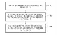
本例示において、候補分離帯情報が複数の候補分離帯情報を含む場合に、図3に示すように、上記ステップ103は以下のステップ201〜203を含む。 In this example, when the candidate median strip information includes a plurality of candidate median strip information, the
ステップ201は、複数の候補分離帯情報における各候補分離帯情報の信頼度を決定する。 Step 201 determines the reliability of each candidate separation zone information in the plurality of candidate separation zone information.
具体的には、分離帯情報を採用できるか否かを知るために、各候補分離帯情報の信頼度を決定する。 Specifically, in order to know whether or not the median strip information can be adopted, the reliability of each candidate median strip information is determined.
一例として、以上の分析のように、候補分離帯情報は分離帯タイプを含み、そのため、各候補分離帯情報における分離帯タイプに基づいて、複数の候補分離帯情報を少なくとも1つの分離帯集合に分け、各分離帯集合の候補分離帯タイプが同じであり、さらに、各分離帯集合に含まれる候補分離帯情報の数を決定し、数によって各分離帯集合に含まれる各候補分離帯情報の信頼度を決定する。 As an example, as in the above analysis, the candidate median information includes a median type, and therefore, based on the median type in each median information, a plurality of candidate median information is combined into at least one median set. Divide, the candidate median type of each median set is the same, and the number of candidate median information included in each median set is determined, and the number of candidate median information included in each median set is determined. Determine reliability.
なお、道路上、特に高速道路上では、道路の片側の分離帯タイプは通常一致しているため、本実施例において、分離帯タイプに対応する数に基づいて候補分離帯情報の信頼度を決定することは容易に理解するであろう。ここで、数と全体の候補分離帯情報の数との比率を計算して、予め確率された比率と信頼度との関係に基づいて、候補分離帯情報の信頼度を決定することができる。例えば、1つの目標道路で識別された候補分離帯情報が10個であって、そのうちの7個が緑地帯、3個がフェンスである場合、緑地帯タイプの候補分離帯情報の信頼度が高いと考えられる。 Since the median strip types on one side of the road usually match on the road, especially on the expressway, in this embodiment, the reliability of the candidate median strip information is determined based on the number corresponding to the median strip type. It will be easy to understand what to do. Here, the reliability of the candidate median strip information can be determined based on the relationship between the pre-probability ratio and the reliability by calculating the ratio between the number and the total number of candidate median strip information. For example, if there are 10 candidate median strips identified on one target road, and 7 of them are green zones and 3 are fences, the reliability of the green zone type candidate median strip information is high. it is conceivable that.
もちろん、本例示において、候補分離帯情報に対応する確率は同じく重要な参考意味を持っているので、各分離帯集合に含まれるすべての候補分離帯情報の確率の平均値が決定でき、平均値に基づいて信頼度を修正し、例えば、確率の平均値が比較的高いと決定された場合、予め設定された対応関係に基づいて確率の平均値に対応する信頼度増加値を決定し、さらに、確率の平均値に基づいて、信頼度増加値を最後の信頼度増加値として追加し、本例示において、特定のノイズパラメータの影響を避けるために、さらに各分離帯集合におけるすべての候補分離帯情報の確率のうちの最大値と最小値を除いてから確率の平均値を取ることもできる。 Of course, in this example, since the probabilities corresponding to the candidate separation zone information have the same important reference meaning, the average value of the probabilities of all the candidate separation zone information included in each separation zone set can be determined, and the average value can be determined. For example, if it is determined that the average value of the probabilities is relatively high, the reliability increase value corresponding to the average value of the probabilities is determined based on a preset correspondence relationship, and further. , Based on the average value of the probabilities, the confidence increase value is added as the final confidence increase value, and in this example, in order to avoid the influence of specific noise parameters, all candidate separation zones in each separation zone set are further added. It is also possible to take the average value of the probabilities after excluding the maximum and minimum values of the probabilities of the information.
本例示において、数に基づいて各分離帯集合に含まれる各候補分離帯情報の信頼度を決定する前に、さらに各分離帯情報に対応する分離帯位置を決定することもでき、分離帯位置に基づいて、候補分離帯情報の連続して隣接する数を決定し、連続して隣接する数に基づいて信頼度を修正する。つまり、本例示において、連続する複数の候補分離帯情報の分離帯タイプが同じである場合、それは信頼できると考えられる。例えば、数と信頼度増加値との対応関係を確立することができ、これにより、信頼度に基づいて対応する信頼度増加値を追加して最後の信頼度とする。 In this example, before determining the reliability of each candidate median information included in each median set based on the number, the median position corresponding to each median information can be further determined, and the median position can be determined. Based on, the number of consecutively adjacent candidate median strip information is determined, and the reliability is corrected based on the number of consecutively adjacent numbers. That is, in this example, if the separation band types of a plurality of consecutive candidate separation band information are the same, it is considered to be reliable. For example, a correspondence between the number and the reliability increase value can be established, whereby the corresponding reliability increase value is added based on the reliability to be the final reliability.
一例をあげると、図4に示すように、引き続き上記例示に基づいて、目標道路で識別された候補分離帯情報が10個であって、そのうちの7個が緑地帯、3個がフェンスであるが、3個のフェンスが隣接する分離帯情報である場合、フェンスの信頼度が比較的高いと考えられ、したがって、信頼度に基づいて一定値を追加して最後の信頼度とする。 As an example, as shown in FIG. 4, based on the above example, there are 10 candidate median strips identified on the target road, 7 of which are green zones and 3 of which are fences. However, when the three fences are adjacent median strip information, the reliability of the fence is considered to be relatively high, and therefore, a constant value is added based on the reliability to obtain the final reliability.
実際の実行過程において、本例示において、分離帯タイプの隣接する分離帯位置に基づいて信頼度を修正する場合、隣接する候補分離帯情報の確率に合わせて計算してもよく、ここで、計算方式は連続して隣接する候補分離帯情報の確率の平均値であってもよく、信頼度増加値を決定し、信頼度に基づいて対応する信頼度増加値を追加して最後の信頼度とする。 In the actual execution process, in this example, when the reliability is corrected based on the adjacent median position of the median type, it may be calculated according to the probability of the adjacent candidate median information, and is calculated here. The method may be the average value of the probabilities of consecutive adjacent candidate median strip information, determine the confidence increase value, add the corresponding reliability increase value based on the reliability, and use it as the final reliability. To do.
ステップ202は、信頼度が第1の予め設定された閾値より大きい第1の候補分離帯情報、及び信頼度が第2の予め設定された閾値以下である第2の候補分離帯情報を含むか否かを判断し、ここで、第2の予め設定された閾値は第1の予め設定された閾値より小さい。 Does
具体的には、信頼度を決定した後、信頼度が第1の予め設定された閾値より大きい第1の候補分離帯情報、及び信頼度が第1の予め設定された閾値より小さい第2の予め設定された閾値以下である第2の候補分離帯情報を含むか否かを判断する。 Specifically, after determining the reliability, the first candidate median strip information whose reliability is larger than the first preset threshold, and the second candidate whose reliability is smaller than the first preset threshold. It is determined whether or not the second candidate median strip information which is equal to or less than the preset threshold value is included.
ステップ203は、第1の候補分離帯情報及び第2の候補分離帯情報を含む場合、第2の候補分離帯情報のうちの候補分離帯タイプを第1の候補分離帯情報に対応する候補分離帯タイプに修正する。 In
具体的には、第1の候補分離帯情報及び第2の候補分離帯情報を含む場合、第2の候補分離帯情報のうちの候補分離帯タイプを第1の候補分離帯情報に対応する候補分離帯タイプに修正し、これにより、個別のノイズの影響を避けた。例えば、目標道路で識別された候補分離帯情報が10個であって、そのうちの7個が緑地帯、3個がフェンスであり、3個のフェンスの信頼度が比較的低いため、フェンスを緑地帯に変更する。 Specifically, when the first candidate median strip information and the second candidate median strip information are included, the candidate median strip type of the second candidate median strip information corresponds to the candidate corresponding to the first candidate median strip information. It was modified to a median strip type, thereby avoiding the influence of individual noise. For example, there are 10 candidate median strips identified on the target road, 7 of which are green zones, 3 are fences, and the reliability of the 3 fences is relatively low, so the fences are green. Change to a zone.
本発明の1つの実施例において、第1の候補分離帯情報が含まれておらず、第2の候補分離帯情報のみが含まれる場合、第2の候補分離帯情報が正しいか否かを人工で確認するようにユーザに通知でき、第1の候補分離帯情報を含むが、第2の候補分離帯情報を含まない場合は、既存のあらゆる候補分離帯情報を保留する。 In one embodiment of the present invention, when the first candidate median strip information is not included and only the second candidate median strip information is included, it is artificially determined whether or not the second candidate median strip information is correct. Can be notified to the user to confirm in, and includes the first candidate median information, but does not include the second candidate median information, all existing candidate median information is withheld.
他の一例として、以上の例示で述べたように、候補分離帯情報には分離帯位置をさらに含み、分離帯位置は座標位置であってよく、目標道路に対する位置であってもよく、候補分離帯データに対応する参考分離帯データを取得する。ここで、参考分離帯データは目標道路と隣接する道路上で取得され、隣接する道路と目標道路との関係は上下行関係であってよい。したがって、同じ分離帯位置において、候補分離帯データのうちの候補分離帯情報と参考分離帯データのうちの参考分離帯情報とが一致しているか否かを取得し、一致していない候補分離帯情報を決定し、一致していない候補分離帯情報の確率が、対応する参考分離帯情報の確率以上であるかを判断し、それ以上である場合、一致していない候補分離帯情報を対応する参考分離帯情報に修正する。つまり、本実施例において、同じ分離帯位置において、目標道路と隣接する道路で識別された分離帯情報に対して、確率が比較的高い分離帯情報を用いる。 As another example, as described in the above examples, the candidate separation zone information further includes the separation zone position, and the separation zone position may be a coordinate position, a position with respect to the target road, and candidate separation. Acquire the reference median strip data corresponding to the band data. Here, the reference median strip data is acquired on the road adjacent to the target road, and the relationship between the adjacent road and the target road may be a vertical relationship. Therefore, at the same median position, it is acquired whether or not the candidate median information in the candidate median data and the reference median information in the reference median data match, and the candidate median strips that do not match are acquired. The information is determined to determine whether the probability of the non-matching candidate median information is greater than or equal to the probability of the corresponding reference median information, and if it is greater than that, the non-matching candidate median information is matched. Correct to reference median strip information. That is, in this embodiment, the median information having a relatively high probability is used with respect to the median information identified by the road adjacent to the target road at the same median position.
一例をあげると、図5に示すように、目標道路A及び目標道路に対向する隣接道路Bについて、目標道路Aの候補分離帯情報A1と同じ分離帯位置における参考分離帯情報B1とが一致せず、A1の確率が20%、B1の確率が80%である場合、a1の分離帯タイプをb1に対応する分離帯タイプに修正する。 As an example, as shown in FIG. 5, the target road A and the adjacent road B facing the target road match the reference median information B1 at the same median position as the candidate median information A1 of the target road A. However, when the probability of A1 is 20% and the probability of B1 is 80%, the median strip type of a1 is modified to the median strip type corresponding to b1.
ステップ104は、目標道路が含まれる地図ベースマップにおいて、地図を生成するように目標分離帯情報に対応するアイコンをマークする。 Step 104 marks the icon corresponding to the target median information so as to generate a map in the map basemap including the target road.
具体的には、目標分離帯情報を決定した後、目標道路が含まれる地図ベースマップにおいて、目標分離帯情報に対応するアイコンをマークし、ここで、アイコンは予め設定された、目標分離帯情報に対応する分離帯タイプに対応する標準アイコンであってよい。一例をあげると、地図上の道路において、通常の道路分割線以外、対応する分離帯情報をマークし、ユーザは地図上で道路上の緑地帯を直感的に見ることができる。本発明の1つの実施例において、地図の真実感を向上させるように、直接緑地帯に対応するストリートビュー画像におけるエリアを地図の地図サイズに応じてズームした後、地図に対応する位置に示すこともできる。 Specifically, after determining the target median strip information, an icon corresponding to the target median strip information is marked on the map base map including the target road, where the icon is a preset target median strip information. It may be a standard icon corresponding to the median type corresponding to. For example, on a road on a map, other than the normal road dividing line, the corresponding median strip information is marked, and the user can intuitively see the green zone on the road on the map. In one embodiment of the present invention, in order to improve the sense of truth of the map, the area in the street view image directly corresponding to the green zone is zoomed according to the map size of the map and then shown at the position corresponding to the map. You can also.
本発明の1つの実施例において、識別された目標分離情報の正確性を保証するために、予め設定された期間内に、目標道路でのユーザの運行情報を提供することもでき、運行情報の軌跡に基づいて、目標分離帯情報を通り抜けるなどの行為があるか否かを決定し、以上のような行為がある場合、目標分離帯情報が信頼できないと表明され、したがって、当該位置について目標分離帯情報の評価を改めて行う。例えば、ユーザの運転軌跡に基づいて、ユーザがユーターンなどの対応する目標分離帯情報に対する回避行為を有するか否かを判断し、これにより目標分離帯情報が信頼できか否かを決定し、したがって、信頼できない目標分離帯情報を修正する。 In one embodiment of the present invention, in order to guarantee the accuracy of the identified target separation information, the operation information of the user on the target road can be provided within a preset period, and the operation information of the operation information can be provided. Based on the trajectory, it is determined whether or not there is an action such as passing through the target separation zone information, and if there is such an action, it is stated that the target separation zone information is unreliable, and therefore the target separation for the relevant position. Evaluate the band information again. For example, based on the user's driving trajectory, it is determined whether or not the user has an evasive action against the corresponding target separation zone information such as a U-turn, thereby determining whether or not the target separation zone information is reliable, and therefore. , Correct unreliable median strip information.
以上により、本発明に係る実施例の地図生成方法は、目標道路に対応するストリートビュー画像を取得し、ストリートビュー画像を予め設定された識別モデルに入力して、ストリートビュー画像に対応する、候補分離帯情報及び対応する確率を含む候補分離帯データを取得し、予め設定された修正ポリシー及び確率に基づいて候補分離帯情報を修正して目標分離帯情報を取得し、さらに、目標道路を含む地図ベースマップにおいて、地図を生成するように目標分離帯情報に対応するアイコンをマークする。これにより、地図上で分離帯情報を正確にマークすることを実現し、地図のナビゲーション性能を向上させる。 Based on the above, the map generation method of the embodiment according to the present invention is a candidate that acquires a street view image corresponding to the target road, inputs the street view image into a preset identification model, and corresponds to the street view image. The candidate separation zone data including the separation zone information and the corresponding probability is acquired, the candidate separation zone information is modified based on the preset correction policy and the probability, and the target separation zone information is acquired, and further, the target road is included. In the map basemap, mark the icon corresponding to the target separation zone information to generate the map. This makes it possible to accurately mark the median strip information on the map and improve the navigation performance of the map.
上記実施例を実現するため、本発明は地図生成装置をさらに提供する。図6は本発明の1つの実施例に係る地図生成装置の構成概略図であり、図6に示すように、地図生成装置は、第1の取得モジュール10と、第2の取得モジュール20と、第3の取得モジュール30と、生成モジュール40とを備える。 In order to realize the above embodiment, the present invention further provides a map generator. FIG. 6 is a schematic configuration diagram of a map generator according to an embodiment of the present invention. As shown in FIG. 6, the map generator includes a
第1の取得モジュール10は、目標道路に対応するストリートビュー画像の取得に用いられる。 The
第2の取得モジュール20は、前記ストリートビュー画像を予め設定された識別モデルに入力して、前記ストリートビュー画像に対応する、候補分離帯情報及び対応する確率を含む候補分離帯データを取得することに用いられる。 The
第3の取得モジュール30は、予め設定された修正ポリシー及び確率に基づいて候補分離帯情報を修正して目標分離帯情報を取得することに用いられる。 The
生成モジュール40は、目標道路を含む地図ベースマップにおいて、地図を生成するように目標分離帯情報に対応するアイコンをマークすることに用いられる。 The
本発明の1つの実施例において、図7に示すように、地図生成装置は撮影モジュール50をさらに備えていてもよい。 In one embodiment of the present invention, as shown in FIG. 7, the map generator may further include a photographing
撮影モジュールは、具体的には、目標道路の道路進行方向及び道路タイプを決定し、道路進行方向と道路タイプに基づいて、ストリートビュー撮影パラメータを決定し、ストリートビュー撮影パラメータに基づいてストリートビュー画像を撮影することに用いられる。 Specifically, the shooting module determines the road direction and road type of the target road, determines the street view shooting parameters based on the road traveling direction and the road type, and determines the street view shooting parameters based on the street view shooting parameters. It is used to photograph.
本発明の1つの実施例において、候補分離帯情報が複数含まれる場合、第3の取得モジュール30は、具体的には、複数の候補分離帯情報の各候補分離帯情報の信頼度を決定し、信頼度が第1の予め設定された閾値より大きい第1の候補分離帯情報、及び信頼度が第1の予め設定された閾値より小さい第2の予め設定された閾値以下である第2の候補分離帯情報を含むか否かを判断する。そして、第1の候補分離帯情報及び第2の候補分離帯情報を含む場合、第2の候補分離帯情報の中の候補分離帯タイプを第1の候補分離帯情報に対応する候補分離帯タイプに修正することに用いられる。 In one embodiment of the present invention, when a plurality of candidate median strip information is included, the
本発明の1つの実施例において、第3の取得モジュール30は、具体的には、候補分離帯データに対応する参考分離帯データを取得し、参考分離帯データは目標道路と隣接する道路上で取得され、同じ分離帯位置において、候補分離帯データの中の候補分離帯情報と、参考分離帯データの中の参考分離帯情報とが一致しているか否かを判断する。そして、一致していない候補分離帯情報を決定し、一致していない候補分離帯情報の確率が、対応する参考分離帯情報の確率以上であるかを判断し、それ以上である場合、一致していない候補分離帯情報を対応する参考分離帯情報に修正することに用いられる。 In one embodiment of the present invention, the
なお、地図生成方法の上記説明は、本実施例の地図生成装置にも適用可能であり、その実現原理は類似するものであるため、ここでは説明を省略する。 Since the above description of the map generation method can be applied to the map generation device of this embodiment and the realization principle is similar, the description thereof will be omitted here.
以上により、本発明に係る地図生成装置は、目標道路に対応するストリートビュー画像を撮影し、ストリートビュー画像を予め設定された識別モデルに入力して、ストリートビュー画像に対応する、候補分離帯情報及び対応する確率を含む候補分離帯データを取得し、予め設定された修正ポリシー及び確率に基づいて候補分離帯情報を修正して目標分離帯情報を取得し、さらに、目標道路を含む地図ベースマップにおいて、地図を生成するように目標分離帯情報に対応するアイコンをマークする。これにより、地図上で分離帯情報を正確にマークすることを実現し、地図のナビゲーション性能を向上させる。 Based on the above, the map generator according to the present invention captures a street view image corresponding to the target road, inputs the street view image into a preset identification model, and provides candidate median strip information corresponding to the street view image. And the candidate median data including the corresponding probability is acquired, the candidate median information is modified based on the preset correction policy and the probability to acquire the target median information, and the map base map including the target road is obtained. In, mark the icon corresponding to the target median strip information so as to generate a map. This makes it possible to accurately mark the median strip information on the map and improve the navigation performance of the map.
本発明の実施例により、本発明に係る電子機器及び読み取り可能な記憶媒体をさらに提供する。 Embodiments of the present invention further provide electronic devices and readable storage media according to the present invention.
図8に示すように、本発明の実施例に係る地図生成方法の電子機器のブロック図である。電子機器は、ラップトップコンピュータ、デスクトップコンピュータ、ワークベンチ、携帯情報端末、サーバ、ブレードサーバ、メインフレームコンピュータ、及びその他の適切なコンピュータなど、さまざまな形式のデジタルコンピュータを表すことを目的としている。電子機器は、携帯情報端末、携帯電話、スマートフォン、ウェアラブルデバイス、その他の同様のコンピューティングデバイスなど、さまざまな形態のモバイルデバイスを表すこともできる。本明細書で示されるコンポーネント、それらの接続及び関係、及びそれらの機能は単なる一例であり、本明細書で説明及び/または必要とされる本発明の実現を限定することを意図するものではない。 As shown in FIG. 8, it is a block diagram of an electronic device of the map generation method according to the embodiment of the present invention. Electronic devices are intended to represent various types of digital computers, such as laptop computers, desktop computers, workbench, mobile information terminals, servers, blade servers, mainframe computers, and other suitable computers. Electronic devices can also represent various forms of mobile devices, such as personal digital assistants, mobile phones, smartphones, wearable devices, and other similar computing devices. The components shown herein, their connections and relationships, and their functions are merely examples and are not intended to limit the realization of the invention as described and / or required herein. ..
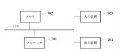
図8に示すように、電子機器は、少なくとも1つのプロセッサ701と、メモリ702と、高速インタフェース及び低速インタフェースを有し、様々なコンポーネントを接続するためのインタフェースとを備える。さまざまなコンポーネントは、異なるバスを用いて互いに接続され、共通のマザーボードに取り付けられるか、必要に応じて取り付けられてもよい。プロセッサは、外部入力/出力デバイス(たとえば、インタフェースに結合されたディスプレイデバイス)にGUIのグラフィカル情報を表示するためにメモリに記憶されている命令を含み、電子機器内で実行される命令を処理することができる。他の実施例では、必要に応じて、複数のプロセッサ及び/または複数のバスを複数のメモリとともに使用することができる。同様に、複数の電子機器を接続してもよく、それぞれの電子機器が必要な操作(たとえば、サーバアレイ、1グループのブレードサーバ、マルチプロセッサシステム)の一部を提供できる。図8では、1つのプロセッサ701を一例に挙げている。 As shown in FIG. 8, the electronic device includes at least one
メモリ702は、本発明によって提供される非一時的なコンピュータ読み取り可能な記憶媒体である。メモリ702には、少なくとも1つのプロセッサが上記の地図生成方法を実行するように、少なくとも1つのプロセッサによって実行可能な命令が記憶されている。本発明に係る非一時的なコンピュータ読み取り可能な記憶媒体には、上記の地図生成方法をコンピュータに実行させるためのコンピュータ命令が記憶されている。 The
メモリ702は、非一時的なコンピュータ読み取り可能な記憶媒体として、非一時的なソフトウェアプログラム、非一時的なコンピュータ実行可能なプログラム、及び本発明の実施例の駐車スペースデータの有効性を識別する方法に対応するプログラム命令/モジュール(たとえば、図6に示される第1の取得モジュール10、第2の取得モジュール20、第3の取得モジュール30及び生成モジュール40)を記憶することに用いられてもよい。プロセッサ701は、メモリ702に記憶されている非一時的なソフトウェアプログラム、命令、及びモジュールを実行することにより、サーバの様々な機能アプリケーション及びデータ処理を実行し、すなわち、上記方法の実施例における駐車スペースデータの有効性を識別する方法を実現する。 The
メモリ702は、プログラム記憶領域及びデータ記憶領域を含むことができ、プログラム記憶領域は、オペレーティングシステムと、少なくとも1つの機能に必要なアプリケーションプログラムとを記憶することができる。データ記憶領域は、電子機器の使用に基づいて生成されたデータを記憶することができる。また、メモリ702は、高速ランダムアクセスメモリを含んでもよく、少なくとも1つの磁気ディスク記憶装置、フラッシュメモリ装置、または他の非一時的な固体記憶装置などの非一時的なメモリを含んでもよい。変形例として、メモリ702は、プロセッサ701に対して遠隔に配置されたメモリを選択可能に含んでもよく、これらの遠隔メモリは、ネットワークを介して電子機器に接続され得る。上記ネットワークの一例としては、インターネット、イントラネット、ローカルエリアネットワーク、モバイル通信ネットワーク、及びそれらの組み合わせを含むが、これらに限定されない。 The
駐車スペースデータの有効性を識別する方法を実行する電子機器は、入力装置703及び出力装置704をさらに備えていてもよい。プロセッサ701、メモリ702、入力装置703、及び出力装置704は、バスまたは他の方式を介して接続することができ、図7では、バスによる接続を一例に挙げている。 An electronic device that implements the method of identifying the validity of parking space data may further include an
入力装置703は、入力された数字または文字情報を受信し、電子機器のユーザ設定及び機能制御に関するキー信号入力を生成することができ、たとえば、タッチスクリーン、キーパッド、マウス、トラックパネル、タッチパネル、ポインティングスティック、少なくとも1つのマウスボタン、トラックボール、ジョイスティックなどの入力デバイス電子機器。出力装置704は、表示装置、補助照明装置(たとえば、LED)、触覚フィードバック装置(たとえば、振動モータ)などを備えていてもよい。表示装置は、液晶ディスプレイ(LCD)、発光ダイオード(LED)ディスプレイ、及びプラズマディスプレイを含んでもよいが、これらに限定されない。変形例として、表示装置はタッチスクリーンであってもよい。 The
本明細書で説明されるシステム及び技術の様々な実施形態は、デジタル電子回路、集積回路システム、特定用途向けASIC(特定用途向け集積回路)、コンピュータハードウェア、ファームウェア、ソフトウェア、及び/またはそれらの組み合わせで実現され得る。これらの様々な実施例は以下を含んでもよい。少なくとも1つのプログラマブルプロセッサを含むプログラマブルシステム上で実行可能及び/または解釈可能な少なくとも1つのコンピュータプログラムにおいて実行され、プログラマブルプロセッサは、ストレージシステム、少なくとも1つの入力装置、及び少なくとも1つの出力装置からデータ及び命令を受信し、データ及び命令をストレージシステム、少なくとも1つの入力装置、及び少なくとも1つの出力装置に送信することができる専用または汎用のプログラマブルプロセッサであってもよい。 Various embodiments of the systems and techniques described herein include digital electronic circuits, integrated circuit systems, application specific ASICs (ASICs), computer hardware, firmware, software, and / or theirs. It can be realized in combination. These various examples may include: Executed in at least one computer program that is executable and / or interpretable on a programmable system that includes at least one programmable processor, the programmable processor is data and data from a storage system, at least one input device, and at least one output device. It may be a dedicated or general purpose programmable processor capable of receiving instructions and transmitting data and instructions to a storage system, at least one input device, and at least one output device.
これらのコンピューティングプログラム(プログラム、ソフトウェア、ソフトウェアアプリケーション、またはコードともいう)は、プログラマブルプロセッサの機械命令を含み、されに高度プロセス及び/またはオブジェクト指向プログラミング言語、及び/またはアセンブリ/機械言語を用いてこれらのンピューティングプログラムを実施することができる。本明細書で使用される「機械読み取り可能な媒体」及び「コンピュータ読み取り可能な媒体」という用語は、機械命令及び/またはデータをプログラマブルプロセッサに提供するための任意のコンピュータプログラム製品、デバイス、及び/または装置( たとえば、磁気ディスク、光ディスク、メモリ、プログラマブルロジックデバイス(PLD)を指し、機械読み取り可能な信号としての機械命令を受信する機械読み取り可能な媒体を含む。「機械読み取り可能な信号」という用語は、機械命令及び/またはデータをプログラマブルプロセッサに提供するための信号を指す。 These computing programs (also referred to as programs, software, software applications, or code) include programmable processor machine instructions, using advanced process and / or object-oriented programming languages, and / or assembly / machine languages. These computing programs can be implemented. As used herein, the terms "machine readable medium" and "computer readable medium" are any computer program product, device, and / for providing machine instructions and / or data to a programmable processor. Or a device (eg, a magnetic disk, an optical disk, a memory, a programmable logic device (PLD), including a machine-readable medium that receives a machine instruction as a machine-readable signal. The term "machine-readable signal". Refers to a signal for providing machine instructions and / or data to a programmable processor.
ユーザとのインタラクションを提供するために、本明細書に記載のシステム及び技術は、ユーザに情報を表示するための表示装置(たとえば、CRT(陰極線管)またはLCD(液晶ディスプレイ)モニター)と、キーボード及びポインティング装置(たとえば、マウスまたはトラックボール)とを有するコンピュータで実施されてもよく、ユーザはキーボード及びポインティング装置を介してコンピュータに入力できる。他の種類の装置を用いてユーザとのインタラクションを提供することもできる。たとえば、ユーザに提供されるフィードバックは、任意の形式のセンシングフィードバック(たとえば、視覚フィードバック、聴覚フィードバック、または触覚フィードバック)であってもよく、任意の形式(たとえば、音響入力、音声入力、または触覚入力)を用いてユーザからの入力を受信することができる。 To provide interaction with the user, the systems and techniques described herein include a display device (eg, a CRT (cathode tube) or LCD (liquid crystal display) monitor) for displaying information to the user, and a keyboard. And may be performed on a computer with a pointing device (eg, mouse or trackball), the user can enter into the computer via a keyboard and pointing device. Other types of devices can also be used to provide interaction with the user. For example, the feedback provided to the user may be of any form of sensing feedback (eg, visual feedback, auditory feedback, or tactile feedback) and of any form (eg, acoustic input, voice input, or tactile input). ) Can be used to receive input from the user.
本明細書に記載のシステム及び技術の各実施例は、バックエンドコンポーネントを含むコンピューティングシステム(たとえば、データサーバとして)、またはミドルコンポーネントを含むコンピューティングシステム(たとえば、アプリケーションサーバ)、またはフロントエンドコンポーネントを含むコンピューティングシステム(たとえば、グラフィカルユーザインターフェイスまたはWebブラウザを備えたユーザコンピュータ。ユーザは、グラフィカルユーザインターフェイスまたはWebブラウザを介して、ここで説明されるシステム及び技術の実施例とインタラクションできる)、またはこのようなバックエンドコンポーネント、ミドルコンポーネント、またはフロントエンドコンポーネントの任意の組み合わせを含むコンピューティングシステムで実施することができる。デジタルデータ通信の任意の形式または媒体(たとえば、通信ネットワーク)によってシステムのコンポーネントを互いに接続してもよい。通信ネットワークの例は、ローカルエリアネットワーク(LAN)、ワイドエリアネットワーク(WAN)、及びインターネットを含む。 Each embodiment of the system and technology described herein is a computing system that includes a back-end component (eg, as a data server), or a computing system that includes a middle component (eg, an application server), or a front-end component. A computing system including (eg, a user computer with a graphical user interface or web browser; the user can interact with embodiments of the systems and techniques described herein through the graphical user interface or web browser), or. It can be implemented in computing systems that include any combination of such back-end, middle, or front-end components. The components of the system may be connected to each other by any form or medium of digital data communication (eg, a communication network). Examples of communication networks include local area networks (LANs), wide area networks (WANs), and the Internet.
コンピュータシステムは、クライアントとサーバとを備えていてもよい。一般的に、クライアントとサーバとは互いに離れており、通信ネットワークを介してインタラクションする。それぞれのコンピュータで実行され、互いにクライアントとサーバとの関係を持つコンピュータプログラムによってクライアントとサーバとの関係を生成する。 The computer system may include a client and a server. Generally, the client and the server are separated from each other and interact with each other via a communication network. A client-server relationship is created by a computer program that runs on each computer and has a client-server relationship with each other.
なお、上記さまざまな形態のプロセスを使用して、ステップを並べ替え、追加、または削除できることを理解されたい。たとえば、本発明で説明されている各ステップは、並列、順次、または異なる順序で実行できる。本発明で開示された技術案の望ましい結果を達成できれば、本明細書では限定されない。 It should be noted that the various forms of process described above can be used to sort, add, or remove steps. For example, each step described in the present invention can be performed in parallel, sequentially, or in a different order. The present specification is not limited as long as the desired result of the proposed technique disclosed in the present invention can be achieved.
前述した具体的な実施例は、本発明の保護範囲を限定するものではない。当業者であれば、設計要件及び他の要因に応じて、さまざまな修正、組み合わせ、一部の組み合わせ、及び置き換えを行うことができることを理解されたい。本発明の趣旨及び原則の範囲内で行われた修正、同等の置き換え、及び改善は、いずれも本発明の保護範囲に含まれるものとする。 The specific examples described above do not limit the scope of protection of the present invention. It should be appreciated that one of ordinary skill in the art can make various modifications, combinations, some combinations, and replacements, depending on design requirements and other factors. Any modifications, equivalent replacements, or improvements made within the scope of the gist and principles of the present invention shall be included in the scope of protection of the present invention.
Claims (14)
Translated fromJapanese目標道路に対応するストリートビュー画像を取得するステップと、
前記ストリートビュー画像を予め設定された識別モデルに入力して、前記ストリートビュー画像に対応する、候補分離帯情報及び対応する確率を含む候補分離帯データを取得するステップと、
予め設定された修正ポリシー及び前記確率に基づいて前記候補分離帯情報を修正して目標分離帯情報を取得するステップと、
前記目標道路を含む地図ベースマップにおいて、地図を生成するように前記目標分離帯情報に対応するアイコンをマークするステップとを含む地図生成方法。It ’s a map generation method.
Steps to get the Street View image corresponding to the target road,
A step of inputting the Street View image into a preset discriminative model to acquire candidate median strip data including candidate median strip information and corresponding probabilities corresponding to the Street View image.
A step of modifying the candidate median strip information based on a preset modification policy and the probability to acquire the target median strip information, and
A map generation method including a step of marking an icon corresponding to the target separation zone information so as to generate a map in a map base map including the target road.
前記目標道路の道路進行方向及び道路タイプを決定するステップと、
前記道路進行方向及び前記道路タイプに基づいて、ストリートビュー撮影パラメータを決定するステップと、
前記ストリートビュー撮影パラメータに基づいて前記ストリートビュー画像を撮影するステップとを含む請求項1に記載の地図生成方法。Before the step of acquiring the Street View image corresponding to the target road,
Steps to determine the road direction and road type of the target road, and
A step of determining street view shooting parameters based on the road traveling direction and the road type, and
The map generation method according to claim 1, further comprising a step of capturing the street view image based on the street view photographing parameter.
複数の前記候補分離帯情報の各前記候補分離帯情報の信頼度を決定するステップと、
前記信頼度が第1の予め設定された閾値より大きい第1の候補分離帯情報、及び前記信頼度が第2の予め設定された閾値以下である第2の候補分離帯情報を含むか否かを判断するステップであって、前記第2の予め設定された閾値が前記第1の予め設定された閾値より小さいステップと、
前記第1の候補分離帯情報及び前記第2の候補分離帯情報を含む場合、前記第2の候補分離帯情報の候補分離帯タイプを前記第1の候補分離帯情報に対応する候補分離帯タイプに修正するステップとを含む請求項1に記載の地図生成方法。When a plurality of candidate median strip information is included, the step of modifying the candidate median strip information based on the preset modification policy and the probability to acquire the target median strip information is
A step of determining the reliability of each of the candidate separation band information of the plurality of candidate separation band information, and
Whether or not the reliability includes the first candidate median information whose reliability is greater than the first preset threshold value and the second candidate median information whose reliability is equal to or less than the second preset threshold value. A step in which the second preset threshold value is smaller than the first preset threshold value.
When the first candidate median strip information and the second candidate median strip information are included, the candidate median strip type of the second candidate median strip information corresponds to the candidate median strip type corresponding to the first candidate median strip information. The map generation method according to claim 1, further comprising a step of modifying the above.
各前記候補分離帯情報の各前記候補分離帯タイプに基づいて、複数の前記候補分離帯情報を少なくとも1つの分離帯集合に分けるステップであって、少なくとも1つの前記分離帯集合の各前記分離帯集合の前記候補分離帯タイプが同じであるステップと、
各前記分離帯集合に含まれる前記候補分離帯情報の数を決定し、決定した該数に基づいて各前記分離帯集合に含まれる各前記候補分離帯情報の前記信頼度を決定するステップとを含む請求項3に記載の地図生成方法。The step of determining the reliability of each of the candidate separation band information of the plurality of candidate separation band information is
A step of dividing a plurality of candidate median information into at least one median set based on each candidate median type of each median information, and each median of at least one median set. A step in which the candidate median type of the set is the same,
A step of determining the number of candidate separation zone information included in each separation zone set and determining the reliability of each candidate separation zone information included in each separation zone set based on the determined number. The map generation method according to claim 3, which includes.
各前記分離帯集合に含まれるすべての前記候補分離帯情報の確率の平均値を決定し、決定した該平均値に基づいて前記信頼度を修正するステップをさらに含む請求項4に記載の地図生成方法。Before the step of determining the reliability of each candidate median information contained in each median set based on the number.
The map generation according to claim 4, further comprising a step of determining an average value of the probabilities of all the candidate median strip information included in each median set and modifying the reliability based on the determined average value. Method.
各前記分離帯集合に含まれる各前記分離帯情報に対応する分離帯位置を決定するステップと、
前記分離帯位置に基づいて、前記候補分離帯情報の連続して隣接する数を決定し、前記連続して隣接する数に基づいて前記信頼度を修正するステップとをさらに含む請求項4に記載の地図生成方法。Before the step of determining the reliability of each candidate separation zone information contained in each separation zone set based on the number.
A step of determining a median position corresponding to each median information included in each median set, and
4. The fourth aspect of the present invention further includes a step of determining a number of consecutively adjacent candidate separation zone information based on the position of the separation zone and correcting the reliability based on the number of consecutively adjacent numbers. Map generation method.
前記候補分離帯データに対応する参考分離帯データを取得するステップであって、前記参考分離帯データは前記目標道路と隣接する道路上で取得されるステップと、
同じ分離帯位置において、前記候補分離帯データの候補分離帯情報と、前記参考分離帯データの参考分離帯情報とが一致しているか否かを判断するステップと、
一致していない前記候補分離帯情報を決定し、一致していない前記候補分離帯情報の確率が、対応する前記参考分離帯情報の確率以上であるか否かを判断して比較するステップと、
前記参考分離帯情報の確率以上である場合、一致していない前記候補分離帯情報を対応する前記参考分離帯情報に修正するステップとを含む請求項1に記載の地図生成方法。The step of modifying the candidate median strip information based on the preset modification policy and the probability to acquire the target median strip information is
A step of acquiring reference median data corresponding to the candidate median data, the step of acquiring the reference median data on a road adjacent to the target road, and a step of acquiring the reference median data.
At the same separation zone position, a step of determining whether or not the candidate separation zone information of the candidate separation zone data and the reference separation zone information of the reference separation zone data match.
A step of determining the non-matching candidate median strip information, determining whether the probability of the non-matching candidate median strip information is greater than or equal to the probability of the corresponding reference median strip information, and comparing the information.
The map generation method according to claim 1, further comprising a step of correcting the non-matching candidate median strip information to the corresponding reference median strip information when the probability is greater than or equal to the probability of the reference median strip information.
目標道路に対応するストリートビュー画像を取得する第1の取得モジュールと、
前記ストリートビュー画像を予め設定された識別モデルに入力して、前記ストリートビュー画像に対応する、候補分離帯情報及び対応する確率を含む候補分離帯データを取得する第2の取得モジュールと、
予め設定された修正ポリシー及び前記確率に基づいて前記候補分離帯情報を修正して目標分離帯情報を取得する第3の取得モジュールと、
前記目標道路を含む地図ベースマップにおいて、地図を生成するように前記目標分離帯情報に対応するアイコンをマークする生成モジュールとを備える地図生成装置。It is a map generator
The first acquisition module that acquires the Street View image corresponding to the target road,
A second acquisition module that inputs the street view image into a preset identification model and acquires candidate separation zone data including candidate separation zone information and corresponding probabilities corresponding to the street view image, and a second acquisition module.
A third acquisition module that modifies the candidate segregation zone information and acquires the target segregation zone information based on the preset modification policy and the probability.
A map generation device including a generation module that marks an icon corresponding to the target separation zone information so as to generate a map in a map base map including the target road.
前記道路進行方向及び前記道路タイプに基づいて、ストリートビュー撮影パラメータを決定し、
前記ストリートビュー撮影パラメータに基づいてストリートビュー画像を撮影する撮影モジュールを備える請求項8に記載の地図生成装置。Determine the road direction and road type of the target road,
Based on the road traveling direction and the road type, the street view shooting parameters are determined.
The map generation device according to claim 8, further comprising a shooting module that shoots a street view image based on the street view shooting parameter.
複数の前記候補分離帯情報の各前記候補分離帯情報の信頼度を決定し、
前記信頼度が第1の予め設定された閾値より大きい第1の候補分離帯情報、及び前記信頼度が第2の予め設定された閾値以下である第2の候補分離帯情報を含むか否かを判断し、前記第2の予め設定された閾値が前記第1の予め設定された閾値より小さく、
前記第1の候補分離帯情報及び前記第2の候補分離帯情報を含む場合、前記第2の候補分離帯情報の候補分離帯タイプを前記第1の候補分離帯情報に対応する候補分離帯タイプに修正することに用いられる請求項8に記載の地図生成装置。When a plurality of candidate median strip information is included, the third acquisition module specifically includes:
The reliability of each of the candidate separation band information of the plurality of candidate separation band information is determined, and the reliability is determined.
Whether or not to include the first candidate separation zone information whose reliability is greater than the first preset threshold and the second candidate separation zone information whose reliability is equal to or less than the second preset threshold. The second preset threshold is smaller than the first preset threshold.
When the first candidate median strip information and the second candidate median strip information are included, the candidate median strip type of the second candidate median strip information is changed to the candidate median strip type corresponding to the first candidate median strip information. The map generator according to claim 8, which is used for modifying the above.
前記候補分離帯データに対応する参考分離帯データを取得し、該参考分離帯データは前記目標道路と隣接する道路上で取得され、
同じ分離帯位置において、前記候補分離帯データの候補分離帯情報と、前記参考分離帯データの参考分離帯情報とが一致しているか否かを判断し、
一致していない前記候補分離帯情報を決定し、一致していない前記候補分離帯情報の確率が、対応する前記参考分離帯情報の確率以上であるか否かを判断して比較し、
前記参考分離帯情報の確率以上である場合、一致していない前記候補分離帯情報を対応する参考分離帯情報に修正することに用いられる請求項8に記載の地図生成装置。Specifically, the third acquisition module is
The reference median data corresponding to the candidate median data is acquired, and the reference median data is acquired on the road adjacent to the target road.
At the same median position, it is determined whether or not the candidate median information of the candidate median data and the reference median information of the reference median data match.
The non-matching candidate median strip information is determined, and whether or not the probability of the non-matching candidate median strip information is greater than or equal to the probability of the corresponding reference median strip information is determined and compared.
The map generator according to claim 8, wherein when the probability of the reference separation zone information is equal to or higher than that, the candidate separation zone information that does not match is corrected to the corresponding reference separation zone information.
少なくとも1つのプロセッサと、
少なくとも1つの前記プロセッサに通信可能に接続するメモリとを備え、
前記メモリに少なくとも1つの前記プロセッサによって実行可能な命令が記憶され、前記命令は、少なくとも1つの前記プロセッサによって実行される場合、少なくとも1つの前記プロセッサが請求項1から請求項7のいずれかに記載の地図生成方法を実行する電子機器。It ’s an electronic device,
With at least one processor
A memory that is communicably connected to at least one of the processors is provided.
The memory stores instructions that can be executed by at least one processor, and if the instructions are executed by at least one processor, at least one of the processors according to any one of claims 1 to 7. An electronic device that implements a map generation method.
前記コンピュータ命令は、コンピュータに請求項1から請求項7のいずれかに記載の地図生成方法を実行させることに用いられる非一時的なコンピュータ読み取り可能な記憶媒体。A non-temporary computer-readable storage medium that stores computer instructions.
The computer instruction is a non-temporary computer-readable storage medium used to cause a computer to execute the map generation method according to any one of claims 1 to 7.
A computer program that causes the computer to execute the map generation method according to any one of claims 1 to 7, while operating on the computer.
Applications Claiming Priority (2)
| Application Number | Priority Date | Filing Date | Title |
|---|---|---|---|
| CN201911343925.5ACN113091757B (en) | 2019-12-23 | 2019-12-23 | Map generation method and device |
| CN201911343925.5 | 2019-12-23 |
Publications (2)
| Publication Number | Publication Date |
|---|---|
| JP2021099489Atrue JP2021099489A (en) | 2021-07-01 |
| JP7200207B2 JP7200207B2 (en) | 2023-01-06 |
Family
ID=72428229
Family Applications (1)
| Application Number | Title | Priority Date | Filing Date |
|---|---|---|---|
| JP2020213102AActiveJP7200207B2 (en) | 2019-12-23 | 2020-12-23 | Map generation method, map generation device, electronic device, non-transitory computer-readable storage medium and computer program |
Country Status (4)
| Country | Link |
|---|---|
| US (1) | US11380035B2 (en) |
| EP (1) | EP3842995A1 (en) |
| JP (1) | JP7200207B2 (en) |
| CN (1) | CN113091757B (en) |
Cited By (1)
| Publication number | Priority date | Publication date | Assignee | Title |
|---|---|---|---|---|
| JP2024169078A (en)* | 2023-05-25 | 2024-12-05 | ウーブン・バイ・トヨタ株式会社 | Feature identification device, feature identification method, and feature identification computer program |
Families Citing this family (8)
| Publication number | Priority date | Publication date | Assignee | Title |
|---|---|---|---|---|
| CN113514053B (en)* | 2021-07-13 | 2024-03-26 | 阿波罗智能技术(北京)有限公司 | Method and device for generating sample image pair and method for updating high-precision map |
| CN113449687B (en)* | 2021-07-19 | 2023-08-01 | 北京百度网讯科技有限公司 | Method and device for identifying point of interest outlet and point of interest inlet and electronic equipment |
| CN115909235A (en)* | 2021-08-16 | 2023-04-04 | 丰图科技(深圳)有限公司 | Method, device, computer equipment and storage medium for identifying road gaps |
| CN113837155B (en)* | 2021-11-25 | 2022-02-08 | 腾讯科技(深圳)有限公司 | Image processing method, map data updating device and storage medium |
| CN115112146B (en)* | 2022-07-07 | 2025-09-23 | 安徽蔚来智驾科技有限公司 | Method, computer system, and medium for generating autonomous driving maps |
| CN116092371A (en)* | 2023-01-10 | 2023-05-09 | 阿里巴巴(中国)有限公司 | Method, device, equipment and product for generating isolation zone |
| CN118690932A (en)* | 2023-03-22 | 2024-09-24 | 北京极智嘉科技股份有限公司 | Map generation method and device |
| CN117685995B (en)* | 2024-02-02 | 2024-04-09 | 腾讯科技(深圳)有限公司 | Road processing method, apparatus, computer device, and computer-readable storage medium |
Citations (6)
| Publication number | Priority date | Publication date | Assignee | Title |
|---|---|---|---|---|
| JP2007210458A (en)* | 2006-02-09 | 2007-08-23 | Nissan Motor Co Ltd | VEHICLE DISPLAY DEVICE AND VEHICLE VIDEO DISPLAY CONTROL METHOD |
| JP2012037455A (en)* | 2010-08-10 | 2012-02-23 | Alpine Electronics Inc | On-vehicle navigation device |
| JP2015045622A (en)* | 2013-08-29 | 2015-03-12 | 株式会社デンソー | Road feature recognition method, road feature recognition apparatus, program, and recording medium |
| JP2016029553A (en)* | 2014-07-23 | 2016-03-03 | 株式会社日本自動車部品総合研究所 | Travel section line recognition device and travel section line recognition program |
| WO2019073024A1 (en)* | 2017-10-13 | 2019-04-18 | Connaught Electronics Ltd. | Lane sensing method |
| JP2019512824A (en)* | 2016-03-23 | 2019-05-16 | ヌートノミー インコーポレイテッド | How to simplify vehicle operation and automatic operation |
Family Cites Families (30)
| Publication number | Priority date | Publication date | Assignee | Title |
|---|---|---|---|---|
| JP4172941B2 (en)* | 2002-03-01 | 2008-10-29 | 日立ソフトウエアエンジニアリング株式会社 | Land parcel data creation method and apparatus |
| US7400770B2 (en)* | 2002-11-06 | 2008-07-15 | Hrl Laboratories | Method and apparatus for automatically extracting geospatial features from multispectral imagery suitable for fast and robust extraction of landmarks |
| US20050102098A1 (en)* | 2003-11-07 | 2005-05-12 | Montealegre Steve E. | Adaptive navigation system with artificial intelligence |
| US8675995B2 (en)* | 2004-07-09 | 2014-03-18 | Terrago Technologies, Inc. | Precisely locating features on geospatial imagery |
| US7508400B2 (en)* | 2005-03-23 | 2009-03-24 | Zenrin Co., Ltd. | Digital map data processing system |
| WO2008091565A1 (en)* | 2007-01-23 | 2008-07-31 | Valeo Schalter & Sensoren Gmbh | Method and system for universal lane boundary detection |
| JP5064870B2 (en)* | 2007-04-17 | 2012-10-31 | 株式会社日立製作所 | Digital road map generation method and map generation system |
| US8612138B2 (en)* | 2010-09-15 | 2013-12-17 | The University Of Hong Kong | Lane-based road transport information generation |
| KR20120067757A (en)* | 2010-12-16 | 2012-06-26 | 한국전자통신연구원 | Apparatus for matching correspondence between aerial images and method thereof |
| US9396563B2 (en)* | 2012-06-06 | 2016-07-19 | Apple Inc. | Constructing road geometry |
| CN103150759B (en)* | 2013-03-05 | 2015-11-25 | 腾讯科技(深圳)有限公司 | A kind of method and apparatus street view image being carried out to Dynamic contrast enhance |
| US9384398B2 (en)* | 2014-06-11 | 2016-07-05 | Here Global B.V. | Method and apparatus for roof type classification and reconstruction based on two dimensional aerial images |
| CN112902975B (en)* | 2015-02-10 | 2024-04-30 | 御眼视觉技术有限公司 | Autonomous vehicle navigation method, readable device, server, vehicle and system |
| JP2016198392A (en)* | 2015-04-13 | 2016-12-01 | 東芝メディカルシステムズ株式会社 | Magnetic resonance imaging system |
| WO2017040949A1 (en)* | 2015-09-04 | 2017-03-09 | Crown Equipment Corporation | Industrial vehicle with feature-based localization and navigation |
| CN106909562B (en)* | 2015-12-23 | 2020-07-07 | 华为技术有限公司 | Street view image acquisition method, device and system |
| WO2017122552A1 (en)* | 2016-01-15 | 2017-07-20 | ソニー株式会社 | Image processing device and method, program, and image processing system |
| CN105719284B (en)* | 2016-01-18 | 2018-11-06 | 腾讯科技(深圳)有限公司 | A kind of data processing method, device and terminal |
| CN105512646B (en)* | 2016-01-19 | 2019-03-01 | 腾讯科技(深圳)有限公司 | A kind of data processing method, device and terminal |
| US9978161B2 (en)* | 2016-04-11 | 2018-05-22 | Here Global B.V. | Supporting a creation of a representation of road geometry |
| US10365658B2 (en)* | 2016-07-21 | 2019-07-30 | Mobileye Vision Technologies Ltd. | Systems and methods for aligning crowdsourced sparse map data |
| CN110832348B (en)* | 2016-12-30 | 2023-08-15 | 辉达公司 | Point cloud data enrichment for high-definition maps of autonomous vehicles |
| US10552950B2 (en)* | 2017-05-25 | 2020-02-04 | International Business Machines Corporation | Mapping and encoding gemological features |
| CN109086650B (en)* | 2017-06-14 | 2022-04-12 | 现代摩比斯株式会社 | Calibration method and calibration apparatus |
| US10628671B2 (en)* | 2017-11-01 | 2020-04-21 | Here Global B.V. | Road modeling from overhead imagery |
| WO2019222358A1 (en)* | 2018-05-15 | 2019-11-21 | Mobileye Vision Technologies Ltd. | Systems and methods for autonomous vehicle navigation |
| US10976747B2 (en)* | 2018-10-29 | 2021-04-13 | Here Global B.V. | Method and apparatus for generating a representation of an environment |
| CN109448373A (en)* | 2018-11-09 | 2019-03-08 | 百度在线网络技术(北京)有限公司 | Method and apparatus for generating information |
| US10803635B2 (en)* | 2019-02-26 | 2020-10-13 | Tusimple, Inc. | Method and system for map construction |
| US20210048819A1 (en)* | 2019-08-14 | 2021-02-18 | Electronics And Telecommunications Research Institute | Apparatus and method for determining junction |
- 2019
- 2019-12-23CNCN201911343925.5Apatent/CN113091757B/enactiveActive
- 2020
- 2020-09-08EPEP20195003.7Apatent/EP3842995A1/ennot_activeWithdrawn
- 2020-09-09USUS17/015,916patent/US11380035B2/enactiveActive
- 2020-12-23JPJP2020213102Apatent/JP7200207B2/enactiveActive
Patent Citations (6)
| Publication number | Priority date | Publication date | Assignee | Title |
|---|---|---|---|---|
| JP2007210458A (en)* | 2006-02-09 | 2007-08-23 | Nissan Motor Co Ltd | VEHICLE DISPLAY DEVICE AND VEHICLE VIDEO DISPLAY CONTROL METHOD |
| JP2012037455A (en)* | 2010-08-10 | 2012-02-23 | Alpine Electronics Inc | On-vehicle navigation device |
| JP2015045622A (en)* | 2013-08-29 | 2015-03-12 | 株式会社デンソー | Road feature recognition method, road feature recognition apparatus, program, and recording medium |
| JP2016029553A (en)* | 2014-07-23 | 2016-03-03 | 株式会社日本自動車部品総合研究所 | Travel section line recognition device and travel section line recognition program |
| JP2019512824A (en)* | 2016-03-23 | 2019-05-16 | ヌートノミー インコーポレイテッド | How to simplify vehicle operation and automatic operation |
| WO2019073024A1 (en)* | 2017-10-13 | 2019-04-18 | Connaught Electronics Ltd. | Lane sensing method |
Cited By (2)
| Publication number | Priority date | Publication date | Assignee | Title |
|---|---|---|---|---|
| JP2024169078A (en)* | 2023-05-25 | 2024-12-05 | ウーブン・バイ・トヨタ株式会社 | Feature identification device, feature identification method, and feature identification computer program |
| JP7682227B2 (en) | 2023-05-25 | 2025-05-23 | ウーブン・バイ・トヨタ株式会社 | Feature identification device, feature identification method, and feature identification computer program |
Also Published As
| Publication number | Publication date |
|---|---|
| US11380035B2 (en) | 2022-07-05 |
| EP3842995A1 (en) | 2021-06-30 |
| US20210192815A1 (en) | 2021-06-24 |
| JP7200207B2 (en) | 2023-01-06 |
| CN113091757B (en) | 2022-09-27 |
| CN113091757A (en) | 2021-07-09 |
Similar Documents
| Publication | Publication Date | Title |
|---|---|---|
| JP2021099489A (en) | Map generation method, map generation apparatus, electronic apparatus, non-transitory computer-readable storage medium, and computer program | |
| CN113221677B (en) | Track abnormality detection method and device, road side equipment and cloud control platform | |
| CN111797187B (en) | Map data update method, device, electronic device and storage medium | |
| CN111275983B (en) | Vehicle tracking method, device, electronic equipment and computer-readable storage medium | |
| EP4116867A1 (en) | Vehicle tracking method and apparatus, and electronic device | |
| CN111523471B (en) | Method, device, equipment and storage medium for determining lane where vehicle is located | |
| CN111324616B (en) | Method, device and equipment for detecting lane line change information | |
| US20210209395A1 (en) | Method, electronic device, and storage medium for recognizing license plate | |
| JP7268076B2 (en) | Vehicle re-identification method, apparatus, equipment and storage medium | |
| CN113723141B (en) | Vehicle positioning method and device, electronic equipment, vehicle and storage medium | |
| CN110675644B (en) | Method and device for identifying road traffic lights, electronic equipment and storage medium | |
| CN110968718B (en) | Target detection model negative sample mining method, device and electronic equipment | |
| US20210350146A1 (en) | Vehicle Tracking Method, Apparatus, and Electronic Device | |
| CN111666876B (en) | Method and device for detecting obstacle, electronic equipment and road side equipment | |
| CN112132113A (en) | Method, device, training method and electronic device for vehicle re-identification | |
| US11288887B2 (en) | Object tracking method and apparatus | |
| CN111767360B (en) | Method and device for marking virtual lane at intersection | |
| CN113673281B (en) | Speed limit information determining method, device, equipment and storage medium | |
| CN111652112B (en) | Lane flow direction identification method and device, electronic equipment and storage medium | |
| US11443621B2 (en) | Method and apparatus for adjusting channelization of traffic intersection | |
| CN113269213B (en) | Training set acquisition method and device and electronic equipment | |
| CN111640301A (en) | Method, system and device for detecting fault vehicle, electronic equipment and storage medium | |
| CN111950345B (en) | Camera recognition method, device, electronic device and storage medium | |
| CN110458815B (en) | Method and device for detecting foggy scene of automatic driving | |
| CN112577524A (en) | Information correction method and device |
Legal Events
| Date | Code | Title | Description |
|---|---|---|---|
| A621 | Written request for application examination | Free format text:JAPANESE INTERMEDIATE CODE: A621 Effective date:20201223 | |
| A977 | Report on retrieval | Free format text:JAPANESE INTERMEDIATE CODE: A971007 Effective date:20211027 | |
| A131 | Notification of reasons for refusal | Free format text:JAPANESE INTERMEDIATE CODE: A131 Effective date:20211130 | |
| A521 | Request for written amendment filed | Free format text:JAPANESE INTERMEDIATE CODE: A523 Effective date:20220222 | |
| A131 | Notification of reasons for refusal | Free format text:JAPANESE INTERMEDIATE CODE: A131 Effective date:20220614 | |
| A521 | Request for written amendment filed | Free format text:JAPANESE INTERMEDIATE CODE: A523 Effective date:20220914 | |
| TRDD | Decision of grant or rejection written | ||
| A01 | Written decision to grant a patent or to grant a registration (utility model) | Free format text:JAPANESE INTERMEDIATE CODE: A01 Effective date:20221220 | |
| A61 | First payment of annual fees (during grant procedure) | Free format text:JAPANESE INTERMEDIATE CODE: A61 Effective date:20221221 | |
| R150 | Certificate of patent or registration of utility model | Ref document number:7200207 Country of ref document:JP Free format text:JAPANESE INTERMEDIATE CODE: R150 |