JP2021004886A - Information processing system and information processing method - Google Patents
Information processing system and information processing methodDownload PDFInfo
- Publication number
- JP2021004886A JP2021004886AJP2020152968AJP2020152968AJP2021004886AJP 2021004886 AJP2021004886 AJP 2021004886AJP 2020152968 AJP2020152968 AJP 2020152968AJP 2020152968 AJP2020152968 AJP 2020152968AJP 2021004886 AJP2021004886 AJP 2021004886A
- Authority
- JP
- Japan
- Prior art keywords
- route
- information processing
- server device
- search
- information
- Prior art date
- Legal status (The legal status is an assumption and is not a legal conclusion. Google has not performed a legal analysis and makes no representation as to the accuracy of the status listed.)
- Pending
Links
- 230000010365information processingEffects0.000claimsabstractdescription35
- 238000000034methodMethods0.000claimsdescription15
- 238000003672processing methodMethods0.000claimsdescription3
- 238000004891communicationMethods0.000description26
- 238000013500data storageMethods0.000description22
- 238000012545processingMethods0.000description16
- 238000010586diagramMethods0.000description10
- 230000008569processEffects0.000description7
- 239000004065semiconductorSubstances0.000description4
- 230000008859changeEffects0.000description2
- 239000000284extractSubstances0.000description2
- 230000006870functionEffects0.000description2
- 238000012986modificationMethods0.000description2
- 230000004048modificationEffects0.000description2
- 230000004044responseEffects0.000description2
- 238000007796conventional methodMethods0.000description1
- 239000004973liquid crystal related substanceSubstances0.000description1
- 238000011160researchMethods0.000description1
- 239000007787solidSubstances0.000description1
Images


Landscapes
- Instructional Devices (AREA)
- Navigation (AREA)
- Traffic Control Systems (AREA)
Abstract
Description
Translated fromJapanese本発明は、情報処理システム及び情報処理方法に関する。 The present invention relates to an information processing system and an information processing method.
従来より、例えば車両等に搭載されるナビゲーション装置等が知られている。ナビゲーション装置では、ユーザにより入力された目的地等に基づいて経路を探索することで、探索された経路を用いて、目的地までの経路案内を行うことができる。 Conventionally, for example, a navigation device mounted on a vehicle or the like has been known. In the navigation device, by searching for a route based on a destination or the like input by the user, it is possible to provide route guidance to the destination using the searched route.
また、ナビゲーション装置では、ユーザにより入力された目的地等の情報をサーバ装置に送信することで、当該サーバ装置において探索された経路を用いて、目的地までの経路案内を行うことができる。 Further, in the navigation device, by transmitting information such as a destination input by the user to the server device, route guidance to the destination can be performed using the route searched by the server device.
更に、ナビゲーション装置で探索された経路と、サーバ装置で探索された経路とが一致しているか否かを判定した上で、不一致の部分についてはサーバ装置で探索された経路の情報を利用して経路案内を行う技術が知られている(例えば特許文献1参照)。 Furthermore, after determining whether or not the route searched by the navigation device and the route searched by the server device match, the information of the route searched by the server device is used for the inconsistent part. A technique for providing route guidance is known (see, for example, Patent Document 1).
ここで、ナビゲーション装置及びサーバ装置は、例えば交差点や分岐点、道路属性が変化する箇所等の各種地点を示すノード情報と、ノード間を繋ぐリンク情報とが含まれるネットワークデータに基づいて、経路探索を行う。 Here, the navigation device and the server device search for a route based on network data including node information indicating various points such as intersections, branch points, and places where road attributes change, and link information connecting the nodes. I do.
しかしながら、上記の従来技術では、例えば、サーバ装置が有するネットワークデータと、ナビゲーション装置が有するネットワークデータとが異なる場合には、サーバ装置で探索された経路をナビゲーション装置で表示することができなかった。したがって、このような場合には、ナビゲーション装置は、サーバ装置で探索された経路を用いた経路案内を行うことができなかった。 However, in the above-mentioned conventional technique, for example, when the network data possessed by the server device and the network data possessed by the navigation device are different, the route searched by the server device cannot be displayed by the navigation device. Therefore, in such a case, the navigation device could not perform route guidance using the route searched by the server device.
本発明の実施の形態は、上記の点に鑑みてなされたものであり、経路案内を支援することを目的とする。 An embodiment of the present invention has been made in view of the above points, and an object of the present invention is to support route guidance.
上記目的を達成するため、本発明の実施の形態は、目的地までの経路を探索するサーバ装置と、該サーバ装置とネットワークを介して接続される情報処理装置とを含む情報処理システムであって、前記情報処理装置は、前記経路を探索するための条件を示す探索条件を設定する条件設定手段と、前記条件設定手段により設定された前記探索条件を前記サーバ装置に送信する探索要求手段と、前記サーバ装置から点列情報を受信すると、該点列情報から、前記サーバ装置で探索された経路と同じ経路をポリラインで地図上に描画する描画手段と、を有し、前記サーバ装置は、前記情報処理装置から前記探索条件を受信すると、前記探索条件に基づいて経路を探索し、探索した経路を表す点列情報を前記情報処理装置に送信する第1の探索手段、を有する。 In order to achieve the above object, an embodiment of the present invention is an information processing system including a server device for searching a route to a destination and an information processing device connected to the server device via a network. The information processing device includes condition setting means for setting search conditions indicating conditions for searching the route, search request means for transmitting the search conditions set by the condition setting means to the server device, and the like. When the point sequence information is received from the server device, the server device has a drawing means for drawing the same route as the route searched by the server device on a map with a polyline from the point sequence information. When the search condition is received from the information processing device, the server searches for a route based on the search condition, and has a first search means for transmitting point sequence information representing the searched route to the information processing device.
本発明の実施の形態によれば、経路案内を支援することができる。 According to the embodiment of the present invention, route guidance can be assisted.
以下、本発明の実施の形態について、図面を参照しながら詳細に説明する。 Hereinafter, embodiments of the present invention will be described in detail with reference to the drawings.
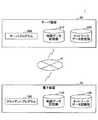
<システム構成>
まず、本実施形態に係る経路案内システム1のシステム構成について、図1を参照しながら説明する。図1は、本実施形態に係る経路案内システム1の一例のシステム構成を示す図である。<System configuration>
First, the system configuration of the
図1に示すように、本実施形態に係る経路案内システム1は、電子装置10と、サーバ装置20とを有し、インターネット等の広域的なネットワークNを介して通信可能に接続されている。 As shown in FIG. 1, the
電子装置10は、例えば、車両等に搭載されるナビゲーション装置(いわゆる、カーナビ)等である。なお、経路案内システム1は、複数台の電子装置10を有していても良い。 The
電子装置10には、クライアントプログラム100がインストールされている。また、電子装置10は、地図データ記憶部110と、ネットワークデータ記憶部120とを有する。 The
電子装置10は、クライアントプログラム100により、例えばユーザから入力された目的地や経由地等に基づいて、サーバ装置20に対して、現在地から目的地までの経路探索を要求する。また、電子装置10は、例えばユーザから入力された目的地や経由地等と、ネットワークデータ記憶部120に記憶されているネットワークデータとに基づいて、現在地から目的地までの経路探索を行う。 The
そして、電子装置10は、クライアントプログラム100により、当該サーバ装置20で探索された経路又は当該電子装置10で探索した経路を、地図データ記憶部110に記憶されている地図データが示す地図上に表示する。これにより、電子装置10は、ユーザに対して、経路案内を行うことができる。 Then, the
このように、電子装置10は、サーバ装置20に経路探索を要求することができると共に、当該電子装置10でも経路探索を行うことができる。 In this way, the
なお、地図データとは、電子装置10上に地図を表示するためのデータであり、例えば、緑地や河川、道路、鉄道、都道府県等の表示対象の種類毎に分類され、緯度及び経度等が既知のメッシュ状に区切られて管理されている。そして、表示対象の種類毎に分類された地図データは、縮尺に応じて、当該種類毎に予め定められたレイヤーに、メッシュ毎に描画されることで表示される。したがって、クライアントプログラム100は、例えば、表示対象の種類毎に分類された地図データがそれぞれ描画されたメッシュ状のレイヤーを、1つ以上結合して重畳することにより、電子装置10上に地図を表示する。 The map data is data for displaying a map on the
また、ネットワークデータとは、経路探索等に用いられるデータであり、例えば、交差点や分岐点、道路属性が変化する箇所、道路幅が変化する箇所等の各種地点を示すノード情報と、ノード間を繋ぐリンク情報とが含まれる。また、ノード情報には、例えば、ノード番号、緯度・経度、交差点の名称(漢字及び読み)や信号機の有無等の情報が含まれている。更に、リンク情報には、例えば、リンク長や座標点列、リンクのコスト、リンクの両端にあるノード番号、道路属性、進行方向、高度(標高)等の情報が含まれている。したがって、クライアントプログラム100は、例えば、ダイクストラ法等の既知のアルゴリズムを用いて、現在地から目的地までのリンクのコストが最小になるように経路探索を行う。 The network data is data used for route search and the like. For example, node information indicating various points such as intersections, branch points, places where road attributes change, and places where road width changes, and nodes are used. Includes link information to connect. Further, the node information includes, for example, information such as a node number, latitude / longitude, intersection name (kanji and reading), and presence / absence of a traffic light. Further, the link information includes, for example, information such as a link length, a coordinate point sequence, a link cost, node numbers at both ends of the link, road attributes, a traveling direction, and an altitude (elevation). Therefore, the
サーバ装置20は、電子装置10からの要求に応じて経路探索を行うコンピュータである。なお、サーバ装置20は、1台以上のコンピュータにより実現されていても良い。 The
サーバ装置20には、サーバプログラム200がインストールされている。また、サーバ装置20は、地図データ記憶部210と、ネットワークデータ記憶部220とを有する。 The
サーバ装置20は、サーバプログラム200により、電子装置10からの要求に応じて、当該要求に含まれる現在地や目的地等と、ネットワークデータ記憶部220に記憶されているネットワークデータとに基づいて、現在地から目的地までの経路探索を行う。なお、サーバプログラム200は、クライアントプログラム100と同様に、例えば、ダイクストラ法等の既知のアルゴリズムを用いて、現在地から目的地までのリンクのコストが最小になるように経路探索を行う。 The
そして、サーバ装置20は、サーバプログラム200により、探索した経路を電子装置10に返信する。なお、このとき、サーバ装置20は、地図データ記憶部210に記憶されている地図データのうち、探索した経路に対応する地図データを電子装置10に返信しても良い。 Then, the
このように、サーバ装置20は、電子装置10からの要求に応じて、経路探索を行うことができる。 In this way, the
ここで、地図データやネットワークデータは、例えば、新たに道路の敷設や交差点の敷設等があった場合には、クライアントプログラム100やサーバプログラム200のベンダー等により、最新の地図データやネットワークデータが配布等される。 Here, as for the map data and network data, for example, when a new road is laid or an intersection is laid, the latest map data and network data are distributed by the vendors of the
本実施形態において、サーバ装置20が有するネットワークデータ記憶部220には、最新のネットワークデータが記憶されているものとする。一方で、電子装置10が有するネットワークデータ記憶部120には、必ずしも最新のネットワークデータが記憶されているとは限らないものとする。なお、電子装置10のユーザは、例えば、ベンダー等から配布されるCDやDVD、USBメモリ等の記録媒体を用いて、ネットワークデータや地図データを最新の状態に更新することができる。 In the present embodiment, it is assumed that the latest network data is stored in the network
<処理の概要>
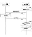
次に、本実施形態に係る経路案内システム1の処理の概要について、図2を参照しながら説明する。図2は、本実施形態に係る経路案内システム1の処理の概要を説明する図である。<Outline of processing>
Next, an outline of the processing of the
S1)まず、電子装置10は、例えばユーザにより入力された目的地や経由地等を含む経路探索要求をサーバ装置20に送信する。 S1) First, the
S2)次に、サーバ装置20は、電子装置10から経路探索要求を受信すると、当該経路探索要求に含まれる目的地や経由地等に基づいて、目的地までの経路を探索する。 S2) Next, when the
S3)続いて、サーバ装置20は、探索した経路を点列情報として電子装置10に返信する。 S3) Subsequently, the
ここで、点列情報とは、上記のS2で探索された経路上の緯度及び経度を示す情報である。すなわち、ai(i=1,2,・・・,N)を経路上の緯度及び経度を示す情報であるとした場合、点列情報は、(a1,a2,・・・,aN−1,aN,)と表される。なお、ai(i=1,2,・・・,N)は、経路上の緯度及び経度に加えて、当該経度及び緯度における高さが含まれていても良い。また、高さには、基準面(海面や地面等)から鉛直上方向への距離だけでなく、基準面から鉛直下方向への距離が含まれていても良い。Here, the point sequence information is information indicating the latitude and longitude on the route searched in S2 above. That is, assuming thatai (i = 1, 2, ..., N) is information indicating latitude and longitude on the route, the point sequence information is (a1 , a2 , ..., a.It is expressed asN-1 , aN ,). Note thatai (i = 1, 2, ..., N) may include the longitude and the height at the latitude in addition to the latitude and longitude on the route. Further, the height may include not only the distance vertically upward from the reference plane (sea surface, ground, etc.) but also the distance vertically downward from the reference plane.
S4)続いて、電子装置10は、サーバ装置20から点列情報を受信すると、当該点列情報からポリラインを地図上に描画して、当該描画したポリラインを経路1000とした経路案内を行う。ここで、ポリラインは、各i=1,2,・・・,N−1に対して、aiとai+1とを直線又は曲線で繋ぐことにより描画される。S4) Subsequently, when the
このように、本実施形態に係る経路案内システム1では、サーバ装置20で探索された経路を点列情報として電子装置10に返信する。そして、本実施形態に係る経路案内システム1では、点列情報からポリラインを地図上に描画して、当該ポリラインを経路とした経路案内を行う。 As described above, in the
これにより、本実施形態に係る経路案内システム1では、例えば、電子装置10が有するネットワークデータ記憶部120に記憶されているネットワークデータが最新でない場合であっても、サーバ装置20で探索された経路と同一の経路を地図上に表示することができる。言い換えれば、本実施形態に係る経路案内システム1では、電子装置10では探索することができない経路(例えば、最近敷設された道路を通る経路等)を用いて経路案内を行えるようになる。 As a result, in the
このため、本実施形態に係る経路案内システム1によれば、電子装置10は、最新のネットワークデータを用いて、最適な経路による経路案内をユーザに提供することができるようになる。 Therefore, according to the
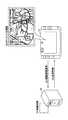
<ハードウェア構成>
次に、本実施形態に係る経路案内システム1に含まれる電子装置10及びサーバ装置20のハードウェア構成について、図3を参照しながら説明する。図3は、本実施形態に係る電子装置10及びサーバ装置20の一例のハードウェア構成を示す図である。<Hardware configuration>
Next, the hardware configurations of the
≪電子装置10≫
図3(a)に示すように、本実施形態に係る電子装置10は、入力装置11と、表示装置12と、外部I/F13と、通信I/F14とを有する。また、本実施形態に係る電子装置10は、ROM(Read Only Memory)15と、RAM(Random Access Memory)16と、CPU(Central Processing Unit)17と、記憶装置18と、GPS(Global Positioning System)受信機19とを有する。更に、これらハードウェアは、バスB1で互いに接続されている。
As shown in FIG. 3A, the
入力装置11は、例えば、タッチパネルや各種ボタン等であり、ユーザが電子装置10に各種入力を行うのに用いられる。表示装置12は、例えば、LCD(Liquid Crystal Display)等であり、電子装置10による処理結果を表示する。 The
外部I/F13は、外部装置とのインタフェースである。外部装置には、記録媒体13a等がある。電子装置10は、外部I/F13を介して、記録媒体13aの読み取りや書き込みを行うことができる。 The external I /
記録媒体13aには、例えば、CD、DVD、SDメモリカード、USBメモリ等がある。なお、記録媒体13aには、クライアントプログラム100が格納されていても良い。 The recording medium 13a includes, for example, a CD, a DVD, an SD memory card, a USB memory, and the like. The
通信I/F14は、電子装置10をネットワークNに接続するためのインタフェースである。電子装置10は、通信I/F14を介して、サーバ装置20との間でデータ通信を行うことができる。 The communication I /
記憶装置18は、プログラムやデータを格納している不揮発性のメモリであり、例えば、HDD(Hard Disk Drive)やSSD(Solid State Drive)等である。記憶装置18に格納されているプログラムやデータには、クライアントプログラム100、電子装置10全体を制御する基本ソフトウェアであるOS(Operating System)等がある。 The
RAM16は、プログラムやデータを一時保持する揮発性の半導体メモリである。ROM15は、電源を切ってもプログラムやデータを保持することができる不揮発性の半導体メモリである。ROM15には、例えば、OS設定やネットワーク設定等のデータが格納されている。 The
CPU17は、ROM15や記憶装置18等からプログラムやデータをRAM16上に読み出し、当該プログラムやデータに基づく処理を実行することで、電子装置10全体の制御や各種の機能を実現する演算装置である。 The
GPS受信機19は、GPSから所定の電波を受信して、電子装置10の現在の位置を示す緯度及び経度の測定を行う。なお、GPS受信機19は、電子装置10の高度を測定することができても良い。 The
本実施形態に係る電子装置10は、図3(a)に示すハードウェア構成を有することにより、後述するような各種処理を実現できる。 By having the hardware configuration shown in FIG. 3A, the
≪サーバ装置20≫
図3(b)に示すように、本実施形態に係るサーバ装置20は、入力装置21と、表示装置22と、外部I/F23と、通信I/F24とを有する。また、本実施形態に係るサーバ装置20は、ROM25と、RAM26と、CPU27と、記憶装置28とを有する。更に、これらハードウェアは、バスB2で互いに接続されている。<<
As shown in FIG. 3B, the
入力装置21は、例えば、キーボードやマウス、タッチパネルや各種ボタン等であり、ユーザがサーバ装置20に各種入力を行うのに用いられる。表示装置22は、例えば、LCDやCRT(Cathode Ray Tube)等であり、サーバ装置20による処理結果を表示する。なお、入力装置21及び表示装置22の少なくとも一方は、必要なときにバスB2に接続して利用する形態であっても良い。 The
外部I/F23は、外部装置とのインタフェースである。外部装置には、記録媒体23a等がある。サーバ装置20は、外部I/F23を介して、記録媒体23aの読み取りや書き込みを行うことができる。 The external I /
記録媒体23aには、例えば、CD、DVD、SDメモリカード、USBメモリ等がある。なお、記録媒体23aには、サーバプログラム200が格納されていても良い。 The recording medium 23a includes, for example, a CD, a DVD, an SD memory card, a USB memory, and the like. The
通信I/F24は、サーバ装置20をネットワークNに接続するためのインタフェースである。サーバ装置20は、通信I/F24を介して、電子装置10との間でデータ通信を行うことができる。 The communication I /
記憶装置28は、プログラムやデータを格納している不揮発性のメモリであり、例えば、HDDやSSD等である。記憶装置28に格納されているプログラムやデータには、サーバプログラム200、サーバ装置20全体を制御する基本ソフトウェアであるOS等がある。 The
RAM26は、プログラムやデータを一時保持する揮発性の半導体メモリである。ROM25は、電源を切ってもプログラムやデータを保持することができる不揮発性の半導体メモリである。ROM25には、例えば、OS設定やネットワーク設定等のデータが格納されている。 The
CPU27は、ROM25や記憶装置28等からプログラムやデータをRAM26上に読み出し、当該プログラムやデータに基づく処理を実行することで、サーバ装置20全体の制御や各種の機能を実現する演算装置である。 The
本実施形態に係るサーバ装置20は、図3(b)に示すハードウェア構成を有することにより、後述するような各種処理を実現できる。 By having the hardware configuration shown in FIG. 3B, the
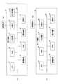
<機能構成>
次に、本実施形態に係る経路案内システム1の機能構成について、図4を参照しながら説明する。図4は、本実施形態に係る経路案内システム1の一例の機能構成を示す図である。<Functional configuration>
Next, the functional configuration of the
図4に示すように、本実施形態に係る電子装置10は、主な機能部として、通信部101と、入力受付部102と、表示制御部103と、描画部104と、条件設定部105と、経路探索部106と、経路案内部107とを有する。これら各機能部は、クライアントプログラム100がCPU17に実行させる処理により実現される。 As shown in FIG. 4, the
通信部101は、サーバ装置20との間で各種データの送受信を行う。例えば、通信部101は、サーバ装置20に対して、後述する条件設定部105により設定された探索条件を含む経路探索要求を送信する。また、例えば、通信部101は、サーバ装置20から点列情報を受信する。 The
入力受付部102は、ユーザによる各種入力を受け付ける。例えば、入力受付部102は、ユーザによる目的地や経由地等の入力を受け付ける。また、例えば、入力受付部102は、ユーザによる経路案内開始の入力を受け付ける。 The
表示制御部103は、各種画面を表示する。例えば、表示制御部103は、地図データ記憶部110に記憶されている地図データに基づく地図を表示装置12上に表示する。また、例えば、表示制御部103は、後述する描画部104により地図上に描画されたポリラインを表示する。なお、これらの以外にも、表示制御部103は、例えば、各種情報(例えば、施設情報や注記、標識等の各種案内情報)を地図上に表示したり、各種画面(例えば、目的地や経由地の設定画面や各種設定画面等)を表示したりする。 The
描画部104は、サーバ装置20から受信した点列情報からポリラインを地図上に描画する。すなわち、描画部104は、サーバ装置20から受信した点列情報(a1,a2,・・・,aN−1,aN,)の隣り合う点同士(ai及びai+1)を直線又は曲線で繋ぐことにより、ポリラインを描画する。The
条件設定部105は、経路探索を行うための各種条件が含まれる探索条件を設定する。すなわち、条件設定部105は、例えば、入力受付部102が受け付けた目的地、GPS受信機19により測定された現在地(すなわち、電子装置10の現在位置を示す緯度及び経度の情報)等が含まれる探索条件を設定する。そして、条件設定部105は、通信部101により、探索条件を含む経路探索要求をサーバ装置20に送信する。 The
なお、探索条件には、例えば、入力受付部102が受け付けた経由地が含まれていても良い。また、探索条件には、例えば、有料道路の通行有無等が含まれていても良い。このように、探索条件には、現在地から目的地までの経路探索に用いられる各種条件が含まれる。 The search condition may include, for example, a waypoint received by the
経路探索部106は、条件設定部105により設定された探索条件と、ネットワークデータ記憶部120に記憶されているネットワークデータとに基づいて経路探索を行う。 The
なお、本実施形態に係る経路案内システム1では、上述したように、電子装置10は、サーバ装置20に対して、探索条件を含む経路探索要求を送信する。このため、電子装置10は、必ずしも経路探索部106により経路探索を行う必要はない。ただし、例えば、電子装置10とサーバ装置20との間の通信状態が悪い場合や即時に経路探索を行いたい場合等には、電子装置10は、経路探索要求をサーバ装置20に送信すると共に、経路探索部106により経路探索を行っても良い。 In the
また、経路探索部106により経路探索を行う場合、例えば、次のような処理を行っても良い。すなわち、電子装置10は、サーバ装置20から経路探索結果(座標点列情報)を受信するまでは、経路探索部106により探索した経路を地図上に表示し、経路案内を行う。そして、電子装置10は、サーバ装置20から経路探索結果(座標点列情報)を受信した際に、表示画面を更新し、サーバ装置20で探索した経路(座標点列情報)を地図上に表示し、経路案内を行う。 Further, when the
経路案内部107は、描画部104により描画されたポリラインを経路として経路案内を行う。なお、経路案内とは、電子装置10のユーザに対して、経路に従って目的地に辿り着くまでの案内を行うことであり、例えば、GPS受信機19により測定された現在位置を経路上にマッチングさせ、経路上の特定箇所において、文字による経路案内、音声による経路案内を行うこと等が含まれる。また、経路案内には、例えば、電子装置10の現在地が経路から外れた場合における案内(元の経路に戻るための案内や経路の再探索等)も含まれる。 The
ここで、一般に、経路とは、ノード間をリンクで繋いだものである一方、ポリラインは、上述したように、点列情報に含まれる各点を直線又は曲線で繋いだものである。このため、経路案内部107は、ポリラインを経路と見做して経路案内を行う。 Here, in general, the path is a link connecting the nodes, while the polyline is a straight line or a curve connecting each point included in the point sequence information as described above. Therefore, the
図4に示すように、本実施形態に係るサーバ装置20は、主な機能部として、通信部201と、経路探索部202とを有する。これら各機能部は、サーバプログラム200がCPU27に実行させる処理により実現される。 As shown in FIG. 4, the
通信部201は、電子装置10との間で各種データの送受信を行う。例えば、通信部201は、電子装置10から経路探索要求を受信する。また、例えば、通信部201は、後述する経路探索部202により探索された経路の点列情報を電子装置10に送信する。 The
経路探索部202は、電子装置10から受信した経路探索要求に含まれる探索条件と、ネットワークデータ記憶部220に記憶されているネットワークデータとに基づいて経路探索を行う。そして、経路探索部202は、通信部201により、探索された経路を点列情報として電子装置10に送信する。 The
ここで、経路探索部202は、例えば、探索された経路を電子装置10側で描画するために必要な座標点(例えば、緯度及び経度等)の情報を抽出し、その抽出した座標点の情報を点列情報とする。点列情報は、経路探索部202で探索された経路を電子装置10側で描画するために必要な情報を含んでいれば良い。 Here, the
<処理の詳細>
次に、本実施形態に係る経路案内システム1の処理の詳細について説明する。<Details of processing>
Next, the details of the processing of the
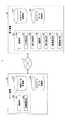
(実施例1)
まず、実施例1について説明する。実施例1では、サーバ装置20で探索された経路を点列情報として電子装置10に送信し、当該電子装置10で点列情報からポリラインを描画した上で、当該ポリラインを経路と見做して経路案内を行う場合について説明する。(Example 1)
First, Example 1 will be described. In the first embodiment, the route searched by the
以降では、本実施形態に係る経路案内システム1において経路案内を開始する処理(実施例1)について、図5を参照しながら説明する。図5は、本実施形態に係る経路案内の開始処理の一例のシーケンス図(実施例1)である。 Hereinafter, the process of starting the route guidance (Example 1) in the
ステップS501において、電子装置10の条件設定部105は、探索条件を設定する。すなわち、条件設定部105は、例えば、入力受付部102が受け付けた目的地、GPS受信機19により測定された現在地等が含まれる探索条件を設定する。なお、ユーザは、例えば、表示制御部103により表示された画面(探索条件の設定画面)において、目的地等を入力することができる。 In step S501, the
ステップS502において、電子装置10の条件設定部105は、通信部101により、上記のステップS501で設定された探索条件を含む経路探索要求をサーバ装置20に送信する。 In step S502, the
ステップS503において、サーバ装置20の経路探索部202は、通信部201により経路探索要求を受信すると、当該経路探索要求に含まれる探索条件と、ネットワークデータ記憶部220に記憶されているネットワークデータとに基づいて経路探索を行う。すなわち、経路探索部202は、例えば、探索条件に含まれる現在地及び目的地に基づいて、当該現在地から当該目的地までの最適な経路を探索する。 In step S503, when the
ステップS504において、サーバ装置20の経路探索部202は、通信部201により、上記のステップS503で探索された経路を点列情報として電子装置10に送信する。 In step S504, the
ステップS505において、電子装置10の描画部104は、通信部101により受信した点列情報からポリラインを地図上に描画する。 In step S505, the
すなわち、まず、表示制御部103は、通信部101により受信した点列情報に対応する地図データを地図データ記憶部110から取得して、取得した地図データに基づく地図を表示する。なお、点列情報に対応する地図データとは、例えば、点列情報に含まれる各点の緯度及び経度が含まれる所定の範囲の地図を示す地図データである。 That is, first, the
次に、描画部104は、表示制御部103により表示された地図上に、点列情報の隣り合う点同士を直線又は曲線で繋ぐことにより、ポリラインを描画する。 Next, the
ここで、地図上に描画されたポリラインを図6に示す。図6は、地図上に描画されたポリラインの一例を示す図である。 Here, the polyline drawn on the map is shown in FIG. FIG. 6 is a diagram showing an example of a polyline drawn on the map.
図6に示す画面G100では、現在地Sから目的地Dまでのポリライン2000が地図上に描画されている。このように、電子装置10の表示装置12上には、上記のステップS501で設定された探索条件に基づいてサーバ装置20で探索された経路と同様のポリライン2000が地図上に表示される。 On the screen G100 shown in FIG. 6, the
ステップS506において、電子装置10の経路案内部107は、描画部104により描画されたポリラインを経路として経路案内を行う。すなわち、例えば、図6に示す画面G100においてユーザにより案内開始ボタンG101が押下等されると、経路案内部107は、ポリライン2000を経路として経路案内を行う。これにより、電子装置10のユーザは、ポリライン2000に従って、現在地Sから目的地Dに向かうことができるようになる。 In step S506, the
以上のように、本実施形態に係る経路案内システム1では、サーバ装置20で探索された経路を点列情報として電子装置10に送信して、電子装置10では、当該点列情報からポリラインを描画した上で、当該ポリラインを経路と見做して経路案内を行う。 As described above, in the
このため、本実施形態に係る経路案内システム1では、例えば、電子装置10のユーザがネットワークデータの更新等を行っておらず、当該電子装置10が有するネットワークデータ記憶部120に記憶されているネットワークデータが古い場合も、最新のネットワークデータに基づく経路案内を行うことができるようになる。したがって、本実施形態に係る経路案内システム1では、実際の道路の敷設状況に応じた適切な経路案内を行うことができるようになる。 Therefore, in the
(実施例2)
次に、実施例2について説明する。実施例1では、ポリラインを経路と見做して経路案内を行う場合について説明したが、この場合、ルートマッチングを適切に行えない場合がある。すなわち、ポリラインに含まれる各点を繋ぐ直線又は曲線は、リンク情報に含まれる各種情報(例えば、高度(標高)等)を有していないため、自己位置(電子装置10の現在地)がポリライン上から外れた場合に、ルートマッチングを適切に行えない場合がある。(Example 2)
Next, Example 2 will be described. In the first embodiment, the case where the polyline is regarded as a route and the route guidance is performed has been described, but in this case, the route matching may not be performed properly. That is, since the straight line or curve connecting the points included in the polyline does not have various information included in the link information (for example, altitude (elevation), etc.), its own position (current location of the electronic device 10) is on the polyline. If it deviates from the above, route matching may not be performed properly.
例えば、ポリラインから側道に自己位置が外れたとする。当該側道とポリラインとの高度が略同じである場合、ポリラインに含まれる各点の緯度及び経度と、自己位置の緯度及び経度とに基づいて適切なルートマッチングを行うことができる。一方で、当該側道とポリラインとの高度が所定以上異なる場合には、適切なルートマッチングを行うことができず、例えば、自己位置が側道上にあるにも関わらず、ポリライン上にあるとルートマッチングが行われてしまう場合がある。 For example, suppose that the self-position deviates from the polyline to the side road. When the altitudes of the frontage road and the polyline are substantially the same, appropriate route matching can be performed based on the latitude and longitude of each point included in the polyline and the latitude and longitude of the self-position. On the other hand, if the altitudes of the frontage road and the polyline are different than a predetermined value, appropriate route matching cannot be performed. For example, if the self-position is on the frontage road but on the polyline, the route Matching may occur.
そこで、実施例2では、ポリラインを経路と見做した経路案内を行うと共に、電子装置10の経路探索部106により探索された経路を用いて適切なルートマッチングを行えるようにするものである。 Therefore, in the second embodiment, route guidance is performed with the polyline as a route, and appropriate route matching can be performed using the route searched by the
以降では、本実施形態に係る経路案内システム1において経路案内を開始する処理(実施例2)について、図7を参照しながら説明する。図7は、本実施形態に係る経路案内の開始処理の一例のシーケンス図(実施例2)である。なお、図7におけるステップS501〜ステップS505の処理は、実施例1と同様であるため、その説明を省略する。 Hereinafter, the process of starting the route guidance (Example 2) in the
ステップS701において、電子装置10の経路探索部106は、ステップS501で条件設定部105により設定された探索条件と、ネットワークデータ記憶部120に記憶されているネットワークデータとに基づいて、バックグラウンドで経路探索を行う。これにより、経路探索部106は、ステップS503でサーバ装置20の経路探索部202により探索された経路と少なくとも一部が同一である経路を探索することができる。なお、経路は、ノード間をリンクで繋いだものであるため、ノード情報とリンク情報とが含まれている。 In step S701, the
ステップS702において、電子装置10の経路探索部106は、上記のステップS701で探索した経路に含まれるリンク情報のうち、ステップS505で描画したポリラインに対応するリンク情報を抽出する。 In step S702, the
ここで、ポリラインに対応するリンク情報とは、上記のステップS701で探索した経路に含まれるリンク情報の座標点列の各緯度及び経度が、ポリラインに含まれるリンク情報のことである。 Here, the link information corresponding to the polyline is the link information in which each latitude and longitude of the coordinate point sequence of the link information included in the route searched in step S701 is included in the polyline.
ステップS703において、電子装置10の経路案内部107は、描画部104により描画されたポリラインを経路として経路案内を行う。このとき、経路案内部107は、上記のステップS702で抽出したリンク情報を用いてルートマッチングを行う。 In step S703, the
ここで、上記のステップS702で抽出したリンク情報を用いてルートマッチングを行う場合について、図8を参照しながら説明する。図8は、リンク情報を用いたルートマッチングの一例を説明する図である。 Here, a case where route matching is performed using the link information extracted in step S702 will be described with reference to FIG. FIG. 8 is a diagram illustrating an example of route matching using link information.
図8(a)に示すように、道路R100上にポリライン3000があると共に、道路R100と高度差がある道路R200上に自己位置Pがあったとする。なお、自己位置Pには、GPS受信機19により測定された緯度及び経度並びに高度の情報が含まれるものとする。 As shown in FIG. 8A, it is assumed that the
このとき、経路案内部107は、ポリライン3000に対応するリンク情報(上記のステップS702で抽出されたリンク情報)に含まれる高度と、自己位置Pの高度とを比較して、当該自己位置Pは、道路R200上にあるものと判定する。 At this time, the
これにより、図8(b)に示すように、経路案内部107は、道路R200を経由するようにリルート(経路の再探索)して、新たなポリライン4000を経路とした経路案内を行うことができるようになる。なお、リルートは、電子装置10が再度、サーバ装置20に対して、経路探索要求を送信することで行うことができる。 As a result, as shown in FIG. 8B, the
このように、本実施形態に係る経路案内システム1では、電子装置10において、ポリラインを経路と見做して経路案内を行うと共に、バックグラウンドで探索した経路のリンク情報にも基づいて経路案内を行う。このため、本実施形態に係る経路案内システム1では、ポリラインを経路と見做した経路案内において、例えば、自己位置の高度等に基づいたルートマッチングを行うことができるようになる。言い換えると、本実施形態に係る経路案内システム1では、緯度及び経度に基づく平面的なルートマッチングだけでなく、高度にも基づく立体的なルートマッチングも行うことができる。 As described above, in the
なお、実施例2では、一例として、ポリラインに対応するリンク情報の高度に基づいてルートマッチングを行う場合について説明したが、これに限られず、例えば、ポリラインに対応するリンク情報の道路属性や進行方向等に基づいてルートマッチングを行っても良い。 In the second embodiment, as an example, a case where route matching is performed based on the altitude of the link information corresponding to the polyline has been described, but the present invention is not limited to this, and for example, the road attribute and the traveling direction of the link information corresponding to the polyline are described. Route matching may be performed based on the above.
なお、本発明は、具体的に開示された上記の実施形態に限定されるものではなく、特許請求の範囲から逸脱することなく、種々の変形や変更が可能である。 It should be noted that the present invention is not limited to the above-described embodiment disclosed specifically, and various modifications and modifications can be made without departing from the scope of claims.
1 経路案内システム
10 電子装置
20 サーバ装置
100 クライアントプログラム
101 通信部
102 入力受付部
103 表示制御部
104 描画部
105 条件設定部
106 経路探索部
107 経路案内部
110 地図データ記憶部
120 ネットワークデータ記憶部
200 サーバプログラム
201 通信部
202 経路探索部
210 地図データ記憶部
220 ネットワークデータ記憶部1
Claims (8)
Translated fromJapanese前記情報処理装置は、
前記経路を探索するための条件を示す探索条件を設定する条件設定手段と、
前記条件設定手段により設定された前記探索条件を前記サーバ装置に送信する探索要求手段と、
前記サーバ装置から点列情報を受信すると、該点列情報から、前記サーバ装置で探索された経路と同じ経路をポリラインで地図上に描画する描画手段と、を有し、
前記サーバ装置は、
前記情報処理装置から前記探索条件を受信すると、前記探索条件に基づいて経路を探索し、探索した経路を表す点列情報を前記情報処理装置に送信する第1の探索手段、
を有する情報処理システム。An information processing system including a server device for searching a route to a destination and an information processing device connected to the server device via a network.
The information processing device
A condition setting means for setting a search condition indicating a condition for searching the route, and
A search request means for transmitting the search condition set by the condition setting means to the server device, and a search request means.
When the point sequence information is received from the server device, it has a drawing means for drawing the same route as the route searched by the server device on the map with a polyline from the point sequence information.
The server device is
A first search means, which receives the search condition from the information processing device, searches for a route based on the search condition, and transmits point sequence information representing the searched route to the information processing device.
Information processing system with.
前記点列情報に含まれる隣り合う各点同士を直線又は曲線で繋ぐことにより前記ポリラインを描画する、請求項1に記載の情報処理システム。The drawing means
The information processing system according to claim 1, wherein the polyline is drawn by connecting adjacent points included in the point sequence information with a straight line or a curved line.
前記描画手段により描画された前記ポリラインに従って目的地までの経路案内を行う案内手段を有する、請求項1乃至3の何れか一項に記載の情報処理システム。The information processing device
The information processing system according to any one of claims 1 to 3, further comprising a guiding means for guiding a route to a destination according to the polyline drawn by the drawing means.
前記情報処理装置の現在位置を測位する測位手段を有し、
前記案内手段は、
前記測位手段により測位された現在位置を前記ポリライン上にルートマッチングさせて、前記経路案内を行う、請求項4に記載の情報処理システム。The information processing device
It has a positioning means for positioning the current position of the information processing device, and has
The guidance means
The information processing system according to claim 4, wherein the current position determined by the positioning means is route-matched on the polyline to provide route guidance.
前記条件設定手段により設定された前記探索条件に基づいて、該探索条件に含まれる目的地までの経路を探索する第2の探索手段を有し、
前記案内手段は、
前記第2の探索手段により探索された経路に含まれるリンク情報のうち、前記ポリラインに対応するリンク情報に基づいて前記ルートマッチングを行う、請求項5に記載の情報処理システム。The information processing device
It has a second search means for searching a route to a destination included in the search condition based on the search condition set by the condition setting means.
The guidance means
The information processing system according to claim 5, wherein the route matching is performed based on the link information corresponding to the polyline among the link information included in the route searched by the second search means.
前記ポリラインに対応するリンク情報に含まれる高度情報又は/及び道路属性に基づいて前記ルートマッチングを行う、請求項6に記載の情報処理システム。The guidance means
The information processing system according to claim 6, wherein the route matching is performed based on the altitude information and / and the road attribute included in the link information corresponding to the polyline.
前記情報処理装置が、
前記経路を探索するための条件を示す探索条件を設定する条件設定手順と、
前記条件設定手順により設定された前記探索条件を前記サーバ装置に送信する探索要求手順と、
前記サーバ装置から点列情報を受信すると、該点列情報から、前記サーバ装置で探索された経路と同じ経路をポリラインで地図上に描画する描画手順と、を実行し、
前記サーバ装置が、
前記情報処理装置から前記探索条件を受信すると、前記探索条件に基づいて経路を探索し、探索した経路を表す点列情報を前記情報処理装置に送信する第1の探索手順、
を実行する情報処理方法。An information processing method used in an information processing system including a server device for searching a route to a destination and an information processing device connected to the server device via a network.
The information processing device
A condition setting procedure for setting a search condition indicating a condition for searching the route, and a condition setting procedure.
A search request procedure for transmitting the search condition set by the condition setting procedure to the server device, and a search request procedure.
When the point sequence information is received from the server device, the drawing procedure of drawing the same route as the route searched by the server device on the map with a polyline is executed from the point sequence information.
The server device
A first search procedure, in which when the search condition is received from the information processing device, a route is searched based on the search condition and point sequence information representing the searched route is transmitted to the information processing device.
Information processing method to execute.
Priority Applications (1)
| Application Number | Priority Date | Filing Date | Title |
|---|---|---|---|
| JP2020152968AJP2021004886A (en) | 2020-09-11 | 2020-09-11 | Information processing system and information processing method |
Applications Claiming Priority (1)
| Application Number | Priority Date | Filing Date | Title |
|---|---|---|---|
| JP2020152968AJP2021004886A (en) | 2020-09-11 | 2020-09-11 | Information processing system and information processing method |
Related Parent Applications (1)
| Application Number | Title | Priority Date | Filing Date |
|---|---|---|---|
| JP2016175827ADivisionJP2018041332A (en) | 2016-09-08 | 2016-09-08 | Information processing apparatus, information processing system, information processing method, and program |
Publications (1)
| Publication Number | Publication Date |
|---|---|
| JP2021004886Atrue JP2021004886A (en) | 2021-01-14 |
Family
ID=74098206
Family Applications (1)
| Application Number | Title | Priority Date | Filing Date |
|---|---|---|---|
| JP2020152968APendingJP2021004886A (en) | 2020-09-11 | 2020-09-11 | Information processing system and information processing method |
Country Status (1)
| Country | Link |
|---|---|
| JP (1) | JP2021004886A (en) |
Citations (3)
| Publication number | Priority date | Publication date | Assignee | Title |
|---|---|---|---|---|
| JP2003065783A (en)* | 2001-08-27 | 2003-03-05 | Pioneer Electronic Corp | Communication navigation system and method for the same, device for communication center for providing map information, communication navigation terminal and computer program |
| JP2006349507A (en)* | 2005-06-16 | 2006-12-28 | Nissan Motor Co Ltd | Guide route distribution system and in-vehicle navigation system |
| JP2011059255A (en)* | 2009-09-08 | 2011-03-24 | Hitachi Automotive Systems Ltd | Map display terminal unit and map display system |
- 2020
- 2020-09-11JPJP2020152968Apatent/JP2021004886A/enactivePending
Patent Citations (3)
| Publication number | Priority date | Publication date | Assignee | Title |
|---|---|---|---|---|
| JP2003065783A (en)* | 2001-08-27 | 2003-03-05 | Pioneer Electronic Corp | Communication navigation system and method for the same, device for communication center for providing map information, communication navigation terminal and computer program |
| JP2006349507A (en)* | 2005-06-16 | 2006-12-28 | Nissan Motor Co Ltd | Guide route distribution system and in-vehicle navigation system |
| JP2011059255A (en)* | 2009-09-08 | 2011-03-24 | Hitachi Automotive Systems Ltd | Map display terminal unit and map display system |
Similar Documents
| Publication | Publication Date | Title |
|---|---|---|
| US9239246B2 (en) | Method, system, and computer program product for visual disambiguation for directions queries | |
| US8126644B2 (en) | Travel support system, method thereof, program thereof, and recording medium containing the program | |
| US7136744B2 (en) | Navigation system, method thereof, program thereof and recording medium storing the program | |
| US20040196163A1 (en) | Map information processing device, system thereof, method thereof, program thereof and recording medium storing the program | |
| US20090248758A1 (en) | Map update data supplying apparatus, version table, map data updating system, and map update data supplying method | |
| US20050090974A1 (en) | Traffic condition notifying device, system thereof, method thereof, program thereof and recording medium storing the program | |
| US20050027448A1 (en) | Device, system, method and program for notifying traffic condition and recording medium storing such program | |
| US20070073471A1 (en) | Data structure of proceeding control information, data structure of map information, storage medium storing the map information, information generating device, information generating method and navigating device | |
| JP2002116689A (en) | Updating method of road information in map information providing system, its updating server, server program and recording medium recorded with the program | |
| CN105164496B (en) | Map data storage device, map data update method, and computer-readable storage medium | |
| US9851210B2 (en) | Map information processing apparatus, map information processing method, and method for adjusting update data | |
| JP2008249539A (en) | Map display system, terminal device, map display server, and map display method | |
| JP2017020994A (en) | Information distribution device and information distribution method | |
| WO2015059872A1 (en) | Map data delivery system, server, and navigation device | |
| JP6943791B2 (en) | Route information transmission method, route information transmission system, in-vehicle terminal | |
| US20090048772A1 (en) | Method and apparatus for searching target location | |
| JP2018040593A (en) | Information processing apparatus, information processing system and information processing method | |
| JP2021004886A (en) | Information processing system and information processing method | |
| JP7129457B2 (en) | Information processing system and information processing device | |
| JP6949633B2 (en) | Map display system and map display method | |
| JP2018041332A (en) | Information processing apparatus, information processing system, information processing method, and program | |
| JP4533586B2 (en) | Map information processing system, method thereof, program thereof, and recording medium recording the program | |
| JP4036762B2 (en) | MAP INFORMATION PROCESSING DEVICE, ITS SYSTEM, ITS METHOD, ITS PROGRAM, AND RECORDING MEDIUM CONTAINING THE PROGRAM | |
| JP6710051B2 (en) | Display device, display method, and display program | |
| JP2013152500A (en) | Navigation system, information processing apparatus, information processing server, navigation method and navigation program |
Legal Events
| Date | Code | Title | Description |
|---|---|---|---|
| A621 | Written request for application examination | Free format text:JAPANESE INTERMEDIATE CODE: A621 Effective date:20200914 | |
| A131 | Notification of reasons for refusal | Free format text:JAPANESE INTERMEDIATE CODE: A131 Effective date:20211207 | |
| A02 | Decision of refusal | Free format text:JAPANESE INTERMEDIATE CODE: A02 Effective date:20220531 |