JP2017151103A - Calibrator, autonomous travel device, calibration method, and travel system - Google Patents
Calibrator, autonomous travel device, calibration method, and travel systemDownload PDFInfo
- Publication number
- JP2017151103A JP2017151103AJP2017031304AJP2017031304AJP2017151103AJP 2017151103 AJP2017151103 AJP 2017151103AJP 2017031304 AJP2017031304 AJP 2017031304AJP 2017031304 AJP2017031304 AJP 2017031304AJP 2017151103 AJP2017151103 AJP 2017151103A
- Authority
- JP
- Japan
- Prior art keywords
- calibration
- map
- index value
- action point
- mobile device
- Prior art date
- Legal status (The legal status is an assumption and is not a legal conclusion. Google has not performed a legal analysis and makes no representation as to the accuracy of the status listed.)
- Pending
Links
Images


Classifications
- G—PHYSICS
- G01—MEASURING; TESTING
- G01C—MEASURING DISTANCES, LEVELS OR BEARINGS; SURVEYING; NAVIGATION; GYROSCOPIC INSTRUMENTS; PHOTOGRAMMETRY OR VIDEOGRAMMETRY
- G01C21/00—Navigation; Navigational instruments not provided for in groups G01C1/00 - G01C19/00
- G01C21/20—Instruments for performing navigational calculations
- G—PHYSICS
- G01—MEASURING; TESTING
- G01C—MEASURING DISTANCES, LEVELS OR BEARINGS; SURVEYING; NAVIGATION; GYROSCOPIC INSTRUMENTS; PHOTOGRAMMETRY OR VIDEOGRAMMETRY
- G01C25/00—Manufacturing, calibrating, cleaning, or repairing instruments or devices referred to in the other groups of this subclass
- G—PHYSICS
- G01—MEASURING; TESTING
- G01C—MEASURING DISTANCES, LEVELS OR BEARINGS; SURVEYING; NAVIGATION; GYROSCOPIC INSTRUMENTS; PHOTOGRAMMETRY OR VIDEOGRAMMETRY
- G01C21/00—Navigation; Navigational instruments not provided for in groups G01C1/00 - G01C19/00
- G01C21/26—Navigation; Navigational instruments not provided for in groups G01C1/00 - G01C19/00 specially adapted for navigation in a road network
- G01C21/28—Navigation; Navigational instruments not provided for in groups G01C1/00 - G01C19/00 specially adapted for navigation in a road network with correlation of data from several navigational instruments
- G01C21/30—Map- or contour-matching
Landscapes
- Engineering & Computer Science (AREA)
- Radar, Positioning & Navigation (AREA)
- Remote Sensing (AREA)
- Physics & Mathematics (AREA)
- General Physics & Mathematics (AREA)
- Automation & Control Theory (AREA)
- Manufacturing & Machinery (AREA)
- Navigation (AREA)
Abstract
Translated fromJapaneseDescription
Translated fromJapanese本発明の実施形態は一般的に走行経路に沿って自律走行する自律走行装置において適用される較正装置等に関する。 Embodiments of the present invention generally relate to a calibration device or the like applied in an autonomous traveling device that autonomously travels along a traveling route.
絶対位置検出システム(例えば、グローバルナビゲーションサテライトシステム(GNSS:Global Navigation Satellite System)は、屋外等における自律走行装置のナビゲーションや、自律走行装置の自律走行に利用されている。GNSSの例として、例えば、GPS(Global Positioning System))、Galileo、Beidou等が含まれる。 An absolute position detection system (for example, a global navigation satellite system (GNSS: Global Navigation Satellite System) is used for navigation of autonomous traveling devices outdoors and autonomous traveling of autonomous traveling devices. As an example of GNSS, for example, Global Positioning System (GPS), Galileo, Beidou, and the like are included.
ここで、GNSSの送信機と受信機との間の信号の障害物によって、受信機がGNSSの信号を失うことになることがある。これは、建物、木及びその他の障害物が地上レベル又はその近くで動作されている受信機において、GNSSの信号の喪失に影響するからである。 Here, a signal obstruction between the GNSS transmitter and the receiver may cause the receiver to lose the GNSS signal. This is because buildings, trees and other obstacles affect GNSS signal loss at receivers operating at or near ground level.
そして、絶対位置検出システムからの信号が利用できない場合の間隔を補償するために、多くの自律型ナビゲーションシステムや、自律走行装置は、ジャイロスコープ、視覚に基づいたナビゲーション、LIDAR、検出オドメトリー及びその他のナビゲーション技術を絶対位置検出システムに追加して使用し、更にナビゲーションの安定を提供している。 And in order to compensate for the interval when the signal from the absolute position detection system is not available, many autonomous navigation systems and autonomous mobile devices are gyroscopes, vision-based navigation, LIDAR, detection odometry and other Navigation technology is used in addition to the absolute position detection system to provide navigation stability.
例えば、距離又は方位検出手段の出力に基づいて、移動体の現在位置を地図上に表示するとともに、衛星からの絶対位置検出手段により、距離又は方位の検出手段のデータを較正する発明が開示されている(例えば、特許文献1参照)。 For example, an invention is disclosed in which the current position of a moving object is displayed on a map based on the output of a distance or azimuth detection means, and the data of the distance or azimuth detection means is calibrated by an absolute position detection means from a satellite. (For example, refer to Patent Document 1).
しかし、ジャイロスコープ及びその他のセンサにおける位置ずれによっては、制御できないエラーが増加することにより、経路を判定できないという問題が生じていた。 However, there is a problem that the path cannot be determined due to an increase in uncontrollable errors due to misalignment in the gyroscope and other sensors.
とくに、自律走行装置において、較正処理を実行する場合、正しく較正処理が実行できない環境であっても、較正処理が実行されることにより、適切に較正されないという問題点があった。 In particular, when the calibration process is executed in the autonomous mobile device, there is a problem in that the calibration process is not performed properly even in an environment where the calibration process cannot be executed correctly.
上述した課題に鑑み、本発明の目的は、自律走行装置において、適切な較正処理を実行することが可能な較正装置等を提供することである。 In view of the above-described problems, an object of the present invention is to provide a calibration device or the like that can execute an appropriate calibration process in an autonomous traveling device.
上述した課題に鑑み、本発明の較正装置は、
自律走行装置における較正処理を実行する較正手段を備えた較正装置であって、
前記較正手段が較正処理を実行する較正位置を記憶する較正マップと、
前記自律走行装置が位置する第1の位置が較正マップに含まれているか否かを判定する位置判定手段と、
前記第1の位置が較正マップに含まれている場合に、前記自律走行装置の位置に関連した較正指標の較正指標値を読み出す較正指標値読み出し手段と、
を備え、
前記較正手段は、
前記読み出された較正指標値に基づいて、前記第1の位置が較正処理を実行するのに適切な位置であると判定された場合に、前記較正処理を実行することを特徴とする。In view of the above-described problems, the calibration device of the present invention is
A calibration device comprising calibration means for executing calibration processing in an autonomous traveling device,
A calibration map for storing calibration positions at which the calibration means performs a calibration process;
Position determination means for determining whether or not the first position where the autonomous mobile device is located is included in the calibration map;
Calibration index value reading means for reading a calibration index value of a calibration index related to the position of the autonomous mobile device when the first position is included in a calibration map;
With
The calibration means includes
The calibration process is performed when it is determined that the first position is an appropriate position for performing the calibration process based on the read calibration index value.
本発明の自律走行装置は、
自律走行装置の速度・方向を算出する速度・方向算出部と、前記走行・方向算出部により出力される値を較正する較正手段とを備えた自律走行装置であって、
前記較正手段が較正処理を実行する較正位置を記憶する較正マップと、
前記自律走行装置が位置する第1の位置が較正マップに含まれているか否かを判定する位置判定手段と、
前記第1の位置が較正マップに含まれている場合に、前記自律走行装置の位置に関連した較正指標の較正指標値を読み出す較正指標値読み出し手段と、
を備え、
前記較正手段は、
前記読み出された較正指標値に基づいて、前記第1の位置が較正処理を実行するのに適切な位置であると判定された場合に、前記較正処理を実行することを特徴とする。The autonomous traveling device of the present invention is
An autonomous traveling device comprising a speed / direction calculating unit that calculates the speed / direction of the autonomous traveling device, and a calibration unit that calibrates a value output by the traveling / direction calculating unit,
A calibration map for storing calibration positions at which the calibration means performs a calibration process;
Position determination means for determining whether or not the first position where the autonomous mobile device is located is included in the calibration map;
Calibration index value reading means for reading a calibration index value of a calibration index related to the position of the autonomous mobile device when the first position is included in a calibration map;
With
The calibration means includes
The calibration process is performed when it is determined that the first position is an appropriate position for performing the calibration process based on the read calibration index value.
本発明の較正方法は、
較正処理を実行する較正位置が記憶された較正マップを有する自律走行装置における較正方法であって、
前記自律走行装置が位置する第1の位置が較正マップに含まれているか否かを判定し、
前記第1の位置が較正マップに含まれている場合に、前記自律走行装置の位置に関連した較正指標の較正指標値を読み出し、
前記読み出された較正指標値に基づいて、前記第1の位置が較正処理を実行するのに適切な位置であると判定された場合に、較正処理を実行する、
ことを特徴とする。The calibration method of the present invention comprises:
A calibration method in an autonomous mobile device having a calibration map in which calibration positions for executing a calibration process are stored,
Determining whether the first position where the autonomous mobile device is located is included in the calibration map;
When the first position is included in a calibration map, a calibration index value of a calibration index related to the position of the autonomous mobile device is read out,
Performing a calibration process when it is determined based on the read calibration index value that the first position is an appropriate position for performing the calibration process;
It is characterized by that.
本発明の走行システムは、
一又は複数の自律走行装置と、前記自律走行装置の走行状態を管理する管理装置とを含む走行システムであって、
前記管理装置は、
前記自律走行装置における較正処理を実行する較正手段と、
前記較正手段が較正処理を実行する較正位置を記憶する較正マップと、
前記自律走行装置が位置する第1の位置が較正マップに含まれているか否かを判定する位置判定手段と、
前記第1の位置が較正マップに含まれている場合に、前記自律走行装置の位置に関連した較正指標の較正指標値を読み出す較正指標値読み出し手段と、
を備え、
前記較正手段は、
前記読み出された較正指標値に基づいて、前記第1の位置が較正処理を実行するのに適切な位置であると判定された場合に、前記較正処理を実行する、
ことを特徴とする走行システム。The traveling system of the present invention is
A traveling system including one or a plurality of autonomous traveling devices and a management device that manages a traveling state of the autonomous traveling device,
The management device
Calibration means for executing calibration processing in the autonomous traveling device;
A calibration map for storing calibration positions at which the calibration means performs a calibration process;
Position determination means for determining whether or not the first position where the autonomous mobile device is located is included in the calibration map;
Calibration index value reading means for reading a calibration index value of a calibration index related to the position of the autonomous mobile device when the first position is included in a calibration map;
With
The calibration means includes
Performing the calibration process when it is determined that the first position is an appropriate position for performing the calibration process based on the read calibration index value;
A traveling system characterized by that.
本発明の較正装置によれば、自律走行装置が位置する第1の位置が較正マップに含まれている場合に、自律走行装置の位置に関連した較正指標の較正指標値を読み出す。そして、読み出された較正指標値に基づいて、前記第1の位置が較正処理を実行するのに適切な位置であると判定された場合に、前記較正処理を実行する。これにより、自律走行装置が、現在の地点である第1の地点で、較正処理を実行してよいのか否かを判定することが可能となる。 According to the calibration device of the present invention, when the first position where the autonomous traveling device is located is included in the calibration map, the calibration index value of the calibration index related to the position of the autonomous traveling device is read. Then, when it is determined that the first position is an appropriate position for executing the calibration process based on the read calibration index value, the calibration process is executed. Thereby, it becomes possible for the autonomous mobile device to determine whether or not the calibration process may be executed at the first point that is the current point.
続いて、本発明の実施形態について説明する。本発明の実施形態は、全体を通して同じ部分であれば、同じ番号で示されている図を参照することによって説明する。また、上記にリストされている図面は、この詳細な説明の一部として特に取り入れられている。 Subsequently, an embodiment of the present invention will be described. Embodiments of the present invention will be described by referring to the figures indicated with the same numbers, if they are the same parts throughout. Also, the drawings listed above are specifically incorporated as part of this detailed description.
また、本実施形態の構成部分は、図面に一般的に記述され図示されているように、幅広くいろいろと異なった構成において配列され設計され得ることは容易に理解される。したがって、本発明を適用した実施形態の更なる詳細な説明は、発明の範囲を制限することを意図するものではなく、発明の現時点での好ましい実施形態の単なる代表的なものである。 Also, it will be readily understood that the components of this embodiment can be arranged and designed in a wide variety of different configurations, as generally described and illustrated in the drawings. Accordingly, the further detailed description of the embodiments to which the present invention is applied is not intended to limit the scope of the invention, but is merely representative of the presently preferred embodiments of the invention.
また、本発明の実施形態の要素は、コンピュータを動作させるプログラムとして実現可能であり、コンピュータが読み取り可能な記憶媒体に記憶され、ハードウェア、ファームウェア及び/又は一時的ではないコンピュータプログラムプロダクトにおいて具体化されてもよい。ここにおいて明らかにされる実施形態は、これらの構成の一つを記述するだけであるが、当業者が本発明の範囲以内に留まりながら、これらのいかなる構成においてもこれらの要素を実施できる。 In addition, the elements of the embodiments of the present invention can be realized as a program for operating a computer, stored in a computer-readable storage medium, and embodied in hardware, firmware, and / or a non-transitory computer program product. May be. While the embodiments disclosed herein describe only one of these configurations, those skilled in the art can implement these elements in any of these configurations while remaining within the scope of the invention.
また、図面における図表及び図解は具体的な実行の順序として記載しているが、この実行の順序は記載されている順序と異なることがあってもよい。例えば、ブロックの実行順序は、示された順序に対して変更されることがある。また、更なる例として、図面において連続して示さる二つ又はそれ以上のブロックが同時に、又は部分的に同時に実行されることがある。 Moreover, although the charts and illustrations in the drawings are described as a specific execution order, the execution order may be different from the described order. For example, the execution order of blocks may be changed with respect to the order shown. As a further example, two or more blocks shown in succession in the drawings may be executed simultaneously or partially simultaneously.
また、コンピュータを実行するのに使われ、記憶された処理が示されたコンピュータが読み取り可能な記憶媒体からなる、一時的ではないコンピュータプログラムプロダクト、ハードウェア及び/又はファームウェアが当業者によって作られ、ここに記述する様々の論理機能を実行可能なことは、当業者によって理解される。 Also, non-transitory computer program products, hardware and / or firmware may be created by one of ordinary skill in the art, consisting of a computer readable storage medium used to execute the computer and indicated stored processing, It will be appreciated by those skilled in the art that the various logical functions described herein can be performed.
また、絶対位置検出システムとして、例えば、グローバルナビゲーションサテライトシステム(GNSS)は、屋外等を基にしたナビゲーション業務のための選択センサである。GNSSの例として、GPS(グローバル位置決めシステム)、ガリレオ及びベイドウが含まれる。しかし、GNSSの送信機と受信機との間の信号の障害物によって、受信機がGNSSの信号を失うことになることがある。建物、木及びその他の障害物が地上レベル又はその近くで動作している受信機のGNSSの信号の喪失に寄与していることがある。 As an absolute position detection system, for example, a global navigation satellite system (GNSS) is a selection sensor for navigation work based on the outdoors. Examples of GNSS include GPS (Global Positioning System), Galileo and Bayou. However, signal obstructions between the GNSS transmitter and receiver may cause the receiver to lose the GNSS signal. Buildings, trees and other obstacles may contribute to the loss of the GNSS signal of the receiver operating at or near the ground level.
絶対位置検出システムからの信号が利用できない場合の間隔を補償するために、多くの自律走行装置等は、ジャイロスコープ、視覚に基づいたナビゲーション、LIDAR、検出オドメトリー及びその他のナビゲーション技術を絶対位置検出システムに追加して使用し、追加のナビゲーションの安定を提供している。しかし、ジャイロスコープ及びその他のセンサにおける位置ずれによっては、制御できないエラーが増加することにより、経路を判定できない場合がある。 In order to compensate for the interval when the signal from the absolute position detection system is not available, many autonomous vehicles, such as gyroscopes, vision-based navigation, LIDAR, detection odometry and other navigation techniques, absolute position detection systems Used in addition to providing additional navigation stability. However, there may be a case where the path cannot be determined due to an increase in uncontrollable errors due to misalignment in the gyroscope and other sensors.
自律走行装置におけるジャイロスコープの位置ずれ及びその他のセンサの位置ずれを測定するための較正方法及びシステムが望まれる。 What is desired is a calibration method and system for measuring gyroscope misalignment and other sensor misalignment in autonomous vehicles.
[1.第1実施形態]
図1に、本実施形態における機能構成を説明する。図1は、自律走行装置に適用可能な走行システム100から構成される。走行システム100は、自律走行装置の走行システムであり、GNSS送信機からの信号を受信するGNSS受信部102と、自律走行装置(走行システム100)の動作をよりよくする動作改善処理部104と、自律走行装置の速度、方向及び重力を測定する慣性測定部106と、任意に、一又は複数の付加的な情報を出力可能な一又は複数のセンサからなるセンサ部108と、を備えている。[1. First Embodiment]
FIG. 1 illustrates a functional configuration in the present embodiment. FIG. 1 includes a traveling
GNSS受信部101の一例としては、衛星測位システムとしてGPS受信機(他のシステムとしては、GLONASS、Galileo、北斗(Beidou)、みちびき等)等のGNSS(グローバルナビゲーションサテライトシステム)受信機を含むんで構成される。 An example of the GNSS receiving unit 101 includes a GPS receiver as a satellite positioning system (other systems include GNSS (global navigation satellite system) receivers such as GLONASS, Galileo, Beidou, and Michibiki). Is done.
動作改善処理部104は、衛星航法補強システム(satellite-based augmentation systems)、地上型衛星補強システム(ground-based augmentation systems)、DGNSS(differential GNSS)が含まれており、Classical DGNSS、リアルタイムキネマティック(RTK)、ワイドエリアRTK(WRTK)及び正確な位置検出が含まれており、正確性改善及び完全性改善システムが含まれる。 The operation
慣性測定部106は、一つ又は複数の加速度計から構成される。また、慣性測定部106は、磁力計により構成されてもよい。 The
センサ部108は、一つ又は複数のセンサであり、例えば、速度センサ、距離測定用のレーザ装置、車輪すべり量用のセンサ、湿度センサ、温度センサ、カメラ等のセンサによって構成される。 The
更に、走行システム100は、信号を受信するGNSSアンテナ110が接続される。GNSS受信部102は、自律走行装置の位置及び速度を測定するための信号を、GNSSアンテナ110を経由して受信する。 Furthermore, the traveling
位置及び速度は、速度・方向算出部114に出力される。動作改善処理部104は速度・方向算出部114に外部情報(付加情報)を出力し、GNSS受信部102によって出力された情報の完全性、継続性及び/又は正確性を改善する。 The position and speed are output to the speed /
慣性測定部106は、速度・方向算出部114に参照される方向及び姿勢の情報を出力し、センサ部108は速度・方向算出部114にセンサにより特定される情報を出力する。 The
速度・方向算出部114は自律走行装置の現在の速度、位置及び姿勢を算出する。 The speed /
自律走行装置の現在の速度、位置及び姿勢は、自律走行装置を制御し、その装置の速度及び/又は方向を維持する。さらに、速度及び/又は方向の修正をするのに必要な値を算出する速度制御値算出部116に出力される。制御値は、走行装置制御部118(例えば、操縦制御装置、ブレーキ制御装置、スロットル制御装置及びその他の自律走行装置又は自律走行装置の付属品制御装置)に出力される。 The current speed, position and orientation of the autonomous mobile device controls the autonomous mobile device and maintains the speed and / or direction of the device. Further, it is output to a speed control
また、自律走行装置は、経路情報を記憶しいていてもよい。例えば、経路情報にしたがって、所定の経路を巡回したり、移動したりすることができる。経路情報としては、緯度経度情報であったり、距離情報であったりを有していてもよい。 In addition, the autonomous mobile device may store route information. For example, it is possible to go around a predetermined route or move according to the route information. The route information may include latitude / longitude information or distance information.
走行システム100は、ジャイロスコープ及びその他のセンサによる位置ずれを測定する較正処理部120を更に備えて構成される。 The traveling
較正処理部120は、GNSS受信部102、動作改善処理部104、慣性測定部106及びセンサ部108からの入力情報を受信する。 The
較正処理部120は、走行装置制御部118に制御信号を出力し、自律走行装置を制御し、較正処理を実施する。較正処理部120は、速度・方向算出部114に、測定された位置ずれ(位置ずれ量)を出力する。 The
較正処理部120は、較正マップ生成部122、較正制御部124及び位置ずれ算出部126を備えて構成される。 The
較正マップ生成部122は較正マップを生成する。較正マップは、走行経路上の一又は複数の位置において、一又は複数の較正指標に基づいた値に関連づけられる。較正マップは複数生成されても良い。一又は複数の較正指標は、自律走行装置の走行中(稼働中)に使用され、較正処理が較正マップの位置で動作させるべきか、かつ、確実に動作できるかどうかを判定する場合に利用される。 The
ここで、自律走行装置が移動する経路は、一又は複数の走行地点であり、走行地点とは走行位置、ウェイポイント、中間位置とも呼ばれる。また、自律走行装置は、例えば、一又は複数のウェイポイントにおいて、測定を行うこと、予め定められた時間の間待機すること、一又は複数の処理を実行することを要求されることがある。 Here, the route along which the autonomous traveling device moves is one or a plurality of travel points, and the travel points are also called travel positions, waypoints, and intermediate positions. In addition, the autonomous mobile device may be required to perform measurement, wait for a predetermined time, or execute one or more processes, for example, at one or more waypoints.
ここで、ウェイポイントとは、上述したように、自律走行車両が所定の処理を実行するための地点、場所である。具体的には、監視活動として周辺を撮影したり、自律走行装置に搭載された機能(例えば、ブームを伸縮することにより、周囲を監視する、警告音を出力する、会話を行う等)を実行したりする位置・場所である。 Here, the waypoint is a point or place for the autonomous vehicle to execute a predetermined process, as described above. Specifically, as a monitoring activity, the surroundings are photographed, and the functions installed in the autonomous mobile device (for example, monitoring the surroundings by expanding and contracting the boom, outputting a warning sound, performing conversation, etc.) It is the position and place to do.
なお、走行経路上における較正マップにおけるウェイポイントの位置は、走行経路上の各々のウェイポイントから構成されてもよいし、一つのウェイポイントから構成されてもよいし、ウェイポイントを全く含まなくても良い。 The position of the waypoint in the calibration map on the travel route may be composed of each waypoint on the travel route, may be composed of one waypoint, or may not include any waypoint. Also good.
また、走行経路上の較正マップの較正位置は、利用者によって選択されてもよいし、自動的に選択されてもよい。 Further, the calibration position of the calibration map on the travel route may be selected by the user or may be automatically selected.
また、第1の位置が走行経路上の較正マップの較正位置から選択的に取り除かれても良いし、走行経路上の較正マップの較正位置の中にはない第2の較正位置が選択的に追加されてもよい。 Further, the first position may be selectively removed from the calibration position of the calibration map on the travel route, or the second calibration position that is not among the calibration positions of the calibration map on the travel route is selectively selected. It may be added.
また、較正マップの較正位置は、実施形態によって、一又は複数の方法で選択されたり、判定されたりする。 Further, the calibration position of the calibration map is selected or determined by one or more methods according to the embodiment.
また、利用者は、走行経路上で、較正マップの較正位置を選択し、経路を学習するために自律走行装置が走行経路を移動する場合の経路学習状態で、走行経路上に較正マップの較正位置を追加してもよい。 Further, the user selects the calibration position of the calibration map on the travel route, and the calibration map is calibrated on the travel route in the route learning state when the autonomous traveling device moves the travel route to learn the route. Locations may be added.
また、利用者は走行経路上で、較正位置を選択し、ユーザインターフェイスを通して、走行経路上に較正マップの較正位置に追加してもよい。走行経路のマップが表示され、利用者は、相互作用によって、例えば、ドラッグと位置決め操作を通して、ポイントとクリック操作を通して又は位置を示す別な操作を通して、表示された走行経路上で地点を選択する。選択された地点に対応する較正位置は、走行経路上の複数の較正マップに追加される。 In addition, the user may select a calibration position on the travel route and add it to the calibration position of the calibration map on the travel route through the user interface. A map of the travel route is displayed, and the user selects a point on the displayed travel route by interaction, for example, through a drag and positioning operation, through a point and click operation, or through another operation indicating the position. The calibration position corresponding to the selected point is added to a plurality of calibration maps on the travel route.
また、走行経路上の較正位置は自動的に選択され、較正マップの較正位置に追加されてもよい。この場合、走行経路上の各々のウェイポイントが自動的に選択されて、較正マップの較正位置に追加されてもよい。 Further, the calibration position on the travel route may be automatically selected and added to the calibration position of the calibration map. In this case, each waypoint on the travel route may be automatically selected and added to the calibration position of the calibration map.
また、第1のウェイポイントが自動的に選択されて較正マップの較正位置に追加され、第2のウェイポイントは、第1のウェイポイントと第2のウェイポイントとの間の関係に基づいて、自動的に選択され、較正マップの較正位置に追加されてもよい。この場合、第1及び第2のウェイポイントとの関係は、例えば、距離の関係、空間の関係、予想される移動時間の関係、その他の空間及び/又は時間の関係等が考えられる。 Also, the first waypoint is automatically selected and added to the calibration position of the calibration map, and the second waypoint is based on the relationship between the first waypoint and the second waypoint, It may be automatically selected and added to the calibration location in the calibration map. In this case, the relationship between the first and second waypoints may be, for example, a distance relationship, a space relationship, an expected travel time relationship, another space and / or time relationship, and the like.
また、較正マップにおける第1の較正マップの較正位置が、一又は複数の時間的に変化する特性に基づいて、較正マップから選択されて削除されてもよい。 Also, the calibration position of the first calibration map in the calibration map may be selected and deleted from the calibration map based on one or more time-varying characteristics.
ここで、時間的に変化する特性としては、例えば、環境特性、動作特性、較正特性等といった時間的に変化する特性が含まれる。 Here, the time-varying characteristics include time-changing characteristics such as environmental characteristics, operation characteristics, calibration characteristics, and the like.
第1の較正マップの較正位置においては、関連する時間的に変化する特性が、一又は複数、測定され、測定された値が、第1の較正マップの位置が較正マップの位置から削除するかどうかを判定するのに使用される。 At the calibration position of the first calibration map, one or more associated time-varying properties are measured and the measured value is removed from the position of the first calibration map from the position of the calibration map. Used to determine if.
また、各々の測定が関係する閾値と比較され、比較した結果、基準として較正マップ削除基準を満たす場合は、第1の較正マップの較正位置から削除されることとしてもよい。この場合、比較した結果が較正マップ削除基準を満たさない場合は、較正マップの較正位置は削除されないこととなる。また、較正マップ削除基準として、測定値に基づいた基準により決定がなされてもよい。 Further, each measurement is compared with a related threshold value, and as a result of comparison, if the calibration map deletion criterion is satisfied as a reference, the measurement may be deleted from the calibration position of the first calibration map. In this case, if the comparison result does not satisfy the calibration map deletion criterion, the calibration position of the calibration map is not deleted. Further, the determination based on the measurement value may be made as the calibration map deletion reference.
走行経路上の第2の較正位置は、一又は複数の時間的に変化する特性値に基づいて、較正マップの較正位置に選択的に追加される。 A second calibration position on the travel path is selectively added to the calibration position of the calibration map based on one or more time-varying characteristic values.
ここで、時間的に変化する特性のとしては、例えば、環境特性、動作特性、較正特性等が含まれる。 Here, the time-varying characteristics include, for example, environmental characteristics, operation characteristics, calibration characteristics, and the like.
走行経路上の第1のウェイポイントにおいては、一又は複数の測定が関連して時間的に変化する特性についてなされ、その測定値は、そのウェイポイントが較正マップの較正位置に追加されるかどうかを判定するのに使用される。 At the first waypoint on the travel path, one or more measurements are made with respect to the time-varying characteristic, and the measurement is based on whether the waypoint is added to the calibration position of the calibration map. Used to determine
また、ウェイポイントにおいて各々の測定が関係するしきい値と比較され、その比較が基準である較正マップ追加基準を満たす場合、そのウェイポイントの位置を較正マップの較正位置に追加することとしてもよい。この場合、その比較が較正マップ追加基準を満たさない場合は、そのウェイポイントの位置は、較正マップの較正位置に追加されない。また、較正マップ追加基準として、測定値に基づいた基準により決定がなされてもよい。 Alternatively, each measurement at a waypoint may be compared to an associated threshold, and if the comparison meets the standard calibration map addition criteria, the waypoint location may be added to the calibration location of the calibration map. . In this case, if the comparison does not meet the calibration map addition criteria, the position of the waypoint is not added to the calibration position of the calibration map. Further, the determination based on the measurement value may be made as the calibration map additional reference.
また、各ウェイポイントは特性が調査・検査され、較正マップの較正位置に選択的に追加されてもよい。また、所定のウェイポイントの特性が調査され、較正マップの較正位置に追加されてもよい。 Each waypoint may also be examined and inspected and selectively added to the calibration location of the calibration map. Also, the characteristics of a given waypoint may be examined and added to the calibration location of the calibration map.
ここで、ウェイポイントにおいて調査される特性としては、環境特性、動作特性、較正特性等が考えられる。 Here, environmental characteristics, operation characteristics, calibration characteristics, and the like are considered as characteristics to be investigated at the waypoints.
環境特性としては、例えば、地理特性、地形特性、気象特性、例えば温度、湿度、降水、気圧、雲量、可視性及びその他の気象特性及びその他の環境特性等である。 The environmental characteristics include, for example, geographical characteristics, topographic characteristics, weather characteristics, such as temperature, humidity, precipitation, atmospheric pressure, cloud cover, visibility, other weather characteristics, and other environmental characteristics.
また、動作特性としては、例えば動力消費、電池力残量、自律型走行装置の安定性及びその他の動作特性等である。 The operation characteristics include, for example, power consumption, remaining battery power, stability of the autonomous traveling device, and other operation characteristics.
また、較正特性の一例として、較正に適応する特性(較正適応特性)であってもよい。較正マップの位置に関連づけられた較正に適応する指標とは、較正マップの位置がどの程度、較正処理を実行するのに適切な位置かどうかを示すことができる。 Further, as an example of the calibration characteristic, a characteristic adapted to calibration (calibration adaptive characteristic) may be used. The indication adapted to the calibration associated with the position of the calibration map can indicate how much the position of the calibration map is suitable for performing the calibration process.
また、較正に適応する特性の指標は、2進法の指標であっても良いし、較正処理を実行する較正マップの位置として適切かを示す非二進法の値であっても良い。例えば、較正処理を実行すべき場所として適切な場所を「1」とし、較正処理を実行すべき場所として不適切な場所を「0」と示しても良い。 In addition, the characteristic index adapted to the calibration may be a binary index or a non-binary value indicating whether it is appropriate as the position of the calibration map for executing the calibration process. For example, an appropriate place as a place where the calibration process should be executed may be indicated as “1”, and an inappropriate place as a place where the calibration process should be executed may be indicated as “0”.
また、較正適応指標値は、利用者によって較正マップの位置に割り当てられてもよい。例えば、利用者は自律走行装置が走行経路を移動して経路学習中に、較正マップの位置に較正適応指標値を割り当ててもよい。 Also, the calibration adaptation index value may be assigned to the position of the calibration map by the user. For example, the user may assign the calibration adaptive index value to the position of the calibration map while the autonomous traveling device moves along the traveling route and learns the route.
ここで、利用者は自律走行装置を止めた場合、その位置がウェイポイントであるならば、利用者はその位置をウェイポイントと関連づけて、較正適応指標値を入力し、それによってその位置を較正マップの較正位置として決めることができる。 Here, when the user stops the autonomous mobile device, if the position is a waypoint, the user associates the position with the waypoint and inputs a calibration adaptive index value, thereby calibrating the position. It can be determined as the calibration position of the map.
もしその位置がウェイポイントでなければ、利用者は、その位置をウェイポイントと関連づけないで較正適応指標値を入力してもよい。 If the location is not a waypoint, the user may enter the calibration adaptation index value without associating the location with the waypoint.
また、利用者は、ユーザインターフェイスを通して、較正適応指標値を較正マップの較正位置に割り当てても良い。 The user may also assign the calibration adaptation index value to the calibration position of the calibration map through the user interface.
また、利用者は、較正処理が実行される予定である較正予定位置で問合せがあった場合、当該位置について、較正位置に適応する一つ又はそれ以上の回答を入力することができる。利用者の回答は、その較正予定位置と関係する較正適応指標値を判定するのに使用される。もし、判定された較正適応指標値が適応基準を満たすならば、その較正予定位置は較正マップの較正位置に追加され、その新しく追加された較正マップの較正位置にその判定された較正適応指標値が割り当てられてもよい。 In addition, when an inquiry is made at a calibration scheduled position where the calibration process is scheduled to be executed, the user can input one or more answers adapted to the calibration position for the position. The user's answer is used to determine a calibration adaptation index value associated with the scheduled calibration position. If the determined calibration adaptation index value meets the adaptation criteria, the scheduled calibration position is added to the calibration position of the calibration map and the determined calibration adaptation index value at the calibration position of the newly added calibration map. May be assigned.
また、較正適応指標値は自動的に較正マップの較正位置に割り当てられてもよい。 Also, the calibration adaptation index value may be automatically assigned to the calibration position of the calibration map.
また、走行経路の位置においてGNSS信号を利用できることは、較正処理を実行する適当な位置として主要な指標である。もし必要なGNSS信号が利用できなければ、較正指標は、その位置で較正が行えないことを示す値に設定されてもよい。 In addition, the availability of the GNSS signal at the position of the travel route is a main indicator as an appropriate position for executing the calibration process. If the required GNSS signal is not available, the calibration index may be set to a value indicating that calibration cannot be performed at that location.
もし、制限された状態で必要なGNSS信号が利用でき、較正指標値が2進法の指標以外のものであれば、較正指標値は、その位置でのGNSS信号の利用可能性の程度を示す値に設定されてもよい。 If the required GNSS signal is available in a restricted state and the calibration index value is something other than a binary index, the calibration index value indicates the degree of availability of the GNSS signal at that location. It may be set to a value.
利用者は、その位置でGNSS信号の利用可能性を合理的に判定できない場合や、GNSS信号の利用可能性を測定する操作があった場合には、較正マップ生成部122は、その位置で較正指標値を割り当てるよう利用者を支援してもよい。また、一つの位置でのGNSS信号の利用可能性は、信号の強さを測定したり、GNSS信号の利用可能性の別な基準を測定したりすることによって自動的に判定されてもよい。 When the user cannot reasonably determine the availability of the GNSS signal at the position, or when there is an operation for measuring the availability of the GNSS signal, the calibration
また、カメラを備える場合には、画像分析技術が使用され、ひとつの位置でのGNSS信号の信頼性を損なう障害物を決定してもよい。 When a camera is provided, an image analysis technique may be used to determine an obstacle that impairs the reliability of the GNSS signal at one position.
本実施形態において、自律走行装置の較正は、自律走行装置を所定の時間及び/又は距離を、まっすぐ走行させる。そして、ジャイロスコープの位置ずれ(ずれ量)を算出するために、各算出部で算出された方向及び速度と、GNSS信号を使って測定された方向及び速度と比較することにより実行される。 In the present embodiment, the calibration of the autonomous traveling device causes the autonomous traveling device to travel straight for a predetermined time and / or distance. Then, in order to calculate the displacement (displacement amount) of the gyroscope, the calculation is performed by comparing the direction and speed calculated by each calculation unit with the direction and speed measured using the GNSS signal.
従って、較正マップの位置に近い障害物のない平坦な経路の利用可能性が較正適応指標の測定に寄与する。また、較正マップの位置に近い適当な較正に利用される経路(較正経路)の利用可能性を利用者は判定することができる。すなわち、較正マップにおいて、どの経路が較正経路と使用出来るかを判定することができる。 Therefore, the availability of a flat path without obstacles close to the position of the calibration map contributes to the measurement of the calibration adaptation index. Further, the user can determine the availability of a path (calibration path) used for appropriate calibration close to the position of the calibration map. That is, it can be determined which path can be used with the calibration path in the calibration map.
また、カメラを備える場合には、画像分析技術が使用され、較正マップの位置に近い適当な較正経路の利用可能性を判定することができる。 Also, if equipped with a camera, image analysis techniques can be used to determine the availability of an appropriate calibration path close to the location of the calibration map.
ここで、較正経路の利用可能性とは、現在の位置が較正経路として利用出来るか否かを示す指標である。上述したように、各特性に基づいて判定されてもよいし、各指標、指標値群によって判定されてもよい。また、フラグによって示したり、パラメータによって示したりしてもよい。 Here, the availability of the calibration path is an index indicating whether or not the current position can be used as the calibration path. As described above, it may be determined based on each characteristic, or may be determined based on each index and index value group. Further, it may be indicated by a flag or indicated by a parameter.
また、較正指標の信頼性は、環境特性、例えば、気象特性及びその他の環境特性に関係することとしてもよい。また、較正指標の信頼性は、修正することができない指標であるが、自律走行装置の操作時間において環境特性によって決定されてもよい。 Also, the reliability of the calibration index may be related to environmental characteristics, such as weather characteristics and other environmental characteristics. Moreover, although the reliability of a calibration parameter | index is an parameter | index which cannot be corrected, it may be determined by an environmental characteristic in the operation time of an autonomous running apparatus.
例えば、一又は複数のセンサにより、較正進路として利用される可能性がある較正マップの位置において、較正に利用するには適切ではない又は適切ではないと予測される場合(例えば、泥状態、凍結状態又はその他の状態を含む)は、較正指標の信頼性は一時的な状態により更新され、更新されたものとしてフラグを付けてもよい。 For example, if one or more sensors are predicted to be unsuitable or unsuitable for calibration at the position of a calibration map that may be used as a calibration path (eg mud condition, freezing (Including state or other state), the reliability of the calibration index may be updated with the temporary state and flagged as updated.
引き続き経路を移動することで、較正進路が信頼できる安定した状態の条件に戻った場合に、較正指標の信頼性(すなわち、較正指標値)が更新され、そのように更新されたことを示すためにフラグを消してもよい。 In order to indicate that the calibration path reliability has been updated (ie, the calibration index value) and has been updated as the calibration path returns to a reliable and stable condition by continuing the path. You may turn off the flag.
また、較正指標値の代わりに一又は複数の特定の較正指標値(例えば、較正適応指標値、較正信頼性指標値及びその他の特定の較正指標値)を、複数用いることで較正指標値群を利用してもよい。 Further, by using a plurality of specific calibration index values (for example, calibration adaptive index values, calibration reliability index values, and other specific calibration index values) instead of the calibration index values, a calibration index value group is obtained. May be used.
ここで、較正指標値群は、一又は複数の特定の指標値を組み合わせて利用されてもよいし、指標値によって重み付けをして組み合わせて利用されてもよいし、一又は複数の特定の指標値を規則に基づいて組み合わせて利用されてもよい。 Here, the calibration index value group may be used in combination with one or more specific index values, may be used in combination with weighting by the index value, or may be used with one or more specific indexes. The values may be used in combination based on rules.
また、較正指標値群は複数の値であり、複数の特定の較正指標値、例えば、較正適正指標値、較正信頼性指標値及びその他の特定の較正指標値から構成されてもよい。 The calibration index value group is a plurality of values, and may be configured from a plurality of specific calibration index values, for example, a calibration appropriate index value, a calibration reliability index value, and other specific calibration index values.
このように、本実施形態において、較正指標値は、1つの値である場合や、複数の値である場合(すなわち、較正指標値群を構成する場合)を含むものとする。 As described above, in this embodiment, the calibration index value includes a case where the value is a single value or a plurality of values (that is, a case where a calibration index value group is configured).
また、較正指標値は自動的に較正マップの較正位置に割り当てられてもよい。また、経路を学習するために自律走行装置が走行経路中に、較正マップの位置に到達すると、較正指標値が自動的に判定されてもよい。 Also, the calibration index value may be automatically assigned to the calibration position of the calibration map. Further, when the autonomous traveling device reaches the position of the calibration map during the traveling route to learn the route, the calibration index value may be automatically determined.
また、利用者はユーザインターフェイスを通して走行経路上でナビゲーションマップの位置を選択し、手動で較正指標値を割り当ててもよい。 Further, the user may select the position of the navigation map on the travel route through the user interface and manually assign the calibration index value.
走行経路のマップは、較正マップの較正位置がハイライトされて表示され、利用者は、対話式で、例えば、ポイントとクリック操作を通して又は較正位置をマークするその他の操作を通して、表示された走行経路上で較正マップの地点を選択し、較正指標値を選択された較正マップ地点に割り当てる。 The travel path map is displayed with the calibration position of the calibration map highlighted, and the user can interactively display the travel path displayed, for example, through a point and click operation or through other operations that mark the calibration position. A calibration map point is selected above and a calibration index value is assigned to the selected calibration map point.
また、較正指標値を割り当てることは、複数の特定の較正指標値(上述した較正指標値群)を割り当ててもよい。また、利用者は、値を各特定の較正指標に割り当て、特定の較正指標値を組み合わせる条件又は方法を更に選択してもよい。また、利用者は、値を各特定の較正指標に割り当て、較正指標値は自動的に測定されてもよいし、値を各特定の較正指標に割り当て、較正指標値は複数の特定値としてもよい。 Further, assigning the calibration index value may assign a plurality of specific calibration index values (the calibration index value group described above). The user may also assign a value to each specific calibration index and further select a condition or method that combines the specific calibration index values. The user may also assign a value to each specific calibration index and the calibration index value may be automatically measured, or a value may be assigned to each specific calibration index and the calibration index value may be a plurality of specific values. Good.
また、利用者が測定した指標値及び自動的に測定された指標値を組み合わせることにより、較正指標値を割り当ててもよい。 Further, the calibration index value may be assigned by combining the index value measured by the user and the automatically measured index value.
自律走行装置が走行経路を移動しているとき、較正制御部124は、較正マップを使用して、較正動作が較正マップの構成位置で行われるべきか判定する。較正制御部124は、対応する較正指標値とその他の動作パラメータ値、例えば、最近の較正動作からの経過時間、先の較正動作の測定の一時的な履歴及びその他の動作パラメータ値との組み合わせを使用してもよい。 When the autonomous mobile device is moving along the travel route, the
ここで、もし先の較正動作から相当時間が経過し、現在の較正マップの構成位置の較正指標値が、較正動作のため適切な位置であることを十分に示していれば、較正制御部124は較正動作を開始する。 Here, if a considerable time has elapsed since the previous calibration operation and the calibration index value of the current calibration map configuration position sufficiently indicates that it is an appropriate position for the calibration operation, the
較正処理部120は、適当な走行装置に対する制御信号を走行装置制御装置118に送信し、対応する較正経路に沿って走行動作を開始する。 The
変動量算出部126は、慣性測定部106、動作改善処理部104及びGNSS受信部102の測定から得られた結果からジャイロスコープの位置ずれ(ずれ量)を算出する。算出されたジャイロスコープの位置ずれ(ずれ量)は、今後の速度及び方向の計算を補正するために、較正処理部120から速度・方向算出部114に伝達される。 The fluctuation
(処理の流れ)
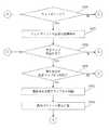
つづいて、本実施形態における較正方法について、図2を利用して説明する。(Process flow)
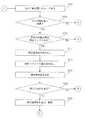
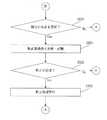
Next, a calibration method according to this embodiment will be described with reference to FIG.
まず、自律走行装置は、次の行動地点に向かって走行する(ステップS202)。次の行動地点は、ウェイポイントの位置、較正マップの較正位置又は同じ場所に位置するウェイポイント/較正マップの較正位置である。つづいて、自律走行装置が次の行動地点に到達したかどうかについて判定がなされる(ステップS204)。 First, the autonomous traveling device travels toward the next action point (step S202). The next action point is the location of the waypoint, the calibration location of the calibration map or the calibration location of the waypoint / calibration map located at the same location. Subsequently, it is determined whether or not the autonomous mobile device has reached the next action point (step S204).
自律走行装置が次の行動地点に到達していなければ(ステップS204;No)、自律走行装置は次の行動地点に向かって走行し続ける(ステップS202)。 If the autonomous traveling device has not reached the next action point (step S204; No), the autonomous traveling device continues to travel toward the next action point (step S202).
他方、自律走行装置が次の行動地点に到達した場合(ステップS204;Yes)、現在の行動地点が較正マップ上にあるかどうかについて判定する(ステップS210)。 On the other hand, when the autonomous mobile device has reached the next action point (step S204; Yes), it is determined whether the current action point is on the calibration map (step S210).
現在の行動地点が較正マップ上にあるならば(ステップS210;Yes)、較正指標値が読み出される(ステップS214)。そして、一又は複数の動作パラメータ値が読み出され(ステップS216)、一つ又は複数の環境パラメータ値が測定される(ステップ218)。 If the current action point is on the calibration map (step S210; Yes), the calibration index value is read (step S214). Then, one or more operation parameter values are read (step S216), and one or more environmental parameter values are measured (step 218).
続いて、現在の行動地点が、較正指標値が更新される較正マップの較正位置であるかどうかについて判定する(ステップS220)。現在の行動地点が、較正指標値が較正マップから更新される位置であれば(ステップS220;Yes)、較正指標値は更新され、記憶される(ステップS224)。 Subsequently, it is determined whether or not the current action point is the calibration position of the calibration map whose calibration index value is updated (step S220). If the current action point is a position where the calibration index value is updated from the calibration map (step S220; Yes), the calibration index value is updated and stored (step S224).
例えば、現在の地点で、較正処理を実行するために、距離を多くとる必要がある場合には、距離を多くとるように較正指標値を更新し、記憶する。ここで、較正指標値が更新されることにより、地点に応じた較正処理を実行することができるようになる。 For example, when it is necessary to increase the distance in order to execute the calibration process at the current point, the calibration index value is updated and stored so as to increase the distance. Here, the calibration process according to the point can be executed by updating the calibration index value.
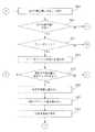
つづいて、較正処理を実行する必要があるか否かについて判定がなされる(図2BのステップS226)。一例として、較正指標値が一つの基準として較正判定基準を満たす場合に、較正が必要であると判定される。較正判定基準を満たすか否かは、較正指標値のうち1つが基準を満たすか否かが判定されてもよいし、複数の較正指標値により判定されてもよい。また、複数の較正指標値(較正指標値群)の中から一又は複数の較正指標値の基準が満たすか否かを判定してもよい。 Subsequently, a determination is made as to whether or not a calibration process needs to be executed (step S226 in FIG. 2B). As an example, if the calibration index value satisfies the calibration criterion as one criterion, it is determined that calibration is necessary. Whether or not the calibration determination criterion is satisfied may be determined based on whether or not one of the calibration index values satisfies the criterion, or may be determined based on a plurality of calibration index values. Further, it may be determined whether one or a plurality of calibration index value criteria is satisfied from among a plurality of calibration index values (calibration index value group).
更に、較正指標値、動作パラメータ値及び環境パラメータ値を組み合わせて較正判定基準を満たす場合に、較正が必要と判定されてもよい。 Furthermore, it may be determined that calibration is required when the calibration criteria are met by combining calibration index values, operating parameter values, and environmental parameter values.
そして、較正処理の実行が必要と判定されれば(ステップS226;Yes)、較正処理が実行される(ステップS230)。 And if it determines with execution of a calibration process being required (step S226; Yes), a calibration process will be performed (step S230).
ここで、較正処理は、予め記憶されている経路(例えば、較正経路)に沿って自律走行装置を動かすことにより行われることとしてもよい。 Here, the calibration process may be performed by moving the autonomous mobile device along a route (for example, a calibration route) stored in advance.
また、較正処理の実行後、自律走行装置は現在の行動地点に戻ることとしてもよいし、較正処理の実行後、自律走行装置は較正経路の最終点に留まることとしてもよい。 In addition, after the calibration process, the autonomous mobile device may return to the current action point, or after the calibration process, the autonomous mobile device may remain at the final point of the calibration route.
更に、現在の行動地点がウェイポイントであるかどうかについて判定される(ステップS232)。現在の行動地点がウェイポイントであれば(ステップS232;Yes)、ウェイポイントで行われるのに必要な処理が実行される(ステップS236)。 Further, it is determined whether or not the current action point is a waypoint (step S232). If the current action point is a waypoint (step S232; Yes), processing necessary to be performed at the waypoint is executed (step S236).
もし、自律走行装置が、較正処理を実行した後、較正経路の最終地点に留まっている場合には、ウェイポイントでの処理を実行するために、自律走行装置は現在の行動地点に戻る。それから、較正マップの較正位置の更新が許可されるかどうか判定する(ステップS238)。 If the autonomous mobile device remains at the final point of the calibration route after executing the calibration process, the autonomous mobile device returns to the current action point in order to execute the process at the waypoint. Then, it is determined whether or not the update of the calibration position of the calibration map is permitted (step S238).
ここで、較正マップの較正位置の更新が許可されなければ、自律走行装置は、次の行動地点に向かって走行する(ステップS238;No→ステップS202)。 Here, if the update of the calibration position of the calibration map is not permitted, the autonomous traveling device travels toward the next action point (step S238; No → step S202).
較正マップの較正位置の更新が許可されれば(ステップS240;Yes)、現在の行動地点を較正マップに追加するか否かが判定される。一例として、較正マップに追加されることを示す基準である較正マップ追加基準を現在の行動地点が満たすかどうかによって判定される(ステップS244)。 If updating of the calibration position of the calibration map is permitted (step S240; Yes), it is determined whether or not to add the current action point to the calibration map. As an example, the determination is made based on whether or not the current action point satisfies a calibration map addition criterion, which is a criterion indicating that it is added to the calibration map (step S244).
現在の行動地点が較正マップ追加基準を満たせば(ステップS244;Yes)、現在の行動地点は較正マップに追加される(図2DのステップS250)。また、現在の行動地点と関連した較正指標値が決定されて記憶される(図2DのステップS252)。また、現在の動作パラメータ値が記憶される(ステップS254)。そして、自律走行装置は次の行動地点に向かって走行する(ステップS202)。 If the current action point satisfies the calibration map addition criteria (step S244; Yes), the current action point is added to the calibration map (step S250 in FIG. 2D). Also, the calibration index value associated with the current action point is determined and stored (step S252 in FIG. 2D). Further, the current operation parameter value is stored (step S254). Then, the autonomous traveling device travels toward the next action point (step S202).
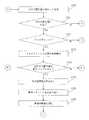
ステップS244において、現在の行動地点が較正マップ追加基準を満たさず、現在地点(現在の行動地点)を較正マップに追加しない場合には(ステップS244;No)、現在の行動地点を較正マップから削除するか否かを判定する(ステップS258)。 In step S244, if the current action point does not satisfy the calibration map addition criteria and the current point (current action point) is not added to the calibration map (step S244; No), the current action point is deleted from the calibration map. It is determined whether or not to perform (step S258).
この場合、一例として、較正マップから較正位置が削除されることを示す基準である較正マップ削除基準を満たすかどうかにより判定される。 In this case, as an example, the determination is made based on whether or not a calibration map deletion criterion that is a criterion indicating that the calibration position is deleted from the calibration map is satisfied.
現在の地点が、較正マップ削除基準を満たす場合には(ステップS258;Yes)、現在の地点(現在の行動地点)が較正マップの較正位置から削除され(図2EのステップS262)、現在の動作パラメータ値が記憶される(ステップS264)。そして、自律走行装置は次の行動地点に向かって走行する(ステップS202)。 If the current point satisfies the calibration map deletion criteria (step S258; Yes), the current point (current action point) is deleted from the calibration position of the calibration map (step S262 in FIG. 2E), and the current operation The parameter value is stored (step S264). Then, the autonomous traveling device travels toward the next action point (step S202).
なお、較正マップ削除基準を満たしていないために、較正マップから現在の行動地点に対応する較正位置が削除されない場合にも(ステップS258;No)、自律走行装置は次の行動地点に向かって走行する(ステップS202)。 Even when the calibration position corresponding to the current action point is not deleted from the calibration map because the calibration map deletion criterion is not satisfied (step S258; No), the autonomous mobile device travels toward the next action point. (Step S202).
図2BのステップS232において、現在の行動地点がウェイポイントの位置でない場合には(ステップS232;No)、較正マップの更新が許可されるかどうかについて判定され(ステップS238)、その処理ステップは上記の通り実行される。 In step S232 of FIG. 2B, when the current action point is not the waypoint position (step S232; No), it is determined whether or not the update of the calibration map is permitted (step S238). It is executed as follows.
図2BのステップS226において、較正処理の実行が必要でない場合(ステップS226;No)、較正マップの較正位置の更新が許可されるかどうかについて判定され(図2CのステップS238)、処理ステップが上記の通り実行される。 In step S226 of FIG. 2B, if the execution of the calibration process is not necessary (step S226; No), it is determined whether or not the update of the calibration position of the calibration map is permitted (step S238 of FIG. 2C), and the processing steps are described above. It is executed as follows.
図2AのステップS220において、現在の行動地点が、較正指標値が更新される較正マップの較正位置でなければ(ステップS220;No)、較正が必要とされているかどうかについて判定がなされ(図2CのステップS226)、処理ステップが上記の通り実行される。 In step S220 of FIG. 2A, if the current action point is not the calibration position of the calibration map whose calibration index value is updated (step S220; No), a determination is made as to whether calibration is required (FIG. 2C). Step S226), the processing steps are executed as described above.
もし現在の行動地点が較正マップ上になければ(ステップS210;No)、ウェイポイントで行われるのに必要な行動が行われ(図2CのステップS236)、処理ステップが上記の通り実行される。 If the current action point is not on the calibration map (step S210; No), an action necessary to be performed at the waypoint is performed (step S236 in FIG. 2C), and the processing steps are executed as described above.
[2.第2実施形態]
つづいて、第2実施形態の自律走行装置におけるナビゲーション較正のための処理について、図3(図3A、図3B)に基づいて説明する。[2. Second Embodiment]
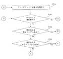
Next, a process for navigation calibration in the autonomous mobile device of the second embodiment will be described with reference to FIG. 3 (FIGS. 3A and 3B).
まず、自律走行装置は、次の行動地点に向かって走行する(ステップS302)。次の行動地点は、ウェイポイントの位置、較正マップの位置又は同じ場所に位置するウェイポイント/較正マップの位置である。そして、自律走行装置が次の行動地点に到達したかどうかについて判定がなされる(ステップS304)。 First, the autonomous traveling device travels toward the next action point (step S302). The next action point is the position of the waypoint, the position of the calibration map or the position of the waypoint / calibration map located at the same place. Then, a determination is made as to whether the autonomous mobile device has reached the next action point (step S304).
自律走行装置が次の行動地点に到達していなければ、自律走行装置は次の行動地点に向かって走行し続ける(ステップS304;No→ステップS302)。 If the autonomous traveling device has not reached the next action point, the autonomous traveling device continues to travel toward the next action point (step S304; No → step S302).
自律走行装置が次の行動地点に到達したならば(ステップS304;Yes)、現在の地点(現在の行動地点)が較正マップ上にあるかどうかについて判定する(ステップS310)。 If the autonomous mobile device has reached the next action point (step S304; Yes), it is determined whether or not the current point (current action point) is on the calibration map (step S310).
現在の行動地点が較正マップ上にあるならば(ステップS310;Yes)、較正指標値が読みだされ(ステップS314)、一又は複数の動作パラメータが読み出され(ステップS316)、一又は複数の環境パラメータ値が測定される(ステップS318)。 If the current action point is on the calibration map (step S310; Yes), the calibration index value is read (step S314), one or more operating parameters are read (step S316), and one or more An environmental parameter value is measured (step S318).
続いて、現在の行動地点において、較正が必要か否か判定される(ステップS320)。較正が必要であれば(ステップS320;Yes)、較正処理が実行される(ステップS324)。 Subsequently, it is determined whether calibration is necessary at the current action point (step S320). If calibration is necessary (step S320; Yes), a calibration process is executed (step S324).
具体的には、較正処理は予め記憶されている経路(例えば、較正経路)に沿って自律走行装置を動かすことにより行われる。 Specifically, the calibration process is performed by moving the autonomous traveling device along a route (for example, a calibration route) stored in advance.
また、較正処理の実行後に、自律走行装置は、現在の行動地点に戻ることとしてもよいし、較正処理の実行後、自律走行装置は、較正経路の最終点に留まることとしてもよい。 Moreover, after execution of the calibration process, the autonomous mobile device may return to the current action point, or after execution of the calibration process, the autonomous mobile device may remain at the final point of the calibration route.
続いて、現在の行動地点がウェイポイントの位置でもあるかどうかについて判定される(ステップS326)。現在の行動地点がウェイポイントであれば(ステップS326;Yes)、ウェイポイントで行われるのに必要な処理が実行される(ステップS330)。 Subsequently, it is determined whether or not the current action point is also the position of the waypoint (step S326). If the current action point is a waypoint (step S326; Yes), processing necessary to be performed at the waypoint is executed (step S330).
もし自律走行装置が、較正を実行した後、較正経路の最終地点に留まっている場合には、ウェイポイントの行動を行うために、自律走行装置はまず現在の行動地点に戻ることとしてもよい。自律走行装置は次の行動地点に向かって走行する(ステップS302)。 If the autonomous mobile device stays at the final point of the calibration route after executing calibration, the autonomous mobile device may first return to the current action point in order to perform the action of the waypoint. The autonomous traveling device travels toward the next action point (step S302).
もし現在の行動地点が較正マップ上になければ(ステップS310;No)、ウェイポイントで行われるのに必要な行動が行われ(図3BのステップS330)、自律走行装置は次の行動地点に向かって走行する(ステップS302)。 If the current action point is not on the calibration map (step S310; No), an action necessary to be performed at the waypoint is performed (step S330 in FIG. 3B), and the autonomous mobile device goes to the next action point. (Step S302).
ステップS320において、較正が必要でないと判定された場合には、現在の行動地点がウェイポイントの位置であるかどうか判定される(ステップS320;No→ステップS326)。 If it is determined in step S320 that calibration is not necessary, it is determined whether or not the current action point is a waypoint position (step S320; No → step S326).
もし現在の行動地点がウェイポイントでなければ(ステップS326;No)、自律走行装置は次の行動地点に向かって走行する(ステップS302)。 If the current action point is not a waypoint (step S326; No), the autonomous mobile device runs toward the next action point (step S302).
現在の行動地点がウェイポイントであれば(ステップS326;Yes)、ウェイポイントで行われるのに必要な行動が行われ(ステップS330)、自律走行装置は次の行動地点に向かって走行する(ステップS302)。 If the current action point is a waypoint (step S326; Yes), an action necessary to be performed at the waypoint is performed (step S330), and the autonomous mobile device travels toward the next action point (step S330). S302).
[3.第3実施形態]
つづいて、第3実施形態の自律走行装置におけるナビゲーション較正のための処理について、図4(図4A、図4B、図4C)に基づいて説明する。[3. Third Embodiment]
Next, a process for navigation calibration in the autonomous mobile device of the third embodiment will be described with reference to FIG. 4 (FIGS. 4A, 4B, and 4C).
まず、自律走行装置は、次の行動地点に向かって走行する(ステップS402)。次の行動地点は、ウェイポイントの位置、較正マップの較正位置又は同じ場所に位置するウェイポイント/較正マップの較正位置である。自律走行装置が次の行動地点に到達したかどうかについて判定がなされる(ステップS404)。 First, the autonomous traveling device travels toward the next action point (step S402). The next action point is the location of the waypoint, the calibration location of the calibration map or the calibration location of the waypoint / calibration map located at the same location. A determination is made as to whether the autonomous mobile device has reached the next action point (step S404).
自律走行装置が次の行動地点に到達していなければ、自律走行装置は次の行動地点に向かって走行し続ける(ステップS404;No→ステップS402)。 If the autonomous traveling device has not reached the next action point, the autonomous traveling device continues to travel toward the next action point (step S404; No → step S402).
自律走行装置が次の行動地点に到達したならば(ステップS404;Yes)、現在の行動地点が較正マップ上にあるかどうかについて判定がなされる(ステップS410)。 If the autonomous mobile device has reached the next action point (step S404; Yes), a determination is made as to whether the current action point is on the calibration map (step S410).
現在の行動地点が較正マップ上にあるならば(ステップS410;Yes)、較正指標値が読み出され(ステップS414)、一又は複数の動作パラメータが読み出され(ステップS416)、一又は複数の環境パラメータ値が測定される(ステップS418)。 If the current action point is on the calibration map (step S410; Yes), the calibration index value is read (step S414), one or more operating parameters are read (step S416), and one or more An environmental parameter value is measured (step S418).
続いて、現在の行動地点において、較正が必要か否か判定される(ステップS420)。較正が必要であれば(ステップS420;Yes)、較正処理が実行される(ステップS424)。 Subsequently, it is determined whether calibration is necessary at the current action point (step S420). If calibration is necessary (step S420; Yes), a calibration process is executed (step S424).
具体的には、較正処理は予め記憶されている経路(例えば、較正経路)に沿って自律走行装置を動かすことにより行われる。 Specifically, the calibration process is performed by moving the autonomous traveling device along a route (for example, a calibration route) stored in advance.
また、較正処理の実行後、自律走行装置は、現在の行動地点に戻ることとしてもよいし、較正経路の最終点に留まこととしてもよい。 In addition, after execution of the calibration process, the autonomous mobile device may return to the current action point or may remain at the final point of the calibration path.
続いて、現在の行動地点がウェイポイントの位置でもあるかどうかについて判定される(ステップS426)。現在の行動地点がウェイポイントの位置であれば(ステップS326;Yes)、ウェイポイントで行われるのに必要な処理が実行される(ステップS430)。 Subsequently, it is determined whether or not the current action point is also the position of the waypoint (step S426). If the current action point is the position of the waypoint (step S326; Yes), processing necessary to be performed at the waypoint is executed (step S430).
自律走行装置が、較正を実行した後、較正経路の最終地点に留まっている場合には、ウェイポイントでの処理を実行するために、まず自律走行装置は現在の構成地点に戻ることとしてもよい。 If the autonomous mobile device stays at the final point of the calibration path after performing calibration, the autonomous mobile device may first return to the current configuration point in order to execute processing at the waypoint. .
それから、較正マップの較正位置の更新が許可されるかどうかを判定する(ステップS432)。較正マップの較正位置の更新が許可されなければ(ステップS432;No)、自律走行装置は次の行動地点に向かって走行する(ステップS402)。 Then, it is determined whether or not the update of the calibration position of the calibration map is permitted (step S432). If the update of the calibration position of the calibration map is not permitted (step S432; No), the autonomous traveling device travels toward the next action point (step S402).
較正マップの較正位置の更新が許可されていれば(ステップS432;Yes)、現在の行動地点を較正マップから削除するか否かを判定する(ステップS438)。 If updating of the calibration position of the calibration map is permitted (step S432; Yes), it is determined whether or not to delete the current action point from the calibration map (step S438).
この場合、較正マップ削除基準を満たすかどうかにより判定され、較正マップ削除基準を満たす場合には(ステップS440;Yes)、現在の行動地点は較正マップから削除され(ステップS442)、現在の動作パラメータ値が記憶される(ステップS444)。自律走行装置は次の行動地点に向かって走行する(ステップS402)。 In this case, it is determined whether or not the calibration map deletion criterion is satisfied. If the calibration map deletion criterion is satisfied (step S440; Yes), the current action point is deleted from the calibration map (step S442), and the current operation parameter is set. The value is stored (step S444). The autonomous traveling device travels toward the next action point (step S402).
他方、較正マップ削除基準を満たしていないために、較正マップから現在の行動地点が削除されない場合にも(ステップS438;No)、自律走行装置は次の行動地点に向かって走行する(ステップS402)。 On the other hand, even when the current action point is not deleted from the calibration map because the calibration map deletion criterion is not satisfied (step S438; No), the autonomous mobile device runs toward the next action point (step S402). .
図4AのステップS420において、もし較正が必要と判定されなかった場合には(ステップS420;No)、現在の行動地点がウェイポイントの位置でもあるかどうか判定され(ステップS426)、処理ステップが上記の通りに実行される。 In step S420 of FIG. 4A, if it is not determined that calibration is necessary (step S420; No), it is determined whether or not the current action point is also a waypoint position (step S426), and the processing steps are as described above. Executed as follows.
図4AのステップS410において、現在の行動地点が較正マップ上になければ(ステップS410;No)、ウェイポイントで行われるのに必要な行動が行われる(図4Cのステップ452)。 In step S410 in FIG. 4A, if the current action point is not on the calibration map (step S410; No), an action necessary to be performed at the waypoint is performed (
それから、較正マップの較正位置の更新が許可されるかどうか判定され(ステップS454)、較正マップの較正位置の更新が許可されていなければ、自律走行装置は次の行動地点に向かって走行する(ステップS454;No→ステップS402)。 Then, it is determined whether or not the update of the calibration position of the calibration map is permitted (step S454). If the update of the calibration position of the calibration map is not permitted, the autonomous traveling device travels toward the next action point ( Step S454; No-> Step S402).
他方、較正マップの較正位置の更新が許可されていれば(ステップS454;Yes)、現在の行動地点を較正マップに追加するか否かが判定される(ステップS460)。一例として、較正マップに追加するべきことを示す較正マップ追加基準を現在の行動地点が満たすかどうかについて判定する(ステップS460)。 On the other hand, if the update of the calibration position of the calibration map is permitted (step S454; Yes), it is determined whether or not to add the current action point to the calibration map (step S460). As an example, it is determined whether or not the current action point satisfies a calibration map addition criterion indicating that it should be added to the calibration map (step S460).
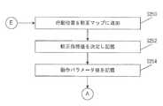
現在の行動地点が較正マップ追加基準を満たせば(ステップS460;Yes)、現在の行動地点は較正マップに追加される(ステップS464)。また、現在の行動地点と関連する較正指標値が決定されて記憶される(ステップS466)、また、現在の動作パラメータ値が記憶される(ステップS468)。そして、自律走行装置は次の行動地点に向かって走行する(ステップS402)。 If the current action point satisfies the calibration map addition criteria (step S460; Yes), the current action point is added to the calibration map (step S464). Further, the calibration index value associated with the current action point is determined and stored (step S466), and the current operation parameter value is stored (step S468). Then, the autonomous traveling device travels toward the next action point (step S402).
ステップS460において、現在の行動地点が較正マップ追加基準を満たさず、現在地点(現在の行動地点)を較正マップに追加しない場合には(ステップS460;No)、自律走行装置は次の行動地点に向かって走行する(ステップS402)。 In step S460, when the current action point does not satisfy the calibration map addition criterion and the current point (current action point) is not added to the calibration map (step S460; No), the autonomous mobile device is set to the next action point. It travels toward (step S402).
図4BのステップS426において、現在の行動地点が較正マップの較正位置であって、ウェイポイントでないと判定された場合(ステップS426;No)、処理ステップは、較正マップの較正位置の更新が許可されるかどうかについての判定(ステップS432)に飛び越えていき、上記の通りに実行される。 If it is determined in step S426 of FIG. 4B that the current action point is the calibration position of the calibration map and not the waypoint (step S426; No), the processing step is permitted to update the calibration position of the calibration map. Whether or not (step S432) is jumped to and executed as described above.
[4.第4実施形態]
つづいて、第4実施形態の自律走行装置における較正処理について、図5(図5A、図5B)に基づいて説明する。[4. Fourth Embodiment]
It continues and the calibration process in the autonomous running apparatus of 4th Embodiment is demonstrated based on FIG. 5 (FIG. 5A, FIG. 5B).
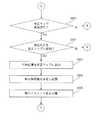
まず、自律走行装置は、次の行動地点に向かって走行する(ステップS502)。次の行動地点は、ウェイポイントの位置、較正マップの較正位置又は同じ場所に位置するウェイポイント/較正マップの較正位置である。自律走行装置が次の行動地点に到達したかどうかについて判定がなされる(ステップS504)。 First, the autonomous traveling device travels toward the next action point (step S502). The next action point is the location of the waypoint, the calibration location of the calibration map or the calibration location of the waypoint / calibration map located at the same location. A determination is made as to whether the autonomous mobile device has reached the next action point (step S504).
自律走行装置が次の行動地点に到達していなければ、自律走行装置は次の行動地点に向かって走行し続ける(ステップS504;No→ステップS502)。 If the autonomous traveling device has not reached the next action point, the autonomous traveling device continues to travel toward the next action point (step S504; No → step S502).
自律走行装置が次の行動地点に到達したならば(ステップS504;Yes)、現在の行動地点が較正マップ上にあるかどうかについて判定がなされる(ステップS510)。現在の行動地点が較正マップ上にあるならば(ステップS510;Yes)、較正指標値が読み出される(ステップS514)。 If the autonomous mobile device has reached the next action point (step S504; Yes), a determination is made as to whether the current action point is on the calibration map (step S510). If the current action point is on the calibration map (step S510; Yes), the calibration index value is read (step S514).
つづいて、較正を実行する必要であるか否かについて判定がなされる(ステップS516)。較正が必要と判定されれば(ステップS516;Yes)、較正処理が実行される(ステップS520)。 Subsequently, a determination is made as to whether calibration needs to be executed (step S516). If it is determined that calibration is necessary (step S516; Yes), a calibration process is executed (step S520).
ここで、較正処理は、予め記憶されている経路(例えば、較正経路)に沿って自律走行装置を動かすことにより行われることとしてもよい。 Here, the calibration process may be performed by moving the autonomous mobile device along a route (for example, a calibration route) stored in advance.
また、較正処理の実行後に、自律走行装置は、現在の行動地点に戻ることとしてもよいし、較正処理の実行後、自律走行装置は、較正経路の最終点に留まることとしてもよい。 Moreover, after execution of the calibration process, the autonomous mobile device may return to the current action point, or after execution of the calibration process, the autonomous mobile device may remain at the final point of the calibration route.
更に、現在の行動地点がウェイポイントであるかどうかについて判定される(図5BのステップS522)。現在の行動地点がウェイポイントの位置であれば(ステップS522;Yes)、ウェイポイントで行われるのに必要な処理が実行される(ステップS526)。 Further, it is determined whether or not the current action point is a waypoint (step S522 in FIG. 5B). If the current action point is the position of the waypoint (step S522; Yes), processing necessary to be performed at the waypoint is executed (step S526).
自律走行装置が、較正処理を実行した後、較正経路の最終地点に留まっている場合には、ウェイポイントでの処理を実行するために、自律走行装置は最初の行動地点に戻る。そして、自律走行装置は次の行動地点に向かって走行する(ステップS502)。 If the autonomous mobile device remains at the final point of the calibration route after executing the calibration process, the autonomous mobile device returns to the first action point in order to execute the process at the waypoint. Then, the autonomous traveling device travels toward the next action point (step S502).
また、図5AのステップS510において、現在の行動地点が較正マップ上にない場合は、ウェイポイントで行われるのに必要な処理が実行される処理に遷移する(ステップS510;No→ステップS526)。 Further, in step S510 of FIG. 5A, when the current action point is not on the calibration map, the process shifts to a process in which a process necessary to be performed at the waypoint is executed (step S510; No → step S526).
また、図5AのステップS516において、もし、較正処理が必要でない場合には、現在の行動地点がウェイポイントの位置であるかどうか判定される処理に遷移する(ステップS516;Noス→テップS522)。 Further, in step S516 of FIG. 5A, if the calibration process is not necessary, the process proceeds to a process for determining whether or not the current action point is the position of the waypoint (step S516; No S → Step S522). .
また、図5BのステップS522において、現在地点がウェイポイントでなければ、自律走行装置は次の行動地点に向かって走行する処理に遷移する(ステップS522;No→ステップS502)。 Moreover, in step S522 of FIG. 5B, if the current location is not a waypoint, the autonomous mobile device transits to a process of traveling toward the next action location (step S522; No → step S502).
[5.第5実施形態]
つづいて、第5実施形態の自律走行装置におけるナビゲーション較正のための処理について、図6(図6A、図6B、図6C、図6D、図6E)に基づいて説明する。[5. Fifth Embodiment]
Next, processing for navigation calibration in the autonomous mobile device of the fifth embodiment will be described based on FIG. 6 (FIGS. 6A, 6B, 6C, 6D, and 6E).
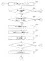
まず、自律走行装置は、次の行動地点に向かって走行する(ステップS602)。次の行動地点は、ウェイポイントの位置、較正マップの較正位置又は同じ場所に位置するウェイポイント/較正マップの較正位置である。自律走行装置が次の行動地点に到達したかどうかについて判定がなされる(ステップS604)。 First, the autonomous traveling device travels toward the next action point (step S602). The next action point is the location of the waypoint, the calibration location of the calibration map or the calibration location of the waypoint / calibration map located at the same location. A determination is made as to whether the autonomous mobile device has reached the next action point (step S604).
自律走行装置が次の行動地点に到達していなければ、自律走行装置は次の行動地点に向かって走行し続ける(ステップS604;No→ステップS602)。 If the autonomous traveling device has not reached the next action point, the autonomous traveling device continues to travel toward the next action point (step S604; No → step S602).
自律走行装置が次の行動地点に到達したならば(ステップS604;Yes)、現在の行動地点がウェイポイントであるかどうかについて判定がなされる(ステップS610)。 If the autonomous mobile device has reached the next action point (step S604; Yes), a determination is made as to whether the current action point is a waypoint (step S610).
現在の行動地点がウェイポイントであるならば(ステップS610;Yes)、ウェイポイントで行われるのに必要な処理が実行される(ステップS614)。 If the current action point is a waypoint (step S610; Yes), processing necessary to be performed at the waypoint is executed (step S614).
現在の行動地点がウェイポイントでないか、又は、ウェイポイントで行われるのに必要な行動が行われた後かであれば、現在の行動地点が較正マップ上にあるかどうかについて判定がなされる(ステップS618)。 If the current action point is not a waypoint or after actions necessary to be performed at the waypoint, a determination is made as to whether the current action point is on the calibration map ( Step S618).
現在の行動地点が較正マップ上にあるならば(ステップS618;Yes)、較正指標値が読み出され(ステップS622)、一又は複数の動作パラメータが読み出され(ステップS624)、一又は複数の環境パラメータ値が測定される(ステップS626)。 If the current action point is on the calibration map (step S618; Yes), the calibration index value is read (step S622), one or more operating parameters are read (step S624), and one or more An environmental parameter value is measured (step S626).
つづいて、現在の行動地点が、較正指標値が更新される較正マップの位置であるかどうかについて判定する(ステップS628)。現在の行動地点が、較正指標値が較正マップから更新される位置であれば(ステップS628;Yes)、較正指標値は更新され、記憶される(ステップS632)。 Subsequently, it is determined whether or not the current action point is the position of the calibration map where the calibration index value is updated (step S628). If the current action point is a position where the calibration index value is updated from the calibration map (step S628; Yes), the calibration index value is updated and stored (step S632).
現在の行動地点が、較正指標値が更新される較正マップの位置でないか(ステップS628;No)、又は、較正指標値が更新され、記憶された後であれば、較正を実行する必要があるか否かについて判定がなされる(ステップS636)。一例として、一又は複数の較正指標値が一つの基準として較正判定規準を満たす場合に、較正必要であると判定される。 If the current action point is not the position of the calibration map where the calibration index value is updated (step S628; No), or if the calibration index value has been updated and stored, calibration needs to be performed. A determination is made as to whether or not (step S636). As an example, if one or more calibration index values satisfy the calibration criterion as one criterion, it is determined that calibration is necessary.
なお、較正指標値、動作パラメータの値及び環境パラメータの値が組み合わせて較正判定規準を満たす場合に、較正が必要と判定されてもよい。 In addition, when the calibration index value, the value of the operation parameter, and the value of the environment parameter are combined to satisfy the calibration determination criterion, it may be determined that calibration is necessary.
そして、較正が必要と判定されていれば(ステップS636;Yes)、較正処理が実行される(ステップS640)。 If it is determined that calibration is necessary (step S636; Yes), calibration processing is executed (step S640).
ここで、較正処理は、予め記憶されている経路(例えば、較正経路)に沿って自律走行装置を動かすことにより行われることとしてもよい。 Here, the calibration process may be performed by moving the autonomous mobile device along a route (for example, a calibration route) stored in advance.
また、較正処理の実行後、自律走行装置は現在の行動地点に戻ることとしてもよいし、較正処理の実行後、自律走行装置は較正経路の最終点に留まることとしてもよい。 In addition, after the calibration process, the autonomous mobile device may return to the current action point, or after the calibration process, the autonomous mobile device may remain at the final point of the calibration route.
較正処理が実行された後か、又は、較正が必要ない場合(ステップS636;No)、較正マップの較正位置の更新が許可されるかどうかについて判定がなされる(ステップS646)。 After the calibration process has been performed or if calibration is not required (step S636; No), a determination is made as to whether updating of the calibration position of the calibration map is permitted (step S646).
較正マップの較正位置の更新が許可されている場合(ステップS646;Yes)、現在の行動地点を較正マップに追加するか否かが判定される(ステップS650)。一例として、較正マップ追加基準を現在の行動地点が満たすかどうかについて判定する(ステップS650)。 When updating of the calibration position of the calibration map is permitted (step S646; Yes), it is determined whether or not to add the current action point to the calibration map (step S650). As an example, it is determined whether or not the current action point satisfies the calibration map addition criterion (step S650).
現在の行動地点が、較正マップ追加基準を満たせば(ステップS650;Yes)、現在の行動地点は較正マップに追加され(図6DのステップS654)、現在の行動地点に関連した較正指標値が決定されて記憶される(ステップS656)。また、現在の動作パラメータ値が記憶される(ステップS658)。そして、自律走行装置は次の行動地点に向かって走行する(ステップS602)。 If the current action point satisfies the calibration map addition criteria (step S650; Yes), the current action point is added to the calibration map (step S654 in FIG. 6D), and the calibration index value associated with the current action point is determined. And stored (step S656). Further, the current operation parameter value is stored (step S658). Then, the autonomous traveling device travels toward the next action point (step S602).
もし現在の行動地点が較正マップ追加基準を満たさず、現在地点(現在の行動地点)を較正マップに追加しない場合には(ステップS650;No)、現在の行動地点を較正マップから削除するか否かを判定する(ステップS662)。 If the current action point does not satisfy the calibration map addition criteria and the current point (current action point) is not added to the calibration map (step S650; No), whether or not to delete the current action point from the calibration map. Is determined (step S662).
この場合、一例として、較正マップから較正位置が削除されることを示す基準である較正マップ削除基準を満たすかどうかにより判定される。 In this case, as an example, the determination is made based on whether or not a calibration map deletion criterion that is a criterion indicating that the calibration position is deleted from the calibration map is satisfied.
現在の行動地点が、較正マップ削除基準を満たす場合(ステップS662;Yes)、現在の行動地点に対応する較正位置が較正マップから削除され(図6EのステップS666)、現在の動作パラメータ値が記憶される(ステップS668)。その後、自律走行装置は次の行動地点に向かって走行する(ステップS602)。 If the current action point satisfies the calibration map deletion criteria (step S662; Yes), the calibration position corresponding to the current action point is deleted from the calibration map (step S666 in FIG. 6E), and the current operation parameter value is stored. (Step S668). Thereafter, the autonomous traveling device travels toward the next action point (step S602).
較正マップ削除基準が満たされなければ(ステップS662;No)、自律走行装置は次の行動地点に向かって走行する(ステップS602)。 If the calibration map deletion criterion is not satisfied (step S662; No), the autonomous traveling device travels toward the next action point (step S602).
また、図6CのステップS646において、較正マップの較正位置の更新が許可されていなければ、自律走行装置は次の行動地点に向かって走行する処理の遷移する(ステップS646;No→ステップS602)。 Further, in step S646 of FIG. 6C, if the update of the calibration position of the calibration map is not permitted, the autonomous traveling device transits to a process of traveling toward the next action point (step S646; No → step S602).
[6.第6実施形態]
つづいて、第6実施形態の自律走行装置におけるナビゲーション較正のための処理について、図7(図7A、図7B)に基づいて説明する。[6. Sixth Embodiment]
Subsequently, a process for navigation calibration in the autonomous mobile device of the sixth embodiment will be described with reference to FIG. 7 (FIGS. 7A and 7B).
まず、自律走行装置は、次の行動地点に向かって走行する(ステップS702)。次の行動地点は、ウェイポイントの位置、較正マップの較正位置又は同じ場所に位置するウェイポイント/較正マップの較正位置である。そして、自律走行装置が次の行動地点に到達したかどうかについて判定がなされる(ステップS704)。 First, the autonomous traveling device travels toward the next action point (step S702). The next action point is the location of the waypoint, the calibration location of the calibration map or the calibration location of the waypoint / calibration map located at the same location. Then, a determination is made as to whether the autonomous mobile device has reached the next action point (step S704).
自律走行装置が次の行動地点に到達していなければ、自律走行装置は次の行動地点に向かって走行し続ける(ステップS704;No→ステップS702)。 If the autonomous traveling device has not reached the next action point, the autonomous traveling device continues to travel toward the next action point (step S704; No → step S702).
自律走行装置が、次の行動地点に到達したならば(ステップS704;Yes)、現在の行動地点がウェイポイントの位置であるかどうかについて判定がなされる(ステップS710)。現在の行動地点がウェイポイントの位置であるならば、ウェイポイントで行われるのに必要な処理が実行される(ステップS710;Yes→ステップS714)。 If the autonomous mobile device has reached the next action point (step S704; Yes), a determination is made as to whether the current action point is the position of the waypoint (step S710). If the current action point is the position of the waypoint, processing necessary to be performed at the waypoint is executed (step S710; Yes → step S714).
ウェイポイントの行動がなされた後か、又は、現在の位置がウェイポイントでなければ(ステップS710;No)、現在の行動地点が較正マップ上にあるかどうかについて判定がなされる(ステップS718)。 After a waypoint action is taken or if the current position is not a waypoint (step S710; No), a determination is made as to whether the current action point is on the calibration map (step S718).
現在の行動地点が較正マップ上にあるならば(ステップS718;Yes)、較正指標値が読み出され(ステップS724)、一又は複数の動作パラメータが読み出され(ステップS726)、一又は複数の環境パラメータ値が測定される(ステップS728)。 If the current action point is on the calibration map (step S718; Yes), the calibration index value is read (step S724), one or more operating parameters are read (step S726), and one or more An environmental parameter value is measured (step S728).
続いて、較正が必要であるか否かの判定がなされる(図7BのステップS730)。もし較正する必要が無いと判定されれば図7BのステップS730;No)、自律走行装置は次の行動地点に向かって走行し続ける(ステップS702)。 Subsequently, it is determined whether calibration is necessary (step S730 in FIG. 7B). If it is determined that there is no need to calibrate, step S730 in FIG. 7B; No), the autonomous mobile device continues to travel toward the next action point (step S702).
他方、較正が必要と判定された場合には(ステップS734;Yes)、較正処理が実行される(ステップS736)。 On the other hand, if it is determined that calibration is necessary (step S734; Yes), a calibration process is executed (step S736).
ここで、較正処理は予め記憶されている経路(例えば、較正経路)に沿って自律走行装置を動かすことにより行われることとしてもよい。 Here, the calibration process may be performed by moving the autonomous mobile device along a route (for example, a calibration route) stored in advance.
また、較正処理の実行後、自律走行装置は、現在の行動地点に戻ることとしてもよいし、較正処理の実行後、自律走行装置は、較正経路の最終点に留まることとしてもよい。 Moreover, after execution of the calibration process, the autonomous mobile device may return to the current action point, or after execution of the calibration process, the autonomous mobile device may remain at the final point of the calibration route.
較正処理が実行された後、自律走行装置は、次の行動地点に向かって走行する(図7AのステップS702)。 After the calibration process is executed, the autonomous traveling device travels toward the next action point (step S702 in FIG. 7A).
[7.第7実施形態]
つづいて、第7実施形態の自律走行装置におけるナビゲーション較正のための処理について、図8(図8A、図8B、図8C)に基づいて説明する。[7. Seventh Embodiment]
Next, a process for navigation calibration in the autonomous mobile device of the seventh embodiment will be described based on FIG. 8 (FIGS. 8A, 8B, and 8C).
まず、自律走行装置は、次の行動地点に向かって走行する(ステップS802)。次の行動地点は、ウェイポイントの位置、較正マップの較正位置又は同じ場所に位置するウェイポイント/較正マップの較正位置である。自律走行装置が次の行動地点に到達したかどうかについて判定がなされる(ステップS804)。 First, the autonomous traveling device travels toward the next action point (step S802). The next action point is the location of the waypoint, the calibration location of the calibration map or the calibration location of the waypoint / calibration map located at the same location. A determination is made as to whether the autonomous mobile device has reached the next action point (step S804).
自律走行装置が次の行動地点に到達していなければ(ステップS804;No)、自律走行装置は次の行動地点に向かって走行し続ける(ステップS802)。 If the autonomous mobile device has not reached the next action point (step S804; No), the autonomous mobile device continues to travel toward the next action point (step S802).
自律走行装置が次の行動地点に到達したならば(ステップS804;Yes)、現在の行動地点がウェイポイントの位置であるかどうかについて判定がなされる(ステップS810)。もし現在の行動地点がウェイポイントの位置であるならば(ステップS810;Yes)、ウェイポイントで行われるのに必要な処理が実行される(ステップS814)。 If the autonomous mobile device has reached the next action point (step S804; Yes), a determination is made as to whether the current action point is a waypoint position (step S810). If the current action point is the position of the waypoint (step S810; Yes), processing necessary to be performed at the waypoint is executed (step S814).
他方、現在の行動地点がウェイポイントでないか(ステップS810;No)又はウェイポイントの行動が行われた後であれば、現在の行動地点が較正マップ上にあるかどうかについて判定がなされる(ステップS818)。 On the other hand, if the current action point is not a waypoint (step S810; No) or after the action of the waypoint has been performed, a determination is made as to whether the current action point is on the calibration map (step). S818).
現在の行動地点が較正マップ上になければ(ステップS818;No)、較正マップの較正位置の更新が許可されるかどうかについて判定がなされる(図8BのステップS822)。較正マップの位置の更新が許可されていなければ(ステップS822;No)、自律走行装置は次の行動地点に向かって走行する(ステップS802)。 If the current action point is not on the calibration map (step S818; No), a determination is made as to whether updating of the calibration position of the calibration map is permitted (step S822 in FIG. 8B). If the update of the position of the calibration map is not permitted (step S822; No), the autonomous mobile device travels toward the next action point (step S802).
図8BのステップS822において、較正マップの較正位置の更新が許可されていれば(ステップS822;Yes)、現在の行動地点を較正マップに追加するか否かが判定される(ステップS828)。一例として、較正マップ追加基準を現在の行動地点が満たすかどうかによって判定される(ステップS828)。 If update of the calibration position of the calibration map is permitted in step S822 of FIG. 8B (step S822; Yes), it is determined whether or not to add the current action point to the calibration map (step S828). As an example, it is determined based on whether or not the current action point satisfies the calibration map addition criterion (step S828).
現在の行動地点が較正マップ追加基準を満たせば(ステップS828;Yes)、現在の行動地点は較正マップに追加される(ステップS832)。また現在の行動地点と関連した較正指標値が決定されて記憶される(ステップS834)。また、現在の動作パラメータ値が記憶される(ステップS836)。自律走行装置は次の行動地点に向かって走行する(ステップS802)。 If the current action point satisfies the calibration map addition criteria (step S828; Yes), the current action point is added to the calibration map (step S832). The calibration index value associated with the current action point is determined and stored (step S834). Further, the current operation parameter value is stored (step S836). The autonomous traveling device travels toward the next action point (step S802).
ここで、現在の行動地点が較正マップ追加基準を満たされなければ(ステップS828;No)、自律走行装置は次の行動地点に向かって走行する(ステップS802)。 Here, if the current action point does not satisfy the calibration map addition criteria (step S828; No), the autonomous mobile device runs toward the next action point (step S802).
また、図8AのステップS818において、現在の行動地点が較正マップ上にあると判定された場合には(ステップS818;Yes)、較正指標値が読み出される(ステップS842)。そして、一又は複数の動作パラメータ値が読み出され(ステップS844)、一又は複数の環境パラメータ値が測定される(ステップS846)。 If it is determined in step S818 of FIG. 8A that the current action point is on the calibration map (step S818; Yes), the calibration index value is read (step S842). Then, one or more operation parameter values are read (step S844), and one or more environmental parameter values are measured (step S846).
つづいて、較正処理を実行する必要があるか否かについて判定がなされる(ステップS848)。そして、較正処理の実行が必要と判定されれば(ステップS848;Yes)、較正処理が実行される(ステップS852)。 Subsequently, it is determined whether or not the calibration process needs to be executed (step S848). And if it determines with execution of a calibration process being required (step S848; Yes), a calibration process will be performed (step S852).
ここで、較正処理は、予め記憶されている経路(例えば、較正経路)に沿って自律走行装置を動かすことにより行われることとしてもよい。 Here, the calibration process may be performed by moving the autonomous mobile device along a route (for example, a calibration route) stored in advance.
また、較正処理の実行後、自律走行装置は現在の行動地点に戻ることとしてもよいし、較正処理の実行後、自律走行装置は較正経路の最終点に留まることとしてもよい。 In addition, after the calibration process, the autonomous mobile device may return to the current action point, or after the calibration process, the autonomous mobile device may remain at the final point of the calibration route.
較正処理が実行されていないか(ステップS848;No)、又は、較正処理が実行された後であれば、較正マップの較正位置の更新が許可されるかどうかについて判定がなされる(ステップS856)。較正マップの較正位置の更新が許可されなければ(ステップS856;No)、自律走行装置は次の行動地点に向かって走行する(ステップS802)。 If the calibration process has not been performed (step S848; No), or after the calibration process has been performed, a determination is made as to whether updating of the calibration position of the calibration map is permitted (step S856). . If the update of the calibration position of the calibration map is not permitted (step S856; No), the autonomous traveling device travels toward the next action point (step S802).
較正マップの較正位置の更新が許可される場合(ステップS856;Yes)、現在の行動地点に対応する較正位置を較正マップから削除するか否かを判定する(ステップS862)。 When updating of the calibration position of the calibration map is permitted (step S856; Yes), it is determined whether or not to delete the calibration position corresponding to the current action point from the calibration map (step S862).
この場合、一例として、較正マップから較正位置が削除されることを示す基準である較正マップ削除基準を満たすかどうかについて判定される。現在の行動地点が較正マップ削除基準を満たせば(ステップS862;Yes)、現在の行動地点に対応する較正位置が較正マップから削除され(ステップS866)、動作パラメータ値が記憶される(ステップS868)。そして、自律走行装置は次の行動地点に向かって走行する(ステップS802)。また、現在の行動地点が較正マップ削除基準を満たさない場合にも(ステップS862;No)、自律走行装置は次の行動地点に向かって走行する(ステップS802)。 In this case, as an example, it is determined whether or not a calibration map deletion criterion that is a criterion indicating that a calibration position is deleted from the calibration map is satisfied. If the current action point satisfies the calibration map deletion criteria (step S862; Yes), the calibration position corresponding to the current action point is deleted from the calibration map (step S866), and the operation parameter value is stored (step S868). . Then, the autonomous traveling device travels toward the next action point (step S802). Even when the current action point does not satisfy the calibration map deletion criterion (step S862; No), the autonomous mobile device runs toward the next action point (step S802).
[8.第8実施形態]
つづいて、第8実施形態の自律走行装置におけるナビゲーション較正のための処理について、図9(図9A、図9B)に基づいて説明する。[8. Eighth Embodiment]
Subsequently, a process for navigation calibration in the autonomous mobile device of the eighth embodiment will be described with reference to FIG. 9 (FIGS. 9A and 9B).
まず、自律走行装置は、次の行動地点に向かって走行する(ステップS902)。次の行動地点は、ウェイポイントの位置、較正マップの較正位置又は同じ場所に位置するウェイポイント/較正マップの較正位置である。そして、自律走行装置が次の行動地点に到達したかどうかについて判定がなされる(ステップS904)。 First, the autonomous traveling device travels toward the next action point (step S902). The next action point is the location of the waypoint, the calibration location of the calibration map or the calibration location of the waypoint / calibration map located at the same location. Then, a determination is made as to whether the autonomous traveling device has reached the next action point (step S904).
自律走行装置が次の行動地点に到達していなければ(ステップS904;No)、自律走行装置は次の行動地点に向かって走行し続ける(ステップS902)。 If the autonomous traveling device has not reached the next action point (step S904; No), the autonomous traveling device continues to travel toward the next action point (step S902).
自律走行装置の現在位置が次の行動地点に到達したならば(ステップS904;Yes)、当該現在位置がウェイポイントであるかどうかについて判定する(ステップS910)。現在位置(現在いる行動地点)がウェイポイントである場合には(ステップS910:;Yes)、ウェイポイントで行われるのに必要な処理が実行される(ステップS914)。 If the current position of the autonomous mobile device has reached the next action point (step S904; Yes), it is determined whether the current position is a waypoint (step S910). If the current position (the current action point) is a waypoint (step S910: Yes), processing necessary to be performed at the waypoint is executed (step S914).
ここで、ウェイポイントの行動が行われた後か又は現在の行動地点がウェイポイントでなければ(ステップS910;No)、現在の行動地点が較正マップ上にあるかどうかについて判定がなされる(図9BのステップS918)。 Here, after the action of the waypoint is performed or if the current action point is not the waypoint (step S910; No), it is determined whether or not the current action point is on the calibration map (FIG. Step S918 of 9B).
現在の行動地点が較正マップ上になければ(ステップS918;No)、自律走行装置は次の行動地点に向かって走行する(ステップS902)。現在の行動地点が較正マップ上にあれば(ステップS918;Yes)、較正指標値が読み出される(ステップS924)。 If the current action point is not on the calibration map (step S918; No), the autonomous mobile device runs toward the next action point (step S902). If the current action point is on the calibration map (step S918; Yes), the calibration index value is read (step S924).
つづいて、較正処理の実行が必要かどうかについて判定がなされる(ステップS926)。較正処理の実行が必要でなければ(ステップS926;No)、自律走行装置は次の行動地点に向かって走行する(ステップS902)。 Subsequently, it is determined whether or not the calibration process needs to be executed (step S926). If it is not necessary to execute the calibration process (step S926; No), the autonomous mobile device travels toward the next action point (step S902).
較正処理の実行が必要な場合(ステップS926;Yes)、較正処理が実行される(ステップS932)。ここで、較正処理は、予め記憶されている経路(例えば、較正経路)に沿って自律走行装置を動かすことにより行われることとしてもよい。 When it is necessary to execute the calibration process (step S926; Yes), the calibration process is executed (step S932). Here, the calibration process may be performed by moving the autonomous mobile device along a route (for example, a calibration route) stored in advance.
また、較正処理の実行後、自律走行装置は現在の行動地点に戻ることとしてもよいし、較正処理の実行後、自律走行装置は較正経路の最終点に留まることとしてもよい。 In addition, after the calibration process, the autonomous mobile device may return to the current action point, or after the calibration process, the autonomous mobile device may remain at the final point of the calibration route.
そして、自律走行装置は次の行動地点に向かって走行する(ステップS902)。 Then, the autonomous traveling device travels toward the next action point (step S902).
上述した実施形態において、自律走行装置の較正のための方法及びシステムから構成される。 In the above-described embodiment, the method and system are configured for calibration of an autonomous mobile device.
[9.第9実施形態]
つづいて、第9実施形態について説明する。第9実施形態は、一又は複数の自律走行装置が、管理装置(管理サーバ)に、ネットワークを介して接続されている場合の実施形態である。[9. Ninth Embodiment]
Subsequently, a ninth embodiment will be described. The ninth embodiment is an embodiment in which one or a plurality of autonomous traveling devices are connected to a management device (management server) via a network.
すなわち、自律走行装置に対して、移動する制御信号を管理装置から送信する。自律走行装置は、管理装置から受信される制御信号に基づいて移動制御がされている。 That is, a control signal that moves is transmitted from the management device to the autonomous mobile device. The autonomous traveling device is subjected to movement control based on a control signal received from the management device.
ここで、管理装置より、較正指示が行われると、上述した実施形態の較正処理が実行される。このとき、較正処理部120は、自律走行装置に備えていてもよいし、管理装置に備えていてもよい。 Here, when a calibration instruction is issued from the management device, the calibration processing of the above-described embodiment is executed. At this time, the
すなわち、自律走行装置の位置ずれの算出を、管理装置で行い、算出された位置ずれ(量)を管理装置から自律走行装置に送信してもよい。また、較正マップ122等の一部の構成要素を管理装置に記憶し、一部の処理を管理装置で実行してもよい。例えば、較正地点の判定は、管理装置で行うが、位置ずれの算出は自律走行装置で行うこととしてもよい。 That is, the position deviation of the autonomous traveling device may be calculated by the management device, and the calculated position deviation (amount) may be transmitted from the management device to the autonomous traveling device. Also, some components such as the
このように、本実施形態によれば、位置ずれの処理について、自律走行装置ではなく、管理装置側で行っていてもよい。また、管理装置は、管理サーバのような一又は複数の自律走行装置を管理する装置であってもよいし、スマートフォンのような小型の端末装置であってもよい。 As described above, according to the present embodiment, the misregistration process may be performed not on the autonomous traveling device but on the management device side. Further, the management device may be a device that manages one or more autonomous traveling devices such as a management server, or may be a small terminal device such as a smartphone.
例えば、自律走行装置と、スマートフォン・タブレットといった携帯端末装置とを近距離無線通信で接続し、携帯端末装置で較正処理を実行してもよい。また、携帯端末装置において、較正処理を実現可能なアプリケーションをダウンロードすることにより、処理を実行することができるようにしてもよい。 For example, the autonomous mobile device and a mobile terminal device such as a smartphone / tablet may be connected by short-range wireless communication, and the calibration process may be executed by the mobile terminal device. Further, in the mobile terminal device, the process may be executed by downloading an application that can realize the calibration process.
このように、本発明の第1の側面によると、自律走行装置の第1の位置が較正マップに対応する時、全較正指標値が検索され、第1の位置が動作を行うために適切な位置かどうか判定するのに使用される。 Thus, according to the first aspect of the present invention, when the first position of the autonomous mobile device corresponds to the calibration map, all calibration index values are retrieved, and the first position is suitable for performing the operation. Used to determine if position.
本発明の第2の側面によると、第1の位置が較正動作を行うために適切な位置であると判定されて時、較正動作は行われる。 According to the second aspect of the present invention, the calibration operation is performed when it is determined that the first position is an appropriate position for performing the calibration operation.
本発明の第3の側面によると、全較正指標値は、較正動作を行うための位置の適切性を示すものである。 According to the third aspect of the present invention, the total calibration index value indicates the appropriateness of the position for performing the calibration operation.
本発明の第4の側面によると、較正マップの生成は、複数の較正マップの位置を特定し、それぞれの較正マップの位置に全較正指標値を割り当てることから構成される。 According to a fourth aspect of the present invention, the generation of the calibration map consists of identifying the positions of a plurality of calibration maps and assigning all calibration index values to the positions of each calibration map.
本発明の第5の側面によると、第1の較正マップの位置と関連付けられる全較正指標値は、第1の較正マップの位置における絶対位置検出システムの利用性に関する。 According to a fifth aspect of the invention, the total calibration index value associated with the position of the first calibration map relates to the availability of the absolute position detection system at the position of the first calibration map.
本発明の第6の側面によると、第1の較正マップの位置と関連する全較正指標値は、第1の較正マップの位置における適当な較正経路の利用性に関する。 According to a sixth aspect of the invention, the total calibration index value associated with the position of the first calibration map relates to the availability of a suitable calibration path at the position of the first calibration map.
本発明の第7の側面によると、較正マップは生成される。 According to a seventh aspect of the invention, a calibration map is generated.
本発明の第8の側面によると、較正マップの生成は、複数の較正マップの位置を特定し、複数の較正マップの位置におけるそれぞれの較正マップの位置に全較正指標値を割り当てることから構成される。 According to an eighth aspect of the invention, the generation of the calibration map consists of locating a plurality of calibration maps and assigning a total calibration index value to each calibration map position at the plurality of calibration map positions. The
本発明の第9の側面によると、複数の較正マップの位置において第1の較正マップの位置を特定することは、第1の候補地における絶対位置検出システムの利用性を判定することから構成される。 According to a ninth aspect of the present invention, identifying the position of the first calibration map at a plurality of calibration map positions consists of determining the availability of the absolute position detection system at the first candidate site. The
本発明の第10の側面によると、複数の較正マップの位置において第1の較正マップの位置を特定することは、候補地において適切な較正進路を特定することから構成される。 According to a tenth aspect of the present invention, identifying the location of the first calibration map at the location of the plurality of calibration maps consists of identifying an appropriate calibration path at the candidate location.
本発明の第11の側面によると、第1の較正マップの位置に全較正指標値を割り当てることは、複数の特定の較正指標値を結合することから構成される。According to an eleventh aspect of the present invention, assigning all calibration index values to the position of the first calibration map consists of combining a plurality of specific calibration index values.
前述のこと及び本発明のその他の目的、特徴及び利点は、添付図面と共に次の発明の詳細な説明を考慮することによりもっと容易に理解されるであろう。 The foregoing and other objects, features and advantages of the present invention will be more readily understood upon consideration of the following detailed description of the invention in conjunction with the accompanying drawings.
[10.変形例]
本発明のいくつかの実施形態は、ここに記載された特徴及び方法を行うために計算システムをプログラムするのに使用される、記憶された指示を有するコンピュータ解読可能な記憶媒体からなるコンピュータプログラムプロダクトから構成される。模範的なコンピュータ解読可能な記憶媒体は、フラッシュメモリー装置、ディスク記憶媒体、例えば、フロッピーディスク、光ディスク、光磁気ディスク、デジタル多用途ディスク(DVD)、コンパクトディスク(CD)、マイクロドライブ及びその他の記憶媒体、読み取り専用メモリー(ROM)、プログラマブル読み取り専用メモリー(PROM)、消去可能なプログラム可能な読み取り専用メモリー(EEPROM)、ランダムアクセスメモリー(RAM)、ビデオランダムアクセスメモリー(VRAM)、ダイナミックランダムアクセスメモリー(DRAM)、指示及び/又はデータを記憶するために適したいかなる種類の媒体又は装置をも含むが、それらに限定されるものではない。[10. Modified example]
Some embodiments of the present invention provide a computer program product comprising a computer-readable storage medium having stored instructions used to program a computing system to perform the features and methods described herein. Consists of Exemplary computer readable storage media include flash memory devices, disk storage media such as floppy disks, optical disks, magneto-optical disks, digital versatile disks (DVDs), compact disks (CDs), microdrives and other storage. Medium, read only memory (ROM), programmable read only memory (PROM), erasable programmable read only memory (EEPROM), random access memory (RAM), video random access memory (VRAM), dynamic random access memory ( DRAM), any type of medium or device suitable for storing instructions and / or data, but is not limited thereto.
上記の明細書に使用されている文言及び表現は、記載の文言として使われていて、限定するものではなく、示され記載されている特徴、又は、その一部と同等のものを除外する文言及び表現を使用する意図はなく、発明の範囲は、次のクレームによってのみ定義され、限定されることが認められる。 The language and expressions used in the above specification are used as descriptive language and are not intended to be limiting, but exclude the features shown or described, or equivalents thereof. It is recognized that the scope of the invention is defined and limited only by the following claims.
100 走行システム
102 GNSS受信部
104 動作改善処理部
106 慣性測定部
108 センサ部
110 GNSSアンテナ
114 速度・方向算出部
116 速度制御値算出部
118 走行装置制御部
120 較正処理部
122 較正マップ生成部
124 較正制御部
126 位置ずれ算出部DESCRIPTION OF
Claims (15)
Translated fromJapanese前記較正手段が較正処理を実行する較正位置を記憶する較正マップと、
前記自律走行装置が位置する第1の位置が較正マップに含まれているか否かを判定する位置判定手段と、
前記第1の位置が較正マップに含まれている場合に、前記自律走行装置の位置に関連した較正指標の較正指標値を読み出す較正指標値読み出し手段と、
を備え、
前記較正手段は、
前記読み出された較正指標値に基づいて、前記第1の位置が較正処理を実行するのに適切な位置であると判定された場合に、前記較正処理を実行することを特徴とする較正装置。A calibration device comprising calibration means for executing calibration processing in an autonomous traveling device,
A calibration map for storing calibration positions at which the calibration means performs a calibration process;
Position determination means for determining whether or not the first position where the autonomous mobile device is located is included in the calibration map;
Calibration index value reading means for reading a calibration index value of a calibration index related to the position of the autonomous mobile device when the first position is included in a calibration map;
With
The calibration means includes
A calibration apparatus that executes the calibration process when it is determined that the first position is an appropriate position for executing the calibration process based on the read calibration index value. .
前記較正手段は、
前記取得された動作パラメータ値及び/又は環境パラメータ値に基づいて、前記自律走行装置の位置が較正処理を実行するのに適切な位置であると判定することを特徴とする請求項1に記載の較正装置。Further comprising parameter value acquisition means for acquiring an operation parameter value of the autonomous mobile device and an environmental parameter value;
The calibration means includes
The position of the autonomous mobile device is determined to be an appropriate position for executing a calibration process based on the acquired operation parameter value and / or environmental parameter value. Calibration device.
前記第1の位置がウェイポイントであると判定された場合には、ウェイポイントで行う処理を実行するウェイポイント処理実行手段と、
を備えることを特徴とする請求項1に記載の較正装置。Waypoint determination means for determining whether or not the first position is a waypoint;
When it is determined that the first position is a waypoint, waypoint process execution means for executing a process performed at the waypoint;
The calibration apparatus according to claim 1, further comprising:
前記較正手段が較正処理を実行する較正位置を記憶する較正マップと、
前記自律走行装置が位置する第1の位置が較正マップに含まれているか否かを判定する位置判定手段と、
前記第1の位置が較正マップに含まれている場合に、前記自律走行装置の位置に関連した較正指標の較正指標値を読み出す較正指標値読み出し手段と、
を備え、
前記較正手段は、
前記読み出された較正指標値に基づいて、前記第1の位置が較正処理を実行するのに適切な位置であると判定された場合に、前記較正処理を実行することを特徴とする自律走行装置。An autonomous traveling device comprising a speed / direction calculating unit that calculates the speed / direction of the autonomous traveling device, and a calibration unit that calibrates a value output by the traveling / direction calculating unit,
A calibration map for storing calibration positions at which the calibration means performs a calibration process;
Position determination means for determining whether or not the first position where the autonomous mobile device is located is included in the calibration map;
Calibration index value reading means for reading a calibration index value of a calibration index related to the position of the autonomous mobile device when the first position is included in a calibration map;
With
The calibration means includes
Autonomous traveling characterized in that the calibration process is executed when it is determined that the first position is an appropriate position for executing the calibration process based on the read calibration index value. apparatus.
前記自律走行装置が位置する第1の位置が較正マップに含まれているか否かを判定し、
前記第1の位置が較正マップに含まれている場合に、前記自律走行装置の位置に関連した較正指標の較正指標値を読み出し、
前記読み出された較正指標値に基づいて、前記第1の位置が較正処理を実行するのに適切な位置であると判定された場合に、較正処理を実行する、
ことを特徴とする較正方法。A calibration method in an autonomous mobile device having a calibration map in which calibration positions for executing a calibration process are stored,
Determining whether the first position where the autonomous mobile device is located is included in the calibration map;
When the first position is included in a calibration map, a calibration index value of a calibration index related to the position of the autonomous mobile device is read out,
Performing a calibration process when it is determined based on the read calibration index value that the first position is an appropriate position for performing the calibration process;
A calibration method characterized by the above.
前記管理装置は、
前記自律走行装置における較正処理を実行する較正手段と、
前記較正手段が較正処理を実行する較正位置を記憶する較正マップと、
前記自律走行装置が位置する第1の位置が較正マップに含まれているか否かを判定する位置判定手段と、
前記第1の位置が較正マップに含まれている場合に、前記自律走行装置の位置に関連した較正指標の較正指標値を読み出す較正指標値読み出し手段と、
を備え、
前記較正手段は、
前記読み出された較正指標値に基づいて、前記第1の位置が較正処理を実行するのに適切な位置であると判定された場合に、前記較正処理を実行する、
ことを特徴とする走行システム。A traveling system including one or a plurality of autonomous traveling devices and a management device that manages a traveling state of the autonomous traveling device,
The management device
Calibration means for executing calibration processing in the autonomous traveling device;
A calibration map for storing calibration positions at which the calibration means performs a calibration process;
Position determination means for determining whether or not the first position where the autonomous mobile device is located is included in the calibration map;
Calibration index value reading means for reading a calibration index value of a calibration index related to the position of the autonomous mobile device when the first position is included in a calibration map;
With
The calibration means includes
Performing the calibration process when it is determined that the first position is an appropriate position for performing the calibration process based on the read calibration index value;
A traveling system characterized by that.
Applications Claiming Priority (2)
| Application Number | Priority Date | Filing Date | Title |
|---|---|---|---|
| US15/053,869 | 2016-02-25 | ||
| US15/053,869US10197400B2 (en) | 2016-02-25 | 2016-02-25 | Calibration methods and systems for an autonomous navigation vehicle |
Publications (1)
| Publication Number | Publication Date |
|---|---|
| JP2017151103Atrue JP2017151103A (en) | 2017-08-31 |
Family
ID=59678917
Family Applications (1)
| Application Number | Title | Priority Date | Filing Date |
|---|---|---|---|
| JP2017031304APendingJP2017151103A (en) | 2016-02-25 | 2017-02-22 | Calibrator, autonomous travel device, calibration method, and travel system |
Country Status (2)
| Country | Link |
|---|---|
| US (1) | US10197400B2 (en) |
| JP (1) | JP2017151103A (en) |
Cited By (1)
| Publication number | Priority date | Publication date | Assignee | Title |
|---|---|---|---|---|
| KR20220042038A (en)* | 2020-09-25 | 2022-04-04 | 모셔널 에이디 엘엘씨 | Av path planning with calibration information |
Families Citing this family (47)
| Publication number | Priority date | Publication date | Assignee | Title |
|---|---|---|---|---|
| US11042161B2 (en) | 2016-11-16 | 2021-06-22 | Symbol Technologies, Llc | Navigation control method and apparatus in a mobile automation system |
| US11367092B2 (en) | 2017-05-01 | 2022-06-21 | Symbol Technologies, Llc | Method and apparatus for extracting and processing price text from an image set |
| WO2018204342A1 (en) | 2017-05-01 | 2018-11-08 | Symbol Technologies, Llc | Product status detection system |
| US10726273B2 (en) | 2017-05-01 | 2020-07-28 | Symbol Technologies, Llc | Method and apparatus for shelf feature and object placement detection from shelf images |
| CN110603533A (en) | 2017-05-01 | 2019-12-20 | 讯宝科技有限责任公司 | Method and apparatus for object state detection |
| US10949798B2 (en)* | 2017-05-01 | 2021-03-16 | Symbol Technologies, Llc | Multimodal localization and mapping for a mobile automation apparatus |
| US11449059B2 (en) | 2017-05-01 | 2022-09-20 | Symbol Technologies, Llc | Obstacle detection for a mobile automation apparatus |
| WO2018201423A1 (en) | 2017-05-05 | 2018-11-08 | Symbol Technologies, Llc | Method and apparatus for detecting and interpreting price label text |
| CN107765277B (en)* | 2017-09-28 | 2020-11-10 | 上海惠芽信息技术有限公司 | Map track drawing method and device |
| US11327504B2 (en) | 2018-04-05 | 2022-05-10 | Symbol Technologies, Llc | Method, system and apparatus for mobile automation apparatus localization |
| US10809078B2 (en) | 2018-04-05 | 2020-10-20 | Symbol Technologies, Llc | Method, system and apparatus for dynamic path generation |
| US10823572B2 (en) | 2018-04-05 | 2020-11-03 | Symbol Technologies, Llc | Method, system and apparatus for generating navigational data |
| US10740911B2 (en) | 2018-04-05 | 2020-08-11 | Symbol Technologies, Llc | Method, system and apparatus for correcting translucency artifacts in data representing a support structure |
| US10832436B2 (en) | 2018-04-05 | 2020-11-10 | Symbol Technologies, Llc | Method, system and apparatus for recovering label positions |
| US10989562B2 (en)* | 2018-07-12 | 2021-04-27 | Toyota Research Institute, Inc. | Systems and methods for annotating maps to improve sensor calibration |
| US11010920B2 (en) | 2018-10-05 | 2021-05-18 | Zebra Technologies Corporation | Method, system and apparatus for object detection in point clouds |
| US11506483B2 (en) | 2018-10-05 | 2022-11-22 | Zebra Technologies Corporation | Method, system and apparatus for support structure depth determination |
| US11003188B2 (en) | 2018-11-13 | 2021-05-11 | Zebra Technologies Corporation | Method, system and apparatus for obstacle handling in navigational path generation |
| US11090811B2 (en) | 2018-11-13 | 2021-08-17 | Zebra Technologies Corporation | Method and apparatus for labeling of support structures |
| US11416000B2 (en) | 2018-12-07 | 2022-08-16 | Zebra Technologies Corporation | Method and apparatus for navigational ray tracing |
| US11079240B2 (en) | 2018-12-07 | 2021-08-03 | Zebra Technologies Corporation | Method, system and apparatus for adaptive particle filter localization |
| US11100303B2 (en) | 2018-12-10 | 2021-08-24 | Zebra Technologies Corporation | Method, system and apparatus for auxiliary label detection and association |
| US11015938B2 (en) | 2018-12-12 | 2021-05-25 | Zebra Technologies Corporation | Method, system and apparatus for navigational assistance |
| US10731970B2 (en) | 2018-12-13 | 2020-08-04 | Zebra Technologies Corporation | Method, system and apparatus for support structure detection |
| KR102686018B1 (en)* | 2018-12-20 | 2024-07-18 | 삼성전자주식회사 | Apparatus for controlling driving of vehicle and method for performing calibration thereof |
| CA3028708A1 (en) | 2018-12-28 | 2020-06-28 | Zih Corp. | Method, system and apparatus for dynamic loop closure in mapping trajectories |
| US11415687B2 (en) | 2019-05-08 | 2022-08-16 | Pony Ai Inc. | System and method for determining whether to perform sensor calibration while minimizing system load |
| US11200677B2 (en) | 2019-06-03 | 2021-12-14 | Zebra Technologies Corporation | Method, system and apparatus for shelf edge detection |
| US11151743B2 (en) | 2019-06-03 | 2021-10-19 | Zebra Technologies Corporation | Method, system and apparatus for end of aisle detection |
| US11960286B2 (en) | 2019-06-03 | 2024-04-16 | Zebra Technologies Corporation | Method, system and apparatus for dynamic task sequencing |
| US11662739B2 (en) | 2019-06-03 | 2023-05-30 | Zebra Technologies Corporation | Method, system and apparatus for adaptive ceiling-based localization |
| US11080566B2 (en) | 2019-06-03 | 2021-08-03 | Zebra Technologies Corporation | Method, system and apparatus for gap detection in support structures with peg regions |
| US11341663B2 (en) | 2019-06-03 | 2022-05-24 | Zebra Technologies Corporation | Method, system and apparatus for detecting support structure obstructions |
| US11402846B2 (en) | 2019-06-03 | 2022-08-02 | Zebra Technologies Corporation | Method, system and apparatus for mitigating data capture light leakage |
| US11507103B2 (en) | 2019-12-04 | 2022-11-22 | Zebra Technologies Corporation | Method, system and apparatus for localization-based historical obstacle handling |
| US11107238B2 (en) | 2019-12-13 | 2021-08-31 | Zebra Technologies Corporation | Method, system and apparatus for detecting item facings |
| US11898859B2 (en)* | 2020-01-06 | 2024-02-13 | Motional Ad Llc | System and method for updating map data |
| US11822333B2 (en) | 2020-03-30 | 2023-11-21 | Zebra Technologies Corporation | Method, system and apparatus for data capture illumination control |
| US11450024B2 (en) | 2020-07-17 | 2022-09-20 | Zebra Technologies Corporation | Mixed depth object detection |
| US11593915B2 (en) | 2020-10-21 | 2023-02-28 | Zebra Technologies Corporation | Parallax-tolerant panoramic image generation |
| US11392891B2 (en) | 2020-11-03 | 2022-07-19 | Zebra Technologies Corporation | Item placement detection and optimization in material handling systems |
| US11847832B2 (en) | 2020-11-11 | 2023-12-19 | Zebra Technologies Corporation | Object classification for autonomous navigation systems |
| US11954882B2 (en) | 2021-06-17 | 2024-04-09 | Zebra Technologies Corporation | Feature-based georegistration for mobile computing devices |
| US11814067B2 (en)* | 2021-12-14 | 2023-11-14 | Gm Cruise Holdings Llc | Periodically mapping calibration scene for calibrating autonomous vehicle sensors |
| US20230314578A1 (en)* | 2022-03-31 | 2023-10-05 | Rivian Ip Holdings, Llc | Auto-calibrating a target sensor using scene mapping information from a reference sensor |
| FR3137764B1 (en)* | 2022-07-08 | 2024-07-12 | Sysnav | Method for resetting an attitude provided by a dead reckoning navigation system by means of a relative positioning system |
| CN115195788A (en)* | 2022-08-18 | 2022-10-18 | 中国第一汽车股份有限公司 | Path correction method and device applied to vehicle and electronic equipment |
Family Cites Families (2)
| Publication number | Priority date | Publication date | Assignee | Title |
|---|---|---|---|---|
| US9933515B2 (en)* | 2014-12-09 | 2018-04-03 | Toyota Motor Engineering & Manufacturing North America, Inc. | Sensor calibration for autonomous vehicles |
| BR112017025107A2 (en)* | 2015-05-26 | 2018-07-31 | Crown Equipment Corporation | system and method for calibrating an image capture device for a material handling vehicle, and material handling vehicle |
- 2016
- 2016-02-25USUS15/053,869patent/US10197400B2/enactiveActive
- 2017
- 2017-02-22JPJP2017031304Apatent/JP2017151103A/enactivePending
Cited By (3)
| Publication number | Priority date | Publication date | Assignee | Title |
|---|---|---|---|---|
| KR20220042038A (en)* | 2020-09-25 | 2022-04-04 | 모셔널 에이디 엘엘씨 | Av path planning with calibration information |
| KR102580097B1 (en)* | 2020-09-25 | 2023-09-19 | 모셔널 에이디 엘엘씨 | Av path planning with calibration information |
| US11970183B2 (en) | 2020-09-25 | 2024-04-30 | Motional Ad Llc | AV path planning with calibration information |
Also Published As
| Publication number | Publication date |
|---|---|
| US20170248426A1 (en) | 2017-08-31 |
| US10197400B2 (en) | 2019-02-05 |
Similar Documents
| Publication | Publication Date | Title |
|---|---|---|
| JP2017151103A (en) | Calibrator, autonomous travel device, calibration method, and travel system | |
| CN112050817B (en) | Lane Level Map Matching | |
| JP7459276B2 (en) | Navigation methods and devices | |
| US10429487B1 (en) | Drone localization | |
| JP4661439B2 (en) | Vehicle navigation device and road map distribution system | |
| JP4716886B2 (en) | Method of determining advancing angle of position calculating device | |
| JP5852920B2 (en) | Navigation device | |
| JP6380936B2 (en) | Mobile body and system | |
| US20100312465A1 (en) | Method and apparatus for navigation system using routing data created by remote navigation server | |
| CN111176270A (en) | Positioning using dynamic landmarks | |
| TW201111746A (en) | Method of detecting transportation network database errors and devices thereof | |
| JP6330471B2 (en) | Wireless positioning device | |
| US20210190537A1 (en) | Method and system for generating and updating digital maps | |
| KR20200116437A (en) | Agricultural machinery and automatic driving method thereof | |
| JP6143474B2 (en) | Position detection apparatus and program | |
| CN106871889B (en) | Control method capable of switching navigation modes | |
| JP4848931B2 (en) | Signal correction device for angular velocity sensor | |
| KR100605944B1 (en) | Navigation system and method for guiding route considering user preference section | |
| JP2004340689A (en) | Route guidance device | |
| JP7381804B1 (en) | Route control device and route control method | |
| JP2006337114A (en) | Navigation system, matching method, route search server, and navigation terminal device | |
| US20230266483A1 (en) | Information processing device, information processing method, and program | |
| JP2008249614A (en) | Onboard navigation device, navigation system, and computer program | |
| US20050080553A1 (en) | Navigation system and controlling method for the motor vehicle | |
| WO2019188874A1 (en) | Data structure, information processing device, and map data generation device |