JP2017078605A - Navigation system - Google Patents
Navigation systemDownload PDFInfo
- Publication number
- JP2017078605A JP2017078605AJP2015205797AJP2015205797AJP2017078605AJP 2017078605 AJP2017078605 AJP 2017078605AJP 2015205797 AJP2015205797 AJP 2015205797AJP 2015205797 AJP2015205797 AJP 2015205797AJP 2017078605 AJP2017078605 AJP 2017078605A
- Authority
- JP
- Japan
- Prior art keywords
- route
- automatic driving
- distance
- user
- unit
- Prior art date
- Legal status (The legal status is an assumption and is not a legal conclusion. Google has not performed a legal analysis and makes no representation as to the accuracy of the status listed.)
- Pending
Links
Images


Classifications
- G—PHYSICS
- G01—MEASURING; TESTING
- G01C—MEASURING DISTANCES, LEVELS OR BEARINGS; SURVEYING; NAVIGATION; GYROSCOPIC INSTRUMENTS; PHOTOGRAMMETRY OR VIDEOGRAMMETRY
- G01C21/00—Navigation; Navigational instruments not provided for in groups G01C1/00 - G01C19/00
- G01C21/26—Navigation; Navigational instruments not provided for in groups G01C1/00 - G01C19/00 specially adapted for navigation in a road network
- G01C21/34—Route searching; Route guidance
- G01C21/3453—Special cost functions, i.e. other than distance or default speed limit of road segments
- G01C21/3484—Personalized, e.g. from learned user behaviour or user-defined profiles
- G—PHYSICS
- G08—SIGNALLING
- G08G—TRAFFIC CONTROL SYSTEMS
- G08G1/00—Traffic control systems for road vehicles
- G08G1/09—Arrangements for giving variable traffic instructions
- G08G1/0962—Arrangements for giving variable traffic instructions having an indicator mounted inside the vehicle, e.g. giving voice messages
- G08G1/0968—Systems involving transmission of navigation instructions to the vehicle
- G08G1/0969—Systems involving transmission of navigation instructions to the vehicle having a display in the form of a map
- G—PHYSICS
- G01—MEASURING; TESTING
- G01C—MEASURING DISTANCES, LEVELS OR BEARINGS; SURVEYING; NAVIGATION; GYROSCOPIC INSTRUMENTS; PHOTOGRAMMETRY OR VIDEOGRAMMETRY
- G01C21/00—Navigation; Navigational instruments not provided for in groups G01C1/00 - G01C19/00
- G01C21/26—Navigation; Navigational instruments not provided for in groups G01C1/00 - G01C19/00 specially adapted for navigation in a road network
- G01C21/34—Route searching; Route guidance
- G01C21/36—Input/output arrangements for on-board computers
- G01C21/3664—Details of the user input interface, e.g. buttons, knobs or sliders, including those provided on a touch screen; remote controllers; input using gestures
- G—PHYSICS
- G01—MEASURING; TESTING
- G01C—MEASURING DISTANCES, LEVELS OR BEARINGS; SURVEYING; NAVIGATION; GYROSCOPIC INSTRUMENTS; PHOTOGRAMMETRY OR VIDEOGRAMMETRY
- G01C21/00—Navigation; Navigational instruments not provided for in groups G01C1/00 - G01C19/00
- G01C21/26—Navigation; Navigational instruments not provided for in groups G01C1/00 - G01C19/00 specially adapted for navigation in a road network
- G01C21/34—Route searching; Route guidance
- G01C21/36—Input/output arrangements for on-board computers
- G01C21/3667—Display of a road map
- G01C21/3676—Overview of the route on the road map
- G—PHYSICS
- G08—SIGNALLING
- G08G—TRAFFIC CONTROL SYSTEMS
- G08G1/00—Traffic control systems for road vehicles
- G08G1/09—Arrangements for giving variable traffic instructions
- G08G1/0962—Arrangements for giving variable traffic instructions having an indicator mounted inside the vehicle, e.g. giving voice messages
- G08G1/0968—Systems involving transmission of navigation instructions to the vehicle
- G08G1/096833—Systems involving transmission of navigation instructions to the vehicle where different aspects are considered when computing the route
- G08G1/096838—Systems involving transmission of navigation instructions to the vehicle where different aspects are considered when computing the route where the user preferences are taken into account or the user selects one route out of a plurality
- G—PHYSICS
- G08—SIGNALLING
- G08G—TRAFFIC CONTROL SYSTEMS
- G08G1/00—Traffic control systems for road vehicles
- G08G1/09—Arrangements for giving variable traffic instructions
- G08G1/0962—Arrangements for giving variable traffic instructions having an indicator mounted inside the vehicle, e.g. giving voice messages
- G08G1/0968—Systems involving transmission of navigation instructions to the vehicle
- G08G1/096855—Systems involving transmission of navigation instructions to the vehicle where the output is provided in a suitable form to the driver
- G08G1/096866—Systems involving transmission of navigation instructions to the vehicle where the output is provided in a suitable form to the driver where the complete route is shown to the driver
- G—PHYSICS
- G09—EDUCATION; CRYPTOGRAPHY; DISPLAY; ADVERTISING; SEALS
- G09B—EDUCATIONAL OR DEMONSTRATION APPLIANCES; APPLIANCES FOR TEACHING, OR COMMUNICATING WITH, THE BLIND, DEAF OR MUTE; MODELS; PLANETARIA; GLOBES; MAPS; DIAGRAMS
- G09B29/00—Maps; Plans; Charts; Diagrams, e.g. route diagram
- G09B29/10—Map spot or coordinate position indicators; Map reading aids
- G09B29/106—Map spot or coordinate position indicators; Map reading aids using electronic means
Landscapes
- Engineering & Computer Science (AREA)
- Radar, Positioning & Navigation (AREA)
- Remote Sensing (AREA)
- Physics & Mathematics (AREA)
- General Physics & Mathematics (AREA)
- Theoretical Computer Science (AREA)
- Mathematical Physics (AREA)
- Automation & Control Theory (AREA)
- Business, Economics & Management (AREA)
- Educational Administration (AREA)
- Educational Technology (AREA)
- Human Computer Interaction (AREA)
- Health & Medical Sciences (AREA)
- General Health & Medical Sciences (AREA)
- Social Psychology (AREA)
- Navigation (AREA)
- Instructional Devices (AREA)
- Traffic Control Systems (AREA)
Abstract
Description
Translated fromJapanese本発明は、車両のユーザによって指定された目的地までの複数の経路候補をユーザに提示するナビゲーションシステムに関する。 The present invention relates to a navigation system that presents a plurality of route candidates to a destination designated by a user of a vehicle.
従来、特許文献1に開示されているように、道路網の接続関係を示す地図データを用いて、ユーザによって設定された目的地までの経路として、複数種類の条件のそれぞれに対応する経路を計算するナビゲーションシステムがある。所定の条件に対応する経路とは、例えば、経路の行程が最も短くなる経路、目的地までの移動に要する時間が最小となる経路、経済コストが最小となる経路等である。 Conventionally, as disclosed in
また、この種のナビゲーションシステムは、算出した複数の経路の中から、実際に走行する経路(以降、走行予定経路)をユーザが選択するための画面を表示する。そして、複数の経路のうち、ユーザによって選択された経路を、走行予定経路として認識する。 In addition, this type of navigation system displays a screen for the user to select a route on which the vehicle actually travels (hereinafter referred to as a scheduled travel route) from the calculated plurality of routes. Then, the route selected by the user among the plurality of routes is recognized as the planned travel route.
近年は、車両の運転操作を自動的に実施する技術(つまり自動運転技術)の実用化が目指されている。便宜上、自動運転技術によって車両を自動的に走行させる機能を自動運転機能と称する。 In recent years, a technique for automatically performing a driving operation of a vehicle (that is, an automatic driving technique) has been aimed at practical use. For convenience, the function of automatically driving the vehicle by the automatic driving technique is referred to as an automatic driving function.
自動運転技術の初期段階としては、例えば高速道路等の、比較的他車両との合流/分岐等が少ない道路から、自動運転による走行が許可されていくことが予測される。その結果、自動運転が実用化されていく過程においては、自動運転機能を利用できる道路(以降、自動運転対応路)と、ドライバが手動運転しなければならない道路(以降、手動運転路)とが混在する状況が生じうる。 As an initial stage of the automatic driving technology, it is predicted that traveling by automatic driving is permitted from a road that has relatively few merging / branching with other vehicles such as an expressway. As a result, in the process of automatic driving being put into practical use, there are roads that can use the automatic driving function (hereinafter referred to as automatic driving compatible roads) and roads that must be driven manually by the driver (hereinafter referred to as manual driving roads). A mixed situation can occur.
そのように自動運転対応路と手動運転路とが混在する状況においては、できる限り手動運転をせずに、目的地まで到達したいというナビゲーションシステムのユーザの需要が想定される。しかしながら、従来のナビゲーションシステムでは、ユーザは、複数の経路のうち、どの経路が相対的に手動運転をせずに目的地まで到達できる経路であるかがわからない。 In such a situation where automatic operation compatible roads and manual operation roads coexist, demands of navigation system users who want to reach the destination without manual operation as much as possible are assumed. However, in the conventional navigation system, the user does not know which of the plurality of routes is a route that can reach the destination without relatively manual operation.
なお、ここでの手動運転とは、完全な手動運転に限らない。運転操作の一部をドライバ自身が実行する態様も含めてもよい。また、運転操作は自動で実行されているものの、周辺の交通状況に応じて手動運転を実施するための準備状態で待機している状態を、手動運転に含めてもよい。 The manual operation here is not limited to complete manual operation. A mode in which a part of the driving operation is executed by the driver itself may be included. Further, although the driving operation is automatically performed, a state of waiting in a preparation state for performing the manual driving according to the surrounding traffic condition may be included in the manual driving.
本発明は、上述した事情に基づいて成されたものであり、その目的とするところは、手動運転を実施する手間が抑制される経路をユーザが選択可能なナビゲーションシステムを提供することにある。 The present invention has been made based on the above-described circumstances, and an object of the present invention is to provide a navigation system in which a user can select a route in which the trouble of performing manual operation is suppressed.
その目的を達成するための第1の発明は、ユーザによって指定された目的地までの経路の候補をユーザが利用する車両で用いられるディスプレイ(2)に表示するナビゲーションシステムであって、目的地とする地点の情報を取得する目的地取得部(F1)と、車両の出発地とする地点の情報を取得する出発地取得部(F2)と、出発地取得部が取得した出発地から目的地取得部が取得した目的地までの経路の候補として、複数の経路を算出する経路計算部(F3)と、自動運転による走行が許容されている道路である自動運転対応路を示すデータを記憶している自動運転対応路記憶部(M1)と、自動運転対応路記憶部が記憶しているデータに基づいて、複数の経路のそれぞれに対して、経路のうち自動運転対応路となっている部分の距離である自動運転可能距離を算出する自動運転可能距離算出部(F4)と、経路計算部が算出した複数の経路のうち、ユーザが走行予定経路として採用する経路を選択するための画面であって、各経路についての情報を表した画面である経路選択画面を、ディスプレイに表示する表示処理部(F6)と、を備え、表示処理部は、複数の経路毎に、その経路に対して自動運転可能距離算出部が算出した自動運転可能距離に応じて定まる情報であって、その経路においてユーザが手動運転を実施する必要がある距離又は時間の長さをユーザが認識するための情報である手動運転量情報を経路選択画面に表示することを特徴とする。 A first invention for achieving the object is a navigation system for displaying a route candidate to a destination designated by a user on a display (2) used in a vehicle used by the user, A destination acquisition unit (F1) that acquires information on a point to be performed, a departure point acquisition unit (F2) that acquires information on a point as a vehicle departure point, and a destination acquisition from the departure point acquired by the departure point acquisition unit The route calculation unit (F3) that calculates a plurality of routes as candidates for the route to the destination acquired by the unit, and data indicating an automatic driving corresponding route that is a road that is allowed to run by automatic driving are stored. The automatic driving corresponding path storage unit (M1) and the data stored in the automatic driving corresponding path storing unit store the portion of the path that is the automatic driving corresponding path for each of the plurality of paths. distance An automatic drivable distance calculation unit (F4) that calculates a certain automatic drivable distance and a screen for selecting a route that the user adopts as a planned travel route from among a plurality of routes calculated by the route calculation unit, A display processing unit (F6) that displays a route selection screen, which is a screen showing information about each route, on the display, and the display processing unit can automatically drive the route for each of the plurality of routes. Manual operation that is information that is determined according to the automatic driving possible distance calculated by the distance calculation unit and that allows the user to recognize the distance or length of time that the user needs to perform manual driving on the route Quantity information is displayed on a route selection screen.
以上では、経路計算部が算出した複数の経路のそれぞれに対して、自動運転可能距離算出部が、その経路において自動運転が利用できる区間の距離を算出する。そして、表示処理部は、経路毎の手動運転量情報を経路選択画面に表示する。 In the above, for each of the plurality of routes calculated by the route calculation unit, the automatic driving possible distance calculation unit calculates the distance of the section where the automatic driving can be used in the route. Then, the display processing unit displays the manual operation amount information for each route on the route selection screen.
ここで経路選択画面に表示される手動運転量情報は、自動運転可能距離に応じて定まる、ユーザが手動運転を実施する必要がある距離又は時間の長さをユーザが認識するための情報である。 Here, the manual driving amount information displayed on the route selection screen is information for the user to recognize the distance or the length of time that the user needs to perform the manual driving, which is determined according to the automatic driving possible distance. .
このような態様によれば、ユーザは経路毎の手動運転量情報を比較することで、複数の経路のうち、手動運転を実施する手間が抑制される経路を選択することができる。 According to such an aspect, the user can select the path | route in which the effort which implements manual driving is suppressed among several paths by comparing the manual driving amount information for every path | route.
また、上記目的を達成するための第2の発明は、ユーザによって指定された目的地までの経路の候補を、ユーザが利用する車両で用いられるディスプレイ(2)に表示するナビゲーションシステムであって、目的地とする地点の情報を取得する目的地取得部(F1)と、車両の出発地とする地点の情報を取得する出発地取得部(F2)と、出発地取得部が取得した出発地から目的地取得部が取得した目的地までの経路の候補として、複数の経路を算出する経路計算部(F3)と、自動運転による走行が許容されている道路である自動運転対応路を示すデータを記憶している自動運転対応路記憶部(M1)と、出発地取得部が取得した出発地から目的地取得部が取得した目的地までの経路の候補として、複数の経路を算出する経路計算部(F3)と、自動運転対応路記憶部が記憶しているデータに基づいて、経路計算部が算出した複数の経路のそれぞれに対して、経路のうち自動運転対応路となっている部分の距離である自動運転可能距離を算出する自動運転可能距離算出部(F4)と、自動運転可能距離算出部が算出した経路毎の自動運転可能距離に基づいて、複数の経路のうち、ユーザが手動運転を実施する必要がある距離又は時間が最も短い経路である負荷最小経路を特定する最小経路特定部(F41)と、経路計算部が算出した複数の経路のうち、ユーザが走行予定経路として採用する経路を選択するための経路選択画面をディスプレイに表示する表示処理部(F6)と、を備え、表示処理部は、経路選択画面に、複数の経路のうち、最小経路特定部が特定している負荷最小経路をユーザが選択するためのボタンである最小経路選択ボタン(B1)を表示することを特徴とする。 A second invention for achieving the above object is a navigation system for displaying a candidate for a route to a destination designated by a user on a display (2) used in a vehicle used by the user, From a destination acquisition unit (F1) that acquires information on a point as a destination, a departure point acquisition unit (F2) that acquires information on a point as a vehicle departure point, and a departure point acquired by the departure point acquisition unit As a route candidate to the destination acquired by the destination acquisition unit, a route calculation unit (F3) that calculates a plurality of routes, and data indicating an automatic driving corresponding road that is allowed to run by automatic driving Stored automatic driving correspondence route storage unit (M1) and a route calculation unit that calculates a plurality of routes as candidate routes from the departure point acquired by the departure point acquisition unit to the destination acquired by the destination acquisition unit (F3 Based on the data stored in the automatic driving correspondence path storage unit, for each of the plurality of routes calculated by the route calculation unit, the distance of the portion of the route that is the automatic driving correspondence path is automatic Based on the automatic driving possible distance calculation unit (F4) that calculates the driving possible distance and the automatic driving possible distance for each route calculated by the automatic driving possible distance calculation unit, the user performs manual driving among a plurality of routes. The minimum route specifying unit (F41) that specifies the minimum load route that is the shortest distance or time required, and the route that the user adopts as the planned travel route is selected from the plurality of routes calculated by the route calculation unit A display processing unit (F6) that displays a route selection screen on the display, and the display processing unit has a minimum load specified by the minimum route specifying unit among a plurality of routes on the route selection screen. Road and displaying the minimum path selection button (B1) is a button for the user to select a.
以上では、経路計算部が算出した複数の経路のそれぞれに対して、自動運転可能距離算出部が、その経路において自動運転が利用できる区間の距離を算出する。また、最小経路特定部は、経路計算部が算出した複数の経路のうち、手動運転を実施する必要性が最も小さい経路を、経路毎の自動運転可能距離に基づいて特定する。そして、表示処理部は、複数の経路のうち、手動運転を実施する必要性が最も小さい経路を選択するための最小経路選択ボタンを表示する。 In the above, for each of the plurality of routes calculated by the route calculation unit, the automatic driving possible distance calculation unit calculates the distance of the section where the automatic driving can be used in the route. Further, the minimum route specifying unit specifies a route having the smallest necessity for performing the manual operation among the plurality of routes calculated by the route calculation unit based on the automatic driving possible distance for each route. And a display process part displays the minimum path | route selection button for selecting the path | route with the least necessity of implementing manual driving | operation among several path | routes.
このような構成によれば、ユーザは、最小経路選択ボタンを選択することで、複数の経路のうち、手動運転を実施する必要性が最も小さい経路を走行予定経路に設定することができる。つまり、以上の構成によればユーザは、複数の経路のうち、手動運転を実施する手間が抑制される経路を選択することができる。 According to such a configuration, the user can set the route that is least necessary to perform the manual operation among the plurality of routes as the planned travel route by selecting the minimum route selection button. That is, according to the above configuration, the user can select a route that saves time and effort for performing manual operation from among a plurality of routes.
なお、特許請求の範囲に記載した括弧内の符号は、一つの態様として後述する実施形態に記載の具体的手段との対応関係を示すものであって、本発明の技術的範囲を限定するものではない。 In addition, the code | symbol in the parenthesis described in the claim shows the correspondence with the specific means as described in embodiment mentioned later as one aspect, Comprising: The technical scope of this invention is limited is not.
以下、本発明の実施形態の一例を図面に基づいて説明する。本実施形態における車載システム100は、車両に搭載されており、図1に示すように、ナビゲーションECU1、ディスプレイ2、スピーカ3、入力装置4、及び位置検出器5を備える。ECUはElectronic Control Unitの略である。ナビゲーションECU1は、車両内に構築されたローカルネットワーク(以降、LAN:Local Area Network)6を介して、ディスプレイ2、スピーカ3、入力装置4、及び位置検出器5のそれぞれと相互通信可能に接続されている。以降では、車載システム100が搭載された車両を自車両と称する。 Hereinafter, an example of an embodiment of the present invention will be described with reference to the drawings. The in-
ナビゲーションECU1は、通常のコンピュータとして構成されており、CPU11、RAM12、フラッシュメモリ13、I/O14、及びこれらの構成を接続するバスラインなどを備えている。RAM12は、CPU11にとっての主記憶装置(いわゆるメモリ)として機能する。フラッシュメモリ13は、補助記憶装置(いわゆるストレージ)として機能する。 The navigation ECU 1 is configured as a normal computer, and includes a
フラッシュメモリ13には、通常のコンピュータを、本実施形態におけるナビゲーションECU1として機能させるためのプログラム(以降、ナビ用プログラム)等が格納されている。なお、上述のナビ用プログラムは、例えばフラッシュメモリやROM等といった、非遷移的実体的記録媒体(non- transitory tangible storage medium)に格納されていればよい。CPU11が当該ナビ用プログラムを実行することは、当該ナビ用プログラムに対応する方法が実行されることに相当する。 The
このナビゲーションECU1は、ディスプレイ2、スピーカ3などを用いて、ユーザによる走行予定経路の選択、及び、選択された走行予定経路に沿った運転操作を支援する装置である。このナビゲーションECU1の詳細については別途後述する。 The navigation ECU 1 is a device that uses the
ディスプレイ2は、ナビゲーションECU1から入力された画像を表示する。ディスプレイ2は、例えばインスツルメントパネルの中央付近や、運転席の前方に設けられたコンビネーションメータ内等に配置されている。ディスプレイ2は、例えばフルカラー表示が可能なものであり、周知の液晶ディスプレイや有機ELディスプレイ等を用いて実現することができる。なお、ディスプレイ2は周知のヘッドアップディスプレイであってもよい。 The
スピーカ3は、ナビゲーションECU1から入力されたデータに応じた音を出力する。換言すれば、ナビゲーションECU1は、スピーカ3から、所定の音声メッセージや、効果音、音楽などを出力させる。 The
入力装置4は、ナビゲーションECU1に対するユーザの指示操作を受け付けるための装置である。例えば入力装置4は、ディスプレイ2と一体になったタッチパネルとすればよい。他の態様として、入力装置4は、メカニカルなスイッチ等であってもよいし、図示しないマイクを備えた音声認識装置であってもよい。また、入力装置4として、それら複数種類の装置を備えていても良い。 The input device 4 is a device for accepting a user instruction operation on the
位置検出器5は、自車両の現在位置を逐次(例えば100ミリ秒毎に)検出する。この位置検出器5は、例えばGNSS(Global Navigation Satellite System)に用いられる受信機(以降、GNSS受信機)を用いて実現されればよい。GNSS受信機は、GNSSを構成する測位衛星から送信された電波を受信することで、当該GNSS受信機の位置を特定する装置である。なお、位置検出器5は、ヨーレートセンサや加速度センサなどの検出値を用いて、現在位置を推定する処理(いわゆるデッドレコニング:Dead Reckoning)を行うものであってもよい。 The
位置検出器5の検出結果としての自車両の現在位置を示す情報は、例えば緯度と経度で表されれば良い。位置検出器5が検出する現在位置は、逐次ナビゲーションECU1に提供される。 Information indicating the current position of the host vehicle as a detection result of the
<ナビゲーションECU1について>
次に、図2を用いてナビゲーションECU1が備える機能について述べる。ナビゲーションECU1は、ユーザによって設定された走行予定経路の案内を実施する、いわゆるナビゲーション装置に相当するデバイスである。つまり、ナビゲーションECU1は、周知のナビゲーション装置としての機能を備えている。ただし、周知のナビゲーションECUが備える機能のうち、経路の選択に関連しない部分についての説明は省略する。<About
Next, functions provided in the
ナビゲーションECU1は、CPU11がナビ用プログラムを実行することで実現される機能ブロックとして図2に示すように、目的地取得部F1、出発地取得部F2、経路計算部F3、自動運転可能距離算出部F4、自動運転可否判定部F5、及び、表示処理部F6を備える。なお、ナビゲーションECU1が備える種々の機能ブロックのそれぞれは、一つあるいは複数のIC等によりハードウェア的に実現されてもよい。ナビゲーションECU1が請求項に記載のナビゲーションシステムに相当する。 As shown in FIG. 2, the
また、ナビゲーションECU1は、地図データ記憶部M1、及び、車両情報記憶部M2を備える。 The
地図データ記憶部M1は、地図データを記憶している。地図データは、道路の接続関係(すなわち道路網)を示す道路データや、背景データ、テキストデータ、音声データ、イメージ(2D画像や3D画像やポリゴン画像)データなどを含む。 The map data storage unit M1 stores map data. The map data includes road data indicating a road connection relationship (that is, a road network), background data, text data, voice data, image (2D image, 3D image, and polygon image) data, and the like.
道路データは、複数の道路が交差、合流、分岐する地点(以降、ノード)に関するノードデータと、その地点間を結ぶ道路(以降、リンク)に関するリンクデータを有する。なお、ノードとして設定される地点は、複数の道路が交差、合流、分岐する地点に限らない。道路の行き止まり地点や、道路上において道路の種別が変化する地点、有料道路区間の始点・終点、道路網の表現上便宜的に設定される地点などもノードに設定される。 The road data includes node data regarding points (hereinafter referred to as nodes) where a plurality of roads intersect, merge, and branch, and link data regarding roads (hereinafter referred to as links) connecting the points. The point set as a node is not limited to a point where a plurality of roads intersect, merge and branch. The dead end point of the road, the point where the type of the road changes on the road, the start / end points of the toll road section, the points set for convenience in expressing the road network, and the like are also set in the node.
ノードデータは、ノード毎に固有の番号を付したノードID、ノードの座標、ノード名称、ノードに接続する全てのリンクのリンクIDが記述される接続リンクID、及び交差点種別などの各データを備える。ノードの座標は、例えば緯度、経度で表されればよい。 The node data includes each data such as a node ID with a unique number for each node, node coordinates, node name, connection link ID describing link IDs of all links connected to the node, and intersection type. . The coordinates of the node may be represented by latitude and longitude, for example.
リンクデータは、リンク毎に固有の番号を付したリンクID、リンクの長さを示すリンク長、リンクの始端及び終端ノード、高速道路や一般道路などの道路種別、道路幅員、リンク方位、道路名称、車線数、制限速度などの各データを備える。また、リンクデータは、リンク毎に、そのリンクが自動運転機能による走行(以降、自動走行)が許容されている道路であるか否かを示すデータを備えている。 The link data includes a link ID with a unique number for each link, a link length indicating the length of the link, a start and end node of the link, a road type such as an expressway and a general road, road width, link direction, and road name. , Data such as the number of lanes and speed limit. In addition, the link data includes data indicating whether or not the link is a road in which traveling by the automatic driving function (hereinafter, automatic traveling) is permitted.
ここでの自動運転機能とは、ユーザによって設定されている走行予定経路に沿って走行するように、操舵、加速、減速を自動的に実行する機能である。なお、自動運転機能による走行(つまり、自動走行)は、例えば、ユーザによって自動運転機能が有効化されてあって、かつ、ユーザによって走行予定経路が設定されており、かつ、自動走行が許容されている道路上に自車両が存在する場合に実施されればよい。 Here, the automatic driving function is a function that automatically executes steering, acceleration, and deceleration so as to travel along a planned travel route set by the user. In addition, in the traveling by the automatic driving function (that is, automatic traveling), for example, the automatic driving function is enabled by the user, the planned traveling route is set by the user, and the automatic traveling is allowed. It may be carried out when the host vehicle is on a road.
道路網を構築する種々の道路(換言すればリンク)のうち、自動走行が許容される道路を、以降では便宜上、自動運転対応路と称する。種々の道路のうち、自動運転対応路とする道路は、行政機関によって設定されればよい。ここでは一例として、高速道路などの有料道路が、自動運転対応路として設定されているものとする。 Of the various roads (in other words, links) that construct the road network, roads that allow automatic driving are hereinafter referred to as automatic driving compatible roads for convenience. Of the various roads, the road to be used as an autonomous driving road may be set by an administrative agency. Here, as an example, it is assumed that a toll road such as an expressway is set as an automatic driving compatible road.
背景データは、地図上の各施設や地形等を、地図上の座標と関連付けたデータとして構成している。なお、施設に関しては、その施設に関連付けて電話番号や、住所等のデータも記憶されている。また、テキストデータは、地名、施設名、道路名等を地図上に表示するものであって、その表示すべき位置に対応する座標データと関連付けて記憶されている。音声データは、音声を出力するためのデータである。画像データは、ディスプレイ2に表示する画像を描画するためのデータである。例えば、経路選択画面を描画するためのデータなどが画像データに含まれている。 The background data is configured as data in which each facility, topography, and the like on the map are associated with the coordinates on the map. Regarding the facility, data such as a telephone number and an address are also stored in association with the facility. The text data is used to display place names, facility names, road names, and the like on a map, and is stored in association with coordinate data corresponding to the positions to be displayed. Audio data is data for outputting audio. The image data is data for drawing an image to be displayed on the
車両情報記憶部M2は、自車両が自動運転機能を搭載している車両であるか否かを示すデータを記憶している。自車両が自動運転機能を搭載している車両であるか否かを示すデータの車両情報記憶部M2への登録は、ユーザやディーラーなどによって実施されればよい。 The vehicle information storage unit M2 stores data indicating whether or not the host vehicle is a vehicle equipped with an automatic driving function. Registration of data indicating whether or not the host vehicle is a vehicle equipped with an automatic driving function in the vehicle information storage unit M2 may be performed by a user, a dealer, or the like.
地図データ記憶部M1や車両情報記憶部M2は、不揮発性の記憶媒体を用いて実現されれば良い。ここでは一例として、地図データ記憶部M1及び車両情報記憶部M2はナビゲーションECU1が備えるフラッシュメモリ13を用いて実現されているものとする。他の態様として、地図データ記憶部M1や車両情報記憶部M2はフラッシュメモリ13以外の記憶媒体を用いて実現されても良い。例えば地図データ記憶部M1は、ハードディスクドライブ(HDD:Hard Disk Drive)や光学記憶媒体等を用いて実現されてもよい。 The map data storage part M1 and the vehicle information storage part M2 should just be implement | achieved using a non-volatile storage medium. Here, as an example, it is assumed that the map data storage unit M1 and the vehicle information storage unit M2 are realized by using the
なお、地図データ記憶部M1は、地図データの一部として、自動運転対応路を示すデータを記憶している。したがって、地図データ記憶部M1が請求項に記載の自動運転対応路記憶部に相当する。 The map data storage unit M1 stores data indicating an automatic driving corresponding path as a part of the map data. Therefore, the map data storage unit M1 corresponds to the automatic driving corresponding path storage unit described in the claims.
目的地取得部F1は、入力装置4を介してユーザが目的地として指定した地点の情報を取得する。出発地取得部F2は、目的地までの経路候補を算出する上での始点とする地点(つまり出発地)の情報を取得する。出発地は、位置検出器5で取得される現在位置とすればよい。なお、出発地は、現在位置に限らず、入力装置4を介してユーザによって指定された地点であってもよい。 The destination acquisition unit F <b> 1 acquires information on the point designated by the user as the destination via the input device 4. The departure point acquisition unit F2 acquires information on a point (that is, a departure point) as a starting point in calculating a route candidate to the destination. The departure point may be the current position acquired by the
経路計算部F3は、出発地から目的地までの経路の候補を、地図データ記憶部M1が記憶している地図データに基づいて算出する。ここでは一例として、経路計算部F3は、出発地から目的地までの経路の候補として、複数種類の条件のそれぞれに対応する、複数の経路を算出するものとする。具体的には、経路計算部F3は、経路の構成が最も簡素な推奨経路、有料道路を優先的に利用する有料優先経路、有料道路の利用を抑制する一般優先経路、移動距離が最小となる距離優先経路、及び、他の経路候補が通らないリンクを優先して採用する迂回経路を算出する。 The route calculation unit F3 calculates a route candidate from the departure point to the destination based on the map data stored in the map data storage unit M1. Here, as an example, it is assumed that the route calculation unit F3 calculates a plurality of routes corresponding to each of a plurality of types of conditions as candidates for a route from the departure place to the destination. Specifically, the route calculation unit F3 minimizes the recommended route with the simplest route configuration, the toll priority route that preferentially uses the toll road, the general priority route that suppresses the use of the toll road, and the travel distance is minimized. A detour route that preferentially adopts a distance priority route and a link through which other route candidates do not pass is calculated.
所定の条件を優先した経路の計算方法は周知の方法を援用すればよい。例えば、ダイクストラ法において各リンクやノードに付与する重み(いわゆるコスト)を、優先する条件に適合するほど小さくすることで、所望の条件を優先した経路を探索すればよい。 A well-known method may be used as a route calculation method giving priority to a predetermined condition. For example, a route giving priority to a desired condition may be searched by reducing a weight (so-called cost) given to each link or node in the Dijkstra method so as to meet the priority condition.
実際に走行する経路(以降、走行予定経路)の候補として経路計算部F3が算出した複数の経路(以降、経路候補)のそれぞれについての情報(以降、経路情報)は、自動運転可能距離算出部F4及び表示処理部F6に提供される。経路情報には、経路候補を構成するリンクやノードの情報、出発地から目的地までの移動距離(つまり経路候補の全長)、目的地に到着するまでの所要時間の予測値などが含まれればよい。また、経路情報には、その経路を探索する上で優先した条件も含まれている。 Information (hereinafter referred to as route information) about each of a plurality of routes (hereinafter referred to as route candidates) calculated by the route calculation unit F3 as candidates for the actually traveled route (hereinafter referred to as planned travel route) is an automatic driving distance calculation unit. F4 and display processing unit F6. If the route information includes information on the links and nodes that make up the route candidate, the travel distance from the departure point to the destination (that is, the total length of the route candidate), the predicted value of the time required to reach the destination, etc. Good. In addition, the route information includes conditions that are prioritized when searching for the route.
なお、経路候補を算出する際に用いる条件は、上述したものに限らない。例えば経路計算部F3は、経路候補の1つとして、出発地から目的地までの移動に要する時間の予測値が最小となる時間優先経路を算出してもよい。さらに、経路候補の1つとして、消費燃料又は消費電力に対する費用に、有料道路の利用代金をあわせた総合的な経済的コストが最小となる経路を算出してもよい。なお、経路の構成が簡素であるということは、右左折等の回数が相対的に少ないことに相当する。 Note that the conditions used when calculating route candidates are not limited to those described above. For example, the route calculation unit F3 may calculate a time priority route that minimizes the predicted value of the time required to move from the departure place to the destination as one of the route candidates. Furthermore, as one of the route candidates, a route that minimizes the total economic cost by combining the cost for fuel consumption or power consumption with the usage fee for the toll road may be calculated. Note that the simple configuration of the route corresponds to a relatively small number of turns such as right and left.
また、本実施形態では、経路候補として、それぞれ異なる条件を優先した複数の経路を計算する態様とするが、これに限らない。1つの条件に対して複数の経路を算出する態様としてもよい。 In the present embodiment, a plurality of routes giving priority to different conditions are calculated as route candidates. However, the present invention is not limited to this. It is good also as an aspect which calculates a several path | route with respect to one condition.
自動運転可能距離算出部F4は、経路計算部F3が算出した複数の経路候補のそれぞれに対して、経路を構成する道路のうち、自動運転対応路となっている区間の長さの合計値を、地図データに基づいて算出する。或る経路候補における自動運転対応路となっている区間の長さの合計値が、その経路候補における自動運転可能な距離(以降、自動運転可能距離)に相当する。或る経路候補における自動運転可能距離は、その経路を構成するリンクのリンクデータを順次参照していき、自動運転対応路となっているリンクの長さを積み重ねていくことで特定すればよい。 The automatic driving possible distance calculation unit F4 calculates, for each of the plurality of route candidates calculated by the route calculation unit F3, a total value of the lengths of the sections that are routes corresponding to the automatic driving among the roads constituting the route. Calculate based on map data. The total value of the lengths of the sections corresponding to the automatic operation corresponding route in a certain route candidate corresponds to the distance that can be automatically operated in the route candidate (hereinafter, the automatic operation possible distance). The automatic driving possible distance in a certain route candidate may be specified by sequentially referring to the link data of the links constituting the route and accumulating the lengths of the links serving as the automatic driving corresponding route.
自動運転可能距離算出部F4が算出した経路候補毎の自動運転可能距離は、その経路候補と対応付けて表示処理部F6に提供される。 The automatic driving possible distance for each route candidate calculated by the automatic driving possible distance calculation unit F4 is provided to the display processing unit F6 in association with the route candidate.
自動運転可否判定部F5は、車両情報記憶部M2を参照し、自車両が自動運転機能を搭載している車両であるか否かを判定する。自動運転可否判定部F5の判定結果は、表示処理部F6に提供される。なお、ここでは一例として、自車両が自動運転機能を搭載している車両であるか否かを示す情報が車両情報記憶部M2に格納されており、自動運転可否判定部F5は、車両情報記憶部M2を参照することで、上記判定を実施する態様とするがこれに限らない。 The automatic driving availability determination unit F5 refers to the vehicle information storage unit M2 and determines whether or not the host vehicle is a vehicle equipped with an automatic driving function. The determination result of the automatic driving availability determination unit F5 is provided to the display processing unit F6. Here, as an example, information indicating whether or not the host vehicle is a vehicle equipped with an automatic driving function is stored in the vehicle information storage unit M2, and the automatic driving propriety determination unit F5 includes the vehicle information storage. Although it is set as the aspect which implements the said determination by referring to the part M2, it is not restricted to this.
他の態様として、自動運転可否判定部F5は、LAN6に接続している他のECU等から、自車両が自動運転機能を搭載している車両(以降、自動運転対応車)であるか否かを示す情報を取得してもよい。例えば、自動運転機能を提供するECUがLAN6に接続されていることを検出できた場合に、自車両は自動運転対応車であると判定すればよい。また、自動運転機能を提供するECUがLAN6に接続されていることを検出できない場合に、自車両は自動運転対応車ではないと判定すればよい。 As another aspect, the automatic driving availability determination unit F5 determines whether or not the own vehicle is a vehicle equipped with an automatic driving function (hereinafter referred to as an automatic driving compatible vehicle) from another ECU or the like connected to the
表示処理部F6は、ディスプレイ2に表示させる画像を生成する。例えば、表示処理部F6は、経路計算部F3から提供される経路情報に基づいて、経路選択画面としてディスプレイ2に表示するための画像データを生成する。そして、表示処理部F6は、生成した画像データをディスプレイ2に出力し、表示させる。つまり、表示処理部F6は、ディスプレイ2の表示画面を制御する。 The display processing unit F6 generates an image to be displayed on the
なお、経路選択画面とは、複数の経路候補の中から、走行予定経路として採用する経路候補をユーザが選択するための画面である。例えば経路選択画面は、経路候補毎の概略的な形状を地図画像上に示すとともに、各経路候補を走行予定経路として採用するためのボタン(以降、経路選択用ボタン)を配置した画面とすればよい。この経路選択画面の詳細については別途後述する。 The route selection screen is a screen for the user to select a route candidate to be adopted as a planned travel route from a plurality of route candidates. For example, if the route selection screen is a screen on which a rough shape for each route candidate is shown on a map image and buttons for adopting each route candidate as a planned travel route (hereinafter, a route selection button) are arranged. Good. Details of the route selection screen will be described later.
<経路候補表示処理>
次に図3に示すフローチャートを用いて、本ナビゲーションECU1が実施する経路候補表示処理について説明する。ここでの経路候補表示処理とは、複数の経路候補を示す経路選択画面をディスプレイ2に表示するためにナビゲーションECU1が実施する一連の処理を指す。この図3に示すフローチャートは、ユーザによる目的地の入力操作が完了したことを示す制御信号が入力装置4から入力された場合に開始されればよい。<Route candidate display processing>
Next, route candidate display processing performed by the
まず、ステップS1では目的地取得部F1が、入力装置4を介してユーザが入力した目的地を取得してステップS2に移る。ステップS2では経路計算部F3が、出発地から目的地までの複数の経路候補を算出する。そして、算出した経路候補毎の経路情報を自動運転可能距離算出部F4及び表示処理部F6に提供してステップS3に移る。 First, in step S1, the destination acquisition unit F1 acquires the destination input by the user via the input device 4, and proceeds to step S2. In step S2, the route calculation unit F3 calculates a plurality of route candidates from the departure point to the destination. Then, the calculated route information for each route candidate is provided to the automatically operable distance calculation unit F4 and the display processing unit F6, and the process proceeds to step S3.
ステップS3では自動運転可否判定部F5が、車両情報記憶部M2を参照し、自車両が自動運転対応車であるか否かを判定する。自車両が自動運転対応車である場合には、ステップS3が肯定判定されてステップS4に移る。一方、自車両が自動運転対応車ではない場合には、ステップS3が否定判定されてステップS6に移る。 In step S <b> 3, the automatic driving availability determination unit F <b> 5 refers to the vehicle information storage unit M <b> 2 and determines whether the host vehicle is an automatic driving compatible vehicle. If the host vehicle is an autonomous driving vehicle, an affirmative determination is made in step S3 and the process proceeds to step S4. On the other hand, if the host vehicle is not an autonomous driving vehicle, a negative determination is made in step S3 and the process proceeds to step S6.
ステップS4では自動運転可能距離算出部F4が、経路候補毎に自動運転可能距離を算出する。そして、算出した自動運転可能距離を経路候補と対応付けて表示処理部F6に提供する。ステップS4での処理が完了するとステップS5に移る。 In step S4, the automatic driving distance calculation unit F4 calculates the automatic driving distance for each route candidate. Then, the calculated automatic driving possible distance is associated with the route candidate and provided to the display processing unit F6. When the process in step S4 is completed, the process proceeds to step S5.
ステップS5では表示処理部F6が、経路選択画面として、自動運転機能を搭載している車両用の経路選択画面(以降、搭載車用経路選択画面)を生成し、ディスプレイ2に表示して本フローを終了する。 In step S5, the display processing unit F6 generates a route selection screen for a vehicle equipped with an automatic driving function (hereinafter referred to as an on-vehicle route selection screen) as a route selection screen, and displays it on the
搭載車用経路選択画面は、経路候補毎の概略的な形状と経路選択用ボタンに加えて、自動運転可能距離に応じて定まる経路候補毎の、ユーザが手動運転で走行する必要がある距離又は時間を明示又は示唆する手動運転量情報を表示した画面である。 The route selection screen for on-board vehicles has a rough shape for each route candidate and a route selection button, as well as a distance that the user needs to travel by manual driving for each route candidate determined according to the automatic driving possible distance or It is the screen which displayed manual operation amount information which expresses or suggests time.
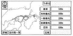
例えば搭載車用経路選択画面は、図4に示すように、経路候補毎の手動運転量情報として、経路候補毎の全長と自動運転可能距離とを示した画面とすればよい。図4は、各経路候補に対応する経路選択用ボタンの右側に、経路候補の全長と自動運転可能距離とを併記している態様を例示している。 For example, as shown in FIG. 4, the on-vehicle route selection screen may be a screen showing the total length and the automatic driving possible distance for each route candidate as the manual driving amount information for each route candidate. FIG. 4 illustrates a mode in which the total length of the route candidate and the automatic driving possible distance are written on the right side of the route selection button corresponding to each route candidate.
より具体的には、図4において有料優先経路は、全長が120Kmであって、そのうち、80Kmが自動運転対応路となっていることを示している。言い換えれば、全長120Kmのうち、40Kmはユーザが手動運転を実施する必要があることを表している。 More specifically, FIG. 4 shows that the pay priority route has a total length of 120 km, of which 80 km is a route for automatic driving. In other words, 40 km out of the total length of 120 km represents that the user needs to perform manual operation.
なお、ここでの手動運転とは、完全な手動運転に限らない。運転操作の一部をドライバ自身が実行する態様も含めてもよい。また、運転操作は自動で実行されているものの、周辺の交通状況に応じて手動運転を実施するための準備状態で待機している状態を、手動運転に含めてもよい。 The manual operation here is not limited to complete manual operation. A mode in which a part of the driving operation is executed by the driver itself may be included. Further, although the driving operation is automatically performed, a state of waiting in a preparation state for performing the manual driving according to the surrounding traffic condition may be included in the manual driving.
このような態様によれば、ユーザは、経路候補毎の手動運転量情報を見比べることで、手動運転を実施する必要がある距離又は時間が最も小さい経路を特定することができる。つまり、以上の構成によれば、手動運転を実施する必要性が相対的に少ない経路をユーザが選択可能となる。 According to such an aspect, the user can identify the route with the shortest distance or time for which manual operation is required by comparing the manual driving amount information for each route candidate. That is, according to the above configuration, the user can select a route with relatively little need for manual operation.
なお、図4においては便宜上、各経路候補の概略的な形状を、二重線や、破線、一点鎖線、二点鎖線といった線種で区別して表しているが、実際には色の違いによって各経路を区別して表せばよい。経路選択用ボタン内には、その経路の算出に用いた条件を表すテキストやアイコン画像等が配置されれば良い。 In FIG. 4, for the sake of convenience, the schematic shape of each route candidate is represented by a line type such as a double line, a broken line, a one-dot chain line, or a two-dot chain line. What is necessary is just to distinguish and express a path | route. In the route selection button, text, an icon image, or the like representing the conditions used for calculating the route may be arranged.
ステップS6では、経路選択画面として、経路候補毎の概略的な軌跡を地図画像上に示した地図画像と、各経路候補に対応する経路選択用ボタンを配置した画面を表示する。すなわち、自車両に自動運転機能が搭載されていない場合には、通常の経路選択画面を表示する。通常の経路選択画面とは、手動運転量情報を含まない経路選択画面に相当する。 In step S6, as a route selection screen, a map image in which a rough path for each route candidate is shown on the map image and a route selection button corresponding to each route candidate are displayed. That is, when the self-driving function is not installed in the host vehicle, a normal route selection screen is displayed. The normal route selection screen corresponds to a route selection screen that does not include manual driving amount information.
<実施形態のまとめ>
以上の構成では、自車両が自動運転機能を搭載している場合には、ユーザが走行予定経路を決定するための画面(つまり経路選択画面)として、手動運転量情報を含む搭載車用経路選択画面を表示する。<Summary of Embodiment>
In the above configuration, when the host vehicle is equipped with an automatic driving function, the route selection for the on-vehicle vehicle including the manual driving amount information is performed as a screen for the user to determine the planned travel route (that is, the route selection screen). Display the screen.
この搭載車用経路選択画面において表示される経路候補毎の手動運転量情報は、前述の通り、自動運転可能距離に応じて定まる、ユーザが手動運転で走行する必要がある距離又は時間を表している。 The manual driving amount information for each route candidate displayed on this route selection screen for on-board vehicles represents the distance or time that the user needs to travel by manual driving, which is determined according to the automatic driving possible distance as described above. Yes.
このような構成によればユーザは、経路候補毎の手動運転量情報を比較することで、手動運転を実施する必要がある距離又は時間が最も小さい経路を認識することができる。つまり、手動運転を実施する必要性が相対的に低減される経路をユーザが選択可能となる。 According to such a configuration, the user can recognize the route with the shortest distance or time for which manual operation is required by comparing the manual driving amount information for each route candidate. In other words, the user can select a route that relatively reduces the need for manual operation.
また、以上の構成では、自車両が自動運転機能を搭載していない場合には、ユーザが走行予定経路を決定するための画面(つまり経路選択画面)として、手動運転量情報を含まない非搭載車用経路選択画面を表示する。 In addition, in the above configuration, when the host vehicle does not have an automatic driving function, it is not installed as a screen for a user to determine a planned driving route (that is, a route selection screen) that does not include manual driving amount information. Display the route selection screen for cars.
これは、自動運転機能を備えていない車両のユーザにとっては、経路候補毎の手動運転量情報は不要な情報であるためである。不要な情報を表示すると、かえってユーザに煩わしさを与えてしまう恐れがある。そのような課題に対し、本実施形態の構成によれば、ユーザに煩わしさを与えてしまう恐れを低減することができる。 This is because manual driving amount information for each route candidate is unnecessary information for a vehicle user who does not have an automatic driving function. If unnecessary information is displayed, the user may be annoyed. In response to such a problem, according to the configuration of the present embodiment, it is possible to reduce the risk of annoying the user.
以上、本発明の実施形態を説明したが、本発明は上述の実施形態に限定されるものではなく、以降で述べる種々の変形例も本発明の技術的範囲に含まれ、さらに、下記以外にも要旨を逸脱しない範囲内で種々変更して実施することができる。 As mentioned above, although embodiment of this invention was described, this invention is not limited to the above-mentioned embodiment, The various modifications described below are also contained in the technical scope of this invention, and also in addition to the following However, various modifications can be made without departing from the scope of the invention.
なお、前述の実施形態で述べた部材と同一の機能を有する部材については、同一の符号を付し、その説明を省略する。また、構成の一部のみに言及している場合、他の部分については先に説明した実施形態の構成を適用することができる。 In addition, about the member which has the same function as the member described in the above-mentioned embodiment, the same code | symbol is attached | subjected and the description is abbreviate | omitted. In addition, when only a part of the configuration is mentioned, the configuration of the above-described embodiment can be applied to the other portions.
<変形例1>
上述した実施形態では、手動運転量情報として、経路候補毎の自動運転可能距離と全長とを表示する態様を例示したがこれに限らない。図5に示すように、手動運転量情報として、経路候補毎の手動運転距離と全長とを表示してもよい。或る経路候補における手動運転距離は、その経路においてユーザが手動運転を実施しなければならない区間の長さを表すものである。換言すれば、経路候補を構成するリンクのうち、自動運転対応路ではないリンクの長さの合計値である。手動運転距離は、経路の全長から自動運転可能距離を減算することで求めてもよい。<
In the above-described embodiment, the mode of displaying the automatic driving possible distance and the total length for each route candidate is exemplified as the manual driving amount information, but is not limited thereto. As shown in FIG. 5, the manual driving distance and the total length for each route candidate may be displayed as the manual driving amount information. The manual driving distance in a certain route candidate represents the length of a section in which the user must perform manual driving on that route. In other words, it is the total value of the lengths of the links that are not the automatic driving corresponding path among the links constituting the route candidate. The manual driving distance may be obtained by subtracting the automatic driving possible distance from the total length of the route.
<変形例2>
上述した実施形態及び変形例1では、手動運転量情報として経路候補の全長を、自動運転可能距離又は手動運転距離とともに表示する態様を例示したが、これに限らない。例えば、図6に示すように、自動運転可能距離のみを表示してもよい。また、同様に、手動運転距離のみを表示してもよい。<
In the embodiment and the first modification described above, the mode in which the total length of the route candidate is displayed as the manual driving amount information together with the automatic driving possible distance or the manual driving distance is illustrated, but the present invention is not limited thereto. For example, as shown in FIG. 6, only the automatic driving possible distance may be displayed. Similarly, only the manual driving distance may be displayed.
さらには、自動運転可能距離と手動運転距離の両方を表示してもよい。自動運転可能距離と手動運転距離の和は全長に相当する。もちろん、自動運転可能距離、手動運転距離、及び全長のそれぞれを表示してもよい。 Furthermore, both the automatic driving possible distance and the manual driving distance may be displayed. The sum of the automatic driving distance and the manual driving distance corresponds to the total length. Of course, the automatic driving possible distance, the manual driving distance, and the total length may be displayed.
<変形例3>
以上では、手動運転を実施する必要性の度合いを、自動運転可能距離や手動運転距離といった、距離の概念で表した態様を例示したがこれに限らない。手動運転を実施する必要性の度合いは、時間の概念によって表現されていてもよい。そのような態様によっても、上述した実施形態と同様の効果を奏する。<
In the above, although the mode which expressed the degree of necessity of carrying out manual operation by the concept of distance, such as automatic operation possible distance and manual operation distance, was illustrated, but it is not restricted to this. The degree of necessity for performing manual operation may be expressed by the concept of time. Even in such an aspect, the same effects as those of the above-described embodiment can be obtained.
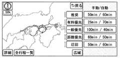
例えば、手動運転量情報として図7に示すように、自動運転で走行可能な時間の予測値(以降、自動運転時間)と、手動運転で走行する必要がある区間の走行時間の予測値(以降、手動運転時間)を表示してもよい。 For example, as shown in FIG. 7 as manual driving amount information, a predicted value of a time during which automatic driving can be performed (hereinafter, automatic driving time) and a predicted value of a driving time of a section where manual driving must be performed (hereinafter, referred to as manual driving amount information) , Manual operation time) may be displayed.
自動運転時間は、自動運転対応路を巡航速度で走行した場合に要する時間である。ここでの巡航速度は、法定速度の上限値に応じて適宜設計された値としてもよいし、実際の交通の流れに応じて動的に決定されてもよい。自動運転時間は、経路候補に含まれる自動運転路となっているリンク毎の所要時間の合計値とすればよい。自動運転路となっている或るリンクの所要時間は、そのリンク長をそのリンクにおける巡航速度で除算することで定まる。なお、仮に経路候補に含まれる自動運転対応路の巡航速度が一定の値である場合には、自動運転可能距離を巡航速度で除算した値が自動運転時間に相当する。 The automatic driving time is a time required when the vehicle travels on an automatic driving road at a cruising speed. Here, the cruise speed may be a value that is appropriately designed according to the upper limit value of the legal speed, or may be dynamically determined according to the actual traffic flow. The automatic driving time may be a total value of the required time for each link that is an automatic driving path included in the route candidate. The time required for a certain link on the automatic driving path is determined by dividing the link length by the cruise speed on the link. If the cruising speed of the automatic driving corresponding path included in the route candidate is a constant value, a value obtained by dividing the automatic driving possible distance by the cruising speed corresponds to the automatic driving time.
手動運転時間は、経路候補を構成するリンクのうち、自動運転対応路となっていないリンク毎の所要時間の合計値とすればよい。リンク当りの所要時間は、自動運転時間と同様に求めればよい。つまり、リンク長をそのリンクにおける巡航速度で除算することで求めればよい。 The manual driving time may be a total value of the required time for each link that is not an automatic driving corresponding path among the links constituting the route candidate. What is necessary is just to obtain | require the required time per link similarly to automatic operation time. That is, the link length may be obtained by dividing by the cruise speed on the link.
なお、手動運転時間は、総所要時間から自動運転時間を差し引いた時間としてもよい。総所要時間は周知の方法で算出されればよい。自動運転時間と手動運転時間の和は、その経路候補を採用した場合の総所要時間に相当する。自動運転時間や手動運転時間には、経路を構成する各ノードを通過するために要する時間も含まれていることが好ましい。手動運転時間や自動運転時間の算出は、自動運転可能距離算出部F4が実施してもよいし、表示処理部F6が実施してもよい。ここでは一例として、自動運転可能距離算出部F4が算出するものとする。 The manual operation time may be a time obtained by subtracting the automatic operation time from the total required time. The total required time may be calculated by a known method. The sum of the automatic operation time and the manual operation time corresponds to the total required time when the route candidate is adopted. It is preferable that the automatic operation time and the manual operation time include a time required for passing through each node constituting the route. The calculation of the manual driving time and the automatic driving time may be performed by the automatic driving possible distance calculating unit F4 or the display processing unit F6. Here, as an example, it is assumed that the automatic driving distance calculation unit F4 calculates.
ところで、図7では、手動運転量情報を時間の概念で表す態様の一例として、手動運転時間と自動運転時間を表示する態様を例示しているが、これに限らない。手動運転量情報として、手動運転時間と総所要時間を表示してもよいし、自動運転時間と総所要時間を表示してもよい。さらに、手動運転量情報として、手動運転時間と自動運転時間と総所要時間を表示してもよい。もちろん、手動運転時間と自動運転時間の何れか一方のみを表示してもよい。 By the way, in FIG. 7, although the mode which displays manual driving time and automatic driving time is illustrated as an example of the mode which represents manual driving amount information by the concept of time, it is not restricted to this. As the manual operation amount information, the manual operation time and the total required time may be displayed, or the automatic operation time and the total required time may be displayed. Further, manual operation time, automatic operation time, and total required time may be displayed as manual operation amount information. Of course, only one of the manual operation time and the automatic operation time may be displayed.
また、経路候補毎の手動運転を実施する必要性の度合いは、総所要時間に占める手動運転時間の比率で表しても良い。その比率は、数値で表されても良いし、円グラフ等、図形的に表されていても良い。 The degree of necessity of performing manual operation for each route candidate may be represented by the ratio of manual operation time to the total required time. The ratio may be expressed numerically or graphically such as a pie chart.
<変形例4>
また、表示処理部F6は、手動運転量情報として、自動運転可能距離、自動運転時間、手動運転距離、及び手動運転時間を、搭載車用経路選択画面に表示してもよい。つまり、経路候補毎の手動運転を実施する必要性の度合いは、距離の長さと時間の長さの両方で表してもよい。<Modification 4>
Further, the display processing unit F6 may display the automatic driving possible distance, the automatic driving time, the manual driving distance, and the manual driving time as the manual driving amount information on the on-vehicle vehicle route selection screen. That is, the degree of necessity of performing the manual operation for each route candidate may be expressed by both the distance length and the time length.
<変形例5>
また、搭載車用経路選択画面には、経路選択用ボタンに加えて、図8に示すように、複数の経路候補のうち、手動運転を実施する必要性(換言すれば手間)が最も小さい経路候補を選択するためのボタン(以降、手動運転最小ボタン)B1を表示してもよい。手動運転最小ボタンB1が請求項に記載の最小経路選択ボタンに相当する。<
In addition to the route selection button, the route selection screen for mounted vehicles has the least need for manual driving (in other words, trouble) among a plurality of route candidates as shown in FIG. A button (hereinafter referred to as a manual operation minimum button) B1 for selecting a candidate may be displayed. The manual operation minimum button B1 corresponds to the minimum route selection button described in the claims.
複数の経路候補のうち、手動運転を実施する必要性が最も小さい経路候補とは、例えば、手動運転時間が最小となる経路候補とすれば良い。もちろん、複数の経路候補のうち、手動運転距離が最小となる経路候補を、手動運転を実施する必要性が最も小さい経路候補と見なしてもよい。 Of the plurality of route candidates, the route candidate having the smallest necessity of performing the manual operation may be, for example, the route candidate having the minimum manual operation time. Of course, among the plurality of route candidates, the route candidate having the minimum manual driving distance may be regarded as the route candidate having the smallest necessity of performing the manual driving.
便宜上、複数の経路候補のうち、手動運転を実施する必要性が最も小さい経路候補を以降では、負荷最小経路と記載する。手動運転距離や手動運転時間は、自動運転可能距離に応じて定まるため、複数の経路候補のうち、負荷最小経路となる経路候補もまた、経路候補毎の自動運転可能距離に応じて定まると言える。 For the sake of convenience, among the plurality of route candidates, the route candidate having the smallest necessity for performing the manual operation is hereinafter referred to as a minimum load route. Since the manual driving distance and the manual driving time are determined according to the automatic driving possible distance, among the plurality of route candidates, the route candidate that becomes the minimum load route is also determined according to the automatic driving possible distance for each route candidate. .
この変形例5に対応するナビゲーションECU1は、例えば、図9に示す構成によって実現されれば良い。自動運転可能距離算出部F4が備える最小経路特定部F41は、経路計算部F3が算出した複数の経路候補のうち、負荷最小経路を特定する機能ブロックである。 The
なお、ここでは一例として、最小経路特定部F41は、自動運転可能距離算出部F4に備得られている態様とするがこれに限らない。最小経路特定部F41は、ナビゲーションECU1が備えていればよい。また、変形例9として後述するようにナビゲーションシステムがサーバSrvを備える場合には、最小経路特定部F41はサーバSrvが備えていても良い。 Here, as an example, the minimum path specifying unit F41 is not limited to this, although it is provided in the automatic driving distance calculation unit F4. The minimum path specifying unit F41 only needs to be included in the
この変形例5のナビゲーションECU1は例えば次のように動作する。ナビゲーションECU1は入力装置4と協働し、経路選択画面を表示中においてユーザによって手動運転最小ボタンB1が選択されたことを検出すると、複数の経路候補のうち、最小経路特定部F41が特定している負荷最小経路を、走行予定経路に設定する。そして、例えば走行予定経路の案内等といった後続の処理を実施する。 For example, the
このような態様によれば、ユーザは、手動運転最小ボタンB1を選択する操作を実施するだけで、複数の経路候補のうち、手動運転を実施する必要性が最も小さい経路候補を、走行予定経路に設定することができる。すなわち、上述した実施形態よりも簡単に、手動運転を実施する必要性が相対的に低減される経路を選択することができる。 According to such an aspect, the user only needs to perform the operation of selecting the manual driving minimum button B1, and selects the route candidate with the least necessity of performing the manual driving among the plurality of route candidates. Can be set to That is, it is possible to select a route in which the necessity of performing manual operation is relatively reduced as compared with the above-described embodiment.
<変形例6>
ところで、上述した変形例5では、手動運転最小ボタンB1と、経路候補毎の手動運転量情報を経路選択画面に表示する態様を例示したが、これに限らない。ユーザは、手動運転最小ボタンB1を選択すれば自動的に手動運転を実施する必要性が最も小さい経路候補が選択されるため、経路候補毎の手動運転量情報を表示する必要は小さい。<
By the way, although the
つまり、手動運転最小ボタンB1を表示する場合には、経路候補毎の手動運転量情報を表示しなくともよい。そのような態様によっても、ユーザは、手動運転を実施する必要性が相対的に低減される経路を選択することができる。 That is, when displaying the manual operation minimum button B1, the manual operation amount information for each route candidate may not be displayed. Such an aspect also allows the user to select a path that relatively reduces the need for manual operation.
<変形例7>
以上では、自車両が自動運転機能を搭載しているか否かによって異なる経路選択画面を表示する態様を例示したが、これに限らない。自車両が自動運転機能を搭載しているか否かに関わらず、手動運転量情報を表示してもよい。つまり、自動運転可否判定部F5は備えていなくとも良い。<
In the above, although the mode which displays a different route selection screen depending on whether the own vehicle is equipped with an automatic driving function is illustrated, it is not limited thereto. Regardless of whether or not the vehicle has an automatic driving function, manual driving amount information may be displayed. That is, the automatic driving availability determination unit F5 may not be provided.
<変形例8>
以上では、請求項に記載のナビゲーションシステムを、車両に搭載されているナビゲーションECU1を用いて実現した態様を例示したが、これに限らない。ナビゲーションシステムは、車両に持ち込み可能な携帯型ナビゲーション端末によって実現されてもよい。また、周知のスマートフォンや、タブレット端末に、ナビ用プログラムをインストールすることで、請求項に記載のナビゲーションシステムとして機能させても良い。<Modification 8>
Although the aspect which implement | achieved the navigation system of a claim using the navigation ECU1 mounted in the vehicle was illustrated above, it is not restricted to this. The navigation system may be realized by a portable navigation terminal that can be brought into a vehicle. Moreover, you may make it function as a navigation system as described in a claim by installing the program for navigation in a well-known smart phone or a tablet terminal.
ナビゲーションシステムが携帯型ナビゲーション端末やスマートフォンなどを用いて実現される場合には、当該携帯型ナビゲーション端末やスマートフォンが備えるディスプレイが、請求項に記載のディスプレイに相当する。つまり、ディスプレイ自体も、車両に搭載されているものに限らず、ユーザによって車両に持ち込まれるものであってもよい。 When the navigation system is realized using a portable navigation terminal, a smartphone, or the like, a display included in the portable navigation terminal or the smartphone corresponds to the display described in the claims. That is, the display itself is not limited to the one mounted on the vehicle, but may be one brought into the vehicle by the user.
<変形例9>
上述したナビゲーションECU1が備える機能の一部は、図10に示すように、車両の外部に設けられてあって、かつ、ナビゲーションECU1と広域通信網8を介して相互通信可能に構成されているサーバSrvが備えていても良い。例えば、経路計算部F3や、自動運転可能距離算出部F4、地図データ記憶部M1はサーバSrvが備えていても良い。つまり、請求項に記載のナビゲーションシステムは、ナビゲーションECU1とサーバSrvとを用いて実現されてもよい。<Modification 9>
As shown in FIG. 10, some of the functions of the
なお、この変形例9における車載システム100は広域通信網8にアクセスするための無線通信装置7を備えており、ナビゲーションECU1は、LAN6を介して、無線通信装置7と接続されているものとする。 The in-
この変形例9においてナビゲーションECU1及びサーバSrvはそれぞれ、例えば次のように動作すればよい。まず、ナビゲーションECU1は、目的地取得部F1が取得した目的地及び出発地取得部F2が取得した出発地を示すデータをサーバSrvに送信する。サーバSrvが備える経路計算部F3は、ナビゲーションECU1から送信されてきた目的地と出発地に基づいて、複数の経路候補を算出する。また、自動運転可能距離算出部F4が、各経路候補についての自動運転可能距離を算出するとともに、自動運転可能距離に応じて定まる手動運転量情報を生成する。そして、経路候補毎の経路情報及び手動運転量情報をナビゲーションECU1に返送する。 In this modified example 9, the
ナビゲーションECU1の表示処理部F6は、サーバSrvから返送されてきた経路候補毎の経路情報及び手動運転量情報に基づいて、搭載車用経路選択画面を生成してディスプレイ2に表示する。もちろん、自動運転可否判定部F5が自車両は自動運転対応車ではないと判定している場合には、非搭載車用経路選択画面を表示してもよい。 The display processing unit F6 of the
この変形例9の構成によっても、先に説明した実施形態と同様の効果を奏する。また、この変形例9の構成によれば、車両で用いられるナビゲーションECU1が備えるべき機能や記憶容量を低減することができる。 The configuration of the modification 9 also has the same effect as the above-described embodiment. Moreover, according to the structure of this modification 9, the function and memory capacity which navigation ECU1 used with a vehicle should be equipped with can be reduced.
100 車載システム、1 ナビゲーションECU(ナビゲーションシステム)、2 ディスプレイ、3 スピーカ、4 入力装置、5 位置検出器、F1 目的地取得部、F2 出発地取得部、F3 経路計算部、F4 自動運転可能距離算出部、F5 自動運転可否判定部、F6 表示処理部、M1 地図データ記憶部(自動運転対応路記憶部)、M2 車両情報記憶部、B1 手動運転最小ボタン(最小経路選択ボタン)100 in-vehicle system, 1 navigation ECU (navigation system), 2 display, 3 speaker, 4 input device, 5 position detector, F1 destination acquisition unit, F2 departure point acquisition unit, F3 route calculation unit, F4 automatic driving distance calculation Unit, F5 automatic driving availability determination unit, F6 display processing unit, M1 map data storage unit (automatic driving correspondence path storage unit), M2 vehicle information storage unit, B1 manual driving minimum button (minimum route selection button)
Claims (7)
Translated fromJapanese前記目的地とする地点の情報を取得する目的地取得部(F1)と、
前記車両の出発地とする地点の情報を取得する出発地取得部(F2)と、
前記出発地取得部が取得した前記出発地から前記目的地取得部が取得した前記目的地までの経路の候補として、複数の経路を算出する経路計算部(F3)と、
自動運転による走行が許容されている道路である自動運転対応路を示すデータを記憶している自動運転対応路記憶部(M1)と、
前記自動運転対応路記憶部が記憶しているデータに基づいて、複数の前記経路のそれぞれに対して、前記経路のうち前記自動運転対応路となっている部分の距離である自動運転可能距離を算出する自動運転可能距離算出部(F4)と、
前記経路計算部が算出した複数の前記経路のうち、前記ユーザが走行予定経路として採用する経路を選択するための画面であって、各前記経路についての情報を表した画面である経路選択画面を、前記ディスプレイに表示する表示処理部(F6)と、を備え、
前記表示処理部は、複数の前記経路毎に、その経路に対して前記自動運転可能距離算出部が算出した前記自動運転可能距離に応じて定まる情報であって、その経路において前記ユーザが手動運転を実施する必要がある距離又は時間の長さを前記ユーザが認識するための情報である手動運転量情報を、前記経路選択画面に表示することを特徴とするナビゲーションシステム。A navigation system for displaying a route candidate to a destination designated by a user on a display (2) used in a vehicle used by the user,
A destination acquisition unit (F1) for acquiring information of a point as the destination;
A departure point acquisition unit (F2) for acquiring information of a point as a departure point of the vehicle;
A route calculation unit (F3) that calculates a plurality of routes as candidate routes from the departure point acquired by the departure point acquisition unit to the destination acquired by the destination acquisition unit;
An automatic driving corresponding path storage unit (M1) that stores data indicating an automatic driving corresponding path that is a road that is allowed to travel by automatic driving;
Based on the data stored in the automatic driving corresponding path storage unit, for each of the plurality of paths, an automatic driving possible distance that is a distance of a portion of the path that is the automatic driving corresponding path. An automatic driving distance calculation unit (F4) to calculate,
A route selection screen that is a screen for selecting a route that the user adopts as a scheduled travel route from among the plurality of routes calculated by the route calculation unit, and is a screen that represents information about each of the routes. A display processing unit (F6) for displaying on the display,
The display processing unit is information determined according to the automatic driving possible distance calculated by the automatic driving possible distance calculation unit for each of the plurality of routes, and the user performs manual driving in the route The navigation system is characterized in that manual driving amount information, which is information for the user to recognize the distance or the length of time that needs to be executed, is displayed on the route selection screen.
自動運転を実施する機能である自動運転機能を前記車両が備えているか否かを判定する自動運転可否判定部(F5)を備え、
前記表示処理部は、前記自動運転可否判定部によって前記車両が自動運転機能を備えていないと判定している場合には、前記経路毎の前記手動運転量情報を前記経路選択画面に表示しないことを特徴とするナビゲーションシステム。In claim 1,
An automatic driving availability determination unit (F5) that determines whether or not the vehicle has an automatic driving function that is a function of performing automatic driving;
The display processing unit does not display the manual driving amount information for each route on the route selection screen when the automatic driving availability determining unit determines that the vehicle does not have an automatic driving function. A navigation system characterized by
前記表示処理部は、前記手動運転量情報として、前記経路において前記ユーザが手動運転を実施する必要がある部分の距離である手動運転距離と前記自動運転可能距離の少なくとも何れか一方を前記経路選択画面に表示することを特徴とするナビゲーションシステム。In claim 1 or 2,
The display processing unit selects, as the manual driving amount information, at least one of a manual driving distance, which is a distance of a portion where the user needs to perform manual driving in the route, and the automatic driving possible distance as the route. A navigation system characterized by being displayed on a screen.
前記表示処理部は、前記経路において前記ユーザが手動運転を実施する必要がある部分の距離である手動運転距離と前記自動運転可能距離の少なくとも何れか一方と、前記経路の全長を、前記手動運転量情報として前記経路選択画面に表示することを特徴とするナビゲーションシステム。In any one of Claims 1-3,
The display processing unit displays at least one of a manual driving distance that is a distance of a portion where the user needs to perform manual driving on the route and the automatic driving possible distance, and the total length of the route as the manual driving. A navigation system characterized in that it is displayed as quantity information on the route selection screen.
前記表示処理部は、前記手動運転量情報として、前記経路において手動運転を実施する時間の予測値である手動運転時間と、前記経路において自動運転によって走行する時間の予測値である自動運転時間の少なくとも何れか一方を、前記経路選択画面に表示することを特徴とするナビゲーションシステム。In any one of Claims 1-4,
The display processing unit includes, as the manual operation amount information, a manual operation time that is a predicted value of a time for performing a manual operation on the route, and an automatic operation time that is a predicted value of a time for traveling by the automatic operation on the route. At least one of them is displayed on the route selection screen.
前記表示処理部は、複数の前記経路のうち、前記ユーザが手動運転を実施する必要がある距離又は時間が最も短い前記経路を前記ユーザが選択するためのボタンである最小経路選択ボタン(B1)を前記経路選択画面に表示することを特徴とするナビゲーションシステム。In any one of Claim 1 to 5,
The display processing unit is a minimum route selection button (B1) that is a button for the user to select the route that requires the shortest distance or time for the user to perform manual operation among the plurality of routes. Is displayed on the route selection screen.
前記目的地とする地点の情報を取得する目的地取得部(F1)と、
前記車両の出発地とする地点の情報を取得する出発地取得部(F2)と、
前記出発地取得部が取得した前記出発地から前記目的地取得部が取得した前記目的地までの経路の候補として、複数の経路を算出する経路計算部(F3)と、
自動運転による走行が許容されている道路である自動運転対応路を示すデータを記憶している自動運転対応路記憶部(M1)と、
前記出発地取得部が取得した前記出発地から前記目的地取得部が取得した前記目的地までの経路の候補として、複数の経路を算出する経路計算部(F3)と、
前記自動運転対応路記憶部が記憶しているデータに基づいて、前記経路計算部が算出した複数の前記経路のそれぞれに対して、前記経路のうち前記自動運転対応路となっている部分の距離である自動運転可能距離を算出する自動運転可能距離算出部(F4)と、
前記自動運転可能距離算出部が算出した前記経路毎の前記自動運転可能距離に基づいて、複数の前記経路のうち、前記ユーザが手動運転を実施する必要がある距離又は時間が最も短い前記経路である負荷最小経路を特定する最小経路特定部(F41)と、
前記経路計算部が算出した複数の前記経路のうち、前記ユーザが走行予定経路として採用する経路を選択するための経路選択画面を前記ディスプレイに表示する表示処理部(F6)と、を備え、
前記表示処理部は、前記経路選択画面に、複数の前記経路のうち、前記最小経路特定部が特定している前記負荷最小経路を前記ユーザが選択するためのボタンである最小経路選択ボタン(B1)を表示することを特徴とするナビゲーションシステム。A navigation system for displaying a route candidate to a destination designated by a user on a display (2) used in a vehicle used by the user,
A destination acquisition unit (F1) for acquiring information of a point as the destination;
A departure point acquisition unit (F2) for acquiring information of a point as a departure point of the vehicle;
A route calculation unit (F3) that calculates a plurality of routes as candidate routes from the departure point acquired by the departure point acquisition unit to the destination acquired by the destination acquisition unit;
An automatic driving corresponding path storage unit (M1) that stores data indicating an automatic driving corresponding path that is a road that is allowed to travel by automatic driving;
A route calculation unit (F3) that calculates a plurality of routes as candidate routes from the departure point acquired by the departure point acquisition unit to the destination acquired by the destination acquisition unit;
Based on the data stored in the automatic operation corresponding path storage unit, for each of the plurality of routes calculated by the route calculation unit, the distance of the portion of the route that is the automatic operation corresponding path An automatic driving possible distance calculating unit (F4) for calculating the automatic driving possible distance,
Based on the automatic driving possible distance for each of the routes calculated by the automatic driving possible distance calculation unit, among the plurality of routes, the distance or time that the user needs to perform manual driving is the shortest. A minimum path specifying unit (F41) for specifying a certain load minimum path;
A display processing unit (F6) that displays on the display a route selection screen for selecting a route that the user adopts as a planned travel route among the plurality of routes calculated by the route calculation unit;
The display processing unit displays a minimum route selection button (B1) which is a button for the user to select the minimum load route specified by the minimum route specifying unit among the plurality of routes on the route selection screen. ) Display a navigation system.
Priority Applications (3)
| Application Number | Priority Date | Filing Date | Title |
|---|---|---|---|
| JP2015205797AJP2017078605A (en) | 2015-10-19 | 2015-10-19 | Navigation system |
| US15/768,938US10866107B2 (en) | 2015-10-19 | 2016-09-19 | Navigation system |
| PCT/JP2016/077604WO2017068897A1 (en) | 2015-10-19 | 2016-09-19 | Navigation system |
Applications Claiming Priority (1)
| Application Number | Priority Date | Filing Date | Title |
|---|---|---|---|
| JP2015205797AJP2017078605A (en) | 2015-10-19 | 2015-10-19 | Navigation system |
Publications (1)
| Publication Number | Publication Date |
|---|---|
| JP2017078605Atrue JP2017078605A (en) | 2017-04-27 |
Family
ID=58556960
Family Applications (1)
| Application Number | Title | Priority Date | Filing Date |
|---|---|---|---|
| JP2015205797APendingJP2017078605A (en) | 2015-10-19 | 2015-10-19 | Navigation system |
Country Status (3)
| Country | Link |
|---|---|
| US (1) | US10866107B2 (en) |
| JP (1) | JP2017078605A (en) |
| WO (1) | WO2017068897A1 (en) |
Cited By (7)
| Publication number | Priority date | Publication date | Assignee | Title |
|---|---|---|---|---|
| JP2018189594A (en)* | 2017-05-11 | 2018-11-29 | アルパイン株式会社 | Automatic driving availability notification system |
| JP2019074518A (en)* | 2017-10-12 | 2019-05-16 | トヨタ自動車株式会社 | Route selection method for advanced autonomous vehicle, and vehicle |
| JP2020173264A (en)* | 2020-06-29 | 2020-10-22 | 株式会社デンソー | Route setting device |
| US11586217B2 (en) | 2017-10-13 | 2023-02-21 | Denso Corporation | Route setting device |
| WO2023047773A1 (en)* | 2021-09-21 | 2023-03-30 | カシオ計算機株式会社 | Information processing device, route setting method, and recording medium |
| JP2023046200A (en)* | 2021-09-21 | 2023-04-03 | カシオ計算機株式会社 | Information processing device, navigation system, route setting method and program |
| US12103550B2 (en) | 2019-07-29 | 2024-10-01 | Denso Corporation | Second task execution assistance device and non-transitory computer readable storage medium |
Families Citing this family (6)
| Publication number | Priority date | Publication date | Assignee | Title |
|---|---|---|---|---|
| US10710607B2 (en)* | 2018-02-12 | 2020-07-14 | Lenovo (Singapore) Pte. Ltd. | Systems and methods for identifying first route to destination as involving less human driving of vehicle than second route to destination |
| JP6990160B2 (en)* | 2018-09-28 | 2022-01-12 | 株式会社Subaru | Automatic driving support device |
| US20210258751A1 (en) | 2020-02-18 | 2021-08-19 | Lenovo (Singapore) Pte. Ltd. | Responding to a signal indicating that an autonomous driving feature has been overridden by alerting plural vehicles |
| JP7374350B2 (en)* | 2021-01-13 | 2023-11-06 | 三菱電機株式会社 | Automatic driving support device and automatic driving support method |
| JP7357653B2 (en) | 2021-03-11 | 2023-10-06 | 本田技研工業株式会社 | Control system, moving object, and control method |
| US12024172B2 (en) | 2022-05-10 | 2024-07-02 | Lenovo (Singapore) Pte. Ltd. | Lane assist for deviating from preexisting traffic lane |
Citations (7)
| Publication number | Priority date | Publication date | Assignee | Title |
|---|---|---|---|---|
| WO2013069130A1 (en)* | 2011-11-10 | 2013-05-16 | 三菱電機株式会社 | Vehicle system |
| JP2015017944A (en)* | 2013-07-12 | 2015-01-29 | 株式会社デンソー | Automatic driving support device |
| JP2015141052A (en)* | 2014-01-27 | 2015-08-03 | アイシン・エィ・ダブリュ株式会社 | Route guidance system, route guidance method, and computer program |
| JP2015141054A (en)* | 2014-01-27 | 2015-08-03 | アイシン・エィ・ダブリュ株式会社 | Route guidance system, route guidance method, and computer program |
| JP2015141050A (en)* | 2014-01-27 | 2015-08-03 | アイシン・エィ・ダブリュ株式会社 | Route search system, route search method, and computer program |
| JP2015145849A (en)* | 2014-02-04 | 2015-08-13 | アイシン・エィ・ダブリュ株式会社 | Navigator, navigation method and program |
| JP2015158467A (en)* | 2014-02-25 | 2015-09-03 | アイシン・エィ・ダブリュ株式会社 | Route search system, route search method, computer program, and cost table data structure |
Family Cites Families (9)
| Publication number | Priority date | Publication date | Assignee | Title |
|---|---|---|---|---|
| JP3671734B2 (en) | 1999-04-23 | 2005-07-13 | アイシン・エィ・ダブリュ株式会社 | Route search apparatus and route search method |
| JP4735310B2 (en)* | 2005-04-15 | 2011-07-27 | 株式会社デンソー | Driving support device |
| DE102009002521A1 (en)* | 2009-04-21 | 2010-10-28 | Zf Friedrichshafen Ag | Method for operating a vehicle with a sailing or rolling mode |
| EP2765388B1 (en)* | 2013-02-08 | 2018-10-17 | Hexagon Technology Center GmbH | Mobile field controller for measuring and remote control |
| MX353483B (en)* | 2014-03-26 | 2018-01-16 | Nissan Motor | Vehicular information provision device. |
| JP6520066B2 (en)* | 2014-11-20 | 2019-05-29 | アイシン・エィ・ダブリュ株式会社 | Automatic driving support device, automatic driving support method and program |
| WO2016113890A1 (en)* | 2015-01-16 | 2016-07-21 | 三菱電機株式会社 | Travel plan creation device and travel plan changing method |
| JP6419586B2 (en)* | 2015-01-16 | 2018-11-07 | アルパイン株式会社 | Route search system and computer program |
| JP6288859B2 (en)* | 2015-07-07 | 2018-03-07 | 本田技研工業株式会社 | Vehicle control device, vehicle control method, and vehicle control program |
- 2015
- 2015-10-19JPJP2015205797Apatent/JP2017078605A/enactivePending
- 2016
- 2016-09-19USUS15/768,938patent/US10866107B2/enactiveActive
- 2016-09-19WOPCT/JP2016/077604patent/WO2017068897A1/ennot_activeCeased
Patent Citations (7)
| Publication number | Priority date | Publication date | Assignee | Title |
|---|---|---|---|---|
| WO2013069130A1 (en)* | 2011-11-10 | 2013-05-16 | 三菱電機株式会社 | Vehicle system |
| JP2015017944A (en)* | 2013-07-12 | 2015-01-29 | 株式会社デンソー | Automatic driving support device |
| JP2015141052A (en)* | 2014-01-27 | 2015-08-03 | アイシン・エィ・ダブリュ株式会社 | Route guidance system, route guidance method, and computer program |
| JP2015141054A (en)* | 2014-01-27 | 2015-08-03 | アイシン・エィ・ダブリュ株式会社 | Route guidance system, route guidance method, and computer program |
| JP2015141050A (en)* | 2014-01-27 | 2015-08-03 | アイシン・エィ・ダブリュ株式会社 | Route search system, route search method, and computer program |
| JP2015145849A (en)* | 2014-02-04 | 2015-08-13 | アイシン・エィ・ダブリュ株式会社 | Navigator, navigation method and program |
| JP2015158467A (en)* | 2014-02-25 | 2015-09-03 | アイシン・エィ・ダブリュ株式会社 | Route search system, route search method, computer program, and cost table data structure |
Cited By (10)
| Publication number | Priority date | Publication date | Assignee | Title |
|---|---|---|---|---|
| JP2018189594A (en)* | 2017-05-11 | 2018-11-29 | アルパイン株式会社 | Automatic driving availability notification system |
| JP2019074518A (en)* | 2017-10-12 | 2019-05-16 | トヨタ自動車株式会社 | Route selection method for advanced autonomous vehicle, and vehicle |
| US10895465B2 (en) | 2017-10-12 | 2021-01-19 | Toyota Jidosha Kabushiki Kaisha | Optimizing a route selection for a highly autonomous vehicle |
| US11586217B2 (en) | 2017-10-13 | 2023-02-21 | Denso Corporation | Route setting device |
| US12103550B2 (en) | 2019-07-29 | 2024-10-01 | Denso Corporation | Second task execution assistance device and non-transitory computer readable storage medium |
| JP2020173264A (en)* | 2020-06-29 | 2020-10-22 | 株式会社デンソー | Route setting device |
| JP7014263B2 (en) | 2020-06-29 | 2022-02-01 | 株式会社デンソー | Route setting device |
| WO2023047773A1 (en)* | 2021-09-21 | 2023-03-30 | カシオ計算機株式会社 | Information processing device, route setting method, and recording medium |
| JP2023046200A (en)* | 2021-09-21 | 2023-04-03 | カシオ計算機株式会社 | Information processing device, navigation system, route setting method and program |
| JP7259930B2 (en) | 2021-09-21 | 2023-04-18 | カシオ計算機株式会社 | Information processing device, navigation system, route setting method and program |
Also Published As
| Publication number | Publication date |
|---|---|
| WO2017068897A1 (en) | 2017-04-27 |
| US10866107B2 (en) | 2020-12-15 |
| US20180299281A1 (en) | 2018-10-18 |
Similar Documents
| Publication | Publication Date | Title |
|---|---|---|
| JP2017078605A (en) | Navigation system | |
| US10371536B2 (en) | Alternative routes | |
| US9638542B2 (en) | Method and system of route scheduling and presenting route-based fuel information | |
| US20090063048A1 (en) | Navigation apparatus | |
| JP2007024833A (en) | On-vehicle navigation apparatus | |
| JP2010281802A (en) | Route search apparatus and route search method | |
| JP2008039480A (en) | Route searching device | |
| US10019853B2 (en) | Support server, mobile terminal, and support system | |
| US8452534B2 (en) | Route search device and route search method | |
| JP2010197211A (en) | Server apparatus, navigation apparatus, route information presentation system and route information presentation method | |
| JP4488967B2 (en) | Route search apparatus and route search method | |
| JP5173955B2 (en) | Navigation system, route search server, route search method, terminal device, and navigation device | |
| JP2002365076A (en) | Staying time calculator, navigation system, and program | |
| JP4245174B2 (en) | Navigation apparatus and method, and navigation program | |
| JP4128444B2 (en) | Guidance display method in in-vehicle navigator | |
| JP2009229397A (en) | Drive support system | |
| JP5149097B2 (en) | Navigation device and route search method | |
| JP4836265B2 (en) | Navigation system, terminal device, and navigation method | |
| JP5607848B1 (en) | Portable information terminal, computer program, and operation control system | |
| JP2008002854A (en) | Route guidance device | |
| JP4097553B2 (en) | Navigation device | |
| JP2004138421A (en) | Vehicle-mounted navigation device | |
| JP2016176770A (en) | Map information display device, map information display method, and program | |
| JP2009198293A (en) | Route searching apparatus | |
| JP2008058083A (en) | Navigation apparatus, its control method, and its control program |
Legal Events
| Date | Code | Title | Description |
|---|---|---|---|
| A621 | Written request for application examination | Free format text:JAPANESE INTERMEDIATE CODE: A621 Effective date:20180122 | |
| A131 | Notification of reasons for refusal | Free format text:JAPANESE INTERMEDIATE CODE: A131 Effective date:20190402 | |
| A521 | Request for written amendment filed | Free format text:JAPANESE INTERMEDIATE CODE: A523 Effective date:20190531 | |
| A02 | Decision of refusal | Free format text:JAPANESE INTERMEDIATE CODE: A02 Effective date:20191105 |