JP2015179216A - Information processor and information processing method - Google Patents
Information processor and information processing methodDownload PDFInfo
- Publication number
- JP2015179216A JP2015179216AJP2014057194AJP2014057194AJP2015179216AJP 2015179216 AJP2015179216 AJP 2015179216AJP 2014057194 AJP2014057194 AJP 2014057194AJP 2014057194 AJP2014057194 AJP 2014057194AJP 2015179216 AJP2015179216 AJP 2015179216A
- Authority
- JP
- Japan
- Prior art keywords
- information
- search
- drawing data
- map
- information processing
- Prior art date
- Legal status (The legal status is an assumption and is not a legal conclusion. Google has not performed a legal analysis and makes no representation as to the accuracy of the status listed.)
- Pending
Links
- 230000010365information processingEffects0.000titleclaimsabstractdescription49
- 238000003672processing methodMethods0.000titleclaimsabstractdescription7
- 238000004891communicationMethods0.000description22
- 230000006870functionEffects0.000description16
- 238000000034methodMethods0.000description12
- 238000010586diagramMethods0.000description7
- 230000008569processEffects0.000description7
- 230000001133accelerationEffects0.000description5
- 230000004044responseEffects0.000description3
- 238000001514detection methodMethods0.000description2
- 230000000694effectsEffects0.000description2
- 229960003965antiepilepticsDrugs0.000description1
- 230000008901benefitEffects0.000description1
- 230000002708enhancing effectEffects0.000description1
- 238000009434installationMethods0.000description1
- 239000004973liquid crystal related substanceSubstances0.000description1
- 238000012986modificationMethods0.000description1
- 230000004048modificationEffects0.000description1
Images


Landscapes
- Instructional Devices (AREA)
- Navigation (AREA)
- Information Retrieval, Db Structures And Fs Structures Therefor (AREA)
- Traffic Control Systems (AREA)
Abstract
Description
Translated fromJapanese本発明に係るいくつかの態様は、情報処理装置、及び情報処理方法に関する。 Some embodiments according to the present invention relate to an information processing apparatus and an information processing method.
近年、例えば携帯電話の表示画面上で地図などを表示するサービスが広く普及しつつある。このような地図表示サービスにおいては、検索機能を備えるものも多い。例えば特許文献1は、建造物の形状を表示するとともに、建造物に関する情報や周囲の情報に対する検索を可能とする情報案内装置を開示している。 In recent years, for example, a service for displaying a map or the like on a display screen of a mobile phone has been widely spread. Many of such map display services have a search function. For example,
しかしながら、特許文献1記載の装置は、トイレや階段、エレベーター等の細かい設備を含む様々なPOIに対する検索環境の充実については考慮されていない。 However, the device described in
本発明のいくつかの態様は前述の課題に鑑みてなされたものであり、設備に対する検索サービスを充実させることのできる情報処理装置及び情報処理方法を提供することを目的の1つとする。 Some aspects of the present invention have been made in view of the above problems, and an object thereof is to provide an information processing apparatus and an information processing method capable of enhancing a search service for equipment.
本発明に係る情報処理装置は、サーバから地図を描画するための描画データを受信する受信手段と、前記描画データに基づいて地図を表示装置に表示させる第1の表示制御手段と、前記描画データを対象に、設備を検索する検索手段と、前記描画データに対する検索結果を前記表示装置に表示させる第2の表示制御手段とを備える。 An information processing apparatus according to the present invention includes: a receiving unit that receives drawing data for drawing a map from a server; a first display control unit that displays a map on a display device based on the drawing data; and the drawing data And a second display control means for displaying a search result for the drawing data on the display device.
本発明に係る情報処理方法は、サーバから地図を描画するための描画データを受信するステップと、前記描画データに基づいて地図を表示装置に表示させるステップと、前記描画データを対象に、設備を検索するステップと、前記描画データに対する検索結果を前記表示装置に表示させるステップとを情報処理システムが行う。 An information processing method according to the present invention includes a step of receiving drawing data for drawing a map from a server, a step of displaying a map on a display device based on the drawing data, and a facility for the drawing data. The information processing system performs a step of searching and a step of displaying a search result for the drawing data on the display device.
尚、本発明において、「部」や「手段」、「装置」、「システム」とは、単に物理的手段を意味するものではなく、その「部」や「手段」、「装置」、「システム」が有する機能をソフトウェアによって実現する場合も含む。また、1つの「部」や「手段」、「装置」、「システム」が有する機能が2つ以上の物理的手段や装置により実現されても、2つ以上の「部」や「手段」、「装置」、「システム」の機能が1つの物理的手段や装置により実現されても良い。 In the present invention, “part”, “means”, “apparatus”, and “system” do not simply mean physical means, but “part”, “means”, “apparatus”, “system”. This includes the case where the functions possessed by "are realized by software. Further, even if the functions of one “unit”, “means”, “apparatus”, and “system” are realized by two or more physical means or devices, two or more “parts” or “means”, The functions of “device” and “system” may be realized by a single physical means or device.
本発明によれば、設備に対する検索サービスを充実させることのできる情報処理装置及び情報処理方法を提供することができる。 ADVANTAGE OF THE INVENTION According to this invention, the information processing apparatus and information processing method which can enrich the search service with respect to an installation can be provided.
以下に本発明の実施形態を説明する。以下の説明及び参照する図面の記載において、同一又は類似の構成には、それぞれ同一又は類似の符号が付されている。 Embodiments of the present invention will be described below. In the following description and the description of the drawings to be referred to, the same or similar components are denoted by the same or similar reference numerals.
(実施形態)
図1乃至図7は、実施形態を説明するための図である。以下、これらの図を参照しながら、以下の流れに沿って実施形態を説明する。まず「1」で実施形態全体の概要を説明する。その上で「2」でシステム構成を、ハードウェア及びソフトウェア構成の具体例を示しながら説明する。「3」では、処理の流れを説明する。「4」以下では、本実施形態に係る効果などを説明する。(Embodiment)
1 to 7 are diagrams for explaining the embodiment. Hereinafter, embodiments will be described along the following flow with reference to these drawings. First, an outline of the entire embodiment will be described in “1”. Then, “2” will be used to explain the system configuration with specific examples of hardware and software configurations. In “3”, the flow of processing will be described. In “4” and below, effects and the like according to the present embodiment will be described.
(1 概要)
図1は、情報処理装置である携帯端末100を含む通信システム1の概略構成を示す図である。図1に示すように、通信システム1は、携帯端末100(携帯端末100A乃至100Eを総称して携帯端末100という。)、情報処理サーバ200、及び基地局300を含む。情報処理サーバ200及び基地局300は、それぞれ公衆網Nに接続されている。公衆網Nは、携帯端末100及び情報処理サーバ200が相互に通信できれば、どのような方式のネットワークでも良い。公衆網Nの具体例としては、例えばインターネットのほか、携帯電話網であることが考えられる。(1 Overview)
FIG. 1 is a diagram illustrating a schematic configuration of a
なお、携帯端末100は、例えば携帯電話(いわゆるフィーチャーフォンであるかスマートフォンであるかは問わない。)やタブレット型の情報端末、或いはノートPC(Personal Computer)等の、可搬型の情報処理端末である。 The
ここで、本実施形態に係る通信システム1では、携帯端末100が情報処理サーバ200から地図描画データ211をダウンロードした上で、当該地図描画データ211に基づいて地図を表示装置(ディスプレイ)上に表示する機能を有する。当該地図描画データ211には、地図に各種描画を行うための座標情報、ポリゴンデータ等と共に、設備名等が含まれる注記データや階層情報、設備の大まかな種別を示すレイヤーID等の情報を含むことができる。詳細については図5を参照しながら後述する。携帯端末100はこれらの地図描画データ211に基づいて地図画像を作成した上で、表示装置上に地図を表示する。 Here, in the
また、本実施形態に係る情報処理サーバ200は、施設情報213を管理する。当該施設情報には、様々な施設に関する施設名称や座標、住所、ジャンル等の情報が含まれる。携帯端末100が情報処理サーバ200に対して検索を要求すると、情報処理サーバ200は当該施設情報213を検索し、その結果を携帯端末100に返信する。このような機能により、情報処理サーバ200は携帯端末100に施設検索サービスを提供する。例えば、ユーザが携帯端末100に施設名称の一部となる文字列などを入力すると、当該文字列に合致する施設情報213を情報処理サーバ200が検索し、当該検索結果を携帯端末100へ送信することで、ユーザは携帯端末100上に入力した文字列に合致する施設の一覧などを確認することが可能となる。 Further, the
しかしながら、施設情報213には、ビルや店舗、公園、遊園地や動物園といったある程度大きな単位で且つユニーク性の高い施設(POI:Point of Interest)に関する情報は含まれるものの、トイレやAED(Automated External Defibrillator)、駅事務局などといった設備(POI)に関しては、極めて数が多いため、施設情報213として管理することは困難である。つまり、施設情報213にトイレ等の情報は殆ど含まれていないため、当該施設情報213に対する検索機能では、トイレやAED、駅事務局等の情報を知ることは難しい。 However, although the
しかしながら、トイレやAED等の情報も、地図上には描画されることが多いため、地図描画データ211には含まれることが多い。そこで本実施形態に係る携帯端末100では、通常地図の表示に使用する地図描画データ211に対するPOIの検索を行うことで、このような細かいPOIの検索機能を提供する。 However, since information such as toilets and AEDs are often drawn on the map, they are often included in the
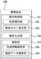
図2に、携帯端末100でトイレや駅事務局等に対する検索機能を行う場合の表示画面の具体例を示す。図2の例では、表示画面21上に表示されるダイアログボックス21Aで「出入り口」「忘れ物預り所」「駅事務所」「トイレ」等の設備に係るボタンを選択すると、携帯端末100は選択された設備に関する検索を、地図描画データ211を対象に行う。携帯端末100は検索の結果見つかった施設の位置等の情報を、表示画面23上で吹出し型のアイコン23Aとして表示している。これにより、ユーザは例えば一番近くにあるトイレや出入り口等の位置を簡単に知ることが可能となる。 FIG. 2 shows a specific example of a display screen when the
(2 システム構成)
以下、図3を参照しながら、本実施形態に係る通信システム1の機能構成を説明する。図3は、本実施形態に係る通信システム1の機能構成を示す図である。前述のとおり、本実施形態に係る通信システム1は、携帯端末100及び情報処理サーバ200を含む。以下、これらの構成について説明する。なお、図3において、基地局300は記載を省略している。(2 System configuration)
Hereinafter, the functional configuration of the
(2.1 携帯端末100)
まず、携帯端末100の構成を説明する。携帯端末100は、図3に示すように、主制御部110、無線通信部120、入力部130、表示部140、及びセンサ150を含む。(2.1 Mobile terminal 100)
First, the configuration of the
主制御部110は、携帯端末100における各種処理を制御し、CPU111及びメモリ113(揮発性メモリ及び不揮発性メモリを含む。)を含む。主制御部110では、メモリ113の記憶領域に地図表示アプリケーションを含む各種アプリケーションなどのプログラムを格納したり、CPU221が当該アプリケーション等のプログラムを実行したりすることにより、携帯端末100が有する各種機能を実現することができる。主制御部110で実行可能なソフトウェアの機能構成に関しては、図4を参照しながら後述する。 The
無線通信部120は、公衆網Nを介して他の情報処理装置との間でデータを送受信することができる。情報処理サーバ200への施設情報213の検索要求や、情報処理サーバ200からの地図描画データ211の受信などは、無線通信部120は、主制御部110による制御のもとで実行する。 The
入力部130は、携帯端末100に対するユーザからの入力を受け付ける装置であり、入力キーやタッチパネル等を含む。なお、入力部130は、ユーザからの音声を受け付けて入力情報として主制御部110へ出力する機能を有してもよい。表示部240は、図2に具体例を示した表示画面21及び23等により各種情報を表示してユーザに提示するための、例えばディスプレイ装置である。表示部240は、例えば液晶ディスプレイであっても良いし、有機ELであっても良い。 The
センサ150は、携帯端末100のユーザの移動状態に応じて変化する検出信号を出力し、例えば、加速度センサ151やGPS受信機153を含む。具体的には、センサ150から出力される検出信号には、加速度センサ151から出力される加速度を示す加速度情報や、GPS受信機153から出力される携帯端末100の現在位置を示す位置情報が含まれる。なお、位置情報には、高度に係る情報を含んでも良い。 The
次に、図4を参照しながら、携帯端末100で実行されるソフトウェアの機能構成について説明する。図4は、携帯端末100で実行されるソフトウェアの機能構成を示す図である。
本実施形態に係る携帯端末100のソフトウェアは、大きく分けて、表示制御部161と操作入力部165と検索部167とを含む。Next, a functional configuration of software executed on the
The software of the
表示制御部161は、携帯端末100の表示部140に表示される表示画面に係る表示制御を行う。表示制御部161は、地図描画部162及び検索GUI表示部163を含む。
地図描画部162は、情報処理サーバ200から受信した地図描画データ211に基づいて地図を生成し、当該地図を表示部140に地図を表示させる。The
The
検索GUI表示部163は、例えば図2で具体例を示した表示画面21及び23等を生成し、当該表示画面を表示部140に表示させる。より具体的には、検索すべき設備等を指定する表示画面(図2の具体例に係る表示画面21に相当)や、検索結果を示す表示画面((図2の具体例に係る表示画面23に相当)を、検索GUI表示部163は表示部140に表示させる。
操作入力部165は、入力部130から入力されたユーザからの操作信号を、各種ソフトウェアの機能に対して伝達する。The search
The
検索部167は、操作入力部165から入力されたユーザ操作に基づいて、POIに対する検索処理を行う。検索部167は、施設情報検索部168及び描画データ検索部169を含む。
施設情報検索部168は、情報処理サーバ200に対し、施設情報213を対象とする検索を要求する。The
The facility
描画データ検索部169は、地図描画データ211を対象とする検索を行う。ここで描画データ検索部169による地図描画データ211を対象とする検索の実現手法は、種々考えることができる。例えば、描画データ検索部169が情報処理サーバ200に対して、DB210内の地図描画データ211を対象とした検索を要求することにより実現することが考えられる。若しくは、地図描画部162が地図描画のために情報処理サーバ200からダウンロードし、メモリ113に記憶されている地図描画データ211を対象に、描画データ検索部169が検索しても良い。 The drawing
本実施形態では、地図描画部162が地図描画のために情報処理サーバ200から取得し、メモリ113に記憶されている地図描画データ211を対象に描画データ検索部169が検索を行う場合を中心に説明する。 In this embodiment, the
(2.2 情報処理サーバ200)
情報処理サーバ200は、前述のとおり、携帯端末100からの要求に応じて地図描画データ211を送信するとともに、施設情報213に対する検索サービスを提供する機能を持つ情報処理装置である。情報処理サーバ200は、制御部220、通信部230、及びデータベース(DB)210を含む。なお、情報処理サーバ200の機能は、2以上の情報処理装置(サーバも含む)を組み合わせたシステムとして実現することも可能である。(2.2 Information processing server 200)
As described above, the
制御部220は、演算装置であるCPU(Central Processing Unit)221及びメモリ223を含む。制御部220では、メモリ223に記憶されたプログラム(ソフトウェア)を格納し、CPU221上で当該プログラムを実行することにより、情報処理サーバ200における各種処理を制御する。制御部220は、例えば、通信部230で受信した携帯端末100からの施設検索要求に応じて施設情報213を検索したり、或いは携帯端末100からの要求に応じて、要求された位置及び縮尺の地図に係る地図描画データ211を当該携帯端末100へ送信したりする機能を制御する。 The
通信部230は、携帯端末100と通信するための通信インタフェースである。通信部230は、例えば、携帯端末100からの地図描画データ211の取得要求や、施設情報213の検索要求を受信する。また、通信部230は、要求された地図描画データ211の携帯端末100への送信や、施設情報213に対する検索の検索結果の携帯端末100への送信も行う。
DB210は、例えば記憶装置上に構成される情報管理モジュールであり、地図描画データ211及び施設情報213を管理する。The
The
図5に、地図描画データ211の構成例を示す。図5に示すように、本実施形態に係る地図描画データ211は、緯度経度情報(座標情報)211a、ポリゴンデータ211b、図種情報211c、階層情報211d、レイヤーID211e、注記データ211f、企業アイコン211gを含む。このような情報は、地図上に描画される各種POIごとに用意されるが、各POIはこれらの情報を全て含む必要はない。 FIG. 5 shows a configuration example of the
緯度経度情報211aは、地図描画データ211が対象とするPOIの位置(座標)を示す情報である。携帯端末100が地図を描画する際には、当該緯度経度情報211aに基づいて対象POIの配置位置が決定される。 The latitude /
ポリゴンデータ211bは、地図上に描画されるPOIの形状等に関する情報である。携帯端末100が地図を描画する際には、当該ポリゴンデータ211bを用いて対象POIの形状を描画する。 The polygon data 211b is information related to the shape of the POI drawn on the map. When the
図種情報211cは、どの縮尺の地図データ(どの図種の地図データ)で描画するかを示す情報である。大きさの小さいPOIは縮尺の小さい地図では表示されないが、図種情報211cは、対象POIをどの縮尺以上で表示するかを定めるためのものである。 The
階層情報211dは、対象POIの階層を示すものである。より具体的には、階層情報211dは、地下1階の地図に表示させるPOIであるか、地上1階の地図に表示させるPOIであるか、等の情報を示すためのものである。地図描画データ211の階層情報211dを指定した検索を行えば、例えば地下1階のPOIのみを対象に検索する等の、階層を指定した検索が可能となる。 The
レイヤーID211eは、各POIのジャンルなどを示す情報である。例えば、レイヤーIDを指定することにより、トイレや飲食店などのジャンルを指定することが可能となる。すなわち、地図描画データ211のレイヤーID211eを対象に検索を行えば、トイレや飲食店等の各ジャンルに属するPOIを網羅的に抽出することができる。 The layer ID 211e is information indicating the genre of each POI. For example, by specifying a layer ID, a genre such as a toilet or a restaurant can be specified. That is, if a search is performed on the layer ID 211e of the
注記データ211fは、例えばPOIの名称などの、地図上に表示される文字列に関する情報である。例えば「A3出入り口」や「男性用トイレ」、「○×駅案内所」等の文字列を注記データ211fに含むことができる。地図描画データ211の注記データ211fを対象に検索すれば、「トイレ」や「駅案内所」等の注記が含まれるPOIを網羅的に抽出することが可能となる。 The
企業アイコン211gは、例えばトイレ、階段、エレベーター、コンビニエンスストアやガソリンスタンド等の各種設備や企業のアイコンに相当する。地図描画データ211の企業アイコン211gを対象に検索すれば、各アイコンに該当するPOIを網羅的に抽出することが可能となる。 The company icon 211g corresponds to various facilities and company icons such as toilets, stairs, elevators, convenience stores, and gas stations. By searching for the company icon 211g in the
続いて、施設情報213について説明する。施設情報213は、店舗や公園、ビル等、比較的ユニーク性の高い施設に関する情報を管理するためのものである。施設情報213は検索が行い易くするために、例えばSQLデータベースとして構築することができる。 Next, the
図6は、施設情報213の具体例を示す図である。図6に示すように、施設情報213は、施設IDや施設座標、名称、住所、施設ジャンル等の情報を含むことができる。 FIG. 6 is a diagram illustrating a specific example of the
(3 処理の流れ)
以下、図7を参照しながら、携帯端末100による処理の流れを説明する。図7は、POIに係る検索を携帯端末100が行う際の処理の流れを示すフローチャートである。(3 Process flow)
Hereinafter, the flow of processing by the
尚、後述の各処理ステップは、処理内容に矛盾を生じない範囲で、任意に順番を変更して若しくは並列に実行することができ、また、各処理ステップ間に他のステップを追加しても良い。更に、便宜上1つのステップとして記載されているステップは複数のステップに分けて実行することもでき、便宜上複数に分けて記載されているステップを1ステップとして実行することもできる。 Each processing step to be described later can be executed in any order or in parallel as long as there is no contradiction in processing contents, and other steps can be added between the processing steps. good. Further, a step described as a single step for convenience can be executed by being divided into a plurality of steps, and a step described as being divided into a plurality of steps for convenience can be executed as one step.
操作入力部165がPOIに関する検索要求に係るユーザ操作を受けると(S701)、施設情報検索部168は、施設情報213を検索するための検索キーを設定する(S703)。この時、例えば図2に具体例を示したダイアログボックス21A上で「トイレ」「出入り口」等の各種POIが選択された場合には、当該種別に応じた「トイレ」や「出入り口」等の文字列を含む施設情報213を取得するための検索キーを、施設情報検索部168は生成することができる。この時、施設情報検索部168は、別途センサ150から取得した現在位置(緯度経度などで指定することができる)から、予め定められた範囲内のPOIに係る検索を行うべく、検索キーを設定しても良い。 When the
施設情報検索部168は、S703で生成した検索キーを用いた検索処理を行う(S705)。より具体的には、施設情報検索部168は、生成した検索キーを情報処理サーバ200へ送信し、情報処理サーバ200から、当該検索キーで施設情報213を検索した検索結果を受信する。その結果、該当するPOIが見つかった場合には(S707のYes)、検索GUI表示部163は検索結果を表示部140に表示させる(S713)。検索結果の表示方法としては、例えば図2の表示画面23に具体例を示したように、地図描画部162が生成した地図上に、検索の結果見つかったPOIの位置を示すアイコン23Aを表示する方法などが考えられる。 The facility
施設情報213を検索しても適当なPOIが見つからなかった場合には(S707のNo)、描画データ検索部169は地図描画データ211に対する検索を行うための検索キーを設定する(S709)。この時、検索キーに設定可能なパラメータは種々考えられるが、例えば、検索範囲の中心となる緯度経度情報(例えば、センサ150から取得できる携帯端末100の位置情報を使用することができる。)並びに当該中心からの検索範囲を示す検索距離(例えば、半径200m程度の、予め定められた固定値を使用することができる。)を検索キーに含むことができる。また、どの縮尺(図種)で表示される地図描画データ211を使用するか(地図描画データ211が地図を表示している場合には、表示にかかる縮尺の図種を使用してもよいし、或いは予め定められた図種としてもよい)、階層(携帯端末100が屋内にいる場合、携帯端末100が存在すると考えられる階層(地下1階、地上1階等)、)等を検索キーに含むこともできる。また、トイレや飲食店などのジャンルを示すレイヤーID(ユーザから指定された「トイレ」「出入り口」等のPOIのジャンルに応じて指定することができる)、検索キーワード(検索したいPOIの注記データとして含まれる名称文字列の少なくとも一部など)をも検索キーに含むことができる。 If no suitable POI is found even after searching the facility information 213 (No in S707), the drawing
より具体例を挙げて説明すると、例えばユーザが表示画面21において「トイレ」を対象に検索すべく、ボタンを選択した場合には、描画データ検索部169は、自装置の位置(緯度経度)を中心に、例えば半径200m等の予め定められた範囲のPOIを抽出すべく、検索キーを設定することができる。この時、携帯端末100が建物内の地上1階にいると判断できる場合には、階層を地上1階として設定するようにしても良い。また、「トイレ」のレイヤーIDを検索キーに設定することができる。加えて、注記データ中に「トイレ」の文字列を含むPOIを抽出すべく、検索キーに設定することもできる。 More specifically, for example, when the user selects a button on the
描画データ検索部169は、このようにして生成した検索キーを用いて、例えばメモリ113に記憶された地図描画データ211に対する検索を行う(S711)。これにより描画データ検索部169は、例えば携帯端末100の位置から200m以内且つ同じ階層にある、注記データに「トイレ」の文字列を含むか、或いはトイレに関するレイヤーIDが設定されたPOIを、網羅的に抽出することができる。 The drawing
描画データ検索部169が行った検索結果は、検索GUI表示部163が表示部140に表示させる(S713)。上述の通り、検索結果の表示方法としては、例えば図2の表示画面23に具体例を示したように、地図描画部162が生成した地図上に、検索の結果見つかったPOIの位置を示すアイコン23Aを表示する方法などが考えられる。 The search
なお、図7の処理の流れではまず施設情報213を検索した後、地図描画データ211を検索するようになっているが、これに限られるものではなく、例えばトイレや駅事務局、出入り口といった設備(POI)に関しては、施設情報213を検索することなく、地図描画データ211を検索するようにしても良い。 In the process flow of FIG. 7, the
(4 本実施形態の効果)
以上説明したように、本実施形態に係る通信システム1は、地図を描画するために用意される地図描画データ211を用いて、POIに対する検索サービスを提供する。これにより、トイレや出入り口といった、数が多く(ユニーク性が低く)、且つ施設情報213で管理されることの少ない設備(POI)に関しても、好適にユーザに情報を提供することができる。すなわち、本実施形態に係る通信システム1は、設備に対する検索サービスを充実させることができる。(4 Effects of this embodiment)
As described above, the
(5 付記事項)
尚、前述の各実施形態の構成は、組み合わせたり或いは一部の構成部分を入れ替えたりしてもよい。また、本発明の構成は前述の実施形態のみに限定されるものではなく、本発明の要旨を逸脱しない範囲内において種々変更を加えてもよい。(5 Additional notes)
Note that the configurations of the above-described embodiments may be combined or some of the components may be replaced. The configuration of the present invention is not limited to the above-described embodiment, and various modifications may be made without departing from the scope of the present invention.
1・・・通信システム、21・・・表示画面、21A・・・ダイアログボックス、23・・・表示画面、23A・・・アイコン、100・・・携帯端末、110・・・主制御部、111・・・CPU、113・・・メモリ、120・・・無線通信部、130・・・入力部、140・・・表示部、150・・・センサ、151・・・加速度センサ、153・・・GPS受信機、161・・・表示制御部、162・・・地図描画部、163・・・検索GUI表示部、165・・・操作入力部、167・・・検索部、168・・・施設情報検索部、169・・・描画データ検索部、200・・・情報処理サーバ、211・・・地図描画データ、211a・・・緯度経度情報、211b・・・ポリゴンデータ、211c・・・図種情報、211d・・・階層情報、211e・・・レイヤーID、211f・・・注記データ、211g・・・企業アイコン、213・・・施設情報、220・・・制御部、221・・・CPU、223・・・メモリ、230・・・通信部、240・・・表示部、300・・・基地局、N・・・公衆網DESCRIPTION OF
Claims (6)
Translated fromJapanese前記描画データに基づいて地図を表示装置に表示させる第1の表示制御手段と、
前記描画データを対象に、設備を検索する検索手段と、
前記描画データに対する検索結果を前記表示装置に表示させる第2の表示制御手段と
を備える情報処理システム。Receiving means for receiving drawing data for drawing a map from the server;
First display control means for displaying a map on a display device based on the drawing data;
Search means for searching for equipment for the drawing data;
An information processing system comprising: second display control means for displaying a search result for the drawing data on the display device.
前記検索手段は前記注記情報を対象に設備を検索する、
請求項1記載の情報処理システム。The drawing data includes at least drawing information for displaying an image of the facility on the map, coordinate information of the facility, and note information for displaying a character string related to the facility on the map,
The search means searches for equipment for the note information.
The information processing system according to claim 1.
請求項1又は請求項2記載の情報処理システム。The search means includes means for searching for facility information managed by the server, and means for searching for the drawing data.
The information processing system according to claim 1 or 2.
請求項3記載の情報処理システム。As a result of the search for facility information, the search means searches for the drawing data when a search target facility is not found,
The information processing system according to claim 3.
請求項1乃至請求項4のいずれか1項記載の情報処理システム。The second display control means causes the display device to display a search result facility within a certain range from the current position.
The information processing system according to any one of claims 1 to 4.
前記描画データに基づいて地図を表示装置に表示させるステップと、
前記描画データを対象に、設備を検索するステップと、
前記描画データに対する検索結果を前記表示装置に表示させるステップと
を情報処理システムが行う情報処理方法。Receiving drawing data for drawing a map from the server;
Displaying a map on a display device based on the drawing data;
Searching for equipment for the drawing data; and
The information processing method which an information processing system performs the step which displays the search result with respect to the said drawing data on the said display apparatus.
Priority Applications (1)
| Application Number | Priority Date | Filing Date | Title |
|---|---|---|---|
| JP2014057194AJP2015179216A (en) | 2014-03-19 | 2014-03-19 | Information processor and information processing method |
Applications Claiming Priority (1)
| Application Number | Priority Date | Filing Date | Title |
|---|---|---|---|
| JP2014057194AJP2015179216A (en) | 2014-03-19 | 2014-03-19 | Information processor and information processing method |
Publications (1)
| Publication Number | Publication Date |
|---|---|
| JP2015179216Atrue JP2015179216A (en) | 2015-10-08 |
Family
ID=54263295
Family Applications (1)
| Application Number | Title | Priority Date | Filing Date |
|---|---|---|---|
| JP2014057194APendingJP2015179216A (en) | 2014-03-19 | 2014-03-19 | Information processor and information processing method |
Country Status (1)
| Country | Link |
|---|---|
| JP (1) | JP2015179216A (en) |
Citations (10)
| Publication number | Priority date | Publication date | Assignee | Title |
|---|---|---|---|---|
| JPH10333554A (en)* | 1997-06-02 | 1998-12-18 | Hitachi Eng Co Ltd | Map information display system and map information display method |
| JP2002328031A (en)* | 2001-03-02 | 2002-11-15 | Alpine Electronics Inc | Navigation system |
| JP2003085575A (en)* | 2001-09-10 | 2003-03-20 | Alpine Electronics Inc | Method of making map plotting data and device |
| JP2005233727A (en)* | 2004-02-18 | 2005-09-02 | Denso Corp | Map searching device and navigation system |
| JP2006162516A (en)* | 2004-12-09 | 2006-06-22 | Fujitsu Ten Ltd | Information terminal |
| JP2006285646A (en)* | 2005-03-31 | 2006-10-19 | System Developments Bureau:Kk | Facility information provision method and facility information provision device |
| JP2009098446A (en)* | 2007-10-17 | 2009-05-07 | Sony Corp | Information providing system, information providing device, information providing method, terminal unit, and display method |
| JP2010066193A (en)* | 2008-09-12 | 2010-03-25 | Fujitsu Ten Ltd | Information processing device, and control device for processing navigation information |
| JP2011128099A (en)* | 2009-12-21 | 2011-06-30 | Aisin Aw Co Ltd | Navigation system and program |
| JP2013238655A (en)* | 2012-05-11 | 2013-11-28 | Denso Corp | Map display device and navigation system comprising said map display device |
- 2014
- 2014-03-19JPJP2014057194Apatent/JP2015179216A/enactivePending
Patent Citations (10)
| Publication number | Priority date | Publication date | Assignee | Title |
|---|---|---|---|---|
| JPH10333554A (en)* | 1997-06-02 | 1998-12-18 | Hitachi Eng Co Ltd | Map information display system and map information display method |
| JP2002328031A (en)* | 2001-03-02 | 2002-11-15 | Alpine Electronics Inc | Navigation system |
| JP2003085575A (en)* | 2001-09-10 | 2003-03-20 | Alpine Electronics Inc | Method of making map plotting data and device |
| JP2005233727A (en)* | 2004-02-18 | 2005-09-02 | Denso Corp | Map searching device and navigation system |
| JP2006162516A (en)* | 2004-12-09 | 2006-06-22 | Fujitsu Ten Ltd | Information terminal |
| JP2006285646A (en)* | 2005-03-31 | 2006-10-19 | System Developments Bureau:Kk | Facility information provision method and facility information provision device |
| JP2009098446A (en)* | 2007-10-17 | 2009-05-07 | Sony Corp | Information providing system, information providing device, information providing method, terminal unit, and display method |
| JP2010066193A (en)* | 2008-09-12 | 2010-03-25 | Fujitsu Ten Ltd | Information processing device, and control device for processing navigation information |
| JP2011128099A (en)* | 2009-12-21 | 2011-06-30 | Aisin Aw Co Ltd | Navigation system and program |
| JP2013238655A (en)* | 2012-05-11 | 2013-11-28 | Denso Corp | Map display device and navigation system comprising said map display device |
Similar Documents
| Publication | Publication Date | Title |
|---|---|---|
| US9885582B2 (en) | Systems and methods for generating electronic map displays with points-of-interest information based on reference locations | |
| US9746342B2 (en) | Systems and methods for generating electronic map displays with points-of-interest based on density thresholds | |
| US20160320197A1 (en) | Systems and methods for generating electronic map displays with points-of-interest information | |
| US20160132513A1 (en) | Device and method for providing poi information using poi grouping | |
| US10365112B2 (en) | Method and apparatus for providing a route forecast user interface | |
| JP6885819B2 (en) | Navigation devices and navigation systems | |
| KR20140037846A (en) | Discovering nearby places based on automatic query | |
| KR102128320B1 (en) | System and method for providing circumference search result | |
| CN105136147A (en) | An indoor navigation method, device and terminal | |
| JP2018524646A (en) | System and method for disambiguating a location entity associated with a mobile device's current geographic location | |
| JP6599674B2 (en) | Information processing system, information processing program, information processing apparatus, information processing method, correlation information data, storage medium, and correlation information generation method | |
| JP7126112B2 (en) | Communication system, display method and program | |
| CN105241446A (en) | Indoor navigation route generation method and user terminal | |
| EP2929466B1 (en) | Predictively presenting location based search types | |
| US20150213088A1 (en) | Method and apparatus for providing applications associated with location-based user-interfaces | |
| CN103778209A (en) | POI (Point of Interest) search result display method and electronic equipment | |
| JP5749057B2 (en) | Navigation device | |
| CN109040166A (en) | Information display device and information display system | |
| JP2015179216A (en) | Information processor and information processing method | |
| KR20180072652A (en) | System and method for sharing position information using multiple ids | |
| JP2014079010A (en) | Location information providing system, server device, terminal device, location information providing method and program | |
| JP4636033B2 (en) | Information retrieval system / apparatus / method / program, user terminal, registrant terminal, database construction method | |
| JP7657484B1 (en) | Information processing system, information processing device, program, and information processing method | |
| JP2016090792A (en) | Area information providing apparatus, area information providing method, and program | |
| WO2019177786A1 (en) | System for location naming service |
Legal Events
| Date | Code | Title | Description |
|---|---|---|---|
| A621 | Written request for application examination | Free format text:JAPANESE INTERMEDIATE CODE: A621 Effective date:20160328 | |
| A131 | Notification of reasons for refusal | Free format text:JAPANESE INTERMEDIATE CODE: A131 Effective date:20170316 | |
| A521 | Request for written amendment filed | Free format text:JAPANESE INTERMEDIATE CODE: A523 Effective date:20170414 | |
| A02 | Decision of refusal | Free format text:JAPANESE INTERMEDIATE CODE: A02 Effective date:20170613 |