JP2011523062A - Method and system for determining position using a hybrid satellite / WLAN positioning system by selecting the best WLAN-PS derived solution - Google Patents
Method and system for determining position using a hybrid satellite / WLAN positioning system by selecting the best WLAN-PS derived solutionDownload PDFInfo
- Publication number
- JP2011523062A JP2011523062AJP2011512722AJP2011512722AJP2011523062AJP 2011523062 AJP2011523062 AJP 2011523062AJP 2011512722 AJP2011512722 AJP 2011512722AJP 2011512722 AJP2011512722 AJP 2011512722AJP 2011523062 AJP2011523062 AJP 2011523062A
- Authority
- JP
- Japan
- Prior art keywords
- wlan
- satellite
- location
- estimate
- positioning system
- Prior art date
- Legal status (The legal status is an assumption and is not a legal conclusion. Google has not performed a legal analysis and makes no representation as to the accuracy of the status listed.)
- Granted
Links
Images


Classifications
- H—ELECTRICITY
- H04—ELECTRIC COMMUNICATION TECHNIQUE
- H04W—WIRELESS COMMUNICATION NETWORKS
- H04W64/00—Locating users or terminals or network equipment for network management purposes, e.g. mobility management
- G—PHYSICS
- G01—MEASURING; TESTING
- G01S—RADIO DIRECTION-FINDING; RADIO NAVIGATION; DETERMINING DISTANCE OR VELOCITY BY USE OF RADIO WAVES; LOCATING OR PRESENCE-DETECTING BY USE OF THE REFLECTION OR RERADIATION OF RADIO WAVES; ANALOGOUS ARRANGEMENTS USING OTHER WAVES
- G01S19/00—Satellite radio beacon positioning systems; Determining position, velocity or attitude using signals transmitted by such systems
- G01S19/38—Determining a navigation solution using signals transmitted by a satellite radio beacon positioning system
- G01S19/39—Determining a navigation solution using signals transmitted by a satellite radio beacon positioning system the satellite radio beacon positioning system transmitting time-stamped messages, e.g. GPS [Global Positioning System], GLONASS [Global Orbiting Navigation Satellite System] or GALILEO
- G01S19/42—Determining position
- G01S19/48—Determining position by combining or switching between position solutions derived from the satellite radio beacon positioning system and position solutions derived from a further system
- G—PHYSICS
- G01—MEASURING; TESTING
- G01S—RADIO DIRECTION-FINDING; RADIO NAVIGATION; DETERMINING DISTANCE OR VELOCITY BY USE OF RADIO WAVES; LOCATING OR PRESENCE-DETECTING BY USE OF THE REFLECTION OR RERADIATION OF RADIO WAVES; ANALOGOUS ARRANGEMENTS USING OTHER WAVES
- G01S19/00—Satellite radio beacon positioning systems; Determining position, velocity or attitude using signals transmitted by such systems
- G01S19/38—Determining a navigation solution using signals transmitted by a satellite radio beacon positioning system
- G01S19/39—Determining a navigation solution using signals transmitted by a satellite radio beacon positioning system the satellite radio beacon positioning system transmitting time-stamped messages, e.g. GPS [Global Positioning System], GLONASS [Global Orbiting Navigation Satellite System] or GALILEO
- G01S19/42—Determining position
- G01S19/45—Determining position by combining measurements of signals from the satellite radio beacon positioning system with a supplementary measurement
- G01S19/46—Determining position by combining measurements of signals from the satellite radio beacon positioning system with a supplementary measurement the supplementary measurement being of a radio-wave signal type
- G—PHYSICS
- G01—MEASURING; TESTING
- G01S—RADIO DIRECTION-FINDING; RADIO NAVIGATION; DETERMINING DISTANCE OR VELOCITY BY USE OF RADIO WAVES; LOCATING OR PRESENCE-DETECTING BY USE OF THE REFLECTION OR RERADIATION OF RADIO WAVES; ANALOGOUS ARRANGEMENTS USING OTHER WAVES
- G01S19/00—Satellite radio beacon positioning systems; Determining position, velocity or attitude using signals transmitted by such systems
- G01S19/01—Satellite radio beacon positioning systems transmitting time-stamped messages, e.g. GPS [Global Positioning System], GLONASS [Global Orbiting Navigation Satellite System] or GALILEO
- G01S19/13—Receivers
- G01S19/31—Acquisition or tracking of other signals for positioning
- G—PHYSICS
- G01—MEASURING; TESTING
- G01S—RADIO DIRECTION-FINDING; RADIO NAVIGATION; DETERMINING DISTANCE OR VELOCITY BY USE OF RADIO WAVES; LOCATING OR PRESENCE-DETECTING BY USE OF THE REFLECTION OR RERADIATION OF RADIO WAVES; ANALOGOUS ARRANGEMENTS USING OTHER WAVES
- G01S5/00—Position-fixing by co-ordinating two or more direction or position line determinations; Position-fixing by co-ordinating two or more distance determinations
- G01S5/02—Position-fixing by co-ordinating two or more direction or position line determinations; Position-fixing by co-ordinating two or more distance determinations using radio waves
- G01S5/14—Determining absolute distances from a plurality of spaced points of known location
- G—PHYSICS
- G01—MEASURING; TESTING
- G01S—RADIO DIRECTION-FINDING; RADIO NAVIGATION; DETERMINING DISTANCE OR VELOCITY BY USE OF RADIO WAVES; LOCATING OR PRESENCE-DETECTING BY USE OF THE REFLECTION OR RERADIATION OF RADIO WAVES; ANALOGOUS ARRANGEMENTS USING OTHER WAVES
- G01S19/00—Satellite radio beacon positioning systems; Determining position, velocity or attitude using signals transmitted by such systems
- G01S19/01—Satellite radio beacon positioning systems transmitting time-stamped messages, e.g. GPS [Global Positioning System], GLONASS [Global Orbiting Navigation Satellite System] or GALILEO
- G01S19/13—Receivers
- G01S19/34—Power consumption
Landscapes
- Engineering & Computer Science (AREA)
- Radar, Positioning & Navigation (AREA)
- Remote Sensing (AREA)
- Computer Networks & Wireless Communication (AREA)
- Physics & Mathematics (AREA)
- General Physics & Mathematics (AREA)
- Signal Processing (AREA)
- Position Fixing By Use Of Radio Waves (AREA)
Abstract
Translated fromJapaneseDescription
Translated fromJapanese本開示は、概略的には、ハイブリッド測位システムに、より厳密には、位置推定の精度を改善し、測位サービスの可用性をより多くのユーザーへ増大させ、消費電力を下げ、更にユーザーの位置推定における予測誤差の推定を改善するための無線ローカルエリアネットワーク(WLAN)を利用した測位システム(WLAN‐PS)及び衛星を利用した測位システム(SPS)に関する。 The present disclosure generally provides a hybrid positioning system, more precisely, improving the accuracy of location estimation, increasing the availability of positioning services to more users, reducing power consumption, and user location estimation. The present invention relates to a positioning system (WLAN-PS) using a wireless local area network (WLAN) and a positioning system (SPS) using a satellite for improving estimation of a prediction error.
本出願は、2008年6月6日出願の米国仮特許出願第61/059,580号「統合化されたWLANを利用した及び衛星を利用した測位システム」の米国特許法第119条(e)下の恩典を請求し、その全体を参考文献としてここに援用する。 This application is based on US Provisional Patent Application No. 119 (e) of US Provisional Patent Application No. 61 / 059,580 “Positioning System Using Integrated WLAN and Satellite”, filed June 6, 2008. We claim the benefits below and are hereby incorporated by reference in their entirety.
本出願は、以下の参考文献に関連している。
同時出願の米国特許出願第(未定)号「ハイブリッド測位システムで環境情報を使用するシステム及び方法」、
同時出願の米国特許出願第(未定)号「ハイブリッド測位システムでクロックバイアス精度を維持するシステム及び方法」、
同時出願の米国特許出願第(未定)号「ハイブリッド測位システムで衛星測定値を使用してWLAN‐PS推定位置を改善するシステム及び方法」、
同時出願の米国特許出願第(未定)号「ハイブリッド測位システムで初期位置としてWLAN−PS推定位置を使用して位置を決定する方法及びシステム」、
同時出願の米国特許出願第(未定)号「ハイブリッド測位システムで予測誤差推定の精度を高める方法及びシステム」、
同時出願の米国特許出願第(未定)号「ハイブリッド測位システムで静止したユーザーの検出のための方法及びシステム」及び
同時出願の米国特許出願第(未定)号「ハイブリッド測位システムでWLANアクセスポイントにフィルターをかけるために衛星測位システムを使用するシステム及び方法」である。This application is related to the following references:
U.S. Patent Application No. (Undecided), "System and Method for Using Environmental Information in Hybrid Positioning System",
U.S. Patent Application No. (TBD), filed concurrently, "System and Method for Maintaining Clock Bias Accuracy in Hybrid Positioning Systems",
Co-filed U.S. Patent Application No. (TBD) "System and Method for Improving WLAN-PS Estimated Location Using Satellite Measurements in Hybrid Positioning System",
Co-filed U.S. Patent Application No. (TBD) "Method and System for Determining Position Using WLAN-PS Estimated Position as Initial Position in Hybrid Positioning System"
U.S. Patent Application No. (Undecided), “Method and System for Improving Prediction Error Estimation Accuracy in Hybrid Positioning System”,
Simultaneously filed US Patent Application (TBD) “Method and System for Detection of Stationary Users with Hybrid Positioning System” and US Patent Application No. (TBD) “Hybrid Positioning System with Filter to WLAN Access Point” System and method for using a satellite positioning system to apply ".
近年、多くの携帯型計算装置が飛躍的に増えてきており、より進んだ移動及び無線のサービスの必要性を作り出している。移動電子メール、携帯用無線電話サービス、多人数参加型ゲーム及びコールフォロイング(call−following)は、如何に新しい用途が、移動装置で出現しているのか、ということの実例である。更に、ユーザーは、現在の自分の位置を利用するだけでなく更にその様な位置情報を他者と共有する利用を必要とする/求めるようになっている。親は自分の子供の動きを把握することを望み、監督者は、会社の配達車両の位置を追跡する必要があり、商用旅行者は、処方箋を受け取るために最寄りの薬局を見つけようとする。全てのこれらの例では、個人が自身の現在位置又は他の誰かの位置を知る必要がある。今日まで、我々は、行き方を尋ねること、ヒトに電話して所在を尋ねること又は被雇用者に自身の位置を報告させるためにその時々到着を報告させること、を頼りにしていた。 In recent years, the number of portable computing devices has increased dramatically, creating the need for more advanced mobile and wireless services. Mobile e-mail, portable wireless telephone services, multiplayer games, and call-following are examples of how new applications are emerging in mobile devices. In addition, users need / require not only to use their current location but also to share such location information with others. Parents want to keep track of their children, supervisors need to track the location of the company's delivery vehicles, and commercial travelers try to find the nearest pharmacy to receive prescriptions. All these examples require an individual to know his current location or someone else's location. To date, we have relied on asking for directions, calling people to ask for their location, or letting employees report their arrivals from time to time to report their location.
位置を利用したサービスは、地理的な位置を計算し、それらをユーザー又はサービスへ報告する新しい装置の能力を活用する携帯型の利用の新たな領域である。それらのサービスの例は、局地天気、最新交通情報及び運転方向を取得することから子供を追跡する人、仲間を探す人及び都市コンシェルジェサービスに及んでいる。それらの新しい位置感知型装置は、全て、同じ一般概念を使用している様々な技術を頼りにしている。既知の基準点から発せられた無線信号を測定することで、それらの装置は、それらの基準点に対するユーザーの位置を数学的に計算することができる。それぞれのそれらのアプローチは、信号及び測定値の特質及び採用している位置決めアルゴリズムによって、長所及び短所を有している。 Location-based services are a new area of portable usage that takes advantage of the new device's ability to calculate geographic locations and report them to users or services. Examples of such services range from obtaining local weather, up-to-date traffic information and driving directions to tracking children, looking for peers and urban concierge services. These new position sensitive devices all rely on various technologies that use the same general concept. By measuring radio signals emitted from known reference points, these devices can mathematically calculate the user's position relative to those reference points. Each of these approaches has advantages and disadvantages depending on the nature of the signals and measurements and the positioning algorithm employed.
米国政府によって運営されているナブスター全地球位置把握システム(GPS)は、基準点として中軌道にある約24の軌道衛星を活用している。GPS受信機を装備するユーザーは、受信機が「視野内に」4つ又はそれ以上の衛星が存在しているだけ十分な空を見ることができれば、真位置の数メートル範囲内で、いつどこにいても自身の三次元位置(緯度、経度及び高度)を推定することができる。セルラー電話会社は、ユーザーの又は携帯装置の位置を決定するために携帯電話基地局から発せられる及び携帯電話基地局で受信される信号を使用してきた。アシスト型GPS(AGPS)は、屋内にいる可能性のある及び天空遮断の理由でGPS信号の減衰に対処しなければならない携帯ユーザーの位置を推定するためにGPSとセルラー基地局の技術の両方を組み合わせている別のモデルである。このモデルでは、セルラーネットワークは、衛星位置、クロックオフセット、現在時刻の正確な推定及び携帯基地局の位置に基づいてユーザーの概略的な位置についての情報を伝送することで、GPS受信機が信号受信を改善することを助けようと試みる。以下において、GPS及びAGPSは区別されない。 The Nabster Global Positioning System (GPS), operated by the US government, uses about 24 orbiting satellites in middle orbits as reference points. A user equipped with a GPS receiver will be able to see where the receiver is "in sight" enough sky to have four or more satellites, within a few meters of true position, where and where However, it is possible to estimate its own three-dimensional position (latitude, longitude, and altitude). Cellular telephone companies have used signals originating from and received at mobile phone base stations to determine the location of a user's or mobile device. Assisted GPS (AGPS) uses both GPS and cellular base station technology to estimate the location of portable users who may be indoors and have to deal with GPS signal attenuation due to sky blockage. It is another model that combines. In this model, the cellular network transmits information about the user's approximate location based on the satellite location, clock offset, accurate estimate of the current time and the location of the mobile base station, so that the GPS receiver can Try to help improve. In the following, GPS and AGPS are not distinguished.
基準点として衛星を使用する全ての測位システムは、本明細書では、衛星を利用した測位システム(SPS)と称している。GPSは、本明細書執筆時点では、唯一の運用中のSPSであり、他のシステムは開発下又は計画中である。GLONASSと呼ばれるロシア製システム及びGalileoと呼ばれるヨーロッパ製システムは、今後数年以内に運用される可能性がある。全てのその様なシステムは、本明細書ではSPSと称している。GPS、GLONASS及びGalileoは、全て、三辺測量の、即ち位置が分かっている衛星までの距離の測定値に基づいて位置を推定するという同じ基本概念に基づいている。各事例では、衛星は、受信機に特定の瞬間に衛星位置を算出させる或るパラメータの値を伝送する。受信機から衛星までの距離は、信号の伝送時間の観点から測定される。それらの距離測定値は、衛星及び受信機(ユーザー装置)のクロック間の同期化の欠如に起因する通常的なバイアスを含む可能性があり、疑似距離値と称される。衛星クロック及び受信機(ユーザー装置)クロック間の同期化の欠如は、受信機クロック及び衛星クロック間の相違を生じ、ここでは内部SPS受信機クロックバイアス又は受信機クロックバイアスと呼ばれる。三次元位置を推定するためには、三次元測定に加えて4つの衛星が受信機のクロックバイアスを推定する必要がある。各衛星からの付加的な測定値は、ドップラー周波数の形式の疑似距離比率に対応する。下文での未処理のSPS測定値への言及は、疑似距離値及びドップラー周波数の測定値を標準的には意味するように意図されている。SPSデータへの言及は、衛星によるデータ放送を標準的には意味するように意図されている。SPS方程式への言及は、衛星からの測定値及びデータをSPS受信機の位置及び速度に関係付ける数学的な方程式を意味するように意図されている。 All positioning systems that use satellites as reference points are referred to herein as satellite-based positioning systems (SPS). GPS is the only operational SPS at the time of this writing, and other systems are under development or planning. A Russian system called GLONASS and a European system called Galileo may be operational within the next few years. All such systems are referred to herein as SPS. GPS, GLONASS, and Galileo are all based on the same basic concept of triangulation, ie, estimating position based on distance measurements to satellites whose position is known. In each case, the satellite transmits certain parameter values that cause the receiver to calculate the satellite position at a particular moment. The distance from the receiver to the satellite is measured in terms of signal transmission time. These distance measurements may include normal bias due to the lack of synchronization between the satellite and receiver (user equipment) clocks and are referred to as pseudorange values. The lack of synchronization between the satellite clock and the receiver (user equipment) clock results in a difference between the receiver clock and the satellite clock, referred to herein as the internal SPS receiver clock bias or receiver clock bias. In order to estimate the three-dimensional position, in addition to the three-dimensional measurement, four satellites need to estimate the clock bias of the receiver. Additional measurements from each satellite correspond to pseudorange ratios in the form of Doppler frequencies. References to raw SPS measurements below are intended to mean, typically, pseudorange values and Doppler frequency measurements. Reference to SPS data is intended to mean data broadcasting by satellite as standard. Reference to the SPS equation is intended to mean a mathematical equation that relates measurements and data from the satellite to the position and velocity of the SPS receiver.
WLANを利用した測位は、携帯電話ユーザーの位置を決定するためにWLANアクセスポイントを使用する技術である。大都市圏内のWLANを利用した測位システムは、幾つかの研究室によって調査されてきた。この分野における最も重要な調査活動は、Place Lab(www.placelab.com、Microsoft及びIntelによって後援を受けている事業)、カリフォルニア大学、サンディエゴ・アクティブキャンパス事業(アクティブ・キャンパス―携帯電話技術を介した教育コミュニティの維持、技術報告書#CS2002−0714)及びMIT学内位置測定システムによって実施されてきた。本明細書執筆時点では、市場には、唯1つの民間の大都市圏内WLANを利用した測位システムが存在しており、それは、本明細書ではSkyhook Wireless, Inc.(www.skyhookwireless.com)のWPS(WiFi測位システム)製品と称されている。 Positioning using WLAN is a technique that uses a WLAN access point to determine the location of a mobile phone user. A positioning system using WLAN in a metropolitan area has been investigated by several laboratories. The most important research activities in this area are Place Lab (a business sponsored by www.placelab.com, Microsoft and Intel), the University of California, San Diego Active Campus Business (Active Campus – via mobile phone technology) Education Community Maintenance, Technical Report # CS2002-0714) and MIT on-site location measurement system. At the time of this specification writing, there is only one positioning system using WLAN in a private metropolitan area in the market, which is referred to as Skyhook Wireless, Inc. in this specification. (Www.skyhookwireless.com) is referred to as a WPS (WiFi Positioning System) product.
図1は、WiFi信号に基づく従来式WLANを利用した測位システムを図示している。測位システムは、携帯電話又はユーザー装置101に在る測位ソフトウェア103を含んでいる。特定の目標地理上の区域全体に亘って、制御/共通チャネル信号を使用して情報を伝送する複数の固定無線アクセスポイント102が存在している。装置101は、それらの伝送を監視している。それぞれのアクセスポイントは、MACアドレスとして知られている独自のハードウェア識別子を含んでいる。クライアント測位ソフトウェア103は、その領域内の802.11アクセスポイントからの伝送を受信し、無線信号の特性を使用して計算装置の地理的位置を計算する。それらの特性は、MACアドレス、802.11アクセスポイントの独自の識別子、信号の到着時間(TOA)及びクライアント装置101での信号強度を含んでいる。クライアントソフトウェア103は、観測された802.11アクセスポイントをアクセスポイントの参考データベース104のアクセスポイントと比較する。この参考データベース104は、装置101に存在していてもよい又はしていなくてもよい。参考データベース104は、計算された地理的位置及びシステムが収集した全てのアクセスポイントの電力プロファイルを含んでいる。電力プロファイルは、様々な位置の信号電力又は信号TOAの測定値の収集から生成されてもよい。それらの周知の位置又は電力プロファイルを使用して、クライアントソフトウェア103は、アクセスポイント102の周知の位置に対するユーザー装置101の位置を計算し、装置101の緯度及び経度、又は緯度、経度及び高度、の形式の絶対地理的座標を決定する。それらの読み出しは、その後、友人を探す人、地方探索ウェブサイト、フリート管理システム及びE911サービスのような位置ベースの用途に供給することができる。 FIG. 1 illustrates a positioning system using a conventional WLAN based on a WiFi signal. The positioning system includes positioning software 103 residing on a mobile phone or
本明細書における検討では、アクセスポイントからの未処理のWLAN測定値は、標準的には、受信信号強度(RSS)及び/又は到着時間(TOA)及び/又は到着時間差(TDOA)を意味するように意図されている。データへの言及は、MACアドレス、その1つ又はそれ以上の記録、1つ又はそれ以上の電力プロファイル及びそのアクセスポイントの以前の測定値に基づく他の特質を意味するように標準的には意図されている。WLAN‐PS方程式への言及は、WLAN‐PS測定値及びデータを携帯装置の位置に関係付ける数学方程式を意味するように意図されている。 In the discussion herein, the raw WLAN measurements from the access points typically mean received signal strength (RSS) and / or time of arrival (TOA) and / or time of arrival difference (TDOA). Is intended. Reference to data is typically intended to mean a MAC address, one or more records thereof, one or more power profiles and other attributes based on previous measurements of the access point. Has been. Reference to the WLAN-PS equation is intended to mean a mathematical equation relating WLAN-PS measurements and data to the location of the portable device.
WLANを利用した測位システムは、屋内又は屋外で使用することができる。ユーザーの近辺にWLANアクセスポイントが存在することが唯一の要件である。WLANを利用した測位システムは、位置を推定するために論理を採用する以外には何も修正せずに既存の市販のWLANカードを使用して活用することができる。 A positioning system using WLAN can be used indoors or outdoors. The only requirement is that there is a WLAN access point in the vicinity of the user. A positioning system using a WLAN can be used by using an existing commercially available WLAN card without modifying anything other than adopting logic to estimate the position.
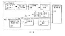
図2は、WLAN‐PSとSPSを統合する従来式の方法を図解しており、この方法は、WLAN‐PS201及びSPS206、そして位置組み合わせ論理210で構成されている。 FIG. 2 illustrates a conventional method of integrating WLAN-PS and SPS, which consists of WLAN-
WLAN‐PS201及びSPS206は、独立型システムであり、それぞれは互いのシステムから独立して作動することができる。従って、それぞれのシステムの結果を互いのシステムから独立して計算することができる。各システムの予測誤差推定の付随した推定位置は、位置組み合わせ論理210に供給され得る。予測誤差推定は、更に、本明細書ではHPE(水平位置誤差)と称されている。SPS206及びWLAN‐PS201の位置更新の公称比率は、1秒に1回である。位置組み合わせ論理210は、両方のシステムによって同じ秒に計算された位置推定を組み合わせる。 WLAN-
WLAN‐PS201は、WLANアクセスポイントを使用することで携帯装置の位置を推定する従来式のシステムである。WLAN‐PS201は、WLAN AP202のスキャナ、WLAN AP203を選択する装置、三辺測量モジュール204及びHPE推定装置205を含んでいてもよい。 The WLAN-
WLANスキャナ202は、受信電力(RSS、受信信号強度)及び/又は信号の到着時間(TOA)を検出することで携帯装置周辺のWLAN APを検出する。能動的走査、受動的走査又は受動的走査及び能動的走査の組み合わせを含むWLAN APを検出するために異なる方法を使用することができる。 The
選択WLAN AP装置203は、携帯装置の位置を推定するために最良のWLAN APの組を選択する。例えば、10のWLAN APが検出され、1つのAPがシカゴに位置しており、残りはボストンに位置しており他に情報は何もない場合、ボストンAPが選択される。これは、シカゴAPがボストンに移されたことを示している。従来式のシステムでは、最良のWLAN APの組は、受信信号強度、ノイズ分配の信号及び移動される可能性を含む、信号WLAN APの対応するパラメータに加えてWLAN APの地理学上の分布に基づいて選択される。 The selected
三辺測量モジュール204は、WLAN APと、携帯装置の位置を推定するために対応する測定値及び特性と、を使用している。WLAN APから受信した信号強度又はTOA測定値は、携帯装置からWLAN APまでの距離を推定するために使用されている。周知の位置を備える異なるWLAN APからの距離推定の合算は、携帯装置の位置を計算するために使用されている。三辺測量204は、最近隣と呼ばれる方法を使用することもでき、当該方法では、携帯装置の電力読み出しに類似する又は最近接する電力プロファイルを備えた位置が、携帯装置の最終位置として報告される。各WLAN AP又は全受信可能範囲の電力プロファイルは、受信可能範囲の詳細な調査によってシステムの較正段階で見つけることができる。 The
HPE推定装置205は、携帯装置の位置推定の予測誤差を推定するモジュールである。その全体を参考文献としてここに援用する、同時係属Skyhook無線特許出願第11/625,450号「WLANを利用した測位システムの中の測位誤差を推定するシステム及び方法」で説明されたように、HPE又は水平位置調整誤差は、以前に走査したAP及びそれらの特性及び更に受信信号の特性に基づいて計算される。 The
SPSシステム206は、衛星信号受信機及び測定装置207、三辺測量装置208及びSPS HPE推定モジュール209で構成されている。 The
衛星信号受信機及び測定装置207は、装置の視界の中の衛星から信号を受信し、受信信号を復号し、各衛星からの衛星パラメータを測定する。測定値は、疑似距離、搬送周波数及びドップラー周波数を含んでいてもよい。 A satellite signal receiver and
三辺測量装置208は、ユーザー装置の位置、携帯装置の移動速度及び移動方向を推定するために、少なくとも4つの衛星からの測定値及び視界の中の衛星の位置を使用する。 The
HPE推定装置209は、推定位置の予測誤差を推定する。HPE推定装置209は、従来式であり、衛星の幾何学及び衛星からの受信信号の信号品質に基づく予測誤差、例えばDOP(精度低下率)、及びC/N(搬送波対ノイズ比)などを計算する。 The
位置組み合わせ論理210は、WLAN−PS201及びSPS206からほとんど同じ秒の間に計算された位置及びHPE推定を受信する。言い換えれば、同時に行われる測定値と推定値は、比較され且つ組み合わされる。実際には、1秒以内の測定値及び推定値は、同時と考えることができる。ユーザー装置の位置組み合わせ論理210は、それらの1つを選択すること又はそれらを線形に組み合わせることで1つの推定位置を報告する。例えば位置組み合わせ論理は、報告された予測誤差又はHPEに基づいてWLAN−PS201又はSPS206によって提供された推定位置の1つを選択してもよく、又はHPEに照らして両方のシステムによる推定位置の加重平均を報告してもよい。
本願発明は、最良のWLAN−PS導出解を選択することでハイブリッド衛星/WLAN測位システムを使用して位置を決定する方法及びシステムを提供することを目的としている。 The present invention seeks to provide a method and system for determining position using a hybrid satellite / WLAN positioning system by selecting the best WLAN-PS derivation solution.
幾つかの実施形態では、衛星測位情報を使用するWLANを利用した位置推定の精度を高める方法は、1つ又はそれ以上のWLANアクセスポイントに基づいてWLANと衛星を使用することができる装置に対して一組の有力なWLAN位置導出解を決定することと、少なくとも2つの異なる衛星から、WLANと衛星を使用することができる装置のために衛星情報を取得することと、有力なWLAN位置導出解の組から最良のWLAN位置導出解を決定するために少なくとも2つの異なる衛星からの衛星情報を使用することと、を含んでいてもよい。 In some embodiments, a method for improving accuracy of location estimation using WLAN using satellite positioning information is provided for devices that can use WLAN and satellite based on one or more WLAN access points. Determining a set of leading WLAN position derivation solutions, obtaining satellite information from at least two different satellites for a device capable of using the WLAN and satellites, and a leading WLAN position derivation solution. Using satellite information from at least two different satellites to determine the best WLAN location derivation solution from the set.
幾つかの実施形態では、有力なWLAN位置導出解の組から最良のWLAN位置導出解を決定するために少なくとも2つの異なる衛星からの衛星情報を使用することは、衛星情報に対する有力なWLAN位置導出解のそれぞれを検証すること及び衛星情報を満足する有力なWLAN位置標定のどれかに基づいて位置を選択することを含んでいてもよい。 In some embodiments, using satellite information from at least two different satellites to determine the best WLAN position derivation solution from a set of leading WLAN position derivation solutions is a powerful WLAN position derivation for satellite information. It may include verifying each of the solutions and selecting a position based on any of the leading WLAN position location satisfying satellite information.
幾つかの実施形態では、有力なWLAN位置導出解の組から最良のWLAN位置導出解を決定するために少なくとも2つの異なる衛星からの衛星位置情報を使用する段階は、衛星情報と一致しない有力なWLAN位置導出解を削除することを含んでいてもよい。 In some embodiments, using satellite position information from at least two different satellites to determine the best WLAN position derivation solution from a set of leading WLAN position derivation solutions may be inconsistent with satellite information. It may include deleting the WLAN location derivation solution.
幾つかの実施形態では、衛星情報と一致したWLAN位置導出解は、有力なWLANを利用した位置推定のそれぞれを衛星測定値に適用すること及びそれぞれの有力なWLANを利用した位置推定に対して内部SPS受信機クロックバイアスを計算すること、によって測定されてもよい。 In some embodiments, a WLAN location derivation solution that is consistent with satellite information applies each of the dominant WLAN-based location estimates to the satellite measurements and for each potential WLAN-based location estimate. It may be measured by calculating an internal SPS receiver clock bias.
幾つかの実施形態では、有力なWLANを利用した位置推定のそれぞれに対する内部SPS受信機クロックの一致性は、WLANを利用した位置推定及び衛星測位システムの有力な導出解の間の距離を示すものとして使用することができる。 In some embodiments, the consistency of the internal SPS receiver clock for each of the dominant WLAN-based position estimates is indicative of the distance between the WLAN-based position estimation and the dominant derived solution of the satellite positioning system. Can be used as
幾つかの実施形態では、有力なWLANを利用した位置推定のそれぞれに対する内部SPS受信機クロックの一致性は、WLANを利用した位置推定及び衛星測定値の間の一致性を示すものとして使用することができる。 In some embodiments, the consistency of the internal SPS receiver clock for each of the leading WLAN location estimates may be used as an indication of the match between the WLAN location estimate and the satellite measurements. Can do.
幾つかの実施形態では、所与のWLANを利用した位置推定に対して取得した衛星に亘って実質的に同じ内部SPS受信機クロックバイアスは、良好な位置推定であることを示すことができる。 In some embodiments, substantially the same internal SPS receiver clock bias across acquired satellites for position estimation utilizing a given WLAN can be shown to be a good position estimate.
所与のWLANを利用した位置推定に対して取得した衛星に亘る内部SPS受信機クロックの不均一値は、不良な位置推定であることを示すことができる。 A non-uniform value of the internal SPS receiver clock across the satellites obtained for a position estimate using a given WLAN can indicate a poor position estimate.
幾つかの実施形態では、有力なWLAN位置導出解の組は、クラスターを含んでいてもよい。 In some embodiments, the set of leading WLAN location derivation solutions may include clusters.
幾つかの実施形態では、衛星情報は、領域、表面又は曲線の形式の衛星位置導出解を提供してもよい。 In some embodiments, the satellite information may provide a satellite position derivation solution in the form of a region, surface or curve.
幾つかの実施形態では、方法は、それぞれのWLAN位置導出解から衛星位置導出解までの距離によってWLAN位置導出解を重み付けすることを含んでいてもよい。 In some embodiments, the method may include weighting the WLAN position derivation solution by the distance from each WLAN position derivation solution to the satellite position derivation solution.
幾つかの実施形態では、方法は、衛星位置導出解まで短い距離、例えば10メートルを有するWLAN位置導出解を選択することを含んでいてもよい。 In some embodiments, the method may include selecting a WLAN position derivation solution having a short distance to the satellite position derivation solution, eg, 10 meters.
幾つかの実施形態では、方法は、衛星位置導出解まで長い距離、例えば1,000メートルを有するWLAN位置導出解を削除することを含んでいてもよい。 In some embodiments, the method may include deleting a WLAN position derivation solution having a long distance to the satellite position derivation solution, eg, 1,000 meters.
幾つかの実施形態では、衛星情報は、衛星位置データ、衛星速度データ、疑似距離測定、ドップラー周波数測定及び信号伝送時間を含んでいてもよい。 In some embodiments, the satellite information may include satellite position data, satellite velocity data, pseudorange measurements, Doppler frequency measurements, and signal transmission times.
幾つかの実施形態では、本出願は、衛星測位情報を使用してWLANを利用した位置推定の精度を高めるシステムに関しており、1つ又はそれ以上のWLANアクセスポイントから情報を受信するWLANモジュールと、少なくとも2つの異なる衛星から衛星情報を取得する衛星測位モジュールと、を含んでいてもよい測位モジュールと、1つ又はそれ以上のWLANアクセスポイントに基づいて一組の有力なWLAN位置導出解を決定するWLANモジュールの中に組み込まれる論理と、有力なWLAN位置導出解の組から最良のWLAN位置導出解を決定するために少なくとも2つの異なる衛星からの衛星情報を使用するために測位モジュールの中に組み込まれる論理と、を含んでいる。 In some embodiments, this application relates to a system that uses satellite positioning information to improve accuracy of location estimation utilizing WLAN, and a WLAN module that receives information from one or more WLAN access points; A positioning module that may include satellite positioning modules that obtain satellite information from at least two different satellites, and determining a set of potential WLAN location derivation solutions based on one or more WLAN access points Built into the positioning module to use the satellite information from at least two different satellites to determine the best WLAN position derivation solution from the set of leading WLAN position derivation solutions and the logic built into the WLAN module Logic.
幾つかの実施形態では、本出願は、衛星測位情報を用いてWLANを利用した測位推定の精度を高めるハイブリッド測位システムを有する携帯装置に関している。幾つかの実施形態では、携帯装置は、1つ又はそれ以上のWLANアクセスポイントから情報を受信するWLANモジュールと、少なくとも2つの異なる衛星からの衛星情報を取得する衛星測位モジュールと、を含んでいてもよいハイブリッド測位モジュールと、1つ又はそれ以上のWLANアクセスポイントに基づいて一組の有力なWLAN位置導出解を決定するためにWLANモジュールの中に組み込まれる論理と、有力なWLAN位置導出解の組から最良のWLAN位置導出解を決定するために少なくとも2つの異なる衛星からの衛星情報を使用するために測位モジュールの中に組み込まれる論理と、を含んでいてもよい。 In some embodiments, the present application relates to a portable device having a hybrid positioning system that uses satellite positioning information to improve the accuracy of positioning estimation using WLAN. In some embodiments, the portable device includes a WLAN module that receives information from one or more WLAN access points, and a satellite positioning module that obtains satellite information from at least two different satellites. A good hybrid positioning module, logic incorporated into the WLAN module to determine a set of possible WLAN location derivation solutions based on one or more WLAN access points, and Logic incorporated into the positioning module to use satellite information from at least two different satellites to determine the best WLAN position derivation solution from the set.
幾つかの実施形態では、方法は、WLANと衛星を使用することができる装置の範囲内でWLAN APを検出することと、装置の複数の有力な衛星位置を提供するために少なくとも2つの衛星から衛星測定値を取得することと、WLAN APから装置の有力な衛星位置までの距離に基づいてそれぞれのAPに重みを付与することと、によって、WLANアクセスポイント(AP)を重み付けするために衛星測定値を使用することでWLANと衛星を使用することができる装置の位置を決定することを含んでいてもよい。 In some embodiments, the method detects WLAN APs within a range of devices that can use WLAN and satellites, and from at least two satellites to provide multiple dominant satellite positions for the device. Satellite measurements to weight WLAN access points (APs) by obtaining satellite measurements and weighting each AP based on the distance from the WLAN AP to the dominant satellite position of the device Using values may include determining the location of devices that can use the WLAN and satellite.
幾つかの実施形態では、方法は、装置の位置を決定するために位置アルゴリズムでAP毎に重みを使用することを含んでいてもよい。 In some embodiments, the method may include using a weight for each AP in the location algorithm to determine the location of the device.
幾つかの実施形態では、装置の有力な衛星位置は、装置のための有力な位置導出解の領域を含んでいてもよい。 In some embodiments, the device's dominant satellite position may include an area of a dominant position derivation solution for the device.
幾つかの実施形態では、高い重みは、装置の有力な衛星位置に近い可能性のあるAPに対応している。 In some embodiments, the high weight corresponds to an AP that may be close to the device's dominant satellite position.
幾つかの実施形態では、装置の位置の衛星推定に近接しているということは、APの受信可能範囲の10倍以内の距離を含んでいる場合がある。 In some embodiments, proximity to a satellite estimate of the location of the device may include a distance within 10 times the coverage area of the AP.
幾つかの実施形態では、低い重みは、装置の位置の衛星推定から離れている可能性のあるAPに対応している。 In some embodiments, the low weight corresponds to an AP that may be distant from the satellite estimate of the device's location.
幾つかの実施形態では、APがAPの受信可能範囲の10倍を上回る距離に位置する場合、WLAN APは、装置の位置から離れている場合がある。 In some embodiments, the WLAN AP may be remote from the location of the device if the AP is located at a distance greater than 10 times the coverage of the AP.
幾つかの実施形態では、WLAN APが装置の有力な衛星位置から離れていると決定される場合、WLANと衛星を使用することができる装置の位置は、離れているWLAN APからのデータがなくても計算することができる。 In some embodiments, if the WLAN AP is determined to be remote from the device's dominant satellite location, the location of the device that can use the WLAN and satellite is free of data from the remote WLAN AP. Can be calculated.
幾つかの実施形態では、重みは、装置のWLAN APの位置と装置の有力な衛星の位置の間の一致性に基づいていてもよい。 In some embodiments, the weight may be based on a match between the location of the device's WLAN AP and the location of the device's dominant satellite.
幾つかの実施形態では、方法は、装置の有力な衛星位置と一致していないWLAN APを削除することを含んでいてもよい。 In some embodiments, the method may include deleting WLAN APs that do not match the device's dominant satellite position.
幾つかの実施形態では、WLAN AP位置の衛星情報との一致性は、WLAN AP位置のそれぞれを衛星測定値に適用し、WLAN AP位置毎に内部SPS受信機のクロックバイアスを計算することで測定されてもよい。 In some embodiments, the consistency of the WLAN AP position with the satellite information is measured by applying each of the WLAN AP positions to the satellite measurements and calculating the clock bias of the internal SPS receiver for each WLAN AP position. May be.
幾つかの実施形態では、方法は、初期位置としての各WLAN APの位置及び各衛星からの測定値を考察することで、内部SPS受信機のクロックバイアスを計算することを含んでいてもよい。 In some embodiments, the method may include calculating the clock bias of the internal SPS receiver by considering the location of each WLAN AP as an initial location and measurements from each satellite.
幾つかの実施形態では、WLAN APのそれぞれに対する内部SPS受信機クロックバイアスの一致性は、WLAN AP位置と有力な衛星装置の位置の間の距離を示すものとして使用することができる。 In some embodiments, the consistency of the internal SPS receiver clock bias for each of the WLAN APs can be used as an indication of the distance between the WLAN AP position and the position of the dominant satellite device.
幾つかの実施形態では、方法は、内部SPS受信機クロックバイアスの標準偏差又は平均平方誤差を計算することを含んでいてもよい、各WLAN AP位置に対する内部SPS受信機クロックバイアスの一致性を計算することを含んでいてもよい。 In some embodiments, the method calculates the internal SPS receiver clock bias consistency for each WLAN AP location, which may include calculating a standard deviation or mean square error of the internal SPS receiver clock bias. May include.
幾つかの実施形態では、本出願は、WLANアクセスポイント(AP)を重み付けするために衛星測定値を使用することでWLANと衛星を使用することができる装置の位置を決定するためのシステムを説明しており、システムは、1つ又はそれ以上のWLANアクセスポイントからの情報を受信するためのWLANモジュールと、少なくとも2つの異なる衛星からの衛星情報に基づいて装置の複数の有力な装置位置を提供するための衛星測位モジュールと、を含んでいてもよいハイブリッド測位モジュールと、WLAN APから装置の有力な衛星装置位置までの距離に基づいて各APに重みを付与する測位モジュールの中に含まれる論理と、を含んでいてもよい。 In some embodiments, this application describes a system for determining the location of devices that can use WLAN and satellites by using satellite measurements to weight WLAN access points (APs). The system provides a WLAN module for receiving information from one or more WLAN access points and multiple dominant device locations of the device based on satellite information from at least two different satellites. A satellite positioning module that may include: a hybrid positioning module that includes a logic included in the positioning module that weights each AP based on the distance from the WLAN AP to the dominant satellite device position of the device And may be included.
幾つかの実施形態では、本出願は、初期のWLANを利用した位置決定を改善するために2つ又はそれ以上の衛星測定値を使用することで、WLANと衛星を使用することができる装置の位置を決定する方法に関しており、WLAN測位システムを使用してWLANと衛星を使用することができる装置の位置を推定することと、少なくとも2つの衛星から衛星位置測定値を収集することと、を含んでおり、方法は、WLAN位置推定の予測誤差に基づいてWLAN位置推定の周囲の不確定要素区域を決定することであって、不確定要素区域は、複数の有力な位置導出解を有している、不確定要素を決定することと、衛星測定値を最もよく満足するWLAN位置不確定要素の内側で装置位置推定を決定することと、を含んでいてもよい。 In some embodiments, the present application provides for an apparatus that can use WLAN and satellite by using two or more satellite measurements to improve initial WLAN-based positioning. A method for determining a position, comprising: estimating a position of a device capable of using a WLAN and satellite using a WLAN positioning system; and collecting satellite position measurements from at least two satellites. And the method is to determine an uncertain element area around the WLAN position estimate based on a prediction error of the WLAN position estimate, the uncertain element area having a plurality of dominant position derivation solutions. Determining an uncertain factor and determining a device position estimate within the WLAN position uncertainties that best satisfy the satellite measurements.
幾つかの実施形態では、方法は、不確定要素区域をグリッドに分割することを含んでいてもよい。 In some embodiments, the method may include dividing the uncertain element area into a grid.
幾つかの実施形態では、方法は、グリッドの各点の衛星測定値を使用してWLAN位置推定を評価することを含んでいてもよい。 In some embodiments, the method may include evaluating the WLAN position estimate using satellite measurements at each point of the grid.
幾つかの実施形態では、方法は、各グリッド点の衛星測定値の内部SPS受信機クロックバイアスを決定することを含んでいてもよい。 In some embodiments, the method may include determining an internal SPS receiver clock bias for satellite measurements at each grid point.
幾つかの実施形態では、方法は、装置の位置を決定するために衛星測定値の内部SPS受信機クロックバイアスの一致性を使用することを含んでいてもよい。 In some embodiments, the method may include using the internal SPS receiver clock bias consistency of the satellite measurements to determine the position of the device.
幾つかの実施形態では、装置の位置は、衛星測定値に対して最も一致性のある内部SPS受信機クロックバイアスを提供するグリッド点であってもよい。 In some embodiments, the location of the device may be a grid point that provides an internal SPS receiver clock bias that is most consistent with satellite measurements.
幾つかの実施形態では、グリッドの大きさは、位置決定のための精度要件に基づいていてもよい。 In some embodiments, the grid size may be based on accuracy requirements for position determination.
幾つかの実施形態では、精度要件は、約10メートルであってもよい。 In some embodiments, the accuracy requirement may be about 10 meters.
幾つかの実施形態は、衛星測位情報を使用してWLANを利用した位置推定の精度を高めるシステムに関している。システムは、ハイブリッド測位モジュールと、1つ又はそれ以上のWLANアクセスポイントから情報を受信するWLANモジュールと、少なくとも2つの異なる衛星からの衛星情報を取得する衛星測位モジュールと、WLAN位置推定の予測誤差に基づいてWLAN位置推定周囲の不確定要素区域を決定するWLAN測位モジュールの中の論理であって、当該区域は、複数の有力な位置導出解を有している、論理と、最も衛星測定値を満足するWLAN位置推定として装置位置を決定するハイブリッド測位モジュールの中の論理と、を含んでいてもよい。 Some embodiments relate to a system that uses satellite positioning information to improve the accuracy of position estimation using WLAN. The system includes a hybrid positioning module, a WLAN module that receives information from one or more WLAN access points, a satellite positioning module that acquires satellite information from at least two different satellites, and a prediction error in WLAN position estimation. Logic in the WLAN positioning module that determines an indeterminate element area around the WLAN position estimate based on the logic having a plurality of dominant position derivation solutions and the most satellite measurements. And logic in a hybrid positioning module that determines the device location as a satisfactory WLAN location estimate.
幾つかの実施形態では、方法は、WLANと衛星を使用することができる装置のWLAN位置推定を計算することと、WLANと衛星を使用することができる装置の位置を決定するために衛星位置システムの中で初期位置としてWLAN位置推定を使用することと、を含んでいてもよい。 In some embodiments, the method calculates a WLAN location estimate for a device that can use WLAN and satellite, and determines a location of the device that can use WLAN and satellite. Using WLAN location estimation as the initial location.
幾つかの実施形態では、システムは、1つ又はそれ以上のWLANアクセスポイントから情報を受信することと、WLANと衛星を使用することができる装置の位置推定を計算することと、のためのWLANモジュールと、
少なくとも4つの異なる衛星から衛星情報を取得するための衛星測位モジュールであって、衛星測位モジュールは、最終位置推定のために初期位置としてWLAN位置推定を使用している、衛星測位モジュールと、を含んでいてもよい測位モジュールを含んでいてもよい。In some embodiments, the system receives WLAN information from one or more WLAN access points, calculates a location estimate of a device that can use the WLAN and satellite, and a WLAN for Module,
A satellite positioning module for obtaining satellite information from at least four different satellites, the satellite positioning module using a WLAN position estimate as an initial position for final position estimation; A positioning module may be included.
幾つかの実施形態では、WLANと衛星を使用することができる装置の位置決定の予測誤差を決定する方法は、WLAN位置推定及びWLAN位置推定のための予測誤差推定を決定することと、少なくとも2つの衛星から測定値を取得することと、衛星測位システム測定値のWLAN測位システム位置推定に対する一致性を評価することで位置決定の予測誤差を決定することと、を含んでいてもよい。 In some embodiments, a method for determining a prediction error for position determination of a device capable of using WLAN and satellite includes determining a WLAN position estimate and a prediction error estimate for the WLAN position estimate, and at least two. Obtaining measurement values from one satellite and determining a prediction error in position determination by evaluating the consistency of the satellite positioning system measurement values with the WLAN positioning system position estimate.
幾つかの実施形態では、WLAN位置推定と衛星測位システム測定値の間の一致した測定値は、位置決定により低い予測誤差をもたらすことができる。 In some embodiments, consistent measurements between WLAN position estimates and satellite positioning system measurements can result in low prediction errors due to position determination.
幾つかの実施形態では、WLAN位置推定と衛星測位システム測定値の間の一致していない測定値は、位置決定により高い予測誤差をもたらすことができる。 In some embodiments, inconsistent measurements between WLAN position estimates and satellite positioning system measurements can lead to higher prediction errors in position determination.
幾つかの実施形態では、測定値の一致性は、WLAN測位システム位置推定と衛星測位システム測定値によって提供される有力な導出解の間の距離を含んでいてもよい。 In some embodiments, the measurement consistency may include a distance between the leading positioning solution provided by the WLAN positioning system position estimate and the satellite positioning system measurement.
幾つかの実施形態では、WLANを利用した位置推定に対する内部SPS受信機クロックの一致性は、WLANを利用した位置推定と衛星測定値の間の一致性を示すものとして使用されてもよい。 In some embodiments, the consistency of the internal SPS receiver clock for position estimation using WLAN may be used as an indication of consistency between position estimation using WLAN and satellite measurements.
幾つかの実施形態では、方法は、WLANと衛星を使用することができる装置の位置決定の予測誤差を含んでいてもよく、WLANを利用した位置推定とWLAN位置推定用の予測誤差推定を決定することを含んでおり、方法は、衛星を利用した位置推定と衛星を利用した位置推定のための予測誤差推定を決定することを含んでいてもよく、方法は、衛星測位システム位置推定のWLAN測位システム位置推定に対する一致性を評価することで、位置決定の予測誤差を決定することを含んでいてもよい。 In some embodiments, the method may include a prediction error for position determination of a device capable of using WLAN and satellite to determine position estimation using WLAN and prediction error estimation for WLAN position estimation. And the method may include determining a satellite-based position estimate and a prediction error estimate for the satellite-based position estimate, the method including a satellite positioning system position estimate WLAN. Determining a prediction error in position determination may be included by evaluating consistency with the positioning system position estimate.
幾つかの実施形態では、より低い予測誤差を有する位置推定は、WLANと衛星を使用することができる装置の位置として選択されてもよい。 In some embodiments, a position estimate with a lower prediction error may be selected as the position of a device that can use WLAN and satellite.
幾つかの実施形態では、方法は、WLAN位置推定と衛星測位システム位置推定を比較することで位置決定の予測誤差を決定することを含んでいてもよい。 In some embodiments, the method may include determining a position determination prediction error by comparing the WLAN position estimate and the satellite positioning system position estimate.
幾つかの実施形態では、WLAN位置推定と衛星測位システム位置推定の間の一致した測定値は、位置決定により低い予測誤差をもたらすことができる。 In some embodiments, a consistent measurement between the WLAN position estimate and the satellite positioning system position estimate can result in lower prediction errors due to position determination.
幾つかの実施形態では、WLAN位置推定と衛星測位システム位置推定の間の一致していない測定値は、位置決定により高い予測誤差をもたらすことができる。 In some embodiments, inconsistent measurements between WLAN position estimates and satellite positioning system position estimates can lead to higher prediction errors in position determination.
幾つかの実施形態では、推定の一致性は、衛星測位システム位置推定とWLAN測位システム位置推定の間の距離を含んでいてもよい。 In some embodiments, the estimation consistency may include a distance between the satellite positioning system position estimate and the WLAN positioning system position estimate.
幾つかの実施形態では、方法は、WLANを利用した位置推定と衛星測位システム位置の間の一致性を示すものとして使用されてもよい、WLANを利用した位置推定用の内部SPS受信機クロックを含んでいてもよい。 In some embodiments, the method uses an internal SPS receiver clock for location estimation using WLAN, which may be used to indicate consistency between location estimation using WLAN and satellite positioning system location. May be included.
幾つかの実施形態は、衛星測位情報を使用してWLANを利用した位置推定の精度を高めるためのシステムに関している。システムは、WLAN位置推定を計算するために1つ又はそれ以上のWLANアクセスポイントから情報を受信するためのWLANモジュールと、少なくとも2つの異なる衛星から衛星情報を取得するための衛星測位モジュールと、を含んでいる測位モジュールと、衛星測位システム測定値のWLAN測位システム位置推定に対する一致性を評価することで位置決定の予測誤差を決定するための測位モジュールの中に組み込まれる論理と、を含んでいてもよい。 Some embodiments relate to a system for improving accuracy of position estimation using WLAN using satellite positioning information. The system includes a WLAN module for receiving information from one or more WLAN access points to calculate a WLAN position estimate, and a satellite positioning module for obtaining satellite information from at least two different satellites. Including a positioning module and logic incorporated into the positioning module to determine a prediction error in positioning by evaluating the consistency of the satellite positioning system measurements to the WLAN positioning system position estimate. Also good.
幾つかの実施形態は、衛星測位情報を使用してWLANを利用した位置推定の精度を高めるシステムに関している。システムは、1つ又はそれ以上のWLANアクセスポイントから情報を受信するための且つWLAN位置推定を計算する目的の、WLANモジュールと、衛星位置推定を計算するために少なくとも4つの異なる衛星から衛星情報を取得するための衛星測位モジュールと、を含んでいる測位モジュールと、衛星測位システム位置推定のWLAN測位システム位置推定に対する一致性を評価することで位置決定の予測誤差を決定するための測位モジュールの中に組み込まれる論理と、を含んでいてもよい。 Some embodiments relate to a system that uses satellite positioning information to improve the accuracy of position estimation using WLAN. The system receives satellite information from a WLAN module for receiving information from one or more WLAN access points and for calculating WLAN position estimates and from at least four different satellites for calculating satellite position estimates. A positioning module including: a positioning module including: a positioning module including: a positioning module for determining a position determination prediction error by evaluating the coincidence of the satellite positioning system position estimation with the WLAN positioning system position estimation; And logic incorporated into the.
幾つかの実施形態では、受信した衛星信号のドップラー周波数を測定することで、衛星を使用することができる装置が静止しているか否かを決定する方法は、少なくとも2つの衛星から衛星測定値を取得することであって、衛星測定値は、ドップラー周波数測定値を含んでいる、少なくとも2つの衛星から衛星測定値を取得することと、衛星を使用することができる装置の位置の概略的な推定を取得することと、衛星を使用することができる装置の内部周波数オフセットを計算することと、を含んでいてもよい。 In some embodiments, a method for determining whether a device capable of using a satellite is stationary by measuring a Doppler frequency of a received satellite signal is to obtain satellite measurements from at least two satellites. Obtaining satellite measurements, including Doppler frequency measurements, obtaining satellite measurements from at least two satellites, and a rough estimate of the position of the device that can use the satellites. And calculating an internal frequency offset of a device that can use the satellite.
幾つかの実施形態では、方法は、衛星の運動を説明するためにドップラー周波数測定値を及び装置のドップラー周波数を提供するために内部周波数オフセットを、調整することを含んでいてもよい。 In some embodiments, the method may include adjusting a Doppler frequency measurement to account for satellite motion and an internal frequency offset to provide a device Doppler frequency.
幾つかの実施形態では、方法は、装置のドップラー周波数が小さい場合、装置は静止していると決定することを含んでいてもよい。 In some embodiments, the method may include determining that the device is stationary if the device Doppler frequency is low.
幾つかの実施形態では、方法は、衛星毎の内部周波数オフセットが実質的に同じ値である場合、装置は静止していると決定することを含んでいてもよい。 In some embodiments, the method may include determining that the device is stationary if the internal frequency offset per satellite is substantially the same value.
幾つかの実施形態では、小さいドップラー周波数は、毎時1.609344キロメートル未満の衛星を使用することができる装置の動きに対応するドップラー周波数であってもよい。 In some embodiments, the small Doppler frequency may be a Doppler frequency corresponding to device movement that can use satellites less than 1.609344 kilometers per hour.
幾つかの実施形態では、装置が静止していると決定される場合、方法は、省電力特徴を、衛星を使用することができる装置の中に位置するWLAN測位システムに実装することを含んでいてもよい。 In some embodiments, if the device is determined to be stationary, the method includes implementing a power saving feature in a WLAN positioning system located within the device that can use the satellite. May be.
幾つかの実施形態では、省電力特徴は、WLAN測位システムによって、例えば毎分1回より低い頻度で装置位置を更新することを含んでいてもよい。 In some embodiments, the power saving feature may include updating the device location by the WLAN positioning system, for example, less frequently than once per minute.
幾つかの実施形態は、受信した衛星信号のドップラー周波数を測定することで衛星を使用することができる装置が静止しているか否かを決定するためのシステムに関している。当該システムは、少なくとも2つの異なる衛星からの衛星情報を取得するための衛星測位モジュールであって、衛星測定値はドップラー周波数測定値を含んでいる、衛星測位モジュールと、衛星の運動を説明するためにドップラー周波数測定値を、及び装置のドップラー周波数を提供するために衛星を使用することができる装置の周波数オフセットを、調節するための衛星測位モジュールの中に位置しており、装置のドップラー周波数が小さい場合、装置は静止していると決定する、論理と、を含んでいる測位モジュールを含んでいてもよい。 Some embodiments relate to a system for determining whether a device capable of using a satellite is stationary by measuring the Doppler frequency of a received satellite signal. The system is a satellite positioning module for obtaining satellite information from at least two different satellites, where the satellite measurements include Doppler frequency measurements, and to describe the movement of the satellites Is located in a satellite positioning module for adjusting the Doppler frequency measurement and the device frequency offset, which can be used to provide the Doppler frequency of the device, and the Doppler frequency of the device is If so, the device may include a positioning module that includes logic to determine that the device is stationary.
幾つかの実施形態は、装置が位置する環境の特性を使用してWLANと衛星の測位システムを使用することができる装置の位置を決定するための方法に関しており、装置は、装置の距離範囲にあるWLAN APを検出することと、装置によって検出されたWLAN APに基づいて参考データベースから環境特性を取得することと、環境特性に基づいて、WLAN測位システム又は衛星測位システムを使用するかどうかを決定することと、を含んでいてもよい。 Some embodiments relate to a method for determining the location of a device that can use WLAN and satellite positioning systems using the characteristics of the environment in which the device is located, and the device is within range of the device. Detects a WLAN AP, obtains environmental characteristics from a reference database based on the WLAN AP detected by the device, and determines whether to use a WLAN positioning system or a satellite positioning system based on the environmental characteristics And may include.
幾つかの実施形態では、環境特性は、AP付近の建築物密度、AP付近の建築物高さ及びAPがビルの谷間又は都市部又は郊外部に位置しているかどうか、で構成される群から選択される。 In some embodiments, the environmental characteristics are from a group consisting of building density near the AP, building height near the AP, and whether the AP is located in a valley or urban or suburban area of the building. Selected.
幾つかの実施形態では、装置がビルの谷間にあると決定することができる場合、装置は、WLAN測位システムだけに基づいて自らの位置を決定するであろう。 In some embodiments, if the device can be determined to be in a valley of a building, the device will determine its location based solely on the WLAN positioning system.
幾つかの実施形態では、装置が郊外部にあると決定することができる場合、装置は、衛星測位システムだけに基づいて自らの位置を決定するであろう。 In some embodiments, if the device can be determined to be in the suburbs, the device will determine its position based solely on the satellite positioning system.
幾つかの実施形態では、環境特性は、装置の位置を推定する方法を選択するために衛星測位システムによって使用されてもよい。 In some embodiments, the environmental characteristics may be used by the satellite positioning system to select a method for estimating the position of the device.
幾つかの実施形態では、環境特性は、装置の位置を推定する方法を選択するためにWLAN測位システムによって使用されてもよい。 In some embodiments, the environmental characteristics may be used by the WLAN positioning system to select a method for estimating the position of the device.
幾つかの実施形態は、装置が位置している環境の特性を使用して装置の位置を決定するハイブリッド測位システムに関しており、当該システムは、1つ又はそれ以上のWLANアクセスポイントから情報を受信するためのWLANモジュールであって、環境特性を含んでいるWLANモジュールと、衛星情報を取得するための衛星測位モジュールと、を含んでいる測位モジュールと、環境特性に基づいてWLAN測位システム又は衛星測位システムを使用するかどうかを決定するために測位モジュールの中に組み込まれる論理と、を含んでいる。 Some embodiments relate to a hybrid positioning system that uses the characteristics of the environment in which the device is located to determine the location of the device, which receives information from one or more WLAN access points. WLAN module including an environmental characteristic, a satellite positioning module for acquiring satellite information, a positioning module, and a WLAN positioning system or a satellite positioning system based on the environmental characteristic And logic built into the positioning module to determine whether to use.
幾つかの実施形態では、WLANアクセスポイント(AP)を使用することで衛星測位システム受信機の内部クロックの安定性を維持するための方法は、基準として1つ又はそれ以上のWLAN APを使用することで衛星測位システム受信機の内部クロック精度を維持することを含んでいてもよい。 In some embodiments, a method for maintaining the internal clock stability of a satellite positioning system receiver by using a WLAN access point (AP) uses one or more WLAN APs as a reference. This may include maintaining the internal clock accuracy of the satellite positioning system receiver.
幾つかの実施形態では、内部クロック精度を維持することは、WLAN APによって伝送される及び衛星測位システム受信機によって受信される、1つ又はそれ以上の信号の1つ又はそれ以上の時間間隔を測定することを含んでいてもよい。 In some embodiments, maintaining internal clock accuracy can include one or more time intervals of one or more signals transmitted by the WLAN AP and received by the satellite positioning system receiver. May include measuring.
幾つかの実施形態では、WLAN APは、衛星測位システムクロックと同期することで内部クロック精度を維持している。 In some embodiments, the WLAN AP maintains internal clock accuracy by synchronizing with the satellite positioning system clock.
幾つかの実施形態では、WLAN APは、衛星測位システムクロックと同期するために衛星測位システム受信機を含んでいてもよい。 In some embodiments, the WLAN AP may include a satellite positioning system receiver to synchronize with the satellite positioning system clock.
幾つかの実施形態では、WLAN APは、衛星測位システムクロックと同期するために中央側に接続されてもよい。 In some embodiments, the WLAN AP may be connected to the central side to synchronize with the satellite positioning system clock.
幾つかの実施形態では、WLAN APは、正確な内部発振器受信機を使用することで内部クロック精度を維持してもよい In some embodiments, the WLAN AP may maintain internal clock accuracy by using an accurate internal oscillator receiver.
幾つかの実施形態では、方法は、WLAN APから、内部発振器の精度についての情報又はタイミングの予測誤差を受信することと、衛星受信機の内部クロックバイアスを修正及び維持するために異なるWLAN APからタイミング測定値を選択することと、を含んでいてもよい。 In some embodiments, the method receives information about the accuracy of the internal oscillator or timing prediction error from the WLAN AP and from different WLAN APs to correct and maintain the internal clock bias of the satellite receiver. Selecting timing measurements.
幾つかの実施形態では、方法は、内部発振器の衛星受信機の精度より高い内部発振器の精度を備えたWLAN APを選択することを含んでいてもよい。 In some embodiments, the method may include selecting a WLAN AP with an internal oscillator accuracy that is higher than an internal oscillator satellite receiver accuracy.
幾つかの実施形態では、WLAN APは、地方自治体のAPであってもよく、地方自治体のAPは、衛星測位システムクロックと同期化される。 In some embodiments, the WLAN AP may be a municipal AP, and the municipal AP is synchronized with a satellite positioning system clock.
幾つかの実施形態では、衛星測位システム受信機は、WLAN受信機を含んでいてもよい。 In some embodiments, the satellite positioning system receiver may include a WLAN receiver.
幾つかの実施形態では、衛星測位受信機は、基準として1つ又はそれ以上のWLAN APを使用することで内部クロックバイアスを維持している。幾つかの実施形態では、WLAN APは、地方自治体のAPであってもよい。 In some embodiments, the satellite positioning receiver maintains the internal clock bias by using one or more WLAN APs as a reference. In some embodiments, the WLAN AP may be a municipal AP.
本発明の様々な実施形態のより完全な理解のため、この後に続く添付図面と関連させながらこれより下記の説明に論及してゆく。 For a more complete understanding of various embodiments of the present invention, reference is now made to the following description, taken in conjunction with the accompanying drawings.
開示する主題の実施形態は、ハイブリッド測位システムを作るためにWLANを利用した測位システム(WLAN‐PS)及び衛星を利用した測位システム(SPS)を統合する方法を提供している。統合された又はハイブリッドのシステムは、測位及び速度推定及び方位推定の精度及び予測誤差推定の精度を高めるため、及び独立して機能する各個別のシステムと比較して消費電力を低減するために、1つ又はそれ以上のシステムからの測定値を組み合わせるシステムを指している。ハイブリッド測位システムを作り出すためにWLAN−PS及びSPSを統合する方法は、別の入力として未処理のSPS測定値をWLAN−PSへ及び別の入力としてWLAN‐PS最終推定をSPSに追加することができる。2つ又はそれ以上の衛星からの未処理のSPS測定値は、WLAN−PSが位置推定、HPE及び静止ユーザー検出の精度を高めることを支援することができる。WLAN−PS初期位置推定及び他の推定は、同様に、SPSが初回測位時間(TTFF)及び電力消費を低減することを支援することができる。ハイブリッド測位システムは、更に、精度向上又は他の推定に関する値を追加していない時には、WLAN−PS又はSPSの動作を停止することで、別々に作動するWLAN−PS及びSPSと比較して電力消費を低減することができる。 Embodiments of the disclosed subject matter provide a method for integrating a positioning system using WLAN (WLAN-PS) and a positioning system using satellite (SPS) to create a hybrid positioning system. An integrated or hybrid system increases the accuracy of positioning and velocity estimation and orientation estimation and the accuracy of prediction error estimation, and to reduce power consumption compared to each individual system functioning independently. Refers to a system that combines measurements from one or more systems. The method of integrating WLAN-PS and SPS to create a hybrid positioning system may add raw SPS measurements as separate inputs to WLAN-PS and WLAN-PS final estimates as separate inputs to SPS. it can. Raw SPS measurements from two or more satellites can help WLAN-PS improve the accuracy of location estimation, HPE and stationary user detection. WLAN-PS initial position estimates and other estimates can similarly help SPS reduce initial positioning time (TTFF) and power consumption. The hybrid positioning system also consumes power compared to WLAN-PS and SPS operating separately by stopping the operation of WLAN-PS or SPS when no value for accuracy improvement or other estimation is added. Can be reduced.
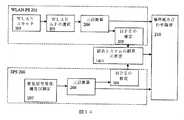
図3はWLAN−PS301及びSPS306のハイブリッドシステムのブロック図を図解している。 FIG. 3 illustrates a block diagram of a hybrid system of WLAN-
SPS306は、図2のSPS206と同じ装置から構成されており、出力311及び(本明細書でより詳細に検討される)WLAN−PSからの入力312が追加された、市販の従来式の衛星測位装置である。衛星受信機及び測定装置207は、全ての従来式SPS受信機306の一部であり、未処理のSPS測定値は、SPS測定の重要な一部である。しかしながら、ここでは、未処理のSPS測定値は、出力311で示すように、SPS306の外部で使用されている。全ての市販されるSPS受信機が、未処理のSPS測定値をSPS306の外部の装置へ公開するわけではない。例えば、SiRF Technology社(カリフォルニア州、サンノゼ)製のStar III GPSは、未処理のSPS測定値を標準インターフェイスの一部として提供している。しかしながら、その様な測定値を提供しない他のGPS受信機も幾つかある。未処理のSPS測定値を標準インターフェイスの一部として公開していないSPS受信機では、SPS受信機306は、未処理のSPS測定値へのアクセスを認めるように修正される。 The
WLAN−PS301は、未処理のSPS測定値311を受信するように構成されている点を除いて、図2に示すWLAN−PS201と同様の様式で機能している。未処理のSPS測定値のWLAN−PS301との統合は、WLAN AP選択装置303、三辺測量装置304及びHPE推定装置305の設計を変えている。WLAN−PS301は、SPS306からの測位又は導出解が何らなくとも、少なくとも2つの衛星が獲得される場合には未処理のSPS測定値の利点を生かすことができる。 The WLAN-
未処理のSPS測定値を受信した後のWLAN−PS301のこの設計変更を本明細書でより詳細に検討する。 This design change of WLAN-
1つの実施形態下では、開示する方法は、WLANを利用した測位システム(WLAN−PS)及び衛星を利用した測位システム(SPS)を統合しており、ここでは、WLAN−PSは、携帯装置の一組の有力な位置を提供し、当該有力な位置の中で、SPS測定値に最も適合する1つが、最終位置推定として選択される。 Under one embodiment, the disclosed method integrates a positioning system using WLAN (WLAN-PS) and a positioning system using satellite (SPS), where WLAN-PS is the mobile device's positioning system. A set of strong positions is provided, and one of the strong positions that best fits the SPS measurement is selected as the final position estimate.
この実施形態は、WLANを利用した測位システム(WLAN−PS)及び衛星を利用した測位システム(SPS)を統合する方法を更に提供することができ、ここでは、WLAN−PSは、携帯装置用の一組の有力な位置を提供し、有力な位置は、複数の有力なSPS装置位置導出解までの距離によって重み付けされる。言い換えると、重みは、WLAN−PSの有力な導出解がどれ程衛星測定値に一致しているのかによってWLAN−PS有力な導出解に割り当てられる。重みをそれぞれの有力な位置に割り当てた後、様々なアルゴリズムをWLAN−PS有力な位置を組み合わせる又は選択するために使用することができる。例えば、最終記録位置を、全ての有力な位置の平均を用いて重み付けすることができ、低い重みの位置は、記録され得る平均の重みの付けられた位置から除去することができる又は最高の重みが付けられた位置だけを記録することができる。選択は、個別の重みがゼロ及び1である重み付けの特別な事例であってもよい。 This embodiment may further provide a method for integrating a positioning system using WLAN (WLAN-PS) and a positioning system using satellite (SPS), where WLAN-PS is for mobile devices. A set of dominant positions is provided, and the dominant positions are weighted by the distance to a plurality of leading SPS device position derivation solutions. In other words, weights are assigned to WLAN-PS dominant derived solutions according to how well the leading WLAN-PS derived solutions match the satellite measurements. After assigning weights to each dominant position, various algorithms can be used to combine or select WLAN-PS dominant positions. For example, the final recorded position can be weighted using the average of all the dominant positions, and the low weight position can be removed from the average weighted position that can be recorded or the highest weight Only positions marked with can be recorded. The selection may be a special case of weighting where the individual weights are zero and one.
例えば、幾つかの区域におけるWLAN APの高密度の理由から、WLAN−PSは、所与の位置の中で10のWLAN APを検出する場合がある。検出されたWLAN APは、1つよりも多くのクラスターを形成してもよい。クラスターは、互いの受信可能範囲で一組のAPと画定される。WLAN APの受信可能範囲が周知でない場合、公称受信可能範囲を考察してもよい。WLAN APの公称受信可能範囲又は標準的な受信可能範囲は、数千のWLAN APの受信可能範囲を測定することで統計的に獲得され、この文書の執筆時、100m及び250mの間の数字が報告されている。例えば、携帯装置が15のWLAN APを検出し、その内10は、高層ビルの中に位置し、他の5つは高層ビルから離れた(例えば高層ビルから500メートル離れた)オフィスビルの中に位置する場合、検出されたWLAN APは、それぞれ、10及び5の大きさをした2つのクラスターとして考えることができる。従来式の測位アルゴリズムは、高いほうの数のAPを備えたクラスター、即ち10のAPのクラスターを選択するであろう。従来式の手法下では、位置は高層ビルの中のどこかであろう。しかしながら、2つ又はそれ以上の衛星からの未処理のSPS測定値が、たとえSPSからの位置測定を備えていなくてもクラスター情報を備えていると考えられる場合、未処理のSPS測定値は、複数のクラスターからWLAN APの適正なクラスターを選択するために使用することができる。この実施例では、携帯装置も同様にSPS方程式を満足させるので、5つのWLAN APのクラスターは、携帯装置の位置に最近接するクラスターとして選択されてもよい。SPS測定値も、同様に、有力なSPS導出解からの推定距離によって、重みを5つ及び10のAPのクラスターに割り当てるために使用することができる。重みをクラスターに割り当てた後、論理は、クラスターの推定結果を組み合わせ、1つの位置だけを記録するために使用され得る。例えば、クラスターの推定結果の重み付けされた平均、最大重みを有するクラスターの推定又はより高い重みを有するクラスターの推定の平均は、最終推定結果として報告することができる。 For example, because of the high density of WLAN APs in some areas, WLAN-PS may detect 10 WLAN APs in a given location. Detected WLAN APs may form more than one cluster. A cluster is defined as a set of APs within each other's coverage. If the WLAN AP coverage is not known, the nominal coverage may be considered. The WLAN AP nominal coverage or standard coverage is statistically obtained by measuring the coverage of thousands of WLAN APs, and at the time of writing this document a number between 100 and 250 meters is used. It has been reported. For example, a mobile device detects 15 WLAN APs, 10 of which are located in a high-rise building and the other 5 are in an office building away from the high-rise building (eg 500 meters away from the high-rise building). , The detected WLAN AP can be thought of as two clusters of size 10 and 5, respectively. A conventional positioning algorithm would select a cluster with a higher number of APs, ie a cluster of 10 APs. Under conventional methods, the location will be somewhere in the skyscraper. However, if raw SPS measurements from two or more satellites are considered to comprise cluster information even though they do not comprise position measurements from SPS, the raw SPS measurements are It can be used to select a proper cluster of WLAN APs from multiple clusters. In this embodiment, the mobile device also satisfies the SPS equation, so a cluster of five WLAN APs may be selected as the cluster closest to the location of the mobile device. SPS measurements can also be used to assign weights to clusters of 5 and 10 APs, depending on the estimated distance from the dominant SPS derivation solution. After assigning weights to the clusters, the logic can be used to combine the cluster estimation results and record only one location. For example, the weighted average of the cluster estimation results, the estimation of the cluster with the maximum weight or the estimation of the cluster with the higher weight can be reported as the final estimation result.
第1の段階は、ユーザー装置を位置付けるための基準点として使用されるであろうWLANアクセスポイントを検出することである。WLANアクセスポイントは、無作為に分散され、それらは、更に、時間と共に動く場合がある。従って、WLAN測位システムは、エンドユーザーによって検出されるWLANアクセスポイントの全てのクラスターを識別するためにクラスター化アルゴリズムを適用する。 The first step is to detect the WLAN access point that will be used as a reference point for positioning the user equipment. WLAN access points are randomly distributed and they may also move over time. Accordingly, the WLAN positioning system applies a clustering algorithm to identify all clusters of WLAN access points detected by the end user.
WLANアクセスポイントのクラスターは、互いの受信可能範囲内にある一組のWLANアクセスポイントである。アクセスポイントの通常の受信可能範囲よりクラスターから更に離れているWLANアクセスポイントは、新しいクラスターとして考えられる。 A cluster of WLAN access points is a set of WLAN access points that are within range of each other. A WLAN access point that is further away from the cluster than the normal coverage of the access point is considered a new cluster.
例えば、ユーザーが、4つのアクセスポイントを検出し、その内の3つは、ボストンに、その内の1つはシアトルに位置している。従って、それらは、2つのクラスターを形成しており、即ちボストンの1つは3つのWLANアクセスポイントを備え、シアトルの1つは、1つのWLANアクセスポイントを備えている。WLANアクセスポイントの各クラスターは、WLAN測位システムの中で離れた位置になってもよい。携帯装置が更に2つ又はそれ以上の衛星から信号を取得する場合、衛星測定値は、WLANアクセスポイントのクラスターを選択するため又はWLANアクセスポイントのクラスターを拒否するために使用されてもよい。2つ又はそれ以上の衛星測定値は、領域(容積、表面又は曲線)の形式をした一組の導出解を提供する。有力なWPS導出解のSPS有力な導出解に対する近接性は、WPS導出解を重み付け、選択又は拒否するための基準になり得る。言い換えれば、WLAN−PS導出解がSPS導出解に近いほど、WLAN−PS導出解の品質は高くなる。 For example, a user detects four access points, three of which are located in Boston and one of them is located in Seattle. Thus, they form two clusters: one in Boston with three WLAN access points and one in Seattle with one WLAN access point. Each cluster of WLAN access points may be located remotely in the WLAN positioning system. If the mobile device further acquires signals from two or more satellites, the satellite measurements may be used to select a cluster of WLAN access points or to reject a cluster of WLAN access points. Two or more satellite measurements provide a set of derived solutions in the form of regions (volumes, surfaces or curves). The proximity of a leading WPS derived solution to an SPS leading derived solution can be a criterion for weighting, selecting or rejecting the WPS derived solution. In other words, the closer the WLAN-PS derived solution is to the SPS derived solution, the higher the quality of the WLAN-PS derived solution.
例えば図4は、5つのWLANアクセスポイント404から成るWLAN−PS401を示している。WLANアクセスポイントは、この実施例では2つのクラスター、第1のクラスター402及び第2のクラスター403を形成している。それぞれのクラスターは、ユーザー装置の位置を推定するために使用することができる。ユーザー装置が少なくとも2つの衛星405から信号を取得する場合、2つ又はそれ以上の衛星406の有力な導出解を、幾つかのクラスターを選択又は削除するために使用してもよい。この実施例では、2つ又はそれ以上の衛星の有力な導出解を帯域406として示している。クラスター402は、クラスター403と比べて有力な衛星導出解帯域406により近くなっている。従って、クラスター402は選択され、クラスター403は拒否され得る。 For example, FIG. 4 shows a WLAN-
図5は、SPS及びWLAN−PSの統合された導出解のブロック図を図解している。SPS506は、標準の市販される装置であってもよいが、図3で検討したような未処理のSPS測定値を提供することができなければならない。未処理のSPS測定値311は、WLAN AP503及び三辺測量装置504へ方向付けられる。 FIG. 5 illustrates a block diagram of an integrated derivation solution for SPS and WLAN-PS. The
WLAN AP選択装置503は、WLANスキャナ202から入力としてデータを受信する。WLAN AP選択装置503は、アクセスポイント間の距離に基づいてWLAN APを集めてクラスター化する。WLAN AP選択装置503は、クラスターを識別するだけでなく、クラスター毎に異なる組のWLAN APを選択する。それぞれの異なるクラスターは、異なる位置推定をもたらし得る。全ての異なる組のクラスターは、三辺測量装置504で使用することができ、異なる位置推定をもたらし得る。クラスターに基づく位置推定は、SPS有力な導出解からのクラスター距離によって重み付けされてもよく、又はSPS有力な導出解からのクラスター距離によって選択されてもよい。クラスターが衛星距離導出解に(短距離で)近接していると考えられる場合、クラスターは、高い重みを割り当てられ得る。例えば、クラスターは、衛星距離導出解から約10メートル離れて位置する場合など。クラスターが衛星距離導出解から(長距離で)離れていると考えられる場合、例えばクラスターが衛星距離導出解から約100メートル又は1,000メートル離れて位置する場合などでは、クラスターには低い重みが割り当てられ得る。 The WLAN
SPS導出解は、以下のように得ることができる。各衛星測定値では、標準的には、携帯装置の位置の4つの未知の座標(x、y、z)及びSPS受信機の内部クロックバイアスが存在している。2つ又はそれ以上の衛星からの未処理のSPS測定値は、方程式からSPS受信機の内部クロックバイアスを削除するために使用することができる。この場合、結果は、ユーザー装置の位置の座標(x、y、z)の関数になり、一般的な形式として以下のように書くことができる。
F(x、y、z)=0The SPS derivation solution can be obtained as follows. For each satellite measurement, there are typically four unknown coordinates (x, y, z) of the position of the mobile device and the internal clock bias of the SPS receiver. The raw SPS measurements from two or more satellites can be used to remove the SPS receiver's internal clock bias from the equation. In this case, the result is a function of the coordinates (x, y, z) of the position of the user device, which can be written as a general form:
F (x, y, z) = 0
この関数は、衛星の数に基づいて区域、表面、又は曲線を表現することができる。従って、2つ又はそれ以上の衛星からの未処理のSPS測定値は、最終の位置推定を有せずとも、一組の有力な導出解をもたらすことができる。 This function can represent an area, surface, or curve based on the number of satellites. Thus, raw SPS measurements from two or more satellites can yield a set of powerful derived solutions without having a final position estimate.
WLAN−PSの異なる導出解及びSPS有力な導出解の間の距離は、各WLAN−PS導出解を重み付けするための基準として使用することができる。重みを各WLAN−PS有力な導出解に割り当てた後、論理は、導出解を組み合わせる又は有力な導出解から導出解を選択するために使用することができる。 The distance between the different derived solutions of WLAN-PS and the dominant derived solution of SPS can be used as a basis for weighting each WLAN-PS derived solution. After assigning weights to each WLAN-PS dominant derived solution, logic can be used to combine the derived solutions or select a derived solution from the leading derived solutions.
更に、SPS測定値及びWLAN−PSによって提供される位置の間の一致性は、WLAN−PSによって提供される位置と携帯装置の位置の間の距離を示すものとして使用することができる。ユーザー装置の位置は、(1)有力なWLAN−PS位置をユーザー装置の位置の概略的な推定として使用すること(即ちそれぞれの有力なWLAN−PS位置をx、y、zとして使用すること)及び(2)各衛星からの測定値を使用して、各WLAN−PS位置推定毎に最終の未知の内部衛星受信機クロックバイアスを計算すること、で計算することができる。WLAN位置推定毎の、計算された(近い将来では各衛星毎に計算された)内部衛星受信機クロックバイアスの間の一致性は、WLAN−PSの位置推定と携帯装置の実際の位置の間の距離を示すものとして使用することができる。良好なWLAN−PS推定値は、一致した受信機クロックバイアス推定値を有するであろう、即ちWLAN−PS推定位置が、衛星毎にx、y、z位置として使用される時には、受信機クロックバイアスは、例えば互いの約10%以内で、実質的には同じであろう。しかしながら、WLAN−PS位置がユーザー装置の位置の不良な推定であれば、WLAN−PS位置は、衛星毎に様々な衛星受信機クロックバイアス推定を生み出すであろう、例えば受信機クロックバイアスは、10%より多く変化するであろう。 Furthermore, the consistency between the SPS measurement and the location provided by the WLAN-PS can be used as an indication of the distance between the location provided by the WLAN-PS and the location of the mobile device. User device location: (1) Use the dominant WLAN-PS location as a rough estimate of the user device location (ie, use each dominant WLAN-PS location as x, y, z). And (2) using the measurements from each satellite to calculate the final unknown internal satellite receiver clock bias for each WLAN-PS position estimate. The consistency between the calculated internal satellite receiver clock bias (calculated for each satellite in the near future) for each WLAN position estimate is between the WLAN-PS position estimate and the actual position of the mobile device. Can be used as an indication of distance. A good WLAN-PS estimate will have a matched receiver clock bias estimate, i.e., when the WLAN-PS estimate position is used as the x, y, z position for each satellite. Will be substantially the same, for example, within about 10% of each other. However, if the WLAN-PS position is a poor estimate of the position of the user equipment, the WLAN-PS position will produce different satellite receiver clock bias estimates for each satellite, eg, the receiver clock bias is 10 Will change more than%.
衛星測定値毎に得られるクロックバイアスがCiで示される場合、Ciの一致性は、所与の位置(この場合、WLAN−PSによって決定される位置)と衛星方程式を満足する位置の間の距離の測定として使用することができる。Ciの一致性は、以下のような、
Ciの標準偏差又はCi推定の平均平方誤差などの異なる数学的な手法で測定することができる。If the clock bias obtained for each satellite measurement is denoted by Ci, Ci consistency is the distance between a given position (in this case, the position determined by WLAN-PS) and the position satisfying the satellite equation. Can be used as a measure of The coincidence of Ci is as follows:
It can be measured by different mathematical techniques such as standard deviation of Ci or mean square error of Ci estimation.
MSEの値は、Ci標本の一致性の指標として使用することができる。従って、WLAN−PSの全ての有力な位置は、SPSの未処理の測定値で検証することができ、Ciの一致性は、実際の携帯装置の位置までの導出解の距離の指標として使用することができる。この距離は、携帯装置の位置を計算する過程で、APを重み付けする又は選択する又は非選択化する(除外する)ために他のWLAN APパラメータと共に使用することができる。 The value of MSE can be used as an indicator of Ci sample consistency. Thus, all possible positions of the WLAN-PS can be verified with raw measurements of the SPS, and the Ci consistency is used as an indicator of the distance of the derived solution to the actual mobile device position. be able to. This distance can be used with other WLAN AP parameters to weight or select or deselect (exclude) APs in the process of calculating the location of the mobile device.
図6は、領域606の形式のSPS導出解及びWLAN測位システム601を示しており、ここではWLANアクセスポイント604が第1のクラスター602及び第2のクラスター603を形成している。携帯装置の2つ又はそれ以上の衛星605の取得は、更に、一組の有力な衛星装置の導出解606をもたらすことができる。SPS導出解606及びWLAN−PS導出解602の間の一致性は、この実施例ではWLAN−PSの602導出解である最良の導出解を選択するために使用される。SPSとWLAN−PSの間の一致性は、それらの両方が導出解の一部と同じ位置を説明している又は最終推定位置が両方のシステムの導出解の内の1つであることを意味している。更に、APのクラスターは、SPS有力な導出解までの距離によって重み付けされてもよい。 FIG. 6 shows an SPS derivation solution in the form of region 606 and a
開示する主題の別の実施形態は、未処理のSPS測定値を使用することでWLANアクセスポイントを重み付けする方法を提供している。未処理のSPS測定値を使用することでエンドユーザーの位置を推定するためにWLANアクセスポイントの最良の組を選択することは、重みをWLAN APに割り当てる特殊な事例であり得る。携帯装置の位置を推定するためにWLANアクセスポイントの最良の組を重み付け又は選択するために使用される他の基準に加えて、未処理のSPS測定値を使用してもよい又は他の基準と組み合わせてもよい。他の基準及び重みは、受信信号強度に基づく重み又は受信信号の往復時間に基づく重みである。WLAN−PSは、携帯装置の位置を推定するためにWLAN−AP及びその特性を使用する。 Another embodiment of the disclosed subject matter provides a method for weighting WLAN access points by using raw SPS measurements. Selecting the best set of WLAN access points to estimate the end user's location by using raw SPS measurements may be a special case of assigning weights to WLAN APs. In addition to other criteria used to weight or select the best set of WLAN access points to estimate the location of the mobile device, raw SPS measurements may be used or other criteria You may combine. Other criteria and weights are weights based on received signal strength or weights based on round trip time of the received signal. WLAN-PS uses WLAN-AP and its characteristics to estimate the location of the mobile device.
WLAN APの特性は、受信信号強度(RSS)、位置又は位置の推定、信号対ノイズ比及び到着時間(TOA)を、これらに限定するわけではないが、含んでいてもよい。2つ又はそれ以上の衛星からの未処理のSPS測定値は、WLAN APの位置(又は推定位置)と携帯装置の実際の位置の間の距離を示すものを計算するために使用される。距離のこの表示は、携帯装置の位置を推定するためにWLAN APの最良の組みを選択するために使用することができる又は距離の指標は、装置の位置からの距離によってWLAN APを重み付けするために使用することができる。少なくとも2つの衛星からの未処理のSPS測定値は、SPSから位置推定を有している又は有していない状態で、この工程で使用することができる。距離がWLAN APの受信可能範囲の10倍を上回る場合、距離は遠いと考えられる。近い又は遠くないと考えられる距離は、WLAN APの受信可能範囲の10倍以内の距離である。遠いと考えられるWLAN APは、測位計算から削除することができる。 WLAN AP characteristics may include, but are not limited to, received signal strength (RSS), location or position estimation, signal-to-noise ratio, and time of arrival (TOA). Raw SPS measurements from two or more satellites are used to calculate an indication of the distance between the location of the WLAN AP (or estimated location) and the actual location of the mobile device. This indication of distance can be used to select the best set of WLAN APs to estimate the position of the mobile device or the distance indicator weights the WLAN AP by the distance from the device location Can be used for Raw SPS measurements from at least two satellites can be used in this process with or without a position estimate from the SPS. If the distance exceeds 10 times the WLAN AP coverage, the distance is considered far. The distance that is considered not close or far is within 10 times the WLAN AP coverage. WLAN APs that are considered distant can be removed from the positioning calculation.
図7は、WLAN−PS及びSPSの統合型導出解の実施例を示しており、ここでは、携帯装置は5つのWLANアクセスポイント702を検出し、2つの衛星704から信号及び未処理の測定値を取得している。この実施例では、WLANアクセスポイントは、携帯装置の周囲に無作為に広がり、WLANアクセスポイント702と2つの衛星703の有力な導出解の間の距離は、WLANアクセスポイントと携帯装置の実際の位置の間の距離を示すものとして使用することができる。有力なSPS導出解703の領域は、2つの衛星からの測定値を使用して計算される。WLANアクセスポイント702とSPS有力な導出解703の間の距離は、WLANアクセスポイントと携帯装置の実際の位置の間の距離の指標として使用される。この実施例では、全てのWLANアクセスポイント702−1は、SPS有力な導出解703に非常に近接しているが、1つのWLANアクセスポイント702−2はそうではない。従って、WLANアクセスポイント702―2と有力なSPS導出解703の間のより長い距離は、他の検出されたWLANアクセスポイント702−1と比較して、WLANアクセスポイント702−2と携帯装置の位置の間のより大きい距離の指標である。従って、WLANアクセスポイント702−2は、SPS有力な導出解までの距離によって重み付けされ得る、又は携帯装置位置を計算するためにAPの組から除去され得る。 FIG. 7 shows an example of an integrated WLAN-PS and SPS derived solution, where the mobile device detects five WLAN access points 702 and signals and raw measurements from two
図8は、WLAN−PS801及びSPS806の統合導出解を図解しており、ここでは全てのモジュールは、WLAN AP803を選択すること以外は図2と同じである。WLAN AP803の選択では、更に、入力として未処理のSPS測定値311を受信している。これらの未処理の測定値は、WLAN APの位置(又は推定位置)と携帯装置の位置の間の距離を推定するために使用される。 FIG. 8 illustrates an integrated derivation solution for WLAN-
前述の実施形態で検討したように、この実施形態では、2つ又はそれ以上の衛星からのSPS測定値を使用して、WLAN AP位置(又は推定位置)と携帯装置の実際の位置の間の距離の表示を計算する必要性が存在している。未処理のSPS測定値とWLAN APの間の一致性は、WLAN APの位置と携帯装置の位置の間の距離を示すものとして使用することができる。一致性は、(1)WLAN APの位置を携帯装置の位置の推定として使用すること及び(2)各衛星からの測定値に基づいてWLAN APの位置毎に受信機のクロックバイアスを計算することで、計算することができる。計算した受信機クロックバイアス間の一致性は、WLAN AP位置と携帯装置の実際の位置の間の距離の指標として使用することができる。 As discussed in the previous embodiment, this embodiment uses SPS measurements from two or more satellites to determine between the WLAN AP location (or estimated location) and the actual location of the mobile device. There is a need to calculate an indication of distance. The consistency between the raw SPS measurements and the WLAN AP can be used as an indication of the distance between the location of the WLAN AP and the location of the mobile device. Consistency consists of (1) using the location of the WLAN AP as an estimate of the location of the portable device, and (2) calculating the receiver clock bias for each location of the WLAN AP based on measurements from each satellite. And can be calculated. The consistency between the calculated receiver clock biases can be used as a measure of the distance between the WLAN AP location and the actual location of the mobile device.
言い換えれば、疑似距離測定値を用いてWLAN APの位置をSPS方程式の初期位置に適用した後、唯一残っている未知の要素は、全てのSPSの未処理の測定値に対して同じある、受信機クロックバイアスである。衛星測定値毎に得られるクロックバイアスがCiで示される場合、Ciの一致性は、所与の位置(この場合、WLAN APの位置)と衛星方程式を満足する位置の間の距離の測定として使用される。Ciの一致性は、以下のような、
Ciの標準偏差又はCi推定の平均平方誤差などの異なる数学的な手法で測定することができる。In other words, after applying the WLAN AP position to the initial position of the SPS equation using pseudorange measurements, the only remaining unknown elements are the same for all SPS raw measurements. Machine clock bias. When the clock bias obtained for each satellite measurement is denoted by Ci, Ci consistency is used as a measure of the distance between a given location (in this case, the location of the WLAN AP) and a location that satisfies the satellite equation Is done. The coincidence of Ci is as follows:
It can be measured by different mathematical techniques such as standard deviation of Ci or mean square error of Ci estimation.
MSEの値は、Ci標本の一致性の指標として使用することができる。従って、全ての検出されたWLAN APの位置は、SPSの未処理の測定値で検証することができ、Ciの一致性は、携帯装置の位置までの距離の指標として使用することができる。この指標は、携帯装置の位置を計算する過程でAPを重み付け、選択又は除去するために他のAPパラメータと共に使用することができる。 The value of MSE can be used as an indicator of Ci sample consistency. Thus, all detected WLAN AP locations can be verified with raw measurements of SPS, and Ci consistency can be used as an indicator of distance to the location of the mobile device. This indicator can be used with other AP parameters to weight, select or remove APs in the process of calculating the location of the mobile device.
開示する主題の別の実施形態の下では、WLAN−PSが、有力な位置導出解が存在する領域を提供するシステム及び方法が提供されており、当該提供される領域の中で、携帯装置の最終の位置推定が、2つ又はそれ以上の衛星からのSPS測定値に基づいて選択される。 Under another embodiment of the disclosed subject matter, a system and method is provided in which WLAN-PS provides a region where a dominant location derivation solution exists, within the provided region of the mobile device. A final position estimate is selected based on SPS measurements from two or more satellites.
図9は、統合されたWLAN−PS及びSPSを示しており、ここではWLAN−PS901は、幾つかの不確定要素903と共に携帯装置の位置の推定を提供している。不確定要素903は、WLAN−PSの予測誤差であり得る。携帯装置は、2つ又はそれ以上の衛星902からの信号を更に取得する。WLAN−PSによって報告される不確定要素区域903の中の全てのポイントを使用して、衛星測定値に最も適合する位置904は、携帯装置の位置の最良の推定として選択される。 FIG. 9 shows an integrated WLAN-PS and SPS, where the WLAN-
その領域で衛星の導出解に適合する最良のポイントは、不確定要素区域903を小グリッドに分割し、図10に示すようなそれぞれのグリッド点を評価することで探し出すことができる。グリッド線間の距離は、位置推定の必要な精度及びSPS測定値の品質に基づいていてもよい。精度要件及びSPS測定値品質が高いほど、できるグリッド線間の距離が小さくなり、且つ位置推定がより正確になる。例えばグリッド線は、約5メートル及び約100メートルの間だけ離れていてもよく、約10メートル離れていれば望ましい。 The best point that fits the satellite derived solution in that region can be found by dividing the uncertain element area 903 into small grids and evaluating each grid point as shown in FIG. The distance between grid lines may be based on the required accuracy of position estimation and the quality of SPS measurements. The higher the accuracy requirement and the SPS measurement quality, the smaller the distance between grid lines that can be made and the more accurate the position estimation. For example, the grid lines may be separated by between about 5 meters and about 100 meters, preferably about 10 meters apart.
この実施形態では、SPS衛星902の数は、2つ又はそれ以上であってもよい。このシステム又は方法は、SPSが、携帯装置の位置をそれ自体では決定することができないが、SPS疑似距離方程式と最も一致する物を最良の位置904として選択するために、WLAN−PS有力な導出解903をSPS情報で検証することができる事例で使用することができる。 In this embodiment, the number of
図11は、WLAN−PS1101及びSPS1106の統合導出解を示しており、ここでは、WLAN−PSによって提供される最終位置推定は、2つ又はそれ以上の衛星からのSPS測定値311を使用することで改良されている。新しいモジュール、改良モジュール1111は、WLAN−PS三辺測量結果、それらの測定値の対応する不確定要素及び2つ又はそれ以上の衛星からのSPS測定値を受信する従来式WLAN−PSに追加される。この情報を使用して、改良モジュール1111は、携帯装置の位置の推定を報告する。 FIG. 11 shows an integrated derivation solution for WLAN-
例えば、WLAN‐PSが、有力な位置導出解の圏域を改良モジュール1111に提供する場合。圏域の大きさは、幾つかの実施形態のそれぞれの位置推定のために計算することができる、又はWLAN−PSの不確定要素の公称値を使用することができる、WLAN−PS(予測誤差)の位置推定の不確定要素に対応している。例えば、Skyhook無線WLAN−PSの中央誤差は、約30mであり、WLAN−PS誤差の公称値として使用することができる。次の段階では、2つ又はそれ以上の衛星からのSPS測定値は、SPS測定値を最もよく満足するWLAN−PSによって特定される領域の中でポイントを探し出すために使用することができる。衛星毎の衛星方程式は以下のように
Fi(x,y,z,b)=0
と書ける。For example, when the WLAN-PS provides the refinement module 1111 with a range of potential position derivation solutions. The size of the sphere can be calculated for each location estimation of some embodiments, or the nominal value of the WLAN-PS uncertainty factor can be used, WLAN-PS (prediction error ) Corresponds to the uncertain element of position estimation. For example, the Skyhook wireless WLAN-PS median error is about 30 m and can be used as a nominal value for WLAN-PS error. In the next stage, SPS measurements from two or more satellites can be used to find points in the region identified by the WLAN-PS that best satisfies the SPS measurements. The satellite equation for each satellite is Fi (x, y, z, b) = 0 as follows:
Can be written.
その(x、y、z)は、携帯装置の位置であり、bは、SPS受信機の内部クロックバイアスを示している。WLAN−PSによって特定される領域の中の任意のポイントは、携帯装置の位置(x、y、z)の推定を提供し、内部クロックバイアスは、それぞれの取得衛星に対して計算される。全ての測定値は、同じSPS受信機によってほぼ同時に行われるので、SPS受信機の内部クロックバイアスは、全てのSPS測定値に対してほぼ同じでなければならない。従って、先に論じたように、異なる取得衛星から計算されたSPS受信機の受信機クロックバイアス間の一致性は、携帯装置の位置推定(x、y、z)と実際の位置の間の距離を示すことができる。SPS受信機の計算された内部クロックの一致性は、受信機クロックバイアス測定値の標準偏差を計算することで測定することができる。 The (x, y, z) is the position of the portable device, and b indicates the internal clock bias of the SPS receiver. Any point within the area identified by the WLAN-PS provides an estimate of the position (x, y, z) of the mobile device and an internal clock bias is calculated for each acquisition satellite. Since all measurements are made almost simultaneously by the same SPS receiver, the internal clock bias of the SPS receiver must be approximately the same for all SPS measurements. Thus, as discussed above, the consistency between the SPS receiver's receiver clock biases calculated from different acquisition satellites is the distance between the portable device's position estimate (x, y, z) and the actual position. Can be shown. The consistency of the calculated internal clock of the SPS receiver can be measured by calculating the standard deviation of the receiver clock bias measurement.
WLAN−PSによって特定される領域がグリッドに分割される場合、SPS方程式は各グリッド点で検証される。全ての取得衛星に対して最も一致性を有する受信機クロックバイアスを提供するグリッド点は、携帯装置の最良の位置推定である。 If the region specified by WLAN-PS is divided into grids, the SPS equation is verified at each grid point. The grid point that provides the most consistent receiver clock bias for all acquired satellites is the best position estimate for the portable device.
本発明の別の実施形態は、初期位置としてのWLAN−PSの位置推定をSPSに提供することでSPSの取得時間を短縮する方法を提供している。WLAN−PSによって初期位置を提供することは、SPSの取得期間を短縮し、それによってSPSの初回測位時間を短縮する。衛星の測位システムは、既に初期位置を受信する方法を提供しており、当該システムがSPSの内部に提供された初期位置を使用する方法は、一般的に周知である。本システムは、衛星測位システム用の初期位置の源としてWLAN−PS位置推定を使用する。SPS衛星の位置は如何なる時も周知であるので、携帯装置の概略的な位置の知識は、SPSが探索する衛星の組を、全ての衛星ではなく、装置にとって実際に可視的な衛星の組まで減らすことに役立ち得、それによって探索時間を短縮する。 Another embodiment of the present invention provides a method for reducing SPS acquisition time by providing the SPS with WLAN-PS position estimation as the initial position. Providing the initial position by WLAN-PS shortens the SPS acquisition period, thereby shortening the initial positioning time of SPS. Satellite positioning systems already provide a way to receive the initial position, and how the system uses the initial position provided within the SPS is generally well known. The system uses WLAN-PS position estimation as a source of initial position for a satellite positioning system. Since the position of the SPS satellite is known at any time, the general position knowledge of the mobile device is not limited to all satellites, but to the set of satellites that are actually visible to the device, rather than all satellites. Can help reduce, thereby reducing search time.
図12は、WLAN−PS201及びSPS1203を図解しており、ここではWLAN−PSは、SPSシステムに初期位置1211を提供している。従って、WLAN−PS201によって携帯装置1211の推定される位置は、初期位置としてSPS1202に提供することができる。携帯装置の初期位置を知ることは、SPS1202が装置の位置を探索し、装置の位置の測位時間を短縮するために、最良の組の衛星を選択することに役立つことができる。 FIG. 12 illustrates WLAN-
WLAN−PS及びSPSは、独立して機能し、位置推定、位置推定の予測誤差、速度及び方位推定を含む携帯装置の特質の推定を提供することができる。しかしながら、WLAN−PSは、SPSに比べて初回測位時間(TTFF)がかなり短いので、WLAN−PSによる推定位置は、携帯装置の初期位置としてSPSに提供することができ、位置を探し出すのに必要な時間を短縮している。 WLAN-PS and SPS function independently and can provide estimates of mobile device characteristics including position estimation, position estimation prediction error, speed and orientation estimation. However, since WLAN-PS has a much shorter initial positioning time (TTFF) than SPS, the estimated position by WLAN-PS can be provided to SPS as the initial position of the portable device and is necessary to find the position. Saving time.
初期位置の受け取りは、SPSの標準的な動作であり、SPS受信機のほとんどは、初期位置を受信する方法を提供している。ここでWLAN−PSは、初期位置をSPSに提供する源として使用されている。 Initial position reception is a standard operation of SPS, and most SPS receivers provide a way to receive the initial position. Here, the WLAN-PS is used as a source for providing the initial position to the SPS.
本発明の別の実施形態は、SPS及びWLAN−PSの統合位置導出解の位置推定の予測誤差の精度を高め、各個別のシステム毎に誤差を誤差位置結果と比較する方法を提供している。予測誤差推定は、推定位置付近の不確定要素区域を提供している。WLAN−PS及びSPSの推定位置が互いの不確定要素区域の中にある場合、不確定要素区域は、両方のシステムから推定される位置の間の距離に基づいて縮小される。WLAN−PS及びSPSの推定位置が互いの不確定要素区域の中にない場合、不確定要素区域は両方のシステムから推定される位置の間の距離に基づいて増大される。WLAN−PS及びSPSの推定位置の内の1つだけが他のシステムの不確定要素区域の内側に入る場合、不確定要素区域は、各システムから推定される誤差の品質に基づいて縮小又は増大することができる。位置推定の推定誤差は、通常95%信頼区間を報告しているが、何らかの他の信頼区間を更に報告してもよい。 Another embodiment of the present invention provides a method for improving the accuracy of position estimation prediction errors for SPS and WLAN-PS integrated position derivation solutions and comparing the error with the error position results for each individual system. . Prediction error estimation provides an uncertain element area near the estimated location. If the estimated positions of WLAN-PS and SPS are within each other's uncertain element area, the uncertain element area is reduced based on the distance between the positions estimated from both systems. If the estimated positions of WLAN-PS and SPS are not within each other's uncertain element area, the uncertain element area is increased based on the distance between the positions estimated from both systems. If only one of the estimated positions of WLAN-PS and SPS falls inside the uncertain element area of the other system, the uncertain element area is reduced or increased based on the quality of error estimated from each system. can do. The estimation error of the position estimation usually reports 95% confidence intervals, but some other confidence interval may be further reported.
本発明の別の実施形態は、SPS及びWLAN−PSの統合された位置導出解の位置推定の予測誤差の精度を高める方法を提供している。WLAN−PSは、位置推定を提供しており、SPSは、少なくとも2つの衛星を取得している。予測誤差推定は、推定WLAN−PS位置の周囲の不確定要素区域を提供している。WLAN−PSの推定位置及び未処理のSPS測定値の間の一致性は、予測誤差推定を減らす又は増やす基準として使用されている。WLAN−PSの推定位置及び未処理のSPS測定値が一致する場合、不確定要素区域は、SPS有力な導出解からWLAN−PS推定位置の間の距離に基づいて減らされる。WLAN−PSの推定位置及び未処理のSPS測定値が一致していない場合、不確定要素区域は、SPS有力な導出解からWLAN−PS推定位置の間の距離に基づいて増やされる。 Another embodiment of the present invention provides a method for improving the accuracy of the prediction error of the position estimation of the integrated position derivation solution of SPS and WLAN-PS. WLAN-PS provides position estimation and SPS has acquired at least two satellites. The prediction error estimate provides an uncertain element area around the estimated WLAN-PS location. The consistency between the estimated location of the WLAN-PS and the raw SPS measurements has been used as a basis for reducing or increasing the prediction error estimate. If the estimated location of the WLAN-PS and the raw SPS measurement match, the indeterminate element area is reduced based on the distance between the estimated location of the WLAN-PS from the SPS dominant derivation solution. If the WLAN-PS estimated position and the raw SPS measurement do not match, the indeterminate element area is increased based on the distance between the WLAN-PS estimated positions from the SPS dominant derived solution.
図13は、WLAN−PS位置推定1301及び推定のWLAN−PS予測誤差1303並びに更にSPS位置推定1302及び推定のSPS予測誤差1304を図解している。各システムによって報告される不確定要素は、位置推定の予測誤差である。 FIG. 13 illustrates a WLAN-
その様なシステムでは、SPS及びWLAN−PSは、それぞれ、位置推定及び更にその位置推定における予測誤差の推定を提供している。両方のシステムによって提供される位置推定の予測誤差は、位置推定の誤差のより良い推定を提供するために結合される。例えば、各システムが、報告された位置周囲の区域を推定位置の不確定要素として提供する場合(1303及び1304)、統合システムは、最終位置推定の不確定要素を推定するために不確定要素区域の重複部1305及び更に推定位置間の距離1306を考察する。SPS及びWLAN−PSによって推定される位置の間の距離が大きいほど、位置推定の予測誤差は高くなる。別の実装では、システムは、最終位置推定として最も低い不確定要素を備える位置推定を選択することができる。 In such a system, SPS and WLAN-PS, respectively, provide position estimation and further estimation of prediction errors in that position estimation. The position estimation prediction errors provided by both systems are combined to provide a better estimate of the position estimation error. For example, if each system provides an area around the reported location as the estimated position uncertainty (1303 and 1304), the integrated system may use the uncertainty element area to estimate the final position estimate uncertainty. Consider the
図14は、統合WLAN−PS及びSPSシステムのブロック図を図解しており、ここでは、それぞれのシステムの予測誤差は従来式の方法を用いて計算され、結果は、統合誤差推定システム装置1411に提供される。統合誤差推定1411は、WLAN−PS及びSPSによって報告された位置の間の一致性を考察することで最終予測誤差を計算する。一致性は、先に論じたように、受信機クロックバイアスを比較することで決定することもできる。 FIG. 14 illustrates a block diagram of an integrated WLAN-PS and SPS system, where the prediction error of each system is calculated using conventional methods, and the result is sent to the integrated error
幾つかの実施形態では、SPSは、携帯装置が静止していることを検出することができる。一般的には、携帯装置の速度又は速さを推定するために4つのSPS衛星から測定値を受け取る。本方法及び本システムは、2つ又はそれ以上の衛星からのドップラー周波数測定値の一致性を検証することで、僅か2つの衛星からの測定値を使用して携帯装置が静止しているか否かを決定することができる。装置が静止している場合、SPSからのドップラー測定値は、装置の初期位置に対する衛星の運動及び受信機のクロックの周波数オフセットによって完全に説明されなければならない。受信機クロックオフセットは、2つ又はそれ以上の衛星からのドップラー測定値を与えられて推定することができる。ユーザーが静止しているという仮説は、推定受信機周波数バイアスがSPSドップラー方程式で置き換えられた後、残余部の大きさに基づいている。 In some embodiments, the SPS can detect that the mobile device is stationary. In general, measurements are received from four SPS satellites to estimate the speed or speed of the portable device. The method and system verify whether the portable device is stationary using measurements from only two satellites by verifying the consistency of Doppler frequency measurements from two or more satellites. Can be determined. If the device is stationary, the Doppler measurement from the SPS must be fully accounted for by the satellite motion relative to the initial position of the device and the frequency offset of the receiver clock. The receiver clock offset can be estimated given Doppler measurements from two or more satellites. The hypothesis that the user is stationary is based on the size of the remainder after the estimated receiver frequency bias is replaced by the SPS Doppler equation.
携帯装置が静止していることが分かると、ハイブリッドシステムは、装置が動いている時とは異なってWLAN−PSに応答させることができる。例えば、WLAN−PSは、それほど頻繁ではなく、例えば1秒に1回、位置の更新を行うことで電力を節約することができる。更に、WLAN−PSは、携帯装置が静止している時間間隔を通して検出されたWLANアクセスポイントの全てを考察し、携帯装置の改良された位置を推定するために集合的な情報を使用することができる。これは、WLAN−PSが、アクセスポイントから受信した信号強度のより良い推定を取得することができ、及びユーザーが静止している時には、多重通路に起因する電源変動をより一層緩和することができるからである。多重通路は、2つ又はそれ以上の通路を通って受信アンテナに届く無線信号をもたらし、電力を変動させる伝播現象であり、それは、無線伝播分野の専門家には周知の現象である。 Knowing that the mobile device is stationary, the hybrid system can respond to the WLAN-PS differently than when the device is moving. For example, WLAN-PS is less frequent, and can save power by updating the position once a second, for example. In addition, WLAN-PS considers all of the WLAN access points detected throughout the time interval when the mobile device is stationary and may use collective information to estimate the improved location of the mobile device. it can. This allows the WLAN-PS to obtain a better estimate of the signal strength received from the access point and to further mitigate power fluctuations due to multiple paths when the user is stationary. Because. Multipath is a propagation phenomenon that causes a radio signal to reach a receiving antenna through two or more paths and fluctuates power, a phenomenon well known to radio propagation experts.
図15は、2つ又はそれ以上の衛星に基づく静止したユーザーの検知を図解している。 FIG. 15 illustrates stationary user detection based on two or more satellites.
携帯装置1503が2つ又はそれ以上の衛星1501、1502を検出する場合、携帯装置は静止している又は衛星からの受信信号のドップラー測定から動いていることを決定することができる。 If
第1の段階は、WLAN−PSによって計算することができる携帯装置1503の概略的な位置を探しだすことである。携帯装置の位置についてのこの概略的な推定は、他の測位技術によっても同様に提供され得る。携帯装置の位置についての概略的な推定は、約2キロメータまでの誤差を有する場合があるが、WLAN−PSによる位置の概略的な推定の精度は最大で2百メートルである。 The first step is to find the approximate location of the
携帯装置は、図15では衛星1501及び1502で示される、少なくとも2つの衛星からの信号を取得することができる。携帯装置は、更に、信号取得の正にその時点の衛星の速度が分かっている。言い換えれば、携帯装置1503が時間tに衛星1501及び1502から信号を取得する場合、時間tの時点の衛星の速度を携帯装置は分かっている。全ての衛星は、いつの時点においてもその速度を送信しているので、携帯装置1503は、衛星から受信したメッセージを復号化することで取得した衛星1501及び1502の速度を確定することができる。携帯装置は、他の源、例えばセルラーネットワークから衛星速度を受信することもできる。 The portable device can acquire signals from at least two satellites, shown in FIG. 15 as
速度は、大きさ及び方向を備えたベクトルであり、衛星1501及び1502に関してそれぞれ速度V1及びV2で示されている。衛星の運動に起因するドップラー周波数は、速度に基づいて計算される。衛星毎のドップラー周波数を得るための簡易方程式は、以下のようである。
λは、SPS無線の波長であり、どの様なSPSシステムでも既知のものであり、fdは、ドップラー周波数である。 λ is the wavelength of the SPS radio and is known in any SPS system, and fd is the Doppler frequency.
携帯装置は、各衛星から受信した信号の周波数を測定する。各衛星の伝送周波数は分かっているので、携帯装置は、受信信号周波数及び伝送信号周波数間の差を測定することができる。受信周波数及び伝送周波数の差は、衛星1501及び1502ではそれぞれfm1及びfm2と表示される。 The portable device measures the frequency of the signal received from each satellite. Since the transmission frequency of each satellite is known, the portable device can measure the difference between the received signal frequency and the transmitted signal frequency. The difference between the reception frequency and the transmission frequency is displayed as fm1 and fm2 on the
内部クロックの携帯装置周波数オフセットがf0であり、携帯装置1503の速度がvmである場合、各衛星から測定される周波数は、以下のように計算される。
角度α1及びα2は、衛星の速度ベクトルと、衛星1501及び1502それぞれに関して携帯装置を衛星まで結ぶ線と、の間に存在する。携帯装置は、装置の位置、衛星の位置及び衛星の速度ベクトルに基づいて角度を計算することができる。携帯装置が静止している場合、上記の方程式は以下のように書き換えられる。
これらの方程式で携帯装置に関して未知の要素は、f0だけであり、各衛星の方程式それぞれから見つけることができる。携帯装置が静止している場合、全ての取得衛星からのf0の値は、同じになるであろう。言い換えれば、全ての取得衛星のための方程式から得られるf0の値が同じではない場合、携帯装置は静止していない。 In these equations, the only unknown element for the portable device is f0, which can be found from each of the equations for each satellite. If the portable device is stationary, the value of f0 from all acquisition satellites will be the same. In other words, if the values of f0 obtained from the equations for all acquisition satellites are not the same, the mobile device is not stationary.
開示する主題の別の実施形態は、WLAN−PSを使用することで携帯装置の環境特性を提供する方法に関している。WLAN APは、測位目的で調査される比較的小さい受信可能範囲を有する静止した無線送受信機である。調査過程の間、WLAN APと関連付けられる特性の1つは、環境特性であり得る。その後、携帯装置によって検出されたWLANアクセスポイントは、携帯装置が作動している環境を決定するためにまとめて使用される。環境特性は、WLANアクセスポイントの属性、例えばAP付近の建築物の密度、AP付近の建築物の高さ及びAPがビルの谷間、都市又は郊外にあるか否か、として考えてもよい。アクセスポイントの環境特性に関するデータは、アクセスポイントの関連データベースに存在する場合があり、ユーザー装置によってそこで取得することができる。区域の細分性は、WLANアクセスポイントで特徴付けられるが、様々であってもよく、建築物ほど小さい又は周辺地域ほど大きい場合がある。環境情報は、位置取得を処理するシステム及び/又は電力管理用のシステムを調整するために、SPS、WLAN−PS及び更に両方のシステムの統合導出解によって使用することができる。例えば、携帯装置がビルの谷間環境にあるという事実についての情報は、ハイブリッドシステムにWLAN−PSだけを信頼するようにさせ、一方で郊外環境にある場合、SPSは、携帯装置の位置及び他の属性を推定する主要な源と見なされるであろう。 Another embodiment of the disclosed subject matter relates to a method for providing environmental characteristics of a mobile device using WLAN-PS. A WLAN AP is a stationary radio transceiver with a relatively small coverage area that is investigated for positioning purposes. One characteristic associated with the WLAN AP during the investigation process may be an environmental characteristic. The WLAN access points detected by the mobile device are then used together to determine the environment in which the mobile device is operating. Environmental characteristics may be considered as attributes of the WLAN access point, such as the density of buildings near the AP, the height of the buildings near the AP, and whether the AP is in a building valley, city or suburb. Data regarding the environmental characteristics of the access point may be present in the access point's associated database and can be obtained there by the user device. Area granularity is characterized by WLAN access points, but may vary and may be as small as buildings or as large as surrounding areas. The environmental information can be used by the integrated derivation solution of SPS, WLAN-PS and even both systems to coordinate the system that handles location acquisition and / or the system for power management. For example, information about the fact that the mobile device is in a canyon environment of a building makes the hybrid system trust only WLAN-PS, while in a suburban environment, the SPS can determine the location of the mobile device and other Would be considered the primary source of attribute estimation.
開示する主題及びシステムの別の実施形態は、WLAN APを使用することでSPS受信機の内部クロックの安定性を維持する方法を提供している。これは、安定したクロックを備えたWLAN装置によって伝送される信号の既知の時間間隔を測定することで実現することができる。SPS受信機の内部クロックの安定性を維持することは、位置決定に重要である。例えば、それは、衛星信号をより高速で取得すること、より低電力で作動することが可能であること及び更に、より少ない衛星で位置決定(位置推定)を提供すること、に有用である。WLAN規格は、WLAN802.11規格DIFS(DCFフレーム間空間)、SIFS(短フレーム間空間)又はスロット時間などにあるような、幾つかのパケットヘッダ、幾つかのパケットの幾つかの分野を、これらに限定するわけではないが、含む一定の時間間隔を画定しており、携帯装置は、長期に亘って内部クロックバイアスを測定し安定性を維持するためにそれらの既知の時間間隔を使用することができる。 Another embodiment of the disclosed subject matter and system provides a method for maintaining the stability of the internal clock of an SPS receiver by using WLAN AP. This can be achieved by measuring a known time interval of a signal transmitted by a WLAN device with a stable clock. Maintaining the stability of the internal clock of the SPS receiver is important for position determination. For example, it is useful for acquiring satellite signals faster, being able to operate at lower power and, moreover, providing position determination (position estimation) with fewer satellites. The WLAN standard includes several packet headers, several fields of several packets, such as in the WLAN 802.11 standard DIFS (DCF inter-frame space), SIFS (short inter-frame space) or slot time. Defining a certain time interval, including but not limited to, the portable device shall use these known time intervals to measure internal clock bias and maintain stability over time. Can do.
様々なクロック安定性を備えたWLANアクセスポイントが存在する場合がある。この場合、安定したクロックを備えているアクセスポイントを特定するデータは、WLAN APの特性の一部として考えることができる及び/又は特性は、アクセスポイントのデータベースにあり、そこから取得することができる。 There may be WLAN access points with various clock stability. In this case, data identifying an access point with a stable clock can be considered as part of the WLAN AP's characteristics and / or characteristics can be obtained from the access point database. .
初期位置及びクロック情報を提供することに加えて、WLAN測位システムは、WLANを使用することができるSPS受信機にクロック更新を提供することができる。全てのSPS受信機は、GPSクロック情報の表示を維持するために内部発振器を備えている。しかしながら、それらの発振器は、時間の正確な測定を維持することに不備があるので、SPS受信機内部のクロックは、漂動する。このクロック漂動は、位置推定誤差を引き起こす場合がある。正確なGPSクロック情報をSPSシステムに提供しているWLAN−PSによって、WLAN測位システムは、その様な位置推定誤差の回避を促進する。更に、SPS受信機は、GPSクロック情報の高度に正確な測定を維持することができるので、それらは、位置推定計算ではノイズ比(SNR)値よりも比較的低い信号で作動することができる。SPS受信機によるSPSタイミング維持は、衛星から受信された信号の時間の不確定要素を減らす。従って、ノイズから信号を引き出すことはより容易であり、SPS受信機は、SPS信号の観点から、より弱い信号を検出し、より厳しい位置で作動することができる。従って、方法の態様は、SPS受信機が、そのような望ましいSPS信号状態を下回る区域で作動することを可能にする。 In addition to providing initial position and clock information, the WLAN positioning system can provide clock updates to SPS receivers that can use WLAN. All SPS receivers are equipped with an internal oscillator to maintain the display of GPS clock information. However, because these oscillators are deficient in maintaining an accurate measurement of time, the clock inside the SPS receiver drifts. This clock drift may cause position estimation errors. With WLAN-PS providing accurate GPS clock information to the SPS system, the WLAN positioning system facilitates avoiding such position estimation errors. In addition, since SPS receivers can maintain highly accurate measurements of GPS clock information, they can operate with signals that are relatively lower than noise ratio (SNR) values in position estimation calculations. Maintaining SPS timing by the SPS receiver reduces the time uncertainty of the signal received from the satellite. Thus, it is easier to derive a signal from noise, and the SPS receiver can detect weaker signals and operate in more severe locations from the perspective of SPS signals. Thus, the method aspects allow the SPS receiver to operate in areas below such desirable SPS signal conditions.
本開示の別の実施形態は、初期のタイミング及び位置情報をSPS受信機に提供することでSPS受信機推定の精度を高めるために、WLAN地方自治体ネットワークを使用することに関している。WLAN地方自治体ネットワークは、WLAN技術を用いて無線接続を提供するために、市の役人によって又はその管理下で市に設置される市全域に及ぶWLANネットワークである。WLAN地方自治体ネットワークデータを用いてSPS受信機の位置推定精度を改良する方法及びシステムの態様は、以下の項目から構成される。 Another embodiment of the present disclosure relates to using a WLAN municipal network to increase the accuracy of SPS receiver estimation by providing initial timing and location information to the SPS receiver. A WLAN municipal network is a city-wide WLAN network installed in a city by or under the control of a city official to provide wireless connectivity using WLAN technology. An aspect of a method and system for improving the position estimation accuracy of an SPS receiver using WLAN local government network data includes the following items.
GPSクロック情報を提供することによってSPS位置推定を支援するために、地方自治体WLANアクセスポイントは、GPSクロックと同期化されなければならない。地方自治体ネットワークのWLANアクセスポイントは、以下の例証的な方法、(1)地方自治体ネットワークの各WLAN APは、GPS無線信号からGPSクロック情報を引き出す装置を装備することができる、SPSを使用することができるWLAN APの使用、(2)GPSクロック情報は、1か所で引き出され、その後地方自治体ネットワークの全てのWLAN APに分配されることができる、同期化される集権的クロック分配エンティティの使用及び(3)WLAN APの高品質発振器の使用、の内の1つを用いることでGPSクロックと同期化することができる。発振器は時間を測定し、GPSクロックとの同期化を維持するために使用されている。WLAN AP発振器の品質がSPS受信機の発振器よりも高い限り、WLAN APによって提供されるタイミングは、SPS受信機よりも高くなるであろう。従って、SPS受信機は、内部クロックを使用するよりも良好にタイミングを維持するために、WLAN APを使用することができる。GPSクロック情報を引き出す単一のモジュール(ここでは「クロック分配エンティティ」)は、GPSクロック情報を引き出し、その後、ネットワークの全てのWLANアクセスポイントにタイミングを提供する唯一のユニット及び唯一の位置である。 In order to support SPS location estimation by providing GPS clock information, the municipal WLAN access point must be synchronized with the GPS clock. WLAN access points in local government networks use the following illustrative method: (1) Each WLAN AP in a local government network can be equipped with a device that extracts GPS clock information from GPS radio signals, using SPS (2) Use of a synchronized centralized clock distribution entity where GPS clock information can be derived in one place and then distributed to all WLAN APs in the municipal network And (3) use of one of the WLAN AP high quality oscillators can be synchronized with the GPS clock. The oscillator is used to measure time and maintain synchronization with the GPS clock. As long as the quality of the WLAN AP oscillator is higher than that of the SPS receiver, the timing provided by the WLAN AP will be higher than that of the SPS receiver. Thus, SPS receivers can use WLAN APs to maintain timing better than using an internal clock. The single module that derives GPS clock information (here "clock distribution entity") is the only unit and the only location that derives GPS clock information and then provides timing to all WLAN access points in the network.
更に、WLAN受信機がSPS受信機に統合される場合、SPS受信機は、WLAN地方自治体ネットワークのWLANアクセスポイントから受信された信号からタイミング情報を引き出すためにWLAN受信機を使用することができる。初期タイミングをSPS受信機に提供する着想は、WLAN地方自治体ネットワークに関して説明されてきたが、それは、GPSクロックに同期化されるどのようなWLANネットワークにも適用することができる。 Furthermore, when a WLAN receiver is integrated into an SPS receiver, the SPS receiver can use the WLAN receiver to derive timing information from signals received from WLAN access points of the WLAN local government network. The idea of providing initial timing to the SPS receiver has been described with respect to WLAN municipal networks, but it can be applied to any WLAN network that is synchronized to a GPS clock.
本発明の説明及び実施形態を検討すれば、本発明の本質から逸脱すること無く本発明を実現する中で修正及び均等な置き換えを行うことができることは、当業者には理解頂けるであろう。従って、本発明は、上文で明示的に説明した実施形態によって制限されるように意図されてはおらず、本発明はこの後の特許請求の範囲によってのみ制限される。更に、開示される実施形態の特徴は、追加的な実施形態を作り出すために本発明の範囲の中で組み合わせる、再配置するなどを行うことができる。 After reviewing the description and the embodiments of the present invention, those skilled in the art will recognize that modifications and equivalent substitutions can be made while implementing the present invention without departing from the essence of the present invention. Accordingly, the invention is not intended to be limited by the embodiments explicitly described above, but the invention is limited only by the claims that follow. Furthermore, the features of the disclosed embodiments can be combined, rearranged, etc. within the scope of the invention to create additional embodiments.
Claims (137)
Translated fromJapanese1つ又はそれ以上のWLANアクセスポイントに基づいてWLANと衛星を使用することができる装置に対して一組の有力なWLAN位置導出解を決定することと、
少なくとも2つの異なる衛星から、WLANと衛星を使用することができる装置のために衛星情報を取得することと、
有力なWLAN位置導出解の組から最良のWLAN位置導出解を決定するために少なくとも2つの異なる衛星からの衛星情報を使用することを備えている方法。In a method for improving the accuracy of position estimation using WLAN using satellite positioning information,
Determining a set of dominant WLAN location derivation solutions for a device capable of using WLAN and satellite based on one or more WLAN access points;
Obtaining satellite information from at least two different satellites for a device capable of using WLAN and satellite;
A method comprising using satellite information from at least two different satellites to determine a best WLAN position derivation solution from a set of leading WLAN position derivation solutions.
前記衛星情報に対する前記有力なWLAN位置導出解のそれぞれを検証することと、
前記衛星情報を満足する前記有力なWLAN位置標定のどれかに基づいて前記位置を選択することを備えている、請求項1に記載の方法。Using the satellite information from the at least two different satellites to determine the best WLAN position derivation solution from the set of dominant WLAN position derivation solutions;
Verifying each of the leading WLAN position derivation solutions for the satellite information;
The method of claim 1, comprising selecting the position based on any of the leading WLAN position locations that satisfy the satellite information.
前記衛星情報と一致しない有力なWLAN位置導出解を削除することを備えている、請求項1に記載の方法。Using satellite position information from the at least two different satellites to determine the best WLAN position derivation solution from the set of leading WLAN position derivation solutions;
The method of claim 1, comprising deleting a leading WLAN position derivation solution that does not match the satellite information.
測位モジュールであって、
1つ又はそれ以上のWLANアクセスポイントから情報を受信するためのWLANモジュールと、
少なくとも2つの異なる衛星から衛星情報を取得するための衛星測位モジュールと、を備えている測位モジュールと、
1つ又はそれ以上のWLANアクセスポイントに基づいて一組の有力なWLAN位置導出解を決定するために前記WLANモジュールの中に組み込まれる論理と、
有力なWLAN位置導出解の前記組から最良のWLAN位置導出解を決定するために前記少なくとも2つの異なる衛星からの前記衛星情報を使用するために前記測位モジュールの中に組み込まれる論理と、を備えているシステム。In a system for improving the accuracy of position estimation using WLAN using satellite positioning information,
A positioning module,
A WLAN module for receiving information from one or more WLAN access points;
A satellite positioning module for obtaining satellite information from at least two different satellites;
Logic incorporated into the WLAN module to determine a set of possible WLAN location derivation solutions based on one or more WLAN access points;
Logic incorporated into the positioning module to use the satellite information from the at least two different satellites to determine the best WLAN position derivation solution from the set of leading WLAN position derivation solutions. System.
ハイブリッド測位モジュールであって、
1つ又はそれ以上のWLANアクセスポイントから情報を受信するためのWLANモジュールと、
少なくとも2つの異なる衛星からの衛星情報を取得するための衛星測位モジュールと、を備えているハイブリッド測位モジュールと、
1つ又はそれ以上のWLANアクセスポイントに基づいて一組の有力なWLAN位置導出解を決定するために前記WLANモジュールの中に組み込まれる論理と、
有力なWLAN位置導出解の前記組から最良のWL位置導出解を決定するために前記少なくとも2つの異なる衛星からの前記衛星情報を使用するために前記測位モジュールの中に組み込まれる論理と、を備えている携帯装置。In a portable device having a hybrid positioning system that improves the accuracy of positioning estimation using WLAN using satellite positioning information,
A hybrid positioning module,
A WLAN module for receiving information from one or more WLAN access points;
A hybrid positioning module comprising: a satellite positioning module for obtaining satellite information from at least two different satellites;
Logic incorporated into the WLAN module to determine a set of possible WLAN location derivation solutions based on one or more WLAN access points;
Logic incorporated into the positioning module to use the satellite information from the at least two different satellites to determine the best WL position derivation solution from the set of leading WLAN position derivation solutions. Portable device.
前記WLANと衛星を使用することができる装置の範囲内でWLAN APを検出することと、
前記装置の複数の有力な衛星位置を提供するために少なくとも2つの衛星から衛星測定値を取得することと、
前記WLAN APから前記装置の前記有力な衛星位置までの前記距離に基づいてそれぞれのAPに重みを付与することと、を備えている方法。In a method for determining the location of a device capable of using a WLAN and satellite by using satellite measurements to weight a WLAN access point (AP),
Detecting a WLAN AP within a range of devices capable of using the WLAN and satellite;
Obtaining satellite measurements from at least two satellites to provide a plurality of dominant satellite positions of the apparatus;
Weighting each AP based on the distance from the WLAN AP to the dominant satellite position of the device.
ハイブリッド測位モジュールであって、
1つ又はそれ以上のWLANアクセスポイントからの情報を受信するためのWLANモジュールと、
少なくとも2つの異なる衛星からの衛星情報に基づいて前記装置の複数の有力な装置位置を提供するための衛星測位モジュールと、を備えている、ハイブリッド測位モジュールと、
前記WLAN APから前記装置の前記有力な衛星装置位置までの前記距離に基づいて各APに重みを付与するための前記測位モジュールの中に含まれる論理と、を備えているシステム。In a system for determining the location of a device that can use a WLAN and a satellite by using satellite measurements to weight a WLAN access point (AP),
A hybrid positioning module,
A WLAN module for receiving information from one or more WLAN access points;
A hybrid positioning module comprising: a satellite positioning module for providing a plurality of leading device positions of the device based on satellite information from at least two different satellites;
A logic included in the positioning module for weighting each AP based on the distance from the WLAN AP to the dominant satellite device location of the device.
WLAN測位システムを使用して前記WLANと衛星を使用することができる装置の位置を推定することと、
少なくとも2つの衛星から衛星位置測定値を収集することと、
前記WLAN位置推定の前記予測誤差に基づいて前記WLAN位置推定の周囲の不確定要素区域を決定することであって、前記不確定要素区域は、複数の有力な位置導出解を有している、不確定要素を決定することと、
前記衛星測定値を最もよく満足する前記WLAN位置不確定要素の内側で前記装置位置推定を決定することと、を備えている方法。In a method for determining the position of a device capable of using a WLAN and a satellite by using two or more satellite measurements to improve initial WLAN based positioning.
Estimating a position of a device capable of using the WLAN and satellite using a WLAN positioning system;
Collecting satellite position measurements from at least two satellites;
Determining an uncertain element area around the WLAN position estimate based on the prediction error of the WLAN position estimate, the uncertain element area having a plurality of dominant position derivation solutions; Determining the uncertainties;
Determining the device position estimate within the WLAN position uncertainty that best satisfies the satellite measurements.
1つ又はそれ以上のWLANアクセスポイントから情報を受信するためのWLANモジュールと、
少なくとも2つの異なる衛星からの衛星情報を取得するための衛星測位モジュールと、を備えているハイブリッド測位モジュールと、
前記WLAN位置推定の前記予測誤差に基づいて前記WLAN位置推定周囲の不確定要素区域を決定するための前記WLAN測位モジュールの中の論理であって、前記区域は、複数の有力な位置導出解を有している、論理と、
最も前記衛星測定値を満足する前記WLAN位置推定として前記装置位置を決定するための前記ハイブリッド測位モジュールの中の論理と、を備えているシステム。In a system for improving the accuracy of position estimation using WLAN using satellite positioning information,
A WLAN module for receiving information from one or more WLAN access points;
A hybrid positioning module comprising: a satellite positioning module for obtaining satellite information from at least two different satellites;
Logic in the WLAN positioning module for determining an uncertain element area around the WLAN position estimate based on the prediction error of the WLAN position estimate, the area comprising a plurality of dominant position derivation solutions. Have logic and
A logic in the hybrid positioning module for determining the device position as the WLAN position estimate that most satisfies the satellite measurement.
前記WLANと衛星を使用することができる装置のWLAN位置推定を計算することと、
前記WLANと衛星を使用することができる装置の前記位置を決定するために衛星位置システムの中で初期位置として前記WLAN位置推定を使用することと、を備えている方法。In a method for determining a position of a device capable of using WLAN and satellite by using WLAN position estimation as an initial position for a satellite positioning system,
Calculating a WLAN location estimate for a device capable of using said WLAN and satellite;
Using the WLAN position estimate as an initial position in a satellite position system to determine the position of a device capable of using the WLAN and satellite.
1つ又はそれ以上のWLANアクセスポイントから情報を受信し、前記WLANと衛星を使用することができる装置の位置推定を計算するためのWLANモジュールと、
少なくとも4つの異なる衛星から衛星情報を取得するための衛星測位モジュールであって、前記衛星測位モジュールは、最終位置推定用の初期位置として前記WLAN位置推定を使用する、衛星測位モジュールと、を備えている測位モジュールを備えているシステム。In a system for increasing the positioning time of satellite based position estimation using the initial position provided by the WLAN positioning system,
A WLAN module for receiving information from one or more WLAN access points and calculating a position estimate of a device capable of using the WLAN and satellite;
A satellite positioning module for obtaining satellite information from at least four different satellites, the satellite positioning module comprising a satellite positioning module that uses the WLAN position estimate as an initial position for final position estimation; A system that has a positioning module.
WLAN位置推定及び前記WLAN位置推定のための予測誤差推定を決定することと、
少なくとも2つの衛星から測定値を取得することと、
前記衛星測位システム測定値の前記WLAN測位システム位置推定に対する一致性を評価することで前記位置決定の前記予測誤差を決定することと、を備えている方法。In a method for determining a prediction error in positioning of a device capable of using WLAN and satellite,
Determining a WLAN position estimate and a prediction error estimate for said WLAN position estimate;
Obtaining measurements from at least two satellites;
Determining the prediction error of the position determination by evaluating the consistency of the satellite positioning system measurements with the WLAN positioning system position estimate.
WLANを利用した位置推定と前記WLAN位置推定用の予測誤差推定を決定することと、
衛星を利用した位置推定と前記衛星を利用した位置推定用の予測誤差推定を決定することと、
前記衛星測位システム位置推定の前記WLAN測位システム位置推定に対する一致性を評価することで前記位置決定の前記予測誤差を決定することと、を備えている方法。In a method for determining a prediction error in positioning of a device capable of using WLAN and satellite,
Determining position estimation using WLAN and prediction error estimation for said WLAN position estimation;
Determining a position estimate using a satellite and a prediction error estimate for position estimation using the satellite;
Determining the prediction error of the position determination by evaluating the consistency of the satellite positioning system position estimate with the WLAN positioning system position estimate.
WLAN位置推定を計算するために1つ又はそれ以上のWLANアクセスポイントから情報を受信するためのWLANモジュールと、
少なくとも2つの異なる衛星から衛星情報を取得するための衛星測位モジュールと、を備えている、測位モジュールと、
前記衛星測位システム測定値の前記WLAN測位システム位置推定に対する前記一致性を評価することで前記位置決定の前記予測誤差を決定するための前記測位モジュールの中に組み込まれる論理と、を備えているシステム。In a system for improving the accuracy of position estimation using WLAN using satellite positioning information,
A WLAN module for receiving information from one or more WLAN access points to calculate a WLAN location estimate;
A positioning module comprising: a satellite positioning module for obtaining satellite information from at least two different satellites;
A logic embedded in the positioning module for determining the prediction error of the position determination by evaluating the consistency of the satellite positioning system measurements with the WLAN positioning system position estimate. .
1つ又はそれ以上のWLANアクセスポイントから情報を受信するための且つWLAN位置推定を計算する目的の、WLANモジュールと、
衛星位置推定を計算するために少なくとも4つの異なる衛星から衛星情報を取得するための衛星測位モジュールと、を含んでいる測位モジュールと、
前記衛星測位システム位置推定の前記WLAN測位システム位置推定に対する前記一致性を評価することで前記位置決定の前記予測誤差を決定するための前記測位モジュールの中に組み込まれる論理と、を備えているシステム。In a system for improving the accuracy of position estimation using WLAN using satellite positioning information,
A WLAN module for receiving information from one or more WLAN access points and for calculating WLAN location estimates;
A positioning module including a satellite positioning module for obtaining satellite information from at least four different satellites to calculate a satellite position estimate;
A logic embedded in the positioning module for determining the prediction error of the positioning by evaluating the consistency of the satellite positioning system position estimation with the WLAN positioning system position estimate. .
少なくとも2つの衛星から衛星測定値を取得することであって、前記衛星測定値は、ドップラー周波数測定値を含んでいる、衛星測定値を取得することと、
前記衛星を使用することができる装置の位置の概略的な推定を取得することと、
衛星を使用することができる装置の内部周波数オフセットを計算することと、
衛星の運動を説明するために前記ドップラー周波数測定値を、及び装置のドップラー周波数を提供するために前記内部周波数オフセットを、調整することと、
前記装置のドップラー周波数が小さい場合、前記装置は、静止していると決定することと、を備えている方法。In a method for determining whether a device capable of using a satellite is stationary by measuring a Doppler frequency of a received satellite signal,
Obtaining satellite measurements from at least two satellites, said satellite measurements comprising Doppler frequency measurements; obtaining satellite measurements;
Obtaining a rough estimate of the position of a device that can use the satellite;
Calculating the internal frequency offset of the device that can use the satellite;
Adjusting the Doppler frequency measurement to account for satellite motion and the internal frequency offset to provide a device Doppler frequency;
Determining that the device is stationary if the Doppler frequency of the device is low.
少なくとも2つの異なる衛星からの衛星情報を取得するための衛星測位モジュールであって、前記衛星測定値はドップラー周波数測定値を含んでいる、衛星測位モジュールと、衛星の運動を説明するために前記ドップラー周波数測定値を、及び装置のドップラー周波数を提供するために衛星を使用することができる装置の周波数オフセットを、調節するための前記衛星測位モジュールの中に位置しており、前記装置のドップラー周波数が小さい場合、前記装置は静止していると決定する、論理と、を備えている測位モジュールを備えているシステム。In a system for determining whether a device capable of using a satellite is stationary by measuring the Doppler frequency of a received satellite signal,
A satellite positioning module for obtaining satellite information from at least two different satellites, wherein the satellite measurements include Doppler frequency measurements, and the Doppler to account for satellite motion Located in the satellite positioning module for adjusting the frequency measurement and the frequency offset of the device that can use the satellite to provide the Doppler frequency of the device, the Doppler frequency of the device being A system comprising a positioning module comprising logic, wherein, if small, said device is determined to be stationary.
前記装置の距離範囲にあるWLAN APを検出することと、
前記装置によって検出されたWLAN APに基づいて参考データベースから環境特性を取得することと、
前記環境特性に基づいて、前記WLAN測位システム又は衛星測位システムを使用するかどうかを決定することと、を備えている方法。In a method for determining the position of the device using characteristics of the environment where the device is located, which can use a WLAN and satellite positioning system,
Detecting a WLAN AP in the range of the device;
Obtaining environmental characteristics from a reference database based on the WLAN AP detected by the device;
Determining whether to use the WLAN positioning system or satellite positioning system based on the environmental characteristics.
1つ又はそれ以上のWLANアクセスポイントから情報を受信するためのWLANモジュールであって、環境特性を含んでいるWLANモジュールと、
衛星情報を取得するための衛星測位モジュールと、
を備えている測位モジュールと、
前記環境特性に基づいて前記WLAN測位システム又は衛星測位システムを使用するか否かを決定するために前記測位モジュールの中に組み込まれる論理と、を備えているシステム。The user device has a hybrid positioning system for determining the position of the device using characteristics of the environment in which the device is located,
A WLAN module for receiving information from one or more WLAN access points, the WLAN module including environmental characteristics;
A satellite positioning module for obtaining satellite information;
A positioning module comprising:
And logic embedded in the positioning module to determine whether to use the WLAN positioning system or satellite positioning system based on the environmental characteristics.
基準として1つ又はそれ以上のWLAN APを使用することで衛星測位システム受信機の前記内部クロック精度を維持すること、を備えている方法。In a method for maintaining the stability of an internal clock of a satellite positioning system receiver by using a WLAN access point (AP),
Maintaining the internal clock accuracy of the satellite positioning system receiver by using one or more WLAN APs as a reference.
前記衛星受信機の内部クロックバイアスを修正及び維持するために異なるWLAN APからタイミング測定値を選択することと、を備えている、請求項126に記載の方法。Receiving, from the WLAN AP, information about the accuracy of its internal oscillator or its timing prediction error;
127. The method of claim 126, comprising: selecting timing measurements from different WLAN APs to modify and maintain an internal clock bias of the satellite receiver.
Applications Claiming Priority (3)
| Application Number | Priority Date | Filing Date | Title |
|---|---|---|---|
| US5958008P | 2008-06-06 | 2008-06-06 | |
| US61/059,580 | 2008-06-06 | ||
| PCT/US2009/046504WO2009149417A1 (en) | 2008-06-06 | 2009-06-05 | Method and system for determining location using a hybrid satellite and wlan positioning system by selecting the best wlan-ps solution |
Publications (3)
| Publication Number | Publication Date |
|---|---|
| JP2011523062Atrue JP2011523062A (en) | 2011-08-04 |
| JP2011523062A5 JP2011523062A5 (en) | 2012-07-19 |
| JP5775449B2 JP5775449B2 (en) | 2015-09-09 |
Family
ID=41398570
Family Applications (1)
| Application Number | Title | Priority Date | Filing Date |
|---|---|---|---|
| JP2011512722AExpired - Fee RelatedJP5775449B2 (en) | 2008-06-06 | 2009-06-05 | Method and system for determining position using a hybrid satellite / WLAN positioning system by selecting the best WLAN-PS derived solution |
Country Status (7)
| Country | Link |
|---|---|
| US (9) | US20090303114A1 (en) |
| EP (1) | EP2283641B1 (en) |
| JP (1) | JP5775449B2 (en) |
| KR (1) | KR101603810B1 (en) |
| CN (1) | CN102100058A (en) |
| CA (1) | CA2727038A1 (en) |
| WO (1) | WO2009149417A1 (en) |
Cited By (7)
| Publication number | Priority date | Publication date | Assignee | Title |
|---|---|---|---|---|
| JP2013514533A (en)* | 2009-12-18 | 2013-04-25 | トゥルーポジション・インコーポレーテッド | Satellite positioning receiver and substitute localization system |
| JP2013101085A (en)* | 2011-11-10 | 2013-05-23 | Hitachi Kokusai Electric Inc | Mobile station device |
| JP2015514979A (en)* | 2012-03-29 | 2015-05-21 | アールエックス ネットワークス インコーポレイテッド | Method and apparatus for determining the position of a GNSS receiver |
| JP2015519549A (en)* | 2012-04-16 | 2015-07-09 | ゼットティーイー コーポレイション | United positioning method and apparatus |
| JP2017173137A (en)* | 2016-03-24 | 2017-09-28 | 日本電気株式会社 | Satellite positioning system, positioning terminal, positioning method, and program |
| US10018730B2 (en) | 2010-10-26 | 2018-07-10 | Fathom Systems Inc. | Method and apparatus for determining a position of a GNSS receiver |
| US10884137B2 (en) | 2018-11-29 | 2021-01-05 | Fujitsu Limited | Position detection system, position detection device, position detection method, and sensor terminal |
Families Citing this family (165)
| Publication number | Priority date | Publication date | Assignee | Title |
|---|---|---|---|---|
| SG157355A1 (en) | 2004-10-29 | 2009-12-29 | Skyhook Wireless Inc | Location beacon database and server, method of building location beacon database, and location based service using same |
| US8244272B2 (en) | 2005-02-22 | 2012-08-14 | Skyhook Wireless, Inc. | Continuous data optimization of moved access points in positioning systems |
| US8369264B2 (en) | 2005-10-28 | 2013-02-05 | Skyhook Wireless, Inc. | Method and system for selecting and providing a relevant subset of Wi-Fi location information to a mobile client device so the client device may estimate its position with efficient utilization of resources |
| EP1911312B8 (en)* | 2005-07-25 | 2016-07-13 | Telefonaktiebolaget LM Ericsson (publ) | Means and methods for improving the handover characteristics of radio access networks |
| US7551929B2 (en) | 2006-05-08 | 2009-06-23 | Skyhook Wireless, Inc. | Estimation of speed and direction of travel in a WLAN positioning system using multiple position estimations |
| US8014788B2 (en)* | 2006-05-08 | 2011-09-06 | Skyhook Wireless, Inc. | Estimation of speed of travel using the dynamic signal strength variation of multiple WLAN access points |
| US7835754B2 (en) | 2006-05-08 | 2010-11-16 | Skyhook Wireless, Inc. | Estimation of speed and direction of travel in a WLAN positioning system |
| US7551579B2 (en) | 2006-05-08 | 2009-06-23 | Skyhook Wireless, Inc. | Calculation of quality of wlan access point characterization for use in a wlan positioning system |
| US7515578B2 (en)* | 2006-05-08 | 2009-04-07 | Skyhook Wireless, Inc. | Estimation of position using WLAN access point radio propagation characteristics in a WLAN positioning system |
| US8315233B2 (en) | 2006-07-07 | 2012-11-20 | Skyhook Wireless, Inc. | System and method of gathering WLAN packet samples to improve position estimates of WLAN positioning device |
| US7856234B2 (en)* | 2006-11-07 | 2010-12-21 | Skyhook Wireless, Inc. | System and method for estimating positioning error within a WLAN-based positioning system |
| US20080234558A1 (en)* | 2007-03-20 | 2008-09-25 | Cogito Health Inc. | Methods and systems for performing a clinical assessment |
| US20080248741A1 (en)* | 2007-04-05 | 2008-10-09 | Farshid Alizadeh-Shabdiz | Time difference of arrival based estimation of direction of travel in a wlan positioning system |
| US20080248808A1 (en)* | 2007-04-05 | 2008-10-09 | Farshid Alizadeh-Shabdiz | Estimation of position, speed and bearing using time difference of arrival and received signal strength in a wlan positioning system |
| US20080291086A1 (en)* | 2007-05-25 | 2008-11-27 | Broadcom Corporation | Position determination using available positioning techniques |
| US20090189810A1 (en)* | 2008-01-24 | 2009-07-30 | Broadcom Corporation | Weighted aiding for positioning systems |
| US20090303114A1 (en) | 2008-06-06 | 2009-12-10 | Skyhook Wireless, Inc. | Method and system for determining location using a hybrid satellite and wlan positioning system by selecting the best wlan-ps solution |
| US8155666B2 (en) | 2008-06-16 | 2012-04-10 | Skyhook Wireless, Inc. | Methods and systems for determining location using a cellular and WLAN positioning system by selecting the best cellular positioning system solution |
| WO2010007539A1 (en)* | 2008-07-16 | 2010-01-21 | Autotalks Ltd. | Relative vehicular positioning using vehicular communications |
| US8060936B2 (en) | 2008-10-21 | 2011-11-15 | Lookout, Inc. | Security status and information display system |
| US8108933B2 (en) | 2008-10-21 | 2012-01-31 | Lookout, Inc. | System and method for attack and malware prevention |
| US9781148B2 (en) | 2008-10-21 | 2017-10-03 | Lookout, Inc. | Methods and systems for sharing risk responses between collections of mobile communications devices |
| US8087067B2 (en) | 2008-10-21 | 2011-12-27 | Lookout, Inc. | Secure mobile platform system |
| US9367680B2 (en) | 2008-10-21 | 2016-06-14 | Lookout, Inc. | System and method for mobile communication device application advisement |
| US9235704B2 (en) | 2008-10-21 | 2016-01-12 | Lookout, Inc. | System and method for a scanning API |
| US8347386B2 (en) | 2008-10-21 | 2013-01-01 | Lookout, Inc. | System and method for server-coupled malware prevention |
| US8533844B2 (en) | 2008-10-21 | 2013-09-10 | Lookout, Inc. | System and method for security data collection and analysis |
| US8984628B2 (en) | 2008-10-21 | 2015-03-17 | Lookout, Inc. | System and method for adverse mobile application identification |
| US8051480B2 (en) | 2008-10-21 | 2011-11-01 | Lookout, Inc. | System and method for monitoring and analyzing multiple interfaces and multiple protocols |
| US9043919B2 (en) | 2008-10-21 | 2015-05-26 | Lookout, Inc. | Crawling multiple markets and correlating |
| FR2942097A1 (en)* | 2009-02-06 | 2010-08-13 | Thomson Licensing | TRANSMITTING METHOD IN A WIRELESS NETWORK AND CORRESPONDING RECEIVING METHOD |
| US8538815B2 (en) | 2009-02-17 | 2013-09-17 | Lookout, Inc. | System and method for mobile device replacement |
| US8855601B2 (en) | 2009-02-17 | 2014-10-07 | Lookout, Inc. | System and method for remotely-initiated audio communication |
| US9955352B2 (en) | 2009-02-17 | 2018-04-24 | Lookout, Inc. | Methods and systems for addressing mobile communications devices that are lost or stolen but not yet reported as such |
| US9042876B2 (en) | 2009-02-17 | 2015-05-26 | Lookout, Inc. | System and method for uploading location information based on device movement |
| US8467768B2 (en) | 2009-02-17 | 2013-06-18 | Lookout, Inc. | System and method for remotely securing or recovering a mobile device |
| FR2945176B1 (en)* | 2009-04-30 | 2012-07-20 | Pole Star Sa | METHOD OF POSITIONING BY WI-FI SIGNALS |
| US8427977B2 (en)* | 2009-06-23 | 2013-04-23 | CSC Holdings, LLC | Wireless network polling and data warehousing |
| US8022877B2 (en) | 2009-07-16 | 2011-09-20 | Skyhook Wireless, Inc. | Systems and methods for using a satellite positioning system to detect moved WLAN access points |
| US8063820B2 (en) | 2009-07-16 | 2011-11-22 | Skyhook Wireless, Inc. | Methods and systems for determining location using a hybrid satellite and WLAN positioning system by selecting the best SPS measurements |
| US20110021207A1 (en)* | 2009-07-24 | 2011-01-27 | Morgan Edward J | System and Method for Estimating Positioning Error Within a WLAN-Based Positioning System |
| US8406785B2 (en) | 2009-08-18 | 2013-03-26 | Skyhook Wireless, Inc. | Method and system for estimating range of mobile device to wireless installation |
| US8638256B2 (en) | 2009-09-29 | 2014-01-28 | Skyhook Wireless, Inc. | Accuracy and performance of a hybrid positioning system |
| US20110080318A1 (en)* | 2009-10-02 | 2011-04-07 | Skyhook Wireless, Inc. | Determining A Dilution of Precision Metric Using Two or Three GPS Satellites |
| US8279114B2 (en)* | 2009-10-02 | 2012-10-02 | Skyhook Wireless, Inc. | Method of determining position in a hybrid positioning system using a dilution of precision metric |
| EP2487866A4 (en)* | 2009-10-06 | 2015-12-16 | Rfid Mexico Sa De Cv | Geographical localization system |
| US8397301B2 (en) | 2009-11-18 | 2013-03-12 | Lookout, Inc. | System and method for identifying and assessing vulnerabilities on a mobile communication device |
| US8634359B2 (en)* | 2009-12-23 | 2014-01-21 | Sensewhere Limited | Locating electromagnetic signal sources |
| JPWO2011083802A1 (en)* | 2010-01-07 | 2013-05-13 | 日本電気株式会社 | Wireless communication system, wireless terminal, wireless network, wireless communication method and program |
| US8634860B2 (en) | 2010-01-15 | 2014-01-21 | Apple Inc. | Location determination using cached location area codes |
| US8660576B2 (en) | 2010-01-15 | 2014-02-25 | Apple Inc. | Adaptive location determination |
| US8433334B2 (en) | 2010-01-15 | 2013-04-30 | Apple Inc. | Managing a location database for network-based positioning system |
| US8200251B2 (en) | 2010-01-15 | 2012-06-12 | Apple Inc. | Determining a location of a mobile device using a location database |
| US8655371B2 (en) | 2010-01-15 | 2014-02-18 | Apple Inc. | Location determination using cached location area codes |
| US8504059B2 (en) | 2010-01-15 | 2013-08-06 | Apple Inc. | Location filtering using mobile country code |
| US20110207472A1 (en)* | 2010-02-19 | 2011-08-25 | Charles Abraham | Method and system for cellular clock-assisted wireless access point locating |
| US8531332B2 (en) | 2010-03-22 | 2013-09-10 | Qualcomm Incorporated | Anti-spoofing detection system |
| US9253605B2 (en) | 2010-03-24 | 2016-02-02 | Skyhook Wireless, Inc. | System and method for resolving multiple location estimate conflicts in a WLAN-positioning system |
| US8620344B2 (en) | 2010-04-07 | 2013-12-31 | Apple Inc. | Location-based application program management |
| EP2558877A4 (en)* | 2010-04-12 | 2013-10-30 | Nokia Corp | SELECTING A RELATIVE POSITIONING METHOD |
| JP5081274B2 (en)* | 2010-05-25 | 2012-11-28 | 株式会社エヌ・ティ・ティ・ドコモ | Mobile communication terminal and positioning method selection method |
| JP5249991B2 (en)* | 2010-05-26 | 2013-07-31 | 株式会社エヌ・ティ・ティ・ドコモ | Positioning apparatus and method |
| US8630657B2 (en) | 2010-06-11 | 2014-01-14 | Skyhook Wireless, Inc. | Systems for and methods of determining likelihood of reference point identity duplication in a positioning system |
| KR101440836B1 (en)* | 2010-07-08 | 2014-11-04 | 에스케이텔레콤 주식회사 | Method And Apparatus for Detecting Positioning Error by Using WLAN Signal |
| US8339316B1 (en) | 2010-08-13 | 2012-12-25 | Google Inc. | Smart GPS use |
| US8924155B2 (en)* | 2010-09-13 | 2014-12-30 | Texas Instruments Incorporated | System and method for access point based positioning |
| US9234965B2 (en)* | 2010-09-17 | 2016-01-12 | Qualcomm Incorporated | Indoor positioning using pressure sensors |
| US8606294B2 (en) | 2010-10-05 | 2013-12-10 | Skyhook Wireless, Inc. | Method of and system for estimating temporal demographics of mobile users |
| US8890746B2 (en) | 2010-11-03 | 2014-11-18 | Skyhook Wireless, Inc. | Method of and system for increasing the reliability and accuracy of location estimation in a hybrid positioning system |
| JP6023718B2 (en) | 2010-11-24 | 2016-11-09 | クランボ エスエー | Communication system and method including generation of virtual space |
| US20120172054A1 (en)* | 2011-01-05 | 2012-07-05 | Texas Instruments Incorporated | System and method for cooperative positioning |
| US9081080B2 (en) | 2011-03-04 | 2015-07-14 | Qualcomm Incorporated | RSSI-based indoor positioning in the presence of dynamic transmission power control access points |
| US8391889B2 (en) | 2011-06-03 | 2013-03-05 | Apple Inc. | Altitude estimation using a probability density function |
| CN102821461A (en)* | 2011-06-07 | 2012-12-12 | 深圳市嘀咕网科技有限公司 | Method and system for position judgment and corresponding mobile terminals |
| US8738765B2 (en) | 2011-06-14 | 2014-05-27 | Lookout, Inc. | Mobile device DNS optimization |
| US20120331561A1 (en) | 2011-06-22 | 2012-12-27 | Broadstone Andrew J | Method of and Systems for Privacy Preserving Mobile Demographic Measurement of Individuals, Groups and Locations Over Time and Space |
| CA2840250C (en)* | 2011-06-30 | 2019-05-21 | Trusted Positioning Inc. | An improved system and method for wireless positioning in wireless network-enabled environments |
| US8788881B2 (en) | 2011-08-17 | 2014-07-22 | Lookout, Inc. | System and method for mobile device push communications |
| US9535154B2 (en)* | 2011-09-12 | 2017-01-03 | Microsoft Technology Licensing, Llc | Cache-based location determination |
| US8675535B2 (en)* | 2012-01-11 | 2014-03-18 | Qualcomm Incorporated | Reducing power consumption in a mobile communication device in response to motion detection |
| US8700057B2 (en)* | 2012-01-13 | 2014-04-15 | Qualcomm Incorporated | Method and apparatus for multi-resolution adaptive positioning |
| GB201200831D0 (en) | 2012-01-18 | 2012-02-29 | Sensewhere Ltd | Improved positioning system |
| US8611247B2 (en)* | 2012-01-24 | 2013-12-17 | Qualcomm Incorporated | Dynamic data retrieval in a WLAN positioning system |
| US9973884B2 (en) | 2012-03-07 | 2018-05-15 | Intel Corporation | Device, system and method of controlling access to location sources |
| KR101642213B1 (en)* | 2012-03-29 | 2016-07-22 | 인텔 코포레이션 | Device, system and method of location estimation of a mobile device |
| WO2013154533A1 (en) | 2012-04-10 | 2013-10-17 | Intel Corporation | Device, system and method of collaborative location error correction |
| US9103916B2 (en) | 2012-05-02 | 2015-08-11 | Texas Instruments Incorporated | Apparatus and method for indoor positioning |
| CN103428629B (en)* | 2012-05-18 | 2016-12-14 | 中国电信股份有限公司 | Mixed positioning realization method and system |
| US9589129B2 (en) | 2012-06-05 | 2017-03-07 | Lookout, Inc. | Determining source of side-loaded software |
| US9407443B2 (en) | 2012-06-05 | 2016-08-02 | Lookout, Inc. | Component analysis of software applications on computing devices |
| WO2013188579A1 (en) | 2012-06-12 | 2013-12-19 | Trx Systems, Inc. | Wi-fi enhanced tracking algorithms |
| US8655307B1 (en) | 2012-10-26 | 2014-02-18 | Lookout, Inc. | System and method for developing, updating, and using user device behavioral context models to modify user, device, and application state, settings and behavior for enhanced user security |
| US9208215B2 (en) | 2012-12-27 | 2015-12-08 | Lookout, Inc. | User classification based on data gathered from a computing device |
| US8738035B1 (en)* | 2012-12-27 | 2014-05-27 | Texas Instruments Incorporated | System and method for hybrid positioning using Wi-Fi and GNSS blending |
| US9374369B2 (en) | 2012-12-28 | 2016-06-21 | Lookout, Inc. | Multi-factor authentication and comprehensive login system for client-server networks |
| US8855599B2 (en) | 2012-12-31 | 2014-10-07 | Lookout, Inc. | Method and apparatus for auxiliary communications with mobile communications device |
| US9424409B2 (en) | 2013-01-10 | 2016-08-23 | Lookout, Inc. | Method and system for protecting privacy and enhancing security on an electronic device |
| US20140199959A1 (en)* | 2013-01-14 | 2014-07-17 | Microsoft Corporation | Location determination for emergency services in wireless networks |
| US9179265B2 (en) | 2013-01-31 | 2015-11-03 | Apple Inc. | Reducing location search space |
| US9198003B2 (en) | 2013-01-31 | 2015-11-24 | Apple Inc. | Survey techniques for generating location fingerprint data |
| US9191908B2 (en)* | 2013-03-05 | 2015-11-17 | Qualcomm Incorporated | Reducing impact of clock drift in wireless devices |
| WO2014151118A1 (en)* | 2013-03-15 | 2014-09-25 | Nextnav, Llc | Techniques to improve the performance of a fixed, timing-based radio positioning network using external assistance information |
| US9976860B2 (en) | 2013-04-16 | 2018-05-22 | Apple Inc. | Seamless transition from outdoor to indoor mapping |
| US9460388B2 (en) | 2013-05-30 | 2016-10-04 | Apple Inc. | Range class estimation for radio frequency devices |
| US20150045022A1 (en)* | 2013-08-06 | 2015-02-12 | Gaby Prechner | Access points and methods for access point selection using an information data structure |
| US9642008B2 (en) | 2013-10-25 | 2017-05-02 | Lookout, Inc. | System and method for creating and assigning a policy for a mobile communications device based on personal data |
| US9753796B2 (en) | 2013-12-06 | 2017-09-05 | Lookout, Inc. | Distributed monitoring, evaluation, and response for multiple devices |
| US10122747B2 (en) | 2013-12-06 | 2018-11-06 | Lookout, Inc. | Response generation after distributed monitoring and evaluation of multiple devices |
| US9820093B2 (en) | 2013-12-20 | 2017-11-14 | Apple Inc. | Programmable beacon payloads |
| US10939407B2 (en) | 2014-03-28 | 2021-03-02 | Apple Inc. | Method and apparatus for Wi-Fi location determination |
| KR102280610B1 (en) | 2014-04-24 | 2021-07-23 | 삼성전자주식회사 | Method and apparatus for location estimation of electronic device |
| US9863773B2 (en) | 2014-04-29 | 2018-01-09 | Samsung Electronics Co., Ltd. | Indoor global positioning system |
| US20150330795A1 (en)* | 2014-05-15 | 2015-11-19 | Qualcomm Incorporated | Method to Dynamically Adjust Assistance Data for Improved Indoor Positioning Performance |
| US9439043B2 (en)* | 2014-05-16 | 2016-09-06 | Google Inc. | Running location provider processes |
| US11310367B2 (en)* | 2014-05-20 | 2022-04-19 | Time Warner Cable Enterprises Llc | Wireless network installation analyzer and reporting |
| US10664856B2 (en) | 2014-05-21 | 2020-05-26 | Apple Inc. | Beacon-triggered code redemption for mobile devices |
| US9949200B2 (en) | 2014-05-27 | 2018-04-17 | Apple Inc. | Centralized beacon management service |
| US9769622B2 (en) | 2014-05-30 | 2017-09-19 | Apple Inc. | Indoor location survey assisted by a motion path on a venue map |
| US9913100B2 (en) | 2014-05-30 | 2018-03-06 | Apple Inc. | Techniques for generating maps of venues including buildings and floors |
| US10108748B2 (en) | 2014-05-30 | 2018-10-23 | Apple Inc. | Most relevant application recommendation based on crowd-sourced application usage data |
| US9491585B2 (en) | 2014-05-31 | 2016-11-08 | Apple Inc. | Location determination using dual statistical filters |
| US9304185B2 (en) | 2014-05-31 | 2016-04-05 | Apple Inc. | Deduplicating location fingerprint data |
| US9720091B2 (en) | 2014-06-30 | 2017-08-01 | Honeywell International Inc. | Adaptive satellite search succession |
| CN105282698B (en)* | 2014-07-10 | 2020-11-03 | 中兴通讯股份有限公司 | Method and system for acquiring GPS signal |
| US10111030B2 (en) | 2014-09-29 | 2018-10-23 | Apple Inc. | Beacon applications for content discovery and interaction |
| US9998867B2 (en) | 2014-09-29 | 2018-06-12 | Apple Inc. | Content discovery using beacons |
| US10296950B2 (en) | 2014-09-30 | 2019-05-21 | Apple Inc. | Beacon triggered processes |
| US10210561B2 (en) | 2014-09-30 | 2019-02-19 | Apple Inc. | Beacon triggered device to device content transfer |
| US9456416B2 (en) | 2014-09-30 | 2016-09-27 | Apple Inc. | Scoring beacon messages for mobile device wake-up |
| US9426615B2 (en) | 2014-09-30 | 2016-08-23 | Apple Inc. | Prioritizing beacon messages for mobile devices |
| CN105807700B (en)* | 2014-12-30 | 2020-07-17 | 芯讯通无线科技(上海)有限公司 | Vehicle-mounted monitoring equipment |
| WO2016139615A1 (en)* | 2015-03-04 | 2016-09-09 | Universita' Degli Studi Di Genova | Method and system for real-time location |
| WO2016144298A1 (en)* | 2015-03-06 | 2016-09-15 | Hewlett Packard Enterprise Development Lp | Location update scheduling |
| US9781569B2 (en)* | 2015-03-12 | 2017-10-03 | GM Global Technology Operations LLC | Systems and methods for resolving positional ambiguities using access point information |
| US9650039B2 (en)* | 2015-03-20 | 2017-05-16 | Ford Global Technologies, Llc | Vehicle location accuracy |
| CA2982463C (en) | 2015-05-01 | 2019-03-05 | Lookout, Inc. | Determining source of side-loaded software |
| US9838848B2 (en) | 2015-06-05 | 2017-12-05 | Apple Inc. | Venue data prefetch |
| US9578459B2 (en) | 2015-06-05 | 2017-02-21 | Qualcomm Incorporated | Hybrid positioning techniques based on RTT and TOA/TDOA |
| US9936342B2 (en) | 2015-06-05 | 2018-04-03 | Apple Inc. | Floor level determination |
| US9918203B2 (en) | 2015-06-05 | 2018-03-13 | Apple Inc. | Correcting in-venue location estimation using structural information |
| US9681267B2 (en) | 2015-06-24 | 2017-06-13 | Apple Inc. | Positioning techniques for narrowband wireless signals under dense multipath conditions |
| US9823079B2 (en) | 2015-09-29 | 2017-11-21 | Apple Inc. | Polygonal routing |
| US9635510B1 (en) | 2016-06-24 | 2017-04-25 | Athentek Innovations, Inc. | Database for Wi-Fi position estimation |
| US10254379B2 (en)* | 2017-02-08 | 2019-04-09 | Nextnav, Llc | Systems and methods for estimating a position of a receiver |
| US10794986B2 (en) | 2017-06-02 | 2020-10-06 | Apple Inc. | Extending a radio map |
| US10477609B2 (en) | 2017-06-02 | 2019-11-12 | Apple Inc. | Healing a radio map |
| US10979854B2 (en) | 2017-06-02 | 2021-04-13 | Apple Inc. | Extending a radio map |
| US10218697B2 (en) | 2017-06-09 | 2019-02-26 | Lookout, Inc. | Use of device risk evaluation to manage access to services |
| US11582576B2 (en) | 2018-06-01 | 2023-02-14 | Apple Inc. | Feature-based slam |
| US11122441B2 (en)* | 2018-06-08 | 2021-09-14 | Microsoft Technology Licensing, Llc | Anomalous access point detection |
| CN108966127B (en)* | 2018-07-18 | 2021-03-30 | 广东小天才科技有限公司 | Positioning correction method and positioning server combining Wi-Fi fingerprint and satellite positioning |
| JP2021001833A (en)* | 2019-06-24 | 2021-01-07 | アライドテレシスホールディングス株式会社 | Position estimating device and method |
| US11917488B2 (en) | 2019-09-13 | 2024-02-27 | Troverlo, Inc. | Passive asset tracking using observations of pseudo Wi-Fi access points |
| US11622234B2 (en) | 2019-09-13 | 2023-04-04 | Troverlo, Inc. | Passive asset tracking using observations of Wi-Fi access points |
| US11589187B2 (en) | 2019-09-13 | 2023-02-21 | Troverlo, Inc. | Passive sensor tracking using observations of Wi-Fi access points |
| CN112578334A (en) | 2019-09-27 | 2021-03-30 | 中光电智能机器人股份有限公司 | Unmanned aerial vehicle and positioning method thereof, unmanned aerial vehicle communication system and operation method thereof |
| CN110823176A (en)* | 2019-11-14 | 2020-02-21 | 广西电网有限责任公司电力科学研究院 | Method, equipment and medium for monitoring inclined settlement of transformer substation enclosure wall |
| US20240151800A1 (en)* | 2019-11-27 | 2024-05-09 | Rockwell Collins, Inc. | System and method for application of doppler null scanning (dns) to position navigation timing (pnt) |
| CN111239777B (en)* | 2020-01-07 | 2023-07-25 | 哈尔滨工业大学 | Satellite cluster hierarchical positioning method based on position fingerprint |
| FR3108398B1 (en)* | 2020-03-19 | 2022-02-25 | Psa Automobiles Sa | Method and system for determining the location of a motor vehicle |
| CN111510409B (en)* | 2020-04-16 | 2020-12-29 | 清华大学 | Method and system for estimating space-based opportunistic Doppler using BPSK data |
| FI20206326A1 (en)* | 2020-12-17 | 2022-06-18 | Nokia Technologies Oy | Assessment of positioning integrity |
| US12078738B2 (en)* | 2021-11-09 | 2024-09-03 | Msrs Llc | Method, apparatus, and computer readable medium for a multi-source reckoning system |
| KR102666637B1 (en)* | 2022-08-03 | 2024-05-17 | 주식회사 엘지유플러스 | Complex positioning method and device for improving location accuracy of terminal |
| US12259246B1 (en) | 2024-05-13 | 2025-03-25 | Msrs Llc | Method, apparatus, and computer readable medium for calculating a handrail influence intensity factor |
Citations (5)
| Publication number | Priority date | Publication date | Assignee | Title |
|---|---|---|---|---|
| JP2000338217A (en)* | 1999-05-28 | 2000-12-08 | Nippon Telegr & Teleph Corp <Ntt> | Position detection method |
| JP2001235337A (en)* | 2000-02-22 | 2001-08-31 | Japan Aviation Electronics Industry Ltd | Mobile station positioning apparatus using mobile communication and mobile station positioning apparatus using both mobile communication and GPS satellite navigation |
| JP2004251714A (en)* | 2003-02-19 | 2004-09-09 | Mitsubishi Electric Corp | Positioning device |
| WO2007133968A2 (en)* | 2006-05-08 | 2007-11-22 | Skyhook Wireless, Inc. | Calculation of quality of wlan access point characterization for use in a wlan positioning system |
| WO2008057737A2 (en)* | 2006-11-07 | 2008-05-15 | Skyhook Wireless, Inc. | System and method for estimating positioning error within a wlan-based positioning system |
Family Cites Families (136)
| Publication number | Priority date | Publication date | Assignee | Title |
|---|---|---|---|---|
| US5420592A (en)* | 1993-04-05 | 1995-05-30 | Radix Technologies, Inc. | Separated GPS sensor and processing system for remote GPS sensing and centralized ground station processing for remote mobile position and velocity determinations |
| US5936572A (en)* | 1994-02-04 | 1999-08-10 | Trimble Navigation Limited | Portable hybrid location determination system |
| US6185427B1 (en) | 1996-09-06 | 2001-02-06 | Snaptrack, Inc. | Distributed satellite position system processing and application network |
| US5943606A (en) | 1996-09-30 | 1999-08-24 | Qualcomm Incorporated | Determination of frequency offsets in communication systems |
| US6006260A (en) | 1997-06-03 | 1999-12-21 | Keynote Systems, Inc. | Method and apparatus for evalutating service to a user over the internet |
| US6262741B1 (en)* | 1998-03-17 | 2001-07-17 | Prc Public Sector, Inc. | Tiling of object-based geographic information system (GIS) |
| US6192314B1 (en)* | 1998-03-25 | 2001-02-20 | Navigation Technologies Corp. | Method and system for route calculation in a navigation application |
| US5999124A (en) | 1998-04-22 | 1999-12-07 | Snaptrack, Inc, | Satellite positioning system augmentation with wireless communication signals |
| US6313786B1 (en)* | 1998-07-02 | 2001-11-06 | Snaptrack, Inc. | Method and apparatus for measurement processing of satellite positioning system (SPS) signals |
| JP2000029521A (en) | 1998-07-08 | 2000-01-28 | Fuji Heavy Ind Ltd | Autonomous driving method and autonomous vehicle |
| US6321090B1 (en)* | 1998-11-06 | 2001-11-20 | Samir S. Soliman | Mobile communication system with position detection to facilitate hard handoff |
| US6725158B1 (en)* | 1999-07-12 | 2004-04-20 | Skybitz, Inc. | System and method for fast acquisition reporting using communication satellite range measurement |
| FI19992236A7 (en) | 1999-10-15 | 2001-04-16 | Nokia Networks Oy | Positioning in a telecommunications network |
| US6353398B1 (en)* | 1999-10-22 | 2002-03-05 | Himanshu S. Amin | System for dynamically pushing information to a user utilizing global positioning system |
| US6429808B1 (en)* | 1999-11-12 | 2002-08-06 | Motorola, Inc. | Method and apparatus for assisted GPS integrity maintenance |
| US6665658B1 (en) | 2000-01-13 | 2003-12-16 | International Business Machines Corporation | System and method for automatically gathering dynamic content and resources on the world wide web by stimulating user interaction and managing session information |
| US6587692B1 (en)* | 2000-03-30 | 2003-07-01 | Lucent Technologies Inc. | Location determination using weighted ridge regression |
| US7917390B2 (en) | 2000-06-09 | 2011-03-29 | Sony Corporation | System and method for providing customized advertisements over a network |
| US7373425B2 (en)* | 2000-08-22 | 2008-05-13 | Conexant Systems, Inc. | High-speed MAC address search engine |
| US20020055956A1 (en)* | 2000-09-08 | 2002-05-09 | Krasnoiarov Boris Andreyevich | Method and system for assembling concurrently-generated content |
| US6420999B1 (en)* | 2000-10-26 | 2002-07-16 | Qualcomm, Inc. | Method and apparatus for determining an error estimate in a hybrid position determination system |
| JP2002281540A (en) | 2001-03-19 | 2002-09-27 | Hitachi Ltd | Mobile terminal device for position measurement |
| JP2002328157A (en) | 2001-04-27 | 2002-11-15 | Pioneer Electronic Corp | Positioning error area setting device, positioning error area setting method, positioning error area setting processing program and navigation device |
| US6594483B2 (en)* | 2001-05-15 | 2003-07-15 | Nokia Corporation | System and method for location based web services |
| AU2002335697A1 (en)* | 2001-09-05 | 2003-03-18 | Newbury Networks, Inc. | Position detection and location tracking in a wireless network |
| US6888811B2 (en)* | 2001-09-24 | 2005-05-03 | Motorola, Inc. | Communication system for location sensitive information and method therefor |
| US6771211B2 (en)* | 2001-11-13 | 2004-08-03 | Nokia Corporation | Method, system and devices for positioning a receiver |
| US20030125045A1 (en) | 2001-12-27 | 2003-07-03 | Riley Wyatt Thomas | Creating and using base station almanac information in a wireless communication system having a position location capability |
| KR20030067341A (en)* | 2002-02-08 | 2003-08-14 | 주식회사 팬택앤큐리텔 | Coherent type demodulation device of base transceiver station in interim standard-2000 system |
| US20030217150A1 (en) | 2002-03-01 | 2003-11-20 | Roese John J. | Location based enhanced routing |
| US20040203847A1 (en) | 2002-03-28 | 2004-10-14 | Knauerhase Robert C. | Location-based task notification |
| JP4093792B2 (en) | 2002-04-18 | 2008-06-04 | 富士通株式会社 | Positioning system, program and position determining method for determining position of mobile radio station |
| US7167715B2 (en)* | 2002-05-17 | 2007-01-23 | Meshnetworks, Inc. | System and method for determining relative positioning in AD-HOC networks |
| US7532895B2 (en) | 2002-05-20 | 2009-05-12 | Air Defense, Inc. | Systems and methods for adaptive location tracking |
| US8095657B2 (en) | 2002-07-24 | 2012-01-10 | Oracle America, Inc. | First thread lock management for distributed data systems |
| DE60320260T2 (en) | 2002-07-31 | 2009-08-06 | Interdigital Technology Corp., Wilmington | MULTIPLE BETWEEN A CELLULAR SYSTEM AND A DRATHLESS LOCAL NETWORK |
| US7660588B2 (en)* | 2002-10-17 | 2010-02-09 | Qualcomm Incorporated | Method and apparatus for improving radio location accuracy with measurements |
| US7590079B2 (en)* | 2002-10-25 | 2009-09-15 | Motorola, Inc. | Method of communication device initiated frame exchange |
| US7050787B2 (en)* | 2002-10-30 | 2006-05-23 | Lockheed Martin Corporation | Cooperative element location system |
| US7130646B2 (en) | 2003-02-14 | 2006-10-31 | Atheros Communications, Inc. | Positioning with wireless local area networks and WLAN-aided global positioning systems |
| US7167708B2 (en)* | 2003-02-24 | 2007-01-23 | Autocell Laboratories Inc. | Wireless channel selection apparatus including scanning logic |
| US6978023B2 (en) | 2003-03-25 | 2005-12-20 | Sony Corporation | Apparatus and method for location based wireless client authentication |
| JP2004361186A (en) | 2003-06-03 | 2004-12-24 | Sony Corp | Positional information positioning device |
| US7313402B1 (en)* | 2003-06-24 | 2007-12-25 | Verizon Corporate Services Group Inc. | System and method for evaluating accuracy of an automatic location identification system |
| BR122018004395B1 (en) | 2003-06-27 | 2020-11-10 | Qualcomm Incorporated | method and equipment for hybrid wireless network positioning |
| US8483717B2 (en)* | 2003-06-27 | 2013-07-09 | Qualcomm Incorporated | Local area network assisted positioning |
| US8971913B2 (en)* | 2003-06-27 | 2015-03-03 | Qualcomm Incorporated | Method and apparatus for wireless network hybrid positioning |
| US7250907B2 (en) | 2003-06-30 | 2007-07-31 | Microsoft Corporation | System and methods for determining the location dynamics of a portable computing device |
| US7123928B2 (en) | 2003-07-21 | 2006-10-17 | Qualcomm Incorporated | Method and apparatus for creating and using a base station almanac for position determination |
| US20070063897A1 (en)* | 2003-07-31 | 2007-03-22 | Nec Corporation | Terminal location specification method and system of the same |
| US7343564B2 (en)* | 2003-08-11 | 2008-03-11 | Core Mobility, Inc. | Systems and methods for displaying location-based maps on communication devices |
| GB2405276B (en) | 2003-08-21 | 2005-10-12 | Motorola Inc | Measuring distance using wireless communication |
| US7221928B2 (en)* | 2003-10-01 | 2007-05-22 | Laird Mark D | Mobile emergency notification system |
| US6894645B1 (en) | 2003-12-11 | 2005-05-17 | Nokia Corporation | Position estimation |
| US7545894B2 (en) | 2004-03-19 | 2009-06-09 | Purdue Research Foundation | Method and apparatus for detecting and processing global positioning system (GPS) signals |
| US7308247B2 (en)* | 2004-04-05 | 2007-12-11 | Demetrius Thompson | Cellular telephone safety system |
| US6965576B1 (en)* | 2004-04-21 | 2005-11-15 | Telcordia Technologies, Inc. | Automatic configuration of WLAN for mobile users |
| US7319878B2 (en)* | 2004-06-18 | 2008-01-15 | Qualcomm Incorporated | Method and apparatus for determining location of a base station using a plurality of mobile stations in a wireless mobile network |
| US7509131B2 (en)* | 2004-06-29 | 2009-03-24 | Microsoft Corporation | Proximity detection using wireless signal strengths |
| US7209077B2 (en) | 2004-06-29 | 2007-04-24 | Andrew Corporation | Global positioning system signal acquisition assistance |
| US8005483B2 (en)* | 2004-10-27 | 2011-08-23 | Qwest Communications International Inc. | Mobile caching and data relay vectoring systems and methods |
| US8244272B2 (en)* | 2005-02-22 | 2012-08-14 | Skyhook Wireless, Inc. | Continuous data optimization of moved access points in positioning systems |
| US8369264B2 (en)* | 2005-10-28 | 2013-02-05 | Skyhook Wireless, Inc. | Method and system for selecting and providing a relevant subset of Wi-Fi location information to a mobile client device so the client device may estimate its position with efficient utilization of resources |
| SG157355A1 (en) | 2004-10-29 | 2009-12-29 | Skyhook Wireless Inc | Location beacon database and server, method of building location beacon database, and location based service using same |
| US7881905B2 (en)* | 2004-11-17 | 2011-02-01 | Qualcomm Incorporated | Method for ambiguity resolution in location determination |
| US7254405B2 (en) | 2004-11-22 | 2007-08-07 | Motorola, Inc. | System and method for providing location information to applications |
| KR100689517B1 (en)* | 2004-12-13 | 2007-03-02 | 삼성전자주식회사 | APS system using an NTP server, and a method for measuring the position of a terminal using the NTP server |
| US7696923B2 (en) | 2005-02-03 | 2010-04-13 | Mexens Intellectual Property Holding Llc | System and method for determining geographic location of wireless computing devices |
| US7397424B2 (en)* | 2005-02-03 | 2008-07-08 | Mexens Intellectual Property Holding, Llc | System and method for enabling continuous geographic location estimation for wireless computing devices |
| WO2006096416A2 (en)* | 2005-03-04 | 2006-09-14 | Skyhook Wireless, Inc. | Encoding and compression of a location beacon database |
| US7479922B2 (en)* | 2005-03-31 | 2009-01-20 | Deere & Company | Method and system for determining the location of a vehicle |
| US20060221918A1 (en) | 2005-04-01 | 2006-10-05 | Hitachi, Ltd. | System, method and computer program product for providing content to a remote device |
| US7522099B2 (en) | 2005-09-08 | 2009-04-21 | Topcon Gps, Llc | Position determination using carrier phase measurements of satellite signals |
| US7587081B2 (en) | 2005-09-28 | 2009-09-08 | Deere & Company | Method for processing stereo vision data using image density |
| US7471455B2 (en)* | 2005-10-28 | 2008-12-30 | Cymer, Inc. | Systems and methods for generating laser light shaped as a line beam |
| US20070100955A1 (en)* | 2005-10-29 | 2007-05-03 | Bodner Oran J | System and method for using known geographic locations of Internet users to present local content to web pages |
| US9042917B2 (en)* | 2005-11-07 | 2015-05-26 | Qualcomm Incorporated | Positioning for WLANS and other wireless networks |
| US7701388B2 (en)* | 2005-11-15 | 2010-04-20 | O2Micro International Ltd. | Novas hybrid positioning technology using terrestrial digital broadcasting signal (DBS) and global positioning system (GPS) satellite signal |
| WO2007062192A2 (en)* | 2005-11-23 | 2007-05-31 | Skyhook Wireless, Inc. | Location toolbar for internet search and communication |
| US7664511B2 (en)* | 2005-12-12 | 2010-02-16 | Nokia Corporation | Mobile location method for WLAN-type systems |
| US7466986B2 (en)* | 2006-01-19 | 2008-12-16 | International Business Machines Corporation | On-device mapping of WIFI hotspots via direct connection of WIFI-enabled and GPS-enabled mobile devices |
| US7471954B2 (en)* | 2006-02-24 | 2008-12-30 | Skyhook Wireless, Inc. | Methods and systems for estimating a user position in a WLAN positioning system based on user assigned access point locations |
| JP4768494B2 (en) | 2006-03-31 | 2011-09-07 | テルモ株式会社 | Diagnostic imaging apparatus and processing method thereof |
| US8014788B2 (en) | 2006-05-08 | 2011-09-06 | Skyhook Wireless, Inc. | Estimation of speed of travel using the dynamic signal strength variation of multiple WLAN access points |
| US7835754B2 (en)* | 2006-05-08 | 2010-11-16 | Skyhook Wireless, Inc. | Estimation of speed and direction of travel in a WLAN positioning system |
| US7515578B2 (en) | 2006-05-08 | 2009-04-07 | Skyhook Wireless, Inc. | Estimation of position using WLAN access point radio propagation characteristics in a WLAN positioning system |
| US7551929B2 (en) | 2006-05-08 | 2009-06-23 | Skyhook Wireless, Inc. | Estimation of speed and direction of travel in a WLAN positioning system using multiple position estimations |
| US7656348B2 (en)* | 2006-05-19 | 2010-02-02 | Qualcomm Incorporated | System and/or method for determining sufficiency of pseudorange measurements |
| FI118394B (en)* | 2006-05-26 | 2007-10-31 | Savcor One Oy | A system and method for locating a GPS device |
| US8571580B2 (en)* | 2006-06-01 | 2013-10-29 | Loopt Llc. | Displaying the location of individuals on an interactive map display on a mobile communication device |
| US7925278B2 (en) | 2006-06-27 | 2011-04-12 | Motorola Mobility, Inc. | Method and system for locating a wireless device in a wireless communication network |
| US8239286B2 (en) | 2006-06-29 | 2012-08-07 | Microsoft Corporation | Medium and system for location-based E-commerce for mobile communication devices |
| US8315233B2 (en)* | 2006-07-07 | 2012-11-20 | Skyhook Wireless, Inc. | System and method of gathering WLAN packet samples to improve position estimates of WLAN positioning device |
| EP1879059A1 (en)* | 2006-07-11 | 2008-01-16 | Magna International Inc. | Light pipe with minimized thermal expansion effects |
| KR101217939B1 (en)* | 2006-08-01 | 2013-01-02 | 퀄컴 인코포레이티드 | System and/or method for providing information updates to a location server |
| KR20090035612A (en)* | 2006-08-04 | 2009-04-09 | 스카이후크 와이어리스, 인크. | System and method for automatically retrieving location information from user device for use with server system |
| US7683835B2 (en) | 2006-08-15 | 2010-03-23 | Computer Associates Think, Inc. | System and method for locating wireless devices |
| US7817084B2 (en)* | 2006-08-23 | 2010-10-19 | Qualcomm Incorporated | System and/or method for reducing ambiguities in received SPS signals |
| US7822427B1 (en)* | 2006-10-06 | 2010-10-26 | Sprint Spectrum L.P. | Method and system for using a wireless signal received via a repeater for location determination |
| US20080111737A1 (en)* | 2006-11-15 | 2008-05-15 | Motorola Inc. | Method and system for hybrid location aiding for multi-mode devices |
| JP2008139247A (en)* | 2006-12-05 | 2008-06-19 | Alpine Electronics Inc | Gps positioning device |
| US8193978B2 (en) | 2007-11-14 | 2012-06-05 | Golba Llc | Positioning system and method using GPS with wireless access points |
| US8314736B2 (en) | 2008-03-31 | 2012-11-20 | Golba Llc | Determining the position of a mobile device using the characteristics of received signals and a reference database |
| US7848733B2 (en) | 2006-12-28 | 2010-12-07 | Trueposition, Inc. | Emergency wireless location system including a location determining receiver |
| US8000276B2 (en)* | 2007-02-05 | 2011-08-16 | Wefi, Inc. | Providing easy access to radio networks |
| US20080234533A1 (en)* | 2007-03-21 | 2008-09-25 | Precision Innovations Llc | System for evaluating an environment |
| US20080248808A1 (en) | 2007-04-05 | 2008-10-09 | Farshid Alizadeh-Shabdiz | Estimation of position, speed and bearing using time difference of arrival and received signal strength in a wlan positioning system |
| US20080248741A1 (en) | 2007-04-05 | 2008-10-09 | Farshid Alizadeh-Shabdiz | Time difference of arrival based estimation of direction of travel in a wlan positioning system |
| US8103285B2 (en) | 2007-04-19 | 2012-01-24 | Kyocera Corporation | Apparatus, system and method for determining a geographical location of a portable communication device |
| US7724612B2 (en)* | 2007-04-20 | 2010-05-25 | Sirf Technology, Inc. | System and method for providing aiding information to a satellite positioning system receiver over short-range wireless connections |
| US20080291086A1 (en)* | 2007-05-25 | 2008-11-27 | Broadcom Corporation | Position determination using available positioning techniques |
| US7577441B2 (en)* | 2007-06-27 | 2009-08-18 | Motorola, Inc. | Method and device for determining a position of a portable electronic device |
| US8307414B2 (en)* | 2007-09-07 | 2012-11-06 | Deutsche Telekom Ag | Method and system for distributed, localized authentication in the framework of 802.11 |
| US8331898B2 (en)* | 2007-10-03 | 2012-12-11 | Texas Instruments Incorporated | Power-saving receiver circuits, systems and processes |
| US8559575B2 (en)* | 2007-12-19 | 2013-10-15 | Apple Inc. | Microcontroller clock calibration using data transmission from an accurate third party |
| US7595754B2 (en)* | 2007-12-24 | 2009-09-29 | Qualcomm Incorporated | Methods, systems and apparatus for integrated wireless device location determination |
| US8761133B2 (en)* | 2008-01-14 | 2014-06-24 | Nokia Corporation | Use of movement information about a wireless client |
| US20090189810A1 (en) | 2008-01-24 | 2009-07-30 | Broadcom Corporation | Weighted aiding for positioning systems |
| US8279840B2 (en) | 2008-02-01 | 2012-10-02 | Walker Sr Jonathan B | Systems and methods for providing location based services (LBS) utilizing WLAN and/or GPS signals for seamless indoor and outdoor tracking |
| US8018950B2 (en)* | 2008-03-17 | 2011-09-13 | Wi-Lan, Inc. | Systems and methods for distributing GPS clock to communications devices |
| US7602334B1 (en)* | 2008-04-03 | 2009-10-13 | Beceem Communications Inc. | Method and system of a mobile subscriber estimating position |
| US20090303114A1 (en)* | 2008-06-06 | 2009-12-10 | Skyhook Wireless, Inc. | Method and system for determining location using a hybrid satellite and wlan positioning system by selecting the best wlan-ps solution |
| US8155666B2 (en) | 2008-06-16 | 2012-04-10 | Skyhook Wireless, Inc. | Methods and systems for determining location using a cellular and WLAN positioning system by selecting the best cellular positioning system solution |
| US20100039323A1 (en)* | 2008-08-12 | 2010-02-18 | Andrei Kosolobov | Method and system for global position reference map (gprm) for agps |
| US9155017B2 (en)* | 2009-02-03 | 2015-10-06 | Kyocera Corporation | Access point detection for wireless networking |
| US8022877B2 (en)* | 2009-07-16 | 2011-09-20 | Skyhook Wireless, Inc. | Systems and methods for using a satellite positioning system to detect moved WLAN access points |
| WO2011008613A1 (en) | 2009-07-16 | 2011-01-20 | Skyhook Wireless, Inc. | Systems and methods for using a hybrid satellite and wlan positioning system |
| US8063820B2 (en) | 2009-07-16 | 2011-11-22 | Skyhook Wireless, Inc. | Methods and systems for determining location using a hybrid satellite and WLAN positioning system by selecting the best SPS measurements |
| US20110021207A1 (en)* | 2009-07-24 | 2011-01-27 | Morgan Edward J | System and Method for Estimating Positioning Error Within a WLAN-Based Positioning System |
| US8406785B2 (en)* | 2009-08-18 | 2013-03-26 | Skyhook Wireless, Inc. | Method and system for estimating range of mobile device to wireless installation |
| US8638256B2 (en) | 2009-09-29 | 2014-01-28 | Skyhook Wireless, Inc. | Accuracy and performance of a hybrid positioning system |
| US8279114B2 (en) | 2009-10-02 | 2012-10-02 | Skyhook Wireless, Inc. | Method of determining position in a hybrid positioning system using a dilution of precision metric |
| US20110080318A1 (en) | 2009-10-02 | 2011-04-07 | Skyhook Wireless, Inc. | Determining A Dilution of Precision Metric Using Two or Three GPS Satellites |
| WO2011041430A1 (en) | 2009-10-02 | 2011-04-07 | Skyhook Wireless, Inc. | Determining position in a hybrid positioning system using a dilution of precision metric |
| US9253605B2 (en) | 2010-03-24 | 2016-02-02 | Skyhook Wireless, Inc. | System and method for resolving multiple location estimate conflicts in a WLAN-positioning system |
| US8630657B2 (en) | 2010-06-11 | 2014-01-14 | Skyhook Wireless, Inc. | Systems for and methods of determining likelihood of reference point identity duplication in a positioning system |
- 2009
- 2009-06-05USUS12/479,718patent/US20090303114A1/ennot_activeAbandoned
- 2009-06-05USUS12/479,724patent/US8054219B2/enactiveActive
- 2009-06-05USUS12/479,734patent/US7999742B2/enactiveActive
- 2009-06-05CNCN2009801278882Apatent/CN102100058A/enactivePending
- 2009-06-05USUS12/479,729patent/US8089398B2/enactiveActive
- 2009-06-05KRKR1020117000064Apatent/KR101603810B1/ennot_activeExpired - Fee Related
- 2009-06-05USUS12/479,722patent/US20100052983A1/ennot_activeAbandoned
- 2009-06-05USUS12/479,727patent/US20090303113A1/ennot_activeAbandoned
- 2009-06-05EPEP09759575.5Apatent/EP2283641B1/ennot_activeNot-in-force
- 2009-06-05WOPCT/US2009/046504patent/WO2009149417A1/enactiveApplication Filing
- 2009-06-05JPJP2011512722Apatent/JP5775449B2/ennot_activeExpired - Fee Related
- 2009-06-05USUS12/479,723patent/US8089399B2/enactiveActive
- 2009-06-05USUS12/479,721patent/US20090303119A1/ennot_activeAbandoned
- 2009-06-05CACA2727038Apatent/CA2727038A1/ennot_activeAbandoned
- 2011
- 2011-08-15USUS13/209,629patent/US8130148B2/enactiveActive
Patent Citations (7)
| Publication number | Priority date | Publication date | Assignee | Title |
|---|---|---|---|---|
| JP2000338217A (en)* | 1999-05-28 | 2000-12-08 | Nippon Telegr & Teleph Corp <Ntt> | Position detection method |
| JP2001235337A (en)* | 2000-02-22 | 2001-08-31 | Japan Aviation Electronics Industry Ltd | Mobile station positioning apparatus using mobile communication and mobile station positioning apparatus using both mobile communication and GPS satellite navigation |
| JP2004251714A (en)* | 2003-02-19 | 2004-09-09 | Mitsubishi Electric Corp | Positioning device |
| WO2007133968A2 (en)* | 2006-05-08 | 2007-11-22 | Skyhook Wireless, Inc. | Calculation of quality of wlan access point characterization for use in a wlan positioning system |
| JP2009536809A (en)* | 2006-05-08 | 2009-10-15 | スカイフック ワイヤレス,インク. | WLAN positioning system access point classification method and system |
| WO2008057737A2 (en)* | 2006-11-07 | 2008-05-15 | Skyhook Wireless, Inc. | System and method for estimating positioning error within a wlan-based positioning system |
| JP2010509571A (en)* | 2006-11-07 | 2010-03-25 | スカイフック ワイヤレス,インク. | System and method for estimating positioning error in a positioning system based on wireless LAN |
Cited By (10)
| Publication number | Priority date | Publication date | Assignee | Title |
|---|---|---|---|---|
| JP2013514533A (en)* | 2009-12-18 | 2013-04-25 | トゥルーポジション・インコーポレーテッド | Satellite positioning receiver and substitute localization system |
| US10018730B2 (en) | 2010-10-26 | 2018-07-10 | Fathom Systems Inc. | Method and apparatus for determining a position of a GNSS receiver |
| JP2013101085A (en)* | 2011-11-10 | 2013-05-23 | Hitachi Kokusai Electric Inc | Mobile station device |
| JP2015514979A (en)* | 2012-03-29 | 2015-05-21 | アールエックス ネットワークス インコーポレイテッド | Method and apparatus for determining the position of a GNSS receiver |
| JP2015519549A (en)* | 2012-04-16 | 2015-07-09 | ゼットティーイー コーポレイション | United positioning method and apparatus |
| US9730079B2 (en) | 2012-04-16 | 2017-08-08 | Zte Corporation | Joint positioning method and device |
| JP2017173137A (en)* | 2016-03-24 | 2017-09-28 | 日本電気株式会社 | Satellite positioning system, positioning terminal, positioning method, and program |
| WO2017164118A1 (en)* | 2016-03-24 | 2017-09-28 | 日本電気株式会社 | Satellite navigation system, navigation terminal, navigation method and program |
| US11061143B2 (en) | 2016-03-24 | 2021-07-13 | Nec Corporation | Global navigation satellite system, navigation terminal, navigation method and program |
| US10884137B2 (en) | 2018-11-29 | 2021-01-05 | Fujitsu Limited | Position detection system, position detection device, position detection method, and sensor terminal |
Also Published As
| Publication number | Publication date |
|---|---|
| US8130148B2 (en) | 2012-03-06 |
| US8089399B2 (en) | 2012-01-03 |
| US7999742B2 (en) | 2011-08-16 |
| US20090303113A1 (en) | 2009-12-10 |
| US20090303112A1 (en) | 2009-12-10 |
| EP2283641B1 (en) | 2020-08-12 |
| US20090303121A1 (en) | 2009-12-10 |
| US20100052983A1 (en) | 2010-03-04 |
| EP2283641A1 (en) | 2011-02-16 |
| US20090303120A1 (en) | 2009-12-10 |
| AU2009255955A1 (en) | 2009-12-10 |
| KR20110016473A (en) | 2011-02-17 |
| US8054219B2 (en) | 2011-11-08 |
| WO2009149417A1 (en) | 2009-12-10 |
| CA2727038A1 (en) | 2009-12-10 |
| US20090303119A1 (en) | 2009-12-10 |
| KR101603810B1 (en) | 2016-03-16 |
| EP2283641A4 (en) | 2012-12-19 |
| US20110298659A1 (en) | 2011-12-08 |
| JP5775449B2 (en) | 2015-09-09 |
| US20090303114A1 (en) | 2009-12-10 |
| US20090303115A1 (en) | 2009-12-10 |
| CN102100058A (en) | 2011-06-15 |
| US8089398B2 (en) | 2012-01-03 |
Similar Documents
| Publication | Publication Date | Title |
|---|---|---|
| JP5775449B2 (en) | Method and system for determining position using a hybrid satellite / WLAN positioning system by selecting the best WLAN-PS derived solution | |
| US10031237B2 (en) | Techniques for selecting SPS measurements to use in determining a final location estimate based on a WLAN-based location estimate | |
| US8063820B2 (en) | Methods and systems for determining location using a hybrid satellite and WLAN positioning system by selecting the best SPS measurements | |
| US8155666B2 (en) | Methods and systems for determining location using a cellular and WLAN positioning system by selecting the best cellular positioning system solution | |
| WO2011008613A1 (en) | Systems and methods for using a hybrid satellite and wlan positioning system | |
| Li | Terrestial mobile user positioning using TDOA and fingerprinting techniques | |
| AU2012200417B2 (en) | Method and system for determining location using a hybrid satellite and WLAN positioning system by selecting the best WLAN-PS solution | |
| AU2009255955B2 (en) | Method and system for determining location using a hybrid satellite and WLAN positioning system by selecting the best WLAN-PS solution |
Legal Events
| Date | Code | Title | Description |
|---|---|---|---|
| A521 | Request for written amendment filed | Free format text:JAPANESE INTERMEDIATE CODE: A523 Effective date:20120529 | |
| A621 | Written request for application examination | Free format text:JAPANESE INTERMEDIATE CODE: A621 Effective date:20120529 | |
| A131 | Notification of reasons for refusal | Free format text:JAPANESE INTERMEDIATE CODE: A131 Effective date:20131126 | |
| A601 | Written request for extension of time | Free format text:JAPANESE INTERMEDIATE CODE: A601 Effective date:20140225 | |
| A602 | Written permission of extension of time | Free format text:JAPANESE INTERMEDIATE CODE: A602 Effective date:20140304 | |
| A521 | Request for written amendment filed | Free format text:JAPANESE INTERMEDIATE CODE: A523 Effective date:20140318 | |
| A02 | Decision of refusal | Free format text:JAPANESE INTERMEDIATE CODE: A02 Effective date:20140924 | |
| A521 | Request for written amendment filed | Free format text:JAPANESE INTERMEDIATE CODE: A523 Effective date:20150123 | |
| A911 | Transfer to examiner for re-examination before appeal (zenchi) | Free format text:JAPANESE INTERMEDIATE CODE: A911 Effective date:20150309 | |
| TRDD | Decision of grant or rejection written | ||
| A01 | Written decision to grant a patent or to grant a registration (utility model) | Free format text:JAPANESE INTERMEDIATE CODE: A01 Effective date:20150609 | |
| A61 | First payment of annual fees (during grant procedure) | Free format text:JAPANESE INTERMEDIATE CODE: A61 Effective date:20150703 | |
| R150 | Certificate of patent or registration of utility model | Ref document number:5775449 Country of ref document:JP Free format text:JAPANESE INTERMEDIATE CODE: R150 | |
| R250 | Receipt of annual fees | Free format text:JAPANESE INTERMEDIATE CODE: R250 | |
| R250 | Receipt of annual fees | Free format text:JAPANESE INTERMEDIATE CODE: R250 | |
| R250 | Receipt of annual fees | Free format text:JAPANESE INTERMEDIATE CODE: R250 | |
| R250 | Receipt of annual fees | Free format text:JAPANESE INTERMEDIATE CODE: R250 | |
| R250 | Receipt of annual fees | Free format text:JAPANESE INTERMEDIATE CODE: R250 | |
| R250 | Receipt of annual fees | Free format text:JAPANESE INTERMEDIATE CODE: R250 | |
| LAPS | Cancellation because of no payment of annual fees |