JP2009068945A - Device for estimating road gradient - Google Patents
Device for estimating road gradientDownload PDFInfo
- Publication number
- JP2009068945A JP2009068945AJP2007236585AJP2007236585AJP2009068945AJP 2009068945 AJP2009068945 AJP 2009068945AJP 2007236585 AJP2007236585 AJP 2007236585AJP 2007236585 AJP2007236585 AJP 2007236585AJP 2009068945 AJP2009068945 AJP 2009068945A
- Authority
- JP
- Japan
- Prior art keywords
- road gradient
- road
- gradient
- section
- maximum value
- Prior art date
- Legal status (The legal status is an assumption and is not a legal conclusion. Google has not performed a legal analysis and makes no representation as to the accuracy of the status listed.)
- Granted
Links
- 238000001514detection methodMethods0.000claimsdescription11
- 238000000034methodMethods0.000description57
- 230000008569processEffects0.000description51
- 230000001133accelerationEffects0.000description12
- 230000000295complement effectEffects0.000description8
- 238000002485combustion reactionMethods0.000description3
- 239000000446fuelSubstances0.000description2
- 230000007246mechanismEffects0.000description2
- 230000001172regenerating effectEffects0.000description2
- 238000012935AveragingMethods0.000description1
- 230000006399behaviorEffects0.000description1
- 238000006243chemical reactionMethods0.000description1
- 230000005611electricityEffects0.000description1
- 230000006870functionEffects0.000description1
- 238000005457optimizationMethods0.000description1
- 230000009467reductionEffects0.000description1
- 230000007704transitionEffects0.000description1
Images


Landscapes
- Instructional Devices (AREA)
- Navigation (AREA)
- Traffic Control Systems (AREA)
Abstract
Description
Translated fromJapanese本発明は、予め定められた区間毎の道路勾配を推定する道路勾配推定装置に関する。 The present invention relates to a road gradient estimation apparatus that estimates a road gradient for each predetermined section.
従来、ナビゲーション装置によって特定された自車位置情報や走行道路情報等を利用して走行先の道路状況に適した車両制御を行う車両制御装置がある。例えば、エンジンとモータを動力源とするハイブリッド車両のモータ制御装置では、ナビゲーション装置から走行先の道路状況を取得して、バッテリの充放電を効率的に行うようにしている。 2. Description of the Related Art Conventionally, there is a vehicle control device that performs vehicle control suitable for a road condition of a travel destination by using own vehicle position information and travel road information specified by a navigation device. For example, in a motor control device for a hybrid vehicle that uses an engine and a motor as power sources, the road condition of the travel destination is acquired from the navigation device, and the battery is efficiently charged and discharged.
しかし、ナビゲーション装置に格納されている地図データには、道路勾配に関する情報が含まれていない。そこで、地形図の等高線データ等を利用して区間毎の道路勾配を推定する装置(例えば、特許文献1参照)から走行先の道路勾配を取得して、バッテリの充放電を効率的に行うようにしたものがある。
しかし、特許文献1に記載の装置では、例えば、橋となっている区間の道路勾配を推定する場合に、橋より下の地面の標高情報を用いてその区間の道路勾配が推定されたり、トンネルとなっている区間の道路勾配を推定する場合に、トンネル上部の地面の標高情報を用いてその区間の道路勾配が推定されるため、道路勾配を正確に特定できない場合があるといった問題がある。 However, in the apparatus described in Patent Document 1, for example, when estimating the road gradient of a section that is a bridge, the road gradient of the section is estimated using the altitude information of the ground below the bridge, or the tunnel When estimating the road gradient of the section, the road gradient of the section is estimated using the altitude information of the ground above the tunnel, so that there is a problem that the road gradient may not be specified accurately.
本発明は上記問題に鑑みたもので、より正確に道路勾配を推定できるようにすることを目的とする。 The present invention has been made in view of the above problems, and an object thereof is to make it possible to estimate a road gradient more accurately.
本発明の第1の特徴は、走行道路の実際の道路勾配を検出するための道路勾配検出手段と、道路勾配検出手段を用いて特定された区間毎の道路勾配を取得する第1の道路勾配取得手段と、地形の標高を表す標高データに基づいて推定された区間毎の道路勾配を取得する第2の道路勾配取得手段と、第2の道路勾配取得手段により取得された道路勾配と第1の道路勾配取得手段により取得された同一区間の道路勾配との差分を算出し、その大きさが予め定められた規定値以上であることを判定した場合、道路勾配検出手段を用いて検出された道路勾配をその区間の道路勾配として記憶手段に記憶させる記憶制御手段と、記憶手段に道路勾配が記憶されている区間については記憶手段に記憶されている道路勾配をその区間の道路勾配として特定し、記憶手段に道路勾配が記憶されていない区間については道路勾配推定手段により推定された道路勾配をその区間の道路勾配として特定する道路勾配特定手段と、を備えたことである。 A first feature of the present invention is road gradient detection means for detecting an actual road gradient of a traveling road, and first road gradient for acquiring a road gradient for each section specified by using the road gradient detection means. An acquisition means; a second road gradient acquisition means for acquiring a road gradient for each section estimated based on elevation data representing the altitude of the terrain; and the road gradient acquired by the second road gradient acquisition means and the first When the difference from the road gradient of the same section acquired by the road gradient acquisition means is determined and it is determined that the magnitude is equal to or greater than a predetermined value, it was detected using the road gradient detection means The storage control means for storing the road gradient in the storage means as the road gradient of the section, and for the section in which the road gradient is stored in the storage means, the road gradient stored in the storage means is specified as the road gradient of the section. It is to have and a road gradient specifying means for specifying the road gradient is estimated as the road gradient of the section by the road gradient estimation means for section road gradient in the storage means is not stored.
このような構成では、地形の標高を表す標高データに基づいて推定された道路勾配と道路勾配検出手段を用いて特定された同一区間の道路勾配との差分を算出し、その大きさが予め定められた規定値以上であることを判定した場合、道路勾配検出手段を用いて検出された道路勾配をその区間の道路勾配として記憶手段に記憶するようにし、記憶手段に道路勾配が記憶されている区間については記憶手段に記憶されている道路勾配がその区間の道路勾配として特定され、記憶手段に道路勾配が記憶されていない区間については標高データに基づいて推定された道路勾配がその区間の道路勾配として特定される。 In such a configuration, the difference between the road gradient estimated based on the altitude data representing the altitude of the terrain and the road gradient of the same section specified using the road gradient detecting means is calculated, and the magnitude is predetermined. When it is determined that the value is equal to or greater than the specified value, the road gradient detected by the road gradient detection unit is stored in the storage unit as the road gradient of the section, and the road gradient is stored in the storage unit. For the section, the road gradient stored in the storage means is specified as the road gradient of the section, and for the section where the road gradient is not stored in the storage means, the road gradient estimated based on the altitude data is the road of the section. Identified as a slope.
したがって、例えば、車両が橋やトンネルとなっている区間を走行して、標高データに基づいて推定したその区間の道路勾配と道路勾配検出手段を用いて検出されたその区間の道路勾配との差分の大きさが予め定められた規定値以上となった場合、道路勾配検出手段を用いて検出された道路勾配がその区間の道路勾配として記憶手段に記憶され、このようにして記憶手段に道路勾配が記憶されている区間については記憶手段に記憶されている道路勾配がその区間の道路勾配として特定されるので、橋やトンネルとなっている区間についても標高情報を用いて道路勾配を推定する場合と比較して、より正確に道路勾配を推定することができる。 Therefore, for example, the difference between the road gradient of the section detected by using the road gradient detection means and the road gradient of the section estimated based on the altitude data when the vehicle travels in the section of a bridge or tunnel. When the size of the vehicle is equal to or greater than a predetermined value, the road gradient detected using the road gradient detection unit is stored in the storage unit as the road gradient of the section, and thus the road gradient is stored in the storage unit. If the road gradient stored in the storage means is specified as the road gradient of the section, the road gradient is estimated using the altitude information for the section that is a bridge or tunnel. Compared with, it is possible to estimate the road gradient more accurately.
また、本発明の第2の特徴は、記憶制御手段が、道路勾配検出手段を用いて道路勾配が検出された区間の道路種別に応じて規定値を変更して道路勾配との差分の大きさを判定することである。 Further, the second feature of the present invention is that the storage control means changes the specified value according to the road type of the section in which the road gradient is detected using the road gradient detection means, and the magnitude of the difference from the road gradient. Is to determine.
このように、道路種別に応じて規定値を変更して道路勾配との差分の大きさを判定することができる。 In this way, it is possible to determine the magnitude of the difference from the road gradient by changing the specified value according to the road type.
また、本発明の第3の特徴は、地形の標高を表す標高データに基づいて予め定められた区間毎の道路勾配を推定する第1の道路勾配推定手段と、推定された道路勾配と道路構造上取り得る道路勾配の最大値とを比較して、道路構造上取り得る道路勾配の最大値よりも大きくなる区間が連続して存在するか否かを判定する第1の道路勾配判定手段と、を備え、第1の道路勾配推定手段は、第1の道路勾配判定手段により道路構造上取り得る道路勾配の最大値よりも大きくなる区間が連続して存在すると判定された場合、道路構造上取り得る道路勾配の最大値よりも道路勾配が大きくなる連続した区間の両端の標高を用いて連続した区間の道路勾配を推定することである。 The third feature of the present invention is that a first road gradient estimating means for estimating a road gradient for each predetermined section based on altitude data representing the altitude of the terrain, the estimated road gradient and the road structure A first road gradient determination means that compares the maximum value of the road gradient that can be taken and determines whether or not there is a continuous section that is larger than the maximum value of the road gradient that can be taken on the road structure; And the first road gradient estimation means determines that there is a continuous increase in road structure when it is determined by the first road gradient determination means that there are consecutive sections that are larger than the maximum value of the road gradient that can be taken in the road structure. It is to estimate the road gradient of the continuous section using the altitudes at both ends of the continuous section where the road gradient is larger than the maximum value of the road gradient to be obtained.
このような構成では、道路構造上取り得る道路勾配の最大値よりも大きくなる区間が連続して存在すると判定された場合、道路構造上取り得る道路勾配の最大値よりも道路勾配が大きくなる連続した区間の両端の標高を用いて連続した区間の道路勾配が推定される。 In such a configuration, when it is determined that there are consecutive sections that are larger than the maximum value of the road gradient that can be taken on the road structure, the road gradient is continuously larger than the maximum value of the road gradient that can be taken on the road structure. The road gradient of successive sections is estimated using the elevations at both ends of the section.
例えば、橋やトンネル等により、地形の標高を表す標高データに基づいて推定された道路勾配が道路構造上取り得る道路勾配の最大値よりも大きくなる区間が連続して存在すると判定された場合、道路構造上取り得る道路勾配の最大値よりも道路勾配が大きくなる連続した区間の両端の標高を用いて連続した区間の道路勾配が推定される。したがって、道路構造上取り得ない値として道路勾配を推定してしまうことがなくなり、より正確に道路勾配を推定することができる。 For example, when it is determined that there is a continuous section where the road gradient estimated based on the altitude data representing the altitude of the terrain is larger than the maximum value of the road gradient that can be taken on the road structure due to a bridge, tunnel, etc. The road gradient of the continuous section is estimated using the altitudes at both ends of the continuous section where the road gradient is larger than the maximum value of the road gradient that can be taken from the road structure. Therefore, the road gradient is not estimated as a value that cannot be obtained in the road structure, and the road gradient can be estimated more accurately.
また、本発明の第4の特徴は、第1の道路勾配判定手段が、道路種別に応じて道路構造上取り得る勾配の最大値を変更して道路構造上取り得る道路勾配の最大値よりも大きくなる区間が連続して存在するか否かを判定することである。 Further, the fourth feature of the present invention is that the first road gradient determination means changes the maximum value of the gradient that can be taken on the road structure according to the road type, and is larger than the maximum value of the road gradient that can be taken on the road structure. It is to determine whether or not there are continuously increasing sections.
道路種別により道路構造上取り得る勾配の最大値は異なるため、このように、道路種別に応じて道路構造上取り得る勾配の最大値を変更して道路構造上取り得る道路勾配の最大値よりも大きくなる区間が連続して存在するか否かを判定することができる。 Since the maximum value of the gradient that can be taken on the road structure differs depending on the road type, the maximum value of the gradient that can be taken on the road structure is changed in accordance with the road type, and thus the maximum value of the road gradient that can be taken on the road structure is changed. It is possible to determine whether or not there are continuously increasing sections.
また、本発明の第5の特徴は、地形の標高を表す標高データに基づいて予め定められた区間内に存在する複数地点の標高を特定するとともに特定した各地点の標高から各地点間の道路勾配を推定する第2の道路勾配推定手段と、推定された道路勾配に道路構造上取り得る道路勾配の最大値よりも大きいものが含まれるか否かを判定する第2の道路勾配判定手段と、を備え、第2の道路勾配推定手段は、第2の道路勾配判定手段により推定された道路勾配に道路構造上取り得る道路勾配の最大値よりも大きいものが含まれると判定された場合、道路構造上取り得る道路勾配の最大値よりも推定された道路勾配が大きくなっている箇所が含まれる区間の両端の標高を用いて当該区間の道路勾配を推定することである。 The fifth feature of the present invention is that the altitude of a plurality of points existing in a predetermined section is specified based on the altitude data representing the altitude of the terrain, and the road between the points from the specified altitudes. Second road gradient estimation means for estimating the gradient, and second road gradient determination means for determining whether the estimated road gradient includes a value larger than the maximum value of the road gradient that can be taken from the road structure. And when the second road gradient estimation means determines that the road gradient estimated by the second road gradient determination means includes a road gradient larger than the maximum value of the road gradient that can be taken in the road structure, In other words, the road gradient of the section is estimated using the altitudes at both ends of the section including the portion where the estimated road gradient is larger than the maximum value of the road gradient that can be taken from the road structure.
このような構成では、地形の標高を表す標高データに基づいて推定された道路勾配に道路構造上取り得る道路勾配の最大値よりも大きいものが含まれるか否かを判定し、推定された道路勾配に道路構造上取り得る道路勾配の最大値よりも大きいものが含まれると判定された場合、道路構造上取り得る道路勾配の最大値よりも推定された道路勾配が大きくなっている箇所を含む区間の両端の標高を用いて当該区間の道路勾配が推定される。 In such a configuration, it is determined whether or not the road gradient estimated based on the altitude data representing the altitude of the terrain includes a road gradient that is larger than the maximum value of the road gradient that can be taken from the road structure. If it is determined that the gradient includes a value that is larger than the maximum value of the road gradient that can be taken from the road structure, it includes a portion where the estimated road gradient is larger than the maximum value of the road gradient that can be taken from the road structure The road gradient of the section is estimated using the altitudes at both ends of the section.
例えば、橋やトンネル等により、地形の標高を表す標高データに基づいて推定された道路勾配に道路構造上取り得る道路勾配の最大値よりも大きいものが含まれると判定された場合、道路構造上取り得る道路勾配の最大値よりも推定された道路勾配が大きくなっている箇所を含む区間の両端の標高を用いて当該区間の道路勾配が推定される。したがって、道路構造上取り得ない値として道路勾配を推定してしまうことがなくなり、より正確に道路勾配を推定することができる。 For example, if it is determined that the road gradient estimated based on the elevation data representing the elevation of the terrain, such as a bridge or tunnel, contains a road gradient that is larger than the maximum road gradient that can be taken in the road structure, The road gradient of the section is estimated using the altitudes at both ends of the section including the portion where the estimated road gradient is larger than the maximum possible road gradient. Therefore, the road gradient is not estimated as a value that cannot be obtained in the road structure, and the road gradient can be estimated more accurately.
また、本発明の第6の特徴は、第2の道路勾配判定手段が、道路種別に応じて道路構造上取り得る道路勾配の最大値を変更して推定された道路勾配に道路構造上取り得る道路勾配の最大値よりも大きいものが含まれるか否かを判定することである。 The sixth feature of the present invention is that the second road gradient determination means can take the road structure to the estimated road gradient by changing the maximum value of the road gradient that can be taken according to the road type. It is to determine whether or not a road gradient greater than the maximum value is included.
道路種別により道路構造上取り得る勾配の最大値は異なるため、このように、道路種別に応じて道路構造上取り得る勾配の最大値を変更して推定された道路勾配に道路構造上取り得る道路勾配の最大値よりも大きいものが含まれるか否かを判定することができる。 Since the maximum value of the gradient that can be taken on the road structure differs depending on the road type, the road that can be taken on the road structure to the estimated road gradient by changing the maximum value of the gradient that can be taken on the road structure according to the road type in this way It can be determined whether or not a value larger than the maximum value of the gradient is included.
(第1実施形態)
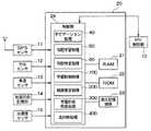
本発明の第1実施形態に係る道路勾配推定装置を搭載したハイブリッド車両の概略構成を図1に示す。このハイブリッド車両には、エンジン1、発電機2、モータ3、差動装置4、タイヤ5a、タイヤ5b、インバータ6、DCリンク7、インバータ8、バッテリ9、HV制御部10が搭載されている。また、このハイブリッド車両には、GPSセンサ11、方位センサ12、車速センサ13、地図DB記憶部14、加速度センサ15およびナビゲーションECU20を有するナビゲーション装置が搭載されている。本実施形態における道路勾配推定装置は、このナビゲーション装置により構成されている。(First embodiment)
FIG. 1 shows a schematic configuration of a hybrid vehicle equipped with a road gradient estimation apparatus according to the first embodiment of the present invention. In this hybrid vehicle, an engine 1, a generator 2, a motor 3, a differential device 4, a
ハイブリッド車両は、エンジン1およびモータ3を動力源として走行する。エンジン1を動力源とする場合は、エンジン1の回転力が、図示しないクラッチ機構および差動装置4を介してタイヤ5a、5bに伝わる。また、モータ3を動力源とする場合は、バッテリ9の直流電力がDCリンク7およびインバータ8を介して交流電力に変換され、その交流電力によってモータ3が作動し、このモータ3の回転力が、差動装置4を介してタイヤ5a、5bに伝わる。以下、エンジン1のみを動力源とする走行のモードを、エンジン走行という。また、エンジン1およびモータ3のうち少なくともモータ3を動力源とする走行のモードを、アシスト走行という。 The hybrid vehicle runs using the engine 1 and the motor 3 as power sources. When the engine 1 is used as a power source, the rotational force of the engine 1 is transmitted to the
また、エンジン1の回転力は発電機2にも伝えられ、その回転力によって発電機2が交流電力を生成し、生成された交流電力はインバータ6、DCリンク7を介して直流電力に変換され、その直流電力がバッテリ9に蓄積される場合がある。このようなバッテリ9への充電は、燃料を使用したエンジン1の作動による充電である。以下、この種の充電を、内燃充電という。 The rotational force of the engine 1 is also transmitted to the generator 2, and the generator 2 generates AC power by the rotational force, and the generated AC power is converted into DC power via the inverter 6 and the DC link 7. The DC power may be stored in the battery 9 in some cases. Such charging of the battery 9 is charging by the operation of the engine 1 using fuel. Hereinafter, this type of charging is referred to as internal combustion charging.
また、図示しない制動機構によりハイブリッド車両が減速すると、その減速時の抵抗力がモータ3に回転力として加わり、この回転力によってモータ3が交流電力を生成し、生成された交流電力がインバータ8、DCリンク7を介して直流電力に変換され、その直流電力がバッテリ9に蓄積される。以下、この種の充電を、回生充電という。 Further, when the hybrid vehicle decelerates by a braking mechanism (not shown), a resistance force at the time of deceleration is applied to the motor 3 as a rotational force, and the motor 3 generates AC power by this rotational force. It is converted into direct current power via the DC link 7, and the direct current power is stored in the battery 9. Hereinafter, this type of charging is referred to as regenerative charging.
HV制御部10は、ナビゲーションECU20からの指令等に応じて、発電機2、モータ3、インバータ6、インバータ8、バッテリ9の上述のような作動の実行・非実行等を制御する。HV制御部10は、例えばマイクロコンピュータを用いて実現してもよいし、下記のような機能を実現するための専用の回路構成を有するハードウェアであってもよい。 The
より具体的には、HV制御部10は、現在SOC、基準SOC(基準残量の一例に相当する)という2つの値を記憶しており、また、以下の(A)、(B)の処理を行う。
(A)ナビゲーションECU20からの指令に基づいて、アシスト走行、内燃充電のタイミングの切り替えを行う。
(B)定期的に現在SOCをナビゲーションECU20に通知する。More specifically, the
(A) Based on a command from the
(B) The current SOC is periodically notified to the
SOC(State of Charge)とは、バッテリの残量を表す指標であり、その値が高いほど残量が多い。現在SOCは、現在のバッテリ9のSOCを示す。HV制御部10は、この現在SOCの値を、逐次バッテリ9の状態を検出することで、繰り返し更新する。 The SOC (State of Charge) is an index representing the remaining amount of the battery, and the higher the value, the more the remaining amount. The current SOC indicates the current SOC of the battery 9. The
GPSセンサ11、方位センサ12、および車速センサ13は、それぞれハイブリッド車両の位置、進行方向、走行速度を特定する周知のセンサである。地図DB記憶部14は、地図データを記憶する記憶媒体である。加速度センサ15は車両の加速度を特定する周知のセンサである。道路勾配(傾斜角)は車速センサ13と加速度センサ15を利用し算出する。なお、車速センサ13と加速度センサ15を利用して道路勾配を算出する手法は、周知技術である(例えば、特開平11−351864参照)。 The
地図データは、複数の交差点のそれぞれに対応するノードデータ、および、交差点と交差点を結ぶ道路区間すなわちリンクのそれぞれに対応するリンクデータを有している。1つのノードデータは、当該ノードの識別番号、所在位置情報、種別情報を含む。また、1つのリンクデータは、当該リンクの識別番号(以下、リンクIDという)、位置情報、種別情報等を含んでいる。 The map data has node data corresponding to each of a plurality of intersections, and link data corresponding to each of road sections or links connecting the intersections. One node data includes an identification number of the node, location information, and type information. One link data includes an identification number of the link (hereinafter referred to as a link ID), position information, type information, and the like.
ここで、リンクの位置情報には、当該リンクが含む形状補完点の所在位置データ、および、当該リンクの両端のノードおよび形状補完点のうち隣り合う2つを繋ぐセグメントのデータを含んでいる。各セグメントのデータは、当該セグメントのセグメントID、当該セグメントの向き、長さ等の情報を有している。 Here, the position information of the link includes the location data of the shape complement point included in the link and the data of the segment connecting two adjacent nodes and the shape complement points at both ends of the link. The data of each segment includes information such as the segment ID of the segment, the direction of the segment, and the length.
図2に示す様に、ナビゲーションECU20は、RAM21、ROM22、データ書き込み可能な耐久記憶媒体23、および制御部24を有している。耐久記憶媒体とは、ナビゲーションECU20の主電源の供給が停止してもデータを保持し続けることができる記憶媒体をいう。耐久記憶媒体23としては、例えば、ハードディスク、フラッシュメモリ、EEPROM等の不揮発性記憶媒体、および、バックアップRAMがある。 As shown in FIG. 2, the
制御部24は、ROM22または耐久記憶媒体23から読み出したプログラムを実行し、その実行の際にはRAM21、ROM22、および耐久記憶媒体23から情報を読み出し、RAM21および耐久記憶媒体23に対して情報の書き込みを行い、HV制御部10、GPSセンサ11、方位センサ12、車速センサ13、地図DB記憶部14、加速度センサ15等と信号の授受を行う。 The
制御部24の処理としては、GPSセンサ11、方位センサ12および車速センサ13から入力される信号に基づいてハイブリッド車両の自車位置を特定する自車位置特定処理、自車位置周辺の地図上に自車位置マークを表示させる地図表示処理、車速センサ13と加速度センサ15から入力される信号に基づいて走行道路における道路勾配を一定距離(例えば、10メートル)毎に算出するとともに同一セグメント内で算出された道路勾配を平均化することにより各セグメントの道路勾配を特定する道路勾配特定処理、標高メッシュデータを用いて走行道路のセグメント毎の道路勾配を推定する道路勾配推定処理等がある。 As the processing of the
また、制御部24は、ナビゲーション処理40、勾配学習処理50、勾配特定処理60、学習制御処理100、経路算出処理200、充電計画処理300、走行時処理400等の処理を、所定のプログラムを実行することで実現する。 In addition, the
ナビゲーション処理40は、ユーザ操作により特定された目的地までの案内経路を特定し、この案内経路に沿ってハイブリッド車両を走行させるための案内を、図示しない画像表示装置、スピーカ等を用いてドライバに対して行う処理である。 The
勾配学習処理50は、車速センサ13と加速度センサ15を利用して検出した道路勾配を耐久記憶媒体23に学習する処理である。図3に、勾配学習処理50のフローチャートを示す。制御部24は、走行中の道路のセグメントの端点(形状補完点)に到達する毎に、この勾配学習処理50を繰り返し実行する。 The
この勾配学習処理50では、まず、センサを利用して検出された走行道路の実際の道路勾配を取得する(S52)。具体的には、直前に走行したセグメントについてセンサを利用して検出された道路勾配を取得する。この直前に走行したセグメントの道路勾配は、道路勾配特定処理の処理結果から得ることができる。 In the
次に、標高メッシュデータを用いて特定された走行道路の道路勾配を取得する(S54)。具体的には、直前に走行したセグメントについて標高メッシュデータを用いて推定された道路勾配を取得する。この直前に走行したセグメントの道路勾配は、道路勾配推定処理の処理結果から得ることができる。なお、標高メッシュデータを用いて走行道路の道路勾配を推定する手法は周知である(例えば、特開2004−45340号公報参照)。 Next, the road gradient of the traveling road specified using the elevation mesh data is acquired (S54). Specifically, the road gradient estimated using the elevation mesh data for the segment that has traveled immediately before is acquired. The road gradient of the segment traveled immediately before this can be obtained from the processing result of the road gradient estimation process. A method for estimating the road gradient of the traveling road using the altitude mesh data is well known (see, for example, JP-A-2004-45340).
次に、標高メッシュデータを用いて推定された道路勾配値(標高勾配値)とセンサを用いて特定された道路勾配値(センサ勾配値)との差分が規定値以上か否かを判定する(S56)。具体的には、S54にて推定されたセグメントの道路勾配値とS52にてセンサを用いて特定された同一セグメントの道路勾配値との差分を算出し、その大きさが予め定められた規定値以上であるか否かを判定する。 Next, it is determined whether or not the difference between the road gradient value (elevation gradient value) estimated using the elevation mesh data and the road gradient value (sensor gradient value) specified using the sensor is equal to or greater than a predetermined value ( S56). Specifically, the difference between the road gradient value of the segment estimated in S54 and the road gradient value of the same segment specified using the sensor in S52 is calculated, and the magnitude of the difference is determined in advance. It is determined whether it is above.
ここで、例えば、ハイブリッド車両が橋やトンネルとなっている区間を走行し、各道路勾配値の差分の大きさが予め定められた規定値以上となった場合、S56の判定はYESとなり、次に、センサを利用して特定された道路勾配値を耐久記憶媒体23に記憶する(S58)。具体的には、S52にて取得した道路勾配値をその区間の道路勾配値としてセグメントID、リンクIDと関連付けて耐久記憶媒体23に記憶する。 Here, for example, when the hybrid vehicle travels in a section that is a bridge or a tunnel, and the magnitude of the difference between the road gradient values exceeds a predetermined value, the determination in S56 is YES, and the next In addition, the road gradient value specified by using the sensor is stored in the durable storage medium 23 (S58). Specifically, the road gradient value acquired in S52 is stored in the
また、ハイブリッド車両が地面とほぼ同一高さの道路を走行し、上記差分の大きさが規定値以上とならない場合には、S56の判定はNOとなり、耐久記憶媒体23に道路勾配を記憶することなく本処理を終了する。 If the hybrid vehicle runs on a road that is almost the same height as the ground and the magnitude of the difference does not exceed the specified value, the determination in S56 is NO and the road gradient is stored in the
上記した道路勾配学習処理50により、ハイブリッド車両が橋やトンネルとなっている区間を走行し、標高メッシュデータに基づいて推定された道路勾配値とセンサを利用して特定された道路勾配値の差分の大きさが規定値以上となった場合に限り、センサを利用して特定された道路勾配がその区間の道路勾配として耐久記憶媒体23に記憶され、道路勾配の学習が行われる。 By the road
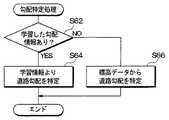
次に、図4に従って、制御部24による勾配特定処理について説明する。制御部24は、充電計画処理300にて特定区間の道路勾配の要求があると、この勾配特定処理60を実施する。 Next, the gradient specifying process by the
まず、学習した勾配情報があるか否かを判定する(S62)。具体的には、特定区間の道路勾配が耐久記憶媒体23に記憶されているか否かを判定する。 First, it is determined whether there is learned gradient information (S62). Specifically, it is determined whether or not the road gradient of the specific section is stored in the
特定区間の道路勾配が耐久記憶媒体23に記憶されている場合、S62の判定はYESとなり、次に、学習情報より道路勾配を特定する(S64)。具体的には、耐久記憶媒体23からその区間の道路勾配を読み出してその区間の道路勾配として特定する。 When the road gradient in the specific section is stored in the
また、特定区間の道路勾配が耐久記憶媒体23に記憶されていない場合、S62の判定はNOとなり、標高メッシュデータを用いて道路勾配を特定する(S66)。具体的には、道路勾配特定処理によって標高メッシュデータを用いて推定された道路勾配をその区間の道路勾配として特定する。 If the road gradient of the specific section is not stored in the
上記勾配特定処理60により、耐久記憶媒体23に道路勾配が記憶されている区間については耐久記憶媒体23に記憶されている道路勾配がその区間の道路勾配として特定され、耐久記憶媒体23に道路勾配が記憶されていない区間については標高メッシュデータから推定した道路勾配がその区間の道路勾配として特定される。 By the
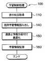
学習制御処理100において、制御部24は、ハイブリッド車両が走行した道路と、当該道路の走行時におけるバッテリ9の電力消費に影響する走行状況の履歴を、セグメント毎に、耐久記憶媒体23に記憶する。図5に、学習制御処理100のフローチャートを示す。なお、この処理において、同じセグメントでも走行方向が違えば異なるセグメントであるとして扱う。 In the
制御部24は、この図に示す学習制御処理100を繰り返し実行し、その繰り返しの各回において、まずステップ110で、現在の走行状況の情報を取得する。走行状況とは、走行時の外部環境、および、走行時の車両挙動のうちいずれかまたは両方の情報をいう。走行状況の情報として取得する情報は、例えば、現在走行中のリンクのリンクID、現在走行中のセグメントのセグメントID、現在の車両の向き、現在の車両の速度、当該リンクの道路種別、当該セグメントにおける消費電気量等を含む。 The
ここで、車両の向きは方位センサ12から取得できる。また、現在の車両の速度は車速センサ13から取得できる。また、当該道路の道路種別は、地図データから取得する。 Here, the direction of the vehicle can be acquired from the
続いてステップ140では、既存の学習情報の読み出しを行う。具体的には、ステップ110で取得したセグメントIDについての走行状況の履歴情報が、耐久記憶媒体23にあれば、それを読み出す。 In step 140, the existing learning information is read out. Specifically, if the history information of the running status for the segment ID acquired in step 110 is in the
続いてステップ150では、ステップ140で読み出した当該セグメントの情報と、ステップ110で新たに取得した当該セグメントの走行状況の情報とを組み合わせて最適化する。最適化としては、例えば、読み出した情報と新たに取得した情報の平均を算出する方法を採用してもよい。なお、ステップ140で、当該セグメントについての走行状況の履歴がなかった場合には、ステップ150では、ステップ110で取得したデータそのものを最適化されたデータとする。最適化された走行状況データは、セグメントIDが含まれているので、道路と、その道路における走行状況の情報とが紐付けられたデータである。 Subsequently, in
続いてステップ160では、最適化されたデータを、当該セグメントについての新たな走行状況の履歴、すなわち学習情報として、耐久記憶媒体23に記憶する。ステップ160の後、学習制御処理100の1回分の実行が終了する。 Subsequently, in step 160, the optimized data is stored in the
上記した勾配学習処理50および学習制御処理100を実行することで、充電可能地点周辺のセグメントのそれぞれについての走行状況の履歴が耐久記憶媒体23に記憶されることになる。 By executing the
図6に、耐久記憶媒体23に記憶される走行状況の履歴のテーブルの一例を、当該履歴に紐付けられた道路と併せて示す。この走行状況の履歴のテーブルにおいては、ノード21、補完形状点25、補完形状点26、ノード22の間に挟まれたセグメント31〜33について、当該セグメントを走行したときの車速、そのセグメントの道路勾配が記憶されている。なお、ノード21とノード22との間には橋が存在しており、勾配学習処理50によりセンサを利用して検出された各セグメント31〜33の道路勾配が記憶されている。これらの情報は、当該セグメントの走行時におけるバッテリ9の電力消費量、充電量に影響する。例えば、道路勾配が上り方向に急であればあるほど、車速が大きければ大きいほど、エンジン負荷が高まるので、そのセグメントでアシスト走行を行ったときの電力消費量は高くなる。また例えば、道路勾配が下り方向に急であればあるほど、そのセグメントで回生充電を行ったときの充電量は高くなる。 FIG. 6 shows an example of a travel situation history table stored in the
また、制御部24は、ステップ160において、自車両がどのような経路を走行したかの情報(以下、経路履歴という)を、自車両が走行する度に、学習情報の一部として耐久記憶媒体23に記憶する。具体的には、車両の走行(例えばエンジン始動からエンジンオフまで)毎に、その走行のあった日時、その走行において通ったリンクの順序、および目的地(すなわちその走行の終点)の情報を、周知のベイジアンネットモデルの学習データとして、耐久記憶媒体23に記憶する。 Further, in step 160, the
経路算出処理200は、現在位置から目的地に至る予定経路の経路算出を行い、この予定経路から後述する充電計画処理300の対称となる計画区間を決定する。なお、目的地については、ユーザ操作に基づいて決定してもよく、また、耐久記憶媒体23に記憶された学習データに基づいて決定してもよい。 The
充電計画処理300において、制御部24は、HV制御部10から現在SOCを取得し、当該現在SOCと耐久記憶媒体23に記憶された道路勾配等の学習情報に基づいて計画区間内の各セグメントにおいて当該セグメントを走行した場合にどれだけの量のエネルギーが必要かを算出し、目的地までのセグメント毎にアシスト走行と内燃充電の最適な切り替えタイミングを決定して充電計画を作成する。なお、セグメントの道路勾配を特定する際には、上記勾配特定処理60に従って道路勾配を特定する。更に、耐久記憶媒体23に記憶された道路勾配等の学習情報に基づいて目的地までの各地点における目標SOCを算出し、目的地までのSOCの推移を予想し、SOC管理計画を作成する。 In the
走行時処理400において、制御部24は、車両の走行に伴って現在位置に対応する目標SOCを現在のSOC管理計画から読み出し、読み出した目標SOCをHV制御部10に送信する。 In the
この目標SOCを受けることで、HV制御部10は、計画区間において、充電計画による走行方向から導かれたSOC管理計画に沿うように車両の走行方法を制御する。その結果、HV制御部10は、充電計画通りに車両の制御方法を制御することができ、燃費の低減を実現することができる。 By receiving this target SOC, the
上記した構成によれば、地形の標高を表す標高データに基づいて推定された区間毎の道路勾配とセンサを用いて検出された同一区間の道路勾配との差分を算出し、その大きさが予め定められた規定値以上であることを判定した場合、センサを用いて検出された道路勾配をその区間の道路勾配として耐久記憶媒体23に記憶し、耐久記憶媒体23に道路勾配が記憶されている区間については耐久記憶媒体23に記憶されている道路勾配がその区間の道路勾配として特定され、耐久記憶媒体23に道路勾配が記憶されていない区間については標高データに基づいて推定された道路勾配がその区間の道路勾配として特定される。 According to the above configuration, the difference between the road gradient for each section estimated based on the elevation data representing the altitude of the terrain and the road gradient of the same section detected using the sensor is calculated, and the magnitude is calculated in advance. When it is determined that the value is equal to or more than a predetermined value, the road gradient detected using the sensor is stored in the
例えば、車両が橋やトンネルとなっている区間を走行して、地形の標高を表す標高データに基づいて推定されたその区間の道路勾配とセンサを用いて検出されたその区間の道路勾配との差分の大きさが予め定められた規定値以上となった場合、センサを用いて検出された道路勾配がその区間の道路勾配として耐久記憶媒体23に記憶され、このようにして耐久記憶媒体23に道路勾配が記憶されている区間については耐久記憶媒体23に記憶されている道路勾配がその区間の道路勾配として特定されるので、橋やトンネルとなっている区間についても標高情報を用いて道路勾配を推定する場合と比較して、より正確に道路勾配を推定することができる。 For example, when a vehicle travels through a section that is a bridge or tunnel, the road gradient of the section estimated using altitude data representing the altitude of the terrain and the road gradient of the section detected using a sensor When the magnitude of the difference becomes equal to or greater than a predetermined value, the road gradient detected using the sensor is stored in the
(第2実施形態)
本発明の第2実施形態に係る道路勾配推定装置の構成は、第1実施形態と同一となっている。第1実施形態における制御部24は、車速センサ13と加速度センサ15を利用して特定した道路勾配を学習する勾配学習処理を実施する構成となっているが、本実施形態における制御部24は、これらのセンサを利用することなく標高メッシュデータに基づいて区間毎の道路勾配を推定する道路勾配推定処理を実施する。(Second Embodiment)
The configuration of the road gradient estimation apparatus according to the second embodiment of the present invention is the same as that of the first embodiment. The
図7に、本実施形態における制御部24による道路勾配推定処理のフローチャートを示す。制御部24は、経路算出処理200により現在位置から目的地に至る予定経路が特定されると、図7に示す道路勾配推定処理を実施する。 FIG. 7 shows a flowchart of road gradient estimation processing by the
まず、現在位置から目的地までの道路区間に存在する地点の標高情報を一定距離毎に標高メッシュデータから読み込む(S300)。具体的には、現在位置から目的地に至る予定経路上に一定距離(例えば、10メートル)毎に存在する各地点の標高情報を標高メッシュデータから読み込む。 First, the altitude information of the points existing in the road section from the current position to the destination is read from the altitude mesh data at regular intervals (S300). Specifically, the altitude information of each point existing every predetermined distance (for example, 10 meters) on the planned route from the current position to the destination is read from the altitude mesh data.
次に、標高情報から道路勾配を算出する(S302)。具体的には、予定経路における現在位置から一定距離区間(例えば、1キロメートル)について、隣り合う地点間の標高差および距離から各地点間の道路勾配(変換勾配)を算出する。 Next, a road gradient is calculated from the altitude information (S302). Specifically, for a certain distance section (for example, 1 kilometer) from the current position on the planned route, the road gradient (conversion gradient) between the points is calculated from the altitude difference and the distance between the adjacent points.
次に、S302にて算出された道路勾配と道路構造上取りうる道路勾配の最大値(閾値)とを比較して、道路構造上取りうる道路勾配の最大値よりも道路勾配が大きくなる区間が規定値M以上連続する区間があるか否かを判定する(S304)。この道路構造上取りうる勾配値は、例えば、国土交通省により定められた道路構造上取りうる道路勾配の最大値であり道路種別により異なる。例えば、高速道路の道路勾配の最大値は、一般道路の道路勾配の最大値よりも小さくなっている。なお、本実施形態では、予定経路として特定された道路の道路種別に応じて、この道路構造上取りうる勾配値を変更するようにしている。 Next, the road gradient calculated in S302 is compared with the maximum value (threshold value) of the road gradient that can be taken on the road structure, and a section in which the road gradient is larger than the maximum value of the road gradient that can be taken on the road structure is found. It is determined whether there is a section that continues for a predetermined value M or more (S304). The gradient value that can be taken from the road structure is, for example, the maximum value of the road gradient that can be taken from the road structure determined by the Ministry of Land, Infrastructure, Transport and Tourism, and varies depending on the road type. For example, the maximum value of the road gradient of an expressway is smaller than the maximum value of the road gradient of a general road. In the present embodiment, the gradient value that can be taken from the road structure is changed according to the road type of the road specified as the planned route.
ここで、道路構造上取りうる道路勾配の最大値よりも道路勾配が大きくなる区間が規定値M以上連続する区間がない場合、S304の判定はNOとなり、標高情報に基づいて各地点間の道路勾配を算出する(S306)。 Here, when there is no section in which the road gradient is larger than the maximum value of the road gradient that can be taken from the road structure, the determination in S304 is NO and the road between the points based on the altitude information. A gradient is calculated (S306).
また、道路構造上取りうる道路勾配の最大値よりも道路勾配が大きくなる区間が規定値M以上連続する区間がある場合、S304の判定はYESとなり、次に、道路構造上取りうる道路勾配の最大値よりも道路勾配が大きくなる連続した区間の両端の標高情報を用いてその区間の道路勾配を算出する(S310)。具体的には、その連続する区間の途中地点で読み込まれた標高情報を除外して、その区間の両端の標高差および距離から各地点間の道路勾配を算出する。 If there is a section where the road gradient is greater than the maximum value of the road gradient that can be taken from the road structure, the determination in S304 is YES, and then the road gradient that can be taken from the road structure is determined. Using the altitude information at both ends of a continuous section where the road slope is larger than the maximum value, the road slope of that section is calculated (S310). Specifically, the altitude information read at the midpoints of the consecutive sections is excluded, and the road gradient between the points is calculated from the altitude difference and the distance at both ends of the section.
次に、道路構造上取りうる勾配値よりも道路勾配が規定値M以上連続して大きくなった区間について道路勾配を変更する(S312)。具体的には、道路構造上取りうる勾配値よりも道路勾配が規定値M以上連続して大きくなった区間について、S302にて算出された各地点間の道路勾配をS310にて算出された道路勾配に置き換える。 Next, the road gradient is changed for a section in which the road gradient is continuously greater than the specified value M by more than the gradient value that can be taken from the road structure (S312). Specifically, the road gradient calculated at S310 is calculated as the road gradient between the points calculated in S302 for a section in which the road gradient is continuously larger than the specified value M by a road structure. Replace with gradient.
S308では、目的地までの道路区間(予定経路)の全区間に対してS304〜S312に示した処理を実施したか否かを判定する。 In S308, it is determined whether or not the processing shown in S304 to S312 has been performed on all sections of the road section (planned route) to the destination.
予定経路の全区間に対してS304〜312に示した処理を実施していない場合、S308の判定はNOとなり、S302へ戻る。そして、予定経路における次の一定距離毎に、上記S304〜S312に示した処理を繰り返し実施する。 When the processes shown in S304 to 312 are not performed for all sections of the planned route, the determination in S308 is NO and the process returns to S302. And the process shown to said S304-S312 is repeatedly implemented for every next fixed distance in a planned path | route.
そして、予定経路の全区間に対してS304〜S312に示した処理を実施すると、S308の判定はYESとなり、本処理を終了する。 And if the process shown to S304-S312 is implemented with respect to all the sections of a plan path | route, determination of S308 will become YES and this process will be complete | finished.
上記した構成によれば、道路構造上取り得る道路勾配の最大値よりも大きくなる区間が連続して存在すると判定された場合、道路構造上取り得る道路勾配の最大値よりも道路勾配が大きくなる連続した区間の両端の標高を用いて連続した区間の道路勾配が推定される。 According to the configuration described above, when it is determined that there are consecutive sections that are larger than the maximum value of the road gradient that can be taken on the road structure, the road gradient becomes larger than the maximum value of the road gradient that can be taken on the road structure. The road gradient of the continuous section is estimated using the elevations at both ends of the continuous section.
例えば、橋やトンネル等により、地形の標高を表す標高データに基づいて推定された道路勾配が道路構造上取り得る道路勾配の最大値よりも大きくなる区間が連続して存在すると判定された場合、標高データに基づいて推定された道路勾配が道路構造上取り得る道路勾配の最大値よりも道路勾配が大きくなる連続した区間の両端の標高を用いて連続した区間の道路勾配が推定される。したがって、道路構造上取り得ない値として道路勾配を推定してしまうことがなくなり、より正確に道路勾配を推定することができる。 For example, when it is determined that there is a continuous section where the road gradient estimated based on the altitude data representing the altitude of the terrain is larger than the maximum value of the road gradient that can be taken on the road structure due to a bridge, tunnel, etc. The road gradient of the continuous section is estimated using the altitudes at both ends of the continuous section where the road gradient is larger than the maximum value of the road gradient that can be taken in the road structure. Therefore, the road gradient is not estimated as a value that cannot be obtained in the road structure, and the road gradient can be estimated more accurately.
(第3実施形態)
本発明の第3実施形態に係る道路勾配推定装置の制御部24による道路勾配推定処理のフローチャートを図8に示す。本実施形態に係る道路勾配推定装置は、第2実施形態に係る道路勾配推定装置と比較して、道路勾配推定処理が異なる。(Third embodiment)
FIG. 8 shows a flowchart of the road gradient estimation process by the
まず、現在位置から目的地までの道路区間の標高情報をセグメントの端点(形状補完点)毎に標高メッシュデータから読み込む(S400)。具体的には、現在位置から目的地に至る予定経路上に設定された各形状補完点の標高情報を標高メッシュデータから読み込む。 First, the elevation information of the road section from the current position to the destination is read from the elevation mesh data for each end point (shape complement point) of the segment (S400). Specifically, the altitude information of each shape complement point set on the planned route from the current position to the destination is read from the altitude mesh data.
次に、標高情報から道路勾配を算出する(S402)。具体的には、予定経路における隣り合う形状補完点間の標高差および距離から各地点間(セグメント)の道路勾配を算出する。 Next, a road gradient is calculated from the altitude information (S402). Specifically, the road gradient between points (segments) is calculated from the elevation difference and distance between adjacent shape complement points on the planned route.
次に、S402にて算出された道路勾配に道路構造上取りうる道路勾配の最大値(閾値)より大きくなるものが含まれるか否かを判定する(S404)。なお、この道路構造上取りうる道路勾配の最大値(閾値)は、その道路の種別に応じて変更することも可能となっている。 Next, it is determined whether or not the road gradient calculated in S402 includes a road gradient larger than the maximum value (threshold value) that can be taken from the road structure (S404). The maximum value (threshold value) of the road gradient that can be taken in this road structure can be changed according to the type of the road.
ここで、S402にて算出された道路勾配に道路構造上取りうる道路勾配の最大値(閾値)より大きくなるものが含まれない場合、S404の判定はNOとなり、標高情報に基づいて各地点間の道路勾配を算出する(S406)。 Here, when the road gradient calculated in S402 does not include a road gradient larger than the maximum value (threshold) of the road gradient that can be taken in the road structure, the determination in S404 is NO, and between each point based on the altitude information Is calculated (S406).
また、S402にて算出された道路勾配に道路構造上取りうる道路勾配の最大値(閾値)より大きくなるものが含まれる場合、S404の判定はYESとなり、次に、道路勾配が大きくなっている箇所が含まれる区間(リンク)の両端の標高情報を用いて道路勾配を算出する(S410)。具体的には、道路勾配が大きくなっている箇所が含まれる区間(リンク)の途中地点で読み込まれた標高情報を除外して、その区間(リンク)の両端の標高差および距離から各地点間の道路勾配を算出する。 If the road gradient calculated in S402 includes a road gradient greater than the maximum value (threshold value) that can be taken from the road structure, the determination in S404 is YES, and then the road gradient is large. A road gradient is calculated using the elevation information at both ends of the section (link) in which the location is included (S410). Specifically, excluding elevation information read at midpoints of a section (link) that includes a portion with a large road gradient, the distance between each point is determined from the elevation difference and distance at both ends of that section (link). Calculate the road gradient.
次に、道路勾配が大きくなっている箇所が含まれる区間について道路勾配を変更する(S412)。具体的には、道路勾配が大きくなっている箇所が含まれる区間について、S402にて算出された各地点間の道路勾配をS410にて算出された道路勾配に置き換える。 Next, the road gradient is changed for a section including a portion where the road gradient is large (S412). Specifically, for the section including the portion where the road gradient is large, the road gradient between the points calculated in S402 is replaced with the road gradient calculated in S410.
S408では、目的地までの道路区間(予定経路)の全区間に対してS404〜S412に示した処理を実施したか否かを判定する。 In S408, it is determined whether or not the processing shown in S404 to S412 has been performed on all sections of the road section (planned route) to the destination.
予定経路の全区間に対してS404〜412に示した処理を実施していない場合、S408の判定はNOとなり、S402へ戻る。そして、予定経路における次の一定距離毎に、上記S404〜S412に示した処理を繰り返し実施する。 When the process shown in S404 to 412 is not performed for all sections of the planned route, the determination in S408 is NO and the process returns to S402. And the process shown to said S404-S412 is repeatedly implemented for every next fixed distance in a planned path | route.
そして、予定経路の全区間に対してS404〜S412に示した処理を実施すると、S408の判定はYESとなり、本処理を終了する。 And if the process shown to S404-S412 is implemented with respect to all the sections of a plan path | route, determination of S408 will become YES and this process will be complete | finished.
上記した構成によれば、地形の標高を表す標高データに基づいて推定された道路勾配に道路構造上取り得る道路勾配の最大値よりも大きいものが含まれるか否かを判定し、標高データに基づいて推定された道路勾配に道路構造上取り得る道路勾配の最大値よりも大きいものが含まれると判定された場合、道路構造上取り得る道路勾配の最大値よりも推定された道路勾配が大きくなっている箇所を含む区間の両端の標高を用いて当該区間の道路勾配が推定される。 According to the above configuration, it is determined whether or not the road gradient estimated based on the altitude data representing the altitude of the terrain includes a road gradient that is larger than the maximum value of the road gradient that can be taken on the road structure. If it is determined that the road gradient estimated based on the road structure includes a value larger than the maximum value of the road gradient that can be taken from the road structure, the estimated road gradient is larger than the maximum value of the road gradient that can be taken from the road structure. The road gradient of the section is estimated using the altitudes at both ends of the section including the part.
例えば、橋やトンネル等により、地形の標高を表す標高データに基づいて推定された道路勾配に道路構造上取り得る道路勾配の最大値よりも大きいものが含まれると判定された場合、道路構造上取り得る道路勾配の最大値よりも推定された道路勾配が大きくなっている箇所を含む区間の両端の標高を用いて当該区間の道路勾配が推定される。したがって、道路構造上取り得ない値として道路勾配を推定してしまうことがなくなり、より正確に道路勾配を推定することができる。 For example, if it is determined that the road gradient estimated based on the elevation data representing the elevation of the terrain, such as a bridge or tunnel, includes a road gradient that is larger than the maximum value of the road gradient that can be taken in the road structure, The road gradient of the section is estimated using the altitudes at both ends of the section including the portion where the estimated road gradient is larger than the maximum possible road gradient. Therefore, the road gradient is not estimated as a value that cannot be obtained in the road structure, and the road gradient can be estimated more accurately.
(その他の実施形態)
上記実施形態では、S54、S66において、標高メッシュデータを用いて道路勾配を推定する例を示したが、標高メッシュデータに限定されるものではなく、例えば、等高線データを用いて道路勾配を推定してもよい。(Other embodiments)
In the above embodiment, an example in which the road gradient is estimated using the elevation mesh data in S54 and S66 is not limited to the elevation mesh data. For example, the road gradient is estimated using the contour data. May be.
また、上記第1実施形態では、車速センサ13と加速度センサ15から入力される信号に基づいて走行道路における道路勾配を特定する道路勾配特定処理を実施する例を示したが、これらのセンサに限定されるものではなく、例えば、3軸ジャイロセンサから出力されるピッチ角情報や、傾斜計から出力される信号を利用して走行道路における道路勾配を検出してもよい。 In the first embodiment, the example in which the road gradient specifying process for specifying the road gradient on the traveling road based on the signals input from the
また、上記実施形態では、一定距離毎あるいはセグメント毎に道路勾配を算出する例を示したが、このような区間に限定されるものではなく、他の条件に従って区間毎の道路勾配を算出するようにしてもよい。 In the above embodiment, an example is shown in which the road gradient is calculated for each fixed distance or for each segment. However, the present invention is not limited to such a section, and the road gradient for each section is calculated according to other conditions. It may be.
なお、上記実施形態における構成と特許請求の範囲の構成との対応関係について説明すると、車速センサ13と加速度センサ15が道路勾配検出手段に相当し、S52が第1の道路勾配取得処理に相当し、S54が第2の道路勾配取得手段に相当し、耐久記憶媒体23が記憶手段に相当し、S56、S58が記憶制御手段に相当し、S62、S64、S66が道路勾配特定手段に相当し、S300、S302、S310、S312が第1の道路勾配推定手段に相当し、S304が道路勾配判定手段に相当し、S400、S402、S410、S412が第2の道路勾配推定手段に相当し、S404が第2の道路勾配判定手段に相当する。 The correspondence relationship between the configuration of the above embodiment and the configuration of the claims will be described. The
1…エンジン、2…発電機、3…モータ、4…差動装置、5a、5b…タイヤ、
6…インバータ、7…DCリンク、8…インバータ、9…バッテリ、
10…HV制御部、11…GPSセンサ、12…方位センサ、13…車速センサ、
14…地図DB記憶部、15…加速度センサ、20…ナビゲーションECU、
21…RAM、22…ROM、23…耐久記憶媒体、24…制御部。DESCRIPTION OF SYMBOLS 1 ... Engine, 2 ... Generator, 3 ... Motor, 4 ... Differential gear, 5a, 5b ... Tire,
6 ... Inverter, 7 ... DC link, 8 ... Inverter, 9 ... Battery,
DESCRIPTION OF
14 ... map DB storage unit, 15 ... acceleration sensor, 20 ... navigation ECU,
21... RAM, 22... ROM, 23... Durable storage medium, 24.
Claims (6)
Translated fromJapanese前記道路勾配検出手段を用いて特定された区間毎の道路勾配を取得する第1の道路勾配取得手段と、
地形の標高を表す標高データに基づいて推定された区間毎の道路勾配を取得する第2の道路勾配取得手段と、
前記第2の道路勾配取得手段により取得された前記道路勾配と前記第1の道路勾配取得手段により取得された同一区間の道路勾配との差分を算出し、その大きさが予め定められた規定値以上であることを判定した場合、前記道路勾配検出手段を用いて検出された前記道路勾配をその区間の道路勾配として記憶手段に記憶させる記憶制御手段と、
前記記憶手段に前記道路勾配が記憶されている区間については前記記憶手段に記憶されている前記道路勾配をその区間の道路勾配として特定し、前記記憶手段に前記道路勾配が記憶されていない区間については前記道路勾配推定手段により推定された前記道路勾配をその区間の道路勾配として特定する道路勾配特定手段と、を備えたことを特徴とする道路勾配推定装置。Road gradient detecting means for detecting the actual road gradient of the traveling road;
First road gradient acquisition means for acquiring a road gradient for each section specified using the road gradient detection means;
Second road gradient acquisition means for acquiring a road gradient for each section estimated based on altitude data representing the altitude of the terrain;
The difference between the road gradient acquired by the second road gradient acquisition unit and the road gradient of the same section acquired by the first road gradient acquisition unit is calculated, and the magnitude thereof is predetermined. A storage control unit that stores the road gradient detected using the road gradient detection unit in a storage unit as a road gradient of the section,
For the section in which the road gradient is stored in the storage means, the road gradient stored in the storage means is specified as the road gradient of the section, and for the section in which the road gradient is not stored in the storage means A road gradient estimation device comprising: a road gradient identification unit that identifies the road gradient estimated by the road gradient estimation unit as a road gradient of the section.
前記推定された道路勾配と道路構造上取り得る道路勾配の最大値とを比較して、道路構造上取り得る道路勾配の最大値よりも大きくなる区間が連続して存在するか否かを判定する第1の道路勾配判定手段と、を備え、
前記第1の道路勾配推定手段は、前記第1の道路勾配判定手段により前記道路構造上取り得る道路勾配の最大値よりも大きくなる区間が連続して存在すると判定された場合、前記道路構造上取り得る道路勾配の最大値よりも道路勾配が大きくなる連続した区間の両端の標高を用いて前記連続した区間の道路勾配を推定することを特徴とする道路勾配推定装置。First road gradient estimation means for estimating a road gradient for each predetermined section based on altitude data representing the altitude of the terrain;
The estimated road gradient is compared with the maximum value of the road gradient that can be taken on the road structure, and it is determined whether or not there are consecutive sections that are larger than the maximum value of the road gradient that can be taken on the road structure. First road slope determination means,
When the first road gradient estimation means determines that there are consecutive sections that are larger than the maximum value of the road gradient that can be taken on the road structure by the first road gradient determination means, A road gradient estimation apparatus for estimating a road gradient in a continuous section using elevations at both ends of the continuous section where the road gradient is larger than a maximum value of a possible road gradient.
前記推定された道路勾配に道路構造上取り得る道路勾配の最大値よりも大きいものが含まれるか否かを判定する第2の道路勾配判定手段と、を備え、
前記第2の道路勾配推定手段は、前記第2の道路勾配判定手段により前記推定された道路勾配に道路構造上取り得る道路勾配の最大値よりも大きいものが含まれると判定された場合、前記道路構造上取り得る道路勾配の最大値よりも前記推定された道路勾配が大きくなっている箇所が含まれる前記区間の両端の標高を用いて当該区間の道路勾配を推定することを特徴とする道路勾配推定装置。Second road gradient estimation that identifies the altitudes of a plurality of points existing in a predetermined section based on altitude data representing the altitude of the terrain and estimates the road gradient between the points from the altitudes of the specified points Means,
A second road gradient determination means for determining whether or not the estimated road gradient includes a value larger than a maximum value of a road gradient that can be taken on a road structure,
When the second road gradient estimation means determines that the road gradient estimated by the second road gradient determination means includes a road gradient larger than the maximum value of the road gradient that can be taken on the road structure, A road characterized in that the road gradient of the section is estimated using the altitudes at both ends of the section including a portion where the estimated road gradient is larger than the maximum value of the road gradient that can be taken from the road structure. Gradient estimation device.
Priority Applications (1)
| Application Number | Priority Date | Filing Date | Title |
|---|---|---|---|
| JP2007236585AJP5018363B2 (en) | 2007-09-12 | 2007-09-12 | Road gradient estimation device |
Applications Claiming Priority (1)
| Application Number | Priority Date | Filing Date | Title |
|---|---|---|---|
| JP2007236585AJP5018363B2 (en) | 2007-09-12 | 2007-09-12 | Road gradient estimation device |
Publications (2)
| Publication Number | Publication Date |
|---|---|
| JP2009068945Atrue JP2009068945A (en) | 2009-04-02 |
| JP5018363B2 JP5018363B2 (en) | 2012-09-05 |
Family
ID=40605365
Family Applications (1)
| Application Number | Title | Priority Date | Filing Date |
|---|---|---|---|
| JP2007236585AExpired - Fee RelatedJP5018363B2 (en) | 2007-09-12 | 2007-09-12 | Road gradient estimation device |
Country Status (1)
| Country | Link |
|---|---|
| JP (1) | JP5018363B2 (en) |
Cited By (5)
| Publication number | Priority date | Publication date | Assignee | Title |
|---|---|---|---|---|
| JP2012149995A (en)* | 2011-01-19 | 2012-08-09 | Nec System Technologies Ltd | Route search device, route search method and route search program |
| JP2017030468A (en)* | 2015-07-30 | 2017-02-09 | トヨタ自動車株式会社 | Hybrid-vehicular control apparatus |
| JP2018029409A (en)* | 2016-08-15 | 2018-02-22 | トヨタ自動車株式会社 | Electric vehicle |
| JP2018090052A (en)* | 2016-12-01 | 2018-06-14 | トヨタ自動車株式会社 | Electric vehicle |
| KR20210014969A (en)* | 2019-07-31 | 2021-02-10 | 현대엠엔소프트 주식회사 | Road slop information modeling apparatus and method based on ramer-douglas-peuker algorithm |
Citations (4)
| Publication number | Priority date | Publication date | Assignee | Title |
|---|---|---|---|---|
| JPH10177638A (en)* | 1996-12-18 | 1998-06-30 | Hitachi Ltd | Image display device |
| JP2002116029A (en)* | 2000-10-05 | 2002-04-19 | Nissan Motor Co Ltd | Method and apparatus for estimating grade of road |
| JP2004046746A (en)* | 2002-07-15 | 2004-02-12 | Aisin Aw Co Ltd | Road information inference device |
| JP2006119090A (en)* | 2004-10-25 | 2006-05-11 | Mitsubishi Electric Corp | Navigation device |
- 2007
- 2007-09-12JPJP2007236585Apatent/JP5018363B2/ennot_activeExpired - Fee Related
Patent Citations (4)
| Publication number | Priority date | Publication date | Assignee | Title |
|---|---|---|---|---|
| JPH10177638A (en)* | 1996-12-18 | 1998-06-30 | Hitachi Ltd | Image display device |
| JP2002116029A (en)* | 2000-10-05 | 2002-04-19 | Nissan Motor Co Ltd | Method and apparatus for estimating grade of road |
| JP2004046746A (en)* | 2002-07-15 | 2004-02-12 | Aisin Aw Co Ltd | Road information inference device |
| JP2006119090A (en)* | 2004-10-25 | 2006-05-11 | Mitsubishi Electric Corp | Navigation device |
Cited By (6)
| Publication number | Priority date | Publication date | Assignee | Title |
|---|---|---|---|---|
| JP2012149995A (en)* | 2011-01-19 | 2012-08-09 | Nec System Technologies Ltd | Route search device, route search method and route search program |
| JP2017030468A (en)* | 2015-07-30 | 2017-02-09 | トヨタ自動車株式会社 | Hybrid-vehicular control apparatus |
| JP2018029409A (en)* | 2016-08-15 | 2018-02-22 | トヨタ自動車株式会社 | Electric vehicle |
| JP2018090052A (en)* | 2016-12-01 | 2018-06-14 | トヨタ自動車株式会社 | Electric vehicle |
| KR20210014969A (en)* | 2019-07-31 | 2021-02-10 | 현대엠엔소프트 주식회사 | Road slop information modeling apparatus and method based on ramer-douglas-peuker algorithm |
| KR102568112B1 (en)* | 2019-07-31 | 2023-08-17 | 현대오토에버 주식회사 | Road slop information modeling apparatus and method based on ramer-douglas-peuker algorithm |
Also Published As
| Publication number | Publication date |
|---|---|
| JP5018363B2 (en) | 2012-09-05 |
Similar Documents
| Publication | Publication Date | Title |
|---|---|---|
| JP4694582B2 (en) | Drive control apparatus for hybrid vehicle | |
| US8433466B2 (en) | Drive control apparatus for hybrid electric vehicle and method for controlling the same | |
| JP5093321B2 (en) | Vehicle drive control device | |
| JP4715912B2 (en) | Drive control apparatus for hybrid vehicle | |
| JP5045685B2 (en) | Route guidance device, route guidance method and computer program | |
| JP5926558B2 (en) | Vehicle information system and server device | |
| CN104859643B (en) | Travel support device, travel support method, and drive support system | |
| JP4788643B2 (en) | Charge / discharge control device for hybrid vehicle and program for the charge / discharge control device | |
| JP5228366B2 (en) | Driving information collection system and driving information learning method | |
| JP5446934B2 (en) | Vehicle drive control device and travel section specifying device | |
| JP5920309B2 (en) | Movement support device, movement support method, and driving support system | |
| JP2010125868A (en) | Charge and discharge planning device | |
| JP2011063186A (en) | Vehicle drive controller | |
| JP2010143454A (en) | Driving controller for hybrid car, traveling plan creation device, and traveling path estimation device for vehicle | |
| US9346362B2 (en) | Energy estimation device, information system for automotive, and server device | |
| CN104867348B (en) | Travel holding equipment, traveling support method and driving support system | |
| JP2010132240A (en) | Running support apparatus, running support method, and computer program | |
| US20170043790A1 (en) | Movement assistance apparatus, movement assistance method, and driving assistance system based on the display of the driving modes according the different sections of the travel in the range allowed by the state of charge of the battery | |
| JP2020505262A (en) | Method of calculating management settings for managing fuel and power consumption of hybrid powered vehicles | |
| JP5018363B2 (en) | Road gradient estimation device | |
| JP2009023637A (en) | Charge-discharge management apparatus and program for charge-discharge management apparatus | |
| CN114599564B (en) | Determining a trajectory of a first vehicle taking into account the driving behavior of a second vehicle | |
| JP2017078871A (en) | Information system for vehicle, and server device | |
| JP5023894B2 (en) | Travel plan generator | |
| JP5992012B2 (en) | Energy management device |
Legal Events
| Date | Code | Title | Description |
|---|---|---|---|
| A621 | Written request for application examination | Free format text:JAPANESE INTERMEDIATE CODE: A621 Effective date:20091020 | |
| A977 | Report on retrieval | Free format text:JAPANESE INTERMEDIATE CODE: A971007 Effective date:20110511 | |
| A131 | Notification of reasons for refusal | Free format text:JAPANESE INTERMEDIATE CODE: A131 Effective date:20110517 | |
| A521 | Request for written amendment filed | Free format text:JAPANESE INTERMEDIATE CODE: A523 Effective date:20110714 | |
| A131 | Notification of reasons for refusal | Free format text:JAPANESE INTERMEDIATE CODE: A131 Effective date:20120207 | |
| A521 | Request for written amendment filed | Free format text:JAPANESE INTERMEDIATE CODE: A523 Effective date:20120409 | |
| TRDD | Decision of grant or rejection written | ||
| A01 | Written decision to grant a patent or to grant a registration (utility model) | Free format text:JAPANESE INTERMEDIATE CODE: A01 Effective date:20120515 | |
| A01 | Written decision to grant a patent or to grant a registration (utility model) | Free format text:JAPANESE INTERMEDIATE CODE: A01 | |
| A61 | First payment of annual fees (during grant procedure) | Free format text:JAPANESE INTERMEDIATE CODE: A61 Effective date:20120528 | |
| R151 | Written notification of patent or utility model registration | Ref document number:5018363 Country of ref document:JP Free format text:JAPANESE INTERMEDIATE CODE: R151 | |
| FPAY | Renewal fee payment (event date is renewal date of database) | Free format text:PAYMENT UNTIL: 20150622 Year of fee payment:3 | |
| R250 | Receipt of annual fees | Free format text:JAPANESE INTERMEDIATE CODE: R250 | |
| R250 | Receipt of annual fees | Free format text:JAPANESE INTERMEDIATE CODE: R250 | |
| R250 | Receipt of annual fees | Free format text:JAPANESE INTERMEDIATE CODE: R250 | |
| R250 | Receipt of annual fees | Free format text:JAPANESE INTERMEDIATE CODE: R250 | |
| R250 | Receipt of annual fees | Free format text:JAPANESE INTERMEDIATE CODE: R250 | |
| R250 | Receipt of annual fees | Free format text:JAPANESE INTERMEDIATE CODE: R250 | |
| R250 | Receipt of annual fees | Free format text:JAPANESE INTERMEDIATE CODE: R250 | |
| LAPS | Cancellation because of no payment of annual fees |