JP2008122298A - Information terminal device, monitoring method, and guidance method - Google Patents
Information terminal device, monitoring method, and guidance methodDownload PDFInfo
- Publication number
- JP2008122298A JP2008122298AJP2006308462AJP2006308462AJP2008122298AJP 2008122298 AJP2008122298 AJP 2008122298AJP 2006308462 AJP2006308462 AJP 2006308462AJP 2006308462 AJP2006308462 AJP 2006308462AJP 2008122298 AJP2008122298 AJP 2008122298A
- Authority
- JP
- Japan
- Prior art keywords
- terminal device
- information terminal
- straight line
- current position
- point
- Prior art date
- Legal status (The legal status is an assumption and is not a legal conclusion. Google has not performed a legal analysis and makes no representation as to the accuracy of the status listed.)
- Pending
Links
- 238000012544monitoring processMethods0.000titleclaimsabstractdescription91
- 238000000034methodMethods0.000titleclaimsdescription145
- 230000006870functionEffects0.000claimsdescription210
- 238000000605extractionMethods0.000claimsdescription87
- 230000008569processEffects0.000claimsdescription86
- 238000001514detection methodMethods0.000claimsdescription46
- 230000004044responseEffects0.000claimsdescription38
- 239000000284extractSubstances0.000claimsdescription20
- 230000003213activating effectEffects0.000claimsdescription4
- 230000004913activationEffects0.000claimsdescription2
- 230000006698inductionEffects0.000claims2
- 238000005259measurementMethods0.000description59
- 238000012545processingMethods0.000description21
- 238000010586diagramMethods0.000description17
- 238000004891communicationMethods0.000description6
- 238000005516engineering processMethods0.000description5
- 238000012986modificationMethods0.000description5
- 230000004048modificationEffects0.000description5
- 238000012935AveragingMethods0.000description4
- 238000009825accumulationMethods0.000description3
- 230000000694effectsEffects0.000description3
- 230000002411adverseEffects0.000description1
- 230000005540biological transmissionEffects0.000description1
- 230000007423decreaseEffects0.000description1
- 239000004973liquid crystal related substanceSubstances0.000description1
Images


Landscapes
- Position Fixing By Use Of Radio Waves (AREA)
- Mobile Radio Communication Systems (AREA)
- Navigation (AREA)
- Alarm Systems (AREA)
- Traffic Control Systems (AREA)
Abstract
Translated fromJapaneseDescription
Translated fromJapanese本発明は、地球上での緯度および経度を検出することにより現在位置を特定する機能を搭載した情報端末装置に関し、詳しくは、かかる機能を利用することで、情報端末装置を保持する者の所在位置を監視したり、あるいは目的地への誘導を行う技術に関する。 The present invention relates to an information terminal device equipped with a function for specifying a current position by detecting latitude and longitude on the earth, and in particular, by using such a function, the location of a person holding the information terminal device is determined. The present invention relates to a technique for monitoring a position or guiding to a destination.
通信技術やコンピュータ関連技術の進歩を受けて、携帯電話や、PDA(Personal Digital Assistance)、ノート型コンピュータなどの携帯情報端末装置には多彩な機能が搭載されるようになっている。こうした機能の中には、地球の衛星軌道上を周回するGPS(Global Positioning System )衛星や、存在位置の分かった発信局などが発信する電波を同時に3ヶ所以上から受信することで、地球上での緯度や経度などを検出して現在位置を特定する機能(位置特定機能)も搭載されている。特に、GPS衛星からの電波を受けて現在位置を特定する機能(いわゆるGPS機能)は比較的手軽に利用可能であることから、今日では、GPS機能を利用した種々のサービスが提案されている。 In response to advances in communication technology and computer-related technology, mobile information terminal devices such as mobile phones, PDAs (Personal Digital Assistance), and notebook computers are equipped with various functions. Among these functions, GPS (Global Positioning System) satellites orbiting the earth's satellite orbit, and radio waves transmitted from transmitting stations with known locations are received simultaneously from three or more locations on the earth. A function (position specifying function) for detecting the latitude and longitude of the current position and specifying the current position is also installed. In particular, since the function of identifying the current position by receiving radio waves from a GPS satellite (so-called GPS function) can be used relatively easily, various services using the GPS function have been proposed today.
例えば、携帯電話に搭載されたGPS機能を用いて現在位置を検出することにより、携帯電話をいわゆるナビゲーション装置として利用可能とする技術が提案されている。かかる技術によれば、GPS機能を用いて現在位置を検出するとともに、複数の地図データが記憶されているサーバ(地図データサーバ)に接続して、現在位置を含む地図データを読み込んでおく。そして、読み込んだ地図データを携帯電話の画面上に表示するとともに、GPS機能を用いて検出した現在位置を、画面上に表示された地図に重ねて表示することで、道に迷うことなく目的地に辿り着くことが可能となっている(特許文献1)。 For example, a technique has been proposed in which a mobile phone can be used as a so-called navigation device by detecting a current position using a GPS function mounted on the mobile phone. According to this technology, the current position is detected using the GPS function, and the map data including the current position is read by connecting to a server (map data server) in which a plurality of map data is stored. The read map data is displayed on the screen of the mobile phone, and the current position detected by using the GPS function is displayed on the map displayed on the screen so that the destination can be obtained without getting lost. It is possible to arrive at (patent document 1).
あるいは、携帯電話に搭載されたGPS機能を用いて検出した現在位置の情報を、地図データサーバやコンピュータ端末に送信することで、携帯電話の保持者が監視領域内に居るか否かを確認可能とした技術も提案されている。かかる技術によれば、地図データサーバに記憶されている地図データ上に監視領域を予め設定しておく。あるいは、地図データサーバからコンピュータ端末に地図データを読み込んで、コンピュータ端末上の地図データに対して監視領域を予め設定しておく。そして、携帯電話で検出した現在位置の情報を、これら地図データサーバあるいはコンピュータ端末に向かって送信し、携帯電話の現在位置と地図データとを照合することにより、携帯電話の保持者が監視領域内に居るか否かを確認することが可能となっている(特許文献2)。 Alternatively, it is possible to check whether the holder of the mobile phone is in the monitoring area by sending information on the current position detected using the GPS function installed in the mobile phone to the map data server or computer terminal. This technology has also been proposed. According to such a technique, the monitoring area is set in advance on the map data stored in the map data server. Alternatively, map data is read from the map data server to the computer terminal, and a monitoring area is set in advance for the map data on the computer terminal. Then, information on the current position detected by the mobile phone is transmitted to these map data servers or computer terminals, and the current position of the mobile phone is checked against the map data, so that the holder of the mobile phone can (Patent Document 2).
しかし、提案されている技術は何れも地図データを使用するため、複数の地図データを記憶した地図データサーバが必要となる。そのため、装置が全体として大掛かりになってしまったり、あるいは、地図データサーバへの接続時に認証が必要なために手軽に利用することが難しいという問題がある。また、こうした問題は、携帯電話などの携帯型の情報端末装置に限られるものではなく、カーナビゲーションシステム等のように携帯型ではない情報端末装置の場合にも同様に生じ得る。 However, since all the proposed techniques use map data, a map data server storing a plurality of map data is required. Therefore, there is a problem that the device becomes large as a whole or it is difficult to use easily because authentication is required when connecting to the map data server. Further, such a problem is not limited to a portable information terminal device such as a mobile phone, and may similarly occur in the case of an information terminal device that is not portable, such as a car navigation system.
この発明は、従来の技術における上述した課題に対応してなされたものであり、情報装置に搭載された位置特定機能を利用することで、目的地へ誘導する機能や、現在位置を監視する機能を、簡便に且つ手軽に利用可能とする技術の提供を目的とする。 The present invention has been made in response to the above-described problems in the prior art, and uses a position specifying function mounted on an information device to guide to a destination and to monitor a current position. The purpose of this is to provide a technique that makes it easy and easy to use.
上述した課題の少なくとも一部を解決するために、本発明の携帯情報端末装置は次の構成を採用した。すなわち、本発明の携帯情報端末装置は、
地球上での緯度および経度を検出することにより現在位置を特定する位置特定機能を搭載した携帯情報端末装置であって、
前記現在位置の緯度および経度によって示される座標点を、前記位置特定機能を用いて時系列的に検出する現在位置検出手段と、
前記時系列的に検出された座標点の集まりを折れ線によって近似し、該折れ線を、複数の折れ点の緯度および経度によって表された態様で、前記携帯情報端末装置の移動経路として記憶する移動経路記憶手段と、
前記位置特定機能を用いて特定した前記携帯情報端末装置の現在位置と、予め記憶されている前記移動経路との隔たりを表す偏差距離を算出する偏差距離算出手段と、
前記算出された偏差距離が、所定の閾値距離よりも大きい場合には、前記携帯情報端末装置が該閾値距離の範囲外にある旨を、予め登録されている連絡先に連絡する連絡手段と
を備え、
前記移動経路記憶手段は、
前記現在位置検出手段によって所定の複数個の座標点が検出されると、該座標点から直線を抽出する直線抽出手段と、
前記直線が抽出されたことを受けて、以降に検出される座標点が、該直線によって近似できるか否かを判断し、近似できないと判断された場合には、一つ前に検出された座標点を前記移動経路の折れ点として抽出する折れ点抽出手段と
を備えるとともに、
前記直線抽出手段は、前記折れ点が抽出された場合には、該折れ点より以降に検出された前記所定の複数個の座標点に基づいて、新たな直線を抽出する手段であることを要旨とする。In order to solve at least a part of the problems described above, the portable information terminal device of the present invention employs the following configuration. That is, the portable information terminal device of the present invention is
A portable information terminal device equipped with a position specifying function for specifying a current position by detecting latitude and longitude on the earth,
Current position detection means for detecting the coordinate point indicated by the latitude and longitude of the current position in time series using the position specifying function;
A moving route that approximates a collection of coordinate points detected in time series by a broken line, and stores the broken line as a moving route of the portable information terminal device in a manner represented by the latitude and longitude of a plurality of broken points Storage means;
A deviation distance calculating means for calculating a deviation distance representing a distance between the current position of the portable information terminal device specified using the position specifying function and the movement route stored in advance;
A contact means for contacting a pre-registered contact that the portable information terminal device is outside the range of the threshold distance when the calculated deviation distance is greater than a predetermined threshold distance; Prepared,
The movement route storage means includes
When a predetermined plurality of coordinate points are detected by the current position detection unit, a straight line extraction unit that extracts a straight line from the coordinate points;
In response to the fact that the straight line has been extracted, it is determined whether or not coordinate points detected thereafter can be approximated by the straight line. A break point extracting means for extracting a point as a break point of the travel route, and
The straight line extracting means is a means for extracting a new straight line based on the plurality of predetermined coordinate points detected after the broken point when the broken point is extracted. And
また、上記の携帯情報端末装置に対応する本発明の現在位置監視方法は、
地球上での緯度および経度を検出することにより現在位置を特定する位置特定機能を搭載した携帯情報端末装置の現在位置を監視する現在位置監視方法であって、
前記現在位置の緯度および経度によって示される座標点を、前記位置特定機能を用いて時系列的に検出する第1の工程と、
前記時系列的に検出された座標点の集まりを折れ線によって近似し、該折れ線を、複数の折れ点の緯度および経度によって表された態様で、前記携帯情報端末装置の移動経路として記憶する第2の工程と、
前記位置特定機能を用いて特定した前記携帯情報端末装置の現在位置と、予め記憶されている前記移動経路との隔たりを表す偏差距離を算出する第3の工程と、
前記算出された偏差距離が、所定の閾値距離より大きい場合には、前記携帯情報端末装置が該閾値距離の範囲外にある旨を、予め登録されている連絡先に連絡する第4の工程と
を備え、
前記第2の工程は、
前記第1の工程によって所定の複数個の座標点が検出されたことを受けて、該座標点から直線を抽出する副工程(2−1)と、
前記直線が抽出されたことを受けて、以降に検出される座標点が、該直線によって近似できるか否かを判断し、近似できないと判断された場合には、一つ前に検出された座標点を前記移動経路の折れ点として抽出する副工程(2−2)と
を備えるとともに、
前記副工程(2−1)は、前記折れ点が抽出された場合には、該折れ点より以降に検出された前記所定の複数個の座標点に基づいて、新たな直線を抽出する副工程であることを要旨とする。In addition, the current position monitoring method of the present invention corresponding to the above-described portable information terminal device,
A current position monitoring method for monitoring a current position of a portable information terminal device equipped with a position specifying function for specifying a current position by detecting latitude and longitude on the earth,
A first step of detecting a coordinate point indicated by the latitude and longitude of the current position in time series using the position specifying function;
Secondly, a set of coordinate points detected in time series is approximated by a polygonal line, and the polygonal line is stored as a movement route of the portable information terminal device in a manner represented by the latitude and longitude of a plurality of polygonal points. And the process of
A third step of calculating a deviation distance indicating a distance between the current position of the portable information terminal device specified using the position specifying function and the movement route stored in advance;
A fourth step of contacting a pre-registered contact that the portable information terminal device is outside the range of the threshold distance if the calculated deviation distance is greater than a predetermined threshold distance; With
The second step includes
A sub-step (2-1) for extracting a straight line from the coordinate points in response to detection of a plurality of predetermined coordinate points in the first step;
In response to the fact that the straight line has been extracted, it is determined whether or not coordinate points detected thereafter can be approximated by the straight line. A sub-step (2-2) for extracting a point as a break point of the travel route, and
The sub-step (2-1) is a sub-step of extracting a new straight line based on the plurality of predetermined coordinate points detected after the break point when the break point is extracted. It is a summary.
かかる本発明の携帯情報端末装置、およびに現在位置監視方法においては、携帯情報端末装置に搭載された位置特定機能を用いて現在位置の座標点を時系列的に検出し、それら座標点を折れ線近似した状態で、携帯情報端末装置の移動経路として予め記憶しておく。尚、折れ線近似した後は、近似の対象(すなわち、時系列的に検出した複数の座標点)は削除可能なことは言うまでもない。もちろん、全ての座標点あるいは一部の座標点を、後の処理で利用するために記憶しておいても構わない。そして、既に記憶されている移動経路を通る場合には、携帯情報端末装置の位置特定機能を用いて現在位置を特定し、既に記憶されている移動経路との隔たりを表す偏差距離を算出して、所定の閾値距離との大小関係を判断しながら移動する。その結果、算出した偏差距離の方が閾値距離よりも大きいと判断された場合には、携帯情報端末装置が該閾値距離の範囲外にある旨を、予め登録されている連絡先に連絡する。尚、連絡する形態としては、例えば、予め登録されているメールアドレスに向かって、所定のメールデータを送信することとしても良いし、あるいは予め登録されている電話番号に、自動で電話をかけて、所定の音声データを再生するなど、種々の形態で連絡することができる。 In the portable information terminal device and the current position monitoring method of the present invention, the coordinate point of the current position is detected in time series using the position specifying function mounted on the portable information terminal device, and the coordinate points are broken line. In the approximated state, it is stored in advance as the movement route of the portable information terminal device. Needless to say, after the polygonal line approximation, the approximation target (that is, a plurality of coordinate points detected in time series) can be deleted. Of course, all or some of the coordinate points may be stored for use in later processing. And when passing the already stored movement route, the current position is specified using the position specifying function of the portable information terminal device, and the deviation distance indicating the distance from the already stored movement route is calculated. , Moving while judging the magnitude relationship with a predetermined threshold distance. As a result, when it is determined that the calculated deviation distance is larger than the threshold distance, the mobile information terminal device is notified to a pre-registered contact that it is outside the range of the threshold distance. As a form of contact, for example, predetermined mail data may be sent to a pre-registered mail address, or a telephone number registered in advance is automatically called. It is possible to communicate in various forms such as reproducing predetermined audio data.
こうすれば、携帯情報端末装置に予め移動経路を記憶しておくだけで、携帯情報端末装置の現在位置が、移動経路から所定の閾値距離の範囲内にあるか否かを判断することができ、閾値距離の範囲外にあれば、予め登録されている連絡先にその旨を連絡することができる。その結果、地図データを用いることなく、簡便に、携帯情報端末装置の現在位置を監視することが可能となる。また、地図データを用いないことから地図データサーバが不要となるので、携帯情報端末装置の現在位置を監視するための装置構成が大掛かりになってしまうこともない。加えて、移動経路は、複数の座標点の軌跡を折れ線近似した状態で記憶されているので、携帯情報端末装置に搭載されている記憶容量を、移動経路を記憶しておくために大量に消費してしまうこともない。 In this way, it is possible to determine whether or not the current position of the portable information terminal device is within a predetermined threshold distance from the movement route simply by storing the movement route in advance in the portable information terminal device. If it is out of the range of the threshold distance, it can be notified to a pre-registered contact. As a result, the current position of the portable information terminal device can be easily monitored without using map data. In addition, since no map data server is required because no map data is used, the device configuration for monitoring the current position of the portable information terminal device does not become large. In addition, since the movement route is stored in a state where the trajectory of a plurality of coordinate points is approximated by a polygonal line, a large amount of storage capacity installed in the portable information terminal device is consumed to store the movement route. There is no end to it.
また、複数個の座標点から直線を抽出する際には、これら座標点に最小二乗法を適用することによって、直線を抽出することとしても良い。そして、抽出した直線と、先に抽出した直線との交点を検出し、その交点を、最終的に抽出された折れ点として確定することとしても良い。 Further, when a straight line is extracted from a plurality of coordinate points, the straight line may be extracted by applying a least square method to these coordinate points. And it is good also as detecting the intersection of the extracted straight line and the straight line extracted previously, and confirming the intersection as a finally extracted broken point.
現在位置の座標点が検出される位置は、必ずしも折れ点として適切な位置であるとは限らない。従って、直線を抽出した後に、直線同士の交点を求め、その交点に折れ点の位置を修正してやれば、移動経路をより適切に折れ線によって近似することが可能となる。 The position where the coordinate point of the current position is detected is not necessarily an appropriate position as a break point. Therefore, if the intersection of the straight lines is obtained after extracting the straight line and the position of the broken point is corrected at the intersection, the movement path can be more appropriately approximated by the broken line.
あるいは、折れ点から所定の複数個の座標点から検出された直線が、それ以降に検出された座標点も含めて、必ずしも適切に移動経路を近似する直線であるとは限らない。そこで、移動経路を折れ線近似することによって折れ点を検出した後、折れ点間で検出された複数の座標点に対して最小二乗法を適用することにより、直線を抽出し直して更新してもよい。そして、更新した直線と、一つ前に更新した直線との交点を検出し、検出した交点によって折れ点を更新することにより、移動経路を折れ線近似することとしても良い。尚、直線を抽出し直す際には、折れ点を含んだ複数の座標点に対して最小二乗法を適用して直線を抽出しても良い。また、必ずしも折れ点間の全ての座標点を用いて直線を抽出することには限らず、一部の座標点は考慮せずに直線を抽出しても構わない。 Alternatively, a straight line detected from a plurality of predetermined coordinate points from a break point is not necessarily a straight line that appropriately approximates the movement path, including coordinate points detected thereafter. Therefore, after detecting a break point by approximating a moving line with a broken line, a least square method is applied to a plurality of coordinate points detected between the broken points, so that a straight line can be re-extracted and updated. Good. Then, the intersection of the updated straight line and the straight line updated immediately before is detected, and the broken point is updated by the detected intersection, so that the moving route may be approximated by a broken line. When the straight line is re-extracted, the straight line may be extracted by applying the least square method to a plurality of coordinate points including break points. In addition, a straight line is not necessarily extracted using all coordinate points between break points, and a straight line may be extracted without considering some coordinate points.
こうして折れ点間の座標点に対して最小二乗法を適用して抽出した直線は、折れ点から所定の複数個の座標点から抽出した直線よりも、移動経路をより適切に近似していると考えることができる。そこで、折れ点から所定の複数個の座標点から検出した直線を、折れ点間の座標点から抽出し直した直線によって更新し、更新した直線を用いて折れ線近似してやれば、移動経路をより適切に近似することが可能となる。 The straight line extracted by applying the method of least squares to the coordinate points between the break points in this way approximates the movement path more appropriately than the straight line extracted from a plurality of predetermined coordinate points from the break points. Can think. Therefore, if the straight line detected from a plurality of predetermined coordinate points from the break points is updated with the straight lines extracted from the coordinate points between the break points, and the broken lines are approximated using the updated straight lines, the movement path is more appropriate. It is possible to approximate
また、上述した本発明の携帯情報端末装置においては、算出した偏差距離が閾値距離よりも小さい場合には、予め登録されている連絡先に所定の頻度で、その旨を連絡するようにしても良い。尚、所定の頻度としては、所定時間毎に連絡する場合に限らず、種々の条件を設定することができる。例えば、所定の距離だけ移動した場合に連絡することとしても良いし、その他、何らかの条件が成立した場合に連絡するようにしても良い。 Further, in the above-described portable information terminal device of the present invention, when the calculated deviation distance is smaller than the threshold distance, the fact is notified to the contact information registered in advance at a predetermined frequency. good. The predetermined frequency is not limited to the case of contacting every predetermined time, and various conditions can be set. For example, it may be notified when it has moved by a predetermined distance, or may be notified when some other condition is satisfied.
こうすれば、携帯情報端末装置が、移動経路の近傍にいる場合でも、所定の頻度でその旨を確認することが可能となる。 In this way, even when the portable information terminal device is in the vicinity of the movement route, it can be confirmed at a predetermined frequency.
あるいは、上述した本発明の携帯情報端末装置においては、現在位置と移動経路との間の偏差距離が閾値距離よりも小さい場合には、次のような条件が成立すると、携帯情報端末装置が移動経路の近くにいる旨を、予め登録されている連絡先に連絡するようにしても良い。すなわち、移動経路を、複数の領域に区分した状態で記憶しておく。そして、算出した偏差距離が閾値距離よりも小さい場合には、現在位置から最も近い領域を検出し、検出した領域が切り換わる度に、予め登録しておいた連絡先に、検出した領域を連絡することとしてもよい。 Alternatively, in the above-described portable information terminal device of the present invention, when the deviation distance between the current position and the movement route is smaller than the threshold distance, the portable information terminal device moves when the following condition is satisfied. You may make it notify the contact information registered beforehand that it is near the route. That is, the movement route is stored in a state divided into a plurality of areas. If the calculated deviation distance is smaller than the threshold distance, the closest area from the current position is detected, and the detected area is notified to the contact information registered in advance every time the detected area is switched. It is good to do.
こうすれば、携帯情報端末装置が、移動経路上に設けられた領域を跨ぐ度に、その旨が連絡されるので、携帯情報端末装置の移動に合わせて、適切な頻度で、途中経過の連絡を受け取ることができる。このため、携帯情報端末装置から、毎回同じ内容の連絡が送られてきて、連絡を受け取る側が煩雑に感じるおそれを回避することが可能となる。 In this way, every time the portable information terminal device crosses the area provided on the movement route, a notification to that effect is made. Therefore, the progress of the communication is notified at an appropriate frequency according to the movement of the portable information terminal device. Can receive. For this reason, it is possible to avoid the possibility that the communication information having the same content is sent from the portable information terminal device every time, and that the side receiving the communication feels complicated.
また、従来の技術が有する前述した課題の少なくとも一部を解決するために、本発明の第1の情報端末装置は、次の構成を採用した。すなわち、本発明の第1の情報端末装置は、
地球上での緯度および経度を検出することにより現在位置を特定する位置特定機能を搭載した情報端末装置であって、
前記現在位置の緯度および経度によって示される座標点を、前記位置特定機能を用いて時系列的に検出する現在位置検出手段と、
前記時系列的に検出された座標点の集まりを折れ線によって近似し、該折れ線を、複数の折れ点の緯度および経度によって表された態様で、前記情報端末装置の移動経路として記憶する移動経路記憶手段と、
前記移動経路上で始点に向かう方向または終点に向かう方向の何れか一方を、誘導方向として選択する誘導方向選択手段と、
前記位置特定機能を用いて特定した前記情報端末装置の現在位置と、予め記憶されている前記移動経路との隔たりを表す偏差距離を算出する偏差距離算出手段と、
前記算出された偏差距離が、所定の閾値距離より小さい場合には、該移動経路に沿って前記誘導方向に進むための方向に関する情報を出力し、該算出された偏差距離が該閾値距離よりも大きい場合には、該現在位置から該移動経路に戻るための方向に関する情報を出力することにより、前記情報端末装置の保持者を誘導する誘導手段と
を備え、
前記移動経路記憶手段は、
前記現在位置検出手段によって所定の複数個の座標点が検出されると、該座標点から直線を抽出する直線抽出手段と、
前記直線が抽出されたことを受けて、以降に検出される座標点が、該直線によって近似できるか否かを判断し、近似できないと判断された場合には、一つ前に検出された座標点を前記移動経路の折れ点として抽出する折れ点抽出手段と
を備えるとともに、
前記直線抽出手段は、前記折れ点が抽出された場合には、該折れ点より以降に検出された前記所定の複数個の座標点に基づいて、新たな直線を抽出する手段であることを要旨とする。Moreover, in order to solve at least a part of the above-described problems of the conventional technology, the first information terminal device of the present invention employs the following configuration. That is, the first information terminal device of the present invention is
An information terminal device equipped with a position specifying function for specifying a current position by detecting latitude and longitude on the earth,
Current position detection means for detecting the coordinate point indicated by the latitude and longitude of the current position in time series using the position specifying function;
A moving path storage that approximates a collection of coordinate points detected in time series by a broken line, and stores the broken line as a moving path of the information terminal device in a manner represented by the latitude and longitude of a plurality of broken points Means,
Guidance direction selection means for selecting either the direction toward the start point or the direction toward the end point on the movement path as a guidance direction;
Deviation distance calculating means for calculating a deviation distance representing a distance between the current position of the information terminal device specified using the position specifying function and the movement route stored in advance;
When the calculated deviation distance is smaller than a predetermined threshold distance, information on a direction for proceeding in the guidance direction along the movement route is output, and the calculated deviation distance is larger than the threshold distance. If it is larger, it comprises guidance means for guiding the holder of the information terminal device by outputting information on the direction for returning from the current position to the moving route,
The movement route storage means includes
When a predetermined plurality of coordinate points are detected by the current position detection unit, a straight line extraction unit that extracts a straight line from the coordinate points;
In response to the fact that the straight line has been extracted, it is determined whether or not coordinate points detected thereafter can be approximated by the straight line. A break point extracting means for extracting a point as a break point of the travel route, and
The straight line extracting means is a means for extracting a new straight line based on the plurality of predetermined coordinate points detected after the broken point when the broken point is extracted. And
また、上記の第1の情報端末装置に対応する本発明の第1の誘導方法は、
地球上での緯度および経度を検出することにより現在位置を特定する位置特定機能を搭載した情報端末装置を用いて、該情報端末装置の保持者を誘導する誘導方法であって、
前記現在位置の緯度および経度によって示される座標点を、前記位置特定機能を用いて時系列的に検出する工程(A)と、
前記時系列的に検出された座標点の集まりを折れ線によって近似し、該折れ線を、複数の折れ点の緯度および経度によって表された態様で、前記情報端末装置の移動経路として記憶する工程(B)と、
前記移動経路上で始点に向かう方向または終点に向かう方向の何れか一方を、誘導方向として選択する工程(C)と、
前記位置特定機能を用いて特定した前記情報端末装置の現在位置と、予め記憶されている前記移動経路との隔たりを表す偏差距離を算出する工程(D)と、
前記算出された偏差距離が、所定の閾値距離より小さい場合には、該移動経路に沿って前記誘導方向に進むための方向に関する情報を出力し、該算出された偏差距離が該閾値距離よりも大きい場合には、該現在位置から該移動経路に戻るための方向に関する情報を出力することにより、前記情報端末装置の保持者を誘導する工程(E)と
を備え、
前記工程(B)は、
前記工程(A)によって所定の複数個の座標点が検出されたことを受けて、該座標点から直線を抽出する副工程(B−1)と、
前記直線が抽出されたことを受けて、以降に検出される座標点が、該直線によって近似できるか否かを判断し、近似できないと判断された場合には、一つ前に検出された座標点を前記移動経路の折れ点として抽出する副工程(B−2)と
を備えるとともに、
前記副工程(B−1)は、前記折れ点が抽出された場合には、該折れ点より以降に検出された前記所定の複数個の座標点に基づいて、新たな直線を抽出する副工程であることを要旨とする。The first guiding method of the present invention corresponding to the first information terminal device described above is
A guidance method for guiding a holder of an information terminal device using an information terminal device equipped with a position identifying function for identifying a current position by detecting latitude and longitude on the earth,
A step (A) of detecting a coordinate point indicated by the latitude and longitude of the current position in time series using the position specifying function;
A step of approximating a collection of coordinate points detected in time series by a broken line, and storing the broken line as a moving path of the information terminal device in a manner represented by the latitude and longitude of a plurality of broken points (B )When,
Selecting either one of the direction toward the start point or the direction toward the end point on the movement route as a guide direction (C);
A step (D) of calculating a deviation distance representing a distance between the current position of the information terminal device specified using the position specifying function and the movement route stored in advance;
When the calculated deviation distance is smaller than a predetermined threshold distance, information on a direction for proceeding in the guidance direction along the movement route is output, and the calculated deviation distance is larger than the threshold distance. If it is larger, a step (E) of guiding the holder of the information terminal device by outputting information on the direction for returning from the current position to the moving route,
The step (B)
A sub-step (B-1) for extracting a straight line from the coordinate points in response to detection of a plurality of predetermined coordinate points in the step (A);
In response to the fact that the straight line has been extracted, it is determined whether or not coordinate points detected thereafter can be approximated by the straight line. A sub-process (B-2) for extracting a point as a break point of the travel route, and
The sub-step (B-1) is a sub-step of extracting a new straight line based on the predetermined plurality of coordinate points detected after the break point when the break point is extracted. It is a summary.
かかる本発明の第1の情報端末装置、および、これに対応する第1の誘導方法においても、情報端末装置に搭載された位置特定機能を用いて現在位置の座標点を時系列的に検出し、それら座標点を折れ線近似した状態で、情報端末装置の移動経路として予め記憶しておく。また、移動経路に基づいて誘導を行うに際しては、移動経路上で始点に向かう方向または終点に向かう方向の何れか一方を、誘導方向として選択しておく。そして、情報端末装置の位置特定機能を用いて現在位置を特定して、誘導に用いる移動経路との隔たりを表す偏差距離を算出し、所定の閾値距離と比較する。その結果、算出した偏差距離の方が閾値距離よりも小さい場合には、移動経路に沿って誘導方向に進むための方向に関する情報を出力し、逆に、算出した偏差距離の方が閾値距離よりも大きい場合には、現在位置から移動経路に戻るための方向に関する情報を出力する。尚、これらの情報を出力する形態としては、例えば、情報端末装置に表示画面が設けられている場合には、画面上に文字や図形などを表示するようにしても良いし、あるいは情報端末装置に音声の出力機能が搭載されている場合には、出力する内容に応じた音声データを再生することとしてもよい。 Also in the first information terminal device of the present invention and the first guidance method corresponding thereto, the coordinate point of the current position is detected in time series using the position specifying function installed in the information terminal device. The coordinate points are preliminarily stored as the movement route of the information terminal device in the state of approximating the broken line. When performing guidance based on the movement route, either the direction toward the start point or the direction toward the end point on the movement route is selected as the guidance direction. Then, the current position is specified using the position specifying function of the information terminal device, a deviation distance representing a distance from the moving route used for guidance is calculated, and compared with a predetermined threshold distance. As a result, if the calculated deviation distance is smaller than the threshold distance, information on the direction to travel in the guidance direction along the movement route is output, and conversely, the calculated deviation distance is smaller than the threshold distance. Is also larger, information on the direction for returning from the current position to the moving route is output. As a form of outputting these information, for example, when a display screen is provided in the information terminal device, characters or figures may be displayed on the screen, or the information terminal device. If a voice output function is installed, voice data corresponding to the content to be output may be reproduced.
こうすれば、情報端末装置に予め移動経路を記憶しておくだけで、移動経路に従って誘導することができるので、地図データを用いることなく、簡便に、情報端末装置の保持者を誘導することが可能となる。また、地図データを用いないことから地図データサーバが不要となるので、装置構成が大掛かりになることも回避することができる。加えて、移動経路は、折れ線近似されて、折れ点の座標点として記憶されるので、移動経路を記憶しておくために、情報端末装置の記憶容量が大量に使用されることもない。 In this way, it is possible to guide the user according to the travel route simply by storing the travel route in advance in the information terminal device. Therefore, it is possible to easily guide the holder of the information terminal device without using map data. It becomes possible. Further, since no map data is used, a map data server is not necessary, and it is possible to avoid an increase in the size of the apparatus. In addition, since the moving route is approximated by a broken line and stored as a coordinate point of the broken point, the storage capacity of the information terminal device is not used in large quantities in order to store the moving route.
あるいは、従来技術の有する前述した課題の少なくとも一部を解決するためには、次のような構成を採用することも可能である。すなわち、本発明の第2の情報端末装置は、
地球上での緯度および経度を検出することにより現在位置を特定する位置特定機能を搭載した情報端末装置であって、
前記現在位置の緯度および経度によって示される座標点を、前記位置特定機能を用いて時系列的に検出する現在位置検出手段と、
前記時系列的に検出された座標点の集まりを折れ線によって近似し、該折れ線を、複数の折れ点の緯度および経度によって表された態様で、前記情報端末装置の移動経路として記憶する移動経路記憶手段と、
前記移動経路上で始点に向かう方向または終点に向かう方向の何れか一方を、誘導方向として選択する誘導方向選択手段と、
前記位置特定機能を用いて特定した前記情報端末装置の現在位置と、予め記憶されている前記移動経路との隔たりを表す偏差距離を算出する偏差距離算出手段と、
前記算出された偏差距離が、所定の閾値距離より小さい場合には、該移動経路に沿って前記誘導方向に進むための方向に関する情報を出力し、該算出された偏差距離が該閾値距離よりも大きい場合には、該現在位置から前記終点に向かう方向に関する情報を出力することにより、前記情報端末装置の保持者を誘導する誘導手段と
を備え、
前記移動経路記憶手段は、
前記現在位置検出手段によって所定の複数個の座標点が検出されると、該座標点から直線を抽出する直線抽出手段と、
前記直線が抽出されたことを受けて、以降に検出される座標点が、該直線によって近似できるか否かを判断し、近似できないと判断された場合には、一つ前に検出された座標点を前記移動経路の折れ点として抽出する折れ点抽出手段と
を備えるとともに、
前記直線抽出手段は、前記折れ点が抽出された場合には、該折れ点より以降に検出された前記所定の複数個の座標点に基づいて、新たな直線を抽出する手段であることを要旨とする。Alternatively, in order to solve at least a part of the above-described problems of the prior art, it is possible to adopt the following configuration. That is, the second information terminal device of the present invention is
An information terminal device equipped with a position specifying function for specifying a current position by detecting latitude and longitude on the earth,
Current position detection means for detecting the coordinate point indicated by the latitude and longitude of the current position in time series using the position specifying function;
A moving path storage that approximates a collection of coordinate points detected in time series by a broken line, and stores the broken line as a moving path of the information terminal device in a manner represented by the latitude and longitude of a plurality of broken points Means,
Guidance direction selection means for selecting either the direction toward the start point or the direction toward the end point on the movement path as a guidance direction;
Deviation distance calculating means for calculating a deviation distance representing a distance between the current position of the information terminal device specified using the position specifying function and the movement route stored in advance;
When the calculated deviation distance is smaller than a predetermined threshold distance, information on a direction for proceeding in the guidance direction along the movement route is output, and the calculated deviation distance is larger than the threshold distance. If it is larger, it comprises guidance means for guiding the holder of the information terminal device by outputting information on the direction from the current position toward the end point, and
The movement route storage means includes
When a predetermined plurality of coordinate points are detected by the current position detection unit, a straight line extraction unit that extracts a straight line from the coordinate points;
In response to the fact that the straight line has been extracted, it is determined whether or not coordinate points detected thereafter can be approximated by the straight line. A break point extracting means for extracting a point as a break point of the travel route, and
The straight line extracting means is a means for extracting a new straight line based on the plurality of predetermined coordinate points detected after the broken point when the broken point is extracted. And
また、上述した第2の情報端末装置に対応する本発明の第2の誘導方法は、
地球上での緯度および経度を検出することにより現在位置を特定する位置特定機能を搭載した情報端末装置を用いて、該情報端末装置の保持者を誘導する誘導方法であって、
前記現在位置の緯度および経度によって示される座標点を、前記位置特定機能を用いて時系列的に検出する工程(ア)と、
前記時系列的に検出された座標点の集まりを折れ線によって近似し、該折れ線を、複数の折れ点の緯度および経度によって表された態様で、前記情報端末装置の移動経路として記憶する工程(イ)と、
前記移動経路上で始点に向かう方向または終点に向かう方向の何れか一方を、誘導方向として選択する工程(ウ)と、
前記位置特定機能を用いて特定した前記情報端末装置の現在位置と、予め記憶されている前記移動経路との隔たりを表す偏差距離を算出する工程(エ)と、
前記算出された偏差距離が、所定の閾値距離より小さい場合には、該移動経路に沿って前記誘導方向に進むための方向に関する情報を出力し、該算出された偏差距離が該閾値距離よりも大きい場合には、該現在位置から前記終点に向かう方向に関する情報を出力することにより、前記情報端末装置の保持者を誘導する工程(オ)と
を備え、
前記工程(イ)は、
前記工程(ア)によって所定の複数個の座標点が検出されたことを受けて、該座標点から直線を抽出する副工程(イ−1)と、
前記直線が抽出されたことを受けて、以降に検出される座標点が、該直線によって近似できるか否かを判断し、近似できないと判断された場合には、一つ前に検出された座標点を前記移動経路の折れ点として抽出する副工程(イ−2)と
を備えるとともに、
前記副工程(イ−1)は、前記折れ点が抽出された場合には、該折れ点より以降に検出された前記所定の複数個の座標点に基づいて、新たな直線を抽出する副工程であることを要旨とする。The second guiding method of the present invention corresponding to the second information terminal device described above is
A guidance method for guiding a holder of an information terminal device using an information terminal device equipped with a position identifying function for identifying a current position by detecting latitude and longitude on the earth,
(A) detecting the coordinate point indicated by the latitude and longitude of the current position in time series using the position specifying function;
A step of approximating a collection of coordinate points detected in time series with a broken line, and storing the broken line as a movement path of the information terminal device in a manner represented by the latitude and longitude of a plurality of broken points ( )When,
Selecting either one of the direction toward the start point or the direction toward the end point on the movement route as the guide direction (c);
A step (d) of calculating a deviation distance representing a distance between the current position of the information terminal device specified using the position specifying function and the movement route stored in advance;
When the calculated deviation distance is smaller than a predetermined threshold distance, information on a direction for proceeding in the guidance direction along the movement route is output, and the calculated deviation distance is larger than the threshold distance. If larger, the method includes (e) guiding the holder of the information terminal device by outputting information on the direction from the current position toward the end point.
The step (a)
In response to the detection of a plurality of predetermined coordinate points in step (a), a sub-step (A-1) for extracting a straight line from the coordinate points;
In response to the fact that the straight line has been extracted, it is determined whether or not coordinate points detected thereafter can be approximated by the straight line. A sub-process (A-2) for extracting a point as a breakpoint of the travel route, and
The sub-step (A-1) is a sub-step of extracting a new straight line based on the predetermined plurality of coordinate points detected after the break point when the break point is extracted. It is a summary.
かかる本発明の第2の情報端末装置、および第2の誘導方法においても、上述した第2の情報端末装置および第1の誘導方法と同様に、移動経路を予め記憶しておき、情報端末装置の現在位置から移動経路までの偏差距離を算出する。そして、算出した偏差距離の方が閾値距離よりも小さい場合には、移動経路に沿って誘導方向に進むための方向に関する情報を出力することによって誘導を行う。これに対して、算出した偏差距離の方が閾値距離よりも大きい場合には、現在位置から終点に向かう方向に関する情報を出力することによって、情報端末装置の保持者を誘導することとしてもよい。 In the second information terminal device and the second guidance method of the present invention, similarly to the second information terminal device and the first guidance method described above, the movement route is stored in advance, and the information terminal device The deviation distance from the current position to the movement route is calculated. When the calculated deviation distance is smaller than the threshold distance, guidance is performed by outputting information on a direction for proceeding in the guidance direction along the movement route. On the other hand, when the calculated deviation distance is larger than the threshold distance, the information terminal device holder may be guided by outputting information on the direction from the current position toward the end point.
このようにしても、情報端末装置に予め移動経路を記憶しておくだけで、地図データを用いることなく、簡便に、情報端末装置の保持者を誘導することが可能となる。また、移動経路を折れ線によって近似した後、その折れ線の折れ点を記憶しているので、比較的僅かな記憶容量で、移動経路を記憶しておくことが可能となる。 Even in this case, it is possible to easily guide the holder of the information terminal device by simply storing the travel route in advance in the information terminal device without using map data. Further, after approximating the movement route with a broken line, the broken point of the broken line is stored, so that the moving route can be stored with a relatively small storage capacity.
また、上述した本発明の携帯情報端末装置、第1の情報端末装置、または第2の情報端末装置においては、移動経路を記憶するに際して、次のようにしても良い。すなわち、移動経路の記憶中に所定の操作を行うと、その操作を行った位置での緯度および経度を検出し、得られた緯度および経度が表す座標点を、移動経路を近似する折れ点として設定できるようにしても良い。 Further, in the above-described portable information terminal device, first information terminal device, or second information terminal device of the present invention, when storing the movement route, the following may be performed. That is, when a predetermined operation is performed while the movement route is being stored, the latitude and longitude at the position where the operation is performed is detected, and the coordinate point represented by the obtained latitude and longitude is used as a break point that approximates the movement route. It may be settable.
こうすれば、曲がり角などが連続するような場合でも、必要に応じて折れ点を設定することができるので、十分な精度の移動経路を記憶しておくことが可能となる。 In this way, even when the turning corners and the like are continuous, it is possible to set a breakpoint as necessary, so that it is possible to store a sufficiently accurate movement path.
あるいは、上述した本発明の携帯情報端末装置、第1の情報端末装置、または第2の情報端末装置においては、移動経路の折れ点を検出した後、新たな直線を抽出するために検出する座標点については、他の座標点よりも高い頻度で検出するようにしても良い。 Alternatively, in the above-described portable information terminal device, first information terminal device, or second information terminal device of the present invention, coordinates detected in order to extract a new straight line after detecting a break point of the movement route You may make it detect a point more frequently than other coordinate points.
新たな直線を抽出する際には、抽出精度を確保する観点からは、ある程度、多数の座標点に基づいて抽出した方が望ましいが、その一方で、直線の抽出に時間がかかってしまう。そこで、新たな直線を抽出する際には座標点の検出頻度を高くしてやれば、抽出精度を確保しながら速やかに直線を抽出することができる。加えて、座標点の検出頻度を高くすれば、短い移動距離で直線を抽出することができるので、比較的短い距離で曲がり角が続いたような場合でも、適切に直線を抽出して、移動経路を記憶することが可能となる。 When extracting a new straight line, it is desirable to extract based on a large number of coordinate points to some extent from the viewpoint of ensuring the extraction accuracy, but on the other hand, it takes time to extract a straight line. Therefore, when extracting a new straight line, if the frequency of detecting coordinate points is increased, it is possible to quickly extract a straight line while ensuring the extraction accuracy. In addition, if the detection frequency of the coordinate points is increased, a straight line can be extracted with a short movement distance. Therefore, even when a corner continues at a relatively short distance, a straight line is appropriately extracted and the movement route is extracted. Can be stored.
また、上述した本発明の携帯情報端末装置、第1の情報端末装置、または第2の情報端末装置においては、直線が抽出された後、新たな折れ点を抽出するための座標点については、検出する頻度を変更可能としても良い。 Further, in the above-described portable information terminal device, first information terminal device, or second information terminal device of the present invention, after the straight line is extracted, the coordinate points for extracting a new break point are as follows: The frequency of detection may be changeable.
移動経路の精度を確保するためには、できるだけ密に座標点を検出した方が望ましいが、その一方で、座標点の検出頻度が高くなると、単に検出頻度が増えるだけでなく、検出の度に、座標点が直線で近似できるか否かの判断も必要になるので、処理の負担が大きくなる。このことから、移動経路を記憶する際には、座標点の間隔が適切な間隔となるように、現在位置の座標点を検出することが望ましい。従って、座標点を検出する頻度を変更可能としておけば、情報端末装置の移動速度に応じた頻度で座標点を計測することができるので、適切な間隔で座標点を検出しながら移動経路を記憶することが可能となる。 In order to ensure the accuracy of the movement path, it is desirable to detect the coordinate points as densely as possible, but on the other hand, if the detection frequency of the coordinate points increases, not only the detection frequency increases, Since it is necessary to determine whether or not the coordinate points can be approximated by a straight line, the processing load increases. Therefore, when storing the movement route, it is desirable to detect the coordinate point of the current position so that the coordinate point interval is an appropriate interval. Therefore, if the frequency of detecting the coordinate points can be changed, the coordinate points can be measured at a frequency according to the moving speed of the information terminal device, so that the movement path is stored while detecting the coordinate points at appropriate intervals. It becomes possible to do.
更には、上述した本発明の携帯情報端末装置、第1の情報端末装置、または第2の情報端末装置においては、移動経路の記憶を開始するための経路記憶開始ボタンと、移動経路の記憶を終了するための経路記憶終了ボタンとを設けておき、経路記憶開始ボタンが操作されたことを検出すると移動経路の記憶を開始して、経路記憶終了ボタンが操作されたことを検出したら、移動経路の記憶を終了するようにしても良い。 Furthermore, in the portable information terminal device, the first information terminal device, or the second information terminal device of the present invention described above, a route storage start button for starting the storage of the movement route and the storage of the movement route are provided. A route storage end button for ending, and when detecting that the route storage start button has been operated, storage of the movement route is started, and when it is detected that the route storage end button has been operated, the movement route This storage may be terminated.
こうすれば、移動経路の記憶開始と終了とを、分かり易く、且つ、簡単な操作で行うことが可能となる。 In this way, it is possible to easily start and end the storage of the travel route with a simple operation.
あるいは、上述した本発明の携帯情報端末装置は、次のような態様として把握することも可能である。すなわち、
地球上での緯度および経度を検出することにより現在位置を特定する位置特定機能を搭載した携帯情報端末装置であって、
前記現在位置の緯度および経度によって示される座標点を、前記位置特定機能を用いて時系列的に検出する現在位置検出手段と、
前記時系列的に検出された座標点の集まりを折れ線によって近似し、該折れ線を、複数の折れ点の緯度および経度によって表された態様で、前記携帯情報端末装置の移動経路として記憶する移動経路記憶手段と、
前記位置特定機能を用いて特定した現在位置から、予め記憶されている前記移動経路までの距離が、所定の閾値距離よりも大きい場合には該閾値距離の範囲外にある旨を、予め登録されている連絡先に連絡することにより、前記携帯情報端末装置の現在位置を監視する監視手段と、
前記移動経路記憶手段に関連付けられた第1の選択肢、および前記監視手段に関連付けられた第2の選択肢を、前記携帯情報端末装置の画面上に表示する選択肢表示手段と、
前記第1の選択肢または前記第2の選択肢が選択されたことを検出して、該選択肢に関連付けられた前記移動経路記憶手段または前記監視手段を起動する起動手段と
を備え、
前記移動経路記憶手段は、
前記現在位置検出手段によって所定の複数個の座標点が検出されると、該座標点から直線を抽出する直線抽出手段と、
前記直線が抽出されたことを受けて、以降に検出される座標点が該直線によって近似できるか否かを判断し、近似できないと判断された場合には、一つ前に検出された座標点を前記移動経路の折れ点として抽出する折れ点抽出手段と
を備えるとともに、
前記直線抽出手段は、前記折れ点が抽出された場合には、該折れ点より以降に検出された前記所定の複数個の座標点に基づいて、新たな直線を抽出する手段である携帯情報端末装置として把握することもできる。Or the portable information terminal device of this invention mentioned above can also be grasped | ascertained as the following aspects. That is,
A portable information terminal device equipped with a position specifying function for specifying a current position by detecting latitude and longitude on the earth,
Current position detection means for detecting the coordinate point indicated by the latitude and longitude of the current position in time series using the position specifying function;
A moving route that approximates a collection of coordinate points detected in time series by a broken line, and stores the broken line as a moving route of the portable information terminal device in a manner represented by the latitude and longitude of a plurality of broken points Storage means;
When the distance from the current position specified using the position specifying function to the movement route stored in advance is larger than a predetermined threshold distance, it is registered in advance that the distance is outside the range of the threshold distance. Monitoring means for monitoring the current position of the portable information terminal device by contacting
Option display means for displaying a first option associated with the movement path storage means and a second option associated with the monitoring means on the screen of the portable information terminal device;
An activation unit that detects that the first option or the second option is selected and activates the movement path storage unit or the monitoring unit associated with the option;
The movement route storage means includes
When a predetermined plurality of coordinate points are detected by the current position detection unit, a straight line extraction unit that extracts a straight line from the coordinate points;
In response to the extraction of the straight line, it is determined whether or not coordinate points detected thereafter can be approximated by the straight line. If it is determined that approximation cannot be performed, the coordinate point detected immediately before is determined. And a break point extracting means for extracting a break point as the break point of the travel route,
The straight line extraction means is a means for extracting a new straight line based on the predetermined plurality of coordinate points detected after the break point when the break point is extracted. It can also be grasped as a device.
このように、移動経路記憶手段と監視手段とを、それぞれ第1の選択肢および第2の選択肢に関連付けておき、これらの選択肢が選択された場合には、関連付けられている手段を起動するようにすれば、移動経路を記憶したり、記憶した移動経路に基づいて監視する機能を、簡単な操作によって利用することが可能となる。 As described above, the movement path storage means and the monitoring means are associated with the first option and the second option, respectively, and when these options are selected, the associated means is activated. By doing so, it is possible to use a function for storing a movement route or monitoring based on the stored movement route by a simple operation.
同様に、上述した本発明の第1の情報端末装置あるいは第2の情報端末装置についても、次のような態様で把握することができる。すなわち、
地球上での緯度および経度を検出することにより現在位置を特定する位置特定機能を搭載した情報端末装置であって、
前記現在位置の緯度および経度によって示される座標点を、前記位置特定機能を用いて時系列的に検出する現在位置検出手段と、
前記時系列的に検出された座標点の集まりを折れ線によって近似し、該折れ線を、複数の折れ点の緯度および経度によって表された態様で、前記情報端末装置の移動経路として記憶する移動経路記憶手段と、
前記移動経路上の始点または終点の何れか選択しておいた側に向かって、該移動経路に沿って進むための方向に関する情報を出力することにより、前記情報端末装置の保持者を誘導する誘導手段と
前記移動経路記憶手段に関連付けられた第1の選択肢、および前記誘導手段に関連付けられた第3の選択肢を、前記情報端末装置の画面上に表示する選択肢表示手段と、
前記第1の選択肢または前記第3の選択肢が選択されたことを検出して、該選択肢に関連付けられた前記移動経路記憶手段または前記誘導手段を起動する起動手段と
を備え、
前記移動経路記憶手段は、
前記現在位置検出手段によって所定の複数個の座標点が検出されると、該座標点から直線を抽出する直線抽出手段と、
前記直線が抽出されたことを受けて、以降に検出される座標点が該直線によって近似できるか否かを判断し、近似できないと判断された場合には、一つ前に検出された座標点を前記移動経路の折れ点として抽出する折れ点抽出手段と
を備えるとともに、
前記直線抽出手段は、前記折れ点が抽出された場合には、該折れ点より以降に検出された前記所定の複数個の座標点に基づいて、新たな直線を抽出する手段である情報端末装置として把握することもできる。Similarly, the first information terminal device or the second information terminal device of the present invention described above can be grasped in the following manner. That is,
An information terminal device equipped with a position specifying function for specifying a current position by detecting latitude and longitude on the earth,
Current position detection means for detecting the coordinate point indicated by the latitude and longitude of the current position in time series using the position specifying function;
A moving path storage that approximates a collection of coordinate points detected in time series by a broken line, and stores the broken line as a moving path of the information terminal device in a manner represented by the latitude and longitude of a plurality of broken points Means,
Guidance that guides the holder of the information terminal device by outputting information about the direction to travel along the moving path toward either the starting point or the ending point on the moving path. An option display means for displaying on the screen of the information terminal device, a first option associated with the movement route storage means, and a third option associated with the guidance means;
Activating means for detecting that the first option or the third option is selected and activating the movement path storage means or the guidance means associated with the option;
The movement route storage means includes
When a predetermined plurality of coordinate points are detected by the current position detection unit, a straight line extraction unit that extracts a straight line from the coordinate points;
In response to the extraction of the straight line, it is determined whether or not coordinate points detected thereafter can be approximated by the straight line. If it is determined that approximation cannot be performed, the coordinate point detected immediately before is determined. And a break point extracting means for extracting a break point as the break point of the travel route,
The straight line extracting means is an information terminal device that, when the break point is extracted, is a means for extracting a new straight line based on the predetermined plurality of coordinate points detected after the break point. Can also be grasped.
このように、移動経路記憶手段と誘導手段とを、それぞれ第1の選択肢および第3の選択肢に関連付けておき、これらの選択肢が選択された場合には、関連付けられている手段を起動するようにすれば、移動経路を記憶したり、記憶した移動経路に基づいて誘導する機能を、簡単な操作によって利用することが可能となる。 In this way, the movement route storage means and the guidance means are associated with the first option and the third option, respectively, and when these options are selected, the associated means is activated. By doing so, it becomes possible to use the function of storing the movement route or guiding based on the stored movement route by a simple operation.
更には、本発明の情報端末装置は、次のような形態として把握することも可能である。すなわち、
地球上での緯度および経度を検出することにより現在位置を特定する位置特定機能を搭載した情報端末装置であって、
前記現在位置の緯度および経度によって示される座標点を、前記位置特定機能を用いて時系列的に検出する現在位置検出手段と、
前記時系列的に検出された座標点の集まりを折れ線によって近似し、該折れ線を、複数の折れ点の緯度および経度によって表された態様で、前記情報端末装置の移動経路として記憶する移動経路記憶手段と、
前記移動経路上で始点に向かう方向または終点に向かう方向の何れか一方を、誘導方向として選択する誘導方向選択手段と、
前記位置特定機能を用いて特定した前記情報端末装置の現在位置と、予め記憶されている前記移動経路との隔たりを表す偏差距離を算出する偏差距離算出手段と、
前記算出された偏差距離が、所定の閾値距離より小さい場合には、該移動経路に沿って前記誘導方向に進むための方向に関する情報を出力し、該算出された偏差距離が該閾値距離よりも大きい場合には、該現在位置から該移動経路に戻るための方向に関する情報を出力することにより、前記情報端末装置の保持者を誘導する誘導手段と、
前記移動経路記憶手段が移動経路として記憶した前記折れ線を、前記携帯情報端末装置の画面上に表示する移動経路表示手段と
を備え、
前記移動経路記憶手段は、
前記現在位置検出手段によって所定の複数個の座標点が検出されると、該座標点から直線を抽出する直線抽出手段と、
前記直線が抽出されたことを受けて、以降に検出される座標点が該直線によって近似できるか否かを判断し、近似できないと判断された場合には、一つ前に検出された座標点を前記移動経路の折れ点として抽出する折れ点抽出手段と
を備えるとともに、
前記直線抽出手段は、前記折れ点が抽出された場合には、該折れ点より以降に検出された前記所定の複数個の座標点に基づいて、新たな直線を抽出する手段である情報端末装置として把握することも可能である。Furthermore, the information terminal device of the present invention can be grasped as the following forms. That is,
An information terminal device equipped with a position specifying function for specifying a current position by detecting latitude and longitude on the earth,
Current position detection means for detecting the coordinate point indicated by the latitude and longitude of the current position in time series using the position specifying function;
A moving path storage that approximates a collection of coordinate points detected in time series by a broken line, and stores the broken line as a moving path of the information terminal device in a manner represented by the latitude and longitude of a plurality of broken points Means,
Guidance direction selection means for selecting either the direction toward the start point or the direction toward the end point on the movement path as a guidance direction;
Deviation distance calculating means for calculating a deviation distance representing a distance between the current position of the information terminal device specified using the position specifying function and the movement route stored in advance;
When the calculated deviation distance is smaller than a predetermined threshold distance, information on a direction for proceeding in the guidance direction along the movement route is output, and the calculated deviation distance is larger than the threshold distance. If larger, guiding means for guiding the holder of the information terminal device by outputting information on the direction for returning from the current position to the moving route; and
Moving path display means for displaying the broken line stored as the moving path by the moving path storage means on the screen of the portable information terminal device, and
The movement route storage means includes
When a predetermined plurality of coordinate points are detected by the current position detection unit, a straight line extraction unit that extracts a straight line from the coordinate points;
In response to the extraction of the straight line, it is determined whether or not coordinate points detected thereafter can be approximated by the straight line. If it is determined that approximation cannot be performed, the coordinate point detected immediately before is determined. And a break point extracting means for extracting a break point as the break point of the travel route,
The straight line extracting means is an information terminal device that, when the break point is extracted, is a means for extracting a new straight line based on the predetermined plurality of coordinate points detected after the break point. It is also possible to grasp as.
こうして、記憶されている移動経路を情報端末装置の画面上に表示させれば、情報端末装置の保持者をより容易に誘導することが可能となる。 Thus, if the stored movement route is displayed on the screen of the information terminal device, the holder of the information terminal device can be guided more easily.
また、上述した本発明の現在位置監視方法あるいは誘導方法は、コンピュータに所定のプログラムを読み込ませて、必要な機能を発揮させることによっても実現可能である。従って、この点に着目すれば、本発明は、コンピュータを用いて各種の機能を発揮させるためのプログラムとして把握することも可能である。すなわち、上述した現在位置監視方法に対応する本発明のプログラムは、
地球上での緯度および経度を検出することにより現在位置を特定する位置特定機能を搭載した携帯情報端末装置の現在位置を監視する方法を、コンピュータを用いて実現するためのプログラムであって、
前記現在位置の緯度および経度によって示される座標点を、前記位置特定機能を用いて時系列的に検出する第1の機能と、
前記時系列的に検出された座標点の集まりを折れ線によって近似し、該折れ線を、複数の折れ点の緯度および経度によって表された態様で、前記携帯情報端末装置の移動経路として記憶する第2の機能と、
前記位置特定機能を用いて特定した前記携帯情報端末装置の現在位置と、予め記憶されている前記移動経路との隔たりを表す偏差距離を算出する第3の機能と、
前記算出された偏差距離が、所定の閾値距離より大きい場合には、前記携帯情報端末装置が該閾値距離の範囲外にある旨を、予め登録されている連絡先に連絡する第4の機能と
をコンピュータにより実現させるとともに、
前記第2の機能は、
前記第1の機能によって所定の複数個の座標点が検出されたことを受けて、該座標点から直線を抽出する副機能(2−1)と、
前記直線が抽出されたことを受けて、以降に検出される座標点が該直線によって近似できるか否かを判断し、近似できないと判断された場合には、一つ前に検出された座標点を前記移動経路の折れ点として抽出する副機能(2−2)と
を備え、
前記副機能(2−1)は、前記折れ点が抽出された場合には、該折れ点より以降に検出された前記所定の複数個の座標点に基づいて、新たな直線を抽出する副機能であることを要旨とする。In addition, the above-described current position monitoring method or guidance method of the present invention can also be realized by causing a computer to read a predetermined program and exhibit necessary functions. Therefore, paying attention to this point, the present invention can be grasped as a program for causing a computer to perform various functions. That is, the program of the present invention corresponding to the current position monitoring method described above is
A program for realizing, using a computer, a method for monitoring a current position of a portable information terminal device equipped with a position specifying function for specifying a current position by detecting latitude and longitude on the earth,
A first function for detecting a coordinate point indicated by the latitude and longitude of the current position in time series using the position specifying function;
Secondly, a set of coordinate points detected in time series is approximated by a polygonal line, and the polygonal line is stored as a movement route of the portable information terminal device in a manner represented by the latitude and longitude of a plurality of polygonal points. Functions and
A third function for calculating a deviation distance representing a distance between the current position of the portable information terminal device specified using the position specifying function and the movement route stored in advance;
A fourth function of contacting a pre-registered contact that the portable information terminal device is outside the range of the threshold distance when the calculated deviation distance is greater than a predetermined threshold distance; Is realized by a computer,
The second function is:
A sub-function (2-1) for extracting a straight line from the coordinate points in response to detection of a plurality of predetermined coordinate points by the first function;
In response to the extraction of the straight line, it is determined whether or not coordinate points detected thereafter can be approximated by the straight line. If it is determined that approximation cannot be performed, the coordinate point detected immediately before is determined. Sub-function (2-2) for extracting
The subfunction (2-1) is a subfunction for extracting a new straight line based on the predetermined plurality of coordinate points detected after the breakpoint when the breakpoint is extracted. It is a summary.
また、上述した第1の誘導方法に対応する本発明のプログラムは、
地球上での緯度および経度を検出することにより現在位置を特定する位置特定機能を搭載した情報端末装置を用いて、該情報端末装置の保持者を誘導する方法を、コンピュータを用いて実現するためのプログラムであって、
前記現在位置の緯度および経度によって示される座標点を、前記位置特定機能を用いて時系列的に検出する機能(A)と、
前記時系列的に検出された座標点の集まりを折れ線によって近似し、該折れ線を、複数の折れ点の緯度および経度によって表された態様で、前記情報端末装置の移動経路として記憶する機能(B)と、
前記移動経路上で始点に向かう方向または終点に向かう方向の何れか一方を、誘導方向として選択する機能(C)と、
前記位置特定機能を用いて特定した前記情報端末装置の現在位置と、予め記憶されている前記移動経路との隔たりを表す偏差距離を算出する機能(D)と、
前記算出された偏差距離が、所定の閾値距離より小さい場合には、該移動経路に沿って前記誘導方向に進むための方向に関する情報を出力し、該算出された偏差距離が該閾値距離よりも大きい場合には、該現在位置から該移動経路に戻るための方向に関する情報を出力することにより、前記情報端末装置の保持者を誘導する機能(E)と
をコンピュータにより実現させるとともに、
前記機能(B)は、
前記機能(A)によって所定の複数個の座標点が検出されたことを受けて、該座標点から直線を抽出する副機能(B−1)と、
前記直線が抽出されたことを受けて、以降に検出される座標点が該直線によって近似できるか否かを判断し、近似できないと判断された場合には、一つ前に検出された座標点を前記移動経路の折れ点として抽出する副機能(B−2)と
を備え、
前記副機能(B−1)は、前記折れ点が抽出された場合には、該折れ点より以降に検出された前記所定の複数個の座標点に基づいて、新たな直線を抽出する副機能であることを要旨とする。Further, the program of the present invention corresponding to the first guiding method described above is
To realize a method for guiding a holder of an information terminal device using a computer using an information terminal device equipped with a position specifying function for specifying a current position by detecting latitude and longitude on the earth The program of
A function (A) for detecting a coordinate point indicated by the latitude and longitude of the current position in time series using the position specifying function;
A function of approximating a set of coordinate points detected in time series with a polygonal line and storing the polygonal line as a movement path of the information terminal device in a manner represented by the latitude and longitude of a plurality of polygonal points (B )When,
A function (C) for selecting either the direction toward the start point or the direction toward the end point on the movement route as the guide direction;
A function (D) for calculating a deviation distance indicating a distance between the current position of the information terminal device specified using the position specifying function and the movement route stored in advance;
When the calculated deviation distance is smaller than a predetermined threshold distance, information on a direction for proceeding in the guidance direction along the movement route is output, and the calculated deviation distance is larger than the threshold distance. In the case of being large, the function (E) for guiding the holder of the information terminal device is realized by a computer by outputting information about the direction for returning from the current position to the moving route, and
The function (B) is
A sub-function (B-1) for extracting a straight line from the coordinate points in response to detection of a plurality of predetermined coordinate points by the function (A);
In response to the extraction of the straight line, it is determined whether or not coordinate points detected thereafter can be approximated by the straight line. If it is determined that approximation cannot be performed, the coordinate point detected immediately before is determined. Sub-function (B-2) for extracting as a breakpoint of the travel route,
The subfunction (B-1) is a subfunction for extracting a new straight line based on the predetermined plurality of coordinate points detected after the breakpoint when the breakpoint is extracted. It is a summary.
また、上述した第2の誘導方法に対応する本発明のプログラムは、
地球上での緯度および経度を検出することにより現在位置を特定する位置特定機能を搭載した情報端末装置を用いて、該情報端末装置の保持者を誘導する方法を、コンピュータを用いて実現するためのプログラムであって、
前記現在位置の緯度および経度によって示される座標点を、前記位置特定機能を用いて時系列的に検出する機能(ア)と、
前記時系列的に検出された座標点の集まりを折れ線によって近似し、該折れ線を、複数の折れ点の緯度および経度によって表された態様で、前記情報端末装置の移動経路として記憶する機能(イ)と、
前記移動経路上で始点に向かう方向または終点に向かう方向の何れか一方を、誘導方向として選択する機能(ウ)と、
前記位置特定機能を用いて特定した前記情報端末装置の現在位置と、予め記憶されている前記移動経路との隔たりを表す偏差距離を算出する機能(エ)と、
前記算出された偏差距離が、所定の閾値距離より小さい場合には、該移動経路に沿って前記誘導方向に進むための方向に関する情報を出力し、該算出された偏差距離が該閾値距離よりも大きい場合には、該現在位置から前記終点に向かう方向に関する情報を出力することにより、前記情報端末装置の保持者を誘導する機能(オ)と
をコンピュータにより実現させるとともに、
前記機能(イ)は、
前記機能(ア)によって所定の複数個の座標点が検出されたことを受けて、該座標点から直線を抽出する副機能(イ−1)と、
前記直線が抽出されたことを受けて、以降に検出される座標点が該直線によって近似できるか否かを判断し、近似できないと判断された場合には、一つ前に検出された座標点を前記移動経路の折れ点として抽出する副機能(イ−2)と
を備え、
前記副機能(イ−1)は、前記折れ点が抽出された場合には、該折れ点より以降に検出された前記所定の複数個の座標点に基づいて、新たな直線を抽出する副機能であることを要旨とする。Further, the program of the present invention corresponding to the second guiding method described above is
To realize a method for guiding a holder of an information terminal device using a computer using an information terminal device equipped with a position specifying function for specifying a current position by detecting latitude and longitude on the earth The program of
A function (a) for detecting the coordinate point indicated by the latitude and longitude of the current position in time series using the position specifying function;
A function of approximating a set of coordinate points detected in time series with a polygonal line, and storing the polygonal line as a movement path of the information terminal device in a manner represented by the latitude and longitude of a plurality of polygonal points (I )When,
A function (c) for selecting either the direction toward the start point or the direction toward the end point on the movement route as the guidance direction;
A function (d) for calculating a deviation distance representing a distance between the current position of the information terminal device specified using the position specifying function and the movement route stored in advance;
When the calculated deviation distance is smaller than a predetermined threshold distance, information on a direction for proceeding in the guidance direction along the movement route is output, and the calculated deviation distance is larger than the threshold distance. In the case of being large, the function (e) for guiding the holder of the information terminal device is realized by a computer by outputting information on the direction from the current position toward the end point, and
The function (b)
In response to the fact that a plurality of predetermined coordinate points are detected by the function (a), a sub-function (A-1) for extracting a straight line from the coordinate points;
In response to the extraction of the straight line, it is determined whether or not coordinate points detected thereafter can be approximated by the straight line. If it is determined that approximation cannot be performed, the coordinate point detected immediately before is determined. A sub-function (A-2) that extracts a as a breakpoint of the travel route,
The subfunction (A-1) is a subfunction for extracting a new straight line based on the predetermined plurality of coordinate points detected after the breakpoint when the breakpoint is extracted. It is a summary.
このようなプログラムをコンピュータに読み込ませて、上述した各種の機能を実現させれば、携帯情報端末装置の現在位置を監視する機能や、情報端末装置を目的地点に誘導する機能を、大掛かりな装置を用いることなく、簡便且つ手軽に利用することが可能となる。 If such a program is read into a computer and the various functions described above are realized, the function of monitoring the current position of the portable information terminal device and the function of guiding the information terminal device to the destination point are large-scale devices. It becomes possible to use it simply and easily without using.
以下では、上述した本願発明の内容を明確にするために、次のような順序に従って実施例を説明する。
A.実施例の概要:
B.情報端末装置の構成:
C.移動経路記憶処理:
D.移動経路監視処理:
E.移動経路誘導処理:
F:変形例:Hereinafter, in order to clarify the contents of the present invention described above, examples will be described in the following order.
A. Summary of Examples:
B. Configuration of information terminal device:
C. Travel route storage processing:
D. Travel route monitoring processing:
E. Travel route guidance processing:
F: Modification:
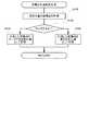
A.実施例の概要 :
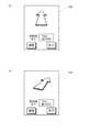
実施例の詳細な説明に先立って、理解の便宜を図るために、実施例の概要について簡単に説明しておく。図1は、本実施例の携帯情報端末装置100の大まかな構成を示した説明図である。図示されているように、本実施例の携帯情報端末装置100には、「現在位置検出モジュール」や、「移動経路記憶モジュール」、「偏差距離算出モジュール」など複数のモジュールが搭載されている。尚、ここで言う「モジュール」とは、携帯情報端末装置100が内部で行う処理を、機能に着目して便宜的に分類したものであり、従って「モジュール」は、プログラムの一部として実現することもできるし、あるいは、特定の機能を有する論理回路を用いて実現したり、更には、これらを組合せることによっても実現することが可能である。A. Summary of Examples:
Prior to the detailed description of the embodiments, the outline of the embodiments will be briefly described for the convenience of understanding. FIG. 1 is an explanatory diagram showing a rough configuration of the portable
「現在位置検出モジュール」は、地球の衛星軌道上を周回する3つ以上の人工衛星50からの電波を同時に受け取って、それぞれの人工衛星50までの距離を算出することにより、地球上での緯度および経度を検出して、現在位置を検出する機能を有している。尚、本実施例では、もっぱら人工衛星50からの電波を受け取って現在位置を検出するものとして説明するが、人工衛星50からの電波に限らず、所在地が分かっている発信源からの電波であれば、例えば地上に設けられた電波局からの電波を受け取って現在位置を検出することも可能である。また、「移動経路記憶モジュール」は、「位置特定モジュール」によって時系列的に検出された座標点(すなわち緯度および経度)の集まりを、折れ線によって近似して、その折れ線を、複数の折れ点の緯度および経度によって表された状態で、移動経路として記憶する機能を有している。更に「偏差距離算出モジュール」は、既に記憶されている移動経路が存在する場合に、「現在位置検出モジュール」によって検出された現在位置と、既に記憶されている移動経路との隔たりを表す偏差距離を算出する機能を有している。 The “current position detection module” simultaneously receives radio waves from three or more
「連絡モジュール」は、現在位置から移動経路までの偏差距離が、所定の閾値距離よりも大きいか否かを判断し、偏差距離の方が閾値距離よりも大きいと判断した場合には、その旨、すなわち、携帯情報端末装置100が移動経路から閾値距離の範囲外にある旨を、予め登録されている連絡先に連絡する。ここで、連絡方法としては、予め登録されている電話番号に電話をかけた後、所定の音声データを再生することとしてもよいし、あるいは、予め登録されているメールアドレスに向かって、所定のメールデータを送信することとしても良い。図1では、予め連絡先として登録されていた携帯電話12に向かって、無線基地局14を経由して電話がかけられ、あるいはメールデータが送信される様子が概念的に表現されている。このように、「現在位置検出モジュール」、「移動経路記憶モジュール」、「偏差距離算出モジュール」の3つのモジュールに加えて、「連絡モジュール」を搭載することにより、携帯情報端末装置100の現在位置を監視することが可能となる。 The “contact module” judges whether or not the deviation distance from the current position to the moving route is larger than a predetermined threshold distance, and if it is judged that the deviation distance is larger than the threshold distance, that fact That is, it notifies the contact information registered in advance that the portable
あるいは「現在位置検出モジュール」、「移動経路記憶モジュール」、「偏差距離算出モジュール」の3つのモジュールに加えて、「誘導方向選択モジュール」および「誘導モジュール」を携帯情報端末装置100に搭載すれば、携帯情報端末装置100の保持者を目的地へ誘導するための、簡易なナビゲーション装置として使用することが可能となる。すなわち、「誘導方向選択モジュール」には、予め記憶されている移動経路の始点側に向かって誘導するのか、終点側に向かって誘導するのかを選択する機能が搭載されている。また、「誘導モジュール」には、次のような機能が搭載されている。まず、現在位置と移動経路との距離を示す偏差距離を「偏差距離算出モジュール」から受け取って、その偏差距離が所定の閾値距離よりも大きいか否かを判断する。そして、偏差距離が閾値距離よりも小さいと判断された場合には、携帯情報端末装置100が概ね移動経路に沿った位置にいるものとして、移動経路上を予め選択しておいた誘導方向に進むための方向を出力する。一方、「偏差距離算出モジュール」から受け取った偏差距離が所定の閾値距離よりも大きいと判断された場合には、「誘導モジュール」は、現在位置から移動経路に戻るための方向を出力する。 Alternatively, in addition to the “current position detection module”, “movement path storage module”, and “deviation distance calculation module”, a “guidance direction selection module” and a “guidance module” are mounted on the portable
ここで、方向を出力する形態としては、携帯情報端末装置100の画面上に方向を表示するようにしても良いし、あるいは音声によって出力しても良い。また、出力する内容としては、現在の進行方向(または画面の向き)を基準として、進むべき方向を表示しても良いし、あるいは、単に東西南北のような方位を出力することとしても良い。方位磁石などによって東西南北の方向を知ることができれば、単に方位を出力するだけでも進むべき方向を知ることができる。このように、「現在位置検出モジュール」、「移動経路記憶モジュール」、「偏差距離算出モジュール」に加えて、「誘導方向選択モジュール」および「誘導モジュール」を携帯情報端末装置100に搭載すれば、携帯情報端末装置100を簡易なナビゲーション装置として使用することも可能となる。 Here, as a form of outputting the direction, the direction may be displayed on the screen of the portable
加えて、本実施例の携帯情報端末装置100は、現在位置を監視するために用いる場合でも、目的地への誘導のために用いる場合でも、地図データを用いることなく、それぞれの機能を実現することが可能である。加えて、移動経路は、折れ線近似されて、折れ点の緯度および経度によって表された状態で記憶されているので、多数の移動経路を記憶した場合でも、多くの記憶容量を消費することがない。このため、現在位置を監視する機能や、目的地へ誘導する機能を、簡便に且つ手軽に利用することが可能となる。以下では、このような本実施例の携帯情報端末装置100について、詳細に説明する。 In addition, the portable
B.情報端末装置の構成 :
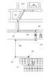
図2は、携帯電話を例にとって本実施例の携帯情報端末装置100の大まかな構成を示したブロック図である。携帯情報端末装置100には、液晶画面によって構成される表示画面102と、電話をかける等の種々の操作を行うための操作ボタン104と、通話時に用いられる集音マイク106と、通話時あるいは音声データの再生時に用いられるスピーカ108と、無線基地局14(あるいは無線ルータなど)と通信するためのアンテナ110と、着脱可能なメモリカード112など、携帯情報端末装置100を使用するための種々のディバイスが設けられている。B. Configuration of information terminal equipment:
FIG. 2 is a block diagram showing a rough configuration of the mobile
また、携帯情報端末装置100の内部には、これらディバイスを駆動するための駆動回路が設けられている。例えば、表示画面102はビデオドライバ120によって駆動されており、操作ボタン104はボタンキードライバ124によって駆動され、集音マイク106およびスピーカ108はサウンドプロセッサ126によって駆動されている。また、アンテナ110やメモリカード112は、それぞれアンテナドライバ128、カードドライバ130によって駆動されている。本実施例の携帯情報端末装置100では、これらの各種ドライバは、専用のLSIチップによって構成されている。更に、本実施例の携帯情報端末装置100には、いわゆるGPS機能を実現するためのGPSモジュール132や、東西南北の方位を検出するための方位磁石134も搭載されている。GPSモジュール132は、3つ以上のGPS衛星からの電波を受信して各GPS衛星との距離を算出することにより、地球上で携帯情報端末装置100が存在している現在位置の座標点(緯度および経度)を検出することが可能となっている。 In addition, a driving circuit for driving these devices is provided inside the portable
これら各種ドライバや、GPSモジュール132、方位磁石134などは、論理演算および算術演算を行うCPU150とデータをやり取り可能に接続されている。また、CPU150には、データを読み出すことはできるが書き込むことはできない不揮発メモリであるROM152と、データの読み出しも書き込みも可能な不揮発メモリであるRAM154とが接続されており、これらの不揮発メモリには、各種の制御プログラムが記憶されている。CPU150は、ROM152あるいはRAM154から制御プログラムを読み出すと、プログラムの実行時に生成されるデータをRAM154に記憶しながら、上述した各種ディバイスの動作を制御することにより、携帯情報端末装置100全体の動作を制御している。 These various drivers, the
表示画面102には、CPU150で実行されるプログラムに従って、種々の文字や図形などを表示可能となっている。また、後述するように本実施例の携帯情報端末装置100には、地図データを用いることなく、携帯情報端末装置100の現在位置を監視したり、道順を案内する機能が搭載されており、これらの機能は、ROM152に記憶されているアプリケーションプログラムをCPU150が読み出して、読み出したアプリケーションプログラムを実行しながら表示画面102に種々の表示を行うことによって実現されている。 Various characters and figures can be displayed on the
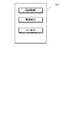
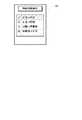
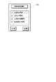
図3は、本実施例の携帯情報端末装置100を用いて現在位置の監視や道順の案内を行う際に、表示画面102に最初に表示される画面を例示した説明図である。図示されているように、表示画面102の中央には、それぞれ「経路記憶」、「監視実行」、「ナビ実行」と表記された3つのボタンが表示されており、以下に説明する操作ボタン104を用いて何れかのボタンを選択することが可能となっている。 FIG. 3 is an explanatory view exemplifying a screen that is first displayed on the
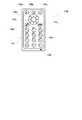
図4は、本実施例の携帯情報端末装置100に搭載された各種の操作ボタン104を示した説明図である。図示されているように、携帯情報端末装置100の本体部101には、中央のやや上方寄りの位置にカーソルボタン104dが設けられており、また、カーソルボタン104dの中央には選択ボタン104eが設けられている。カーソルボタン104dを操作することで、表示画面102上のカーソルを上下左右に移動させることができ、選択ボタン104eを押せば、カーソルがある位置の機能を選択することが可能となっている。例えば、図3に示した例では、カーソルが「経路記憶」と表示されたボタン上に存在しているが、カーソルボタン104dを用いてカーソルを移動させることができる。更に、カーソルを合わせた状態で選択ボタン104eを押してやれば、カーソルを合わせた位置に表示されている機能を選択することが可能となっている。 FIG. 4 is an explanatory diagram showing
また、カーソルボタン104dの上側には、3つの機能選択ボタン104a、104b、104cが設けられている。これらのボタンは、表示画面102の下部に機能が表示されている場合に有効となり、対応する位置のボタンを押すことによって、表示されている機能を使用することが可能となる。尚、図3に示した例では、表示画面102の下部には機能が表示されていないので、3つの機能選択ボタン104a、104b、104cは何れも無効な状態となっている。 In addition, three
カーソルボタン104dの左下方および右下方には、それぞれ受話器の図形が表示された通話開始ボタン104fおよび通話終了ボタン104gが設けられている。電話の着信中に左側の通話開始ボタン104fを押せば携帯電話として通話することが可能となり、右側の通話終了ボタン104gを押せば通話を終了することができる。また、こちらから電話をかける場合には、「1」〜「0」までの入力ボタン104hを用いて相手の電話番号を入力した後、入力ボタン104hの上方に設けられた通話開始ボタン104fを押すことで、相手を呼び出して通話することが可能となる。尚、電話の通話中は、入力ボタン104hの下方に設けられた集音マイク106が有効となり、こちらの話し声を拾って電気信号に変換した後、電波に載せて送信することができる。また、相手の話し声は表示画面102の上方に設けられた図示しないスピーカ108から音声として再生されるようになっている。 On the lower left and lower right of the
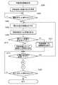
C.移動経路記憶処理 :
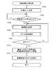
上述したように本実施例の携帯情報端末装置100では、地図データを用いることなく、携帯情報端末装置100の現在位置を監視したり、道順を案内することが可能となっている。こうしたことを、地図データを用いることなく可能とするためには、携帯情報端末装置100の移動経路を予め記憶しておく必要がある。ここで移動経路とは、携帯情報端末装置100に搭載されているGPSモジュール132を用いて現在位置を時系列的に検出し、得られた座標点の集まりを折れ線近似して記憶したデータであり、本実施例では、移動経路は、折れ線を構成する複数の折れ点の緯度および経度を示した一連のデータとして記憶されている。このような移動経路を記憶する処理は、図3に例示した画面上で「経路記憶」と表示されたボタンを選択することによって開始される。C. Travel route storage processing:
As described above, the portable
図5は、本実施例の携帯情報端末装置100で移動経路を記憶するために実行される処理の流れを示すフローチャートである。前述したように、かかる処理は、CPU150がROM152に記憶されているプログラムを読み出して実行することによって実現される処理である。以下、フローチャートに従って説明する。 FIG. 5 is a flowchart showing the flow of processing executed to store the movement route in the portable
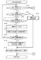
移動経路記憶処理では、先ず初めに、現在位置の座標点を計測するための計測モードを設定する処理を行う(ステップS100)。すなわち、図3に示した初期画面上で「経路記憶」と表示されたボタンを選択すると、表示画面102の表示は、座標点の計測モードを設定するための画面に切り換わり、その画面上でカーソルを移動させて選択することにより、計測モードを設定することが可能となっている。 In the movement path storage process, first, a process for setting a measurement mode for measuring the coordinate point of the current position is performed (step S100). That is, when the button displayed as “route storage” on the initial screen shown in FIG. 3 is selected, the display on the
図6は、本実施例の携帯情報端末装置100において計測モードとして設定すべき項目を例示した説明図である。図示されているように、本実施例の携帯情報端末装置100では、「計測精度」および「計測時間間隔」の2つの項目を設定するようになっている。このうち、「計測精度」という項目は、GPSモジュール132を用いて計測する緯度および経度の精度を設定する項目であり、本実施例では、いわゆる一般的なナビゲーションシステムよりも粗い精度で計測する設定と、一般的なナビゲーションシステムと同程度の細かい精度で計測する設定の、2つの設定が可能となっている。詳細には後述するが、本実施例の携帯情報端末装置100では、地図を用いることなく簡易な方法で、現在位置の監視や道順の案内を可能としており、このような簡易な方法では、緯度および経度の計測精度を多少落としても十分に実用可能である。そこで、一般的なナビゲーションシステムよりも粗い精度で計測するか、あるいは一般的なナビゲーションシステムと同程度の精度で計測するかを、予め選択しておくのである。 FIG. 6 is an explanatory diagram illustrating items to be set as the measurement mode in the portable
また、「計測時間間隔」という項目は、GPSモジュール132を用いて現在位置を計測する時間間隔を設定するための項目である。すなわち、GPSモジュール132を用いて計測できるのはあくまでも点の情報(現在位置の緯度および経度)であるため、座標点と座標点との間隔が離れすぎると、それらを折れ線近似して生成した移動経路の精度が低下してしまう。とは言え、移動経路を記憶するためには、単に座標点を検出するだけでなく、座標点を検出する度に新たな折れ点が発生しているか否かを判断しなければならないので、処理の負担が大きくなり過ぎてしまう。従って、移動経路を生成するための処理の負担と、生成した移動経路の精度との兼ね合いから、座標点を検出する間隔は適度に隔たっていることが好ましい。そこで、徒歩で移動している場合には、比較的長い時間間隔で現在位置の座標点を検出し、自転車で移動している場合にはより短い時間間隔で座標点を検出し、自動車で移動している場合には更に短い時間間隔で座標点を検出するように、座標点を計測する時間間隔を設定しておくのである。 The item “measurement time interval” is an item for setting a time interval for measuring the current position using the
尚、本実施例の携帯情報端末装置100では、「計測精度」および「計測時間間隔」の何れの項目については、予め設定されている中から選択することによって、段階的に切り換えるものとしているが、これらの項目を連続的に変更可能としても良い。図5に示した計測モードを設定する処理(ステップS100)では、以上のようにして、現在位置の座標点を計測する際の計測モードを設定する。 In the portable
計測モードを設定したら、今度は、開始ボタンが押されたか否かを判断する(ステップS102)。本実施例の携帯情報端末装置100では、本体部101の上部右側に設けられた機能選択ボタン104cが、開始ボタンに設定されている。未だ開始ボタンが押されていないと判断された場合は(ステップS102:no)、同じ判断を繰り返しながら、開始ボタンが押されるまで待機状態となる。そして、開始ボタンが押されたことが確認されたら(ステップS102:yes)、GPSモジュール132を用いて、現在位置の座標点(緯度および経度)の検出を開始する(ステップS104)。すなわち、記憶モードを設定した後(ステップS102)、移動経路の始点とする地点まで移動してから開始ボタンを押すことにより、所望の地点から移動経路の記憶を開始することが可能となっている。尚、開始ボタンが押されて移動経路の記憶が開始された後は、機能選択ボタン104cの機能は開始ボタンから終了ボタンに切り換わり、再び機能選択ボタン104cを押すことで、移動経路の記憶を終了させることが可能となる。この点については後述する。 Once the measurement mode is set, it is determined whether or not the start button has been pressed (step S102). In the portable
移動経路の記憶を開始すると、以下に説明する直線抽出処理(ステップS104)と折れ点抽出処理(ステップS106)とを繰り返し行うことによって、移動経路を近似する折れ線を生成しながら、折れ線を構成する複数の折れ点を記憶する処理を行う。 When storage of the movement path is started, a line is formed while generating a line that approximates the movement path by repeatedly performing a straight line extraction process (step S104) and a break point extraction process (step S106) described below. A process of storing a plurality of break points is performed.
図7は、移動経路を記憶するために、複数個の座標点から直線を抽出する処理(直線抽出処理)の流れを示したフローチャートである。図示されているように、直線抽出処理を開始すると、先ず初めに、線分の始点が取得されているか否かを判断する(ステップS130)。このような判断を行っているのは、次のような理由による。先ず、本実施例では、移動経路を折れ線によって近似した状態で記憶する。ここで、折れ線は複数の線分が連なったものであるから、ある線分の終点は同時に次の線分の始点となっており、従って、ほとんどの線分については、既に始点が決定されていて、傾きだけを決定すればよい状態となっている。しかし、折れ線の先頭にある線分についてだけは、前の線分が存在しないため、未だ始点が決定されていない。そこで、直線を抽出するに先立って、先ず、線分の始点が既に取得されているか否かを判断するのである。 FIG. 7 is a flowchart showing a flow of processing (straight line extraction processing) for extracting a straight line from a plurality of coordinate points in order to store the movement route. As shown in the figure, when the straight line extraction process is started, first, it is determined whether or not the start point of the line segment has been acquired (step S130). This determination is made for the following reason. First, in this embodiment, the movement route is stored in a state approximated by a broken line. Here, since a broken line is a series of multiple line segments, the end point of one line segment is the start point of the next line segment at the same time, and therefore the start point has already been determined for most line segments. Thus, only the inclination needs to be determined. However, only the line segment at the beginning of the broken line has no previous line segment, so the starting point has not been determined yet. Therefore, before extracting the straight line, first, it is determined whether or not the start point of the line segment has been acquired.
その結果、始点が取得されていないと判断された場合は(ステップS130:no)、現在位置の座標点(すなわち、緯度および経度)を計測して、得られた座標点を、線分の始点として記憶する(ステップS132)。尚、このようにして記憶された線分の始点は、同時に、移動経路の始点にもなっている。 As a result, when it is determined that the start point has not been acquired (step S130: no), the coordinate point (that is, latitude and longitude) of the current position is measured, and the obtained coordinate point is used as the start point of the line segment. (Step S132). The starting point of the line segment stored in this way is also the starting point of the movement path.
こうして始点が取得されているか否かを確認し(ステップS130)、そして、未だ取得されていない場合には始点を取得したら(ステップS132)、移動経路の記憶のために先に設定されている計測モード(図5のステップS100参照)を、直線抽出用の設定に切り換える処理を行う(ステップS134)。図6を用いて前述したように、現在位置の座標点を計測する計測モードとしては、計測精度および計測時間間隔について設定可能となっているが、直線抽出用には、計測時間間隔が「1秒毎」および計測精度が「細かい」の組合せが設定されている。これは、できるだけ短時間にしかも精度良く直線を抽出することを意図したものである。この点については、直線を抽出する方法について説明した後で、補足して説明する。 In this way, it is confirmed whether or not the start point has been acquired (step S130). If the start point has not yet been acquired (step S132), the measurement previously set for storing the movement path is performed. Processing for switching the mode (see step S100 in FIG. 5) to the setting for line extraction is performed (step S134). As described above with reference to FIG. 6, the measurement mode for measuring the coordinate point of the current position can be set with respect to the measurement accuracy and the measurement time interval. However, for straight line extraction, the measurement time interval is “1”. A combination of “every second” and a measurement accuracy of “fine” is set. This is intended to extract a straight line in as short a time as possible with high accuracy. This point will be supplementarily described after describing a method of extracting a straight line.
次いで、直線抽出用の計測時間間隔で、所定個数の座標点を計測した後(ステップS136)、それら座標点から直線の傾きを抽出する(ステップS138)。図8は、所定個数の座標点から直線の傾きを抽出している様子を示した説明図である。図8(a)は、直線の傾きを抽出するために、所定個数の座標点を計測した状態を表している。ここでは、直線の傾きを抽出するために、始点に加えて4個の座標点を用いるものとしており、これに対応して、図8(a)では、始点P0 と、続く4つの座標点P1 〜P4 が計測された状態を表している。もちろん、用いる座標点の個数は、始点を含めて5つである必要はない。座標点の個数が少なくなれば、迅速に直線を抽出することが可能となり、逆に座標点の個数が多くなれば、より適切な直線を抽出することが可能となる。 Next, after measuring a predetermined number of coordinate points at a measurement time interval for line extraction (step S136), the inclination of the line is extracted from these coordinate points (step S138). FIG. 8 is an explanatory diagram showing a state in which the slope of a straight line is extracted from a predetermined number of coordinate points. FIG. 8A shows a state in which a predetermined number of coordinate points are measured in order to extract the slope of the straight line. Here, in order to extract the inclination of the straight line, four coordinate points are used in addition to the start point. Correspondingly, in FIG. 8A, the start point P0 and the following four coordinate points P1 are used. ~ P4 represents the measured state. Of course, the number of coordinate points used need not be five including the start point. If the number of coordinate points decreases, it is possible to quickly extract a straight line. Conversely, if the number of coordinate points increases, a more appropriate straight line can be extracted.
直線の傾きを抽出するに際しては、始点P0 と、それ以降に計測された各座標点P1 〜P4 とを結んだ4本の線分の傾きを算出する。図8(b)に示したθ1 は、始点P0 と座標点P1 とを結んだ線分の傾きを表している。また、θ2 は、始点P0 と座標点P2 とを結ぶ線分の傾きを表しており、θ3は 、始点P0 と座標点P3 とを結ぶ線分の傾きを、そしてθ4 は、始点P0 と座標点P4 とを結ぶ線分の傾きを表している。このように、始点P0 と各座標点P1 〜P4 とを結ぶ線分の傾きにはバラツキが存在しているが、全体としてはほぼ同じ方向を向いており、携帯情報端末装置100の保持者はその方向に移動していると考えて良い。そこで、これら4本の線分の傾きの平均値を算出し、得られた値θave を直線の傾きとして抽出する。図8(c)には、それぞれの線分の傾きを平均することで、移動方向と考えられる直線の傾きが抽出された様子が示されている。ステップS138では、このようにして、始点に加えて所定個数(ここでは4個)の座標点から、直線の傾きを抽出する処理を行う。既に始点は決定されているから、このようにして直線の傾きを抽出してやれば、直線が抽出されたことになる。そこで、直線抽出用に切り換えた計測モードを、先に移動経路を記憶するためにステップS100で設定しておいた計測モードに戻した後(ステップS140)、図7に示す直線抽出処理を終了して、図5の移動経路記憶処理に復帰する。 When extracting the inclination of the straight line, the inclinations of four line segments connecting the starting point P0 and the coordinate points P1 to P4 measured thereafter are calculated. Θ1 shown in FIG. 8B represents the slope of the line segment connecting the starting point P0 and the coordinate point P1. Θ2 represents the slope of the line segment connecting the start point P0 and the coordinate point P2, θ3 represents the slope of the line segment connecting the start point P0 and the coordinate point P3, and θ4 represents the start point P0 and the coordinate point. It represents the slope of the line segment connecting P4. As described above, although there is a variation in the slope of the line segment connecting the starting point P0 and the coordinate points P1 to P4, the whole is in the same direction, and the holder of the portable
尚、図8に示した方法では、始点(図示した例ではP0 点)から各始点(図示した例では、P1 点〜P4 点)への傾きの平均を取ることによって、直線を抽出することとした。しかし、始点からの傾きではなく、続いて検出された座標点間の傾きを求め、これら傾きの平均を算出して直線を抽出しても良い。すなわち、始点P0 から座標点P1 への傾きと、座標点P1 から座標点P2 への傾き、座標点P2 から座標点P3 への傾き、座標点P3 から座標点P4 への傾きをそれぞれ求め、それら傾きの平均を算出する。そして、算出した平均の傾きで、始点P0 から伸びる直線を抽出することも可能である。もっとも、図8に示した方法は、常に始点からの傾きを求めればよいので、上述した方法よりも、傾きを求める処理を簡単にすることができる。また、検出する座標点にも誤差が含まれていることを考えると、隣接する座標点から傾きを求めるよりも、離れた座標点から傾きを求めた方が、座標点の誤差の影響を緩和することが可能であり、従って、より適切な直線を抽出することが可能となる。 In the method shown in FIG. 8, a straight line is extracted by averaging the slopes from the starting point (P0 point in the illustrated example) to each starting point (P1 to P4 point in the illustrated example). did. However, instead of the inclination from the starting point, the inclination between the detected coordinate points may be obtained, and an average of these inclinations may be calculated to extract a straight line. That is, the inclination from the starting point P0 to the coordinate point P1, the inclination from the coordinate point P1 to the coordinate point P2, the inclination from the coordinate point P2 to the coordinate point P3, and the inclination from the coordinate point P3 to the coordinate point P4 are obtained, respectively. Calculate the average of the slopes. It is also possible to extract a straight line extending from the starting point P0 with the calculated average inclination. However, since the method shown in FIG. 8 only needs to always obtain the inclination from the starting point, the process for obtaining the inclination can be simplified as compared with the method described above. Also, considering that errors are also included in the detected coordinate points, the effect of coordinate point errors is mitigated by obtaining the tilt from a distant coordinate point rather than obtaining the tilt from an adjacent coordinate point. Therefore, it is possible to extract a more appropriate straight line.
尚、上述したように本実施例の直線抽出処理では、始点と所定個数の座標点とに基づいて直線を抽出しているから、所定個数の座標点を計測するまでは、直線を抽出することができない。換言すれば、速やかに直線を抽出するためには、所定個数の座標点をある程度以内の短い時間で計測することが必要となる。前述した直線抽出用の計測モードでは、計測時間間隔が「1秒毎」と短い時間に設定されていたのは、このような点を考慮したためである。また、直線抽出用の計測モードで計測精度が「細かい」に設定されているのは、直線の傾きをできるだけ精度良く算出可能とするためである。もっとも、上述したように、直線の傾きは、複数の線分について得られた傾きを平均して算出しているため、計測精度が「粗い」設定のままでも、それほど大きな弊害が生じることはない。従って、簡便には、計測精度については、予め設定されている内容をそのまま用いることも可能である。 As described above, in the straight line extraction process of this embodiment, straight lines are extracted based on the starting point and a predetermined number of coordinate points. Therefore, until a predetermined number of coordinate points are measured, straight lines are extracted. I can't. In other words, in order to quickly extract a straight line, it is necessary to measure a predetermined number of coordinate points in a short time within a certain range. In the measurement mode for line extraction described above, the measurement time interval is set to a short time of “every second” because of this point. The reason why the measurement accuracy is set to “fine” in the measurement mode for line extraction is that the inclination of the line can be calculated as accurately as possible. However, as described above, the inclination of the straight line is calculated by averaging the inclinations obtained for a plurality of line segments, so even if the measurement accuracy is set to “rough”, there is no great adverse effect. . Therefore, for convenience, it is possible to use the preset contents as they are for the measurement accuracy.
また、上述した直線抽出処理では、必ず始点および所定個数(上述した例では4個)の座標点を用いて直線を抽出するものとしたが、次のようにしても良い。所定個数の座標点については、座標点を計測するたびに、始点とその座標点とを結ぶ線分の傾きを検出しておく。通常は、所定個数の座標点は、何れの座標点についてもほぼ同じような傾きが検出されるが、所定個数の座標点を全て計測する前に、大きく傾きが異なる座標点が検出された場合、あるいは傾きが大きく異なるだけでなく、同じ方向に異なる座標点が続いて検出された場合などには、それら傾きが大きく異なる座標点が計測される前までの座標点だけを用いて、直線を抽出することとしても良い。このようにしておけば、曲がり角の直ぐ後に曲がり角が来るような道を通った場合でも、適切に直線を抽出して移動経路として記憶することが可能となる。 In the straight line extraction process described above, a straight line is always extracted using the start point and a predetermined number of coordinate points (four in the above example), but may be as follows. For a predetermined number of coordinate points, every time the coordinate point is measured, the inclination of the line segment connecting the start point and the coordinate point is detected. Normally, a predetermined number of coordinate points are detected to have almost the same inclination at any coordinate point, but before a predetermined number of coordinate points are measured, a coordinate point with a significantly different inclination is detected. In addition, when not only the inclination is greatly different but also different coordinate points are detected in the same direction, the straight line is drawn using only the coordinate points before the coordinate points with greatly different inclinations are measured. It is good also as extracting. In this way, even when the vehicle travels on a road where a corner comes immediately after the corner, it is possible to appropriately extract a straight line and store it as a moving path.
以上のようにして、複数個の座標点から直線を抽出したら(図5のステップS104)、今度は、その直線の終わりを示す座標点(折れ点)を抽出するための折れ点抽出処理を開始する(ステップS106)。 When a straight line is extracted from a plurality of coordinate points as described above (step S104 in FIG. 5), a break point extraction process for extracting a coordinate point (break point) indicating the end of the straight line is started. (Step S106).
図9は、移動経路を記憶するために、直線の折れ点を抽出する処理(折れ点抽出処理)の流れを示したフローチャートである。折れ点抽出処理を開始すると、先ず初めに、終了ボタンが押されたか否かを判断する(ステップS160)。すなわち、図5を用いて前述したように、移動経路記憶処理の開始前は、機能選択ボタン104cに開始ボタンの機能が割り付けられており、機能選択ボタン104cを押すと、直線抽出処理(ステップS104)が行われ、続いて、折れ点抽出処理(ステップS106)が開始される。また、機能選択ボタン104cを押して直線抽出処理が開始されると、機能選択ボタン104cの機能は、開始ボタンとしての機能から終了ボタンの機能に切り換わり、再び機能選択ボタン104cを押すことによって、移動経路の記憶を終了させることができる。このことと対応して、折れ点抽出処理を開始すると、先ず初めに、機能選択ボタン104c(ここでは、終了ボタンとして機能している)が押されたか否かを判断し(ステップS160)、押されていた場合は(ステップS160:yes)、直ちに折れ点抽出処理を終了する。 FIG. 9 is a flowchart showing a flow of a process of extracting a break point of a straight line (break point extraction process) in order to store a movement route. When the break point extraction process is started, it is first determined whether or not the end button has been pressed (step S160). That is, as described above with reference to FIG. 5, before the movement path storing process is started, the function of the start button is assigned to the
終了ボタンが押されていないと判断された場合は(ステップS160:no)、今度は、手動で折れ点を設定するか否かを判断する(ステップS162)。以下に詳しく説明するように、折れ点は所定の時間間隔で計測される座標点の中から自動的に抽出されるものであるが、本体部101の上部左側に設けられた機能選択ボタン104a(図4参照)を押すと、手動で折れ点を設定することも可能となっている。そこで、終了ボタンが押されていないと判断された場合(ステップS160:no)、換言すれば、折れ点抽出処理を継続すると判断された場合は、続いて、折れ点を自動で抽出するのか、あるいは手動で設定するのかを判断するために、機能選択ボタン104aが押されたか否かを確認するのである(ステップS162)。 If it is determined that the end button has not been pressed (step S160: no), it is next determined whether to manually set a break point (step S162). As will be described in detail below, the break point is automatically extracted from the coordinate points measured at predetermined time intervals, but the
手動で折れ点を設定しないと判断された場合は(ステップS162:yes)、計測時間間隔が経過したか否かを判断する(ステップS164)。ここで計測時間間隔とは、現在位置の座標点(緯度および経度)を計測する時間の間隔であり、図5を用いて前述した移動経路記憶処理の中で計測モードとして予め設定されている。計測時間間隔が経過していないと判断された場合は(ステップS164:no)、計測時間間隔が経過したことが確認されるまで、そのまま待機状態となる。 If it is determined that the break point is not manually set (step S162: yes), it is determined whether the measurement time interval has elapsed (step S164). Here, the measurement time interval is a time interval for measuring the coordinate point (latitude and longitude) of the current position, and is set in advance as a measurement mode in the movement path storage process described above with reference to FIG. If it is determined that the measurement time interval has not elapsed (step S164: no), the process remains in a standby state until it is confirmed that the measurement time interval has elapsed.
そして、計測時間間隔が経過したと判断されたら(ステップS164:yes)、現在位置の座標点を1つ計測した後(ステップS166)、その座標点から、先に直線抽出処理(ステップS104)の中で抽出された直線までの距離を算出する(ステップS168)。そして、算出した距離(偏差距離)と、所定の閾値距離とを比較して、偏差距離が閾値距離よりも小さいか否かを判断する(ステップS170)。その結果、偏差距離(座標点から直線までの距離)が閾値距離より小さいと判断された場合は(ステップS170:yes)、先頭に戻って、終了ボタンが押されたか否かの判断を行い(ステップS160)、その結果に応じて続く一連の処理を行う。一方、算出した偏差距離が閾値距離よりも大きいと判断された場合は(ステップS170:no)、1つ前に計測した座標点を折れ点として記憶する(ステップS172)。 If it is determined that the measurement time interval has elapsed (step S164: yes), one coordinate point at the current position is measured (step S166), and then the straight line extraction process (step S104) is first performed from that coordinate point. The distance to the straight line extracted is calculated (step S168). Then, the calculated distance (deviation distance) is compared with a predetermined threshold distance to determine whether the deviation distance is smaller than the threshold distance (step S170). As a result, when it is determined that the deviation distance (distance from the coordinate point to the straight line) is smaller than the threshold distance (step S170: yes), the process returns to the top and determines whether or not the end button is pressed ( In step S160), a series of subsequent processes are performed according to the result. On the other hand, when it is determined that the calculated deviation distance is larger than the threshold distance (step S170: no), the coordinate point measured immediately before is stored as a break point (step S172).
図10は、座標点から直線までの距離を算出して閾値距離と比較することにより、折れ点を抽出している様子を概念的に示した説明図である。図中に示した太い実線は、抽出された直線を表しており、図中の白丸は線分の始点を、そして×印は、直線を抽出するために用いた座標点を表している。折れ点抽出処理では、このように直線が抽出された状態で、座標点を1つ計測する(図9のステップS166に相当)。図10では、直線の抽出後、最初に計測された座標点を、Q1と表記している。次いで、Q1点から直線までの距離が、所定の閾値距離よりも小さいか否かを判断する(図9のステップS170に相当)。図10では、直線から閾値距離Rだけ離れた位置が破線によって示されている。図示されているように、Q1点は破線で示された位置より内側にあるから(図9のステップS170:yesに相当)、次の座標点を計測する(図9のステップS166に相当)。続いて計測された座標点Q2も破線で示された閾値距離Rの範囲内にあるから、更に、次の座標点Q3を計測する。このようにして、次々と座標点を計測していくと、やがて図10に示したQ6点のように、閾値距離Rよりも離れた位置に座標点が計測される(図9のステップS170:noに相当)。直線に沿って移動している限りは、座標点が直線から閾値距離R以上離れることはないと考えられるから、このように直線から閾値距離R以上に離れた座標点が計測されたということは、移動の方向が既に変わっているものと考えられる。そこで、1つ前に計測された座標点(図10ではQ5点)を折れ点として抽出し、その座標点Q5の緯度および経度を記憶する。 FIG. 10 is an explanatory diagram conceptually showing how a break point is extracted by calculating a distance from a coordinate point to a straight line and comparing it with a threshold distance. The thick solid line shown in the figure represents the extracted straight line, the white circle in the figure represents the starting point of the line segment, and the x mark represents the coordinate point used to extract the straight line. In the break point extraction process, one coordinate point is measured in a state where the straight line is extracted in this manner (corresponding to step S166 in FIG. 9). In FIG. 10, the coordinate point measured first after the straight line is extracted is denoted as Q1. Next, it is determined whether or not the distance from the point Q1 to the straight line is smaller than a predetermined threshold distance (corresponding to step S170 in FIG. 9). In FIG. 10, the position away from the straight line by the threshold distance R is indicated by a broken line. As shown in the figure, the point Q1 is inside the position indicated by the broken line (corresponding to step S170 in FIG. 9: yes), and the next coordinate point is measured (corresponding to step S166 in FIG. 9). Subsequently, since the measured coordinate point Q2 is also within the range of the threshold distance R indicated by the broken line, the next coordinate point Q3 is further measured. In this way, when the coordinate points are measured one after another, the coordinate points are eventually measured at a position farther than the threshold distance R, such as the point Q6 shown in FIG. 10 (step S170 in FIG. 9: no). As long as it moves along the straight line, it is considered that the coordinate point is not separated from the straight line by the threshold distance R or more. Therefore, the coordinate point that is separated from the straight line by the threshold distance R or more is measured in this way. It is thought that the direction of movement has already changed. Therefore, the coordinate point (Q5 in FIG. 10) measured immediately before is extracted as a break point, and the latitude and longitude of the coordinate point Q5 are stored.
図9に示した折れ点抽出処理では、このような操作を繰り返すことによって、折れ点を抽出し、抽出した折れ点の座標を記憶する(図9のステップS172)。そして、抽出した折れ点を新たな直線の始点として設定した後(ステップS174)、折れ点抽出処理を終了して、図5の移動経路記憶処理に復帰する。 In the break point extraction process shown in FIG. 9, by repeating such an operation, a break point is extracted and the coordinates of the extracted break point are stored (step S172 in FIG. 9). Then, after setting the extracted break point as the start point of a new straight line (step S174), the break point extraction process is terminated, and the process returns to the movement route storage process of FIG.
また、以上のようにして、計測時間間隔が経過するたびに座標点を計測して折れ点を抽出している間に、携帯情報端末装置100の操作者によって機能選択ボタン104aが押された場合には(ステップS162:yes)、以下のようにして折れ点を手動で設定する処理(手動折れ点設定処理)を開始する(ステップS176)。 In addition, as described above, when the
図12は、手動折れ点設定処理の流れを示したフローチャートである。手動折れ点設定処理を開始すると、先ず初めに現在位置の座標点を計測する(ステップS180)。すなわち、手動折れ点設定処理は、図9の折れ点抽出処理を行って自動で折れ点を抽出している最中に、携帯情報端末装置100の操作者が現在位置を折れ点として設定しておきたいと判断した場合に、機能選択ボタン104aを押すことによって開始される処理である。そこで、手動折れ点設定処理を開始すると、直ちに現在位置の座標点を計測するのである。 FIG. 12 is a flowchart showing the flow of the manual break point setting process. When the manual break point setting process is started, first, the coordinate point of the current position is measured (step S180). That is, in the manual break point setting process, the operator of the portable
次いで、計測した座標点に「マーク」を設定するか否かを判断する(ステップS182)。ここで「マーク」とは、次のようなものである。本実施例の携帯情報端末装置100では、図5に示す移動経路記憶処理を行うことによって移動経路を記憶するが、このとき、1つの移動経路を複数の領域に分割することが可能となっている。「マーク」とは、移動経路の分割位置を示す目印のようなものである。「マーク」を設定する機能も、折れ点を手動で設定する機能と同様に、本体部101の上部左側に設けられた機能選択ボタン104aに割り当てられている。すなわち、折れ点を手動で設定するために機能選択ボタン104aを押し、続いてもう一度、機能選択ボタン104aを押すと、設定する折れ点に「マーク」が設定されることになる。また、機能選択ボタン104aを2回押した場合だけでなく、機能選択ボタン104aを長押し(一定時間以上、押し続けること)した場合にも、「マーク」を設定することとしても良い。図12のステップS182では、折れ点を手動で設定するために機能選択ボタン104aが押された後、所定の時間内に再び機能選択ボタン104aが押されるか否か、あるいは機能選択ボタン104aが長押しされているか否かを判断する。 Next, it is determined whether or not a “mark” is set at the measured coordinate point (step S182). Here, the “mark” is as follows. In the portable
そして、所定時間以内に再び機能選択ボタン104aが押されておらず、しかも長押しもされていない場合は、「マーク」を設定しないものと判断して(ステップS182:no)、ステップS180で計測した座標点を通常の折れ点として記憶する(ステップS186)。これに対して、所定時間以内に再び機能選択ボタン104aが押されるか、あるいは長押しされた場合は、「マーク」を設定するものと判断して(ステップS182:yes)、計測した座標点をマーク付きの折れ点として記憶する(ステップS184)。このようにして、手動折れ点設定処理では、マーク付きの折れ点、あるいはマークなしの通常の折れ点の何れかの態様で折れ点が記憶されると、処理を終了して、図9の折れ点抽出処理に復帰する。そして、折れ点抽出処理では、記憶された折れ点を新たな直線の始点として設定した後(ステップS174)、折れ点抽出処理を抜けて、図5に示した移動経路記憶処理に復帰する。尚、前述したように、折れ点抽出処理中に終了ボタン(ここでは、機能選択ボタン104c)が押されたと判断された場合には(図9のステップS160:yes)、直ちに処理を終了して、図5に示した移動経路記憶処理に復帰する。 If the
図5に示されているように、移動経路記憶処理では、折れ点抽出処理(ステップS106)から復帰すると、移動経路の記憶を終了するか否かを判断する(ステップS108)。移動経路の記憶は、上述した折れ点抽出処理の中で、終了ボタン(折れ点抽出処理の実行中は機能選択ボタン104c)を押すことによって終了するようになっている。そこで、図5のステップS108では、折れ点抽出処理の中で終了ボタンが押されていたか否かを判断する。そして、終了ボタンが押されていなかった場合は、その直前に行われた折れ点抽出処理は、終了ボタンが押されたから終了したのではなく、折れ点が抽出されて、その折れ点が新たな線分の始点として設定された(図9のステップS174)ことによって終了したものと考えられるので、移動経路の記憶は未だ終了していないと判断して(ステップS108:no)、新たな直線を抽出するべく、ステップS104に戻って直線抽出処理を開始する。 As shown in FIG. 5, in the movement route storage process, after returning from the break point extraction process (step S106), it is determined whether or not the movement route storage is to be ended (step S108). The storage of the movement route is ended by pressing an end button (the
図7を用いて前述したように、直線抽出処理では、先ず初めに線分の始点が取得されているか否かを判断する(ステップS130)。先に折れ点が抽出されている場合は、その抽出した折れ点が新たな線分の始点に設定されているから(図9のステップS174参照)、始点は取得されていると判断して(図7のステップS130:yes)、計測モードを直線抽出用に設定した後(ステップSS132)、直線抽出用の所定個数の座標点を計測する(ステップS134)。 As described above with reference to FIG. 7, in the straight line extraction process, it is first determined whether or not the start point of the line segment has been acquired (step S130). If the break point has been extracted first, since the extracted break point is set as the start point of a new line segment (see step S174 in FIG. 9), it is determined that the start point has been acquired ( After the measurement mode is set for line extraction (step SS132), a predetermined number of coordinate points for line extraction are measured (step S134).
ここで、折れ点を抽出する際には、直線から閾値距離R以上離れた座標点(図10のQ6点に相当)を検出し、その1つ前に計測された座標点(図10のQ5点に相当)を折れ点としている。従って、新たな直線を抽出する際に、折れ点(新たな直線の始点)を抽出する際に最後に計測された座標点(図10のQ6点に相当)が存在していれば、その座標点を、新たな直線を抽出するために利用することができる。このような場合としては、直前に行われた折れ点抽出処理の中で、折れ点が自動で抽出された場合が該当する。そこで、折れ点抽出処理に続いて直線抽出処理を行う場合には、図7のステップS136では、既に計測されている座標点を含めて、所定個数の座標点を計測すればよい。一方、先に行われた折れ点抽出処理の中で手動によって折れ点が設定された場合には、折れ点の次に検出された座標点は存在していない。あるいは、移動経路の記憶を開始した直後に初めて直線を抽出する場合にも、始点の次に既に検出されている座標点は存在していない。従って、これらの場合には、図7のステップS136では、所定個数の座標点を計測すればよい。 Here, when extracting the break point, a coordinate point (corresponding to the point Q6 in FIG. 10) separated from the straight line by the threshold distance R or more is detected, and the coordinate point measured immediately before (Q5 in FIG. 10) is detected. (Corresponding to a point). Accordingly, when a new straight line is extracted, if there is a coordinate point (corresponding to Q6 in FIG. 10) measured last when a break point (start point of a new straight line) is extracted, the coordinates The points can be used to extract new straight lines. Such a case corresponds to a case where a break point is automatically extracted in the break point extraction process performed immediately before. Therefore, when the line extraction process is performed following the break point extraction process, a predetermined number of coordinate points including the already measured coordinate points may be measured in step S136 of FIG. On the other hand, when a breakpoint is set manually in the breakpoint extraction process performed previously, there is no coordinate point detected next to the breakpoint. Alternatively, even when a straight line is extracted for the first time immediately after the storage of the movement route is started, there is no coordinate point already detected after the start point. Therefore, in these cases, a predetermined number of coordinate points may be measured in step S136 of FIG.
そして、計測した所定個数の座標点から、図10を用いて説明した方法に従って、新たな直線の傾きを抽出した後(図7のステップS138)、計測モードを元のモードに復帰させて(ステップS140)、直線抽出処理を終了する。図11には、折れ点を自動で抽出した後に、その折れ点を始点とする新たな直線を抽出している様子が、概念的に示されている。こうして新たな直線が抽出されると、その直線に対して、新たな折れ点を抽出し、折れ点が抽出されたら、再び図5の移動経路記憶処理に戻って、移動経路の記憶を終了するか、すなわち、折れ点抽出処理の中で終了ボタンが押されたか否かを判断する。 Then, after extracting a new straight line inclination from the measured number of coordinate points according to the method described with reference to FIG. 10 (step S138 in FIG. 7), the measurement mode is returned to the original mode (step S138). S140), the straight line extraction process ends. FIG. 11 conceptually shows a state in which a new straight line starting from the break point is extracted after the break point is automatically extracted. When a new straight line is extracted in this way, a new break point is extracted from the straight line, and when a break point is extracted, the process returns to the movement route storage process in FIG. 5 again to finish the movement route storage. That is, it is determined whether or not the end button is pressed during the break point extraction process.
このように、移動経路を記憶する処理は、折れ点抽出処理の中で終了ボタンが押されたと判断されるまで、直線を抽出する処理(ステップS104)と、折れ点を抽出処理(ステップS106)とを繰り返すことによって何時までも継続する。そして、やがて、終了ボタンが押されたと判断されたら、移動経路の記憶を終了するものと判断して(ステップS108:yes)、記憶した移動経路のタイトルを設定する(ステップS110)。 As described above, the process of storing the movement route includes a process of extracting a straight line (step S104) and a process of extracting a breakpoint (step S106) until it is determined that the end button is pressed during the breakpoint extraction process. It continues for hours by repeating. When it is determined that the end button has been pressed, it is determined that the storage of the travel route is to be terminated (step S108: yes), and the title of the stored travel route is set (step S110).
図13は、本実施例の携帯情報端末装置100の表示画面102に、移動経路のタイトルを設定する画面が表示された様子を表している。図示されているように、タイトルを設定する画面には、移動経路の始点と、終点とを設定する欄が設けられており、これらの欄に始点および終点の名称を書き込むことで、移動経路のタイトルが自動的に設定されるようになっている。尚、図13に示されているように、タイトルの設定画面が表示されている状態で、本体部101の上部左側の機能選択ボタン104aを押せば、入力形態を漢字や平仮名あるいはカタカナによる入力に切り換えることができ、機能選択ボタン104bを押せば、アルファベットまたは数字による入力に切り換えることができる。そして、2つの欄に始点および終点を入力したら、本体部101の上部右側の機能選択ボタン104cを押すことにより、移動経路のタイトルを確定する。図5に示した移動経路記憶処理では、このようにして、移動経路のタイトルを設定した後(ステップS110)、全ての処理を終了する。その結果、携帯情報端末装置100のRAM154には、移動経路のデータが記憶されることになる。 FIG. 13 shows a state in which a screen for setting a title of a moving route is displayed on the
図14は、上述した本実施例の移動経路記憶処理を行うことによって、自宅から学校までの道順が、移動経路として記憶された様子を概念的に表した説明図である。図中に示した白丸は、移動経路の始点および終点を表しており、黒丸は折れ点を表している。また、黒丸の二重丸は「マーク」付きの折れ点を表している。図示されているように、自宅から学校までの移動経路が、始点、終点、および10個の折れ点によって表されている。また、移動経路の途中にあるB2点およびB6点には「マーク」が付されていることから、移動経路は、始点からB2点(図示した例では、自宅から住宅街を出た辺り)までと、B2点からB6点(住宅街から公園)までと、B6点から終点(公園から学校)までの、3つの領域に区分されて記憶されていることになる。 FIG. 14 is an explanatory diagram conceptually showing a state in which the route from the home to the school is stored as the moving route by performing the moving route storing process of the present embodiment described above. The white circles shown in the figure represent the start point and end point of the movement path, and the black circles represent the break points. The black double circle represents a break point with a “mark”. As shown in the figure, the travel path from home to school is represented by a start point, an end point, and 10 break points. In addition, since the “B” and B6 points in the middle of the travel route are marked with “marks”, the travel route is from the start point to the B2 point (in the example shown, around the residential area from the home). And it is divided and stored in three areas from B2 point to B6 point (residential area to park) and B6 point to end point (park to school).
図15は、移動経路が記憶されているデータ構造を示した説明図である。図示されているように移動経路は、複数の座標点の緯度および経度が連続したデータとして記憶されている。また、本実施例では、座標点の緯度および経度に合わせて、移動経路の記憶を開始してから各座標点を計測するまでの経過時間も記憶されている。更に、「マーク」が付された座標点には、その旨を表すフラグが設定されている。このように移動経路を、始点、折れ点、および終点によって表すことで、極めて少ないデータ量で移動経路を記憶しておくことが可能となる。 FIG. 15 is an explanatory diagram showing a data structure in which a movement route is stored. As shown in the drawing, the movement route is stored as data in which the latitude and longitude of a plurality of coordinate points are continuous. In this embodiment, the elapsed time from the start of storage of the movement route to the measurement of each coordinate point is also stored in accordance with the latitude and longitude of the coordinate point. Furthermore, a flag indicating that is set to the coordinate point to which “mark” is attached. By representing the movement route by the start point, the break point, and the end point in this way, the movement route can be stored with an extremely small amount of data.
D.移動経路監視処理 :
以上のようにして記憶しておいた移動経路を用いれば、携帯情報端末装置100の現在位置を、地図データを用いることなく監視することが可能となる。以下では、移動経路を用いて、携帯情報端末装置100の現在位置を監視するために行われる処理について説明する。D. Travel route monitoring processing:
If the travel route stored as described above is used, the current position of the portable
図16は、本実施例の携帯情報端末装置100で移動経路を用いて現在位置を監視するために実行される処理の流れを示すフローチャートである。この移動経路監視処理は、図3に例示した画面上で「監視実行」と表示されたボタンを選択すると、CPU150がROM152に記憶されているプログラムを読み出すことによって実行される処理である。以下、フローチャートに従って説明する。 FIG. 16 is a flowchart illustrating a flow of processing executed to monitor the current position using the movement route in the portable
移動経路監視処理では、先ず初めに、監視に用いる移動経路や監視モードを設定する処理を行う(ステップS200)。これらの設定は、表示画面102の表示を確認しながら、画面上で行うことができる。 In the movement route monitoring process, first, a process for setting a movement route and a monitoring mode used for monitoring is performed (step S200). These settings can be made on the screen while confirming the display on the
図17は、本実施例の携帯情報端末装置100において、監視を行うための移動経路を選択している画面を例示した説明図である。移動経路の選択画面では、既に記憶されている複数の移動経路のタイトルが、選択可能な状態で表示されている。本体部101のカーソルボタン104dを操作して、選択しようとする移動経路にカーソルを合わせた後、選択ボタン104eを押すことにより、監視に用いる移動経路を選択することができる。移動経路を選択すると、携帯情報端末装置100の表示画面102には、監視モードを設定するための画面が表示される。 FIG. 17 is an explanatory view exemplifying a screen for selecting a movement route for monitoring in the portable
図18は、本実施例の携帯情報端末装置100において、監視モードを設定する際に表示される画面を例示した説明図である。図示されているように、監視モードとしては、携帯情報端末装置100が監視領域外に出た場合に、予め設定されている連絡先に通報するか否か、および、監視領域内に居る場合にも通報を行うか否かを設定する。また、監視領域内に居る場合にも通報する場合には、所定時間毎に通報するのか、あるいは移動経路の設定された領域を跨ぐ際に通報するのかについても設定するようになっている。監視モードは、標準の状態では、携帯情報端末装置100が監視領域に出る際に通報し、また監視領域内に居る場合でも、領域を跨ぐ際には通報するように設定されている。更には、記憶済みの移動経路を修正するために、移動経路の監視中に実際に通った経路を記憶しておくか否かを設定することも可能である。すなわち、経路蓄積ありを選択しておけば、監視中に実際に通った経路が蓄積され、経路蓄積なしを選択した場合には、経路の蓄積は行われないようになっている。 FIG. 18 is an explanatory diagram illustrating a screen displayed when the monitoring mode is set in the portable
図16のステップS200では、これら移動経路および監視モードを設定する処理を行う。次いで、開始ボタンが押されたか否かを判断する(ステップS202)。移動経路監視処理においても、図5を用いて前述した移動経路記憶処理の場合と同様に、携帯情報端末装置100の本体部101の上部右側に設けられた機能選択ボタン104cが、開始ボタンに設定されている。未だ開始ボタンが押されていないと判断された場合は(ステップS202:no)、同じ判断を繰り返しながら、開始ボタンが押されるまで待機状態となり、開始ボタンが押されたことが確認されたら(ステップS202:yes)、GPSモジュール132を用いて、現在位置の緯度および経度の計測を開始する(ステップS204)。また、前述した移動経路記憶処理と同様に、移動経路監視処理においても、開始ボタンが押された後は、機能選択ボタン104cの機能は開始ボタンから終了ボタンに切り換わるようになっている。 In step S200 of FIG. 16, a process for setting the movement route and the monitoring mode is performed. Next, it is determined whether or not the start button has been pressed (step S202). In the movement route monitoring process, as in the case of the movement route storage process described above with reference to FIG. 5, the
尚、移動経路および監視モードを設定する処理では、前回の監視に用いた設定内容を記憶しておき、図16に示した移動経路監視処理の起動後、所定時間が経過しても移動経路および監視モードが設定されない場合には、前回の監視に用いた設定内容を読み出して、以降の処理を行うこととしても良い。同様に、所定時間が経過しても開始ボタンが押されない場合には、開始ボタンが押されたものとして(ステップS202:yes)、以降の処理を行うこととしても良い。こうすれば、図3に示した画面上で「監視実行」と表示されたボタンが押されたにも拘わらず、移動経路および監視モードが設定されなかったり、あるいは開始ボタンが押されないために、実際には監視が行われないといった事態を回避することが可能となる。 In the process of setting the movement route and the monitoring mode, the setting contents used for the previous monitoring are stored, and the movement route and When the monitoring mode is not set, the setting contents used for the previous monitoring may be read and the subsequent processing may be performed. Similarly, when the start button is not pressed even after a predetermined time has elapsed, it is possible that the start button has been pressed (step S202: yes) and the subsequent processing is performed. In this way, the movement route and the monitoring mode are not set or the start button is not pressed even though the button labeled “execute monitoring” on the screen shown in FIG. 3 is pressed. It is possible to avoid a situation in which monitoring is not actually performed.
移動経路監視処理では、現在位置の緯度および経度を計測すると、今度は、現在位置から移動経路までの距離を算出する(ステップS206)。前述したように、移動経路は折れ線の形態で記憶されているから、折れ線を構成する複数の線分の中で、現在位置に最も近い線分を抽出し、現在位置からその線分に向かって垂線を下ろして、垂線と線分との交点の座標値を算出する。そして、こうして求めた座標値と、現在位置の座標値とに基づいて、2つの座標点の距離を算出する。 In the movement route monitoring process, when the latitude and longitude of the current position are measured, this time, the distance from the current position to the movement route is calculated (step S206). As described above, since the movement route is stored in the form of a broken line, a line segment closest to the current position is extracted from a plurality of line segments constituting the broken line, and the line segment is moved from the current position toward the line segment. The vertical line is lowered and the coordinate value of the intersection of the vertical line and the line segment is calculated. Then, based on the coordinate value thus obtained and the coordinate value of the current position, the distance between the two coordinate points is calculated.
尚、本実施例の移動経路監視処理では、現在位置から移動経路までの距離を算出することによって監視を行っている。従って、開始ボタンを押す位置は、必ずしも移動経路の始点あるいは終点である必要はない。例えば、監視する移動経路として「自宅」と「学校」とをつなぐ経路が選択された場合を例に取ると、「自宅」または「学校」に居るときに開始ボタンを押す必要はなく、選択された監視経路の近傍でありさえすれば、何処で開始ボタンが押された場合でも、移動経路までの距離を算出して、その位置から監視を開始することが可能である。 In the movement route monitoring process of the present embodiment, monitoring is performed by calculating the distance from the current position to the movement route. Therefore, the position where the start button is pressed is not necessarily the start point or end point of the movement path. For example, if the route that connects “Home” and “School” is selected as the travel route to be monitored, it is not necessary to press the start button when you are at “Home” or “School”. As long as it is in the vicinity of the monitored route, it is possible to calculate the distance to the moving route and start monitoring from that position, regardless of where the start button is pressed.
次いで、算出した距離が、閾値として定められている所定値(閾値距離)以下か否かを判断する(ステップS208)。閾値距離の値は、必要に応じて種々の値に設定することができるが、通常であれば、1メートルから50メートルまでの範囲内から選択された適切な値に設定される。そして、現在位置から移動経路までの距離が、所定の閾値距離よりも小さいと判断された場合は(ステップS208:yes)、現在位置の属する領域を検出する(ステップS212)。図5を用いて前述したように、本実施例の携帯情報端末装置100では、移動経路を記憶する際に、手動で設定した折れ点に「マーク」を付加することで、1本の移動経路を複数の領域に区分することが可能となっている。そこで、携帯情報端末装置100の現在位置が移動経路の近傍にあると判断された場合は(ステップS208:yes)、現在位置が、移動経路の何れの領域にあるかを検出するのである(ステップS212)。 Next, it is determined whether the calculated distance is equal to or less than a predetermined value (threshold distance) set as a threshold (step S208). Although the value of the threshold distance can be set to various values as required, normally, it is set to an appropriate value selected from the range of 1 meter to 50 meters. If it is determined that the distance from the current position to the moving route is smaller than the predetermined threshold distance (step S208: yes), the area to which the current position belongs is detected (step S212). As described above with reference to FIG. 5, in the mobile
図19は、現在位置が属する領域を検出している様子を概念的に示した説明図である。図示されているように、現在位置が属する領域は、移動経路を構成する複数の線分の中から、現在位置までの距離が最も短い線分を抽出し、その線分が何れの領域に含まれているかを調べることによって検出することができる。移動経路上で、現在位置までの距離が最も短い線分は、現在位置から移動経路までの距離を求める際に既に決定されているので、その線分が含まれる領域を調べるだけで、現在位置が属する領域を決定することができる。図19に示した例では、現在位置は、領域3(公園から学校までの領域)に属している場合が示されている。 FIG. 19 is an explanatory diagram conceptually showing a state in which a region to which the current position belongs is detected. As shown in the figure, the area to which the current position belongs is extracted from the plurality of line segments that make up the movement route, and the line segment that has the shortest distance to the current position is included in any area. It can be detected by checking if it is. The line segment with the shortest distance to the current position on the movement path has already been determined when calculating the distance from the current position to the movement path, so just by examining the area that contains the line segment, The region to which can belong can be determined. In the example shown in FIG. 19, the case where the current position belongs to the area 3 (area from the park to the school) is shown.
こうして現在位置が属する領域を検出したら(図16のステップS212)、予め登録しておいた連絡先に向かって、検出した領域を連絡する(ステップS214)。連絡する形態としては、種々の形態で行うことができる。例えば、予め登録しておいた電話番号に自動で電話をかけて、検出した領域を、予め登録しておいた音声によって連絡しても良い。あるいは、予め登録しておいたメールアドレスに向かって、検出した領域を示すメールデータを送信することによって連絡することも可能である。一方、現在位置から移動経路までの距離が所定の閾値距離よりも小さいと判断された場合は(ステップS208:no)、監視している移動経路から外れた旨を、登録しておいた連絡先に連絡する(ステップS210)。 When the area to which the current position belongs is detected in this way (step S212 in FIG. 16), the detected area is communicated to the contact information registered in advance (step S214). As a form to contact, it can carry out with various forms. For example, a telephone number registered in advance may be automatically called, and the detected area may be communicated by voice registered in advance. Alternatively, it is possible to contact by sending mail data indicating a detected area toward a pre-registered mail address. On the other hand, if it is determined that the distance from the current position to the travel route is smaller than the predetermined threshold distance (step S208: no), the registered contact information indicating that the travel route being monitored has been removed. (Step S210).
次いで、計測時間間隔が経過したか否かを判断する(ステップS216)。ここで計測時間間隔とは、ステップS204で現在位置の緯度および経度を計測するために設定されている所定の時間である。ステップS216で、計測時間間隔が経過したと判断される度に(ステップS216:yes)、ステップS204に戻って現在位置の座標点(緯度および経度)が計測され、現在位置から移動経路までの距離が閾値距離と比較されることから(ステップS208)、結局、計測時間間隔毎に携帯情報端末装置100の現在位置が監視されることになる。 Next, it is determined whether or not the measurement time interval has elapsed (step S216). Here, the measurement time interval is a predetermined time set in order to measure the latitude and longitude of the current position in step S204. Every time it is determined in step S216 that the measurement time interval has elapsed (step S216: yes), the process returns to step S204 to measure the coordinate point (latitude and longitude) of the current position, and the distance from the current position to the moving route. Is compared with the threshold distance (step S208), the current position of the portable
一方、計測時間間隔が経過していないと判断された場合は(ステップS216:no)、終了ボタンが押されたか否かを判断する(ステップS218)。前述したように、開始ボタンが押されるまでは、機能選択ボタン104cが開始ボタンに設定されているが、開始ボタンが押されて現在位置の監視が開始された後は、機能選択ボタン104cの設定は、開始ボタンから終了ボタンに切り換わる。そこで、ステップS218では、機能選択ボタン104cが押されたか否かを判断する。そして、終了ボタンが押されていないと判断された場合は(ステップS218:no)、ステップS216に戻って、計測時間間隔が経過したか否かを判断し、計測時間間隔が経過していれば(ステップS216:yes)、ステップS204に戻って現在位置の緯度および経度を計測し、続く一連の処理を行う。 On the other hand, when it is determined that the measurement time interval has not elapsed (step S216: no), it is determined whether or not the end button has been pressed (step S218). As described above, the
図16に示した移動経路監視処理では、こうした処理を繰り返し実行することにより、計測時間間隔が経過する度に、携帯情報端末装置100が移動経路から外れていないか、移動経路に沿って進んでいる場合は、移動経路上の何れの領域に居るかについての情報が、予め登録しておいた連絡先に連絡されることになる。そして、終了ボタンが押されたと判断されたら(ステップS218:yes)、図16に示した移動経路監視処理を終了する。尚、図18を用いて説明した監視モードの設定において、領域内の監視は行わない旨が設定されていた場合には、現在位置から移動経路までの距離が閾値距離より大きくなった場合にだけ、その旨を連絡するようにすればよい。逆に、領域外の監視は行わない旨が設定されていた場合には、現在位置から移動経路までの距離が閾値距離より小さい場合にだけ、現在位置の属する領域を連絡すればよい。 In the movement route monitoring process shown in FIG. 16, by repeatedly executing such a process, every time the measurement time interval elapses, the portable
以上に説明した本実施例の移動経路監視処理では、携帯情報端末装置100のメモリに移動経路を記憶しておくだけで、計測した現在位置と、記憶されている移動経路とを比較することにより、地図データを用いることなく携帯情報端末装置100の現在位置を監視することが可能である。地図データが不要となれば、取り扱うデータ量を抑制することができるので、携帯情報端末装置100のようなメモリ容量の制約の大きな機器によっても、容易に移動経路の監視を行うことが可能となる。また、移動経路も折れ線で近似しているために、少ないデータ量で記憶しておくことが可能であり、この点からも携帯情報端末装置100のメモリ容量を大きく節約することができる。更に加えて、地図データサーバも不要となるので、監視を行うための全体のシステムを簡素なものとすることが可能となる。 In the movement route monitoring process of the present embodiment described above, by simply storing the movement route in the memory of the portable
尚、以上に説明した移動経路監視処理では、計測時間間隔が経過する度に、何らかの連絡が、登録しておいた連絡先に向かって行われるものとして説明した。しかし、監視している対象が、移動経路から外れた場合はともかく、移動経路に沿って進んでいるにも計測時間間隔が経過する度に連絡されるのでは、監視する側も煩雑に感じられる場合が起こり得る。そこで、監視対象の携帯情報端末装置100が移動経路から所定の閾値距離以内にある場合には、移動経路の領域を跨ぐ場合にだけ、途中経過報告として連絡するようにしても良い。 In the travel route monitoring process described above, it has been described that some kind of contact is made toward the registered contact every time the measurement time interval elapses. However, if the object being monitored deviates from the movement route, the monitoring side feels complicated if the measurement time interval elapses even though the object is moving along the movement route. Cases can happen. Therefore, when the monitored portable
例えば、図19に示した例では、移動経路は「領域1」、「領域2」、「領域3」の3つに区分されており、自宅から学校に向かって移動する場合には、学校にたどり着くまでの間に、現在位置の属する領域が「領域1」から「領域3」へと切り換わる。逆に、学校から自宅に戻る場合には、現在位置の属する領域が「領域1」から「領域3」へと切り換わる。そして、移動経路に沿っての移動中に、領域が切り換わったと判断された場合には、予め登録しておいた連絡先に向けて、現在位置の属する領域を連絡する。こうすれば、連絡を受けた側では、領域の連絡を受けることによって、ちょうど今、連絡のあった領域に差し掛かったことを知ることが可能となる。 For example, in the example shown in FIG. 19, the movement route is divided into three areas of “
尚、移動経路から閾値距離より離れた領域に出た後、再び閾値距離の範囲内に戻った場合にも、現在位置の属する領域が切り換わったものと判断しても良い。このようにした場合、一旦、移動経路から離れた旨を連絡した後、移動経路の近傍に戻った場合にも、その旨の連絡をすることができるので、連絡を受ける側では、移動経路の近くまで戻ったこと、および現在、移動経路上のどの辺りにいるかについて、認識することが可能となる。 It should be noted that the area to which the current position belongs may be determined to have changed even after returning to the area of the threshold distance after exiting the area away from the threshold distance from the movement route. In such a case, once you have been informed that you are away from the travel route, you can still be informed when you return to the vicinity of the travel route. It is possible to recognize that the vehicle has returned to near and where it is currently on the moving route.
また、上述した移動経路監視処理では、監視に用いる移動経路を1つ選択し、選択した1つの移動経路を監視するものとして説明した。これに対して、携帯情報端末装置100に記憶されている複数の移動経路を選択し、これら複数の移動経路を監視対象に設定して、複数の移動経路内に監視対象者が居るか否かについてを監視するようにしても良い。 In the above-described movement route monitoring process, one movement route used for monitoring is selected and one selected movement route is monitored. On the other hand, a plurality of movement routes stored in the portable
E.移動経路誘導処理 :
本実施例の携帯情報端末装置100には、移動経路に従って、目的地への道順を案内する機能(ナビゲーション機能)も搭載されている(図3参照)。目的地への道順を案内する場合でも、地図を用いることなく案内することができるので、地図データサーバに接続して地図データを読み込む必要が無く、手軽にナビゲーション機能を利用することができる。加えて、地図データを用いないことから、取り扱うデータ量を抑制することができるので、メモリ容量に大きな制約を受ける機器によっても、十分に実用的なナビゲーション機能を利用することが可能となる。以下では、本実施例の携帯情報端末装置100において、移動経路に基づいて目的地への道順を案内する場合に行われる処理について詳しく説明する。E. Travel route guidance processing:
The portable
図20は、本実施例の携帯情報端末装置100において移動経路に従って目的地への道順を案内するために行われる移動経路誘導処理の一部を示すフローチャートである。また、図21は、本実施例の携帯情報端末装置100で行われる移動経路誘導処理の残りの部分を示すフローチャートである。これらの処理は、携帯情報端末装置100の表示画面102上に、図3に示した画面が表示されている状態で、「ナビ実行」と表示されたボタンを選択すると、CPU150がROM152に記憶されているプログラムを読み出すことによって行われる処理である。以下、フローチャートに従って説明する。 FIG. 20 is a flowchart showing a part of the movement route guidance process performed to guide the route to the destination according to the movement route in the portable
移動経路誘導処理を開始すると、先ず初めに、誘導に用いる移動経路および誘導方向を選択する処理を行う(ステップS300)。移動経路および誘導方向の選択は、携帯情報端末装置100の表示画面102上から行うことができる。 When the movement route guidance process is started, first, a process of selecting a movement route and a guidance direction used for guidance is performed (step S300). Selection of the movement route and the guidance direction can be performed from the
図22は、本実施例の携帯情報端末装置100において移動経路誘導処理を開始すると、初めに、移動経路および誘導方向を選択するための画面が表示画面102に表示された様子を示す説明図である。図示されているように、表示画面102には、既に記憶されている複数の移動経路のタイトルが、選択可能な状態で表示されている。また、図13を用いて前述したように、本実施例の携帯情報端末装置100では、移動経路の始点および終点が、移動経路のタイトルとして設定されている。例えば、図22に示した1番目の移動経路には、自宅を始点として学校を終点とする移動経路が記憶されている。また、2番目の移動経路には、自宅から駅前までの移動経路が記憶されている。これら既に記憶されている移動経路のタイトルを見ながら、所望の移動経路にカーソルを合わせて選択ボタン104eを押すことによって、移動経路を選択する。 FIG. 22 is an explanatory diagram showing a state in which a screen for selecting a movement route and a guidance direction is first displayed on the
また、誘導方向は、表示画面102の下部に表示された「正順」あるいは「逆順」の何れかのボタンを選択することによって指定する。これらのボタンは、携帯情報端末装置100の本体部101の上方左側の機能選択ボタン104a、あるいは、上方右側の機能選択ボタン104cを押すことによって選択することができる。「正順」と表示されたボタンを選択した場合には、移動経路の始点から終点に向かう方向に誘導され、「逆順」と表示されたボタンを選択した場合には、移動経路の終点から始点に向かう方向に誘導されることになる。 The guidance direction is designated by selecting one of the “forward” and “reverse” buttons displayed at the bottom of the
こうして移動経路と誘導方向とが選択されたら、続いて、開始ボタンが押されたか否かを判断する(ステップS302)。移動経路誘導処理においても、前述した移動経路記憶処理あるいは移動経路監視処理と同様に、本体部101の上部右側に設けられた機能選択ボタン104cが、開始ボタンに設定されている。そして、開始ボタンが押されていない場合は(ステップS302:no)、開始ボタンが押されるまで待機状態となり、開始ボタンが押されたことが確認されたら(ステップS302:yes)、現在位置の座標点(緯度および経度)を計測する(ステップS304)。 When the movement route and the guidance direction are thus selected, it is subsequently determined whether or not the start button has been pressed (step S302). Also in the movement route guidance process, the
次いで、計測した現在位置の座標点から移動経路までの距離を算出する(ステップS306)。移動経路までの距離は、前述した移動経路監視処理の場合と同様にして算出することができる。次いで、算出した距離と閾値距離との大小関係を比較する(ステップS308)。そして、算出した距離が閾値距離よりも小さいと判断された場合には(ステップS308:yes)、移動経路に沿って目的地へと誘導する画面を、表示画面102上に表示する(ステップS310)。 Next, the distance from the measured coordinate point of the current position to the movement path is calculated (step S306). The distance to the travel route can be calculated in the same manner as in the travel route monitoring process described above. Next, the magnitude relationship between the calculated distance and the threshold distance is compared (step S308). If it is determined that the calculated distance is smaller than the threshold distance (step S308: yes), a screen for guiding to the destination along the movement route is displayed on the display screen 102 (step S310). .
図23は、移動経路に沿って目的地へと誘導する画面を例示した説明図である。図23(a)は、移動経路に沿って進むためには、このまま真っ直ぐに進めばよいことを示す画面であり、図23(b)は、斜め右方向に進めばよいことを示す画面である。このような画面は次のようにして表示されている。まず、移動経路上の座標点の中から、現在位置から誘導方向に見て、最も近い折れ点を検出する。そして、現在位置と検出した折れ点との相対座標を算出して、進むべき方向を決定する。次いで、内蔵されている方位磁石134を用いて、携帯情報端末装置100の向きを検出し、表示画面102上に表示する矢印の向きを決定する。あるいは、方位磁石134を用いて携帯情報端末装置100の向きを検出する代わりに、1つ前に現在位置として計測した座標点と、今回、現在位置として計測した座標点とを結ぶ方向を検出し、この方向を携帯情報端末装置100の向きであると仮定して、表示画面102上に表示する矢印の向きを決定しても良い。 FIG. 23 is an explanatory view exemplifying a screen for guiding to a destination along a movement route. FIG. 23A is a screen showing that it is necessary to proceed straight in order to proceed along the movement route, and FIG. 23B is a screen showing that it is only necessary to proceed diagonally to the right. . Such a screen is displayed as follows. First, the closest break point is detected from the coordinate points on the movement path as seen in the guidance direction from the current position. Then, a relative coordinate between the current position and the detected break point is calculated, and a direction to be advanced is determined. Next, the orientation of the portable
また、図23に示されているように、本実施例の携帯情報端末装置100では、画面の下部に、目的地までの直線距離と、大まかな所要時間も表示されるようになっている。これらの表示内容は、次のようにして決定されている。まず、現在位置の緯度および経度は分かっており、また、目的地の座標値も、記憶されている移動経路から知ることができる。すなわち、誘導方向が「正順」であれば、移動経路の終点が目的地であり。誘導方向が「逆順」であれば移動経路の始点が目的地となる。従って、移動経路として記憶されている座標値の中から、目的地の座標値を選び出し、現在位置の座標値との偏差を求めれば、目的地までの直線距離を算出することができる。 Further, as shown in FIG. 23, in the portable
更に、目的地への大まかな所要時間は、次のようにして求めることができる。図15に示したように、移動経路には、折れ点の緯度および経度に加えて、移動経路の記憶を開始してからの経過時間も記憶されている。従って、現在位置が何れの折れ点の近傍にあるかが分かれば、あるいは何れの折れ点の間にあるかが分かれば、現在位置から目的地に到着するまでの大まかな所要時間を求めることができる。図23に示した目的地までの直線距離および所要時間は、このようにして求めた数値が表示されている。 Further, the approximate time required for the destination can be obtained as follows. As shown in FIG. 15, in addition to the latitude and longitude of the break point, the travel route also stores the elapsed time since the start of storage of the travel route. Therefore, if you know which breakpoint the current position is in the vicinity of, or if you know what breakpoint it is, you can find the approximate time required to reach the destination from the current position. it can. The linear distance to the destination and the required time shown in FIG. 23 are displayed as numerical values obtained in this way.
現在位置が、移動経路から閾値距離以内の範囲にある場合は(ステップS308:yes)、このようにして、図23に示すような誘導画面を表示する(ステップS310)。一方、現在位置が、移動経路から閾値距離の範囲外にあると判断された場合は(ステップS308:no)、移動経路への復帰画面を、表示画面102上に表示する(ステップS312)。 If the current position is within the threshold distance from the movement route (step S308: yes), the guidance screen as shown in FIG. 23 is displayed in this way (step S310). On the other hand, when it is determined that the current position is outside the range of the threshold distance from the movement route (step S308: no), a return screen to the movement route is displayed on the display screen 102 (step S312).
また、矢印に加えて、現在位置の近傍にある線分と、その線分の終点(すなわち、折れ点)の向こう側にある線分とを読み出して、画面上に表示するようにしても良い。図24には、移動経路として記憶されている折れ線の少なくとも一部を画面上に表示した様子を例示した説明図である。図示した例では、現在位置の近傍にある線分L1 と、折れ点P5 を介して向こう側の線分L2 とからなる折れ線によって、移動経路が表示されている。図示した例では、現在位置の近傍にある線分L1 と、折れ点P5 を介して向こう側の線分L2 とは、異なる態様で(例えば、線の太さや、線の色、あるいは線種などを異ならせて)表示されている。このため、現在、移動経路のどの辺りを進んでいるのか、大まかな情報や、進む方向などを予め把握することができる。もちろん、折れ点を介して隣接する線分だけでなく、より遠くまで(あるいは目的地まで)の線分を表示して、大まかな道順を表示しても良い。更には、現在位置の座標値から折れ点P5 までの距離を算出し、その結果を、図24に示されているように画面上に表示することとしても良い。 In addition to the arrow, a line segment in the vicinity of the current position and a line segment beyond the end point (that is, the break point) of the line segment may be read out and displayed on the screen. . FIG. 24 is an explanatory diagram illustrating a state in which at least a part of the broken line stored as the movement route is displayed on the screen. In the illustrated example, the movement path is displayed by a broken line composed of a line segment L1 in the vicinity of the current position and a line segment L2 on the far side via the broken point P5. In the illustrated example, the line segment L1 in the vicinity of the current position is different from the line segment L2 on the far side through the break point P5 (for example, line thickness, line color, line type, etc.). Are displayed). For this reason, it is possible to grasp in advance which information on the moving route is being traveled, rough information, the traveling direction, and the like. Of course, not only the adjacent line segment through the break point but also a line segment farther away (or to the destination) may be displayed to display a rough route. Further, the distance from the coordinate value of the current position to the break point P5 may be calculated, and the result may be displayed on the screen as shown in FIG.
図25は、移動経路に復帰するために表示される画面を例示した説明図である。図25(a)は、斜め右方向に進めば移動経路に戻れる旨を表示した画面であり、図25(b)は、真っ直ぐ進めば移動経路に戻れる旨を表示した画面である。また、表示されている方向が、移動経路上を目的地に向かって進むための方向ではなく、移動経路に戻るための方向であることを明確にするために、図25では矢印が破線によって表示され、矢印の進む先には移動経路をイメージさせる太い線が表示されている。 FIG. 25 is an explanatory diagram illustrating a screen displayed for returning to the movement route. FIG. 25 (a) is a screen displaying that it is possible to return to the moving path if it is advanced diagonally to the right, and FIG. 25 (b) is a screen displaying that it is possible to return to the moving path if it is advanced straight. In addition, in order to clarify that the displayed direction is not the direction for moving toward the destination on the moving route but the direction for returning to the moving route, the arrow is displayed by a broken line in FIG. In addition, a thick line that gives an image of the movement path is displayed at the destination of the arrow.
移動経路へ復帰するための画面に表示される矢印の向きは、次のようにして決定されている。まず、現在位置から、移動経路上の最も近い線分を検出する。そして、この線分に向かって現在位置から垂線を下ろして交点を検出し、現在位置と交点との相対座標を算出して、移動経路に戻るための方向を決定する。次いで、内蔵されている方位磁石134を用いて、携帯情報端末装置100の向きを検出し、表示画面102上に表示する矢印の向きを決定する。また、図25に示されているように、移動経路に復帰するための画面にも、現在位置から移動経路までの直線距離が表示されるようになっている。ここに表示される距離は、図20に示した移動経路誘導処理のステップS306において算出された距離を、そのまま表示すればよい。尚、方位磁石134を使用する代わりに、ジャイロを内蔵しておき、携帯情報端末装置100の向きを判断して、表示画面102上に矢印を表示するようにしても良い。更には、所定時間内に複数箇所(代表的には2箇所あるいは3箇所)で取得した座標点の差異に基づいて、演算により進行方向を予測し、予測結果に基づいて矢印を表示することも可能である。通常、携帯情報端末装置100の保持者は、携帯情報端末装置100を進行方向に向けて半ば掲げるようにして、表示画面102の表示を見ながら進むものと考えられるから、表示画面102の上部が、演算によって求めた進行方向を向いているものと仮定して、移動経路に戻るための向きを矢印で表示することも可能である。更には、このような場合には、表示画面102に表示された矢印の向きは、表示画面102の上部を進行方向に向けたときに、移動経路の戻るための方向を示している旨を、表示画面102上に表示するようにしても良い。 The direction of the arrow displayed on the screen for returning to the movement path is determined as follows. First, the closest line segment on the moving route is detected from the current position. Then, a perpendicular line is dropped from the current position toward the line segment to detect the intersection point, the relative coordinates between the current position and the intersection point are calculated, and the direction for returning to the movement path is determined. Next, the orientation of the portable
また、以上の説明では、移動経路への復帰画面を表示するために、先ず移動経路を構成する複数の線分の中で現在位置から最も近い線分を検出し、次いで、現在位置からその線分に復帰する方向を示すものとして説明した。しかし、これに代えて、現在位置から誘導方向に向かって最も近い折れ点を検出して、その折れ点に向かう方向を表示することとしても良い。こうしておけば、現在位置と移動経路との位置関係によっては、目的地とは逆方向に戻ってしまうことも回避することができる。また、現在位置から線分へ下ろした垂線の足(垂線と線分との交点)を算出する必要もないので、携帯情報端末装置100内での処理負担を軽減することも可能となる。 Further, in the above description, in order to display the return screen to the movement route, first, the line segment closest to the current position is detected from among the plurality of line segments constituting the movement route, and then the line from the current position is detected. It was described as indicating the direction to return to minutes. However, instead of this, it is also possible to detect the closest break point from the current position toward the guidance direction and display the direction toward the break point. In this way, depending on the positional relationship between the current position and the movement route, it is possible to avoid returning in the direction opposite to the destination. In addition, since it is not necessary to calculate the foot of the perpendicular line (intersection of the perpendicular line and the line segment) from the current position to the line segment, it is possible to reduce the processing load in the portable
もちろん、本実施例の移動経路誘導処理では、地図データを使用しないので、特に移動経路から外れてしまった場合には、表示された方向の道が存在するとは限らない。例えば、移動経路に戻るためには右斜め方向に進めばよい旨が表示されたとしても、右斜め方向に進む道が存在しなければ、右斜め方向に進むことはできない。しかし、このような場合でも、現在位置が移動経路から離れていること、および移動経路に戻るためにはどちらの方向に進めばよいかを知るだけで、十分に道案内の役に立てることができる。例えば、右斜め方向の表示が出たにも拘わらず、そちら方向に向かう道が無かった場合には、取り敢えずそのまま直進し、右折する道に出たところで右折すれば、全体として右斜め方向に進んだことになるので、やがて移動経路に戻ることが可能となる。 Of course, since the map data is not used in the movement route guidance process of the present embodiment, the road in the displayed direction does not always exist, particularly when the map is deviated from the movement route. For example, even if it is displayed that it is only necessary to proceed in the right diagonal direction in order to return to the movement route, it is not possible to proceed in the right diagonal direction unless there is a road that proceeds in the right diagonal direction. However, even in such a case, it is possible to sufficiently use the route guidance only by knowing that the current position is away from the moving route and in which direction to go back to the moving route. . For example, if there is no way to go in the right direction even though the right direction is displayed, go straight ahead and turn right when you come to the right turn. As a result, it is possible to return to the movement route in due course.
あるいは、移動経路に戻るための方向を表示する代わりに、目的地が何れに方向にあるかを、表示画面102に表示するようにしても良い。たとえ移動経路から外れてしまった場合でも、取り敢えず、目的地に向かって進んでいれば、やがて移動経路の近傍に戻ることができるので、目的地の方向を表示してもよい。もちろん、移動経路に戻るための方向と、目的地の方向とを同時に表示することも可能である。 Alternatively, instead of displaying the direction for returning to the travel route, the
以上のようにして、移動経路に沿って誘導する画面、あるいは移動経路に戻るための画面を表示したら(ステップS310、ステップS312)、計測時間間隔が経過したか否かを判断する(ステップS312)。ここで計測時間間隔とは、図23あるいは図25に例示した表示画面102の表示を更新する間隔に設定されている所定の時間である。前述した移動経路監視処理と同様に、移動経路誘導処理においても、計測時間間隔は、比較的長い値の固定時間に設定されている。そして、計測時間間隔が経過したと判断された場合は(ステップS314:yes)、ステップS304に戻って現在位置の緯度および経度を計測した後、上述した続く一連の処理を行うことにより、表示画面102の画面の表示を更新する。 When the screen for guiding along the movement route or the screen for returning to the movement route is displayed as described above (step S310, step S312), it is determined whether or not the measurement time interval has passed (step S312). . Here, the measurement time interval is a predetermined time set as an interval for updating the display on the
一方、計測時間間隔が経過していないと判断された場合は(ステップS314:no)、今度は、地図を読み込むか否かを判断する(図21のステップS316)。図23あるいは図25に示されているように、表示画面102の下方左側には「地図」と表示されたボタンが設けられており、このボタンを選択すると、地図を読み込むものと判断される(ステップS316:yes)。そして、この場合は、現在位置から目的地までの範囲を含む地図データを読み込む処理を行う(ステップS318)。すなわち、無線基地局14を介してインターネットなどの通信回線上に設けられた地図データサーバに接続した後、地図データサーバに対して、現在位置および目的地の座標値を出力することによって、現在位置および目的地を含んだ地図データを選択する。次いで、選択した地図データを、無線基地局14を介して取り込んで、携帯情報端末装置100のメモリ(RAM154や、メモリカード112など)に記憶する。 On the other hand, if it is determined that the measurement time interval has not elapsed (step S314: no), it is next determined whether or not the map is read (step S316 in FIG. 21). As shown in FIG. 23 or 25, a button labeled “Map” is provided on the lower left side of the
こうして地図データを読み込んだら、地図データに基づいて現在位置周辺の地図を表示画面102に表示するとともに、地図上に現在位置および目的地を表示する(ステップS320)。このとき、現在位置および目的地に加えて、移動経路も表示することとしても良い。また、地図が大きいために、表示画面102上に全てを表示できない場合は、表示画面102で地図をスクロール可能な形式で表示すればよい。 After the map data is read in this way, a map around the current position is displayed on the
図26は、地図データサーバから読み込まれた地図が表示画面102上に表示されている様子を例示した説明図である。図中に示した黒い矢印は、現在位置を表している。このように、地図データサーバからは、現在位置と目的地(学校)とを含むような地図データが読み込まれて表示画面102に表示される。また、図中に示した一点鎖線は、移動経路を表している。本実施例の携帯情報端末装置100では、仮に移動経路に戻れなくなってしまった場合や、何らかの理由で地図を確認したくなった場合などには、直ちに現在位置を含む地図を、表示画面102上で確認することが可能となっている。 FIG. 26 is an explanatory diagram illustrating a state in which a map read from the map data server is displayed on the
図21のステップS316で、地図を読み込むと判断された場合は、こうして表示画面102に地図を表示させた後(ステップS320)、続いて、地図を閉じて良いか否かを判断する(ステップS322)。図26に示されているように、表示画面102の下方左側には「閉じる」と表示されたボタンが設けられており、表示画面102に表示されている地図を閉じて良い場合には、本体部101の上部左側に設けられた機能選択ボタン104aを押すことによって、「閉じる」ボタンを選択することが可能となっている。「閉じる」ボタンが選択されていない場合は(ステップS322:no)、ボタンが選択されるまで、そのまま待機状態となる。このため、携帯情報端末装置100の操作者は、必要なだけ時間をかけて地図を確認することができる。 If it is determined in step S316 in FIG. 21 that the map is read, after the map is displayed on the display screen 102 (step S320), it is then determined whether or not the map can be closed (step S322). ). As shown in FIG. 26, a button displayed as “Close” is provided on the lower left side of the
そして、操作者が十分に地図を確認したら、「閉じる」ボタンが選択されるので、地図を閉じて良いものと判断して(ステップS322:yes)、今度は、終了ボタンが押されたか否かを判断する(図20のステップS324)。前述したように、終了ボタンは、本体部101の上部右側に設けられた機能選択ボタン104cに設定されている。そして、終了ボタンが押されていないと判断された場合は(ステップS324:no)、ステップS314に戻って、計測時間間隔が経過したか否かを判断し、計測時間間隔が経過していれば(ステップS314:yes)、ステップS304に戻って現在位置の緯度および経度を計測した後、表示画面102の表示を更新する(ステップS310、またはステップS312)。こうした処理を繰り返して実行し、終了ボタンが押されたと判断されたら(ステップS324:yes)、図20および図21に示した移動経路監視処理を終了する。 When the operator sufficiently confirms the map, the “close” button is selected. Therefore, it is determined that the map can be closed (step S322: yes), and this time, whether or not the end button has been pressed. Is determined (step S324 in FIG. 20). As described above, the end button is set to the
図20および図21に示した移動経路誘導処理では、以上のような処理を実行しており、その結果、移動経路に従って目的地まで誘導することが可能となっている。以上に説明した移動経路誘導処理によれば、予め記憶しておいた移動経路に従って、目的地まで誘導することができる。このため、地図データを用いる必要が無く、メモリ容量は処理能力の乏しい機器を用いた場合でも、軽快なナビゲーション機能を実現することが可能となる。もちろん、地図データを読み込んで表示画面102に表示させることで、必要に応じて地図を確認することも可能である。このとき、自動的に地図を用いたナビゲーション機能に切り換えることとしても良いが、既に地図で確認しているので、移動経路を用いて誘導するだけでも、容易に目的地に到着することが可能となる。 In the movement route guidance processing shown in FIG. 20 and FIG. 21, the processing as described above is executed, and as a result, it is possible to guide to the destination according to the movement route. According to the movement route guidance process described above, it is possible to guide to the destination according to the movement route stored in advance. For this reason, it is not necessary to use map data, and it is possible to realize a light navigation function even when a device having a small memory capacity is used. Of course, it is also possible to check the map as required by reading the map data and displaying it on the
F.変形例 :
以上に説明した実施例では、始点を抽出すると、その始点から、続いて計測された座標点への方向を検出し、複数個の座標点について求めた方向を平均することによって、直線を抽出するものとして説明した。このような方法では、一旦、始点を抽出すると、その始点の位置は確定したものとして、その始点から伸びる直線を抽出していることになる。これに対して、始点の位置を固定することなく直線を抽出し、抽出結果を受けて始点の位置を確定することとしても良い。F. Modified example:
In the embodiment described above, when the start point is extracted, the direction from the start point to the subsequently measured coordinate point is detected, and a straight line is extracted by averaging the directions obtained for a plurality of coordinate points. Explained as a thing. In such a method, once the starting point is extracted, the position of the starting point is determined, and a straight line extending from the starting point is extracted. On the other hand, a straight line may be extracted without fixing the position of the starting point, and the position of the starting point may be determined based on the extraction result.
図27は、変形例の方法によって直線を抽出している様子を概念的に示した説明図である。図27(a)は、始点P0 に続いて計測された4つの座標点を検出し、これら座標点に対して最小二乗法を適用することによって、直線を抽出している様子を表している。こうして直線を抽出したら、前述した実施例と同様にして、新たな座標点を計測するたびに、その座標点が直線によって近似可能か否か、すなわち、直線から所定の閾値距離以上離れているか否かを判断する。そして、直線によって近似できない座標点(閾値距離以上離れた座標点)が検出されたら、一つ前に計測された座標点を新たな始点として抽出し、その始点に続いて計測された所定の複数個の座標点に対して最小二乗法を適用することにより、新たな直線を抽出する。 FIG. 27 is an explanatory diagram conceptually showing a state in which straight lines are extracted by the method of the modification. FIG. 27A shows a state in which straight lines are extracted by detecting four coordinate points measured following the start point P0 and applying the least square method to these coordinate points. When a straight line is extracted in this manner, each time a new coordinate point is measured, whether or not the coordinate point can be approximated by a straight line, that is, whether or not it is more than a predetermined threshold distance from the straight line. Determine whether. When a coordinate point that cannot be approximated by a straight line (coordinate points separated by a threshold distance or more) is detected, a coordinate point measured immediately before is extracted as a new starting point, and a predetermined plurality of measured points following the starting point are extracted. A new straight line is extracted by applying the least square method to each coordinate point.
図27(b)は、このようにして新たな直線が抽出された様子を表している。前述した実施例とは異なり、直線を最小二乗法によって抽出しているために、抽出した直線は、もはや先に検出した始点を通過するとは限らない。そこで、抽出した直線と、先に抽出した直線との交点を検出し、この交点を最終的に確定された折れ点として抽出する。 FIG. 27B shows a state where a new straight line is extracted in this way. Unlike the embodiment described above, since the straight line is extracted by the least square method, the extracted straight line no longer passes through the start point detected earlier. Therefore, an intersection point between the extracted straight line and the previously extracted straight line is detected, and this intersection point is extracted as a finally determined break point.
図28は、変形例の方法によって折れ点を抽出しながら移動経路を記憶する様子を示した説明図である。図中に示した黒丸は、携帯情報端末装置100が時系列的に計測した座標点を表している。今、紙面上で左下から右上の方向に向かって移動しているとする。この方向に進んでいる間は、直線で近似することが可能である。ところが交差点を曲がると、もはや直線では近似できなくなるから、所定個数(図28では4個)の座標点を検出して、新たな直線を抽出する。そして、新たに抽出した直線と、一つ前に抽出されていた直線との交点を求め、その交点を、折れ点として確定する。図中に示した白丸は、こうして確定された折れ点を表している。図示されているように、移動経路に沿って複数の座標点が計測されているが、適切な折れ点は、必ずしも実際に計測された座標点の中に存在しているとは限らない。そこで、計測した座標点は直線を抽出するために使用し、折れ点は、座標点の中から選択するのではなく、直線から交点を算出して生成する。こうすれば、移動経路を折れ線によって、より適切に近似することが可能となる。 FIG. 28 is an explanatory diagram showing a state in which a movement route is stored while extracting a break point by the method of the modification. Black circles shown in the figure represent coordinate points measured by the portable
以上、本発明について各種の実施の形態を説明したが、本発明はこれに限定されるものではなく、各請求項に記載した範囲を逸脱しない限り、各請求項の記載文言に限定されず、当業者がそれらから容易に置き換えられる範囲にも及び、かつ、当業者が通常有する知識に基づく改良を適宜付加することができる。 While various embodiments of the present invention have been described above, the present invention is not limited thereto, and is not limited to the wording of each claim unless it departs from the scope described in each claim. Improvements based on the knowledge that a person skilled in the art normally has can also be added as appropriate to the extent that those skilled in the art can easily replace them.
例えば、上述した移動経路監視処理、あるいは移動経路誘導処理においては、予め移動経路を記憶しておき、この移動経路を読み出して、監視あるいは誘導に使用するものとして説明した。しかし、移動経路のデータはデータ量もそれ程大きなものではないので、他の携帯情報端末装置100に記憶されている移動経路のデータを、通信回線を介して取り込んで、監視あるいは誘導に利用することも可能となる。こうすれば、例えば道順を説明する場合にも、電話などで説明する代わりに、移動経路のデータを相手の携帯情報端末装置100に送信することで、簡単に且つ正確に道順を伝えることも可能となる。 For example, in the travel route monitoring process or the travel route guidance process described above, the travel route is stored in advance, and the travel route is read and used for monitoring or guidance. However, since the data of the movement route is not so large, the movement route data stored in another portable
また、ナビモードの最中にも、時系列的に計測した座標点から折れ線を生成して記憶しておき、複数回に亘って蓄積した結果に基づいて移動経路を修正するようにしても良い。例えば、同じ経路を辿っている限りは、ほぼ同じような位置に折れ点が抽出されるものと考えられる。換言すれば、各折れ点は、異なる折れ線の折れ点であっても、同じような位置に固まって抽出される傾向がある。そこで、これら固まって抽出された折れ点の座標値の平均を算出して、得られた座標値を正しい折れ点としてもよい。また、ある折れ線では折れ点が検出されているが、異なる折れ線については近くに折れ点が検出されていない場合には、その孤立した折れ点は不適切な折れ点である可能性が高い。そこで、複数の折れ線を蓄積した後に、孤立した折れ点を削除するようにしてもよい。 Further, during the navigation mode, a broken line may be generated and stored from the coordinate points measured in time series, and the movement route may be corrected based on the result accumulated over a plurality of times. . For example, as long as the same route is followed, it is considered that break points are extracted at substantially the same position. In other words, each broken point tends to be extracted at a similar position even if it is a broken point of a different broken line. Therefore, an average of the coordinate values of the broken points extracted together may be calculated, and the obtained coordinate values may be used as correct broken points. In addition, a broken point is detected in a certain broken line, but if a broken point is not detected in the vicinity of a different broken line, the isolated broken point is highly likely to be an inappropriate broken point. Therefore, after a plurality of broken lines are accumulated, the isolated broken points may be deleted.
更には、上述した実施例では、GPS衛星から送信される緯度経度情報を利用して、携帯情報端末装置100の現在位置を検出したり、あるいは進行方向を決定するものとして説明した。しかし、GPS衛星からの情報に代えて、所在位置の分かっている電波発信装置(例えば、携帯電話の無線基地局など)から、無線電波機器に対して出力される電波の強度を利用することで、位置情報を取得したり、進行方向を決定したり、あるいはこれら情報を用いて位置や方向を補正するようにしても構わない。 Furthermore, in the above-described embodiment, the description has been made assuming that the current position of the portable
12…携帯電話、 14…無線基地局、 50…人工衛星、
100…携帯情報端末装置、 101…本体部、 102…表示画面、
104…操作ボタン、 104a…機能選択ボタン、
104b…機能選択ボタン、 104c…機能選択ボタン、
104d…カーソルボタン、 104e…選択ボタン、
104f…通話開始ボタン、 104g…通話終了ボタン、
104h…入力ボタン、 106…集音マイク、 108…スピーカ、
110…アンテナ、 112…メモリカード、 120…ビデオドライバ、
124…ボタンキードライバ、 126…サウンドプロセッサ、
128…アンテナドライバ、 130…カードドライバ、 134…方位磁石、
150…CPU、 152…ROM、 154…RAM12 ... mobile phone, 14 ... wireless base station, 50 ... artificial satellite,
DESCRIPTION OF
104 ... operation buttons, 104a ... function selection buttons,
104b ... function selection button, 104c ... function selection button,
104d ... Cursor button, 104e ... Select button,
104f ... Call start button, 104g ... Call end button,
104h ...
110 ... antenna, 112 ... memory card, 120 ... video driver,
124 ... button key driver, 126 ... sound processor,
128 ...
150 ... CPU, 152 ... ROM, 154 ... RAM
Claims (20)
Translated fromJapanese前記現在位置の緯度および経度によって示される座標点を、前記位置特定機能を用いて時系列的に検出する現在位置検出手段と、
前記時系列的に検出された座標点の集まりを折れ線によって近似し、該折れ線を、複数の折れ点の緯度および経度によって表された態様で、前記携帯情報端末装置の移動経路として記憶する移動経路記憶手段と、
前記位置特定機能を用いて特定した前記携帯情報端末装置の現在位置と、予め記憶されている前記移動経路との隔たりを表す偏差距離を算出する偏差距離算出手段と、
前記算出された偏差距離が、所定の閾値距離よりも大きい場合には、前記携帯情報端末装置が該閾値距離の範囲外にある旨を、予め登録されている連絡先に連絡する連絡手段と
を備え、
前記移動経路記憶手段は、
前記現在位置検出手段によって所定の複数個の座標点が検出されると、該座標点から直線を抽出する直線抽出手段と、
前記直線が抽出されたことを受けて、以降に検出される座標点が該直線によって近似できるか否かを判断し、近似できないと判断された場合には、一つ前に検出された座標点を前記移動経路の折れ点として抽出する折れ点抽出手段と
を備えるとともに、
前記直線抽出手段は、前記折れ点が抽出された場合には、該折れ点より以降に検出された前記所定の複数個の座標点に基づいて、新たな直線を抽出する手段である携帯情報端末装置。A portable information terminal device equipped with a position specifying function for specifying a current position by detecting latitude and longitude on the earth,
Current position detection means for detecting the coordinate point indicated by the latitude and longitude of the current position in time series using the position specifying function;
A moving route that approximates a collection of coordinate points detected in time series by a broken line, and stores the broken line as a moving route of the portable information terminal device in a manner represented by the latitude and longitude of a plurality of broken points Storage means;
A deviation distance calculating means for calculating a deviation distance representing a distance between the current position of the portable information terminal device specified using the position specifying function and the movement route stored in advance;
A contact means for contacting a pre-registered contact that the portable information terminal device is outside the range of the threshold distance when the calculated deviation distance is greater than a predetermined threshold distance; Prepared,
The movement route storage means includes
When a predetermined plurality of coordinate points are detected by the current position detection unit, a straight line extraction unit that extracts a straight line from the coordinate points;
In response to the extraction of the straight line, it is determined whether or not coordinate points detected thereafter can be approximated by the straight line. If it is determined that approximation cannot be performed, the coordinate point detected immediately before is determined. And a break point extracting means for extracting a break point as the break point of the travel route,
The straight line extraction means is a means for extracting a new straight line based on the predetermined plurality of coordinate points detected after the break point when the break point is extracted. apparatus.
前記直線抽出手段は、前記複数個の座標点に対して最小二乗法を適用することにより、直線を抽出する手段であり、
前記折れ点抽出手段は、前記折れ点より以降に検出された前記複数個の座標点に基づいて前記直線が抽出された場合には、該直線と、一つ前に抽出された直線との交点を検出し、該検出した交点を、最終的に抽出された折れ点として確定する手段である携帯情報端末装置。The portable information terminal device according to claim 1,
The straight line extraction means is means for extracting a straight line by applying a least square method to the plurality of coordinate points,
In the case where the straight line is extracted based on the plurality of coordinate points detected after the break point, the break point extracting means intersects the straight line and the straight line extracted immediately before. And a portable information terminal device that is a means for determining the detected intersection as a finally extracted break point.
前記移動経路記憶手段は、
前記隣接する折れ点間で検出された複数の座標点に対して最小二乗法を適用して直線を抽出することにより、前記直線抽出手段によって抽出された直線を更新する直線更新手段と、
前記更新された直線と、一つ前に更新された直線との交点を検出し、前記確定された折れ点を、該検出した交点によって更新する折れ点更新手段と
を備える携帯情報端末装置。The portable information terminal device according to claim 1,
The movement route storage means includes
Straight line updating means for updating a straight line extracted by the straight line extracting means by extracting a straight line by applying a least square method to a plurality of coordinate points detected between the adjacent break points;
A portable information terminal device comprising: a break point updating unit that detects an intersection between the updated straight line and a straight line that has been updated immediately before, and updates the determined break point with the detected intersection.
前記連絡手段は、前記現在位置から前記移動経路への距離が前記閾値距離よりも小さい場合には、前記携帯情報端末装置が該閾値距離の範囲内にある旨を、前記連絡先に所定の頻度で連絡する手段である携帯情報端末装置。The portable information terminal device according to claim 1,
When the distance from the current position to the moving route is smaller than the threshold distance, the contact means informs the contact that the portable information terminal device is within the threshold distance. A portable information terminal device that is a means of contacting with the user.
前記移動経路記憶手段は、前記移動経路を、複数の領域に区分した状態で記憶している手段であり、
前記連絡手段は、前記現在位置から前記移動経路への距離が前記閾値距離よりも小さい場合には、該現在位置から最も近い前記領域を検出し、該検出した領域が切り換わる度に、該新たな領域を前記連絡先に連絡する手段である携帯情報端末装置。The portable information terminal device according to claim 1,
The movement route storage means is means for storing the movement route in a state of being divided into a plurality of areas,
The contact means detects the area closest to the current position when the distance from the current position to the movement route is smaller than the threshold distance, and the new area is detected each time the detected area is switched. A portable information terminal device as means for contacting a contact area with the contact information.
前記現在位置の緯度および経度によって示される座標点を、前記位置特定機能を用いて時系列的に検出する現在位置検出手段と、
前記時系列的に検出された座標点の集まりを折れ線によって近似し、該折れ線を、複数の折れ点の緯度および経度によって表された態様で、前記情報端末装置の移動経路として記憶する移動経路記憶手段と、
前記移動経路上で始点に向かう方向または終点に向かう方向の何れか一方を、誘導方向として選択する誘導方向選択手段と、
前記位置特定機能を用いて特定した前記情報端末装置の現在位置と、予め記憶されている前記移動経路との隔たりを表す偏差距離を算出する偏差距離算出手段と、
前記算出された偏差距離が、所定の閾値距離より小さい場合には、該移動経路に沿って前記誘導方向に進むための方向に関する情報を出力し、該算出された偏差距離が該閾値距離よりも大きい場合には、該現在位置から該移動経路に戻るための方向に関する情報を出力することにより、前記情報端末装置の保持者を誘導する誘導手段と
を備え、
前記移動経路記憶手段は、
前記現在位置検出手段によって所定の複数個の座標点が検出されると、該座標点から直線を抽出する直線抽出手段と、
前記直線が抽出されたことを受けて、以降に検出される座標点が該直線によって近似できるか否かを判断し、近似できないと判断された場合には、一つ前に検出された座標点を前記移動経路の折れ点として抽出する折れ点抽出手段と
を備えるとともに、
前記直線抽出手段は、前記折れ点が抽出された場合には、該折れ点より以降に検出された前記所定の複数個の座標点に基づいて、新たな直線を抽出する手段である情報端末装置。An information terminal device equipped with a position specifying function for specifying a current position by detecting latitude and longitude on the earth,
Current position detection means for detecting the coordinate point indicated by the latitude and longitude of the current position in time series using the position specifying function;
A moving path storage that approximates a collection of coordinate points detected in time series by a broken line, and stores the broken line as a moving path of the information terminal device in a manner represented by the latitude and longitude of a plurality of broken points Means,
Guidance direction selection means for selecting either the direction toward the start point or the direction toward the end point on the movement path as a guidance direction;
Deviation distance calculating means for calculating a deviation distance representing a distance between the current position of the information terminal device specified using the position specifying function and the movement route stored in advance;
When the calculated deviation distance is smaller than a predetermined threshold distance, information on a direction for proceeding in the guidance direction along the movement route is output, and the calculated deviation distance is larger than the threshold distance. If it is larger, it comprises guidance means for guiding the holder of the information terminal device by outputting information on the direction for returning from the current position to the moving route,
The movement route storage means includes
When a predetermined plurality of coordinate points are detected by the current position detection unit, a straight line extraction unit that extracts a straight line from the coordinate points;
In response to the extraction of the straight line, it is determined whether or not coordinate points detected thereafter can be approximated by the straight line. If it is determined that approximation cannot be performed, the coordinate point detected immediately before is determined. And a break point extracting means for extracting a break point as the break point of the travel route,
The straight line extracting means is an information terminal device that, when the break point is extracted, is a means for extracting a new straight line based on the predetermined plurality of coordinate points detected after the break point. .
前記現在位置の緯度および経度によって示される座標点を、前記位置特定機能を用いて時系列的に検出する現在位置検出手段と、
前記時系列的に検出された座標点の集まりを折れ線によって近似し、該折れ線を、複数の折れ点の緯度および経度によって表された態様で、前記情報端末装置の移動経路として記憶する移動経路記憶手段と、
前記移動経路上で始点に向かう方向または終点に向かう方向の何れか一方を、誘導方向として選択する誘導方向選択手段と、
前記位置特定機能を用いて特定した前記情報端末装置の現在位置と、予め記憶されている前記移動経路との隔たりを表す偏差距離を算出する偏差距離算出手段と、
前記算出された偏差距離が、所定の閾値距離より小さい場合には、該移動経路に沿って前記誘導方向に進むための方向に関する情報を出力し、該算出された偏差距離が該閾値距離よりも大きい場合には、該現在位置から前記終点に向かう方向に関する情報を出力することにより、前記情報端末装置の保持者を誘導する誘導手段と
を備え、
前記移動経路記憶手段は、
前記現在位置検出手段によって所定の複数個の座標点が検出されると、該座標点から直線を抽出する直線抽出手段と、
前記直線が抽出されたことを受けて、以降に検出される座標点が該直線によって近似できるか否かを判断し、近似できないと判断された場合には、一つ前に検出された座標点を前記移動経路の折れ点として抽出する折れ点抽出手段と
を備えるとともに、
前記直線抽出手段は、前記折れ点が抽出された場合には、該折れ点より以降に検出された前記所定の複数個の座標点に基づいて、新たな直線を抽出する手段である情報端末装置。An information terminal device equipped with a position specifying function for specifying a current position by detecting latitude and longitude on the earth,
Current position detection means for detecting the coordinate point indicated by the latitude and longitude of the current position in time series using the position specifying function;
A moving path storage that approximates a collection of coordinate points detected in time series by a broken line, and stores the broken line as a moving path of the information terminal device in a manner represented by the latitude and longitude of a plurality of broken points Means,
Guidance direction selection means for selecting either the direction toward the start point or the direction toward the end point on the movement path as a guidance direction;
Deviation distance calculating means for calculating a deviation distance representing a distance between the current position of the information terminal device specified using the position specifying function and the movement route stored in advance;
When the calculated deviation distance is smaller than a predetermined threshold distance, information on a direction for proceeding in the guidance direction along the movement route is output, and the calculated deviation distance is larger than the threshold distance. If it is larger, it comprises guidance means for guiding the holder of the information terminal device by outputting information on the direction from the current position toward the end point, and
The movement route storage means includes
When a predetermined plurality of coordinate points are detected by the current position detection unit, a straight line extraction unit that extracts a straight line from the coordinate points;
In response to the extraction of the straight line, it is determined whether or not coordinate points detected thereafter can be approximated by the straight line. If it is determined that approximation cannot be performed, the coordinate point detected immediately before is determined. And a break point extracting means for extracting a break point as the break point of the travel route,
The straight line extracting means is an information terminal device that, when the break point is extracted, is a means for extracting a new straight line based on the predetermined plurality of coordinate points detected after the break point. .
前記移動経路記憶手段は、
前記移動経路の記憶中に所定の操作を行うと、該操作を行った位置での緯度および経度を検出し、得られた緯度および経度が表す座標点を、前記折れ点として設定する折れ点設定手段を備えており、
前記直線抽出手段は、前記折れ点が設定された場合にも、該折れ点より以降に検出された前記所定の複数個の座標点に基づいて、新たな直線を抽出する手段である情報端末装置。An information terminal device according to any one of claims 1, 6, or 7,
The movement route storage means includes
When a predetermined operation is performed during storage of the travel route, the latitude and longitude at the position where the operation is performed is detected, and the coordinate point represented by the obtained latitude and longitude is set as the break point Means,
The straight line extracting means is an information terminal device that is a means for extracting a new straight line based on the plurality of predetermined coordinate points detected after the broken point even when the broken point is set. .
前記現在位置検出手段は、前記直線を抽出するために検出する座標点については、他の座標点よりも高い頻度で検出する手段である情報端末装置。An information terminal device according to any one of claims 1, 6, or 7,
The information terminal device, wherein the current position detecting means is means for detecting a coordinate point detected for extracting the straight line at a higher frequency than other coordinate points.
前記折れ点抽出手段には、前記折れ点の抽出中に前記現在位置検出手段が座標点を検出する頻度を変更する検出頻度変更手段が設けられている情報端末装置。An information terminal device according to any one of claims 1, 6, or 7,
An information terminal device in which the break point extracting means is provided with a detection frequency changing means for changing a frequency with which the current position detecting means detects a coordinate point during the extraction of the break point.
前記移動経路の記憶を開始するための経路記憶開始ボタンと、
前記移動経路の記憶を終了するための経路記憶終了ボタンと
を備え、
前記移動経路記憶手段は、前記経路記憶開始ボタンが操作されたことを検出して前記移動経路の記憶を開始するとともに、前記経路記憶終了ボタンが操作されたことを検出して前記移動経路の記憶を終了する手段である情報端末装置。An information terminal device according to any one of claims 1, 6, or 7,
A route storage start button for starting storage of the travel route;
A route storage end button for ending the storage of the travel route, and
The movement route storage means detects that the route storage start button has been operated and starts storing the movement route, and detects that the route storage end button has been operated to store the movement route. Information terminal device which is means for terminating.
前記現在位置の緯度および経度によって示される座標点を、前記位置特定機能を用いて時系列的に検出する現在位置検出手段と、
前記時系列的に検出された座標点の集まりを折れ線によって近似し、該折れ線を、複数の折れ点の緯度および経度によって表された態様で、前記携帯情報端末装置の移動経路として記憶する移動経路記憶手段と、
前記位置特定機能を用いて特定した現在位置から、予め記憶されている前記移動経路までの距離が、所定の閾値距離よりも大きい場合には該閾値距離の範囲外にある旨を、予め登録されている連絡先に連絡することにより、前記携帯情報端末装置の現在位置を監視する監視手段と、
前記移動経路記憶手段に関連付けられた第1の選択肢、および前記監視手段に関連付けられた第2の選択肢を、前記携帯情報端末装置の画面上に表示する選択肢表示手段と、
前記第1の選択肢または前記第2の選択肢が選択されたことを検出して、該選択肢に関連付けられた前記移動経路記憶手段または前記監視手段を起動する起動手段と
を備え、
前記移動経路記憶手段は、
前記現在位置検出手段によって所定の複数個の座標点が検出されると、該座標点から直線を抽出する直線抽出手段と、
前記直線が抽出されたことを受けて、以降に検出される座標点が該直線によって近似できるか否かを判断し、近似できないと判断された場合には、一つ前に検出された座標点を前記移動経路の折れ点として抽出する折れ点抽出手段と
を備えるとともに、
前記直線抽出手段は、前記折れ点が抽出された場合には、該折れ点より以降に検出された前記所定の複数個の座標点に基づいて、新たな直線を抽出する手段である携帯情報端末装置。A portable information terminal device equipped with a position specifying function for specifying a current position by detecting latitude and longitude on the earth,
Current position detection means for detecting the coordinate point indicated by the latitude and longitude of the current position in time series using the position specifying function;
A moving route that approximates a collection of coordinate points detected in time series by a broken line, and stores the broken line as a moving route of the portable information terminal device in a manner represented by the latitude and longitude of a plurality of broken points Storage means;
When the distance from the current position specified using the position specifying function to the movement route stored in advance is larger than a predetermined threshold distance, it is registered in advance that the distance is outside the range of the threshold distance. Monitoring means for monitoring the current position of the portable information terminal device by contacting
Option display means for displaying a first option associated with the movement path storage means and a second option associated with the monitoring means on the screen of the portable information terminal device;
An activation unit that detects that the first option or the second option is selected and activates the movement path storage unit or the monitoring unit associated with the option;
The movement route storage means includes
When a predetermined plurality of coordinate points are detected by the current position detection unit, a straight line extraction unit that extracts a straight line from the coordinate points;
In response to the extraction of the straight line, it is determined whether or not coordinate points detected thereafter can be approximated by the straight line. If it is determined that approximation cannot be performed, the coordinate point detected immediately before is determined. And a break point extracting means for extracting a break point as the break point of the travel route,
The straight line extraction means is a means for extracting a new straight line based on the predetermined plurality of coordinate points detected after the break point when the break point is extracted. apparatus.
前記現在位置の緯度および経度によって示される座標点を、前記位置特定機能を用いて時系列的に検出する現在位置検出手段と、
前記時系列的に検出された座標点の集まりを折れ線によって近似し、該折れ線を、複数の折れ点の緯度および経度によって表された態様で、前記情報端末装置の移動経路として記憶する移動経路記憶手段と、
前記移動経路上の始点または終点の何れか選択しておいた側に向かって、該移動経路に沿って進むための方向に関する情報を出力することにより、前記情報端末装置の保持者を誘導する誘導手段と
前記移動経路記憶手段に関連付けられた第1の選択肢、および前記誘導手段に関連付けられた第3の選択肢を、前記情報端末装置の画面上に表示する選択肢表示手段と、
前記第1の選択肢または前記第3の選択肢が選択されたことを検出して、該選択肢に関連付けられた前記移動経路記憶手段または前記誘導手段を起動する起動手段と
を備え、
前記移動経路記憶手段は、
前記現在位置検出手段によって所定の複数個の座標点が検出されると、該座標点から直線を抽出する直線抽出手段と、
前記直線が抽出されたことを受けて、以降に検出される座標点が該直線によって近似できるか否かを判断し、近似できないと判断された場合には、一つ前に検出された座標点を前記移動経路の折れ点として抽出する折れ点抽出手段と
を備えるとともに、
前記直線抽出手段は、前記折れ点が抽出された場合には、該折れ点より以降に検出された前記所定の複数個の座標点に基づいて、新たな直線を抽出する手段である情報端末装置。An information terminal device equipped with a position specifying function for specifying a current position by detecting latitude and longitude on the earth,
Current position detection means for detecting the coordinate point indicated by the latitude and longitude of the current position in time series using the position specifying function;
A moving path storage that approximates a collection of coordinate points detected in time series by a broken line, and stores the broken line as a moving path of the information terminal device in a manner represented by the latitude and longitude of a plurality of broken points Means,
Guidance that guides the holder of the information terminal device by outputting information about the direction to travel along the moving path toward either the starting point or the ending point on the moving path. An option display means for displaying on the screen of the information terminal device, a first option associated with the movement route storage means, and a third option associated with the guidance means;
Activating means for detecting that the first option or the third option is selected and activating the movement path storage means or the guidance means associated with the option;
The movement route storage means includes
When a predetermined plurality of coordinate points are detected by the current position detection unit, a straight line extraction unit that extracts a straight line from the coordinate points;
In response to the extraction of the straight line, it is determined whether or not coordinate points detected thereafter can be approximated by the straight line. If it is determined that approximation cannot be performed, the coordinate point detected immediately before is determined. And a break point extracting means for extracting a break point as the break point of the travel route,
The straight line extracting means is an information terminal device that, when the break point is extracted, is a means for extracting a new straight line based on the predetermined plurality of coordinate points detected after the break point. .
前記現在位置の緯度および経度によって示される座標点を、前記位置特定機能を用いて時系列的に検出する現在位置検出手段と、
前記時系列的に検出された座標点の集まりを折れ線によって近似し、該折れ線を、複数の折れ点の緯度および経度によって表された態様で、前記情報端末装置の移動経路として記憶する移動経路記憶手段と、
前記移動経路上で始点に向かう方向または終点に向かう方向の何れか一方を、誘導方向として選択する誘導方向選択手段と、
前記位置特定機能を用いて特定した前記情報端末装置の現在位置と、予め記憶されている前記移動経路との隔たりを表す偏差距離を算出する偏差距離算出手段と、
前記算出された偏差距離が、所定の閾値距離より小さい場合には、該移動経路に沿って前記誘導方向に進むための方向に関する情報を出力し、該算出された偏差距離が該閾値距離よりも大きい場合には、該現在位置から該移動経路に戻るための方向に関する情報を出力することにより、前記情報端末装置の保持者を誘導する誘導手段と、
前記移動経路記憶手段が移動経路として記憶した前記折れ線を、前記携帯情報端末装置の画面上に表示する移動経路表示手段と
を備え、
前記移動経路記憶手段は、
前記現在位置検出手段によって所定の複数個の座標点が検出されると、該座標点から直線を抽出する直線抽出手段と、
前記直線が抽出されたことを受けて、以降に検出される座標点が該直線によって近似できるか否かを判断し、近似できないと判断された場合には、一つ前に検出された座標点を前記移動経路の折れ点として抽出する折れ点抽出手段と
を備えるとともに、
前記直線抽出手段は、前記折れ点が抽出された場合には、該折れ点より以降に検出された前記所定の複数個の座標点に基づいて、新たな直線を抽出する手段である情報端末装置。An information terminal device equipped with a position specifying function for specifying a current position by detecting latitude and longitude on the earth,
Current position detection means for detecting the coordinate point indicated by the latitude and longitude of the current position in time series using the position specifying function;
A moving path storage that approximates a collection of coordinate points detected in time series by a broken line, and stores the broken line as a moving path of the information terminal device in a manner represented by the latitude and longitude of a plurality of broken points Means,
Guidance direction selection means for selecting either the direction toward the start point or the direction toward the end point on the movement path as a guidance direction;
Deviation distance calculating means for calculating a deviation distance representing a distance between the current position of the information terminal device specified using the position specifying function and the movement route stored in advance;
When the calculated deviation distance is smaller than a predetermined threshold distance, information on a direction for proceeding in the guidance direction along the movement route is output, and the calculated deviation distance is larger than the threshold distance. If larger, guiding means for guiding the holder of the information terminal device by outputting information on the direction for returning from the current position to the moving route; and
Moving path display means for displaying the broken line stored as the moving path by the moving path storage means on the screen of the portable information terminal device, and
The movement route storage means includes
When a predetermined plurality of coordinate points are detected by the current position detection unit, a straight line extraction unit that extracts a straight line from the coordinate points;
In response to the extraction of the straight line, it is determined whether or not coordinate points detected thereafter can be approximated by the straight line. If it is determined that approximation cannot be performed, the coordinate point detected immediately before is determined. And a break point extracting means for extracting a break point as the break point of the travel route,
The straight line extracting means is an information terminal device that, when the break point is extracted, is a means for extracting a new straight line based on the predetermined plurality of coordinate points detected after the break point. .
前記現在位置の緯度および経度によって示される座標点を、前記位置特定機能を用いて時系列的に検出する第1の工程と、
前記時系列的に検出された座標点の集まりを折れ線によって近似し、該折れ線を、複数の折れ点の緯度および経度によって表された態様で、前記携帯情報端末装置の移動経路として記憶する第2の工程と、
前記位置特定機能を用いて特定した前記携帯情報端末装置の現在位置と、予め記憶されている前記移動経路との隔たりを表す偏差距離を算出する第3の工程と、
前記算出された偏差距離が、所定の閾値距離より大きい場合には、前記携帯情報端末装置が該閾値距離の範囲外にある旨を、予め登録されている連絡先に連絡する第4の工程と
を備え、
前記第2の工程は、
前記第1の工程によって所定の複数個の座標点が検出されたことを受けて、該座標点から直線を抽出する副工程(2−1)と、
前記直線が抽出されたことを受けて、以降に検出される座標点が該直線によって近似できるか否かを判断し、近似できないと判断された場合には、一つ前に検出された座標点を前記移動経路の折れ点として抽出する副工程(2−2)と
を備えるとともに、
前記副工程(2−1)は、前記折れ点が抽出された場合には、該折れ点より以降に検出された前記所定の複数個の座標点に基づいて、新たな直線を抽出する副工程である現在位置監視方法。A current position monitoring method for monitoring a current position of a portable information terminal device equipped with a position specifying function for specifying a current position by detecting latitude and longitude on the earth,
A first step of detecting a coordinate point indicated by the latitude and longitude of the current position in time series using the position specifying function;
Secondly, a set of coordinate points detected in time series is approximated by a polygonal line, and the polygonal line is stored as a movement route of the portable information terminal device in a manner represented by the latitude and longitude of a plurality of polygonal points. And the process of
A third step of calculating a deviation distance indicating a distance between the current position of the portable information terminal device specified using the position specifying function and the movement route stored in advance;
A fourth step of contacting a pre-registered contact that the portable information terminal device is outside the range of the threshold distance if the calculated deviation distance is greater than a predetermined threshold distance; With
The second step includes
A sub-step (2-1) for extracting a straight line from the coordinate points in response to detection of a plurality of predetermined coordinate points in the first step;
In response to the extraction of the straight line, it is determined whether or not coordinate points detected thereafter can be approximated by the straight line. If it is determined that approximation cannot be performed, the coordinate point detected immediately before is determined. And sub-step (2-2) for extracting as a breakpoint of the travel route,
The sub-step (2-1) is a sub-step of extracting a new straight line based on the plurality of predetermined coordinate points detected after the break point when the break point is extracted. The current location monitoring method.
前記現在位置の緯度および経度によって示される座標点を、前記位置特定機能を用いて時系列的に検出する工程(A)と、
前記時系列的に検出された座標点の集まりを折れ線によって近似し、該折れ線を、複数の折れ点の緯度および経度によって表された態様で、前記情報端末装置の移動経路として記憶する工程(B)と、
前記移動経路上で始点に向かう方向または終点に向かう方向の何れか一方を、誘導方向として選択する工程(C)と、
前記位置特定機能を用いて特定した前記情報端末装置の現在位置と、予め記憶されている前記移動経路との隔たりを表す偏差距離を算出する工程(D)と、
前記算出された偏差距離が、所定の閾値距離より小さい場合には、該移動経路に沿って前記誘導方向に進むための方向に関する情報を出力し、該算出された偏差距離が該閾値距離よりも大きい場合には、該現在位置から該移動経路に戻るための方向に関する情報を出力することにより、前記情報端末装置の保持者を誘導する工程(E)と
を備え、
前記工程(B)は、
前記工程(A)によって所定の複数個の座標点が検出されたことを受けて、該座標点から直線を抽出する副工程(B−1)と、
前記直線が抽出されたことを受けて、以降に検出される座標点が該直線によって近似できるか否かを判断し、近似できないと判断された場合には、一つ前に検出された座標点を前記移動経路の折れ点として抽出する副工程(B−2)と
を備えるとともに、
前記副工程(B−1)は、前記折れ点が抽出された場合には、該折れ点より以降に検出された前記所定の複数個の座標点に基づいて、新たな直線を抽出する副工程である誘導方法。A guidance method for guiding a holder of an information terminal device using an information terminal device equipped with a position identifying function for identifying a current position by detecting latitude and longitude on the earth,
A step (A) of detecting a coordinate point indicated by the latitude and longitude of the current position in time series using the position specifying function;
A step of approximating a collection of coordinate points detected in time series by a broken line, and storing the broken line as a moving path of the information terminal device in a manner represented by the latitude and longitude of a plurality of broken points (B )When,
Selecting either one of the direction toward the start point or the direction toward the end point on the movement route as a guide direction (C);
A step (D) of calculating a deviation distance representing a distance between the current position of the information terminal device specified using the position specifying function and the movement route stored in advance;
When the calculated deviation distance is smaller than a predetermined threshold distance, information on a direction for proceeding in the guidance direction along the movement route is output, and the calculated deviation distance is larger than the threshold distance. If it is larger, a step (E) of guiding the holder of the information terminal device by outputting information on the direction for returning from the current position to the moving route,
The step (B)
A sub-step (B-1) for extracting a straight line from the coordinate points in response to detection of a plurality of predetermined coordinate points in the step (A);
In response to the extraction of the straight line, it is determined whether or not coordinate points detected thereafter can be approximated by the straight line. If it is determined that approximation cannot be performed, the coordinate point detected immediately before is determined. Sub-step (B-2) for extracting as a breakpoint of the travel route,
The sub-step (B-1) is a sub-step of extracting a new straight line based on the predetermined plurality of coordinate points detected after the break point when the break point is extracted. Induction method that is.
前記現在位置の緯度および経度によって示される座標点を、前記位置特定機能を用いて時系列的に検出する工程(ア)と、
前記時系列的に検出された座標点の集まりを折れ線によって近似し、該折れ線を、複数の折れ点の緯度および経度によって表された態様で、前記情報端末装置の移動経路として記憶する工程(イ)と、
前記移動経路上で始点に向かう方向または終点に向かう方向の何れか一方を、誘導方向として選択する工程(ウ)と、
前記位置特定機能を用いて特定した前記情報端末装置の現在位置と、予め記憶されている前記移動経路との隔たりを表す偏差距離を算出する工程(エ)と、
前記算出された偏差距離が、所定の閾値距離より小さい場合には、該移動経路に沿って前記誘導方向に進むための方向に関する情報を出力し、該算出された偏差距離が該閾値距離よりも大きい場合には、該現在位置から前記終点に向かう方向に関する情報を出力することにより、前記情報端末装置の保持者を誘導する工程(オ)と
を備え、
前記工程(イ)は、
前記工程(ア)によって所定の複数個の座標点が検出されたことを受けて、該座標点から直線を抽出する副工程(イ−1)と、
前記直線が抽出されたことを受けて、以降に検出される座標点が該直線によって近似できるか否かを判断し、近似できないと判断された場合には、一つ前に検出された座標点を前記移動経路の折れ点として抽出する副工程(イ−2)と
を備えるとともに、
前記副工程(イ−1)は、前記折れ点が抽出された場合には、該折れ点より以降に検出された前記所定の複数個の座標点に基づいて、新たな直線を抽出する副工程である誘導方法。A guidance method for guiding a holder of an information terminal device using an information terminal device equipped with a position identifying function for identifying a current position by detecting latitude and longitude on the earth,
(A) detecting the coordinate point indicated by the latitude and longitude of the current position in time series using the position specifying function;
A step of approximating a collection of coordinate points detected in time series with a broken line, and storing the broken line as a movement path of the information terminal device in a manner represented by the latitude and longitude of a plurality of broken points ( )When,
Selecting either one of the direction toward the start point or the direction toward the end point on the movement route as the guide direction (c);
A step (d) of calculating a deviation distance representing a distance between the current position of the information terminal device specified using the position specifying function and the movement route stored in advance;
When the calculated deviation distance is smaller than a predetermined threshold distance, information on a direction for proceeding in the guidance direction along the movement route is output, and the calculated deviation distance is larger than the threshold distance. If larger, the method includes (e) guiding the holder of the information terminal device by outputting information on the direction from the current position toward the end point.
The step (a)
In response to the detection of a plurality of predetermined coordinate points in step (a), a sub-step (A-1) for extracting a straight line from the coordinate points;
In response to the extraction of the straight line, it is determined whether or not coordinate points detected thereafter can be approximated by the straight line. If it is determined that approximation cannot be performed, the coordinate point detected immediately before is determined. And sub-step (b-2) for extracting as a breakpoint of the travel route,
The sub-step (A-1) is a sub-step of extracting a new straight line based on the predetermined plurality of coordinate points detected after the break point when the break point is extracted. Induction method that is.
前記現在位置の緯度および経度によって示される座標点を、前記位置特定機能を用いて時系列的に検出する第1の機能と、
前記時系列的に検出された座標点の集まりを折れ線によって近似し、該折れ線を、複数の折れ点の緯度および経度によって表された態様で、前記携帯情報端末装置の移動経路として記憶する第2の機能と、
前記位置特定機能を用いて特定した前記携帯情報端末装置の現在位置と、予め記憶されている前記移動経路との隔たりを表す偏差距離を算出する第3の機能と、
前記算出された偏差距離が、所定の閾値距離より大きい場合には、前記携帯情報端末装置が該閾値距離の範囲外にある旨を、予め登録されている連絡先に連絡する第4の機能と
をコンピュータにより実現させるとともに、
前記第2の機能は、
前記第1の機能によって所定の複数個の座標点が検出されたことを受けて、該座標点から直線を抽出する副機能(2−1)と、
前記直線が抽出されたことを受けて、以降に検出される座標点が該直線によって近似できるか否かを判断し、近似できないと判断された場合には、一つ前に検出された座標点を前記移動経路の折れ点として抽出する副機能(2−2)と
を備え、
前記副機能(2−1)は、前記折れ点が抽出された場合には、該折れ点より以降に検出された前記所定の複数個の座標点に基づいて、新たな直線を抽出する副機能であるプログラム。A program for realizing, using a computer, a method for monitoring a current position of a portable information terminal device equipped with a position specifying function for specifying a current position by detecting latitude and longitude on the earth,
A first function for detecting a coordinate point indicated by the latitude and longitude of the current position in time series using the position specifying function;
Secondly, a set of coordinate points detected in time series is approximated by a polygonal line, and the polygonal line is stored as a movement route of the portable information terminal device in a manner represented by the latitude and longitude of a plurality of polygonal points. Functions and
A third function for calculating a deviation distance representing a distance between the current position of the portable information terminal device specified using the position specifying function and the movement route stored in advance;
A fourth function of contacting a pre-registered contact that the portable information terminal device is outside the range of the threshold distance when the calculated deviation distance is greater than a predetermined threshold distance; Is realized by a computer,
The second function is:
A sub-function (2-1) for extracting a straight line from the coordinate points in response to detection of a plurality of predetermined coordinate points by the first function;
In response to the extraction of the straight line, it is determined whether or not coordinate points detected thereafter can be approximated by the straight line. If it is determined that approximation cannot be performed, the coordinate point detected immediately before is determined. Sub-function (2-2) for extracting
The subfunction (2-1) is a subfunction for extracting a new straight line based on the predetermined plurality of coordinate points detected after the breakpoint when the breakpoint is extracted. Is a program.
前記現在位置の緯度および経度によって示される座標点を、前記位置特定機能を用いて時系列的に検出する機能(A)と、
前記時系列的に検出された座標点の集まりを折れ線によって近似し、該折れ線を、複数の折れ点の緯度および経度によって表された態様で、前記情報端末装置の移動経路として記憶する機能(B)と、
前記移動経路上で始点に向かう方向または終点に向かう方向の何れか一方を、誘導方向として選択する機能(C)と、
前記位置特定機能を用いて特定した前記情報端末装置の現在位置と、予め記憶されている前記移動経路との隔たりを表す偏差距離を算出する機能(D)と、
前記算出された偏差距離が、所定の閾値距離より小さい場合には、該移動経路に沿って前記誘導方向に進むための方向に関する情報を出力し、該算出された偏差距離が該閾値距離よりも大きい場合には、該現在位置から該移動経路に戻るための方向に関する情報を出力することにより、前記情報端末装置の保持者を誘導する機能(E)と
をコンピュータにより実現させるとともに、
前記機能(B)は、
前記機能(A)によって所定の複数個の座標点が検出されたことを受けて、該座標点から直線を抽出する副機能(B−1)と、
前記直線が抽出されたことを受けて、以降に検出される座標点が該直線によって近似できるか否かを判断し、近似できないと判断された場合には、一つ前に検出された座標点を前記移動経路の折れ点として抽出する副機能(B−2)と
を備え、
前記副機能(B−1)は、前記折れ点が抽出された場合には、該折れ点より以降に検出された前記所定の複数個の座標点に基づいて、新たな直線を抽出する副機能であるプログラム。To realize a method for guiding a holder of an information terminal device using a computer using an information terminal device equipped with a position specifying function for specifying a current position by detecting latitude and longitude on the earth The program of
A function (A) for detecting a coordinate point indicated by the latitude and longitude of the current position in time series using the position specifying function;
A function of approximating a set of coordinate points detected in time series with a polygonal line and storing the polygonal line as a movement path of the information terminal device in a manner represented by the latitude and longitude of a plurality of polygonal points (B )When,
A function (C) for selecting either the direction toward the start point or the direction toward the end point on the movement route as the guide direction;
A function (D) for calculating a deviation distance indicating a distance between the current position of the information terminal device specified using the position specifying function and the movement route stored in advance;
When the calculated deviation distance is smaller than a predetermined threshold distance, information on a direction for proceeding in the guidance direction along the movement route is output, and the calculated deviation distance is larger than the threshold distance. In the case of being large, the function (E) for guiding the holder of the information terminal device is realized by a computer by outputting information about the direction for returning from the current position to the moving route, and
The function (B) is
A sub-function (B-1) for extracting a straight line from the coordinate points in response to detection of a plurality of predetermined coordinate points by the function (A);
In response to the extraction of the straight line, it is determined whether or not coordinate points detected thereafter can be approximated by the straight line. If it is determined that approximation cannot be performed, the coordinate point detected immediately before is determined. Sub-function (B-2) for extracting as a breakpoint of the travel route,
The subfunction (B-1) is a subfunction for extracting a new straight line based on the predetermined plurality of coordinate points detected after the breakpoint when the breakpoint is extracted. Is a program.
前記現在位置の緯度および経度によって示される座標点を、前記位置特定機能を用いて時系列的に検出する機能(ア)と、
前記時系列的に検出された座標点の集まりを折れ線によって近似し、該折れ線を、複数の折れ点の緯度および経度によって表された態様で、前記情報端末装置の移動経路として記憶する機能(イ)と、
前記移動経路上で始点に向かう方向または終点に向かう方向の何れか一方を、誘導方向として選択する機能(ウ)と、
前記位置特定機能を用いて特定した前記情報端末装置の現在位置と、予め記憶されている前記移動経路との隔たりを表す偏差距離を算出する機能(エ)と、
前記算出された偏差距離が、所定の閾値距離より小さい場合には、該移動経路に沿って前記誘導方向に進むための方向に関する情報を出力し、該算出された偏差距離が該閾値距離よりも大きい場合には、該現在位置から前記終点に向かう方向に関する情報を出力することにより、前記情報端末装置の保持者を誘導する機能(オ)と
をコンピュータにより実現させるとともに、
前記機能(イ)は、
前記機能(ア)によって所定の複数個の座標点が検出されたことを受けて、該座標点から直線を抽出する副機能(イ−1)と、
前記直線が抽出されたことを受けて、以降に検出される座標点が該直線によって近似できるか否かを判断し、近似できないと判断された場合には、一つ前に検出された座標点を前記移動経路の折れ点として抽出する副機能(イ−2)と
を備え、
前記副機能(イ−1)は、前記折れ点が抽出された場合には、該折れ点より以降に検出された前記所定の複数個の座標点に基づいて、新たな直線を抽出する副機能であるプログラム。To realize a method for guiding a holder of an information terminal device using a computer using an information terminal device equipped with a position specifying function for specifying a current position by detecting latitude and longitude on the earth The program of
A function (a) for detecting the coordinate point indicated by the latitude and longitude of the current position in time series using the position specifying function;
A function of approximating a set of coordinate points detected in time series with a polygonal line, and storing the polygonal line as a movement path of the information terminal device in a manner represented by the latitude and longitude of a plurality of polygonal points (I )When,
A function (c) for selecting either the direction toward the start point or the direction toward the end point on the movement route as the guidance direction;
A function (d) for calculating a deviation distance representing a distance between the current position of the information terminal device specified using the position specifying function and the movement route stored in advance;
When the calculated deviation distance is smaller than a predetermined threshold distance, information on a direction for proceeding in the guidance direction along the movement route is output, and the calculated deviation distance is larger than the threshold distance. In the case of being large, the function (e) for guiding the holder of the information terminal device is realized by a computer by outputting information on the direction from the current position toward the end point, and
The function (b)
In response to the fact that a plurality of predetermined coordinate points are detected by the function (a), a sub-function (A-1) for extracting a straight line from the coordinate points;
In response to the extraction of the straight line, it is determined whether or not coordinate points detected thereafter can be approximated by the straight line. If it is determined that approximation cannot be performed, the coordinate point detected immediately before is determined. A sub-function (A-2) that extracts a as a breakpoint of the travel route,
The subfunction (A-1) is a subfunction for extracting a new straight line based on the predetermined plurality of coordinate points detected after the breakpoint when the breakpoint is extracted. Is a program.
Priority Applications (1)
| Application Number | Priority Date | Filing Date | Title |
|---|---|---|---|
| JP2006308462AJP2008122298A (en) | 2006-11-14 | 2006-11-14 | Information terminal device, monitoring method, and guidance method |
Applications Claiming Priority (1)
| Application Number | Priority Date | Filing Date | Title |
|---|---|---|---|
| JP2006308462AJP2008122298A (en) | 2006-11-14 | 2006-11-14 | Information terminal device, monitoring method, and guidance method |
Publications (1)
| Publication Number | Publication Date |
|---|---|
| JP2008122298Atrue JP2008122298A (en) | 2008-05-29 |
Family
ID=39507197
Family Applications (1)
| Application Number | Title | Priority Date | Filing Date |
|---|---|---|---|
| JP2006308462APendingJP2008122298A (en) | 2006-11-14 | 2006-11-14 | Information terminal device, monitoring method, and guidance method |
Country Status (1)
| Country | Link |
|---|---|
| JP (1) | JP2008122298A (en) |
Cited By (4)
| Publication number | Priority date | Publication date | Assignee | Title |
|---|---|---|---|---|
| JP2015076069A (en)* | 2013-10-11 | 2015-04-20 | 富士通株式会社 | Planar graph generation device, program and method |
| JP2015224958A (en)* | 2014-05-28 | 2015-12-14 | 株式会社サカノEng. | Navigation device and navigation system |
| JP2016054471A (en)* | 2014-09-02 | 2016-04-14 | バイドゥ オンライン ネットワーク テクノロジー(ペキン) カンパニー リミテッド | Service processing method and apparatus based on location information |
| JP2021081278A (en)* | 2019-11-18 | 2021-05-27 | ヤフー株式会社 | Information processing device, information processing method, and information processing program |
Citations (9)
| Publication number | Priority date | Publication date | Assignee | Title |
|---|---|---|---|---|
| JPH04138315A (en)* | 1990-09-29 | 1992-05-12 | Aisin Seiki Co Ltd | Route guide for automobile, and data recording card and data recording floppy disk therefor |
| JPH0989579A (en)* | 1995-09-21 | 1997-04-04 | Sumitomo Electric Ind Ltd | Navigation device equipped with a traveling locus display function |
| JPH09145394A (en)* | 1995-11-24 | 1997-06-06 | Nippon Telegr & Teleph Corp <Ntt> | Driving trajectory measuring method and device |
| JP2001033263A (en)* | 1999-07-23 | 2001-02-09 | Toshiba Corp | Car navigation device and route display method |
| JP2003051093A (en)* | 2001-08-07 | 2003-02-21 | Nippon Signal Co Ltd:The | Device and system for collecting travel data |
| JP2003185459A (en)* | 2001-12-17 | 2003-07-03 | Denso Corp | Car navigation apparatus and specific spot retrieving method therefor |
| JP2003207351A (en)* | 2002-01-16 | 2003-07-25 | Matsushita Electric Ind Co Ltd | Navigation device |
| JP2004040284A (en)* | 2002-07-01 | 2004-02-05 | Matsushita Electric Ind Co Ltd | Portable electronic devices and contact programs |
| JP2004304358A (en)* | 2003-03-28 | 2004-10-28 | Kyocera Corp | Mobile communication support device and mobile communication support method |
- 2006
- 2006-11-14JPJP2006308462Apatent/JP2008122298A/enactivePending
Patent Citations (9)
| Publication number | Priority date | Publication date | Assignee | Title |
|---|---|---|---|---|
| JPH04138315A (en)* | 1990-09-29 | 1992-05-12 | Aisin Seiki Co Ltd | Route guide for automobile, and data recording card and data recording floppy disk therefor |
| JPH0989579A (en)* | 1995-09-21 | 1997-04-04 | Sumitomo Electric Ind Ltd | Navigation device equipped with a traveling locus display function |
| JPH09145394A (en)* | 1995-11-24 | 1997-06-06 | Nippon Telegr & Teleph Corp <Ntt> | Driving trajectory measuring method and device |
| JP2001033263A (en)* | 1999-07-23 | 2001-02-09 | Toshiba Corp | Car navigation device and route display method |
| JP2003051093A (en)* | 2001-08-07 | 2003-02-21 | Nippon Signal Co Ltd:The | Device and system for collecting travel data |
| JP2003185459A (en)* | 2001-12-17 | 2003-07-03 | Denso Corp | Car navigation apparatus and specific spot retrieving method therefor |
| JP2003207351A (en)* | 2002-01-16 | 2003-07-25 | Matsushita Electric Ind Co Ltd | Navigation device |
| JP2004040284A (en)* | 2002-07-01 | 2004-02-05 | Matsushita Electric Ind Co Ltd | Portable electronic devices and contact programs |
| JP2004304358A (en)* | 2003-03-28 | 2004-10-28 | Kyocera Corp | Mobile communication support device and mobile communication support method |
Cited By (5)
| Publication number | Priority date | Publication date | Assignee | Title |
|---|---|---|---|---|
| JP2015076069A (en)* | 2013-10-11 | 2015-04-20 | 富士通株式会社 | Planar graph generation device, program and method |
| JP2015224958A (en)* | 2014-05-28 | 2015-12-14 | 株式会社サカノEng. | Navigation device and navigation system |
| JP2016054471A (en)* | 2014-09-02 | 2016-04-14 | バイドゥ オンライン ネットワーク テクノロジー(ペキン) カンパニー リミテッド | Service processing method and apparatus based on location information |
| JP2021081278A (en)* | 2019-11-18 | 2021-05-27 | ヤフー株式会社 | Information processing device, information processing method, and information processing program |
| JP7290551B2 (en) | 2019-11-18 | 2023-06-13 | ヤフー株式会社 | Information processing device, information processing method and information processing program |
Similar Documents
| Publication | Publication Date | Title |
|---|---|---|
| US11073395B2 (en) | Method and apparatus for setting destination in navigation terminal | |
| KR101561913B1 (en) | Method for displaying image for mobile terminal and apparatus thereof | |
| US9546879B2 (en) | User terminal, method for providing position and method for guiding route thereof | |
| KR101612785B1 (en) | Mobile vehicle navigation method and apparatus thereof | |
| CN101144721B (en) | Mobile terminal device and method | |
| US6853904B2 (en) | Navigation system | |
| JP4934452B2 (en) | Vehicle map display device | |
| JPWO2008146374A1 (en) | Map display system, map display device, and map display method | |
| EP3385675A1 (en) | Communication terminal, server device, movement guidance system, and computer program | |
| JP2008046674A (en) | Information terminal device, monitoring method, and guidance method | |
| US20160092070A1 (en) | Location display method, portable communication apparatus using the method and recording medium using the method | |
| JP2008122298A (en) | Information terminal device, monitoring method, and guidance method | |
| EP3385674B1 (en) | Server device, communication terminal, route search system, and computer program | |
| JP2000098882A (en) | Map display device | |
| US7079948B2 (en) | Navigation apparatus and display method thereof | |
| KR101677615B1 (en) | Method for registering poi for mobile terminal and apparatus thereof | |
| JP4298182B2 (en) | Route map display device | |
| KR101745178B1 (en) | Navigation device and path information providing method thereof | |
| JP2004340854A (en) | Map information distribution system | |
| KR101553948B1 (en) | Method and apparatus for providing POI information of a mobile terminal | |
| KR200291353Y1 (en) | Automatic destination display device using cellular phone | |
| KR101451666B1 (en) | Navigation method and apparatus for mobile terminal | |
| KR20040102249A (en) | Navigation system of mobile telecommunication and method for controlling thereof | |
| JP2019120489A (en) | Communication terminal, movement guide system, and computer program | |
| JP2012242305A (en) | Portable terminal device, and method and program for route display |
Legal Events
| Date | Code | Title | Description |
|---|---|---|---|
| A621 | Written request for application examination | Free format text:JAPANESE INTERMEDIATE CODE: A621 Effective date:20091113 | |
| A977 | Report on retrieval | Free format text:JAPANESE INTERMEDIATE CODE: A971007 Effective date:20110422 | |
| A131 | Notification of reasons for refusal | Free format text:JAPANESE INTERMEDIATE CODE: A131 Effective date:20110426 | |
| A02 | Decision of refusal | Free format text:JAPANESE INTERMEDIATE CODE: A02 Effective date:20111018 |