JP2008046674A - Information terminal device, monitoring method, and guidance method - Google Patents
Information terminal device, monitoring method, and guidance methodDownload PDFInfo
- Publication number
- JP2008046674A JP2008046674AJP2006218773AJP2006218773AJP2008046674AJP 2008046674 AJP2008046674 AJP 2008046674AJP 2006218773 AJP2006218773 AJP 2006218773AJP 2006218773 AJP2006218773 AJP 2006218773AJP 2008046674 AJP2008046674 AJP 2008046674A
- Authority
- JP
- Japan
- Prior art keywords
- terminal device
- information terminal
- current position
- route
- distance
- Prior art date
- Legal status (The legal status is an assumption and is not a legal conclusion. Google has not performed a legal analysis and makes no representation as to the accuracy of the status listed.)
- Withdrawn
Links
- 238000012544monitoring processMethods0.000titleclaimsabstractdescription131
- 238000000034methodMethods0.000titleclaimsdescription98
- 238000005259measurementMethods0.000claimsdescription65
- 238000004891communicationMethods0.000claimsdescription9
- 238000001514detection methodMethods0.000claimsdescription9
- 230000004913activationEffects0.000claimsdescription5
- 230000006870functionEffects0.000description128
- 230000008569processEffects0.000description60
- 238000012545processingMethods0.000description22
- 238000010586diagramMethods0.000description14
- 238000003825pressingMethods0.000description10
- 230000004048modificationEffects0.000description7
- 238000012986modificationMethods0.000description7
- 238000005516engineering processMethods0.000description5
- 230000000694effectsEffects0.000description2
- 230000004044responseEffects0.000description2
- 230000005540biological transmissionEffects0.000description1
- 239000004973liquid crystal related substanceSubstances0.000description1
Images


Landscapes
- Instructional Devices (AREA)
- Navigation (AREA)
- Alarm Systems (AREA)
- Traffic Control Systems (AREA)
- Mobile Radio Communication Systems (AREA)
Abstract
Translated fromJapaneseDescription
Translated fromJapanese本発明は、地球上での緯度および経度を検出することにより現在位置を特定する機能を搭載した情報端末装置に関し、詳しくは、かかる機能を利用することで、情報端末装置を保持する者の所在位置を監視したり、あるいは目的地への誘導を行う技術に関する。 The present invention relates to an information terminal device equipped with a function for specifying a current position by detecting latitude and longitude on the earth, and in particular, by using such a function, the location of a person holding the information terminal device is determined. The present invention relates to a technique for monitoring a position or guiding to a destination.
通信技術やコンピュータ関連技術の進歩を受けて、携帯電話や、PDA(Personal Digital Assistance)、ノート型コンピュータなどの携帯情報端末装置には多彩な機能が搭載されるようになっている。こうした機能の中には、地球の衛星軌道上を周回するGPS(Global Positioning System)衛星や、存在位置の分かった発信局などが発信する電波を同時に3ヶ所以上から受信することで、地球上での緯度や経度などを検出して現在位置を特定する機能(位置特定機能)も搭載されている。特に、GPS衛星からの電波を受けて現在位置を特定する機能(いわゆるGPS機能)は比較的手軽に利用可能であることから、今日では、GPS機能を利用した種々のサービスが提案されている。 In response to advances in communication technology and computer-related technology, mobile information terminal devices such as mobile phones, PDAs (Personal Digital Assistance), and notebook computers are equipped with various functions. Among these functions, GPS (Global Positioning System) satellites orbiting the earth's satellite orbit, and radio waves transmitted from transmitting stations with known locations, etc. are simultaneously received from three or more locations on the earth. A function (position specifying function) for detecting the latitude and longitude of the current position and specifying the current position is also installed. In particular, since the function of identifying the current position by receiving radio waves from a GPS satellite (so-called GPS function) can be used relatively easily, various services using the GPS function have been proposed today.
例えば、携帯電話に搭載されたGPS機能を用いて現在位置を検出することにより、携帯電話をいわゆるナビゲーション装置として利用可能とする技術が提案されている。かかる技術によれば、GPS機能を用いて現在位置を検出するとともに、複数の地図データが記憶されているサーバ(地図データサーバ)に接続して、現在位置を含む地図データを読み込んでおく。そして、読み込んだ地図データを携帯電話の画面上に表示するとともに、GPS機能を用いて検出した現在位置を、画面上に表示された地図に重ねて表示することで、道に迷うことなく目的地に辿り着くことが可能となっている(特許文献1)。 For example, a technique has been proposed in which a mobile phone can be used as a so-called navigation device by detecting a current position using a GPS function mounted on the mobile phone. According to this technology, the current position is detected using the GPS function, and the map data including the current position is read by connecting to a server (map data server) in which a plurality of map data is stored. The read map data is displayed on the screen of the mobile phone, and the current position detected by using the GPS function is displayed on the map displayed on the screen so that the destination can be obtained without getting lost. It is possible to arrive at (patent document 1).
あるいは、携帯電話に搭載されたGPS機能を用いて検出した現在位置の情報を、地図データサーバやコンピュータ端末に送信することで、携帯電話の保持者が監視領域内に居るか否かを確認可能とした技術も提案されている。かかる技術によれば、地図データサーバに記憶されている地図データ上に監視領域を予め設定しておく。あるいは、地図データサーバからコンピュータ端末に地図データを読み込んで、コンピュータ端末上の地図データに対して監視領域を予め設定しておく。そして、携帯電話で検出した現在位置の情報を、これら地図データサーバあるいはコンピュータ端末に向かって送信し、携帯電話の現在位置と地図データとを照合することにより、携帯電話の保持者が監視領域内に居るか否かを確認することが可能となっている(特許文献2)。 Alternatively, it is possible to check whether the holder of the mobile phone is in the monitoring area by sending information on the current position detected using the GPS function installed in the mobile phone to the map data server or computer terminal. This technology has also been proposed. According to such a technique, the monitoring area is set in advance on the map data stored in the map data server. Alternatively, map data is read from the map data server to the computer terminal, and a monitoring area is set in advance for the map data on the computer terminal. Then, information on the current position detected by the mobile phone is transmitted to these map data servers or computer terminals, and the current position of the mobile phone is checked against the map data, so that the holder of the mobile phone can (Patent Document 2).
しかし、提案されている技術は何れも地図データを使用するため、複数の地図データを記憶した地図データサーバが必要となる。そのため、装置が全体として大掛かりになってしまったり、あるいは、地図データサーバへの接続時に認証が必要なために手軽に利用することが難しいという問題がある。また、こうした問題は、携帯電話などの携帯型の情報端末装置に限られるものではなく、カーナビゲーションシステム等のように携帯型ではない情報端末装置の場合にも同様に生じ得る。 However, since all the proposed techniques use map data, a map data server storing a plurality of map data is required. Therefore, there is a problem that the device becomes large as a whole or it is difficult to use easily because authentication is required when connecting to the map data server. Further, such a problem is not limited to a portable information terminal device such as a mobile phone, and may similarly occur in the case of an information terminal device that is not portable, such as a car navigation system.
この発明は、従来の技術における上述した課題に対応してなされたものであり、情報装置に搭載された位置特定機能を利用することで、目的地へ誘導する機能や、現在位置を監視する機能を、簡便に且つ手軽に利用可能とする技術の提供を目的とする。 The present invention has been made in response to the above-described problems in the prior art, and uses a position specifying function mounted on an information device to guide to a destination and to monitor a current position. The purpose of this is to provide a technique that makes it easy and easy to use.
上述した課題の少なくとも一部を解決するために、本発明の携帯情報端末装置は次の構成を採用した。すなわち、本発明の携帯情報端末装置は、
地球上での緯度および経度を検出することにより現在位置を特定する位置特定機能を搭載した携帯情報端末装置であって、
前記位置特定機能を用いて特定した現在位置の緯度および経度を時系列的に記憶することにより、前記携帯情報端末装置の移動経路を記憶する移動経路記憶手段と、
前記位置特定機能を用いて特定した前記携帯情報端末装置の現在位置と、予め記憶されている前記移動経路との隔たりを表す偏差情報を検出する偏差情報検出手段と、
前記偏差情報に基づいて算出した前記現在位置から前記移動経路までの距離が、所定の閾値距離より大きい場合には、前記携帯情報端末装置が該閾値距離の範囲外にある旨を、予め登録されている連絡先に連絡する連絡手段と
を備えることを要旨とする。In order to solve at least a part of the problems described above, the portable information terminal device of the present invention employs the following configuration. That is, the portable information terminal device of the present invention is
A portable information terminal device equipped with a position specifying function for specifying a current position by detecting latitude and longitude on the earth,
Moving path storage means for storing the moving path of the portable information terminal device by storing the latitude and longitude of the current position specified using the position specifying function in time series;
Deviation information detecting means for detecting deviation information indicating a distance between the current position of the portable information terminal device specified using the position specifying function and the movement route stored in advance;
When the distance from the current position calculated based on the deviation information to the moving route is larger than a predetermined threshold distance, it is registered in advance that the portable information terminal device is out of the threshold distance range. The main point is to provide a contact means for contacting the contact information.
また、上記の携帯情報端末装置に対応する本発明の現在位置監視方法は、
地球上での緯度および経度を検出することにより現在位置を特定する位置特定機能を搭載した携帯情報端末装置の現在位置を監視する現在位置監視方法であって、
前記位置特定機能を用いて特定した現在位置の緯度および経度を時系列的に記憶することにより、前記携帯情報端末装置の移動経路を記憶しておく第1の工程と、
前記位置特定機能を用いて特定した前記携帯情報端末装置の現在位置と、予め記憶されている前記移動経路との隔たりを表す偏差情報を検出する第2の工程と、
前記偏差情報に基づいて算出した前記現在位置から前記移動経路までの距離が、所定の閾値距離より大きい場合には、前記携帯情報端末装置が該閾値距離の範囲外にある旨を、予め登録されている連絡先に連絡する第3の工程と
を備えることを要旨とする。In addition, the current position monitoring method of the present invention corresponding to the above-described portable information terminal device,
A current position monitoring method for monitoring a current position of a portable information terminal device equipped with a position specifying function for specifying a current position by detecting latitude and longitude on the earth,
A first step of storing a movement route of the portable information terminal device by storing the latitude and longitude of the current position specified using the position specifying function in time series;
A second step of detecting deviation information indicating a distance between the current position of the portable information terminal device specified using the position specifying function and the movement route stored in advance;
When the distance from the current position calculated based on the deviation information to the moving route is larger than a predetermined threshold distance, it is registered in advance that the portable information terminal device is out of the threshold distance range. And a third step of contacting the contact address.
かかる本発明の携帯情報端末装置、およびに現在位置監視方法においては、携帯情報端末装置に搭載された位置特定機能を用いて現在位置を特定し、現在位置の緯度および経度を時系列的に記憶することによって、携帯情報端末装置の移動経路を予め記憶しておく。そして、既に記憶されている移動経路を通る場合には、携帯情報端末装置の位置特定機能を用いて現在位置を特定し、既に記憶されている移動経路との隔たりを表す偏差情報を検出する。ここで偏差情報としては、現在位置と移動経路との隔たりを表すものであれば、種々の値を検出することができる。例えば、移動経路は、位置特定機能が以前に現在位置として検出した複数の座標点によって構成されているから、これら座標点の中で、現在位置に最も近い座標点を検出し、これら2つの座標点の座標値(すなわち、緯度および経度)や、座標値の緯度成分および経度成分の偏差、更には、2つの座標点の間の距離などを、偏差情報として検出することができる。あるいは、移動経路を構成する複数の座標点の間を、直線または曲線によって補間し、得られた直線または曲線に向かって現在位置の座標点から垂線を下ろす。そして、垂線の足(垂線と補間直線または補間曲線との交点)の座標点および現在位置の座標点について、2つの座標点の座標値や、緯度成分および経度成分の偏差、更には2つの座標点間の距離などを、偏差情報として検出することとしても良い。次いで、こうして求めた偏差情報に基づいて求めた現在位置から移動経路までの距離と、所定の閾値距離との大小関係を判断する。そして、現在位置から移動経路までの距離の方が閾値距離よりも大きい場合には、携帯情報端末装置が該閾値距離の範囲外にある旨を、予め登録されている連絡先に連絡する。尚、連絡する形態としては、例えば、予め登録されているメールアドレスに向かって、所定のメールデータを送信することとしても良いし、あるいは予め登録されている電話番号に、自動で電話をかけて、所定の音声データを再生するなど、種々の形態で連絡することができる。 In the portable information terminal device and the current position monitoring method of the present invention, the current position is specified using the position specifying function installed in the portable information terminal device, and the latitude and longitude of the current position are stored in time series. By doing so, the movement route of the portable information terminal device is stored in advance. Then, when passing the already stored movement route, the current position is specified by using the position specifying function of the portable information terminal device, and deviation information indicating the distance from the already stored movement route is detected. Here, as the deviation information, various values can be detected as long as they represent the distance between the current position and the movement route. For example, since the movement path is composed of a plurality of coordinate points previously detected as the current position by the position specifying function, the coordinate point closest to the current position is detected among these coordinate points, and these two coordinates are detected. The coordinate value of the point (that is, latitude and longitude), the deviation of the latitude and longitude components of the coordinate value, and the distance between the two coordinate points can be detected as the deviation information. Alternatively, a plurality of coordinate points constituting the movement path are interpolated by a straight line or a curve, and a perpendicular line is drawn from the coordinate point of the current position toward the obtained straight line or curve. For the coordinate point of the foot of the perpendicular (intersection of the perpendicular and the interpolation line or interpolation curve) and the coordinate point of the current position, the coordinate value of the two coordinate points, the deviation of the latitude and longitude components, and further two coordinates The distance between points may be detected as deviation information. Next, the magnitude relationship between the distance from the current position obtained based on the deviation information thus obtained to the moving route and a predetermined threshold distance is determined. If the distance from the current position to the travel route is greater than the threshold distance, the mobile information terminal device is notified to a pre-registered contact that it is out of the threshold distance range. As a form of contact, for example, predetermined mail data may be sent to a pre-registered mail address, or a telephone number registered in advance is automatically called. It is possible to communicate in various forms such as reproducing predetermined audio data.
こうすれば、携帯情報端末装置に予め移動経路を記憶しておくだけで、携帯情報端末装置の現在位置が、移動経路から所定の閾値距離の範囲内にあるか否かを判断することができ、閾値距離の範囲外にあれば、予め登録されている連絡先にその旨を連絡することができる。その結果、地図データを用いることなく、簡便に、携帯情報端末装置の現在位置を監視することが可能となる。また、地図データを用いないことから地図データサーバが不要となるので、携帯情報端末装置の現在位置を監視するための装置構成が大掛かりになってしまうこともない。 In this way, it is possible to determine whether or not the current position of the portable information terminal device is within a predetermined threshold distance from the movement route simply by storing the movement route in advance in the portable information terminal device. If it is out of the range of the threshold distance, it can be notified to a pre-registered contact. As a result, the current position of the portable information terminal device can be easily monitored without using map data. In addition, since no map data server is required because no map data is used, the device configuration for monitoring the current position of the portable information terminal device does not become large.
また、上述した本発明の携帯情報端末装置においては、現在位置から移動経路への距離が閾値距離よりも小さい場合には、予め登録されている連絡先に所定の頻度で、その旨を連絡するようにしても良い。尚、所定の頻度としては、所定時間毎に連絡する場合に限らず、種々の条件を設定することができる。例えば、所定の距離だけ移動した場合に連絡することとしても良いし、その他、何らかの条件が成立した場合に連絡するようにしても良い。 Further, in the above-described portable information terminal device of the present invention, when the distance from the current position to the moving route is smaller than the threshold distance, the information is notified to a pre-registered contact at a predetermined frequency. You may do it. The predetermined frequency is not limited to the case of contacting every predetermined time, and various conditions can be set. For example, it may be notified when it has moved by a predetermined distance, or may be notified when some other condition is satisfied.
こうすれば、携帯情報端末装置が、移動経路の近傍にいる場合でも、所定の頻度でその旨を確認することが可能となる。 In this way, even when the portable information terminal device is in the vicinity of the movement route, it can be confirmed at a predetermined frequency.
また、上記の携帯情報端末装置においては、現在位置から移動経路への距離が閾値距離よりも小さい場合には、単に、携帯情報端末装置が移動経路の近くに居る旨を連絡するだけではなく、次のような情報を連絡するようにしても良い。すなわち、移動経路を、複数の領域に区分した状態で記憶しておき、現在位置から移動経路への距離が閾値距離よりも小さい場合には、現在位置から最も近い領域を検出して、検出した領域を連絡するようにしてもよい。 Further, in the above portable information terminal device, when the distance from the current position to the moving route is smaller than the threshold distance, it is not only a notification that the portable information terminal device is near the moving route, The following information may be communicated. That is, the movement route is stored in a state of being divided into a plurality of areas, and when the distance from the current position to the movement route is smaller than the threshold distance, the area closest to the current position is detected and detected. You may make it contact | connect an area | region.
こうすれば、携帯情報端末装置が、単に移動経路から閾値距離以内の範囲にいることだけでなく、移動経路の何れの領域の近くにいるかを、連絡することができるので、携帯情報端末装置の現在位置をより精度良く監視することが可能となる。 In this way, the mobile information terminal device can communicate not only that it is within the range within the threshold distance from the travel route, but also which region of the travel route is close. It becomes possible to monitor the current position with higher accuracy.
あるいは、上述した本発明の携帯情報端末装置においては、現在位置から移動経路への距離が閾値距離よりも小さい場合には、次のような条件が成立すると、携帯情報端末装置が移動経路の近くにいる旨を、予め登録されている連絡先に連絡するようにしても良い。すなわち、移動経路を、複数の領域に区分した状態で記憶しておく。そして、現在位置から移動経路への距離が閾値距離よりも小さい場合には、現在位置から最も近い領域を検出し、検出した領域が切り換わる度に、予め登録しておいた連絡先に、検出した領域を連絡することとしてもよい。 Alternatively, in the above-described portable information terminal device of the present invention, when the distance from the current position to the moving route is smaller than the threshold distance, the portable information terminal device is close to the moving route when the following condition is satisfied. You may make it notify the contact information registered beforehand that there is. That is, the movement route is stored in a state divided into a plurality of areas. When the distance from the current position to the moving route is smaller than the threshold distance, the closest area from the current position is detected, and every time the detected area is switched, a pre-registered contact is detected. It is good also as contacting the done area.
こうすれば、携帯情報端末装置が、移動経路上に設けられた領域を跨ぐ度に、その旨が連絡されるので、携帯情報端末装置の移動に合わせて、適切な頻度で、途中経過の連絡を受け取ることができる。このため、携帯情報端末装置から、毎回同じ内容の連絡が送られてきて、連絡を受け取る側が煩雑に感じるおそれを回避することが可能となる。 In this way, every time the portable information terminal device crosses the area provided on the movement route, a notification to that effect is made. Therefore, the progress of the communication is notified at an appropriate frequency according to the movement of the portable information terminal device. Can receive. For this reason, it is possible to avoid the possibility that the communication information having the same content is sent from the portable information terminal device every time, and that the side receiving the communication feels complicated.
また、従来の技術が有する前述した課題の少なくとも一部を解決するために、本発明の第1の情報端末装置は、次の構成を採用した。すなわち、本発明の第1の情報端末装置は、
地球上での緯度および経度を検出することにより現在位置を特定する位置特定機能を搭載した情報端末装置であって、
前記位置特定機能を用いて特定した現在位置の緯度および経度を時系列的に記憶することにより、前記情報端末装置の移動経路を記憶する移動経路記憶手段と、
前記移動経路上で始点に向かう方向または終点に向かう方向の何れか一方を、誘導方向として選択する誘導方向選択手段と、
前記位置特定機能を用いて特定した前記情報端末装置の現在位置と、予め記憶されている前記移動経路との隔たりを表す偏差情報を検出する偏差情報検出手段と、
前記偏差情報に基づいて算出した前記現在位置から前記移動経路までの距離が、所定の閾値距離より小さい場合には、該移動経路に沿って前記誘導方向に進むための方向に関する情報を出力し、該算出した距離が該閾値距離よりも大きい場合には、該現在位置から該移動経路に戻るための方向に関する情報を出力することにより、前記情報端末装置の保持者を誘導する誘導手段と
を備えることを要旨とする。Moreover, in order to solve at least a part of the above-described problems of the conventional technology, the first information terminal device of the present invention employs the following configuration. That is, the first information terminal device of the present invention is
An information terminal device equipped with a position specifying function for specifying a current position by detecting latitude and longitude on the earth,
Moving path storage means for storing the moving path of the information terminal device by storing the latitude and longitude of the current position specified using the position specifying function in time series;
Guidance direction selection means for selecting either the direction toward the start point or the direction toward the end point on the movement path as a guidance direction;
Deviation information detecting means for detecting deviation information indicating a distance between the current position of the information terminal device specified using the position specifying function and the movement route stored in advance;
When the distance from the current position calculated based on the deviation information to the moving route is smaller than a predetermined threshold distance, information on a direction to travel in the guidance direction along the moving route is output. Guidance means for guiding a holder of the information terminal device by outputting information on a direction to return from the current position to the moving route when the calculated distance is larger than the threshold distance. This is the gist.
また、上記の第1の情報端末装置に対応する本発明の第1の誘導方法は、
地球上での緯度および経度を検出することにより現在位置を特定する位置特定機能を搭載した情報端末装置を用いて、該情報端末装置の保持者を誘導する誘導方法であって、
前記位置特定機能を用いて特定した現在位置の緯度および経度を時系列的に記憶することにより、前記情報端末装置の移動経路を記憶しておく工程(A)と、
前記移動経路上で始点に向かう方向または終点に向かう方向の何れか一方を、誘導方向として選択する工程(B)と、
前記位置特定機能を用いて特定した前記情報端末装置の現在位置と、予め記憶されている前記移動経路との隔たりを表す偏差情報を検出する工程(C)と、
前記偏差情報に基づいて算出した前記現在位置から前記移動経路までの距離が、所定の閾値距離より小さい場合には、該移動経路に沿って前記誘導方向に進むための方向に関する情報を出力し、該算出した距離が該閾値距離よりも大きい場合には、該現在位置から該移動経路に戻るための方向に関する情報を出力することにより、前記情報端末装置の保持者を誘導する工程(D)と
を備えることを要旨とする。The first guiding method of the present invention corresponding to the first information terminal device described above is
A guidance method for guiding a holder of an information terminal device using an information terminal device equipped with a position identifying function for identifying a current position by detecting latitude and longitude on the earth,
Storing the travel route of the information terminal device by storing the latitude and longitude of the current location identified using the location identification function in time series;
Selecting either one of the direction toward the start point or the direction toward the end point on the movement path as a guide direction (B);
(C) detecting deviation information indicating a distance between the current position of the information terminal device specified using the position specifying function and the movement route stored in advance;
When the distance from the current position calculated based on the deviation information to the moving route is smaller than a predetermined threshold distance, information on a direction to travel in the guidance direction along the moving route is output. When the calculated distance is larger than the threshold distance, a step (D) of guiding the holder of the information terminal device by outputting information on a direction to return from the current position to the moving route; It is a summary to provide.
かかる本発明の第1の情報端末装置、および、これに対応する第1の誘導方法においても、情報端末装置に搭載された位置特定機能を用いて現在位置を特定し、現在位置の緯度および経度を時系列的に記憶することによって、情報端末装置の移動経路を予め記憶しておく。また、移動経路に基づいて誘導を行うに際しては、移動経路上で始点に向かう方向または終点に向かう方向の何れか一方を、誘導方向として選択しておく。そして、情報端末装置の位置特定機能を用いて現在位置を特定して、誘導に用いる移動経路との隔たりを表す偏差情報を検出する。ここで偏差情報としては、第1の携帯情報端末装置における偏差情報と同様な情報を検出することができる。次いで、検出した偏差情報に基づいて求めた現在位置から移動経路までの距離と、所定の閾値距離との大小関係を判断する。そして、現在位置から移動経路までの距離の方が閾値距離よりも小さい場合には、移動経路に沿って誘導方向に進むための方向に関する情報を出力し、逆に、現在位置から移動経路までの距離の方が閾値距離よりも大きい場合には、現在位置から移動経路に戻るための方向に関する情報を出力する。尚、これらの情報を出力する形態としては、例えば、情報端末装置に表示画面が設けられている場合には、画面上に文字や図形などを表示するようにしても良いし、あるいは情報端末装置に音声の出力機能が搭載されている場合には、出力する内容に応じた音声データを再生することとしてもよい。 Also in the first information terminal device of the present invention and the first guidance method corresponding thereto, the current position is specified by using the position specifying function installed in the information terminal device, and the latitude and longitude of the current position are determined. Are stored in time series to previously store the movement route of the information terminal device. When performing guidance based on the movement route, either the direction toward the start point or the direction toward the end point on the movement route is selected as the guidance direction. Then, the current position is specified using the position specifying function of the information terminal device, and deviation information indicating the distance from the moving route used for guidance is detected. Here, as the deviation information, information similar to the deviation information in the first portable information terminal device can be detected. Next, the magnitude relationship between the distance from the current position obtained based on the detected deviation information to the moving route and a predetermined threshold distance is determined. If the distance from the current position to the moving route is smaller than the threshold distance, information on the direction to travel in the guidance direction along the moving route is output, and conversely, the distance from the current position to the moving route is output. When the distance is larger than the threshold distance, information on the direction for returning from the current position to the moving route is output. As a form of outputting these information, for example, when a display screen is provided in the information terminal device, characters or figures may be displayed on the screen, or the information terminal device. If a voice output function is installed, voice data corresponding to the content to be output may be reproduced.
こうすれば、情報端末装置に予め移動経路を記憶しておくだけで、移動経路に従って誘導することができるので、地図データを用いることなく、簡便に、情報端末装置の保持者を誘導することが可能となる。また、地図データを用いないことから地図データサーバが不要となるので、装置構成が大掛かりになることも回避することができる。 In this way, it is possible to guide the user according to the travel route simply by storing the travel route in advance in the information terminal device. Therefore, it is possible to easily guide the holder of the information terminal device without using map data. It becomes possible. Further, since no map data is used, a map data server is not necessary, and it is possible to avoid an increase in the size of the apparatus.
あるいは、従来技術の有する前述した課題の少なくとも一部を解決するためには、次のような構成を採用することも可能である。すなわち、本発明の第2の情報端末装置は、
地球上での緯度および経度を検出することにより現在位置を特定する位置特定機能を搭載した情報端末装置であって、
前記位置特定機能を用いて特定した現在位置の緯度および経度を時系列的に記憶することにより、前記情報端末装置の移動経路を記憶する移動経路記憶手段と、
前記移動経路上で始点に向かう方向または終点に向かう方向の何れか一方を、誘導方向として選択する誘導方向選択手段と、
前記位置特定機能を用いて特定した前記情報端末装置の現在位置と、予め記憶されている前記移動経路との隔たりを表す偏差情報を検出する偏差情報検出手段と、
前記偏差情報に基づいて算出した前記現在位置から前記移動経路までの距離が、所定の閾値距離より小さい場合には、該移動経路に沿って前記誘導方向に進むための方向に関する情報を出力し、該算出した距離が該閾値距離よりも大きい場合には、該現在位置から前記終点に向かう方向に関する情報を出力することにより、前記情報端末装置の保持者を誘導する誘導手段と
を備えることを要旨とする。Alternatively, in order to solve at least a part of the above-described problems of the prior art, it is possible to adopt the following configuration. That is, the second information terminal device of the present invention is
An information terminal device equipped with a position specifying function for specifying a current position by detecting latitude and longitude on the earth,
Moving path storage means for storing the moving path of the information terminal device by storing the latitude and longitude of the current position specified using the position specifying function in time series;
Guidance direction selection means for selecting either the direction toward the start point or the direction toward the end point on the movement path as a guidance direction;
Deviation information detecting means for detecting deviation information indicating a distance between the current position of the information terminal device specified using the position specifying function and the movement route stored in advance;
When the distance from the current position calculated based on the deviation information to the moving route is smaller than a predetermined threshold distance, information on a direction to travel in the guidance direction along the moving route is output. When the calculated distance is larger than the threshold distance, a guidance means for guiding the holder of the information terminal device by outputting information on the direction from the current position toward the end point is provided. And
また、上述した第2の情報端末装置に対応する本発明の第2の誘導方法は、
地球上での緯度および経度を検出することにより現在位置を特定する位置特定機能を搭載した情報端末装置を用いて、該情報端末装置の保持者を誘導する誘導方法であって、
前記位置特定機能を用いて特定した現在位置の緯度および経度を時系列的に記憶することにより、前記情報端末装置の移動経路を記憶しておく工程(ア)と、
前記移動経路上で始点に向かう方向または終点に向かう方向の何れか一方を、誘導方向として選択する工程(イ)と、
前記位置特定機能を用いて特定した前記情報端末装置の現在位置と、予め記憶されている前記移動経路との隔たりを表す偏差情報を検出する工程(ウ)と、
前記偏差情報に基づいて算出した前記現在位置から前記移動経路までの距離が、所定の閾値距離より小さい場合には、該移動経路に沿って前記誘導方向に進むための方向に関する情報を出力し、該算出した距離が該閾値距離よりも大きい場合には、該現在位置から前記終点に向かう方向に関する情報を出力することにより、前記情報端末装置の保持者を誘導する工程(エ)と
を備えることを要旨とする。The second guiding method of the present invention corresponding to the second information terminal device described above is
A guidance method for guiding a holder of an information terminal device using an information terminal device equipped with a position identifying function for identifying a current position by detecting latitude and longitude on the earth,
(A) storing the movement route of the information terminal device by storing the latitude and longitude of the current position specified by using the position specifying function in time series;
Selecting either one of the direction toward the start point or the direction toward the end point on the movement route as the guide direction (A);
Detecting deviation information representing a distance between the current position of the information terminal device specified using the position specifying function and the movement route stored in advance (c);
When the distance from the current position calculated based on the deviation information to the moving route is smaller than a predetermined threshold distance, information on a direction to travel in the guidance direction along the moving route is output. And (d) guiding the holder of the information terminal device by outputting information on the direction from the current position toward the end point when the calculated distance is greater than the threshold distance. Is the gist.
かかる本発明の第2の情報端末装置、および第2の誘導方法においても、上述した第2の情報端末装置および第1の誘導方法と同様に、移動経路を予め記憶しておき、情報端末装置の現在位置から移動経路までの距離を検出する。そして、現在位置から移動経路までの距離の方が閾値距離よりも小さい場合には、移動経路に沿って誘導方向に進むための方向に関する情報を出力することによって誘導を行う。これに対して、現在位置から移動経路までの距離の方が閾値距離よりも大きい場合には、現在位置から終点に向かう方向に関する情報を出力することによって、情報端末装置の保持者を誘導することとしてもよい。 In the second information terminal device and the second guidance method of the present invention, similarly to the second information terminal device and the first guidance method described above, the movement route is stored in advance, and the information terminal device The distance from the current position to the movement path is detected. If the distance from the current position to the movement route is smaller than the threshold distance, guidance is performed by outputting information on a direction for proceeding in the guidance direction along the movement route. On the other hand, when the distance from the current position to the moving route is larger than the threshold distance, the information terminal device holder is guided by outputting information about the direction from the current position to the end point. It is good.
このようにしても、情報端末装置に予め移動経路を記憶しておくだけで、地図データを用いることなく、簡便に、情報端末装置の保持者を誘導することが可能となる。 Even in this case, it is possible to easily guide the holder of the information terminal device by simply storing the travel route in advance in the information terminal device without using map data.
また、このような本発明の第1の情報端末装置あるいは第2の情報端末装置においては、複数の地図データを記憶している地図データサーバに通信回線を介して接続して、少なくとも現在位置を含む地図データを読み込んで、地図データを、少なくとも現在位置とともに画面上に表示可能としても良い。そして、誘導を行うに際しては、移動経路に基づいて進むべき方向を出力する形態と、画面上に地図データおよび現在位置を表示する形態とを、切り換え可能としておき、何れか一方の形態で誘導するようにしても良い。 Further, in the first information terminal device or the second information terminal device of the present invention, at least the current position is determined by connecting to a map data server storing a plurality of map data via a communication line. The map data including the map data may be read so that the map data can be displayed on the screen together with at least the current position. When performing the guidance, the mode of outputting the direction to travel based on the movement route and the mode of displaying the map data and the current position on the screen are made switchable, and the guidance is performed in either one of the modes. You may do it.
こうすれば、必要に応じて地図を確認しながら、移動経路に沿って進むことができるので、より容易に目的地点に到達することが可能となる。 By doing so, it is possible to proceed along the movement route while checking the map as necessary, so that the destination can be reached more easily.
また、上述した本発明の携帯情報端末装置、第1の情報端末装置、または第2の情報端末装置においては、移動経路を記憶するに際して、次のようにしても良い。すなわち、移動経路の記憶中に所定の操作を行うと、その操作を行った位置での緯度および経度を特定し、得られた緯度および経度が表す計測位置を含めて、移動経路として記憶するようにしても良い。 Further, in the above-described portable information terminal device, first information terminal device, or second information terminal device of the present invention, when storing the movement route, the following may be performed. That is, if a predetermined operation is performed while the movement route is stored, the latitude and longitude at the position where the operation is performed is specified, and the measurement position represented by the obtained latitude and longitude is stored as the movement route. Anyway.
こうすれば、曲がり角などがあった場合に、必要に応じて移動経路の計測位置を追加することができるので、移動経路の計測位置をいたずらに増やすことなく、十分な精度の移動経路を記憶しておくことが可能となる。 In this way, if there is a corner, etc., the measurement position of the movement path can be added as necessary, so it is possible to store a movement path with sufficient accuracy without increasing the measurement position of the movement path unnecessarily. It is possible to keep.
あるいは、上述した本発明の携帯情報端末装置、第1の情報端末装置、または第2の情報端末装置においては、移動経路を記憶するに際して、現在位置の緯度および経度を検出する頻度を変更可能としても良い。 Alternatively, in the portable information terminal device, the first information terminal device, or the second information terminal device of the present invention described above, the frequency of detecting the latitude and longitude of the current position can be changed when storing the movement route. Also good.
移動経路の精度を確保するためには、できるだけ密に緯度および経度を計測しておくことが望ましく、一方、移動経路のデータ量を抑制する観点からは、できるだけまばらに緯度および経度を計測しておくことが望ましい。このことから、移動経路を記憶する際には、計測位置の間隔が適切な間隔となるように、緯度および経度を計測することが望ましい。従って、現在位置の緯度および経度を計測する頻度を変更可能としておけば、情報端末装置の移動速度に応じた頻度で緯度および経度を計測することができるので、移動経路を構成する計測位置の間隔を適切な間隔とすることが可能となる。 In order to ensure the accuracy of the travel route, it is desirable to measure the latitude and longitude as closely as possible. On the other hand, from the viewpoint of reducing the data amount of the travel route, measure the latitude and longitude as sparsely as possible. It is desirable to keep it. For this reason, when storing the movement route, it is desirable to measure the latitude and longitude so that the measurement position intervals are appropriate. Therefore, if the frequency of measuring the latitude and longitude of the current position can be changed, the latitude and longitude can be measured at a frequency according to the moving speed of the information terminal device. Can be set to an appropriate interval.
更には、上述した本発明の携帯情報端末装置、第1の情報端末装置、または第2の情報端末装置においては、移動経路の記憶を開始するための経路記憶開始ボタンと、移動経路の記憶を終了するための経路記憶終了ボタンとを設けておき、経路記憶開始ボタンが操作されたことを検出すると移動経路の記憶を開始して、経路記憶終了ボタンが操作されたことを検出したら、移動経路の記憶を終了するようにしても良い。 Furthermore, in the portable information terminal device, the first information terminal device, or the second information terminal device of the present invention described above, a route storage start button for starting the storage of the movement route and the storage of the movement route are provided. A route storage end button for ending, and when detecting that the route storage start button has been operated, storage of the movement route is started, and when it is detected that the route storage end button has been operated, the movement route This storage may be terminated.
こうすれば、移動経路の記憶開始と終了とを、分かり易く、且つ、簡単な操作で行うことが可能となる。 In this way, it is possible to easily start and end the storage of the travel route with a simple operation.
あるいは、上述した本発明の携帯情報端末装置は、次のような態様として把握することも可能である。すなわち、
地球上での緯度および経度を検出することにより現在位置を特定する位置特定機能を搭載した携帯情報端末装置であって、
前記位置特定機能を用いて特定した現在位置の緯度および経度を時系列的に記憶することにより、前記携帯情報端末装置の移動経路を記憶する移動経路記憶手段と、
前記位置特定機能を用いて特定した現在位置から、予め記憶されている前記移動経路までの距離が、所定の閾値距離よりも大きい場合には該閾値距離の範囲外にある旨を、予め登録されている連絡先に連絡することにより、前記携帯情報端末装置の現在位置を監視する監視手段と、
前記移動経路記憶手段に関連付けられた第1の選択肢、および前記監視手段に関連付けられた第2の選択肢を、前記携帯情報端末装置の画面上に表示する選択肢表示手段と、
前記第1の選択肢または前記第2の選択肢が選択されたことを検出して、該選択肢に関連付けられた前記移動経路記憶手段または前記監視手段を起動する起動手段と
を備える携帯情報端末装置として把握することもできる。Or the portable information terminal device of this invention mentioned above can also be grasped | ascertained as the following aspects. That is,
A portable information terminal device equipped with a position specifying function for specifying a current position by detecting latitude and longitude on the earth,
Moving path storage means for storing the moving path of the portable information terminal device by storing the latitude and longitude of the current position specified using the position specifying function in time series;
When the distance from the current position specified using the position specifying function to the movement route stored in advance is larger than a predetermined threshold distance, it is registered in advance that the distance is outside the range of the threshold distance. Monitoring means for monitoring the current position of the portable information terminal device by contacting
Option display means for displaying a first option associated with the movement path storage means and a second option associated with the monitoring means on the screen of the portable information terminal device;
Detecting that the first option or the second option is selected, and grasping as a portable information terminal device comprising: an activation unit that activates the movement path storage unit or the monitoring unit associated with the option You can also
このように、移動経路記憶手段と監視手段とを、それぞれ第1の選択肢および第2の選択肢に関連付けておき、これらの選択肢が選択された場合には、関連付けられている手段を起動するようにすれば、移動経路を記憶したり、記憶した移動経路に基づいて監視する機能を、簡単な操作によって利用することが可能となる。 As described above, the movement path storage means and the monitoring means are associated with the first option and the second option, respectively, and when these options are selected, the associated means is activated. By doing so, it is possible to use a function for storing a movement route or monitoring based on the stored movement route by a simple operation.
同様に、上述した本発明の第1の情報端末装置あるいは第2の情報端末装置についても、次のような態様で把握することができる。すなわち、
地球上での緯度および経度を検出することにより現在位置を特定する位置特定機能を搭載した情報端末装置であって、
前記位置特定機能を用いて特定した現在位置の緯度および経度を時系列的に記憶することにより、前記情報端末装置の移動経路を記憶する移動経路記憶手段と、
前記移動経路上の始点または終点の何れか選択しておいた側に向かって、該移動経路に沿って進むための方向に関する情報を出力することにより、前記情報端末装置の保持者を誘導する誘導手段と
前記移動経路記憶手段に関連付けられた第1の選択肢、および前記誘導手段に関連付けられた第3の選択肢を、前記情報端末装置の画面上に表示する選択肢表示手段と、
前記第1の選択肢または前記第3の選択肢が選択されたことを検出して、該選択肢に関連付けられた前記移動経路記憶手段または前記誘導手段を起動する起動手段と
を備える情報端末装置として把握することもできる。Similarly, the first information terminal device or the second information terminal device of the present invention described above can be grasped in the following manner. That is,
An information terminal device equipped with a position specifying function for specifying a current position by detecting latitude and longitude on the earth,
Moving path storage means for storing the moving path of the information terminal device by storing the latitude and longitude of the current position specified using the position specifying function in time series;
Guidance that guides the holder of the information terminal device by outputting information about the direction to travel along the moving path toward either the starting point or the ending point on the moving path. An option display means for displaying on the screen of the information terminal device, a first option associated with the movement route storage means, and a third option associated with the guidance means;
Detecting that the first option or the third option is selected, and grasping it as an information terminal device comprising: an activation unit that activates the moving path storage unit or the guidance unit associated with the option You can also.
このように、移動経路記憶手段と誘導手段とを、それぞれ第1の選択肢および第3の選択肢に関連付けておき、これらの選択肢が選択された場合には、関連付けられている手段を起動するようにすれば、移動経路を記憶したり、記憶した移動経路に基づいて誘導する機能を、簡単な操作によって利用することが可能となる。 In this way, the movement route storage means and the guidance means are associated with the first option and the third option, respectively, and when these options are selected, the associated means is activated. By doing so, it becomes possible to use the function of storing the movement route or guiding based on the stored movement route by a simple operation.
また、上述した本発明の現在位置監視方法あるいは誘導方法は、コンピュータに所定のプログラムを読み込ませて、必要な機能を発揮させることによっても実現可能である。従って、この点に着目すれば、本発明は、コンピュータを用いて各種の機能を発揮させるためのプログラムとして把握することも可能である。すなわち、上述した現在位置監視方法に対応する本発明のプログラムは、
地球上での緯度および経度を検出することにより現在位置を特定する位置特定機能を搭載した携帯情報端末装置の現在位置を監視する方法を、コンピュータを用いて実現するためのプログラムであって、
前記位置特定機能を用いて特定した現在位置の緯度および経度を時系列的に記憶することにより、前記携帯情報端末装置の移動経路を記憶しておく第1の機能と、
前記位置特定機能を用いて特定した前記携帯情報端末装置の現在位置と、予め記憶されている前記移動経路との隔たりを表す偏差情報を検出する第2の機能と、
前記偏差情報に基づいて算出した前記現在位置から前記移動経路までの距離が、所定の閾値距離より大きい場合には、前記携帯情報端末装置が該閾値距離の範囲外にある旨を、予め登録されている連絡先に連絡する第3の機能と
をコンピュータにより実現させることを要旨とする。In addition, the above-described current position monitoring method or guidance method of the present invention can also be realized by causing a computer to read a predetermined program and exhibit necessary functions. Therefore, paying attention to this point, the present invention can be grasped as a program for causing a computer to perform various functions. That is, the program of the present invention corresponding to the current position monitoring method described above is
A program for realizing, using a computer, a method for monitoring a current position of a portable information terminal device equipped with a position specifying function for specifying a current position by detecting latitude and longitude on the earth,
A first function for storing a movement route of the portable information terminal device by storing the latitude and longitude of the current position specified using the position specifying function in time series;
A second function for detecting deviation information indicating a distance between the current position of the portable information terminal device specified using the position specifying function and the movement route stored in advance;
When the distance from the current position calculated based on the deviation information to the moving route is larger than a predetermined threshold distance, it is registered in advance that the portable information terminal device is out of the threshold distance range. The gist is to realize a third function of contacting a contact address with a computer.
また、上述した第1の誘導方法に対応する本発明のプログラムは、
地球上での緯度および経度を検出することにより現在位置を特定する位置特定機能を搭載した情報端末装置を用いて、該情報端末装置の保持者を誘導する方法を、コンピュータを用いて実現するためのプログラムであって、
前記位置特定機能を用いて特定した現在位置の緯度および経度を時系列的に記憶することにより、前記情報端末装置の移動経路を記憶しておく機能(A)と、
前記移動経路上で始点に向かう方向または終点に向かう方向の何れか一方を、誘導方向として選択する機能(B)と、
前記位置特定機能を用いて特定した前記情報端末装置の現在位置と、予め記憶されている前記移動経路との隔たりを表す偏差情報を検出する機能(C)と、
前記偏差情報に基づいて算出した前記現在位置から前記移動経路までの距離が、所定の閾値距離より小さい場合には、該移動経路に沿って前記誘導方向に進むための方向に関する情報を出力し、該算出した距離が該閾値距離よりも大きい場合には、該現在位置から該移動経路に戻るための方向に関する情報を出力することにより、前記情報端末装置の保持者を誘導する機能(D)と
をコンピュータにより実現させることを要旨とする。Further, the program of the present invention corresponding to the first guiding method described above is
To realize a method for guiding a holder of an information terminal device using a computer using an information terminal device equipped with a position specifying function for specifying a current position by detecting latitude and longitude on the earth The program of
A function (A) for storing the movement route of the information terminal device by storing the latitude and longitude of the current position specified using the position specifying function in time series;
A function (B) for selecting either the direction toward the start point or the direction toward the end point on the movement path as a guide direction;
A function (C) for detecting deviation information indicating a distance between the current position of the information terminal device specified using the position specifying function and the movement route stored in advance;
When the distance from the current position calculated based on the deviation information to the moving route is smaller than a predetermined threshold distance, information on a direction to travel in the guidance direction along the moving route is output. When the calculated distance is larger than the threshold distance, a function (D) for guiding the holder of the information terminal device by outputting information on a direction for returning from the current position to the moving route; The main point is to realize the above by a computer.
また、上述した第2の誘導方法に対応する本発明のプログラムは、
地球上での緯度および経度を検出することにより現在位置を特定する位置特定機能を搭載した情報端末装置を用いて、該情報端末装置の保持者を誘導する方法を、コンピュータを用いて実現するためのプログラムであって、
前記位置特定機能を用いて特定した現在位置の緯度および経度を時系列的に記憶することにより、前記情報端末装置の移動経路を記憶しておく機能(ア)と、
前記移動経路上で始点に向かう方向または終点に向かう方向の何れか一方を、誘導方向として選択する機能(イ)と、
前記位置特定機能を用いて特定した前記情報端末装置の現在位置と、予め記憶されている前記移動経路との隔たりを表す偏差情報を検出する機能(ウ)と、
前記偏差情報に基づいて算出した前記現在位置から前記移動経路までの距離が、所定の閾値距離より小さい場合には、該移動経路に沿って前記誘導方向に進むための方向に関する情報を出力し、該算出した距離が該閾値距離よりも大きい場合には、該現在位置から前記終点に向かう方向に関する情報を出力することにより、前記情報端末装置の保持者を誘導する機能(エ)と
をコンピュータにより実現させることを要旨とする。Further, the program of the present invention corresponding to the second guiding method described above is
To realize a method for guiding a holder of an information terminal device using a computer using an information terminal device equipped with a position specifying function for specifying a current position by detecting latitude and longitude on the earth The program of
A function (a) for storing the movement route of the information terminal device by storing the latitude and longitude of the current position specified using the position specifying function in time series;
A function (A) for selecting either the direction toward the start point or the direction toward the end point on the movement route as the guidance direction;
A function (c) for detecting deviation information indicating a distance between the current position of the information terminal device specified using the position specifying function and the movement route stored in advance;
When the distance from the current position calculated based on the deviation information to the moving route is smaller than a predetermined threshold distance, information on a direction to travel in the guidance direction along the moving route is output. When the calculated distance is greater than the threshold distance, a function (d) for guiding the holder of the information terminal device by outputting information on the direction from the current position toward the end point is performed by a computer. The gist is to achieve this.
このようなプログラムをコンピュータに読み込ませて、上述した各種の機能を実現させれば、情報端末装置の現在位置を監視する機能や、目的地点に誘導する機能を、大掛かりな装置を用いることなく、簡便且つ手軽に利用することが可能となる。 If such a program is read into a computer and the various functions described above are realized, the function of monitoring the current position of the information terminal device and the function of guiding to the destination point can be performed without using a large-scale device. It can be used simply and easily.
以下では、上述した本願発明の内容を明確にするために、次のような順序に従って実施例を説明する。
A.実施例の概要:
B.情報端末装置の構成:
C.移動経路記憶処理:
D.移動経路監視処理:
D−1.第1の変形例の移動経路監視処理:
D−2.第2の変形例の移動経路監視処理:
E.移動経路誘導処理:
F.変形例:Hereinafter, in order to clarify the contents of the present invention described above, examples will be described in the following order.
A. Summary of Examples:
B. Configuration of information terminal device:
C. Travel route storage processing:
D. Travel route monitoring processing:
D-1. Movement path monitoring process of the first modified example:
D-2. Movement route monitoring process of the second modified example:
E. Travel route guidance processing:
F. Variation:
A.実施例の概要 :
実施例の詳細な説明に先立って、理解の便宜を図るために、実施例の概要について簡単に説明しておく。図1は、本実施例の携帯情報端末装置100の大まかな構成を示した説明図である。図示されているように、本実施例の携帯情報端末装置100には、「位置特定モジュール」や、「移動経路記憶モジュール」、「偏差情報検出モジュール」など複数のモジュールが搭載されている。尚、ここで言う「モジュール」とは、携帯情報端末装置100が内部で行う処理を、機能に着目して便宜的に分類したものであり、従って「モジュール」は、プログラムの一部として実現することもできるし、あるいは、特定の機能を有する論理回路を用いて実現したり、更には、これらを組合せることによっても実現することが可能である。A. Summary of Examples:
Prior to the detailed description of the embodiments, the outline of the embodiments will be briefly described for the convenience of understanding. FIG. 1 is an explanatory diagram showing a rough configuration of the portable
「位置特定モジュール」は、地球の衛星軌道上を周回する3つ以上の人工衛星50からの電波を同時に受け取って、それぞれの人工衛星50までの距離を算出することにより、地球上での緯度および経度を検出して、現在位置を特定する機能を有している。尚、本実施例では、もっぱら人工衛星50からの電波を受け取って現在位置を特定するものとして説明するが、人工衛星50からの電波に限らず、所在地が分かっている発信源からの電波であれば、例えば地上に設けられた電波局からの電波を受け取って現在位置を特定することも可能である。また、「移動経路記憶モジュール」は、「位置特定モジュール」によって特定された現在位置(すなわち緯度および経度)を時系列的に記憶する機能を有している。携帯情報端末装置100を携えて移動しながら現在位置を検出し、得られたデータを時系列的に記憶しておくことで、携帯情報端末装置100の移動経路を記憶しておくことが可能である。 The “position determination module” simultaneously receives radio waves from three or more
更に「偏差情報検出モジュール」は、既に記憶されている移動経路が存在する場合に、「位置特定モジュール」によって特定された現在位置と、既に記憶されている移動経路との隔たりを表す偏差情報を検出する機能を有している。ここで移動経路は、実際には、連続した直線あるいは曲線ではなく、緯度および経度によって示される複数の座標点によって構成されている。従って、現在位置と移動経路との隔たりとしては、次のような値を用いることができる。まず、複数の座標点を直線または曲線によって補間し、次いで、補間によって得られた直線または曲線上で、現在位置への距離が最も小さい座標点を検出する。そして、この座標点と、現在位置として特定された緯度および経度の座標点との隔たりを、現在位置と移動経路との隔たりとして用いることができる。あるいは、複数の座標点を補間するのではなく、移動経路を構成する複数の座標点の中から、現在位置として特定された座標点に最も近い座標点を検出して、これら2つの座標点の隔たりを、現在位置と移動経路との隔たりとして用いることも可能である。また、何れの場合でも、偏差情報としては、2つの座標点についての座標値、緯度成分および経度成分の偏差、あるいは2つの座標点間の距離などを検出することができる。 Further, the “deviation information detection module” displays deviation information indicating a distance between the current position specified by the “position specifying module” and the already stored movement route when there is an already stored movement route. It has a function to detect. Here, the movement route is not actually a continuous straight line or curve, but is composed of a plurality of coordinate points indicated by latitude and longitude. Therefore, the following values can be used as the distance between the current position and the movement route. First, a plurality of coordinate points are interpolated by straight lines or curves, and then a coordinate point having the smallest distance to the current position is detected on the straight lines or curves obtained by the interpolation. The distance between the coordinate point and the coordinate point of latitude and longitude specified as the current position can be used as the distance between the current position and the movement route. Alternatively, instead of interpolating a plurality of coordinate points, a coordinate point closest to the coordinate point specified as the current position is detected from a plurality of coordinate points constituting the movement path, and the two coordinate points are detected. It is also possible to use the gap as a gap between the current position and the movement path. In any case, as the deviation information, a coordinate value for two coordinate points, a deviation between latitude and longitude components, a distance between the two coordinate points, or the like can be detected.
「連絡モジュール」は、現在位置から移動経路までの距離が所定の閾値距離よりも大きいか否かを、「偏差情報検出モジュール」によって得られた偏差情報に基づいて判断する。そして、閾値距離よりも大きいと判断した場合には、その旨、すなわち、携帯情報端末装置100が移動経路から閾値距離の範囲外にある旨を、予め登録されている連絡先に連絡する機能を有している。ここで、連絡方法としては、予め登録されている電話番号に電話をかけた後、所定の音声データを再生することとしてもよいし、あるいは、予め登録されているメールアドレスに向かって、所定のメールデータを送信することとしても良い。図1では、予め連絡先として登録されていた携帯電話12に向かって、無線基地局14を経由して電話がかけられ、あるいはメールデータが送信される様子が概念的に表現されている。このように、「位置特定モジュール」、「移動経路記憶モジュール」、「偏差情報検出モジュール」の3つのモジュールに加えて、「連絡モジュール」を搭載することにより、携帯情報端末装置100の現在位置を監視することが可能となる。 The “contact module” determines whether or not the distance from the current position to the moving route is greater than a predetermined threshold distance based on the deviation information obtained by the “deviation information detection module”. When it is determined that the distance is larger than the threshold distance, a function to notify the contact point registered in advance to that effect, that is, that the portable
あるいは「位置特定モジュール」、「移動経路記憶モジュール」、「偏差情報検出モジュール」の3つのモジュールに加えて、「誘導方向選択モジュール」および「誘導モジュール」を携帯情報端末装置100に搭載すれば、携帯情報端末装置100の保持者を目的地へ誘導するための、簡易なナビゲーション装置として使用することが可能となる。すなわち、「誘導方向選択モジュール」には、予め記憶されている移動経路の始点側に向かって誘導するのか、終点側に向かって誘導するのかを選択する機能が搭載されている。また、「誘導モジュール」には、次のような機能が搭載されている。まず、「偏差情報検出モジュール」から現在位置と移動経路との偏差情報を受け取って、現在位置から移動経路までの距離が所定の閾値距離よりも大きいか否かを判断する。 Alternatively, in addition to the three modules “location specifying module”, “movement path storage module”, and “deviation information detection module”, if the “guidance direction selection module” and “guidance module” are mounted on the portable
そして、閾値距離よりも小さいと判断された場合には、携帯情報端末装置100が概ね移動経路に沿った位置にいるものとして、移動経路上を予め選択しておいた誘導方向に進むための方向を出力する。一方、現在位置から移動経路までの距離が所定の閾値距離よりも大きいと判断された場合には、「誘導モジュール」は、現在位置から移動経路に戻るための方向を出力する。ここで、方向を出力する形態としては、携帯情報端末装置100の画面上に方向を表示するようにしても良いし、あるいは音声によって出力しても良い。また、出力する内容としては、現在の進行方向(または画面の向き)を基準として、進むべき方向を表示しても良いし、あるいは、単に東西南北のような方位を出力することとしても良い。方位磁石などによって東西南北の方向を知ることができれば、単に方位を出力するだけでも進むべき方向を知ることができる。このように、「位置特定モジュール」、「移動経路記憶モジュール」、「偏差情報検出モジュール」に加えて、「誘導方向選択モジュール」および「誘導モジュール」を携帯情報端末装置100に搭載すれば、携帯情報端末装置100を簡易なナビゲーション装置として使用することも可能となる。 Then, if it is determined that the distance is smaller than the threshold distance, it is assumed that the portable
加えて、本実施例の携帯情報端末装置100は、現在位置を監視するために用いる場合でも、目的地への誘導のために用いる場合でも、地図データを用いることなく、それぞれの機能を実現することが可能である。このため、現在位置を監視する機能や、目的地へ誘導する機能を、簡便に且つ手軽に利用することが可能となる。以下では、このような本実施例の携帯情報端末装置100について、詳細に説明する。 In addition, the portable
B.情報端末装置の構成 :
図2は、携帯電話を例にとって本実施例の携帯情報端末装置100の大まかな構成を示したブロック図である。携帯情報端末装置100には、液晶画面によって構成される表示画面102と、電話をかける等の種々の操作を行うための操作ボタン104と、通話時に用いられる集音マイク106と、通話時あるいは音声データの再生時に用いられるスピーカ108と、無線基地局14(あるいは無線ルータなど)と通信するためのアンテナ110と、着脱可能なメモリカード112など、携帯情報端末装置100を使用するための種々のディバイスが設けられている。B. Configuration of information terminal equipment:
FIG. 2 is a block diagram showing a rough configuration of the mobile
また、携帯情報端末装置100の内部には、これらディバイスを駆動するための駆動回路が設けられている。例えば、表示画面102はビデオドライバ120によって駆動されており、操作ボタン104はボタンキードライバ124によって駆動され、集音マイク106およびスピーカ108はサウンドプロセッサ126によって駆動されている。また、アンテナ110やメモリカード112は、それぞれアンテナドライバ128、カードドライバ130によって駆動されている。本実施例の携帯情報端末装置100では、これらの各種ドライバは、専用のLSIチップによって構成されている。更に、本実施例の携帯情報端末装置100には、いわゆるGPS機能を実現するためのGPSモジュール132や、東西南北の方位を検出するための方位磁石134も搭載されている。GPSモジュール132は、3つ以上のGPS衛星からの電波を受信して各GPS衛星との距離を算出することにより、地球上で携帯情報端末装置100が存在している現在位置の緯度および経度を検出することが可能となっている。 In addition, a driving circuit for driving these devices is provided inside the portable
これら各種ドライバや、GPSモジュール132、方位磁石134などは、論理演算および算術演算を行うCPU150とデータをやり取り可能に接続されている。また、CPU150には、データを読み出すことはできるが書き込むことはできない不揮発メモリであるROM152と、データの読み出しも書き込みも可能な不揮発メモリであるRAM154とが接続されており、これらの不揮発メモリには、各種の制御プログラムが記憶されている。CPU150は、ROM152あるいはRAM154から制御プログラムを読み出すと、プログラムの実行時に生成されるデータをRAM154に記憶しながら、上述した各種ディバイスの動作を制御することにより、携帯情報端末装置100全体の動作を制御している。 These various drivers, the
表示画面102には、CPU150で実行されるプログラムに従って、種々の文字や図形などを表示可能となっている。また、後述するように本実施例の携帯情報端末装置100には、地図データを用いることなく、携帯情報端末装置100の現在位置を監視したり、道順を案内する機能が搭載されており、これらの機能は、ROM152に記憶されているアプリケーションプログラムをCPU150が読み出して、読み出したアプリケーションプログラムを実行しながら表示画面102に種々の表示を行うことによって実現されている。 Various characters and figures can be displayed on the
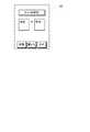
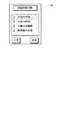
図3は、本実施例の携帯情報端末装置100を用いて現在位置の監視や道順の案内を行う際に、表示画面102に最初に表示される画面を例示した説明図である。図示されているように、表示画面102の中央には、それぞれ「経路記憶」、「監視実行」、「ナビ実行」と表記された3つのボタンが表示されており、以下に説明する操作ボタン104を用いて何れかのボタンを選択することが可能となっている。 FIG. 3 is an explanatory view exemplifying a screen that is first displayed on the
図4は、本実施例の携帯情報端末装置100に搭載された各種の操作ボタン104を示した説明図である。図示されているように、携帯情報端末装置100の本体部101には、中央のやや上方寄りの位置にカーソルボタン104dが設けられており、また、カーソルボタン104dの中央には選択ボタン104eが設けられている。カーソルボタン104dを操作することで、表示画面102上のカーソルを上下左右に移動させることができ、選択ボタン104eを押せば、カーソルがある位置の機能を選択することが可能となっている。例えば、図3に示した例では、カーソルが「経路記憶」と表示されたボタン上に存在しているが、カーソルボタン104dを用いてカーソルを移動させることができる。更に、カーソルを合わせた状態で選択ボタン104eを押してやれば、カーソルを合わせた位置に表示されている機能を選択することが可能となっている。 FIG. 4 is an explanatory diagram showing
また、カーソルボタン104dの上側には、3つの機能選択ボタン104a、104b、104cが設けられている。これらのボタンは、表示画面102の下部に機能が表示されている場合に有効となり、対応する位置のボタンを押すことによって、表示されている機能を使用することが可能となる。尚、図3に示した例では、表示画面102の下部には機能が表示されていないので、3つの機能選択ボタン104a、104b、104cは何れも無効な状態となっている。 In addition, three
カーソルボタン104dの左下方および右下方には、それぞれ受話器の図形が表示された通話開始ボタン104fおよび通話終了ボタン104gが設けられている。電話の着信中に左側の通話開始ボタン104fを押せば携帯電話として通話することが可能となり、右側の通話終了ボタン104gを押せば通話を終了することができる。また、こちらから電話をかける場合には、「1」〜「0」までの入力ボタン104hを用いて相手の電話番号を入力した後、入力ボタン104hの上方に設けられた通話開始ボタン104fを押すことで、相手を呼び出して通話することが可能となる。尚、電話の通話中は、入力ボタン104hの下方に設けられた集音マイク106が有効となり、こちらの話し声を拾って電気信号に変換した後、電波に載せて送信することができる。また、相手の話し声は表示画面102の上方に設けられた図示しないスピーカ108から音声として再生されるようになっている。 On the lower left and lower right of the
C.移動経路記憶処理 :
上述したように本実施例の携帯情報端末装置100では、地図データを用いることなく、携帯情報端末装置100の現在位置を監視したり、道順を案内することが可能となっている。こうしたことを、地図データを用いることなく可能とするためには、携帯情報端末装置100の移動経路を予め記憶しておく必要がある。ここで移動経路とは、携帯情報端末装置100に搭載されているGPSモジュール132を用いて検出した現在位置を時系列的に並べた一連のデータであり、本実施例では、現在位置の緯度および経度を定期的に検出して記憶することで、移動経路を生成することが可能となっている。このように移動経路を生成して記憶する処理は、図3に例示した画面上で「経路記憶」と表示されたボタンを選択することによって開始される。C. Travel route storage processing:
As described above, the portable
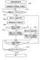
図5は、本実施例の携帯情報端末装置100で移動経路を記憶するために実行される処理の流れを示すフローチャートである。前述したように、かかる処理は、CPU150がROM152に記憶されているプログラムを読み出して実行することによって実現される処理である。以下、フローチャートに従って説明する。 FIG. 5 is a flowchart showing the flow of processing executed to store the movement route in the portable
移動経路記憶処理では、先ず初めに、移動経路を記憶するための記憶モードを設定する処理を行う(ステップS100)。すなわち、図3に示した初期画面上で「経路記憶」と表示されたボタンを選択すると、表示画面102の表示は、移動経路の記憶モードを設定するための画面に切り換わり、その画面上でカーソルを移動させて選択することにより、記憶モードを設定することが可能となっている。 In the travel route storage process, first, a process for setting a storage mode for storing the travel route is performed (step S100). That is, when the button displayed as “route storage” on the initial screen shown in FIG. 3 is selected, the display on the
図6は、本実施例の携帯情報端末装置100において記憶モードとして設定すべき項目を例示した説明図である。図示されているように、本実施例の携帯情報端末装置100では、「計測精度」および「計測時間間隔」の2つの項目を設定するようになっている。このうち、「計測精度」という項目は、GPSモジュール132を用いて計測する緯度および経度の精度を設定する項目であり、本実施例では、いわゆる一般的なナビゲーションシステムよりも粗い精度で計測する設定と、一般的なナビゲーションシステムと同程度の細かい精度で計測する設定の、2つの設定が可能となっている。詳細には後述するが、本実施例の携帯情報端末装置100では、地図を用いることなく簡易な方法で、現在位置の監視や道順の案内を可能としており、このような簡易な方法では、緯度および経度の計測精度を多少落としても十分に実用可能である。そこで、一般的なナビゲーションシステムよりも粗い精度で計測するか、あるいは一般的なナビゲーションシステムと同程度の精度で計測するかを、予め選択しておくのである。 FIG. 6 is an explanatory diagram illustrating items to be set as the storage mode in the portable
また、「計測時間間隔」という項目は、GPSモジュール132を用いて現在位置を計測する時間間隔を設定するための項目である。すなわち、GPSモジュール132を用いて計測できるのはあくまでも点の情報(現在位置の緯度および経度)であるため、点と点との間隔が離れすぎると、移動経路としての精度が低下してしまう。とは言え、あまりに点と点との間隔が密になると、記憶すべきデータ量が大きくなるという弊害が生じる。従って、精度とデータ量との兼ね合いから、現在位置を計測する地点同士の間隔は適度に隔たっていることが好ましい。そこで、徒歩で移動している場合には、比較的長い時間間隔で現在位置を計測し、自転車で移動している場合にはより短い時間間隔で現在位置を計測し、自動車で移動している場合には更に短い時間間隔で計測するように、計測する時間間隔を設定しておくのである。 The item “measurement time interval” is an item for setting a time interval for measuring the current position using the
尚、本実施例の携帯情報端末装置100では、「計測精度」および「計測時間間隔」の何れの項目については、予め設定されている中から選択することによって、段階的に切り換えるものとしているが、これらの項目を連続的に変更可能としても良い。図5に示した記憶モード設定処理(ステップS100)では、以上のようにして、移動経路を記憶するための記憶モードを設定する処理を行う。 In the portable
記憶モードを設定したら、今度は、開始ボタンが押されたか否かを判断する(ステップS102)。本実施例の携帯情報端末装置100では、本体部101の上部右側に設けられた機能選択ボタン104cが、開始ボタンに設定されている。未だ開始ボタンが押されていないと判断された場合は(ステップS102:no)、同じ判断を繰り返しながら、開始ボタンが押されるまで待機状態となる。そして、開始ボタンが押されたことが確認されたら(ステップS102:yes)、GPSモジュール132を用いて、現在位置の緯度および経度の計測を開始する(ステップS104)。すなわち、記憶モードを設定した後(ステップS102)、移動経路の始点とする地点まで移動してから開始ボタンを押すことにより、所望の地点から移動経路の記憶を開始することが可能となっている。尚、開始ボタンが押されて移動経路の記憶が開始された後は、機能選択ボタン104cの機能は開始ボタンから終了ボタンに切り換わり、再び機能選択ボタン104cを押すことで、移動経路の記憶を終了させることが可能となる。この点については後述する。 Once the storage mode is set, it is determined whether or not the start button has been pressed (step S102). In the portable
次いで、計測した緯度および経度のデータを、携帯情報端末装置100に搭載されたRAM154などのメモリに記憶する(ステップS106)。このとき、緯度および経度のデータに加えて、データを計測した時刻(あるいは、計測開始からの経過時間)も同時に記憶しても良い。図7は、緯度および経度の計測値と、初回の計測からの経過時間とが、携帯情報端末装置100のメモリに記憶されている様子を概念的に表した説明図である。ここでは、開始ボタンが押された後(図5のステップS102:yes)、初めて緯度および経度を計測した場合を想定しているから、ステップS106では、緯度の計測値(北緯35度2分6.15秒)、経度の計測値(東経136度50分46.21秒)に加えて、初回の計測からの経過時間(0時間0分0秒)が記憶される。 Next, the measured latitude and longitude data is stored in a memory such as the
続いて、現在位置を記憶するか否かを判断する(ステップS108)。説明の都合から、このような判断を行う理由については後述するが、多くの場合は、ステップS108では現在位置を記憶しないと判断されるので(ステップS108:no)、ステップS100において設定された計測時間間隔が経過したか否かを判断する(ステップS110)。そして、計測時間間隔が経過したと判断された場合は(ステップS110:yes)、ステップS104に戻って緯度および経度を計測した後、計測した緯度および経度の計測値をメモリに記憶する(ステップS106)。このとき、先に記憶した計測値が存在する場合には、その計測値に続けて記憶する。このような処理を繰り返すことで、携帯情報端末装置100のメモリ上には、所定の時間間隔で計測された経度および緯度の計測値が、時系列的に記憶されることになる。図7では、15秒間の計測時間間隔で、緯度および経度の計測値が時系列的に記憶されている様子が示されている。本実施例の携帯情報端末装置100では、このように緯度および経路の計測値を時系列的に記憶することによって、携帯情報端末装置100の移動経路を記憶するようになっている。 Subsequently, it is determined whether or not the current position is stored (step S108). For reasons of explanation, the reason for making such a determination will be described later, but in many cases, it is determined that the current position is not stored in step S108 (step S108: no), so the measurement set in step S100 is performed. It is determined whether the time interval has elapsed (step S110). If it is determined that the measurement time interval has elapsed (step S110: yes), the process returns to step S104 to measure the latitude and longitude, and the measured values of latitude and longitude are stored in the memory (step S106). ). At this time, if the previously stored measurement value exists, it is stored after the measurement value. By repeating such processing, the measured values of longitude and latitude measured at predetermined time intervals are stored in time series on the memory of the portable
ここで、ステップS108において、現在位置を記憶するか否かを判断している理由について説明する。上述したように、本実施例の携帯情報端末装置100では、所定の時間間隔で計測した緯度および経度の値を記憶しておき、これを移動経路として利用する。このように所定の時間間隔で緯度および経度を計測しておくだけでも、真っ直ぐな道やゆっくりとカーブした道の部分であれば十分な精度で移動経路を記憶しておくことができるが、急に折れ曲がった部分では、記憶されている移動経路の精度低下を来してしまう。もちろん、計測時間間隔を短くすれば、折れ曲がった部分でも十分な精度で移動経路を記憶しておくことができるが、計測時間間隔を短くすると、距離あたりの緯度および経度の計測値が多くなるので、移動経路のデータ量が増加してしまう。 Here, the reason for determining whether or not to store the current position in step S108 will be described. As described above, in the portable
そこで、計測時間間隔が経過していなくても、所定の操作を行うことで、その位置での緯度および経度を計測して携帯情報端末装置100のメモリに記憶することにより、移動経路のデータ量の増加を最小限に抑制しつつ、十分な精度を確保することが可能となっている。本実施例の携帯情報端末装置100では、図5の移動経路記憶処理の実行中に、本体部101の上部中央に設けられた機能選択ボタン104bを押すと、その位置での緯度および経度が計測されてメモリに記憶されるようになっている。そこで、ステップS108では、機能選択ボタン104bが押されたか否か、すなわち現在位置での緯度および経度を計測して記憶するか否かを判断するのである。そして、現在位置での緯度および経度を記憶すると判断された場合は(ステップS108:yes)、ステップS104に戻って、現在位置の緯度および経度を計測し(ステップS104)、得られた計測値をメモリ上に記憶する。 Therefore, even if the measurement time interval has not elapsed, by performing a predetermined operation, the latitude and longitude at that position are measured and stored in the memory of the portable
図7の中で、破線の矩形で囲って示した計測値は、移動経路の記憶中に機能選択ボタン104bが押されたために(すなわち、ステップS108:yesと判断されたために)、所定時間毎の計測に加えて、追加して計測された計測値を表している。 In FIG. 7, the measurement value surrounded by a broken-line rectangle is measured every predetermined time because the
一方、ステップS110において、未だ計測時間間隔が経過していないと判断された場合は(S110:no)、「マーク」を設定するか否かを判断する(ステップS112)。ここで「マーク」とは、次のようなものである。上述したように移動経路は、緯度および経度の計測値を時系列的に連続して並べたデータであるが、本実施例の携帯情報端末装置100では、1つの連続する移動経路を複数の領域に分割することが可能となっている。「マーク」とは、移動経路の分割する位置を示す目印のようなものであり、本体部101の上部左側に設けられた機能選択ボタン104aを押すことで、「マーク」を設定することが可能となっている。そこでステップS112においては、機能選択ボタン104aが押されたか否かを判断し、機能選択ボタン104aが押されていた場合には、「マーク」が設定されていたものと判断して(ステップS112:yes)、マークデータをメモリに記憶する(ステップS114)。尚、本実施例では、専ら携帯情報端末装置100の保持者が所定の操作を行うことによって「マーク」が設定されるものとして説明するが、これに限られるものではない。例えば、携帯情報端末装置100の内部に予め条件を設定しておき、かかる条件が満足された場合には、自動的に「マーク」が設定されるようにしても良い。 On the other hand, if it is determined in step S110 that the measurement time interval has not yet elapsed (S110: no), it is determined whether or not to set a “mark” (step S112). Here, the “mark” is as follows. As described above, the movement route is data in which the measured values of latitude and longitude are continuously arranged in time series. In the portable
図7の中で、一点鎖線の矩形で囲って示した計測値は、メモリにマークデータが記憶されている様子を表している。図示されているように、本実施例では、緯度が北緯0度0分0秒、経度が東経0度0分0秒と、通常ではあり得ない値がマークデータとして設定されており、「マーク」が設定された場合には、このような所定のマークデータがメモリに書き込まれるようになっている。もちろん、ステップS112において「マーク」が設定されていないと判断された場合は(ステップS112:no)、マークデータを記憶する処理(ステップS114)はスキップする。 In FIG. 7, the measurement value surrounded by a one-dot chain line rectangle represents a state in which mark data is stored in the memory. As shown in the figure, in this embodiment, latitude is 0
次いで、終了ボタンが押されたか否かを判断する(ステップS116)。前述したように、開始ボタンが押されるまでは、機能選択ボタン104cが開始ボタンに設定されているが、開始ボタンが押されて移動経路の記憶が開始された後は、機能選択ボタン104cの設定は、開始ボタンから終了ボタンに切り換わる。そこで、ステップS116では、機能選択ボタン104cが押されたか否かを判断する。そして、終了ボタンが押されていないと判断された場合は(ステップS116:no)、ステップS108に戻って、以降の一連の判断を繰り返す。すなわち、現在位置を記憶するか否か(ステップS108)、あるいは計測時間間隔が経過したか否か(ステップS110)、更には「マーク」を設定するか否か(ステップS112)を判断し、現在位置を記憶するか、計測時間間隔が経過したと判断されたら(ステップS108:yes、またはステップS110:yes)、ステップS104に戻って、緯度および経度を計測し、得られた計測値をメモリに記憶する(ステップS106)。また、「マーク」を設定すると判断された場合は(ステップS112:yes)、所定のマークデータをメモリに記憶する(ステップS114)。このような処理を繰り返し行うことにより、携帯情報端末装置100の移動経路を記憶することが可能となる。 Next, it is determined whether or not the end button has been pressed (step S116). As described above, the function selection button 104c is set as the start button until the start button is pressed, but after the start button is pressed and the storage of the movement path is started, the function selection button 104c is set. Switches from the start button to the end button. In step S116, it is determined whether or not the function selection button 104c has been pressed. If it is determined that the end button has not been pressed (step S116: no), the process returns to step S108, and a series of subsequent determinations are repeated. That is, it is determined whether or not the current position is stored (step S108), whether or not the measurement time interval has elapsed (step S110), and whether or not “mark” is set (step S112). When it is determined that the position is stored or the measurement time interval has elapsed (step S108: yes or step S110: yes), the process returns to step S104, the latitude and longitude are measured, and the obtained measurement value is stored in the memory. Store (step S106). If it is determined to set “mark” (step S112: yes), predetermined mark data is stored in the memory (step S114). By repeatedly performing such processing, the movement route of the portable
図8は、自宅から学校までの道順が、移動経路として記憶された様子を概念的に表した説明図である。図示されているように、A点ないしG点では、道がほぼ直角に折れ曲がっているが、これらの位置では、携帯情報端末装置100の本体部101の上部中央に設けられた機能選択ボタン104bを押して現在位置を計測することにより、精度を低下させることなく移動経路を記憶しておくことが可能である。また、G点の次の角、更にはその次の角では、道が少しだけ右に折れ曲がっているが、この程度の角度では、特に現在位置を記憶しておかなくても、それほど移動経路の精度が低下することはない。図8に示した例では、G点の次の角では現在位置を記憶せずに、その次の角では現在位置を記憶した場合が示されている。 FIG. 8 is an explanatory diagram conceptually showing how the route from home to school is stored as a travel route. As shown in the figure, at points A to G, the road is bent at a substantially right angle. At these positions, the
また、図8中に示した二重丸は、その位置に「マーク」が設定されていることを表している。図示した例では、自宅のある住宅街を出たあたりと、学校までの途中にある公園の前の2箇所で「マーク」が設定されており、その結果、自宅から学校までの移動経路が、住宅街を出るまでと、住宅街を出てから公園までと、公園から学校までとの、3つの領域に区分されていることになる。 A double circle shown in FIG. 8 indicates that a “mark” is set at that position. In the example shown in the figure, “Mark” is set at two places in front of the park in the middle of the house and the park in the middle of the school. As a result, the travel route from the home to the school is It is divided into three areas: from the residential area, from the residential area to the park, and from the park to the school.
図5に示す移動経路記憶処理を行いながら、携帯情報端末装置100を持って移動することにより、図8に示すような移動経路を記憶することが可能である。そして、目的地に到着したら、終了ボタン(すなわち、機能選択ボタン104c)を押す。すると、ステップS116で「yes」と判断されて、携帯情報端末装置100の表示画面102には、移動経路のタイトルを設定する画面が表示される。 It is possible to store a movement route as shown in FIG. 8 by moving with the portable
図9は、本実施例の携帯情報端末装置100の表示画面102に、移動経路のタイトルを設定する画面が表示された様子を表している。図示されているように、タイトルを設定する画面には、移動経路の始点と、終点とを設定する欄が設けられており、これらの欄に始点および終点の名称を書き込むことで、移動経路のタイトルが自動的に設定されるようになっている。尚、図9に示されているように、タイトルの設定画面が表示されている状態で、本体部101の上部左側の機能選択ボタン104aを押せば、入力形態を漢字や平仮名あるいはカタカナによる入力に切り換えることができ、機能選択ボタン104bを押せば、アルファベットまたは数字による入力に切り換えることができる。そして、2つの欄に始点および終点を入力したら、本体部101の上部右側の機能選択ボタン104cを押すことにより、移動経路のタイトルを確定する。図5に示した移動経路記憶処理では、このようにして、移動経路のタイトルを設定した後(ステップS118)、全ての処理を終了する。 FIG. 9 shows a state in which a screen for setting the title of the movement route is displayed on the
D.移動経路監視処理 :
以上のようにして記憶しておいた移動経路を用いれば、携帯情報端末装置100の現在位置を、地図データを用いることなく監視することが可能となる。以下では、移動経路を用いて、携帯情報端末装置100の現在位置を監視するために行われる処理について説明する。D. Travel route monitoring processing:
If the travel route stored as described above is used, the current position of the portable
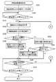
図10は、本実施例の携帯情報端末装置100で移動経路を用いて現在位置を監視するために実行される処理の流れを示すフローチャートである。この移動経路監視処理は、図3に例示した画面上で「監視実行」と表示されたボタンを選択すると、CPU150がROM152に記憶されているプログラムを読み出すことによって実行される処理である。以下、フローチャートに従って説明する。 FIG. 10 is a flowchart illustrating a flow of processing executed to monitor the current position using the movement route in the portable
移動経路監視処理では、先ず初めに、監視に用いる移動経路や監視モードを設定する処理を行う(ステップS200)。これらの設定は、表示画面102の表示を確認しながら、画面上で行うことができる。 In the movement route monitoring process, first, a process for setting a movement route and a monitoring mode used for monitoring is performed (step S200). These settings can be made on the screen while confirming the display on the
図11は、本実施例の携帯情報端末装置100において、監視を行うための移動経路を選択している画面を例示した説明図である。移動経路の選択画面では、既に記憶されている複数の移動経路のタイトルが、選択可能な状態で表示されている。本体部101のカーソルボタン104dを操作して、選択しようとする移動経路にカーソルを合わせた後、選択ボタン104eを押すことにより、監視に用いる移動経路を選択することができる。移動経路を選択すると、携帯情報端末装置100の表示画面102には、監視モードを設定するための画面が表示される。 FIG. 11 is an explanatory view exemplifying a screen for selecting a movement route for monitoring in the portable
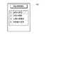
図12は、本実施例の携帯情報端末装置100において、監視モードを設定する際に表示される画面を例示した説明図である。図示されているように、監視モードとしては、携帯情報端末装置100が監視領域外に出た場合に、予め設定されている連絡先に通報するか否か、および、監視領域内に居る場合にも通報を行うか否かを設定する。また、監視領域内に居る場合にも通報する場合には、所定時間毎に通報するのか、あるいは移動経路の設定された領域を跨ぐ際に通報するのかについても設定するようになっている。監視モードは、標準の状態では、携帯情報端末装置100が監視領域に出る際に通報し、また監視領域内に居る場合でも、領域を跨ぐ際には通報するように設定されている。 FIG. 12 is an explanatory diagram illustrating a screen displayed when the monitoring mode is set in the portable
図10のステップS200では、これら移動経路および監視モードを設定する処理を行う。次いで、開始ボタンが押されたか否かを判断する(ステップS202)。移動経路監視処理においても、図5を用いて前述した移動経路記憶処理の場合と同様に、携帯情報端末装置100の本体部101の上部右側に設けられた機能選択ボタン104cが、開始ボタンに設定されている。未だ開始ボタンが押されていないと判断された場合は(ステップS202:no)、同じ判断を繰り返しながら、開始ボタンが押されるまで待機状態となり、開始ボタンが押されたことが確認されたら(ステップS202:yes)、GPSモジュール132を用いて、現在位置の緯度および経度の計測を開始する(ステップS204)。また、前述した移動経路記憶処理と同様に、移動経路監視処理においても、開始ボタンが押された後は、機能選択ボタン104cの機能は開始ボタンから終了ボタンに切り換わるようになっている。 In step S200 of FIG. 10, a process for setting the movement route and the monitoring mode is performed. Next, it is determined whether or not the start button has been pressed (step S202). In the movement route monitoring process, as in the case of the movement route storage process described above with reference to FIG. 5, the function selection button 104c provided on the upper right side of the
尚、移動経路および監視モードを設定する処理では、前回の監視に用いた設定内容を記憶しておき、図10に示した移動経路監視処理の起動後、所定時間が経過しても移動経路および監視モードが設定されない場合には、前回の監視に用いた設定内容を読み出して、以降の処理を行うこととしても良い。同様に、所定時間が経過しても開始ボタンが押されない場合には、開始ボタンが押されたものとして(ステップS202:yes)、以降の処理を行うこととしても良い。こうすれば、図3に示した画面上で「監視実行」と表示されたボタンが押されたにも拘わらず、移動経路および監視モードが設定されなかったり、あるいは開始ボタンが押されないために、実際には監視が行われないといった事態を回避することが可能となる。 In the process of setting the movement route and the monitoring mode, the setting contents used for the previous monitoring are stored, and the movement route and the monitoring mode are set even after a predetermined time has elapsed after the movement route monitoring process shown in FIG. When the monitoring mode is not set, the setting content used for the previous monitoring may be read and the subsequent processing may be performed. Similarly, when the start button is not pressed even after a predetermined time has elapsed, it is possible that the start button has been pressed (step S202: yes) and the subsequent processing is performed. In this way, the movement route and the monitoring mode are not set or the start button is not pressed even though the button labeled “execute monitoring” on the screen shown in FIG. 3 is pressed. It is possible to avoid a situation in which monitoring is not actually performed.
移動経路監視処理では、現在位置の緯度および経度を計測すると、今度は、現在位置から移動経路までの距離を算出する(ステップS206)。本実施例の携帯情報端末装置100では、移動経路までの距離は次のようにして算出する。まず、移動経路として記憶されている複数の座標点の間を直線によって補間することにより、連続した移動経路を生成する。次いで、現在位置として計測された座標点から、連続する移動経路に向かって垂線を下ろして、垂線と移動経路との交点の座標値を算出する。そして、こうして求めた座標値と、現在位置の座標値とに基づいて、2つの座標点の距離を算出する。図13(a)には、このようにして、現在位置から移動経路までの距離を求めている様子が概念的に示されている。 In the movement route monitoring process, when the latitude and longitude of the current position are measured, this time, the distance from the current position to the movement route is calculated (step S206). In the portable
あるいは、簡便には、次のようにして現在位置から移動経路までの距離を求めることとしても良い。まず、移動経路を構成する複数の座標点の中から、現在位置との距離が最も小さい座標点を検出する。次いで、検出した座標点の座標値と、現在位置の座標値とに基づいて、2つの座標点の距離を算出し、得られた値を現在位置から移動経路までの距離としてもよい。図13(b)には、このような簡便な方法で、現在位置から移動経路までの距離を求めている様子が概念的に示されている。図10のステップS206では、以上のようにして、現在位置から移動経路までの距離を算出する。 Or simply, it is good also as calculating | requiring the distance from a present position to a movement path | route as follows. First, a coordinate point having the shortest distance from the current position is detected from a plurality of coordinate points constituting the movement route. Next, the distance between the two coordinate points may be calculated based on the detected coordinate value of the coordinate point and the coordinate value of the current position, and the obtained value may be used as the distance from the current position to the moving path. FIG. 13B conceptually shows how the distance from the current position to the moving route is obtained by such a simple method. In step S206 of FIG. 10, the distance from the current position to the movement route is calculated as described above.
尚、本実施例の移動経路監視処理では、現在位置から移動経路までの距離を算出することによって監視を行っている。従って、開始ボタンを押す位置は、必ずしも移動経路の始点あるいは終点である必要はない。例えば、監視する移動経路として「自宅」と「学校」とをつなぐ経路が選択された場合を例に取ると、「自宅」または「学校」に居るときに開始ボタンを押す必要はなく、選択された監視経路の近傍でありさえすれば、何処で開始ボタンが押された場合でも、移動経路までの距離を算出して、その位置から監視を開始することが可能である。 In the movement route monitoring process of the present embodiment, monitoring is performed by calculating the distance from the current position to the movement route. Therefore, the position where the start button is pressed is not necessarily the start point or end point of the movement path. For example, if the route that connects “Home” and “School” is selected as the travel route to be monitored, it is not necessary to press the start button when you are at “Home” or “School”. As long as it is in the vicinity of the monitored route, it is possible to calculate the distance to the moving route and start monitoring from that position, regardless of where the start button is pressed.
次いで、算出した距離が、閾値として定められている所定値(閾値距離)以下か否かを判断する(ステップS208)。閾値距離の値は、必要に応じて種々の値に設定することができるが、通常であれば、10メートルから50メートルの範囲内から選択された適切な値に設定される。そして、現在位置から移動経路までの距離が、所定の閾値距離よりも小さいと判断された場合は(ステップS208:yes)、現在位置の属する領域を検出する(ステップS212)。図5を用いて前述したように、本実施例の携帯情報端末装置100では、移動経路を記憶する際に適宜「マーク」を設定することで、1本の移動経路を複数の領域に区分することが可能となっている。そこで、携帯情報端末装置100の現在位置が移動経路の近傍にあると判断された場合は(ステップS208:yes)、現在位置が、移動経路の何れの領域にあるかを検出するのである(ステップS212)。 Next, it is determined whether the calculated distance is equal to or less than a predetermined value (threshold distance) set as a threshold (step S208). Although the value of the threshold distance can be set to various values as required, it is normally set to an appropriate value selected from the range of 10 to 50 meters. If it is determined that the distance from the current position to the moving route is smaller than the predetermined threshold distance (step S208: yes), the area to which the current position belongs is detected (step S212). As described above with reference to FIG. 5, in the portable
図14は、現在位置が属する領域を検出している様子を概念的に示した説明図である。図示されているように、現在位置が属する領域は、移動経路上の座標点の中から、現在位置までの距離が最も短い座標点を抽出し、その座標点が何れの領域に含まれているかを調べることによって検出することができる。移動経路上で、現在位置までの距離が最も短い座標点は、現在位置から移動経路までの距離を求める際に既に決定されているので、その座標点が含まれる領域を調べるだけで、現在位置が属する領域を決定することができる。図14に示した例では、現在位置は、領域3(公園から学校までの領域)に属している場合が示されている。 FIG. 14 is an explanatory diagram conceptually showing a state in which a region to which the current position belongs is detected. As shown in the figure, for the area to which the current position belongs, the coordinate point with the shortest distance to the current position is extracted from the coordinate points on the movement route, and which area the coordinate point is included in Can be detected by examining. The coordinate point with the shortest distance to the current position on the movement path has already been determined when calculating the distance from the current position to the movement path. The region to which can belong can be determined. In the example illustrated in FIG. 14, a case where the current position belongs to the region 3 (region from the park to the school) is illustrated.
こうして現在位置が属する領域を検出したら(図10のステップS212)、予め登録しておいた連絡先に向かって、検出した領域を連絡する(ステップS214)。連絡する形態としては、種々の形態で行うことができる。例えば、予め登録しておいた電話番号に自動で電話をかけて、検出した領域を、予め登録しておいた音声によって連絡しても良い。あるいは、予め登録しておいたメールアドレスに向かって、検出した領域を示すメールデータを送信することによって連絡することも可能である。一方、現在位置から移動経路までの距離が所定の閾値距離よりも小さいと判断された場合は(ステップS208:no)、監視している移動経路から外れた旨を、登録しておいた連絡先に連絡する(ステップS210)。 When the area to which the current position belongs is detected in this way (step S212 in FIG. 10), the detected area is communicated to the contact information registered in advance (step S214). As a form to contact, it can carry out with various forms. For example, a telephone number registered in advance may be automatically called, and the detected area may be communicated by voice registered in advance. Alternatively, it is possible to contact by sending mail data indicating a detected area toward a pre-registered mail address. On the other hand, if it is determined that the distance from the current position to the travel route is smaller than the predetermined threshold distance (step S208: no), the registered contact information indicating that the travel route being monitored has been removed. (Step S210).
次いで、計測時間間隔が経過したか否かを判断する(ステップS216)。ここで計測時間間隔とは、ステップS204で現在位置の緯度および経度を計測するために設定されている所定の時間である。ステップS216で、計測時間間隔が経過したと判断される度に(ステップS216:yes)、ステップS204に戻って現在位置の緯度および経度が計測され、現在位置から移動経路までの距離が閾値距離と比較されることから(ステップS208)、結局、計測時間間隔毎に携帯情報端末装置100の現在位置が監視されることになる。 Next, it is determined whether or not the measurement time interval has elapsed (step S216). Here, the measurement time interval is a predetermined time set in order to measure the latitude and longitude of the current position in step S204. Every time it is determined in step S216 that the measurement time interval has passed (step S216: yes), the process returns to step S204 to measure the latitude and longitude of the current position, and the distance from the current position to the moving route is the threshold distance. Since the comparison is made (step S208), the current position of the portable
尚、図5を用いて前述したように、移動経路記憶処理においては移動経路の記憶精度を確保するために、携帯情報端末装置100の移動速度に応じて適切な計測時間間隔を設定した。しかし、携帯情報端末装置100の現在位置を監視する場合には、監視する時間間隔を短くしたからといって直ちに監視精度が上がるわけではない。通常は、移動経路を記憶する際の計測時間間隔よりも、長い時間間隔で監視すれば十分である。そこで、移動経路監視処理で用いる計測時間間隔は、移動経路記憶処理で用いた計測時間間隔よりも長い時間の固定時間に予め設定されている。もちろん、ステップS200で監視モードを設定する際に、監視に用いる計測時間間隔を設定可能としても良い。 As described above with reference to FIG. 5, in the movement route storage process, an appropriate measurement time interval is set according to the movement speed of the portable
一方、計測時間間隔が経過していないと判断された場合は(ステップS216:no)、終了ボタンが押されたか否かを判断する(ステップS218)。前述したように、開始ボタンが押されるまでは、機能選択ボタン104cが開始ボタンに設定されているが、開始ボタンが押されて現在位置の監視が開始された後は、機能選択ボタン104cの設定は、開始ボタンから終了ボタンに切り換わる。そこで、ステップS218では、機能選択ボタン104cが押されたか否かを判断する。そして、終了ボタンが押されていないと判断された場合は(ステップS218:no)、ステップS216に戻って、計測時間間隔が経過したか否かを判断し、計測時間間隔が経過していれば(ステップS216:yes)、ステップS204に戻って現在位置の緯度および経度を計測し、続く一連の処理を行う。 On the other hand, when it is determined that the measurement time interval has not elapsed (step S216: no), it is determined whether or not the end button has been pressed (step S218). As described above, the function selection button 104c is set as the start button until the start button is pressed. After the start button is pressed and monitoring of the current position is started, the function selection button 104c is set. Switches from the start button to the end button. Therefore, in step S218, it is determined whether or not the function selection button 104c has been pressed. If it is determined that the end button has not been pressed (step S218: no), the process returns to step S216 to determine whether the measurement time interval has elapsed, and if the measurement time interval has elapsed. (Step S216: yes), returning to Step S204, the latitude and longitude of the current position are measured, and the following series of processing is performed.
図10に示した移動経路監視処理では、こうした処理を繰り返し実行することにより、計測時間間隔が経過する度に、携帯情報端末装置100が移動経路から外れていないか、移動経路に沿って進んでいる場合は、移動経路上の何れの領域に居るかについての情報が、予め登録しておいた連絡先に連絡されることになる。そして、終了ボタンが押されたと判断されたら(ステップS218:yes)、図10に示した移動経路監視処理を終了する。尚、図12を用いて説明した監視モードの設定において、領域内の監視は行わない旨が設定されていた場合には、現在位置から移動経路までの距離が閾値距離より大きくなった場合にだけ、その旨を連絡するようにすればよい。逆に、領域外の監視は行わない旨が設定されていた場合には、現在位置から移動経路までの距離が閾値距離より小さい場合にだけ、現在位置の属する領域を連絡すればよい。 In the movement route monitoring process shown in FIG. 10, by repeatedly executing such a process, the mobile
以上に説明した本実施例の移動経路監視処理では、携帯情報端末装置100のメモリに移動経路を記憶しておくだけで、計測した現在位置と、記憶されている移動経路とを比較することにより、地図データを用いることなく携帯情報端末装置100の現在位置を監視することが可能である。地図データが不要となれば、取り扱うデータ量を抑制することができるので、携帯情報端末装置100のようなメモリ容量の制約の大きな機器によっても、容易に移動経路の監視を行うことが可能となる。また、地図データサーバも不要となるので、監視を行うための全体のシステムを簡素なものとすることができる。 In the movement route monitoring process of the present embodiment described above, by simply storing the movement route in the memory of the portable
D−1.第1の変形例の移動経路監視処理 :
以上に説明した本実施例の移動経路監視処理では、計測時間間隔が経過する度に、何らかの連絡が、登録しておいた連絡先に向かって行われるものとして説明した。しかし、監視している対象が、移動経路から外れた場合はともかく、移動経路に沿って進んでいるにも計測時間間隔が経過する度に連絡されるのでは、監視する側も煩雑に感じられる場合が起こり得る。このような点に鑑みて、監視対象の携帯情報端末装置100が移動経路から所定の閾値距離以内にある場合には、移動経路の領域を跨ぐ場合にだけ、途中経過報告として連絡するようにしても良い。以下では、このような第1の変形例の移動経路監視処理について説明する。D-1. Movement route monitoring process of the first modified example:
In the movement route monitoring process of the present embodiment described above, it has been described that some kind of contact is made toward the registered contact every time the measurement time interval elapses. However, if the object being monitored deviates from the movement route, the monitoring side feels complicated if the measurement time interval elapses even though the object is moving along the movement route. Cases can happen. In view of such points, when the mobile
図15は、第1の変形例の移動経路監視処理の流れを示すフローチャートである。第1の変形例の移動経路監視処理は、図10を用いて前述した移動経路監視処理に対して、現在位置から移動経路までの距離が閾値距離以下であった場合の処理のみが異なっており、他の処理は同様である。そこで、以下では、このような相違点を中心として、第1の変形例の移動経路監視処理について説明する。 FIG. 15 is a flowchart showing the flow of the movement route monitoring process of the first modification. The movement route monitoring process of the first modification is different from the movement path monitoring process described above with reference to FIG. 10 only in the case where the distance from the current position to the movement path is equal to or less than the threshold distance. The other processes are the same. Therefore, hereinafter, the movement path monitoring process of the first modification will be described focusing on such differences.
第1の変形例の移動経路監視処理においても、図10を用いて前述した移動経路監視処理と同様に、処理を開始すると、先ず初めに移動経路や監視モードを設定する(ステップS250)。次いで、開始ボタンが押されたか否かを判断し、押されていないと判断された場合は(ステップS252:no)、開始ボタンが押されるまで待機状態となる。そして、開始ボタンが押されたことを確認したら(ステップS252:yes)、GPSモジュール132を用いて、現在位置の緯度および経度を計測した後(ステップS254)、現在位置から移動経路までの距離を算出する(ステップS256)。 Also in the movement route monitoring process of the first modified example, as in the movement route monitoring process described above with reference to FIG. 10, when the process is started, first, the movement route and the monitoring mode are set (step S250). Next, it is determined whether or not the start button has been pressed. If it is determined that the start button has not been pressed (step S252: no), the system waits until the start button is pressed. After confirming that the start button has been pressed (step S252: yes), the
こうして算出した現在位置から移動経路までの距離を、所定の閾値距離と比較して(ステップS258)、算出した距離が閾値距離よりも大きかった場合には(ステップS258:no)、前述した移動経路監視処理と同様に、予め登録しておいた連絡先に、その旨を連絡する(ステップS260)。 The distance from the current position thus calculated to the movement route is compared with a predetermined threshold distance (step S258). If the calculated distance is larger than the threshold distance (step S258: no), the movement route described above is used. Similar to the monitoring process, this is notified to the contact information registered in advance (step S260).
一方、現在位置から移動経路までの距離が、閾値距離よりも小さかった場合には(ステップS258:yes)、現在位置が属する領域を検出する(ステップS262)。現在位置の領域を検出する処理も、前述した移動経路監視処理と同様である。 On the other hand, when the distance from the current position to the moving route is smaller than the threshold distance (step S258: yes), the area to which the current position belongs is detected (step S262). The process of detecting the current position area is also the same as the movement route monitoring process described above.
第1の変形例の移動経路監視処理では、現在位置が属する領域を検出すると、その領域が前回に検出した時から切り換わったか否かを判断する(ステップS264)。例えば、図14に示した例では、移動経路は「領域1」、「領域2」、「領域3」の3つに区分されており、自宅から学校に向かって移動する場合には、学校にたどり着くまでの間に、現在位置の属する領域が「領域1」から「領域3」へと切り換わる。逆に、学校から自宅に戻る場合には、現在位置の属する領域が「領域1」から「領域3」へと切り換わる。ステップS262では、このように現在位置の属する領域が切り換わったか否かを判断するのである。 In the movement route monitoring process of the first modified example, when an area to which the current position belongs is detected, it is determined whether or not the area has been switched since the previous detection (step S264). For example, in the example shown in FIG. 14, the movement route is divided into three areas “
そして、領域が切り換わったと判断された場合には(ステップS262:yes)、予め登録しておいた連絡先に向けて、現在位置の属する領域を連絡する(ステップS266)。一方、領域が切り換わっていないと判断された場合には(ステップS262:no)、現在位置の属する領域を連絡することなく、そのまま処理を継続する。このようにする結果、変形例の移動経路監視処理では、現在位置の属する領域が切り換わった場合にだけ、予め登録されている連絡先に、現在位置の領域が連絡されることになる。連絡を受けた側では、領域の連絡を受けることによって、ちょうど今、連絡のあった領域に差し掛かったことを知ることが可能となる。 When it is determined that the area has been switched (step S262: yes), the area to which the current position belongs is communicated to the contact information registered in advance (step S266). On the other hand, if it is determined that the area has not been switched (step S262: no), the process is continued without contacting the area to which the current position belongs. As a result, in the movement route monitoring process according to the modified example, the area at the current position is notified to the contact information registered in advance only when the area to which the current position belongs is switched. By receiving the contact of the area, the side having received the contact can know that the contacted area has just been reached.
尚、ステップS262の判断においては、移動経路から閾値距離より離れた領域に出た後、再び閾値距離の範囲内に戻った場合にも、現在位置の属する領域が切り換わったものと判断しても良い。このようにした場合、一旦、移動経路から離れた旨を連絡した後、移動経路の近傍に戻った場合にも、その旨の連絡をすることができるので、連絡を受ける側では、移動経路の近くまで戻ったこと、および現在、移動経路上のどの辺りにいるかについて、認識することが可能となる。 In step S262, it is determined that the region to which the current position belongs has been switched even when the vehicle travels back to the region away from the threshold distance from the movement route and then returns to the threshold distance. Also good. In such a case, once you have been informed that you are away from the travel route, you can still be informed when you return to the vicinity of the travel route. It is possible to recognize that the vehicle has returned to near and where it is currently on the moving route.
次いで、前述した移動経路監視処理と同様に、計測時間間隔が経過したか否かを判断する(ステップS268)。そして、計測時間間隔が経過したと判断されたら(ステップS268:yes)、ステップS254に戻って現在位置の緯度および経度が計測され、続く一連の処理を行う。一方、未だ計測時間間隔が経過していないと判断された場合は(ステップS268:no)、終了ボタンが押されたか否かを判断する(ステップS270)。そして、終了ボタンが押されていないと判断された場合は(ステップS270:no)、ステップS268に戻って、計測時間間隔が経過したか否かを判断し、計測時間間隔が経過していれば(ステップS268:yes)、ステップS254に戻って現在位置の緯度および経度を計測し、続く一連の処理を行う。こうした処理を繰り返し実行しながら、終了ボタンが押されたと判断されたら(ステップS270:yes)、図15に示した第1の変形例の移動経路監視処理を終了する。 Next, it is determined whether or not the measurement time interval has passed in the same manner as the movement route monitoring process described above (step S268). If it is determined that the measurement time interval has elapsed (step S268: yes), the process returns to step S254, the latitude and longitude of the current position are measured, and a series of subsequent processing is performed. On the other hand, when it is determined that the measurement time interval has not yet elapsed (step S268: no), it is determined whether or not the end button has been pressed (step S270). If it is determined that the end button has not been pressed (step S270: no), the process returns to step S268 to determine whether or not the measurement time interval has elapsed, and if the measurement time interval has elapsed. (Step S268: yes), returning to step S254, the latitude and longitude of the current position are measured, and the following series of processing is performed. If it is determined that the end button has been pressed while repeatedly executing such processing (step S270: yes), the movement route monitoring processing of the first modification shown in FIG. 15 is ended.
以上に説明した第1の変形例の移動経路監視処理においても、地図データを用いることなく携帯情報端末装置100の現在位置を監視することができるので、監視を行うための全体のシステムを簡素なものとしながら、携帯情報端末装置100の現在位置を簡便に監視することが可能となる。加えて、携帯情報端末装置100が移動経路から閾値距離の範囲内にある場合は、移動経路の領域を跨ぐ場合(あるいは、移動経路の領域内に入った場合)にだけ、携帯情報端末装置100が現在何れの領域にいるかが連絡されるので、連絡を受ける側が、連絡を煩く感じる場合にも、これを回避することが可能となる。 Even in the movement route monitoring process of the first modification described above, the current position of the portable
D−2.第2の変形例の移動経路監視処理 :
また、上述した本実施例の移動経路監視処理では、監視に用いる移動経路を1つ選択し、選択した1つの移動経路を監視するものとして説明した。これに対して、携帯情報端末装置100に記憶されている複数の移動経路を選択し、これら複数の移動経路を監視対象に設定して、複数の移動経路内に監視対象者が居るか否かについてを監視するようにしても良い。すなわち、図3に例示した画面上で「監視実行」と表示されたボタンを選択した後、記憶されている複数の経路情報の中から任意に選択した経路情報(あるいは全ての経路情報)を監視対象として設定し、設定した移動経路の領域を跨ぐ場合、あるいは設定した全ての移動経路から閾値以上離れた場合には、予め登録しておいた連絡先に、所定の報知手段を用いて連絡するようにしても良い。D-2. Movement route monitoring process of the second modified example:
Further, in the movement route monitoring process of the present embodiment described above, one movement route used for monitoring is selected and one selected movement route is monitored. On the other hand, a plurality of movement routes stored in the portable
E.移動経路誘導処理 :
また、本実施例の携帯情報端末装置100には、移動経路に従って、目的地への道順を案内する機能(ナビゲーション機能)も搭載されている(図3参照)。目的地への道順を案内する場合でも、地図を用いることなく案内することができるので、地図データサーバに接続して地図データを読み込む必要が無く、手軽にナビゲーション機能を利用することができる。加えて、地図データを用いないことから、取り扱うデータ量を抑制することができるので、メモリ容量に大きな制約を受ける機器によっても、十分に実用的なナビゲーション機能を利用することが可能となる。以下では、本実施例の携帯情報端末装置100において、移動経路に基づいて目的地への道順を案内する場合に行われる処理について詳しく説明する。E. Travel route guidance processing:
Further, the portable
図16は、本実施例の携帯情報端末装置100において移動経路に従って目的地への道順を案内するために行われる移動経路誘導処理の一部を示すフローチャートである。また、図17は、本実施例の携帯情報端末装置100で行われる移動経路誘導処理の残りの部分を示すフローチャートである。これらの処理は、携帯情報端末装置100の表示画面102上に、図3に示した画面が表示されている状態で、「ナビ実行」と表示されたボタンを選択すると、CPU150がROM152に記憶されているプログラムを読み出すことによって行われる処理である。以下、フローチャートに従って説明する。 FIG. 16 is a flowchart showing a part of the movement route guidance process performed to guide the route to the destination according to the movement route in the portable
移動経路誘導処理を開始すると、先ず初めに、誘導に用いる移動経路および誘導方向を選択する処理を行う(ステップS300)。移動経路および誘導方向の選択は、携帯情報端末装置100の表示画面102上から行うことができる。 When the movement route guidance process is started, first, a process of selecting a movement route and a guidance direction used for guidance is performed (step S300). Selection of the movement route and the guidance direction can be performed from the
図18は、本実施例の携帯情報端末装置100において移動経路誘導処理を開始すると、初めに、移動経路および誘導方向を選択するための画面が表示画面102に表示された様子を示す説明図である。図示されているように、表示画面102には、既に記憶されている複数の移動経路のタイトルが、選択可能な状態で表示されている。また、図9を用いて前述したように、本実施例の携帯情報端末装置100では、移動経路の始点および終点が、移動経路のタイトルとして設定されている。例えば、図18に示した1番目の移動経路には、自宅を始点として学校を終点とする移動経路が記憶されている。また、2番目の移動経路には、自宅から駅前までの移動経路が記憶されている。これら既に記憶されている移動経路のタイトルを見ながら、所望の移動経路にカーソルを合わせて選択ボタン104eを押すことによって、移動経路を選択する。 FIG. 18 is an explanatory diagram illustrating a state in which a screen for selecting a movement route and a guidance direction is first displayed on the
また、誘導方向は、表示画面102の下部に表示された「正順」あるいは「逆順」の何れかのボタンを選択することによって指定する。これらのボタンは、携帯情報端末装置100の本体部101の上方左側の機能選択ボタン104a、あるいは、上方右側の機能選択ボタン104cを押すことによって選択することができる。「正順」と表示されたボタンを選択した場合には、移動経路の始点から終点に向かう方向に誘導され、「逆順」と表示されたボタンを選択した場合には、移動経路の終点から始点に向かう方向に誘導されることになる。 The guidance direction is designated by selecting one of the “forward” and “reverse” buttons displayed at the bottom of the
こうして移動経路と誘導方向とが選択されたら、続いて、開始ボタンが押されたか否かを判断する(ステップS302)。移動経路誘導処理においても、前述した移動経路記憶処理あるいは移動経路監視処理と同様に、本体部101の上部右側に設けられた機能選択ボタン104cが、開始ボタンに設定されている。そして、開始ボタンが押されていない場合は(ステップS302:no)、開始ボタンが押されるまで待機状態となり、開始ボタンが押されたことが確認されたら(ステップS302:yes)、現在位置の緯度および経度を計測する(ステップS304)。 When the movement route and the guidance direction are thus selected, it is subsequently determined whether or not the start button has been pressed (step S302). Also in the movement route guidance process, the function selection button 104c provided on the upper right side of the
次いで、緯度および経度を計測した現在位置から移動経路までの距離を算出する(ステップS306)。移動経路までの距離は、前述した移動経路監視処理の場合と同様にして算出することができる。すなわち、移動経路として記憶されている複数の座標点の間を直線によって補間しておき、現在位置から補間直線への距離を算出する(図13(a)参照)。あるいは、移動経路を構成する複数の座標点の中から、現在位置との距離が最も小さい座標点を検出して、現在位置からこの座標点までの距離を算出しても良い(図13(b)参照)。 Next, the distance from the current position where the latitude and longitude are measured to the movement route is calculated (step S306). The distance to the travel route can be calculated in the same manner as in the travel route monitoring process described above. That is, a plurality of coordinate points stored as movement paths are interpolated with straight lines, and the distance from the current position to the interpolation straight line is calculated (see FIG. 13A). Alternatively, the coordinate point having the shortest distance from the current position may be detected from among a plurality of coordinate points constituting the movement route, and the distance from the current position to this coordinate point may be calculated (FIG. 13B). )reference).
こうして現在位置から移動経路まで距離が得られたら、算出した距離と閾値距離との大小関係を比較する(ステップS308)。そして、算出した距離が閾値距離よりも小さいと判断された場合には(ステップS308:yes)、移動経路に沿って目的地へと誘導する画面を、表示画面102上に表示する(ステップS310)。 When the distance from the current position to the movement route is obtained in this way, the magnitude relationship between the calculated distance and the threshold distance is compared (step S308). If it is determined that the calculated distance is smaller than the threshold distance (step S308: yes), a screen for guiding to the destination along the movement route is displayed on the display screen 102 (step S310). .
図19は、移動経路に沿って目的地へと誘導する画面を例示した説明図である。図19(a)は、移動経路に沿って進むためには、このまま真っ直ぐに進めばよいことを示す画面であり、図19(b)は、斜め右方向に進めばよいことを示す画面である。このような画面は次のようにして表示されている。まず、移動経路上の座標点の中から、現在位置から誘導方向に見て、最も近い座標点を検出する。そして、現在位置と検出した座標値との相対座標を算出して、進むべき方向を決定する。次いで、内蔵されている方位磁石134を用いて、携帯情報端末装置100の向きを検出し、表示画面102上に表示する矢印の向きを決定する。あるいは、方位磁石134を用いて携帯情報端末装置100の向きを検出する代わりに、1つ前に現在位置として計測した座標点と、今回計測した座標点とを結ぶ方向を検出し、この方向を携帯情報端末装置100の向きであると仮定して、表示画面102上に表示する矢印の向きを決定しても良い。 FIG. 19 is an explanatory diagram illustrating a screen for guiding to a destination along a movement route. FIG. 19A is a screen showing that it is necessary to proceed straight in order to proceed along the movement route, and FIG. 19B is a screen showing that it is only necessary to proceed diagonally to the right. . Such a screen is displayed as follows. First, from the coordinate points on the movement route, the closest coordinate point is detected when viewed from the current position in the guiding direction. Then, a relative coordinate between the current position and the detected coordinate value is calculated, and a direction to be advanced is determined. Next, the orientation of the portable
また、図19に示されているように、本実施例の携帯情報端末装置100では、画面の下部に、目的地までの直線距離と、大まかな所要時間も表示されるようになっている。これらの表示内容は、次のようにして決定されている。まず、現在位置の緯度および経度は分かっており、また、目的地の座標値も、記憶されている移動経路から知ることができる。すなわち、誘導方向が「正順」であれば、移動経路の終点が目的地であり。誘導方向が「逆順」であれば移動経路の始点が目的地となる。従って、移動経路として記憶されている座標値の中から、目的地の座標値を選び出し、現在位置の座標値との偏差を求めれば、目的地までの直線距離を算出することができる。 Further, as shown in FIG. 19, in the portable
更に、目的地への大まかな所要時間は、次のようにして求めることができる。図7に示したように、移動経路には、緯度および経度の計測値に加えて、移動経路の記憶を開始してからの経過時間も記憶されている。従って、移動経路上での現在位置が分かれば、目的地に到着するまでの大まかな所要時間を求めることができる。図19に示した目的地までの直線距離および所要時間は、このようにして求めた数値が表示されている。 Further, the approximate time required for the destination can be obtained as follows. As shown in FIG. 7, in addition to the measured values of latitude and longitude, the movement path stores an elapsed time since the start of storage of the movement path. Therefore, if the current position on the movement route is known, it is possible to obtain a rough time required to arrive at the destination. The linear distance to the destination and the required time shown in FIG. 19 are displayed as numerical values obtained in this way.
現在位置が、移動経路から閾値距離以内の範囲にある場合は(ステップS308:yes)、このようにして、図19に示すような誘導画面を表示する(ステップS310)。一方、現在位置が、移動経路から閾値距離の範囲外にあると判断された場合は(ステップS308:no)、移動経路への復帰画面を、表示画面102上に表示する(ステップS312)。 When the current position is within the threshold distance from the movement route (step S308: yes), the guidance screen as shown in FIG. 19 is displayed in this way (step S310). On the other hand, when it is determined that the current position is outside the range of the threshold distance from the movement route (step S308: no), a return screen to the movement route is displayed on the display screen 102 (step S312).
図20は、移動経路に復帰するために表示される画面を例示した説明図である。図20(a)は、斜め右方向に進めば移動経路に戻れる旨を表示した画面であり、図20(b)は、真っ直ぐ進めば移動経路に戻れる旨を表示した画面である。また、表示されている方向が、移動経路上を目的地に向かって進むための方向ではなく、移動経路に戻るための方向であることを明確にするために、図20では矢印が破線によって表示され、矢印の進む先には移動経路をイメージさせる太い線が表示されている。 FIG. 20 is an explanatory diagram illustrating a screen displayed for returning to the movement route. FIG. 20A is a screen displaying that it is possible to return to the moving path if it is advanced diagonally to the right, and FIG. 20B is a screen displaying that it is possible to return to the moving path if it is straightly advanced. Also, in order to clarify that the displayed direction is not the direction for traveling toward the destination on the travel route, but the direction for returning to the travel route, the arrow is displayed by a broken line in FIG. In addition, a thick line that gives an image of the moving route is displayed at the destination of the arrow.
移動経路へ復帰するための画面に表示される矢印の向きは、次のようにして決定されている。まず、現在位置から、移動経路上の最も近い座標点を検出する。この座標点は、移動経路として記憶されている複数の座標点の中から選択しても良いし、あるいは座標点の間を直線によって補間し、得られた補間直線上の点を検出しても良い。そして、現在位置と検出した座標値との相対座標を算出して、移動経路に戻るための方向を決定する。次いで、内蔵されている方位磁石134を用いて、携帯情報端末装置100の向きを検出し、表示画面102上に表示する矢印の向きを決定する。また、図20に示されているように、移動経路に復帰するための画面にも、現在位置から移動経路までの直線距離が表示されるようになっている。ここに表示される距離は、図15に示した移動経路誘導処理のステップS306において算出された距離を、そのまま表示すればよい。尚、方位磁石134を使用する代わりに、ジャイロを内蔵しておき、携帯情報端末装置100の向きを判断して、表示画面102上に矢印を表示するようにしても良い。更には、所定時間内に複数箇所(代表的には2箇所あるいは3箇所)で取得した座標点の差異に基づいて、演算により進行方向を予測し、予測結果に基づいて矢印を表示することも可能である。通常、携帯情報端末装置100の保持者は、携帯情報端末装置100を進行方向に向けて半ば掲げるようにして、表示画面102の表示を見ながら進むものと考えられるから、表示画面102の上部が、演算によって求めた進行方向を向いているものと仮定して、移動経路に戻るための向きを矢印で表示することも可能である。更には、このような場合には、表示画面102に表示された矢印の向きは、表示画面102の上部を進行方向に向けたときに、移動経路の戻るための方向を示している旨を、表示画面102上に表示するようにしても良い。 The direction of the arrow displayed on the screen for returning to the movement path is determined as follows. First, the closest coordinate point on the movement path is detected from the current position. This coordinate point may be selected from a plurality of coordinate points stored as a movement path, or may be interpolated between the coordinate points by a straight line, and a point on the obtained interpolation straight line may be detected. good. Then, a relative coordinate between the current position and the detected coordinate value is calculated, and a direction for returning to the movement path is determined. Next, the orientation of the portable
もちろん、本実施例の移動経路誘導処理では、地図データを使用しないので、特に移動経路から外れてしまった場合には、表示された方向の道が存在するとは限らない。例えば、移動経路に戻るためには右斜め方向に進めばよい旨が表示されたとしても、右斜め方向に進む道が存在しなければ、右斜め方向に進むことはできない。しかし、このような場合でも、現在位置が移動経路から離れていること、および移動経路に戻るためにはどちらの方向に進めばよいかを知るだけで、十分に道案内の役に立てることができる。例えば、右斜め方向の表示が出たにも拘わらず、そちら方向に向かう道が無かった場合には、取り敢えずそのまま直進し、右折する道に出たところで右折すれば、全体として右斜め方向に進んだことになるので、やがて移動経路に戻ることが可能となる。 Of course, since the map data is not used in the movement route guidance process of the present embodiment, the road in the displayed direction does not always exist, particularly when the map is deviated from the movement route. For example, even if it is displayed that it is only necessary to proceed in the right diagonal direction in order to return to the movement route, it is not possible to proceed in the right diagonal direction unless there is a road that proceeds in the right diagonal direction. However, even in such a case, it is possible to sufficiently use the route guidance only by knowing that the current position is away from the moving route and in which direction to go back to the moving route. . For example, if there is no way to go in the right direction even though the right direction is displayed, go straight ahead and turn right when you come to the right turn. As a result, it is possible to return to the movement route in due course.
あるいは、移動経路に戻るための方向を表示する代わりに、目的地が何れに方向にあるかを、表示画面102に表示するようにしても良い。たとえ移動経路から外れてしまった場合でも、取り敢えず、目的地に向かって進んでいれば、やがて移動経路の近傍に戻ることができるので、目的地の方向を表示してもよい。もちろん、移動経路に戻るための方向と、目的地の方向とを同時に表示することも可能である。 Alternatively, instead of displaying the direction for returning to the travel route, the
以上のようにして、移動経路に沿って誘導する画面、あるいは移動経路に戻るための画面を表示したら(ステップS310、ステップS312)、計測時間間隔が経過したか否かを判断する(ステップS312)。ここで計測時間間隔とは、図19あるいは図20に例示した表示画面102の表示を更新する間隔に設定されている所定の時間である。前述した移動経路監視処理と同様に、移動経路誘導処理においても、計測時間間隔は、比較的長い値の固定時間に設定されている。そして、計測時間間隔が経過したと判断された場合は(ステップS314:yes)、ステップS304に戻って現在位置の緯度および経度を計測した後、上述した続く一連の処理を行うことにより、表示画面102の画面の表示を更新する。 When the screen for guiding along the movement route or the screen for returning to the movement route is displayed as described above (step S310, step S312), it is determined whether or not the measurement time interval has passed (step S312). . Here, the measurement time interval is a predetermined time set as an interval for updating the display on the
一方、計測時間間隔が経過していないと判断された場合は(ステップS314:no)、今度は、地図を読み込むか否かを判断する(図17のステップS316)。図19あるいは図20に示されているように、表示画面102の下方左側には「地図」と表示されたボタンが設けられており、このボタンを選択すると、地図を読み込むものと判断される(ステップS316:yes)。そして、この場合は、現在位置から目的地までの範囲を含む地図データを読み込む処理を行う(ステップS318)。すなわち、無線基地局14を介してインターネットなどの通信回線上に設けられた地図データサーバに接続した後、地図データサーバに対して、現在位置および目的地の座標値を出力することによって、現在位置および目的地を含んだ地図データを選択する。次いで、選択した地図データを、無線基地局14を介して取り込んで、携帯情報端末装置100のメモリ(RAM154や、メモリカード112など)に記憶する。 On the other hand, if it is determined that the measurement time interval has not elapsed (step S314: no), it is next determined whether or not the map is to be read (step S316 in FIG. 17). As shown in FIG. 19 or 20, a button labeled “Map” is provided on the lower left side of the
こうして地図データを読み込んだら、地図データに基づいて現在位置周辺の地図を表示画面102に表示するとともに、地図上に現在位置および目的地を表示する(ステップS320)。このとき、現在位置および目的地に加えて、移動経路も表示することとしても良い。また、地図が大きいために、表示画面102上に全てを表示できない場合は、表示画面102で地図をスクロール可能な形式で表示すればよい。 After the map data is read in this way, a map around the current position is displayed on the
図21は、地図データサーバから読み込まれた地図が表示画面102上に表示されている様子を例示した説明図である。図中に示した黒い矢印は、現在位置を表している。このように、地図データサーバからは、現在位置と目的地(学校)とを含むような地図データが読み込まれて表示画面102に表示される。また、図中に示した一点鎖線は、移動経路を表している。本実施例の携帯情報端末装置100では、仮に移動経路に戻れなくなってしまった場合や、何らかの理由で地図を確認したくなった場合などには、直ちに現在位置を含む地図を、表示画面102上で確認することが可能となっている。 FIG. 21 is an explanatory diagram illustrating a state in which a map read from the map data server is displayed on the
図17のステップS316で、地図を読み込むと判断された場合は、こうして表示画面102に地図を表示させた後(ステップS320)、続いて、地図を閉じて良いか否かを判断する(ステップS322)。図21に示されているように、表示画面102の下方左側には「閉じる」と表示されたボタンが設けられており、表示画面102に表示されている地図を閉じて良い場合には、本体部101の上部左側に設けられた機能選択ボタン104aを押すことによって、「閉じる」ボタンを選択することが可能となっている。「閉じる」ボタンが選択されていない場合は(ステップS322:no)、ボタンが選択されるまで、そのまま待機状態となる。このため、携帯情報端末装置100の操作者は、必要なだけ時間をかけて地図を確認することができる。 If it is determined in step S316 in FIG. 17 that the map is read, after the map is displayed on the display screen 102 (step S320), it is then determined whether the map can be closed (step S322). ). As shown in FIG. 21, a button “Close” is provided on the lower left side of the
そして、操作者が十分に地図を確認したら、「閉じる」ボタンが選択されるので、地図を閉じて良いものと判断して(ステップS322:yes)、今度は、終了ボタンが押されたか否かを判断する(図16のステップS324)。前述したように、終了ボタンは、本体部101の上部右側に設けられた機能選択ボタン104cに設定されている。そして、終了ボタンが押されていないと判断された場合は(ステップS324:no)、ステップS314に戻って、計測時間間隔が経過したか否かを判断し、計測時間間隔が経過していれば(ステップS314:yes)、ステップS304に戻って現在位置の緯度および経度を計測した後、表示画面102の表示を更新する(ステップS310、またはステップS312)。こうした処理を繰り返して実行し、終了ボタンが押されたと判断されたら(ステップS324:yes)、図16および図17に示した移動経路監視処理を終了する。 When the operator sufficiently confirms the map, the “close” button is selected, so it is determined that the map can be closed (step S322: yes), and this time, whether or not the end button has been pressed. Is determined (step S324 in FIG. 16). As described above, the end button is set to the function selection button 104 c provided on the upper right side of the
図16および図17に示した移動経路誘導処理では、以上のような処理を実行しており、その結果、移動経路に従って目的地まで誘導することが可能となっている。以上に説明した移動経路誘導処理によれば、予め記憶しておいた移動経路に従って、目的地まで誘導することができる。このため、地図データを用いる必要が無く、メモリ容量は処理能力の乏しい機器を用いた場合でも、軽快なナビゲーション機能を実現することが可能となる。もちろん、地図データを読み込んで表示画面102に表示させることで、必要に応じて地図を確認することも可能である。このとき、自動的に地図を用いたナビゲーション機能に切り換えることとしても良いが、既に地図で確認しているので、移動経路を用いて誘導するだけでも、容易に目的地に到着することが可能となる。 In the movement route guidance processing shown in FIG. 16 and FIG. 17, the above processing is executed, and as a result, it is possible to guide to the destination according to the movement route. According to the movement route guidance process described above, it is possible to guide to the destination according to the movement route stored in advance. For this reason, it is not necessary to use map data, and it is possible to realize a light navigation function even when a device having a small memory capacity is used. Of course, it is also possible to check the map as required by reading the map data and displaying it on the
F.変形例 :
前述した移動経路監視処理では、記憶されている移動経路は互いに独立しているものとして説明した。しかし、複数の移動経路を互いに関連付けた状態で記憶しておき、携帯情報端末装置100の現在位置に応じて移動経路を切り換えながら、監視を行うこととしても良い。F. Modified example:
In the movement route monitoring process described above, the stored movement routes are described as being independent of each other. However, a plurality of movement routes may be stored in association with each other, and monitoring may be performed while switching the movement route according to the current position of the portable
例えば、1週間のうちの特定の曜日には、学校の帰りに学習塾に寄ってから帰宅することになったとする。このような場合、学習塾の無い日は、学校から自宅への移動経路に従って監視すればよい。しかし、学習塾のある日は、監視対象の経路を、学校から学習塾を経由して自宅に戻る経路に切り換えなければ、監視経路から外れた旨が、繰り返し連絡されてしまう。このような場合には、学校から自宅までの経路に関連付けて、学校から学習塾を経由して帰る経路を記憶しておく。 For example, suppose that on a specific day of the week, a student comes to the school after returning to school. In such a case, a day without a cram school may be monitored according to the travel route from school to home. However, on a certain day of the cram school, if the route to be monitored is not switched from the school to the route returning to the home via the cram school, it will be repeatedly notified that the route has been removed from the monitoring route. In such a case, the route returning from the school via the school cram is stored in association with the route from the school to the home.
図22は、2つの移動経路を関連付けて記憶している様子を概念的に示した説明図である。図中に示した一点鎖線は、従来から記憶されていた学校から自宅までの経路を示している。また、図中に示した破線は、学校から学習塾によって帰宅する経路を示している。このような、学習塾に寄ってから帰宅する経路を記憶する場合には、先ず初めに、従来の経路(ここでは、学校から自宅までの経路)を選択しておく。次いで、新たに記憶する経路を、選択した経路に関連付けて記憶する旨を指定した後、新たな記憶しようとする経路への分岐点から、移動経路の記憶を開始する。ここで新たな経路への分岐点は、必ずしも既に記憶した経路の途中にある必要はなく、例えば図22に示すように、経路の始点から分岐することも可能である。 FIG. 22 is an explanatory diagram conceptually showing a state in which two movement routes are stored in association with each other. A one-dot chain line shown in the figure indicates a route from the school to the home that has been stored in the past. Moreover, the broken line shown in the figure has shown the path | route which goes home from a school by a learning cram school. In the case of storing such a route for returning home after visiting a cram school, first, a conventional route (here, a route from school to home) is selected. Next, after designating that the newly stored route is stored in association with the selected route, the storage of the moving route is started from the branch point to the new route to be stored. Here, the branch point to the new route does not necessarily need to be in the middle of the already stored route. For example, as shown in FIG. 22, it is possible to branch from the start point of the route.
こうして、学習塾に寄ってから自宅に向かう経路を移動しながら、現在位置の緯度および経度を計測することによって新たな経路を記憶していき、そして従来の経路に合流したら、新たな経路の記憶を終了する。尚、従来の経路に合流する位置も、必ずしも経路の途中で合流する場合に限られるものではなく、終点(ここでは自宅)で合流することも可能である。その結果、図22に、破線で示した経路(学習塾に寄って帰宅する経路)が、一点鎖線で示した経路(学校から自宅に向かう経路)に関連付けられた状態で記憶されることになる。尚、新たな移動経路のデータを記憶する形態は、従来から記憶されている移動経路と何らかの方法で関連付けて記憶されているのであれば、種々の形態で記憶しておくこともできる。例えば、データの中に何らかの識別データを挿入しておき、この識別データを手がかりにして、一方の移動経路のデータから他方の移動経路のデータを読み出せるように記憶しておくことができる。 In this way, the new route is memorized by measuring the latitude and longitude of the current position while moving the route toward the home after coming to the cram school, and when it joins the conventional route, the new route is memorized. Exit. In addition, the position where the conventional route joins is not necessarily limited to the case of joining in the middle of the route, and it is possible to join at the end point (here, home). As a result, in FIG. 22, the route indicated by the broken line (route returning to the cram school) is stored in a state associated with the route indicated by the alternate long and short dash line (route from school to home). . It should be noted that the form of storing the data of the new travel route can be stored in various forms as long as it is stored in association with the travel route stored in the past by some method. For example, some identification data can be inserted into the data, and the identification data can be used as a clue to store the data so that the data of one movement path can be read from the data of the other movement path.
次いで、移動経路に基づいた監視を行う場合には、互いに関連付けられた経路の中から1つの経路を選択して、監視経路として設定しておく。図22に示した例では、学校から自宅までの経路と、学習塾に寄ってから帰宅する経路の2つの経路が関連付けられているが、ここでは、学校から自宅までの経路が監視経路として設定されたものとする。その結果、設定された監視経路に基づいて監視が開始されるが、互いに関連付けられた経路の分岐点に達したら、その後に検出される現在位置に応じて、監視対象の経路を切り換える。例えば、学校の正門を出た後、真っ直ぐ帰宅する方向に進んだ場合は、一点鎖線の経路に沿って監視が行われるが、正門から学習塾の方向に進んだ場合には、監視経路が破線の経路に切り換わって監視が行われる。その後、学校から真っ直ぐ帰宅する経路に合流すると、再び監視対象の経路がこの経路に切り換わる。 Next, when performing monitoring based on the movement route, one route is selected from the routes associated with each other and set as the monitoring route. In the example shown in FIG. 22, the route from the school to the home and the route to return home after visiting the cram school are associated, but here, the route from the school to the home is set as the monitoring route. It shall be assumed. As a result, monitoring is started based on the set monitoring route, but when the branch point of the route associated with each other is reached, the route to be monitored is switched according to the current position detected thereafter. For example, after leaving the main gate of the school, if you proceed in the direction of returning home, monitoring will be performed along the alternate long and short dash line route, but if you proceed from the main gate toward the cram school, the monitoring route will be broken Monitoring is performed by switching to the route. After that, when joining the route to go home straight from school, the route to be monitored is switched to this route again.
このように、2つの経路(ここでは、学校から真っ直ぐ帰宅する経路と、学習塾に寄ってから帰宅する経路)を関連付けて記憶しておくことで、携帯情報端末装置100の保持者の進路に応じて監視経路を自動的に切り換えることが可能となる。その結果、日によって経路が異なるような場合でも、その度に監視対象の経路を設定し直す必要が無いので、常に適切に監視することが可能となる。 In this way, by storing the two routes (here, the route to go home straight from the school and the route to go home after visiting the cram school) in association with each other, the route of the holder of the portable
尚、以上では、関連付けられた移動経路の分岐点、あるいは合流点に達したときに、監視対象の経路を切り換えるか否かを判断するものとして説明した。しかし、次のようにして判断することも可能である。すなわち、監視中の移動経路から外れた場合に、関連付けられた移動経路が近くを通っていないかどうかを判断し、関連付けられた移動経路が近くを通っていた場合には、監視対象の経路を、その移動経路に切り換えるようにしても良い。このようにすれば、分岐点あるいは合流点を検出しなくても、監視対象の経路を切り換えることが可能となる。 In the above description, it has been described that it is determined whether or not the route to be monitored is switched when the branch point or junction point of the associated moving route is reached. However, it can also be determined as follows. In other words, when it is out of the travel route being monitored, it is determined whether or not the associated travel route passes nearby, and if the associated travel route passes nearby, the route to be monitored is determined. It is also possible to switch to the movement route. In this way, it is possible to switch the route to be monitored without detecting a branch point or a merging point.
以上、本発明について各種の実施の形態を説明したが、本発明はこれに限定されるものではなく、各請求項に記載した範囲を逸脱しない限り、各請求項の記載文言に限定されず、当業者がそれらから容易に置き換えられる範囲にも及び、かつ、当業者が通常有する知識に基づく改良を適宜付加することができる。 While various embodiments of the present invention have been described above, the present invention is not limited thereto, and is not limited to the wording of each claim unless it departs from the scope described in each claim. Improvements based on the knowledge that a person skilled in the art normally has can also be added as appropriate to the extent that those skilled in the art can easily replace them.
例えば、上述した移動経路監視処理、あるいは移動経路誘導処理においては、予め移動経路を記憶しておき、この移動経路を読み出して、監視あるいは誘導に使用するものとして説明した。しかし、移動経路のデータはデータ量もそれ程大きなものではないので、他の携帯情報端末装置100に記憶されている移動経路のデータを、通信回線を介して取り込んで、監視あるいは誘導に利用することも可能となる。こうすれば、例えば道順を説明する場合にも、電話などで説明する代わりに、移動経路のデータを相手の携帯情報端末装置100に送信することで、簡単に且つ正確に道順を伝えることも可能となる。 For example, in the travel route monitoring process or the travel route guidance process described above, the travel route is stored in advance, and the travel route is read and used for monitoring or guidance. However, since the data of the movement route is not so large, the movement route data stored in another portable
また、記憶された移動経路と実際に通った道との関係を把握するために、監視モードの実行中でも、現在位置情報を時系列的に記憶するようにしても良い。 Further, in order to grasp the relationship between the stored travel route and the actual path, the current position information may be stored in time series even during execution of the monitoring mode.
更には、上述した実施例では、GPS衛星から送信される緯度経度情報を利用して、携帯情報端末装置100の現在位置を検出したり、あるいは進行方向を決定するものとして説明した。しかし、GPS衛星からの情報に代えて、所在位置の分かっている電波発信装置(例えば、携帯電話の無線基地局など)から、無線電波機器に対して出力される電波の強度を利用することで、位置情報を取得したり、進行方向を決定したり、あるいはこれら情報を用いて位置や方向を補正するようにしても構わない。 Furthermore, in the above-described embodiment, the description has been made assuming that the current position of the portable
12…携帯電話、 14…無線基地局、 50…人工衛星、
100…携帯情報端末装置、 101…本体部、 102…表示画面、
104…操作ボタン、 104a…機能選択ボタン、
104b…機能選択ボタン、 104c…機能選択ボタン、
104d…カーソルボタン、 104e…選択ボタン、
104f…通話開始ボタン、 104g…通話終了ボタン、
104h…入力ボタン、 106…集音マイク、 108…スピーカ、
110…アンテナ、 112…メモリカード、 120…ビデオドライバ、
124…ボタンキードライバ、 126…サウンドプロセッサ、
128…アンテナドライバ、 130…カードドライバ、 134…方位磁石、
150…CPU、 152…ROM、 154…RAM
12 ... mobile phone, 14 ... wireless base station, 50 ... artificial satellite,
DESCRIPTION OF
104 ... operation buttons, 104a ... function selection buttons,
104b ... function selection button, 104c ... function selection button,
104d ... Cursor button, 104e ... Select button,
104f ... Call start button, 104g ... Call end button,
104h ...
110 ... antenna, 112 ... memory card, 120 ... video driver,
124 ... button key driver, 126 ... sound processor,
128 ...
150 ... CPU, 152 ... ROM, 154 ... RAM
Claims (18)
Translated fromJapanese前記位置特定機能を用いて特定した現在位置の緯度および経度を時系列的に記憶することにより、前記携帯情報端末装置の移動経路を記憶する移動経路記憶手段と、
前記位置特定機能を用いて特定した前記携帯情報端末装置の現在位置と、予め記憶されている前記移動経路との隔たりを表す偏差情報を検出する偏差情報検出手段と、
前記偏差情報に基づいて算出した前記現在位置から前記移動経路までの距離が、所定の閾値距離より大きい場合には、前記携帯情報端末装置が該閾値距離の範囲外にある旨を、予め登録されている連絡先に連絡する連絡手段と
を備える携帯情報端末装置。A portable information terminal device equipped with a position specifying function for specifying a current position by detecting latitude and longitude on the earth,
Moving path storage means for storing the moving path of the portable information terminal device by storing the latitude and longitude of the current position specified using the position specifying function in time series;
Deviation information detecting means for detecting deviation information indicating a distance between the current position of the portable information terminal device specified using the position specifying function and the movement route stored in advance;
When the distance from the current position calculated based on the deviation information to the moving route is larger than a predetermined threshold distance, it is registered in advance that the portable information terminal device is out of the threshold distance range. And a contact means for contacting the contact information.
前記連絡手段は、前記現在位置から前記移動経路への距離が前記閾値距離よりも小さい場合には、前記携帯情報端末装置が該閾値距離の範囲内にある旨を、前記連絡先に所定の頻度で連絡する手段である携帯情報端末装置。The portable information terminal device according to claim 1,
When the distance from the current position to the moving route is smaller than the threshold distance, the contact means informs the contact that the portable information terminal device is within the threshold distance. A portable information terminal device that is a means of contacting with the user.
前記移動経路記憶手段は、前記移動経路を、複数の領域に区分した状態で記憶している手段であり、
前記連絡手段は、前記現在位置から前記移動経路への距離が前記閾値距離よりも小さい場合には、該現在位置から最も近い前記領域を検出して前記連絡先に連絡する手段である携帯情報端末装置。The portable information terminal device according to claim 2,
The movement route storage means is means for storing the movement route in a state of being divided into a plurality of areas,
When the distance from the current position to the moving route is smaller than the threshold distance, the contact means detects the area closest to the current position and contacts the contact information. apparatus.
前記移動経路記憶手段は、前記移動経路を、複数の領域に区分した状態で記憶している手段であり、
前記連絡手段は、前記現在位置から前記移動経路への距離が前記閾値距離よりも小さい場合には、該現在位置から最も近い前記領域を検出し、該検出した領域が切り換わる度に、該新たな領域を前記連絡先に連絡する手段である携帯情報端末装置。The portable information terminal device according to claim 1,
The movement route storage means is means for storing the movement route in a state of being divided into a plurality of areas,
The contact means detects the area closest to the current position when the distance from the current position to the movement route is smaller than the threshold distance, and the new area is detected each time the detected area is switched. A portable information terminal device as means for contacting a contact area with the contact information.
前記位置特定機能を用いて特定した現在位置の緯度および経度を時系列的に記憶することにより、前記情報端末装置の移動経路を記憶する移動経路記憶手段と、
前記移動経路上で始点に向かう方向または終点に向かう方向の何れか一方を、誘導方向として選択する誘導方向選択手段と、
前記位置特定機能を用いて特定した前記情報端末装置の現在位置と、予め記憶されている前記移動経路との隔たりを表す偏差情報を検出する偏差情報検出手段と、
前記偏差情報に基づいて算出した前記現在位置から前記移動経路までの距離が、所定の閾値距離より小さい場合には、該移動経路に沿って前記誘導方向に進むための方向に関する情報を出力し、該算出した距離が該閾値距離よりも大きい場合には、該現在位置から該移動経路に戻るための方向に関する情報を出力することにより、前記情報端末装置の保持者を誘導する誘導手段と
を備える情報端末装置。An information terminal device equipped with a position specifying function for specifying a current position by detecting latitude and longitude on the earth,
Moving path storage means for storing the moving path of the information terminal device by storing the latitude and longitude of the current position specified using the position specifying function in time series;
Guidance direction selection means for selecting either the direction toward the start point or the direction toward the end point on the movement path as a guidance direction;
Deviation information detecting means for detecting deviation information indicating a distance between the current position of the information terminal device specified using the position specifying function and the movement route stored in advance;
When the distance from the current position calculated based on the deviation information to the moving route is smaller than a predetermined threshold distance, information on a direction for traveling in the guiding direction along the moving route is output. Guidance means for guiding a holder of the information terminal device by outputting information on a direction to return from the current position to the moving route when the calculated distance is larger than the threshold distance. Information terminal device.
前記位置特定機能を用いて特定した現在位置の緯度および経度を時系列的に記憶することにより、前記情報端末装置の移動経路を記憶する移動経路記憶手段と、
前記移動経路上で始点に向かう方向または終点に向かう方向の何れか一方を、誘導方向として選択する誘導方向選択手段と、
前記位置特定機能を用いて特定した前記情報端末装置の現在位置と、予め記憶されている前記移動経路との隔たりを表す偏差情報を検出する偏差情報検出手段と、
前記偏差情報に基づいて算出した前記現在位置から前記移動経路までの距離が、所定の閾値距離より小さい場合には、該移動経路に沿って前記誘導方向に進むための方向に関する情報を出力し、該算出した距離が該閾値距離よりも大きい場合には、該現在位置から前記終点に向かう方向に関する情報を出力することにより、前記情報端末装置の保持者を誘導する誘導手段と
を備える情報端末装置。An information terminal device equipped with a position specifying function for specifying a current position by detecting latitude and longitude on the earth,
Moving path storage means for storing the moving path of the information terminal device by storing the latitude and longitude of the current position specified using the position specifying function in time series;
Guidance direction selection means for selecting either the direction toward the start point or the direction toward the end point on the movement path as a guidance direction;
Deviation information detecting means for detecting deviation information indicating a distance between the current position of the information terminal device specified using the position specifying function and the movement route stored in advance;
When the distance from the current position calculated based on the deviation information to the moving route is smaller than a predetermined threshold distance, information on a direction to travel in the guidance direction along the moving route is output. When the calculated distance is larger than the threshold distance, an information terminal device comprising: guidance means for guiding a holder of the information terminal device by outputting information on a direction from the current position toward the end point .
複数の地図データを記憶している地図データサーバに通信回線を介して接続する地図データサーバ接続手段と、
少なくとも前記現在位置を含む地図データを読み込んで、該地図データを該現在位置とともに画面上に表示する地図データ表示手段と、
前記誘導手段または前記地図データ表示手段の何れか一方を、他方に切り換え可能な状態で起動する切換起動手段と
を備える情報端末装置。The information terminal device according to claim 5 or 6, wherein
Map data server connection means for connecting via a communication line to a map data server storing a plurality of map data;
Map data display means for reading map data including at least the current position and displaying the map data on the screen together with the current position;
An information terminal device comprising: a switching activation unit that activates one of the guiding unit and the map data display unit in a state in which it can be switched to the other.
前記移動経路記憶手段には、前記移動経路の記憶中に所定の操作を行うと、該操作を行った位置での緯度および経度を特定し、得られた緯度および経度が表す計測位置を、該記憶中の移動経路に追加する計測位置追加手段が設けられている情報端末装置。An information terminal device according to any one of claims 1, 5, or 6,
When a predetermined operation is performed during the storage of the movement route, the movement route storage unit specifies the latitude and longitude at the position where the operation is performed, and the measurement position represented by the obtained latitude and longitude is An information terminal device provided with measurement position adding means for adding to a moving route being stored.
前記移動経路記憶手段には、現在位置の緯度および経度を検出する頻度を変更する検出頻度変更手段が設けられている情報端末装置。An information terminal device according to any one of claims 1, 5, or 6,
An information terminal device in which the moving route storage means is provided with detection frequency changing means for changing the frequency of detecting the latitude and longitude of the current position.
前記移動経路の記憶を開始するための経路記憶開始ボタンと、
前記移動経路の記憶を終了するための経路記憶終了ボタンと
を備え、
前記移動経路記憶手段は、前記経路記憶開始ボタンが操作されたことを検出して前記移動経路の記憶を開始するとともに、前記経路記憶終了ボタンが操作されたことを検出して前記移動経路の記憶を終了する手段である情報端末装置。An information terminal device according to any one of claims 1, 5, or 6,
A route storage start button for starting storage of the travel route;
A route storage end button for ending the storage of the travel route, and
The movement route storage means detects that the route storage start button has been operated and starts storing the movement route, and detects that the route storage end button has been operated to store the movement route. Information terminal device which is means for terminating.
前記位置特定機能を用いて特定した現在位置の緯度および経度を時系列的に記憶することにより、前記情報端末装置の移動経路を記憶する移動経路記憶手段と、
前記位置特定機能を用いて特定した現在位置から、予め記憶されている前記移動経路までの距離が、所定の閾値距離よりも大きい場合には該閾値距離の範囲外にある旨を、予め登録されている連絡先に連絡することにより、前記情報端末装置の現在位置を監視する監視手段と、
前記移動経路記憶手段に関連付けられた第1の選択肢、および前記監視手段に関連付けられた第2の選択肢を、前記情報端末装置の画面上に表示する選択肢表示手段と、
前記第1の選択肢または前記第2の選択肢が選択されたことを検出して、該選択肢に関連付けられた前記移動経路記憶手段または前記監視手段を起動する起動手段と
を備える情報端末装置。An information terminal device equipped with a position specifying function for specifying a current position by detecting latitude and longitude on the earth,
Moving path storage means for storing the moving path of the information terminal device by storing the latitude and longitude of the current position specified using the position specifying function in time series;
When the distance from the current position specified using the position specifying function to the movement route stored in advance is larger than a predetermined threshold distance, it is registered in advance that the distance is outside the range of the threshold distance. Monitoring means for monitoring the current position of the information terminal device by contacting
Option display means for displaying on the screen of the information terminal device a first option associated with the travel route storage means and a second option associated with the monitoring means;
An information terminal device comprising: an activation unit that detects that the first option or the second option is selected, and activates the movement path storage unit or the monitoring unit associated with the option.
前記位置特定機能を用いて特定した現在位置の緯度および経度を時系列的に記憶することにより、前記携帯情報端末装置の移動経路を記憶する移動経路記憶手段と、
前記移動経路上の始点または終点の何れか選択しておいた側に向かって、該移動経路に沿って進むための方向に関する情報を出力することにより、前記情報端末装置の保持者を誘導する誘導手段と
前記移動経路記憶手段に関連付けられた第1の選択肢、および前記誘導手段に関連付けられた第3の選択肢を、前記携帯情報端末装置の画面上に表示する選択肢表示手段と、
前記第1の選択肢または前記第3の選択肢が選択されたことを検出して、該選択肢に関連付けられた前記移動経路記憶手段または前記誘導手段を起動する起動手段と
を備える携帯情報端末装置。A portable information terminal device equipped with a position specifying function for specifying a current position by detecting latitude and longitude on the earth,
Moving path storage means for storing the moving path of the portable information terminal device by storing the latitude and longitude of the current position specified using the position specifying function in time series;
Guidance that guides the holder of the information terminal device by outputting information about the direction to travel along the moving path toward either the starting point or the ending point on the moving path. An option display means for displaying on the screen of the portable information terminal device, a first option associated with the movement path storage means, and a third option associated with the guidance means;
A portable information terminal device comprising: an activation unit that detects that the first option or the third option is selected, and activates the moving path storage unit or the guidance unit associated with the option.
前記位置特定機能を用いて特定した現在位置の緯度および経度を時系列的に記憶することにより、前記携帯情報端末装置の移動経路を記憶しておく第1の工程と、
前記位置特定機能を用いて特定した前記携帯情報端末装置の現在位置と、予め記憶されている前記移動経路との隔たりを表す偏差情報を検出する第2の工程と、
前記偏差情報に基づいて算出した前記現在位置から前記移動経路までの距離が、所定の閾値距離より大きい場合には、前記携帯情報端末装置が該閾値距離の範囲外にある旨を、予め登録されている連絡先に連絡する第3の工程と
を備える現在位置監視方法。A current position monitoring method for monitoring a current position of a portable information terminal device equipped with a position specifying function for specifying a current position by detecting latitude and longitude on the earth,
A first step of storing a movement route of the portable information terminal device by storing the latitude and longitude of the current position specified using the position specifying function in time series;
A second step of detecting deviation information indicating a distance between the current position of the portable information terminal device specified using the position specifying function and the movement route stored in advance;
When the distance from the current position calculated based on the deviation information to the moving route is larger than a predetermined threshold distance, it is registered in advance that the portable information terminal device is out of the threshold distance range. A third step of contacting a contacted person, and a current position monitoring method.
前記位置特定機能を用いて特定した現在位置の緯度および経度を時系列的に記憶することにより、前記情報端末装置の移動経路を記憶しておく工程(A)と、
前記移動経路上で始点に向かう方向または終点に向かう方向の何れか一方を、誘導方向として選択する工程(B)と、
前記位置特定機能を用いて特定した前記情報端末装置の現在位置と、予め記憶されている前記移動経路との隔たりを表す偏差情報を検出する工程(C)と、
前記偏差情報に基づいて算出した前記現在位置から前記移動経路までの距離が、所定の閾値距離より小さい場合には、該移動経路に沿って前記誘導方向に進むための方向に関する情報を出力し、該算出した距離が該閾値距離よりも大きい場合には、該現在位置から該移動経路に戻るための方向に関する情報を出力することにより、前記情報端末装置の保持者を誘導する工程(D)と
を備える誘導方法。A guidance method for guiding a holder of an information terminal device using an information terminal device equipped with a position identifying function for identifying a current position by detecting latitude and longitude on the earth,
Storing the travel route of the information terminal device by storing the latitude and longitude of the current location identified using the location identification function in time series;
Selecting either one of the direction toward the start point or the direction toward the end point on the movement path as a guide direction (B);
(C) detecting deviation information indicating a distance between the current position of the information terminal device specified using the position specifying function and the movement route stored in advance;
When the distance from the current position calculated based on the deviation information to the moving route is smaller than a predetermined threshold distance, information on a direction to travel in the guidance direction along the moving route is output. When the calculated distance is larger than the threshold distance, a step (D) of guiding the holder of the information terminal device by outputting information on a direction to return from the current position to the moving route; A guidance method comprising:
前記位置特定機能を用いて特定した現在位置の緯度および経度を時系列的に記憶することにより、前記情報端末装置の移動経路を記憶しておく工程(ア)と、
前記移動経路上で始点に向かう方向または終点に向かう方向の何れか一方を、誘導方向として選択する工程(イ)と、
前記位置特定機能を用いて特定した前記情報端末装置の現在位置と、予め記憶されている前記移動経路との隔たりを表す偏差情報を検出する工程(ウ)と、
前記偏差情報に基づいて算出した前記現在位置から前記移動経路までの距離が、所定の閾値距離より小さい場合には、該移動経路に沿って前記誘導方向に進むための方向に関する情報を出力し、該算出した距離が該閾値距離よりも大きい場合には、該現在位置から前記終点に向かう方向に関する情報を出力することにより、前記情報端末装置の保持者を誘導する工程(エ)と
を備える誘導方法。A guidance method for guiding a holder of an information terminal device using an information terminal device equipped with a position identifying function for identifying a current position by detecting latitude and longitude on the earth,
(A) storing the movement route of the information terminal device by storing the latitude and longitude of the current position specified by using the position specifying function in time series;
Selecting either one of the direction toward the start point or the direction toward the end point on the movement route as the guide direction (A);
Detecting deviation information representing a distance between the current position of the information terminal device specified using the position specifying function and the movement route stored in advance (c);
When the distance from the current position calculated based on the deviation information to the moving route is smaller than a predetermined threshold distance, information on a direction to travel in the guidance direction along the moving route is output. If the calculated distance is greater than the threshold distance, a guide (d) is provided that guides a holder of the information terminal device by outputting information on a direction from the current position toward the end point. Method.
前記位置特定機能を用いて特定した現在位置の緯度および経度を時系列的に記憶することにより、前記携帯情報端末装置の移動経路を記憶しておく第1の機能と、
前記位置特定機能を用いて特定した前記携帯情報端末装置の現在位置と、予め記憶されている前記移動経路との隔たりを表す偏差情報を検出する第2の機能と、
前記偏差情報に基づいて算出した前記現在位置から前記移動経路までの距離が、所定の閾値距離より大きい場合には、前記携帯情報端末装置が該閾値距離の範囲外にある旨を、予め登録されている連絡先に連絡する第3の機能と
をコンピュータにより実現させるプログラム。A program for realizing, using a computer, a method for monitoring a current position of a portable information terminal device equipped with a position specifying function for specifying a current position by detecting latitude and longitude on the earth,
A first function for storing a movement route of the portable information terminal device by storing the latitude and longitude of the current position specified using the position specifying function in time series;
A second function for detecting deviation information indicating a distance between the current position of the portable information terminal device specified using the position specifying function and the movement route stored in advance;
When the distance from the current position calculated based on the deviation information to the moving route is larger than a predetermined threshold distance, it is registered in advance that the portable information terminal device is out of the threshold distance range. A program that realizes the third function of contacting a contact person using a computer.
前記位置特定機能を用いて特定した現在位置の緯度および経度を時系列的に記憶することにより、前記情報端末装置の移動経路を記憶しておく機能(A)と、
前記移動経路上で始点に向かう方向または終点に向かう方向の何れか一方を、誘導方向として選択する機能(B)と、
前記位置特定機能を用いて特定した前記情報端末装置の現在位置と、予め記憶されている前記移動経路との隔たりを表す偏差情報を検出する機能(C)と、
前記偏差情報に基づいて算出した前記現在位置から前記移動経路までの距離が、所定の閾値距離より小さい場合には、該移動経路に沿って前記誘導方向に進むための方向に関する情報を出力し、該算出した距離が該閾値距離よりも大きい場合には、該現在位置から該移動経路に戻るための方向に関する情報を出力することにより、前記情報端末装置の保持者を誘導する機能(D)と
をコンピュータにより実現させるプログラム。To realize, using a computer, a method for guiding a holder of an information terminal device using an information terminal device equipped with a position specifying function for specifying a current position by detecting latitude and longitude on the earth The program of
A function (A) for storing the movement route of the information terminal device by storing the latitude and longitude of the current position specified using the position specifying function in time series;
A function (B) for selecting either the direction toward the start point or the direction toward the end point on the movement path as a guide direction;
A function (C) for detecting deviation information indicating a distance between the current position of the information terminal device specified using the position specifying function and the movement route stored in advance;
When the distance from the current position calculated based on the deviation information to the moving route is smaller than a predetermined threshold distance, information on a direction to travel in the guidance direction along the moving route is output. When the calculated distance is larger than the threshold distance, a function (D) for guiding the holder of the information terminal device by outputting information on a direction for returning from the current position to the moving route; A program that realizes the above with a computer.
前記位置特定機能を用いて特定した現在位置の緯度および経度を時系列的に記憶することにより、前記情報端末装置の移動経路を記憶しておく機能(ア)と、
前記移動経路上で始点に向かう方向または終点に向かう方向の何れか一方を、誘導方向として選択する機能(イ)と、
前記位置特定機能を用いて特定した前記情報端末装置の現在位置と、予め記憶されている前記移動経路との隔たりを表す偏差情報を検出する機能(ウ)と、
前記偏差情報に基づいて算出した前記現在位置から前記移動経路までの距離が、所定の閾値距離より小さい場合には、該移動経路に沿って前記誘導方向に進むための方向に関する情報を出力し、該算出した距離が該閾値距離よりも大きい場合には、該現在位置から前記終点に向かう方向に関する情報を出力することにより、前記情報端末装置の保持者を誘導する機能(エ)と
をコンピュータにより実現させるプログラム。
To realize a method for guiding a holder of an information terminal device using a computer using an information terminal device equipped with a position specifying function for specifying a current position by detecting latitude and longitude on the earth The program of
A function (a) for storing the movement route of the information terminal device by storing the latitude and longitude of the current position specified using the position specifying function in time series;
A function (A) for selecting either the direction toward the start point or the direction toward the end point on the movement route as the guidance direction;
A function (c) for detecting deviation information indicating a distance between the current position of the information terminal device specified using the position specifying function and the movement route stored in advance;
When the distance from the current position calculated based on the deviation information to the moving route is smaller than a predetermined threshold distance, information on a direction to travel in the guidance direction along the moving route is output. When the calculated distance is greater than the threshold distance, a function (d) for guiding the holder of the information terminal device by outputting information on the direction from the current position toward the end point is performed by a computer. Program to be realized.
Priority Applications (1)
| Application Number | Priority Date | Filing Date | Title |
|---|---|---|---|
| JP2006218773AJP2008046674A (en) | 2006-08-10 | 2006-08-10 | Information terminal device, monitoring method, and guidance method |
Applications Claiming Priority (1)
| Application Number | Priority Date | Filing Date | Title |
|---|---|---|---|
| JP2006218773AJP2008046674A (en) | 2006-08-10 | 2006-08-10 | Information terminal device, monitoring method, and guidance method |
Publications (1)
| Publication Number | Publication Date |
|---|---|
| JP2008046674Atrue JP2008046674A (en) | 2008-02-28 |
Family
ID=39180391
Family Applications (1)
| Application Number | Title | Priority Date | Filing Date |
|---|---|---|---|
| JP2006218773AWithdrawnJP2008046674A (en) | 2006-08-10 | 2006-08-10 | Information terminal device, monitoring method, and guidance method |
Country Status (1)
| Country | Link |
|---|---|
| JP (1) | JP2008046674A (en) |
Cited By (6)
| Publication number | Priority date | Publication date | Assignee | Title |
|---|---|---|---|---|
| CN101887644A (en)* | 2010-07-13 | 2010-11-17 | 满欣然 | Bus taking guide method |
| JP2011180068A (en)* | 2010-03-03 | 2011-09-15 | Ntt Docomo Inc | Positioning terminal and server |
| JP2011220849A (en)* | 2010-04-09 | 2011-11-04 | Nec Corp | Portable navigation method and portable navigation device |
| JP2016042709A (en)* | 2008-03-25 | 2016-03-31 | クゥアルコム・インコーポレイテッドQualcomm Incorporated | Apparatus and methods for managing widgets in wireless communication environment |
| US9600261B2 (en) | 2008-03-25 | 2017-03-21 | Qualcomm Incorporated | Apparatus and methods for widget update scheduling |
| US10061500B2 (en) | 2008-03-25 | 2018-08-28 | Qualcomm Incorporated | Apparatus and methods for widget-related memory management |
- 2006
- 2006-08-10JPJP2006218773Apatent/JP2008046674A/ennot_activeWithdrawn
Cited By (8)
| Publication number | Priority date | Publication date | Assignee | Title |
|---|---|---|---|---|
| JP2016042709A (en)* | 2008-03-25 | 2016-03-31 | クゥアルコム・インコーポレイテッドQualcomm Incorporated | Apparatus and methods for managing widgets in wireless communication environment |
| US9600261B2 (en) | 2008-03-25 | 2017-03-21 | Qualcomm Incorporated | Apparatus and methods for widget update scheduling |
| US10061500B2 (en) | 2008-03-25 | 2018-08-28 | Qualcomm Incorporated | Apparatus and methods for widget-related memory management |
| US10481927B2 (en) | 2008-03-25 | 2019-11-19 | Qualcomm Incorporated | Apparatus and methods for managing widgets in a wireless communication environment |
| JP2011180068A (en)* | 2010-03-03 | 2011-09-15 | Ntt Docomo Inc | Positioning terminal and server |
| JP2011220849A (en)* | 2010-04-09 | 2011-11-04 | Nec Corp | Portable navigation method and portable navigation device |
| CN101887644A (en)* | 2010-07-13 | 2010-11-17 | 满欣然 | Bus taking guide method |
| CN101887644B (en)* | 2010-07-13 | 2013-03-27 | 满欣然 | Bus taking guide method |
Similar Documents
| Publication | Publication Date | Title |
|---|---|---|
| US10760921B2 (en) | Start-of-route map navigation with suppression of off-route feedback | |
| KR101561913B1 (en) | Method for displaying image for mobile terminal and apparatus thereof | |
| US11073395B2 (en) | Method and apparatus for setting destination in navigation terminal | |
| US7292935B2 (en) | Apparatus and method for guiding location of the other party in navigation system | |
| US9026366B2 (en) | Multi-device mapping functionality | |
| US20100048184A1 (en) | Navigation method and apparatus for mobile terminal | |
| JP2008046674A (en) | Information terminal device, monitoring method, and guidance method | |
| JP6076027B2 (en) | Navigation system | |
| US9638531B2 (en) | Map matching methods for mobile devices | |
| JP2008122298A (en) | Information terminal device, monitoring method, and guidance method | |
| CN104764456A (en) | Validating map data corrections | |
| JP2007071848A (en) | Portable navigation system | |
| JP4298182B2 (en) | Route map display device | |
| KR101745178B1 (en) | Navigation device and path information providing method thereof | |
| JP3767671B2 (en) | Navigation device and navigation method | |
| KR101451666B1 (en) | Navigation method and apparatus for mobile terminal | |
| JP5388690B2 (en) | Route guidance device and program | |
| KR101553948B1 (en) | Method and apparatus for providing POI information of a mobile terminal | |
| JP3829687B2 (en) | Data communication system and mobile image display terminal | |
| KR200291353Y1 (en) | Automatic destination display device using cellular phone | |
| JP2007101408A (en) | System, method and program for search route, and computer-readable recording medium | |
| KR20080014183A (en) | Voice guidance method based on mobile communication terminal and mobile communication terminal | |
| KR101510696B1 (en) | Mobile vehicle navigation method and apparatus thereof | |
| WO2011160679A1 (en) | Navigation device & method | |
| KR20100058315A (en) | Navigation apparatus and navigating method thereof |
Legal Events
| Date | Code | Title | Description |
|---|---|---|---|
| A621 | Written request for application examination | Free format text:JAPANESE INTERMEDIATE CODE: A621 Effective date:20090809 | |
| A761 | Written withdrawal of application | Free format text:JAPANESE INTERMEDIATE CODE: A761 Effective date:20110621 |