JP2007292505A - Portable navigation system - Google Patents
Portable navigation systemDownload PDFInfo
- Publication number
- JP2007292505A JP2007292505AJP2006118253AJP2006118253AJP2007292505AJP 2007292505 AJP2007292505 AJP 2007292505AJP 2006118253 AJP2006118253 AJP 2006118253AJP 2006118253 AJP2006118253 AJP 2006118253AJP 2007292505 AJP2007292505 AJP 2007292505A
- Authority
- JP
- Japan
- Prior art keywords
- calorie consumption
- map data
- storage unit
- road
- unit
- Prior art date
- Legal status (The legal status is an assumption and is not a legal conclusion. Google has not performed a legal analysis and makes no representation as to the accuracy of the status listed.)
- Pending
Links
Images


Landscapes
- Instructional Devices (AREA)
- Navigation (AREA)
- Traffic Control Systems (AREA)
Abstract
Translated fromJapaneseDescription
Translated fromJapaneseこの発明は、持ち運び可能なポータブルナビゲーションシステムに関し、特に、健康増進に寄与できる情報を提供する技術に関する。 The present invention relates to a portable navigation system that can be carried, and more particularly, to a technique for providing information that can contribute to health promotion.
近年、健康増進の目的で、自動車で郊外まで出かけ、その郊外においてサイクリングやランニング、トレッキングなどの屋外アクティビティを愉しむ人が増えている。このような場合は、自動車から離れてもナビゲーション機能を使用できるポータブルナビゲーションシステムを有効に活用することができる。このようなポータブルナビゲーションシステムとしては、自動車から取り外してユーザが携行できるカーナビゲーション装置やナビゲーション機能を有する携帯電話などが知られている。このような従来のポータブルナビゲーションシステムは、時間効率性を重視した経路案内を行うことに主眼を置いて作製されている。 In recent years, for the purpose of health promotion, an increasing number of people go out to the suburbs by car and enjoy outdoor activities such as cycling, running and trekking in the suburbs. In such a case, it is possible to effectively utilize a portable navigation system that can use the navigation function even when away from the automobile. As such a portable navigation system, a car navigation device that can be carried out by a user after being removed from a car, a mobile phone having a navigation function, and the like are known. Such a conventional portable navigation system is manufactured with a focus on route guidance with an emphasis on time efficiency.
一方、時間効率性以外を考慮したナビゲーションシステムとして、特許文献1は、ドライバの特性に応じた最適経路を選択することができる経路誘導装置を開示している。この経路誘導装置は、ドライバの生体計測データと道路情報を基に「個人別運転レベル」を算出し、この算出した個人別運転レベルを目的地までの経路案内に利用し、一定の難易度を超えた経路を案内しないように構成されている。 On the other hand, as a navigation system that considers other than time efficiency,
また、特許文献2は、安全走行を最優先に考え、ドライバの運転余裕度を把握し、ストレスの無い運転状況を実現できるナビゲーション装置を開示している。このナビゲーション装置は、視線移動や心拍数の変化などの情報から「運転者の受けたストレス」を記録し、次回以降の経路案内で運転ストレスの低減を図るように構成されている。 Further, Patent Document 2 discloses a navigation device that gives priority to safe driving, grasps the driver's driving margin, and can realize a stress-free driving situation. This navigation device is configured to record “stress received by the driver” from information such as line-of-sight movement and heart rate change, and to reduce driving stress by route guidance from the next time onward.
また、ナビゲーションシステム以外で「健康増進」を目的とした機器として、特許文献3は、万歩計(登録商標)や血圧計などの健康維持器具や補聴器などを気軽に利用できるようにし、使い勝手を向上させた多機能携帯電話機を開示している。この多機能携帯電話機は、携帯用の電話機本体に万歩計(登録商標)や、その他の必要な測定器具の機能を組み込み、表示部にそれらの機能の測定結果を表示する。 In addition to the navigation system, as a device for "health promotion",
しかしながら、上述した特許文献1および特許文献2に開示された技術は、ユーザの運転レベルに適合する経路案内やユーザの負荷軽減を目的としたものであり、健康増進、例えば、よりカロリーを消費したいというユーザ性向を満たすことができるものではない。また、特許文献3に開示された技術は、携帯電話機の万歩計(登録商標)や移動距離のデータを元に算出したカロリー消費量を基にユーザの健康増進を図るものであるが、ナビゲーション機能を有しない。このような現況にあって、ナビゲーション機能を有し、しかも健康増進に寄与できる機器の開発が望まれている。 However, the techniques disclosed in
この発明は、上述した要請に応えるためになされたものであり、その課題は、健康増進に寄与できるポータブルナビゲーションシステムを提供することにある。 The present invention has been made to meet the above-described demand, and an object thereof is to provide a portable navigation system that can contribute to health promotion.
この発明に係るポータブルナビゲーションシステムは、上記課題を解決するために、心拍数を計数する心拍計と、心拍計で計数された心拍数に基づきカロリー消費量を計算するカロリー消費量計算部と、地図データを記憶する地図データ記憶部と、現在位置を検出する現在位置検出部と、現在位置検出部で検出された現在位置と地図データ記憶部から読み出した地図データとのマッチングをとることにより通過した道路を検出する道路検出部と、道路検出部で検出された道路の各区間に、カロリー消費量計算部で計算された該区間におけるカロリー消費量を対応付けて記憶するカロリー消費量記憶部と、地図データ記憶部から読み出した地図データによって示される道路の各区間に、カロリー消費量記憶部から読み出した該道路の各区間におけるカロリー消費量を対応させて表示する表示部とを備えている。 In order to solve the above problems, a portable navigation system according to the present invention includes a heart rate meter that counts a heart rate, a calorie consumption calculation unit that calculates a calorie consumption based on the heart rate counted by the heart rate monitor, and a map The map data storage unit for storing data, the current position detection unit for detecting the current position, and the current position detected by the current position detection unit and the map data read from the map data storage unit are passed to obtain a pass. A road detection unit for detecting a road; a calorie consumption storage unit for storing the calorie consumption in the section calculated by the calorie consumption calculation unit in association with each section of the road detected by the road detection unit; In each section of the road indicated by the map data read from the map data storage section, in each section of the road read from the calorie consumption storage section. The calorie consumption in correspondence and a display unit for displaying that.
この発明に係るポータブルナビゲーションシステムによれば、心拍計からの心拍数から求められるカロリー消費量を地図データに対応付けて記憶し、この記憶されたカロリー消費量を道路の区間毎に表示できるように構成したので、単に「消費したカロリーの総量」を示すだけではなく、「地図上のどの辺りがカロリー消費に貢献したか、大変だったか」などを表示できる。その結果、より楽しく、且つ効果的に屋外でのフィットネス活動をサポートできるので、健康増進に寄与できる。 According to the portable navigation system of the present invention, the calorie consumption calculated from the heart rate from the heart rate monitor is stored in association with the map data, and the stored calorie consumption can be displayed for each section of the road. Since it is configured, it can display not only “total amount of calories consumed” but also “what part of the map contributed to calorie consumption, which was hard”. As a result, outdoor fitness activities can be supported more happily and effectively, which can contribute to health promotion.
以下、この発明の実施の形態を、図面を参照しながら詳細に説明する。
実施の形態1.
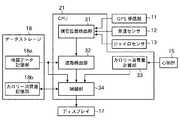
図1は、この発明の実施の形態1に係るポータブルナビゲーションシステムのハードウェア構成を示すブロック図である。このポータブルナビゲーションシステムは、本体1、クレードル2および心拍センサ3から構成されている。Hereinafter, embodiments of the present invention will be described in detail with reference to the drawings.
FIG. 1 is a block diagram showing a hardware configuration of a portable navigation system according to
本体1は、クレードル2に着脱可能に構成されている。クレードル2は、自動車、自転車、家庭内などに設置され、主に、本体1の電源(図示しない)を充電するために使用される。本体1は、クレードル2から取り外して持ち運び可能に構成されており、単体でナビゲーション機能を提供することができる。クレードル2は、移動手段識別器22を備えている。移動手段識別器22は、本体1が装着されたクレードル2が自動車用であるか、自転車用であるか、または家庭用であるかを表す移動手段識別信号を発生して本体1に送る。 The
ポータブルナビゲーションシステムは、本体1が、例えば自動車用のクレードル2に装着されることにより自動車用のナビゲーション装置、つまりカーナビゲーション装置として機能し、自転車用のクレードル2に装着されることにより自転車用のナビゲーション装置として機能し、クレードル2に装着されない場合は、歩行またはランニング用のナビゲーション装置として機能する。 The portable navigation system functions as an automobile navigation device, that is, a car navigation device, when the
心拍センサ3は、ユーザの心拍を検出し、心拍パルスとして無線で本体1に送信する。この心拍センサ3としては、ユーザが例えば腕に巻き付けて使用する腕時計型の心拍センサを使用することができる。 The
本体1は、GPS(Global Positioning System)受信器11、車速センサ12、ジャイロセンサ13、操作入力器14、心拍計15、ワイヤレス受信部16、ディスプレイ17、データストレージ18、ROM19、RAM20およびCPU21から構成されている。 The
GPS受信器11は、複数のGPS衛星からの電波を受信することにより自車位置を計測することができるGPS信号を生成し、CPU21に送る。車速センサ12は、本体1が自動車用のクレードル2に装着されることにより有効になり、自車の移動速度を計測する。この車速センサ12で計測された自車の移動速度は、速度信号としてCPU21に送られる。車速センサ12は、一般的に、車輪の回転数を計測するセンサから構成されており、このセンサで計測された回転数に基づき移動速度を算出する。 The
ジャイロセンサ13は、進行方向を計測し、方位信号としてCPU21に送る。操作入力器14は、例えば、リモートコントローラ(リモコン)、ディスプレイ17の画面上に載置されたタッチパネル、押釦スイッチ、音声認識装置などから構成することができる。この操作入力器14は、ユーザが、操作によって、目的地や、ユーザが消費を所望するカロリー量(以下、「カロリー消費量」という)の目標値を入力するために使用される。この操作入力器14から入力された目的地や目標値はCPU21に送られる。 The
心拍計15は、ワイヤレス受信部16からの心拍パルス信号を受け取り、心拍数を算出する。この心拍計15で算出された心拍数は、CPU21に送られる。ワイヤレス受信部16は、心拍センサ3から無線で送られてくる心拍パルスを受信して電気信号に変換し、心拍パルス信号として心拍計15に送る。ディスプレイ17は、例えば液晶ディスプレイ装置から構成されており、CPU21から送られてくる表示データにしたがって地図や経路を表示するとともに、この地図上にカロリー消費量などの情報を表示する。この発明の表示部は、このディスプレイ17とCPU21の制御部34(詳細は後述する)とによって構成されている。 The
データストレージ18は、例えばHDD(Hard Disk Drive)から構成されており、地図データ記憶部18aおよびカロリー消費量記憶部18bを備えている。地図データ記憶部18aは、地図データを記憶している。カロリー消費量記憶部18bは、CPU21で計算されたカロリー消費量を記憶する。このデータストレージ18は、CPU21によってアクセスされる。 The
ROM19は、このポータブルナビゲーションシステムの動作を制御する制御プログラムを記憶している。RAM20は、データを一時的に記憶するワーク領域として使用される。CPU21は、ROM19に記憶されている制御プログラムにしたがって動作し、RAM20をワーク領域として使用して各種処理を実行する。このCPU21の詳細を以下に説明する。 The
図2は、CPU21の機能的な構成を示すブロック図である。CPU21は、現在位置検出部31、道路検出部32、カロリー消費量計算部33および制御部34を備えている。これらの各部は、CPU21のソフトウェア処理によって実現されている。 FIG. 2 is a block diagram illustrating a functional configuration of the
現在位置検出部31は、GPS受信器11から送られてくるGPS信号、車速センサ12から送られてくる速度信号およびジャイロセンサ13から送られてくる方位信号に基づき自己の現在位置を検出する。この現在位置検出部31で検出された自己の現在位置を示す現在位置データは、道路検出部32に送られる。なお、車速センサ12から送られてくる速度信号は、クレードル2の移動手段識別器22が自動車用であることを表す移動手段識別信号を出力している場合にのみ使用される。 The current
道路検出部32は、現在位置検出部31からリアルタイムに送られてくる現在位置データと地図データ記憶部18aから読み出した地図データとのマッチングをとることにより、自己が通過した道路を検出する。この道路検出部32で検出された道路を表す道路データは、制御部34に送られる。カロリー消費量計算部33は、心拍計15から送られてくる心拍数に基づきカロリー消費量を計算する。このカロリー消費量計算部33で計算されたカロリー消費量は、制御部34に送られる。 The
制御部34は、道路検出部32から送られてくる道路データが所定の区間の終わり、例えば1つの道路リンクの終わりを示す毎に、カロリー消費量計算部33から受け取ったカロリー消費量に基づき、その区間におけるカロリー消費量を算出する。そして、算出したカロリー消費量を、その区間に対応付けてカロリー消費量記憶部18bに記憶する。 Whenever the road data sent from the
また、制御部34は、地図データ記憶部18aから地図データを読み出してディスプレイ17に送ることによって通過した道路を含む地図を表示し、さらに、カロリー消費量記憶部18bから通過した道路の各区間のカロリー消費量を読み出して全区間のカロリー消費量を計算し、各区間のカロリー消費量および全区間のカロリー消費量をディスプレイ17に送る。これにより、図3に示すように、ディスプレイ17には、スタート地点Sからゴール地点Gまでの道路の全区間のカロリー消費量の他に、各区間T1、T2およびT3のカロリー消費量が表示される。したがって、ユーザは、地図上のどの区間でカロリー消費が多かったかなどを視覚的に把握することができる。 Moreover, the
以上説明したように、この発明の実施の形態1に係るポータブルナビゲーションシステムによれば、心拍計15からの心拍数から求められるカロリー消費量(個人差のある情報)を地図データに対応付けて記録できるようにしたので、単に「消費したカロリーの総量」を示すだけではなく、「地図上のどの辺りがカロリー消費に貢献したか、大変だったか」などを表示できるので、より楽しく、且つ効果的に屋外でのフィットネス活動をサポートできる。 As described above, according to the portable navigation system of the first embodiment of the present invention, the calorie consumption (information with individual differences) obtained from the heart rate from the
実施の形態2.
この発明の実施の形態2に係るポータブルナビゲーションシステムは、実施の形態1に係るポータブルナビゲーションシステムにおいて、カロリー消費量記憶部18bに記憶されたカロリー消費量を考慮して経路探索を行うようにしたものである。このポータブルナビゲーションシステムでは、操作入力器14から目的地が入力される他に、ユーザが所望するカロリー消費量の目標値が入力される。Embodiment 2. FIG.
A portable navigation system according to Embodiment 2 of the present invention is a portable navigation system according to
実施の形態2に係るポータブルナビゲーションシステムのハードウェア構成は、CPU21の機能的な構成を除き、実施の形態1に係るポータブルナビゲーションシステムの構成と同じである。図4は、実施の形態2に係るポータブルナビゲーションシステムで使用されるCPU21の機能的な構成を示すブロック図である。CPU21は、図2に示した実施の形態1に係るCPUの構成に、ソフトウェア処理によって実現された経路探索部35が追加されて構成されている。 The hardware configuration of the portable navigation system according to the second embodiment is the same as the configuration of the portable navigation system according to the first embodiment except for the functional configuration of the
経路探索部35は、現在位置検出部31で検出された現在位置から、操作入力器14から入力された目的地までの経路を、地図データ記憶部18aに記憶されている地図データに基づき探索する。そして、探索された経路の各区間で消費されるカロリーを、カロリー消費量記憶部18bから読み出したカロリー消費量に基づき計算し、各区間におけるカロリー消費量の総和が、操作入力器14から入力されたカロリー消費量の目標値より小さければ、再度、他の経路を探索する。そして、各区間におけるカロリー消費量の総和が、操作入力器14から入力されたカロリー消費量より大きい経路が探索された場合に、その経路を推奨経路として制御部34に送る。 The
制御部34は、経路探索部35から送られてきた推奨経路を含む地図データを、地図データ記憶部18aから読み出してディスプレイ17に送ることにより推奨経路を含む地図を表示させ、さらに、カロリー消費量記憶部18bから読み出した推奨経路の各区間のカロリー消費量から全区間のカロリー消費量を計算し、推奨経路の各区間のカロリー消費量および全区間のカロリー消費量をディスプレイ17に送る。これにより、ディスプレイ17には、推奨経路の全区間のカロリー消費量の他に、各区間のカロリー消費量が、例えば図3に示すような形態で表示される。 The
以上説明したように、この発明の実施の形態2に係るポータブルナビゲーションシステムによれば、カロリー消費量記憶部18bに経路の各区間のカロリー消費量が記憶されていれば、ユーザが所望するカロリー消費を達成できる推奨経路を表示させることができるので、ユーザの健康増進に寄与できる。 As described above, according to the portable navigation system according to the second embodiment of the present invention, if the calorie consumption of each section of the route is stored in the calorie
実施の形態3.
上述した実施の形態2に係るポータブルナビゲーションシステムでは、カロリー消費量記憶部18bには、ユーザが実際に通った経路の各区間のカロリー消費量が記憶されるだけであるので、ユーザが未だ通っていない経路を含む推奨経路をユーザに提示できない。この実施の形態3に係るポータブルナビゲーションシステムは、ユーザが未だ通っていない経路を含む推奨経路をユーザに提示できるようにしたものである。
In the portable navigation system according to the second embodiment described above, the calorie
実施の形態3に係るポータブルナビゲーションシステムのハードウェア構成は、CPU21の機能的な構成を除き、実施の形態2に係るポータブルナビゲーションシステムと同じである。図5は、実施の形態3に係るポータブルナビゲーションシステムで使用されるCPU21の機能的な構成を示すブロック図である。CPU21は、図4に示した実施の形態2に係るCPUの構成に、ソフトウェア処理によって実現された勾配計算部36が追加されて構成されている。 The hardware configuration of the portable navigation system according to the third embodiment is the same as that of the portable navigation system according to the second embodiment except for the functional configuration of the
勾配計算部36は、道路検出部32から送られてくる道路データが所定区間(例えば、100m)の終わりを示す毎に、その所定区間の道路の勾配を、地図データ記憶部18aから読み出した地図データに含まれる高度データに基づき計算し、制御部34に送る。制御部34は、勾配計算部36から送られてくる勾配を、カロリー消費量計算部33から送られてくる、その所定区間におけるカロリー消費量に対応付けてカロリー消費量記憶部18bにテーブル形式で記憶する。図6は、カロリー消費量記憶部18bに記憶されるテーブルの例を示す図であり、勾配値毎に100mあたりのカロリー消費量が記憶されている。 Each time the road data sent from the
経路探索部35は、現在位置検出部31で検出された現在位置から、操作入力器14から入力された目的地までの複数の経路を、地図データ記憶部18aに記憶されている地図データに基づき探索する。そして、探索された複数の経路の各々で消費されるカロリーを、カロリー消費量記憶部18bから読み出したカロリー消費量に基づき計算し、経路と一緒に制御部34に送る。 The
制御部34は、経路探索部35から送られてきた複数の経路を含む地図データを地図データ記憶部18aから読み出してディスプレイ17に送ることにより複数の経路を含む地図を表示し、さらに、カロリー消費量記憶部18bから読み出した複数の経路の各々のカロリー消費量を計算し、これにより、ディスプレイ17には、図7に示すように、現在位置から目的地までの複数の経路と、各経路のカロリー消費量とが表示される。 The
以上説明したように、この実施の形態3に係るポータブルナビゲーションシステムによれば、ある道路をユーザが実際に通ったときに、勾配値毎のカロリー消費量を計算して記憶しておき、経路探索時に、探索された複数の経路の各々につて、勾配値に基づきカロリー消費量を計算して表示するように構成したので、ユーザが未だ通ったことのない経路に対して、カロリー消費量を予想することができる。 As described above, according to the portable navigation system according to the third embodiment, when the user actually passes a certain road, the calorie consumption for each gradient value is calculated and stored, and the route search is performed. Sometimes, for each of a plurality of searched routes, the calorie consumption is calculated and displayed based on the gradient value, so the calorie consumption is predicted for the route that the user has not yet passed. can do.
なお、この実施の形態3に係るポータブルナビゲーションシステムにおいて、実施の形態2に係るポータブルナビゲーションシステムのように、ユーザが目的地に到達するまでに消費を所望するカロリー消費量の目標値を設定しておき、これを達成できるような経路を表示するように構成すれば、ユーザが目標とするカロリー消費を達成できる「遠回り」の経路検索も可能になる。 In the portable navigation system according to the third embodiment, the target value of calorie consumption desired to be consumed by the user before reaching the destination is set as in the portable navigation system according to the second embodiment. In addition, if a route that can achieve this is displayed, it is possible to search for a “detour” route that allows the user to achieve the target calorie consumption.
実施の形態4.
この発明の実施の形態4に係るポータブルナビゲーションシステムは、携帯電話を使用してナビゲーション機能および健康増進のための情報を提示できるようにしたものである。以下では、自転車用のポータブルナビゲーションシステムについて説明する。
A portable navigation system according to
図8は、この発明の実施の形態4に係るポータブルナビゲーションシステムのハードウェア構成を示すブロック図である。このポータブルナビゲーションシステムは、GPS機能内蔵の携帯電話4、自転車用のクレードル5および心拍センサ3から構成されている。携帯電話4はクレードル5に装着されて使用される。心拍センサ3は、実施の形態1に係るポータブルナビゲーションシステムのそれと同じである。 FIG. 8 is a block diagram showing a hardware configuration of a portable navigation system according to
クレードル5は、コネクタ51、車輪回転センサ52、心拍計53およびワイヤレス受信部54から構成されている。コネクタ51は、クレードル5に携帯電話4を接続するために使用される。車輪回転センサ52は、自車の移動速度を計測する。この車輪回転センサ52で計測された自車の移動速度は、速度信号としてコネクタ51を経由して携帯電話4に送られる。車輪回転センサ52は、車輪の回転数を計測するセンサから構成されており、このセンサで計測された回転数に基づき移動速度を算出する。 The
心拍計53およびワイヤレス受信部54は、実施の形態1に係るポータブルナビゲーションシステムの心拍計15およびワイヤレス受信部16とそれぞれ同じである。心拍計53で算出された心拍数は、コネクタ51を経由して携帯電話4に送られる。
携帯電話4は、GPS受信器41およびナビゲーションソフトウェア42を搭載している。GPS受信器41は、実施の形態1〜3におけるGPS受信器11と同じである。また、ナビゲーションソフトウェア42は、実施の形態1〜3における現在位置検出部31、道路検出部32、カロリー消費量計算部33、制御部34、経路探索部35および勾配計算部36と同様の機能を含む。なお、ディスプレイ17およびデータストレージ18は、図示は省略するが、携帯電話4に備えられているディスプレイおよびメモリがそれぞれ使用される。 The
上記のように構成される、この発明の実施の形態4に係るポータブルナビゲーションシステムの動作は、心拍数をクレードル5に搭載された心拍計53から取得し、移動速度をクレードル5に搭載された車輪回転センサ52から取得することを除けば、上述した実施の形態1〜3の動作と同じである。 The operation of the portable navigation system according to the fourth embodiment of the present invention configured as described above acquires the heart rate from the
以上説明したように、この発明の実施の形態4に係るポータブルナビゲーションシステムによれば、上述した実施の形態1〜3に係るポータブルナビゲーションシステムと同様の効果を奏する。 As described above, according to the portable navigation system according to the fourth embodiment of the present invention, the same effects as the portable navigation system according to the first to third embodiments described above can be obtained.
なお、この実施の形態4に係るポータブルナビゲーションシステムは、クレードル5から取り出した携帯電話4だけの場合は、徒歩用またはランニング用のナビゲーションシステムとして使用できる。また、クレードル5から車輪回転センサ52を取り外して、徒歩用やランニング用のナビゲーションシステムとして使用するように構成することもできる。さらに、クレードル5が有する機能を携帯電話4に内蔵するように構成することもできる。 The portable navigation system according to the fourth embodiment can be used as a walking or running navigation system when only the
1 本体、2 クレードル、3 心拍センサ、4 携帯電話、5 クレードル、11 GPS受信器、12 車速センサ、13 ジャイロセンサ、14 操作入力器、15 心拍計、16 ワイヤレス受信部、17 ディスプレイ、18 データストレージ、18a 地図データ記憶部、18b カロリー消費量記憶部、19 ROM、20 RAM、21 CPU、22 移動手段識別器、31 現在位置検出部、32 道路検出部、33 カロリー消費量計算部、34 制御部、35 経路探索部、36 勾配計算部、41 GPS受信器、42 ナビゲーションソフトウェア、51 コネクタ、52 車輪回転センサ、53 心拍計、54 ワイヤレス受信部。 1 Main unit, 2 Cradle, 3 Heart rate sensor, 4 Mobile phone, 5 Cradle, 11 GPS receiver, 12 Vehicle speed sensor, 13 Gyro sensor, 14 Operation input device, 15 Heart rate monitor, 16 Wireless receiver, 17 Display, 18 Data storage , 18a Map data storage unit, 18b Calorie consumption storage unit, 19 ROM, 20 RAM, 21 CPU, 22 Moving means identifier, 31 Current position detection unit, 32 Road detection unit, 33 Calorie consumption calculation unit, 34 Control unit , 35 route search unit, 36 gradient calculation unit, 41 GPS receiver, 42 navigation software, 51 connector, 52 wheel rotation sensor, 53 heart rate monitor, 54 wireless reception unit.
Claims (4)
Translated fromJapanese前記心拍計で計数された心拍数に基づきカロリー消費量を計算するカロリー消費量計算部と、
地図データを記憶する地図データ記憶部と、
現在位置を検出する現在位置検出部と、
前記現在位置検出部で検出された現在位置と前記地図データ記憶部から読み出した地図データとのマッチングをとることにより通過した道路を検出する道路検出部と、
前記道路検出部で検出された道路の各区間に、前記カロリー消費量計算部で計算された該区間におけるカロリー消費量を対応付けて記憶するカロリー消費量記憶部と、
前記地図データ記憶部から読み出した地図データによって示される道路の各区間に、前記カロリー消費量記憶部から読み出した該道路の各区間におけるカロリー消費量を対応させて表示する表示部
とを備えたポータブルナビゲーションシステム。A heart rate monitor that counts your heart rate;
A calorie consumption calculator that calculates calorie consumption based on the heart rate counted by the heart rate monitor;
A map data storage unit for storing map data;
A current position detector for detecting the current position;
A road detection unit that detects a road that has passed by matching the current position detected by the current position detection unit and the map data read from the map data storage unit;
A calorie consumption storage unit that stores the calorie consumption in the section calculated by the calorie consumption calculation unit in association with each section of the road detected by the road detection unit;
A display unit that displays the corresponding calorie consumption in each section of the road read from the calorie consumption storage unit in correspondence with each section of the road indicated by the map data read from the map data storage unit Navigation system.
現在位置検出部で検出された現在位置から前記操作入力器によって入力された目的地までの複数の経路の中から、前記操作入力器によって入力されたカロリー消費の目標値を越えることができる推奨経路を、地図データ記憶部から読み出した地図データとカロリー消費量記憶部から読み出したカロリー消費量とに基づき探索する経路探索部とを備え、
表示部は、前記経路探索部で探索された推奨経路を地図データ記憶部から読み出した地図データに基づき表示するとともに、前記カロリー消費量記憶部から読み出した該推奨経路の各区間におけるカロリー消費量を表示する
ことを特徴とする請求項1記載のポータブルナビゲーションシステム。An operation input device for inputting the destination and the target value of calorie consumption;
A recommended route that can exceed the target value of calorie consumption input by the operation input device from a plurality of routes from the current position detected by the current position detection unit to the destination input by the operation input device. A route search unit for searching based on the map data read from the map data storage unit and the calorie consumption read from the calorie consumption storage unit,
The display unit displays the recommended route searched by the route search unit based on the map data read from the map data storage unit, and displays the calorie consumption in each section of the recommended route read from the calorie consumption storage unit. The portable navigation system according to claim 1, wherein the portable navigation system is displayed.
目的地を入力する操作入力器と、
現在位置検出部で検出された現在位置から前記操作入力器によって入力された目的地までの複数の経路を地図データ記憶部から読み出した地図データに基づき探索し、該探索した複数の経路の各々に対応するカロリー消費量を前記カロリー消費量記憶部に記憶されているカロリー消費量に基づき計算する経路探索部とを備え、
表示部は、前記経路探索部で探索された複数の経路を地図データ記憶部から読み出した地図データに基づき表示するとともに、前記カロリー消費量記憶部から読み出した各経路のカロリー消費量を表示する
ことを特徴とする請求項1記載のポータブルナビゲーションシステム。The slope of the road section detected by the road detection unit is calculated based on the altitude data included in the map data read from the map data storage unit, and the calculated slope and the calorie in the section calculated by the calorie consumption calculation unit are calculated. A gradient calculation unit that associates consumptions and stores them in a calorie consumption storage unit;
An operation input device for entering the destination,
A plurality of routes from the current position detected by the current position detection unit to the destination input by the operation input device are searched based on the map data read from the map data storage unit, and each of the searched plurality of routes is A route search unit that calculates a corresponding calorie consumption based on the calorie consumption stored in the calorie consumption storage unit;
The display unit displays a plurality of routes searched by the route search unit based on the map data read from the map data storage unit, and displays the calorie consumption amount of each route read from the calorie consumption storage unit. The portable navigation system according to claim 1.
前記クレードルに装着される携帯電話
とを備えたポータブルナビゲーションシステムであって、
前記携帯電話は、
前記クレードルに備えられた心拍計で計数された心拍数に基づきカロリー消費量を計算するカロリー消費量計算部と、
地図データを記憶する地図データ記憶部と、
現在位置を検出する現在位置検出部と、
前記現在位置検出部で検出された現在位置と前記地図データ記憶部から読み出した地図データとのマッチングをとることにより通過した道路の区間を検出する道路検出部と、
前記道路検出部で検出された道路の区間に、前記カロリー消費量計算部で計算された該区間におけるカロリー消費量を対応付けて記憶するカロリー消費量記憶部と、
前記地図データ記憶部から読み出した地図データによって示される道路の各区間に、前記カロリー消費量記憶部から読み出した該道路の各区間におけるカロリー消費量を対応させて表示する表示部
とを備えたポータブルナビゲーションシステム。A cradle with a heart rate meter to count heart rate;
A portable navigation system comprising a mobile phone attached to the cradle,
The mobile phone
A calorie consumption calculator that calculates calorie consumption based on the heart rate counted by a heart rate meter provided in the cradle;
A map data storage unit for storing map data;
A current position detector for detecting the current position;
A road detection unit that detects a section of a road that has been passed by matching the current position detected by the current position detection unit and the map data read from the map data storage unit;
A calorie consumption storage unit for storing the calorie consumption in the section calculated by the calorie consumption calculation unit in association with the section of the road detected by the road detection unit;
A display unit that displays the corresponding calorie consumption in each section of the road read from the calorie consumption storage unit in correspondence with each section of the road indicated by the map data read from the map data storage unit Navigation system.
Priority Applications (1)
| Application Number | Priority Date | Filing Date | Title |
|---|---|---|---|
| JP2006118253AJP2007292505A (en) | 2006-04-21 | 2006-04-21 | Portable navigation system |
Applications Claiming Priority (1)
| Application Number | Priority Date | Filing Date | Title |
|---|---|---|---|
| JP2006118253AJP2007292505A (en) | 2006-04-21 | 2006-04-21 | Portable navigation system |
Publications (1)
| Publication Number | Publication Date |
|---|---|
| JP2007292505Atrue JP2007292505A (en) | 2007-11-08 |
Family
ID=38763258
Family Applications (1)
| Application Number | Title | Priority Date | Filing Date |
|---|---|---|---|
| JP2006118253APendingJP2007292505A (en) | 2006-04-21 | 2006-04-21 | Portable navigation system |
Country Status (1)
| Country | Link |
|---|---|
| JP (1) | JP2007292505A (en) |
Cited By (11)
| Publication number | Priority date | Publication date | Assignee | Title |
|---|---|---|---|---|
| JP2009150804A (en)* | 2007-12-21 | 2009-07-09 | Nec Electronics Corp | Car navigation system and its control method |
| WO2010064178A1 (en)* | 2008-12-03 | 2010-06-10 | Koninklijke Philips Electronics N.V. | Navigational unit and system for maintaining physical activity goal |
| JP2010240385A (en)* | 2009-03-19 | 2010-10-28 | Yupiteru Corp | Device for support of golf, and program |
| EP2314806A1 (en)* | 2009-10-22 | 2011-04-27 | Fraunhofer-Gesellschaft zur Förderung der Angewandten Forschung e.V. | Motor vehicle ignition key, motor vehicle navigation device, motor vehicle system and method |
| JP2011112479A (en)* | 2009-11-26 | 2011-06-09 | Clarion Co Ltd | Personal navigation device with bicycle mode |
| JP2012018001A (en)* | 2010-07-06 | 2012-01-26 | Sony Corp | Positioning system, communication device, and positioning method |
| JP2012177871A (en)* | 2011-02-28 | 2012-09-13 | Pioneer Electronic Corp | Information presenting device, information presenting method, information presenting program and storage medium storing information presenting program |
| JP2014500560A (en)* | 2010-12-10 | 2014-01-09 | クアルコム,インコーポレイテッド | System, method, apparatus or computer program product for exercise and personal security |
| JP2017142819A (en)* | 2010-08-09 | 2017-08-17 | ナイキ イノベイト シーブイ | Fitness monitoring method, apparatus, computer readable medium, and system using mobile devices |
| US10232220B2 (en) | 2010-08-09 | 2019-03-19 | Nike, Inc. | Monitoring fitness using a mobile device |
| US10474885B2 (en) | 2010-08-09 | 2019-11-12 | Nike, Inc. | Monitoring fitness using a mobile device |
Citations (8)
| Publication number | Priority date | Publication date | Assignee | Title |
|---|---|---|---|---|
| JPH1082653A (en)* | 1996-09-06 | 1998-03-31 | Matsushita Electric Ind Co Ltd | Navigation device |
| JPH10148539A (en)* | 1996-11-18 | 1998-06-02 | Toyota Motor Corp | Route guidance device |
| JPH10253379A (en)* | 1997-03-13 | 1998-09-25 | Nissan Motor Co Ltd | Route guidance device |
| JP2001103134A (en)* | 1999-09-30 | 2001-04-13 | Koji Aoki | Multi-function mobile phone and measurement device using the mobile phone |
| JP2001161670A (en)* | 1999-12-07 | 2001-06-19 | Ya Man Ltd | Calculator for calorie |
| JP2001296137A (en)* | 2000-04-17 | 2001-10-26 | Denso Corp | Portable map display device |
| JP2001317960A (en)* | 2000-05-11 | 2001-11-16 | Sento:Kk | Measurement system for movement distance using mobile communication terminal |
| JP2004109100A (en)* | 2002-09-18 | 2004-04-08 | Fumio Mizoguchi | Navigation system for health management |
- 2006
- 2006-04-21JPJP2006118253Apatent/JP2007292505A/enactivePending
Patent Citations (8)
| Publication number | Priority date | Publication date | Assignee | Title |
|---|---|---|---|---|
| JPH1082653A (en)* | 1996-09-06 | 1998-03-31 | Matsushita Electric Ind Co Ltd | Navigation device |
| JPH10148539A (en)* | 1996-11-18 | 1998-06-02 | Toyota Motor Corp | Route guidance device |
| JPH10253379A (en)* | 1997-03-13 | 1998-09-25 | Nissan Motor Co Ltd | Route guidance device |
| JP2001103134A (en)* | 1999-09-30 | 2001-04-13 | Koji Aoki | Multi-function mobile phone and measurement device using the mobile phone |
| JP2001161670A (en)* | 1999-12-07 | 2001-06-19 | Ya Man Ltd | Calculator for calorie |
| JP2001296137A (en)* | 2000-04-17 | 2001-10-26 | Denso Corp | Portable map display device |
| JP2001317960A (en)* | 2000-05-11 | 2001-11-16 | Sento:Kk | Measurement system for movement distance using mobile communication terminal |
| JP2004109100A (en)* | 2002-09-18 | 2004-04-08 | Fumio Mizoguchi | Navigation system for health management |
Cited By (23)
| Publication number | Priority date | Publication date | Assignee | Title |
|---|---|---|---|---|
| JP2009150804A (en)* | 2007-12-21 | 2009-07-09 | Nec Electronics Corp | Car navigation system and its control method |
| WO2010064178A1 (en)* | 2008-12-03 | 2010-06-10 | Koninklijke Philips Electronics N.V. | Navigational unit and system for maintaining physical activity goal |
| CN102239388A (en)* | 2008-12-03 | 2011-11-09 | 皇家飞利浦电子股份有限公司 | Navigation unit and system for maintaining physical activity goals |
| JP2010240385A (en)* | 2009-03-19 | 2010-10-28 | Yupiteru Corp | Device for support of golf, and program |
| US8775012B2 (en) | 2009-10-22 | 2014-07-08 | Fraunhofer-Gesellschaft Zur Foerderung Der Angewandten Forschung E. V. | Motor vehicle ignition key, motor vehicle navigation device, motor vehicle system, and methods |
| EP2314806A1 (en)* | 2009-10-22 | 2011-04-27 | Fraunhofer-Gesellschaft zur Förderung der Angewandten Forschung e.V. | Motor vehicle ignition key, motor vehicle navigation device, motor vehicle system and method |
| EP2325421A1 (en)* | 2009-10-22 | 2011-05-25 | Fraunhofer-Gesellschaft zur Förderung der angewandten Forschung e.V. | Motor vehicle ignition key, motor vehicle navigation device, motor vehicle system and method |
| JP2011112479A (en)* | 2009-11-26 | 2011-06-09 | Clarion Co Ltd | Personal navigation device with bicycle mode |
| JP2012018001A (en)* | 2010-07-06 | 2012-01-26 | Sony Corp | Positioning system, communication device, and positioning method |
| US11600114B2 (en) | 2010-08-09 | 2023-03-07 | Nike, Inc. | Monitoring fitness using a mobile device |
| US11468711B2 (en) | 2010-08-09 | 2022-10-11 | Nike, Inc. | Monitoring fitness using a mobile device |
| US12387531B2 (en) | 2010-08-09 | 2025-08-12 | Nike, Inc. | Monitoring fitness using a mobile device |
| JP2017142819A (en)* | 2010-08-09 | 2017-08-17 | ナイキ イノベイト シーブイ | Fitness monitoring method, apparatus, computer readable medium, and system using mobile devices |
| US10232220B2 (en) | 2010-08-09 | 2019-03-19 | Nike, Inc. | Monitoring fitness using a mobile device |
| US10474885B2 (en) | 2010-08-09 | 2019-11-12 | Nike, Inc. | Monitoring fitness using a mobile device |
| US10572721B2 (en) | 2010-08-09 | 2020-02-25 | Nike, Inc. | Monitoring fitness using a mobile device |
| US12230064B2 (en) | 2010-08-09 | 2025-02-18 | Nike, Inc. | Monitoring fitness using a mobile device |
| US11783638B2 (en) | 2010-08-09 | 2023-10-10 | Nike, Inc. | Monitoring fitness using a mobile device |
| US11776321B2 (en) | 2010-08-09 | 2023-10-03 | Nike, Inc. | Monitoring fitness using a mobile device |
| US11783637B2 (en) | 2010-08-09 | 2023-10-10 | Nike, Inc. | Monitoring fitness using a mobile device |
| JP2014500560A (en)* | 2010-12-10 | 2014-01-09 | クアルコム,インコーポレイテッド | System, method, apparatus or computer program product for exercise and personal security |
| US8988214B2 (en) | 2010-12-10 | 2015-03-24 | Qualcomm Incorporated | System, method, apparatus, or computer program product for exercise and personal security |
| JP2012177871A (en)* | 2011-02-28 | 2012-09-13 | Pioneer Electronic Corp | Information presenting device, information presenting method, information presenting program and storage medium storing information presenting program |
Similar Documents
| Publication | Publication Date | Title |
|---|---|---|
| JP2007292505A (en) | Portable navigation system | |
| US10151597B2 (en) | Route search apparatus and route search method | |
| US9970777B2 (en) | Method and apparatus for recommending exercise routes | |
| US8768613B2 (en) | Tour route generating device, tour route generating method, and program | |
| US7853404B2 (en) | Vehicle docking station for portable handheld computing device | |
| US20110208421A1 (en) | Navigation device, navigation method, and program | |
| US6148262A (en) | Sports computer with GPS receiver and performance tracking capabilities | |
| US8655740B2 (en) | Information providing apparatus and system | |
| JP5985788B2 (en) | Information processing device | |
| US20110250937A1 (en) | Race participant tracking via wireless positioning technology and near real time reporting of location and pertinent race metrics to the participant and optionally to other individuals or publication on the internet | |
| US20090070038A1 (en) | Navigation Device with Automatic Gps Precision Enhancement | |
| KR20120038929A (en) | Athletic watch | |
| US20120150429A1 (en) | Method and arrangement relating to navigation | |
| JP6015900B2 (en) | Information processing apparatus, exercise support information providing system, exercise support information providing method, and exercise support information providing program | |
| JP2011070660A (en) | Personal navigation system to be used by portable device | |
| JP2013095306A (en) | Electronic system for bicycle, and program | |
| US20080221792A1 (en) | Navigation apparatus | |
| JP2009213654A (en) | Information presentation device and information presentation system | |
| US20130038459A1 (en) | Information processing apparatus, information processing method, program, and recording medium | |
| JP5892305B2 (en) | Activity amount measuring device, activity amount measuring system, program and recording medium | |
| JP2013221821A (en) | Information processing apparatus, moving body, traveling support system and traveling support method | |
| JP2005147916A (en) | Walking schedule management system | |
| CN104215250A (en) | Apparatus, server and method for providing route guidance | |
| JP2014115196A (en) | Gps receiver and program | |
| JP2010190648A (en) | Navigation apparatus and navigating method |
Legal Events
| Date | Code | Title | Description |
|---|---|---|---|
| RD04 | Notification of resignation of power of attorney | Free format text:JAPANESE INTERMEDIATE CODE: A7424 Effective date:20070920 | |
| A621 | Written request for application examination | Free format text:JAPANESE INTERMEDIATE CODE: A621 Effective date:20080402 | |
| RD04 | Notification of resignation of power of attorney | Free format text:JAPANESE INTERMEDIATE CODE: A7424 Effective date:20080630 | |
| A977 | Report on retrieval | Free format text:JAPANESE INTERMEDIATE CODE: A971007 Effective date:20100831 | |
| A131 | Notification of reasons for refusal | Free format text:JAPANESE INTERMEDIATE CODE: A131 Effective date:20100907 | |
| A02 | Decision of refusal | Free format text:JAPANESE INTERMEDIATE CODE: A02 Effective date:20110104 |