Movatterモバイル変換


[0]ホーム

URL:


JP2007240279A - Navigation device and navigation system - Google Patents

Navigation device and navigation system
Download PDF

Info

Publication number
JP2007240279A
JP2007240279AJP2006061730AJP2006061730AJP2007240279AJP 2007240279 AJP2007240279 AJP 2007240279AJP 2006061730 AJP2006061730 AJP 2006061730AJP 2006061730 AJP2006061730 AJP 2006061730AJP 2007240279 AJP2007240279 AJP 2007240279A
Authority
JP
Japan
Prior art keywords
information
traffic information
traffic
intersection
vehicle position
Prior art date
Legal status (The legal status is an assumption and is not a legal conclusion. Google has not performed a legal analysis and makes no representation as to the accuracy of the status listed.)
Granted
Application number
JP2006061730A
Other languages
Japanese (ja)
Other versions
JP4631751B2 (en
Inventor
Shoji Yokoyama
昭二 横山
Teruhiro Nakajima
彰宏 中嶋
Current Assignee (The listed assignees may be inaccurate. Google has not performed a legal analysis and makes no representation or warranty as to the accuracy of the list.)
Aisin AW Co Ltd
Original Assignee
Aisin AW Co Ltd
Priority date (The priority date is an assumption and is not a legal conclusion. Google has not performed a legal analysis and makes no representation as to the accuracy of the date listed.)
Filing date
Publication date
Application filed by Aisin AW Co LtdfiledCriticalAisin AW Co Ltd
Priority to JP2006061730ApriorityCriticalpatent/JP4631751B2/en
Publication of JP2007240279ApublicationCriticalpatent/JP2007240279A/en
Application grantedgrantedCritical
Publication of JP4631751B2publicationCriticalpatent/JP4631751B2/en
Expired - Fee Relatedlegal-statusCriticalCurrent
Anticipated expirationlegal-statusCritical

Links

Images

Landscapes

Abstract

<P>PROBLEM TO BE SOLVED: To provide a navigation device and a navigation system, in which a driver is capable of easily discriminating the traffic information regarding the route changed destination, and is capable of instantaneously selecting the route. <P>SOLUTION: The CPU 41 extracts crossings ahead in a running direction, in a prescribed region from own vehicle position including own vehicle position from navigation map information 39; thereafter, by the Dijkstra method, the cost from own vehicle position to each extracted crossings are calculated, and temporally routes are obtained (S1 to S3). The CPU 41 extracts the last link of each temporary route (S4), and the CPU 41 read out the traffic information, corresponding to the direction of the extracted last link from the present traffic information 37A of navigation-side traffic information DB36, and displays the traffic congestion information and traffic regulation information etc., while making it associated with "last link" on the map images 50 displayed on the display 25 (S5 to S6). <P>COPYRIGHT: (C)2007,JPO&INPIT

Description

Translated fromJapanese

本発明は、ナビゲーション装置及びナビゲーションシステムに関し、特に、表示装置の地図上に交通情報を表示するナビゲーション装置及びナビゲーションシステムに関するものである。  The present invention relates to a navigation device and a navigation system, and more particularly to a navigation device and a navigation system that display traffic information on a map of a display device.

近年、車両の走行案内を行い、運転者が所望の目的地に容易に到着できるようにしたナビゲーション装置が車両に搭載されていることが多い。このナビゲーション装置とは、GPS受信機などにより車両の現在位置を検出し、その現在位置に対応する地図データをDVD−ROMやHDDなどの記録媒体、又はネットワークを通じて取得して液晶モニタに表示することが可能な装置である。そして、車両の現在位置を含む地図データを記録媒体等から読み出し、地図データに基づいて車両の現在位置の周囲における地図画像を描画して表示装置に表示するとともに、車両位置マークを地図画像に重ね合わせて表示し、車両の移動に応じて地図画像をスクロールしたり、地図画像を画面に固定し車両位置マークを移動させることによって、車両が現在どの地点を走行しているのかを一目でわかるようにしている。  2. Description of the Related Art In recent years, a navigation device is often mounted on a vehicle that provides vehicle travel guidance so that a driver can easily arrive at a desired destination. This navigation device detects the current position of a vehicle with a GPS receiver or the like, acquires map data corresponding to the current position through a recording medium such as a DVD-ROM or HDD, or a network, and displays it on a liquid crystal monitor. It is a device that can. Then, map data including the current position of the vehicle is read from a recording medium or the like, a map image around the current position of the vehicle is drawn based on the map data and displayed on the display device, and the vehicle position mark is overlaid on the map image. You can also see at a glance which point the vehicle is currently driving by scrolling the map image as the vehicle moves, or by fixing the map image to the screen and moving the vehicle position mark I have to.

ここで、受信した交通情報に基づいて渋滞情報等を案内するナビゲーション装置及びナビゲーションシステムが種々提案されている。
例えば、自己の現在位置に基づき、地図情報記憶手段に記憶された地図情報に基づく地図を画面に表示しながら、目的地に向けて設定された誘導経路に従い使用者を誘導する経路誘導機能を有するナビゲーション装置において、送られてくる交通情報を受信する情報受信手段と、該情報受信手段により受信された前記交通情報から、誘導経路上における進行方向の交通情報のみを表示するように構成されたナビゲーション装置がある(例えば、特許文献1参照。)。
特開平9−270094号公報(段落(0027)〜(0031)、図6〜図9)
Here, various navigation devices and navigation systems for guiding traffic jam information and the like based on received traffic information have been proposed.
For example, it has a route guidance function that guides the user according to the guidance route set for the destination while displaying a map based on the map information stored in the map information storage means on the screen based on the current position of the user In the navigation device, information receiving means for receiving the traffic information sent, and navigation configured to display only the traffic information in the traveling direction on the guide route from the traffic information received by the information receiving means There is an apparatus (for example, refer to Patent Document 1).
JP-A-9-270094 (paragraphs (0027) to (0031), FIGS. 6 to 9)

前記した特許文献1に記載されたナビゲーション装置では、経路誘導中に誘導経路上の交通情報を確認することができるため、誘導経路上に渋滞、交通規制等の交通障害がある場合に、これらを迂回するために現在の経路を変更して走行することが考えられる。
しかしながら、誘導経路上における進行方向の交通情報のみが表示されるため、変更した先の道路の交通情報を事前に確認できないことから、実際に走行した結果、更なる交通障害に会うこともある。また、全ての交通情報を表示することで、経路変更先の交通情報を事前に確認することはできるが、運転者は必要な交通情報と不要な交通情報とを選別する必要があるため、煩雑であり、経路選択を瞬時に行うことが困難になるという問題がある。
In the navigation device described inPatent Document 1 described above, traffic information on the guidance route can be confirmed during route guidance. Therefore, when there are traffic obstacles such as traffic jams or traffic restrictions on the guidance route, To detour, it is possible to change the current route and drive.
However, since only the traffic information in the traveling direction on the guide route is displayed, the traffic information of the changed road cannot be confirmed in advance, and as a result of actual driving, further traffic obstacles may be encountered. In addition, by displaying all traffic information, it is possible to confirm the traffic information of the route change destination in advance, but since the driver needs to select necessary traffic information and unnecessary traffic information, it is complicated. There is a problem that it is difficult to instantly select a route.

そこで、本発明は、上述した問題点を解決するためになされたものであり、運転者が走行する可能性の高い道路の交通情報を選択して表示することによって、経路変更先の交通情報を容易に判別でき、経路選択を瞬時に行うことが可能となるナビゲーション装置及びナビゲーションシステムを提供することを目的とする。  Therefore, the present invention has been made to solve the above-mentioned problems, and by selecting and displaying road traffic information that a driver is likely to travel, the traffic information of the route change destination is displayed. It is an object of the present invention to provide a navigation device and a navigation system that can be easily discriminated and that can instantly select a route.

前記目的を達成するため請求項1に係るナビゲーション装置は、交通情報を受信する受信手段(27)と、自車位置から所定範囲内の交差点を抽出する交差点抽出手段(23)と、自車位置から前記交差点抽出手段によって抽出された各抽出交差点に到達するまでの重み付けを算出し、前記各抽出交差点までの仮経路を求める重み付け算出手段(23)と、前記重み付け算出手段によって求められた各仮経路の最終道路リンクを抽出する最終リンク抽出手段(23)と、前記最終リンク抽出手段によって抽出された各最終道路リンクに対応する交通情報を前記受信手段により受信した交通情報から選択して表示装置(25)の地図上に表示するように制御する表示制御手段(23)と、を備えたことを特徴とする。  In order to achieve the above object, the navigation apparatus according toclaim 1 includes a receiving means (27) for receiving traffic information, an intersection extracting means (23) for extracting an intersection within a predetermined range from the own vehicle position, and the own vehicle position. The weighting calculation means (23) for calculating a weight until reaching each extraction intersection extracted by the intersection extraction means from each other, and a weight calculation means (23) for obtaining a temporary route to each extraction intersection, and each temporary calculation obtained by the weight calculation means A final link extracting means (23) for extracting the final road link of the route, and a traffic information corresponding to each final road link extracted by the final link extracting means is selected from the traffic information received by the receiving means and displayed. Display control means (23) for controlling to display on the map of (25).

また、請求項2に係るナビゲーション装置は、請求項1に記載のナビゲーション装置(2)において、前記最終リンク抽出手段(23)は、自車位置から前記各抽出交差点に到達するまでの重み付けが最も低い重み付けとなる各仮経路の最終道路リンクを抽出することを特徴とする。  Further, in the navigation device according toclaim 2, in the navigation device (2) according toclaim 1, the final link extraction means (23) is most weighted until reaching each extraction intersection from the own vehicle position. The final road link of each temporary route with a low weight is extracted.

また、請求項3に係るナビゲーション装置は、請求項1又は請求項2に記載のナビゲーションシ装置(2)において、前記交差点抽出手段(23)は、自車位置から進行方向前方の交差点を抽出することを特徴とする。  According to a third aspect of the present invention, in the navigation system (2) according to the first or second aspect, the intersection extraction means (23) extracts an intersection ahead of the traveling direction from the own vehicle position. It is characterized by that.

また、請求項4に係るナビゲーション装置は、請求項1乃至請求項3のいずれかに記載のナビゲーション装置(2)において、前記交通情報は、渋滞情報を含むことを特徴とする。  A navigation device according toclaim 4 is the navigation device (2) according to any one ofclaims 1 to 3, wherein the traffic information includes traffic jam information.

また、請求項5に係るナビゲーションシステムは、ナビゲーション装置(2)と、交通情報を受信する第1受信手段(17)と、前記第1受信手段で受信した交通情報を前記ナビゲーション装置に配信する交通情報配信手段(10、17)と、を有する情報配信センタ(3)と、を備えたナビゲーションシステム(1)において、前記ナビゲーション装置(2)は、自車位置を特定する自車位置情報を前記情報配信センタに送信する自車位置情報送信手段(23、27)と、前記情報配信センタから配信された交通情報を受信する第2受信手段(27)と、前記第2受信手段で受信した交通情報を表示装置(25)の地図上に表示するように制御する表示制御手段(23)と、を有し、前記情報配信センタ(3)は、前記ナビゲーション装置から自車位置情報を受信した場合には、該自車位置情報に基づいて前記自車位置から所定範囲内の交差点を抽出する交差点抽出手段(10)と、該自車位置から前記交差点抽出手段によって抽出された各抽出交差点に到達するまでの重み付けを算出し、前記各抽出交差点までの仮経路を求める重み付け算出手段(10)と、前記重み付け算出手段によって求められた各仮経路の最終道路リンクを抽出する最終リンク抽出手段(10)と、前記最終リンク抽出手段によって抽出された各最終道路リンクに対応する交通情報を前記第1受信手段により受信した交通情報から選択して前記交通情報配信手段を介して該ナビゲーション装置に配信するように制御する配信制御手段(10)と、を有することを特徴とする。  The navigation system according toclaim 5 is a navigation device (2), a first receiving means (17) for receiving traffic information, and a traffic for distributing the traffic information received by the first receiving means to the navigation device. In a navigation system (1) comprising an information distribution center (3) having information distribution means (10, 17), the navigation device (2) uses the vehicle position information for specifying the vehicle position as the vehicle position information. Vehicle position information transmitting means (23, 27) for transmitting to the information distribution center, second receiving means (27) for receiving traffic information distributed from the information distribution center, and traffic received by the second receiving means Display control means (23) for controlling information to be displayed on a map of the display device (25), and the information distribution center (3) includes the navigation device. When the vehicle position information is received, an intersection extraction means (10) for extracting an intersection within a predetermined range from the vehicle position based on the vehicle position information, and the intersection extraction means from the vehicle position. Weighting means (10) for calculating a weight until reaching each extracted intersection extracted by the above, and calculating a temporary route to each extracted intersection, and a final road link of each temporary route obtained by the weight calculating means A final link extracting means (10) for extracting the traffic information corresponding to each final road link extracted by the final link extracting means from the traffic information received by the first receiving means, and the traffic information distributing means And a delivery control means (10) for controlling delivery to the navigation device via the navigation device.

また、請求項6に係るナビゲーションシステムは、請求項5に記載のナビゲーションシステム(1)において、前記最終リンク抽出手段(10)は、自車位置から前記各抽出交差点に到達するまでの重み付けが最も低い重み付けとなる各仮経路の最終道路リンクを抽出することを特徴とする。  Further, in the navigation system according to claim 6, in the navigation system (1) according toclaim 5, the final link extraction means (10) is most weighted until reaching each extraction intersection from the own vehicle position. The final road link of each temporary route with a low weight is extracted.

また、請求項7に係るナビゲーションシステムは、請求項5又は請求項6に記載のナビゲーションシシステム(1)において、前記交差点抽出手段(10)は、前記自車位置から進行方向前方の交差点を抽出することを特徴とする。  The navigation system according toclaim 7 is the navigation system (1) according toclaim 5 or 6, wherein the intersection extraction means (10) extracts an intersection ahead of the traveling direction from the own vehicle position. It is characterized by doing.

更に、請求項8に係るナビゲーションシステムは、請求項5乃至請求項7のいずれかに記載のナビゲーションシステム(1)において、前記交通情報は、渋滞情報を含むことを特徴とする。  Further, the navigation system according to claim 8 is the navigation system (1) according to any one ofclaims 5 to 7, wherein the traffic information includes traffic jam information.

前記構成を有する請求項1に係るナビゲーション装置では、先ず、自車位置から所定範囲内の交差点を抽出し、この抽出された各抽出交差点に到達するまでの重み付けを算出して、各抽出交差点毎に自車位置から到達する仮経路を求め、この求められた各仮経路の最終道路リンクを抽出する。続いて、この抽出された各最終道路リンクに対応する交通情報を受信手段により受信した交通情報から選択して表示装置の地図上に表示する。
これにより、表示装置に表示されている各交通情報は、自車位置から所定範囲内の各交差点に到達するまでの重み付けによって求められた各仮経路の最終道路リンクに対応する交通情報であるため、経路を変更する場合に、運転者が走行する可能性の高い経路上の各交差点間の交通情報を選択して地図上に表示することが可能となり、運転者は、経路変更先の交通情報を容易に判別でき、経路選択を瞬時に行うことが可能となる。
In the navigation device according toclaim 1 having the above-described configuration, first, an intersection within a predetermined range is extracted from the own vehicle position, a weight until reaching each extracted intersection is calculated, and each extracted intersection is calculated. Then, a temporary route reaching from the vehicle position is obtained, and a final road link of each obtained temporary route is extracted. Subsequently, the traffic information corresponding to each extracted final road link is selected from the traffic information received by the receiving means and displayed on the map of the display device.
As a result, each traffic information displayed on the display device is traffic information corresponding to the final road link of each temporary route obtained by weighting until reaching each intersection within a predetermined range from the own vehicle position. When changing the route, it is possible to select the traffic information between each intersection on the route where the driver is likely to travel and display it on the map. Can be easily determined, and the route can be selected instantaneously.

また、請求項2に係るナビゲーション装置では、最終リンク抽出手段は、自車位置から各抽出交差点に到達するまでの重み付けが最も低い重み付けとなる各仮経路の最終道路リンクを抽出するため、地図上に表示される各交差点に対して、運転者が走行する可能性の最も高い経路上に各交通情報を表示することが可能となり、運転者は、経路変更先の交通情報を更に容易に判別でき、最適な経路選択を瞬時に行うことが可能となる。  In the navigation device according toclaim 2, the final link extraction means extracts the final road link of each temporary route having the lowest weight until reaching each extraction intersection from the own vehicle position. It is possible to display each traffic information on the route where the driver is most likely to travel for each intersection displayed on the road, and the driver can more easily determine the traffic information of the route change destination. Thus, it is possible to instantly select the optimum route.

また、請求項3に係るナビゲーション装置では、交差点抽出手段は、自車位置から進行方向前方の交差点を抽出するため、自車位置から前方の交通情報のみが選択されて地図上に表示され、経路を変更する場合に、運転者が走行する可能性のより高い経路上の各交差点間の進行方向の交通情報を選択して地図上に表示することが可能となる。これにより、運転者は、経路変更先の交通情報を更に容易に判別でき、経路選択を瞬時に行うことが可能となる。  In the navigation device according toclaim 3, the intersection extraction means extracts the intersection ahead of the traveling direction from the own vehicle position, so that only the traffic information ahead from the own vehicle position is selected and displayed on the map, and the route , It is possible to select and display on the map the traffic information in the traveling direction between the intersections on the route where the driver is more likely to travel. As a result, the driver can more easily determine the traffic information of the route change destination, and can select the route instantly.

また、請求項4に係るナビゲーション装置では、交通情報には、渋滞情報が含まれるため、経路を変更する場合に、運転者が走行する可能性の高い経路上の各交差点間の渋滞状況が地図上に表示されるため、運転者は、経路変更先の渋滞状況を容易に判別でき、経路選択を瞬時に行うことが可能となる。  Further, in the navigation device according toclaim 4, since the traffic information includes traffic jam information, when changing the route, the traffic jam status between the intersections on the route where the driver is likely to travel is displayed on the map. Since it is displayed on the upper side, the driver can easily determine the traffic congestion status of the route change destination and can instantly select the route.

また、請求項5に係るナビゲーションシステムでは、先ず、ナビゲーション装置は、自車位置を特定する自車位置情報を情報配信センタに送信する。そして、情報配信センタは、この送信された自車位置情報を受信した場合には、該自車位置情報に基づいて自車位置から所定範囲内の交差点を抽出し、この抽出された各抽出交差点に到達するまでの重み付けを算出して、各抽出交差点毎に自車位置から到達する仮経路を求め、この求められた各仮経路の最終道路リンクを抽出する。続いて、この抽出された各最終道路リンクに対応する交通情報をナビゲーション装置に配信する。その後、ナビゲーション装置は、この受信した交通情報を表示装置の地図上に表示する。
これにより、ナビゲーション装置の表示装置に表示されている各交通情報は、自車位置から所定範囲内の各交差点に到達するまでの重み付けによって求められた各仮経路の最終道路リンクに対応する交通情報であるため、経路を変更する場合に、運転者が走行する可能性の高い経路上の各交差点間の交通情報を地図上に表示することが可能となり、運転者は、経路変更先の交通情報を容易に判別でき、経路選択を瞬時に行うことが可能となる。また、情報配信センタが、自車位置から所定範囲内の各交差点に到達するまでの重み付けによって求められた各仮経路の最終道路リンクに対応する交通情報を選択してナビゲーション装置に配信するため、ナビゲーション装置の処理負荷を軽減することが可能となる。
In the navigation system according toclaim 5, the navigation device first transmits own vehicle position information for specifying the own vehicle position to the information distribution center. When the information distribution center receives the transmitted own vehicle position information, the information distribution center extracts an intersection within a predetermined range from the own vehicle position based on the own vehicle position information, and each extracted extracted intersection The weighting to reach is calculated, a temporary route reaching from the own vehicle position is obtained for each extracted intersection, and the final road link of each calculated temporary route is extracted. Subsequently, the traffic information corresponding to each extracted final road link is distributed to the navigation device. Thereafter, the navigation device displays the received traffic information on the map of the display device.
Thereby, each traffic information displayed on the display device of the navigation device is traffic information corresponding to the final road link of each temporary route obtained by weighting from the vehicle position until reaching each intersection within a predetermined range. Therefore, when changing the route, it is possible to display on the map traffic information between each intersection on the route where the driver is likely to travel. Can be easily determined, and the route can be selected instantaneously. In addition, in order for the information distribution center to select and distribute the traffic information corresponding to the final road link of each temporary route obtained by weighting until reaching each intersection within a predetermined range from the vehicle position, to the navigation device, The processing load on the navigation device can be reduced.

また、請求項6に係るナビゲーションシステムでは、情報配信センタは、最終リンク抽出手段を介して自車位置から各抽出交差点に到達するまでの重み付けが最も低い重み付けとなる各仮経路の最終道路リンクを抽出するため、運転者が走行する可能性の最も高い経路上の各交差点間の交通情報を選択してナビゲーション装置に配信することが可能となる。これにより、ナビゲーション装置の表示装置の地図上に表示される各交差点に対して、運転者が走行する可能性の最も高い経路上に各交通情報を表示することが可能となり、運転者は、経路変更先の交通情報を更に容易に判別でき、最適な経路選択を瞬時に行うことが可能となる。  In the navigation system according to claim 6, the information distribution center determines the final road link of each temporary route having the lowest weight until reaching each extraction intersection from the vehicle position via the final link extraction means. In order to extract, it becomes possible to select the traffic information between each intersection on the path | route where a driver | operator is most likely to drive | work, and to distribute to a navigation apparatus. Thereby, it becomes possible to display each traffic information on the route where the driver is most likely to travel for each intersection displayed on the map of the display device of the navigation device. The traffic information of the change destination can be more easily discriminated, and the optimum route can be selected instantaneously.

また、請求項7に係るナビゲーションシステムでは、情報配信センタは、交差点抽出手段を介して自車位置から進行方向前方の交差点を抽出するため、自車位置から前方の交通情報のみを選択してナビゲーション装置に配信することが可能となる。これにより、ナビゲーション装置の表示装置の地図上に自車位置から前方の交通情報のみが選択されて表示され、経路を変更する場合に、運転者が走行する可能性のより高い経路上の各交差点間の進行方向の交通情報を地図上に表示することが可能となるため、運転者は、経路変更先の交通情報を更に容易に判別でき、経路選択を瞬時に行うことが可能となる。  In the navigation system according toclaim 7, since the information distribution center extracts the intersection ahead of the traveling direction from the own vehicle position via the intersection extracting means, the navigation is performed by selecting only the traffic information ahead from the own vehicle position. It can be distributed to the device. Thereby, only the traffic information ahead from the vehicle position is selected and displayed on the map of the display device of the navigation device, and when changing the route, each intersection on the route where the driver is more likely to travel Since the traffic information in the traveling direction can be displayed on the map, the driver can more easily discriminate the traffic information of the route change destination and can instantly select the route.

更に、請求項8に係るナビゲーションシステムでは、情報配信センタからナビゲーション装置に配信される交通情報には、渋滞情報が含まれるため、ナビゲーション装置の表示装置の地図上には、経路を変更する場合に、運転者が走行する可能性の高い経路上の各交差点間の渋滞状況が地図上に表示される。このため、運転者は、経路変更先の渋滞状況を容易に判別でき、経路選択を瞬時に行うことが可能となる。  Further, in the navigation system according to claim 8, since traffic information distributed from the information distribution center to the navigation device includes traffic jam information, when the route is changed on the map of the display device of the navigation device. The traffic situation between the intersections on the route where the driver is likely to travel is displayed on the map. For this reason, the driver can easily determine the traffic congestion state of the route change destination, and can select the route instantly.

以下、本発明に係るナビゲーション装置及びナビゲーションシステムについて具体化した実施例1及び実施例2に基づき図面を参照しつつ詳細に説明する。  Hereinafter, a navigation device and a navigation system according to the present invention will be described in detail with reference to the drawings based on a first embodiment and a second embodiment.

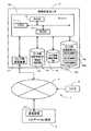
先ず、実施例1に係るナビゲーションシステム1の概略構成について図1を用いて説明する。図1は実施例1に係るナビゲーションシステム1を示したブロック図である。  First, a schematic configuration of thenavigation system 1 according to the first embodiment will be described with reference to FIG. FIG. 1 is a block diagram illustrating anavigation system 1 according to the first embodiment.

図1に示すように実施例1に係るナビゲーションシステム1は、ナビゲーション装置2と、ナビゲーション装置2に対して地図情報を更新する為の更新情報や後述の渋滞情報等交通情報を配信する情報配信センタ3と、ネットワーク4から基本的に構成されている。そして、ナビゲーション装置2と情報配信センタ3は、ネットワーク4を介して各種の情報の送受信が可能となるように構成されている。  As shown in FIG. 1, anavigation system 1 according to the first embodiment includes anavigation device 2 and an information distribution center that distributes update information for updating map information to thenavigation device 2 and traffic information such as traffic information to be described later. 3 and thenetwork 4 basically. Thenavigation device 2 and theinformation distribution center 3 are configured to be able to transmit and receive various types of information via thenetwork 4.

また、このネットワーク4には、道路交通情報センタ(VICS(登録商標):Vehicle Information and Communication System)5が接続され、ナビゲーション装置2と情報配信センタ3とは、ネットワーク4を介して、警察、日本道路公団等の交通管制システムの情報を収集して作成した道路の渋滞等に関する情報や交通規制情報等の交通情報を所定時間毎に受信することが可能に構成されている。また、この交通情報は、例えば、道路の渋滞等に関する道路渋滞情報、道路工事、建築工事等による交通規制情報等の道路交通情報に関する詳細情報である。該詳細情報は、道路渋滞情報の場合、後述のVICSリンクID、渋滞の実際の長さ、渋滞を通過するのに要する所要時間、渋滞度(渋滞無し/混雑/渋滞の別等)、渋滞中の車速、旅行時間、渋滞車線の進行方向、渋滞解消の見込まれる時刻等であり、交通規制情報の場合、後述のVICSリンクID、道路工事、建築工事等の継続期間、通行止め、片側交互通行、車線規制等の交通規制の種類、交通規制の時間帯等である。
尚、ナビゲーション装置2の構成に関しては後に図2を用いて詳細に説明する。
In addition, a road traffic information center (VICS (registered trademark)) 5 is connected to thenetwork 4, and thenavigation device 2 and theinformation distribution center 3 are connected to the police, Japan, via thenetwork 4. Traffic information such as road traffic congestion information and traffic regulation information created by collecting information of a traffic control system such as a road corporation can be received every predetermined time. The traffic information is, for example, detailed information on road traffic information such as road traffic information related to road traffic jams, traffic regulation information due to road construction, construction work, and the like. In the case of road traffic information, the detailed information includes a VICS link ID (to be described later), the actual length of the traffic, the time required to pass through the traffic, the degree of traffic (no traffic / congested / separated traffic, etc.), and traffic Vehicle speed, travel time, traveling direction of traffic jam lane, time when traffic jam is expected to be resolved, etc.In the case of traffic regulation information, the duration of VICS link ID, road construction, building construction, etc., which will be described later, no traffic, one-sided alternate traffic, The type of traffic regulation such as lane regulation, the time zone of traffic regulation, etc.
The configuration of thenavigation device 2 will be described in detail later with reference to FIG.

情報配信センタ3は、図1に示すようにサーバ10と、サーバ10に接続された地図情報記録部としてのセンタ側地図情報DB14と、ナビ更新履歴情報DB15と、センタ側交通情報DB16と、センタ側通信装置17とを備える。また、サーバ10は、サーバ10の全体の制御を行う演算装置及び制御装置としてのCPU11、並びにCPU11が各種の演算処理を行うに当たってワーキングメモリとして使用されるRAM12、ナビゲーション装置2からの要求に基づいてナビゲーション装置2に記憶された地図情報の内、所定エリアの地図情報を新たなバージョンの地図情報に更新する為の更新情報をセンタ側地図情報DB14から抽出し、ナビゲーション装置2に対して配信する地図情報更新処理や、後述のナビゲーション装置2からの要求に基づいて自車位置情報から各交差点間の交通情報をセンタ側交通情報DB16から作成し、ナビゲーション装置2に対して配信する交通情報配信処理等を行うための各種の制御プログラム(図7参照)が記録されたROM13等の内部記憶装置を備えている。尚、CPU11に代えてMPU等を使用することができる。  As shown in FIG. 1, theinformation distribution center 3 includes aserver 10, a center sidemap information DB 14 as a map information recording unit connected to theserver 10, a navigation updatehistory information DB 15, a center sidetraffic information DB 16,Side communication device 17. In addition, theserver 10 is based on requests from thenavigation device 2 and the arithmetic unit that controls theentire server 10 and theCPU 11 as the control unit, theRAM 12 that is used as a working memory when theCPU 11 performs various arithmetic processes. Of the map information stored in thenavigation device 2, the update information for updating the map information of the predetermined area to the new version of the map information is extracted from the center sidemap information DB 14 and distributed to thenavigation device 2. Information update processing, traffic information distribution processing for creating traffic information between intersections from the vehicle position information from the center sidetraffic information DB 16 based on the request from thenavigation device 2 described later, and distributing the traffic information to thenavigation device 2 ROM in which various control programs (see FIG. 7) for recording are recorded They include aninternal storage device 3 or the like. An MPU or the like can be used instead of theCPU 11.

また、センタ側地図情報DB14には、情報配信センタ3で作成され、ナビゲーション装置2に記憶された地図情報を更新する際の基本となる地図情報である更新用地図情報18がバージョン毎に区分されて記憶されている。更に、現在のナビゲーション装置2に記憶される地図情報の一部又は全部を更新用地図情報18に更新する為の更新情報についても記憶されている。ここで、バージョンとは地図情報が作成された時期を特定する為の作成時期情報であり、バージョンを参照することによって地図情報が作成された時期を特定することが可能となっている。  In the center-sidemap information DB 14,update map information 18 that is basic map information for updating the map information created in theinformation distribution center 3 and stored in thenavigation device 2 is classified for each version. Is remembered. Furthermore, update information for updating part or all of the map information stored in thecurrent navigation device 2 to theupdate map information 18 is also stored. Here, the version is creation time information for specifying the time when the map information is created, and the time when the map information is created can be specified by referring to the version.

また、センタ側地図情報DB14に記憶された更新用地図情報18には、ナビゲーション装置2で経路案内及び地図表示を行うのに必要な各種情報が記録されており、例えば、地図を表示するための地図表示データ、各交差点に関する交差点データ、ノード点に関するノードデータ、施設の一種である道路(道路リンク)に関するリンクデータ、経路を探索するための探索データ、施設の一種である店舗等のPOI(Point of Interest)に関する店舗データ、地点を検索するための検索データ等から構成されている。  Further, theupdate map information 18 stored in the center sidemap information DB 14 stores various information necessary for route guidance and map display by thenavigation device 2, for example, for displaying a map. Map display data, intersection data regarding each intersection, node data regarding node points, link data regarding roads (road links) as a kind of facility, search data for searching for routes, POIs such as stores as a kind of facility of Interest), store data, search data for searching points, and the like.

ここで、特に地図表示データとしては、10km×10kmで区画された2次メッシュをベースに4分割(長さ1/2)、16分割(1/4)、64分割(1/8)されたユニットで構成されており、各ユニットのデータ量が略同レベルになるように、各地のユニットが設定されている。最も小さい64分割サイズのユニットは、約1.25km四方の大きさである。  Here, in particular, the map display data is divided into 4 (length 1/2), 16 (1/4), and 64 (1/8) based on a secondary mesh partitioned by 10 km × 10 km. Each unit is configured so that the data amount of each unit is approximately the same level. The smallest 64 division size unit is about 1.25 km square.

また、ノードデータとしては、実際の道路の分岐点(交差点、T字路等も含む)、各道路に曲率半径等に応じて所定の距離ごとに設定されたノード点の座標(位置)、ノードが交差点に対応するノードであるか等を表すノード属性、ノードに接続するリンクの識別番号であるリンクIDのリストである接続リンク番号リスト、ノードにリンクを介して隣接するノードのノード番号のリストである隣接ノード番号リスト、各ノード点の高さ(高度)等に関するデータ等が記録される。  Node data includes actual road branch points (including intersections, T-junctions, etc.), node point coordinates (positions) set for each road according to the radius of curvature, etc., nodes A node attribute indicating whether or not is a node corresponding to an intersection, a connection link number list which is a list of link IDs which are identification numbers of links connected to the node, and a list of node numbers of nodes adjacent to the node via the link Are recorded on the adjacent node number list, the height (altitude) of each node point, and the like.

また、リンクデータとしては、道路を構成する各道路リンク(以下、「リンク」という。)に関してリンクの属する道路の幅員、勾(こう)配、カント、バンク、路面の状態、道路の車線数、車線数の減少する箇所、幅員の狭くなる箇所、踏切り等を表すデータが、コーナに関して、曲率半径、交差点、T字路、コーナの入口及び出口等を表すデータが、道路属性に関して、降坂路、登坂路等を表すデータが、道路種別に関して、国道、県道、細街路等の一般道のほか、高速自動車国道、都市高速道路、一般有料道路、有料橋等の有料道路を表すデータがそれぞれ記録される。更に、有料道路に関して、有料道路の入口及び出口の取付道(ランプウェイ)、料金所(インターチェンジ)等に関するデータが記録される。  In addition, as link data, for each road link constituting the road (hereinafter referred to as “link”), the width of the road to which the link belongs, the gradient, the cant, the bank, the road surface condition, the number of road lanes, Data representing the number of lanes decreasing, width narrowing, railroad crossings, etc. for corners, curvature radius, intersections, T-junctions, corner entrances and exits, etc. Data representing uphill roads are recorded for road types, including roads such as national roads, prefectural roads, and narrow streets, as well as toll roads such as national highways, urban highways, general toll roads, and toll bridges. The Furthermore, regarding toll roads, data relating to entrance roads (rampways), toll gates (interchanges) and the like of toll roads are recorded.

また、探索データとしては、設定された目的地までの経路を探索及び表示する際に使用されるデータについて記録されており、ノードを通過する際の右左折や道路を構成するリンクの距離、道幅、道路種別等によって決定される各ノードの重み付け(以下、「コスト」という。)を算出する為に使用するコストデータ、経路探索により選択された経路を液晶ディスプレイ25の地図上に表示するための経路表示データ等から構成されている。  In addition, as search data, data used when searching and displaying a route to a set destination is recorded, and the distance and road width of a link that forms a right / left turn or road when passing through a node. The cost data used to calculate the weight of each node (hereinafter referred to as “cost”) determined by the road type, etc., and the route selected by the route search are displayed on the map of theliquid crystal display 25. It consists of route display data.

また、店舗データとしては、各地域のホテル、病院、ガソリンスタンド、駐車場、観光施設等のPOIに関するデータがPOIを特定するIDとともに記録される。なお、前記センタ側地図情報DB14には、所定の情報をナビゲーション装置2のスピーカ26によって出力するための音声出力データも記録される。  Further, as store data, data on POIs such as hotels, hospitals, gas stations, parking lots, and tourist facilities in each region are recorded together with IDs that identify the POIs. The center-sidemap information DB 14 also records voice output data for outputting predetermined information by thespeaker 26 of thenavigation device 2.

そして、情報配信センタ3は、ナビゲーション装置2からの要求があったタイミングで、センタ側地図情報DB14に格納された更新用地図情報18の内、最もバージョンの新しい更新用地図情報18によってナビゲーション装置2に記憶された地図情報の更新を行う。具体的には、実施例1に係るナビゲーションシステム1では、ナビゲーション装置2から更新用地図情報18の配信要求があった場合には、最もバージョンの新しい更新用地図情報18に更新する為の更新情報をナビゲーション装置2に対して配信することにより更新が行われる。ここで、ナビゲーション装置2に対して送信される更新情報としては、最もバージョンの新しい更新用地図情報18の新設道路を特定するための新設道路情報を含む全情報を送信することとしても良いし、現在のナビゲーション装置に記憶される地図情報から最もバージョンの新しい更新用地図情報18に更新する為の必要最小限の情報(新設道路を特定するための新設道路情報を含む更新部分の情報のみ)を送信することとしても良い。  Then, theinformation distribution center 3 uses the latest version of theupdate map information 18 stored in the center-sidemap information DB 14 at the timing when a request is made from thenavigation device 2, and thenavigation device 2. Update the map information stored in. Specifically, in thenavigation system 1 according to the first embodiment, when there is a distribution request for theupdate map information 18 from thenavigation device 2, the update information for updating to the newestupdate map information 18. Is delivered to thenavigation device 2. Here, as the update information transmitted to thenavigation device 2, all information including new road information for specifying the new road of the newestupdate map information 18 may be transmitted. Necessary minimum information for updating from the map information stored in the current navigation device to the newest update map information 18 (only information on the update portion including the new road information for specifying the new road) It may be sent.

一方、ナビ更新履歴情報DB15には、ナビゲーション装置2に記憶されている地図情報について現在までに更新を行った更新履歴に関する情報が、ナビゲーション装置2を特定するナビ識別IDとともに記憶される。更新履歴としては、具体的に地図情報を構成するリンクデータやノードデータ毎にどのバージョンの地図情報が用いられているかが記憶されており、ナビゲーション装置2の地図情報の更新を行う毎に新たな更新履歴に書き換えられる。  On the other hand, in the navigation updatehistory information DB 15, information related to the update history in which the map information stored in thenavigation device 2 has been updated so far is stored together with the navigation identification ID that identifies thenavigation device 2. As the update history, which version of map information is used for each link data or node data that specifically constitutes map information is stored, and a new one is updated every time the map information of thenavigation device 2 is updated. Rewritten to update history.

また、センタ側交通情報DB16には、道路交通情報センタ(VICS)5から受信した交通情報を収集して作成した現況の道路の渋滞等に関する情報である現況交通情報19Aが格納されている。また、このセンタ側交通情報DB16には、過去に作成された道路の渋滞等に関する統計的交通情報である統計交通情報19Bが格納されている。この統計交通情報19Bは、祭り、パレード、花火大会等のイベントの開催予定場所、予定日時等のイベント予定情報、例えば、駅周辺や大型商業施設周辺の道路には週末を除く毎日の特定時刻に渋滞が発生するとか、海水浴場周辺の道路には夏季休暇時期に渋滞が発生する等の統計的渋滞情報や渋滞予測情報を含んでもよい。更に、センタ側交通情報DB16には、現況交通情報19A及び統計交通情報19Bに基づいて作成された現況の各渋滞に対する将来における所定時刻毎(例えば、現在時刻から約30分間毎、約1時間毎、約2時間毎等である。)の渋滞予測情報等である予測交通情報19Cが格納されている。  The center-sidetraffic information DB 16 storescurrent traffic information 19A, which is information related to traffic congestion on the current road, created by collecting traffic information received from the road traffic information center (VICS) 5. The center sidetraffic information DB 16 storesstatistical traffic information 19B, which is statistical traffic information relating to traffic jams and the like created in the past. Thisstatistical traffic information 19B is the event schedule information such as the scheduled location and scheduled date and time of events such as festivals, parades, fireworks festivals, etc. For example, roads around stations and large commercial facilities at specific times every day except weekends. Statistical traffic jam information and traffic jam prediction information such as the occurrence of traffic jams or the occurrence of traffic jams during summer holidays may be included on roads around the beach. Further, in the center sidetraffic information DB 16, every predetermined time in the future (for example, about every 30 minutes from the current time, about every hour) for each traffic jam created based on thecurrent traffic information 19A and thestatistical traffic information 19B. , Approximately every 2 hours, etc.) of predictedtraffic information 19C, such as traffic jam prediction information.

そして、後述のように、情報配信センタ3は、ナビゲーション装置2からの要求があったタイミングで、センタ側交通情報DB16に格納された現況交通情報19A、統計交通情報19B、及び予測交通情報19Cに基づいて各交差点間の交通情報等を選択して配信する(図7参照)。  As will be described later, theinformation distribution center 3 stores thecurrent traffic information 19A, thestatistical traffic information 19B, and the predictedtraffic information 19C stored in the center sidetraffic information DB 16 at a timing when a request is made from thenavigation device 2. Based on this, traffic information between intersections is selected and distributed (see FIG. 7).

また、道路交通情報センタ(VICS)5から受信した交通情報には、種別情報、位置、渋滞区間の距離、渋滞度等の情報とともに、VICSリンクIDが含まれる。該VICSリンクIDは、道路を所定の交差点毎に分割して規格化された走行案内用リンクとしてのVICSリンクに付与された識別番号である。なお、前記交通情報には、各VICSリンクにおける始点及び終点の座標、始点から終点までの距離等の情報も含まれている。  The traffic information received from the road traffic information center (VICS) 5 includes a VICS link ID together with information such as type information, position, distance of a traffic jam section, traffic jam level, and the like. The VICS link ID is an identification number assigned to a VICS link as a travel guide link that is standardized by dividing a road into predetermined intersections. The traffic information also includes information such as the coordinates of the start point and end point in each VICS link, the distance from the start point to the end point, and the like.

ここで、センタ側地図情報DB14に記憶される道路(リンク)とVICSリンクとは同一のものではない(一般的には、道路(リンク)の方がVICSリンクよりも細分化されている。)。そこで、各道路(リンク)に識別番号として付与される道路リンクIDとVICSリンクIDとの間の変換テーブル(対照表)を有し、VICSリンクIDに基づいて、対応する道路リンクIDを特定することができるようになっている。そのため、ナビゲーション装置2のように変換テーブルを有するものである場合には、情報配信センタ3や道路交通情報センタ(VICS)5からVICSリンクIDを受信すると、該VICSリンクIDに基づいて渋滞情報等の交通情報を表示すべき道路の区間を特定することができる。
ところが、ナビゲーション装置2が変換テーブルを有するものでない場合には、VICSリンクIDに基づいて道路の区間を特定することができなくなってしまう。そこで、センタ側交通情報DB16には、この変換テーブルも格納されている。これにより、VICSリンクIDをナビゲーション装置2において使用されている道路リンクIDに変換して、交通情報を送信することができる。
Here, the road (link) and the VICS link stored in the center sidemap information DB 14 are not the same (generally, the road (link) is subdivided more than the VICS link). . Therefore, each road (link) has a conversion table (contrast table) between the road link ID and the VICS link ID given as an identification number, and the corresponding road link ID is specified based on the VICS link ID. Be able to. Therefore, when thenavigation apparatus 2 has a conversion table, when a VICS link ID is received from theinformation distribution center 3 or the road traffic information center (VICS) 5, traffic congestion information or the like is based on the VICS link ID. It is possible to specify the road section on which the traffic information is to be displayed.
However, if thenavigation device 2 does not have a conversion table, the road section cannot be specified based on the VICS link ID. Therefore, this conversion table is also stored in the center sidetraffic information DB 16. Thereby, VICS link ID can be converted into road link ID currently used in thenavigation apparatus 2, and traffic information can be transmitted.

尚、情報配信センタ3は、個人、企業、団体、地方自治体、政府関係機関等のいずれが運営していてもよく、道路交通情報センタ(VICS)5が運営していてもよい。  Theinformation distribution center 3 may be operated by any one of an individual, a company, a group, a local government, a government-related organization, or the like, or may be operated by a road traffic information center (VICS) 5.

また、ネットワーク4としては、例えばLAN(Local Area Network)、WAN(Wide Area Network)、イントラネット、携帯電話回線網、電話回線網、公衆通信回線網、専用通信回線網、インターネット等の通信回線網等の通信系を使用することができる。そして、放送衛星によるCS放送、BS放送、地上波ディジタルテレビ放送、FM多重放送等を利用する通信系を使用することもできる。更に、高度道路交通システム(ITS)において利用されるノンストップ自動料金支払いシステム(ETC)、狭域通信システム(DSRC)等の通信系を使用することもできる。  Thenetwork 4 includes, for example, a LAN (Local Area Network), a WAN (Wide Area Network), an intranet, a mobile phone line network, a telephone line network, a public communication line network, a dedicated communication line network, a communication line network such as the Internet, etc. Can be used. A communication system using CS broadcasting, BS broadcasting, terrestrial digital television broadcasting, FM multiplex broadcasting, or the like by a broadcasting satellite can also be used. Furthermore, a communication system such as a non-stop automatic fee payment system (ETC) or a narrow area communication system (DSRC) used in an intelligent road traffic system (ITS) can also be used.

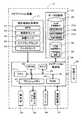
次に、実施例1に係るナビゲーションシステム1を構成するナビゲーション装置2の概略構成について図2を用いて説明する。図2は実施例1に係るナビゲーション装置2を示したブロック図である。  Next, a schematic configuration of thenavigation device 2 configuring thenavigation system 1 according to the first embodiment will be described with reference to FIG. FIG. 2 is a block diagram illustrating thenavigation device 2 according to the first embodiment.

図2に示すように実施例1に係るナビゲーション装置2は、自車の現在位置を検出する現在地検出処理部21と、各種のデータが記録されたデータ記録部22と、入力された情報に基づいて、各種の演算処理を行うナビゲーション制御部23と、操作者からの操作を受け付ける操作部24と、操作者に対して地図等の情報を表示する液晶ディスプレイ25と、経路案内に関する音声ガイダンスを出力するスピーカ26と、道路交通情報センタ(VICS)5や情報配信センタ3等との間で通信を行う通信装置27と、から構成されている。また、ナビゲーション制御部23には自車の走行速度を検出する車速センサ28が接続される。  As shown in FIG. 2, thenavigation device 2 according to the first embodiment is based on a current locationdetection processing unit 21 that detects the current position of the host vehicle, adata recording unit 22 that records various data, and input information. Thenavigation control unit 23 that performs various arithmetic processes, theoperation unit 24 that receives operations from the operator, theliquid crystal display 25 that displays information such as a map to the operator, and voice guidance related to route guidance are output. And acommunication device 27 that communicates with the road traffic information center (VICS) 5, theinformation distribution center 3, and the like. Thenavigation control unit 23 is connected to avehicle speed sensor 28 that detects the traveling speed of the host vehicle.

以下に、ナビゲーション装置2を構成する各構成要素について説明すると、現在地検出処理部21は、GPS31、地磁気センサ32、距離センサ33、ステアリングセンサ34、方位検出部としてのジャイロセンサ35、高度計(図示せず)等からなり、現在の自車の位置、方位、目標物(例えば、交差点)までの距離等を検出することが可能となっている。  The components constituting thenavigation device 2 will be described below. The current locationdetection processing unit 21 includes aGPS 31, ageomagnetic sensor 32, adistance sensor 33, asteering sensor 34, agyro sensor 35 as an azimuth detection unit, and an altimeter (not shown). And the like, and it is possible to detect the current position, direction, distance to a target (for example, an intersection), and the like.

具体的には、GPS31は、人工衛星によって発生させられた電波を受信することにより、地球上における自車の現在地及び現在時刻を検出し、地磁気センサ32は、地磁気を測定することによって自車方位を検出し、距離センサ33は、道路上の所定の位置間の距離等を検出する。ここで、距離センサ33としては、例えば、自車の車輪(図示せず)の回転速度を測定し、測定した回転速度に基づいて距離を検出するセンサ、加速度を測定し、測定した加速度を2回積分して距離を検出するセンサ等を使用することができる。  Specifically, theGPS 31 detects the current location and current time of the vehicle on the earth by receiving radio waves generated by artificial satellites, and thegeomagnetic sensor 32 measures the direction of the vehicle by measuring the geomagnetism. Thedistance sensor 33 detects a distance between predetermined positions on the road. Here, as thedistance sensor 33, for example, the rotational speed of a wheel (not shown) of the vehicle is measured, a sensor that detects the distance based on the measured rotational speed, the acceleration is measured, and the measured acceleration is 2 A sensor that integrates the times and detects the distance can be used.

また、ステアリングセンサ34は自車の舵(だ)角を検出する。ここで、ステアリングセンサ34としては、例えば、ステアリングホイール(図示せず)の回転部に取り付けられた光学的な回転センサ、回転抵抗センサ、車輪に取り付けられた角度センサ等が使用される。  Thesteering sensor 34 detects the rudder angle of the host vehicle. Here, as thesteering sensor 34, for example, an optical rotation sensor attached to a rotating portion of a steering wheel (not shown), a rotation resistance sensor, an angle sensor attached to a wheel, or the like is used.

そして、ジャイロセンサ35は自車の旋回角を検出する。ここで、ジャイロセンサ35としては、例えば、ガスレートジャイロ、振動ジャイロ等が使用される。また、ジャイロセンサ35によって検出された旋回角を積分することにより、自車方位を検出することができる。  And thegyro sensor 35 detects the turning angle of the own vehicle. Here, as thegyro sensor 35, for example, a gas rate gyro, a vibration gyro, or the like is used. Further, by integrating the turning angle detected by thegyro sensor 35, the vehicle direction can be detected.

また、データ記録部22は、外部記憶装置及び記憶媒体としてのハードディスク(図示せず)と、ハードディスクに記憶されたナビ側交通情報DB36、ナビ側地図情報DB38、及び所定のプログラム等を読み出すとともにハードディスクに所定のデータを書き込む為のドライバである記録ヘッド(図示せず)とを備えている。尚、実施例1においては、データ記録部22の外部記憶装置及び記憶媒体としてハードディスクが使用されるが、ハードディスクのほかに、フレキシブルディスク等の磁気ディスクを外部記憶装置として使用することができる。また、メモリーカード、磁気テープ、磁気ドラム、CD、MD、DVD、光ディスク、MO、ICカード、光カード等を外部記憶装置として使用することもできる。  Thedata recording unit 22 reads an external storage device and a hard disk (not shown) as a storage medium, a navigation sidetraffic information DB 36, a navigation sidemap information DB 38, a predetermined program, and the like stored in the hard disk and a hard disk. And a recording head (not shown) which is a driver for writing predetermined data. In the first embodiment, a hard disk is used as the external storage device and the storage medium of thedata recording unit 22, but a magnetic disk such as a flexible disk can be used as the external storage device in addition to the hard disk. Also, a memory card, magnetic tape, magnetic drum, CD, MD, DVD, optical disk, MO, IC card, optical card, etc. can be used as an external storage device.

ここで、ナビ側交通情報DB36には、道路交通情報センタ(VICS)5から受信した渋滞の実際の長さ、渋滞の原因、渋滞解消の見込まれる時刻等から構成される現況の道路の渋滞等に関する道路渋滞情報や、道路工事、建築工事等による交通規制情報等の交通情報から作成した現況交通情報37Aが格納される。また、ナビ側交通情報DB36には、過去に作成された道路の渋滞等に関する統計的交通情報である統計交通情報37Bが格納されている。この統計渋滞情報37は、祭り、パレード、花火大会等のイベントの開催予定場所、予定日時等のイベント予定情報、例えば、駅周辺や大型商業施設周辺の道路には週末を除く毎日の特定時刻に渋滞が発生するとか、海水浴場周辺の道路には夏季休暇時期に渋滞が発生する等の統計的渋滞情報や渋滞予測情報を含んでもよい。更に、ナビ側交通情報DB36には、現況交通情報37A及び統計交通情報37Bに基づいて作成された現況の各渋滞に対する将来における所定時刻毎(例えば、現在時刻から約30分間毎、約1時間毎、約2時間毎等である。)の渋滞予測情報等である予測交通情報37Cが格納されている。  Here, in the navigation sidetraffic information DB 36, the actual length of the traffic jam received from the road traffic information center (VICS) 5, the cause of the traffic jam, the time when the traffic jam is expected to be eliminated, etc.Current traffic information 37A created from traffic information such as road traffic congestion information and traffic regulation information such as road construction and building construction is stored. The navigation-sidetraffic information DB 36 storesstatistical traffic information 37B, which is statistical traffic information relating to traffic jams and the like created in the past. This statistical traffic jam information 37 is information on event schedules such as festivals, parades, fireworks festivals, event schedules such as scheduled dates and times, for example, roads around stations and large commercial facilities at specific times every day except weekends. Statistical traffic jam information and traffic jam prediction information such as the occurrence of traffic jams or the occurrence of traffic jams during summer holidays may be included on roads around the beach. Further, in the navigation sidetraffic information DB 36, every predetermined time in the future (for example, about every 30 minutes from the current time, about every 1 hour) for each traffic jam created based on thecurrent traffic information 37A and thestatistical traffic information 37B. , Approximately every 2 hours, etc.) of predictedtraffic information 37C, such as traffic jam prediction information.

また、ナビ側地図情報DB38には、ナビゲーション装置2の走行案内や経路探索に使用されるとともに情報配信センタ3による更新対象となるナビ地図情報39が格納されている。ここで、ナビ地図情報39には、更新用地図情報18と同様に経路案内及び地図表示に必要な各種情報から構成されており、例えば、各新設道路を特定するための新設道路情報、地図を表示するための地図表示データ、各交差点に関する交差点データ、ノード点に関するノードデータ、施設の一種である道路(リンク)に関するリンクデータ、経路を探索するための探索データ、施設の一種である店舗等のPOIに関する店舗データ、地点を検索するための検索データ等から構成されている。尚、各データの詳細については既に説明したので、ここではその詳細は省略する。
そして、ナビ側地図情報DB38の内容は、情報配信センタ3から通信装置27を介して配信された更新情報をダウンロードすることによって更新される。
The navigation-sidemap information DB 38 storesnavigation map information 39 that is used for travel guidance and route search of thenavigation device 2 and that is to be updated by theinformation distribution center 3. Here, thenavigation map information 39 is composed of various information necessary for route guidance and map display in the same way as theupdate map information 18. For example, the new map information and map for specifying each new road are displayed. Map display data for display, intersection data for each intersection, node data for node points, link data for roads (links) as a type of facility, search data for searching for routes, stores as a type of facility, etc. It consists of store data related to POI, search data for searching points, and the like. Since details of each data have already been described, details thereof are omitted here.
The contents of the navigation-sidemap information DB 38 are updated by downloading update information distributed from theinformation distribution center 3 via thecommunication device 27.

また、図2に示すように、ナビゲーション装置2を構成するナビゲーション制御部23は、ナビゲーション装置2の全体の制御を行う演算装置及び制御装置としてのCPU41、並びにCPU41が各種の演算処理を行うに当たってワーキングメモリとして使用されるとともに、経路が探索されたときの経路データや情報配信センタ3から受信した交通情報等が記憶されるRAM42、制御用のプログラムのほか、後述の進行方向前方の各交差点間の交通情報を地図上に表示する交通情報表示処理プログラム(図3参照)が記憶されたROM43、ROM43から読み出したプログラムを記憶するフラッシュメモリ44等の内部記憶装置や、時間を計測するタイマ45等を備えている。尚、前記RAM42、ROM43、フラッシュメモリ44等としては半導体メモリ、磁気コア等が使用される。そして、演算装置及び制御装置としては、CPU41に代えてMPU等を使用することも可能である。  As shown in FIG. 2, thenavigation control unit 23 constituting thenavigation device 2 is a computing device that performs overall control of thenavigation device 2, aCPU 41 as a control device, and working when theCPU 41 performs various types of computation processing. In addition to being used as a memory, theRAM 42 that stores route data when a route is searched, traffic information received from theinformation distribution center 3 and the like, a control program, and between intersections ahead in the traveling direction described laterROM 43 in which a traffic information display processing program (see FIG. 3) for displaying traffic information on a map is stored, an internal storage device such as aflash memory 44 for storing a program read from theROM 43, atimer 45 for measuring time, etc. I have. As theRAM 42,ROM 43,flash memory 44, etc., a semiconductor memory, a magnetic core or the like is used. As the arithmetic device and the control device, an MPU or the like can be used instead of theCPU 41.

また、実施例1においては、前記ROM43に各種のプログラムが記憶され、前記データ記録部22に各種のデータが記憶されるようになっているが、プログラム、データ等を同じ外部記憶装置、メモリーカード等からプログラム、データ等を読み出して前記フラッシュメモリ44に書き込むこともできる。更に、メモリーカード等を交換することによって前記プログラム、データ等を更新することができる。  In the first embodiment, various programs are stored in theROM 43, and various data are stored in thedata recording unit 22. However, the programs, data, and the like are stored in the same external storage device, memory card, and the like. It is also possible to read out a program, data, etc. from theflash memory 44 and so on. Further, the program, data, etc. can be updated by exchanging a memory card or the like.

更に、前記ナビゲーション制御部23には、操作部24、液晶ディスプレイ25、スピーカ26、通信装置27の各周辺装置(アクチュエータ)が電気的に接続されている。  Furthermore, thenavigation control unit 23 is electrically connected to peripheral devices (actuators) of theoperation unit 24, theliquid crystal display 25, thespeaker 26, and thecommunication device 27.

操作部24は、走行開始時の現在地を修正し、案内開始地点としての出発地及び案内終了地点としての目的地を入力する際や施設に関する情報の検索を行う場合等に操作され、各種のキーや複数の操作スイッチから構成される。そして、ナビゲーション制御部23は、各スイッチの押下等により出力されるスイッチ信号に基づき、対応する各種の動作を実行すべく制御を行う。尚、操作部24としては、キーボード、マウス、バーコードリーダ、遠隔操作用のリモートコントロール装置、ジョイスティック、ライトペン、スタイラスペン等を使用することもできる。更に、液晶ディスプレイ25の前面に設けたタッチパネルによって構成することもできる。  Theoperation unit 24 is operated when correcting the current location at the start of traveling, inputting a departure point as a guidance start point and a destination as a guidance end point, or when searching for information about facilities, etc. And a plurality of operation switches. Then, thenavigation control unit 23 performs control to execute various corresponding operations based on switch signals output by pressing the switches. As theoperation unit 24, a keyboard, a mouse, a barcode reader, a remote control device for remote operation, a joystick, a light pen, a stylus pen, or the like can be used. Furthermore, it can also be configured by a touch panel provided on the front surface of theliquid crystal display 25.

また、液晶ディスプレイ25には、後述のようにナビ地図情報39に基づく地図が表示されて各リンク上の交通情報が表示される経路案内画面の他、操作案内、操作メニュー、キーの案内、現在地から目的地までの誘導経路、誘導経路に沿った案内情報、交通情報、ニュース、天気予報、時刻、メール、テレビ番組等が表示される。尚、液晶ディスプレイ25の代わりに、CRTディスプレイ、プラズマディスプレイ等を使用したり、車両のフロントガラスにホログラムを投影するホログラム装置等を使用することも可能である。  In addition to a route guidance screen on which a map based on thenavigation map information 39 is displayed and traffic information on each link is displayed on theliquid crystal display 25 as described later, operation guidance, operation menus, key guidance, current location A guide route from the destination to the destination, guidance information along the guide route, traffic information, news, weather forecast, time, mail, TV program, etc. are displayed. Instead of theliquid crystal display 25, it is also possible to use a CRT display, a plasma display, or the like, or a hologram device that projects a hologram on the windshield of a vehicle.

また、スピーカ26は、ナビゲーション制御部23からの指示に基づいて、誘導経路に沿った走行を案内する音声ガイダンス等を出力する。ここで、案内される音声ガイダンスとしては、例えば、「200m先、○○交差点を右方向です。」や「この先の国道○○号線が渋滞しています。」等がある。なお、スピーカ26より出力される音声としては、合成された音声のほかに、各種効果音、予めテープやメモリ等に録音された各種の案内情報を出力することもできる。  In addition, thespeaker 26 outputs voice guidance or the like that guides traveling along the guidance route based on an instruction from thenavigation control unit 23. Here, examples of the voice guidance to be guided include “200m ahead, turn right at XX intersection”, “Now, the next national road XX is congested”. Note that as the sound output from thespeaker 26, in addition to the synthesized sound, various sound effects and various guidance information recorded in advance on a tape, a memory or the like can be output.

そして、通信装置27は、情報配信センタ3と通信を行う通信手段であり、情報配信センタ3との間で最もバージョンの新しい更新地図情報等の送受信を行う。また、通信装置27は、情報配信センタ3に加えて、道路交通情報センタ(VICS)等から送信された渋滞情報、規制情報、駐車場情報、交通事故情報、サービスエリアの混雑状況等の各情報から成る交通情報を受信する。  Thecommunication device 27 is a communication unit that communicates with theinformation distribution center 3, and transmits / receives updated map information and the like of the latest version to / from theinformation distribution center 3. Further, in addition to theinformation distribution center 3, thecommunication device 27 includes information such as traffic congestion information, regulation information, parking information, traffic accident information, and service area congestion status transmitted from the road traffic information center (VICS) or the like. Receive traffic information consisting of

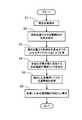
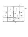
次に、前記構成を有するナビゲーションシステム1において、ナビゲーション装置2のCPU41が、自車位置から進行方向前方の渋滞情報等の交通情報を道路交通情報センタ(VICS)3から受信していた場合に実行する交通情報表示処理について図3乃至図6に基づいて説明する。図3は実施例1に係るナビゲーション装置2が実行する自車位置から進行方向前方の渋滞情報等の交通情報を地図上に表示する交通情報表示処理を示すフローチャートである。図4は図3のステップ3の処理内容を説明する説明図である。図5は図3のステップ3及びステップ4の処理内容を説明する説明図である。図6は図3のステップ6の処理によって液晶ディスプレイ25の地図上に表示される交通情報の一例を示す図である。
尚、図3にフローチャートで示されるプログラムは、ナビゲーション装置2が備えているRAM42やROM43に記憶されており、CPU41により所定時間毎(例えば、約30秒〜5分毎である。)や自車が現在位置しているリンクが変更されたときに実行される。
Next, in thenavigation system 1 having the above-described configuration, theCPU 41 of thenavigation device 2 executes when the traffic information such as traffic jam information ahead of the traveling direction from the vehicle position is received from the road traffic information center (VICS) 3. The traffic information display processing to be performed will be described with reference to FIGS. FIG. 3 is a flowchart showing a traffic information display process for displaying traffic information such as traffic jam information ahead of the traveling direction from the own vehicle position on the map, which is executed by thenavigation device 2 according to the first embodiment. FIG. 4 is an explanatory diagram for explaining the processing content ofstep 3 in FIG. FIG. 5 is an explanatory diagram for explaining the processing contents ofsteps 3 and 4 in FIG. FIG. 6 is a diagram showing an example of traffic information displayed on the map of theliquid crystal display 25 by the process of step 6 of FIG.
3 is stored in theRAM 42 or theROM 43 provided in thenavigation device 2, and theCPU 41 executes the program every predetermined time (for example, about every 30 seconds to 5 minutes) or the own vehicle. Executed when the current link is changed.

図3に示すように、先ず、ステップ(以下、Sと略記する)1において、CPU41は、現在位置検出処理部21により自車の現在位置(以下、「自車位置」という。)を検出する。また、車両の現在位置を含む地図データをナビ地図情報39から読み出し、地図データに基づいて車両の現在位置の周囲における地図画像50(図6参照)を描画して液晶ディスプレイ25に表示するとともに、車両位置マーク51(図6参照)を地図画像50に重ね合わせて表示し、車両の移動に応じて地図画像をスクロールしたり、地図画像50を画面に固定し車両位置マーク51を移動させることによって、車両が現在どの地点を走行しているのかを一目でわかるように表示する。  As shown in FIG. 3, first, in step (hereinafter abbreviated as S) 1, theCPU 41 detects the current position of the own vehicle (hereinafter referred to as “own vehicle position”) by the current positiondetection processing unit 21. . In addition, map data including the current position of the vehicle is read from thenavigation map information 39, and a map image 50 (see FIG. 6) around the current position of the vehicle is drawn and displayed on theliquid crystal display 25 based on the map data. By displaying the vehicle position mark 51 (see FIG. 6) superimposed on themap image 50 and scrolling the map image according to the movement of the vehicle, or fixing themap image 50 to the screen and moving thevehicle position mark 51. , It displays so that you can see at a glance which point the vehicle is currently driving.

続いて、S2において、CPU41は、自車位置を含んで自車位置から進行方向前方の所定範囲内(例えば、半径約5km〜15kmの距離の範囲内や、約10km四方の範囲内である。)に存在する交差点(ノード)をナビ地図情報39から抽出して「抽出交差点」としてRAM42に記憶する。尚、前方の目的地までの誘導経路を地図上に表示して経路を案内している場合には、CPU41は、誘導経路から所定距離以内(例えば、約2km〜10kmの距離以内である。)に存在する交差点(ノード)をナビ地図情報39から抽出して「抽出交差点」としてRAM42に記憶するようにしてもよい。  Subsequently, in S2, theCPU 41 is within a predetermined range forward of the traveling direction from the own vehicle position including the own vehicle position (for example, within a range of a distance of about 5 km to 15 km in radius or within a range of about 10 km square). ) Are extracted from thenavigation map information 39 and stored in theRAM 42 as “extracted intersections”. When the guidance route to the destination ahead is displayed on the map and the route is guided, theCPU 41 is within a predetermined distance from the guidance route (for example, within a distance of about 2 km to 10 km). The intersections (nodes) existing in thenavigation map information 39 may be extracted from thenavigation map information 39 and stored in theRAM 42 as “extracted intersections”.

続いて、S3において、CPU41は、ダイクストラ法によって、自車位置から上記S2で抽出した各「抽出交差点」までのコストを算出し、仮経路を求めるコスト算出処理を実行する。
具体的には、例えば、図4に示すように、CPU41は、先ず、自車位置から前方の第1番目の抽出交差点N1までのリンクR1のコスト「1」を該抽出交差点N1のコストとしてRAM42に記憶する。続いて、抽出交差点N1に各リンクR2、R3、R4によって接続される各抽出交差点N2、N3、N4のコストを、抽出交差点N1のコストにリンクR2のコスト「3」、リンクR3のコスト「1」、リンクR4のコスト「2」を加算して算出して、RAM42に記憶する。従って、各抽出交差点N2、N3、N4のコストとして各コスト「4」、「2」、「3」がRAM42に記憶される。
続いて、この算出された各抽出交差点N2、N3、N4に対して同様な処理を繰り返し行い、S2で抽出した全ての抽出交差点のコストを算出していく。
Subsequently, in S3, theCPU 41 calculates a cost from the vehicle position to each “extracted intersection” extracted in S2 by the Dijkstra method, and executes a cost calculation process for obtaining a temporary route.
Specifically, for example, as shown in FIG. 4, theCPU 41 first determines the cost “1” of the link R1 from the vehicle position to the first extracted intersection N1 ahead as the cost of the extracted intersection N1. To remember. Subsequently, the cost of each of the extracted intersections N2, N3, and N4 connected to the extracted intersection N1 by the links R2, R3, and R4 is set to the cost of the extracted intersection N1, the cost “3” of the link R2, and the cost “1” of the link R3. ”And the cost“ 2 ”of the link R4 are added and calculated and stored in the RAM. Accordingly, the costs “4”, “2”, and “3” are stored in theRAM 42 as the costs of the extracted intersections N2, N3, and N4.
Subsequently, the same processing is repeated for each of the calculated extracted intersections N2, N3, and N4, and the costs of all the extracted intersections extracted in S2 are calculated.

ここで、図5に示すように、抽出交差点N2のコスト「4」にリンクR5のコスト「2」を加算したコスト「6」の方が、抽出交差点N3のコスト「2」にリンクR6のコスト「5」を加算したコスト「7」よりも小さいため、抽出交差点N5のコストは、リンクR5を経由したコスト「6」となり、抽出交差点N5のコストとしてコスト「6」がRAM42に記憶される。即ち、自車位置(車両位置マーク51)から抽出交差点N5に至る最もコストの低い仮経路は、リンクR1→リンクR2→リンクR5となる。また、抽出交差点N1から各リンクR3、R6、R5を経て抽出交差点N2に至るコストは「9」となるため、自車位置(車両位置マーク51)から抽出交差点N2に至る最もコストの低い仮経路は、リンクR1→リンクR2となる。  Here, as shown in FIG. 5, the cost “6” obtained by adding the cost “2” of the link R5 to the cost “4” of the extracted intersection N2 is the cost of the link R6 to the cost “2” of the extracted intersection N3. Since the cost is lower than the cost “7” obtained by adding “5”, the cost of the extracted intersection N5 is the cost “6” via the link R5, and the cost “6” is stored in theRAM 42 as the cost of the extracted intersection N5. That is, the lowest cost temporary route from the vehicle position (vehicle position mark 51) to the extracted intersection N5 is link R1 → link R2 → link R5. Further, since the cost from the extracted intersection N1 to the extracted intersection N2 via the links R3, R6, R5 is “9”, the provisional route having the lowest cost from the vehicle position (vehicle position mark 51) to the extracted intersection N2 Becomes link R1 → link R2.

また、抽出交差点N4のコスト「3」にリンクR7のコスト「2」を加算したコスト「5」の方が、抽出交差点N3のコスト「2」にリンクR8のコスト「5」を加算したコスト「7」よりも小さいため、抽出交差点N6のコストは、リンクR7を経由したコスト「5」となり、抽出交差点N6のコストとしてコスト「5」がRAM42に記憶される。即ち、自車位置(車両位置マーク51)から抽出交差点N6に至る最もコストの低い仮経路は、リンクR1→リンクR4→リンクR7となる。また、抽出交差点N1から各リンクR3、R8、R7を経て抽出交差点N4に至るコストは「9」となるため、自車位置(車両位置マーク51)から抽出交差点N4に至る最もコストの低い仮経路は、リンクR1→リンクR4となる。  The cost “5” obtained by adding the cost “2” of the link R7 to the cost “3” of the extracted intersection N4 is the cost “5” obtained by adding the cost “5” of the link R8 to the cost “2” of the extracted intersection N3. Therefore, the cost of the extracted intersection N6 is the cost “5” via the link R7, and the cost “5” is stored in theRAM 42 as the cost of the extracted intersection N6. That is, the lowest cost temporary route from the vehicle position (vehicle position mark 51) to the extracted intersection N6 is link R1 → link R4 → link R7. Further, since the cost from the extracted intersection N1 to the extracted intersection N4 via the links R3, R8, R7 is “9”, the provisional route with the lowest cost from the vehicle position (vehicle position mark 51) to the extracted intersection N4. Becomes link R1 → link R4.

そして、S4において、CPU41は、上記S3で算出した各抽出交差点までの仮経路に基づいて、各仮経路の最終リンクを抽出して「最終リンク」としてRAM42に記憶する。
具体的には、例えば、図5に示すように、自車位置(車両位置マーク51)から抽出交差点N2に至る最もコストの低い仮経路は、リンクR1→リンクR2となり、このリンクR2が抽出交差点N2に至る「最終リンク」としてRAM42に記憶される。同様に、各リンクR3、R4が、自車位置(車両位置マーク51)から各抽出交差点N3、N4に至る仮経路の「最終リンク」としてRAM42に記憶される。
In S4, theCPU 41 extracts the final link of each temporary route based on the temporary route to each extracted intersection calculated in S3 and stores it in theRAM 42 as a “final link”.
Specifically, as shown in FIG. 5, for example, the lowest cost temporary route from the vehicle position (vehicle position mark 51) to the extracted intersection N2 is link R1 → link R2, and this link R2 is the extracted intersection. It is stored in theRAM 42 as the “final link” leading to N2. Similarly, each link R3, R4 is stored in theRAM 42 as a “final link” of a temporary route from the vehicle position (vehicle position mark 51) to each extracted intersection N3, N4.

また、自車位置(車両位置マーク51)から抽出交差点N5に至るコストがコスト「6」になる仮経路は、リンクR1→リンクR2→リンクR5であるため、このリンクR5が自車位置(車両位置マーク51)から抽出交差点N5に至る仮経路の「最終リンク」としてRAM42に記憶される。また、自車位置(車両位置マーク51)から抽出交差点N6に至るコストがコスト「5」になる仮経路は、リンクR1→リンクR4→リンクR7であるため、このリンクR7が自車位置(車両位置マーク51)から抽出交差点N6に至る仮経路の「最終リンク」としてRAM42に記憶される。  In addition, since the temporary route where the cost from the vehicle position (vehicle position mark 51) to the extracted intersection N5 is cost “6” is link R1 → link R2 → link R5, this link R5 is the vehicle position (vehicle It is stored in theRAM 42 as the “final link” of the temporary route from the position mark 51) to the extracted intersection N5. In addition, the temporary route where the cost from the vehicle position (vehicle position mark 51) to the extracted intersection N6 is cost “5” is link R1 → link R4 → link R7. It is stored in theRAM 42 as the “final link” of the temporary route from the position mark 51) to the extracted intersection N6.

続いて、S5において、CPU41は、上記S4でRAM42に記憶した各「最終リンク」のその方向に対応する渋滞情報や交通規制等の交通情報をナビ側交通情報DB36の現況交通情報37Aから読み出し、該各「最終リンク」に対応させてRAM42に記憶する。  Subsequently, in S5, theCPU 41 reads traffic information such as traffic information and traffic regulations corresponding to the direction of each “final link” stored in theRAM 42 in S4 from thecurrent traffic information 37A of the navigation sidetraffic information DB 36, The data is stored in theRAM 42 in correspondence with each “final link”.

尚、「最終リンク」のその方向に対応する現況交通情報37Aは無いが、この「最終リンク」のその方向に対応する統計交通情報37Bがある場合には、CPU41は、該「最終リンク」のその方向に対応する統計交通情報37BをRAM42に記憶するようにしてもよい。更に、各抽出交差点毎に到達する最もコストの低い仮経路を順次探索した場合に、各仮経路を構成するリンクに対応する渋滞情報や交通規制等の交通情報から抽出交差点に到達する旅行時間が所定時間以上(例えば、約30分〜1時間以上である。)の場合には、この抽出交差点に至る仮経路の「最終リンク」のその方向に対応する渋滞情報や交通規制等の交通情報をナビ側交通情報DB36の予測交通情報37Cから読み出し、該「最終リンク」に対応させてRAM42に記憶するようにしてもよい。  Note that there is nocurrent traffic information 37A corresponding to the direction of the “final link”, but if there isstatistical traffic information 37B corresponding to the direction of the “final link”, theCPU 41 determines the “final link”. You may make it memorize | store thestatistical traffic information 37B corresponding to the direction in RAM42. Furthermore, when the temporary route with the lowest cost that reaches each extracted intersection is sequentially searched, the travel time to reach the extracted intersection from traffic information such as traffic information and traffic regulations corresponding to the links constituting each temporary route. In the case of a predetermined time or longer (for example, about 30 minutes to 1 hour or longer), traffic information such as traffic information and traffic regulations corresponding to the direction of the “final link” of the temporary route to the extracted intersection is displayed. The predictedtraffic information 37C of the navigation sidetraffic information DB 36 may be read out and stored in theRAM 42 in association with the “final link”.

そして、S6において、CPU41は、上記S5で各「最終リンク」に対応させてRAM42に記憶した現況交通情報37A等を読み出し、液晶ディスプレイ25に表示されている地図画像50(図6参照)上の該当する「最終リンク」に対応させて渋滞情報や交通規制情報等を表示後、当該処理を終了する。  In S6, theCPU 41 reads thecurrent traffic information 37A and the like stored in theRAM 42 in association with each “final link” in S5, and on the map image 50 (see FIG. 6) displayed on theliquid crystal display 25. After displaying traffic jam information, traffic regulation information, and the like corresponding to the corresponding “final link”, the processing ends.

例えば、図6に示すように、各リンクR2、R7に沿って、渋滞度が「混雑」(例えば、渋滞中の車速が時速20km以下である。)の渋滞情報が橙色の各矢印X1、X2で表示される。また、各リンクR3、R4、R5に沿って、渋滞度が「渋滞」(例えば、渋滞中の車速が時速10km以下である。)の渋滞情報が赤色の各矢印Y1、Y2、Y3で表示される。ここで、各矢印X1、X2、Y1〜Y3の長さは、各渋滞の実際の長さを表している。また、各矢印X1、X2、Y1〜Y3の各リンクR2、R7、R3〜R5上における表示位置は、各リンクR2、R7、R3〜R5における渋滞位置を表している。ここで、地図画像50上には、渋滞度が「混雑」と「渋滞」の各渋滞情報のみが表示されているが、道路工事、片側交互通行、車線規制等の交通規制情報等がある場合には、これら交通規制情報等も地図画像50上の対応する「最終リンク」に表示される。  For example, as shown in FIG. 6, along the links R2 and R7, the traffic congestion information indicating that the traffic congestion degree is “congested” (for example, the vehicle speed during traffic congestion is 20 km or less per hour) is indicated by orange arrows X1 and X2. Is displayed. Also, along each link R3, R4, R5, traffic congestion information with a traffic congestion degree of “congested” (for example, the vehicle speed during traffic congestion is 10 km / h or less) is displayed with red arrows Y1, Y2, Y3. The Here, the length of each arrow X1, X2, and Y1-Y3 represents the actual length of each traffic jam. In addition, the display positions of the arrows X1, X2, Y1 to Y3 on the links R2, R7, R3 to R5 represent the congestion positions on the links R2, R7, R3 to R5. Here, on themap image 50, only the traffic congestion information of “congestion” and “traffic congestion” is displayed, but there is traffic regulation information such as road construction, one-sided alternate traffic, lane regulation, etc. The traffic regulation information and the like are also displayed on the corresponding “final link” on themap image 50.

尚、S6において、CPU41は、各「最終リンク」に対応する交通情報のうちの渋滞度が「混雑」と「渋滞」の渋滞情報のみを表示するようにしてもよい。これにより、液晶ディスプレイ25に表示される地図画像50上には、運転者が走行する可能性の高い経路上の各交差点間の渋滞状況が表示されるため、運転者は、経路変更先の渋滞状況をより容易に判別でき、経路選択を瞬時に行うことが可能となる。  In S <b> 6, theCPU 41 may display only the traffic information with traffic levels “congested” and “traffic” in the traffic information corresponding to each “final link”. As a result, on themap image 50 displayed on theliquid crystal display 25, the traffic congestion status between the intersections on the route where the driver is likely to travel is displayed. The situation can be determined more easily, and the route can be selected instantaneously.

以上詳細に説明した通り、実施例1に係るナビゲーション装置2では、先ず、CPU41は、自車位置から進行方向前方の所定範囲内の交差点をナビ地図情報39から抽出後、ダイクストラ法によって、自車位置から抽出した各「抽出交差点」までのコストを算出し、仮経路を求める(S1〜S3)。そして、CPU41は、各仮経路の最終リンクを抽出する(S4)。続いて、CPU41は、この抽出した各最終リンクのその方向に対応する交通情報をナビ側交通情報DB36の現況交通情報37Aから読み出し、液晶ディスプレイ25に表示されている地図画像50上の該当する「最終リンク」に対応させて渋滞情報や交通規制情報等を表示する(S5〜S6)。  As described above in detail, in thenavigation device 2 according to the first embodiment, first, theCPU 41 extracts an intersection within a predetermined range ahead of the traveling direction from the vehicle position from thenavigation map information 39, and then uses the Dijkstra method to extract the vehicle. The cost to each “extracted intersection” extracted from the position is calculated to obtain a temporary route (S1 to S3). Then, theCPU 41 extracts the final link of each temporary route (S4). Subsequently, theCPU 41 reads the traffic information corresponding to the direction of each extracted final link from thecurrent traffic information 37A of the navigation sidetraffic information DB 36, and the corresponding “on themap image 50 displayed on theliquid crystal display 25”. Corresponding traffic information, traffic regulation information, etc. are displayed in correspondence with the “last link” (S5 to S6).

これにより、液晶ディスプレイ25の地図画像50上に表示される交通情報は、自車位置を含んで自車位置から進行方向前方の各抽出交差点に到達する最もコストの低い仮経路の最終リンクに対応する交通情報であるため、地図画像50上に表示される各交差点に対して、運転者が走行する可能性の最も高い経路上に各交通情報を表示することが可能となり、運転者は、経路変更先の交通情報を容易に判別でき、最適な経路選択を瞬時に行うことが可能となる。また、液晶ディスプレイ25の地図画像50上に表示される交通情報には、渋滞度が「混雑」や「渋滞」の渋滞情報が含まれるため、経路を変更する場合に、運転者が走行する可能性の最も高い経路上の各交差点間の渋滞状況が地図上に表示されるため、運転者は、経路変更先の渋滞状況を更に容易に判別でき、経路選択を瞬時に行うことが可能となる。  Thereby, the traffic information displayed on themap image 50 of theliquid crystal display 25 corresponds to the final link of the lowest cost temporary route that reaches each extracted intersection ahead of the traveling direction from the own vehicle position including the own vehicle position. Therefore, for each intersection displayed on themap image 50, the traffic information can be displayed on the route that the driver is most likely to travel. The traffic information of the change destination can be easily discriminated, and the optimum route can be selected instantaneously. In addition, the traffic information displayed on themap image 50 of theliquid crystal display 25 includes traffic congestion information of “congestion” and “traffic congestion”, so that the driver can travel when changing the route. The traffic situation between the intersections on the most likely route is displayed on the map, so the driver can more easily determine the traffic situation at the route change destination and instantly select the route. .

次に、実施例2に係るナビゲーションシステムにおいて、ナビゲーション装置2のCPU41が、自車位置から進行方向前方の渋滞情報等の交通情報を情報配信センタ3から受信して実行する交通情報表示処理について図7に基づいて説明する。
尚、以下の説明において上記図1乃至図6の実施例1に係るナビゲーションシステム1の構成と同一符号は、前記実施例1に係るナビゲーションシステム1の構成と同一あるいは相当部分を示すものである。
Next, in the navigation system according to the second embodiment, theCPU 41 of thenavigation apparatus 2 receives traffic information such as traffic jam information ahead of the traveling direction from the vehicle position from theinformation distribution center 3 and executes the traffic information display process. 7 will be described.
In the following description, the same reference numerals as those in the configuration of thenavigation system 1 according to the first embodiment in FIGS. 1 to 6 indicate the same or corresponding parts as those in the configuration of thenavigation system 1 according to the first embodiment.

この実施例2に係るナビゲーションシステムの概略構成は、実施例1に係るナビゲーションシステム1とほぼ同じ構成である。また、各種制御処理も実施例1に係るナビゲーションシステム1とほぼ同じ制御処理である。
ただし、図7に示すように、実施例2に係るナビゲーションシステムは、情報配信センタ3が上記S2〜S5に相当する処理を実行する点で、前記実施例1に係るナビゲーションシステム1と異なっている。
The schematic configuration of the navigation system according to the second embodiment is substantially the same as that of thenavigation system 1 according to the first embodiment. Various control processes are also substantially the same as those in thenavigation system 1 according to the first embodiment.
However, as shown in FIG. 7, the navigation system according to the second embodiment is different from thenavigation system 1 according to the first embodiment in that theinformation distribution center 3 executes a process corresponding to S2 to S5. .

先ず、図7に基づいてナビゲーション装置2のCPU41が実行する「交通情報表示処理」について説明する。尚、図7に、S21〜S23のフローチャートで示されるプログラムは、ナビゲーション装置2が備えているRAM42やROM43に記憶されており、CPU41により所定時間毎(例えば、約30秒〜5分毎である。)や自車が現在位置しているリンクが変更されたときに実行される。  First, the “traffic information display process” executed by theCPU 41 of thenavigation device 2 will be described with reference to FIG. 7 is stored in theRAM 42 orROM 43 provided in thenavigation device 2 and is executed by theCPU 41 every predetermined time (for example, about every 30 seconds to 5 minutes). .) Or when the link where the vehicle is currently located is changed.

図7に示すように、S21において、CPU41は、現在地検出処理部21の検出結果に基づいて自車位置を検出し、情報配信センタ3に対して、自車位置を含んで自車位置から進行方向前方の所定範囲内(例えば、半径約5km〜15kmの距離の範囲内や、約10km四方の範囲内である。)に存在する交差点(ノード)に関する交通情報を要求する要求コマンドと共に、自車位置のデータを送信する。また同時に、CPU41は、ナビ側地図情報DB38に記憶される現在のナビ地図情報39のバージョンを表すバージョン情報を情報配信センタ3に対して送信する。
尚、前方の目的地までの誘導経路を液晶ディスプレイ25の地図上に表示して経路を案内している場合には、CPU41は、誘導経路から所定距離以内(例えば、約2km〜10kmの距離以内である。)に存在する交差点(ノード)に関する交通情報を要求する要求コマンドと共に、自車位置のデータを送信するようにしてもよい。
As shown in FIG. 7, in S <b> 21, theCPU 41 detects the vehicle position based on the detection result of the current locationdetection processing unit 21, and proceeds from the vehicle position including the vehicle position to theinformation distribution center 3. Along with a request command for requesting traffic information relating to an intersection (node) existing within a predetermined range in the forward direction (for example, within a range of a distance of about 5 km to 15 km in radius or within a range of about 10 km square) Send location data. At the same time, theCPU 41 transmits version information representing the version of the currentnavigation map information 39 stored in the navigation sidemap information DB 38 to theinformation distribution center 3.
When the guidance route to the destination ahead is displayed on the map of theliquid crystal display 25 to guide the route, theCPU 41 is within a predetermined distance from the guidance route (for example, within a distance of about 2 km to 10 km). The vehicle position data may be transmitted together with a request command for requesting traffic information relating to an intersection (node) existing in the vehicle.

その後、S22において、CPU41は、情報配信センタ3から、自車位置から進行方向前方の所定範囲内(例えば、半径約5km〜15kmの距離の範囲内や、約10km四方の範囲内である。)に存在する各交差点毎に到達する最もコストの低い仮経路の「最終リンク」に対応する現況交通情報19A等の有・無、及び各「最終リンク」に対応する現況交通情報19A等のリストデータを受信して、この各現況交通情報19A等を各「最終リンク」に対応させてRAM42に記憶する。
そして、S23において、CPU41は、上記S6の処理を実行後、当該処理を終了する。即ち、CPU41は、上記S22で各「最終リンク」に対応させてRAM42に記憶した現況交通情報19A等を読み出し、液晶ディスプレイ25に表示されている地図画像50(図6参照)上の該当する「最終リンク」に対応させて渋滞情報や交通規制情報等を表示後、当該処理を終了する。
After that, in S22, theCPU 41 is within a predetermined range forward from the vehicle position from the information distribution center 3 (for example, within a range of a distance of about 5 km to 15 km in radius or within a range of about 10 km square). Yes / No of thecurrent traffic information 19A corresponding to the “final link” of the temporary route with the lowest cost reaching each intersection existing in the road, and list data such as thecurrent traffic information 19A corresponding to each “final link” Thecurrent traffic information 19A and the like are stored in theRAM 42 in association with each “final link”.
In S23, theCPU 41 ends the process after executing the process in S6. That is, theCPU 41 reads thecurrent traffic information 19A and the like stored in theRAM 42 in association with each “final link” in S22, and the corresponding “on the map image 50 (see FIG. 6) displayed on theliquid crystal display 25. After displaying traffic jam information, traffic regulation information, etc. corresponding to the “last link”, the processing is terminated.

尚、S23において、CPU41は、各「最終リンク」に対応する交通情報のうちの渋滞度が「混雑」と「渋滞」の渋滞情報のみを表示するようにしてもよい。これにより、液晶ディスプレイ25に表示される地図画像50上には、運転者が走行する可能性の高い経路上の各交差点間の渋滞状況が表示されるため、運転者は、経路変更先の渋滞状況をより容易に判別でき、経路選択を瞬時に行うことが可能となる。  In S <b> 23, theCPU 41 may display only the traffic information with traffic levels “congested” and “traffic” in the traffic information corresponding to each “final link”. As a result, on themap image 50 displayed on theliquid crystal display 25, the traffic congestion status between the intersections on the route where the driver is likely to travel is displayed. The situation can be determined more easily, and the route can be selected instantaneously.

次に、図7に基づいて情報配信センタ3のCPU11が実行する「交通情報案内処理」について説明する。尚、図7に、S101〜S105のフローチャートで示されるプログラムは、情報配信センタ3が備えているRAM12やROM13に記憶されており、CPU11により実行される。
先ず、S101において、CPU11は、上記S21でナビゲーション装置2から送信された交通情報を要求する要求コマンドと共に、自車位置のデータ、ナビ地図情報39のバージョン情報の各情報を受信して、この各情報をRAM12に記憶する。そして、CPU11は、この受信した各情報に基づいて上記S2に相当する処理を実行する。
具体的には、CPU11は、自車位置を含んで自車位置から進行方向前方の所定範囲内(例えば、半径約5km〜15kmの距離の範囲内や、約10km四方の範囲内である。)に存在する交差点(ノード)をセンタ側地図情報DB14に格納されるナビ地図情報39のバージョン情報に対応する更新用地図情報18から抽出して「抽出交差点」としてRAM12に記憶する。
Next, “traffic information guidance processing” executed by theCPU 11 of theinformation distribution center 3 will be described with reference to FIG. 7 is stored in theRAM 12 or theROM 13 provided in theinformation distribution center 3 and executed by theCPU 11.
First, in S101, theCPU 11 receives each information of the vehicle position data and the version information of thenavigation map information 39 together with the request command for requesting the traffic information transmitted from thenavigation device 2 in S21. Information is stored in theRAM 12. And CPU11 performs the process corresponded to said S2 based on each received information.
Specifically, theCPU 11 includes the vehicle position and includes a predetermined range in front of the vehicle position in the traveling direction (for example, within a range of a radius of about 5 km to 15 km or a range of about 10 km square). Are extracted from theupdate map information 18 corresponding to the version information of thenavigation map information 39 stored in the center-sidemap information DB 14 and stored in theRAM 12 as “extracted intersections”.

そして、S102において、CPU11は、上記S3に相当する処理を実行する。具体的には、CPU11は、上述のダイクストラ法によって、自車位置から上記S101で抽出した各「抽出交差点」までのコストを算出し、仮経路を求めるコスト算出処理を実行する。
具体的には、例えば、図4に示すように、CPU11は、先ず、自車位置から前方の第1番目の抽出交差点N1までのリンクR1のコスト「1」を該抽出交差点N1のコストとしてRAM12に記憶する。続いて、抽出交差点N1に各リンクR2、R3、R4によって接続される各抽出交差点N2、N3、N4のコストを、抽出交差点N1のコストにリンクR2のコスト「3」、リンクR3のコスト「1」、リンクR4のコスト「2」を加算して算出して、RAM12に記憶する。従って、各抽出交差点N2、N3、N4のコストとして各コスト「4」、「2」、「3」がRAM12に記憶される。
続いて、この算出された各抽出交差点N2、N3、N4に対して同様な処理を繰り返し行い、S101で抽出した全ての抽出交差点のコストを算出していく。
In S102, theCPU 11 executes a process corresponding to S3. Specifically, theCPU 11 calculates a cost from the vehicle position to each “extracted intersection” extracted in S101 by the Dijkstra method described above, and executes a cost calculation process for obtaining a temporary route.
Specifically, for example, as shown in FIG. 4, theCPU 11 first sets the cost “1” of the link R1 from the vehicle position to the first extracted intersection N1 ahead as the cost of the extracted intersection N1 in theRAM 12. To remember. Subsequently, the cost of each of the extracted intersections N2, N3, and N4 connected to the extracted intersection N1 by the links R2, R3, and R4 is set to the cost of the extracted intersection N1, the cost “3” of the link R2, and the cost “1” of the link R3. ”And the cost“ 2 ”of the link R4 are added and calculated and stored in theRAM 12. Accordingly, the costs “4”, “2”, and “3” are stored in theRAM 12 as the costs of the extracted intersections N2, N3, and N4.
Subsequently, the same processing is repeatedly performed on the calculated extracted intersections N2, N3, and N4, and the costs of all the extracted intersections extracted in S101 are calculated.

ここで、図5に示すように、抽出交差点N2のコスト「4」にリンクR5のコスト「2」を加算したコスト「6」の方が、抽出交差点N3のコスト「2」にリンクR6のコスト「5」を加算したコスト「7」よりも小さいため、抽出交差点N5のコストは、リンクR5を経由したコスト「6」となり、抽出交差点N5のコストとしてコスト「6」がRAM12に記憶される。即ち、自車位置(車両位置マーク51)から抽出交差点N5に至る最もコストの低い仮経路は、リンクR1→リンクR2→リンクR5となる。また、抽出交差点N1から各リンクR3、R6、R5を経て抽出交差点N2に至るコストは「9」となるため、自車位置(車両位置マーク51)から抽出交差点N2に至る最もコストの低い仮経路は、リンクR1→リンクR2となる。  Here, as shown in FIG. 5, the cost “6” obtained by adding the cost “2” of the link R5 to the cost “4” of the extracted intersection N2 is the cost of the link R6 to the cost “2” of the extracted intersection N3. Since the cost is lower than the cost “7” obtained by adding “5”, the cost of the extracted intersection N5 is the cost “6” via the link R5, and the cost “6” is stored in theRAM 12 as the cost of the extracted intersection N5. That is, the lowest cost temporary route from the vehicle position (vehicle position mark 51) to the extracted intersection N5 is link R1 → link R2 → link R5. Further, since the cost from the extracted intersection N1 to the extracted intersection N2 via the links R3, R6, R5 is “9”, the provisional route having the lowest cost from the vehicle position (vehicle position mark 51) to the extracted intersection N2 Becomes link R1 → link R2.

また、抽出交差点N4のコスト「3」にリンクR7のコスト「2」を加算したコスト「5」の方が、抽出交差点N3のコスト「2」にリンクR8のコスト「5」を加算したコスト「7」よりも小さいため、抽出交差点N6のコストは、リンクR7を経由したコスト「5」となり、抽出交差点N6のコストとしてコスト「5」がRAM42に記憶される。即ち、自車位置(車両位置マーク51)から抽出交差点N6に至る最もコストの低い仮経路は、リンクR1→リンクR4→リンクR7となる。また、抽出交差点N1から各リンクR3、R8、R7を経て抽出交差点N4に至るコストは「9」となるため、自車位置(車両位置マーク51)から抽出交差点N4に至る最もコストの低い仮経路は、リンクR1→リンクR4となる。  The cost “5” obtained by adding the cost “2” of the link R7 to the cost “3” of the extracted intersection N4 is the cost “5” obtained by adding the cost “5” of the link R8 to the cost “2” of the extracted intersection N3. Therefore, the cost of the extracted intersection N6 is the cost “5” via the link R7, and the cost “5” is stored in theRAM 42 as the cost of the extracted intersection N6. That is, the lowest cost temporary route from the vehicle position (vehicle position mark 51) to the extracted intersection N6 is link R1 → link R4 → link R7. Further, since the cost from the extracted intersection N1 to the extracted intersection N4 via the links R3, R8, R7 is “9”, the provisional route having the lowest cost from the vehicle position (vehicle position mark 51) to the extracted intersection N4. Becomes link R1 → link R4.

続いて、S103において、CPU11は、上記S4に相当する処理を実行する。具体的には、CPU11は、上記S102で算出した各抽出交差点までの仮経路に基づいて、各仮経路の最終リンクを抽出して「最終リンク」としてRAM12に記憶する。
例えば、図5に示すように、自車位置(車両位置マーク51)から抽出交差点N5に至るコストがコスト「6」になる仮経路は、リンクR1→リンクR2→リンクR5であるため、このリンクR5が自車位置(車両位置マーク51)から抽出交差点N5に至る仮経路の「最終リンク」としてRAM12に記憶される。
Subsequently, in S103, theCPU 11 executes a process corresponding to S4. Specifically, theCPU 11 extracts the final link of each temporary route based on the temporary route to each extracted intersection calculated in S102 and stores it in theRAM 12 as a “final link”.
For example, as shown in FIG. 5, since the cost from the own vehicle position (vehicle position mark 51) to the extracted intersection N5 has a cost “6” is link R1 → link R2 → link R5. R5 is stored in theRAM 12 as the “final link” of the temporary route from the vehicle position (vehicle position mark 51) to the extracted intersection N5.

そしてまた、S104において、CPU11は、上記S5に相当する処理を実行する。具体的には、CPU11は、上記S103でRAM12に記憶した各「最終リンク」のその方向に対応する渋滞情報や交通規制等の交通情報をセンタ側交通情報DB16の現況交通情報19Aから読み出し、該各「最終リンク」に対応する現況交通情報19Aの有・無、及び各現況交通情報19A等をRAM12に記憶する。
尚、「最終リンク」のその方向に対応する現況交通情報19Aは無いが、この「最終リンク」のその方向に対応する統計交通情報19Bがある場合には、CPU11は、該「最終リンク」のその方向に対応する統計交通情報19BをRAM12に記憶するようにしてもよい。更に、各抽出交差点毎に到達する最もコストの低い仮経路を順次探索した場合に、各仮経路を構成するリンクに対応する渋滞情報や交通規制等の交通情報から抽出交差点に到達する旅行時間が所定時間以上(例えば、約30分〜1時間以上である。)の場合には、この抽出交差点に至る仮経路の「最終リンク」のその方向に対応する渋滞情報や交通規制等の交通情報をセンタ側交通情報DB16の予測交通情報19Cから読み出し、該「最終リンク」に対応させてRAM12に記憶するようにしてもよい。
In S104, theCPU 11 executes a process corresponding to S5. Specifically, theCPU 11 reads traffic information such as traffic information and traffic regulations corresponding to the direction of each “final link” stored in theRAM 12 in S103 from thecurrent traffic information 19A of the center sidetraffic information DB 16, Presence / absence ofcurrent traffic information 19A corresponding to each “final link”, eachcurrent traffic information 19A, and the like are stored in theRAM 12.
Although there is nocurrent traffic information 19A corresponding to the direction of the “final link”, if there isstatistical traffic information 19B corresponding to the direction of the “final link”, theCPU 11 You may make it memorize | store thestatistical traffic information 19B corresponding to the direction in RAM12. Furthermore, when the temporary route with the lowest cost that reaches each extracted intersection is sequentially searched, the travel time to reach the extracted intersection from traffic information such as traffic information and traffic regulations corresponding to the links constituting each temporary route. In the case of a predetermined time or longer (for example, about 30 minutes to 1 hour or longer), traffic information such as traffic information and traffic regulations corresponding to the direction of the “final link” of the temporary route to the extracted intersection is displayed. It may be read from the predictedtraffic information 19C of the center sidetraffic information DB 16 and stored in theRAM 12 in association with the “final link”.

続いて、S105において、CPU11は、RAM12に記憶されている各「最終リンク」と、該各「最終リンク」に対応する現況交通情報19A等の有・無、及び各「最終リンク」に対応する現況交通情報19A等のリストデータを作成してナビゲーション装置2に送信後、当該処理を終了する。  Subsequently, in S105, theCPU 11 corresponds to each “final link” stored in theRAM 12, the presence / absence of thecurrent traffic information 19A corresponding to each “final link”, and each “final link”. After the list data such as thecurrent traffic information 19A is created and transmitted to thenavigation device 2, the processing is terminated.

以上詳細に説明した通り、実施例2に係るナビゲーションシステムでは、ナビゲーション装置2のCPU41は、情報配信センタ3に対して、自車位置を含んで自車位置から進行方向前方の所定範囲内に存在する交差点に関する交通情報を要求する要求コマンドと共に、自車位置のデータ、ナビ地図情報39のバージョン情報の各情報を送信する(S21)。
そして、情報配信センタ3のCPU11は、自車位置のデータとナビ地図情報39のバージョン情報に基づいて、自車位置を含んで自車位置から進行方向前方の所定範囲内の交差点を更新用地図情報18から抽出後、ダイクストラ法によって、自車位置から抽出した各「抽出交差点」までのコストを算出し、仮経路を求める(S101〜S102)。そして、CPU11は、各仮経路の最終リンクを抽出する(S103)。続いて、CPU11は、この抽出した各最終リンクのその方向に対応する交通情報をナビ側交通情報DB16の現況交通情報19Aから読み出し、該各「最終リンク」に対応する現況交通情報19A等の有・無、及び各「最終リンク」に対応する現況交通情報19A等のリストデータを作成してナビゲーション装置2に送信する(S104〜S105)。
その後、ナビゲーション装置2のCPU41は、受信した各「最終リンク」に対応する現況交通情報19A等を液晶ディスプレイ25に表示されている地図上の該当する「最終リンク」に対応させて表示する(S22〜S23)。
As described above in detail, in the navigation system according to the second embodiment, theCPU 41 of thenavigation device 2 exists within a predetermined range ahead of the traveling direction from the own vehicle position including the own vehicle position with respect to theinformation distribution center 3. Along with a request command for requesting traffic information relating to the intersection to be transmitted, information of the vehicle position data and version information of thenavigation map information 39 is transmitted (S21).
Then, theCPU 11 of theinformation distribution center 3 updates the intersection within the predetermined range ahead of the traveling direction from the own vehicle position including the own vehicle position based on the data of the own vehicle position and the version information of thenavigation map information 39. After extraction from theinformation 18, the cost to each “extraction intersection” extracted from the vehicle position is calculated by the Dijkstra method to obtain a temporary route (S101 to S102). Then, theCPU 11 extracts the final link of each temporary route (S103). Subsequently, theCPU 11 reads the traffic information corresponding to the direction of each extracted final link from thecurrent traffic information 19A of the navigation sidetraffic information DB 16, and presents thecurrent traffic information 19A corresponding to each “final link”. -List data such as none andcurrent traffic information 19A corresponding to each "final link" is created and transmitted to the navigation device 2 (S104 to S105).
Thereafter, theCPU 41 of thenavigation device 2 displays the receivedcurrent traffic information 19A and the like corresponding to each “final link” corresponding to the corresponding “final link” on the map displayed on the liquid crystal display 25 (S22). To S23).

これにより、ナビゲーション装置2の液晶ディスプレイ25の地図画像50上に表示される交通情報は、自車位置を含んで自車位置から進行方向前方の各抽出交差点に到達する最もコストの低い仮経路の最終リンクに対応する交通情報であるため、地図画像50上に表示される各交差点に対して、運転者が走行する可能性の最も高い経路上に各交通情報を表示することが可能となり、運転者は、経路変更先の交通情報を容易に判別でき、最適な経路選択を瞬時に行うことが可能となる。また、液晶ディスプレイ25の地図画像50上に表示される交通情報には、渋滞度が「混雑」や「渋滞」の渋滞情報が含まれるため、経路を変更する場合に、運転者が走行する可能性の最も高い経路上の各交差点間の渋滞状況が地図上に表示されるため、運転者は、経路変更先の渋滞状況を更に容易に判別でき、経路選択を瞬時に行うことが可能となる。また、情報配信センタ3のCPU11が、自車位置から進行方向前方の各抽出交差点に到達する最もコストの低い仮経路の「最終リンク」及び各「最終リンク」に対応する現況交通情報19A等の交通情報を取得してナビゲーション装置2に配信するため、ナビゲーション装置2のCPU41の処理負荷の軽減化を図ることができる。  Thereby, the traffic information displayed on themap image 50 of theliquid crystal display 25 of thenavigation device 2 includes the own vehicle position and the lowest cost temporary route that reaches each extracted intersection ahead of the traveling direction from the own vehicle position. Since it is traffic information corresponding to the final link, it becomes possible to display each traffic information on the route where the driver is most likely to drive at each intersection displayed on themap image 50. The person can easily discriminate the traffic information of the route change destination and can instantly select the optimum route. In addition, the traffic information displayed on themap image 50 of theliquid crystal display 25 includes traffic congestion information of “congestion” and “traffic congestion”, so that the driver can travel when changing the route. The traffic situation between the intersections on the most likely route is displayed on the map, so the driver can more easily determine the traffic situation at the route change destination and instantly select the route. . In addition, theCPU 11 of theinformation distribution center 3 stores thecurrent traffic information 19A corresponding to the “final link” and the “final link” of the temporary route with the lowest cost to reach each extraction intersection in the traveling direction from the own vehicle position. Since the traffic information is acquired and distributed to thenavigation device 2, the processing load on theCPU 41 of thenavigation device 2 can be reduced.

尚、本発明は前記実施例1及び実施例2に限定されるものではなく、本発明の要旨を逸脱しない範囲内で種々の改良、変形が可能であることは勿論である。
例えば、前記実施例1及び実施例2では、ナビゲーション装置2の液晶ディスプレイ25の地図画像50上には、自車位置を含んで自車位置から進行方向前方の各抽出交差点に到達する最もコストの低い仮経路の各「最終リンク」に対応する渋滞情報等の交通情報のみを表示したが、前方の目的地までの誘導経路を地図上に表示して経路を案内している場合には、該誘導経路上の交通情報や、現在走行している道路の交通情報については、液晶ディスプレイ25の地図画像50上に常に表示するようにしてもよい。
In addition, this invention is not limited to the said Example 1 and Example 2, Of course, various improvement and deformation | transformation are possible within the range which does not deviate from the summary of this invention.
For example, in the first embodiment and the second embodiment, on themap image 50 of theliquid crystal display 25 of thenavigation device 2, the lowest cost is reached to reach each extraction intersection ahead of the traveling direction from the own vehicle position including the own vehicle position. Only traffic information such as traffic jam information corresponding to each “final link” of a low temporary route is displayed. However, when the route is guided by displaying a guide route to the destination ahead, The traffic information on the guidance route and the traffic information on the road that is currently running may be always displayed on themap image 50 of theliquid crystal display 25.

実施例1に係るナビゲーションシステムを示したブロック図である。1 is a block diagram illustrating a navigation system according toEmbodiment 1. FIG.ナビゲーションシステムのナビゲーション装置を示したブロック図である。It is the block diagram which showed the navigation apparatus of the navigation system.実施例1に係るナビゲーション装置が実行する自車位置から進行方向前方の渋滞情報等の交通情報を地図上に表示する交通情報表示処理を示すフローチャートである。It is a flowchart which shows the traffic information display process which displays traffic information, such as traffic information ahead of the advancing direction from the own vehicle position which the navigation apparatus which concerns on Example 1 forwards on a map.図3のステップ3の処理内容を説明する説明図である。It is explanatory drawing explaining the processing content ofstep 3 of FIG.図3のステップ3及びステップ4の処理内容を説明する説明図である。It is explanatory drawing explaining the processing content ofstep 3 andstep 4 of FIG.図3のステップ6の処理によって液晶ディスプレイの地図上に表示された交通情報の一例を示す図である。It is a figure which shows an example of the traffic information displayed on the map of a liquid crystal display by the process of step 6 of FIG.実施例2に係るナビゲーションシステムのナビゲーション装置が実行する自車位置から進行方向前方の渋滞情報等の交通情報を地図上に表示する交通情報表示処理と情報配信センタが実行する交通情報案内処理を示すフローチャートである。The traffic information display process which the traffic information, such as traffic information ahead of the advancing direction from the own vehicle position which the navigation apparatus of the navigation system which concerns on Example 2 displays on a map, and the traffic information guidance process which an information distribution center performs are shown. It is a flowchart.

符号の説明Explanation of symbols

1 ナビゲーションシステム
2 ナビゲーション装置
3 情報配信センタ
4 ネットワーク
5 道路交通情報センタ(VICS)
10 サーバ
11、41 CPU
12、42 RAM
13、43 ROM
14 センタ側地図情報DB
16 センタ側交通情報DB
17 センタ側通信装置
18 更新用地図情報
19A、37A 現況交通情報
19B、37B 統計交通情報
19C、37C 予測交通情報
23 ナビゲーション制御部
25 液晶ディスプレイ
27 通信装置
36 ナビ側交通情報DB
38 ナビ側地図情報DB
39 ナビ地図情報
50 地図画像
51 車両位置マーク
R1〜R8 リンク
N1〜N6 抽出交差点(ノード)
X1、X2、Y1〜Y3 渋滞情報
DESCRIPTION OFSYMBOLS 1Navigation system 2Navigation apparatus 3Information distribution center 4Network 5 Road traffic information center (VICS)
10server 11, 41 CPU
12, 42 RAM
13, 43 ROM
14 Center side map information DB
16 Center side traffic information DB
17 Centerside communication device 18Update map information 19A, 37ACurrent traffic information 19B, 37BStatistical traffic information 19C, 37CPredicted traffic information 23Navigation control unit 25Liquid crystal display 27Communication device 36 Navigation side traffic information DB
38 Navi side map information DB
39Navi map information 50Map image 51 Vehicle position mark R1-R8 Link N1-N6 Extracted intersection (node)
X1, X2, Y1-Y3 Traffic jam information

Claims (8)

Translated fromJapanese
交通情報を受信する受信手段と、
自車位置から所定範囲内の交差点を抽出する交差点抽出手段と、
自車位置から前記交差点抽出手段によって抽出された各抽出交差点に到達するまでの重み付けを算出し、前記各抽出交差点までの仮経路を求める重み付け算出手段と、
前記重み付け算出手段によって求められた各仮経路の最終道路リンクを抽出する最終リンク抽出手段と、
前記最終リンク抽出手段によって抽出された各最終道路リンクに対応する交通情報を前記受信手段により受信した交通情報から選択して表示装置の地図上に表示するように制御する表示制御手段と、
を備えたことを特徴とするナビゲーション装置。
Receiving means for receiving traffic information;
Intersection extracting means for extracting intersections within a predetermined range from the vehicle position;
A weight calculating means for calculating a weight until reaching each extracted intersection extracted by the intersection extracting means from the vehicle position, and obtaining a temporary route to each extracted intersection;
Final link extraction means for extracting the final road link of each temporary route obtained by the weight calculation means;
Display control means for controlling the traffic information corresponding to each final road link extracted by the final link extraction means to be selected from the traffic information received by the receiving means and displayed on the map of the display device;
A navigation device characterized by comprising:
前記最終リンク抽出手段は、自車位置から前記各抽出交差点に到達するまでの重み付けが最も低い重み付けとなる各仮経路の最終道路リンクを抽出することを特徴とする請求項1に記載のナビゲーション装置。  2. The navigation device according to claim 1, wherein the final link extraction unit extracts a final road link of each temporary route having a lowest weight until reaching the respective extracted intersections from the own vehicle position. . 前記交差点抽出手段は、自車位置から進行方向前方の交差点を抽出することを特徴とする請求項1又は請求項2に記載のナビゲーション装置。  The navigation apparatus according to claim 1, wherein the intersection extraction unit extracts an intersection ahead of the traveling direction from the vehicle position. 前記交通情報は、渋滞情報を含むことを特徴とする請求項1乃至請求項3のいずれかに記載のナビゲーション装置。  The navigation apparatus according to claim 1, wherein the traffic information includes traffic jam information. ナビゲーション装置と、
交通情報を受信する第1受信手段と、前記第1受信手段で受信した交通情報を前記ナビゲーション装置に配信する交通情報配信手段と、を有する情報配信センタと、
を備えたナビゲーションシステムにおいて、
前記ナビゲーション装置は、
自車位置を特定する自車位置情報を前記情報配信センタに送信する自車位置情報送信手段と、
前記情報配信センタから配信された交通情報を受信する第2受信手段と、
前記第2受信手段で受信した交通情報を表示装置の地図上に表示するように制御する表示制御手段と、
を有し、
前記情報配信センタは、
前記ナビゲーション装置から自車位置情報を受信した場合には、該自車位置情報に基づいて前記自車位置から所定範囲内の交差点を抽出する交差点抽出手段と、
該自車位置から前記交差点抽出手段によって抽出された各抽出交差点に到達するまでの重み付けを算出し、前記各抽出交差点までの仮経路を求める重み付け算出手段と、
前記重み付け算出手段によって求められた各仮経路の最終道路リンクを抽出する最終リンク抽出手段と、
前記最終リンク抽出手段によって抽出された各最終道路リンクに対応する交通情報を前記第1受信手段により受信した交通情報から選択して前記交通情報配信手段を介して該ナビゲーション装置に配信するように制御する配信制御手段と、
を有することを特徴とするナビゲーションシステム。
A navigation device;
An information distribution center comprising: first reception means for receiving traffic information; and traffic information distribution means for distributing traffic information received by the first reception means to the navigation device;
In a navigation system with
The navigation device
Own vehicle position information transmitting means for transmitting own vehicle position information for specifying the own vehicle position to the information distribution center;
Second receiving means for receiving traffic information distributed from the information distribution center;
Display control means for controlling the traffic information received by the second receiving means to be displayed on a map of a display device;
Have
The information distribution center
When the vehicle position information is received from the navigation device, an intersection extraction unit that extracts an intersection within a predetermined range from the vehicle position based on the vehicle position information;
Weighting calculation means for calculating a weight until reaching each extraction intersection extracted by the intersection extraction means from the vehicle position, and obtaining a temporary route to each extraction intersection;
Final link extraction means for extracting the final road link of each temporary route obtained by the weight calculation means;
Control is performed so that traffic information corresponding to each final road link extracted by the final link extraction means is selected from the traffic information received by the first receiving means and distributed to the navigation device via the traffic information distribution means. Distribution control means for
A navigation system comprising:
前記最終リンク抽出手段は、自車位置から前記各抽出交差点に到達するまでの重み付けが最も低い重み付けとなる各仮経路の最終道路リンクを抽出することを特徴とする請求項5に記載のナビゲーションシステム。  The navigation system according to claim 5, wherein the final link extraction unit extracts a final road link of each temporary route having a lowest weighting from the vehicle position to the extraction intersection. . 前記交差点抽出手段は、前記自車位置から進行方向前方の交差点を抽出することを特徴とする請求項5又は請求項6に記載のナビゲーションシステム。  The navigation system according to claim 5 or 6, wherein the intersection extraction unit extracts an intersection ahead of the traveling direction from the own vehicle position. 前記交通情報は、渋滞情報を含むことを特徴とする請求項5乃至請求項7のいずれかに記載のナビゲーションシステム。  The navigation system according to any one of claims 5 to 7, wherein the traffic information includes traffic jam information.
JP2006061730A2006-03-072006-03-07 Navigation device and navigation systemExpired - Fee RelatedJP4631751B2 (en)

Priority Applications (1)

Application NumberPriority DateFiling DateTitle
JP2006061730AJP4631751B2 (en)2006-03-072006-03-07 Navigation device and navigation system

Applications Claiming Priority (1)

Application NumberPriority DateFiling DateTitle
JP2006061730AJP4631751B2 (en)2006-03-072006-03-07 Navigation device and navigation system

Publications (2)

Publication NumberPublication Date
JP2007240279Atrue JP2007240279A (en)2007-09-20
JP4631751B2 JP4631751B2 (en)2011-02-16

Family

ID=38585965

Family Applications (1)

Application NumberTitlePriority DateFiling Date
JP2006061730AExpired - Fee RelatedJP4631751B2 (en)2006-03-072006-03-07 Navigation device and navigation system

Country Status (1)

CountryLink
JP (1)JP4631751B2 (en)

Cited By (2)

* Cited by examiner, † Cited by third party
Publication numberPriority datePublication dateAssigneeTitle
CN113776548A (en)*2021-04-132021-12-10京东鲲鹏(江苏)科技有限公司Method, device, equipment, storage medium and program product for path navigation
CN113808387A (en)*2021-07-302021-12-17张承梅Highway wisdom traffic diversion system

Citations (6)

* Cited by examiner, † Cited by third party
Publication numberPriority datePublication dateAssigneeTitle
JPH08292052A (en)*1995-04-201996-11-05Nissan Motor Co Ltd Vehicle route guidance method
JPH10300489A (en)*1997-04-251998-11-13Alpine Electron IncNavigation system
JP2003195743A (en)*2001-12-252003-07-09Aisin Aw Co LtdMap display system, map display device, and map display program
JP2003288672A (en)*2002-03-282003-10-10Seiko Epson Corp Navigation data management server, navigation terminal and program
JP2005283890A (en)*2004-03-292005-10-13Aisin Aw Co LtdPoint retrieval system and program of point retrieval method
JP2006003215A (en)*2004-06-172006-01-05Xanavi Informatics CorpRoute search method for navigation system, and navigation system

Patent Citations (6)

* Cited by examiner, † Cited by third party
Publication numberPriority datePublication dateAssigneeTitle
JPH08292052A (en)*1995-04-201996-11-05Nissan Motor Co Ltd Vehicle route guidance method
JPH10300489A (en)*1997-04-251998-11-13Alpine Electron IncNavigation system
JP2003195743A (en)*2001-12-252003-07-09Aisin Aw Co LtdMap display system, map display device, and map display program
JP2003288672A (en)*2002-03-282003-10-10Seiko Epson Corp Navigation data management server, navigation terminal and program
JP2005283890A (en)*2004-03-292005-10-13Aisin Aw Co LtdPoint retrieval system and program of point retrieval method
JP2006003215A (en)*2004-06-172006-01-05Xanavi Informatics CorpRoute search method for navigation system, and navigation system

Cited By (2)

* Cited by examiner, † Cited by third party
Publication numberPriority datePublication dateAssigneeTitle
CN113776548A (en)*2021-04-132021-12-10京东鲲鹏(江苏)科技有限公司Method, device, equipment, storage medium and program product for path navigation
CN113808387A (en)*2021-07-302021-12-17张承梅Highway wisdom traffic diversion system

Also Published As

Publication numberPublication date
JP4631751B2 (en)2011-02-16

Similar Documents

PublicationPublication DateTitle
JP4591395B2 (en) Navigation system
JP4652307B2 (en) Traffic information distribution device
JP4840069B2 (en) Navigation system
JP4899756B2 (en) Traffic information creation device and traffic information creation method
JP4905044B2 (en) Traffic information distribution device
JP4725535B2 (en) Map information update system
JP2008083918A (en)Navigation device
JP4877876B2 (en) Map information distribution system and map information distribution method
EP1801764B1 (en)Navigation apparatus
JP2007240271A (en)Navigation device and navigation system
JP2008241478A (en)Apparatus and system for creating detour
JP4706469B2 (en) Navigation system
JP4605073B2 (en) Navigation device and navigation system
JP5454559B2 (en) Traffic information distribution device
JP4699170B2 (en) Map information distribution system
JP2008210123A (en)Traffic jam information production device
JP4650320B2 (en) Navigation device
JP4631751B2 (en) Navigation device and navigation system
JP4702228B2 (en) Navigation device
JP4591307B2 (en) Map information distribution system
JP4556854B2 (en) Navigation device and map information distribution system
JP4646778B2 (en) Map information distribution system
JP4556853B2 (en) Navigation device and map information distribution system
JP2008058022A (en)Navigation device
JP4877877B2 (en) Map information distribution system and map information distribution method

Legal Events

DateCodeTitleDescription
RD03Notification of appointment of power of attorney

Free format text:JAPANESE INTERMEDIATE CODE: A7423

Effective date:20070615

A621Written request for application examination

Free format text:JAPANESE INTERMEDIATE CODE: A621

Effective date:20080225

A131Notification of reasons for refusal

Free format text:JAPANESE INTERMEDIATE CODE: A131

Effective date:20100615

A977Report on retrieval

Free format text:JAPANESE INTERMEDIATE CODE: A971007

Effective date:20100617

A521Request for written amendment filed

Free format text:JAPANESE INTERMEDIATE CODE: A523

Effective date:20100721

A131Notification of reasons for refusal

Free format text:JAPANESE INTERMEDIATE CODE: A131

Effective date:20100817

A521Request for written amendment filed

Free format text:JAPANESE INTERMEDIATE CODE: A523

Effective date:20100928

TRDDDecision of grant or rejection written
A01Written decision to grant a patent or to grant a registration (utility model)

Free format text:JAPANESE INTERMEDIATE CODE: A01

Effective date:20101019

A01Written decision to grant a patent or to grant a registration (utility model)

Free format text:JAPANESE INTERMEDIATE CODE: A01

A61First payment of annual fees (during grant procedure)

Free format text:JAPANESE INTERMEDIATE CODE: A61

Effective date:20101101

R150Certificate of patent or registration of utility model

Free format text:JAPANESE INTERMEDIATE CODE: R150

FPAYRenewal fee payment (event date is renewal date of database)

Free format text:PAYMENT UNTIL: 20131126

Year of fee payment:3

FPAYRenewal fee payment (event date is renewal date of database)

Free format text:PAYMENT UNTIL: 20131126

Year of fee payment:3

FPAYRenewal fee payment (event date is renewal date of database)

Free format text:PAYMENT UNTIL: 20141126

Year of fee payment:4

LAPSCancellation because of no payment of annual fees

[8]ページ先頭

©2009-2025 Movatter.jp