JP2006275777A - Navigation device, map data update system, map data update method - Google Patents
Navigation device, map data update system, map data update methodDownload PDFInfo
- Publication number
- JP2006275777A JP2006275777AJP2005095444AJP2005095444AJP2006275777AJP 2006275777 AJP2006275777 AJP 2006275777AJP 2005095444 AJP2005095444 AJP 2005095444AJP 2005095444 AJP2005095444 AJP 2005095444AJP 2006275777 AJP2006275777 AJP 2006275777A
- Authority
- JP
- Japan
- Prior art keywords
- map data
- map
- update
- navigation device
- updated
- Prior art date
- Legal status (The legal status is an assumption and is not a legal conclusion. Google has not performed a legal analysis and makes no representation as to the accuracy of the status listed.)
- Pending
Links
Images


Landscapes
- Instructional Devices (AREA)
- Navigation (AREA)
- Traffic Control Systems (AREA)
Abstract
Translated fromJapaneseDescription
Translated fromJapanese本発明は、ナビゲーション装置に記憶されている地図データを更新する技術に関する。 The present invention relates to a technique for updating map data stored in a navigation device.
設定された目的地によって検索された推奨経路の周辺の地図データを部分的に最新の内容に更新するナビゲーション装置が知られている。 There is known a navigation device that partially updates the map data around a recommended route searched by a set destination to the latest contents.
特許文献1に開示されるナビゲーション装置では、推奨経路周辺以外の地域については更新対象地域とすることができず、地図データを最新の内容に更新することができない。しかし、推奨経路周辺以外の地域であっても、ユーザが利用する可能性が高い地域や地図変化の大きい地域などについては、その状況に応じて更新対象地域に設定し、地図データを最新の内容に更新することが望ましい。このように、部分的に地図データを更新可能なナビゲーション装置において、推奨経路周辺以外の地域についても状況に応じて適切な更新対象地域を設定し、地図データを更新できる方法が求められている。 In the navigation device disclosed in
請求項1の発明は、記憶している地図データに基づいて地図を表示し、その地図データを外部の更新地図データ送信装置から送信される地図データの最新版を用いて部分的に更新可能なナビゲーション装置であって、所定の地域範囲ごとに設定された地図データを記憶する地図記憶手段と、道路交通情報を取得する交通情報取得手段と、交通情報取得手段により取得された道路交通情報と地図記憶手段により記憶された地図データとの照合結果に基づいて、地図データを部分的に更新するときの更新対象地域を設定する更新地域設定手段と、更新地域設定手段により設定された更新対象地域について、地図記憶手段に記憶されている地図データの最新版を更新地図データ送信装置に要求する要求手段と、その要求に応じて更新地図データ送信装置から送信される地図データの最新版を取得する更新地図データ取得手段と、更新地図データ取得手段により取得された地図データの最新版を用いて、地図記憶手段に記憶されている地図データを部分的に更新する地図データ更新手段とを備えるものである。
請求項4の発明は、記憶している地図データに基づいて地図を表示し、その地図データを部分的に更新可能なナビゲーション装置と、ナビゲーション装置に記憶されている地図データを部分的に更新するための地図データの最新版をナビゲーション装置へ送信する更新地図データ送信装置とを有する地図データ更新システムであって、
ナビゲーション装置は、所定の地域範囲ごとに設定された地図データを記憶する地図記憶手段と、道路交通情報を取得する交通情報取得手段と、交通情報取得手段により取得された道路交通情報と、地図記憶手段により記憶された地図データとの照合結果に基づいて、地図データを部分的に更新するときの更新対象地域を設定する更新地域設定手段と、更新地域設定手段により設定された更新対象地域について、地図記憶手段に記憶されている地図データの最新版を更新地図データ送信装置に要求する要求手段と、その要求に応じて更新地図データ送信装置から送信される地図データの最新版を取得する更新地図データ取得手段と、更新地図データ取得手段により取得された地図データの最新版を用いて、地図記憶手段に記憶されている地図データを部分的に更新する地図データ更新手段とを備え、
更新地図データ送信装置は、要求手段による要求に応じて、更新対象地域についての地図データの最新版をナビゲーション装置へ送信する送信手段を備えるものである。
請求項5の発明は、記憶している地図データに基づいて地図を表示し、その地図データを部分的に更新可能なナビゲーション装置と、ナビゲーション装置に記憶されている地図データを部分的に更新するための地図データの最新版をナビゲーション装置へ送信する更新地図データ送信装置とを有する地図データ更新システムにおいて用いられる地図データ更新方法であって、所定の地域範囲ごとに設定された地図データをナビゲーション装置により記憶し、道路交通情報を取得し、取得された道路交通情報と地図データとの照合結果に基づいて、地図データを部分的に更新するときの更新対象地域を設定し、設定された更新対象地域について、地図データの最新版を更新地図データ送信装置に要求し、その要求に応じて、更新対象地域についての地図データの最新版を更新地図データ送信装置からナビゲーション装置へ送信して、ナビゲーション装置により取得し、取得された地図データの最新版を用いて、ナビゲーション装置により記憶されている地図データを部分的に更新するものである。The invention of
The invention according to
The navigation device includes map storage means for storing map data set for each predetermined area range, traffic information acquisition means for acquiring road traffic information, road traffic information acquired by the traffic information acquisition means, and map storage Based on the collation result with the map data stored by the means, the update area setting means for setting the update target area when the map data is partially updated, and the update target area set by the update area setting means, Request means for requesting the updated map data transmitting apparatus for the latest version of the map data stored in the map storage means, and an updated map for acquiring the latest version of the map data transmitted from the updated map data transmitting apparatus in response to the request A map stored in the map storage means using the latest version of the map data acquired by the data acquisition means and the updated map data acquisition means And a map data updating means for updating the over data part,
The updated map data transmission device includes transmission means for transmitting the latest version of the map data for the update target area to the navigation device in response to a request from the request means.
The invention of
本発明によれば、ナビゲーション装置において道路交通情報を取得し、その道路交通情報と地図データとの比較結果に基づいて更新対象地域を設定して、設定された更新対象地域について地図データの最新版を更新地図データ送信装置に要求する。この要求に応じて更新地図データ送信装置から送信される地図データの最新版をナビゲーション装置において取得し、この地図データの最新版を用いて、ナビゲーション装置の地図データを部分的に更新する。このようにしてナビゲーション装置の地図データを部分的に更新することとしたので、推奨経路周辺以外の地域についても状況に応じて適切な更新対象地域を設定し、地図データを更新することができる。 According to the present invention, the navigation device acquires road traffic information, sets an update target area based on a comparison result between the road traffic information and map data, and updates the latest version of the map data for the set update target area. Is requested to the updated map data transmitting device. In response to this request, the latest version of the map data transmitted from the updated map data transmitting apparatus is acquired in the navigation apparatus, and the map data of the navigation apparatus is partially updated using the latest version of the map data. Since the map data of the navigation device is partially updated in this way, it is possible to set an appropriate update target area according to the situation and update the map data for areas other than the vicinity of the recommended route.
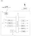
本発明の一実施形態による地図更新システムを図1に示す。このシステムは、車両100に搭載されているナビゲーション装置(車載機)1、通信端末2、移動体通信網3および更新地図データ配信センター4によって構成されている。ナビゲーション装置1と通信端末2が互いに接続されており、移動体通信網3と更新地図データ配信センター4が互いに接続されている。 A map updating system according to an embodiment of the present invention is shown in FIG. This system includes a navigation device (on-vehicle device) 1, a
ナビゲーション装置1は、内部のHDD(ハードディスク)に記録されている地図データに基づいて、現在地の周辺について地図を表示すると共に、ユーザに設定された目的地までの推奨経路を探索し、その推奨経路にしたがって車両100を目的地まで誘導する。なお、ナビゲーション装置1のHDDに記憶されている地図データは、更新地図データ配信センター4から送信される更新地図データを受信することにより、地域単位で部分的に更新することができる。 The
通信端末2には携帯電話などが用いられており、指定された電話番号の発信先に対して電話発信を行うと共に、他の電話からの電話着信を受けることができる。通信端末2において電話の発着信が行われる際には、通信端末2と移動体通信網3が無線接続されて通話回線が確立される。これにより、ユーザは外部の電話との間で通話を行うことができるようになる。なお、ナビゲーション装置1はハンズフリー通話制御機能を有しており、通信端末2における電話の発着信を制御すると共に、その通話履歴、すなわち発信先や着信元の電話番号の履歴を記録しておくことができる。 A mobile phone or the like is used as the
さらに通信端末2は、上記の電話機能の他にデータ通信機能も有しており、ナビゲーション装置1からの出力データを更新地図データ配信センター4へ送信すると共に、更新地図データ配信センター4から送信されるデータをナビゲーション装置1へ出力することができる。その際、通信端末2はナビゲーション装置1の制御によって、移動体通信網3と無線接続される。通信端末2と移動体通信網3が無線接続されることにより、ナビゲーション装置1と更新地図データ配信センター4の間で通信回線が確立され、データの送受信が可能となる。 Further, the
なお、上記のように通話時やデータ通信時において通信端末2と移動体通信網3が無線接続される際には、不図示の無線基地局が用いられる。この無線基地局は、その周囲の所定の通信エリア内にある通信端末2と無線通信することが可能であり、全国各地に散在している。また、ナビゲーション装置1と通信端末2との接続には、ケーブル等による有線接続に限らず、たとえば赤外線などの無線接続を用いてもよい。 As described above, when the
ナビゲーション装置1のHDDに記憶されている地図データを更新する場合は、上記で説明した通信端末2のデータ通信機能を用いて、ナビゲーション装置1から更新地図データ配信センター4へ更新地図データの配信要求が送信される。すなわち、ナビゲーション装置1の制御によって通信端末2が移動体通信網3に無線接続され、ナビゲーション装置1と更新地図データ配信センター4の間で通信回線が確立される。この状態で、ナビゲーション装置1から通信端末2へ更新地図データの配信要求が出力され、通信端末2から更新地図データ配信センター4へと送信される。これにより、更新地図データの配信を更新地図データ配信センター4に要求する。 When updating the map data stored in the HDD of the
さらに、上記のように更新地図データの配信要求を送信する際には、その更新対象の地域を特定するための情報(以下、地域特定情報という)がナビゲーション装置1において作成される。そして、更新地図データの配信要求と共に、ナビゲーション装置1から更新地図データ配信センター4へ送信される。なお、地域特定情報の作成方法については、後で詳しく説明する。 Furthermore, when transmitting the update map data distribution request as described above, information for specifying the region to be updated (hereinafter referred to as region specifying information) is created in the
更新地図データ配信センター4には、最新の地図データが記憶されている地図サーバが備えられている。上記のようにして、ナビゲーション装置1から更新地図データの配信要求と地域特定情報が送信されると、更新地図データ配信センター4は、この地図サーバに記憶されている最新の地図データに基づいて、更新地図データを作成する。その際、受信した地域特定情報の内容に基づいて更新対象地域を特定し、その地域を対象とする更新地図データを作成する。作成された更新地図データは、更新地図データ配信センター4からナビゲーション装置1へ送信される。 The updated map
ナビゲーション装置1は、上記の更新地図データを更新地図データ配信センター4から受信すると、それを用いて、HDDに記録されている地図データを地域単位で部分的に更新する。このようにして、地図データの更新が行われる。 When the
ナビゲーション装置1の構成を図2に示す。ナビゲーション装置1は、制御回路11、ROM12、RAM13、現在地検出装置14、画像メモリ15、表示モニタ16、入力装置17、HDD18およびVICS受信部19を有している。 The configuration of the
制御回路11は、マイクロプロセッサおよびその周辺回路からなり、RAM13を作業エリアとしてROM12に格納された制御プログラムを実行することで、ナビゲーション装置1を動作させるための様々な処理や制御を行う。制御回路11には通信端末2が接続されており、地図データの更新時には制御回路11から通信端末2を制御することで、図1の更新地図データ配信センター4に対して更新地図データの配信要求と地域特定情報が送信される。これに応じて更新地図データ配信センター4から送信される更新地図データを通信端末2を介して受信することで、HDD18の地図データが部分的に更新される。 The
現在地検出装置14は、自車両の現在地を検出する装置であり、たとえば、自車両の進行方向を検出する振動ジャイロ14a、車速を検出する車速センサ14b、GPS衛星からのGPS信号を検出するGPSセンサ14c等からなる。ナビゲーション装置1は、この現在地検出装置14により検出された自車両の現在地に基づいて、推奨経路を探索するときの経路探索開始点を決定することができる。 The current
画像メモリ15は、表示モニタ16に表示するための画像データを一時的に格納する。この画像データは、地図を画像表示するための道路地図描画用データや各種の図形データ等からなり、制御回路11において、HDD18に記録されている地図データに基づいて作成される。この画像メモリ15に格納された画像データを用いて、自車位置周辺の地図が表示モニタ16に表示される。 The
入力装置17は、ユーザからの操作入力を受け付けるための各種入力スイッチを有し、これは操作パネルやリモコン、タッチパネルなどによって実現される。ユーザは、表示モニタ16に表示される画面指示に従って入力装置17を操作することにより、目的地に指定する施設の住所や施設名称などを入力することができる。ユーザが住所や施設名称などを入力すると、それに該当する施設が目的地候補としてナビゲーション装置1において検索され、その目的地候補の中からユーザの選択したものが目的地に設定される。こうして目的地が設定されることにより、その目的地までの推奨経路がナビゲーション装置1において探索される。 The
HDD18には、前述のように地図データが記録されている。すなわち、ナビゲーション装置1は、HDD18により地図データを記憶している。なお、ここではHDDを用いた例を説明しているが、他の書き換え可能な不揮発性の記録デバイス、たとえばDVD−RAM等の書き換え可能な記録ディスクや、フラッシュメモリなどをHDDに替えて用いてもよい。 Map data is recorded in the
HDD18に記録されている地図データには、主に推奨経路を演算するために用いられる経路計算データや、交差点名称、道路名称など、主に推奨経路に従って自車両を目的地まで案内するために用いられる経路誘導データ、主に道路形状を表すために用いられる道路データ、さらには海岸線や河川、鉄道、建物など、道路以外の地図形状を表す背景データなどが含まれている。また、各種施設の名称や位置、種類、電話番号などを表すPOI(Point Of Interest)データも、地図データの中に含まれている。なお、経路計算データ以外の地図データは、メッシュと呼ばれる地図上に決められた所定の地域範囲ごとに設定されており、メッシュ単位で別々にファイル化されている。そのため、経路計算データ以外の地図データについては、ファイルごとに書き換えて地域単位で部分的に更新することができる。 The map data recorded in the
道路データにおいて、道路区間を表す最小単位はリンクと呼ばれている。すなわち、各道路は所定の道路区間ごとに設定された複数のリンクによって構成されている。なお、リンクによって設定される道路区間の長さは異なっており、リンクの長さは一定ではない。リンク同士を接続している点はノードと呼ばれ、このノードはそれぞれに位置情報(座標情報)を有している。また、リンク内にはノードとノードの間に形状補間点と呼ばれる点が設定されていることもある。形状補間点もノードと同じく、それぞれに位置情報(座標情報)を有している。このノードと形状補間点の位置情報によって、リンク形状、すなわち道路の形状が決定される。 In the road data, the smallest unit representing a road section is called a link. That is, each road is composed of a plurality of links set for each predetermined road section. In addition, the length of the road section set by a link differs, and the length of a link is not constant. A point connecting the links is called a node, and each node has position information (coordinate information). Also, a point called a shape interpolation point may be set between nodes in the link. Each shape interpolation point also has position information (coordinate information) like each node. The link shape, that is, the shape of the road is determined based on the position information of the node and the shape interpolation point.
経路計算データには、日本全国の主要な幹線道路を表す各リンクにそれぞれ対応して、その通過所要時間を表すためのリンクコストと呼ばれる情報が記録されている。前述のようにして目的地が設定されると、現在地検出装置14により検出された現在地を経路探索開始点として、そこから目的地までの経路演算が経路計算データに基づいて所定のアルゴリズムにより行われ、目的地までの合計リンクコストが最小となる推奨経路が求められる。そして、求められた推奨経路を含んだ現在地周辺の地図が表示モニタ16に表示され、推奨経路に従って右左折の指示などが適宜行われる。 In the route calculation data, information called a link cost for representing the required travel time is recorded corresponding to each link representing major trunk roads throughout Japan. When the destination is set as described above, a route calculation from the current location detected by the current
VICS受信部19は、不図示の道路交通情報通信システムセンター(VICSセンター)から送信される道路交通情報(VICS情報)を受信し、制御回路11へ出力する。制御回路11は、このVICS情報に基づいて、各道路の渋滞状況や交通規制状況などを表した道路交通情報画面を表示モニタ16に表示する。なお、VICS情報はFM放送によって送信される場合と、道路上に設置されたビーコンによって送信される場合がある。ビーコンには、主に高速道路上に設置されている電波ビーコンと、主に一般道路上に設置されている光ビーコンの二種類がある。 The
VICS情報にはレベル1からレベル3まで3段階のレベルがあり、レベルの違いによって表示される道路交通情報画面の形態が異なる。レベル1のVICS情報では、文字によって道路交通情報画面が表示される。たとえば、渋滞地点名や渋滞距離、特定地点間の所要時間などを表現した文章が、レベル1のVICS情報に基づいて表示される。レベル2のVICS情報では、簡易図形(道路線形を簡易的な図形で表したもの)による道路交通情報画面が表示される。たとえば、特定の道路の渋滞箇所を赤やオレンジ色などによって簡易図形上に表した画像が、レベル2のVICS情報に基づいて表示される。レベル3のVICS情報では、道路地図上に渋滞状況や交通規制状況などを表示した画面が道路交通情報画面として表示される。たとえば、各道路の渋滞状況を示すための赤やオレンジ色などの矢印が道路に沿って表示されたり、通行止めや車線規制などの通行規制を示すためのマークが道路上に表示されたりする。 The VICS information has three levels from
次に、ナビゲーション装置1のHDD18に記録されている地図データを部分的に更新する方法について説明する。本実施形態では、VICS受信部19により受信したVICS情報に基づいて、VICS情報が提供されているが、地図データには含まれていない道路(以下、未対応道路という)の有無を調べる。未対応道路がある場合は、その未対応道路を含むメッシュを特定し、そのメッシュを表すメッシュ番号情報を、前述の地域特定情報としてナビゲーション装置1から更新地図データ配信センター4に送信する。 Next, a method for partially updating the map data recorded in the
ナビゲーション装置1から送信された地域特定情報を受信した更新地図データ配信センター4では、そのメッシュ番号情報から上記の未対応道路を含むメッシュを判別し、そのメッシュを更新対象メッシュとする更新地図データを作成した後、ナビゲーション装置1へ送信する。この更新地図データは、更新地図データ配信センター4の地図サーバから、経路計算データ以外の地図データを更新対象メッシュについて抽出することにより作成される。こうして更新地図データ配信センター4から送信される更新地図データをナビゲーション装置1において受信することで、HDD18に記録されている地図データが部分的に更新される。 The updated map
ナビゲーション装置1において未対応道路の有無を調べ、その未対応道路を含むメッシュを特定する方法について、以下に説明する。VICSセンターは、送信するVICS情報において表された各道路に対して、その各道路を構成する前述の各リンクごとに、VICSリンクIDと呼ばれるそれぞれ固有のID情報を設定する。レベル3のVICS情報では、このVICSリンクIDによって指定される各リンクに対して、それぞれにおける渋滞状況や交通規制状況などが示されている。 A method for checking the presence or absence of an unsupported road in the
一方、ナビゲーション装置1においてHDD18に記録されている地図データでは、道路データの各リンクに対して、上記のVICSリンクIDと同様に、それぞれ固有のID情報が予め設定されている。以下では、この地図データにおけるID情報を地図リンクIDと称する。 On the other hand, in the map data recorded in the
ところで、上記のVICSリンクIDと地図リンクIDとはその内容が必ずしも一致しているとは限らず、同じリンクに対して異なるID情報が設定されていることがある。そのため、ナビゲーション装置1において受信したレベル3のVICS情報に基づいて道路交通情報画面を表示する際に、そのVICS情報におけるVICSリンクIDをそのまま用いて地図データのリンクを指定すると、渋滞状況や交通規制状況を道路地図上の正しい位置に表示できない場合がある。 By the way, the contents of the VICS link ID and the map link ID do not always match, and different ID information may be set for the same link. Therefore, when the road traffic information screen is displayed based on the
このような問題を解決するため本実施形態では、VICSリンクIDを地図リンクIDに変換するための情報として、各リンクのVICSリンクIDと地図リンクIDとの対応関係を示す情報を予めナビゲーション装置1に記憶させておく。この対応関係を参照して受信したVICS情報とHDD18の地図データとを照合することにより、VICS情報におけるVICSリンクIDを地図リンクIDに変換して、VICS情報と地図データとを道路ごとにそれぞれ対応付ける。そして、HDD18に記録されている地図データの中から、当該地図リンクIDに対応する道路の道路データを抽出し、その道路に対して前述したような方法により、渋滞状況や交通規制状況を道路地図上に表示する。これにより、ナビゲーション装置1は受信したレベル3のVICS情報に基づいて、渋滞状況や交通規制状況を道路地図上に正しく表示するようにしている。 In order to solve such a problem, in the present embodiment, as the information for converting the VICS link ID into the map link ID, information indicating the correspondence relationship between the VICS link ID of each link and the map link ID is stored in advance in the
なお、VICSリンクIDは、VICS情報において、地図データの各メッシュに合わせて分類されている。そのため、VICS情報を受信したナビゲーション装置1では、各VICSリンクIDがどの分類に属するかを調べることにより、各VICSリンクIDが地図データのどのメッシュに含まれるリンクを表しているか特定できる。すなわち、VICSリンクIDさえ分かれば、地図リンクIDが分からなくても、そのリンクが含まれるメッシュを特定することができる。 Note that the VICS link ID is classified according to each mesh of the map data in the VICS information. Therefore, in the
ナビゲーション装置1に記憶されているVICSリンクIDと地図リンクIDとの対応関係の例を図3に示す。ここでは、個々のVICSリンクIDとそれに対応する地図リンクIDとを、VICSリンク対応テーブルとして表にまとめている。たとえば、VICSリンクIDがV1である場合は、対応する地図リンクIDがL101となる。同様に、VICSリンクID=V2に対応する地図リンクIDはL102であり、VICSリンクID=V4に対応する地図リンクIDはL114である。このような対応関係に基づいて、VICS情報におけるVICSリンクIDを、地図リンクIDに対応付けることができる。なお、図3に示した内容は一例であるため、他の内容であってもよい。An example of the correspondence between the VICS link ID and the map link ID stored in the
ところが、たとえば新設された道路など、HDD18に記録されている地図データには含まれていない道路を表しているリンクについては、上記のようなVICSリンクIDと地図リンクIDとの対応関係がナビゲーション装置1に記憶されていない。このようなリンクを表すVICSリンクIDがVICSセンターから送信されたVICS情報に含まれていた場合は、ナビゲーション装置1においてそれを地図リンクIDに対応付けることができない。 However, for a link representing a road not included in the map data recorded in the
そこでナビゲーション装置1は、受信したVICS情報におけるVICSリンクIDの中に、地図リンクIDとの対応関係が記憶されていないものが存在する場合には、そのVICSリンクIDに対応するリンクを未対応道路として判断する。すなわち、各リンクのうち上記の対応関係に基づいてVICS情報と地図データとが対応付けられないリンクを、未対応道路と判断する。このようにすることで、ナビゲーション装置1において未対応道路の有無を調べることができる。さらにこのとき、前述のように未対応道路に該当するリンクのVICSリンクIDさえ分かれば、地図IDが分からなくても、そのVICSリンクIDの分類から、その未対応道路を含むメッシュを特定できる。このようにすることで、VICS情報が提供されているが地図データには表されていない未対応道路を含むメッシュを特定することができる。 Therefore, if there is a VICS link ID in the received VICS information that does not store the correspondence relationship with the map link ID, the
以上説明した方法によってナビゲーション装置1のHDD18に記録されている地図データを部分的に更新する際に、ナビゲーション装置1と更新地図データ配信センター4において実行されるフローチャートを図4および図5に示す。図4は、経路計算データを更新する際に実行されるフローチャートである。図5は、経路計算データ以外の地図データを更新する際に実行されるフローチャートである。 4 and 5 show flowcharts executed in the
以下、図4の経路計算データ更新時のフローチャートから先に説明する。図4において、(a)に示すフローチャートはナビゲーション装置1により実行され、(b)に示すフローチャートは更新地図データ配信センター4により実行される。 Hereinafter, the flowchart when updating the route calculation data in FIG. 4 will be described first. In FIG. 4, the flowchart shown in (a) is executed by the
ナビゲーション装置1は、制御回路11により、図4(a)のステップS1において、経路計算データを更新するか否かを判定する。この判定は、予め設定された更新条件を満たすか否かを判定することによって行われる。更新条件を満たす場合は次のステップS2へ進む。ステップS2では、最新版の経路計算データを要求するための経路計算データ配信要求を、通信端末2を介して更新地図データ配信センター4に送信する。なお、このときHDD18に記録されている経路計算データのバージョン番号を示す情報(経路計算データバージョン情報)を、経路計算データ配信要求と合わせて送信する。これにより、ナビゲーション装置1における現在の経路計算データのバージョンを、更新地図データ配信センター4において判別できるようにする。 The
なお、ステップS1の判定に用いる更新条件には、様々な内容を設定しておくことができる。たとえば、前回の更新から所定時間が経過したことや、ユーザから入力装置17によって更新のリクエスト操作が行われたことなどを、更新条件とすることができる。このような更新条件を満たすことにより、ナビゲーション装置1から更新地図データ配信センター4へ経路計算データ配信要求が送信される。 Various contents can be set in the update condition used for the determination in step S1. For example, the update condition may be that a predetermined time has elapsed since the previous update, or that an update request operation has been performed by the
更新地図データ配信センター4は、上記のようにステップS2においてナビゲーション装置1から送信された経路計算データ配信要求を、図4(b)のステップS31で受信する。次のステップS32では、その経路計算データ配信要求に応じて、全国の幹線道路についての経路計算データの最新版を送信する。ステップS32を実行したら、更新地図データ配信センター4は図4(b)のフローチャートを終了する。 The updated map
なお、ステップS32において経路計算データの最新版を送信する際には、ナビゲーション装置1から経路計算データ配信要求と合わせて送信された上記の経路計算データバージョン情報により、ナビゲーション装置1における現在の経路計算データのバージョンを判別しておく。これによって現在の経路計算データのバージョンが最新版と同じである場合は、経路計算データを送信する必要がないため、ステップS32において経路計算データを送信しないようにする。 When the latest version of the route calculation data is transmitted in step S32, the current route calculation in the
ナビゲーション装置1は、通信端末2を介して制御回路11により、上記のようにステップS32において更新地図データ配信センター4から送信された経路計算データを、図4(a)のステップS3で受信する。これにより、経路計算データの最新版を取得する。次のステップS4では、ステップS3で受信した経路計算データを用いて、HDD18に記録されている地図データのうち経路計算データを部分的に更新する。ステップS4を実行したら、図4(a)のフローチャートを終了する。以上説明したようにして、ナビゲーション装置1においてHDD18に記録されている経路計算データが最新の内容に更新される。 The
次に、図5の地図データ更新時のフローチャートについて説明する。図5において、(a)に示すフローチャートはナビゲーション装置1により実行され、(b)に示すフローチャートは更新地図データ配信センター4により実行される。 Next, a flowchart for updating map data in FIG. 5 will be described. In FIG. 5, the flowchart shown in (a) is executed by the
ナビゲーション装置1は、VICS受信部19により、図5(a)のステップS11において、VICSセンターから送信されるVICS情報を受信する。受信したVICS情報は、制御回路11へ出力される。次のステップS12では、制御回路11により、いずれかのメッシュを選択する。なお、ここで選択対象とされるメッシュは、ステップS11で受信したVICS情報によって渋滞状況や交通規制状況などが表されているメッシュである。このようなメッシュは、VICSリンクIDに基づいて判断することができる。 The
ステップS13では、ステップS12で選択したメッシュ内に含まれるVICSリンクIDと地図リンクIDを照合する。この照合は、図3に示されたVICSリンク対応テーブルのように、予めナビゲーション装置1において記憶されたVICSリンクIDと地図リンクIDとの対応関係を示す情報に基づいて行われる。なお、この対応関係を示す情報は、地図データと共にHDD18に記録されている。 In step S13, the VICS link ID and map link ID included in the mesh selected in step S12 are collated. This collation is performed based on information indicating the correspondence relationship between the VICS link ID and the map link ID stored in advance in the
ステップS14では、ステップS13の照合結果から、対応する地図リンクIDが存在しないVICSリンクIDがあるか否かを判定する。そのようなVICSリンクIDがある場合はステップS15へ進み、ない場合、すなわち全てのVICSリンクIDが地図リンクIDに対応付けられる場合は、ステップS15を飛ばしてステップS16へ進む。このようにして、VICS情報と地図データとが対応付けられないリンクがあるか否かを調べる。この条件にあてはまるリンクが、未対応道路と判断される。 In step S14, it is determined from the collation result in step S13 whether there is a VICS link ID for which no corresponding map link ID exists. If there is such a VICS link ID, the process proceeds to step S15. If not, that is, if all the VICS link IDs are associated with the map link ID, step S15 is skipped and the process proceeds to step S16. In this way, it is checked whether or not there is a link in which the VICS information and the map data are not associated with each other. A link that satisfies this condition is determined as an unsupported road.
ステップS15では、現在選択されているメッシュを更新対象メッシュに指定する。これにより、VICS情報が提供されているが地図データには含まれていない未対応道路を含むメッシュが、更新対象地域に設定される。 In step S15, the currently selected mesh is designated as the update target mesh. As a result, a mesh including an unsupported road for which VICS information is provided but is not included in the map data is set as the update target area.
ステップS16では、ステップS12で選択対象とされたVICS情報が提供された全てのメッシュを、それまでに実行したステップS12において選択したか否かを判定する。このようなメッシュの全てを既に選択していた場合は、ステップS17へ進む。まだ選択していないメッシュがある場合はステップS12へ戻り、ステップS12において未選択のメッシュからいずれかのメッシュを選択した後、上記に説明した処理を繰り返す。 In step S16, it is determined whether all the meshes provided with the VICS information selected in step S12 have been selected in step S12 executed so far. If all such meshes have already been selected, the process proceeds to step S17. If there is a mesh that has not yet been selected, the process returns to step S12, and after selecting one of the unselected meshes in step S12, the processing described above is repeated.
ステップS17では、それまでに実行されたステップS15において指定された更新対象メッシュのメッシュ番号を表す地域特定情報を作成する。ステップS18では、更新地図データの配信を要求していることを示す更新地図データ配信要求を、ステップS17で作成された地域特定情報と共に、通信端末2を介して更新地図データ配信センター4へ送信する。 In step S17, area specifying information representing the mesh number of the update target mesh designated in step S15 executed so far is created. In step S18, an update map data distribution request indicating that update map data distribution is requested is transmitted to the update map
更新地図データ配信センター4は、上記のようにステップS18においてナビゲーション装置1から送信された更新地図データ配信要求と地域特定情報を、図5(b)のステップS41で受信する。次のステップS42では、ステップS41で受信した地域特定情報に基づいて更新対象地域に設定されたメッシュを判断し、そのメッシュ(更新対象メッシュ)の最新地図データを自身の地図サーバ内から抽出する。ステップS43では、ステップS42で抽出された更新対象メッシュの最新地図データを、更新地図データとしてナビゲーション装置1に送信する。なお、このときVICSリンクIDと更新地図データにおける地図リンクIDとの対応関係を示す情報も合わせて送信する。ステップS43を実行したら、更新地図データ配信センター4は図5(b)のフローチャートを終了する。 The updated map
ナビゲーション装置1は、通信端末2を介して制御回路11により、上記のようにステップS43において更新地図データ配信センター4から送信された更新地図データを、図5(a)のステップS19で受信する。次のステップS20では、ステップS19で受信した更新地図データを用いて、HDD18に記録されている地図データを部分的に更新する。なお、このとき更新地図データと合わせて送信されたVICSリンクIDと地図リンクIDとの対応関係を示す情報により、HDD18に記録されているVICSリンク対応テーブルを更新する。ステップS20を実行したら、図5(a)のフローチャートを終了する。以上説明したようにして、ナビゲーション装置1においてHDD18に記録されている地図データの部分更新が行われる。 The
なお、ステップS18において地域特定情報をナビゲーション装置1から更新地図データ配信センター4へ送信する際には、それと合わせて各更新対象メッシュにおける地図バージョンの情報を送信することが好ましい。このようにすれば、ステップS42において地図データの最新版を更新地図データ配信センター4の地図サーバから抽出する際に、既に同じ地図バージョンに更新されている更新対象メッシュについては、抽出の対象から除外することができる。その結果、更新する必要のないメッシュの地図データを更新地図データから排除して無駄なデータ量を減らすことができる。 In addition, when transmitting area specific information from the
以上説明した実施の形態によれば、次の作用効果を奏する。
(1)ナビゲーション装置1において、VICSセンターから送信されたVICS情報をVICS受信部19で受信して取得し(ステップS11)、取得されたVICS情報のVICSリンクIDと、HDD18に記憶された地図データの地図リンクIDとを照合する(ステップS13)。この照合結果に基づいて、いずれかのメッシュを更新対象メッシュに指定する(ステップS15)ことにより、更新対象地域を設定する。こうして設定された更新対象地域について、道路データの最新版を含む更新地図データを更新地図データ配信センター4に要求する(ステップS18)。この要求に応じて、更新地図データ配信センター4において、更新対象地域についての道路データの最新版を含む更新地図データをナビゲーション装置1へ送信し(ステップS43)、これをナビゲーション装置1において取得する(ステップS19)。こうして取得した道路データの最新版を用いて、HDD18に記録されている地図データを部分的に更新する(ステップS20)。このようにしてナビゲーション装置の地図データを部分的に更新することとしたので、推奨経路周辺以外の地域についても状況に応じて適切な更新対象地域を設定し、地図データを更新することができる。According to the embodiment described above, the following operational effects are obtained.
(1) In the
(2)VICS情報が提供されているが、地図データには含まれていない未対応道路を含むメッシュを、更新対象メッシュに設定することとした。具体的には、ステップS11で受信したVICS情報に基づいて、そのVICS情報により渋滞状況や交通規制状況が表されるメッシュをそれぞれ選択し(ステップS12)、選択したメッシュが未対応道路を含んでいる場合には、そのメッシュを更新対象メッシュに指定する(ステップS15)こととした。このようにしたので、取得されたVICS情報に基づいて未対応道路を含む適切な更新対象地域を設定することができる。(2) The VICS information is provided, but the mesh including the unsupported road that is not included in the map data is set as the update target mesh. Specifically, based on the VICS information received in step S11, meshes representing traffic congestion and traffic regulation status are selected based on the VICS information (step S12), and the selected mesh includes an unsupported road. If so, the mesh is designated as the update target mesh (step S15). Since it did in this way, the suitable update object area containing an unsupported road can be set based on the acquired VICS information.
(3)VICSリンクIDと地図リンクIDとの対応関係を示す情報をHDD18に記録しておき、この情報に基づいて、VICS情報と地図データとをリンクごとにそれぞれ対応付ける。そして、この方法によってVICS情報と地図データとが対応付けられないリンクを、未対応道路と判断することとした。具体的には、HDD18に記録されているVICSリンク対応テーブルを参照することにより、受信したVICS情報におけるVICSリンクIDと地図リンクIDを照合し(ステップS13)、その照合結果から、対応する地図リンクIDが存在しないVICSリンクIDがあるか否かを判定する(ステップS14)。このようなVICSリンクIDがあると判定された場合は、そのVICSリンクIDに対応するリンクを、未対応道路と判断することとした。このようにしたので、取得されたVICS情報から未対応道路を簡単に判断することができる。(3) Information indicating the correspondence between the VICS link ID and the map link ID is recorded in the
なお、上記の実施の形態では、経路計算データの最新版や更新地図データを、無線通信回線を用いて更新地図データ配信センター4からナビゲーション装置1へダウンロードする例を説明したが、本発明はこの内容に限定されない。たとえば、自動車販売店やサービスセンターなどに備えられた地図データ書き換え用装置をナビゲーション装置と接続し、その地図データ書き換え用装置からナビゲーション装置へ経路計算データの最新版や更新地図データを送信することによって地図データを部分的に書き換える場合にも、本発明を適用することができる。さらに、経路計算データの最新版と更新地図データを別々の場所から取得するようにしてもよい。 In the above embodiment, the example in which the latest version of the route calculation data and the updated map data are downloaded from the updated map
また、上記の実施の形態では、ナビゲーション装置1において更新地図データを受信すると自動的に更新する例を説明したが、更新前にユーザに確認させるようにして、ユーザが了承した場合のみ地図データを更新するようにしてもよい。このようにすることで、ユーザが望まないのに地図データが更新されるのを防ぐことができる。 In the above-described embodiment, an example in which the updated map data is automatically updated when the
上記の実施の形態では、日本全国を対象にした地図データを例に説明したが、その他の地域、たとえば関東地方等の日本国内の一地域や、外国などを対象としてもよい。いずれの地域を対象としても、その地域内の地図が、その地域に対して所定の地域範囲ごとに設定された地図データによって表されている限り、本発明を適用できる。 In the above embodiment, map data for the whole of Japan has been described as an example, but other regions, for example, one region in Japan such as the Kanto region, or a foreign country may be targeted. Regardless of the region, the present invention can be applied as long as the map in the region is represented by the map data set for each predetermined region range for the region.
以上説明した実施の形態や各種の変形例はあくまで一例であり、発明の特徴が損なわれない限り、本発明はこれらの内容に限定されない。 The embodiment and various modifications described above are merely examples, and the present invention is not limited to these contents as long as the features of the invention are not impaired.
上記の実施の形態では、地図記憶手段および対応情報記憶手段をHDD18、交通情報取得手段をVICS受信部19によりそれぞれ実現し、その他の各手段を、ナビゲーション装置1の制御回路11または更新地図データ配信センター4のいずれかにおける処理によって実現している。具体的には、対応付け手段をステップS13、更新地域設定手段をステップS15、要求手段をステップS18、更新地図データ取得手段をステップS19、地図データ更新手段をステップS20によってそれぞれ実現し、送信手段をステップS43によって実現している。なお、以上の説明はあくまで一例であり、発明を解釈する際、上記の実施形態の記載事項と特許請求の範囲の記載事項の対応関係に何ら限定も拘束もされない。 In the above embodiment, the map storage means and the correspondence information storage means are realized by the
1:ナビゲーション装置
2:通信端末
3:移動体通信網
4:更新地図データ配信センター
11:制御回路
12:ROM
13:RAM
14:現在地検出装置
15:画像メモリ
16:表示モニタ
17:入力装置
18:HDD
19:VICS受信部
100:車両1: Navigation device 2: Communication terminal 3: Mobile communication network 4: Update map data distribution center 11: Control circuit 12: ROM
13: RAM
14: Current location detection device 15: Image memory 16: Display monitor 17: Input device 18: HDD
19: VICS receiver 100: vehicle
Claims (5)
Translated fromJapanese所定の地域範囲ごとに設定された地図データを記憶する地図記憶手段と、
道路交通情報を取得する交通情報取得手段と、
前記交通情報取得手段により取得された道路交通情報と前記地図記憶手段により記憶された地図データとの照合結果に基づいて、前記地図データを部分的に更新するときの更新対象地域を設定する更新地域設定手段と、
前記更新地域設定手段により設定された更新対象地域について、前記地図記憶手段に記憶されている地図データの最新版を前記更新地図データ送信装置に要求する要求手段と、
前記要求に応じて前記更新地図データ送信装置から送信される地図データの最新版を取得する更新地図データ取得手段と、
前記更新地図データ取得手段により取得された地図データの最新版を用いて、前記地図記憶手段に記憶されている地図データを部分的に更新する地図データ更新手段とを備えることを特徴とするナビゲーション装置。A navigation device that displays a map based on stored map data, and that can partially update the map data using the latest version of map data transmitted from an external update map data transmission device,
Map storage means for storing map data set for each predetermined area range;
Traffic information acquisition means for acquiring road traffic information;
An update area that sets an update target area when the map data is partially updated based on a result of collation between the road traffic information acquired by the traffic information acquisition means and the map data stored by the map storage means Setting means;
Request means for requesting the updated map data transmission device for the latest version of the map data stored in the map storage means for the update target area set by the update area setting means;
Updated map data acquisition means for acquiring the latest version of the map data transmitted from the updated map data transmitter in response to the request;
A navigation apparatus comprising: map data update means for partially updating map data stored in the map storage means using the latest version of the map data acquired by the update map data acquisition means. .
前記更新地域設定手段は、前記道路交通情報が提供されているが、前記地図データには含まれていない未対応道路を含む地域を、前記更新対象地域に設定することを特徴とするナビゲーション装置。The navigation device according to claim 1.
The navigation apparatus according to claim 1, wherein the update area setting means sets an area including an unsupported road that is provided with the road traffic information but is not included in the map data, as the update target area.
前記道路交通情報において所定の道路区間ごとにそれぞれ固有に設定された第1のID情報と、前記地図データにおいて前記道路区間ごとにそれぞれ固有に設定された第2のID情報との対応関係を示す情報を記憶する対応情報記憶手段と、
前記対応情報記憶手段により記憶されている情報に基づいて、前記道路交通情報と前記地図データとを前記道路区間ごとにそれぞれ対応付ける対応付け手段とをさらに備え、
前記更新地域設定手段は、前記各道路区間のうち、前記対応付け手段によって道路交通情報と地図データとが対応付けられない道路区間を、前記未対応道路と判断することを特徴とするナビゲーション装置。The navigation device according to claim 2,
The correspondence between the first ID information uniquely set for each predetermined road section in the road traffic information and the second ID information uniquely set for each road section in the map data is shown. Correspondence information storage means for storing information;
Based on the information stored by the correspondence information storage unit, the road traffic information and the map data are further associated with each road section, respectively.
The update area setting means determines a road section in which road traffic information and map data are not associated by the association means among the road sections as the unsupported road.
前記ナビゲーション装置は、
所定の地域範囲ごとに設定された地図データを記憶する地図記憶手段と、
道路交通情報を取得する交通情報取得手段と、
前記交通情報取得手段により取得された道路交通情報と前記地図記憶手段により記憶された地図データとの照合結果に基づいて、前記地図データを部分的に更新するときの更新対象地域を設定する更新地域設定手段と、
前記更新地域設定手段により設定された更新対象地域について、前記地図記憶手段に記憶されている地図データの最新版を前記更新地図データ送信装置に要求する要求手段と、
前記要求に応じて前記更新地図データ送信装置から送信される地図データの最新版を取得する更新地図データ取得手段と、
前記更新地図データ取得手段により取得された地図データの最新版を用いて、前記地図記憶手段に記憶されている地図データを部分的に更新する地図データ更新手段とを備え、
前記更新地図データ送信装置は、
前記要求手段による要求に応じて、前記更新対象地域についての地図データの最新版を前記ナビゲーション装置へ送信する送信手段を備えることを特徴とする地図データ更新システム。A navigation device capable of displaying a map based on the stored map data and partially updating the map data, and the latest map data for partially updating the map data stored in the navigation device An updated map data transmitting device for transmitting a version to the navigation device;
The navigation device
Map storage means for storing map data set for each predetermined area range;
Traffic information acquisition means for acquiring road traffic information;
An update area that sets an update target area when the map data is partially updated based on a result of collation between the road traffic information acquired by the traffic information acquisition means and the map data stored by the map storage means Setting means;
Request means for requesting the updated map data transmission device for the latest version of the map data stored in the map storage means for the update target area set by the update area setting means;
Updated map data acquisition means for acquiring the latest version of the map data transmitted from the updated map data transmitter in response to the request;
Map data update means for partially updating the map data stored in the map storage means, using the latest version of the map data acquired by the update map data acquisition means,
The updated map data transmission device includes:
A map data update system comprising: a transmission means for transmitting the latest version of map data for the update target area to the navigation device in response to a request from the request means.
所定の地域範囲ごとに設定された地図データを前記ナビゲーション装置により記憶し、
道路交通情報を取得し、
前記取得された道路交通情報と前記地図データとの照合結果に基づいて、前記地図データを部分的に更新するときの更新対象地域を設定し、
前記設定された更新対象地域について、前記地図データの最新版を前記更新地図データ送信装置に要求し、
前記要求に応じて、前記更新対象地域についての地図データの最新版を前記更新地図データ送信装置から前記ナビゲーション装置へ送信して、前記ナビゲーション装置により取得し、
前記取得された地図データの最新版を用いて、前記ナビゲーション装置により記憶されている地図データを部分的に更新することを特徴とする地図データ更新方法。A navigation device capable of displaying a map based on the stored map data and partially updating the map data, and the latest map data for partially updating the map data stored in the navigation device A map data update method used in a map data update system having an updated map data transmission device for transmitting a version to the navigation device,
Storing the map data set for each predetermined area range by the navigation device;
Get road traffic information,
Based on the result of matching the acquired road traffic information and the map data, set an update target area when partially updating the map data,
For the set update target area, request the updated version of the map data to the updated map data transmission device,
In response to the request, the latest version of the map data for the update target area is transmitted from the updated map data transmitting device to the navigation device, and acquired by the navigation device,
A map data update method, wherein the map data stored in the navigation device is partially updated using the latest version of the acquired map data.
Priority Applications (1)
| Application Number | Priority Date | Filing Date | Title |
|---|---|---|---|
| JP2005095444AJP2006275777A (en) | 2005-03-29 | 2005-03-29 | Navigation device, map data update system, map data update method |
Applications Claiming Priority (1)
| Application Number | Priority Date | Filing Date | Title |
|---|---|---|---|
| JP2005095444AJP2006275777A (en) | 2005-03-29 | 2005-03-29 | Navigation device, map data update system, map data update method |
Publications (1)
| Publication Number | Publication Date |
|---|---|
| JP2006275777Atrue JP2006275777A (en) | 2006-10-12 |
Family
ID=37210698
Family Applications (1)
| Application Number | Title | Priority Date | Filing Date |
|---|---|---|---|
| JP2005095444APendingJP2006275777A (en) | 2005-03-29 | 2005-03-29 | Navigation device, map data update system, map data update method |
Country Status (1)
| Country | Link |
|---|---|
| JP (1) | JP2006275777A (en) |
Cited By (9)
| Publication number | Priority date | Publication date | Assignee | Title |
|---|---|---|---|---|
| CN102341833A (en)* | 2009-03-03 | 2012-02-01 | 丰田自动车株式会社 | driving aids |
| EP2458331A2 (en) | 2010-11-24 | 2012-05-30 | Denso Corporation | Road estimation device and method for estimating road |
| EP2458332A2 (en) | 2010-11-24 | 2012-05-30 | Denso Corporation | Road estimation device and method for estimating road |
| EP2458333A2 (en) | 2010-11-24 | 2012-05-30 | Denso Corporation | Road estimation device and method for estimating road |
| EP2458334A2 (en) | 2010-11-24 | 2012-05-30 | Denso Corporation | Road estimation device and method for estimating road |
| EP2458335A2 (en) | 2010-11-24 | 2012-05-30 | Denso Corporation | Road estimation device and method for estimating road |
| EP2458330A2 (en) | 2010-11-24 | 2012-05-30 | Denso Corporation | Road estimation device and method for estimating road |
| EP2498057A1 (en)* | 2011-03-10 | 2012-09-12 | Technisat Digital Gmbh | Method for updating the map data of a navigation device and navigation device |
| JP2021162334A (en)* | 2020-03-30 | 2021-10-11 | 本田技研工業株式会社 | Information processing device, route guidance device, program, and information processing method |
Citations (5)
| Publication number | Priority date | Publication date | Assignee | Title |
|---|---|---|---|---|
| JP2001021374A (en)* | 1999-07-09 | 2001-01-26 | Toyota Motor Corp | Dynamic route guidance apparatus and method and medium |
| JP2003195743A (en)* | 2001-12-25 | 2003-07-09 | Aisin Aw Co Ltd | Map display system, map display device, and map display program |
| JP2004077254A (en)* | 2002-08-15 | 2004-03-11 | Alpine Electronics Inc | Navigation system, map difference data distribution device, and on-vehicle navigation device |
| JP2004125507A (en)* | 2002-09-30 | 2004-04-22 | Xanavi Informatics Corp | Information terminal device, information processing method, and information distribution center |
| JP2006184772A (en)* | 2004-12-28 | 2006-07-13 | Denso Corp | Map information display device, map information delivery system, and map information delivery center |
- 2005
- 2005-03-29JPJP2005095444Apatent/JP2006275777A/enactivePending
Patent Citations (5)
| Publication number | Priority date | Publication date | Assignee | Title |
|---|---|---|---|---|
| JP2001021374A (en)* | 1999-07-09 | 2001-01-26 | Toyota Motor Corp | Dynamic route guidance apparatus and method and medium |
| JP2003195743A (en)* | 2001-12-25 | 2003-07-09 | Aisin Aw Co Ltd | Map display system, map display device, and map display program |
| JP2004077254A (en)* | 2002-08-15 | 2004-03-11 | Alpine Electronics Inc | Navigation system, map difference data distribution device, and on-vehicle navigation device |
| JP2004125507A (en)* | 2002-09-30 | 2004-04-22 | Xanavi Informatics Corp | Information terminal device, information processing method, and information distribution center |
| JP2006184772A (en)* | 2004-12-28 | 2006-07-13 | Denso Corp | Map information display device, map information delivery system, and map information delivery center |
Cited By (21)
| Publication number | Priority date | Publication date | Assignee | Title |
|---|---|---|---|---|
| CN102341833A (en)* | 2009-03-03 | 2012-02-01 | 丰田自动车株式会社 | driving aids |
| DE112009004441B4 (en)* | 2009-03-03 | 2020-10-15 | Toyota Jidosha Kabushiki Kaisha | Vehicle propulsion assist device |
| US8645058B2 (en) | 2009-03-03 | 2014-02-04 | Toyota Jidosha Kabushiki Kaisha | Vehicle drive support device |
| CN102341833B (en)* | 2009-03-03 | 2014-01-08 | 丰田自动车株式会社 | driving aids |
| DE112009004441T5 (en) | 2009-03-03 | 2012-08-09 | Toyota Jidosha K.K. | The vehicle drive assist device |
| EP2458335A2 (en) | 2010-11-24 | 2012-05-30 | Denso Corporation | Road estimation device and method for estimating road |
| US8761456B2 (en) | 2010-11-24 | 2014-06-24 | Denso Corporation | Road estimation device and method for estimating road |
| CN102589554A (en)* | 2010-11-24 | 2012-07-18 | 株式会社电装 | Road estimation device and method for estimating road |
| EP2458334A2 (en) | 2010-11-24 | 2012-05-30 | Denso Corporation | Road estimation device and method for estimating road |
| EP2458331A2 (en) | 2010-11-24 | 2012-05-30 | Denso Corporation | Road estimation device and method for estimating road |
| EP2458333A2 (en) | 2010-11-24 | 2012-05-30 | Denso Corporation | Road estimation device and method for estimating road |
| EP2458332A2 (en) | 2010-11-24 | 2012-05-30 | Denso Corporation | Road estimation device and method for estimating road |
| US8670595B2 (en) | 2010-11-24 | 2014-03-11 | Denso Corporation | Road estimation device and method for estimating road |
| US8675924B2 (en) | 2010-11-24 | 2014-03-18 | Denso Corporation | Road estimation device and method for estimating road |
| US8761455B2 (en) | 2010-11-24 | 2014-06-24 | Denso Corporation | Road estimation device and method for estimating road |
| EP2458330A2 (en) | 2010-11-24 | 2012-05-30 | Denso Corporation | Road estimation device and method for estimating road |
| US8768011B2 (en) | 2010-11-24 | 2014-07-01 | Denso Corporation | Road estimation device and method for estimating road |
| US8768012B2 (en) | 2010-11-24 | 2014-07-01 | Denso Corporation | Road estimation device and method for estimating road |
| EP2498057A1 (en)* | 2011-03-10 | 2012-09-12 | Technisat Digital Gmbh | Method for updating the map data of a navigation device and navigation device |
| JP2021162334A (en)* | 2020-03-30 | 2021-10-11 | 本田技研工業株式会社 | Information processing device, route guidance device, program, and information processing method |
| JP7085579B2 (en) | 2020-03-30 | 2022-06-16 | 本田技研工業株式会社 | Information processing equipment, route guidance equipment, programs, and information processing methods |
Similar Documents
| Publication | Publication Date | Title |
|---|---|---|
| KR100688856B1 (en) | Navigation device and server device | |
| EP2126515B1 (en) | Route shaping systems and methods | |
| JP2009115814A (en) | Information center and information processing method | |
| JP2011506983A (en) | Improved navigation device and method | |
| JP6718715B2 (en) | Communication terminal, server device, movement guidance system and computer program | |
| JP4520839B2 (en) | Map update system, navigation device, distribution device | |
| CN102112847B (en) | Vehicle-mounted device, navigation system, and control method for navigation system | |
| US11237002B2 (en) | Server device, communication terminal, route retrieval system, and computer program | |
| JP2006275777A (en) | Navigation device, map data update system, map data update method | |
| JP4682665B2 (en) | Navigation device, map data update system, map data update method | |
| JP2003207353A (en) | Network navigation system and navigation device | |
| JP2006275774A (en) | Navigation device, map data update system, map data update method | |
| JP4671535B2 (en) | Communication type navigation system, navigation center and navigation terminal | |
| JP2011059255A (en) | Map display terminal unit and map display system | |
| JP7082588B2 (en) | Programs, navigation systems, navigation devices | |
| KR101955559B1 (en) | Point Of Interest Providing System And Method thereof, Apparatus And Device supporting the same | |
| JP4308291B2 (en) | Information terminal equipment | |
| JP4779401B2 (en) | Navigation device, map data update system, map data update method | |
| JP4173343B2 (en) | Information terminal device and information processing method | |
| JP2005017218A (en) | Facility information retrieval system | |
| JP3789834B2 (en) | Navigation system, navigation device, and server device | |
| JP2001099663A (en) | Communication type navigation device and information acquisition method thereof | |
| JP4517835B2 (en) | Map update system, navigation device, distribution device | |
| JP4606979B2 (en) | Road traffic information distribution system, distribution server, terminal | |
| JP2006275775A (en) | Navigation device, map data update system, map data update method |
Legal Events
| Date | Code | Title | Description |
|---|---|---|---|
| A621 | Written request for application examination | Free format text:JAPANESE INTERMEDIATE CODE: A621 Effective date:20080227 | |
| RD02 | Notification of acceptance of power of attorney | Free format text:JAPANESE INTERMEDIATE CODE: A7422 Effective date:20080624 | |
| RD02 | Notification of acceptance of power of attorney | Effective date:20080605 Free format text:JAPANESE INTERMEDIATE CODE: A7422 | |
| RD04 | Notification of resignation of power of attorney | Free format text:JAPANESE INTERMEDIATE CODE: A7424 Effective date:20081014 | |
| A977 | Report on retrieval | Effective date:20100715 Free format text:JAPANESE INTERMEDIATE CODE: A971007 | |
| A131 | Notification of reasons for refusal | Free format text:JAPANESE INTERMEDIATE CODE: A131 Effective date:20100720 | |
| A02 | Decision of refusal | Free format text:JAPANESE INTERMEDIATE CODE: A02 Effective date:20101116 |