EP3529561B1 - System and method for generating digital road models from aerial or satellite images and from data captured by vehicles - Google Patents
System and method for generating digital road models from aerial or satellite images and from data captured by vehiclesDownload PDFInfo
- Publication number
- EP3529561B1 EP3529561B1EP17793867.7AEP17793867AEP3529561B1EP 3529561 B1EP3529561 B1EP 3529561B1EP 17793867 AEP17793867 AEP 17793867AEP 3529561 B1EP3529561 B1EP 3529561B1
- Authority
- EP
- European Patent Office
- Prior art keywords
- trajectory
- image
- road
- relevant
- module
- Prior art date
- Legal status (The legal status is an assumption and is not a legal conclusion. Google has not performed a legal analysis and makes no representation as to the accuracy of the status listed.)
- Active
Links
Images


Classifications
- G—PHYSICS
- G01—MEASURING; TESTING
- G01C—MEASURING DISTANCES, LEVELS OR BEARINGS; SURVEYING; NAVIGATION; GYROSCOPIC INSTRUMENTS; PHOTOGRAMMETRY OR VIDEOGRAMMETRY
- G01C21/00—Navigation; Navigational instruments not provided for in groups G01C1/00 - G01C19/00
- G01C21/38—Electronic maps specially adapted for navigation; Updating thereof
- G01C21/3804—Creation or updating of map data
- G01C21/3833—Creation or updating of map data characterised by the source of data
- G01C21/3852—Data derived from aerial or satellite images
- G—PHYSICS
- G01—MEASURING; TESTING
- G01C—MEASURING DISTANCES, LEVELS OR BEARINGS; SURVEYING; NAVIGATION; GYROSCOPIC INSTRUMENTS; PHOTOGRAMMETRY OR VIDEOGRAMMETRY
- G01C21/00—Navigation; Navigational instruments not provided for in groups G01C1/00 - G01C19/00
- G01C21/38—Electronic maps specially adapted for navigation; Updating thereof
- G01C21/3804—Creation or updating of map data
- G01C21/3807—Creation or updating of map data characterised by the type of data
- G01C21/3815—Road data
- G—PHYSICS
- G01—MEASURING; TESTING
- G01C—MEASURING DISTANCES, LEVELS OR BEARINGS; SURVEYING; NAVIGATION; GYROSCOPIC INSTRUMENTS; PHOTOGRAMMETRY OR VIDEOGRAMMETRY
- G01C21/00—Navigation; Navigational instruments not provided for in groups G01C1/00 - G01C19/00
- G01C21/38—Electronic maps specially adapted for navigation; Updating thereof
- G01C21/3804—Creation or updating of map data
- G01C21/3833—Creation or updating of map data characterised by the source of data
- G01C21/3844—Data obtained from position sensors only, e.g. from inertial navigation
- G—PHYSICS
- G06—COMPUTING OR CALCULATING; COUNTING
- G06T—IMAGE DATA PROCESSING OR GENERATION, IN GENERAL
- G06T11/00—2D [Two Dimensional] image generation
- G06T11/20—Drawing from basic elements, e.g. lines or circles
- G06T11/203—Drawing of straight lines or curves
- G—PHYSICS
- G06—COMPUTING OR CALCULATING; COUNTING
- G06V—IMAGE OR VIDEO RECOGNITION OR UNDERSTANDING
- G06V20/00—Scenes; Scene-specific elements
- G06V20/10—Terrestrial scenes
- G06V20/182—Network patterns, e.g. roads or rivers
- G—PHYSICS
- G06—COMPUTING OR CALCULATING; COUNTING
- G06V—IMAGE OR VIDEO RECOGNITION OR UNDERSTANDING
- G06V20/00—Scenes; Scene-specific elements
- G06V20/50—Context or environment of the image
- G06V20/56—Context or environment of the image exterior to a vehicle by using sensors mounted on the vehicle
- G—PHYSICS
- G06—COMPUTING OR CALCULATING; COUNTING
- G06V—IMAGE OR VIDEO RECOGNITION OR UNDERSTANDING
- G06V30/00—Character recognition; Recognising digital ink; Document-oriented image-based pattern recognition
- G06V30/40—Document-oriented image-based pattern recognition
- G06V30/42—Document-oriented image-based pattern recognition based on the type of document
- G06V30/422—Technical drawings; Geographical maps
Definitions
- the present inventionrelates to the generation of digital road models by means of a combination of aerial or satellite images, which represent a substantially vertical top view of part of a landscape from a bird's eye view, and data recorded by vehicles when driving on roads, for example camera images or data from scanning Sensors, i.e. radar, lidar, ultrasound and the like.
- Sensorsi.e. radar, lidar, ultrasound and the like.
- Digital road modelsare required for many purposes in the field of mobility, for example for navigation systems, driver support systems, autonomous vehicles.
- a generally high level of accuracy and the greatest possible number of distinctive features on or along the road in the digital road modelsare necessary in order to enable a more precise position determination compared to known positioning methods such as satellite navigation or coupling methods.
- Providers of digital road modelshave special vehicles equipped with a number of different sensors drive the roads for the acquisition and updating of the data on which the road models are based. Since the number of vehicles used for this purpose is small, it may take a long time to update the road data. In addition, the position data of the vehicles are frequent because of the inaccuracy of the positioning sensors imprecise, resulting in an imprecise digital road model overall.
- US 2015/106010 A1relates to a method in which an aerial image is received. A portion of the aerial image is identified that represents an area of interest that includes a vehicle. The part of the aerial image is analyzed in order to generate an identification of one or more objects in the area of interest in relation to a route of the vehicle.
- US 2016/239983 A1relates to a method for generating a map geometry on the basis of a received image and probe data.
- a trajectorycorresponds to a series of waypoints at which a vehicle was actually located on a lane or road at a point in time.
- Each waypointcan be uniquely determined, for example, by relative coordinates, e.g. B. represented by a vector of a distance and a direction of the respective waypoint in relation to a roadside or a Marking on or on the lane or road, or to another clearly localizable reference point.
- an imaging sensor of the vehiclecan be used for this type of determination of the position, for example a camera or a scanning lidar system.
- a recognition of road markingscan, for. B. be done by detecting color differences between the road surface and the marking, or by detecting deviating surface structures.
- a determination of waypoints of a first trajectorycan, however, also take place by determining absolute coordinates, as they are provided, for example, by a satellite navigation system. Other systems and methods for determining a position can also be used, for example position determination by recording acceleration and deceleration over time, recording the steering angle, the speed, or combinations of different methods for increasing the accuracy.
- a trajectorycan be approximated by connecting the waypoints, for example by means of a polynomial function following curves or spline-like lines.
- a first trajectorycan have a beginning and an end; however, a certain length is not mandatory.
- driving-relevant or positioning-relevant features of a roadinclude, among other things, lane markings, conspicuous geometries of lanes or lanes, positions of curbs, manhole covers, road and railroad tracks, etc.
- the designationis relevant to driving interchangeable with the designation relevant to positioning, because features of the road relevant to driving can usually also be used to determine the position of a vehicle, and vice versa.
- a system for generating and real-time updating of high-precision digital road modelsincludes a database for retrievable storage of trajectories and images as well as a first module for receiving at least one trajectory of a vehicle for the at least one road section and for storing the at least one trajectory in the database.
- a second module of the systemis set up to receive at least one image that shows at least parts of the at least one road section, the image having a perspective that corresponds to an image recorded from an elevated position essentially vertically downwards, and for storing the at least one Image in the database.
- the modules for receiving trajectories or imagescan include one or more digital data interfaces with transmitters and / or receivers that are designed to be compatible with one or more telecommunication standards and are communicatively connected to other components of the system.
- a third module of the systemis set up to overlay the at least one trajectory with the at least one image in such a way that the at least one trajectory matches the course of a road in the at least one image.
- the systemalso includes a fourth module for analyzing the at least one image in a corridor that extends along the trajectory and includes it, and for recognizing driving or positioning-relevant features of the road section in the corridor, and a fifth module for generating the digital road model the driving- or positioning-relevant features which were recognized in the at least one image aligned with the aid of the at least one trajectory and in the corridor including the trajectory.
- a fifth module of the systemis set up to generate the digital road model from the driving or positioning-relevant ones Features that were recognized in the at least one image aligned on the basis of the at least one trajectory and in the corridor that includes the trajectory.
- At least two modules of the systemare communicatively connected to one another via appropriate physical or logical interfaces and / or bus systems for data exchange.
- One or more of the modules of the systemcan include one or more computers which execute a corresponding computer program that implements the part of the inventive method for creating a digital road model for at least one road section executed by the respective module.
- one or more of the modules of the systemcan also be implemented as corresponding computer programs, several of which are executed in a computer and work together to execute at least parts of the method according to the invention.
- the systemcan also be understood as being formed from one or more function blocks in the sense of a function module architecture.
- the respective function blocksrepresent means for executing corresponding functions.
- the meanscan be implemented by one or more computers or data processing units set up by a computer program to carry out corresponding functions.
- the one or more computers of the systemcan comprise one or more microprocessors which are communicatively connected to main memory and / or non-volatile storage means as well as other system components via one or more data buses, which receive and / or receive data before and / or during the execution of computer program instructions. or send, whereby the computers or processing units carry out at least parts of the method.
- the non-volatile storage meansinclude different storage media, e.g. B. optical or magnetic storage, phase change or Flash memory.
- the computer program instruction or instructions that implement the respective parts of the method according to the inventioncan be stored on one or more data carriers or in storage means.
- the computer program instructionscan be transferred to the storage means using wireless interfaces or interfaces connected by cables or wires.
- the computer program instructionsare available outside the system as a computer program product which is permanently stored on a computer-readable medium or machine-readable medium and which can be interpreted as a computer program stored on a carrier medium.
- the computer program productmay also be in a non-permanent, temporary form, e.g. B. as an electromagnetic or optical signal which temporarily represents the computer program instructions through its modulation.
- the computer program instructionsare thus temporarily readable impressed on the signal, for example during the transfer of the computer program instructions from a data carrier into the system.
- the signale.g. B. represented by a modulated carrier, a concrete embodiment of the computer program product, from which it can be removed or tapped.
- a method according to the invention, executed in a database external to the vehicle, for creating a digital road model for at least one road sectioncomprises receiving at least one trajectory of a vehicle for the at least one road section. If several trajectories for the same route section for the same lane and the same direction of travel are received by a large number of vehicles, these can be calculated using statistical methods a single trajectory can be combined before the resulting trajectory is used for the purposes of the method. Suitable statistical methods include, among other things, the formation of a mean trajectory or a median trajectory which is formed from position values of a plurality of trajectories for corresponding positions in a longitudinal direction along the route section that are transverse to a direction of travel.
- At least one imageis received which shows at least parts of the road section in which the trajectory lies, the image having a perspective which corresponds to an image recorded from an elevated position essentially vertically downwards.
- an imagecan be, for example, an aerial photograph or a satellite photograph, or generally an image which corresponds to a top view from above. If an image does not have a perspective that corresponds essentially to a perpendicular view downwards, an image recorded obliquely downwards can also be converted into an image that has the desired perspective by applying appropriate transformations.
- the at least one trajectoryis superimposed on the at least one image in such a way that the at least one trajectory corresponds to the course of a road in the at least one image.
- stretching or compressing in one or two dimensionscan also be carried out. If a trajectory extends over several images that border one another or partially overlap, the trajectory can be superimposed separately with each of these images and the images can then be aligned with one another based on the trajectory, so that after the superimposition has taken place, a composite of individual images is created Overall picture results.
- a trajectoryextends over several images that do not have a common edge or have no overlap, the corresponding area can remain free in the overall picture.
- the at least one image or the overall imageis subjected to an image analysis that detects driving-relevant features of the at least one road section.
- the analysisis only carried out in a region of the image that extends along the trajectory over a first distance on one or both sides across the trajectory, that is to say it places a corridor or an envelope around the trajectory. Recognized driving or positioning-relevant features in adjacent or overlapping image areas can be used to align the images with one another even more precisely, e.g. B. continuous road markings, side lines, curbs or guardrails.
- the digital road modelis finally generated from the driving- or positioning-relevant features of the road section, which were recognized in the at least one image aligned with the aid of the at least one trajectory and in the corridor including the trajectory.
- the digital road modelcan be in different forms, for example as a vector model, in which the road edges and other features that can be used to determine the position of a vehicle are stored as objects in vector representation with their relative positions to one another.
- the individual objectscan have one or more reference points whose distance and angle to other objects are determined and / or whose absolute positions on the earth's surface are known.
- a height component of the digital road modelalso referred to as a Z component or a relief component
- a Z component or a relief componentcan be supplemented from data from the at least one trajectory, from a topography database or a digital height model.
- information on driving or positioning-relevant features of the road section detected by the vehicleis received.
- the informationcan be transmitted, for example, as images from a camera or a scanning sensor such as, for example, radar, lidar or ultrasonic sensors.
- the featuresinclude e.g. B. Markings on the road, delimitation posts, traffic signs, or other similar slow or unchangeable features.
- the information or the featuresare provided with information on the respective detection locations or positions, so that the received information or features can be used to align the received images or can be transferred to the digital road model.
- the information received on features of the road section relevant to driving or positioningcan be used, for example, in the case of images that are adjacent to one another, to align them more precisely with one another, for example if a feature can be fully or partially recognized in both images.
- the additionally received informationis received in an object-describing vector format.
- the vehicleevaluates the sensor data and generates vector models of features of driving-relevant features, and optionally determines at least one reference point for each vector model.
- the information received in the object-describing vector formatcan also be used for alignment with the received images or can be incorporated into the digital road model. If, for example, a digital road model of a road section already exists and new information about features is received in an object-describing vector format, the features represented in the object-describing vector format can be aligned with less computational effort than would be possible with a different representation.
- an inaccuracy of the positioning used in the acquisitioncan be compensated for by aligning the vector models with the digital road model.
- a digital road model generated according to the inventionis transmitted, for example as a vector model, to vehicles whose trajectories have been received. If the respective vehicle is suitably equipped with sensors and computers suitable for evaluating images, information on features of the road section that is present in the object-describing vector format can be used to improve the accuracy in determining the vehicle position. This accordingly leads to an improvement in the accuracy of the trajectory. This makes it possible to further restrict an area to be analyzed according to the invention, for example to a lane of a multi-lane road, and to carry out a more precise analysis in the restricted area.
- the present method and the corresponding systemsimplify the detection and extraction of roads and road features in satellite and aerial photographs and thereby reduce the susceptibility to errors.
- the alignment and the assembly of aerial or satellite images with respect to one anotheris also simplified, for example if a trajectory extends over several images that are adjacent or overlap.
- the prominent points used by the vehiclesalso referred to as landmarks, are usually given from a perspective that a vehicle can take, while aerial or satellite photographs usually offer a completely different view of landmarks. Even if the representation of landmarks is fundamental can be converted into a different perspective, inaccuracies can result.
- a vehicle trajectoryis sufficiently precise in itself, at least in parts, generally has no discontinuities and is also already present in one plane, so that an alignment of aerial or satellite images requires fewer transformations. Since the vehicle trajectory is initially only used to determine a corridor, within which the aerial photographs are then analyzed, the accuracy initially required is also not particularly great. In addition, if necessary, a general trajectory can be determined from a large number of vehicle trajectories for the same route section, which is then used to determine the analysis corridor.
- the superposition of the trajectoryis more likely to be successful if only parts of the trajectory can be brought into agreement with roads recognizable in an aerial or satellite photograph, for example if a road in the aerial or satellite photograph is partially or partially covered by trees and so it is not immediately recognizable as a street.
- a detailed analysiscan be carried out within the corridor around the trajectory in order to identify partially visible features.
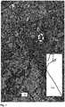
- Figure 1shows a first exemplary representation of an aerial photograph 100 and a trajectory 102 recorded by a vehicle, which were received by a system according to the invention.
- the trajectory 102is shown without a scale and is shown on a white background for reasons of better visibility.
- the systemcarries out method steps in order to bring the trajectory to match a road depicted in the aerial photograph. For this purpose, an initial positioning using absolute coordinates, e.g. B. from a satellite navigation system, whereby the finding of a road with a course that matches the trajectory is simplified and accelerated.
- the method stepsinclude at least piece-wise linear stretching and compressing operations, but also rotation operations.
- the dashed oval in the upper half of the pictureidentifies the image section that is in Figure 4 is shown enlarged.
- Figure 2shows a representation of the aerial view Figure 1 , in which the trajectory 102 was brought to coincide with a road recognizable in the aerial photograph 100. Compared to Figure 1 it can be clearly seen that the trajectory 102 has been enlarged in two dimensions by a stretching operation in order to match the course of the road.
- Figure 3shows an exemplary illustration of a corridor 104 around the trajectory 102, within which a search is made for features of the road.
- the corridor 104is represented by the parallel lines which include the trajectory 102 (not shown) and the road.
- Figure 4shows a part of the corridor in an enlarged section Figure 3 . It can be clearly seen that the trajectory 102 runs on a lane of the road. The outer boundaries of the corridor 104 run parallel to the trajectory and enclose large parts of the street. An evaluation of the aerial photograph to identify features of the road that can be used to position vehicles, for example lane markings, takes place only within the corridor 104, which greatly reduces the effort for the recognition and the result is more reliable because, for example, incorrect assignments are more easily avoided can be.
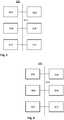
- Figure 5shows an exemplary block diagram of a part 500 of the system according to the invention.
- a database 502a first module 504 for receiving at least one trajectory of a vehicle for the at least one road section and for storing the at least one trajectory in the database and a second module 506 for receiving at least one image showing at least parts of the at least one road section, are via one or more bus systems 514 communicatively connected to each other.
- the one or more bus systems 514also connect a third module 508 for superimposing the at least one trajectory with the at least one image, a fourth module 510 for analyzing the at least one image in a corridor that extends along and includes the trajectory, and for Detection of driving or positioning-relevant features of the road section in the corridor and a fifth module 512 module for generating the digital road model from the driving or positioning-relevant features in the at least one image based on the at least one trajectory and in the corridor that includes the trajectory were recognized, with one another or with the first module 504, the second module 506 and / or the database 502.
- FIG. 6shows an exemplary block diagram of a module 600 of the system that is suitable for performing at least parts of the method according to the invention.
- the module 600comprises a microprocessor 602, a RAM 604, a non-volatile memory 606, one or more interfaces 608 and a database 610, which are communicatively connected to one another via one or more bus systems 612.
- the non-volatile memory 606contains computer program instructions which, when executed by the microprocessor 602 in connection with the main memory 604 and possibly with access to further system components, execute at least parts of one or more aspects of the method according to the invention.
- FIG. 7shows a simplified exemplary flow chart of an aspect of the method according to the invention.
- the flow diagramcan also be understood as a representation of functional modules, with each module executing corresponding parts of the method.
- step or module 702at least one trajectory of a vehicle is received for the at least one road section, and in step or module 706 at least one image is generated which shows at least parts of the at least one road section and has a perspective, which corresponds to an image recorded from an elevated position substantially vertically downwards.
- step or module 704information on driving-relevant features of the road section and on respective detection locations or positions is received and / or a height component for at least part of the road section is received or retrieved from an external database.
- step or module 708the data are stored and made available for the overlay carried out in step or module 710 so that they can be called up.
- Features relevant to driving or positioning identified in step or module 712are finally generated in step or module 714 and stored so that they can be called up.
Landscapes
- Engineering & Computer Science (AREA)
- Remote Sensing (AREA)
- Radar, Positioning & Navigation (AREA)
- Physics & Mathematics (AREA)
- General Physics & Mathematics (AREA)
- Theoretical Computer Science (AREA)
- Automation & Control Theory (AREA)
- Multimedia (AREA)
- Computer Vision & Pattern Recognition (AREA)
- Artificial Intelligence (AREA)
- Traffic Control Systems (AREA)
- Image Processing (AREA)
- Navigation (AREA)
- Image Analysis (AREA)
- Instructional Devices (AREA)
Description
Translated fromGermanDie vorliegende Erfindung betrifft die Erzeugung von digitalen Straßenmodellen mittels einer Kombination aus Luft- oder Satellitenbildern, die eine im Wesentlichen senkrechte Draufsicht auf einen Teil einer Landschaft aus der Vogelperspektive repräsentieren, und von Fahrzeugen beim Befahren von Straßen erfassten Daten, beispielsweise Kamerabilder oder Daten von abtastenden Sensoren, also Radar, Lidar, Ultraschall und dergleichen.The present invention relates to the generation of digital road models by means of a combination of aerial or satellite images, which represent a substantially vertical top view of part of a landscape from a bird's eye view, and data recorded by vehicles when driving on roads, for example camera images or data from scanning Sensors, i.e. radar, lidar, ultrasound and the like.
Digitale Straßenmodelle sind für viele Einsatzzwecke im Bereich Mobilität erforderlich, zum Beispiel für Navigationssysteme, Fahrerunterstützungssysteme, autonom fahrende Fahrzeuge. Insbesondere für Fahrerunterstützungssysteme und autonom fahrende Fahrzeuge ist eine allgemein hohe Genauigkeit und eine möglichst große Anzahl markanter Merkmale auf oder entlang der Straße in den digitalen Straßenmodellen nötig, um eine im Vergleich zu bekannten Positionierungsverfahren wie Satellitennavigation oder Koppelverfahren genauere Positionsbestimmung zu ermöglichen.Digital road models are required for many purposes in the field of mobility, for example for navigation systems, driver support systems, autonomous vehicles. In particular for driver support systems and autonomously driving vehicles, a generally high level of accuracy and the greatest possible number of distinctive features on or along the road in the digital road models are necessary in order to enable a more precise position determination compared to known positioning methods such as satellite navigation or coupling methods.
Anbieter von digitalen Straßenmodellen lassen für die Erfassung und Aktualisierung der den Straßenmodellen zugrunde liegenden Daten spezielle, mit einer Reihe unterschiedlicher Sensoren ausgestatteter Fahrzeuge über die Straßen fahren. Da die Anzahl der für diese Zwecke eingesetzten Fahrzeuge klein ist, kann eine Aktualisierung der Straßendaten eine längere Zeit benötigen. Außerdem sind die Positionsdaten der Fahrzeuge wegen der Ungenauigkeit der Positionierungssensoren häufig ungenau, so dass sich insgesamt ein ungenaues digitales Stra-ßenmodell ergibt.Providers of digital road models have special vehicles equipped with a number of different sensors drive the roads for the acquisition and updating of the data on which the road models are based. Since the number of vehicles used for this purpose is small, it may take a long time to update the road data. In addition, the position data of the vehicles are frequent because of the inaccuracy of the positioning sensors imprecise, resulting in an imprecise digital road model overall.
Die Erzeugung eines digitalen Straßenmodells aus Luft- oder Satellitenaufnahmen erfordert ein Zusammenfügen von einzelnen Bildern. Während ein Zusammenfügen bei ausreichender Bildauflösung und Überlappung möglich erscheint ist dies bei Lücken in der Erfassung nur bedingt möglich; auf jeden Fall können in den Anschlüssen Unstetigkeiten entstehen, welche die Genauigkeit des Gesamtmodells herabsetzen. Auch Verzerrungen durch die verwendeten Optiken, insbesondere an den Rändern eines Bildes, und unterschiedliche Auflösungen bei Bildern aus unterschiedlichen Quellen erschweren ein hochgenaues Zusammenfügen von Luft- oder Satellitenbildern. Schließlich muss in den zusammengesetzten Bildern noch eine aufwendige Suche nach Straßen und Wegen erfolgen, ohne dass fälschlicherweise Flüsse oder Kanäle als Straßen erkannt werden, und ohne dass durch Bäume verdeckte Straßen übersehen werden.The generation of a digital road model from aerial or satellite photographs requires the merging of individual images. While merging appears possible with sufficient image resolution and overlap, this is only possible to a limited extent if there are gaps in the recording; In any case, discontinuities can arise in the connections which reduce the accuracy of the overall model. Distortions caused by the optics used, especially at the edges of an image, and different resolutions in images from different sources make it difficult to combine aerial or satellite images with high precision. Finally, an elaborate search for streets and paths has to be carried out in the composite images without incorrectly recognizing rivers or canals as streets, and without overlooking streets covered by trees.
Es ist eine Aufgabe der Erfindung, ein System und ein Verfahren anzugeben, die eine Erzeugung und eine zeitnahe Aktualisierung hochgenauer digitaler Straßenmodelle ermöglichen.It is an object of the invention to specify a system and a method which enable the generation and real-time updating of high-precision digital road models.
Diese Aufgabe wird gelöst durch das in den unabhängigen Ansprüchen angegebene System bzw. Verfahren. Vorteilhafte Ausgestaltungen des Systems bzw. des Verfahrens sind in entsprechenden abhängigen Ansprüchen angegeben.This object is achieved by the system and method specified in the independent claims. Advantageous refinements of the system and the method are specified in the corresponding dependent claims.
Im Kontext dieser Beschreibung entspricht eine Trajektorie einer Reihe von Wegpunkten, an denen ein Fahrzeug sich zu einem Zeitpunkt tatsächlich auf einer Fahrbahn oder Straße befunden hat. Jeder Wegpunkt kann beispielsweise durch relative Koordinaten eindeutig bestimmt sein, z. B. repräsentiert durch einen Vektor der einen Abstand und eine Richtung des jeweiligen Wegpunktes in Bezug zu einem Straßenrand oder einer Markierung auf oder an der Fahrbahn oder Straße, oder zu einem anderen eindeutig lokalisierbaren Referenzpunkt beschreibt. Für diese Art der Bestimmung der Position kann beispielsweise ein bildgebender Sensor des Fahrzeugs verwendet werden, beispielsweise eine Kamera oder ein abtastendes Lidar-System. Eine Erkennung von Straßenmarkierungen kann z. B. durch Erkennung von Farbunterschieden zwischen der Fahrbahnoberfläche und der Markierung erfolgen, oder durch Erkennung abweichender Oberflächenstrukturen. Die Beschreibung der erkannten Markierungen kann durch entsprechende Merkmale oder Parameter erfolgen, die für eine Relativpositionierung geeignet sind. Eine Bestimmung von Wegpunkten einer ersten Trajektorie kann aber auch durch Ermittlung absoluter Koordinaten erfolgen, wie sie beispielsweise von einem Satellitennavigationssystem bereitgestellt werden. Andere Systeme und Verfahren zur Bestimmung einer Position können ebenfalls angewendet werden, beispielsweise Positionsermittlung durch Erfassen von Beschleunigung und Verzögerung über die Zeit, Erfassen des Lenkwinkels, der Geschwindigkeit, oder Kombinationen unterschiedlicher Verfahren zur Erhöhung der Genauigkeit. Bei nicht-kontinuierlicher Erfassung der Wegpunkte kann eine Trajektorie durch Verbinden der Wegpunkte angenähert werden, beispielsweise durch einer Polynomialfunktion folgende Kurven oder spline-artige Linien. Eine erste Trajektorie kann einen Anfang und ein Ende aufweisen; eine bestimmte Länge ist jedoch nicht zwingend vorgegeben.In the context of this description, a trajectory corresponds to a series of waypoints at which a vehicle was actually located on a lane or road at a point in time. Each waypoint can be uniquely determined, for example, by relative coordinates, e.g. B. represented by a vector of a distance and a direction of the respective waypoint in relation to a roadside or a Marking on or on the lane or road, or to another clearly localizable reference point. For example, an imaging sensor of the vehicle can be used for this type of determination of the position, for example a camera or a scanning lidar system. A recognition of road markings can, for. B. be done by detecting color differences between the road surface and the marking, or by detecting deviating surface structures. The description of the recognized markings can be carried out by means of corresponding features or parameters that are suitable for relative positioning. A determination of waypoints of a first trajectory can, however, also take place by determining absolute coordinates, as they are provided, for example, by a satellite navigation system. Other systems and methods for determining a position can also be used, for example position determination by recording acceleration and deceleration over time, recording the steering angle, the speed, or combinations of different methods for increasing the accuracy. In the case of non-continuous acquisition of the waypoints, a trajectory can be approximated by connecting the waypoints, for example by means of a polynomial function following curves or spline-like lines. A first trajectory can have a beginning and an end; however, a certain length is not mandatory.
Im Kontext dieser Beschreibung umfassen fahrrelevante oder positionierungsrelevante Merkmale einer Straße unter anderem Fahrbahnmarkierungen, auffällige Geometrien von Fahrbahnen oder Fahrspuren, Positionen von Bordsteinen, Gullideckeln, Straßen- und Eisenbahnschienen, etc.. Wenn sich aus dem Kontext nichts anderes ergibt, ist die Bezeichnung fahrrelevant dabei austauschbar mit der Bezeichnung positionierungsrelevant, weil für das Fahren relevante Merkmale der Straße üblicherweise auch für eine Bestimmung der Position eines Fahrzeugs verwendet werden können, und umgekehrt.In the context of this description, driving-relevant or positioning-relevant features of a road include, among other things, lane markings, conspicuous geometries of lanes or lanes, positions of curbs, manhole covers, road and railroad tracks, etc. Unless the context indicates otherwise, the designation is relevant to driving interchangeable with the designation relevant to positioning, because features of the road relevant to driving can usually also be used to determine the position of a vehicle, and vice versa.
Ein erfindungsgemäßes System zur Erzeugung und zeitnahen Aktualisierung hochgenauer digitaler Straßenmodelle umfasst neben einer Datenbank zum abrufbaren Speichern von Trajektorien und Bildern ein erstes Modul zum Empfangen mindestens einer Trajektorie eines Fahrzeugs für den mindestens einen Straßenabschnitt und zum Speichern der mindestens einen Trajektorie in der Datenbank. Ein zweites Modul des Systems ist eingerichtet zum Empfangen mindestens eines Bildes, das zumindest Teile des mindestens einen Straßenabschnitts zeigt, wobei das Bild eine Perspektive aufweist, die einem von einer erhöhten Position im Wesentlichen senkrecht nach unten aufgenommenen Bild entspricht, und zum Speichern des mindestens einen Bildes in der Datenbank. Die Module zum Empfangen von Trajektorien oder Bildern können eine oder mehrere digitale Datenschnittstellen mit Sendern und/oder Empfängern umfassen, welche zu einem oder mehreren Telekommunikationsstandards kompatibel ausgebildet sind und mit anderen Komponenten des Systems kommunikativ verbunden sind.A system according to the invention for generating and real-time updating of high-precision digital road models includes a database for retrievable storage of trajectories and images as well as a first module for receiving at least one trajectory of a vehicle for the at least one road section and for storing the at least one trajectory in the database. A second module of the system is set up to receive at least one image that shows at least parts of the at least one road section, the image having a perspective that corresponds to an image recorded from an elevated position essentially vertically downwards, and for storing the at least one Image in the database. The modules for receiving trajectories or images can include one or more digital data interfaces with transmitters and / or receivers that are designed to be compatible with one or more telecommunication standards and are communicatively connected to other components of the system.
Ein drittes Modul des Systems ist eingerichtet zum Überlagern der mindestens einen Trajektorie mit dem mindestens einen Bild dergestalt, dass die mindestens eine Trajektorie mit dem Verlauf einer Straße in dem mindestens einen Bild übereinstimmt. Das System umfasst außerdem ein viertes Modul zum Analysieren des mindestens einen Bildes in einem Korridor der sich entlang der Trajektorie erstreckt und diese einschließt, und Erkennen von fahr- oder positionierungsrelevanten Merkmalen des Straßenabschnitts in dem Korridor, und ein fünftes Modul zum Erzeugen des digitalen Straßenmodells aus den fahr- oder positionierungsrelevanten Merkmalen, die in dem mindestens einen anhand der mindestens einen Trajektorie ausgerichteten Bild und in dem die Trajektorie einschließenden Korridor erkannt wurden.A third module of the system is set up to overlay the at least one trajectory with the at least one image in such a way that the at least one trajectory matches the course of a road in the at least one image. The system also includes a fourth module for analyzing the at least one image in a corridor that extends along the trajectory and includes it, and for recognizing driving or positioning-relevant features of the road section in the corridor, and a fifth module for generating the digital road model the driving- or positioning-relevant features which were recognized in the at least one image aligned with the aid of the at least one trajectory and in the corridor including the trajectory.
Ein fünftes Modul des Systems ist eingerichtet zum Erzeugen des digitalen Straßenmodells aus den fahr- oder positionierungsrelevanten Merkmalen, die in dem mindestens einen anhand der mindestens einen Trajektorie ausgerichteten Bild und in dem die Trajektorie einschließenden Korridor erkannt wurden.A fifth module of the system is set up to generate the digital road model from the driving or positioning-relevant ones Features that were recognized in the at least one image aligned on the basis of the at least one trajectory and in the corridor that includes the trajectory.
Mindestens zwei Module des Systems sind über entsprechende physikalische oder logische Schnittstellen und/oder Bussysteme zum Datenaustausch kommunikativ miteinander verbunden. Ein oder mehrere der Module des Systems können einen oder mehrere Computer umfassen, welcher oder welche ein entsprechendes Computerprogramm ausführen, das den von dem jeweiligen Modul ausgeführten Teil des erfindungsgemäßen Verfahrens zur Erstellung eines digitalen Straßenmodells für mindestens einen Straßenabschnitt implementiert. Ein oder mehrere der Module des Systems können jedoch auch als entsprechende Computerprogramme implementiert sein, von denen mehrere in einem Computer ausgeführt werden und zusammen wirken, um zumindest Teile des erfindungsgemäßen Verfahrens auszuführen.At least two modules of the system are communicatively connected to one another via appropriate physical or logical interfaces and / or bus systems for data exchange. One or more of the modules of the system can include one or more computers which execute a corresponding computer program that implements the part of the inventive method for creating a digital road model for at least one road section executed by the respective module. However, one or more of the modules of the system can also be implemented as corresponding computer programs, several of which are executed in a computer and work together to execute at least parts of the method according to the invention.
Das System kann auch als aus einem oder mehreren Funktionsblöcken im Sinne einer Funktions-Modul-Architektur gebildet aufgefasst werden. Dabei repräsentieren jeweilige Funktionsblöcke Mittel zur Ausführung entsprechender Funktionen. Die Mittel können, wie bei den Modulen erläutert, durch ein oder mehrere, durch ein Computerprogramm zur Durchführung entsprechender Funktionen eingerichtete Computer oder Datenverarbeitungseinheiten implementiert sein.The system can also be understood as being formed from one or more function blocks in the sense of a function module architecture. The respective function blocks represent means for executing corresponding functions. As explained for the modules, the means can be implemented by one or more computers or data processing units set up by a computer program to carry out corresponding functions.
Die ein oder mehreren Computer des Systems können ein oder mehrere Mikroprozessoren umfassen, welche mit Arbeitsspeicher und/oder nicht-flüchtigen Speichermitteln sowie anderen Systemkomponenten über ein oder mehrere Datenbusse kommunikativ verbunden sind, die vor und/oder während der Ausführung von Computerprogramminstruktionen Daten empfangen und/oder senden, wodurch die Computer oder Verarbeitungseinheiten zumindest Teile des Verfahrens ausführen. Die nicht-flüchtigen Speichermittel umfassen unterschiedliche Speichermedien, z. B. optische oder magnetische Speicher, Phase-Change- oder Flash-Speicher. Mehrere Module oder Funktionsblöcke können in einem Computer oder einer Datenverarbeitungseinheit implementiert sein.The one or more computers of the system can comprise one or more microprocessors which are communicatively connected to main memory and / or non-volatile storage means as well as other system components via one or more data buses, which receive and / or receive data before and / or during the execution of computer program instructions. or send, whereby the computers or processing units carry out at least parts of the method. The non-volatile storage means include different storage media, e.g. B. optical or magnetic storage, phase change or Flash memory. Several modules or functional blocks can be implemented in a computer or a data processing unit.
Das oder die Computerprogramminstruktionen, die jeweilige Teile des erfindungsgemäßen Verfahrens implementieren, können auf einem oder mehreren Datenträgern oder in Speichermitteln gespeichert sein. Die Computerprogramminstruktionen können in die Speichermittel unter Verwendung drahtlos oder mittels Kabeln oder Leitungen verbundener Schnittstellen übertragen werden. Die Computerprogramminstruktionen liegen außerhalb des Systems als Computerprogrammprodukt vor, welches dauerhaft auf einem computerlesbaren Medium oder maschinenlesbaren Medium gespeichert ist, und welches als auf einem Trägermedium gespeichertes Computerprogramm aufgefasst werden kann.The computer program instruction or instructions that implement the respective parts of the method according to the invention can be stored on one or more data carriers or in storage means. The computer program instructions can be transferred to the storage means using wireless interfaces or interfaces connected by cables or wires. The computer program instructions are available outside the system as a computer program product which is permanently stored on a computer-readable medium or machine-readable medium and which can be interpreted as a computer program stored on a carrier medium.
Das Computerprogrammprodukt kann auch in einer nicht dauerhaften, vorübergehenden Form vorliegen, z. B. als ein elektromagnetisches oder optisches Signal, welches die Computerprogramminstruktionen durch seine Modulation vorübergehend repräsentiert. Durch die Modulation werden dem Signal mithin die Computerprogramminstruktionen vorübergehend auslesbar aufgeprägt, beispielsweise während der Übertragung der Computerprogramminstruktionen von einem Datenträger in das System. In diesem Fall stellt das Signal, z. B. repräsentiert durch einen modulierten Träger, eine konkrete Verkörperung des Computerprogrammprodukts dar, von der es entnommen oder abgegriffen werden kann.The computer program product may also be in a non-permanent, temporary form, e.g. B. as an electromagnetic or optical signal which temporarily represents the computer program instructions through its modulation. As a result of the modulation, the computer program instructions are thus temporarily readable impressed on the signal, for example during the transfer of the computer program instructions from a data carrier into the system. In this case the signal, e.g. B. represented by a modulated carrier, a concrete embodiment of the computer program product, from which it can be removed or tapped.
Ein in einer fahrzeugexternen Datenbank ausgeführtes erfindungsgemäßes Verfahren zur Erstellung eines digitalen Stra-ßenmodells für mindestens einen Straßenabschnitt umfasst das Empfangen mindestens einer Trajektorie eines Fahrzeugs für den mindestens einen Straßenabschnitt. Wenn mehrere Trajektorien für denselben Streckenabschnitt für dieselbe Fahrspur und dieselbe Fahrtrichtung von einer Vielzahl von Fahrzeugen empfangen werden, können diese mit statistischen Verfahren zu einer einzigen Trajektorie zusammengefasst werden, bevor die resultierende Trajektorie für die Zwecke des Verfahrens verwendet wird. Geeignete statistische Verfahren umfassen unter anderem die Bildung einer mittleren Trajektorie oder einer Median-Trajektorie, die aus quer zu einer Fahrtrichtung liegenden Positionswerten einer Vielzahl von Trajektorien für entsprechende Positionen in einer Längsrichtung entlang des Streckenabschnitts gebildet wird.A method according to the invention, executed in a database external to the vehicle, for creating a digital road model for at least one road section comprises receiving at least one trajectory of a vehicle for the at least one road section. If several trajectories for the same route section for the same lane and the same direction of travel are received by a large number of vehicles, these can be calculated using statistical methods a single trajectory can be combined before the resulting trajectory is used for the purposes of the method. Suitable statistical methods include, among other things, the formation of a mean trajectory or a median trajectory which is formed from position values of a plurality of trajectories for corresponding positions in a longitudinal direction along the route section that are transverse to a direction of travel.
Außerdem wird mindestens ein Bild empfangen, das zumindest Teile des Straßenabschnitts zeigt, in dem die Trajektorie liegt, wobei das Bild eine Perspektive aufweist, die einem von einer erhöhten Position im Wesentlichen senkrecht nach unten aufgenommenes Bild entspricht. Ein solches Bild kann beispielsweise eine Luftaufnahme oder eine Satellitenaufnahme sein, oder allgemein ein Bild, das einer Draufsicht von oben entspricht. Wenn ein Bild keine Perspektive aufweist, die einen im Wesentlichen senkrechten Blick nach unten entspricht, kann ein schräg nach unten aufgenommenes Bild auch durch Anwendung entsprechender Transformationen in ein Bild umgerechnet werden, dass die gewünschte Perspektive aufweist.In addition, at least one image is received which shows at least parts of the road section in which the trajectory lies, the image having a perspective which corresponds to an image recorded from an elevated position essentially vertically downwards. Such an image can be, for example, an aerial photograph or a satellite photograph, or generally an image which corresponds to a top view from above. If an image does not have a perspective that corresponds essentially to a perpendicular view downwards, an image recorded obliquely downwards can also be converted into an image that has the desired perspective by applying appropriate transformations.
Die mindestens eine Trajektorie wird mit dem mindestens einen Bild dergestalt überlagert, dass die mindestens eine Trajektorie mit dem Verlauf einer Straße in dem mindestens einen Bild übereinstimmt. Um die Trajektorie und den Verlauf einer Straße zur Übereinstimmung zu bringen können neben Verschiebungen oder Drehungen der Bilder oder der Trajektorie auch Streckungen oder Stauchungen in einer oder zwei Dimensionen durchgeführt werden. Wenn eine Trajektorie sich über mehrere Bilder erstreckt, die aneinander grenzen oder sich teilweise überlappen, kann die Trajektorie mit jedem dieser Bilder jeweils separat überlagert werden und die Bilder dann anhand der Trajektorie zueinander ausgerichtet werden, so dass sich nach erfolgter Überlagerung ein aus einzelnen Bildern zusammengesetztes Gesamtbild ergibt. Wenn eine Trajektorie sich über mehrere Bilder erstreckt, die keine gemeinsame Kante haben oder keine Überlappung aufweisen, kann der entsprechende Bereich im Gesamtbild frei bleiben.The at least one trajectory is superimposed on the at least one image in such a way that the at least one trajectory corresponds to the course of a road in the at least one image. In order to bring the trajectory and the course of a road to match, in addition to shifting or rotating the images or the trajectory, stretching or compressing in one or two dimensions can also be carried out. If a trajectory extends over several images that border one another or partially overlap, the trajectory can be superimposed separately with each of these images and the images can then be aligned with one another based on the trajectory, so that after the superimposition has taken place, a composite of individual images is created Overall picture results. When a trajectory extends over several images that do not have a common edge or have no overlap, the corresponding area can remain free in the overall picture.
Das mindestens eine Bild oder das Gesamtbild wird einer Bildanalyse unterworfen, die fahrrelevante Merkmale des mindestens einen Straßenabschnitts erkennt. Dabei wird die Analyse nur in einem Bereich des Bildes durchgeführt, der sich entlang der Trajektorie über eine erste Distanz ein- oder beidseitig quer zu der Trajektorie erstreckt, also quasi einen Korridor oder eine Einhüllende um die Trajektorie legt. Erkannte fahr- oder positionierungsrelevante Merkmale in aneinander grenzenden oder überlappenden Bildbereichen können zur noch genaueren Ausrichtung der Bilder zueinander verwendet werden, z. B. durchgehende Straßenmarkierungen, Seitenlinien, Bordsteinkanten oder Leitplanken.The at least one image or the overall image is subjected to an image analysis that detects driving-relevant features of the at least one road section. The analysis is only carried out in a region of the image that extends along the trajectory over a first distance on one or both sides across the trajectory, that is to say it places a corridor or an envelope around the trajectory. Recognized driving or positioning-relevant features in adjacent or overlapping image areas can be used to align the images with one another even more precisely, e.g. B. continuous road markings, side lines, curbs or guardrails.
Aus den fahr- oder positionierungsrelevanten Merkmalen des Straßenabschnitts, die in dem mindestens einen anhand der mindestens einen Trajektorie ausgerichteten Bild und in dem die Trajektorie einschließenden Korridor erkannt wurden, wird schließlich das digitale Straßenmodell erzeugt. Das digitale Straßenmodell kann in unterschiedlichen Formen vorliegen, beispielsweise als Vektormodell, bei dem die Straßenränder und andere Merkmale, die bei der Positionsbestimmung eines Fahrzeugs verwendet werden können, als Objekte in Vektordarstellung mit ihren relativen Positionen zueinander gespeichert sind. Dazu können die einzelnen Objekte einen oder mehrere Referenzpunkte aufweisen, deren Abstand und Winkel zu anderen Objekten bestimmt sind, und/oder deren absolute Positionen auf der Erdoberfläche bekannt sind.The digital road model is finally generated from the driving- or positioning-relevant features of the road section, which were recognized in the at least one image aligned with the aid of the at least one trajectory and in the corridor including the trajectory. The digital road model can be in different forms, for example as a vector model, in which the road edges and other features that can be used to determine the position of a vehicle are stored as objects in vector representation with their relative positions to one another. For this purpose, the individual objects can have one or more reference points whose distance and angle to other objects are determined and / or whose absolute positions on the earth's surface are known.
Eine Höhenkomponente des digitalen Straßenmodells, auch als Z-Komponente oder Relief-Komponente bezeichnet, kann bei einem Aspekt des vorliegenden Verfahrens aus Daten der mindestens einen Trajektorie, aus einer Topographiedatenbank oder einem digitalen Höhenmodell ergänzt werden.In one aspect of the present method, a height component of the digital road model, also referred to as a Z component or a relief component, can be supplemented from data from the at least one trajectory, from a topography database or a digital height model.
Gemäß einem Aspekt des vorliegenden Verfahrens werden zusätzlich zu der mindestens einen Trajektorie Informationen zu durch das Fahrzeug erfassten fahr- oder positionierungsrelevanten Merkmalen des Straßenabschnitts empfangen. Die Informationen können beispielsweise als Bilder einer Kamera oder eines abtastenden Sensors wie bspw. Radar-, Lidar- oder Ultraschallsensoren übertragen werden. Die Merkmale umfassen z. B. Markierungen auf der Straße, Begrenzungspfosten, Verkehrszeichen, oder andere vergleichbare nur langsam oder unveränderliche Merkmale. Die Informationen oder die Merkmale sind mit Informationen zu jeweiligen Erfassungsorten oder - positionen versehen, so dass die empfangenen Informationen oder Merkmale zur Ausrichtung der empfangenen Bilder verwendet oder in das digitale Straßenmodell übernommen werden können. Die empfangenen Informationen zu fahr- oder positionierungsrelevanten Merkmalen des Straßenabschnitts können beispielsweise bei aneinander grenzenden Bildern verwendet werden, diese genauer zueinander auszurichten, beispielsweise wenn ein Merkmal ganz oder teilweise in beiden Bildern erkennbar ist.According to one aspect of the present method, in addition to the at least one trajectory, information on driving or positioning-relevant features of the road section detected by the vehicle is received. The information can be transmitted, for example, as images from a camera or a scanning sensor such as, for example, radar, lidar or ultrasonic sensors. The features include e.g. B. Markings on the road, delimitation posts, traffic signs, or other similar slow or unchangeable features. The information or the features are provided with information on the respective detection locations or positions, so that the received information or features can be used to align the received images or can be transferred to the digital road model. The information received on features of the road section relevant to driving or positioning can be used, for example, in the case of images that are adjacent to one another, to align them more precisely with one another, for example if a feature can be fully or partially recognized in both images.
Bei einem Ausführungsbeispiel des vorstehend erläuterten Aspekts werden die zusätzlich empfangenen Informationen in einem objektbeschreibenden Vektorformat empfangen. Bei diesem Ausführungsbeispiel wertet das Fahrzeug die Sensordaten aus und erzeugt von fahrrelevanten Merkmalen Vektormodelle von Merkmalen, und bestimmt optional für jedes Vektormodell mindestens einen Referenzpunkt. Die in dem objektbeschreibenden Vektorformat empfangenen Informationen können ebenfalls zur Ausrichtung mit den empfangenen Bildern verwendet oder in das digitale Straßenmodell übernommen werden. Wenn zum Beispiel bereits ein digitales Straßenmodell eines Straßenabschnitts existiert, und neue Informationen über Merkmale in einem objektbeschreibenden Vektorformat empfangen werden, kann eine Ausrichtung der in dem objektbeschreibenden Vektorformat repräsentierten Merkmale geringerem Rechenaufwand erfolgen, als es bei einer anderen Darstellung möglich wäre. Wenn Informationen zu mehreren in einem solchen Format vorliegenden Merkmalen inklusive ihrer relativen Positionierung zueinander empfangen wurden kann durch Ausrichtung der Vektormodelle an dem digitalen Straßenmodell eine Ungenauigkeit der bei der Erfassung verwendeten Positionierung kompensiert werden.In one embodiment of the aspect explained above, the additionally received information is received in an object-describing vector format. In this exemplary embodiment, the vehicle evaluates the sensor data and generates vector models of features of driving-relevant features, and optionally determines at least one reference point for each vector model. The information received in the object-describing vector format can also be used for alignment with the received images or can be incorporated into the digital road model. If, for example, a digital road model of a road section already exists and new information about features is received in an object-describing vector format, the features represented in the object-describing vector format can be aligned with less computational effort than would be possible with a different representation. When information For a plurality of features present in such a format including their relative positioning to one another, an inaccuracy of the positioning used in the acquisition can be compensated for by aligning the vector models with the digital road model.
Bei einem Aspekt des Verfahrens wird ein erfindungsgemäß erzeugtes digitales Straßenmodell beispielsweise als Vektormodell an Fahrzeuge übertragen, deren Trajektorien empfangen wurden. Bei geeigneter Ausrüstung des jeweiligen Fahrzeugs mit Sensoren und zur Auswertung von Bildern geeigneten Computern können in dem objektbeschreibenden Vektorformat vorliegende Informationen zu Merkmalen des Straßenabschnitts zur Verbesserung der Genauigkeit bei der Bestimmung der Fahrzeugposition verwendet werden. Dies führt entsprechend zu einer Verbesserung der Genauigkeit der Trajektorie. Dadurch wird es möglich, einen erfindungsgemäß zu analysierenden Bereich weiter einzuschränken, beispielsweise auf eine Fahrspur einer mehrspurigen Straße, und in dem eingeschränkten Bereich eine genauere Analyse vorzunehmen.In one aspect of the method, a digital road model generated according to the invention is transmitted, for example as a vector model, to vehicles whose trajectories have been received. If the respective vehicle is suitably equipped with sensors and computers suitable for evaluating images, information on features of the road section that is present in the object-describing vector format can be used to improve the accuracy in determining the vehicle position. This accordingly leads to an improvement in the accuracy of the trajectory. This makes it possible to further restrict an area to be analyzed according to the invention, for example to a lane of a multi-lane road, and to carry out a more precise analysis in the restricted area.
Das vorliegende Verfahren und das entsprechende System vereinfachen die Erkennung und Extraktion von Straßen und Stra-ßenmerkmalen in Satelliten- und Luftaufnahmen und verringern dabei die Fehleranfälligkeit. Auch die Ausrichtung und das Zusammensetzen von Luft- oder Satellitenaufnahmen zueinander wird vereinfacht, beispielsweise wenn eine Trajektorie sich über mehrere aneinander angrenzende oder überlappende Bilder erstreckt. Hierbei kann auf die Verwendung von markanten, an einem Weg liegenden Punkten verzichtet werden, wie sie beispielsweise von Fahrzeugen bei der Bestimmung ihrer Position mittels Triangulation verwendet werden. Die von den Fahrzeugen verwendeten markanten Punkte, auch als Landmarks bezeichnet, sind üblicherweise aus einer Perspektive angegeben, die ein Fahrzeug einnehmen kann, während Luft- oder Satellitenaufnahmen in der Regel eine völlig andere Sicht auf Landmarks bieten. Selbst wenn die Darstellung von Landmarks grundsätzlich in eine andere Perspektive umgerechnet werden kann, können sich dabei Ungenauigkeiten ergeben. Eine Fahrzeugtrajektorie ist hingegen zumindest stückweise in sich hinreichend genau, weist in der Regel keine Unstetigkeiten auf und liegt darüber hinaus auch schon in einer Ebene vor, so dass ein Ausrichten von Luft- oder Satellitenaufnahmen weniger Transformationen benötigt. Da die Fahrzeugtrajektorie zunächst nur für die Bestimmung eines Korridors verwendet wird, innerhalb dessen dann eine Analyse der Luftaufnahmen erfolgt, ist die initial geforderte Genauigkeit auch nicht besonders groß. Außerdem kann bei Bedarf aus einer Vielzahl von Fahrzeugtrajektorien für denselben Streckenabschnitt eine allgemeine Trajektorie ermittelt werden, die dann zur Bestimmung des Analysekorridors verwendet wird. Die Überlagerung der Trajektorie führt auch dann eher zum Erfolg, wenn nur Teile der Trajektorie mit in einer Luft- oder Satellitenaufnahme erkennbaren Straßen in Übereinstimmung gebracht werden können, beispielsweise wenn eine Straße in der Luft- oder Satellitenaufnahme stück- oder teilweise von Bäumen verdeckt wird und so nicht sofort als Straße erkennbar ist. Innerhalb des um die Trajektorie herum liegenden Korridors kann dennoch eine Detailanalyse vorgenommen werden, um teilweise sichtbare Merkmale zu erkennen.The present method and the corresponding system simplify the detection and extraction of roads and road features in satellite and aerial photographs and thereby reduce the susceptibility to errors. The alignment and the assembly of aerial or satellite images with respect to one another is also simplified, for example if a trajectory extends over several images that are adjacent or overlap. In this case, it is possible to dispense with the use of distinctive points lying on a path, such as those used, for example, by vehicles when determining their position by means of triangulation. The prominent points used by the vehicles, also referred to as landmarks, are usually given from a perspective that a vehicle can take, while aerial or satellite photographs usually offer a completely different view of landmarks. Even if the representation of landmarks is fundamental can be converted into a different perspective, inaccuracies can result. A vehicle trajectory, on the other hand, is sufficiently precise in itself, at least in parts, generally has no discontinuities and is also already present in one plane, so that an alignment of aerial or satellite images requires fewer transformations. Since the vehicle trajectory is initially only used to determine a corridor, within which the aerial photographs are then analyzed, the accuracy initially required is also not particularly great. In addition, if necessary, a general trajectory can be determined from a large number of vehicle trajectories for the same route section, which is then used to determine the analysis corridor. The superposition of the trajectory is more likely to be successful if only parts of the trajectory can be brought into agreement with roads recognizable in an aerial or satellite photograph, for example if a road in the aerial or satellite photograph is partially or partially covered by trees and so it is not immediately recognizable as a street. However, a detailed analysis can be carried out within the corridor around the trajectory in order to identify partially visible features.
Im Folgenden werden Aspekte der Erfindung mit Bezug auf die Zeichnung beschrieben. In der Zeichnung zeigt
- Fig. 1
- eine erste beispielhafte Darstellung einer Luftaufnahme und einer Trajektorie,
- Fig. 2
- eine Darstellung der Luftaufnahme aus
Figur 1 , bei der die Trajektorie mit einer in der Luftaufnahme erkennbaren Straße zur Übereinstimmung gebracht wurde, - Fig. 3
- eine beispielhafte Darstellung eines Korridors um die Trajektorie, innerhalb dessen nach Merkmalen der Straße gesucht wird,
- Fig. 4
- in einem vergrößerten Bildausschnitt einen Teil des Korridors aus
Figur 3 , - Fig. 5
- ein beispielhaftes Blockschaltbild eines erfindungsgemäßen Systems,
- Fig. 6
- ein beispielhaftes Blockschaltbild eines Moduls des erfindungsgemäßen Systems und
- Fig. 7
- ein vereinfachtes beispielhaftes Flussdiagramm eines erfindungsgemäßen Verfahrens.
- Fig. 1
- a first exemplary representation of an aerial photograph and a trajectory,
- Fig. 2
- a representation of the aerial view
Figure 1 , in which the trajectory was brought to coincide with a road recognizable in the aerial photograph, - Fig. 3
- an exemplary representation of a corridor around the trajectory within which a search is made for features of the road,
- Fig. 4
- part of the corridor in an enlarged image section
Figure 3 , - Fig. 5
- an exemplary block diagram of a system according to the invention,
- Fig. 6
- an exemplary block diagram of a module of the system according to the invention and
- Fig. 7
- a simplified exemplary flow chart of a method according to the invention.
In den Figuren der Zeichnung sind gleiche oder ähnliche Elemente mit den gleichen Bezugszeichen bezeichnet.In the figures of the drawing, the same or similar elements are denoted by the same reference symbols.
Claims (8)
- Method for creating a digital road model for at least one road section, comprising:- receiving at least one trajectory (102) of a vehicle for the at least one road section in a database (502) outside the vehicle,- receiving at least one image which shows at least parts of the at least one road section, wherein the image has a perspective which corresponds to an image recorded from an elevated position substantially vertically downwards,- superimposing the at least one image on the at least one trajectory (102) in such a manner that the at least one trajectory (102) corresponds to the course of a road in the at least one image,- analysing the at least one image in a corridor (104) which extends along the trajectory (102) and encloses the latter, and identifying driving-relevant or positioning-relevant features of the road section in the corridor (104),- generating the digital road model from the driving-relevant or positioning-relevant features which have been identified in the at least one image aligned on the basis of the at least one trajectory (102) and in the corridor (104) enclosing the trajectory (102).
- Method according to Claim 1, additionally comprising:- receiving information relating to driving-relevant or positioning-relevant features of the road section which are captured by the vehicle, wherein the features are provided with information relating to respective capture locations or positions.
- Method according to Claim 2, wherein the information relating to features of the road section is received in an object-describing vector format.
- Method according to Claim 3, wherein at least one reference point is determined for each feature represented by the object-describing vector format.
- Method according to Claim 1, wherein an elevation component for sections of the digital road model is supplemented with data relating to the at least one trajectory (102), from a topography database or from a digital elevation model.
- System for creating a digital road model for at least one road section, comprising:- a database (502) for retrievably storing trajectories (102) and images,- a first module (504) for receiving at least one trajectory (102) of a vehicle for the at least one road section and for storing the at least one trajectory (102) in the database (502),- a second module (506) for receiving at least one image which shows at least parts of the at least one road section, wherein the image has a perspective which corresponds to an image recorded from an elevated position substantially vertically downwards, and for storing the at least one image in the database (502),- a third module (508) for superimposing the at least one image on the at least one trajectory (102) in such a manner that the at least one trajectory (102) corresponds to the course of a road in the at least one image,- a fourth module (510) for analysing the at least one image in a corridor (104) which extends along the trajectory (102) and encloses the latter and for identifying driving-relevant or positioning-relevant features of the road section in the corridor (104),- a fifth module (512) for generating the digital road model from the driving-relevant or positioning-relevant features which have been identified in the at least one image aligned on the basis of the at least one trajectory (102) and in the corridor (104) enclosing the trajectory (102).
- System according to Claim 6, additionally comprising:- a sixth module for receiving information relating to driving-relevant or positioning-relevant features of the road section which are captured by the vehicle, wherein the features are provided with information relating to respective capture locations or positions.
- System according to Claim 6, additionally comprising:- a seventh module for extracting an elevation component for sections of the digital road model from data relating to the at least one trajectory (102), from a topography database or from a digital elevation model and for accordingly supplementing the sections of the digital road model with the elevation component.
Applications Claiming Priority (2)
| Application Number | Priority Date | Filing Date | Title |
|---|---|---|---|
| DE102016220308.8ADE102016220308A1 (en) | 2016-10-18 | 2016-10-18 | System and method for generating digital road models from aerial or satellite imagery and vehicle-acquired data |
| PCT/EP2017/076503WO2018073260A1 (en) | 2016-10-18 | 2017-10-17 | System and method for generating digital road models from aerial or satellite images and from data captured by vehicles |
Publications (2)
| Publication Number | Publication Date |
|---|---|
| EP3529561A1 EP3529561A1 (en) | 2019-08-28 |
| EP3529561B1true EP3529561B1 (en) | 2020-12-09 |
Family
ID=60245054
Family Applications (1)
| Application Number | Title | Priority Date | Filing Date |
|---|---|---|---|
| EP17793867.7AActiveEP3529561B1 (en) | 2016-10-18 | 2017-10-17 | System and method for generating digital road models from aerial or satellite images and from data captured by vehicles |
Country Status (6)
| Country | Link |
|---|---|
| US (1) | US20190244400A1 (en) |
| EP (1) | EP3529561B1 (en) |
| JP (1) | JP6785958B2 (en) |
| CN (1) | CN109844457B (en) |
| DE (1) | DE102016220308A1 (en) |
| WO (1) | WO2018073260A1 (en) |
Cited By (1)
| Publication number | Priority date | Publication date | Assignee | Title |
|---|---|---|---|---|
| DE102022211343A1 (en) | 2022-10-26 | 2024-05-02 | Robert Bosch Gesellschaft mit beschränkter Haftung | Method for detecting and classifying raised road markings |
Families Citing this family (10)
| Publication number | Priority date | Publication date | Assignee | Title |
|---|---|---|---|---|
| IL311264A (en)* | 2017-06-14 | 2024-05-01 | Mobileye Vision Technologies Ltd | Fusion framework of navigation information for autonomous navigation |
| US11181922B2 (en) | 2019-03-29 | 2021-11-23 | Zoox, Inc. | Extension of autonomous driving functionality to new regions |
| DE102019207303A1 (en)* | 2019-05-20 | 2020-11-26 | Robert Bosch Gmbh | Method and system for creating a localization map for a vehicle |
| CN110852342B (en)* | 2019-09-26 | 2020-11-24 | 京东城市(北京)数字科技有限公司 | Road network data acquisition method, device, equipment and computer storage medium |
| US11380093B2 (en)* | 2020-07-30 | 2022-07-05 | GM Global Technology Operations LLC | Detecting road edges by fusing aerial image and telemetry evidences |
| JP6837626B1 (en)* | 2020-08-03 | 2021-03-03 | 株式会社空間技術総合研究所 | Feature data generation system, feature database update system, and feature data generation method |
| US20230063809A1 (en)* | 2021-08-25 | 2023-03-02 | GM Global Technology Operations LLC | Method for improving road topology through sequence estimation and anchor point detetection |
| DE102021213538A1 (en) | 2021-11-30 | 2023-06-01 | Psa Automobiles Sa | Simulation to validate an automated driving function for a vehicle |
| US11922704B2 (en)* | 2021-12-15 | 2024-03-05 | GM Global Technology Operations LLC | System and method for detecting road and lane connections at intersections |
| CN114509068B (en)* | 2022-01-04 | 2024-07-05 | 海信集团控股股份有限公司 | Method and device for judging positions of vehicles on multilayer roads |
Family Cites Families (25)
| Publication number | Priority date | Publication date | Assignee | Title |
|---|---|---|---|---|
| DE10030896A1 (en)* | 2000-06-23 | 2002-01-03 | Bosch Gmbh Robert | Digital road map for automobile navigation system has road sections defined by point coordinates with incline gradient of each road section provided |
| JP3498310B2 (en)* | 2001-04-23 | 2004-02-16 | 株式会社日立製作所 | Road map creation system |
| US20170313332A1 (en)* | 2002-06-04 | 2017-11-02 | General Electric Company | Autonomous vehicle system and method |
| JP4370869B2 (en)* | 2003-09-25 | 2009-11-25 | トヨタ自動車株式会社 | Map data updating method and map data updating apparatus |
| US7251561B2 (en)* | 2004-07-28 | 2007-07-31 | Telmap Ltd. | Selective download of corridor map data |
| JP2007033931A (en)* | 2005-07-27 | 2007-02-08 | Hitachi Software Eng Co Ltd | Road recognition system for map generation using satellite image or the like |
| JP5079577B2 (en)* | 2007-12-13 | 2012-11-21 | クラリオン株式会社 | Navigation device, road gradient calculation method and altitude calculation method |
| JP2012511697A (en)* | 2008-12-09 | 2012-05-24 | トムトム ノース アメリカ インコーポレイテッド | How to generate a geodetic reference database |
| EP2443418B1 (en)* | 2009-06-16 | 2018-12-05 | TomTom North America Inc. | Methods and systems for creating digital street network database |
| US8723886B2 (en)* | 2010-09-08 | 2014-05-13 | Navteq B.V. | Generating a multi-layered geographic image and the use thereof |
| CN101958046B (en)* | 2010-09-26 | 2015-04-15 | 隋亚刚 | Vehicle track recognition system and method |
| JP2012103292A (en)* | 2010-11-05 | 2012-05-31 | Ntt Geospace Co Ltd | Terminal device, display method and computer program |
| EP2487461B1 (en)* | 2011-02-09 | 2015-10-07 | Harman Becker Automotive Systems GmbH | Vehicle navigation device and method |
| JP5483120B2 (en)* | 2011-07-26 | 2014-05-07 | アイシン精機株式会社 | Vehicle perimeter monitoring system |
| DE102013101639A1 (en)* | 2013-02-19 | 2014-09-04 | Continental Teves Ag & Co. Ohg | Method and device for determining a road condition |
| DE102013208521B4 (en)* | 2013-05-08 | 2022-10-13 | Bayerische Motoren Werke Aktiengesellschaft | Collective learning of a highly accurate road model |
| US20150106010A1 (en)* | 2013-10-15 | 2015-04-16 | Ford Global Technologies, Llc | Aerial data for vehicle navigation |
| US10095995B2 (en)* | 2013-11-25 | 2018-10-09 | First Resource Management Group Inc. | Apparatus for and method of forest-inventory management |
| US9384402B1 (en)* | 2014-04-10 | 2016-07-05 | Google Inc. | Image and video compression for remote vehicle assistance |
| US9727784B2 (en)* | 2014-06-03 | 2017-08-08 | Digitalglobe, Inc. | Some automated and semi-automated tools for linear feature extraction in two and three dimensions |
| US10223816B2 (en)* | 2015-02-13 | 2019-03-05 | Here Global B.V. | Method and apparatus for generating map geometry based on a received image and probe data |
| CN105128760B (en)* | 2015-08-27 | 2018-10-16 | 惠州华阳通用电子有限公司 | Backing track plotting method and device |
| US10013610B2 (en)* | 2015-10-23 | 2018-07-03 | Nokia Technologies Oy | Integration of positional data and overhead images for lane identification |
| DE102016211045A1 (en)* | 2016-06-21 | 2017-12-21 | Bayerische Motoren Werke Aktiengesellschaft | Updating a digital map |
| US10599150B2 (en)* | 2016-09-29 | 2020-03-24 | The Charles Stark Kraper Laboratory, Inc. | Autonomous vehicle: object-level fusion |
- 2016
- 2016-10-18DEDE102016220308.8Apatent/DE102016220308A1/ennot_activeWithdrawn
- 2017
- 2017-10-17WOPCT/EP2017/076503patent/WO2018073260A1/ennot_activeCeased
- 2017-10-17CNCN201780064037.2Apatent/CN109844457B/ennot_activeExpired - Fee Related
- 2017-10-17USUS16/342,863patent/US20190244400A1/ennot_activeAbandoned
- 2017-10-17JPJP2019520704Apatent/JP6785958B2/ennot_activeExpired - Fee Related
- 2017-10-17EPEP17793867.7Apatent/EP3529561B1/enactiveActive
Non-Patent Citations (1)
| Title |
|---|
| None* |
Cited By (2)
| Publication number | Priority date | Publication date | Assignee | Title |
|---|---|---|---|---|
| DE102022211343A1 (en) | 2022-10-26 | 2024-05-02 | Robert Bosch Gesellschaft mit beschränkter Haftung | Method for detecting and classifying raised road markings |
| WO2024089080A1 (en) | 2022-10-26 | 2024-05-02 | Robert Bosch Gmbh | Method for recognising and classifying elevated road markings |
Also Published As
| Publication number | Publication date |
|---|---|
| CN109844457B (en) | 2023-05-05 |
| EP3529561A1 (en) | 2019-08-28 |
| JP2019534513A (en) | 2019-11-28 |
| JP6785958B2 (en) | 2020-11-18 |
| DE102016220308A1 (en) | 2018-04-19 |
| CN109844457A (en) | 2019-06-04 |
| WO2018073260A1 (en) | 2018-04-26 |
| US20190244400A1 (en) | 2019-08-08 |
Similar Documents
| Publication | Publication Date | Title |
|---|---|---|
| EP3529561B1 (en) | System and method for generating digital road models from aerial or satellite images and from data captured by vehicles | |
| DE102015203016B4 (en) | Method and device for optical self-localization of a motor vehicle in an environment | |
| DE102016213817B4 (en) | A method, apparatus and computer readable storage medium having instructions for determining the lateral position of a vehicle relative to the lanes of a lane | |
| EP3213260B1 (en) | Method and device for localizing a vehicle in the environment thereof | |
| DE102012201724B4 (en) | TRAFFIC SIGN RECOGNITION DEVICE | |
| DE112014002019B4 (en) | Waveform modeling device, vehicle information processing system, waveform modeling method and waveform modeling program | |
| EP3616181A1 (en) | Method for automatically producing and updating a dataset for an autonomous vehicle | |
| DE102017105086A1 (en) | Updating a landmark map | |
| EP3385673A1 (en) | Method and device for the reduction of intermediate points in a polygon | |
| EP2963631B1 (en) | Method for determining a parking space from a number of measuring points | |
| DE112013004044T5 (en) | Road environment recognition device | |
| DE102010020688A1 (en) | Driving track course determining method for motor vehicle, involves identifying structures limiting driving tracks based on length, contrast, direction and three dimensional position of continuous edge courses of contours of structures | |
| DE102011082379A1 (en) | Method for detecting navigation data for navigating vehicle, involves storing feature and position of feature as additional information to navigation data, or transmitting additional information to external processing unit | |
| DE102020203756A1 (en) | MOTORWAY EXIT DETECTION AND LINE REFLECTION FOR VEHICLE TRACTION DETERMINATION | |
| DE112019000855T5 (en) | VEHICLE CONTROL UNIT | |
| DE102020105250A1 (en) | Determining the course of a lane delimitation | |
| DE112019004285T5 (en) | ON-BOARD DEVICE | |
| DE102018211368A1 (en) | A method of describing an environment of a vehicle through the topology of the busy road | |
| DE102019119478A1 (en) | VEHICLE RADAR CONTROL DEVICE AND METHOD | |
| DE102013217060A1 (en) | Accurate positioning of a vehicle | |
| DE102021207609A1 (en) | Procedure for marking a movement path | |
| DE102015006569A1 (en) | Method for image-based recognition of the road type | |
| DE102013217061B4 (en) | Accurate positioning of a vehicle | |
| DE102012018471A1 (en) | Method for detecting e.g. lane markings of lane edge for motor car, involves performing classification in image region of individual images, which are detected by cameras, and in another image region of disparity images | |
| DE102019216732A1 (en) | Process and system for plausibility checking of map data |
Legal Events
| Date | Code | Title | Description |
|---|---|---|---|
| STAA | Information on the status of an ep patent application or granted ep patent | Free format text:STATUS: UNKNOWN | |
| STAA | Information on the status of an ep patent application or granted ep patent | Free format text:STATUS: THE INTERNATIONAL PUBLICATION HAS BEEN MADE | |
| PUAI | Public reference made under article 153(3) epc to a published international application that has entered the european phase | Free format text:ORIGINAL CODE: 0009012 | |
| STAA | Information on the status of an ep patent application or granted ep patent | Free format text:STATUS: REQUEST FOR EXAMINATION WAS MADE | |
| 17P | Request for examination filed | Effective date:20190520 | |
| AK | Designated contracting states | Kind code of ref document:A1 Designated state(s):AL AT BE BG CH CY CZ DE DK EE ES FI FR GB GR HR HU IE IS IT LI LT LU LV MC MK MT NL NO PL PT RO RS SE SI SK SM TR | |
| AX | Request for extension of the european patent | Extension state:BA ME | |
| DAV | Request for validation of the european patent (deleted) | ||
| DAX | Request for extension of the european patent (deleted) | ||
| GRAP | Despatch of communication of intention to grant a patent | Free format text:ORIGINAL CODE: EPIDOSNIGR1 | |
| STAA | Information on the status of an ep patent application or granted ep patent | Free format text:STATUS: GRANT OF PATENT IS INTENDED | |
| INTG | Intention to grant announced | Effective date:20200603 | |
| GRAS | Grant fee paid | Free format text:ORIGINAL CODE: EPIDOSNIGR3 | |
| GRAA | (expected) grant | Free format text:ORIGINAL CODE: 0009210 | |
| STAA | Information on the status of an ep patent application or granted ep patent | Free format text:STATUS: THE PATENT HAS BEEN GRANTED | |
| AK | Designated contracting states | Kind code of ref document:B1 Designated state(s):AL AT BE BG CH CY CZ DE DK EE ES FI FR GB GR HR HU IE IS IT LI LT LU LV MC MK MT NL NO PL PT RO RS SE SI SK SM TR | |
| REG | Reference to a national code | Ref country code:GB Ref legal event code:FG4D Free format text:NOT ENGLISH | |
| REG | Reference to a national code | Ref country code:AT Ref legal event code:REF Ref document number:1343890 Country of ref document:AT Kind code of ref document:T Effective date:20201215 Ref country code:CH Ref legal event code:EP | |
| REG | Reference to a national code | Ref country code:DE Ref legal event code:R096 Ref document number:502017008638 Country of ref document:DE | |
| REG | Reference to a national code | Ref country code:IE Ref legal event code:FG4D Free format text:LANGUAGE OF EP DOCUMENT: GERMAN | |
| PG25 | Lapsed in a contracting state [announced via postgrant information from national office to epo] | Ref country code:FI Free format text:LAPSE BECAUSE OF FAILURE TO SUBMIT A TRANSLATION OF THE DESCRIPTION OR TO PAY THE FEE WITHIN THE PRESCRIBED TIME-LIMIT Effective date:20201209 Ref country code:RS Free format text:LAPSE BECAUSE OF FAILURE TO SUBMIT A TRANSLATION OF THE DESCRIPTION OR TO PAY THE FEE WITHIN THE PRESCRIBED TIME-LIMIT Effective date:20201209 Ref country code:NO Free format text:LAPSE BECAUSE OF FAILURE TO SUBMIT A TRANSLATION OF THE DESCRIPTION OR TO PAY THE FEE WITHIN THE PRESCRIBED TIME-LIMIT Effective date:20210309 Ref country code:GR Free format text:LAPSE BECAUSE OF FAILURE TO SUBMIT A TRANSLATION OF THE DESCRIPTION OR TO PAY THE FEE WITHIN THE PRESCRIBED TIME-LIMIT Effective date:20210310 | |
| PG25 | Lapsed in a contracting state [announced via postgrant information from national office to epo] | Ref country code:LV Free format text:LAPSE BECAUSE OF FAILURE TO SUBMIT A TRANSLATION OF THE DESCRIPTION OR TO PAY THE FEE WITHIN THE PRESCRIBED TIME-LIMIT Effective date:20201209 Ref country code:SE Free format text:LAPSE BECAUSE OF FAILURE TO SUBMIT A TRANSLATION OF THE DESCRIPTION OR TO PAY THE FEE WITHIN THE PRESCRIBED TIME-LIMIT Effective date:20201209 Ref country code:BG Free format text:LAPSE BECAUSE OF FAILURE TO SUBMIT A TRANSLATION OF THE DESCRIPTION OR TO PAY THE FEE WITHIN THE PRESCRIBED TIME-LIMIT Effective date:20210309 | |
| REG | Reference to a national code | Ref country code:NL Ref legal event code:MP Effective date:20201209 | |
| PG25 | Lapsed in a contracting state [announced via postgrant information from national office to epo] | Ref country code:NL Free format text:LAPSE BECAUSE OF FAILURE TO SUBMIT A TRANSLATION OF THE DESCRIPTION OR TO PAY THE FEE WITHIN THE PRESCRIBED TIME-LIMIT Effective date:20201209 Ref country code:HR Free format text:LAPSE BECAUSE OF FAILURE TO SUBMIT A TRANSLATION OF THE DESCRIPTION OR TO PAY THE FEE WITHIN THE PRESCRIBED TIME-LIMIT Effective date:20201209 | |
| REG | Reference to a national code | Ref country code:LT Ref legal event code:MG9D | |
| PG25 | Lapsed in a contracting state [announced via postgrant information from national office to epo] | Ref country code:PT Free format text:LAPSE BECAUSE OF FAILURE TO SUBMIT A TRANSLATION OF THE DESCRIPTION OR TO PAY THE FEE WITHIN THE PRESCRIBED TIME-LIMIT Effective date:20210409 Ref country code:SK Free format text:LAPSE BECAUSE OF FAILURE TO SUBMIT A TRANSLATION OF THE DESCRIPTION OR TO PAY THE FEE WITHIN THE PRESCRIBED TIME-LIMIT Effective date:20201209 Ref country code:RO Free format text:LAPSE BECAUSE OF FAILURE TO SUBMIT A TRANSLATION OF THE DESCRIPTION OR TO PAY THE FEE WITHIN THE PRESCRIBED TIME-LIMIT Effective date:20201209 Ref country code:SM Free format text:LAPSE BECAUSE OF FAILURE TO SUBMIT A TRANSLATION OF THE DESCRIPTION OR TO PAY THE FEE WITHIN THE PRESCRIBED TIME-LIMIT Effective date:20201209 Ref country code:EE Free format text:LAPSE BECAUSE OF FAILURE TO SUBMIT A TRANSLATION OF THE DESCRIPTION OR TO PAY THE FEE WITHIN THE PRESCRIBED TIME-LIMIT Effective date:20201209 Ref country code:CZ Free format text:LAPSE BECAUSE OF FAILURE TO SUBMIT A TRANSLATION OF THE DESCRIPTION OR TO PAY THE FEE WITHIN THE PRESCRIBED TIME-LIMIT Effective date:20201209 Ref country code:LT Free format text:LAPSE BECAUSE OF FAILURE TO SUBMIT A TRANSLATION OF THE DESCRIPTION OR TO PAY THE FEE WITHIN THE PRESCRIBED TIME-LIMIT Effective date:20201209 | |
| PG25 | Lapsed in a contracting state [announced via postgrant information from national office to epo] | Ref country code:PL Free format text:LAPSE BECAUSE OF FAILURE TO SUBMIT A TRANSLATION OF THE DESCRIPTION OR TO PAY THE FEE WITHIN THE PRESCRIBED TIME-LIMIT Effective date:20201209 | |
| REG | Reference to a national code | Ref country code:DE Ref legal event code:R097 Ref document number:502017008638 Country of ref document:DE | |
| PG25 | Lapsed in a contracting state [announced via postgrant information from national office to epo] | Ref country code:IS Free format text:LAPSE BECAUSE OF FAILURE TO SUBMIT A TRANSLATION OF THE DESCRIPTION OR TO PAY THE FEE WITHIN THE PRESCRIBED TIME-LIMIT Effective date:20210409 | |
| PLBE | No opposition filed within time limit | Free format text:ORIGINAL CODE: 0009261 | |
| STAA | Information on the status of an ep patent application or granted ep patent | Free format text:STATUS: NO OPPOSITION FILED WITHIN TIME LIMIT | |
| PG25 | Lapsed in a contracting state [announced via postgrant information from national office to epo] | Ref country code:IT Free format text:LAPSE BECAUSE OF FAILURE TO SUBMIT A TRANSLATION OF THE DESCRIPTION OR TO PAY THE FEE WITHIN THE PRESCRIBED TIME-LIMIT Effective date:20201209 Ref country code:AL Free format text:LAPSE BECAUSE OF FAILURE TO SUBMIT A TRANSLATION OF THE DESCRIPTION OR TO PAY THE FEE WITHIN THE PRESCRIBED TIME-LIMIT Effective date:20201209 | |
| 26N | No opposition filed | Effective date:20210910 | |
| PG25 | Lapsed in a contracting state [announced via postgrant information from national office to epo] | Ref country code:DK Free format text:LAPSE BECAUSE OF FAILURE TO SUBMIT A TRANSLATION OF THE DESCRIPTION OR TO PAY THE FEE WITHIN THE PRESCRIBED TIME-LIMIT Effective date:20201209 Ref country code:SI Free format text:LAPSE BECAUSE OF FAILURE TO SUBMIT A TRANSLATION OF THE DESCRIPTION OR TO PAY THE FEE WITHIN THE PRESCRIBED TIME-LIMIT Effective date:20201209 | |
| PG25 | Lapsed in a contracting state [announced via postgrant information from national office to epo] | Ref country code:ES Free format text:LAPSE BECAUSE OF FAILURE TO SUBMIT A TRANSLATION OF THE DESCRIPTION OR TO PAY THE FEE WITHIN THE PRESCRIBED TIME-LIMIT Effective date:20201209 | |
| PG25 | Lapsed in a contracting state [announced via postgrant information from national office to epo] | Ref country code:IS Free format text:LAPSE BECAUSE OF FAILURE TO SUBMIT A TRANSLATION OF THE DESCRIPTION OR TO PAY THE FEE WITHIN THE PRESCRIBED TIME-LIMIT Effective date:20210409 | |
| REG | Reference to a national code | Ref country code:BE Ref legal event code:MM Effective date:20211031 | |
| PG25 | Lapsed in a contracting state [announced via postgrant information from national office to epo] | Ref country code:MC Free format text:LAPSE BECAUSE OF FAILURE TO SUBMIT A TRANSLATION OF THE DESCRIPTION OR TO PAY THE FEE WITHIN THE PRESCRIBED TIME-LIMIT Effective date:20201209 | |
| REG | Reference to a national code | Ref country code:DE Ref legal event code:R081 Ref document number:502017008638 Country of ref document:DE Owner name:CONTINENTAL AUTOMOTIVE TECHNOLOGIES GMBH, DE Free format text:FORMER OWNER: CONTINENTAL AUTOMOTIVE GMBH, 30165 HANNOVER, DE | |
| PG25 | Lapsed in a contracting state [announced via postgrant information from national office to epo] | Ref country code:LU Free format text:LAPSE BECAUSE OF NON-PAYMENT OF DUE FEES Effective date:20211017 Ref country code:BE Free format text:LAPSE BECAUSE OF NON-PAYMENT OF DUE FEES Effective date:20211031 | |
| PG25 | Lapsed in a contracting state [announced via postgrant information from national office to epo] | Ref country code:IE Free format text:LAPSE BECAUSE OF NON-PAYMENT OF DUE FEES Effective date:20211017 | |
| PGFP | Annual fee paid to national office [announced via postgrant information from national office to epo] | Ref country code:FR Payment date:20221031 Year of fee payment:6 | |
| PGFP | Annual fee paid to national office [announced via postgrant information from national office to epo] | Ref country code:GB Payment date:20221020 Year of fee payment:6 Ref country code:AT Payment date:20221020 Year of fee payment:6 | |
| PGFP | Annual fee paid to national office [announced via postgrant information from national office to epo] | Ref country code:CH Payment date:20221026 Year of fee payment:6 | |
| REG | Reference to a national code | Ref country code:AT Ref legal event code:PC Ref document number:1343890 Country of ref document:AT Kind code of ref document:T Owner name:CONTINENTAL AUTOMOTIVE TECHNOLOGIES GMBH, DE Effective date:20230208 | |
| REG | Reference to a national code | Ref country code:GB Ref legal event code:732E Free format text:REGISTERED BETWEEN 20230223 AND 20230301 | |
| PG25 | Lapsed in a contracting state [announced via postgrant information from national office to epo] | Ref country code:CY Free format text:LAPSE BECAUSE OF FAILURE TO SUBMIT A TRANSLATION OF THE DESCRIPTION OR TO PAY THE FEE WITHIN THE PRESCRIBED TIME-LIMIT Effective date:20201209 | |
| PG25 | Lapsed in a contracting state [announced via postgrant information from national office to epo] | Ref country code:HU Free format text:LAPSE BECAUSE OF FAILURE TO SUBMIT A TRANSLATION OF THE DESCRIPTION OR TO PAY THE FEE WITHIN THE PRESCRIBED TIME-LIMIT; INVALID AB INITIO Effective date:20171017 | |
| REG | Reference to a national code | Ref country code:DE Ref legal event code:R081 Ref document number:502017008638 Country of ref document:DE Owner name:CONTINENTAL AUTOMOTIVE TECHNOLOGIES GMBH, DE Free format text:FORMER OWNER: CONTINENTAL AUTOMOTIVE TECHNOLOGIES GMBH, 30165 HANNOVER, DE | |
| PG25 | Lapsed in a contracting state [announced via postgrant information from national office to epo] | Ref country code:MK Free format text:LAPSE BECAUSE OF FAILURE TO SUBMIT A TRANSLATION OF THE DESCRIPTION OR TO PAY THE FEE WITHIN THE PRESCRIBED TIME-LIMIT Effective date:20201209 | |
| REG | Reference to a national code | Ref country code:CH Ref legal event code:PL | |
| REG | Reference to a national code | Ref country code:AT Ref legal event code:MM01 Ref document number:1343890 Country of ref document:AT Kind code of ref document:T Effective date:20231017 | |
| GBPC | Gb: european patent ceased through non-payment of renewal fee | Effective date:20231017 | |
| PG25 | Lapsed in a contracting state [announced via postgrant information from national office to epo] | Ref country code:TR Free format text:LAPSE BECAUSE OF FAILURE TO SUBMIT A TRANSLATION OF THE DESCRIPTION OR TO PAY THE FEE WITHIN THE PRESCRIBED TIME-LIMIT Effective date:20201209 | |
| PG25 | Lapsed in a contracting state [announced via postgrant information from national office to epo] | Ref country code:GB Free format text:LAPSE BECAUSE OF NON-PAYMENT OF DUE FEES Effective date:20231017 | |
| PG25 | Lapsed in a contracting state [announced via postgrant information from national office to epo] | Ref country code:CH Free format text:LAPSE BECAUSE OF NON-PAYMENT OF DUE FEES Effective date:20231031 | |
| PG25 | Lapsed in a contracting state [announced via postgrant information from national office to epo] | Ref country code:AT Free format text:LAPSE BECAUSE OF NON-PAYMENT OF DUE FEES Effective date:20231017 | |
| PG25 | Lapsed in a contracting state [announced via postgrant information from national office to epo] | Ref country code:GB Free format text:LAPSE BECAUSE OF NON-PAYMENT OF DUE FEES Effective date:20231017 Ref country code:FR Free format text:LAPSE BECAUSE OF NON-PAYMENT OF DUE FEES Effective date:20231031 Ref country code:CH Free format text:LAPSE BECAUSE OF NON-PAYMENT OF DUE FEES Effective date:20231031 Ref country code:AT Free format text:LAPSE BECAUSE OF NON-PAYMENT OF DUE FEES Effective date:20231017 | |
| PG25 | Lapsed in a contracting state [announced via postgrant information from national office to epo] | Ref country code:MT Free format text:LAPSE BECAUSE OF FAILURE TO SUBMIT A TRANSLATION OF THE DESCRIPTION OR TO PAY THE FEE WITHIN THE PRESCRIBED TIME-LIMIT Effective date:20201209 | |
| PGFP | Annual fee paid to national office [announced via postgrant information from national office to epo] | Ref country code:DE Payment date:20241031 Year of fee payment:8 |