EP3415949B1 - On-board observation system comprising a lidar for obtaining high-resolution three-dimensional images - Google Patents
On-board observation system comprising a lidar for obtaining high-resolution three-dimensional imagesDownload PDFInfo
- Publication number
- EP3415949B1 EP3415949B1EP18176777.3AEP18176777AEP3415949B1EP 3415949 B1EP3415949 B1EP 3415949B1EP 18176777 AEP18176777 AEP 18176777AEP 3415949 B1EP3415949 B1EP 3415949B1
- Authority
- EP
- European Patent Office
- Prior art keywords
- observation
- lidar
- zone
- telescope
- laser
- Prior art date
- Legal status (The legal status is an assumption and is not a legal conclusion. Google has not performed a legal analysis and makes no representation as to the accuracy of the status listed.)
- Active
Links
Images

Classifications
- G—PHYSICS
- G01—MEASURING; TESTING
- G01S—RADIO DIRECTION-FINDING; RADIO NAVIGATION; DETERMINING DISTANCE OR VELOCITY BY USE OF RADIO WAVES; LOCATING OR PRESENCE-DETECTING BY USE OF THE REFLECTION OR RERADIATION OF RADIO WAVES; ANALOGOUS ARRANGEMENTS USING OTHER WAVES
- G01S7/00—Details of systems according to groups G01S13/00, G01S15/00, G01S17/00
- G01S7/48—Details of systems according to groups G01S13/00, G01S15/00, G01S17/00 of systems according to group G01S17/00
- G01S7/481—Constructional features, e.g. arrangements of optical elements
- G01S7/4817—Constructional features, e.g. arrangements of optical elements relating to scanning
- G—PHYSICS
- G01—MEASURING; TESTING
- G01S—RADIO DIRECTION-FINDING; RADIO NAVIGATION; DETERMINING DISTANCE OR VELOCITY BY USE OF RADIO WAVES; LOCATING OR PRESENCE-DETECTING BY USE OF THE REFLECTION OR RERADIATION OF RADIO WAVES; ANALOGOUS ARRANGEMENTS USING OTHER WAVES
- G01S17/00—Systems using the reflection or reradiation of electromagnetic waves other than radio waves, e.g. lidar systems
- G01S17/02—Systems using the reflection of electromagnetic waves other than radio waves
- G01S17/06—Systems determining position data of a target
- G01S17/08—Systems determining position data of a target for measuring distance only
- G01S17/10—Systems determining position data of a target for measuring distance only using transmission of interrupted, pulse-modulated waves
- G—PHYSICS
- G01—MEASURING; TESTING
- G01S—RADIO DIRECTION-FINDING; RADIO NAVIGATION; DETERMINING DISTANCE OR VELOCITY BY USE OF RADIO WAVES; LOCATING OR PRESENCE-DETECTING BY USE OF THE REFLECTION OR RERADIATION OF RADIO WAVES; ANALOGOUS ARRANGEMENTS USING OTHER WAVES
- G01S17/00—Systems using the reflection or reradiation of electromagnetic waves other than radio waves, e.g. lidar systems
- G01S17/86—Combinations of lidar systems with systems other than lidar, radar or sonar, e.g. with direction finders
- G—PHYSICS
- G01—MEASURING; TESTING
- G01S—RADIO DIRECTION-FINDING; RADIO NAVIGATION; DETERMINING DISTANCE OR VELOCITY BY USE OF RADIO WAVES; LOCATING OR PRESENCE-DETECTING BY USE OF THE REFLECTION OR RERADIATION OF RADIO WAVES; ANALOGOUS ARRANGEMENTS USING OTHER WAVES
- G01S17/00—Systems using the reflection or reradiation of electromagnetic waves other than radio waves, e.g. lidar systems
- G01S17/88—Lidar systems specially adapted for specific applications
- G01S17/89—Lidar systems specially adapted for specific applications for mapping or imaging
- G01S17/894—3D imaging with simultaneous measurement of time-of-flight at a 2D array of receiver pixels, e.g. time-of-flight cameras or flash lidar
- G—PHYSICS
- G01—MEASURING; TESTING
- G01S—RADIO DIRECTION-FINDING; RADIO NAVIGATION; DETERMINING DISTANCE OR VELOCITY BY USE OF RADIO WAVES; LOCATING OR PRESENCE-DETECTING BY USE OF THE REFLECTION OR RERADIATION OF RADIO WAVES; ANALOGOUS ARRANGEMENTS USING OTHER WAVES
- G01S7/00—Details of systems according to groups G01S13/00, G01S15/00, G01S17/00
- G01S7/48—Details of systems according to groups G01S13/00, G01S15/00, G01S17/00 of systems according to group G01S17/00
- G01S7/495—Counter-measures or counter-counter-measures using electronic or electro-optical means
Definitions
- the field of the inventionis that of optical instrumentation on board an aircraft or on a satellite and in particular on small or micro-satellites for terrestrial observation.
- Satellitesfor example of the “TacSat” type, short for “Tactical Satellite”. These satellites are, for example, mounted on platforms of the “Myriade” or “Myriade Evolutions” type. These satellites have a mass of a few hundred kilograms for a volume of a few hundred liters. These satellites are intended to operate in an orbit located between 400 and 800 kilometers above sea level. When they are intended for terrestrial observation, this type of satellite includes a telescope. Schematically, this is composed of a catadioptric system and a high resolution matrix imager. The catadioptric system includes a primary mirror.
- the main technical characteristics of the telescopeare as follows: Imager: Type: Ultra low noise CMOS Dimensions: 14 x 16.6 mm 2 Pixel size: 6.5 microns Resolution: 2160 pixels by 2560 pixels Telescope: Opening: 60 centimeters
- the field covered on the groundis a rectangle of 2.16 x 2.56 km 2 , the resolution being 1 meter.
- the field covered on the groundis a rectangle of 1.08 x 1.28 km 2 , the resolution being 50 centimeters.
- the high three-dimensional resolution of this type of satellitemay prove to be insufficient insofar as the navigation of the drone requires three-dimensional cartographic information.
- Stereoscopic or tomographic imagescan be obtained from satellite images. It suffices to correlate images taken by the satellite at several different times and covering the same observation area so as to obtain several views under different incidences. Indeed, at each instant, a different position of the satellite corresponds. A three-dimensional map of the observed area is then reconstructed.
- This solutionhas a number of drawbacks.
- the taking of tomographic imagestakes a certain time insofar as one must control the line of sight of the telescope on the observation zone.
- the resolution of stereoscopic imagesis degraded compared to the initial two-dimensional resolution.
- this methoddoes not always allow them to be identified.
- the detection of fast moving objectsis problematic.
- the telescope making the image of a terrestrial observation zone of determined dimensionsthe emission optics is configured to illuminate a zone of smaller dimensions, the observation system comprising a two-dimensional orientation device of the laser. emission, the orientation amplitudes being at least sufficient to sweep the whole of the terrestrial observation zone.
- the resolution of the telescopeis greater than the resolution of the lidar.
- the field of observation of the telescopeis of an order of magnitude greater than that of the lidar.
- the determined wavelength of the emission laseris located outside the determined spectral band.
- the wavelength of the emission laseris located in the visible.
- the wavelength of the emission laseris located in the near infrared.
- the observation systemcomprises means making it possible to use the emission laser as an illuminator or jammer in a determined direction.
- the catadioptric systemhas an opening of between 0.1 meter and 1 meter and a focal length of between 2 meters and 10 meters.
- topographic LiDARsan acronym meaning “Light Detection And Ranging”.
- a topographic LiDARis a laser range finder coupled to georeferenced localization means. This type of LiDAR is airborne or embarked on a satellite platform. This observation system allows the acquisition of clouds of georeferenced points representative of the terrain overflown.
- LADARmeaning “LAser Detection And Ranging”, is also used for this type of system.
- full-wave return lidaralso known by the Anglo-Saxon name “full-waveform lidar”.
- the main characteristic of this type of LiDARis their ability to digitize the entire signal or echo emitted by the terrain when it is scanned by the emitting laser beam. Much richer information is thus obtained not only on the topography of the land, but on its nature. Further information on this type of LiDAR can be found in the article entitled “The full wave return lidar: state of the art”, by C. Mallet and F. Bretar, published in Signal processing 2007 volume 24 number 6, pages 385-409 .
- Flash Laserin the presentation entitled “3D Flash LiDAR Imaging Systems for Space Applications” by A. Pollini of April 7, 2013 , CSEM as well as in the publication “Imaging Flash Lidar for Autonomous Safe Landing and Spacecraft Proximity Operation” by F. Amzajerdian et al.
- flash lidarsoperate at distances which can be of the order of a few kilometers to a few tens of kilometers.
- the observationis necessarily carried out at high altitude in an orbit located at least 200 kilometers away and generally beyond. It is then necessary to have wide-aperture reception optics.
- the second disadvantageis that the field of view of flash lidars is average and does not exceed 200 x 200 square pixels. This field is ten times weaker than that of a conventional observation instrument.
- the observation systemcomprises both a conventional observation instrument and a lidar flash so as to benefit both from the high resolution and the large field of the passive observation instrument and from the possibility to produce three-dimensional images of the active lidar flash. It is thus possible to process camouflaged objects so as to highlight them and / or moving objects, the image of the lidar flash being instantaneous.
- the observation system according to the inventioncan be on board an aircraft or a satellite, the aircraft possibly being an aerodyne or an aerostat.
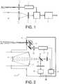
- the figure 2represents a satellite observation system according to the invention. It basically has two coupled instruments which are a telescope and a lidar flash. The two instruments are on board a satellite S represented by its outer casing 10 on the figure 2 .
- This satelliteis preferably an observation satellite moving in polar orbit, that is to say at an altitude of between 200 and 800 kilometers.
- the telescopeessentially comprises a catadioptric system and a first imager 23.
- the catadioptric systemgenerally comprises a primary mirror 21 generally aspherical and a secondary mirror 22.
- the aperture of the telescopehas a diameter of 60 centimeters and a focal length of several meters.
- the first imager 23is a high resolution, high sensitivity and low noise level imager, generally with “CMOS” technology, CMOS is an acronym meaning “Complementary Metal Oxide Semiconductor”.
- CMOScomplementary Metal Oxide Semiconductor
- the dimensions of the matrixare 14x16.6 square millimeters, the size of the square pixels is 6.5 microns and the number of pixels is 2160 pixels by 2560 pixels.
- the spectral sensitivity of the imageris between 400 nanometers and 1000 nanometers with a maximum quantum efficiency of 0.55 around 600 nanometers.
- the imager 23transmits the image to image processing means 24.
- the field covered on the groundis a rectangle of 2.16 x 2.56 km 2 , the resolution being 1 meter.
- the field covered on the groundis a rectangle of 1.08 x 1.28 km 2 , the resolution being 50 centimeters.
- the observation telescopehas two modes of operation. In a first mode of operation, the telescope delivers a single high resolution two-dimensional image covering a first zone. In the second operating mode, the telescope delivers a series of correlated images taken by the satellite under different incidences at different times and covering the same observation zone, making it possible to produce a tomographic view of said zone.
- two imagesare available, the first from the telescope and the second three-dimensional image produced from the echoes scattered by the terrain at a lower resolution provided by the lidar flash covering a second. observation zone of dimensions smaller than the first zone.
- the first one imageis either a simple three-dimensional image or a tomographic three-dimensional image. Usually these two images are in different optical spectra.
- the processing of the imagescan be carried out in the satellite itself or in a ground station, the raw data coming from the imagers are then transmitted by the satellite.
- the two observation zonesdo not necessarily overlap, but it is interesting to observe the same observation zone using the two instruments.
- the figure 3illustrates this principle. It represents a satellite S rotating around the earth in an orbit O at two different instants T and T '.
- This orbitis, by way of example, a polar orbit.
- this satellite Soccupies a first position S (T) on its trajectory and photographs a first observation zone Z by means of its telescope.
- the satellite Shas moved. It occupies a second position S (T ') on its trajectory.
- the lidar flashis activated and takes a three-dimensional view of a second observation zone Z 'of dimensions smaller than those of the first observation zone. Thanks to its two-dimensional orientation device, the second observation zone Z ′ intersects part of the first observation zone Z.
- the telescope and the lidar flashare on board a drone operating at high altitude, that is to say at altitudes of between 15 to 25 kilometers.
- the dimensions of the optics and the emitted powersare adapted accordingly so as to obtain a correct photometric balance for the lidar flash and a suitable resolution.
- the same observation zonecan be illuminated by a series of laser pulses emitted at different times by the emission laser and giving a plurality of series of echoes so as to increase the definition.
- the image processing meanscalculate a high resolution three-dimensional digital image of said observation zone from said tomographic representation and from said plurality of series of echoes at different angles. All of the data is concatenated to provide a high-resolution 3D image of the scene making it possible to process camouflaged objects and / or moving objects.
- the emission laseras an illuminator or jammer in a determined direction, for example to jam the optics of hostile satellites.
- the advantages of the observation system according to the inventionare that it makes it possible to deliver both high-resolution images making it possible, for example, to discover or observe camouflaged objects and also high-speed images by giving priority to them.
- Lidar flash imagesallowing tracking, for example, of moving vehicles.
Landscapes
- Engineering & Computer Science (AREA)
- Physics & Mathematics (AREA)
- Radar, Positioning & Navigation (AREA)
- Remote Sensing (AREA)
- Computer Networks & Wireless Communication (AREA)
- General Physics & Mathematics (AREA)
- Electromagnetism (AREA)
- Optical Radar Systems And Details Thereof (AREA)
Description
Translated fromFrenchLe domaine de l'invention est celui de l'instrumentation optique embarqué sur aéronef ou sur satellite et en particulier sur des petits ou des micro-satellites d'observation terrestre.The field of the invention is that of optical instrumentation on board an aircraft or on a satellite and in particular on small or micro-satellites for terrestrial observation.
Actuellement, pour différentes applications, il existe un besoin d'obtenir rapidement des images haute résolution et si possible tridimensionnelles de certains sites terrestres. Ce besoin ne peut être rempli qu'imparfaitement par les satellites d'observation traditionnels qui ont effectivement une excellente résolution spatiale mais dont le nombre est nécessairement limité compte-tenu de leur coût. Ces « gros » satellites ne peuvent donc pas délivrer rapidement des images haute résolution de n'importe quelle zone du globe.Currently, for various applications, there is a need to quickly obtain high resolution and if possible three-dimensional images of certain terrestrial sites. This need can only be imperfectly fulfilled by traditional observation satellites which indeed have excellent spatial resolution but the number of which is necessarily limited in view of their cost. These “big” satellites therefore cannot quickly deliver high-resolution images of any area of the globe.
Pour pallier cet inconvénient, il existe des « petits » satellites, par exemple de type « TacSat », abrégé de « Tactical Satellite ». Ces satellites sont, par exemple, montés sur des plateformes de type « Myriade » ou « Myriade Evolutions ». Ces satellites ont une masse de quelques centaines de kilogrammes pour un volume de quelques centaines de litres. Ces satellites sont destinés à évoluer sur une orbite située entre 400 et 800 kilomètres d'altitude. Quand ils sont destinés à l'observation terrestre, ce type de satellites comporte un télescope. Schématiquement, celui-ci est composé d'un système catadioptrique et d'un imageur matriciel haute résolution. Le système catadioptrique comprend un miroir primaire. A titre d'exemple, les caractéristiques techniques principales du télescope sont les suivantes :
A titre de premier exemple, pour une altitude du satellite de 400 kilomètres et une focale de 2.6 mètres, le champ couvert au sol est un rectangle de 2.16 x 2.56 km2, la résolution étant de 1 mètre. A titre de second exemple, pour la même altitude du satellite et une focale de 5.2 mètres, le champ couvert au sol est un rectangle de 1.08 x 1.28 km2, la résolution étant de 50 centimètres.As a first example, for an altitude of the satellite of 400 kilometers and a focal length of 2.6 meters, the field covered on the ground is a rectangle of 2.16 x 2.56 km2 , the resolution being 1 meter. As a second example, for the same altitude of the satellite and a focal length of 5.2 meters, the field covered on the ground is a rectangle of 1.08 x 1.28 km2 , the resolution being 50 centimeters.
Pour certaines applications, en particulier si l'on souhaite envoyer sur zone des drones d'observation, la haute résolution tridimensionnelle de ce type de satellite peut se révéler insuffisante dans la mesure où la navigation du drone nécessite une information cartographique tridimensionnelle. Il est possible d'obtenir des images stéréoscopiques ou tomographiques à partir des images prises par satellite. Il suffit de corréler des images prises par le satellite à plusieurs instants différents et couvrant la même zone d'observation de façon à obtenir plusieurs vues sous des incidences différentes. En effet, à chaque instant, correspond une position différente du satellite. On reconstruit ensuite une cartographie tridimensionnelle de la zone observée. Cette solution a un certain nombre d'inconvénients. La prise d'images tomographiques prend un certain temps dans la mesure où l'on doit asservir la ligne de visée du télescope sur la zone d'observation. La résolution des images stéréoscopiques est dégradée par rapport à la résolution bidimensionnelle initiale. Par ailleurs, lorsque des objets ont été camouflés pour ne pas être détectés, cette méthode ne permet pas toujours de les identifier. Enfin, la détection d'objets en mouvement rapide est problématique.For certain applications, in particular if it is desired to send observation drones to an area, the high three-dimensional resolution of this type of satellite may prove to be insufficient insofar as the navigation of the drone requires three-dimensional cartographic information. Stereoscopic or tomographic images can be obtained from satellite images. It suffices to correlate images taken by the satellite at several different times and covering the same observation area so as to obtain several views under different incidences. Indeed, at each instant, a different position of the satellite corresponds. A three-dimensional map of the observed area is then reconstructed. This solution has a number of drawbacks. The taking of tomographic images takes a certain time insofar as one must control the line of sight of the telescope on the observation zone. The resolution of stereoscopic images is degraded compared to the initial two-dimensional resolution. Moreover, when objects have been camouflaged so as not to be detected, this method does not always allow them to be identified. Finally, the detection of fast moving objects is problematic.
Enfin, il existe des systèmes embarqués comportant à la fois des caméras et des systèmes LIDARs. Le document
Le système d'observation selon l'invention ne présente pas ces inconvénients. Il réunit dans un seul instrument comportant une seule optique de réception un télescope traditionnel et un lidar de type « flash lidar » dédié à la prise d'images tridimensionnelles. Plus précisément, l'invention a pour objet un système d'observation comportant un instrument d'observation destiné à être embarqué sur aéronef ou sur satellite, ledit instrument d'observation comprenant un télescope comportant un système catadioptrique et un premier imageur sensible dans une bande spectrale déterminée, l'instrument d'observation comportant :
- un lidar de type « flash lidar » comportant :
- un laser d'émission émettant des impulsions à une longueur d'onde déterminée ;
- une optique d'émission ;
- le système catadioptrique faisant office d'optique de réception des échos dus aux impulsions laser ;
- un second imageur ;
- un séparateur spectral disposé en avant du plan focal du système catadioptrique, ledit séparateur transmettant la longueur d'onde du laser d'émission de façon que les échos soient reçus par le second imageur et réfléchissant la bande spectrale déterminée de façon que l'image d'une zone observée par le télescope soit reçue par le premier imageur ou vice-versa.
- a "flash lidar" type lidar comprising:
- an emission laser emitting pulses at a determined wavelength;
- transmission optics;
- the catadioptric system acting as an optical receiver for the echoes due to the laser pulses;
- a second imager;
- a spectral splitter disposed in front of the focal plane of the catadioptric system, said splitter transmitting the wavelength of the emission laser so that the echoes are received by the second imager and reflecting the determined spectral band so that the image d 'an area observed by the telescope is received by the first imager or vice versa.
Avantageusement, le télescope faisant l'image d'une zone d'observation terrestre de dimensions déterminées, l'optique d'émission est configurée pour éclairer une zone de dimensions inférieures, le système d'observation comportant un dispositif d'orientation bidimensionnel du laser d'émission, les amplitudes d'orientation étant au moins suffisantes pour balayer l'ensemble de la zone d'observation terrestre.Advantageously, the telescope making the image of a terrestrial observation zone of determined dimensions, the emission optics is configured to illuminate a zone of smaller dimensions, the observation system comprising a two-dimensional orientation device of the laser. emission, the orientation amplitudes being at least sufficient to sweep the whole of the terrestrial observation zone.
Avantageusement, la résolution du télescope est supérieure à la résolution du lidar.Advantageously, the resolution of the telescope is greater than the resolution of the lidar.
Avantageusement, le champ d'observation du télescope est d'un ordre de grandeur supérieur à celui du lidar.Advantageously, the field of observation of the telescope is of an order of magnitude greater than that of the lidar.
Avantageusement, la longueur d'onde déterminée du laser d'émission est située en dehors de la bande spectrale déterminée.Advantageously, the determined wavelength of the emission laser is located outside the determined spectral band.
Avantageusement, la longueur d'onde du laser d'émission est située dans le visible.Advantageously, the wavelength of the emission laser is located in the visible.
Avantageusement, la longueur d'onde du laser d'émission est située dans le proche infrarouge.Advantageously, the wavelength of the emission laser is located in the near infrared.
Avantageusement, le système d'observation comporte des moyens permettant d'utiliser le laser d'émission comme illuminateur ou brouilleur dans une direction déterminée.Advantageously, the observation system comprises means making it possible to use the emission laser as an illuminator or jammer in a determined direction.
Avantageusement, le système catadioptrique a une ouverture comprise entre 0.1 mètre et 1 mètre et une focale comprise entre 2 mètres et 10 mètres.Advantageously, the catadioptric system has an opening of between 0.1 meter and 1 meter and a focal length of between 2 meters and 10 meters.
L'invention sera mieux comprise et d'autres avantages apparaîtront à la lecture de la description qui va suivre donnée à titre non limitatif et grâce aux figures annexées parmi lesquelles :
- La
figure 1 représente le synoptique d'un « flash lidar » selon l'art antérieur ; - La
figure 2 représente une vue en coupe de l'instrument d'observation selon l'invention ; - La
figure 3 représente les zones terrestres de balayage d'un instrument d'observation selon l'invention.
- The
figure 1 represents the block diagram of a “lidar flash” according to the prior art; - The
figure 2 shows a sectional view of the observation instrument according to the invention; - The
figure 3 represents the terrestrial scanning zones of an observation instrument according to the invention.
Comme on l'a vu, un des inconvénients des systèmes d'observation embarqués selon l'art antérieur est qu'ils peuvent difficilement et rapidement restituer des images tridimensionnelles.As we have seen, one of the drawbacks of on-board observation systems according to the prior art is that they can hardly and quickly restore three-dimensional images.
Il existe des systèmes optiques réalisant cette fonction. Il s'agit de « LiDARs » topographiques, acronyme signifiant « Light Détection And Ranging ». Un LiDAR topographique est un télémètre laser couplé à des moyens de localisation géoréférencés. Ce type de LiDAR est aéroporté ou embarqué sur une plateforme satellitaire. Ce système d'observation permet l'acquisition de nuages de points géoréférencés représentatifs du terrain survolé. On utilise également pour ce type de système le terme de « LADAR », signifiant « LAser Détection And Ranging ».There are optical systems performing this function. These are topographic “LiDARs”, an acronym meaning “Light Detection And Ranging”. A topographic LiDAR is a laser range finder coupled to georeferenced localization means. This type of LiDAR is airborne or embarked on a satellite platform. This observation system allows the acquisition of clouds of georeferenced points representative of the terrain overflown. The term “LADAR”, meaning “LAser Detection And Ranging”, is also used for this type of system.
Depuis une quinzaine d'année, il existe de nouveaux systèmes lidar appelé « lidar à retour d'onde complète », connu aussi sous l'appellation anglo-saxonne « lidar full-waveform ». La principale caractéristique de ce type de LiDAR est leur capacité à numériser l'intégralité du signal ou de l'écho émis par le terrain lorsqu'il est balayé par le faisceau laser d'émission. On obtient ainsi une information beaucoup plus riche non seulement sur la topographie du terrain, mais sur sa nature. On trouvera des informations complémentaires sur ce type de LiDAR dans l'article intitulé
Plus récemment, une nouvelle génération de lidar est apparue. Ce type de lidar est appelé « 3-D Imaging Flash Lidar ». La différence essentielle entre ce lidar et les générations précédentes est que le terrain observé est éclairé par un seul « flash » laser et non pas par le balayage d'un faisceau étroit comme dans les applications précédentes dites « scanning lidar ». Le synoptique d'un « flash lidar » est représenté en
- un laser d'émission 1 émettant des impulsions brèves d'une durée comprise entre la nanoseconde et quelques nanosecondes à une cadence typique de 10 impulsions par seconde, la longueur d'onde d'émission étant généralement située dans le proche infrarouge, l'énergie d'une impulsion étant de quelques millijoules ;
- une optique de
transmission 2 des impulsions laser. La caractéristique principale de cette optique est qu'elle éclaire l'intégralité de la scène dont on cherche à connaître la topographie ; - une optique de réception 3 qui focalise les échos émis par la scène éclairée ;
- un photodétecteur matriciel 4 à bande passante élevée ;
- un
circuit de lecture 5 de type « ROIC », acronyme signifiant « ReadOut Integrate Circuit », synchronisé avec les temps d'émission des impulsions et qui mesure, pour chaque impulsion, les temps d'arrivée de chaque écho sur chaque pixel du photodétecteur matriciel ; - des moyens d'analyse 6 permettant, à partir de la connaissance des temps d'arrivée et de la forme des différents échos, de reconstituer la topographie et la topologie de la scène analysée.
- an emission laser 1 emitting short pulses with a duration between a nanosecond and a few nanoseconds at a typical rate of 10 pulses per second, the emission wavelength being generally located in the near infrared, the energy of a pulse being a few millijoules;
- an
optical transmission 2 of the laser pulses. The main characteristic of this lens is that it illuminates the entire scene, the topography of which is being sought; - a
reception optic 3 which focuses the echoes emitted by the illuminated scene; - a high
bandwidth matrix photodetector 4; - a
reading circuit 5 of the “ROIC” type, acronym meaning “ReadOut Integrate Circuit”, synchronized with the transmission times of the pulses and which measures, for each pulse, the arrival times of each echo on each pixel of the matrix photodetector; - analysis means 6 making it possible, on the basis of knowledge of the arrival times and of the shape of the various echoes, to reconstitute the topography and the topology of the analyzed scene.
On trouvera des informations complémentaires sur la technologie
Généralement, y compris pour des applications spatiales, les flash lidars fonctionnent à des distances qui peuvent être de l'ordre de quelques kilomètres à quelques dizaines de kilomètres. Pour des applications satellitaires, l'observation est réalisée nécessairement à haute altitude sur une orbite située à au moins 200 kilomètres et généralement au-delà. Il est alors nécessaire de disposer d'optiques de réception de grande ouverture. Le second inconvénient est que le champ de vue des flash lidars est moyenne et ne dépasse pas 200 x 200 pixels carrés. Ce champ est dix fois plus faible que celui d'un instrument d'observation classique.Generally, including for space applications, flash lidars operate at distances which can be of the order of a few kilometers to a few tens of kilometers. For satellite applications, the observation is necessarily carried out at high altitude in an orbit located at least 200 kilometers away and generally beyond. It is then necessary to have wide-aperture reception optics. The second disadvantage is that the field of view of flash lidars is average and does not exceed 200 x 200 square pixels. This field is ten times weaker than that of a conventional observation instrument.
Le système d'observation selon l'invention comporte à la fois un instrument d'observation classique et un flash lidar de façon à bénéficier à la fois de la haute résolution et du grand champ de l'instrument d'observation passif et de la possibilité de réaliser des images tridimensionnelles du flash lidar actif. On peut ainsi traiter des objets camouflés de façon à les mettre en évidence et/ou des objets mobiles, l'image du flash lidar étant instantané.The observation system according to the invention comprises both a conventional observation instrument and a lidar flash so as to benefit both from the high resolution and the large field of the passive observation instrument and from the possibility to produce three-dimensional images of the active lidar flash. It is thus possible to process camouflaged objects so as to highlight them and / or moving objects, the image of the lidar flash being instantaneous.
Le système d'observation selon l'invention peut être embarqué sur aéronef ou sur satellite, l'aéronef pouvant être un aérodyne ou un aérostat.The observation system according to the invention can be on board an aircraft or a satellite, the aircraft possibly being an aerodyne or an aerostat.
A titre de premier exemple non limitatif, la
Le télescope comporte essentiellement un système catadioptrique et un premier imageur 23.The telescope essentially comprises a catadioptric system and a
Le système catadioptrique comporte généralement un miroir primaire 21 généralement asphérique et un miroir secondaire 22. A titre d'exemple, l'ouverture du télescope a un diamètre de 60 centimètres et une focale de plusieurs mètres.The catadioptric system generally comprises a
Le premier imageur 23 est un imageur à haute résolution, haute sensibilité et à bas niveau de bruit, généralement à technologie « CMOS », CMOS est un acronyme signifiant « Complementary Metal Oxide Semi-conductor ». A titre d'exemple, les dimensions de la matrice sont 14x16.6 millimètres carrés, la taille des pixels carrés vaut 6.5 microns et le nombre de pixels vaut 2160 pixels par 2560 pixels. La sensibilité spectrale de l'imageur est comprise entre 400 nanomètres et 1000 nanomètres avec un maximum d'efficacité quantique de 0.55 autour de 600 nanomètres.The
L'imageur 23 transmet l'image à des moyens de traitement d'images 24.The
Pour donner des ordres de grandeur des dimensions de la zone d'observation et de la résolution au sol, pour une altitude du satellite de 400 kilomètres et une focale de 2.6 mètres, le champ couvert au sol est un rectangle de 2.16 x 2.56 km2, la résolution étant de 1 mètre. Pour la même altitude du satellite et une focale double de 5.2 mètres, le champ couvert au sol est un rectangle de 1.08 x 1.28 km2, la résolution étant de 50 centimètres.To give orders of magnitude of the dimensions of the observation zone and of the resolution on the ground, for an altitude of the satellite of 400 kilometers and a focal length of 2.6 meters, the field covered on the ground is a rectangle of 2.16 x 2.56 km2 , the resolution being 1 meter. For the same altitude of the satellite and a double focal length of 5.2 meters, the field covered on the ground is a rectangle of 1.08 x 1.28 km2 , the resolution being 50 centimeters.
Le flash lidar comporte :
un laser d'émission 31 émettant des impulsions brèves d'une durée comprise entre la nanoseconde et quelques nanosecondes à une cadence typique de 10 impulsions par seconde, l'énergie d'une impulsion étant de quelques millijoules. Cette cadence d'émission est donnée à titre indicatif et peut être supérieure. Sa longueur d'onde d'émission est généralement située dans le proche infrarouge. A titre de premier exemple, le laser d'émission est un laser à rétroaction répartie ou « DFB », acronyme signifiant « Distribued FeedBack ». Ce type de laser émet à 1570 nm. A titre de second exemple, le laser d'émission est un laser Nd :-YAG, acronyme signifiant « Neodymium-Doped Yttrium Aluminium Grenat » émettant à 1064 nm. Il serait possible d'utiliser un laser émettant dans le visible, par exemple à la longueur d'onde de 532 nanomètres mais cette solution entraîne des contraintes plus importantes sur la séparation des images et peut présenter des problèmes de sécurité oculaire ;- une optique d'émission 32. La fonction de cette optique d'émission est de générer un faisceau laser légèrement divergent susceptible de couvrir une zone d'éclairage, généralement de dimensions inférieures à la zone d'observation du télescope ;
un dispositif 33 d'orientation bidimensionnel du faisceau laser. Ce dispositif permet d'orienter le faisceau laser d'émission à l'intérieur de la zone d'observation. L'amplitude des déplacements est au moins conditionnée par le temps séparant la prise de vue de la zone d'observation et son éclairage par le laser d'émission. Sur lafigure 2 , on a représenté symboliquement ce système par un miroir surmonté d'une flèche en arc-de-cercle, la rotation du miroir 33 étant assurée par des moyens mécaniques. D'autres systèmes de déflexion sont possibles ;- une optique de réception. Dans le système d'observation selon l'invention, cette optique de réception est le système catadioptrique du télescope composé des miroirs 21
et 22. On obtient ainsi une optique de réception de grande ouverture sans ajouter de composants optiques supplémentaires ; - un
second imageur 34 destiné à recevoir les échos de la zone d'éclairage. Actuellement, il n'est pas possible d'obtenir un imageur compatible de la technique « flash laser » à très haute résolution. Les meilleurs imageurs pour flash lidar ont un nombre de pixels de 128 x 128 pixels carrés ou de 240 x 232 pixels carrés. A champ égal, la résolution du flash laser est donc 10 fois inférieure à celle du télescope dont l'imageur comporte environ 100 fois plus de pixels. Aussi, il est intéressant que la zone d'observation du flash lidar soit de dimensions bien inférieures à celles de la zone d'observation du télescope de façon que les parties de zones d'observation communes au télescope et au flash lidar aient des résolutions voisines. Dans les exemples précédents, il a été défini une première zone d'observation du télescope de 2.16 x 2.56 km2 avec une résolution d'un mètre au sol. Dans ce cas, une zone d'observation adaptée du flash lidar peut être comprise entre 128 x 128 m2 et 480 x 464 m2 selon le nombre de pixels du second imageur et la résolution du flash lidar que l'on souhaite obtenir ; - un
circuit de lecture 35 de type « ROIC » comme déjà décrit, synchronisé avec les temps d'émission des impulsions et qui mesure, pour chaque impulsion, les temps d'arrivée de chaque écho sur chaque pixel du second imageur ; - l'optique de réception étant commune au télescope et au flash lidar, il faut nécessairement séparer l'image du télescope des échos du flash lidar en évitant d'introduire des pertes trop importantes. Or, le télescope travaille essentiellement dans la bande visible du spectre et le flash lidar dans l'infrarouge. La solution la plus simple est donc de disposer un séparateur spectral 36 en avant du plan focal du système catadioptrique. Sur la
figure 2 , ce séparateur 36 transmet la longueur d'onde du laser d'émission de façon que les échos soient reçus par le second imageur et réfléchit la bande spectrale du télescope de façon que l'image d'une zone observée par le télescope soit reçue par le premier imageur. Bien entendu, selon l'agencement du système d'observation, le séparateur peut réaliser la fonction inverse, c'est-à-dire réfléchir la longueur d'onde laser et transmettre la partie visible du spectre. Si le flash lidar émet dans la bande spectrale du télescope, il faut alors utiliser soit une séparation spectrale ciblée précisément sur sa longueur d'onde d'émission, soit d'autres moyens de séparation comme la séparation temporelle des images.
- an
emission laser 31 emitting short pulses with a duration between one nanosecond and a few nanoseconds at a typical rate of 10 pulses per second, the energy of a pulse being a few millijoules. This transmission rate is given as an indication and may be higher. Its emission wavelength is generally located in the near infrared. As a first example, the emission laser is a distributed feedback laser or “DFB”, an acronym meaning “Distribued FeedBack”. This type of laser emits at 1570 nm. As a second example, the emission laser is an Nd: -YAG laser, an acronym meaning “Neodymium-Doped Yttrium Aluminum Garnet” emitting at 1064 nm. It would be possible to use a laser emitting in the visible, for example at the wavelength of 532 nanometers, but this solution entails greater constraints on the separation of the images and may present ocular safety problems; - an
emission optic 32. The function of this emission optic is to generate a slightly divergent laser beam capable of covering an illumination zone, generally of dimensions smaller than the observation zone of the telescope; - a
device 33 for two-dimensional orientation of the laser beam. This device makes it possible to orient the emission laser beam inside the observation zone. The amplitude of the movements is at least conditioned by the time separating the shooting of the observation zone and its illumination by the emission laser. On thefigure 2 , this system is symbolically represented by a mirror surmounted by an arc-of-circle arrow, the rotation of themirror 33 being ensured by mechanical means. Other deflection systems are possible; - a reception optic. In the observation system according to the invention, this reception optic is the catadioptric system of the telescope composed of
mirrors - a
second imager 34 intended to receive the echoes from the illumination zone. Currently, it is not possible to obtain an imager compatible with the very high resolution “laser flash” technique. The best imagers for lidar flash have a pixel count of 128 x 128 square pixels or 240 x 232 square pixels. For an equal field, the resolution of the laser flash is therefore 10 times lower than that of the telescope whose imager has around 100 times more pixels. Also, it is interesting that the observation zone of the lidar flash is of dimensions much smaller than those of the observation zone of the telescope so that the parts of the observation zones common to the telescope and to the lidar flash have similar resolutions. . In the previous examples, a first observation area of the telescope of 2.16 x 2.56 km2 has been defined with a resolution of one meter on the ground. In this case, a suitable observation area of the lidar flash may be between 128 x 128 m2 and 480 x 464 m2 depending on the number of pixels of the second imager and the desired resolution of the lidar flash; - a
reading circuit 35 of the “ROIC” type as already described, synchronized with the transmission times of the pulses and which measures, for each pulse, the arrival times of each echo on each pixel of the second imager; - the reception optics being common to the telescope and to the lidar flash, it is necessary to separate the image of the telescope from the echoes of the lidar flash while avoiding introducing excessive losses. However, the telescope mainly works in the visible band of the spectrum and the lidar flash in the infrared. The simplest solution is therefore to have a
spectral splitter 36 in front of the focal plane of the catadioptric system. On thefigure 2 , thissplitter 36 transmits the wavelength of the emission laser so that the echoes are received by the second imager and reflects the spectral band of the telescope so that the image of an area observed by the telescope is received by the first imager. Of course, depending on the arrangement of the observation system, the splitter can perform the reverse function, that is to say reflect the laser wavelength and transmit the visible part of the spectrum. If the lidar flash emits in the spectral band of the telescope, it is then necessary to use either a spectral separation targeted precisely on its emission wavelength, or other separation means such as the temporal separation of the images.
Le télescope d'observation a deux modes de fonctionnement. Dans un premier mode de fonctionnement, le télescope délivre une image unique haute résolution bidimensionnelle couvrant une première zone. Dans le second mode de fonctionnement, le télescope délivre une série d'images corrélées prises par le satellite sous des incidences différentes à différents instants et couvrant la même zone d'observation, permettant de réaliser une vue tomographique de ladite zone.The observation telescope has two modes of operation. In a first mode of operation, the telescope delivers a single high resolution two-dimensional image covering a first zone. In the second operating mode, the telescope delivers a series of correlated images taken by the satellite under different incidences at different times and covering the same observation zone, making it possible to produce a tomographic view of said zone.
Ainsi, avec le système d'observation selon l'invention, on dispose de deux images, la première issue du télescope et la seconde image tridimensionnelle réalisée à partir des échos diffusés par le terrain à plus basse résolution fournie par le flash lidar couvrant une seconde zone d'observation de dimensions inférieures à la première zone. La première image est soit une image tridimensionnelle simple, soit une image tridimensionnelle tomographique. Généralement, ces deux images sont dans des spectres optiques différents. Le traitement des images peut être réalisé dans le satellite lui-même ou dans une station au sol, les données brutes issues des imageurs sont alors transmises par le satellite.Thus, with the observation system according to the invention, two images are available, the first from the telescope and the second three-dimensional image produced from the echoes scattered by the terrain at a lower resolution provided by the lidar flash covering a second. observation zone of dimensions smaller than the first zone. The first one image is either a simple three-dimensional image or a tomographic three-dimensional image. Usually these two images are in different optical spectra. The processing of the images can be carried out in the satellite itself or in a ground station, the raw data coming from the imagers are then transmitted by the satellite.
Les deux zones d'observation ne se recoupent pas nécessairement mais il est intéressant d'observer une même zone d'observation au moyen des deux instruments.The two observation zones do not necessarily overlap, but it is interesting to observe the same observation zone using the two instruments.
La
On dispose alors pour un même site de plusieurs images, une image bidimensionnelle ou une image tomographique haute résolution fournie par le télescope à partir d'une pluralité d'images prises sous des incidences différentes à différents instants et une image tridimensionnelle à plus basse résolution. Il est alors possible de traiter simultanément ces différentes images pour obtenir une image tridimensionnelle haute résolution de la taille de l'image lidar.Several images are then available for the same site, a two-dimensional image or a high-resolution tomographic image supplied by the telescope from a plurality of images taken under different incidences at different times and a lower-resolution three-dimensional image. It is then possible to simultaneously process these different images to obtain a high-resolution three-dimensional image of the size of the lidar image.
A titre de second exemple non limitatif, le télescope et le flash lidar sont embarqués dans un drone évoluant à haute altitude, c'est-à-dire à des altitudes comprises entre 15 à 25 kilomètres. Dans ce cas, les dimensions des optiques et les puissances émises sont adaptées en conséquence de façon à obtenir un bilan photométrique correct pour le flash lidar et une résolution adaptée.As a second non-limiting example, the telescope and the lidar flash are on board a drone operating at high altitude, that is to say at altitudes of between 15 to 25 kilometers. In this case, the dimensions of the optics and the emitted powers are adapted accordingly so as to obtain a correct photometric balance for the lidar flash and a suitable resolution.
La même zone d'observation peut être éclairée par une série d'impulsions laser émises à des instants différents par le laser d'émission et donnant une pluralité de séries d'échos de façon à augmenter la définition. Les moyens de traitement d'image calculent une image numérique tridimensionnelle à haute résolution de ladite zone d'observation à partir de ladite représentation tomographique et de ladite pluralité de séries d'échos suivant des angles différents. L'ensemble des données est concaténé pour fournir une image 3D de la scène à haute résolution permettant de traiter les objets camouflés et/ou les objets mobiles.The same observation zone can be illuminated by a series of laser pulses emitted at different times by the emission laser and giving a plurality of series of echoes so as to increase the definition. The image processing means calculate a high resolution three-dimensional digital image of said observation zone from said tomographic representation and from said plurality of series of echoes at different angles. All of the data is concatenated to provide a high-resolution 3D image of the scene making it possible to process camouflaged objects and / or moving objects.
Il est également possible d'utiliser le laser d'émission comme illuminateur ou brouilleur dans une direction déterminée, par exemple pour brouiller les optiques de satellites hostiles.It is also possible to use the emission laser as an illuminator or jammer in a determined direction, for example to jam the optics of hostile satellites.
Les avantages du système d'observation selon l'invention est qu'il permet de délivrer à la fois des images à haute résolution permettant, par exemple, de découvrir ou d'observer des objets camouflés et également des images à cadence élevée en privilégiant les images du flash lidar, permettant de suivre, par exemple, des véhicules en mouvement.The advantages of the observation system according to the invention are that it makes it possible to deliver both high-resolution images making it possible, for example, to discover or observe camouflaged objects and also high-speed images by giving priority to them. Lidar flash images, allowing tracking, for example, of moving vehicles.
Claims (9)
- An observation system (S) comprising an observation instrument intended to be placed on board an aircraft or a satellite, said observation instrument comprising a telescope comprising a catadioptric system (21, 22) and a first imaging device (23) that is sensitive in a determined spectral band, the observation instrument comprising:- a "flash lidar" type lidar comprising:- an emission laser (31) emitting pulses with a determined wavelength;- an emission optic (32);- the catadioptric system acting as an optic for receiving echoes due to the laser pulses;- a second imaging device (34);- a splitter (36) disposed in front of the focal plane of the catadioptric system, said splitter transmitting the wavelength of the emission laser so that the echoes are received by the second imaging device and reflecting the determined spectral band so that the image of a zone observed by the telescope is received by the first imaging device, or vice versa;characterised in that, with a terrestrial observation zone being photographed several times at different instants by the telescope and providing a plurality of two-dimensional digital images allowing a tomographic representation of said observation zone to be provided, the same observation zone being illuminated by a series of laser pulses emitted at different instants by said emission laser and providing a plurality of series of echoes, the image processing means compute a high-resolution three-dimensional digital image of said observation zone based on said tomographic representation and of said plurality of series of echoes.
- The observation system according to claim 1,characterised in that, with the telescope taking the image of a terrestrial observation zone (Z) with determined dimensions, the emission optic is configured to illuminate a zone (Z') with smaller dimensions, the observation system comprising a device (33) for two-dimensional orientation of the emission laser, the orientation amplitudes being at least sufficient for scanning the entire terrestrial observation zone.
- The observation system according to any one of the preceding claims,characterised in that the resolution of the telescope is greater than the resolution of the lidar.
- The observation system according to any one of the preceding claims,characterised in that the observation field of the telescope has an order of magnitude that is greater than that of the lidar.
- The observation system according to any one of the preceding claims,characterised in that the determined wavelength of the emission laser is found outside the determined spectral band.
- The observation system as claimed in any one of the preceding claims,characterised in that the wavelength of the emission laser is found in the visible field.
- The observation system according to any one of claims 1 to 5,characterised in that the wavelength of the emission laser is found in the near-infrared field.
- The observation system according to any one of the preceding claims,characterised in that the observation system comprises means for using the emission laser as an illuminator or jammer in a determined direction.
- The observation system according to any one of the preceding claims,characterised in that the catadioptric system has an aperture ranging between 0.1 metre and 1 metre and a focal length ranging between 2 metres and 10 metres.
Applications Claiming Priority (1)
| Application Number | Priority Date | Filing Date | Title |
|---|---|---|---|
| FR1700640AFR3067817B1 (en) | 2017-06-15 | 2017-06-15 | ON-BOARD OBSERVATION SYSTEM COMPRISING A LIDAR FOR OBTAINING HIGH RESOLUTION THREE-DIMENSIONAL IMAGES |
Publications (2)
| Publication Number | Publication Date |
|---|---|
| EP3415949A1 EP3415949A1 (en) | 2018-12-19 |
| EP3415949B1true EP3415949B1 (en) | 2021-05-12 |
Family
ID=60302147
Family Applications (1)
| Application Number | Title | Priority Date | Filing Date |
|---|---|---|---|
| EP18176777.3AActiveEP3415949B1 (en) | 2017-06-15 | 2018-06-08 | On-board observation system comprising a lidar for obtaining high-resolution three-dimensional images |
Country Status (3)
| Country | Link |
|---|---|
| EP (1) | EP3415949B1 (en) |
| ES (1) | ES2875368T3 (en) |
| FR (1) | FR3067817B1 (en) |
Families Citing this family (3)
| Publication number | Priority date | Publication date | Assignee | Title |
|---|---|---|---|---|
| US11493633B2 (en)* | 2019-02-05 | 2022-11-08 | United States Of America As Represented By The Secretary Of The Air Force | Range-enabled three-dimensional imaging system and associated methods |
| CN111751835B (en)* | 2020-07-06 | 2023-05-16 | 中国科学院国家天文台长春人造卫星观测站 | Full-waveform satellite laser ranging system and method |
| CN111880194B (en)* | 2020-08-10 | 2023-11-28 | 中国科学技术大学 | Non-viewing range imaging device and method |
Family Cites Families (4)
| Publication number | Priority date | Publication date | Assignee | Title |
|---|---|---|---|---|
| US7248342B1 (en)* | 2003-02-14 | 2007-07-24 | United States Of America As Represented By The Administrator Of The National Aeronautics And Space Administration | Three-dimension imaging lidar |
| US7961301B2 (en)* | 2008-05-09 | 2011-06-14 | Ball Aerospace & Technologies Corp. | Flash LADAR system |
| ES2512965B2 (en)* | 2013-02-13 | 2015-11-24 | Universitat Politècnica De Catalunya | System and method to scan a surface and computer program that implements the method |
| GB2539427A (en)* | 2015-06-16 | 2016-12-21 | Spectra Medical Ltd | High resolution remote imaging system providing depth information |
- 2017
- 2017-06-15FRFR1700640Apatent/FR3067817B1/ennot_activeExpired - Fee Related
- 2018
- 2018-06-08EPEP18176777.3Apatent/EP3415949B1/enactiveActive
- 2018-06-08ESES18176777Tpatent/ES2875368T3/enactiveActive
Also Published As
| Publication number | Publication date |
|---|---|
| ES2875368T3 (en) | 2021-11-10 |
| FR3067817B1 (en) | 2019-12-27 |
| EP3415949A1 (en) | 2018-12-19 |
| FR3067817A1 (en) | 2018-12-21 |
Similar Documents
| Publication | Publication Date | Title |
|---|---|---|
| US7139067B2 (en) | Three-dimensional imaging with multiframe blind deconvolution | |
| CA2804991C (en) | Optical watch system for a space watch system for near space monitoring | |
| EP3103062B1 (en) | Method for detecting and classifying events of a scene | |
| Hao et al. | Development of pulsed‐laser three‐dimensional imaging flash lidar using APD arrays | |
| EP2469299B1 (en) | Method for enhancing images acquired by a radar with synthetic aperture | |
| EP3415949B1 (en) | On-board observation system comprising a lidar for obtaining high-resolution three-dimensional images | |
| CA2804996C (en) | Method for making a space watch system for near space monitoring | |
| CA2805010C (en) | Space situational awareness system for near space monitoring | |
| EP3247977A1 (en) | Daytime and nighttime stellar sensor with active polarizer | |
| Degnan et al. | Inflight performance of a second-generation photon-counting 3D imaging lidar | |
| US20150092179A1 (en) | Light ranging with moving sensor array | |
| FR2724464A1 (en) | ON-BOARD DEVICE FOR MEASURING LIGHT BACK BROADCAST | |
| FR2723810A1 (en) | SQUARE SENSOR DEVICE FOR SATELLITE OR SIMILAR, WITH PYROELECTRIC DETECTOR MATRIX | |
| FR3091084A1 (en) | COMMUNICATION SYSTEM COMPRISING A MATRIX IMAGE COMMUNICATION RECEIVER | |
| Duncan et al. | Advances in laser gated imaging in an airborne environment | |
| EP2388646B1 (en) | Method for capturing an image | |
| FR3054324A1 (en) | GUIDING SYSTEM FOR GUIDING AN AIRCRAFT ALONG AT LEAST ONE AIR ROAD PORTION | |
| EP1202021B1 (en) | Apparatus for boresighting a laser transmitting channel with a passive observing channel | |
| WO2007045638A1 (en) | Dual-laser-scanning optical device having multiple adjustable parameters | |
| EP2574210B1 (en) | Altimetric measurement device | |
| FR2736491A1 (en) | OPTICAL DETECTION DEVICE | |
| FR3049066A1 (en) | SYSTEM FOR MONITORING AND DETECTING AN EVENT ON THE GROUND SURFACE BY A SATELLITE CONSTELLATION | |
| EP0629882B1 (en) | Lidar with a high pulse repetition rate using a laser source of low pulse repetition rate | |
| FR3119462A1 (en) | Process for acquiring 3D images by line scanning and temporal gate detection | |
| Bayya et al. | Conference 8541: Electro-Optical and Infrared Systems: Technology and Applications |
Legal Events
| Date | Code | Title | Description |
|---|---|---|---|
| PUAI | Public reference made under article 153(3) epc to a published international application that has entered the european phase | Free format text:ORIGINAL CODE: 0009012 | |
| STAA | Information on the status of an ep patent application or granted ep patent | Free format text:STATUS: THE APPLICATION HAS BEEN PUBLISHED | |
| AK | Designated contracting states | Kind code of ref document:A1 Designated state(s):AL AT BE BG CH CY CZ DE DK EE ES FI FR GB GR HR HU IE IS IT LI LT LU LV MC MK MT NL NO PL PT RO RS SE SI SK SM TR | |
| AX | Request for extension of the european patent | Extension state:BA ME | |
| STAA | Information on the status of an ep patent application or granted ep patent | Free format text:STATUS: REQUEST FOR EXAMINATION WAS MADE | |
| 17P | Request for examination filed | Effective date:20190612 | |
| RBV | Designated contracting states (corrected) | Designated state(s):AL AT BE BG CH CY CZ DE DK EE ES FI FR GB GR HR HU IE IS IT LI LT LU LV MC MK MT NL NO PL PT RO RS SE SI SK SM TR | |
| GRAP | Despatch of communication of intention to grant a patent | Free format text:ORIGINAL CODE: EPIDOSNIGR1 | |
| STAA | Information on the status of an ep patent application or granted ep patent | Free format text:STATUS: GRANT OF PATENT IS INTENDED | |
| RIC1 | Information provided on ipc code assigned before grant | Ipc:G01S 17/02 20200101AFI20210125BHEP Ipc:G01S 17/89 20200101ALI20210125BHEP Ipc:G01S 7/495 20060101ALI20210125BHEP Ipc:G01S 17/10 20200101ALI20210125BHEP Ipc:G01S 7/481 20060101ALI20210125BHEP | |
| INTG | Intention to grant announced | Effective date:20210211 | |
| GRAS | Grant fee paid | Free format text:ORIGINAL CODE: EPIDOSNIGR3 | |
| GRAA | (expected) grant | Free format text:ORIGINAL CODE: 0009210 | |
| STAA | Information on the status of an ep patent application or granted ep patent | Free format text:STATUS: THE PATENT HAS BEEN GRANTED | |
| AK | Designated contracting states | Kind code of ref document:B1 Designated state(s):AL AT BE BG CH CY CZ DE DK EE ES FI FR GB GR HR HU IE IS IT LI LT LU LV MC MK MT NL NO PL PT RO RS SE SI SK SM TR | |
| REG | Reference to a national code | Ref country code:GB Ref legal event code:FG4D Free format text:NOT ENGLISH | |
| REG | Reference to a national code | Ref country code:CH Ref legal event code:EP | |
| REG | Reference to a national code | Ref country code:DE Ref legal event code:R096 Ref document number:602018016939 Country of ref document:DE | |
| REG | Reference to a national code | Ref country code:IE Ref legal event code:FG4D Free format text:LANGUAGE OF EP DOCUMENT: FRENCH | |
| REG | Reference to a national code | Ref country code:AT Ref legal event code:REF Ref document number:1392542 Country of ref document:AT Kind code of ref document:T Effective date:20210615 | |
| REG | Reference to a national code | Ref country code:LT Ref legal event code:MG9D | |
| REG | Reference to a national code | Ref country code:AT Ref legal event code:MK05 Ref document number:1392542 Country of ref document:AT Kind code of ref document:T Effective date:20210512 | |
| REG | Reference to a national code | Ref country code:NL Ref legal event code:MP Effective date:20210512 | |
| PG25 | Lapsed in a contracting state [announced via postgrant information from national office to epo] | Ref country code:AT Free format text:LAPSE BECAUSE OF FAILURE TO SUBMIT A TRANSLATION OF THE DESCRIPTION OR TO PAY THE FEE WITHIN THE PRESCRIBED TIME-LIMIT Effective date:20210512 Ref country code:BG Free format text:LAPSE BECAUSE OF FAILURE TO SUBMIT A TRANSLATION OF THE DESCRIPTION OR TO PAY THE FEE WITHIN THE PRESCRIBED TIME-LIMIT Effective date:20210812 Ref country code:LT Free format text:LAPSE BECAUSE OF FAILURE TO SUBMIT A TRANSLATION OF THE DESCRIPTION OR TO PAY THE FEE WITHIN THE PRESCRIBED TIME-LIMIT Effective date:20210512 Ref country code:HR Free format text:LAPSE BECAUSE OF FAILURE TO SUBMIT A TRANSLATION OF THE DESCRIPTION OR TO PAY THE FEE WITHIN THE PRESCRIBED TIME-LIMIT Effective date:20210512 Ref country code:FI Free format text:LAPSE BECAUSE OF FAILURE TO SUBMIT A TRANSLATION OF THE DESCRIPTION OR TO PAY THE FEE WITHIN THE PRESCRIBED TIME-LIMIT Effective date:20210512 | |
| REG | Reference to a national code | Ref country code:ES Ref legal event code:FG2A Ref document number:2875368 Country of ref document:ES Kind code of ref document:T3 Effective date:20211110 | |
| PG25 | Lapsed in a contracting state [announced via postgrant information from national office to epo] | Ref country code:SE Free format text:LAPSE BECAUSE OF FAILURE TO SUBMIT A TRANSLATION OF THE DESCRIPTION OR TO PAY THE FEE WITHIN THE PRESCRIBED TIME-LIMIT Effective date:20210512 Ref country code:RS Free format text:LAPSE BECAUSE OF FAILURE TO SUBMIT A TRANSLATION OF THE DESCRIPTION OR TO PAY THE FEE WITHIN THE PRESCRIBED TIME-LIMIT Effective date:20210512 Ref country code:LV Free format text:LAPSE BECAUSE OF FAILURE TO SUBMIT A TRANSLATION OF THE DESCRIPTION OR TO PAY THE FEE WITHIN THE PRESCRIBED TIME-LIMIT Effective date:20210512 Ref country code:PT Free format text:LAPSE BECAUSE OF FAILURE TO SUBMIT A TRANSLATION OF THE DESCRIPTION OR TO PAY THE FEE WITHIN THE PRESCRIBED TIME-LIMIT Effective date:20210913 Ref country code:NO Free format text:LAPSE BECAUSE OF FAILURE TO SUBMIT A TRANSLATION OF THE DESCRIPTION OR TO PAY THE FEE WITHIN THE PRESCRIBED TIME-LIMIT Effective date:20210812 Ref country code:PL Free format text:LAPSE BECAUSE OF FAILURE TO SUBMIT A TRANSLATION OF THE DESCRIPTION OR TO PAY THE FEE WITHIN THE PRESCRIBED TIME-LIMIT Effective date:20210512 Ref country code:IS Free format text:LAPSE BECAUSE OF FAILURE TO SUBMIT A TRANSLATION OF THE DESCRIPTION OR TO PAY THE FEE WITHIN THE PRESCRIBED TIME-LIMIT Effective date:20210912 Ref country code:GR Free format text:LAPSE BECAUSE OF FAILURE TO SUBMIT A TRANSLATION OF THE DESCRIPTION OR TO PAY THE FEE WITHIN THE PRESCRIBED TIME-LIMIT Effective date:20210813 | |
| PG25 | Lapsed in a contracting state [announced via postgrant information from national office to epo] | Ref country code:NL Free format text:LAPSE BECAUSE OF FAILURE TO SUBMIT A TRANSLATION OF THE DESCRIPTION OR TO PAY THE FEE WITHIN THE PRESCRIBED TIME-LIMIT Effective date:20210512 | |
| PG25 | Lapsed in a contracting state [announced via postgrant information from national office to epo] | Ref country code:CZ Free format text:LAPSE BECAUSE OF FAILURE TO SUBMIT A TRANSLATION OF THE DESCRIPTION OR TO PAY THE FEE WITHIN THE PRESCRIBED TIME-LIMIT Effective date:20210512 Ref country code:DK Free format text:LAPSE BECAUSE OF FAILURE TO SUBMIT A TRANSLATION OF THE DESCRIPTION OR TO PAY THE FEE WITHIN THE PRESCRIBED TIME-LIMIT Effective date:20210512 Ref country code:RO Free format text:LAPSE BECAUSE OF FAILURE TO SUBMIT A TRANSLATION OF THE DESCRIPTION OR TO PAY THE FEE WITHIN THE PRESCRIBED TIME-LIMIT Effective date:20210512 Ref country code:EE Free format text:LAPSE BECAUSE OF FAILURE TO SUBMIT A TRANSLATION OF THE DESCRIPTION OR TO PAY THE FEE WITHIN THE PRESCRIBED TIME-LIMIT Effective date:20210512 Ref country code:SK Free format text:LAPSE BECAUSE OF FAILURE TO SUBMIT A TRANSLATION OF THE DESCRIPTION OR TO PAY THE FEE WITHIN THE PRESCRIBED TIME-LIMIT Effective date:20210512 Ref country code:SM Free format text:LAPSE BECAUSE OF FAILURE TO SUBMIT A TRANSLATION OF THE DESCRIPTION OR TO PAY THE FEE WITHIN THE PRESCRIBED TIME-LIMIT Effective date:20210512 | |
| REG | Reference to a national code | Ref country code:CH Ref legal event code:PL | |
| REG | Reference to a national code | Ref country code:DE Ref legal event code:R097 Ref document number:602018016939 Country of ref document:DE | |
| REG | Reference to a national code | Ref country code:BE Ref legal event code:MM Effective date:20210630 | |
| PLBE | No opposition filed within time limit | Free format text:ORIGINAL CODE: 0009261 | |
| STAA | Information on the status of an ep patent application or granted ep patent | Free format text:STATUS: NO OPPOSITION FILED WITHIN TIME LIMIT | |
| PG25 | Lapsed in a contracting state [announced via postgrant information from national office to epo] | Ref country code:MC Free format text:LAPSE BECAUSE OF FAILURE TO SUBMIT A TRANSLATION OF THE DESCRIPTION OR TO PAY THE FEE WITHIN THE PRESCRIBED TIME-LIMIT Effective date:20210512 Ref country code:LU Free format text:LAPSE BECAUSE OF NON-PAYMENT OF DUE FEES Effective date:20210608 | |
| 26N | No opposition filed | Effective date:20220215 | |
| PG25 | Lapsed in a contracting state [announced via postgrant information from national office to epo] | Ref country code:LI Free format text:LAPSE BECAUSE OF NON-PAYMENT OF DUE FEES Effective date:20210630 Ref country code:IE Free format text:LAPSE BECAUSE OF NON-PAYMENT OF DUE FEES Effective date:20210608 Ref country code:CH Free format text:LAPSE BECAUSE OF NON-PAYMENT OF DUE FEES Effective date:20210630 | |
| PG25 | Lapsed in a contracting state [announced via postgrant information from national office to epo] | Ref country code:IS Free format text:LAPSE BECAUSE OF FAILURE TO SUBMIT A TRANSLATION OF THE DESCRIPTION OR TO PAY THE FEE WITHIN THE PRESCRIBED TIME-LIMIT Effective date:20210912 Ref country code:AL Free format text:LAPSE BECAUSE OF FAILURE TO SUBMIT A TRANSLATION OF THE DESCRIPTION OR TO PAY THE FEE WITHIN THE PRESCRIBED TIME-LIMIT Effective date:20210512 | |
| PG25 | Lapsed in a contracting state [announced via postgrant information from national office to epo] | Ref country code:BE Free format text:LAPSE BECAUSE OF NON-PAYMENT OF DUE FEES Effective date:20210630 | |
| PG25 | Lapsed in a contracting state [announced via postgrant information from national office to epo] | Ref country code:CY Free format text:LAPSE BECAUSE OF FAILURE TO SUBMIT A TRANSLATION OF THE DESCRIPTION OR TO PAY THE FEE WITHIN THE PRESCRIBED TIME-LIMIT Effective date:20210512 | |
| PG25 | Lapsed in a contracting state [announced via postgrant information from national office to epo] | Ref country code:HU Free format text:LAPSE BECAUSE OF FAILURE TO SUBMIT A TRANSLATION OF THE DESCRIPTION OR TO PAY THE FEE WITHIN THE PRESCRIBED TIME-LIMIT; INVALID AB INITIO Effective date:20180608 | |
| PG25 | Lapsed in a contracting state [announced via postgrant information from national office to epo] | Ref country code:MK Free format text:LAPSE BECAUSE OF FAILURE TO SUBMIT A TRANSLATION OF THE DESCRIPTION OR TO PAY THE FEE WITHIN THE PRESCRIBED TIME-LIMIT Effective date:20210512 | |
| PG25 | Lapsed in a contracting state [announced via postgrant information from national office to epo] | Ref country code:TR Free format text:LAPSE BECAUSE OF FAILURE TO SUBMIT A TRANSLATION OF THE DESCRIPTION OR TO PAY THE FEE WITHIN THE PRESCRIBED TIME-LIMIT Effective date:20210512 | |
| PG25 | Lapsed in a contracting state [announced via postgrant information from national office to epo] | Ref country code:MT Free format text:LAPSE BECAUSE OF FAILURE TO SUBMIT A TRANSLATION OF THE DESCRIPTION OR TO PAY THE FEE WITHIN THE PRESCRIBED TIME-LIMIT Effective date:20210512 | |
| PGFP | Annual fee paid to national office [announced via postgrant information from national office to epo] | Ref country code:DE Payment date:20250514 Year of fee payment:8 | |
| PGFP | Annual fee paid to national office [announced via postgrant information from national office to epo] | Ref country code:GB Payment date:20250515 Year of fee payment:8 | |
| PGFP | Annual fee paid to national office [announced via postgrant information from national office to epo] | Ref country code:IT Payment date:20250528 Year of fee payment:8 | |
| PGFP | Annual fee paid to national office [announced via postgrant information from national office to epo] | Ref country code:FR Payment date:20250523 Year of fee payment:8 | |
| PGFP | Annual fee paid to national office [announced via postgrant information from national office to epo] | Ref country code:ES Payment date:20250703 Year of fee payment:8 |