EP2738521B1 - Method and system for providing dynamic driving instructions with a navigation system - Google Patents
Method and system for providing dynamic driving instructions with a navigation systemDownload PDFInfo
- Publication number
- EP2738521B1 EP2738521B1EP13177112.3AEP13177112AEP2738521B1EP 2738521 B1EP2738521 B1EP 2738521B1EP 13177112 AEP13177112 AEP 13177112AEP 2738521 B1EP2738521 B1EP 2738521B1
- Authority
- EP
- European Patent Office
- Prior art keywords
- end user
- driving instructions
- route
- data
- instructions
- Prior art date
- Legal status (The legal status is an assumption and is not a legal conclusion. Google has not performed a legal analysis and makes no representation as to the accuracy of the status listed.)
- Expired - Lifetime
Links
Images


Classifications
- G—PHYSICS
- G01—MEASURING; TESTING
- G01C—MEASURING DISTANCES, LEVELS OR BEARINGS; SURVEYING; NAVIGATION; GYROSCOPIC INSTRUMENTS; PHOTOGRAMMETRY OR VIDEOGRAMMETRY
- G01C21/00—Navigation; Navigational instruments not provided for in groups G01C1/00 - G01C19/00
- G01C21/26—Navigation; Navigational instruments not provided for in groups G01C1/00 - G01C19/00 specially adapted for navigation in a road network
- G01C21/34—Route searching; Route guidance
- G01C21/36—Input/output arrangements for on-board computers
- G01C21/3626—Details of the output of route guidance instructions
Definitions
- the present inventionrelates to navigation systems, and more particularly, the present invention relates to a feature provided by a navigation system whereby a user of the system is provided with backup driving instructions.
- ⁇ navigation systemsThere are various computer architectures for navigation systems that provide navigation-related features (including map-related features).
- end userssuch as vehicle drivers, passengers, and others
- a wireless communications systemto obtain navigation-related services or data from a remotely located navigation services provider.
- the end usersuse various computer platforms (e.g., different kinds of electronic devices and/or systems) to connect to the wireless communications system in order to access the remotely located navigation service provider.
- Associated with the remotely located navigation services provideris a geographic database.
- the remotely located navigation service provideraccesses the geographic database associated therewith and then provides the requested service or data to the requesting end user's computer platform via the wireless communications system.
- This type of navigation system architectureprovides several advantages.
- One advantagerelates to providing updated data.
- a navigation services providerprovides navigation-related services and data to an end user while the end user is traveling within a coverage area.
- a wireless communications systemassociated with the navigation services provider, is available continuously (or relatively continuously) throughout the coverage area. End users located throughout the coverage area use their computing devices to access the wireless communications system in order to obtain navigation-related services and data from the navigation services provider.
- each end usermaintains one or more relatively continuous sessions with the navigation services provider.
- the end user and the navigation services providermay exchange several data messages.
- the end usermay communicate a message to the navigation services provider requesting driving instructions for traveling to a destination.
- the navigation services providersends a message that includes instructions for starting on the route to the destination.
- the end usersends additional messages to the navigation services provider.
- Each additional message from the end user to the navigation services providermay include an update of the end user's position as he/she proceeds along the route.
- the navigation services providerprepares and sends new messages containing additional instructions for continuing along the route.
- the navigation services providercan provide the end user with instructions that are timely and relevant with respect to the end user's progress along the route.
- the end user and navigation services providermaintain a continuous communications link.
- the end usermay not have downloaded sufficient information from the navigation services provider for continuing further along the calculated route toward the destination.
- Interruptions in communications between end users and the navigation services providermay occur for various reasons, such as equipment failure, heavy usage, and so on.
- the interruption of navigation-related servicesmay be inconvenient for some end users. Accordingly, it would be preferable to reduce or minimize any inconvenience to end users of this navigation system architecture occasioned by the lack of navigation-related services.
- WO 99/09374describes a vehicle information system and methods associated therewith.
- Several such methodsrelate to vehicle guidance.
- a planned route to a destinationis received from a server and stored at the vehicle.
- An instruction about a manoeuvreis provided to an operator of the vehicle when the vehicle is a fixed distance from a manoeuvre point. The fixed distance may vary for different road classes, e.g. highway or small residential street. If the vehicle is detected to have deviated from the route, a corrected route can be planned which may use a pre-loaded main roads network and may not involve further communication with the server.
- Another methodinvolves the vehicle information system sending messages to the server to report traffic information. The server may then update the traffic database used to plan routes.
- FR2762906describes a method and device for guiding a vehicle.
- a routeis calculated by a remote server. Voice messages describing this route are transmitted to the device and stored locally. Voice messages are provided to the user at route points determined by the server.
- the calculated routemay take into account traffic information.
- a possible variationcould involve the server communication with the device to propose new routes, in case of changing traffic conditions.
- the present inventioncomprises a method of operation for an end user's mobile computing device as claimed in claim 1, an end user's mobile computing device as claimed in claim 10 and a computer program as claimed in claim 12.
- Users of the systemsare provided with backup driving instructions.
- a wireless communications systemallows end users' computing devices to receive dynamic route guidance from a remotely located navigation services provider.
- the dynamic route guidanceprovides each end user with maneuvering instructions at appropriate locations along a route to a desired destination.
- the navigation service provideralso provides each end user with backup driving instruction data.
- the backup driving instruction dataare used to provide each end user with backup driving instructions for traveling to the end user's desired destination.
- the backup driving instruction dataare used in case wireless communications between the end user and the navigation services provider are interrupted.
- Figure 1shows a geographic region 100.
- the geographic region 100may correspond to a metropolitan or rural area, a state, a country, or combinations thereof, or any other area of comparable size.
- Located in the geographic region 100is a road network 104.
- a navigation system 110serves end users (e.g., vehicle drivers and passengers, as well as other persons) in the geographic region 100.
- the navigation system 110is used by the end users to obtain navigation-related services (including map-related services) with respect to the geographic region 100.
- the navigation-related servicesinclude information about travel along the road network 104, including route calculation and guidance, people and business finding services (e.g., electronic yellow and white pages), maps, point of interest searching, destination selection, and so on.
- the navigation system 110is a combination of hardware, software and data.
- the navigation system 110includes remote components (i.e., hardware, software or data located at a central location remote from the end users) and local components (i.e., hardware, software, or data located physically with each end user).
- a navigation services server 120includes a navigation services server 120. Associated with the navigation services server 120 is a geographic database 122. The navigation services server 120 and the geographic database 122 are maintained and operated by a navigation services provider 128.
- the local components of the navigation system 110include the various computer platforms 130 operated by the end users to request and obtain n ⁇ vigation-related and map-related features and geographic data from the navigation services provider 128.
- These various computer platforms 130may include navigation system units 132 located in vehicles 134, personal computers 140, personal organizers (e.g., PDAs, PalmPilot®-type devices) 150, portable phones 160, or any other types of computing device that has the appropriate hardware and software to access the navigation services provider 128 over a data network 170.
- the data network 170may use any suitable technology and/or protocols that are currently available, as well as technology and/or protocols that become available in the future.
- the data networkmay use WAP, TCPIIP, etc. More than one protocol may be used in the data network 170 with appropriate conversions.
- the data network 170may be part of, or connected to, the Internet.
- a portion of the network 170may include a wireless portion 172.
- the wireless portion 172 of the data network 170enables two-way communication between the mobile end user computing platforms 130 and the service provider 128.
- the wireless portion 172may be implemented by any suitable form of wireless communication, including cellular, PCS, satellite, FM, radio, or technologies that may be developed in the future.
- the wireless portion 172may include one or more transmitters 174, such as a transponder tower, an antenna tower, an FM tower, satellites, or other suitable means.
- the transmitters 174include an appropriate communication link 176 to the network 170 and/or service provider 128. This link 176 may be land-based or may be wireless.
- the transmitters 174include suitable technology that enables two-way communication between the service provider 128 and the mobile end user computing platforms 130.
- the navigation system 110 of Figure 1can accommodate different types of end user computing platforms 130.
- the navigation system 110 of Figure 1allows end users who have different types of computing platforms 130 to obtain navigation services from the navigation services provider 128 and to obtain and use geographic data provided from the navigation services provider 128.
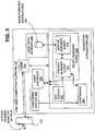
- FIG. 2is a block diagram showing some of the software components of the navigation services provider 128. Included on the navigation services server 120 of the navigation services provider 128 are server applications 200. One of the server applications 200 is a communications application 212. The communications application 212 interfaces with the data network 170 in order to receive messages from and send messages to the end users. The communications application 212 may also maintain and manage communications sessions with the end users.
- the navigation-related applications 216use the geographic database 122 associated with the navigation services server 120 in order to provide the various different types of navigation-related services.
- One of the navigation-related applications 216is a route calculation application 220. Given data that identify the positions of an origin and destination, the route calculation application 220 calculates a route between the origin and the destination.
- the route calculation application 220may use any of various means or algorithms for this purpose. Methods for calculating routes are disclosed in U.S. Pat. No. 6,192,314 , (The methods disclosed in the aforementioned patent represent only some of the ways that routes can be calculated and the claimed subject matter herein is not limited to any particular method of route calculation. Any suitable route calculation method now known or developed in the future may be employed.)
- the route calculation application 220provides an output in the form of a list identifying a continuous series of roads (or segments thereof) that form a legally valid solution route between an origin and a destination.
- a "legally valid solution route"conforms to known traffic restrictions, such as one way streets, turn restrictions, etc.
- the method used by the route calculation application 220may be designed to optimize the solution route to meet one or more predetermined criteria. Such criteria may include the least travel time, the shortest distance, the fewest turns, etc. If the method used by the route calculation application 220 is designed to find a solution route that is optimized for one or more criteria, then the solution route also ideally meets these one or more criteria.
- the route guidance server application 22?uses the output from the route calculation application 220 to provide instructions for the end user to travel to the desired destination. Methods for providing route guidance using geographic data are disclosed in U.S. Pat. No. 6,199,013 ,
- the route guidance server application 222provides instructions to end users dynamically. According to this feature, when an end user is provided with instructions for traveling to a destination, the instructions are provided at appropriate times and/or locations as the end user progresses toward the destination. As an example, according to this feature, as the end user approaches an intersection at which a right turn is required, the end user is provided with an instruction "TURN RIGHT AT NEXT INTERSECTION.”
- the end user's computing platformincludes positioning equipment, such as a GPS system, inertial sensors, wheel pulse sensors, etc. Using this equipment, the end user's computing platform determines the position of the end user. Data that indicate the end user's position are transmitted to the navigation services provider. Using the data that indicate the end user's position, the route guidance server application 222 on the navigation services server 120 determines, the appropriate time and location at which to provide a maneuvering instruction. When the end user approaches the position at which the maneuvering instruction is appropriate, the route guidance server application 222 sends data from which the maneuver can be explicated to the end user. When the data from which the maneuver can be explicated are received on the end user's computing platform, an application (i.e., the route guidance client application 270, described below) on the end user's computing platform uses the data to provide the maneuvering instruction to the end user.
- positioning equipmentsuch as a GPS system, inertial sensors, wheel pulse sensors, etc.
- the route guidance server application 222 on the navigation services server 120determines several maneuvers required to be made by the end user in order to travel along a route to the desired destination.
- the navigation service serversends data from which these maneuvers can be explicated to the end user.
- the navigation services serveralso sends data that describe the route.
- the data that describe the routeindicate the road segm ⁇ nts that form the route.
- the end user's computing platformreceives the data indicating the route and the data from which maneuvers along the route can be explicated and stores these data locally.
- the end user's computing platformmay have positioning equipment, such as a GPS system, inertial sensors, etc.
- An application on the end user's platformuses the data received from the navigation services server to determine the end user's position along the route. Using this information, the application on the end user's computing platform (i.e., the route guidance client application 270, described below) determines the appropriate time and location to provide each maneuvering instruction to the end user.
- the route guidance server application 222 on the navigation serveris capable of providing route guidance dynamically. For example, if changes in traffic conditions affect a route along which an end user is being guided, the route calculation application 220 can calculate a new route. Then, the route guidance server application 222 provides the end user with driving instructions for following the new route that takes into account the changes in traffic conditions.
- the backup driving instructions application 225may be part of the route guidance server application 222 or may be a standalone application.
- the backup driving instructions application 225is described in more detail below.
- the navigation services server 120may include other applications 228.
- the route calculation application 220, the route guidance application 222, the backup driving instructions application 225 and the other applications 228use data from the geographic database 122.
- the geographic database 122includes data representing the roads and intersections in the geographic region (100 in Figure 1 ) and also includes information relating to the represented roads and intersections, such as turn restrictions at intersections, speed limits along the roads, street names of the various roads, address ranges along the roads, and so on.
- the geographic database 122also contains information about points of interest, businesses and other information.
- the geographic database 122may be organized to facilitate performing navigation-related functions. Methods of organizing a geographic database to enhance the performance of certain navigation-related functions are described in U.S. Pat. Nos. 5,974,419 , 5,968,109 and 5,953,722
- Figure 3is a block diagram showing some of the components of one of the end user's computing platforms 130.
- Different end user computing platformsmay have different hardware and software, and accordingly, the navigation-related functions that are performed on the end users' computing platforms may vary from one end user platform to another.
- the end user's computing platform shown in Figure 3represents an exemplary embodiment. It is understood that not all end user computing platforms may necessarily provide all the functions of the embodiment in Figure 3 and that some end user computing platforms may provide additional or other functions.
- the exemplary end user's computing platform 130includes a communications system 250.
- the communications system 250 in the end user's computing platform 130includes the hardware and software components needed to receive messages from and send messages to the navigation server (120 in Figures 1 and 2 ) over the data network 170.
- the communications system 250interfaces with other components in the end user's computing platform 130.
- the end user's computing platform 130also includes a user interface 256.
- the user interface 256allows the end user to provide input to and receive information from the end user's computing platform 130.
- the user interface 256includes hardware and software components.
- the user interface 256may include a display, a microphone, speakers, a keypad, or other kinds of means for inputting information into the computing platform and outputting information therefrom.
- the user interface 256includes supporting software that may provide menus, prompts, audio, etc.
- the user interface 256interfaces with other components in the end user's computing platform 130.
- the navigation-related applications 260use the geographic data obtained from the navigation server 120 to provide various different types of navigation-related services, including route guidance.
- One of the navigation-related applications 260is a positioning application 264.
- the positioning application 264uses the geographic data obtained from the navigation server 120 to determine the position of the end user's computing platform 130 relative to data representing the road network.
- the positioning application 264may also obtain data from a positioning system 268 that is part of the end user's computing platform 130.
- the positioning system 268may use GPS, dead-reckoning, or a combination of these or other technologies to determine the location of the end user's computing platform 130. Methods for performing positioning are disclosed in U.S. Pat. No.6, 192,312 ,
- the positioning application 264is optional, i.e., not all end users' computing platforms may provide for or support positioning.
- the route guidance client application 270uses data from the navigation server 120 to provide instructions to the end user in order to travel to the destination to which a route has been calculated by the route calculation application 220 on the navigation services server 120.
- the route guidance client application 270includes two parts. One part of the route guidance client application 270 is the dynamic route guidance client application 272. The other part of the route guidance client application is the backup driving instructions client application 274.
- the dynamic route guidance client application 272uses the dynamic route guidance data provided by the route guidance server application 222. Using the dynamic route guidance data provided by the route guidance server application 222, the dynamic route guidance client application 272 provides route guidance to the end user as the end user follows the calculated route. As an example, using the dynamic route guidance data from the route guidance server application 222, the dynamic route guidance client application 272 explicates a single upcoming maneuver to the end user as the end user approaches the location at which the maneuver is required to be made.
- the backup driving instructions client application 274 on the end user's computing platform 130uses the backup driving instruction data provided by the backup driving instructions application 225. Using the backup driving instructions provided by the backup driving instructions application 225, the backup driving instructions client application 274 provides backup route guidance to the end user. As an example, the backup driving instructions may include text descriptions of all the maneuvers that the driver is required to make in order to reach the destination. The backup driving instructions may not be provided dynamically to the end user by the backup driving instructions client application 274. Instead, the backup driving instructions client application 274 may provide the backup driving instructions for the entire route all at once.
- map display application 280uses data from the navigation services server 120 to provide maps graphically on the display screen of the user interface 256 of the end user's computing platform.
- the mapsmay show the area around the location of the end user's computing platform, the area along a route that the end user is following, the area around a location specified by the end user, or any other specified area.
- Figure 4shows a process 300 performed by the navigation system 110 (in Figure 1 ) to provide end users with dynamic route guidance and, in addition, to provide end users with backup driving instructions.
- the end userWhen an end user wants to receive guidance for traveling to a destination, the end user first operates hislher computing platform to establish a communications link to the navigation services server 120 over the wireless network 176 (Steps 304 and 308).
- the end userAfter establishing a wireless communications link, the end user determines a destination (and possibly an origin) and transmits data indicating the origin and destination to the navigation services server (Step 312).
- the end userspecifies an address.
- the end userspecifies a type of point of interest (e.g., a restaurant, hotel, gas station, etc.), whereupon the navigation services service finds one or more points of interest of the specified type in proximity to the location of the end user.
- the end usermay exchange information with the navigation services server.
- the end usermay specify an origin by address.
- the originis the end user's current location
- data from the positioning application (264 in Figure 3 ) or positioning system (268 in Figure 3 )may be used to indicate the origin.
- the navigation services server 120After the navigation services server 120 receives the data 316 indicating the origin and destination (Step 320), the navigation services server 120 calculates a solution route from the origin to the destination (Step 324). The navigation services server 120 uses the route calculation application (220 in Figure 2 ) for this purpose. After calculating the solution route, the navigation services server 120 sends data to the end user from which the end user can be provided with guidance for following the route (Step 328). The navigation services server 120 sends two types of data: dynamic route guidance data 332 and backup driving instruction data 336.
- the dynamic route guidance data 332are used to provide the end user with maneuvering instructions at appropriate locations along the solution route.
- the dynamic route guidance data 332may include relatively detailed instructions.
- the dynamic route guidance data 332may include map data from which a map of the area around the end user's location can be rendered on the display of the end user's computing platform.
- the dynamic route guidance data 332may also include positioning data relating to the solution route. The positioning data indicate the coordinates of the road segments that form the solution route as well as the coordinates of some road segments located close to the solution route.
- the dynamic route guidance data 332 sent by the navigation services server 120does not include guidance for the entire route. Instead, the dynamic route guidance data 332 pertain to only the next maneuver or the next several maneuvers that the end user is required to make.
- the other type of data sent by the navigation services server 120is backup driving instructions data 336.
- the backup driving instructions data 336include driving instructions for the entire route. However, the backup driving instructions data 336 may include less detail than the dynamic route guidance. For example, the backup driving instructions data 336 may include only text descriptions of the maneuvers that the end user is required to make.
- the end userreceives the dynamic route guidance data 332 and the backup data 336 sent by the navigation services server 120 (Step 340).
- the backup guidance client 274 on the end user's computing platform 130stores the backup driving instructions data 336 in a re-writable data storage device 348 (Step 344).
- the re-writable data storage device 348may be a flash memory, a hard disk, etc.
- the dynamic route guidance client 272 on the end user's computing platform 130uses the dynamic route guidance data 332 to provide maneuvering instructions to the end user (Step 352).
- the dynamic route guidance instructionsmay include audio or visual instructions that indicate the next maneuver required in order to follow the route.
- the instructionsmay be presented to the end user as the end user approaches the location of the required maneuver.
- the dynamic route guidance client 272may receive input from the positioning application 264 for this purpose.
- the dynamic route guidancemay also use the data 332 for the presentation of a map on the display screen of the user interface 256.
- the dynamic route guidance client 272may use the map display application 280 for presentation of the map.
- the map shown by the dynamic route guidance client 272shows the area around the end user.
- the required maneuvermay be superimposed on the map.
- Figure 5shows an example of the presentation of dynamic route guidance to the end user.
- Figure 5shows the display screen 360 of the end user's computing platform 130.
- On the display screen 360is a map 362 showing the area around the end user's location 366.
- a message 368is shown on the map 362 indicating the required maneuver.
- the required maneuveris also illustrated graphically, by means of an arrow 370 superimposed on the map 362.
- the route guidance client application 270determines whether the vehicle is still on the route (Step 378).
- the route guidance client application 270sends data 380 indicating the vehicle position to the navigation services server 120 (Step 382).
- the navigation services server 120receives the data 380 indicating the vehicle position (Step 386).
- the navigation services server 120determines the appropriate upcoming maneuver and transmits data 388 indicating the appropriate upcoming maneuver to the end user's computing platform (Step 396).
- the data 388 sent by the navigation services serverare dynamic route guidance data and accordingly are similar to the dynamic route guidance data 332 that have been sent previously.
- the end user's computing platformwaits to receive the new dynamic route guidance data 388 (Step 400). If the dynamic route guidance data 388 are received (Step 404), the dynamic route guidance client 272 uses the data 388 to present the end user with new route guidance instructions regarding the next maneuver (Steps 408 and 412). Then, the process 300 continues by looping back to the step (Step 378) in which the route guidance client 270 determines whether the end user is still on the route.
- the end user's computing platform 130may not receive new dynamic route guidance data from the navigation services server. This may occur for various reasons. For example, the end user may travel outside the coverage area of the wireless network (172 in Figure 1 ). Alternatively, there may be heavy communications traffic on the network (176 in Figure 1 ) that causes delays. According to another alternative, there may be equipment malfunctions or maintenance that temporarily interrupts communications between the end user's computing platform and the navigation services server. Regardless of the reason, if the end user's computing platform does not receive new dynamic route guidance data from the navigation services server, the backup driving guidance client 274 retrieves the backup driving instructions data 336 from the data storage 348 (Steps 404 and 416). Then, the backup guidance client 274 uses the backup driving instructions 336 to provide route guidance to the end user (Step 412).
- the backup guidance client 274When the backup guidance client 274 provides route guidance to the end user, the guidance is not as detailed as the route guidance provided by the dynamic route guidance client 272. For example, the backup guidance client 274 may provide only text descriptions of the required maneuvers to the end user. In addition, when the backup guidance client 274 provides route guidance to the end user, the backup driving instructions may not be presented one at a time as the locations at which the maneuvers required to be made are being approached. Instead, when the backup guidance client 274 provides route guidance to the end user, the backup driving instructions may be provided to the end user all at once.
- Figure 6shows an example of the presentation of backup driving instructions to the end user.
- Figure 6shows the display screen 360 of the end user's computing platform 130.
- On the display screen 360is a listing 430 of each of the maneuvers required to follow the route.
- a message 434is displayed indicating that backup driving instructions are being presented.
- the display screen 360may include as many instructions that can reasonably fit on the screen. The rest of the instructions may be viewed by scrolling through the list 430, e.g., using controls on the user interface 256.
- the process 300loops back to the steps in which a determination is made whether the vehicle is still on the route (Step 378), the vehicle position is sent to the navigation services server (Step 382), and new dynamic route guidance data from the navigation services server is expected (Step 400). If communications with the navigation services server are reestablished, new dynamic route guidance data are obtained from the navigation services server and dynamic route guidance is provided to the end user (Steps 400, 404, 408, and 412). Otherwise, if communications with the navigation services server are not reestablished, the backup guidance client 274 continues to present the backup driving instructions to the end user (Step 412).
- some end user computing platformsincluded a positioning system and/or a positioning application by which the location of the end user's computing platform could be determined.
- the location of an end usercan be determined by a positioning system located outside the end user's computing platform.
- Systems for determining the position of a user of a wireless communications deviceare known. For example, there are systems that can determine the positions of users of cellular phones. These systems may determine the location of a cellular phone user who requests emergency service, e.g., "emergency 911 service.” These systems use various technologies, such as triangulation, time-of-arrival, etc., in order to determine a position of a cellular phone user.
- ArrayComrn, Inc.Harris Corporation, Corsair Communications, Lockheed Martin Corporation, CELLTRAX, Inc., TruePosition, Inc., Cell-Loc Inc., KSI Inc., and U.S. Wireless Corporation. Any such technology that is presently available or that becomes available in the future may be suitable for the positioning system.
Landscapes
- Engineering & Computer Science (AREA)
- Radar, Positioning & Navigation (AREA)
- Remote Sensing (AREA)
- Automation & Control Theory (AREA)
- Physics & Mathematics (AREA)
- General Physics & Mathematics (AREA)
- Navigation (AREA)
- Instructional Devices (AREA)
- Traffic Control Systems (AREA)
Description
- The present invention relates to navigation systems, and more particularly, the present invention relates to a feature provided by a navigation system whereby a user of the system is provided with backup driving instructions.
- There are various computer architectures for navigation systems that provide navigation-related features (including map-related features). In one type of architecture for a navigation system, end users (such as vehicle drivers, passengers, and others) use a wireless communications system to obtain navigation-related services or data from a remotely located navigation services provider. The end users use various computer platforms (e.g., different kinds of electronic devices and/or systems) to connect to the wireless communications system in order to access the remotely located navigation service provider. Associated with the remotely located navigation services provider is a geographic database. When an end user uses hislher computer platform to request a navigation-related service or data, the remotely located navigation service provider accesses the geographic database associated therewith and then provides the requested service or data to the requesting end user's computer platform via the wireless communications system.
- This type of navigation system architecture provides several advantages. One advantage relates to providing updated data. There is a continuing need to update the data used by a navigation system. For example, new streets are built, road construction closes roads, detours are established, new businesses open, posted speed limits change, new turn restrictions are established at intersections, streets are renamed, and so on.
- These kinds of changes can affect travel through a geographic region. Accordingly, the data used by a navigation system should be updated on a regular basis to accurately reflect changes in the represented geographic features. A computer architecture in which end user computing platforms obtain data wirelessly from a single central geographic database associated with a navigation services provider affords ∼ advantage with respect to the updating of the geographic data. With such a computer architecture, updates need to be applied only to the central database.
- Although there are advantages associated with a navigation system architecture in which individual end user computer platforms request and obtain navigation-related services and data wirelessly from a single central geographic database associated with a navigation services provider, there are considerations to be addressed. One consideration relates to the need for continuous availability of navigation-related services and data wirelessly. According to one type of navigation system architecture, a navigation services provider provides navigation-related services and data to an end user while the end user is traveling within a coverage area. A wireless communications system, associated with the navigation services provider, is available continuously (or relatively continuously) throughout the coverage area. End users located throughout the coverage area use their computing devices to access the wireless communications system in order to obtain navigation-related services and data from the navigation services provider.
- According to this type of system, each end user maintains one or more relatively continuous sessions with the navigation services provider. During each session, the end user and the navigation services provider may exchange several data messages. As an example, the end user may communicate a message to the navigation services provider requesting driving instructions for traveling to a destination. In response, the navigation services provider sends a message that includes instructions for starting on the route to the destination. As the end user follows the route, the end user sends additional messages to the navigation services provider. Each additional message from the end user to the navigation services provider may include an update of the end user's position as he/she proceeds along the route. As messages from the end user are received by the navigation services provider, the navigation services provider prepares and sends new messages containing additional instructions for continuing along the route. In this manner, the navigation services provider can provide the end user with instructions that are timely and relevant with respect to the end user's progress along the route. With this type of system, it is not necessary that the end user and navigation services provider maintain a continuous communications link. However, if communications between the end user and the navigation services provider are interrupted for a relatively long period of time, the end user may not have downloaded sufficient information from the navigation services provider for continuing further along the calculated route toward the destination. Interruptions in communications between end users and the navigation services provider may occur for various reasons, such as equipment failure, heavy usage, and so on. The interruption of navigation-related services may be inconvenient for some end users. Accordingly, it would be preferable to reduce or minimize any inconvenience to end users of this navigation system architecture occasioned by the lack of navigation-related services.
WO 99/09374 FR2762906 - To address these and other objectives, the present invention comprises a method of operation for an end user's mobile computing device as claimed in
claim 1, an end user's mobile computing device as claimed in claim 10 and a computer program as claimed in claim 12. Users of the systems are provided with backup driving instructions. A wireless communications system allows end users' computing devices to receive dynamic route guidance from a remotely located navigation services provider. The dynamic route guidance provides each end user with maneuvering instructions at appropriate locations along a route to a desired destination. In addition to the dynamic route guidance, the navigation service provider also provides each end user with backup driving instruction data. The backup driving instruction data are used to provide each end user with backup driving instructions for traveling to the end user's desired destination. The backup driving instruction data are used in case wireless communications between the end user and the navigation services provider are interrupted. Figure 1 is a map showing a geographic region and components of a navigation system that services the geographic region.Figure 2 is a block diagram showing components of the navigation services provider shown inFigure 1 .Figure 3 is a block diagram showing components of one of the end user's computing platforms shown inFigure 1 .Figure 4 is a flow chart showing some of the steps performed by the navigation system ofFigure 1 .Figure 5 is an illustration showing an example of dynamic guidance being presented on the display screen of one of the end users' computing platforms ofFigure 1 .Figure 6 is an illustration showing an example of backup driving instructions being presented on the display screen of one of the end users' computing platforms ofFigure 1 .Figure 1 shows ageographic region 100. Thegeographic region 100 may correspond to a metropolitan or rural area, a state, a country, or combinations thereof, or any other area of comparable size. Located in thegeographic region 100 is a road network 104.- A
navigation system 110 serves end users (e.g., vehicle drivers and passengers, as well as other persons) in thegeographic region 100. Thenavigation system 110 is used by the end users to obtain navigation-related services (including map-related services) with respect to thegeographic region 100. The navigation-related services include information about travel along the road network 104, including route calculation and guidance, people and business finding services (e.g., electronic yellow and white pages), maps, point of interest searching, destination selection, and so on. - The
navigation system 110 is a combination of hardware, software and data. Thenavigation system 110 includes remote components (i.e., hardware, software or data located at a central location remote from the end users) and local components (i.e., hardware, software, or data located physically with each end user). - Included among the remote components of the
navigation system 110 is anavigation services server 120. Associated with thenavigation services server 120 is ageographic database 122. Thenavigation services server 120 and thegeographic database 122 are maintained and operated by anavigation services provider 128. - The local components of the
navigation system 110 include thevarious computer platforms 130 operated by the end users to request and obtain n∼vigation-related and map-related features and geographic data from thenavigation services provider 128. These various computer platforms 130 (also referred to as "end user computing platforms" or "client computing platforms") may includenavigation system units 132 located invehicles 134,personal computers 140, personal organizers (e.g., PDAs, PalmPilot®-type devices) 150,portable phones 160, or any other types of computing device that has the appropriate hardware and software to access thenavigation services provider 128 over adata network 170. - The
data network 170 may use any suitable technology and/or protocols that are currently available, as well as technology and/or protocols that become available in the future. For example, the data network may use WAP, TCPIIP, etc. More than one protocol may be used in thedata network 170 with appropriate conversions. Thedata network 170 may be part of, or connected to, the Internet. - A portion of the
network 170 may include awireless portion 172. Thewireless portion 172 of thedata network 170 enables two-way communication between the mobile enduser computing platforms 130 and theservice provider 128. Thewireless portion 172 may be implemented by any suitable form of wireless communication, including cellular, PCS, satellite, FM, radio, or technologies that may be developed in the future. Thewireless portion 172 may include one ormore transmitters 174, such as a transponder tower, an antenna tower, an FM tower, satellites, or other suitable means. Thetransmitters 174 include anappropriate communication link 176 to thenetwork 170 and/orservice provider 128. Thislink 176 may be land-based or may be wireless. Thetransmitters 174 include suitable technology that enables two-way communication between theservice provider 128 and the mobile enduser computing platforms 130. - The
navigation system 110 ofFigure 1 can accommodate different types of enduser computing platforms 130. Thenavigation system 110 ofFigure 1 allows end users who have different types ofcomputing platforms 130 to obtain navigation services from thenavigation services provider 128 and to obtain and use geographic data provided from thenavigation services provider 128. Figure 2 is a block diagram showing some of the software components of thenavigation services provider 128. Included on thenavigation services server 120 of thenavigation services provider 128 areserver applications 200. One of theserver applications 200 is acommunications application 212. Thecommunications application 212 interfaces with thedata network 170 in order to receive messages from and send messages to the end users. Thecommunications application 212 may also maintain and manage communications sessions with the end users.- Included among the
server applications 200 are navigation-related applications 216. The navigation-related applications 216 use thegeographic database 122 associated with thenavigation services server 120 in order to provide the various different types of navigation-related services. One of the navigation-related applications 216 is aroute calculation application 220. Given data that identify the positions of an origin and destination, theroute calculation application 220 calculates a route between the origin and the destination. Theroute calculation application 220 may use any of various means or algorithms for this purpose. Methods for calculating routes are disclosed inU.S. Pat. No. 6,192,314 , (The methods disclosed in the aforementioned patent represent only some of the ways that routes can be calculated and the claimed subject matter herein is not limited to any particular method of route calculation. Any suitable route calculation method now known or developed in the future may be employed.) - Regardless of the method used, the
route calculation application 220 provides an output in the form of a list identifying a continuous series of roads (or segments thereof) that form a legally valid solution route between an origin and a destination. A "legally valid solution route" conforms to known traffic restrictions, such as one way streets, turn restrictions, etc. The method used by theroute calculation application 220 may be designed to optimize the solution route to meet one or more predetermined criteria. Such criteria may include the least travel time, the shortest distance, the fewest turns, etc. If the method used by theroute calculation application 220 is designed to find a solution route that is optimized for one or more criteria, then the solution route also ideally meets these one or more criteria. - Another of the navigation applications 216 on the
server 120 is a routeguidance server application 222. The route guidance server application 22? uses the output from theroute calculation application 220 to provide instructions for the end user to travel to the desired destination. Methods for providing route guidance using geographic data are disclosed inU.S. Pat. No. 6,199,013 , - The route
guidance server application 222 provides instructions to end users dynamically. According to this feature, when an end user is provided with instructions for traveling to a destination, the instructions are provided at appropriate times and/or locations as the end user progresses toward the destination. As an example, according to this feature, as the end user approaches an intersection at which a right turn is required, the end user is provided with an instruction "TURN RIGHT AT NEXT INTERSECTION." - There are several ways that can be used by the route
guidance server application 222 to support this feature. According to one embodiment, the end user's computing platform includes positioning equipment, such as a GPS system, inertial sensors, wheel pulse sensors, etc. Using this equipment, the end user's computing platform determines the position of the end user. Data that indicate the end user's position are transmitted to the navigation services provider. Using the data that indicate the end user's position, the routeguidance server application 222 on thenavigation services server 120 determines, the appropriate time and location at which to provide a maneuvering instruction. When the end user approaches the position at which the maneuvering instruction is appropriate, the routeguidance server application 222 sends data from which the maneuver can be explicated to the end user. When the data from which the maneuver can be explicated are received on the end user's computing platform, an application (i.e., the routeguidance client application 270, described below) on the end user's computing platform uses the data to provide the maneuvering instruction to the end user. - According to an alternative mode of operation, the route
guidance server application 222 on thenavigation services server 120 determines several maneuvers required to be made by the end user in order to travel along a route to the desired destination. The navigation service server sends data from which these maneuvers can be explicated to the end user. The navigation services server also sends data that describe the route. The data that describe the route indicate the road segm∼nts that form the route. The end user's computing platform receives the data indicating the route and the data from which maneuvers along the route can be explicated and stores these data locally. The end user's computing platform may have positioning equipment, such as a GPS system, inertial sensors, etc. An application on the end user's platform (e.g., thepositioning application 264, described below) uses the data received from the navigation services server to determine the end user's position along the route. Using this information, the application on the end user's computing platform (i.e., the routeguidance client application 270, described below) determines the appropriate time and location to provide each maneuvering instruction to the end user. - As stated above, the route
guidance server application 222 on the navigation server is capable of providing route guidance dynamically. For example, if changes in traffic conditions affect a route along which an end user is being guided, theroute calculation application 220 can calculate a new route. Then, the routeguidance server application 222 provides the end user with driving instructions for following the new route that takes into account the changes in traffic conditions. - Another of the navigation applications 216 on the
server 120 is a backup drivinginstructions application 225. The backup drivinginstructions application 225 may be part of the routeguidance server application 222 or may be a standalone application. The backup drivinginstructions application 225 is described in more detail below. - The
navigation services server 120 may includeother applications 228. - In order to provide navigation-related features, the
route calculation application 220, theroute guidance application 222, the backup drivinginstructions application 225 and theother applications 228 use data from thegeographic database 122. Thegeographic database 122 includes data representing the roads and intersections in the geographic region (100 inFigure 1 ) and also includes information relating to the represented roads and intersections, such as turn restrictions at intersections, speed limits along the roads, street names of the various roads, address ranges along the roads, and so on. Thegeographic database 122 also contains information about points of interest, businesses and other information. Thegeographic database 122 may be organized to facilitate performing navigation-related functions. Methods of organizing a geographic database to enhance the performance of certain navigation-related functions are described inU.S. Pat. Nos. 5,974,419 ,5,968,109 and5,953,722 Figure 3 is a block diagram showing some of the components of one of the end user'scomputing platforms 130. Different end user computing platforms may have different hardware and software, and accordingly, the navigation-related functions that are performed on the end users' computing platforms may vary from one end user platform to another. The end user's computing platform shown inFigure 3 represents an exemplary embodiment. It is understood that not all end user computing platforms may necessarily provide all the functions of the embodiment inFigure 3 and that some end user computing platforms may provide additional or other functions.- Referring to
Figure 3 , the exemplary end user'scomputing platform 130 includes acommunications system 250. Thecommunications system 250 in the end user'scomputing platform 130 includes the hardware and software components needed to receive messages from and send messages to the navigation server (120 inFigures 1 and2 ) over thedata network 170. Thecommunications system 250 interfaces with other components in the end user'scomputing platform 130. - The end user's
computing platform 130 also includes auser interface 256. Theuser interface 256 allows the end user to provide input to and receive information from the end user'scomputing platform 130. Theuser interface 256 includes hardware and software components. For example, theuser interface 256 may include a display, a microphone, speakers, a keypad, or other kinds of means for inputting information into the computing platform and outputting information therefrom. Theuser interface 256 includes supporting software that may provide menus, prompts, audio, etc. Theuser interface 256 interfaces with other components in the end user'scomputing platform 130. - Included on the end user's
computing platform 130 are navigation-related applications 260. The navigation-related applications 260 use the geographic data obtained from thenavigation server 120 to provide various different types of navigation-related services, including route guidance. One of the navigation-related applications 260 is apositioning application 264. The positioning application 264.uses the geographic data obtained from thenavigation server 120 to determine the position of the end user'scomputing platform 130 relative to data representing the road network. Thepositioning application 264 may also obtain data from apositioning system 268 that is part of the end user'scomputing platform 130. Thepositioning system 268 may use GPS, dead-reckoning, or a combination of these or other technologies to determine the location of the end user'scomputing platform 130. Methods for performing positioning are disclosed inU.S. Pat. No.6, 192,312 , - The
positioning application 264 is optional, i.e., not all end users' computing platforms may provide for or support positioning. - Another of the navigation applications 260 on the end user's computing platform is a route
guidance client application 270. The routeguidance client application 270 uses data from thenavigation server 120 to provide instructions to the end user in order to travel to the destination to which a route has been calculated by theroute calculation application 220 on thenavigation services server 120. The routeguidance client application 270 includes two parts. One part of the routeguidance client application 270 is the dynamic routeguidance client application 272. The other part of the route guidance client application is the backup drivinginstructions client application 274. - The dynamic route
guidance client application 272 uses the dynamic route guidance data provided by the routeguidance server application 222. Using the dynamic route guidance data provided by the routeguidance server application 222, the dynamic routeguidance client application 272 provides route guidance to the end user as the end user follows the calculated route. As an example, using the dynamic route guidance data from the routeguidance server application 222, the dynamic routeguidance client application 272 explicates a single upcoming maneuver to the end user as the end user approaches the location at which the maneuver is required to be made. - The backup driving
instructions client application 274 on the end user'scomputing platform 130 uses the backup driving instruction data provided by the backup drivinginstructions application 225. Using the backup driving instructions provided by the backup drivinginstructions application 225, the backup drivinginstructions client application 274 provides backup route guidance to the end user. As an example, the backup driving instructions may include text descriptions of all the maneuvers that the driver is required to make in order to reach the destination. The backup driving instructions may not be provided dynamically to the end user by the backup drivinginstructions client application 274. Instead, the backup drivinginstructions client application 274 may provide the backup driving instructions for the entire route all at once. - Another of the navigation applications 620 on the end user's computing platform is a
map display application 280. Themap display application 280 uses data from thenavigation services server 120 to provide maps graphically on the display screen of theuser interface 256 of the end user's computing platform. The maps may show the area around the location of the end user's computing platform, the area along a route that the end user is following, the area around a location specified by the end user, or any other specified area. Methods for performing map display using geographic data are disclosed inU.S. Pat. Nos. 6,092,076 and6,163,749 , Figure 4 shows aprocess 300 performed by the navigation system 110 (inFigure 1 ) to provide end users with dynamic route guidance and, in addition, to provide end users with backup driving instructions.- When an end user wants to receive guidance for traveling to a destination, the end user first operates hislher computing platform to establish a communications link to the
navigation services server 120 over the wireless network 176 (Steps 304 and 308). - After establishing a wireless communications link, the end user determines a destination (and possibly an origin) and transmits data indicating the origin and destination to the navigation services server (Step 312). There are several different ways that the end user can use to determine a desired destination. According to one example, the end user specifies an address. According to another example, the end user specifies a type of point of interest (e.g., a restaurant, hotel, gas station, etc.), whereupon the navigation services service finds one or more points of interest of the specified type in proximity to the location of the end user. When determining a destination, the end user may exchange information with the navigation services server.
- When specifying an origin, the end user may specify an origin by address. Alternatively, if the origin is the end user's current location, data from the positioning application (264 in
Figure 3 ) or positioning system (268 inFigure 3 ) may be used to indicate the origin. - After the
navigation services server 120 receives thedata 316 indicating the origin and destination (Step 320), thenavigation services server 120 calculates a solution route from the origin to the destination (Step 324). Thenavigation services server 120 uses the route calculation application (220 inFigure 2 ) for this purpose. After calculating the solution route, thenavigation services server 120 sends data to the end user from which the end user can be provided with guidance for following the route (Step 328). Thenavigation services server 120 sends two types of data: dynamicroute guidance data 332 and backup drivinginstruction data 336. - The dynamic
route guidance data 332 are used to provide the end user with maneuvering instructions at appropriate locations along the solution route. The dynamicroute guidance data 332 may include relatively detailed instructions. As an example, the dynamicroute guidance data 332 may include map data from which a map of the area around the end user's location can be rendered on the display of the end user's computing platform. The dynamicroute guidance data 332 may also include positioning data relating to the solution route. The positioning data indicate the coordinates of the road segments that form the solution route as well as the coordinates of some road segments located close to the solution route. - The dynamic
route guidance data 332 sent by thenavigation services server 120 does not include guidance for the entire route. Instead, the dynamicroute guidance data 332 pertain to only the next maneuver or the next several maneuvers that the end user is required to make. - The other type of data sent by the
navigation services server 120 is backup drivinginstructions data 336. The backup drivinginstructions data 336 include driving instructions for the entire route. However, the backup drivinginstructions data 336 may include less detail than the dynamic route guidance. For example, the backup drivinginstructions data 336 may include only text descriptions of the maneuvers that the end user is required to make. - The end user receives the dynamic
route guidance data 332 and thebackup data 336 sent by the navigation services server 120 (Step 340). Thebackup guidance client 274 on the end user'scomputing platform 130 stores the backup drivinginstructions data 336 in a re-writable data storage device 348 (Step 344). The re-writabledata storage device 348 may be a flash memory, a hard disk, etc. - The dynamic
route guidance client 272 on the end user'scomputing platform 130 uses the dynamicroute guidance data 332 to provide maneuvering instructions to the end user (Step 352). The dynamic route guidance instructions may include audio or visual instructions that indicate the next maneuver required in order to follow the route. The instructions may be presented to the end user as the end user approaches the location of the required maneuver. The dynamicroute guidance client 272 may receive input from thepositioning application 264 for this purpose. The dynamic route guidance may also use thedata 332 for the presentation of a map on the display screen of theuser interface 256. The dynamicroute guidance client 272 may use themap display application 280 for presentation of the map. The map shown by the dynamicroute guidance client 272 shows the area around the end user. The required maneuver may be superimposed on the map. Figure 5 shows an example of the presentation of dynamic route guidance to the end user.Figure 5 shows thedisplay screen 360 of the end user'scomputing platform 130. On thedisplay screen 360 is amap 362 showing the area around the end user'slocation 366. Amessage 368 is shown on themap 362 indicating the required maneuver. The required maneuver is also illustrated graphically, by means of anarrow 370 superimposed on themap 362.- After the dynamic
route guidance client 272 presents the end user with instructions about a maneuver, the routeguidance client application 270 determines whether the vehicle is still on the route (Step 378). The routeguidance client application 270 sendsdata 380 indicating the vehicle position to the navigation services server 120 (Step 382). Thenavigation services server 120 receives thedata 380 indicating the vehicle position (Step 386). Using thedata 380 indicating the current vehicle position, thenavigation services server 120 determines the appropriate upcoming maneuver and transmitsdata 388 indicating the appropriate upcoming maneuver to the end user's computing platform (Step 396). Thedata 388 sent by the navigation services server are dynamic route guidance data and accordingly are similar to the dynamicroute guidance data 332 that have been sent previously. - The end user's computing platform waits to receive the new dynamic route guidance data 388 (Step 400). If the dynamic
route guidance data 388 are received (Step 404), the dynamicroute guidance client 272 uses thedata 388 to present the end user with new route guidance instructions regarding the next maneuver (Steps 408 and 412). Then, theprocess 300 continues by looping back to the step (Step 378) in which theroute guidance client 270 determines whether the end user is still on the route. - The end user's
computing platform 130 may not receive new dynamic route guidance data from the navigation services server. This may occur for various reasons. For example, the end user may travel outside the coverage area of the wireless network (172 inFigure 1 ). Alternatively, there may be heavy communications traffic on the network (176 inFigure 1 ) that causes delays. According to another alternative, there may be equipment malfunctions or maintenance that temporarily interrupts communications between the end user's computing platform and the navigation services server. Regardless of the reason, if the end user's computing platform does not receive new dynamic route guidance data from the navigation services server, the backup drivingguidance client 274 retrieves the backup drivinginstructions data 336 from the data storage 348 (Steps 404 and 416). Then, thebackup guidance client 274 uses thebackup driving instructions 336 to provide route guidance to the end user (Step 412). - When the
backup guidance client 274 provides route guidance to the end user, the guidance is not as detailed as the route guidance provided by the dynamicroute guidance client 272. For example, thebackup guidance client 274 may provide only text descriptions of the required maneuvers to the end user. In addition, when thebackup guidance client 274 provides route guidance to the end user, the backup driving instructions may not be presented one at a time as the locations at which the maneuvers required to be made are being approached. Instead, when thebackup guidance client 274 provides route guidance to the end user, the backup driving instructions may be provided to the end user all at once. Figure 6 shows an example of the presentation of backup driving instructions to the end user.Figure 6 shows thedisplay screen 360 of the end user'scomputing platform 130. On thedisplay screen 360 is a listing 430 of each of the maneuvers required to follow the route. Amessage 434 is displayed indicating that backup driving instructions are being presented. Thedisplay screen 360 may include as many instructions that can reasonably fit on the screen. The rest of the instructions may be viewed by scrolling through thelist 430, e.g., using controls on theuser interface 256.- After the backup driving instructions are provided to the end user, the
process 300 loops back to the steps in which a determination is made whether the vehicle is still on the route (Step 378), the vehicle position is sent to the navigation services server (Step 382), and new dynamic route guidance data from the navigation services server is expected (Step 400). If communications with the navigation services server are reestablished, new dynamic route guidance data are obtained from the navigation services server and dynamic route guidance is provided to the end user (Steps backup guidance client 274 continues to present the backup driving instructions to the end user (Step 412). - In some of the embodiments described above, it was stated that some end user computing platforms included a positioning system and/or a positioning application by which the location of the end user's computing platform could be determined. According to another embodiment, the location of an end user can be determined by a positioning system located outside the end user's computing platform. Systems for determining the position of a user of a wireless communications device are known. For example, there are systems that can determine the positions of users of cellular phones. These systems may determine the location of a cellular phone user who requests emergency service, e.g., "emergency 911 service." These systems use various technologies, such as triangulation, time-of-arrival, etc., in order to determine a position of a cellular phone user. Some of the companies that provide this type of technology include ArrayComrn, Inc., Harris Corporation, Corsair Communications, Lockheed Martin Corporation, CELLTRAX, Inc., TruePosition, Inc., Cell-Loc Inc., KSI Inc., and U.S. Wireless Corporation. Any such technology that is presently available or that becomes available in the future may be suitable for the positioning system.
- It is intended that the foregoing detailed description be regarded as illustrative rather than limiting and that it is understood that the following claims to define the scope of the invention.
Claims (12)
- A method of operation for an end user's mobile computing device (130) that provides navigation-related services to an end user, the method comprising, on the end user's mobile computing device (130):receiving (340) backup driving instructions data (336) from a remotely located navigation services provider (128) for travelling to a destination along a route;storing the backup driving instructions (336) locally;providing the backup driving instructions (336) to the end user;requesting (312), from the remotely located navigation services provider (128), data for providing dynamic driving instructions for traveling to the destination along the route; obtaining (340) the dynamic driving instructions data (332) from said remotely located navigation services provider (128), wherein the dynamic driving instructions (332) comprise several maneuvering instructions along the route;storing the dynamic driving instructions data (332) locally;providing to the end user, from the local storage, at appropriate times and locations along the route, a maneuvering instruction of the dynamic driving instructions (332);receiving new dynamic driving instructions for following a new route to the destination that takes into account changes in traffic conditions;storing the new dynamic driving instructions locally; andproviding to the end user, from the local storage, at appropriate times and locations along the new route, a maneuvering instruction of the new dynamic driving instructions.
- The method of claim 1, wherein the driving instructions data is received from the remotely located navigation services provider via a wireless communications link.
- The method of any preceding claim, wherein the dynamic driving instructions include audio or visual instructions that indicate the next maneuver required in order to follow the route.
- The method of any preceding claim, wherein the dynamic driving instructions are presented to the end user as the end user approaches the location of the required maneuver.
- The method of any preceding claim wherein the method comprises:on the end user's computing device (130), determining whether the end user's computing device is still on the route to the destination.
- The method of claim 1, wherein the backup driving instructions data includes less detail than the dynamic route instructions.
- The method of claim 1, wherein the method comprises:providing to the end user all of the backup driving instructions at the same time.
- The method of claim 1, wherein the method comprises:providing (412) backup driving instructions using the backup driving instruction data (336), wherein the backup driving instructions are text-based instructions.
- The method of claim 1, wherein the method comprises:providing to the end user the backup driving instructions, wherein the backup driving instructions are not provided dynamically to the end user.
- An end user's mobile computing device, the end user's mobile computing device being configured to:receive (340) backup driving instructions data (336) from a remotely located navigation services provider (128) for travelling to a destination along a route;store the backup driving instructions (336) locally;provide the backup driving instructions (336) to the end user;request (312) from the remotely located navigation services provider (128) data for providing dynamic driving instructions for traveling tc the destination along the route;obtain (340) the dynamic driving instructions data (332) from said remotely located navigation services provider (128), wherein the dynamic driving instructions (332) comprise several maneuvering instructions along the route;store the dynamic driving instructions data (332) locally;provide to the end user, from the local storage, at appropriate times and locations along the route, a maneuvering instruction of the dynamic driving instructions (332);receive new dynamic driving instructions for following a new route to the destination that takes into account changes in traffic conditions;store the new dynamic driving instructions locally; andprovide to the end user, from the local storage, at appropriate times and locations along the route, a maneuvering instruction of the new dynamic driving instructions.
- The end user's mobile computing device of claim 10, wherein said end user's mobile computing device is a vehicle
located navigation system unit (132), a personal computer (140), a personal organizer (150), or a portable phone (160). - A computer program comprising software configured to perform the following steps when run on an end user's mobile computing device (130):receive (340) backup driving instructions data (336) from a remotely located navigation services provider (128) for travelling to a destination along a route;store the backup driving instructions (336) locally;provide the backup driving instructions (336) to the end user;request (3 12) from the remotely located navigation services provider (128) data for providing dynamic driving instructions for traveling to the destination along the route;obtain (340) the dynamic driving instructions data (332) from said remotely located navigation services provider (128), wherein the dynamic driving instructions (332) comprise several maneuvering instructions along the route;store the dynamic driving instructions data (332) locally;provide to the end user, from the local storage, at appropriate times and locations along the route, a maneuvering instruction of the dynamic driving instructions (332);receive new dynamic driving instructions for following a new route to the destination that takes into account changes in traffic conditions;store the new dynamic driving instructions locally; andprovide to the end user, from the local storage, at appropriate times and locations along the new route, a maneuvering instruction of the new dynamic driving instructions.
Applications Claiming Priority (2)
| Application Number | Priority Date | Filing Date | Title |
|---|---|---|---|
| US09/852,879US6725156B2 (en) | 2001-05-10 | 2001-05-10 | Method and system for providing backup driving instructions with a navigation system |
| EP02252803.8AEP1256785B1 (en) | 2001-05-10 | 2002-04-22 | Methods, devices and computer programs for providing a navigation system with backup driving instructions |
Related Parent Applications (2)
| Application Number | Title | Priority Date | Filing Date |
|---|---|---|---|
| EP02252803.8ADivisionEP1256785B1 (en) | 2001-05-10 | 2002-04-22 | Methods, devices and computer programs for providing a navigation system with backup driving instructions |
| EP02252803.8ADivision-IntoEP1256785B1 (en) | 2001-05-10 | 2002-04-22 | Methods, devices and computer programs for providing a navigation system with backup driving instructions |
Publications (3)
| Publication Number | Publication Date |
|---|---|
| EP2738521A2 EP2738521A2 (en) | 2014-06-04 |
| EP2738521A3 EP2738521A3 (en) | 2014-07-09 |
| EP2738521B1true EP2738521B1 (en) | 2017-02-08 |
Family
ID=25314474
Family Applications (3)
| Application Number | Title | Priority Date | Filing Date |
|---|---|---|---|
| EP02252803.8AExpired - LifetimeEP1256785B1 (en) | 2001-05-10 | 2002-04-22 | Methods, devices and computer programs for providing a navigation system with backup driving instructions |
| EP13177112.3AExpired - LifetimeEP2738521B1 (en) | 2001-05-10 | 2002-04-22 | Method and system for providing dynamic driving instructions with a navigation system |
| EP13160479.5AExpired - LifetimeEP2626669B1 (en) | 2001-05-10 | 2002-04-22 | Methods, devices and computer progams for providing backup driving instructions with a distributed navigation system |
Family Applications Before (1)
| Application Number | Title | Priority Date | Filing Date |
|---|---|---|---|
| EP02252803.8AExpired - LifetimeEP1256785B1 (en) | 2001-05-10 | 2002-04-22 | Methods, devices and computer programs for providing a navigation system with backup driving instructions |
Family Applications After (1)
| Application Number | Title | Priority Date | Filing Date |
|---|---|---|---|
| EP13160479.5AExpired - LifetimeEP2626669B1 (en) | 2001-05-10 | 2002-04-22 | Methods, devices and computer progams for providing backup driving instructions with a distributed navigation system |
Country Status (3)
| Country | Link |
|---|---|
| US (1) | US6725156B2 (en) |
| EP (3) | EP1256785B1 (en) |
| JP (1) | JP4180837B2 (en) |
Families Citing this family (26)
| Publication number | Priority date | Publication date | Assignee | Title |
|---|---|---|---|---|
| US20030231755A1 (en)* | 2002-06-18 | 2003-12-18 | Akhteruzzaman | Directory assistance |
| US8977284B2 (en) | 2001-10-04 | 2015-03-10 | Traxcell Technologies, LLC | Machine for providing a dynamic data base of geographic location information for a plurality of wireless devices and process for making same |
| US6545637B1 (en) | 2001-12-20 | 2003-04-08 | Garmin, Ltd. | Systems and methods for a navigational device with improved route calculation capabilities |
| US7277794B1 (en) | 2001-12-21 | 2007-10-02 | Garmin Ltd. | Guidance with feature accounting for insignificant roads |
| US6847890B1 (en) | 2001-12-21 | 2005-01-25 | Garmin Ltd. | Guidance with feature accounting for insignificant roads |
| US6915310B2 (en) | 2002-03-28 | 2005-07-05 | Harris Corporation | Three-dimensional volumetric geo-spatial querying |
| GB2389679B (en)* | 2002-06-14 | 2005-09-07 | Yeoman Group Plc | Mobile navigation |
| US20040044465A1 (en)* | 2002-08-29 | 2004-03-04 | Nesbitt David W. | Automated route determination based on day of route traversal |
| US20040052239A1 (en) | 2002-08-29 | 2004-03-18 | Nesbitt David W. | Automated route determination |
| US7133771B1 (en)* | 2002-08-29 | 2006-11-07 | America Online, Inc. | Automated route determination to avoid a particular maneuver |
| JP4279532B2 (en)* | 2002-10-01 | 2009-06-17 | 株式会社アマダ | Mold apparatus and lower mold for use in processing method of molded product |
| KR100451439B1 (en)* | 2002-10-23 | 2004-10-06 | 에스케이 텔레콤주식회사 | Navigation system and controlling method for the motor vehicle |
| US7474960B1 (en) | 2002-12-30 | 2009-01-06 | Mapquest, Inc. | Presenting a travel route |
| US7321824B1 (en) | 2002-12-30 | 2008-01-22 | Aol Llc | Presenting a travel route using more than one presentation style |
| US7818116B1 (en) | 2002-12-30 | 2010-10-19 | Mapquest, Inc. | Presenting a travel route in a ground-based vehicle |
| DE10323936A1 (en) | 2003-05-24 | 2005-01-27 | Jentro Technologies Gmbh | Navigation system and method |
| KR101128921B1 (en) | 2004-07-09 | 2012-03-27 | 테직 커뮤니케이션 인코포레이티드 | Disambiguating ambiguous characters |
| US7292189B2 (en)* | 2004-09-10 | 2007-11-06 | Worcester Polytechnic Institute | Methods and apparatus for high resolution positioning |
| JP2006184256A (en) | 2004-12-28 | 2006-07-13 | Nissan Motor Co Ltd | GUIDANCE SYSTEM, GUIDANCE METHOD, GUIDE SYSTEM SERVER, GUIDE SYSTEM MOBILE TERMINAL DEVICE, GUIDE INFORMATION PROVIDING PROCESSING PROGRAM, AND GUIDE SYSTEM TERMINAL DEVICE PROGRAM |
| KR101479773B1 (en) | 2007-12-27 | 2015-01-13 | 엘지전자 주식회사 | How to provide navigation device and its turn point list |
| US9683850B2 (en)* | 2009-02-03 | 2017-06-20 | Telenav, Inc. | Method for navigation using adaptive coverage |
| US8301996B2 (en)* | 2009-03-19 | 2012-10-30 | Microsoft Corporation | Annotating images with instructions |
| CN101739836B (en)* | 2009-12-18 | 2012-05-23 | 吉林大学 | Optimizing method of central real-time dynamic traffic guidance path under large-scale road network |
| US9541402B2 (en)* | 2010-03-31 | 2017-01-10 | Telenav, Inc. | Hybrid navigation system with location based services and method of operation thereof |
| US9182498B2 (en)* | 2010-03-31 | 2015-11-10 | Telenav Inc. | Hybrid navigation system with non-network update and method of operation thereof |
| EP2887019B1 (en)* | 2013-12-17 | 2016-03-09 | Alpine Electronics, Inc. | Navigation apparatus and navigation system |
Family Cites Families (30)
| Publication number | Priority date | Publication date | Assignee | Title |
|---|---|---|---|---|
| US3749333A (en)* | 1972-06-15 | 1973-07-31 | Lear Siegler Inc | Dead reckoning back-up navigational system for a drone |
| JPS58190713A (en) | 1982-05-01 | 1983-11-07 | Honda Motor Co Ltd | Displaying device of present position of moving object |
| US5087919A (en) | 1989-09-05 | 1992-02-11 | Pioneer Electronic Corporation | On-board navigation apparatus |
| US5243528A (en)* | 1990-09-12 | 1993-09-07 | Motorola, Inc. | Land vehicle navigation apparatus with visual display |
| JPH04315913A (en) | 1991-04-16 | 1992-11-06 | Pioneer Electron Corp | Vehicle bearing measuring device |
| DE4214067C2 (en) | 1992-04-29 | 1995-08-31 | Heinrich Wanko | Process for monitoring the transport of goods to predetermined delivery points |
| GB9417600D0 (en)* | 1994-09-01 | 1994-10-19 | British Telecomm | Navigation information system |
| JP3632706B2 (en)* | 1994-09-22 | 2005-03-23 | アイシン・エィ・ダブリュ株式会社 | Vehicle navigation device |
| US5610821A (en)* | 1994-11-18 | 1997-03-11 | Ibm Corporation | Optimal and stable route planning system |
| US5835061A (en)* | 1995-06-06 | 1998-11-10 | Wayport, Inc. | Method and apparatus for geographic-based communications service |
| US6259405B1 (en)* | 1995-06-06 | 2001-07-10 | Wayport, Inc. | Geographic based communications service |
| US5724316A (en)* | 1995-09-26 | 1998-03-03 | Delco Electronics Corporation | GPS based time determining system and method |
| DE19539641C2 (en) | 1995-10-25 | 2000-02-17 | Daimler Chrysler Ag | Method and device for traffic situation-dependent vehicle route guidance |
| JPH1069219A (en) | 1996-08-28 | 1998-03-10 | Honda Motor Co Ltd | Automatic driving path and automatic driving system |
| US5968109A (en) | 1996-10-25 | 1999-10-19 | Navigation Technologies Corporation | System and method for use and storage of geographic data on physical media |
| US5953722A (en) | 1996-10-25 | 1999-09-14 | Navigation Technologies Corporation | Method and system for forming and using geographic data |
| US5974419A (en) | 1996-10-25 | 1999-10-26 | Navigation Technologies Corporation | Parcelization of geographic data for storage and use in a navigation application |
| DE19808111B4 (en) | 1997-02-28 | 2007-04-05 | Aisin AW Co., Ltd., Anjo | Car navigation system |
| FR2762906B1 (en)* | 1997-05-02 | 1999-06-04 | Renault | MOTOR VEHICLE GUIDING METHOD AND DEVICE |
| US6199013B1 (en) | 1997-07-15 | 2001-03-06 | Navigation Technologies Corp. | Maneuver generation program and method |
| EP1005627B1 (en)* | 1997-08-19 | 2003-10-29 | Siemens VDO Automotive Corporation | Vehicle information system |
| US6092076A (en) | 1998-03-24 | 2000-07-18 | Navigation Technologies Corporation | Method and system for map display in a navigation application |
| US6192314B1 (en) | 1998-03-25 | 2001-02-20 | Navigation Technologies Corp. | Method and system for route calculation in a navigation application |
| US6163749A (en) | 1998-06-05 | 2000-12-19 | Navigation Technologies Corp. | Method and system for scrolling a map display in a navigation application |
| US6314369B1 (en)* | 1998-07-02 | 2001-11-06 | Kabushikikaisha Equos Research | Communications navigation system, and navigation base apparatus and navigation apparatus both used in the navigation system |
| AUPP523398A0 (en)* | 1998-08-12 | 1998-09-03 | Alter-Tech Pty. Ltd. | Turn-by-turn route system |
| US6400690B1 (en) | 1998-10-15 | 2002-06-04 | International Business Machines Corporation | Dual map system for navigation and wireless communication |
| US6192312B1 (en) | 1999-03-25 | 2001-02-20 | Navigation Technologies Corp. | Position determining program and method |
| JP3596805B2 (en)* | 1999-07-29 | 2004-12-02 | 松下電器産業株式会社 | Information terminal device and route guidance method |
| JP4147712B2 (en) | 1999-11-18 | 2008-09-10 | 株式会社エクォス・リサーチ | Communication type route guidance system |
- 2001
- 2001-05-10USUS09/852,879patent/US6725156B2/ennot_activeExpired - Lifetime
- 2002
- 2002-04-22EPEP02252803.8Apatent/EP1256785B1/ennot_activeExpired - Lifetime
- 2002-04-22EPEP13177112.3Apatent/EP2738521B1/ennot_activeExpired - Lifetime
- 2002-04-22EPEP13160479.5Apatent/EP2626669B1/ennot_activeExpired - Lifetime
- 2002-05-09JPJP2002134167Apatent/JP4180837B2/ennot_activeExpired - Lifetime
Non-Patent Citations (1)
| Title |
|---|
| None* |
Also Published As
| Publication number | Publication date |
|---|---|
| EP2738521A2 (en) | 2014-06-04 |
| US6725156B2 (en) | 2004-04-20 |
| JP2003035549A (en) | 2003-02-07 |
| EP2738521A3 (en) | 2014-07-09 |
| EP1256785B1 (en) | 2014-09-10 |
| EP1256785A3 (en) | 2011-04-20 |
| JP4180837B2 (en) | 2008-11-12 |
| EP2626669A1 (en) | 2013-08-14 |
| EP2626669B1 (en) | 2016-10-19 |
| EP1256785A2 (en) | 2002-11-13 |
| US20020169549A1 (en) | 2002-11-14 |
Similar Documents
| Publication | Publication Date | Title |
|---|---|---|
| EP2738521B1 (en) | Method and system for providing dynamic driving instructions with a navigation system | |
| US8010227B2 (en) | Navigation system with downloadable map data | |
| EP1251335B1 (en) | Navigation system with distributed computing architecture | |
| US7079945B1 (en) | Geographic database including data indicating wireless coverage and method and system for use thereof | |
| US6424910B1 (en) | Method and system for providing related navigation features for two or more end users | |
| AU2005292243B2 (en) | Off board navigation solution | |
| JP5007336B2 (en) | Map display system, map display device, and map display method | |
| US20040225436A1 (en) | Map information processing device, its system, its method, its program, recording medium storing the program, position information display device, its method, its program and recording medium storing the program | |
| EP3441723B1 (en) | Navigation system and method for exchange mutual location information using messenger | |
| TW201128168A (en) | Navigation device & and method | |
| US20060247848A1 (en) | Driving route planning system and method | |
| JPH1151666A (en) | Information search and distribution device for mobile communication terminal and mobile communication terminal | |
| CN102155947A (en) | Network navigation system and method thereof | |
| JPH11271083A (en) | Navigation method | |
| JP2013050792A (en) | Information distribution device, information distribution system, information distribution method, and information distribution program | |
| JP3173422B2 (en) | Beacon position providing device | |
| TW201028666A (en) | Navigation device & method | |
| KR100430036B1 (en) | Apparatus and method for providing car navigation and geographic information | |
| JP2002277253A (en) | Navigator and server apparatus |
Legal Events
| Date | Code | Title | Description |
|---|---|---|---|
| PUAI | Public reference made under article 153(3) epc to a published international application that has entered the european phase | Free format text:ORIGINAL CODE: 0009012 | |
| 17P | Request for examination filed | Effective date:20130718 | |
| AC | Divisional application: reference to earlier application | Ref document number:1256785 Country of ref document:EP Kind code of ref document:P | |
| AK | Designated contracting states | Kind code of ref document:A2 Designated state(s):AT BE CH CY DE DK ES FI FR GB GR IE IT LI LU MC NL PT SE TR | |
| PUAL | Search report despatched | Free format text:ORIGINAL CODE: 0009013 | |
| AK | Designated contracting states | Kind code of ref document:A3 Designated state(s):AT BE CH CY DE DK ES FI FR GB GR IE IT LI LU MC NL PT SE TR | |
| RIC1 | Information provided on ipc code assigned before grant | Ipc:G01C 21/36 20060101AFI20140605BHEP | |
| R17P | Request for examination filed (corrected) | Effective date:20150102 | |
| RBV | Designated contracting states (corrected) | Designated state(s):AT BE CH CY DE DK ES FI FR GB GR IE IT LI LU MC NL PT SE TR | |
| RAP1 | Party data changed (applicant data changed or rights of an application transferred) | Owner name:HERE GLOBAL B.V. | |
| GRAP | Despatch of communication of intention to grant a patent | Free format text:ORIGINAL CODE: EPIDOSNIGR1 | |
| INTG | Intention to grant announced | Effective date:20160822 | |
| STAA | Information on the status of an ep patent application or granted ep patent | Free format text:STATUS: GRANT OF PATENT IS INTENDED | |
| GRAS | Grant fee paid | Free format text:ORIGINAL CODE: EPIDOSNIGR3 | |
| GRAA | (expected) grant | Free format text:ORIGINAL CODE: 0009210 | |
| STAA | Information on the status of an ep patent application or granted ep patent | Free format text:STATUS: THE PATENT HAS BEEN GRANTED | |
| AC | Divisional application: reference to earlier application | Ref document number:1256785 Country of ref document:EP Kind code of ref document:P | |
| AK | Designated contracting states | Kind code of ref document:B1 Designated state(s):AT BE CH CY DE DK ES FI FR GB GR IE IT LI LU MC NL PT SE TR | |
| REG | Reference to a national code | Ref country code:GB Ref legal event code:FG4D | |
| REG | Reference to a national code | Ref country code:CH Ref legal event code:EP Ref country code:AT Ref legal event code:REF Ref document number:867074 Country of ref document:AT Kind code of ref document:T Effective date:20170215 | |
| REG | Reference to a national code | Ref country code:IE Ref legal event code:FG4D | |
| REG | Reference to a national code | Ref country code:DE Ref legal event code:R096 Ref document number:60248659 Country of ref document:DE | |
| REG | Reference to a national code | Ref country code:FR Ref legal event code:PLFP Year of fee payment:16 | |
| REG | Reference to a national code | Ref country code:NL Ref legal event code:MP Effective date:20170208 | |
| REG | Reference to a national code | Ref country code:AT Ref legal event code:MK05 Ref document number:867074 Country of ref document:AT Kind code of ref document:T Effective date:20170208 | |
| PG25 | Lapsed in a contracting state [announced via postgrant information from national office to epo] | Ref country code:GR Free format text:LAPSE BECAUSE OF FAILURE TO SUBMIT A TRANSLATION OF THE DESCRIPTION OR TO PAY THE FEE WITHIN THE PRESCRIBED TIME-LIMIT Effective date:20170509 Ref country code:FI Free format text:LAPSE BECAUSE OF FAILURE TO SUBMIT A TRANSLATION OF THE DESCRIPTION OR TO PAY THE FEE WITHIN THE PRESCRIBED TIME-LIMIT Effective date:20170208 | |
| PG25 | Lapsed in a contracting state [announced via postgrant information from national office to epo] | Ref country code:SE Free format text:LAPSE BECAUSE OF FAILURE TO SUBMIT A TRANSLATION OF THE DESCRIPTION OR TO PAY THE FEE WITHIN THE PRESCRIBED TIME-LIMIT Effective date:20170208 Ref country code:AT Free format text:LAPSE BECAUSE OF FAILURE TO SUBMIT A TRANSLATION OF THE DESCRIPTION OR TO PAY THE FEE WITHIN THE PRESCRIBED TIME-LIMIT Effective date:20170208 Ref country code:ES Free format text:LAPSE BECAUSE OF FAILURE TO SUBMIT A TRANSLATION OF THE DESCRIPTION OR TO PAY THE FEE WITHIN THE PRESCRIBED TIME-LIMIT Effective date:20170208 Ref country code:NL Free format text:LAPSE BECAUSE OF FAILURE TO SUBMIT A TRANSLATION OF THE DESCRIPTION OR TO PAY THE FEE WITHIN THE PRESCRIBED TIME-LIMIT Effective date:20170208 Ref country code:PT Free format text:LAPSE BECAUSE OF FAILURE TO SUBMIT A TRANSLATION OF THE DESCRIPTION OR TO PAY THE FEE WITHIN THE PRESCRIBED TIME-LIMIT Effective date:20170608 | |
| PG25 | Lapsed in a contracting state [announced via postgrant information from national office to epo] | Ref country code:IT Free format text:LAPSE BECAUSE OF FAILURE TO SUBMIT A TRANSLATION OF THE DESCRIPTION OR TO PAY THE FEE WITHIN THE PRESCRIBED TIME-LIMIT Effective date:20170208 | |
| REG | Reference to a national code | Ref country code:DE Ref legal event code:R097 Ref document number:60248659 Country of ref document:DE | |
| PG25 | Lapsed in a contracting state [announced via postgrant information from national office to epo] | Ref country code:DK Free format text:LAPSE BECAUSE OF FAILURE TO SUBMIT A TRANSLATION OF THE DESCRIPTION OR TO PAY THE FEE WITHIN THE PRESCRIBED TIME-LIMIT Effective date:20170208 | |
| REG | Reference to a national code | Ref country code:CH Ref legal event code:PL | |
| PLBE | No opposition filed within time limit | Free format text:ORIGINAL CODE: 0009261 | |
| STAA | Information on the status of an ep patent application or granted ep patent | Free format text:STATUS: NO OPPOSITION FILED WITHIN TIME LIMIT | |
| 26N | No opposition filed | Effective date:20171109 | |
| REG | Reference to a national code | Ref country code:IE Ref legal event code:MM4A | |
| PG25 | Lapsed in a contracting state [announced via postgrant information from national office to epo] | Ref country code:MC Free format text:LAPSE BECAUSE OF FAILURE TO SUBMIT A TRANSLATION OF THE DESCRIPTION OR TO PAY THE FEE WITHIN THE PRESCRIBED TIME-LIMIT Effective date:20170208 | |
| PG25 | Lapsed in a contracting state [announced via postgrant information from national office to epo] | Ref country code:LU Free format text:LAPSE BECAUSE OF NON-PAYMENT OF DUE FEES Effective date:20170422 Ref country code:LI Free format text:LAPSE BECAUSE OF NON-PAYMENT OF DUE FEES Effective date:20170430 Ref country code:CH Free format text:LAPSE BECAUSE OF NON-PAYMENT OF DUE FEES Effective date:20170430 | |
| REG | Reference to a national code | Ref country code:FR Ref legal event code:PLFP Year of fee payment:17 | |
| REG | Reference to a national code | Ref country code:BE Ref legal event code:MM Effective date:20170430 | |
| PG25 | Lapsed in a contracting state [announced via postgrant information from national office to epo] | Ref country code:IE Free format text:LAPSE BECAUSE OF NON-PAYMENT OF DUE FEES Effective date:20170422 | |
| PG25 | Lapsed in a contracting state [announced via postgrant information from national office to epo] | Ref country code:BE Free format text:LAPSE BECAUSE OF NON-PAYMENT OF DUE FEES Effective date:20170430 | |
| PG25 | Lapsed in a contracting state [announced via postgrant information from national office to epo] | Ref country code:CY Free format text:LAPSE BECAUSE OF NON-PAYMENT OF DUE FEES Effective date:20170208 | |
| PG25 | Lapsed in a contracting state [announced via postgrant information from national office to epo] | Ref country code:TR Free format text:LAPSE BECAUSE OF FAILURE TO SUBMIT A TRANSLATION OF THE DESCRIPTION OR TO PAY THE FEE WITHIN THE PRESCRIBED TIME-LIMIT Effective date:20170208 | |
| PGFP | Annual fee paid to national office [announced via postgrant information from national office to epo] | Ref country code:FR Payment date:20210309 Year of fee payment:20 | |
| PGFP | Annual fee paid to national office [announced via postgrant information from national office to epo] | Ref country code:GB Payment date:20210331 Year of fee payment:20 | |
| PGFP | Annual fee paid to national office [announced via postgrant information from national office to epo] | Ref country code:DE Payment date:20210323 Year of fee payment:20 | |
| REG | Reference to a national code | Ref country code:DE Ref legal event code:R071 Ref document number:60248659 Country of ref document:DE | |
| REG | Reference to a national code | Ref country code:GB Ref legal event code:PE20 Expiry date:20220421 | |
| PG25 | Lapsed in a contracting state [announced via postgrant information from national office to epo] | Ref country code:GB Free format text:LAPSE BECAUSE OF EXPIRATION OF PROTECTION Effective date:20220421 |