EP2350977B1 - Method for combining at least two images to form a panoramic image - Google Patents
Method for combining at least two images to form a panoramic imageDownload PDFInfo
- Publication number
- EP2350977B1 EP2350977B1EP10779696AEP10779696AEP2350977B1EP 2350977 B1EP2350977 B1EP 2350977B1EP 10779696 AEP10779696 AEP 10779696AEP 10779696 AEP10779696 AEP 10779696AEP 2350977 B1EP2350977 B1EP 2350977B1
- Authority
- EP
- European Patent Office
- Prior art keywords
- image
- distance
- images
- pixels
- panoramic image
- Prior art date
- Legal status (The legal status is an assumption and is not a legal conclusion. Google has not performed a legal analysis and makes no representation as to the accuracy of the status listed.)
- Not-in-force
Links
Images

Classifications
- G—PHYSICS
- G06—COMPUTING OR CALCULATING; COUNTING
- G06T—IMAGE DATA PROCESSING OR GENERATION, IN GENERAL
- G06T3/00—Geometric image transformations in the plane of the image
- G06T3/40—Scaling of whole images or parts thereof, e.g. expanding or contracting
- G06T3/4038—Image mosaicing, e.g. composing plane images from plane sub-images
- G—PHYSICS
- G06—COMPUTING OR CALCULATING; COUNTING
- G06T—IMAGE DATA PROCESSING OR GENERATION, IN GENERAL
- G06T15/00—3D [Three Dimensional] image rendering
- G06T15/10—Geometric effects
- G06T15/20—Perspective computation
- G06T15/205—Image-based rendering
Definitions
- the inventionrelates to a method for image fusion of at least two images into a panoramic image.
- a simple solution to this problemconsists in a juxtaposition of separate individual representations, so that an interrupted panoramic representation is formed.
- An uninterrupted panoramic imagecan be obtained by means of complex image processing methods in which image contents displayed on two images are recognized as the same image contents and superimposed on one image.
- U.S. Patent No. 7,010,158discloses a method for merging range images obtained by means of an SRI (scannerless range imaging) camera.
- SRIscannerless range imaging
- the 3D images from the SRI cameraare first registered globally and then assembled into a common 3D model.
- pixels of the imagesare each assigned a distance from a distance model, the distance is an assumed distance from an object imaged in the pixel to at least one predetermined point, the distance model the distance in dependence from the position of the pixels in the captured image and the image fusion is performed using the assigned distances.
- the inventionis based on the following consideration: In order to obtain a realistic representation in a panoramic representation, the entire representation should be formed as an observer would see from a single position. This position does not have to match the position of an imaging camera. If multiple cameras can capture frames from different shooting positions, the observer position may not match the position of all the imaging cameras. Therefore, the representations in the individual images are to be converted from the camera view to the observer view.
- each object displayedmust therefore be assigned a unique angle with respect to the observer position. This is possible by means of numerical calculation, provided the observer position, the relative position of the cameras to it and the distance of the imaged object to the cameras are known. If the shooting positions are known, the necessary angles can be easily determined. However, the removal of an imaged object to the imaging camera is usually not known.
- the unknown distancecan be replaced by model assumptions. If the distance is known in this way, a pixel of the other image can be assigned to each pixel of the one image in the overlapping area of two images. These two so assigned pixels can be connected to a single pixel of the panoramic view. As the distance model conforms to reality, stereographic perturbations can be reduced and a continuous panoramic image can be generated from the images.
- the distance modelshould reflect the depicted reality as well as possible. Depending on the depicted topography, this is easier or harder to realize. It is easiest if the topography is known, because then the distance model can be easily formed, since for each pixel can be known which topographic point it maps. The distance model thus reflects the topography of the imaged environment.
- the route over the distance modelis nevertheless expedient if the topography can be reproduced satisfactorily in a simple model.
- Thiscan be z. B. at sea or in a flat landscape of the case, since it can be assumed there from an at least substantially flat topography.
- On the basis of the known height of the camera above the ground or the watercan be concluded on the basis of the elevation angle of a line of sight or a pixel in the image on the distance of the imaged object in the pixel. Is an imaged object with a greater extent in the elevation afflicted, as z. B. is the case with a large or close ship, it is expedient to determine a lower edge of the object and to set the distance of the entire object and thus all the pixels that map it to this distance, even if their elevation angle is smaller.
- the image-receiving optical sensorshereinafter referred to as cameras for the sake of simplicity and without limitation, are spaced from each other. They capture the environment in a different perspective. With reference to the panoramic image, the two images are therefore arranged side by side. They may partially overlap The images may be reduced to image data and need not be visibly displayed. In the following, therefore, also image data representing an image of the environment will be referred to as an image.
- the panoramic imagecan thus be composed of the image data or two image data sets, which could each be put together to form an image.
- the panoramic imagemay be a 360 ° all-round view that has been generated, in particular, with images of more than two cameras spaced apart from each other.
- the predetermined pointis expediently the observer position from which the panoramic image is to be viewed.
- a pixelmay be a pixel of a digital image sensor of a camera, wherein a coarser and in particular a finer subdivision makes sense, since the pixel of one image usually does not coincide exactly with the pixel of the other image corresponding to the distance information.
- the distanceis advantageously the distance of the object imaged in the pixel to the given point, in particular to the position of the fictitious observer, from whose view the panoramic image is to be displayed.
- such pixels of the two imagesare combined to form a pixel of the panoramic image, which is associated with the same distance.
- disturbing stereographic effectscan be largely avoided.
- the azimuth angle of the pixelsis advantageous to use as information for merging second pixels.
- a horizontal overlap distance of the two images for each pixel, and thus an affiliation of two pixels to each other,can be calculated.
- the azimuth angleis expediently based on a predetermined direction.
- voxelscan be generated, each with three-dimensional spatial information.
- the two-dimensional spatial informationwhich can be assigned to each pixel from its position in the image and the known orientation in the imaged space, can hereby be extended by the distance information, so that in each case a voxel with three-dimensional spatial information about the position of the respectively imaged object in space relative to a Reference point is present. If now those voxels with the same spatial information are combined to form one pixel of the panorama image, a panoramic image with small image errors can be generated by such an image fusion.
- the spatial informationexpediently contains the spatial coordinates of a viewpoint or an object imaged by the pixel in a topography as seen from the given point.
- Good supervision of a larger objecte.g. As a ship, can be achieved when the at least two images are taken from different points. Moreover, it is advantageous if the image areas of the at least two images partially overlap.
- a further advantageous embodiment of the inventionprovides that the distance model emanates from a known topography of the environment shown in the images.
- each pixel which expediently images a recorded solid angle rangecan be assigned a point in the topography and thus a distance and in particular a three-dimensional space information.
- the distance modelis particularly easy and the image fusion is reliable, if the distance model emanates from a view of a flat surface.
- the distance modelis thus advantageously based on the assumption of Reduction of the possibility of placing an imaged object into a two-dimensional topography whose shape can form the basis of the distance model.
- the distancecan be determined trigonometrically from in each case one local pick-up point of the pictures, the predetermined point and the position of the picture elements. If the topography is known or believed to be known, the distance can be determined from the position of the pixels in the captured images and their viewpoint into the topography, based on the known orientation of the images in that topography.
- an orientation of the images in the topographycan be determined by image processing using image processing.
- a horizoncan be recognized in the image and thus an orientation of the images can be determined with regard to their elevation.
- the recognition of the horizonis sufficient for image fusion when the two or more cameras are moved synchronously, such as, for example. B. on a ship, so that their receiving directions to each other always remain unchanged.
- an alignment of the images in the topographycan be determined by means of a position sensor for determining the position of the cameras receiving the images. Quick changes in the viewing direction can be easily detected.
- the predetermined pointmay be the position of a virtual observer from which the panoramic image appears.
- a clear monitoringcan be achieved if the predetermined point can be changed by an operator and the panoramic image is reassembled from the images according to the new point.
- the operatorcan thus make a virtual tour of an object, eg. As a ship, make and thus provide a realistic overview of the environment. This can be done by the given point is guided around an object and the panoramic image of a particular continuously changing field of view of a moving around the object and z.
- B.corresponds radially outwardly looking virtual observer.
- the panorama picturecan be another, z. B. have higher image resolution than the two images, for example, two not exactly overlapping pixels well to dissolve. It is also advantageous if the at least two images of at least two cameras are recorded simultaneously.
- This disadvantagecan be counteracted if the object shown in an overlapping area of the two images is only displayed in the panoramic image from the perspective of one of the images.
- This simplified representationis expediently carried out at the command of an operator who can select the camera whose image content is to be used for sole representation from the cameras used.
- the operatorcan switch back and forth between image fusion and - interruption of the image fusion - in whole or in part, so that he can look at an object more precisely when the panorama show is essentially maintained.
- the inventionalso relates to an apparatus for image fusion with at least two spaced-apart cameras for recording an environment from different perspectives, an image display for displaying a panoramic image and a processing means, which is prepared to one image from a camera with an image of the other camera to one Panoramic image to merge, wherein pixels of the two images is each assigned a distance from a distance model, the distance is an assumed distance from an imaged pixel in the image to at least one predetermined point, the distance model, the distance depending on the position of the pixels in the captured image and the image fusion is performed using the assigned distances.
- the process meansis advantageously prepared to control the performance of any, several, or all of the above process steps.
- a preparationmay be provided by a corresponding control program of the process means, the sequence of which - such as in conjunction with suitable input signals, such as sensor signals - causes such a control.
- the control meansexpediently comprises electronic elements, such as a processor and a data memory, which are necessary for running the control program.
- the processing meansis prepared to recognize such objects, to select a suitable camera and to direct it to the object.
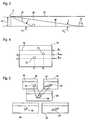
- FIG. 1shows a larger ship 2 in a schematic plan view, which is equipped with ten cameras 4, a processing means 6 and an image display 8.
- Each of the cameras 4has a viewing area 10, wherein each viewing area 10 overlaps with both adjacent viewing areas 10, so that at a certain distance from the ship 2 an all-round view around the ship 2 is made possible.
- any other vehicle, building or objectis possible.
- FIG. 2For example, two viewing areas 12, 14 of two of the ten cameras 4 are off FIG. 1 shown. For the remaining cameras 4 off FIG. 1 the following applies equally.
- an image 16, 18is created with the aid of the processing means 6 and fused to form a panoramic image 20.
- the images 16, 18 per seare not shown and are limited to image data from the two cameras 4.
- the panoramic image 20is made visible on the image display 8 so that an operator can monitor the surroundings of the ship 2 on the basis of the panoramic image 20.
- the object 22is completely displayed in the image 16, the object 24 only partially.
- the objects 24 and 26are shown in the image 18 and the object 28 is not displayed and is therefore not visible to the operator.
- the panoramic image 20shows the environment with the objects 22, 24, 26 as they would show to an observer who is at a predetermined point 30.
- the observeralso has a viewing area 32 which extends over the viewing areas 12, 14 of both cameras 4. Generalized to all ten cameras 4 off FIG. 1 the viewing area 32 of the panoramic image 20 would extend 360 ° around the ship 2.
- the point 30is spaced from the two cameras 4 with the known distances S 1 and S 2 .
- the point 30 and thus the distances S 1 and S 2can be set by an operator on the image display 8 within predetermined limits.
- the point 30can be moved virtually on a track 34 around the ship or around ship superstructures. This can be done by means of an adjustment, z. B. a slider along a mechanical path or a mouse on a screen.
- the panoramic image 20is calculated by the processing means 6 and displayed on the image display 8.
- a distance modelis used which assigns each pixel of each image 16, 18 a defined point in spatial space.
- the coordinates of the location spacecan be related to a fixed point of the ship 2 and be further calculated by means of a coordinate transformation to the coordinates of the point 30 predetermined by the operator.
- the distance modelis based on the assumption of the reduction of the possibility of positioning an imaged object 22, 24, 26 into a two-dimensional landscape or topography whose shape forms the basis for the distance model. It can be assigned to each pixel of each image 16, 18 a location or viewpoint in the landscape. Without the distance model, each pixel would have a line of sight associated with it.
- the possible position of the imaged object 22, 24, 26is reduced to the point of intersection of the line of sight with the topography and thus to a unique point, which can be provided with concrete three-dimensional coordinates.
- Each pixel of an image 16, 18thus becomes a voxel fixed in its three-dimensional coordinates.
- a camera 4 on the ship 2looks at a flat surface 36, z. B. the sea.
- Two objects 22, 24are located on this surface 36.
- the view to the objects 22, 24respectively defines a line of sight 38, 40 whose elevation angle ⁇ 1 and ⁇ 2 and azimuth angle (in FIG FIG. 2 not shown but visible) the position of the imaged object 22, 24 im Figure 16 defines. Due to the elevation angles ⁇ 1 and ⁇ 2 and azimuth angle, each viewing direction 38, 40 is uniquely determined.
- FIG. 4shows in a schematic representation of the objects 22, 24 as they would be visible in the image 16, if this would be displayed on the image display 8.
- Each object 22, 24is assigned image coordinates x 1 , y 1 and x 2 , y 2 , from which the line of sight to the objects 22, 24 can be determined.
- the distance modeladds the topography to this data, or an assumption of a topography, in the example FIG. 3 the flat surface 36, which may differ in reality as a sea or landscape level of the exact flat surface.
- each line of sight 38, 40can be assigned an intersection with the topography, which is uniquely determined in its location coordinates.
- the intersection of the horizontal line of sight 44 with the topographylies at infinity.
- the horizonis assumed to be infinitely far away, so that with a visible horizon by means of image processing a corrective for the horizontal line of sight 44 is present.
- the relative position of the objects 22, 24 to the point 30can be determined by simple coordinate transformation and their position in the panoramic image 20 by simple trigonometry.
- each image pointis assigned two image points, namely one image point in one image 16 and another image point in the other image 18. These two corresponding image points have the same location coordinates with respect to point 30. You will therefore be in Panoramic picture 20 superimposed. This can be done by weighted gray scale averaging, so that a brighter pixel and a darker pixel yield a medium bright pixel. Instead of mapping the two corresponding pixels in a pixel of the panoramic image 20, this can be resolved in a finer manner, so that consideration can be given to incomplete overlapping of the two corresponding pixels. It is also possible to display only parts of the entire panorama image.
- the two images 16, 18show a boat 48, or any other object, in two different perspective views.
- the resulting panoramic view 20shows the boat 48 from the perspective of point 30, which, as in FIG FIG. 2 represented between the two cameras 4, which absorb the two images 16, 18 expediently simultaneously.
- an object 22, 24, 26, like the boat 48is recorded in one image from one side and in the other image from the other side.
- the image fusioncorrectly places each point of the overlapping area of the images in the panoramic image as indicated by the arrows in FIG. 5 however, a look from point 30 to boat 48 would show this either from one side or the other.
- the representation of the non-visible sidewould therefore have to be omitted in the merger, which requires complex image processing. Without this it may be that an object 22, 24, 26 is difficult to see in the panoramic image 20.
- the data processing program with which the processing means 6 creates the panoramic image 20is provided with a function that the operator can select and which represents the boat 48 or an area selected by the operator from a recorded view, conveniently such that the operator of one View of the other view can switch. If the detail is considered sufficient, you can switch from the detail mode back to the panorama mode.
- the basis for the use of the distance modelis that the alignment of the cameras 4 in the topography and the images in the topography is known. In the case of a staggering ship, this basis may be withdrawn by the ship's movements.
- the orientation of the cameras 16 receiving the images 16, 18can be determined by means of a position sensor 54 (FIG. FIG. 1 ) are detected, which registers the movements of the ship 2 and thus the cameras 4 and passes the corresponding data to the processing means 6. Based on the sensor data, this calculates the orientation of the cameras 4 relative to the topography and thus the coordinates of the pixels in the topography.
- the orientation of the cameras 4can additionally or alternatively be determined on the basis of image information by image processing. If an object is imaged and recognized, whose position in space is known, such. As the horizon 46, the orientation of the camera 4 can be determined based on the image data of this object.
- An additional advantage of using image processing in addition to using the distance modelis that extended objects can be recognized as such. So covers z.
- the boat 48would have an elevation angle range that, if the range model were used alone, would result in the upper part of the boat being assumed to be farther away than the lower part. If the object is recognized as such, the distance from a lower pixel of the object or its lower edge can be determined, with all the pixels of the object above z. B. the same distance can be assigned.
- the ship 2When the ship 2 sways, it may be useful to include the ship's movement in the representation of the environment, so that the image area of the panoramic image 20 also fluctuates according to the ship's movement. In this way, a contradiction between eye and equilibrium information in the brain of the observer or operator can be reduced and nausea counteracted. Expediently, it is possible to select and switch between a stabilized virtual representation and a virtual representation accompanying the ship's movement.
- objects 22, 24, 26 in their position to a camera 4 or to the ship 2can be well recognized. If an object 22, 24, 26 is of particular interest, e.g. B. because it is on a collision course to the ship 2, the location coordinates of the object 22, 24, 26 can be used to control one or more cameras 4 using the data of image fusion and to the object 22, 24, 26 align such that an operator images the object 22, 24, 26 without being in an area of the panoramic image 20 that is without image overlap. In this way, an object of interest 22, 24, 26 can be imaged sharply and without error and so be observed closely. For this purpose, the processing means 6 recognizes the location coordinates of the objects 24 imaged in an overlapping area and controls the cameras so that they are guided out of the overlapping area.
- the processing means 6recognizes the location coordinates of the objects 24 imaged in an overlapping area and controls the cameras so that they are guided out of the overlapping area.
Landscapes
- Engineering & Computer Science (AREA)
- Theoretical Computer Science (AREA)
- Physics & Mathematics (AREA)
- General Physics & Mathematics (AREA)
- Computing Systems (AREA)
- Geometry (AREA)
- Computer Graphics (AREA)
- Image Processing (AREA)
- Studio Devices (AREA)
- Processing Or Creating Images (AREA)
Description
Translated fromGermanDie Erfindung betrifft ein Verfahren zur Bildfusion von zumindest zwei Bildern zu einem Panoramabild.The invention relates to a method for image fusion of at least two images into a panoramic image.
Bei Warn- und Auflclärungsgeräten, welche mehrere räumlich verteilte Kameras als Sensoren verwenden, um einem Bediener ein Panoramabild oder eine Rundumsicht der Lage zur Verfügung zu stellen, tritt das Problem der Parallaxenverschiebung auf: Ein physikalisches Objekt im Überlappungsbereich zweier räumlich separierter Kameras erscheint in diesen unter verschiedenen Winkeln. Der Effekt verschwindet im Fernfeld und wird umso größer, je näher das Objekt ist und je größer - im Fall von zwei Sensoren - die Stereobasis ist.In the case of warning and clearing devices which use a plurality of spatially distributed cameras as sensors in order to provide the operator with a panoramic image or an all-round view of the situation, the problem of parallax displacement arises: a physical object in the overlapping area of two spatially separated cameras appears in the latter different angles. The effect disappears in the far field and becomes larger the closer the object is and the larger - in the case of two sensors - the stereo base.
Eine einfache Lösung dieses Problems besteht in einer Nebeneinanderdarstellung separater Einzeldarstellungen, so dass eine unterbrochene Panoramadarstellung gebildet wird. Ein ununterbrochenes Panoramabild kann mit Hilfe komplexer Methoden der Bildverarbeitung gewonnen werden, bei denen auf zwei Bildern dargestellte Bildinhalte als gleiche Bildinhalte erkannt und zu einem Bild überlagert werden.A simple solution to this problem consists in a juxtaposition of separate individual representations, so that an interrupted panoramic representation is formed. An uninterrupted panoramic image can be obtained by means of complex image processing methods in which image contents displayed on two images are recognized as the same image contents and superimposed on one image.
Es ist eine Aufgabe der vorliegenden Erfindung, ein Verfahren zur Bildfusion anzugeben, mit dem ein Panoramabild, das den Bildinhalt mehrerer Einzelbilder enthält, auf einfache Weise erzeugt werden kann.It is an object of the present invention to provide a method for image fusion, with which a panoramic image containing the image content of a plurality of individual images can be generated in a simple manner.
Dieses Aufgabe wird durch ein Verfahren zur Bildfusion von zumindest zwei Bildern zu einem Panoramabild gelöst, bei dem erfingdungsgemäß Bildpunkten der Bilder jeweils eine Entfernung aus einem Entfernungsmodell zugeordnet wird, die Entfernung eine angenommene Entfernung von einem im Bildpunkt abgebildeten Objekt zu zumindest einem vorgegebenen Punkt ist, das Entfernungsmodell die Entfernung in Abhängigkeit von der Position der Bildpunkte im aufgenommenen Bild zuordnet und die Bildfusionierung unter Verwendung der zugeordneten Entfernungen durchgeführt wird.This object is achieved by a method for image fusion of at least two images into a panoramic image, in which according to the invention pixels of the images are each assigned a distance from a distance model, the distance is an assumed distance from an object imaged in the pixel to at least one predetermined point, the distance model the distance in dependence from the position of the pixels in the captured image and the image fusion is performed using the assigned distances.
Die Erfindung geht hierbei von folgender Überlegung aus: Um bei einer Panoramadarstellung eine realistische Darstellung zu erhalten, sollte die gesamte Darstellung so gebildet werden, wie sie ein Beobachter von einer einzigen Position aus sehen würde. Diese Position muss nicht mit der Position einer abbildenden Kamera übereinstimmen. Wenn mehrere Kameras die Einzelbilder von unterschiedlichen Aufnahmepositionen aufnehmen kann die Beobachterposition nicht mit der Position aller abbildenden Kameras übereinstimmen. Es sind daher die Darstellungen in den Einzelbildern von der Kamerasicht auf die Beobachtersicht umzurechnen.The invention is based on the following consideration: In order to obtain a realistic representation in a panoramic representation, the entire representation should be formed as an observer would see from a single position. This position does not have to match the position of an imaging camera. If multiple cameras can capture frames from different shooting positions, the observer position may not match the position of all the imaging cameras. Therefore, the representations in the individual images are to be converted from the camera view to the observer view.
Um aus den Einzelbildern eine realistische und kontinuierliche Panoramadarstellung und nicht nur eine Folge von Einzelbildern zu erzeugen, muss somit jedem dargestellten Objekt ein eindeutiger Winkel in Bezug auf die Beobachterposition zugeordnet werden. Dies ist mittels numerischer Berechnung möglich, sofern die Beobachterposition, die relative Lage der Kameras dazu und die Entfernung des abgebildeten Objekts zu den Kameras bekannt sind. Sind die Aufnahmepositionen bekannt, können die nötigen Winkel einfach bestimmt werden. Allerdings ist in der Regel die Entfernung eines abgebildeten Objekts zur abbildenden Kamera nicht bekannt.In order to generate a realistic and continuous panorama representation from the individual images and not just a series of individual images, each object displayed must therefore be assigned a unique angle with respect to the observer position. This is possible by means of numerical calculation, provided the observer position, the relative position of the cameras to it and the distance of the imaged object to the cameras are known. If the shooting positions are known, the necessary angles can be easily determined. However, the removal of an imaged object to the imaging camera is usually not known.
Durch die Einführung eines Entfernungsmodells kann die an sich unbekannte Entfernung durch Modellannahmen ersetzt werden. Ist die Entfernung auf diese Weise quasi bekannt, kann im Überlappungsbereich zweier Bilder jedem Bildpunkt des einen Bilds ein Bildpunkt des anderen Bilds zugeordnet werden. Diese beiden so einander zugeordneten Bildpunkte können zu einem einzigen Bildpunkt der Panoramadarstellung verbunden werden. In dem Maße, wie das Entfernungsmodell mit der Realität übereinstimmt, können stereografische Störungen verringert und es kann ein kontinuierliches Panoramabild aus den Bildern erzeugt werden.With the introduction of a distance model, the unknown distance can be replaced by model assumptions. If the distance is known in this way, a pixel of the other image can be assigned to each pixel of the one image in the overlapping area of two images. These two so assigned pixels can be connected to a single pixel of the panoramic view. As the distance model conforms to reality, stereographic perturbations can be reduced and a continuous panoramic image can be generated from the images.
Das Entfernungsmodell sollte die abgebildete Realität so gut wie möglich wiedergeben. Je nach abgebildeter Topografie ist dies einfacher oder schwerer zu realisieren. Am einfachsten ist es, wenn die Topografie bekannt ist, da dann das Entfernungsmodell einfach gebildet werden kann, da zu jedem Bildpunkt bekannt sein kann, welchen topografischen Punkt es abbildet. Das Entfernungsmodell gibt so die Topografie der abgebildeten Umgebung wieder.The distance model should reflect the depicted reality as well as possible. Depending on the depicted topography, this is easier or harder to realize. It is easiest if the topography is known, because then the distance model can be easily formed, since for each pixel can be known which topographic point it maps. The distance model thus reflects the topography of the imaged environment.
Sind die Kameras allerdings an einem bewegten Fahrzeug angebracht und ist die Umgebung nicht bekannt, so ist auch eine Zuordnung von Bildpunkt zu topografischem Punkt nicht bekannt. In diesem Fall ist der Weg über das Entfernungsmodell dennoch zielführend, wenn die Topografie in einem einfachen Modell in zufriedenstellendem Maße wiedergegeben werden kann. Dies kann z. B. auf See oder in einer ebenen Landschaft der Fall sein, da dort von einer zumindest im Wesentlichen ebenen Topografie ausgegangen werden kann. Anhand der bekannten Höhe der Kamera über dem Boden oder dem Wasser kann anhand des Elevationswinkels einer Blickrichtung oder eines Bildpunkts im Bild auf die Entfernung des im Bildpunkt abgebildeten Objekts geschlossen werden. Ist ein abgebildeter Gegenstand mit einer größeren Ausdehnung in Elevationsrichtung behaftet, wie es z. B. bei einem großen oder nahen Schiff der Fall ist, so ist zweckmäßigerweise eine Unterkante des Gegenstands zu bestimmen und die Entfernung des gesamten Gegenstands und damit aller Bildpunkte, die ihn abbilden auf diese Entfernung zu setzen, auch wenn ihr Elevationswinkel kleiner ist.However, if the cameras are mounted on a moving vehicle and the environment is not known, an assignment from pixel to topographical point is also unknown. In this case, the route over the distance model is nevertheless expedient if the topography can be reproduced satisfactorily in a simple model. This can be z. B. at sea or in a flat landscape of the case, since it can be assumed there from an at least substantially flat topography. On the basis of the known height of the camera above the ground or the water can be concluded on the basis of the elevation angle of a line of sight or a pixel in the image on the distance of the imaged object in the pixel. Is an imaged object with a greater extent in the elevation afflicted, as z. B. is the case with a large or close ship, it is expedient to determine a lower edge of the object and to set the distance of the entire object and thus all the pixels that map it to this distance, even if their elevation angle is smaller.
Die die Bilder aufnehmenden optischen Sensoren, im Folgenden der Einfachheit halber und ohne damit verbundene Einschränkung als Kameras bezeichnet, sind zueinander beabstandet. Sie nehmen die Umgebung in einer unterschiedlichen Perspektive auf. Mit Bezug zum Panoramabild sind die beiden Bilder daher nebeneinander angeordnet. Sie können teilweise überlappen Die Bilder können auf Bilddaten reduziert sein und müssen nicht sichtbar dargestellt sein. Im Folgenden werden daher auch Bilddaten, die ein Bild der Umgebung repräsentieren, als Bild bezeichnet. Das Panoramabild kann somit aus den Bilddaten bzw. zwei Bilddatensätzen zusammengesetzt sein, die jeweils für sich zu einem Bild zusammengesetzt werden könnten.The image-receiving optical sensors, hereinafter referred to as cameras for the sake of simplicity and without limitation, are spaced from each other. They capture the environment in a different perspective. With reference to the panoramic image, the two images are therefore arranged side by side. They may partially overlap The images may be reduced to image data and need not be visibly displayed. In the following, therefore, also image data representing an image of the environment will be referred to as an image. The panoramic image can thus be composed of the image data or two image data sets, which could each be put together to form an image.
Das Panoramabild kann eine 360°-Rundumsicht sein, das insbesondere mit Bildern von mehr als zwei jeweils zueinander beabstandeten Kameras erzeugt wurde. Der vorgegebene Punkt ist zweckmäßigerweise die Beobachterposition, aus der das Panoramabild betrachtet erscheinen soll. Ein Bildpunkt kann ein Pixel eines digitalen Bildsensors einer Kamera sein, wobei auch eine gröbere und insbesondere eine feinere Unterteilung sinnvoll ist, da der Bildpunkt des einen Bilds zumeist nicht genau mit dem nach der Entfernungsinformation korrespondierenden Bildpunkt des anderen Bilds zusammenfällt. Die Entfernung ist vorteilhafterweise die Entfernung des im Bildpunkt abgebildeten Objekts zum vorgegebenen Punkt, insbesondere zur Position des fiktiven Beobachters, aus dessen Sicht das Panoramabild dargestellt sein soll.The panoramic image may be a 360 ° all-round view that has been generated, in particular, with images of more than two cameras spaced apart from each other. The predetermined point is expediently the observer position from which the panoramic image is to be viewed. A pixel may be a pixel of a digital image sensor of a camera, wherein a coarser and in particular a finer subdivision makes sense, since the pixel of one image usually does not coincide exactly with the pixel of the other image corresponding to the distance information. The distance is advantageously the distance of the object imaged in the pixel to the given point, in particular to the position of the fictitious observer, from whose view the panoramic image is to be displayed.
In einer vorteilhaften Ausführungsform der Erfindung werden solche Bildpunkte der beiden Bilder zu einem Bildpunkt des Panoramabilds zusammengeführt, denen die gleiche Entfernung zugeordnet ist. Hierdurch können störende stereografische Effekte weitgehend vermieden werden.In an advantageous embodiment of the invention such pixels of the two images are combined to form a pixel of the panoramic image, which is associated with the same distance. As a result, disturbing stereographic effects can be largely avoided.
Weiter ist es vorteilhaft, den Azimutwinkel der Bildpunkte als Information zum Zusammenführen zweiter Bildpunkte zu verwenden. Hierdurch kann ein horizontaler Überlappungsabstand der beiden Bilder für jeden Bildpunkt, und somit eine Zugehörigkeit zweier Bildpunkte zueinander, errechnet werden. Der Azimutwinkel ist zweckmäßigerweise bezogen auf eine zuvor festgelegte Richtung.Furthermore, it is advantageous to use the azimuth angle of the pixels as information for merging second pixels. In this way, a horizontal overlap distance of the two images for each pixel, and thus an affiliation of two pixels to each other, can be calculated. The azimuth angle is expediently based on a predetermined direction.
Aus den Bildpunkten der beiden Bilder können Voxel mit jeweils dreidimensionaler Rauminformation erzeugt werden. Die zweidimensionale Rauminformation, die jedem Bildpunkt aus seiner Lage im Bild und der bekannten Ausrichtung im abgebildeten Raum zugeordnet werden kann, kann hierbei um die Entfernungsinformation erweitert werden, so dass je ein Voxel mit dreidimensionaler Rauminformation zur Lage des jeweils abgebildeten Objekts im Raum relativ zu einem Bezugspunkt vorliegt. Werden nun diejenigen Voxel mit gleicher Rauminformation zu je einem Bildpunkt des Panoramabilds zusammengeführt, so kann durch eine solche Bildfusion ein Panoramabild mit geringen Bildfehlern erzeugt werden. Die Rauminformation enthält hierbei zweckmäßigerweise die Raumkoordinaten eines Blickpunkts bzw. eines vom Bildpunkt abgebildeten Objekts in einer Topografie aus Sicht vom vorgegebenen Punkt.From the pixels of the two images voxels can be generated, each with three-dimensional spatial information. The two-dimensional spatial information, which can be assigned to each pixel from its position in the image and the known orientation in the imaged space, can hereby be extended by the distance information, so that in each case a voxel with three-dimensional spatial information about the position of the respectively imaged object in space relative to a Reference point is present. If now those voxels with the same spatial information are combined to form one pixel of the panorama image, a panoramic image with small image errors can be generated by such an image fusion. The spatial information expediently contains the spatial coordinates of a viewpoint or an object imaged by the pixel in a topography as seen from the given point.
Eine gute Überwachung eines größeren Gegenstands, z. B. eines Schiffs, kann erreicht werden, wenn die zumindest zwei Bilder von verschiedenen Punkten aufgenommen werden. Außerdem ist es vorteilhaft, wenn sich die Bildbereiche der zumindest zwei Bilder teilweise überlappen.Good supervision of a larger object, e.g. As a ship, can be achieved when the at least two images are taken from different points. Moreover, it is advantageous if the image areas of the at least two images partially overlap.
Eine weitere vorteilhafte Ausgestaltung der Erfindung sieht vor, dass das Entfernungsmodell von einer bekannten Topografie der in den Bildern dargestellten Umgebung ausgeht. Hierdurch kann jedem Bildpunkt, der zweckmäßigerweise einen aufgenommenen Raumwinkelbereich abbildet, ein Punkt in der Topografie und damit eine Entfernung und insbesondere eine dreidimensionale Rauminformation zugeordnet werden. Das Entfernungsmodell ist besonders einfach und die Bildfusion damit zuverlässig, wenn das Entfernungsmodell von einem Blick auf eine ebene Oberfläche ausgeht. Das Entfernungsmodell geht somit vorteilhafterweise von der Annahme der Reduzierung der Lagemöglichkeit eines abgebildeten Objekts in eine zweidimensionale Topografie aus, deren Gestalt die Grundlage für das Entfernungsmodell bilden kann.A further advantageous embodiment of the invention provides that the distance model emanates from a known topography of the environment shown in the images. In this way, each pixel which expediently images a recorded solid angle range can be assigned a point in the topography and thus a distance and in particular a three-dimensional space information. The distance model is particularly easy and the image fusion is reliable, if the distance model emanates from a view of a flat surface. The distance model is thus advantageously based on the assumption of Reduction of the possibility of placing an imaged object into a two-dimensional topography whose shape can form the basis of the distance model.
Die Entfernung kann trigonometrisch aus jeweils einem örtlichen Aufnahmepunkt der Bilder, dem vorgegebenen Punkt und der Position der Bildpunkte bestimmt werden. Bei bekannter oder als bekannt angenommener Topografie kann die Entfernung anhand der Position der Bildpunkte in den aufgenommenen Bildern und deren Blickpunkt in die Topografie unter Zugrundelegen der bekannten Ausrichtung der Bilder in dieser Topografie bestimmt wird.The distance can be determined trigonometrically from in each case one local pick-up point of the pictures, the predetermined point and the position of the picture elements. If the topography is known or believed to be known, the distance can be determined from the position of the pixels in the captured images and their viewpoint into the topography, based on the known orientation of the images in that topography.
Ist die Ausrichtung der Bilder in der Topografie nicht oder nicht genau genug bekannt, so kann eine Ausrichtung der Bilder in der Topografie anhand von Bildinformationen durch Bildverarbeitung ermittelt werden. So kann beispielsweise ein Horizont im Bild erkannt werden und damit eine Ausrichtung der Bilder hinsichtlich ihrer Elevation bestimmt werden. Das Erkennen des Horizonts ist ausreichend für eine Bildfusion, wenn die zwei oder mehr Kameras synchron bewegt werden, wie z. B. auf einem Schiff, so dass ihre Aufnahmerichtungen zueinander stets unverändert bleiben.If the orientation of the images in the topography is not known or not known with sufficient accuracy, an orientation of the images in the topography can be determined by image processing using image processing. Thus, for example, a horizon can be recognized in the image and thus an orientation of the images can be determined with regard to their elevation. The recognition of the horizon is sufficient for image fusion when the two or more cameras are moved synchronously, such as, for example. B. on a ship, so that their receiving directions to each other always remain unchanged.
Zusätzlich oder alternativ kann eine Ausrichtung der Bilder in der Topografie anhand eines Lagesensors zur Bestimmung der Lage der die Bilder aufnehmenden Kameras ermittelt werden. Schnelle Änderungen in der Blickrichtung können hierdurch einfach erfasst werden.Additionally or alternatively, an alignment of the images in the topography can be determined by means of a position sensor for determining the position of the cameras receiving the images. Quick changes in the viewing direction can be easily detected.
Der vorgegebene Punkt kann die Position eines virtuellen Beobachters sein, aus der das Panoramabild betrachtet erscheint. Eine übersichtliche Überwachung kann erzielt werden, wenn der vorgegebene Punkt von einem Bediener verändert werden kann und das Panoramabild entsprechend des neuen Punkts aus den Bildern neu zusammengesetzt wird. Der Bediener kann so einen virtuellen Rundgang um einen Gegenstand, z. B. ein Schiff, machen und sich so einen realistischen Überblick über die Umgebung verschaffen. Dies kann geschehen, indem der vorgegebene Punkt um ein Objekt herumgeführt wird und das Panoramabild einem sich insbesondere kontinuierlich verändernden Sichtfeld eines sich um das Objekt herum bewegenden und z. B. nach radial außen schauenden virtuellen Beobachters entspricht.The predetermined point may be the position of a virtual observer from which the panoramic image appears. A clear monitoring can be achieved if the predetermined point can be changed by an operator and the panoramic image is reassembled from the images according to the new point. The operator can thus make a virtual tour of an object, eg. As a ship, make and thus provide a realistic overview of the environment. This can be done by the given point is guided around an object and the panoramic image of a particular continuously changing field of view of a moving around the object and z. B. corresponds radially outwardly looking virtual observer.
Das Panoramabild kann eine andere, z. B. höhere Bildauflösung aufweisen als die beiden Bilder, um beispielsweise zwei sich nicht genau überlagernde Bildpunkte gut auflösen zu können. Weiter vorteilhaft ist es, wenn die zumindest zwei Bilder von zumindest zwei Kameras gleichzeitig aufgenommen werden.The panorama picture can be another, z. B. have higher image resolution than the two images, for example, two not exactly overlapping pixels well to dissolve. It is also advantageous if the at least two images of at least two cameras are recorded simultaneously.
Trotz der Bildfusion und der kontinuierlichen Darstellung der Umgebung im Panoramabild kann ein Bildfehler nicht vermieden werden, der dadurch auftritt, dass ein Gegenstand aus zwei unterschiedlichen Perspektiven aufgenommen wird. So wird z. B. ein in beiden Bildern abgebildetes Schiff einmal schräg von der Seite und einmal ganz von der Seite dargestellt. Die korrespondierenden Bildpunkte werden zwar so fusioniert, dass jeder Punkt des Gegenstands, z. B. ein Bullauge des abgebildeten Schiffes, im Panoramabild nur einmal abgebildet wird, doch der perspektivische Unterschied von z. B. in einem Bild sichtbaren und im anderen Bild unsichtbaren Kanten kann nicht eliminiert werden. Es kann daher sein, dass der abgebildete Gegenstand bzw. das dargestellte Objekt nicht scharf dargestellt oder nicht gut in seinen Details zu erkennen ist.Despite the image fusion and the continuous representation of the environment in the panoramic image, an image error can not be avoided by taking an object from two different perspectives. So z. For example, a ship pictured in both pictures is shown diagonally from the side and once completely from the side. The corresponding pixels are indeed fused so that each point of the object, z. B. a porthole of the pictured ship, in the panoramic image is shown only once, but the perspective difference of z. B. visible in one image and the other image invisible edges can not be eliminated. It may therefore be that the imaged object or the object shown is not in focus or is not clearly visible in its details.
Diesem Nachteil kann entgegengewirkt werden, wenn das in einem Überlappungsbereich der beiden Bilder dargestellte Objekt im Panoramabild nur aus der Perspektive eines der Bilder dargestellt wird. Diese vereinfachte Darstellung erfolgt zweckmäßigerweise auf Kommando eines Bedieners, der die Kamera, deren Bildinhalt zur alleinigen Darstellung verwendet werden soll, aus den verwendeten Kameras auswählen kann.This disadvantage can be counteracted if the object shown in an overlapping area of the two images is only displayed in the panoramic image from the perspective of one of the images. This simplified representation is expediently carried out at the command of an operator who can select the camera whose image content is to be used for sole representation from the cameras used.
Für diese Methode gibt es mehrere Optionen. Einfach ist es, wenn der ganze Überlappungsbereich nur mit der Darstellung aus einer Kamera dargestellt wird. Die Bildfusion wird somit zumindest für diesen Bereich gestoppt und eine klare Darstellung auf Kosten der Kontinuität der Panoramadarstellung erwirkt. Der Bediener kann sich somit Klarheit über einen interessierenden Gegenstand verschaffen. Eine Unterbrechung der Kontinuität der Panoramadarstellung kann vermieden werden, wenn der interessierende Gegenstand ohne seine Umgebung ausgewählt werden kann, z. B. mit einer Maus auf einem Bildschirm und einer unterstützenden Bildverarbeitung, und nur der Bildbereich dieses Gegenstands aus der Bildfusion herausgenommen wird.There are several options for this method. It is easy if the entire overlapping area is only displayed with the representation of a camera. The image fusion is thus stopped, at least for this area, and a clear representation at the expense of the continuity of the panorama representation obtained. The operator can thus gain clarity about an object of interest. An interruption of the continuity of the panoramic view can be avoided if the object of interest can be selected without its environment, e.g. With a mouse on a screen and assistive image processing, and only the image area of that object is extracted from the image fusion.
Vorteilhafterweise kann der Bediener zwischen Bildfusion und - ganzer oder bereichsweiser - Unterbrechung der Bildfusion hin und her schalten, so dass er bei im Wesentlicher Aufrechterhaltung der Panoramaschau bei Bedarf einen Gegenstand genauer anschauen kann. Kann die Perspektive, aus der das Objekt im Panoramabild dargestellt wird, aus der Perspektive des einen in die Perspektive des anderen Bilds gewechselt werden, so kann der Bediener das Objekt bzw. den Gegenstand aus zwei Perspektiven anschauen und sich die geeignetere Perspektive auswählen.Advantageously, the operator can switch back and forth between image fusion and - interruption of the image fusion - in whole or in part, so that he can look at an object more precisely when the panorama show is essentially maintained. Can the perspective from which the object in the panoramic picture from the perspective of one to the perspective of the other image, the operator can view the object from two perspectives and select the more appropriate perspective.
Die Erfindung betrifft außerdem eine Vorrichtung zur Bildfusion mit zumindest zwei voneinander beabstandeten Kameras zur Aufnahme einer Umgebung aus verschiedenen Perspektiven, einer Bildanzeige zum Darstellen eines Panoramabilds und einem Prozessmittel, das dazu vorbereitet ist, ein Bild aus einer Kamera mit einem Bild der anderen Kamera zu einem Panoramabild zu fusionieren, wobei Bildpunkten der beiden Bilder jeweils eine Entfernung aus einem Entfernungsmodell zugeordnet wird, die Entfernung eine angenommene Entfernung von einem im Bildpunkt abgebildeten Objekt zu zumindest einem vorgegebenen Punkt ist, das Entfernungsmodell die Entfernung in Abhängigkeit von der Position der Bildpunkte im aufgenommenen Bild zuordnet und die Bildfusionierung unter Verwendung der zugeordneten Entfernungen durchgeführt wird.The invention also relates to an apparatus for image fusion with at least two spaced-apart cameras for recording an environment from different perspectives, an image display for displaying a panoramic image and a processing means, which is prepared to one image from a camera with an image of the other camera to one Panoramic image to merge, wherein pixels of the two images is each assigned a distance from a distance model, the distance is an assumed distance from an imaged pixel in the image to at least one predetermined point, the distance model, the distance depending on the position of the pixels in the captured image and the image fusion is performed using the assigned distances.
Das Prozessmittel ist vorteilhafterweise dazu vorbereitet, die Durchführung eines beliebigen, mehrerer beliebiger oder aller der oben genannten Verfahrensschritte zu steuern. Eine solche Vorbereitung kann durch ein entsprechendes Steuerprogramm des Prozessmittels vorliegen, dessen Ablauf - beispielsweise in Verbindung mit geeigneten Eingangssignalen, wie Sensorsignalen - eine solche Steuerung bewirkt. Hierzu umfasst das Steuermittel zweckmäßigerweise elektronische Elemente, wie einen Prozessor und einen Datenspeicher, die zum Ablaufen des Steuerprogramms notwendig sind.The process means is advantageously prepared to control the performance of any, several, or all of the above process steps. Such a preparation may be provided by a corresponding control program of the process means, the sequence of which - such as in conjunction with suitable input signals, such as sensor signals - causes such a control. For this purpose, the control means expediently comprises electronic elements, such as a processor and a data memory, which are necessary for running the control program.
Aus dem Panoramabild können interessierende Objekt zuverlässig als solche erkannt werden, z. B. ein auf Kollisionskurs befindliches Boot. Vorteilhafterweise ist das Prozessmittel dazu vorbereitet, solche Objekte zu erkennen, eine geeignete Kamera auszuwählen und auf das Objekt zu richten.From the panoramic image objects of interest can be reliably recognized as such, eg. B. a boat on a collision course. Advantageously, the processing means is prepared to recognize such objects, to select a suitable camera and to direct it to the object.
Weitere Vorteile ergeben sich aus der folgenden Zeichnungsbeschreibung. In der Zeichnung sind Ausführungsbeispiele der Erfindung dargestellt. Die Zeichnung und die Beschreibung enthalten zahlreiche Merkmale in Kombination, die der Fachmann zweckmäßigerweise auch einzeln betrachten und zu sinnvollen weiteren Kombinationen zusammenfassen wird.Further advantages emerge from the following description of the drawing. In the drawings, embodiments of the invention are shown. The drawing and the description contain numerous features in combination, which the skilled person expediently consider individually and will summarize meaningful further combinations.
Es zeigen:
- Fig. 1
- ein Schiff mit zehn Kameras, die eine Rundumsicht um das Schiff gewähren, in einer Draufsicht,
- Fig. 2
- eine schematische Darstellung der Sichtbereiche von zwei Kameras und einem virtuellen Sichtbereich,
- Fig. 3
- eine schematische Darstellung der Sichtbereiche aus
FIG. 2 von der Seite, - Fig. 4
- eine schematische Darstellung eines Bilds einer Kamera und zweier darin dargestellter Objekte und
- Fig. 5
- zwei Bilder aus zwei Kameras auf ein Boot und drei aus den beiden Bildern fusionierte Panorarnabilder.
- Fig. 1
- a ship with ten cameras that provide a panoramic view of the ship, in a plan view,
- Fig. 2
- a schematic representation of the viewing areas of two cameras and a virtual field of view,
- Fig. 3
- a schematic representation of the viewing areas
FIG. 2 of the page, - Fig. 4
- a schematic representation of an image of a camera and two objects shown therein and
- Fig. 5
- two pictures from two cameras on a boat and three from the two pictures fused panoramas.
In
Neben dem Schiff 2 befinden sich vier Objekte 22, 24, 26, 28. Das Objekt 22 wird vollständig im Bild 16 abgebildet, das Objekt 24 nur teilweise. Die Objekte 24 und 26 werden im Bild 18 abgebildet und das Objekt 28 wird nicht abgebildet und ist somit für den Bediener nicht sichtbar.In addition to the
Das Panoramabild 20 zeigt die Umgebung mit den Objekten 22, 24, 26 so, wie sie sich einem Beobachter, der sich in einem vorgegebenen Punkt 30 befindet, zeigen würde. Der Beobachter hat ebenfalls einen Sichtbereich 32, der sich über die Sichtbereiche 12, 14 beider Kameras 4 erstreckt. Verallgemeinert auf alle zehn Kameras 4 aus
Zur Fusionierung der beiden Bilder 16, 18 zum Panoramabild 20 wird ein Entfernungsmodell verwendet, das jedem Bildpunkt eines jeden Bilds 16, 18 einen definierte Punkt im Ortsraum zuordnet. Die Koordinaten des Ortsraums können auf einen festen Punkt des Schiffs 2 bezogen sein und mit Hilfe einer Koordinatentransformation auf die Koordinaten des vom Bediener vorgegebenen Punkts 30 weitergerechnet werden. Das Entfernungsmodell geht von der Annahme der Reduzierung der Lagemöglichkeit eines abgebildeten Objekts 22, 24, 26 in eine zweidimensionale Landschaft bzw. Topografie aus, deren Gestalt die Grundlage für das Entfernungsmodell bildet. Es kann so jedem Bildpunkt eines jeden Bilds 16, 18 ein Ort oder Blickpunkt in der Landschaft zugeordnet werden. Ohne das Entfernungsmodell wäre jedem Bildpunkt eine Blicklinie zugeordnet. Durch die vorgegebene Topografie des Entfernungsmodells wird die mögliche Lage des abgebildeten Objekts 22, 24, 26 auf den Schnittpunkt der Blicklinie mit der Topografie und damit auf einen eindeutigen Punkt reduziert, der mit konkreten dreidimensionalen Koordinaten versehen werden kann. Jedes Pixel eines Bilds 16, 18 wird somit zu einem in seinen dreidimensionalen Koordinaten festgelegten Voxel.For fusing the two
Dieses Modell wird im Folgenden anhand der
Das Entfernungsmodell fügt zu diesen Daten die Topografie hinzu, oder eine Annahme einer Topografie, im Beispiel aus
Anhand der als bekannt angenommenen Topografie und dem Entfernungsmodell wird dem Objekt 22 die Entfernung d270 = 270 m und dem Objekt 24 die Entfernung d1000 = 1000 m zur aufnehmenden Kamera 4 zugeordnet. Durch den Elevationswinkel α1 und α2 kann z. B. bei ebener Topografie die Entfernung d durch den Zusammenhang d = h / sin α bestimmt werden, wobei h die Höhe 42 ist. Dem im Bild 16 sichtbaren Horizont 46 wird die Entfernung d∞ = unendlich zugeordnet. Hierdurch und durch den Azimutwinkel ist die Ortslage der Objekte 22, 24 relativ zur aufnehmenden Kamera 4 bekannt.Based on the assumed topography and the distance model, the
Mit Hilfe der bekannten Relativposition des vom Bediener festgelegten Punkts 30 zur aufnehmenden Kamera 4 kann durch einfache Koordinatentransformation die Relativposition der Objekte 22, 24 zum Punkt 30 ermittelt werden und durch einfache Trigonometrie deren Lage im Panoramabild 20.With the aid of the known relative position of the operator-defined
Im Überlappungsbereich von zwei Bildern 16, 18 sind jedem Umgebungspunkt zwei Bildpunkte zugewiesen, nämlich ein Bildpunkt im einen Bild 16 und ein weiterer Bildpunkt im anderen Bild 18. Diese beiden korrespondierenden Bildpunkte haben bezogen auf den Punkt 30 die gleichen Ortskoordinaten. Sie werden daher im Panoramabild 20 übereinander abgebildet. Dies kann durch gewichtete Grauwertmittelung geschehen, so dass ein hellerer Bildpunkt und ein dunklerer Bildpunkt einen mittelhellen Bildpunkt ergeben. Anstelle der Abbildung der beiden korrespondierenden Bildpunkte in einem Bildpunkt des Panoramabilds 20 kann dieses feiner aufgelöst sein, so dass auf eine nicht vollständige Überlappung der beiden korrespondierenden Bildpunkte Rücksicht genommen werden kann. Es ist auch möglich anstelle des gesamten Panoramabilds nur Teile daraus zur Anzeige zu bringen.In the overlapping region of two
Anhand
Je nach Perspektive kann es sein, dass ein Objekt 22, 24, 26, wie das Boot 48, im einen Bild von einer Seite und im anderen Bild von der anderen Seite aufgenommen wird. Die Bildfusion ordnet zwar jeden Punkt des Überlappungsbereichs der Bilder korrekt in das Panoramabild, wie durch die Pfeile in
Besteht die Option, dass der Bediener den Überlappungsbereich oder nur den Bereich um das Boot 48 entweder aus der Perspektive der einen oder der anderen Kamera 4 anschauen kann, so wie in den Panoramabildern 50 und 52 dargestellt ist, kann eine scharfe Abbildung des Boots in das Panoramabild 20 übernommen werden. Die Kontinuität des Panoramabilds 20 ist zwar dann an dieser Stelle unterbrochen, doch zum Zweck einer Detaildarstellung kann dies in Kauf genommen werden. Hierzu ist das Datenverarbeitungsprogramm, mit dem das Prozessmittel 6 das Panoramabild 20 erstellt, mit einer Funktion ausgestattet, die der Bediener anwählen kann und die das Boot 48 oder einen vom Bediener ausgewählten Bereich aus einer aufgenommenen Sicht darstellt, zweckmäßigerweise so, dass der Bediener von einer Sicht auf die andere Sicht umschalten kann. Ist das Detail ausreichen betrachtet, kann vom Detailmodus wieder auf den Panoramamodus gewechselt werden.If there is the option that the operator can view the overlap area or only the area around the
Grundlage für die Verwendung des Entfernungsmodells ist es, dass die Ausrichtung der Kameras 4 in die Topografie bzw. der Bilder in der Topografie bekannt ist. Bei einem schwankenden Schiff kann diese Grundlage durch die Schiffsbewegungen entzogen werden. Es kann jedoch die Ausrichtung der die Bilder 16, 18 aufnehmenden Kameras 4 anhand eines Lagesensors 54 (
Um eine Fehler erzeugende Drift bei der Ausrichtungsbestimmung zu vermeiden, kann die Ausrichtung der Kameras 4 zusätzlich oder alternativ anhand von Bildinformationen durch Bildverarbeitung ermittelt werden. Wird ein Objekt abgebildet und erkannt, dessen Position im Raum bekannt ist, wie z. B. der Horizont 46, so kann die Ausrichtung der Kamera 4 anhand der Bilddaten dieses Objekts bestimmt werden.In order to avoid an error-causing drift in the orientation determination, the orientation of the
Ein zusätzlicher Vorteil beim Verwenden von Bildverarbeitung zusätzlich zur Verwendung des Entfernungsmodells besteht darin, dass ausgedehnte Objekte als solche erkannt werden können. So überdeckt z. B. das Boot 48 einen Elevationswinkelbereich, der bei alleiniger Anwendung des Entfernungsmodells dazu führen würde, dass der obere Teil des Boots als weiter weg angenommen wird, als der untere Teil. Wird das Objekt als solches erkannt, kann die Entfernung aus einem unteren Bildpunkt des Objekts oder seiner Unterkante bestimmt werden, wobei sämtlichen Bildpunkten des Objekts darüber z. B. die gleiche Entfernung zugeordnet werden kann.An additional advantage of using image processing in addition to using the distance model is that extended objects can be recognized as such. So covers z. For example, the
Bei einem Schwanken des Schiffs 2 kann es sinnvoll sein, die Schiffsbewegung in die Darstellung der Umgebung einzubeziehen, so dass auch der Bildbereich des Panoramabilds 20 entsprechend der Schiffsbewegung schwankt. Auf diese Weise kann ein Widerspruch zwischen Augen- und Gleichgewichtsinformation im Gehirn des Beobachters bzw. Bedieners verringert und Übelkeit entgegengewirkt werden. Zweckmäßigerweise kann zwischen einer stabilisierten virtuellen Darstellung und einer die Schiffbewegung mitvollziehenden virtuellen Darstellung gewählt und umgeschaltet werden.When the
Durch die Schritte der Bildfusion können Objekte 22, 24, 26 in ihrer Lage zu einer Kamera 4 bzw. zum Schiff 2 gut erkannt werden. Ist ein Objekt 22, 24, 26 von besonderem Interesse, z. B. weil es sich auf Kollisionskurs zum Schiff 2 befindet, so können die Ortskoordinaten des Objekts 22, 24, 26 dafür verwendet werden, eine oder mehrere Kameras 4 mit Hilfe der Daten der Bildfusion zu steuern und auf das Objekt 22, 24, 26 auszurichten, so dass eine Bediener das Objekt 22, 24, 26 ohne in einem Bereich des Panoramabilds 20 abgebildet wird, der ohne Bildüberschneidung ist. Auf diese Weise kann ein interessierendes Objekt 22, 24, 26 scharf und fehlerfrei abgebildet werden und so genau beobachtet werden. Hierzu erkennt das Prozessmittel 6 die Ortskoordinaten der in einem Überlappungsbereich abgebildeten Objekte 24 und steuert die Kameras so, dass sie aus dem Überlappungsbereich herausgeführt werden.Through the steps of the image fusion, objects 22, 24, 26 in their position to a
- 22
- Schiffship
- 44
- Kameracamera
- 66
- Prozessmittelprocess means
- 88th
- Bildanzeigeimage display
- 1010
- Sichtbereichviewing area
- 1212
- Sichtbereichviewing area
- 1414
- Sichtbereichviewing area
- 1616
- Bildimage
- 1818
- Bildimage
- 2020
- PanoramabildPanorama
- 2222
- Objektobject
- 2424
- Objektobject
- 2626
- Objektobject
- 2828
- Objektobject
- 3030
- PunktPoint
- 3232
- Sichtbereichviewing area
- 3434
- Bahntrain
- 3636
- Flächearea
- 3838
- Blicklinieline of sight
- 4040
- Blicklinieline of sight
- 4242
- Höheheight
- 4444
- Blicklinieline of sight
- 4646
- Horizonthorizon
- 4848
- Bootboat
- 5050
- PanoramabildPanorama
- 5252
- PanoramabildPanorama
- 5454
- Lagesensorposition sensor
Claims (15)
- Method for image fusion of at least two images (16, 18) to form a panoramic image (20, 50, 52), in which pixels in the images (16, 18) are each associated with a distance from a distance model, the distance is an assumed distance from an object (22, 24, 26), which is imaged at that pixel, to at least one predetermined point (30), the distance model associates the distance as a function of the position of the pixels in the recorded image (16, 18), and the image fusion is carried out using the associated distances.
- Method according to Claim 1,
characterized
in that the pixels in the two images (16, 18) which are combined to form one pixel in the panoramic image (20, 50, 52) are those which are associated with the same distance. - Method according to Claim 1 or 2,
characterized
in that the azimuth angle of the pixels is used as information for combination of two pixels. - Method according to one of the preceding claims,
characterized
in that voxels, each having three-dimensional spatial information, are produced from the pixels in the two images (16, 18), and voxels having the same spatial information are combined to form one pixel in the panoramic image (20, 50, 52). - Method according to Claim 4,
characterized
in that the spatial information contains the spatial coordinates of a viewing point in a topography from the view from the predetermined point (30). - Method according to one of the preceding claims,
characterized
in that the at least two images (16, 18) are recorded from different points. - Method according to one of the preceding claims,
characterized
in that the distance model originates from a known topography of the surrounding area represented in the images (16, 18). - Method according to one of the preceding claims,
characterized
in that the distance model originates from the assumption of the reduction in the capability of an imaged object (22, 24, 26) to be positioned in a two-dimensional topography whose shape forms the basis of the distance model. - Method according to one of the preceding claims,
characterized
in that the distance is determined on the basis of the position of the pixels in the recorded images (16, 18) and their viewing point into a known topography on the basis of the known alignment of the images (16, 18) in this topography. - Method according to one of the preceding claims,
characterized
in that the predetermined point (30) is the position of a virtual observer from which the panoramic image (20, 50, 52) appears to be viewed. - Method according to one of the preceding claims,
characterized
in that the predetermined point is changed by an operator, and the panoramic image (20, 50, 52) is recomposed from the images (16, 18), corresponding to the new point. - Method according to Claim 11,
characterized
in that the predetermined point (30) is moved around an object, and the panoramic image (20, 50, 52) corresponds to a changing field of view of a virtual observer who is moving around the object. - Method according to one of the preceding claims,
characterized
in that the at least two images (16, 18) are recorded at the same time by at least two cameras (4). - Method according to one of the preceding claims,
characterized
in that an object (24), which is represented in an overlap area of the two images (16, 18) in the panoramic image (50, 52) is represented only from the perspective of one of the images (16, 18). - Apparatus for image fusion having at least two cameras (4), which are at a distance from one another, for recording a surrounding area from different perspectives, an image display (8) for displaying a panoramic image (20, 50, 52), and a process means (6) which is designed to fuse an image (16, 18) from a camera (4) with an image (18, 16) from the other camera (4) to form a panoramic image (20, 50, 52), with pixels in the two images (16, 18) each being associated with a distance from a distance model, with the distance being an assumed distance from an object (22, 24, 26), which is imaged at that pixel, to at least one predetermined point (30), with the distance model associating the distance as a function of the position of the pixels in the recorded image (16, 18), and with the image fusion being carried out using the associated distances.
Applications Claiming Priority (2)
| Application Number | Priority Date | Filing Date | Title |
|---|---|---|---|
| DE102009054251 | 2009-11-21 | ||
| PCT/EP2010/006764WO2011060885A1 (en) | 2009-11-21 | 2010-11-06 | Method for combining at least two images to form a panoramic image |
Publications (2)
| Publication Number | Publication Date |
|---|---|
| EP2350977A1 EP2350977A1 (en) | 2011-08-03 |
| EP2350977B1true EP2350977B1 (en) | 2013-02-13 |
Family
ID=43533571
Family Applications (1)
| Application Number | Title | Priority Date | Filing Date |
|---|---|---|---|
| EP10779696ANot-in-forceEP2350977B1 (en) | 2009-11-21 | 2010-11-06 | Method for combining at least two images to form a panoramic image |
Country Status (5)
| Country | Link |
|---|---|
| US (1) | US9001186B2 (en) |
| EP (1) | EP2350977B1 (en) |
| CA (1) | CA2781232C (en) |
| IL (1) | IL218627A (en) |
| WO (1) | WO2011060885A1 (en) |
Families Citing this family (7)
| Publication number | Priority date | Publication date | Assignee | Title |
|---|---|---|---|---|
| TW201403545A (en)* | 2012-07-13 | 2014-01-16 | Vivotek Inc | A synthetic virtual perspective image processing systems and method |
| KR102090624B1 (en)* | 2013-02-26 | 2020-03-18 | 삼성전자 주식회사 | Apparatus and method for processing a image in device |
| US11505292B2 (en)* | 2014-12-31 | 2022-11-22 | FLIR Belgium BVBA | Perimeter ranging sensor systems and methods |
| WO2017078777A1 (en)* | 2015-11-04 | 2017-05-11 | Intel Corporation | Generating voxel representations and assigning trust metrics for ensuring veracity for use with multiple applications |
| CN105894448B (en)* | 2015-11-06 | 2019-08-20 | 法法汽车(中国)有限公司 | The generation method of mask matrix, the synthetic method for image of parking and device |
| US12205473B2 (en) | 2017-06-16 | 2025-01-21 | FLIR Belgium BVBA | Collision avoidance systems and methods |
| US10625824B2 (en)* | 2018-01-13 | 2020-04-21 | Thomas Frizlen | Method and system for determining displacement of an anchor |
Family Cites Families (6)
| Publication number | Priority date | Publication date | Assignee | Title |
|---|---|---|---|---|
| US5657402A (en)* | 1991-11-01 | 1997-08-12 | Massachusetts Institute Of Technology | Method of creating a high resolution still image using a plurality of images and apparatus for practice of the method |
| WO2000039995A2 (en)* | 1998-09-17 | 2000-07-06 | Yissum Research Development Company | System and method for generating and displaying panoramic images and movies |
| US7010158B2 (en)* | 2001-11-13 | 2006-03-07 | Eastman Kodak Company | Method and apparatus for three-dimensional scene modeling and reconstruction |
| US7643025B2 (en)* | 2003-09-30 | 2010-01-05 | Eric Belk Lange | Method and apparatus for applying stereoscopic imagery to three-dimensionally defined substrates |
| US8024144B2 (en)* | 2005-09-12 | 2011-09-20 | Trimble Jena Gmbh | Surveying instrument and method of providing survey data of a target region using a surveying instrument |
| EP2048640A2 (en)* | 2007-10-12 | 2009-04-15 | Gruentjens, Norbert | A method and an apparatus for controlling a simulated moving object |
- 2010
- 2010-11-06EPEP10779696Apatent/EP2350977B1/ennot_activeNot-in-force
- 2010-11-06CACA2781232Apatent/CA2781232C/ennot_activeExpired - Fee Related
- 2010-11-06WOPCT/EP2010/006764patent/WO2011060885A1/enactiveApplication Filing
- 2012
- 2012-03-14ILIL218627Apatent/IL218627A/ennot_activeIP Right Cessation
- 2012-05-18USUS13/475,466patent/US9001186B2/ennot_activeExpired - Fee Related
Also Published As
| Publication number | Publication date |
|---|---|
| IL218627A (en) | 2016-10-31 |
| US20120229597A1 (en) | 2012-09-13 |
| CA2781232C (en) | 2018-01-02 |
| EP2350977A1 (en) | 2011-08-03 |
| US9001186B2 (en) | 2015-04-07 |
| CA2781232A1 (en) | 2011-05-26 |
| IL218627A0 (en) | 2012-05-31 |
| WO2011060885A1 (en) | 2011-05-26 |
Similar Documents
| Publication | Publication Date | Title |
|---|---|---|
| DE69425481T2 (en) | Image processing method and device for generating a target image from a source image with a change in perspective | |
| EP2350977B1 (en) | Method for combining at least two images to form a panoramic image | |
| EP2464098B1 (en) | Vicinity presentation device, a vehicle with such a vicinity presentation device and method for displaying a panorama image | |
| DE69428686T2 (en) | IMAGING DEVICE AND METHOD FOR DETERMINING FOCUS INFORMATION | |
| DE112011105371T5 (en) | Apparatus for synthesizing three-dimensional images for visualizing the vehicle environment and associated method | |
| EP2880853B1 (en) | Apparatus and method for determining the distinct location of an image-recording camera | |
| DE102016220075A1 (en) | Motor vehicle and method for 360 ° field detection | |
| DE102015105248A1 (en) | CREATING A PICTURE FROM THE ENVIRONMENT OF A TURNING VEHICLE | |
| DE102012112321A1 (en) | Device for optically scanning and measuring an environment | |
| DE102009015921A1 (en) | Method for optically scanning and measuring an environment | |
| DE102012018325A1 (en) | Method and device for an imaging driver assistance system with adaptive prudential presentation | |
| DE102007049821A1 (en) | Method for calibrating an arrangement with at least one omnidirectional camera and an optical display unit | |
| DE112012004055T5 (en) | Imaging device | |
| DE102017010683A1 (en) | Method for automatic restoration of a measured state of a projection system | |
| EP3403404B1 (en) | Stereoscopic image capture system | |
| DE102016124978A1 (en) | Virtual representation of an environment of a motor vehicle in a driver assistance system with a plurality of projection surfaces | |
| DE102009054214B4 (en) | Method and apparatus for generating a representation of an environment | |
| DE4416557A1 (en) | Method and device for supporting the inertial navigation of a missile autonomously controlling a distant target | |
| DE102018206190A1 (en) | Method for detecting an arrangement of at least two cameras of a multi-camera system of a mobile carrier platform to each other and method for detecting an arrangement of the camera to an object outside the mobile carrier platform | |
| DE102015007673A1 (en) | Visual system for a commercial vehicle for the representation of statutory prescribed fields of view of a main mirror and a wide-angle mirror | |
| EP3833576B1 (en) | Surveillance camera system | |
| DE102008024732A1 (en) | Method for creating stereoscopic temporary perspective in medical-optical observation device, involves determining displacement vector field from two images with different perspectives, where image is provided in one perspective | |
| DE102021131134A1 (en) | Stereoscopic imaging method and stereoscopic imaging device | |
| DE102017000454B4 (en) | Method and system for calibrating image data of two cameras | |
| DE10144456A1 (en) | Method for determination of the amount of sunshine at a given geographical location for use in solar location or shadow analysis is based on recording a wide-angle image of the horizon and superposing sun path lines on it |
Legal Events
| Date | Code | Title | Description |
|---|---|---|---|
| PUAI | Public reference made under article 153(3) epc to a published international application that has entered the european phase | Free format text:ORIGINAL CODE: 0009012 | |
| 17P | Request for examination filed | Effective date:20110308 | |
| AK | Designated contracting states | Kind code of ref document:A1 Designated state(s):AL AT BE BG CH CY CZ DE DK EE ES FI FR GB GR HR HU IE IS IT LI LT LU LV MC MK MT NL NO PL PT RO RS SE SI SK SM TR | |
| GRAP | Despatch of communication of intention to grant a patent | Free format text:ORIGINAL CODE: EPIDOSNIGR1 | |
| DAX | Request for extension of the european patent (deleted) | ||
| GRAS | Grant fee paid | Free format text:ORIGINAL CODE: EPIDOSNIGR3 | |
| GRAA | (expected) grant | Free format text:ORIGINAL CODE: 0009210 | |
| AK | Designated contracting states | Kind code of ref document:B1 Designated state(s):AL AT BE BG CH CY CZ DE DK EE ES FI FR GB GR HR HU IE IS IT LI LT LU LV MC MK MT NL NO PL PT RO RS SE SI SK SM TR | |
| REG | Reference to a national code | Ref country code:GB Ref legal event code:FG4D Free format text:NOT ENGLISH | |
| REG | Reference to a national code | Ref country code:AT Ref legal event code:REF Ref document number:596837 Country of ref document:AT Kind code of ref document:T Effective date:20130215 | |
| REG | Reference to a national code | Ref country code:IE Ref legal event code:FG4D Free format text:LANGUAGE OF EP DOCUMENT: GERMAN | |
| REG | Reference to a national code | Ref country code:DE Ref legal event code:R096 Ref document number:502010002330 Country of ref document:DE Effective date:20130418 | |
| REG | Reference to a national code | Ref country code:NL Ref legal event code:T3 | |
| REG | Reference to a national code | Ref country code:LT Ref legal event code:MG4D | |
| PG25 | Lapsed in a contracting state [announced via postgrant information from national office to epo] | Ref country code:SE Free format text:LAPSE BECAUSE OF FAILURE TO SUBMIT A TRANSLATION OF THE DESCRIPTION OR TO PAY THE FEE WITHIN THE PRESCRIBED TIME-LIMIT Effective date:20130213 Ref country code:NO Free format text:LAPSE BECAUSE OF FAILURE TO SUBMIT A TRANSLATION OF THE DESCRIPTION OR TO PAY THE FEE WITHIN THE PRESCRIBED TIME-LIMIT Effective date:20130513 Ref country code:BG Free format text:LAPSE BECAUSE OF FAILURE TO SUBMIT A TRANSLATION OF THE DESCRIPTION OR TO PAY THE FEE WITHIN THE PRESCRIBED TIME-LIMIT Effective date:20130513 Ref country code:IS Free format text:LAPSE BECAUSE OF FAILURE TO SUBMIT A TRANSLATION OF THE DESCRIPTION OR TO PAY THE FEE WITHIN THE PRESCRIBED TIME-LIMIT Effective date:20130613 Ref country code:LT Free format text:LAPSE BECAUSE OF FAILURE TO SUBMIT A TRANSLATION OF THE DESCRIPTION OR TO PAY THE FEE WITHIN THE PRESCRIBED TIME-LIMIT Effective date:20130213 | |
| PG25 | Lapsed in a contracting state [announced via postgrant information from national office to epo] | Ref country code:SI Free format text:LAPSE BECAUSE OF FAILURE TO SUBMIT A TRANSLATION OF THE DESCRIPTION OR TO PAY THE FEE WITHIN THE PRESCRIBED TIME-LIMIT Effective date:20130213 Ref country code:PT Free format text:LAPSE BECAUSE OF FAILURE TO SUBMIT A TRANSLATION OF THE DESCRIPTION OR TO PAY THE FEE WITHIN THE PRESCRIBED TIME-LIMIT Effective date:20130613 Ref country code:FI Free format text:LAPSE BECAUSE OF FAILURE TO SUBMIT A TRANSLATION OF THE DESCRIPTION OR TO PAY THE FEE WITHIN THE PRESCRIBED TIME-LIMIT Effective date:20130213 Ref country code:GR Free format text:LAPSE BECAUSE OF FAILURE TO SUBMIT A TRANSLATION OF THE DESCRIPTION OR TO PAY THE FEE WITHIN THE PRESCRIBED TIME-LIMIT Effective date:20130514 Ref country code:LV Free format text:LAPSE BECAUSE OF FAILURE TO SUBMIT A TRANSLATION OF THE DESCRIPTION OR TO PAY THE FEE WITHIN THE PRESCRIBED TIME-LIMIT Effective date:20130213 Ref country code:PL Free format text:LAPSE BECAUSE OF FAILURE TO SUBMIT A TRANSLATION OF THE DESCRIPTION OR TO PAY THE FEE WITHIN THE PRESCRIBED TIME-LIMIT Effective date:20130213 | |
| PG25 | Lapsed in a contracting state [announced via postgrant information from national office to epo] | Ref country code:RS Free format text:LAPSE BECAUSE OF FAILURE TO SUBMIT A TRANSLATION OF THE DESCRIPTION OR TO PAY THE FEE WITHIN THE PRESCRIBED TIME-LIMIT Effective date:20130213 Ref country code:HR Free format text:LAPSE BECAUSE OF FAILURE TO SUBMIT A TRANSLATION OF THE DESCRIPTION OR TO PAY THE FEE WITHIN THE PRESCRIBED TIME-LIMIT Effective date:20130213 | |
| PG25 | Lapsed in a contracting state [announced via postgrant information from national office to epo] | Ref country code:CZ Free format text:LAPSE BECAUSE OF FAILURE TO SUBMIT A TRANSLATION OF THE DESCRIPTION OR TO PAY THE FEE WITHIN THE PRESCRIBED TIME-LIMIT Effective date:20130213 Ref country code:EE Free format text:LAPSE BECAUSE OF FAILURE TO SUBMIT A TRANSLATION OF THE DESCRIPTION OR TO PAY THE FEE WITHIN THE PRESCRIBED TIME-LIMIT Effective date:20130213 Ref country code:SK Free format text:LAPSE BECAUSE OF FAILURE TO SUBMIT A TRANSLATION OF THE DESCRIPTION OR TO PAY THE FEE WITHIN THE PRESCRIBED TIME-LIMIT Effective date:20130213 Ref country code:RO Free format text:LAPSE BECAUSE OF FAILURE TO SUBMIT A TRANSLATION OF THE DESCRIPTION OR TO PAY THE FEE WITHIN THE PRESCRIBED TIME-LIMIT Effective date:20130213 Ref country code:DK Free format text:LAPSE BECAUSE OF FAILURE TO SUBMIT A TRANSLATION OF THE DESCRIPTION OR TO PAY THE FEE WITHIN THE PRESCRIBED TIME-LIMIT Effective date:20130213 | |
| PLBE | No opposition filed within time limit | Free format text:ORIGINAL CODE: 0009261 | |
| STAA | Information on the status of an ep patent application or granted ep patent | Free format text:STATUS: NO OPPOSITION FILED WITHIN TIME LIMIT | |
| PG25 | Lapsed in a contracting state [announced via postgrant information from national office to epo] | Ref country code:IT Free format text:LAPSE BECAUSE OF FAILURE TO SUBMIT A TRANSLATION OF THE DESCRIPTION OR TO PAY THE FEE WITHIN THE PRESCRIBED TIME-LIMIT Effective date:20130213 | |
| 26N | No opposition filed | Effective date:20131114 | |
| REG | Reference to a national code | Ref country code:DE Ref legal event code:R097 Ref document number:502010002330 Country of ref document:DE Effective date:20131114 | |
| BERE | Be: lapsed | Owner name:DIEHL BGT DEFENCE G.M.B.H. & CO. KG Effective date:20131130 | |
| PG25 | Lapsed in a contracting state [announced via postgrant information from national office to epo] | Ref country code:MC Free format text:LAPSE BECAUSE OF FAILURE TO SUBMIT A TRANSLATION OF THE DESCRIPTION OR TO PAY THE FEE WITHIN THE PRESCRIBED TIME-LIMIT Effective date:20130213 | |
| REG | Reference to a national code | Ref country code:IE Ref legal event code:MM4A | |
| PG25 | Lapsed in a contracting state [announced via postgrant information from national office to epo] | Ref country code:BE Free format text:LAPSE BECAUSE OF NON-PAYMENT OF DUE FEES Effective date:20131130 | |
| PG25 | Lapsed in a contracting state [announced via postgrant information from national office to epo] | Ref country code:IE Free format text:LAPSE BECAUSE OF NON-PAYMENT OF DUE FEES Effective date:20131106 | |
| PG25 | Lapsed in a contracting state [announced via postgrant information from national office to epo] | Ref country code:SM Free format text:LAPSE BECAUSE OF FAILURE TO SUBMIT A TRANSLATION OF THE DESCRIPTION OR TO PAY THE FEE WITHIN THE PRESCRIBED TIME-LIMIT Effective date:20130213 | |
| PG25 | Lapsed in a contracting state [announced via postgrant information from national office to epo] | Ref country code:TR Free format text:LAPSE BECAUSE OF FAILURE TO SUBMIT A TRANSLATION OF THE DESCRIPTION OR TO PAY THE FEE WITHIN THE PRESCRIBED TIME-LIMIT Effective date:20130213 Ref country code:CY Free format text:LAPSE BECAUSE OF FAILURE TO SUBMIT A TRANSLATION OF THE DESCRIPTION OR TO PAY THE FEE WITHIN THE PRESCRIBED TIME-LIMIT Effective date:20130213 | |
| REG | Reference to a national code | Ref country code:CH Ref legal event code:PL | |
| PG25 | Lapsed in a contracting state [announced via postgrant information from national office to epo] | Ref country code:ES Free format text:LAPSE BECAUSE OF FAILURE TO SUBMIT A TRANSLATION OF THE DESCRIPTION OR TO PAY THE FEE WITHIN THE PRESCRIBED TIME-LIMIT Effective date:20130213 Ref country code:CH Free format text:LAPSE BECAUSE OF NON-PAYMENT OF DUE FEES Effective date:20141130 Ref country code:LI Free format text:LAPSE BECAUSE OF NON-PAYMENT OF DUE FEES Effective date:20141130 Ref country code:MK Free format text:LAPSE BECAUSE OF FAILURE TO SUBMIT A TRANSLATION OF THE DESCRIPTION OR TO PAY THE FEE WITHIN THE PRESCRIBED TIME-LIMIT Effective date:20130213 Ref country code:HU Free format text:LAPSE BECAUSE OF FAILURE TO SUBMIT A TRANSLATION OF THE DESCRIPTION OR TO PAY THE FEE WITHIN THE PRESCRIBED TIME-LIMIT; INVALID AB INITIO Effective date:20101106 Ref country code:LU Free format text:LAPSE BECAUSE OF NON-PAYMENT OF DUE FEES Effective date:20131106 | |
| PG25 | Lapsed in a contracting state [announced via postgrant information from national office to epo] | Ref country code:MT Free format text:LAPSE BECAUSE OF FAILURE TO SUBMIT A TRANSLATION OF THE DESCRIPTION OR TO PAY THE FEE WITHIN THE PRESCRIBED TIME-LIMIT Effective date:20130213 | |
| REG | Reference to a national code | Ref country code:FR Ref legal event code:PLFP Year of fee payment:6 | |
| REG | Reference to a national code | Ref country code:FR Ref legal event code:PLFP Year of fee payment:7 | |
| REG | Reference to a national code | Ref country code:AT Ref legal event code:MM01 Ref document number:596837 Country of ref document:AT Kind code of ref document:T Effective date:20151106 | |
| PG25 | Lapsed in a contracting state [announced via postgrant information from national office to epo] | Ref country code:AT Free format text:LAPSE BECAUSE OF NON-PAYMENT OF DUE FEES Effective date:20151106 | |
| REG | Reference to a national code | Ref country code:DE Ref legal event code:R081 Ref document number:502010002330 Country of ref document:DE Owner name:DIEHL DEFENCE GMBH & CO. KG, DE Free format text:FORMER OWNER: DIEHL BGT DEFENCE GMBH & CO. KG, 88662 UEBERLINGEN, DE | |
| REG | Reference to a national code | Ref country code:FR Ref legal event code:PLFP Year of fee payment:8 | |
| PG25 | Lapsed in a contracting state [announced via postgrant information from national office to epo] | Ref country code:AL Free format text:LAPSE BECAUSE OF FAILURE TO SUBMIT A TRANSLATION OF THE DESCRIPTION OR TO PAY THE FEE WITHIN THE PRESCRIBED TIME-LIMIT Effective date:20130213 | |
| PGFP | Annual fee paid to national office [announced via postgrant information from national office to epo] | Ref country code:NL Payment date:20191120 Year of fee payment:10 | |
| PGFP | Annual fee paid to national office [announced via postgrant information from national office to epo] | Ref country code:FR Payment date:20191120 Year of fee payment:10 | |
| PGFP | Annual fee paid to national office [announced via postgrant information from national office to epo] | Ref country code:GB Payment date:20191120 Year of fee payment:10 Ref country code:DE Payment date:20200122 Year of fee payment:10 | |
| REG | Reference to a national code | Ref country code:DE Ref legal event code:R119 Ref document number:502010002330 Country of ref document:DE | |
| REG | Reference to a national code | Ref country code:NL Ref legal event code:MM Effective date:20201201 | |
| GBPC | Gb: european patent ceased through non-payment of renewal fee | Effective date:20201106 | |
| PG25 | Lapsed in a contracting state [announced via postgrant information from national office to epo] | Ref country code:NL Free format text:LAPSE BECAUSE OF NON-PAYMENT OF DUE FEES Effective date:20201201 | |
| PG25 | Lapsed in a contracting state [announced via postgrant information from national office to epo] | Ref country code:FR Free format text:LAPSE BECAUSE OF NON-PAYMENT OF DUE FEES Effective date:20201130 | |
| PG25 | Lapsed in a contracting state [announced via postgrant information from national office to epo] | Ref country code:GB Free format text:LAPSE BECAUSE OF NON-PAYMENT OF DUE FEES Effective date:20201106 Ref country code:DE Free format text:LAPSE BECAUSE OF NON-PAYMENT OF DUE FEES Effective date:20210601 |