EP2077436A1 - Graphical user interface for presenting location information - Google Patents
Graphical user interface for presenting location informationDownload PDFInfo
- Publication number
- EP2077436A1 EP2077436A1EP09000094AEP09000094AEP2077436A1EP 2077436 A1EP2077436 A1EP 2077436A1EP 09000094 AEP09000094 AEP 09000094AEP 09000094 AEP09000094 AEP 09000094AEP 2077436 A1EP2077436 A1EP 2077436A1
- Authority
- EP
- European Patent Office
- Prior art keywords
- geographic area
- map
- mobile device
- location
- positioning system
- Prior art date
- Legal status (The legal status is an assumption and is not a legal conclusion. Google has not performed a legal analysis and makes no representation as to the accuracy of the status listed.)
- Granted
Links
Images


Classifications
- G—PHYSICS
- G01—MEASURING; TESTING
- G01C—MEASURING DISTANCES, LEVELS OR BEARINGS; SURVEYING; NAVIGATION; GYROSCOPIC INSTRUMENTS; PHOTOGRAMMETRY OR VIDEOGRAMMETRY
- G01C21/00—Navigation; Navigational instruments not provided for in groups G01C1/00 - G01C19/00
- G01C21/26—Navigation; Navigational instruments not provided for in groups G01C1/00 - G01C19/00 specially adapted for navigation in a road network
- G01C21/34—Route searching; Route guidance
- G01C21/36—Input/output arrangements for on-board computers
- G01C21/3605—Destination input or retrieval
- G01C21/3614—Destination input or retrieval through interaction with a road map, e.g. selecting a POI icon on a road map
- G—PHYSICS
- G01—MEASURING; TESTING
- G01C—MEASURING DISTANCES, LEVELS OR BEARINGS; SURVEYING; NAVIGATION; GYROSCOPIC INSTRUMENTS; PHOTOGRAMMETRY OR VIDEOGRAMMETRY
- G01C21/00—Navigation; Navigational instruments not provided for in groups G01C1/00 - G01C19/00
- G01C21/26—Navigation; Navigational instruments not provided for in groups G01C1/00 - G01C19/00 specially adapted for navigation in a road network
- G01C21/34—Route searching; Route guidance
- G01C21/36—Input/output arrangements for on-board computers
- G01C21/3664—Details of the user input interface, e.g. buttons, knobs or sliders, including those provided on a touch screen; remote controllers; input using gestures
- G—PHYSICS
- G01—MEASURING; TESTING
- G01C—MEASURING DISTANCES, LEVELS OR BEARINGS; SURVEYING; NAVIGATION; GYROSCOPIC INSTRUMENTS; PHOTOGRAMMETRY OR VIDEOGRAMMETRY
- G01C21/00—Navigation; Navigational instruments not provided for in groups G01C1/00 - G01C19/00
- G01C21/26—Navigation; Navigational instruments not provided for in groups G01C1/00 - G01C19/00 specially adapted for navigation in a road network
- G01C21/34—Route searching; Route guidance
- G01C21/36—Input/output arrangements for on-board computers
- G01C21/3667—Display of a road map
- G01C21/367—Details, e.g. road map scale, orientation, zooming, illumination, level of detail, scrolling of road map or positioning of current position marker
- G—PHYSICS
- G01—MEASURING; TESTING
- G01S—RADIO DIRECTION-FINDING; RADIO NAVIGATION; DETERMINING DISTANCE OR VELOCITY BY USE OF RADIO WAVES; LOCATING OR PRESENCE-DETECTING BY USE OF THE REFLECTION OR RERADIATION OF RADIO WAVES; ANALOGOUS ARRANGEMENTS USING OTHER WAVES
- G01S19/00—Satellite radio beacon positioning systems; Determining position, velocity or attitude using signals transmitted by such systems
- G01S19/38—Determining a navigation solution using signals transmitted by a satellite radio beacon positioning system
- G01S19/39—Determining a navigation solution using signals transmitted by a satellite radio beacon positioning system the satellite radio beacon positioning system transmitting time-stamped messages, e.g. GPS [Global Positioning System], GLONASS [Global Orbiting Navigation Satellite System] or GALILEO
- G01S19/42—Determining position
- G01S19/48—Determining position by combining or switching between position solutions derived from the satellite radio beacon positioning system and position solutions derived from a further system
- G—PHYSICS
- G01—MEASURING; TESTING
- G01S—RADIO DIRECTION-FINDING; RADIO NAVIGATION; DETERMINING DISTANCE OR VELOCITY BY USE OF RADIO WAVES; LOCATING OR PRESENCE-DETECTING BY USE OF THE REFLECTION OR RERADIATION OF RADIO WAVES; ANALOGOUS ARRANGEMENTS USING OTHER WAVES
- G01S5/00—Position-fixing by co-ordinating two or more direction or position line determinations; Position-fixing by co-ordinating two or more distance determinations
- G01S5/02—Position-fixing by co-ordinating two or more direction or position line determinations; Position-fixing by co-ordinating two or more distance determinations using radio waves
- G01S5/0257—Hybrid positioning
- G01S5/0263—Hybrid positioning by combining or switching between positions derived from two or more separate positioning systems
- G—PHYSICS
- G06—COMPUTING OR CALCULATING; COUNTING
- G06F—ELECTRIC DIGITAL DATA PROCESSING
- G06F3/00—Input arrangements for transferring data to be processed into a form capable of being handled by the computer; Output arrangements for transferring data from processing unit to output unit, e.g. interface arrangements
- G06F3/01—Input arrangements or combined input and output arrangements for interaction between user and computer
- G06F3/048—Interaction techniques based on graphical user interfaces [GUI]
- G06F3/0487—Interaction techniques based on graphical user interfaces [GUI] using specific features provided by the input device, e.g. functions controlled by the rotation of a mouse with dual sensing arrangements, or of the nature of the input device, e.g. tap gestures based on pressure sensed by a digitiser
- G06F3/0488—Interaction techniques based on graphical user interfaces [GUI] using specific features provided by the input device, e.g. functions controlled by the rotation of a mouse with dual sensing arrangements, or of the nature of the input device, e.g. tap gestures based on pressure sensed by a digitiser using a touch-screen or digitiser, e.g. input of commands through traced gestures
- G06F3/04886—Interaction techniques based on graphical user interfaces [GUI] using specific features provided by the input device, e.g. functions controlled by the rotation of a mouse with dual sensing arrangements, or of the nature of the input device, e.g. tap gestures based on pressure sensed by a digitiser using a touch-screen or digitiser, e.g. input of commands through traced gestures by partitioning the display area of the touch-screen or the surface of the digitising tablet into independently controllable areas, e.g. virtual keyboards or menus
- H—ELECTRICITY
- H04—ELECTRIC COMMUNICATION TECHNIQUE
- H04M—TELEPHONIC COMMUNICATION
- H04M1/00—Substation equipment, e.g. for use by subscribers
- H04M1/72—Mobile telephones; Cordless telephones, i.e. devices for establishing wireless links to base stations without route selection
- H04M1/724—User interfaces specially adapted for cordless or mobile telephones
- H04M1/72403—User interfaces specially adapted for cordless or mobile telephones with means for local support of applications that increase the functionality
- H04M1/72427—User interfaces specially adapted for cordless or mobile telephones with means for local support of applications that increase the functionality for supporting games or graphical animations
- H—ELECTRICITY
- H04—ELECTRIC COMMUNICATION TECHNIQUE
- H04M—TELEPHONIC COMMUNICATION
- H04M1/00—Substation equipment, e.g. for use by subscribers
- H04M1/72—Mobile telephones; Cordless telephones, i.e. devices for establishing wireless links to base stations without route selection
- H04M1/724—User interfaces specially adapted for cordless or mobile telephones
- H04M1/72448—User interfaces specially adapted for cordless or mobile telephones with means for adapting the functionality of the device according to specific conditions
- H04M1/72457—User interfaces specially adapted for cordless or mobile telephones with means for adapting the functionality of the device according to specific conditions according to geographic location
- H—ELECTRICITY
- H04—ELECTRIC COMMUNICATION TECHNIQUE
- H04M—TELEPHONIC COMMUNICATION
- H04M2250/00—Details of telephonic subscriber devices
- H04M2250/10—Details of telephonic subscriber devices including a GPS signal receiver
- H—ELECTRICITY
- H04—ELECTRIC COMMUNICATION TECHNIQUE
- H04M—TELEPHONIC COMMUNICATION
- H04M2250/00—Details of telephonic subscriber devices
- H04M2250/12—Details of telephonic subscriber devices including a sensor for measuring a physical value, e.g. temperature or motion
- H—ELECTRICITY
- H04—ELECTRIC COMMUNICATION TECHNIQUE
- H04M—TELEPHONIC COMMUNICATION
- H04M2250/00—Details of telephonic subscriber devices
- H04M2250/22—Details of telephonic subscriber devices including a touch pad, a touch sensor or a touch detector
Definitions
- This specificationis related generally to graphical user interfaces.
- mapping or navigation applicationsprovide information regarding an area selected by a user by recalling map data from local memory or networked services.
- a mapping deviceWhen coupled with any of a number of positioning technologies, a mapping device can display a current position on a map as well as deliver navigation instructions based on the current position to route a user to a desired destination.
- Positioning technologiesinclude satellite positioning systems, such as the Global Positioning System (GPS), cell tower triangulation and network-based positioning systems (e.g., Wi-Fi positioning system). Positioning technologies provide varying degrees of accuracy or precision. For example, GPS is generally accurate to a few meters, while other positioning technologies are generally less accurate.
- one aspect of the subject matter described in this specificationcan be embodied in methods that include the actions of estimating a first geographic area in which a device is currently located using a first positioning system, estimating a second geographic area in which the device is currently located using a second positioning system, presenting a first map view including an indication of the first geographic area on the first map view if the first geographic area is contained within the second geographic area, and presenting a second map view including an indication of the second geographic area if the first geographic area is not contained within the second geographic area.
- Other embodiments of this aspectinclude corresponding systems, apparatus, computer program products, and computer readable media.
- Another aspect of the subject matter described in this specificationcan be embodied in methods that include the actions of presenting a map view, receiving user input requesting an arbitrary position marker, and presenting the map view with the arbitrary position marker placed at an arbitrary position on the map view.
- Other embodiments of this aspectinclude corresponding systems, apparatus, computer program products, and computer readable media.
- Implementationscan include one or more of the following features.
- the methodcan further include receiving user input moving the arbitrary position marker and positioning the arbitrary position marker at a new position based on the user input.
- the methodcan further include generating route information for a route, wherein an endpoint of the route is a position on the map view indicated by the arbitrary position marker and presenting the route information.
- another aspect of the subject matter described in this specificationcan be embodied in methods that include the actions of presenting a map view on a first virtual graphical layer, receiving a request to present other content, presenting a flipped-page graphical effect with respect to the map view, where the flipped-page effect simulates a partial peeling of the first virtual graphical layer to reveal a second virtual graphical layer, and presenting the other content on the second virtual graphical layer.
- Other embodiments of this aspectinclude corresponding systems, apparatus, computer program products, and computer readable media.
- the other contentcan include a menu associated with the map view.
- Another aspect of the subject matter described in this specificationcan be embodied in methods that include the actions of presenting a map view, and presenting an indication of a region on the map view, where the region represents a geographic area in which a device is located.
- Other embodiments of this aspectinclude corresponding systems, apparatus, computer program products, and computer readable media.
- Implementationscan include one or more of the following features.
- the regionis the entirety of the map view, and the indication includes a shape enclosing the map view.
- the regionis a portion of the map view.
- the indicationincludes one or more circles surrounding the region.
- the indicationfurther includes one or more crosshairs.
- a thickness of a respective one of the circlesis a function of a zoom level of the map view.
- the regionis presented in a first color shade and a portion of the map view outside of the region is presented in a second color shade.
- graphical user interfacesthat include a map view and an indication of a region on the map view, where the region represents a geographic area in which a device is located, and where the indication includes a circle and one or more crosshairs.
- Other embodiments of this aspectinclude corresponding methods, systems, apparatus, computer program products, and computer readable media.
- the area of uncertainty associated with a current position determined using a positioning technologycan be indicated on a map.
- Geographic areas in which a device is currently locatedcan be determined or estimated using one or more positioning technologies and the most accurate or precise geographic area can be indicated on a map displayed on a mobile device, for example.
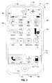
- FIG. 1is a block diagram of an example mobile device 100.
- the mobile device 100can be, for example, a handheld computer, a personal digital assistant, a cellular telephone, a network appliance, a camera, a smart phone, an enhanced general packet radio service (EGPRS) mobile phone, a network base station, a media player, a navigation device, an email device, a game console, or a combination of any two or more of these data processing devices or other data processing devices.
- EGPSenhanced general packet radio service
- the mobile device 100includes a touch-sensitive display 102.
- the touch-sensitive display 102can implement liquid crystal display (LCD) technology, light emitting polymer display (LPD) technology, or some other display technology.
- LCDliquid crystal display
- LPDlight emitting polymer display
- the touch sensitive display 102can be sensitive to haptic and/or tactile contact with a user.
- the touch-sensitive display 102can comprise a multi-touch-sensitive display 102.
- a multi-touch-sensitive display 102can, for example, process multiple simultaneous touch points, including processing data related to the pressure, degree, and/or position of each touch point. Such processing facilitates gestures and interactions with multiple fingers, chording, and other interactions.
- Other touch-sensitive display technologiescan also be used, e.g., a display in which contact is made using a stylus or other pointing device.
- the mobile device 100can display one or more graphical user interfaces on the touch-sensitive display 102 for providing the user access to various system objects and for conveying information to the user.
- the graphical user interfacecan include one or more display objects 104, 106.
- the display objects 104, 106are graphic representations of system objects.
- system objectsinclude device functions, applications, windows, files, alerts, events, or other identifiable system objects.
- the mobile device 100can implement multiple device functionalities, such as a telephony device, an e-mail device, a network data communication device, a Wi-Fi base station device (not shown), and a media processing device.
- device functionalitiescan be displayed in a menu bar 118.
- device functionalitiescan be accessed from a top-level graphical user interface, such as the graphical user interface illustrated in FIG. 1 . Touching one of the objects 104 can, for example, invoke corresponding functionality.
- the mobile device 100can implement network distribution functionality.
- the functionalitycan enable the user to take the mobile device 100 and provide access to its associated network while traveling.
- the mobile device 100can extend Internet access (e.g., Wi-Fi) to other wireless devices in the vicinity.
- mobile device 100can be configured as a base station for one or more devices. As such, mobile device 100 can grant or deny network access to other wireless devices.
- the graphical user interface of the mobile device 100changes, or is augmented or replaced with another user interface or user interface elements, to facilitate user access to particular functions associated with the corresponding device functionality.
- the graphical user interface of the touch-sensitive display 102may present display objects related to various phone functions; likewise, touching of an email object may cause the graphical user interface to present display objects related to various e-mail functions; touching a Web object may cause the graphical user interface to present display objects related to various Web-surfing functions; and touching a media player object may cause the graphical user interface to present display objects related to various media processing functions.
- the top-level graphical user interface environment or state of FIG. 1can be restored by pressing a button 120 located near the bottom of the mobile device 100.
- each corresponding device functionalitymay have corresponding "home" display objects displayed on the touch-sensitive display 102, and the graphical user interface environment of FIG. 1 can be restored by pressing the "home" display object.
- the top-level graphical user interfacecan include additional display objects 106, such as a short messaging service (SMS) object, a calendar object, a photos object, a camera object, a calculator object, a stocks object, a weather object, a maps object 144, a notes object, a clock object, an address book object, and a settings object.
- SMSshort messaging service
- Touching the maps object 144can, for example, invoke a mapping and location-based services environment and supporting functionality; likewise, a selection of any of the display objects 106 can invoke a corresponding object environment and functionality.
- Additional and/or different display objectscan also be displayed in the graphical user interface of FIG. 1 .
- the display objects 106can be configured by a user, e.g., a user may specify which display objects 106 are displayed, and/or may download additional applications or other software that provides other functionalities and corresponding display objects.
- the mobile device 100can include one or more input/output (I/O) devices and/or sensor devices.
- I/Oinput/output
- a speaker 160 and a microphone 162can be included to facilitate voice-enabled functionalities, such as phone and voice mail functions.
- an up/down button 184 for volume control of the speaker 160 and the microphone 162can be included.
- the mobile device 100can also include an on/off button 182 for a ring indicator of incoming phone calls.
- a loud speaker 164can be included to facilitate hands-free voice functionalities, such as speaker phone functions.
- An audio jack 166can also be included for use of headphones and/or a microphone.
- a proximity sensor 168can be included to facilitate the detection of the user positioning the mobile device 100 proximate to the user's ear and, in response, to disengage the touch-sensitive display 102 to prevent accidental function invocations.
- the touch-sensitive display 102can be turned off to conserve additional power when the mobile device 100 is proximate to the user's ear.
- an ambient light sensor 170can be utilized to facilitate adjusting the brightness of the touch-sensitive display 102.
- an accelerometer 172can be utilized to detect movement of the mobile device 100, as indicated by the directional arrow 174. Accordingly, display objects and/or media can be presented according to a detected orientation, e.g., portrait or landscape.
- the mobile device 100may include circuitry and sensors for supporting a location determining capability, such as that provided by the Global Positioning System (GPS) or other positioning systems (e.g., systems using Wi-Fi access points, television signals, cellular grids, Uniform Resource Locators (URLs)).
- GPSGlobal Positioning System
- URLsUniform Resource Locators
- a positioning systeme.g., a GPS receiver
- a positioning systemcan be integrated into the mobile device 100 or provided as a separate device that can be coupled to the mobile device 100 through an interface (e.g., port device 190) to provide access to location-based services.
- a port device 190e.g., a Universal Serial Bus (USB) port, or a docking port, or some other wired port connection
- the port device 190can, for example, be utilized to establish a wired connection to other computing devices, such as other communication devices 100, network access devices, a personal computer, a printer, a display screen, or other processing devices capable of receiving and/or transmitting data.
- the port device 190allows the mobile device 100 to synchronize with a host device using one or more protocols, such as, for example, the TCP/IP, HTTP, UDP and any other known protocol.
- the mobile device 100can also include a camera lens and sensor 180.
- the camera lens and sensor 180can be located on the back surface of the mobile device 100.
- the cameracan capture still images and/or video.
- the mobile device 100can also include one or more wireless communication subsystems, such as an 802.11b/g communication device 186, and/or a BluetoothTM communication device 188.
- Other communication protocolscan also be supported, including other 802.x communication protocols (e.g., WiMax, Wi-Fi, 3G), code division multiple access (CDMA), global system for mobile communications (GSM), Enhanced Data GSM Environment (EDGE), etc.
- 802.x communication protocolse.g., WiMax, Wi-Fi, 3G
- CDMAcode division multiple access
- GSMglobal system for mobile communications
- EDGEEnhanced Data GSM Environment
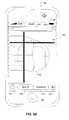
- FIG. 2is a block diagram of an example network operating environment 200.
- mobile devices 202a and 202beach can represent mobile device 100.
- Mobile devices 202a and 202bcan, for example, communicate over one or more wired and/or wireless networks 210 in data communication.
- a wireless network 212e.g., a cellular network
- WANwide area network
- an access device 218, such as an 802.11g wireless access devicecan provide communication access to the wide area network 214.
- both voice and data communicationscan be established over the wireless network 212 and the access device 218.
- the mobile device 202acan place and receive phone calls (e.g., using VoIP protocols), send and receive e-mail messages (e.g., using POP3 protocol), and retrieve electronic documents and/or streams, such as web pages, photographs, and videos, over the wireless network 212, gateway 216, and wide area network 214 (e.g., using TCP/IP or UDP protocols).
- the mobile device 202bcan place and receive phone calls, send and receive e-mail messages, and retrieve electronic documents over the access device 218 and the wide area network 214.
- the mobile device 202a or 202bcan be physically connected to the access device 218 using one or more cables and the access device 218 can be a personal computer. In this configuration, the mobile device 202a or 202b can be referred to as a "tethered" device.
- the mobile devices 202a and 202bcan also establish communications by other means.
- the wireless device 202acan communicate with other wireless devices, e.g., other mobile devices 202a or 202b, cell phones, etc., over the wireless network 212.
- the mobile devices 202a and 202bcan establish peer-to-peer communications 220, e.g., a personal area network, by use of one or more communication subsystems, such as the Bluetooth TM communication devices 188 shown in FIG. 1 .
- Other communication protocols and topologiescan also be implemented.
- the mobile device 202a or 202bcan, for example, communicate with one or more services 230, 240, 250, 260, and 270 over the one or more wired and/or wireless networks 210.
- one or more navigation services 230can provide navigation information, e.g., map information, location information, route information, and other information, to the mobile device 202a or 202b.
- a user of the mobile device 202bcan invoke a map functionality, e.g., by pressing the maps object 144 on the top-level graphical user interface shown in FIG. 1 , and can request and receive a map for a particular location, request and receive route directions, or request and receive listings of businesses in the vicinity of a particular location, for example.
- a messaging service 240can, for example, provide e-mail and/or other messaging services.
- a media service 250can, for example, provide access to media files, such as song files, audio books, movie files, video clips, and other media data. In some implementations, separate audio and video services (not shown) can provide access to the respective types of media files.
- a syncing service 260can, for example, perform syncing services (e.g., sync files).
- An activation service 270can, for example, perform an activation process for activating the mobile device 202a or 202b.
- Other servicescan also be provided, including a software update service that automatically determines whether software updates exist for software on the mobile device 202a or 202b, then downloads the software updates to the mobile device 202a or 202b where the software updates can be manually or automatically unpacked and/or installed.
- a software update servicethat automatically determines whether software updates exist for software on the mobile device 202a or 202b, then downloads the software updates to the mobile device 202a or 202b where the software updates can be manually or automatically unpacked and/or installed.
- the mobile device 202a or 202bcan also access other data and content over the one or more wired and/or wireless networks 210.
- content publisherssuch as news sites, RSS feeds, web sites, blogs, social networking sites, developer networks, etc.
- Such accesscan be provided by invocation of a web browsing function or application (e.g., a browser) in response to a user touching, for example, a Web object.
- FIG. 3is a block diagram 300 of an example implementation of the mobile device 100 of FIG. 1 .
- the mobile device 100can include a memory interface 302, one or more data processors, image processors and/or central processing units 304, and a peripherals interface 306.
- the memory interface 302, the one or more processors 304 and/or the peripherals interface 306can be separate components or can be integrated in one or more integrated circuits.
- the various components in the mobile device 100can be coupled by one or more communication buses or signal lines.
- Sensors, devices, and subsystemscan be coupled to the peripherals interface 306 to facilitate multiple functionalities.
- a motion sensor 310, a light sensor 312, and a proximity sensor 314can be coupled to the peripherals interface 306 to facilitate the orientation, lighting, and proximity functions described with respect to FIG. 1 .
- Other sensors 316can also be connected to the peripherals interface 306, such as a positioning system (e.g., GPS receiver), a temperature sensor, a biometric sensor, or other sensing device, to facilitate related functionalities.
- CCDcharged coupled device
- CMOScomplementary metal-oxide semiconductor
- Communication functionscan be facilitated through one or more wireless communication subsystems 324, which can include radio frequency receivers and transmitters and/or optical (e.g., infrared) receivers and transmitters.
- the specific design and implementation of the communication subsystem 324can depend on the communication network(s) over which the mobile device 100 is intended to operate.
- a mobile device 100may include communication subsystems 324 designed to operate over a GSM network, a GPRS network, an EDGE network, a Wi-Fi or WiMax network, and a BluetoothTM network.
- the wireless communication subsystems 324may include hosting protocols such that the device 100 may be configured as a base station for other wireless devices.
- An audio subsystem 326can be coupled to a speaker 328 and a microphone 330 to facilitate voice-enabled functions, such as voice recognition, voice replication, digital recording, and telephony functions.
- the I/O subsystem 340can include a touch screen controller 342 and/or other input controller(s) 344.
- the touch-screen controller 342can be coupled to a touch screen 346.
- the touch screen 346 and touch screen controller 342can, for example, detect contact and movement or break thereof using any of a plurality of touch sensitivity technologies, including but not limited to capacitive, resistive, infrared, and surface acoustic wave technologies, as well as other proximity sensor arrays or other elements for determining one or more points of contact with the touch screen 346.
- the other input controller(s) 344can be coupled to other input/control devices 348, such as one or more buttons, rocker switches, thumb-wheel, infrared port, USB port, and/or a pointer device such as a stylus.
- the one or more buttonscan include an up/down button for volume control of the speaker 328 and/or the microphone 330.
- a pressing of the button for a first durationmay disengage a lock of the touch screen 346; and a pressing of the button for a second duration that is longer than the first duration may turn power to the mobile device 100 on or off.
- the usermay be able to customize a functionality of one or more of the buttons.
- the touch screen 346can, for example, also be used to implement virtual or soft buttons and/or a keyboard.
- the mobile device 100can present recorded audio and/or video files, such as MP3, AAC, and MPEG files.
- the mobile device 100can include the functionality of an MP3 player, such as an iPodTM.
- the mobile device 100may, therefore, include a 36-pin connector that is compatible with the iPod.
- Other input/output and control devicescan also be used.
- the memory interface 302can be coupled to memory 350.
- the memory 350can include high-speed random access memory and/or non-volatile memory, such as one or more magnetic disk storage devices, one or more optical storage devices, and/or flash memory (e.g., NAND, NOR).
- the memory 350can store an operating system 352, such as Darwin, RTXC, LINUX, UNIX, OS X, WINDOWS, or an embedded operating system such as VxWorks.
- the operating system 352may include instructions for handling basic system services and for performing hardware dependent tasks.
- the operating system 352can be a kernel (e.g., UNIX kernel).
- the memory 350may also store communication instructions 354 to facilitate communicating with one or more additional devices, one or more computers and/or one or more servers.
- the memory 350may include graphical user interface instructions 356 to facilitate graphic user interface processing; sensor processing instructions 358 to facilitate sensor-related processing and functions; phone instructions 360 to facilitate phone-related processes and functions; electronic messaging instructions 362 to facilitate electronic-messaging related processes and functions; web browsing instructions 364 to facilitate web browsing-related processes and functions; media processing instructions 366 to facilitate media processing-related processes and functions; GPS/Navigation instructions 368 to facilitate GPS and navigation-related processes and instructions; camera instructions 370 to facilitate camera-related processes and functions; and/or other software instructions 372 to facilitate other processes and functions, e.g., security processes and functions.
- the memory 350may also store other software instructions (not shown), such as web video instructions to facilitate web video-related processes and functions; and/or web shopping instructions to facilitate web shopping-related processes and functions.
- the media processing instructions 366are divided into audio processing instructions and video processing instructions to facilitate audio processing-related processes and functions and video processing-related processes and functions, respectively.
- An activation record and International Mobile Equipment Identity (IMEI) 374 or similar hardware identifiercan also be stored in memory 350.
- IMEIInternational Mobile Equipment Identity
- Each of the above identified instructions and applicationscan correspond to a set of instructions for performing one or more functions described above. These instructions need not be implemented as separate software programs, procedures, or modules.
- the memory 350can include additional instructions or fewer instructions.
- various functions of the mobile device 100may be implemented in hardware and/or in software, including in one or more signal processing and/or application specific integrated circuits.
- FIG. 4illustrates an example implementation of a navigation system 400.
- mobile device 402can represent mobile device 100.
- the mobile device 402can, for example, communicate to one or more network access points 404 (e.g., Wi-Fi base station devices) or one or more cell towers 406.
- the access points 404can be any combination of 802.11b/g wireless routers, 802.11n wireless routers, and some other Wi-Fi devices that implement any suitable Wi-Fi or other wireless networking technology or protocol.
- a location-based service 408(Location-Based Service A) or a location-based service 410 (Location-Based Service B) can estimate geographic areas where the mobile device 402 is currently located.
- the actual location of the mobile device 402can be anywhere within the estimated geographic area.
- An estimated geographic areais not necessarily circular but can be indicated as a circular area on a map display for convenience.
- the mobile device 402can, for example, receive a communication 412A from an access point 404 (e.g., a Wi-Fi access point).
- the communication 412Acan include information about the access point 404, e.g., the Internet Protocol (IP) address and/or the Media Access Control (MAC) address of the access point 404.
- IPInternet Protocol
- MACMedia Access Control
- the communication 412Acan include other information, such as the latitude and longitude of the access point 404.
- the information received in communication 412Acan be sent to the location-based service 408 in communication 412B.
- the location-based service 408can, for example, with a degree of uncertainty or error, estimate a first geographic area in which the mobile device 402 is currently located using the information sent in communication 412B.
- the location-based service 408is a system or service that estimates, with some degree of uncertainty or error, the position of a device using a database of access points mapped to geographic locations.
- the accuracy or precision (or the degree of uncertainty or error) of the estimated positioncan, for example, be based on the range of the technology, the accuracy of the range, or some other metric.
- Accuracy or precision of an estimated positioncan be affected by one or more factors including, for example, inherent properties or limitations of the technology or system, and a level of deployment of the given technology or system (e.g., number of access points or cell towers in the vicinity of the device).
- the accuracy or precision of the estimated positionis stated in units of distance (e.g., "the estimated position is accurate up to 50 meters”). That is, the actual position of the mobile device 402 can be within the accuracy distance from the estimated position.
- the first geographic areacan be a circle centered at the latitude and longitude of the estimated position with a radius equal to the stated accuracy or precision (e.g. 38 meters if the accuracy of the estimated position is up to 38 meters).
- the first geographic areacan alternatively be represented on a map display as a square, rectangle, oval, diamond, triangle, or some other shaped enclosed region.
- unique signatures of multiple access pointscan be compared to a local cache on the mobile device 402 or a central reference database at location-based service 408 using network communication (e.g. communication 412B can be sent to the location-based service 408).
- the location-based service 408can use the unique signatures to estimate the latitude and longitude of the center of the first geographic circle with an m meter radius (e.g., about 20 meters).
- location-based service 408includes positioning services and reference database information provided by SKYHOOK WIRELESS of Boston, MA.
- the mobile device 402can receive a communication 414A from cell tower 406.
- the cell communication 414Acan include, for example, information identifying the cell tower 406.
- the cell communication 414Acan also include the latitude and longitude of the cell tower 406.
- the identifying information and/or the latitude and longitude of the cell tower 406can be sent to the location-based service 410 in communication 414B.
- the location-based service 410can estimate a position of the mobile device 402 using the information included in communication 414B and estimate an accuracy of the estimate position.
- the location-based service 410can estimate a second geographic area in which the mobile device 402 is currently located.
- the second geographic areais represented on a map as a circular region centered at the estimated position and with a radius equal to the accuracy of the estimated position. In some other implementations, the second geographic area can represented on a map by a square or rectangular shaped enclosed region, to name a few additional examples.
- the position and the geographic area of the mobile device 402can be estimated using a "cell of origin" positioning technology.
- the second geographic areacan be determined by cell tower triangulation.
- the first and second geographic areascan be sent to the mobile device 402 by communications 416 and 418, respectively.
- the mobile device 402can present, on the touch-sensitive display 102 for example, a map view including an indication of one of the geographic areas if that one is entirely contained within the other geographic area (including the case where the boundaries of the geographic areas touch but otherwise no part of the one of the geographic area is outside of the other geographic area).
- a map view that includes an indication of the first geographic areacan be presented if the first geographic area is completely contained within the second geographic area.
- the mobile device 402can present a map view that includes an indication of the second geographic area if the first geographic area is not completely contained within the second geographic area.
- the mobile device 402can use the first geographic area.
- the level of detail of the technologycan, for example, be determined by a priority table stored in the mobile device 402.
- the first geographic areacan be estimated using the access point 404
- the second geographic areacan be estimated using the cell tower 406.
- the access point 404was moved from its original location and the latitude and longitude coordinates of the access point 404 as they are known to location-based service 408 are incorrect and the mobile device 402 is not actually located within the first geographic area.
- the cell tower 406provided correct location-based data and the mobile device 402 is located within the second geographic area. In this situation, the first and second geographic areas do not overlap, so the mobile device 402 would display a map view indicating the second geographic area.
- the mobile device 402can be used to determine the accuracy of the first and second geographic areas, or an external server or servers can be used.
- the location-based service 408 and location-based service 410can run on the same device or on separate devices.
- the location-based services 408 and 410can run on servers communicating with the mobile device 100 through a network (e.g., WAN 214).
- the serverscan be separate servers or the same server.
- the location-based services 408 and 410can alternatively run on the mobile device 402.
- the mobile device 402can, for example, connect to additional devices or services (not shown) for location-based services, instead of, or in addition to the access point 404 and the cell tower 406.
- additional devices or servicescould include a Blue-toothTM device, GPS, radio or TV towers, or cellular grids, to name a few examples.
- the mobile device 402can connect to peer devices with the BluetoothTM communication device 188 ( FIG. 1 ) and receive location-based information from other mobile devices and/or BluetoothTM enabled devices.
- the mobile device 402can determine or estimate its position and/or geographic area using other technologies (e.g., GPS).
- the geographic area determined or estimated using any of these other technologiescan be used (e.g., displayed) in lieu of the geographic area estimated using location-based services 408 or 410 (.e.g., Wi-Fi or cellular positioning techniques) if the geographic area determined or estimated using the other technologies is contained entirely within the geographic area estimated using location-based services 408 or 410 and if the other technologies are more accurate or precise according to the priority table stored in the mobile device 402.
- location-based services 408 or 410e.g., Wi-Fi or cellular positioning techniques
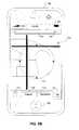
- FIG. 5Aillustrates an example of a map 502 with a geographic area displayed on mobile device 100.
- the mobile device 100can display the map 502 on the touch sensitive display 102 of mobile device 100.
- the map 502can be displayed when a user selects the maps object 144 to view mapping and location based services.
- objectssuch as the maps object 144 ( FIG. 1 ) can be selected by voice activation.
- a search bar 504 and a bookmarks list object 506can be displayed at the top of the map 502. Below the bottom of the map one or more display objects can be displayed, for example a search object 508, a directions object 510, a map view object 512, and a current location object 514.
- the search bar 504can be used to find an address or other location on the map. For example, a user can enter their home address in the search bar 504, and the region containing the address would be displayed on the map 502.
- the bookmarks list object 506can, for example, bring up a Bookmarks list which contains addresses that are frequently visited, such as a user's home address.
- the Bookmarks listcan also, for example, contain special bookmarks such as the current location, e.g. the current location of the mobile device 100.
- the search object 508can be used to display the search bar 504 and other map related search menus.
- the directions object 510can, for example, bring up a menu interface that allows the user to enter a start and end location and then displays information for a route from the start location to the end location, e.g. directions and travel time.
- the map view object 512can bring up a menu that will allow the user to select display options for the map 502. An example of a menu that can be displayed when map view 512 is selected is further described below in reference to FIGS. 11 and 14 .
- the map 502could be changed from black and white to color, the background of the map could be changed, or the user could change the brightness of the map, to name a few examples.
- the current location object 514can allow the user to see a geographic area 516 on the map 502 indicating where the device 100 is currently located.
- the special current location bookmarkcan be placed in the Bookmarks list when the current location object 514 is selected. If the special current location bookmark was previously set in the Bookmarks list, the old bookmark information can, for example, be replaced with the new current location information.
- the special current location bookmarkis tied to the centroid of the geographic area 516. That is, the special current location bookmark includes the address for the centroid of the geographic area 516.
- the geographic area 516can be based on location data determined or estimated using location-based services 408 or 410, or some other location data, such as the data previously described in reference to FIG. 4 .
- the geographic area 516can, for example, be depicted by a circle, rectangle, square, or other enclosed region with crosshairs, or some other distinctive element to differentiate the geographic area 516 from the map 502.
- the geographic area 516indicates a region in which the mobile device 100 is determined or estimated to be located, and the geographic area may not necessarily be centered on the actual current position of the mobile device 100. In this example, the mobile device 100 may be located off-center within the geographic area. In another example, the geographic area 516 can be centered on an estimated current position of the mobile device 100.
- the mobile device 100can, for example, center the map view on the geographic area 516 when the current location object 514 is tapped or otherwise selected.
- the zoom level of the mapcan be adjusted based on the accuracy or precision of the location data or the technology, system, or service that provided the location data.
- the mapcan be zoomed in for higher accuracy GPS location data and zoomed out for lower accuracy cell tower or Wi-Fi location data.
- the zoom levelcan be based on the velocity of the mobile device 100, e.g. the map can be zoomed out at higher velocities and zoomed in when the mobile device 100 is not moving.
- a combination of accuracy or precision and velocitycan also be used. If all methods for retrieving location-based data fail, e.g.
- both location-based service A 408 and location-based service B 410fail and there are no other systems or services available for determining or estimating the current position of the mobile device 100, an error can be displayed to the user and no geographic area is displayed on the map 502.
- the errorcan, for example, contain a message to the user informing them of the failure and the possible reason for the failure.
- the current location object 514can be selected, for example, to activate the estimation and displaying of the geographic area 516 on the map 502, to get directions to or from the estimated current location (i.e., the centroid of the geographic area 516), to send the estimated current location of the mobile device 100 to a friend (e.g. so that the friend can go to the same location), or to create a bookmark for the estimated current location, to name a few examples.
- FIG. 5Billustrates another example of the map 502 with a geographic area 518 on the mobile device 100.
- the geographic area 518is shown as a circle with ticks on the perimeter of the circle.
- Other distinctive featurescould also be used to differentiate the geographic area 518 from the remainder of the map 502, such as a square, a triangle, or a shaded region.
- the perimeter of the geographic area 518can, for example, have crosshairs, tick marks, shading, or some other feature to make it stand out from the map 502.
- the geographic area 518can be shaded and/or highlighted, or the area of the map 502 outside of the geographic area 518 can be shaded and/or highlighted.
- the circle outlining the geographic area 518can, for example, have animation, or be motionless.
- the circlecan, for example, change color (e.g. user defined colors or pre-programmed colors on the mobile device 100), change distinctive features (e.g. switch between crosshairs and ticks), or have moving distinctive features (e.g. the ticks change position).
- the circlecould, for example, have white space overlaid on top of the map directly around the perimeter, or some combination of features.
- the contrast of the circle's coloroscillates or pulses to differentiate the circle from the map 502.
- FIG. 6illustrates a zoomed out view 602 of the map 502 from FIG. 5A .
- the geographic area 604can, for example, be the geographic area 516 rescaled to match the scale of the zoomed out view 602.
- the usercan, for example, find restaurants, entertainment, or some other destination located in or in the vicinity of the geographic area 604.
- This view of the map 602can be presented when the mobile device 100 is moving, e.g. the user of the mobile device 100 is a passenger in a moving vehicle.
- the geographic area 604is determined or estimated when the current location object 514 is selected and does not change with the movement of the mobile device 100.
- the geographic area 604can move on the map 602 with the movement of the mobile device 100.
- the geographic area 604can be based on data from the most recent query to the Wi-Fi base station device 404.
- the geographic area 604could also, for example, be based on historical data of where the mobile device 100 recently was located. For example, if the geographic area 604 was last updated a short time before the newest activation, the previous location can be used to identify the new location. Continuing the example, if the previous current location showed that the user is in California, but the new location 30 minutes later would show a current location in Florida, an error can be displayed on the mobile device 100.
- FIG. 7illustrates another view of the map 502 from FIG. 5A .
- a geographic area 702encloses the entire view of the map 502.
- this view of the map 502 and geographic area 702can be shown, for example, when the mobile device is not moving or not moving very quickly, e.g. the user with mobile device 100 is walking.
- the geographic area 702can be displayed to contain the entire view of the map 502 when, at a given zoom level of the map 502, the accuracy or precision of the estimated position of the device 100 spans the entirety of the displayed area of the map 502, i.e., the geographic area 702 covers the entirety of the displayed portion of the map 502 at the given zoom level. For example, if the map is zoomed to display a 50-meter region around the estimated current position and the accuracy of the estimated current position is 100 meters, then the geographic area 702 can be displayed to enclose the displayed region of the map.
- FIG. 8illustrates another view of map 602 with a larger geographic area 802 than shown in FIG. 6 .
- the geographic area 604could, for example, be determined using Wi-Fi, such as through access point 404 described in reference to FIG. 4
- the geographic area 802could be determined using cell phone towers, such as the cell tower 406 described in reference to FIG. 4 .
- the first geographic area from FIG. 4can be determined using access points 404 and the second geographic area from FIG. 4 can be determined by cell tower 406. If the first geographic area is determined to be wholly contained within the second geographic area, the first geographic area can be used as geographic area 604 and be presented on the mobile device 100. If the first geographic area is determined to be at most partially contained within the second geographic area, the second geographic area could be used as geographic area 802 and be presented on the mobile device 100.
- first geographic areabeing at most partially contained within the second geographic area
- the access point 404being moved, or the access point 404 and the cell tower 406 having a partial overlap of geographic areas (e.g. the first geographic area is on the edge and partially outside of the second geographic area).
- Other examples of the cause of geographic areas 604 and 802 being differentwould be for other positioning technologies, systems or services that have varying levels of accuracy or precision, such as a GPS and a radio tower.
- the scaling of the map 502can be different based on the geographic area selected, the technology/system/service used to determine or estimate the geographic area, or some other requirement. For example, if the first geographic area determined using access points 404, as described above, is selected to be presented as the geographic area 516 from FIG. 5A , the scaling can be larger than if the second geographic area, determined using cell tower 406, was selected to be presented as geographic area 802.
- the scaling of the map 602can, for example, stay the same when the current location object 514 is selected.
- the default zoom level determined to be used on the mobile device 100is close to the currently used zoom level, the zoom level can remain unchanged, e.g.
- the map 602can, for example, be changed to a street view.
- the line width of the circle around the geographic area 802can be changed based on the zoom level, or the line width can stay the same. For example, the line width can get larger or smaller when zooming in closer to the map.
- the change to the line width and/or to lengths of the crosshairs, tick marks, or the like on the circlecan be based on an exponential algorithm, a linear algorithm, or some other algorithm.
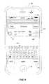
- FIG. 9illustrates an example of an interface for getting directions on the mobile device 100.
- Selection of the directions object 510can, for example, bring up the directions interface.
- the directions interfacecan allow the user of mobile device 100 to get directions to and from any location.
- the current location bookmark in the Bookmarks listcan automatically be inserted a start location 902.
- a start location 902can also be manually entered using a keyboard 908.
- An end location 904can be selected from the Bookmarks list with an end bookmarks list object 906 or can be manually entered using the keyboard 908. If the current location is not used as the start location 902, it can be used as the end location 904 (e.g., by selecting the current location bookmark from the Bookmarks list).
- the start location 902 and end location 904can be swapped with a switch object 910.
- the switch objectcan be used to make the end location 904 the new start location and the start location 902 the new end location.
- the usercan, for example, remove the current location bookmark from the start location 902 if a different start location is desired with a remove start location object 912.
- the usercan manually enter a new location as the start location 902 using the keyboard 908.
- the usercan select the current location bookmark or another location bookmark from the Bookmarks list as the start location.
- the remove start location object 912can be replaced with a start bookmarks list object (not shown), similar to the end bookmarks list object 906, if the start location 902 is empty.
- the route object 914can be selected and directions and optionally other information for a route from the start location 902 to the end location 904 can be displayed on the map, e.g. the map 502.
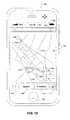
- FIG. 10illustrates an example of directions for a route 1002 displayed on a map 1001.
- the usercan use the directions interface of FIG. 9 to get directions from the center or centroid of the geographic area 1003 in city A, to a destination address (e.g. an address entered on the keyboard 908, a selected bookmarked address).
- a start pin 1004 or other position markercan be placed in the center or centroid of the geographic area 1003 to represent an estimated current location of the mobile device 100; the actual location of the mobile device 100 can be anywhere within the geographic area 1003.
- An end pin 1006can be placed at the destination address.
- the route of the directions 1002 between the start pin 1004 and the end pin 1006can be highlight or depicted in some other way to clearly show the route.
- the start pin 1004has a street flag 1008 that displays the name of the street on which the start pin 1004 is placed.
- the street flag 1008can have an object 1010 that is user selectable. Selection of the 1010 can display an interface to allow the user to change the display of the route 1002, to show turn by turn directions, or to select other options, to name a few examples.
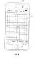
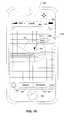
- FIG. 11illustrates a menu presented when the user selects the map view object 512.
- the map 502can be displayed with a page curl or flipped-page graphical effect 1102, to allow presentation of a menu 1103 on a bottom portion of the touch-sensitive display 102. In some implementations, this simulates a peeling of a layer with the map 502 to reveal the menu 1103 in a layer below.
- the flipped-page graphical effect 1102can, for example, also allow presentation of other content such as the Bookmarks list, an address book, the directions interface, a phonebook, a calendar, a calculator, or other information.
- the flipped-page graphical effect 1102can allow additional content to be displayed toward the top, left, right, or middle of the touch-sensitive display 102.
- the flipped-page graphical effect 1102can, for example, be a half page curl, or a whole page curl, to name a few
- the menu 1103 presented with the selection of the map view object 512can contain user selectable objects including a drop pin object 1104 and a show traffic object 1106.
- Map views for the map 502can be changed with a map object 1108, a satellite object 1110, and a hybrid object 1112.
- a list object 1114can also be displayed.
- the show traffic object 1106can display traffic related information on the map 502. For example, roads with heavy traffic can be highlighted in red on the map 502.
- the map object 1108can select a basic background (e.g. just streets, highways, etc are displayed) for the map 502.
- the satellite object 1110can select a satellite view of the map 502 to be presented.
- the satellite viewcan contain terrain, such as trees, hills, mountains, buildings, etc.
- the hybrid object 1112can have a combination of the basic background and the satellite view presented on the map 502. For example, terrain information is displayed with road information overlaid on top.
- the list object 1114can, for example, be used to display a list of one or more businesses, landmarks, addresses, or other locations located in the area displayed on the map 502 or in the vicinity of the current geographic area 516.
- the list of businessescan be a scroll list, or the list can be overlaid on top of map 502, e.g. the names and locations of businesses can be displayed on the map 502.
- the businesses, etc. in the listcan be organized by name or by street.
- the businesses, landmarks, etc.are ordered by a location-based service from which the information regarding the businesses, landmarks, etc. are received.
- the location-based servicecan sort the list based on various criteria (e.g., popularity, relevance to a search query entered by the user of the device, etc.). Selection of the list object 1114 can change the zoom level of map 502 so that too much information is not displayed on the map 502 (e.g., if the user is in a densely populated area the map can be zoomed in more than if the user is in a rural area).
- criteriae.g., popularity, relevance to a search query entered by the user of the device, etc.
- the list that is displayedis a list of the turn-by-turn directions for the route.
- the drop pin object 1104can, for example, allow the user to drop a pin or other position marker on the map 502.
- a mape.g., map 502
- a special drop pin bookmarkis placed in the Bookmarks list.
- the mapcan have one custom drop pin at any time.
- the mapcan have more than one dropped pin at any time.
- the usercan drop a pin on the map to mark and to keep track of an arbitrary location. For example, the user received a current location of a friend and wants to place a pin on the map where their friend is located.
- the usercan use the dropped pin to get directions from the current location of the mobile device 100 to the location of the dropped pin, e.g. their friend's location. In the case of multiple dropped pins, the user can use the dropped pins to get direction from one arbitrary location to another arbitrary location.
- FIG. 12shows an example of a dropped pin 1202 on a map 1201.
- the dropped pin 1202can, for example, have a flag 1204 that provides information to the user of the mobile device 100.
- the flag 1204can display information on the location where the dropped pin 1202 is placed, such as the city and state or street name, for example.
- the flag 1204can include an arrow 1206 that is user selectable.
- other contente.g., additional information, a user-selectable menu of options, etc.
- the dropped pin 1202can be moved by dragging it on the touch-sensitive display 102 to another location.
- the dropped pin 1202can be any arbitrary location, e.g., a location that the user will need to get to in the future, the location of a friend needing directions, or some other point of reference.
- FIG. 13illustrates a dropped pin menu 1302 displayed on the mobile device 100.
- the dropped pin menu 1302can, for example, be accessed by double tapping on the dropped pin 1202 in FIG. 12 , or by selecting the arrow 1206.
- the dropped pin menu 1302can, for example, be associated with a dropped pin, e.g. the dropped pin 1202.
- the dropped pin menu 1302can contain an add to bookmarks object 1304, a directions to here object 1306, a directions from here object 1308, and a remove pin object 1310.
- the add to bookmarks object 1304can create a bookmark in the Bookmarks list for the current location of the dropped pin 1202.
- the special dropped pin bookmarkcan, for example, be removed from the Bookmarks list, or the special dropped pin bookmark can remain in the Bookmarks list.
- the directions to here object 1306can bring up the directions interface for getting directions to the current location of the dropped pin 1202. For example, if the dropped pin 1202 is placed at a location that the user needs to get back to at a later time, the user can double tap on the dropped pin 1202 when they need directions. Continuing the example, if the user has the estimated current location (e.g., the centroid of an estimated geographic area) selected, selection of the directions to here object 1306 can bring up the directions interface with the estimated current location filled out as the start location, and the end location as the dropped pin 1202. This can allow the user of the mobile device 100 to easily get back to another location they were at recently, or to get to a friend's location, to name a few
- the directions from here object 1308can bring up the directions interface and allow the user to select or enter an end destination.
- the directions from here object 1308can, for example, be chosen when the user is giving directions to a friend located at the dropped pin 1202.
- the directions from here object 1308can be selected, continuing the example, and a bookmark (e.g. a home bookmark with the home address of the user of the mobile device 100) or a manually entered location can be chosen as the end location.
- the directions to here object 1308 and the directions from here object 1308can also be used to provide route information to or from the dropped pin 1202 for a doctor's appointment or a sporting event, to name a few additional examples.
- the remove pin object 1310can allow the user to remove the currently selected dropped pin 1202 from the map 502.
- the dropped pin 1202is unique (e.g. there is only one dropped pin on the map at any time), and in other implementations, there can be more than one dropped pin on the map at any time.
- the usercan select the remove pin object 1310 if the location of the dropped pin 1202 is no longer needed, e.g. the location of the dropped pin has been added to the Bookmarks list with the add to bookmarks object 1304.
- FIG. 14illustrates the menu presented by the map view object 512 when there is a dropped pin on the map.
- therecan only be one dropped pin on the map at any time for keeping track of a point of interest, or a destination that will only be traveled to once, to list a few examples.
- the usercan, for example, save the current dropped pin 1202 to the Bookmarks list to keep track of multiple points of interest.
- the drop pin object 1104is replaced with a replace pin object 1402.
- the replace pin object 1402is selected, for example, the currently dropped pin (e.g. dropped pin 1202) is removed from the map and a new pin is dropped onto the map.
- the old dropped pine.g. dropped pin 1202 may not currently be visible on the map.
- both the drop pin object 1104 and the replace pin object 1402can be visible in the menu presented by selection of the map view object 512.
- the usercould, for example, name the dropped pins to keep track of them on the map 502.
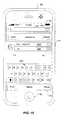
- FIG. 15illustrates an example of the directions interface after selecting the directions from here object 1308.
- the directions interfacewhen the directions interface is displayed, the location of the dropped pin 1202 is filled in for a start location 1502.
- the usercan select the end location 904 with the end bookmark list object 906 or the keyboard 908.
- the switch object 910can be selected to swap the start location 1502 and the end location 904. If, for example, the user changes plans, the start location 1502 can be changed from the dropped pin 1202 to another location by selecting the remove start location object 912 and entering a new start location with the keyboard 908 or by selecting a location from the Bookmarks list.
- the route object 914can be selected to display directions on a map, e.g. the map 1201.
- the directions interfacecan also be entered when the user selects the directions to here object 1306. In this case, when the directions interface is displayed, the location of the dropped pin 1202 is filled in as the end location 904.
- FIG. 16illustrates a dropped pin 1602 placed at the centroid of the geographic area 802 from FIG. 8 .
- a geographic areae.g., geographic area 802
- the dropped pin 1602is placed on the map
- the dropped pin 1602is placed at the centroid of the geographic area.
- the usercan drag the dropped pin 1602 to another location within the geographic area 802 or on the map 602 if desired by selecting the dropped pin, e.g. by touching the touch-sensitive display 102 at the location of the dropped pin 1602.
- the dropped pin 1602can have a flag 1604 that can present information about the location of the dropped pin 1602 or instructions to the user.
- the dropped pin 1602can, for example, be saved as a permanent bookmark in the Bookmarks list via the dropped pin menu 1302 accessed with an arrow 1606 in the flag 1604.
- the disclosed and other embodiments and the functional operations described in this specificationcan be implemented in digital electronic circuitry, or in computer software, firmware, or hardware, including the structures disclosed in this specification and their structural equivalents, or in combinations of one or more of them.
- the disclosed and other embodimentscan be implemented as one or more computer program products, i.e., one or more modules of computer program instructions encoded on a computer-readable medium for execution by, or to control the operation of, data processing apparatus.
- the computer-readable mediumcan be a machine-readable storage device, a machine-readable storage substrate, a memory device, a composition of matter effecting a machine-readable propagated signal, or a combination of one or more them.
- data processing apparatusencompasses all apparatus, devices, and machines for processing data, including by way of example a programmable processor, a computer, or multiple processors or computers.
- the apparatuscan include, in addition to hardware, code that creates an execution environment for the computer program in question, e.g., code that constitutes processor firmware, a protocol stack, a database management system, an operating system, or a combination of one or more of them.
- a propagated signalis an artificially generated signal, e.g., a machine-generated electrical, optical, or electromagnetic signal, that is generated to encode information for transmission to suitable receiver apparatus.
- a computer program(also known as a program, software, software application, script, or code) can be written in any form of programming language, including compiled or interpreted languages, and it can be deployed in any form, including as a stand-alone program or as a module, component, subroutine, or other unit suitable for use in a computing environment.
- a computer programdoes not necessarily correspond to a file in a file system.
- a programcan be stored in a portion of a file that holds other programs or data (e.g., one or more scripts stored in a markup language document), in a single file dedicated to the program in question, or in multiple coordinated files (e.g., files that store one or more modules, sub-programs, or portions of code).
- a computer programcan be deployed to be executed on one computer or on multiple computers that are located at one site or distributed across multiple sites and interconnected by a communication network.
- the processes and logic flows described in this specificationcan be performed by one or more programmable processors executing one or more computer programs to perform functions by operating on input data and generating output.
- the processes and logic flowscan also be performed by, and apparatus can also be implemented as, special purpose logic circuitry, e.g., an FPGA (field programmable gate array) or an ASIC (application-specific integrated circuit).
- processors suitable for the execution of a computer programinclude, by way of example, both general and special purpose microprocessors, and any one or more processors of any kind of digital computer.
- a processorwill receive instructions and data from a read-only memory or a random access memory or both.
- the essential elements of a computerare a processor for performing instructions and one or more memory devices for storing instructions and data.
- a computerwill also include, or be operatively coupled to receive data from or transfer data to, or both, one or more mass storage devices for storing data, e.g., magnetic, magneto-optical disks, or optical disks.
- mass storage devicesfor storing data, e.g., magnetic, magneto-optical disks, or optical disks.
- a computerneed not have such devices.
- Computer-readable media suitable for storing computer program instructions and datainclude all forms of non-volatile memory, media and memory devices, including by way of example semiconductor memory devices, e.g., EPROM, EEPROM, and flash memory devices; magnetic disks, e.g., internal hard disks or removable disks; magneto-optical disks; and CD-ROM and DVD-ROM disks.
- semiconductor memory devicese.g., EPROM, EEPROM, and flash memory devices
- magnetic diskse.g., internal hard disks or removable disks
- magneto-optical diskse.g., CD-ROM and DVD-ROM disks.
- the processor and the memorycan be supplemented by, or incorporated in, special purpose logic circuitry.
- the disclosed embodimentscan be implemented on a computer having a display device, e.g., a CRT (cathode ray tube) or LCD (liquid crystal display) monitor, for displaying information to the user and a keyboard and a pointing device, e.g., a mouse or a trackball, by which the user can provide input to the computer.
- a display devicee.g., a CRT (cathode ray tube) or LCD (liquid crystal display) monitor
- a keyboard and a pointing devicee.g., a mouse or a trackball
- Other kinds of devicescan be used to provide for interaction with a user as well; for example, feedback provided to the user can be any form of sensory feedback, e.g., visual feedback, auditory feedback, or tactile feedback; and input from the user can be received in any form, including acoustic, speech, or tactile input.
- the disclosed embodimentscan be implemented in a computing system that includes a back-end component, e.g., as a data server, or that includes a middleware component, e.g., an application server, or that includes a front-end component, e.g., a client computer having a graphical user interface or a Web browser through which a user can interact with an implementation of what is disclosed here, or any combination of one or more such back-end, middleware, or front-end components.
- the components of the systemcan be interconnected by any form or medium of digital data communication, e.g., a communication network. Examples of communication networks include a local area network ("LAN”) and a wide area network (“WAN”), e.g., the Internet.
- LANlocal area network
- WANwide area network
- the computing systemcan include clients and servers.
- a client and serverare generally remote from each other and typically interact through a communication network.
- the relationship of client and serverarises by virtue of computer programs running on the respective computers and having a client-server relationship to each other.
Landscapes
- Engineering & Computer Science (AREA)
- Remote Sensing (AREA)
- Radar, Positioning & Navigation (AREA)
- Physics & Mathematics (AREA)
- General Physics & Mathematics (AREA)
- Human Computer Interaction (AREA)
- Automation & Control Theory (AREA)
- Computer Networks & Wireless Communication (AREA)
- Theoretical Computer Science (AREA)
- General Engineering & Computer Science (AREA)
- Signal Processing (AREA)
- Environmental & Geological Engineering (AREA)
- Telephone Function (AREA)
- Navigation (AREA)
- Instructional Devices (AREA)
Abstract
Description
- This specification is related generally to graphical user interfaces.
- The role of traditional printed maps is being supplanted by modern devices capable of rendering dynamic map displays. Devices that include mapping or navigation applications provide information regarding an area selected by a user by recalling map data from local memory or networked services.
- When coupled with any of a number of positioning technologies, a mapping device can display a current position on a map as well as deliver navigation instructions based on the current position to route a user to a desired destination. Positioning technologies include satellite positioning systems, such as the Global Positioning System (GPS), cell tower triangulation and network-based positioning systems (e.g., Wi-Fi positioning system). Positioning technologies provide varying degrees of accuracy or precision. For example, GPS is generally accurate to a few meters, while other positioning technologies are generally less accurate.
- In general, one aspect of the subject matter described in this specification can be embodied in methods that include the actions of estimating a first geographic area in which a device is currently located using a first positioning system, estimating a second geographic area in which the device is currently located using a second positioning system, presenting a first map view including an indication of the first geographic area on the first map view if the first geographic area is contained within the second geographic area, and presenting a second map view including an indication of the second geographic area if the first geographic area is not contained within the second geographic area. Other embodiments of this aspect include corresponding systems, apparatus, computer program products, and computer readable media.
- In general, another aspect of the subject matter described in this specification can be embodied in methods that include the actions of presenting a map view, receiving user input requesting an arbitrary position marker, and presenting the map view with the arbitrary position marker placed at an arbitrary position on the map view. Other embodiments of this aspect include corresponding systems, apparatus, computer program products, and computer readable media.
- Implementations can include one or more of the following features. The method can further include receiving user input moving the arbitrary position marker and positioning the arbitrary position marker at a new position based on the user input. The method can further include generating route information for a route, wherein an endpoint of the route is a position on the map view indicated by the arbitrary position marker and presenting the route information.
- In general, another aspect of the subject matter described in this specification can be embodied in methods that include the actions of presenting a map view on a first virtual graphical layer, receiving a request to present other content, presenting a flipped-page graphical effect with respect to the map view, where the flipped-page effect simulates a partial peeling of the first virtual graphical layer to reveal a second virtual graphical layer, and presenting the other content on the second virtual graphical layer. Other embodiments of this aspect include corresponding systems, apparatus, computer program products, and computer readable media.
- In an implementation the other content can include a menu associated with the map view.
- In general, another aspect of the subject matter described in this specification can be embodied in methods that include the actions of presenting a map view, and presenting an indication of a region on the map view, where the region represents a geographic area in which a device is located. Other embodiments of this aspect include corresponding systems, apparatus, computer program products, and computer readable media.
- Implementations can include one or more of the following features. The region is the entirety of the map view, and the indication includes a shape enclosing the map view. The region is a portion of the map view. The indication includes one or more circles surrounding the region. The indication further includes one or more crosshairs. A thickness of a respective one of the circles is a function of a zoom level of the map view. The region is presented in a first color shade and a portion of the map view outside of the region is presented in a second color shade.
- In general, another aspect of the subject matter described in this specification can be embodied in graphical user interfaces that include a map view and an indication of a region on the map view, where the region represents a geographic area in which a device is located, and where the indication includes a circle and one or more crosshairs. Other embodiments of this aspect include corresponding methods, systems, apparatus, computer program products, and computer readable media.
- Particular embodiments of the subject matter described in this specification can be implemented to realize one or more of the following advantages. The area of uncertainty associated with a current position determined using a positioning technology can be indicated on a map. Geographic areas in which a device is currently located can be determined or estimated using one or more positioning technologies and the most accurate or precise geographic area can be indicated on a map displayed on a mobile device, for example.
- The details of one or more embodiments of the subject matter described in this specification are set forth in the accompanying drawings and the description below. Other features, aspects, and advantages of the subject matter will become apparent from the description, the drawings, and the claims.
FIG. 1 is a block diagram of an example mobile device.FIG. 2 is a block diagram of an example network operating environment for the mobile device ofFIG. 1 .FIG. 3 is a block diagram of an example implementation of the mobile device ofFIG. 1 .FIG. 4 illustrates an example implementation of a navigation system.FIG. 5A illustrates an example of a map with a geographic area displayed on the mobile device ofFIG. 1 .FIG. 5B illustrates another example of the map fromFIG. 5A .FIG. 6 illustrates a zoomed out view of the map fromFIG. 5A .FIG. 7 illustrates another view of the map fromFIG. 5A .FIG. 8 illustrates another view of map with a larger geographic area than shown inFIG. 6 .FIG. 9 illustrates an example of a user interface for getting directions.FIG. 10 illustrates an example of route information displayed on a map.FIG. 11 illustrates an example menu in a mapping application.FIG. 12 shows an example of a map with a position marker dropped onto an arbitrary position on the map.FIG. 13 illustrates a dropped position marker menu.FIG. 14 illustrates another example menu in a mapping application.FIG. 15 illustrates another example of a user interface for getting directions.FIG. 16 illustrates a dropped pin in the center of a geographic area.- Like reference numbers and designations in the various drawings indicate like elements.
FIG. 1 is a block diagram of an examplemobile device 100. Themobile device 100 can be, for example, a handheld computer, a personal digital assistant, a cellular telephone, a network appliance, a camera, a smart phone, an enhanced general packet radio service (EGPRS) mobile phone, a network base station, a media player, a navigation device, an email device, a game console, or a combination of any two or more of these data processing devices or other data processing devices.- In some implementations, the
mobile device 100 includes a touch-sensitive display 102. The touch-sensitive display 102 can implement liquid crystal display (LCD) technology, light emitting polymer display (LPD) technology, or some other display technology. The touchsensitive display 102 can be sensitive to haptic and/or tactile contact with a user. - In some implementations, the touch-
sensitive display 102 can comprise a multi-touch-sensitive display 102. A multi-touch-sensitive display 102 can, for example, process multiple simultaneous touch points, including processing data related to the pressure, degree, and/or position of each touch point. Such processing facilitates gestures and interactions with multiple fingers, chording, and other interactions. Other touch-sensitive display technologies can also be used, e.g., a display in which contact is made using a stylus or other pointing device. Some examples of multi-touch-sensitive display technology are described inU.S. Patent Nos. 6,323,846 ,6,570,557 ,6,677,932 , and6,888,536 . - In some implementations, the
mobile device 100 can display one or more graphical user interfaces on the touch-sensitive display 102 for providing the user access to various system objects and for conveying information to the user. In some implementations, the graphical user interface can include one or more display objects 104, 106. In the example shown, the display objects 104, 106, are graphic representations of system objects. Some examples of system objects include device functions, applications, windows, files, alerts, events, or other identifiable system objects. - Example Mobile Device Functionality
- In some implementations, the
mobile device 100 can implement multiple device functionalities, such as a telephony device, an e-mail device, a network data communication device, a Wi-Fi base station device (not shown), and a media processing device. In some implementations, particular display objects 104 can be displayed in amenu bar 118. In some implementations, device functionalities can be accessed from a top-level graphical user interface, such as the graphical user interface illustrated inFIG. 1 . Touching one of theobjects 104 can, for example, invoke corresponding functionality. - In some implementations, the
mobile device 100 can implement network distribution functionality. For example, the functionality can enable the user to take themobile device 100 and provide access to its associated network while traveling. In particular, themobile device 100 can extend Internet access (e.g., Wi-Fi) to other wireless devices in the vicinity. For example,mobile device 100 can be configured as a base station for one or more devices. As such,mobile device 100 can grant or deny network access to other wireless devices. - In some implementations, upon invocation of device functionality, the graphical user interface of the
mobile device 100 changes, or is augmented or replaced with another user interface or user interface elements, to facilitate user access to particular functions associated with the corresponding device functionality. For example, in response to a user touching a phone object, the graphical user interface of the touch-sensitive display 102 may present display objects related to various phone functions; likewise, touching of an email object may cause the graphical user interface to present display objects related to various e-mail functions; touching a Web object may cause the graphical user interface to present display objects related to various Web-surfing functions; and touching a media player object may cause the graphical user interface to present display objects related to various media processing functions. - In some implementations, the top-level graphical user interface environment or state of
FIG. 1 can be restored by pressing abutton 120 located near the bottom of themobile device 100. In some implementations, each corresponding device functionality may have corresponding "home" display objects displayed on the touch-sensitive display 102, and the graphical user interface environment ofFIG. 1 can be restored by pressing the "home" display object. - In some implementations, the top-level graphical user interface can include additional display objects 106, such as a short messaging service (SMS) object, a calendar object, a photos object, a camera object, a calculator object, a stocks object, a weather object, a
maps object 144, a notes object, a clock object, an address book object, and a settings object. Touching the maps object 144 can, for example, invoke a mapping and location-based services environment and supporting functionality; likewise, a selection of any of the display objects 106 can invoke a corresponding object environment and functionality. - Additional and/or different display objects can also be displayed in the graphical user interface of
FIG. 1 . For example, if thedevice 100 is functioning as a base station for other devices, one or more "connection" objects may appear in the graphical user interface to indicate the connection. In some implementations, the display objects 106 can be configured by a user, e.g., a user may specify which display objects 106 are displayed, and/or may download additional applications or other software that provides other functionalities and corresponding display objects. - In some implementations, the
mobile device 100 can include one or more input/output (I/O) devices and/or sensor devices. For example, aspeaker 160 and amicrophone 162 can be included to facilitate voice-enabled functionalities, such as phone and voice mail functions. In some implementations, an up/downbutton 184 for volume control of thespeaker 160 and themicrophone 162 can be included. Themobile device 100 can also include an on/offbutton 182 for a ring indicator of incoming phone calls. In some implementations, aloud speaker 164 can be included to facilitate hands-free voice functionalities, such as speaker phone functions. Anaudio jack 166 can also be included for use of headphones and/or a microphone. - In some implementations, a
proximity sensor 168 can be included to facilitate the detection of the user positioning themobile device 100 proximate to the user's ear and, in response, to disengage the touch-sensitive display 102 to prevent accidental function invocations. In some implementations, the touch-sensitive display 102 can be turned off to conserve additional power when themobile device 100 is proximate to the user's ear. - Other sensors can also be used. For example, in some implementations, an ambient
light sensor 170 can be utilized to facilitate adjusting the brightness of the touch-sensitive display 102. In some implementations, anaccelerometer 172 can be utilized to detect movement of themobile device 100, as indicated by thedirectional arrow 174. Accordingly, display objects and/or media can be presented according to a detected orientation, e.g., portrait or landscape. In some implementations, themobile device 100 may include circuitry and sensors for supporting a location determining capability, such as that provided by the Global Positioning System (GPS) or other positioning systems (e.g., systems using Wi-Fi access points, television signals, cellular grids, Uniform Resource Locators (URLs)). In some implementations, a positioning system (e.g., a GPS receiver) can be integrated into themobile device 100 or provided as a separate device that can be coupled to themobile device 100 through an interface (e.g., port device 190) to provide access to location-based services. - In some implementations, a
port device 190, e.g., a Universal Serial Bus (USB) port, or a docking port, or some other wired port connection, can be included. Theport device 190 can, for example, be utilized to establish a wired connection to other computing devices, such asother communication devices 100, network access devices, a personal computer, a printer, a display screen, or other processing devices capable of receiving and/or transmitting data. In some implementations, theport device 190 allows themobile device 100 to synchronize with a host device using one or more protocols, such as, for example, the TCP/IP, HTTP, UDP and any other known protocol. - The
mobile device 100 can also include a camera lens andsensor 180. In some implementations, the camera lens andsensor 180 can be located on the back surface of themobile device 100. The camera can capture still images and/or video. - The
mobile device 100 can also include one or more wireless communication subsystems, such as an 802.11b/g communication device 186, and/or a Bluetooth™ communication device 188. Other communication protocols can also be supported, including other 802.x communication protocols (e.g., WiMax, Wi-Fi, 3G), code division multiple access (CDMA), global system for mobile communications (GSM), Enhanced Data GSM Environment (EDGE), etc. FIG. 2 is a block diagram of an examplenetwork operating environment 200. InFIG. 2 ,mobile devices mobile device 100.Mobile devices wireless networks 210 in data communication. For example, awireless network 212, e.g., a cellular network, can communicate with a wide area network (WAN) 214, such as the Internet, by use of agateway 216. Likewise, anaccess device 218, such as an 802.11g wireless access device, can provide communication access to the wide area network 214. In some implementations, both voice and data communications can be established over thewireless network 212 and theaccess device 218. For example, themobile device 202a can place and receive phone calls (e.g., using VoIP protocols), send and receive e-mail messages (e.g., using POP3 protocol), and retrieve electronic documents and/or streams, such as web pages, photographs, and videos, over thewireless network 212,gateway 216, and wide area network 214 (e.g., using TCP/IP or UDP protocols). Likewise, in some implementations, themobile device 202b can place and receive phone calls, send and receive e-mail messages, and retrieve electronic documents over theaccess device 218 and the wide area network 214. In some implementations, themobile device access device 218 using one or more cables and theaccess device 218 can be a personal computer. In this configuration, themobile device - The
mobile devices wireless device 202a can communicate with other wireless devices, e.g., othermobile devices wireless network 212. Likewise, themobile devices peer communications 220, e.g., a personal area network, by use of one or more communication subsystems, such as the Bluetooth™ communication devices 188 shown inFIG. 1 . Other communication protocols and topologies can also be implemented. - The
mobile device more services wireless networks 210. For example, one ormore navigation services 230 can provide navigation information, e.g., map information, location information, route information, and other information, to themobile device mobile device 202b can invoke a map functionality, e.g., by pressing the maps object 144 on the top-level graphical user interface shown inFIG. 1 , and can request and receive a map for a particular location, request and receive route directions, or request and receive listings of businesses in the vicinity of a particular location, for example. - A
messaging service 240 can, for example, provide e-mail and/or other messaging services. Amedia service 250 can, for example, provide access to media files, such as song files, audio books, movie files, video clips, and other media data. In some implementations, separate audio and video services (not shown) can provide access to the respective types of media files. Asyncing service 260 can, for example, perform syncing services (e.g., sync files). Anactivation service 270 can, for example, perform an activation process for activating themobile device mobile device mobile device - The
mobile device wireless networks 210. For example, content publishers, such as news sites, RSS feeds, web sites, blogs, social networking sites, developer networks, etc., can be accessed by themobile device FIG. 3 is a block diagram 300 of an example implementation of themobile device 100 ofFIG. 1 . Themobile device 100 can include amemory interface 302, one or more data processors, image processors and/orcentral processing units 304, and aperipherals interface 306. Thememory interface 302, the one ormore processors 304 and/or the peripherals interface 306 can be separate components or can be integrated in one or more integrated circuits. The various components in themobile device 100 can be coupled by one or more communication buses or signal lines.- Sensors, devices, and subsystems can be coupled to the peripherals interface 306 to facilitate multiple functionalities. For example, a
motion sensor 310, alight sensor 312, and aproximity sensor 314 can be coupled to the peripherals interface 306 to facilitate the orientation, lighting, and proximity functions described with respect toFIG. 1 .Other sensors 316 can also be connected to theperipherals interface 306, such as a positioning system (e.g., GPS receiver), a temperature sensor, a biometric sensor, or other sensing device, to facilitate related functionalities. - A
camera subsystem 320 and anoptical sensor 322, e.g., a charged coupled device (CCD) or a complementary metal-oxide semiconductor (CMOS) optical sensor, can be utilized to facilitate camera functions, such as recording photographs and video clips. - Communication functions can be facilitated through one or more
wireless communication subsystems 324, which can include radio frequency receivers and transmitters and/or optical (e.g., infrared) receivers and transmitters. The specific design and implementation of thecommunication subsystem 324 can depend on the communication network(s) over which themobile device 100 is intended to operate. For example, amobile device 100 may includecommunication subsystems 324 designed to operate over a GSM network, a GPRS network, an EDGE network, a Wi-Fi or WiMax network, and a Bluetooth™ network. In particular, thewireless communication subsystems 324 may include hosting protocols such that thedevice 100 may be configured as a base station for other wireless devices. - An
audio subsystem 326 can be coupled to aspeaker 328 and amicrophone 330 to facilitate voice-enabled functions, such as voice recognition, voice replication, digital recording, and telephony functions. - The I/
O subsystem 340 can include atouch screen controller 342 and/or other input controller(s) 344. The touch-screen controller 342 can be coupled to atouch screen 346. Thetouch screen 346 andtouch screen controller 342 can, for example, detect contact and movement or break thereof using any of a plurality of touch sensitivity technologies, including but not limited to capacitive, resistive, infrared, and surface acoustic wave technologies, as well as other proximity sensor arrays or other elements for determining one or more points of contact with thetouch screen 346. - The other input controller(s) 344 can be coupled to other input/
control devices 348, such as one or more buttons, rocker switches, thumb-wheel, infrared port, USB port, and/or a pointer device such as a stylus. The one or more buttons (not shown) can include an up/down button for volume control of thespeaker 328 and/or themicrophone 330. - In one implementation, a pressing of the button for a first duration may disengage a lock of the
touch screen 346; and a pressing of the button for a second duration that is longer than the first duration may turn power to themobile device 100 on or off. The user may be able to customize a functionality of one or more of the buttons. Thetouch screen 346 can, for example, also be used to implement virtual or soft buttons and/or a keyboard. - In some implementations, the
mobile device 100 can present recorded audio and/or video files, such as MP3, AAC, and MPEG files. In some implementations, themobile device 100 can include the functionality of an MP3 player, such as an iPod™. Themobile device 100 may, therefore, include a 36-pin connector that is compatible with the iPod. Other input/output and control devices can also be used. - The
memory interface 302 can be coupled tomemory 350. Thememory 350 can include high-speed random access memory and/or non-volatile memory, such as one or more magnetic disk storage devices, one or more optical storage devices, and/or flash memory (e.g., NAND, NOR). Thememory 350 can store anoperating system 352, such as Darwin, RTXC, LINUX, UNIX, OS X, WINDOWS, or an embedded operating system such as VxWorks. Theoperating system 352 may include instructions for handling basic system services and for performing hardware dependent tasks. In some implementations, theoperating system 352 can be a kernel (e.g., UNIX kernel). - The
memory 350 may also storecommunication instructions 354 to facilitate communicating with one or more additional devices, one or more computers and/or one or more servers. Thememory 350 may include graphicaluser interface instructions 356 to facilitate graphic user interface processing;sensor processing instructions 358 to facilitate sensor-related processing and functions;phone instructions 360 to facilitate phone-related processes and functions;electronic messaging instructions 362 to facilitate electronic-messaging related processes and functions;web browsing instructions 364 to facilitate web browsing-related processes and functions;media processing instructions 366 to facilitate media processing-related processes and functions; GPS/Navigation instructions 368 to facilitate GPS and navigation-related processes and instructions;camera instructions 370 to facilitate camera-related processes and functions; and/orother software instructions 372 to facilitate other processes and functions, e.g., security processes and functions. Thememory 350 may also store other software instructions (not shown), such as web video instructions to facilitate web video-related processes and functions; and/or web shopping instructions to facilitate web shopping-related processes and functions. In some implementations, themedia processing instructions 366 are divided into audio processing instructions and video processing instructions to facilitate audio processing-related processes and functions and video processing-related processes and functions, respectively. An activation record and International Mobile Equipment Identity (IMEI) 374 or similar hardware identifier can also be stored inmemory 350. - Each of the above identified instructions and applications can correspond to a set of instructions for performing one or more functions described above. These instructions need not be implemented as separate software programs, procedures, or modules. The
memory 350 can include additional instructions or fewer instructions. Furthermore, various functions of themobile device 100 may be implemented in hardware and/or in software, including in one or more signal processing and/or application specific integrated circuits. FIG. 4 illustrates an example implementation of a navigation system 400. InFIG. 4 ,mobile device 402 can representmobile device 100. Themobile device 402 can, for example, communicate to one or more network access points 404 (e.g., Wi-Fi base station devices) or one or more cell towers 406. In some implementations, theaccess points 404 can be any combination of 802.11b/g wireless routers, 802.11n wireless routers, and some other Wi-Fi devices that implement any suitable Wi-Fi or other wireless networking technology or protocol. Using the communication with theaccess points 404 or the cell towers 406, a location-based service 408 (Location-Based Service A) or a location-based service 410 (Location-Based Service B) can estimate geographic areas where themobile device 402 is currently located. The actual location of themobile device 402 can be anywhere within the estimated geographic area. An estimated geographic area is not necessarily circular but can be indicated as a circular area on a map display for convenience.- The
mobile device 402 can, for example, receive acommunication 412A from an access point 404 (e.g., a Wi-Fi access point). Thecommunication 412A can include information about theaccess point 404, e.g., the Internet Protocol (IP) address and/or the Media Access Control (MAC) address of theaccess point 404. Thecommunication 412A can include other information, such as the latitude and longitude of theaccess point 404. The information received incommunication 412A can be sent to the location-basedservice 408 incommunication 412B. The location-basedservice 408 can, for example, with a degree of uncertainty or error, estimate a first geographic area in which themobile device 402 is currently located using the information sent incommunication 412B. In some implementations, the location-basedservice 408 is a system or service that estimates, with some degree of uncertainty or error, the position of a device using a database of access points mapped to geographic locations. The accuracy or precision (or the degree of uncertainty or error) of the estimated position can, for example, be based on the range of the technology, the accuracy of the range, or some other metric. Accuracy or precision of an estimated position can be affected by one or more factors including, for example, inherent properties or limitations of the technology or system, and a level of deployment of the given technology or system (e.g., number of access points or cell towers in the vicinity of the device). - In some implementations, the accuracy or precision of the estimated position is stated in units of distance (e.g., "the estimated position is accurate up to 50 meters"). That is, the actual position of the
mobile device 402 can be within the accuracy distance from the estimated position. For example, the first geographic area can be a circle centered at the latitude and longitude of the estimated position with a radius equal to the stated accuracy or precision (e.g. 38 meters if the accuracy of the estimated position is up to 38 meters). The first geographic area can alternatively be represented on a map display as a square, rectangle, oval, diamond, triangle, or some other shaped enclosed region. - In some other implementations, unique signatures of multiple access points (e.g. five or more) can be compared to a local cache on the
mobile device 402 or a central reference database at location-basedservice 408 using network communication (e.g. communication 412B can be sent to the location-based service 408). The location-basedservice 408 can use the unique signatures to estimate the latitude and longitude of the center of the first geographic circle with an m meter radius (e.g., about 20 meters). - In some implementations, location-based
service 408 includes positioning services and reference database information provided by SKYHOOK WIRELESS of Boston, MA. - The
mobile device 402 can receive acommunication 414A fromcell tower 406. Thecell communication 414A can include, for example, information identifying thecell tower 406. In some implementations, thecell communication 414A can also include the latitude and longitude of thecell tower 406. The identifying information and/or the latitude and longitude of thecell tower 406 can be sent to the location-basedservice 410 incommunication 414B. The location-basedservice 410 can estimate a position of themobile device 402 using the information included incommunication 414B and estimate an accuracy of the estimate position. Thus, for example, the location-basedservice 410 can estimate a second geographic area in which themobile device 402 is currently located. In some implementations, the second geographic area is represented on a map as a circular region centered at the estimated position and with a radius equal to the accuracy of the estimated position. In some other implementations, the second geographic area can represented on a map by a square or rectangular shaped enclosed region, to name a few additional examples. - In some implementations, the position and the geographic area of the
mobile device 402 can be estimated using a "cell of origin" positioning technology. In some other implementations, the second geographic area can be determined by cell tower triangulation. - The first and second geographic areas can be sent to the
mobile device 402 bycommunications mobile device 402 can present, on the touch-sensitive display 102 for example, a map view including an indication of one of the geographic areas if that one is entirely contained within the other geographic area (including the case where the boundaries of the geographic areas touch but otherwise no part of the one of the geographic area is outside of the other geographic area). For example, a map view that includes an indication of the first geographic area can be presented if the first geographic area is completely contained within the second geographic area. Themobile device 402 can present a map view that includes an indication of the second geographic area if the first geographic area is not completely contained within the second geographic area. For example, if the technology, system, or service used to estimate the first geographic area has a greater level of accuracy or precision detail than the technology, system, or service used to estimate the second geographic area, and the first geographic area is determined to be more accurate or precise based on the first geographic area being entirely within the second geographic area, themobile device 402 can use the first geographic area. The level of detail of the technology can, for example, be determined by a priority table stored in themobile device 402. - In another example, the first geographic area can be estimated using the
access point 404, and the second geographic area can be estimated using thecell tower 406. In this example, theaccess point 404 was moved from its original location and the latitude and longitude coordinates of theaccess point 404 as they are known to location-basedservice 408 are incorrect and themobile device 402 is not actually located within the first geographic area. Thecell tower 406 provided correct location-based data and themobile device 402 is located within the second geographic area. In this situation, the first and second geographic areas do not overlap, so themobile device 402 would display a map view indicating the second geographic area. Themobile device 402 can be used to determine the accuracy of the first and second geographic areas, or an external server or servers can be used. - The location-based
service 408 and location-basedservice 410 can run on the same device or on separate devices. For example, the location-basedservices mobile device 100 through a network (e.g., WAN 214). The servers can be separate servers or the same server. - The location-based
services mobile device 402. - The
mobile device 402 can, for example, connect to additional devices or services (not shown) for location-based services, instead of, or in addition to theaccess point 404 and thecell tower 406. Such devices or services could include a Blue-tooth™ device, GPS, radio or TV towers, or cellular grids, to name a few examples. For example, themobile device 402 can connect to peer devices with the Bluetooth™ communication device 188 (FIG. 1 ) and receive location-based information from other mobile devices and/or Bluetooth™ enabled devices. In some implementations, themobile device 402 can determine or estimate its position and/or geographic area using other technologies (e.g., GPS). In some implementations, the geographic area determined or estimated using any of these other technologies can be used (e.g., displayed) in lieu of the geographic area estimated using location-basedservices services mobile device 402. FIG. 5A illustrates an example of amap 502 with a geographic area displayed onmobile device 100. In some implementations, themobile device 100 can display themap 502 on the touchsensitive display 102 ofmobile device 100. Themap 502 can be displayed when a user selects the maps object 144 to view mapping and location based services. In some implementations, objects, such as the maps object 144 (FIG. 1 ), can be selected by voice activation. Asearch bar 504 and abookmarks list object 506 can be displayed at the top of themap 502. Below the bottom of the map one or more display objects can be displayed, for example asearch object 508, adirections object 510, amap view object 512, and acurrent location object 514.- The
search bar 504 can be used to find an address or other location on the map. For example, a user can enter their home address in thesearch bar 504, and the region containing the address would be displayed on themap 502. The bookmarks listobject 506 can, for example, bring up a Bookmarks list which contains addresses that are frequently visited, such as a user's home address. The Bookmarks list can also, for example, contain special bookmarks such as the current location, e.g. the current location of themobile device 100. - The
search object 508 can be used to display thesearch bar 504 and other map related search menus. The directions object 510 can, for example, bring up a menu interface that allows the user to enter a start and end location and then displays information for a route from the start location to the end location, e.g. directions and travel time. Themap view object 512 can bring up a menu that will allow the user to select display options for themap 502. An example of a menu that can be displayed whenmap view 512 is selected is further described below in reference toFIGS. 11 and14 . Themap 502 could be changed from black and white to color, the background of the map could be changed, or the user could change the brightness of the map, to name a few examples. - The
current location object 514 can allow the user to see ageographic area 516 on themap 502 indicating where thedevice 100 is currently located. The special current location bookmark can be placed in the Bookmarks list when thecurrent location object 514 is selected. If the special current location bookmark was previously set in the Bookmarks list, the old bookmark information can, for example, be replaced with the new current location information. In some implementations, the special current location bookmark is tied to the centroid of thegeographic area 516. That is, the special current location bookmark includes the address for the centroid of thegeographic area 516. Thegeographic area 516 can be based on location data determined or estimated using location-basedservices FIG. 4 . Thegeographic area 516 can, for example, be depicted by a circle, rectangle, square, or other enclosed region with crosshairs, or some other distinctive element to differentiate thegeographic area 516 from themap 502. - In some implementations, the
geographic area 516 indicates a region in which themobile device 100 is determined or estimated to be located, and the geographic area may not necessarily be centered on the actual current position of themobile device 100. In this example, themobile device 100 may be located off-center within the geographic area. In another example, thegeographic area 516 can be centered on an estimated current position of themobile device 100. - The
mobile device 100 can, for example, center the map view on thegeographic area 516 when thecurrent location object 514 is tapped or otherwise selected. In some implementations, the zoom level of the map can be adjusted based on the accuracy or precision of the location data or the technology, system, or service that provided the location data. For example, the map can be zoomed in for higher accuracy GPS location data and zoomed out for lower accuracy cell tower or Wi-Fi location data. In another implementation, the zoom level can be based on the velocity of themobile device 100, e.g. the map can be zoomed out at higher velocities and zoomed in when themobile device 100 is not moving. A combination of accuracy or precision and velocity can also be used. If all methods for retrieving location-based data fail, e.g. both location-basedservice A 408 and location-basedservice B 410 fail and there are no other systems or services available for determining or estimating the current position of themobile device 100, an error can be displayed to the user and no geographic area is displayed on themap 502. The error can, for example, contain a message to the user informing them of the failure and the possible reason for the failure. - The
current location object 514 can be selected, for example, to activate the estimation and displaying of thegeographic area 516 on themap 502, to get directions to or from the estimated current location (i.e., the centroid of the geographic area 516), to send the estimated current location of themobile device 100 to a friend (e.g. so that the friend can go to the same location), or to create a bookmark for the estimated current location, to name a few examples. FIG. 5B illustrates another example of themap 502 with ageographic area 518 on themobile device 100. In this example thegeographic area 518 is shown as a circle with ticks on the perimeter of the circle. Other distinctive features could also be used to differentiate thegeographic area 518 from the remainder of themap 502, such as a square, a triangle, or a shaded region. The perimeter of thegeographic area 518 can, for example, have crosshairs, tick marks, shading, or some other feature to make it stand out from themap 502. In another example, thegeographic area 518 can be shaded and/or highlighted, or the area of themap 502 outside of thegeographic area 518 can be shaded and/or highlighted.- The circle outlining the
geographic area 518 can, for example, have animation, or be motionless. The circle can, for example, change color (e.g. user defined colors or pre-programmed colors on the mobile device 100), change distinctive features (e.g. switch between crosshairs and ticks), or have moving distinctive features (e.g. the ticks change position). The circle could, for example, have white space overlaid on top of the map directly around the perimeter, or some combination of features. In some implementations, the contrast of the circle's color oscillates or pulses to differentiate the circle from themap 502. FIG. 6 illustrates a zoomed outview 602 of themap 502 fromFIG. 5A . In this example the user is able to view a large area of themap 602 around ageographic area 604. Thegeographic area 604 can, for example, be thegeographic area 516 rescaled to match the scale of the zoomed outview 602. The user can, for example, find restaurants, entertainment, or some other destination located in or in the vicinity of thegeographic area 604. This view of themap 602 can be presented when themobile device 100 is moving, e.g. the user of themobile device 100 is a passenger in a moving vehicle. In some implementations, thegeographic area 604 is determined or estimated when thecurrent location object 514 is selected and does not change with the movement of themobile device 100. In some other implementations, thegeographic area 604 can move on themap 602 with the movement of themobile device 100.- In some implementations, the
geographic area 604 can be based on data from the most recent query to the Wi-Fibase station device 404. Thegeographic area 604 could also, for example, be based on historical data of where themobile device 100 recently was located. For example, if thegeographic area 604 was last updated a short time before the newest activation, the previous location can be used to identify the new location. Continuing the example, if the previous current location showed that the user is in California, but the new location 30 minutes later would show a current location in Florida, an error can be displayed on themobile device 100. FIG. 7 illustrates another view of themap 502 fromFIG. 5A . In this example, ageographic area 702 encloses the entire view of themap 502. In some implementations, this view of themap 502 andgeographic area 702 can be shown, for example, when the mobile device is not moving or not moving very quickly, e.g. the user withmobile device 100 is walking. Thegeographic area 702 can be displayed to contain the entire view of themap 502 when, at a given zoom level of themap 502, the accuracy or precision of the estimated position of thedevice 100 spans the entirety of the displayed area of themap 502, i.e., thegeographic area 702 covers the entirety of the displayed portion of themap 502 at the given zoom level. For example, if the map is zoomed to display a 50-meter region around the estimated current position and the accuracy of the estimated current position is 100 meters, then thegeographic area 702 can be displayed to enclose the displayed region of the map.FIG. 8 illustrates another view ofmap 602 with a largergeographic area 802 than shown inFIG. 6 . Thegeographic area 604 could, for example, be determined using Wi-Fi, such as throughaccess point 404 described in reference toFIG. 4 , and thegeographic area 802 could be determined using cell phone towers, such as thecell tower 406 described in reference toFIG. 4 .- For example, the first geographic area from
FIG. 4 can be determined usingaccess points 404 and the second geographic area fromFIG. 4 can be determined bycell tower 406. If the first geographic area is determined to be wholly contained within the second geographic area, the first geographic area can be used asgeographic area 604 and be presented on themobile device 100. If the first geographic area is determined to be at most partially contained within the second geographic area, the second geographic area could be used asgeographic area 802 and be presented on themobile device 100. - Some examples of the first geographic area being at most partially contained within the second geographic area include the
access point 404 being moved, or theaccess point 404 and thecell tower 406 having a partial overlap of geographic areas (e.g. the first geographic area is on the edge and partially outside of the second geographic area). Other examples of the cause ofgeographic areas - In some implementations, the scaling of the
map 502 can be different based on the geographic area selected, the technology/system/service used to determine or estimate the geographic area, or some other requirement. For example, if the first geographic area determined usingaccess points 404, as described above, is selected to be presented as thegeographic area 516 fromFIG. 5A , the scaling can be larger than if the second geographic area, determined usingcell tower 406, was selected to be presented asgeographic area 802. The scaling of themap 602 can, for example, stay the same when thecurrent location object 514 is selected. Continuing the example, if the default zoom level determined to be used on themobile device 100 is close to the currently used zoom level, the zoom level can remain unchanged, e.g. if the default level is a street zoom and the current zoom level in on a city view, no change is made. If the current zoom level is a state view, and the default level is a street view, themap 602 can, for example, be changed to a street view. - The line width of the circle around the
geographic area 802 can be changed based on the zoom level, or the line width can stay the same. For example, the line width can get larger or smaller when zooming in closer to the map. The change to the line width and/or to lengths of the crosshairs, tick marks, or the like on the circle can be based on an exponential algorithm, a linear algorithm, or some other algorithm. FIG. 9 illustrates an example of an interface for getting directions on themobile device 100. Selection of the directions object 510 can, for example, bring up the directions interface. The directions interface can allow the user ofmobile device 100 to get directions to and from any location. In some implementations, the current location bookmark in the Bookmarks list can automatically be inserted astart location 902. Astart location 902 can also be manually entered using akeyboard 908. Anend location 904 can be selected from the Bookmarks list with an endbookmarks list object 906 or can be manually entered using thekeyboard 908. If the current location is not used as thestart location 902, it can be used as the end location 904 (e.g., by selecting the current location bookmark from the Bookmarks list).- The
start location 902 andend location 904 can be swapped with aswitch object 910. For example, the switch object can be used to make theend location 904 the new start location and thestart location 902 the new end location. - In some implementations, the user can, for example, remove the current location bookmark from the
start location 902 if a different start location is desired with a removestart location object 912. Alternatively, the user can manually enter a new location as thestart location 902 using thekeyboard 908. In other implementations, the user can select the current location bookmark or another location bookmark from the Bookmarks list as the start location. The removestart location object 912 can be replaced with a start bookmarks list object (not shown), similar to the endbookmarks list object 906, if thestart location 902 is empty. Once thestart location 902 andend location 904 have been entered theroute object 914 can be selected and directions and optionally other information for a route from thestart location 902 to theend location 904 can be displayed on the map, e.g. themap 502. FIG. 10 illustrates an example of directions for aroute 1002 displayed on amap 1001. The user, for example, can use the directions interface ofFIG. 9 to get directions from the center or centroid of thegeographic area 1003 in city A, to a destination address (e.g. an address entered on thekeyboard 908, a selected bookmarked address). Astart pin 1004 or other position marker can be placed in the center or centroid of thegeographic area 1003 to represent an estimated current location of themobile device 100; the actual location of themobile device 100 can be anywhere within thegeographic area 1003. Anend pin 1006 can be placed at the destination address.- The route of the
directions 1002 between thestart pin 1004 and theend pin 1006 can be highlight or depicted in some other way to clearly show the route. In some implementations, thestart pin 1004 has astreet flag 1008 that displays the name of the street on which thestart pin 1004 is placed. Thestreet flag 1008 can have anobject 1010 that is user selectable. Selection of the 1010 can display an interface to allow the user to change the display of theroute 1002, to show turn by turn directions, or to select other options, to name a few examples. FIG. 11 illustrates a menu presented when the user selects themap view object 512. When themap view object 512 is selected, themap 502 can be displayed with a page curl or flipped-pagegraphical effect 1102, to allow presentation of amenu 1103 on a bottom portion of the touch-sensitive display 102. In some implementations, this simulates a peeling of a layer with themap 502 to reveal themenu 1103 in a layer below. The flipped-pagegraphical effect 1102 can, for example, also allow presentation of other content such as the Bookmarks list, an address book, the directions interface, a phonebook, a calendar, a calculator, or other information. In some other implementations, the flipped-pagegraphical effect 1102 can allow additional content to be displayed toward the top, left, right, or middle of the touch-sensitive display 102. The flipped-pagegraphical effect 1102 can, for example, be a half page curl, or a whole page curl, to name a few- The
menu 1103 presented with the selection of themap view object 512 can contain user selectable objects including adrop pin object 1104 and ashow traffic object 1106. Map views for themap 502 can be changed with amap object 1108, asatellite object 1110, and ahybrid object 1112. Alist object 1114 can also be displayed. - The
show traffic object 1106 can display traffic related information on themap 502. For example, roads with heavy traffic can be highlighted in red on themap 502. Themap object 1108 can select a basic background (e.g. just streets, highways, etc are displayed) for themap 502. Thesatellite object 1110 can select a satellite view of themap 502 to be presented. The satellite view can contain terrain, such as trees, hills, mountains, buildings, etc. Thehybrid object 1112 can have a combination of the basic background and the satellite view presented on themap 502. For example, terrain information is displayed with road information overlaid on top. - The
list object 1114 can, for example, be used to display a list of one or more businesses, landmarks, addresses, or other locations located in the area displayed on themap 502 or in the vicinity of the currentgeographic area 516. In some implementations, the list of businesses can be a scroll list, or the list can be overlaid on top ofmap 502, e.g. the names and locations of businesses can be displayed on themap 502. In some implementations, the businesses, etc. in the list can be organized by name or by street. In some implementations, the businesses, landmarks, etc. are ordered by a location-based service from which the information regarding the businesses, landmarks, etc. are received. The location-based service can sort the list based on various criteria (e.g., popularity, relevance to a search query entered by the user of the device, etc.). Selection of thelist object 1114 can change the zoom level ofmap 502 so that too much information is not displayed on the map 502 (e.g., if the user is in a densely populated area the map can be zoomed in more than if the user is in a rural area). - In some implementations, when the
list object 1114 is selected while a directions mode is active, e.g., the map is showing direction for a route, the list that is displayed is a list of the turn-by-turn directions for the route. - The
drop pin object 1104 can, for example, allow the user to drop a pin or other position marker on themap 502. When the user drops a pin on a map (e.g., map 502), a special drop pin bookmark is placed in the Bookmarks list. In some implementations, the map can have one custom drop pin at any time. In some other implementations, the map can have more than one dropped pin at any time. The user can drop a pin on the map to mark and to keep track of an arbitrary location. For example, the user received a current location of a friend and wants to place a pin on the map where their friend is located. The user can use the dropped pin to get directions from the current location of themobile device 100 to the location of the dropped pin, e.g. their friend's location. In the case of multiple dropped pins, the user can use the dropped pins to get direction from one arbitrary location to another arbitrary location. FIG. 12 shows an example of a droppedpin 1202 on amap 1201. The droppedpin 1202 can, for example, have aflag 1204 that provides information to the user of themobile device 100. In some implementations, theflag 1204 can display information on the location where the droppedpin 1202 is placed, such as the city and state or street name, for example. Theflag 1204 can include anarrow 1206 that is user selectable. In some implementations, when the user selects thearrow 1206, other content (e.g., additional information, a user-selectable menu of options, etc.) is displayed. In some implementations, the droppedpin 1202 can be moved by dragging it on the touch-sensitive display 102 to another location. The droppedpin 1202 can be any arbitrary location, e.g., a location that the user will need to get to in the future, the location of a friend needing directions, or some other point of reference.FIG. 13 illustrates a droppedpin menu 1302 displayed on themobile device 100. The droppedpin menu 1302 can, for example, be accessed by double tapping on the droppedpin 1202 inFIG. 12 , or by selecting thearrow 1206. The droppedpin menu 1302 can, for example, be associated with a dropped pin, e.g. the droppedpin 1202. The droppedpin menu 1302 can contain an add tobookmarks object 1304, a directions to hereobject 1306, a directions from here object 1308, and aremove pin object 1310.- In some implementations, the add to bookmarks object 1304 can create a bookmark in the Bookmarks list for the current location of the dropped
pin 1202. When the bookmark is added to the Bookmarks list, the special dropped pin bookmark can, for example, be removed from the Bookmarks list, or the special dropped pin bookmark can remain in the Bookmarks list. - The directions to here object 1306 can bring up the directions interface for getting directions to the current location of the dropped
pin 1202. For example, if the droppedpin 1202 is placed at a location that the user needs to get back to at a later time, the user can double tap on the droppedpin 1202 when they need directions. Continuing the example, if the user has the estimated current location (e.g., the centroid of an estimated geographic area) selected, selection of the directions to here object 1306 can bring up the directions interface with the estimated current location filled out as the start location, and the end location as the droppedpin 1202. This can allow the user of themobile device 100 to easily get back to another location they were at recently, or to get to a friend's location, to name a few - The directions from here object 1308 can bring up the directions interface and allow the user to select or enter an end destination. The directions from here object 1308 can, for example, be chosen when the user is giving directions to a friend located at the dropped
pin 1202. The directions from here object 1308 can be selected, continuing the example, and a bookmark (e.g. a home bookmark with the home address of the user of the mobile device 100) or a manually entered location can be chosen as the end location. The directions to here object 1308 and the directions from here object 1308 can also be used to provide route information to or from the droppedpin 1202 for a doctor's appointment or a sporting event, to name a few additional examples. - The
remove pin object 1310 can allow the user to remove the currently selected droppedpin 1202 from themap 502. In some implementations, the droppedpin 1202 is unique (e.g. there is only one dropped pin on the map at any time), and in other implementations, there can be more than one dropped pin on the map at any time. The user can select theremove pin object 1310 if the location of the droppedpin 1202 is no longer needed, e.g. the location of the dropped pin has been added to the Bookmarks list with the add tobookmarks object 1304. FIG. 14 illustrates the menu presented by themap view object 512 when there is a dropped pin on the map. In this implementation, there can only be one dropped pin on the map at any time for keeping track of a point of interest, or a destination that will only be traveled to once, to list a few examples. The user can, for example, save the current droppedpin 1202 to the Bookmarks list to keep track of multiple points of interest. Continuing the example, thedrop pin object 1104 is replaced with a replacepin object 1402. When the replacepin object 1402 is selected, for example, the currently dropped pin (e.g. dropped pin 1202) is removed from the map and a new pin is dropped onto the map. The old dropped pin (e.g. dropped pin 1202) may not currently be visible on the map.- In some other implementations, there can be more than one dropped pin. In this example, both the
drop pin object 1104 and the replacepin object 1402 can be visible in the menu presented by selection of themap view object 512. The user could, for example, name the dropped pins to keep track of them on themap 502. FIG. 15 illustrates an example of the directions interface after selecting the directions from here object 1308. In this case, when the directions interface is displayed, the location of the droppedpin 1202 is filled in for astart location 1502. The user can select theend location 904 with the endbookmark list object 906 or thekeyboard 908. Theswitch object 910 can be selected to swap thestart location 1502 and theend location 904. If, for example, the user changes plans, thestart location 1502 can be changed from the droppedpin 1202 to another location by selecting the removestart location object 912 and entering a new start location with thekeyboard 908 or by selecting a location from the Bookmarks list. When both thestart location 1502 and theend location 904 have been entered, theroute object 914 can be selected to display directions on a map, e.g. themap 1201.- The directions interface can also be entered when the user selects the directions to here
object 1306. In this case, when the directions interface is displayed, the location of the droppedpin 1202 is filled in as theend location 904. FIG. 16 illustrates a droppedpin 1602 placed at the centroid of thegeographic area 802 fromFIG. 8 . When a geographic area (e.g., geographic area 802) of themobile device 100 is displayed on a map (e.g., the map 602) and the droppedpin 1602 is placed on the map, the droppedpin 1602 is placed at the centroid of the geographic area. The user can drag the droppedpin 1602 to another location within thegeographic area 802 or on themap 602 if desired by selecting the dropped pin, e.g. by touching the touch-sensitive display 102 at the location of the droppedpin 1602. In some implementations, the droppedpin 1602 can have aflag 1604 that can present information about the location of the droppedpin 1602 or instructions to the user. The droppedpin 1602 can, for example, be saved as a permanent bookmark in the Bookmarks list via the droppedpin menu 1302 accessed with anarrow 1606 in theflag 1604.- The disclosed and other embodiments and the functional operations described in this specification can be implemented in digital electronic circuitry, or in computer software, firmware, or hardware, including the structures disclosed in this specification and their structural equivalents, or in combinations of one or more of them. The disclosed and other embodiments can be implemented as one or more computer program products, i.e., one or more modules of computer program instructions encoded on a computer-readable medium for execution by, or to control the operation of, data processing apparatus. The computer-readable medium can be a machine-readable storage device, a machine-readable storage substrate, a memory device, a composition of matter effecting a machine-readable propagated signal, or a combination of one or more them. The term "data processing apparatus" encompasses all apparatus, devices, and machines for processing data, including by way of example a programmable processor, a computer, or multiple processors or computers. The apparatus can include, in addition to hardware, code that creates an execution environment for the computer program in question, e.g., code that constitutes processor firmware, a protocol stack, a database management system, an operating system, or a combination of one or more of them.
- A propagated signal is an artificially generated signal, e.g., a machine-generated electrical, optical, or electromagnetic signal, that is generated to encode information for transmission to suitable receiver apparatus.
- A computer program (also known as a program, software, software application, script, or code) can be written in any form of programming language, including compiled or interpreted languages, and it can be deployed in any form, including as a stand-alone program or as a module, component, subroutine, or other unit suitable for use in a computing environment. A computer program does not necessarily correspond to a file in a file system. A program can be stored in a portion of a file that holds other programs or data (e.g., one or more scripts stored in a markup language document), in a single file dedicated to the program in question, or in multiple coordinated files (e.g., files that store one or more modules, sub-programs, or portions of code). A computer program can be deployed to be executed on one computer or on multiple computers that are located at one site or distributed across multiple sites and interconnected by a communication network.
- The processes and logic flows described in this specification can be performed by one or more programmable processors executing one or more computer programs to perform functions by operating on input data and generating output. The processes and logic flows can also be performed by, and apparatus can also be implemented as, special purpose logic circuitry, e.g., an FPGA (field programmable gate array) or an ASIC (application-specific integrated circuit).
- Processors suitable for the execution of a computer program include, by way of example, both general and special purpose microprocessors, and any one or more processors of any kind of digital computer. Generally, a processor will receive instructions and data from a read-only memory or a random access memory or both. The essential elements of a computer are a processor for performing instructions and one or more memory devices for storing instructions and data. Generally, a computer will also include, or be operatively coupled to receive data from or transfer data to, or both, one or more mass storage devices for storing data, e.g., magnetic, magneto-optical disks, or optical disks. However, a computer need not have such devices. Computer-readable media suitable for storing computer program instructions and data include all forms of non-volatile memory, media and memory devices, including by way of example semiconductor memory devices, e.g., EPROM, EEPROM, and flash memory devices; magnetic disks, e.g., internal hard disks or removable disks; magneto-optical disks; and CD-ROM and DVD-ROM disks. The processor and the memory can be supplemented by, or incorporated in, special purpose logic circuitry.
- To provide for interaction with a user, the disclosed embodiments can be implemented on a computer having a display device, e.g., a CRT (cathode ray tube) or LCD (liquid crystal display) monitor, for displaying information to the user and a keyboard and a pointing device, e.g., a mouse or a trackball, by which the user can provide input to the computer. Other kinds of devices can be used to provide for interaction with a user as well; for example, feedback provided to the user can be any form of sensory feedback, e.g., visual feedback, auditory feedback, or tactile feedback; and input from the user can be received in any form, including acoustic, speech, or tactile input.
- The disclosed embodiments can be implemented in a computing system that includes a back-end component, e.g., as a data server, or that includes a middleware component, e.g., an application server, or that includes a front-end component, e.g., a client computer having a graphical user interface or a Web browser through which a user can interact with an implementation of what is disclosed here, or any combination of one or more such back-end, middleware, or front-end components. The components of the system can be interconnected by any form or medium of digital data communication, e.g., a communication network. Examples of communication networks include a local area network ("LAN") and a wide area network ("WAN"), e.g., the Internet.
- The computing system can include clients and servers. A client and server are generally remote from each other and typically interact through a communication network. The relationship of client and server arises by virtue of computer programs running on the respective computers and having a client-server relationship to each other.
- While this specification contains many specifics, these should not be construed as limitations on the scope of what being claims or of what may be claimed, but rather as descriptions of features specific to particular embodiments. Certain features that are described in this specification in the context of separate embodiments can also be implemented in combination in a single embodiment. Conversely, various features that are described in the context of a single embodiment can also be implemented in multiple embodiments separately or in any suitable subcombination. Moreover, although features may be described above as acting in certain combinations and even initially claimed as such, one or more features from a claimed combination can in some cases be excised from the combination, and the claimed combination may be directed to a subcombination or variation of a subcombination.
- Similarly, while operations are depicted in the drawings in a particular order, this should not be understand as requiring that such operations be performed in the particular order shown or in sequential order, or that all illustrated operations be performed, to achieve desirable results. In certain circumstances, multitasking and parallel processing may be advantageous. Moreover, the separation of various system components in the embodiments described above should not be understood as requiring such separation in all embodiments, and it should be understood that the described program components and systems can generally be integrated together in a single software product or packaged into multiple software products.
- Particular embodiments of the subject matter described in this specification have been described. Other embodiments are within the scope of the following claims. For example, the actions recited in the claims can be performed in a different order and still achieve desirable results. As one example, the processes depicted in the accompanying figures do not necessarily require the particular order shown, or sequential order, to achieve desirable results. In certain implementations, multitasking and parallel processing may be advantageous.
Claims (13)
- A method comprising:estimating a first geographic area in which a device is currently located using a first positioning system;estimating a second geographic area in which the device is currently located using a second positioning system;presenting a first map view including an indication of the first geographic area on the first map view if the first geographic area is contained within the second geographic area; andpresenting a second map view including an indication of the second geographic area if the first geographic area is not contained within the second geographic area.
- The method of claim 1, wherein the first positioning system is associated with a first level of positional accuracy, and the second positioning system is associated with a second level of positional accuracy that is lower than the first level of accuracy.
- The method of claim 1, wherein estimating a first geographic area in which a device is currently located using a first positioning system comprises:using the first positioning system to estimate a current position of the device andan error region associated with and at least partially surrounding the estimated current position, wherein the first geographic area comprises the estimated error region.
- The method of claim 1, wherein estimating a second geographic area in which the device is currently located using a second positioning system comprises:using the second positioning system to estimate a current position of the device and an error region associated with and at least partially surrounding the estimated current position, wherein the second geographic area comprises the estimated error region.
- The method of claim 1, further comprising, if the indication of the first geographic area is presented:generating route information for a route, wherein an endpoint of the route is a centroid of the first geographic area; andpresenting the route information.
- The method of claim 1, further comprising, if the indication of the second geographic area is presented:generating route information for a route, wherein an endpoint of the route is a centroid of the second geographic area; andpresenting the route information.
- A mobile device comprising:a display;one or more processors; anda computer-readable medium storing instructions for execution by the one or more processors, the instructions comprising instructions to:estimate a first geographic area in which a device is currently located using a first positioning system;estimate a second geographic area in which the device is currently located using a second positioning system;present a first map view including an indication of the first geographic area on the first map view if the first geographic area is contained within the second geographic area; andpresent a second map view including an indication of the second geographic area if the first geographic area is not contained within the second geographic area.
- The device of claim 7, wherein the first positioning system is associated with a first level of positional accuracy, and the second positioning system is associated with a second level of positional accuracy that is lower than the first level of accuracy.
- The device of claim 7, further comprising instructions to:use the first positioning system to estimate a current position of the device and an error region associated with and at least partially surrounding the estimated current position, wherein the first geographic area comprises the estimated error region.
- The device of claim 7, further comprising instructions to:use the second positioning system to estimate a current position of the device and an error region associated with and at least partially surrounding the estimated current position, wherein the second geographic area comprises the estimated error region.
- The device of claim 7, further comprising instructions to:generate route information for a route, wherein an endpoint of the route is a centroid of the first geographic area; andpresent the route information.
- The device of claim 7, further comprising instructions to:generate route information for a route, wherein an endpoint of the route is a centroid of the second geographic area; andpresent the route information.
- A computer program product, encoded on a tangible program carrier, operable to cause a portable device to perform operations comprising:estimating a first geographic area in which a device is currently located using a first positioning system;estimating a second geographic area in which the device is currently located using a second positioning system;presenting a first map view including an indication of the first geographic area on the first map view if the first geographic area is contained within the second geographic area; andpresenting a second map view including an indication of the second geographic area if the first geographic area is not contained within the second geographic area.
Priority Applications (4)
| Application Number | Priority Date | Filing Date | Title |
|---|---|---|---|
| EP12154025AEP2453210A1 (en) | 2008-01-06 | 2009-01-07 | Graphical user interface for presenting location information |
| EP12154024AEP2453209A1 (en) | 2008-01-06 | 2009-01-07 | Graphical user interface for presenting location information |
| EP12154026AEP2453211A1 (en) | 2008-01-06 | 2009-01-07 | Graphical user interface for presenting location information |
| EP12154027AEP2453212A1 (en) | 2008-01-06 | 2009-01-07 | Graphical User Interface for Presenting Location Information |
Applications Claiming Priority (1)
| Application Number | Priority Date | Filing Date | Title |
|---|---|---|---|
| US11/969,901US8355862B2 (en) | 2008-01-06 | 2008-01-06 | Graphical user interface for presenting location information |
Related Child Applications (4)
| Application Number | Title | Priority Date | Filing Date |
|---|---|---|---|
| EP12154025.6Division-Into | 2012-02-06 | ||
| EP12154026.4Division-Into | 2012-02-06 | ||
| EP12154027.2Division-Into | 2012-02-06 | ||
| EP12154024.9Division-Into | 2012-02-06 |
Publications (2)
| Publication Number | Publication Date |
|---|---|
| EP2077436A1true EP2077436A1 (en) | 2009-07-08 |
| EP2077436B1 EP2077436B1 (en) | 2013-07-17 |
Family
ID=40521910
Family Applications (5)
| Application Number | Title | Priority Date | Filing Date |
|---|---|---|---|
| EP12154024AWithdrawnEP2453209A1 (en) | 2008-01-06 | 2009-01-07 | Graphical user interface for presenting location information |
| EP12154027AWithdrawnEP2453212A1 (en) | 2008-01-06 | 2009-01-07 | Graphical User Interface for Presenting Location Information |
| EP09000094.4AActiveEP2077436B1 (en) | 2008-01-06 | 2009-01-07 | Graphical user interface for presenting location information |
| EP12154026AWithdrawnEP2453211A1 (en) | 2008-01-06 | 2009-01-07 | Graphical user interface for presenting location information |
| EP12154025ACeasedEP2453210A1 (en) | 2008-01-06 | 2009-01-07 | Graphical user interface for presenting location information |
Family Applications Before (2)
| Application Number | Title | Priority Date | Filing Date |
|---|---|---|---|
| EP12154024AWithdrawnEP2453209A1 (en) | 2008-01-06 | 2009-01-07 | Graphical user interface for presenting location information |
| EP12154027AWithdrawnEP2453212A1 (en) | 2008-01-06 | 2009-01-07 | Graphical User Interface for Presenting Location Information |
Family Applications After (2)
| Application Number | Title | Priority Date | Filing Date |
|---|---|---|---|
| EP12154026AWithdrawnEP2453211A1 (en) | 2008-01-06 | 2009-01-07 | Graphical user interface for presenting location information |
| EP12154025ACeasedEP2453210A1 (en) | 2008-01-06 | 2009-01-07 | Graphical user interface for presenting location information |
Country Status (7)
| Country | Link |
|---|---|
| US (2) | US8355862B2 (en) |
| EP (5) | EP2453209A1 (en) |
| KR (1) | KR101233534B1 (en) |
| CN (1) | CN101965500A (en) |
| AU (1) | AU2009204299B2 (en) |
| ES (1) | ES2430848T3 (en) |
| WO (1) | WO2009089171A1 (en) |
Cited By (7)
| Publication number | Priority date | Publication date | Assignee | Title |
|---|---|---|---|---|
| CN102939515A (en)* | 2010-01-06 | 2013-02-20 | 苹果公司 | Apparatus, method and graphical user interface for marking directions between search results on a map |
| GB2500879A (en)* | 2012-03-29 | 2013-10-09 | Nokia Corp | A location shortcut used to enter location information into applications |
| US9330381B2 (en) | 2008-01-06 | 2016-05-03 | Apple Inc. | Portable multifunction device, method, and graphical user interface for viewing and managing electronic calendars |
| US10169431B2 (en) | 2010-01-06 | 2019-01-01 | Apple Inc. | Device, method, and graphical user interface for mapping directions between search results |
| US10686930B2 (en) | 2007-06-22 | 2020-06-16 | Apple Inc. | Touch screen device, method, and graphical user interface for providing maps, directions, and location based information |
| CN113984086A (en)* | 2019-08-16 | 2022-01-28 | 阿波罗智联(北京)科技有限公司 | Navigation method, navigation device, electronic device and storage medium |
| AU2021102652B4 (en)* | 2020-05-18 | 2022-02-24 | Apple Inc. | User interfaces for viewing and refining the current location of an electronic device |
Families Citing this family (190)
| Publication number | Priority date | Publication date | Assignee | Title |
|---|---|---|---|---|
| US8073565B2 (en) | 2000-06-07 | 2011-12-06 | Apple Inc. | System and method for alerting a first mobile data processing system nearby a second mobile data processing system |
| US7598855B2 (en) | 2005-02-01 | 2009-10-06 | Location Based Technologies, Inc. | Apparatus and method for locating individuals and objects using tracking devices |
| US20070229350A1 (en)* | 2005-02-01 | 2007-10-04 | Scalisi Joseph F | Apparatus and Method for Providing Location Information on Individuals and Objects using Tracking Devices |
| US8607167B2 (en)* | 2007-01-07 | 2013-12-10 | Apple Inc. | Portable multifunction device, method, and graphical user interface for providing maps and directions |
| US8774827B2 (en)* | 2007-04-05 | 2014-07-08 | Location Based Technologies, Inc. | Apparatus and method for generating position fix of a tracking device in accordance with a subscriber service usage profile to conserve tracking device power |
| US8244468B2 (en)* | 2007-11-06 | 2012-08-14 | Location Based Technology Inc. | System and method for creating and managing a personalized web interface for monitoring location information on individuals and objects using tracking devices |
| US9111189B2 (en)* | 2007-10-31 | 2015-08-18 | Location Based Technologies, Inc. | Apparatus and method for manufacturing an electronic package |
| US8497774B2 (en)* | 2007-04-05 | 2013-07-30 | Location Based Technologies Inc. | Apparatus and method for adjusting refresh rate of location coordinates of a tracking device |
| US8224355B2 (en)* | 2007-11-06 | 2012-07-17 | Location Based Technologies Inc. | System and method for improved communication bandwidth utilization when monitoring location information |
| US8102256B2 (en) | 2008-01-06 | 2012-01-24 | Location Based Technologies Inc. | Apparatus and method for determining location and tracking coordinates of a tracking device |
| USD628205S1 (en)* | 2007-06-23 | 2010-11-30 | Apple Inc. | Graphical user interface for a display screen or portion thereof |
| US8204684B2 (en) | 2007-06-28 | 2012-06-19 | Apple Inc. | Adaptive mobile device navigation |
| US8108144B2 (en) | 2007-06-28 | 2012-01-31 | Apple Inc. | Location based tracking |
| US9066199B2 (en) | 2007-06-28 | 2015-06-23 | Apple Inc. | Location-aware mobile device |
| US8385946B2 (en) | 2007-06-28 | 2013-02-26 | Apple Inc. | Disfavored route progressions or locations |
| US8774825B2 (en) | 2007-06-28 | 2014-07-08 | Apple Inc. | Integration of map services with user applications in a mobile device |
| US8290513B2 (en) | 2007-06-28 | 2012-10-16 | Apple Inc. | Location-based services |
| US8463238B2 (en) | 2007-06-28 | 2013-06-11 | Apple Inc. | Mobile device base station |
| US8175802B2 (en) | 2007-06-28 | 2012-05-08 | Apple Inc. | Adaptive route guidance based on preferences |
| US8275352B2 (en) | 2007-06-28 | 2012-09-25 | Apple Inc. | Location-based emergency information |
| US8180379B2 (en) | 2007-06-28 | 2012-05-15 | Apple Inc. | Synchronizing mobile and vehicle devices |
| US8332402B2 (en) | 2007-06-28 | 2012-12-11 | Apple Inc. | Location based media items |
| US8311526B2 (en) | 2007-06-28 | 2012-11-13 | Apple Inc. | Location-based categorical information services |
| US8127246B2 (en) | 2007-10-01 | 2012-02-28 | Apple Inc. | Varying user interface element based on movement |
| US8977294B2 (en) | 2007-10-10 | 2015-03-10 | Apple Inc. | Securely locating a device |
| US8654974B2 (en)* | 2007-10-18 | 2014-02-18 | Location Based Technologies, Inc. | Apparatus and method to provide secure communication over an insecure communication channel for location information using tracking devices |
| US8452529B2 (en) | 2008-01-10 | 2013-05-28 | Apple Inc. | Adaptive navigation system for estimating travel times |
| US8631158B1 (en)* | 2008-01-25 | 2014-01-14 | Avaya Inc. | Location-based automatic modification of a portable browser's home page and bookmarks |
| US8803737B2 (en)* | 2008-02-29 | 2014-08-12 | Apple Inc. | Location determination |
| CN101256466B (en)* | 2008-02-29 | 2012-02-15 | 鹏智科技(深圳)有限公司 | Electronic device and method capable of embodiment of electric document page-turning effect |
| US8732246B2 (en)* | 2008-03-14 | 2014-05-20 | Madhavi Jayanthi | Mobile social network for facilitating GPS based services |
| US8213389B2 (en) | 2008-04-15 | 2012-07-03 | Apple Inc. | Location determination using formula |
| US9250092B2 (en) | 2008-05-12 | 2016-02-02 | Apple Inc. | Map service with network-based query for search |
| US8644843B2 (en) | 2008-05-16 | 2014-02-04 | Apple Inc. | Location determination |
| JP2009288882A (en)* | 2008-05-27 | 2009-12-10 | Ntt Docomo Inc | Mobile terminal and information display method |
| US8369867B2 (en) | 2008-06-30 | 2013-02-05 | Apple Inc. | Location sharing |
| US8359643B2 (en) | 2008-09-18 | 2013-01-22 | Apple Inc. | Group formation using anonymous broadcast information |
| US20100087230A1 (en)* | 2008-09-25 | 2010-04-08 | Garmin Ltd. | Mobile communication device user interface |
| US8543441B2 (en)* | 2009-02-24 | 2013-09-24 | At&T Intellectual Property I, L.P. | Map association with calendar entry |
| US20100215166A1 (en)* | 2009-02-24 | 2010-08-26 | At&T Intellectual Property I, L.P. | Initiating a Conference Call |
| US9704138B2 (en)* | 2009-02-24 | 2017-07-11 | At&T Intellectual Property I, L.P. | Calendar overlay features |
| US20100222996A1 (en)* | 2009-02-27 | 2010-09-02 | Navteq North America, Llc | Dual Representation of an Address in a Database |
| US8670748B2 (en) | 2009-05-01 | 2014-03-11 | Apple Inc. | Remotely locating and commanding a mobile device |
| US8660530B2 (en) | 2009-05-01 | 2014-02-25 | Apple Inc. | Remotely receiving and communicating commands to a mobile device for execution by the mobile device |
| US8666367B2 (en) | 2009-05-01 | 2014-03-04 | Apple Inc. | Remotely locating and commanding a mobile device |
| KR101576292B1 (en)* | 2009-05-21 | 2015-12-09 | 엘지전자 주식회사 | The method for executing menu in mobile terminal and mobile terminal using the same |
| AU2010251874A1 (en)* | 2009-05-26 | 2012-01-19 | Motify Pty Ltd | System and method for tracking events |
| US8464182B2 (en)* | 2009-06-07 | 2013-06-11 | Apple Inc. | Device, method, and graphical user interface for providing maps, directions, and location-based information |
| US8583320B2 (en)* | 2009-06-26 | 2013-11-12 | Esurance Insurance Services, Inc. | Apparatus and method for automated vehicle roadside assistance |
| US8756010B2 (en)* | 2009-10-12 | 2014-06-17 | Qualcomm Incorporated | Method and apparatus for identification of points of interest within a predefined area |
| EP2519930A4 (en)* | 2009-10-15 | 2015-01-28 | Binja Inc | Mobile local search platform |
| US9054899B2 (en)* | 2009-10-20 | 2015-06-09 | Beelinx Usa, Llc | Urban mobile network system |
| US9060278B2 (en)* | 2009-11-05 | 2015-06-16 | At&T Intellectual Property I, L.P. | Mobile subscriber device network access |
| US8436887B2 (en) | 2009-11-13 | 2013-05-07 | Samsung Electronics Co., Ltd. | Mobile terminal, display apparatus and control method thereof |
| JP5387366B2 (en)* | 2009-11-26 | 2014-01-15 | ソニー株式会社 | Information processing apparatus, information processing method, and program |
| EP3522081A1 (en)* | 2009-12-04 | 2019-08-07 | Uber Technologies, Inc. | System and method for arranging transport amongst parties through use of mobile devices |
| US9230292B2 (en) | 2012-11-08 | 2016-01-05 | Uber Technologies, Inc. | Providing on-demand services through use of portable computing devices |
| US8456297B2 (en)* | 2010-01-06 | 2013-06-04 | Apple Inc. | Device, method, and graphical user interface for tracking movement on a map |
| US9336320B2 (en)* | 2010-02-19 | 2016-05-10 | Nokia Technologies Oy | Method and apparatus for navigating services |
| WO2012011690A2 (en)* | 2010-07-21 | 2012-01-26 | 주식회사 한국무역정보통신 | System and method for location-based service for navigating indoors |
| USD668674S1 (en) | 2010-07-26 | 2012-10-09 | Apple Inc. | Display screen or portion thereof with icon |
| EP2428946B1 (en)* | 2010-09-09 | 2014-07-30 | BlackBerry Limited | Method and apparatus for controlling a display |
| US8675023B2 (en) | 2010-09-09 | 2014-03-18 | BlackBerrry Limited | Method and apparatus for controlling a display |
| US9140719B2 (en)* | 2010-09-16 | 2015-09-22 | Pioneer Corporation | Terminal holding device |
| US8723888B2 (en) | 2010-10-29 | 2014-05-13 | Core Wireless Licensing, S.a.r.l. | Method and apparatus for determining location offset information |
| US9531803B2 (en)* | 2010-11-01 | 2016-12-27 | Google Inc. | Content sharing interface for sharing content in social networks |
| US8527200B2 (en) | 2010-11-29 | 2013-09-03 | Microsoft Corporation | Visual aid for assisting a user in interpreting a digital map |
| US8756007B2 (en)* | 2011-01-28 | 2014-06-17 | Honeywell International Inc. | Providing a location of an individual |
| KR101822183B1 (en) | 2011-02-09 | 2018-01-26 | 삼성전자주식회사 | Apparatus and method for integrated positioning |
| US20120221363A1 (en)* | 2011-02-25 | 2012-08-30 | Hipmunk, Inc. | System and method for displaying hotel information |
| US8749349B2 (en)* | 2011-03-11 | 2014-06-10 | Nokia Corporation | Method apparatus and computer program |
| EP3770558A1 (en) | 2011-06-03 | 2021-01-27 | Apple Inc. | Devices and methods for comparing and selecting alternative navigation routes |
| JP2014520283A (en)* | 2011-06-03 | 2014-08-21 | アップル インコーポレイテッド | System and method for printing maps and instructions |
| EP2613303A1 (en)* | 2011-06-09 | 2013-07-10 | Research In Motion Limited | Map magnifier |
| US10055804B2 (en) | 2011-09-20 | 2018-08-21 | Metrobee, Llc | Roaming transport distribution management system |
| US10438146B2 (en) | 2011-09-20 | 2019-10-08 | Metrobee, Llc | Roaming transport distribution management system |
| US9390676B2 (en)* | 2011-09-21 | 2016-07-12 | International Business Machines Corporation | Tactile presentation of information |
| TWI454663B (en)* | 2011-11-22 | 2014-10-01 | Core Wireless Licensing Sarl | Method, apparatus and computer-readable storage medium for determining location offset information |
| USD738903S1 (en)* | 2012-01-06 | 2015-09-15 | Samsung Electronics Co., Ltd. | Mobile terminal with animated graphical user interface |
| USD708198S1 (en) | 2012-02-23 | 2014-07-01 | Microsoft Corporation | Display screen with graphical user interface |
| USD715819S1 (en) | 2012-02-23 | 2014-10-21 | Microsoft Corporation | Display screen with graphical user interface |
| USD708196S1 (en) | 2012-02-23 | 2014-07-01 | Microsoft Corporation | Display screen with graphical user interface |
| USD708197S1 (en) | 2012-02-23 | 2014-07-01 | Microsoft Corporation | Display screen with graphical user interface |
| US8723698B2 (en)* | 2012-04-19 | 2014-05-13 | United Parcel Service Of America, Inc. | Overlapping geographic areas |
| WO2013166588A1 (en) | 2012-05-08 | 2013-11-14 | Bitstrips Inc. | System and method for adaptable avatars |
| US9886794B2 (en) | 2012-06-05 | 2018-02-06 | Apple Inc. | Problem reporting in maps |
| US9159153B2 (en) | 2012-06-05 | 2015-10-13 | Apple Inc. | Method, system and apparatus for providing visual feedback of a map view change |
| US8983778B2 (en) | 2012-06-05 | 2015-03-17 | Apple Inc. | Generation of intersection information by a mapping service |
| US9418672B2 (en) | 2012-06-05 | 2016-08-16 | Apple Inc. | Navigation application with adaptive instruction text |
| US10176633B2 (en)* | 2012-06-05 | 2019-01-08 | Apple Inc. | Integrated mapping and navigation application |
| US9997069B2 (en) | 2012-06-05 | 2018-06-12 | Apple Inc. | Context-aware voice guidance |
| US9047691B2 (en) | 2012-06-05 | 2015-06-02 | Apple Inc. | Route display and review |
| TWI625706B (en)* | 2012-06-05 | 2018-06-01 | 蘋果公司 | Method, machine-readable medium and electronic device for presenting a map |
| US9482296B2 (en) | 2012-06-05 | 2016-11-01 | Apple Inc. | Rendering road signs during navigation |
| US9230556B2 (en) | 2012-06-05 | 2016-01-05 | Apple Inc. | Voice instructions during navigation |
| US9269178B2 (en)* | 2012-06-05 | 2016-02-23 | Apple Inc. | Virtual camera for 3D maps |
| US8965696B2 (en) | 2012-06-05 | 2015-02-24 | Apple Inc. | Providing navigation instructions while operating navigation application in background |
| WO2013184528A2 (en) | 2012-06-05 | 2013-12-12 | Apple Inc. | Interactive map |
| USD712421S1 (en) | 2012-06-06 | 2014-09-02 | Apple Inc. | Display screen or portion thereof with graphical user interface |
| USD689079S1 (en)* | 2012-06-14 | 2013-09-03 | Microsoft Corporation | Display screen with animated graphical user interface |
| USD689080S1 (en)* | 2012-06-14 | 2013-09-03 | Microsoft Corporation | Display screen with animated graphical user interface |
| US9317996B2 (en) | 2012-06-22 | 2016-04-19 | II Robert L. Pierce | Method for authenticating a wager using a system and method for interacting with virtual geographic zones |
| US10657768B2 (en) | 2012-06-22 | 2020-05-19 | Zonal Systems, Llc | System and method for placing virtual geographic zone markers |
| US10360760B2 (en) | 2012-06-22 | 2019-07-23 | Zonal Systems, Llc | System and method for placing virtual geographic zone markers |
| USD689083S1 (en)* | 2012-07-10 | 2013-09-03 | Microsoft Corporation | Display screen with animated graphical user interface |
| USD689084S1 (en)* | 2012-07-10 | 2013-09-03 | Microsoft Corporation | Display screen with animated graphical user interface |
| USD689085S1 (en)* | 2012-07-10 | 2013-09-03 | Microsoft Corporation | Display screen with animated graphical user interface |
| US20140025131A1 (en)* | 2012-07-20 | 2014-01-23 | Physio-Control, Inc. | Wearable defibrillator with voice prompts and voice recognition |
| KR101238711B1 (en)* | 2012-08-07 | 2013-03-04 | 주식회사 데이타 피씨에스 | Method and optimized control system of discharge measurement boat for high fidelity river discharge measurement |
| US9392038B2 (en)* | 2012-08-14 | 2016-07-12 | David R. Robinson | Application program and related techniques for organizing a meeting between people |
| US9671233B2 (en) | 2012-11-08 | 2017-06-06 | Uber Technologies, Inc. | Dynamically providing position information of a transit object to a computing device |
| USD724621S1 (en)* | 2012-12-18 | 2015-03-17 | Blackberry Limited | Display screen with an animated icon |
| US20150339028A1 (en)* | 2012-12-28 | 2015-11-26 | Nokia Technologies Oy | Responding to User Input Gestures |
| US9261380B2 (en) | 2013-02-01 | 2016-02-16 | Apple Inc. | Intelligent adjustment of map viewports at launch |
| US9712962B2 (en)* | 2013-02-22 | 2017-07-18 | Intel Corporation | Public and private geo-fences |
| US9198576B1 (en) | 2013-03-07 | 2015-12-01 | Hoya Corporation | Method and system for making ophthalmic measurements |
| USD750663S1 (en) | 2013-03-12 | 2016-03-01 | Google Inc. | Display screen or a portion thereof with graphical user interface |
| US8676431B1 (en) | 2013-03-12 | 2014-03-18 | Google Inc. | User interface for displaying object-based indications in an autonomous driving system |
| USD754189S1 (en)* | 2013-03-13 | 2016-04-19 | Google Inc. | Display screen or portion thereof with graphical user interface |
| USD754190S1 (en)* | 2013-03-13 | 2016-04-19 | Google Inc. | Display screen or portion thereof with graphical user interface |
| US9200915B2 (en) | 2013-06-08 | 2015-12-01 | Apple Inc. | Mapping application with several user interfaces |
| US9317813B2 (en) | 2013-03-15 | 2016-04-19 | Apple Inc. | Mobile device with predictive routing engine |
| US9303997B2 (en) | 2013-03-15 | 2016-04-05 | Apple Inc. | Prediction engine |
| US8831881B1 (en) | 2013-05-15 | 2014-09-09 | Google Inc. | Interactive user interface for displaying available trips |
| US9418485B2 (en) | 2013-05-31 | 2016-08-16 | Apple Inc. | Adjusting heights for road path indicators |
| US9396697B2 (en) | 2013-06-01 | 2016-07-19 | Apple Inc. | Intelligently placing labels |
| US9530316B2 (en) | 2013-06-01 | 2016-12-27 | Apple Inc. | User interface tools for commute assistant |
| US9678651B2 (en) | 2013-06-08 | 2017-06-13 | Apple Inc. | Mapping application with interactive compass |
| US9404766B2 (en) | 2013-06-08 | 2016-08-02 | Apple Inc. | Navigation peek ahead and behind in a navigation application |
| US20140365459A1 (en) | 2013-06-08 | 2014-12-11 | Apple Inc. | Harvesting Addresses |
| US9103681B2 (en) | 2013-06-08 | 2015-08-11 | Apple Inc. | Navigation application with several navigation modes |
| US9500494B2 (en) | 2013-06-09 | 2016-11-22 | Apple Inc. | Providing maneuver indicators on a map |
| US9536325B2 (en) | 2013-06-09 | 2017-01-03 | Apple Inc. | Night mode |
| USD744529S1 (en) | 2013-06-09 | 2015-12-01 | Apple Inc. | Display screen or portion thereof with icon |
| US9170122B2 (en) | 2013-06-09 | 2015-10-27 | Apple Inc. | Direction list |
| USD755240S1 (en) | 2013-06-09 | 2016-05-03 | Apple Inc. | Display screen or portion thereof with graphical user interface |
| US20140365944A1 (en) | 2013-06-09 | 2014-12-11 | Apple Inc. | Location-Based Application Recommendations |
| USD819649S1 (en) | 2013-06-09 | 2018-06-05 | Apple Inc. | Display screen or portion thereof with graphical user interface |
| US9109921B1 (en)* | 2013-06-19 | 2015-08-18 | Amazon Technologies, Inc. | Contextual based navigation element |
| US10379551B2 (en) | 2013-07-10 | 2019-08-13 | Crowdcomfort, Inc. | Systems and methods for providing augmented reality-like interface for the management and maintenance of building systems |
| US10796085B2 (en) | 2013-07-10 | 2020-10-06 | Crowdcomfort, Inc. | Systems and methods for providing cross-device native functionality in a mobile-based crowdsourcing platform |
| US11394462B2 (en) | 2013-07-10 | 2022-07-19 | Crowdcomfort, Inc. | Systems and methods for collecting, managing, and leveraging crowdsourced data |
| US9625922B2 (en) | 2013-07-10 | 2017-04-18 | Crowdcomfort, Inc. | System and method for crowd-sourced environmental system control and maintenance |
| US10541751B2 (en) | 2015-11-18 | 2020-01-21 | Crowdcomfort, Inc. | Systems and methods for providing geolocation services in a mobile-based crowdsourcing platform |
| US10070280B2 (en) | 2016-02-12 | 2018-09-04 | Crowdcomfort, Inc. | Systems and methods for leveraging text messages in a mobile-based crowdsourcing platform |
| US9720640B2 (en)* | 2013-08-20 | 2017-08-01 | Hallmark Cards, Incorporated | Multifunction button |
| CN103475700A (en)* | 2013-08-28 | 2013-12-25 | 小米科技有限责任公司 | Method, device and terminal for obtaining address information |
| US10410537B2 (en)* | 2013-08-30 | 2019-09-10 | Insitu, Inc. | Unmanned vehicle simulation |
| USD746831S1 (en) | 2013-09-10 | 2016-01-05 | Apple Inc. | Display screen or portion thereof with graphical user interface |
| US9332476B2 (en)* | 2013-10-04 | 2016-05-03 | Blackberry Limited | Method and apparatus to correct indoor positioning by utilizing Wi-Fi handovers |
| US9644983B2 (en) | 2013-10-15 | 2017-05-09 | Apple Inc. | Simplified audio navigation instructions |
| US10126913B1 (en) | 2013-11-05 | 2018-11-13 | Google Llc | Interactive digital map including context-based photographic imagery |
| CN105917647B (en)* | 2013-11-14 | 2021-06-11 | Ksi数据科技公司 | System for managing and analyzing multimedia information |
| US10365804B1 (en)* | 2014-02-20 | 2019-07-30 | Google Llc | Manipulation of maps as documents |
| WO2015134364A1 (en)* | 2014-03-04 | 2015-09-11 | Google Inc. | Schematic representation of geographic locations |
| US20150290541A1 (en)* | 2014-04-15 | 2015-10-15 | King.Com Limited | Device, game and methods therefor |
| US20150350858A1 (en)* | 2014-05-28 | 2015-12-03 | EmergenSee, LLC | Systems and Methods for Monitoring Mobile Device Users |
| USD755848S1 (en) | 2014-06-01 | 2016-05-10 | Apple Inc. | Display screen or portion thereof with icon |
| USD753696S1 (en) | 2014-09-01 | 2016-04-12 | Apple Inc. | Display screen or portion thereof with graphical user interface |
| USD753697S1 (en) | 2014-09-02 | 2016-04-12 | Apple Inc. | Display screen or portion thereof with graphical user interface |
| USD765114S1 (en) | 2014-09-02 | 2016-08-30 | Apple Inc. | Display screen or portion thereof with graphical user interface |
| US10026506B1 (en) | 2015-02-06 | 2018-07-17 | Brain Trust Innovations I, Llc | System, RFID chip, server and method for capturing vehicle data |
| US9857939B2 (en) | 2015-02-27 | 2018-01-02 | Accenture Global Services Limited | Three-dimensional virtualization |
| JP6576069B2 (en)* | 2015-03-24 | 2019-09-18 | 任天堂株式会社 | Information processing system, information processing apparatus, information processing program, and information processing method |
| US10171646B2 (en)* | 2015-07-07 | 2019-01-01 | Crowdcomfort, Inc. | Systems and methods for providing geolocation services |
| US10715653B2 (en)* | 2015-07-07 | 2020-07-14 | Crowdcomfort, Inc. | Systems and methods for providing geolocation services |
| US10149114B2 (en)* | 2015-07-07 | 2018-12-04 | Crowdcomfort, Inc. | Systems and methods for providing geolocation services in a mobile-based crowdsourcing platform |
| US10430070B2 (en)* | 2015-07-13 | 2019-10-01 | Sap Se | Providing defined icons on a graphical user interface of a navigation system |
| ES2554825B1 (en)* | 2015-09-10 | 2016-08-31 | Nayco Management, S.L. | Smart garment identification equipment and / or its characteristics, and procedure for such identification |
| CN105486302A (en)* | 2015-11-20 | 2016-04-13 | 魅族科技(中国)有限公司 | Map displaying method and terminal |
| AU2016397278B2 (en)* | 2016-03-16 | 2019-05-30 | Beijing Didi Infinity Technology And Development Co., Ltd. | System and method for determining location |
| US10339365B2 (en) | 2016-03-31 | 2019-07-02 | Snap Inc. | Automated avatar generation |
| US10121374B2 (en)* | 2016-06-10 | 2018-11-06 | Apple Inc. | Parking event detection and location estimation |
| USD804502S1 (en) | 2016-06-11 | 2017-12-05 | Apple Inc. | Display screen or portion thereof with graphical user interface |
| US10360708B2 (en) | 2016-06-30 | 2019-07-23 | Snap Inc. | Avatar based ideogram generation |
| USD819068S1 (en)* | 2016-07-27 | 2018-05-29 | Aetna Inc. | Display screen with graphical user interface |
| US10432559B2 (en) | 2016-10-24 | 2019-10-01 | Snap Inc. | Generating and displaying customized avatars in electronic messages |
| US10454857B1 (en) | 2017-01-23 | 2019-10-22 | Snap Inc. | Customized digital avatar accessories |
| US11790401B2 (en) | 2017-04-10 | 2023-10-17 | BoardActive Corporation | Platform for location and time based advertising |
| US11893647B2 (en) | 2017-04-27 | 2024-02-06 | Snap Inc. | Location-based virtual avatars |
| US10212541B1 (en) | 2017-04-27 | 2019-02-19 | Snap Inc. | Selective location-based identity communication |
| CN110800018A (en) | 2017-04-27 | 2020-02-14 | 斯纳普公司 | Friend location sharing mechanism for social media platform |
| USD855640S1 (en)* | 2017-09-05 | 2019-08-06 | Byton Limited | Display screen or portion thereof with a graphical user interface |
| CN108710624A (en)* | 2018-03-14 | 2018-10-26 | 南京烽火天地通信科技有限公司 | A kind of group conjunction weight methods of exhibiting based on multiple position range regions of same time |
| US10762742B2 (en) | 2018-07-16 | 2020-09-01 | Igt | System and method for modifying gaming establishment mobile device application |
| USD894206S1 (en)* | 2018-08-26 | 2020-08-25 | Google Llc | Display screen with transitional graphical user interface |
| CN109389656A (en)* | 2018-10-23 | 2019-02-26 | 泰华智慧产业集团股份有限公司 | The method and system of drawing area on the map of mobile terminal |
| USD924912S1 (en) | 2019-09-09 | 2021-07-13 | Apple Inc. | Display screen or portion thereof with graphical user interface |
| USD976952S1 (en)* | 2020-12-21 | 2023-01-31 | Samsung Electronics Co., Ltd. | Display screen or portion thereof with graphical user interface |
| USD976953S1 (en)* | 2020-12-21 | 2023-01-31 | Samsung Electronics Co., Ltd. | Display screen or portion thereof with graphical user interface |
Citations (5)
| Publication number | Priority date | Publication date | Assignee | Title |
|---|---|---|---|---|
| US6323846B1 (en) | 1998-01-26 | 2001-11-27 | University Of Delaware | Method and apparatus for integrating manual input |
| US6570557B1 (en) | 2001-02-10 | 2003-05-27 | Finger Works, Inc. | Multi-touch system and method for emulating modifier keys via fingertip chords |
| US6677932B1 (en) | 2001-01-28 | 2004-01-13 | Finger Works, Inc. | System and method for recognizing touch typing under limited tactile feedback conditions |
| EP1469287A2 (en)* | 2003-04-18 | 2004-10-20 | Pioneer Corporation | Device for map information processing and position display |
| WO2005006258A1 (en)* | 2003-07-10 | 2005-01-20 | Koninklijke Philips Electronics N.V. | A method of generating a map display for a graphical user interface |
Family Cites Families (834)
| Publication number | Priority date | Publication date | Assignee | Title |
|---|---|---|---|---|
| FR2272911A1 (en) | 1974-05-29 | 1975-12-26 | Epple Kg Otero Uhren | Plastic pallet for clock movements - has recesses holding movements and forming cavities when pallets stacked |
| US7663502B2 (en) | 1992-05-05 | 2010-02-16 | Intelligent Technologies International, Inc. | Asset system control arrangement and method |
| US5126941A (en) | 1982-11-08 | 1992-06-30 | Hailemichael Gurmu | Vehicle guidance system |
| US4644351A (en)* | 1984-05-08 | 1987-02-17 | Motorola, Inc. | Two way personal message system with extended coverage |
| DE3621456A1 (en) | 1986-06-26 | 1988-01-07 | Licentia Gmbh | Arrangement for representing traffic situations |
| KR910004416B1 (en)* | 1987-03-13 | 1991-06-27 | 미쓰비시덴기 가부시기가이샤 | Navigator |
| ATE78357T1 (en) | 1987-04-24 | 1992-08-15 | Siemens Ag | TRANSPORT AND TRAFFIC MANAGEMENT SYSTEM. |
| ATE158886T1 (en) | 1987-05-09 | 1997-10-15 | Koninkl Philips Electronics Nv | FACILITY FOR RECEIVING AND PROCESSING STREET NEWS REPORTS |
| EP0314806B1 (en) | 1987-05-11 | 1995-04-19 | Sumitomo Electric Industries Limited | Position detection system |
| US5170165A (en) | 1987-08-07 | 1992-12-08 | Honda Giken Kogyo Kabushiki Kaisha | Apparatus for displaying travel path |
| US4973952A (en) | 1987-09-21 | 1990-11-27 | Information Resources, Inc. | Shopping cart display system |
| US5187810A (en)* | 1988-06-10 | 1993-02-16 | Oki Electric Industry Co., Ltd. | Route guidance system for provding a mobile station with optimum route data in response to a guidance request together with base station data indicative of an identification of a base station |
| JPH07119617B2 (en) | 1988-07-05 | 1995-12-20 | マツダ株式会社 | Vehicle navigation system |
| US5195031A (en) | 1988-10-24 | 1993-03-16 | Reuters Limited | Trading system for providing real time context sensitive trading messages based on conversation analysis |
| GB8826624D0 (en) | 1988-11-14 | 1988-12-21 | Martell D K | Traffic congestion monitoring system |
| CA2002912A1 (en)* | 1988-11-14 | 1990-05-14 | William A. Clough | Portable computer with touch screen and computer system employing same |
| US5031104A (en) | 1988-12-05 | 1991-07-09 | Sumitomo Electric Industries, Ltd. | Adaptive in-vehicle route guidance system |
| US5218629A (en) | 1989-05-12 | 1993-06-08 | Public Access Cellular Telephone, Inc. | Communication system for message display onboard mass transit vehicles |
| US5067081A (en) | 1989-08-30 | 1991-11-19 | Person Carl E | Portable electronic navigation aid |
| US6345288B1 (en)* | 1989-08-31 | 2002-02-05 | Onename Corporation | Computer-based communication system and method using metadata defining a control-structure |
| US5289572A (en)* | 1989-10-24 | 1994-02-22 | Mitsubishi Denki Kabushiki Kaisha | Electronic map combined with user service information |
| US6389010B1 (en) | 1995-10-05 | 2002-05-14 | Intermec Ip Corp. | Hierarchical data collection network supporting packetized voice communications among wireless terminals and telephones |
| US5375059A (en)* | 1990-02-05 | 1994-12-20 | Caterpillar Inc. | Vehicle position determination system and method |
| DE4008460A1 (en) | 1990-03-16 | 1991-09-19 | Bosch Gmbh Robert | NAVIGATION SYSTEM |
| US5339391A (en) | 1990-05-14 | 1994-08-16 | Microelectronics And Computer Technology Corporation | Computer display unit with attribute enhanced scroll bar |
| US5173691A (en) | 1990-07-26 | 1992-12-22 | Farradyne Systems, Inc. | Data fusion process for an in-vehicle traffic congestion information system |
| US5164904A (en) | 1990-07-26 | 1992-11-17 | Farradyne Systems, Inc. | In-vehicle traffic congestion information system |
| US5182555A (en)* | 1990-07-26 | 1993-01-26 | Farradyne Systems, Inc. | Cell messaging process for an in-vehicle traffic congestion information system |
| NL9001810A (en) | 1990-08-13 | 1992-03-02 | Philips Nv | METHOD FOR DETERMINING THE POSITION OF A VEHICLE, DEVICE FOR DETERMINING THE POSITION OF A VEHICLE AND VEHICLE PROVIDED WITH THE DEVICE. |
| US5208763A (en) | 1990-09-14 | 1993-05-04 | New York University | Method and apparatus for determining position and orientation of mechanical objects |
| US6195609B1 (en)* | 1993-09-07 | 2001-02-27 | Harold Robert Pilley | Method and system for the control and management of an airport |
| JPH04188181A (en) | 1990-11-22 | 1992-07-06 | Nissan Motor Co Ltd | Route retrieving device for vehicle |
| US5274560A (en) | 1990-12-03 | 1993-12-28 | Audio Navigation Systems, Inc. | Sensor free vehicle navigation system utilizing a voice input/output interface for routing a driver from his source point to his destination point |
| US5845227A (en) | 1991-02-01 | 1998-12-01 | Peterson; Thomas D. | Method and apparatus for providing shortest elapsed time route and tracking information to users |
| AU1530192A (en) | 1991-02-01 | 1992-09-07 | Thomas D. Peterson | Method and apparatus for providing shortest elapsed time route information to users |
| JP2655953B2 (en) | 1991-07-19 | 1997-09-24 | 株式会社日立製作所 | Traffic control system |
| US5499032A (en) | 1992-12-22 | 1996-03-12 | Terrapin Corporation | Navigation and positioning system and method using uncoordinated beacon signals |
| US5337044A (en) | 1991-10-08 | 1994-08-09 | Nomadic Systems, Inc. | System for remote computer control using message broadcasting system |
| US5483457A (en) | 1991-10-25 | 1996-01-09 | Matsushita Electric Industrial Co., Ltd. | Vehicle navigation system using GPS including correction of coefficients for velocity sensor |
| FR2683355A1 (en) | 1991-10-30 | 1993-05-07 | Bertrand Georges | PORTABLE DIGITAL CARD READER. |
| WO1993009511A1 (en) | 1991-11-01 | 1993-05-13 | Motorola, Inc. | A vehicle route planning system |
| US5416890A (en) | 1991-12-11 | 1995-05-16 | Xerox Corporation | Graphical user interface for controlling color gamut clipping |
| US5758049A (en) | 1992-05-01 | 1998-05-26 | International Business Machines Corporation | Method of and apparatus for providing automatic detection and processing of an empty multimedia data object |
| US5243652A (en) | 1992-09-30 | 1993-09-07 | Gte Laboratories Incorporated | Location-sensitive remote database access control |
| US5623588A (en)* | 1992-12-14 | 1997-04-22 | New York University | Computer user interface with non-salience deemphasis |
| US5463725A (en) | 1992-12-31 | 1995-10-31 | International Business Machines Corp. | Data processing system graphical user interface which emulates printed material |
| US5374933A (en) | 1993-01-05 | 1994-12-20 | Zexel Corporation | Position correction method for vehicle navigation system |
| US5587715A (en) | 1993-03-19 | 1996-12-24 | Gps Mobile, Inc. | Method and apparatus for tracking a moving object |
| GB2278196A (en)* | 1993-05-18 | 1994-11-23 | William Michael Frederi Taylor | Information system using GPS |
| US6748318B1 (en) | 1993-05-18 | 2004-06-08 | Arrivalstar, Inc. | Advanced notification systems and methods utilizing a computer network |
| US5806018A (en) | 1993-05-25 | 1998-09-08 | Intellectual Property Development Associates Of Connecticut, Incorporated | Methods and apparatus for updating navigation information in a motorized vehicle |
| US5416712A (en) | 1993-05-28 | 1995-05-16 | Trimble Navigation Limited | Position and velocity estimation system for adaptive weighting of GPS and dead-reckoning information |
| US5504482A (en) | 1993-06-11 | 1996-04-02 | Rockwell International Corporation | Automobile navigation guidance, control and safety system |
| DE69422449T2 (en) | 1993-07-07 | 2000-08-03 | Aisin Aw Co., Ltd. | navigation system |
| CA2134729C (en) | 1993-11-01 | 1999-09-07 | Thomas E. Buss | Location dependent information receiving device and method |
| US5892454A (en) | 1993-12-21 | 1999-04-06 | Trimble Navigation Ltd. | Hybrid monitoring of location of a site confinee |
| DE69425234T2 (en) | 1993-12-27 | 2000-11-30 | Nissan Motor Co., Ltd. | Vehicle route guidance device and method using a display unit |
| WO1995018432A1 (en) | 1993-12-30 | 1995-07-06 | Concord, Inc. | Field navigation system |
| US5936572A (en) | 1994-02-04 | 1999-08-10 | Trimble Navigation Limited | Portable hybrid location determination system |
| US5510801A (en) | 1994-03-01 | 1996-04-23 | Stanford Telecommunications, Inc. | Location determination system and method using television broadcast signals |
| JP3116710B2 (en)* | 1994-03-18 | 2000-12-11 | 株式会社日立製作所 | Information terminal system |
| JP3468824B2 (en) | 1994-03-29 | 2003-11-17 | 本田技研工業株式会社 | Vehicle guidance device |
| US6151309A (en) | 1994-04-28 | 2000-11-21 | British Telecommunications Public Limited Company | Service provision system for communications networks |
| US5469362A (en) | 1994-05-16 | 1995-11-21 | Pitney Bowes Inc. | Dispatching method and apparatus for monitoring scheduled mail |
| JPH07311738A (en) | 1994-05-16 | 1995-11-28 | Aqueous Res:Kk | Electronic notebook |
| US5873068A (en)* | 1994-06-14 | 1999-02-16 | New North Media Inc. | Display based marketing message control system and method |
| US5519760A (en) | 1994-06-22 | 1996-05-21 | Gte Laboratories Incorporated | Cellular network-based location system |
| US5948040A (en) | 1994-06-24 | 1999-09-07 | Delorme Publishing Co. | Travel reservation information and planning system |
| US5848373A (en) | 1994-06-24 | 1998-12-08 | Delorme Publishing Company | Computer aided map location system |
| US6321158B1 (en) | 1994-06-24 | 2001-11-20 | Delorme Publishing Company | Integrated routing/mapping information |
| US5537460A (en) | 1994-07-08 | 1996-07-16 | Holliday, Jr.; Robert O. | Method and apparatus for determining the precise location of a modified cellular telephone using registration messages and reverse control channel transmission |
| JPH0886662A (en) | 1994-07-18 | 1996-04-02 | Sumitomo Electric Ind Ltd | In-vehicle traveling route display device, road information transmission device, route guidance system, and display method for navigation system |
| DE69502105T2 (en) | 1994-07-29 | 1998-08-06 | Seiko Communications Holding N.V., Curacao | TWO-CHANNEL ADVERTISING WITH VEHICLE LOCATION REFERENCE |
| US5636245A (en) | 1994-08-10 | 1997-06-03 | The Mitre Corporation | Location based selective distribution of generally broadcast information |
| US5630206A (en) | 1994-08-11 | 1997-05-13 | Stanford Telecommunications, Inc. | Position enhanced cellular telephone system |
| EP0699894B1 (en) | 1994-09-01 | 2002-03-27 | Aisin Aw Co., Ltd. | Navigation system |
| EP0703432B1 (en) | 1994-09-22 | 2002-11-27 | Aisin Aw Co., Ltd. | Navigation system |
| US5559520A (en) | 1994-09-26 | 1996-09-24 | Lucent Technologies Inc. | Wireless information system for acquiring location related information |
| US5508707A (en)* | 1994-09-28 | 1996-04-16 | U S West Technologies, Inc. | Method for determining position by obtaining directional information from spatial division multiple access (SDMA)-equipped and non-SDMA-equipped base stations |
| US5570412A (en) | 1994-09-28 | 1996-10-29 | U.S. West Technologies, Inc. | System and method for updating a location databank |
| US5742666A (en) | 1994-10-05 | 1998-04-21 | Tele Digital Development, Inc. | Emergency mobile telephone |
| DE4437360A1 (en) | 1994-10-19 | 1996-04-25 | Astrid Feltes | Travel guide with GPS signal receiver |
| US5959580A (en) | 1994-11-03 | 1999-09-28 | Ksi Inc. | Communications localization system |
| CA2158500C (en) | 1994-11-04 | 1999-03-30 | Ender Ayanoglu | Navigation system for an automotive vehicle |
| US5913170A (en) | 1994-11-16 | 1999-06-15 | Highwaymaster Communications, Inc. | Locating system and method using a mobile communications network |
| US6571279B1 (en) | 1997-12-05 | 2003-05-27 | Pinpoint Incorporated | Location enhanced information delivery system |
| US5628050A (en) | 1994-12-09 | 1997-05-06 | Scientific And Commercial Systems Corporation | Disaster warning communications system |
| US5760773A (en) | 1995-01-06 | 1998-06-02 | Microsoft Corporation | Methods and apparatus for interacting with data objects using action handles |
| FR2730083A1 (en) | 1995-01-31 | 1996-08-02 | Bouchand Jean Andre Claude Cha | Tourist Information System for Cars |
| DE19506890A1 (en) | 1995-02-17 | 1996-08-22 | Constin Design Gmbh | Travel and guide information system for recorded information |
| US5675573A (en) | 1995-03-22 | 1997-10-07 | Lucent Technologies Inc. | Delay-minimizing system with guaranteed bandwidth delivery for real-time traffic |
| US5627547A (en) | 1995-04-07 | 1997-05-06 | Delco Electronics Corporation | Mapless GPS navigation system in vehicle entertainment system |
| US5887269A (en) | 1995-04-07 | 1999-03-23 | Delco Elecronics Corporation | Data product authorization control for GPS navigation system |
| US5689431A (en) | 1995-04-18 | 1997-11-18 | Leading Edge Technologies, Inc. | Golf course yardage and information system |
| JP3578512B2 (en) | 1995-04-21 | 2004-10-20 | 株式会社ザナヴィ・インフォマティクス | Current position calculating device and distance coefficient correcting method thereof |
| US5684859A (en) | 1995-05-01 | 1997-11-04 | Motorola, Inc. | Method and apparatus for downloading location specific information to selective call receivers |
| DE19516477A1 (en) | 1995-05-05 | 1996-11-07 | Bosch Gmbh Robert | Device for preparing and outputting information for a driver |
| US5642303A (en) | 1995-05-05 | 1997-06-24 | Apple Computer, Inc. | Time and location based computing |
| DE19516476A1 (en) | 1995-05-05 | 1996-11-07 | Bosch Gmbh Robert | Device for informing a driver |
| US5663732A (en) | 1995-05-25 | 1997-09-02 | Honeywell Inc. | Integrity monitoring method and apparatus for GPS and DGPS receivers |
| CA2177310A1 (en) | 1995-05-30 | 1996-12-01 | Farshad Mohamadi | Gps ready digital cellular telephone |
| US6073062A (en) | 1995-05-31 | 2000-06-06 | Fujitsu Limited | Mobile terminal and moving body operation management system |
| US6418324B1 (en)* | 1995-06-01 | 2002-07-09 | Padcom, Incorporated | Apparatus and method for transparent wireless communication between a remote device and host system |
| US6259405B1 (en) | 1995-06-06 | 2001-07-10 | Wayport, Inc. | Geographic based communications service |
| US5835061A (en) | 1995-06-06 | 1998-11-10 | Wayport, Inc. | Method and apparatus for geographic-based communications service |
| US7202776B2 (en) | 1997-10-22 | 2007-04-10 | Intelligent Technologies International, Inc. | Method and system for detecting objects external to a vehicle |
| US7418346B2 (en)* | 1997-10-22 | 2008-08-26 | Intelligent Technologies International, Inc. | Collision avoidance methods and systems |
| US7313467B2 (en) | 2000-09-08 | 2007-12-25 | Automotive Technologies International Inc. | System and method for in-vehicle communications |
| US10573093B2 (en) | 1995-06-07 | 2020-02-25 | Automotive Technologies International, Inc. | Vehicle computer design and use techniques for receiving navigation software |
| US7426437B2 (en) | 1997-10-22 | 2008-09-16 | Intelligent Technologies International, Inc. | Accident avoidance systems and methods |
| US7295925B2 (en) | 1997-10-22 | 2007-11-13 | Intelligent Technologies International, Inc. | Accident avoidance systems and methods |
| US5752186A (en) | 1995-06-07 | 1998-05-12 | Jeman Technologies, Inc. | Access free wireless telephony fulfillment service system |
| US5941934A (en) | 1995-06-09 | 1999-08-24 | Xanavi Informatics Corporation | Current position calculating device |
| US5917434A (en) | 1995-06-15 | 1999-06-29 | Trimble Navigation Limited | Integrated taximeter/GPS position tracking system |
| US5862244A (en)* | 1995-07-13 | 1999-01-19 | Motorola, Inc. | Satellite traffic reporting system and methods |
| US5657025A (en) | 1995-08-07 | 1997-08-12 | Litton Systems, Inc. | Integrated GPS/inertial navigation apparatus providing improved heading estimates |
| JP3425276B2 (en) | 1995-08-11 | 2003-07-14 | 株式会社日立製作所 | Information notification system |
| US5774824A (en) | 1995-08-24 | 1998-06-30 | The Penn State Research Foundation | Map-matching navigation system |
| US5825306A (en) | 1995-08-25 | 1998-10-20 | Aisin Aw Co., Ltd. | Navigation system for vehicles |
| DE69625142T2 (en) | 1995-09-08 | 2003-04-24 | Aisin Aw Co., Ltd. | Car navigation system |
| KR0183524B1 (en) | 1995-09-27 | 1999-04-15 | 모리 하루오 | Navigation device |
| EP0767358B1 (en) | 1995-10-04 | 2004-02-04 | Aisin Aw Co., Ltd. | Vehicle navigation system |
| US6127945A (en) | 1995-10-18 | 2000-10-03 | Trimble Navigation Limited | Mobile personal navigator |
| US5677837A (en) | 1995-10-18 | 1997-10-14 | Trimble Navigation, Ltd. | Dial a destination system |
| US20070001875A1 (en)* | 1995-11-14 | 2007-01-04 | Taylor William M F | GPS explorer |
| US5794164A (en) | 1995-11-29 | 1998-08-11 | Microsoft Corporation | Vehicle computer system |
| US6023653A (en)* | 1995-11-30 | 2000-02-08 | Fujitsu Ten Limited | Vehicle position detecting apparatus |
| JPH09178495A (en) | 1995-12-25 | 1997-07-11 | Sony Corp | Navigation device |
| US5774829A (en) | 1995-12-12 | 1998-06-30 | Pinterra Corporation | Navigation and positioning system and method using uncoordinated beacon signals in conjunction with an absolute positioning system |
| US5870686A (en)* | 1995-12-13 | 1999-02-09 | Ag-Chem Equipment Co., Inc. | Intelligent Mobile product application control system |
| US5933100A (en) | 1995-12-27 | 1999-08-03 | Mitsubishi Electric Information Technology Center America, Inc. | Automobile navigation system with dynamic traffic data |
| US5991692A (en) | 1995-12-28 | 1999-11-23 | Magellan Dis, Inc. | Zero motion detection system for improved vehicle navigation system |
| US5745865A (en) | 1995-12-29 | 1998-04-28 | Lsi Logic Corporation | Traffic control system utilizing cellular telephone system |
| SG75807A1 (en) | 1996-01-11 | 2000-10-24 | Sony Corp | Signal transmitting method and apparatus |
| US5732074A (en) | 1996-01-16 | 1998-03-24 | Cellport Labs, Inc. | Mobile portable wireless communication system |
| US5951620A (en) | 1996-01-26 | 1999-09-14 | Navigation Technologies Corporation | System and method for distributing information for storage media |
| JP3216514B2 (en) | 1996-01-31 | 2001-10-09 | 株式会社デンソー | Information service equipment |
| US6519463B2 (en)* | 1996-02-28 | 2003-02-11 | Tendler Cellular, Inc. | Location based service request system |
| US6041280A (en) | 1996-03-15 | 2000-03-21 | Sirf Technology, Inc. | GPS car navigation system |
| US5910799A (en) | 1996-04-09 | 1999-06-08 | International Business Machines Corporation | Location motion sensitive user interface |
| US6477581B1 (en) | 1996-04-09 | 2002-11-05 | International Business Machines Corporation | Location/motion sensitive computer connection |
| US6169552B1 (en)* | 1996-04-16 | 2001-01-02 | Xanavi Informatics Corporation | Map display device, navigation device and map display method |
| JP3174265B2 (en) | 1996-04-19 | 2001-06-11 | 三菱電機株式会社 | Traffic information display device |
| JP3370526B2 (en) | 1996-04-24 | 2003-01-27 | 富士通株式会社 | Mobile communication system and mobile terminal and information center used in the mobile communication system |
| JP3406144B2 (en) | 1996-04-24 | 2003-05-12 | 株式会社デンソー | Route guidance device for vehicles |
| US5717392A (en)* | 1996-05-13 | 1998-02-10 | Eldridge; Marty | Position-responsive, hierarchically-selectable information presentation system and control program |
| DE69732546T2 (en) | 1996-05-16 | 2006-01-12 | Matsushita Electric Industrial Co., Ltd., Kadoma | Road map information reproducing apparatus, recording medium and transmission method |
| US6108555A (en) | 1996-05-17 | 2000-08-22 | Ksi, Inc. | Enchanced time difference localization system |
| US5872526A (en)* | 1996-05-23 | 1999-02-16 | Sun Microsystems, Inc. | GPS collision avoidance system |
| JP2910674B2 (en)* | 1996-05-28 | 1999-06-23 | 日本電気株式会社 | Mobile phone navigation system by voice |
| US6434530B1 (en) | 1996-05-30 | 2002-08-13 | Retail Multimedia Corporation | Interactive shopping system with mobile apparatus |
| US5793630A (en) | 1996-06-14 | 1998-08-11 | Xerox Corporation | High precision spatially defined data transfer system |
| EP1517283A3 (en) | 1996-06-19 | 2006-05-03 | Matsushita Electric Industrial Co., Ltd. | Road area extracting apparatus for extracting a road area from a block map, deformed map automatic generation system for generating a deformed map from road area data obtained by the road area extracting apparatus, map information providing system, geographical information providing system and geographical information describing method |
| US5708478A (en)* | 1996-06-26 | 1998-01-13 | Sun Microsystems, Inc. | Computer system for enabling radio listeners/television watchers to obtain advertising information |
| US6314406B1 (en) | 1996-06-26 | 2001-11-06 | Telxon Corporation | Customer information network |
| US5825884A (en) | 1996-07-01 | 1998-10-20 | Thomson Consumer Electronics | Method and apparatus for operating a transactional server in a proprietary database environment |
| US5767795A (en) | 1996-07-03 | 1998-06-16 | Delta Information Systems, Inc. | GPS-based information system for vehicles |
| US5893898A (en) | 1996-07-30 | 1999-04-13 | Alpine Electronics, Inc. | Navigation system having intersection routing using a road segment based database |
| JPH1047982A (en) | 1996-08-06 | 1998-02-20 | Sony Corp | Instrument and method for measuring location, device and method for navigation, information service method, and automobile |
| US6199045B1 (en) | 1996-08-15 | 2001-03-06 | Spatial Adventures, Inc. | Method and apparatus for providing position-related information to mobile recipients |
| KR100278972B1 (en) | 1996-08-21 | 2001-01-15 | 모리 하루오 | Navigation device |
| US6202023B1 (en) | 1996-08-22 | 2001-03-13 | Go2 Systems, Inc. | Internet based geographic location referencing system and method |
| KR100269070B1 (en) | 1996-08-30 | 2000-10-16 | 모리 하루오 | Vehicle navigation device |
| US6185427B1 (en)* | 1996-09-06 | 2001-02-06 | Snaptrack, Inc. | Distributed satellite position system processing and application network |
| US7714778B2 (en) | 1997-08-20 | 2010-05-11 | Tracbeam Llc | Wireless location gateway and applications therefor |
| US7274332B1 (en) | 1996-09-09 | 2007-09-25 | Tracbeam Llc | Multiple evaluators for evaluation of a purality of conditions |
| US6249252B1 (en) | 1996-09-09 | 2001-06-19 | Tracbeam Llc | Wireless location using multiple location estimators |
| US6236365B1 (en) | 1996-09-09 | 2001-05-22 | Tracbeam, Llc | Location of a mobile station using a plurality of commercial wireless infrastructures |
| US6069570A (en) | 1996-09-20 | 2000-05-30 | Atx Technologies, Inc. | Asset location system |
| FR2754093B1 (en) | 1996-09-30 | 1998-12-18 | Peugeot | NAVIGATION AID SYSTEM FOR A MOTOR VEHICLE |
| JP3446930B2 (en)* | 1996-09-30 | 2003-09-16 | 松下電器産業株式会社 | Route selection method and route selection device |
| DE19640735A1 (en) | 1996-10-02 | 1998-04-23 | Bosch Gmbh Robert | Telematics device for a motor vehicle |
| US5938721A (en) | 1996-10-24 | 1999-08-17 | Trimble Navigation Limited | Position based personal digital assistant |
| US6411899B2 (en) | 1996-10-24 | 2002-06-25 | Trimble Navigation Ltd. | Position based personal digital assistant |
| US5968109A (en) | 1996-10-25 | 1999-10-19 | Navigation Technologies Corporation | System and method for use and storage of geographic data on physical media |
| US7848948B2 (en)* | 1996-10-25 | 2010-12-07 | Ipf, Inc. | Internet-based product brand marketing communication network configured to allow members of a product brand management team to communicate directly with consumers browsing HTML-encoded pages at an electronic commerce (EC) enabled web-site along the fabric of the world wide web (WWW), using programable multi-mode virtual kiosks (MMVKS) driven by server-side components and managed by product brand management team members |
| US5948061A (en) | 1996-10-29 | 1999-09-07 | Double Click, Inc. | Method of delivery, targeting, and measuring advertising over networks |
| US6073013A (en) | 1996-11-04 | 2000-06-06 | Qualcomm Incorporated | Method and apparatus for performing position-based call processing in a mobile telephone system |
| US5946618A (en) | 1996-11-04 | 1999-08-31 | Qualcomm Incorporated | Method and apparatus for performing position-based call processing in a mobile telephone system using multiple location mapping schemes |
| US5898680A (en) | 1996-11-05 | 1999-04-27 | Worldspace, Inc. | System for providing location-specific data to a user |
| US5982298A (en) | 1996-11-14 | 1999-11-09 | Microsoft Corporation | Interactive traffic display and trip planner |
| US6138142A (en) | 1996-12-20 | 2000-10-24 | Intel Corporation | Method for providing customized Web information based on attributes of the requester |
| US6999779B1 (en) | 1997-02-06 | 2006-02-14 | Fujitsu Limited | Position information management system |
| DE19708748B4 (en) | 1997-02-25 | 2004-03-25 | Atx Europe Gmbh | Process and system for the provision and transmission of individualized traffic information |
| US5923861A (en) | 1997-03-07 | 1999-07-13 | International Business Machines Corporation | Mobile client computer programmed to display drop down scrolling indicator |
| KR200172315Y1 (en) | 1997-03-26 | 2000-04-01 | 김기일 | Mobile phone with emergency alert and voice and video acquisition |
| US5987381A (en) | 1997-03-11 | 1999-11-16 | Visteon Technologies, Llc | Automobile navigation system using remote download of data |
| CA2199999A1 (en) | 1997-03-14 | 1998-09-14 | Peter Johann Kielland | Parking regulation enforcement system |
| US5883580A (en) | 1997-03-24 | 1999-03-16 | Motorola, Inc. | Geographic-temporal significant messaging |
| US6681120B1 (en)* | 1997-03-26 | 2004-01-20 | Minerva Industries, Inc., | Mobile entertainment and communication device |
| JPH10281790A (en) | 1997-04-08 | 1998-10-23 | Aisin Aw Co Ltd | Route search device, navigation apparatus and medium on which computer program for navigation processing is stored |
| US6005928A (en) | 1997-04-15 | 1999-12-21 | Mci Communication Corporation | Method and system for automatic distribution addressing |
| JPH10300487A (en)* | 1997-04-22 | 1998-11-13 | Mitsubishi Electric Corp | Traffic information display device |
| US6353743B1 (en) | 1997-05-09 | 2002-03-05 | Sony Corporation | Positioning system using packet radio to determine position and to obtain information relative to a position |
| US6111541A (en) | 1997-05-09 | 2000-08-29 | Sony Corporation | Positioning system using packet radio to provide differential global positioning satellite corrections and information relative to a position |
| US6401032B1 (en) | 1997-05-13 | 2002-06-04 | Scott R. Jamison | Automated touring information systems and methods |
| US6091957A (en) | 1997-06-12 | 2000-07-18 | Northern Telecom Limited | System and method for providing a geographic location of a mobile telecommunications unit |
| DE19724919A1 (en) | 1997-06-12 | 1999-01-07 | Adolph Michael Dr | Method for generating, merging and updating data usable in a route guidance system |
| US6091956A (en) | 1997-06-12 | 2000-07-18 | Hollenberg; Dennis D. | Situation information system |
| JP3857388B2 (en) | 1997-06-27 | 2006-12-13 | 富士通株式会社 | Mobile communication terminal |
| DE19730363B4 (en) | 1997-07-15 | 2011-08-11 | Telefonaktiebolaget Lm Ericsson (Publ) | Site-specific World Wide Web services in digital cellular communication networks |
| DE19730452A1 (en) | 1997-07-16 | 1999-01-21 | Bosch Gmbh Robert | Process for the selection of digital traffic reports |
| JPH1138872A (en) | 1997-07-17 | 1999-02-12 | Toyota Motor Corp | Map data distribution system and map data acquisition device suitable for the system |
| US6064335A (en) | 1997-07-21 | 2000-05-16 | Trimble Navigation Limited | GPS based augmented reality collision avoidance system |
| US6377886B1 (en) | 1997-07-31 | 2002-04-23 | Honda Giken Kogyo Kabushiki Kaisha | Navigation apparatus and medium recording program therefor |
| US6028550A (en)* | 1997-08-08 | 2000-02-22 | Trimble Navigation Limited | Vehicle guidance system using signature zones to detect travel path |
| US5952969A (en)* | 1997-08-18 | 1999-09-14 | Telefonakiebolaget L M Ericsson (Publ) | Method and system for determining the position of mobile radio terminals |
| US6680694B1 (en)* | 1997-08-19 | 2004-01-20 | Siemens Vdo Automotive Corporation | Vehicle information system |
| US6707421B1 (en)* | 1997-08-19 | 2004-03-16 | Siemens Vdo Automotive Corporation | Driver information system |
| US6552682B1 (en) | 1997-08-28 | 2003-04-22 | At Road, Inc. | Method for distributing location-relevant information using a network |
| US5959577A (en) | 1997-08-28 | 1999-09-28 | Vectorlink, Inc. | Method and structure for distribution of travel information using network |
| JP3606247B2 (en)* | 1997-08-29 | 2005-01-05 | 株式会社デンソー | Map display device |
| FI105311B (en) | 1997-09-04 | 2000-07-14 | Ericsson Telefon Ab L M | Procedure and arrangements for finding information |
| US6157841A (en) | 1997-09-18 | 2000-12-05 | At&T Corp. | Cellular phone network that provides location-based information |
| US6339437B1 (en)* | 1997-09-30 | 2002-01-15 | Sun Microsystems, Inc. | Relevance-enhanced scrolling |
| US6917968B2 (en) | 1997-09-30 | 2005-07-12 | Canon Kabushiki Kaisha | System for providing location information from a remote terminal and displaying on a map display as a URL |
| US5946687A (en) | 1997-10-10 | 1999-08-31 | Lucent Technologies Inc. | Geo-enabled personal information manager |
| JP3496479B2 (en) | 1997-10-16 | 2004-02-09 | トヨタ自動車株式会社 | Road data maintenance system |
| US6085090A (en) | 1997-10-20 | 2000-07-04 | Motorola, Inc. | Autonomous interrogatable information and position device |
| US6085148A (en) | 1997-10-22 | 2000-07-04 | Jamison; Scott R. | Automated touring information systems and methods |
| US6157381A (en) | 1997-11-18 | 2000-12-05 | International Business Machines Corporation | Computer system, user interface component and method utilizing non-linear scroll bar |
| US6505046B1 (en)* | 1997-11-19 | 2003-01-07 | Nortel Networks Limited | Method and apparatus for distributing location-based messages in a wireless communication network |
| US6088594A (en) | 1997-11-26 | 2000-07-11 | Ericsson Inc. | System and method for positioning a mobile terminal using a terminal based browser |
| US6138003A (en) | 1997-11-26 | 2000-10-24 | Ericsson Inc. | System and method for authorization of location services |
| US6002932A (en) | 1997-11-26 | 1999-12-14 | Ericsson Inc. | System and method for mobile terminal positioning |
| US6094607A (en) | 1998-11-27 | 2000-07-25 | Litton Systems Inc. | 3D AIME™ aircraft navigation |
| US6026375A (en)* | 1997-12-05 | 2000-02-15 | Nortel Networks Corporation | Method and apparatus for processing orders from customers in a mobile environment |
| US6014090A (en)* | 1997-12-22 | 2000-01-11 | At&T Corp. | Method and apparatus for delivering local information to travelers |
| US6199014B1 (en) | 1997-12-23 | 2001-03-06 | Walker Digital, Llc | System for providing driving directions with visual cues |
| US6266614B1 (en) | 1997-12-24 | 2001-07-24 | Wendell Alumbaugh | Travel guide |
| US6115754A (en) | 1997-12-29 | 2000-09-05 | Nortel Networks Limited | System and method for appending location information to a communication sent from a mobile terminal operating in a wireless communication system to an internet server |
| US6125279A (en) | 1998-01-07 | 2000-09-26 | Motorola, Inc. | Method and apparatus for extending coverage in a cellular communication system |
| FI110658B (en) | 1998-01-15 | 2003-02-28 | Nokia Corp | Improved positioning geometry and cell based positioning system |
| US6647257B2 (en) | 1998-01-21 | 2003-11-11 | Leap Wireless International, Inc. | System and method for providing targeted messages based on wireless mobile location |
| FI106283B (en) | 1998-01-21 | 2000-12-29 | Nokia Mobile Phones Ltd | Synchronization in a cellular radio system |
| US6252544B1 (en) | 1998-01-27 | 2001-06-26 | Steven M. Hoffberg | Mobile communication device |
| DE19803662C2 (en)* | 1998-01-30 | 1999-12-02 | Siemens Ag | Navigation device and method for determining position using dead reckoning |
| US6122520A (en) | 1998-02-13 | 2000-09-19 | Xerox Corporation | System and method for obtaining and using location specific information |
| US6078818A (en) | 1998-03-09 | 2000-06-20 | Ericsson Inc. | System and method for implementing positioning quality of service |
| US6002936A (en) | 1998-03-09 | 1999-12-14 | Ericsson Inc. | System and method for informing network of terminal-based positioning method capabilities |
| US6151498A (en) | 1998-03-09 | 2000-11-21 | Ericsson Inc. | System and method for routing positioning requests based on mobile switching center address |
| US6140957A (en) | 1998-03-12 | 2000-10-31 | Trimble Navigation Limited | Method and apparatus for navigation guidance |
| US6501393B1 (en) | 1999-09-27 | 2002-12-31 | Time Domain Corporation | System and method for using impulse radio technology to track and monitor vehicles |
| US6092076A (en) | 1998-03-24 | 2000-07-18 | Navigation Technologies Corporation | Method and system for map display in a navigation application |
| US6119014A (en) | 1998-04-01 | 2000-09-12 | Ericsson Inc. | System and method for displaying short messages depending upon location, priority, and user-defined indicators |
| US6195557B1 (en)* | 1998-04-20 | 2001-02-27 | Ericsson Inc. | System and method for use of override keys for location services |
| US6104931A (en) | 1998-04-20 | 2000-08-15 | Ericsson Inc. | System and method for defining location services |
| JPH11311533A (en) | 1998-04-28 | 1999-11-09 | Xanavi Informatics Corp | Routing device |
| US5982324A (en) | 1998-05-14 | 1999-11-09 | Nortel Networks Corporation | Combining GPS with TOA/TDOA of cellular signals to locate terminal |
| US6252543B1 (en) | 1998-05-28 | 2001-06-26 | Ericsson Inc. | Location system combining ranging measurements from GPS and cellular networks |
| US6167266A (en) | 1998-05-29 | 2000-12-26 | Ericsson Inc. | Method for handling of positioning triggers for batch location requests within a location services system |
| US6163749A (en) | 1998-06-05 | 2000-12-19 | Navigation Technologies Corp. | Method and system for scrolling a map display in a navigation application |
| JP2000009479A (en) | 1998-06-22 | 2000-01-14 | Mitsubishi Electric Corp | Navigation device |
| US6353837B1 (en) | 1998-06-30 | 2002-03-05 | Emc Corporation | Method and apparatus providing mass storage access from systems using different meta-data formats |
| US6314369B1 (en) | 1998-07-02 | 2001-11-06 | Kabushikikaisha Equos Research | Communications navigation system, and navigation base apparatus and navigation apparatus both used in the navigation system |
| DE19914257A1 (en) | 1998-07-09 | 2000-01-13 | Continental Teves Ag & Co Ohg | Identification of vehicle dynamics in relation to road conditions |
| KR20000009806A (en) | 1998-07-28 | 2000-02-15 | 이흥수 | System and method for transmitting picture information expressed as vector data |
| US6490454B1 (en) | 1998-08-07 | 2002-12-03 | Telefonaktiebolaget Lm Ericsson (Publ) | Downlink observed time difference measurements |
| US6683538B1 (en)* | 1998-08-29 | 2004-01-27 | Robert D Wilkes, Jr. | Position dependent messaging system |
| US6169899B1 (en) | 1998-09-11 | 2001-01-02 | Ericsson Inc. | System and method for providing historical data for location services |
| US6563430B1 (en) | 1998-12-11 | 2003-05-13 | Koninklijke Philips Electronics N.V. | Remote control device with location dependent interface |
| US6222483B1 (en) | 1998-09-29 | 2001-04-24 | Nokia Mobile Phones Limited | GPS location for mobile phones using the internet |
| FI113442B (en) | 1998-10-23 | 2004-04-15 | Nokia Corp | Searching for a phone number with a mobile phone |
| FI106823B (en) | 1998-10-23 | 2001-04-12 | Nokia Mobile Phones Ltd | Information Retrieval System |
| US6370629B1 (en) | 1998-10-29 | 2002-04-09 | Datum, Inc. | Controlling access to stored information based on geographical location and date and time |
| US6546360B1 (en) | 1998-10-30 | 2003-04-08 | Trimble Navigation Limited | Device servicing system and method |
| US6321092B1 (en) | 1998-11-03 | 2001-11-20 | Signal Soft Corporation | Multiple input data management for wireless location-based applications |
| US6134548A (en) | 1998-11-19 | 2000-10-17 | Ac Properties B.V. | System, method and article of manufacture for advanced mobile bargain shopping |
| US6181934B1 (en)* | 1998-11-13 | 2001-01-30 | Ericsson Inc. | System and method for providing efficient signaling for a positioning request and an indication of when a mobile station becomes available for location services |
| US6522875B1 (en) | 1998-11-17 | 2003-02-18 | Eric Morgan Dowling | Geographical web browser, methods, apparatus and systems |
| PT1576561E (en) | 1998-11-23 | 2008-08-22 | Integrated Transp Information | Instantaneous traffic monitoring system |
| CZ299807B6 (en) | 1998-12-02 | 2008-12-03 | Swisscom Mobile Ag | Portable mobile apparatus |
| US6177905B1 (en)* | 1998-12-08 | 2001-01-23 | Avaya Technology Corp. | Location-triggered reminder for mobile user devices |
| US6246948B1 (en) | 1998-12-10 | 2001-06-12 | Ericsson Inc. | Wireless intelligent vehicle speed control or monitoring system and method |
| US6128482A (en) | 1998-12-22 | 2000-10-03 | General Motors Corporation | Providing mobile application services with download of speaker independent voice model |
| US7215967B1 (en) | 1998-12-22 | 2007-05-08 | Telefonaktiebolaget Lm Ericsson (Publ) | System and method for fast cold start of a GPS receiver in a telecommunications environment |
| US6208866B1 (en) | 1998-12-30 | 2001-03-27 | Ericsson Inc. | System and method for location-based marketing to mobile stations within a cellular network |
| US6184829B1 (en) | 1999-01-08 | 2001-02-06 | Trueposition, Inc. | Calibration for wireless location system |
| US6449485B1 (en) | 1999-01-22 | 2002-09-10 | International Business Machines Corporation | Technique for mobile wireless device location |
| US6332127B1 (en) | 1999-01-28 | 2001-12-18 | International Business Machines Corporation | Systems, methods and computer program products for providing time and location specific advertising via the internet |
| US6564143B1 (en) | 1999-01-29 | 2003-05-13 | International Business Machines Corporation | Method and apparatus for personalizing static and temporal location based services |
| US6381603B1 (en) | 1999-02-22 | 2002-04-30 | Position Iq, Inc. | System and method for accessing local information by using referencing position system |
| US6415207B1 (en) | 1999-03-01 | 2002-07-02 | Global Research Systems, Inc. | System and method for automatically providing vehicle status information |
| US6199099B1 (en) | 1999-03-05 | 2001-03-06 | Ac Properties B.V. | System, method and article of manufacture for a mobile communication network utilizing a distributed communication network |
| US6671377B1 (en) | 1999-03-18 | 2003-12-30 | Ericsson Inc. | System and method for downloading network information to mobile stations for location calculation |
| US6516197B2 (en)* | 1999-03-18 | 2003-02-04 | Ericsson Inc. | System and method for reporting the number and/or duration of positioning requests for terminal-based location calculation |
| US6295454B1 (en) | 1999-03-18 | 2001-09-25 | Ericsson Inc. | System and method for providing chronicled location information for terminal-based position calculation |
| US6766174B1 (en) | 1999-03-25 | 2004-07-20 | Qwest Communications, Int'l., Inc. | Method and apparatus for providing directional information |
| JP2001008270A (en) | 1999-04-20 | 2001-01-12 | Denso Corp | Mobile phone |
| US6415227B1 (en) | 1999-04-21 | 2002-07-02 | American Gnc Corporation | Enhanced global positioning system and map navigation process |
| US6847969B1 (en)* | 1999-05-03 | 2005-01-25 | Streetspace, Inc. | Method and system for providing personalized online services and advertisements in public spaces |
| US6175740B1 (en)* | 1999-05-20 | 2001-01-16 | Motorola, Inc. | Method and apparatus in a wireless communication system for adaptively selecting a resolution for determining and reporting location information |
| DE69933542T2 (en) | 1999-05-26 | 2007-05-16 | Sony Deutschland Gmbh | Geolocation determination |
| JP3860935B2 (en) | 1999-05-31 | 2006-12-20 | 富士通株式会社 | Radio base station apparatus and mobile station apparatus |
| WO2000075682A1 (en) | 1999-06-08 | 2000-12-14 | Sony International (Europe) Gmbh | Geolocation of mobile devices |
| JP4059605B2 (en) | 1999-06-14 | 2008-03-12 | 三菱電機株式会社 | Portable communication device and automatic call processing method |
| JP3896728B2 (en) | 1999-06-23 | 2007-03-22 | トヨタ自動車株式会社 | Portable terminal device and in-vehicle information processing device |
| JP2001014006A (en) | 1999-06-29 | 2001-01-19 | Denso Corp | Information display equipment and navigation device |
| US6166627A (en) | 1999-07-20 | 2000-12-26 | Reeley; Ronald B. | Mobile detection and alert system |
| US6298306B1 (en) | 1999-07-28 | 2001-10-02 | Motorola, Inc. | Vehicle locating system utilizing global positioning |
| US6324692B1 (en) | 1999-07-28 | 2001-11-27 | Data General Corporation | Upgrade of a program |
| US20050026589A1 (en) | 1999-07-29 | 2005-02-03 | Bryan Holland | Remote locator system using A E911-enabled wireless system |
| US6463289B1 (en) | 1999-08-09 | 2002-10-08 | Ericsson Inc. | System and method for providing restricting positioning of a target mobile station based on the calculated location estimate |
| US6781575B1 (en) | 2000-09-21 | 2004-08-24 | Handspring, Inc. | Method and apparatus for organizing addressing elements |
| JP3512069B2 (en)* | 1999-08-24 | 2004-03-29 | 日本電気株式会社 | GPS terminal, positioning system, and map display method using the same |
| US6549768B1 (en) | 1999-08-24 | 2003-04-15 | Nokia Corp | Mobile communications matching system |
| US6381465B1 (en) | 1999-08-27 | 2002-04-30 | Leap Wireless International, Inc. | System and method for attaching an advertisement to an SMS message for wireless transmission |
| EP1214852A1 (en) | 1999-09-02 | 2002-06-19 | Nokia Corporation | A wireless communication terminal for accessing location information from a server |
| US6456956B1 (en) | 1999-09-09 | 2002-09-24 | Verizon Laboratories Inc. | Algorithm for selectively suppressing NLOS signals in location estimation |
| JP3621612B2 (en) | 1999-09-09 | 2005-02-16 | 株式会社日立国際電気 | Mobile phone |
| US6647270B1 (en) | 1999-09-10 | 2003-11-11 | Richard B. Himmelstein | Vehicletalk |
| US6212473B1 (en) | 1999-09-20 | 2001-04-03 | Ford Global Technologies, Inc. | Vehicle navigation system having inferred user preferences |
| US6266615B1 (en) | 1999-09-27 | 2001-07-24 | Televigation, Inc. | Method and system for an interactive and real-time distributed navigation system |
| US6490519B1 (en) | 1999-09-27 | 2002-12-03 | Decell, Inc. | Traffic monitoring system and methods for traffic monitoring and route guidance useful therewith |
| JP3749821B2 (en)* | 1999-09-30 | 2006-03-01 | 株式会社東芝 | Pedestrian road guidance system and pedestrian road guidance method |
| US6954735B1 (en) | 1999-10-01 | 2005-10-11 | Nokia Corporation | Method and system of shopping with a mobile device to purchase goods and/or services |
| US20020046084A1 (en) | 1999-10-08 | 2002-04-18 | Scott A. Steele | Remotely configurable multimedia entertainment and information system with location based advertising |
| EP1102510A1 (en)* | 1999-10-12 | 2001-05-23 | Taskin Sakarya | Location system for mobile telephones |
| JP3391313B2 (en) | 1999-10-13 | 2003-03-31 | 日本電気株式会社 | Preference information collection device and recording medium recording control program therefor |
| KR100845568B1 (en) | 1999-10-19 | 2008-07-10 | 아메리칸 캘카어 인코포레이티드 | Technique for effective navigation based on user preferences |
| US6353398B1 (en) | 1999-10-22 | 2002-03-05 | Himanshu S. Amin | System for dynamically pushing information to a user utilizing global positioning system |
| US6282496B1 (en) | 1999-10-29 | 2001-08-28 | Visteon Technologies, Llc | Method and apparatus for inertial guidance for an automobile navigation system |
| US6819919B1 (en) | 1999-10-29 | 2004-11-16 | Telcontar | Method for providing matching and introduction services to proximate mobile users and service providers |
| US6594480B1 (en) | 1999-11-05 | 2003-07-15 | Ericsson, Inc. | Apparatus and method for automatically prioritizing telephone dialing strings |
| US6459782B1 (en) | 1999-11-10 | 2002-10-01 | Goldstar Information Technologies, Llc | System and method of developing mapping and directions from caller ID |
| JP3300705B2 (en) | 1999-11-12 | 2002-07-08 | 松下電器産業株式会社 | In-vehicle communication terminal and information service center that communicates with the in-vehicle communication terminal |
| US6650902B1 (en) | 1999-11-15 | 2003-11-18 | Lucent Technologies Inc. | Method and apparatus for wireless telecommunications system that provides location-based information delivery to a wireless mobile unit |
| US6611687B1 (en) | 1999-11-15 | 2003-08-26 | Lucent Technologies Inc. | Method and apparatus for a wireless telecommunication system that provides location-based messages |
| US7139557B2 (en) | 1999-11-15 | 2006-11-21 | Pango Networks, Inc. | Systems, devices and methods for providing services in a proximity-base environment |
| US7418402B2 (en) | 1999-11-18 | 2008-08-26 | First Aura, Llc | Method and system for providing local information over a network |
| GB9928416D0 (en) | 1999-12-01 | 2000-01-26 | Nokia Networks Oy | A telecommunications system |
| US6574484B1 (en) | 1999-12-02 | 2003-06-03 | Worldcom, Inc. | Method for emergency service access using a mobile phone |
| JP2001160063A (en) | 1999-12-03 | 2001-06-12 | Denso Corp | Portable map display |
| US6587688B1 (en) | 1999-12-09 | 2003-07-01 | Lucent Technologies Inc. | Providing telephone number data for international cellular roamer service |
| US6385458B1 (en) | 1999-12-10 | 2002-05-07 | Ericsson Inc. | Priority handling of location services in a mobile communications network |
| US6405123B1 (en) | 1999-12-21 | 2002-06-11 | Televigation, Inc. | Method and system for an efficient operating environment in a real-time navigation system |
| US6615131B1 (en) | 1999-12-21 | 2003-09-02 | Televigation, Inc. | Method and system for an efficient operating environment in a real-time navigation system |
| US6317684B1 (en) | 1999-12-22 | 2001-11-13 | At&T Wireless Services Inc. | Method and apparatus for navigation using a portable communication device |
| US6343317B1 (en)* | 1999-12-29 | 2002-01-29 | Harry A. Glorikian | Internet system for connecting client-travelers with geographically-associated data |
| US6505048B1 (en)* | 1999-12-30 | 2003-01-07 | Samsung Electronics Co., Ltd. | Location privacy feature for wireless mobile stations and method of operation |
| US20020035493A1 (en) | 2000-01-04 | 2002-03-21 | Bahram Mozayeny | Method and system for coordinating appointments |
| AU2627401A (en) | 2000-01-04 | 2001-07-16 | Callnetics Corporation | A method and system for coordinating real estate appointments |
| US7200566B1 (en) | 2000-01-11 | 2007-04-03 | International Business Machines Corporation | Method and system for local wireless commerce |
| GB0000528D0 (en) | 2000-01-11 | 2000-03-01 | Nokia Networks Oy | Location of a station in a telecommunications system |
| US6526335B1 (en) | 2000-01-24 | 2003-02-25 | G. Victor Treyz | Automobile personal computer systems |
| SE0000216L (en)* | 2000-01-26 | 2001-07-27 | Kaj Gellberg | Method and device for route registration |
| US6405034B1 (en) | 2000-01-28 | 2002-06-11 | Leap Wireless International, Inc. | Adaptive communication data retrieval system |
| JP2003521714A (en) | 2000-02-02 | 2003-07-15 | ノキア コーポレイション | Position calculation receiver |
| US6711408B1 (en)* | 2000-02-05 | 2004-03-23 | Ericsson Inc. | Position assisted handoff within a wireless communications network |
| US6587835B1 (en) | 2000-02-09 | 2003-07-01 | G. Victor Treyz | Shopping assistance with handheld computing device |
| DE10005780A1 (en) | 2000-02-10 | 2001-08-16 | Bosch Gmbh Robert | Route planning method for navigation system, involves setting the determined routes as high priority based on at least one evaluation criterion |
| US6507802B1 (en)* | 2000-02-16 | 2003-01-14 | Hrl Laboratories, Llc | Mobile user collaborator discovery method and apparatus |
| US6914626B2 (en) | 2000-02-21 | 2005-07-05 | Hewlett Packard Development Company, L.P. | Location-informed camera |
| US7366522B2 (en) | 2000-02-28 | 2008-04-29 | Thomas C Douglass | Method and system for location tracking |
| US7599795B1 (en) | 2000-02-29 | 2009-10-06 | Smarter Agent, Llc | Mobile location aware search engine and method of providing content for same |
| US7457628B2 (en) | 2000-02-29 | 2008-11-25 | Smarter Agent, Llc | System and method for providing information based on geographic position |
| FI112433B (en) | 2000-02-29 | 2003-11-28 | Nokia Corp | Location-related services |
| GB2359888A (en) | 2000-03-01 | 2001-09-05 | Hewlett Packard Co | Displaying directional indications in handheld devices |
| US6615213B1 (en) | 2000-03-03 | 2003-09-02 | William J. Johnson | System and method for communicating data from a client data processing system user to a remote data processing system |
| US6587782B1 (en) | 2000-03-14 | 2003-07-01 | Navigation Technologies Corp. | Method and system for providing reminders about points of interests while traveling |
| US6721572B1 (en) | 2000-03-24 | 2004-04-13 | International Business Machines Corporation | Mobile communication optimization near wireless dead zone regions |
| US6868074B1 (en) | 2000-03-30 | 2005-03-15 | Mci, Inc. | Mobile data device and method of locating mobile data device |
| AU2001253161A1 (en) | 2000-04-04 | 2001-10-15 | Stick Networks, Inc. | Method and apparatus for scheduling presentation of digital content on a personal communication device |
| US7096029B1 (en) | 2000-04-05 | 2006-08-22 | Microsoft Corporation | Context aware computing devices having a common interface and related methods |
| US6750883B1 (en) | 2000-04-05 | 2004-06-15 | Microsoft Corporation | Identity-based context aware computing systems and methods |
| US7421486B1 (en) | 2000-04-05 | 2008-09-02 | Microsoft Corporation | Context translation methods and systems |
| US7743074B1 (en) | 2000-04-05 | 2010-06-22 | Microsoft Corporation | Context aware systems and methods utilizing hierarchical tree structures |
| US7076255B2 (en) | 2000-04-05 | 2006-07-11 | Microsoft Corporation | Context-aware and location-aware cellular phones and methods |
| US7213048B1 (en) | 2000-04-05 | 2007-05-01 | Microsoft Corporation | Context aware computing devices and methods |
| JP2001289661A (en) | 2000-04-07 | 2001-10-19 | Alpine Electronics Inc | Navigator |
| US6912398B1 (en) | 2000-04-10 | 2005-06-28 | David Domnitz | Apparatus and method for delivering information to an individual based on location and/or time |
| US7003289B1 (en) | 2000-04-24 | 2006-02-21 | Usa Technologies, Inc. | Communication interface device for managing wireless data transmission between a vehicle and the internet |
| DE60140182D1 (en) | 2000-04-25 | 2009-11-26 | Gannett Satellite Information | INFORMATION PORTAL |
| CA2405854C (en) | 2000-05-03 | 2012-02-14 | Telefonaktiebolaget Lm Ericsson | Calibration of positioning systems |
| US6985839B1 (en) | 2000-05-05 | 2006-01-10 | Technocom Corporation | System and method for wireless location coverage and prediction |
| US6662016B1 (en) | 2000-05-05 | 2003-12-09 | Openwave Systems, Inc. | Providing graphical location information for mobile resources using a data-enabled network |
| US20020091991A1 (en) | 2000-05-11 | 2002-07-11 | Castro Juan Carlos | Unified real-time microprocessor computer |
| US6611788B1 (en) | 2000-05-17 | 2003-08-26 | Nokia Corporation | Apparatus and method for measuring and recording movement of a mobile station using a mobile network |
| US8078189B2 (en) | 2000-08-14 | 2011-12-13 | Sirf Technology, Inc. | System and method for providing location based services over a network |
| US7970412B2 (en) | 2000-05-18 | 2011-06-28 | Sirf Technology, Inc. | Aided location communication system |
| US6427120B1 (en) | 2000-08-14 | 2002-07-30 | Sirf Technology, Inc. | Information transfer in a multi-mode global positioning system used with wireless networks |
| US6389291B1 (en) | 2000-08-14 | 2002-05-14 | Sirf Technology | Multi-mode global positioning system for use with wireless networks |
| JP2001333455A (en)* | 2000-05-23 | 2001-11-30 | Aisin Aw Co Ltd | Mobile body advertisement information distribution method, mobile body advertisement information distribution system, mobile body advertisement information registration system, mobile body advertisement information charging system, mobile communication device and recording medium |
| US8060389B2 (en)* | 2000-06-07 | 2011-11-15 | Apple Inc. | System and method for anonymous location based services |
| US8073565B2 (en)* | 2000-06-07 | 2011-12-06 | Apple Inc. | System and method for alerting a first mobile data processing system nearby a second mobile data processing system |
| US6456234B1 (en) | 2000-06-07 | 2002-09-24 | William J. Johnson | System and method for proactive content delivery by situation location |
| FR2810183B1 (en) | 2000-06-08 | 2005-04-29 | Sagem | INFORMATION METHOD USING A PORTABLE COMMUNICATION TERMINAL, SYSTEM AND PORTABLE COMMUNICATION TERMINAL USING THE SAME |
| US6882313B1 (en) | 2000-06-21 | 2005-04-19 | At Road, Inc. | Dual platform location-relevant service |
| US6738808B1 (en) | 2000-06-30 | 2004-05-18 | Bell South Intellectual Property Corporation | Anonymous location service for wireless networks |
| US6847892B2 (en) | 2001-10-29 | 2005-01-25 | Digital Angel Corporation | System for localizing and sensing objects and providing alerts |
| FI108372B (en) | 2000-06-30 | 2002-01-15 | Nokia Corp | Method and apparatus for position measurement |
| US6662023B1 (en) | 2000-07-06 | 2003-12-09 | Nokia Mobile Phones Ltd. | Method and apparatus for controlling and securing mobile phones that are lost, stolen or misused |
| US6356838B1 (en) | 2000-07-25 | 2002-03-12 | Sunil Paul | System and method for determining an efficient transportation route |
| US20070042790A1 (en) | 2000-07-14 | 2007-02-22 | Norman Mohi | Locating system and method |
| US6505123B1 (en)* | 2000-07-24 | 2003-01-07 | Weatherbank, Inc. | Interactive weather advisory system |
| US6823188B1 (en) | 2000-07-26 | 2004-11-23 | International Business Machines Corporation | Automated proximity notification |
| US6674849B1 (en)* | 2000-07-28 | 2004-01-06 | Trimble Navigation Limited | Telephone providing directions to a location |
| ATE307467T1 (en) | 2000-08-09 | 2005-11-15 | METHOD FOR AREA-DEPENDENT OPERATING PARAMETER SETTING IN A MOBILE TERMINAL, ASSOCIATED TERMINAL AND AREA INFORMATION TRANSMITTER | |
| US7236883B2 (en) | 2000-08-14 | 2007-06-26 | Sirf Technology, Inc. | Aiding in a satellite positioning system |
| CA2316417A1 (en) | 2000-08-18 | 2002-02-18 | Jean-Sebastien Lessard | Location bookmarks method and system |
| US6810323B1 (en) | 2000-09-25 | 2004-10-26 | Motorola, Inc. | System and method for storing and using information associated with geographic locations of interest to a mobile user |
| AU2002213069A1 (en) | 2000-10-10 | 2002-04-22 | Discrete Wireless, Inc. | System and methods for conserving wireless resources |
| US7559034B1 (en)* | 2000-10-19 | 2009-07-07 | DG FastChannel, Inc. | Method and system for using a hyperlink, banner, or graphical icon to initiate the overlaying of an object on a window |
| US6414635B1 (en)* | 2000-10-23 | 2002-07-02 | Wayport, Inc. | Geographic-based communication service system with more precise determination of a user's known geographic location |
| GB2393879A (en) | 2000-11-08 | 2004-04-07 | Lavaflow Llp | Method of displaying a picture file on a cellular telephone |
| JP2002149528A (en) | 2000-11-13 | 2002-05-24 | Sharp Corp | Information providing system, server used in the system, information providing method, and machine-readable recording medium for implementing the method |
| US8188878B2 (en) | 2000-11-15 | 2012-05-29 | Federal Law Enforcement Development Services, Inc. | LED light communication system |
| US6724382B2 (en) | 2000-12-04 | 2004-04-20 | Wildtangent, Inc. | Method and apparatus for distributing and displaying maps electronically |
| GB2370149A (en) | 2000-12-14 | 2002-06-19 | World Information On Net | Method of displaying advertisements on a vehicle |
| US6944679B2 (en) | 2000-12-22 | 2005-09-13 | Microsoft Corp. | Context-aware systems and methods, location-aware systems and methods, context-aware vehicles and methods of operating the same, and location-aware vehicles and methods of operating the same |
| WO2002054799A1 (en)* | 2000-12-28 | 2002-07-11 | Matsushita Electric Industrial Co., Ltd. | Position information notifying system and method |
| FI111901B (en) | 2000-12-29 | 2003-09-30 | Ekahau Oy | Estimation of position in wireless communication networks |
| US6868396B2 (en) | 2000-12-29 | 2005-03-15 | Nortel Networks Limited | Method and apparatus for monitoring internet based sales transactions by local vendors |
| US7133909B2 (en) | 2001-01-12 | 2006-11-07 | Microsoft Corporation | Systems and methods for locating mobile computer users in a wireless network |
| ES2377638T3 (en) | 2001-01-24 | 2012-03-29 | Telenav, Inc. | Real-time navigation system for mobile environment |
| US6865394B2 (en) | 2001-01-31 | 2005-03-08 | Hitachi, Ltd | Location detection method, location detection system and location detection program |
| WO2002077945A2 (en) | 2001-02-09 | 2002-10-03 | Yosef Mintz | Traffic predictions |
| US8489146B2 (en) | 2001-02-20 | 2013-07-16 | Research In Motion Limited | User interface for optimized viewing of header information |
| US6714791B2 (en) | 2001-02-23 | 2004-03-30 | Danger, Inc. | System, apparatus and method for location-based instant messaging |
| JP3949902B2 (en) | 2001-02-28 | 2007-07-25 | 株式会社エヌ・ティ・ティ・ドコモ | Location management method, communication system, and information providing system |
| US20020128773A1 (en) | 2001-03-09 | 2002-09-12 | Chowanic Andrea Bowes | Multiple navigation routes based on user preferences and real time parameters |
| US20020140560A1 (en) | 2001-03-30 | 2002-10-03 | Altman Todd M. | Method and apparatus for providing information to a mobile consumer |
| WO2002080483A1 (en)* | 2001-03-30 | 2002-10-10 | Advanced Metering Data Systems, L.L.C. | Enhanced wireless packet data communication system, method, and apparatus apllicable to both wide area networks and local area networks |
| JP3880806B2 (en) | 2001-04-09 | 2007-02-14 | アジア航測株式会社 | Traffic safety information provision system |
| US7277923B2 (en) | 2001-04-13 | 2007-10-02 | Earthlink, Inc. | Systems and methods for automatically accessing internet information from a local application on a handheld internet appliance |
| JP2002320254A (en) | 2001-04-20 | 2002-10-31 | Pioneer Electronic Corp | Mobile communication apparatus and its position detection method |
| US6944447B2 (en) | 2001-04-27 | 2005-09-13 | Accenture Llp | Location-based services |
| JP2002329296A (en)* | 2001-04-27 | 2002-11-15 | Nissan Motor Co Ltd | Driving support information presentation device and driving support information presentation system |
| US20020160815A1 (en) | 2001-04-30 | 2002-10-31 | Milan Patel | Method and apparatus for adjusting a dialing sequence based on location |
| US6679932B2 (en)* | 2001-05-08 | 2004-01-20 | Federal-Mogul World Wide, Inc. | High machinability iron base sintered alloy for valve seat inserts |
| US6678516B2 (en)* | 2001-05-21 | 2004-01-13 | Nokia Corporation | Method, system, and apparatus for providing services in a privacy enabled mobile and Ubicom environment |
| JP4453796B2 (en)* | 2001-05-29 | 2010-04-21 | 日本電気株式会社 | Map display method and system for position information display terminal |
| US7149625B2 (en) | 2001-05-31 | 2006-12-12 | Mathews Michael B | Method and system for distributed navigation and automated guidance |
| US7089264B1 (en)* | 2001-06-22 | 2006-08-08 | Navteq North America, Llc | Geographic database organization that facilitates location-based advertising |
| US6577946B2 (en) | 2001-07-10 | 2003-06-10 | Makor Issues And Rights Ltd. | Traffic information gathering via cellular phone networks for intelligent transportation systems |
| US20050134578A1 (en) | 2001-07-13 | 2005-06-23 | Universal Electronics Inc. | System and methods for interacting with a control environment |
| KR20030008243A (en) | 2001-07-16 | 2003-01-25 | 엘지전자 주식회사 | Remote control method by internet for mobile phone |
| US7333820B2 (en) | 2001-07-17 | 2008-02-19 | Networks In Motion, Inc. | System and method for providing routing, mapping, and relative position information to users of a communication network |
| DE60234605D1 (en) | 2001-07-17 | 2010-01-14 | Honeywell Int Inc | OBSTACLE AND TARGET WARNING FOR WEATHER RADAR |
| GB2377856A (en) | 2001-07-19 | 2003-01-22 | Inventec Appliances Corp | International calling method for mobile phone |
| US6640185B2 (en)* | 2001-07-21 | 2003-10-28 | Alpine Electronics, Inc. | Display method and apparatus for navigation system |
| US20030032404A1 (en)* | 2001-08-07 | 2003-02-13 | Wager Garrick T. | Service zone management system & method |
| DE10141695A1 (en) | 2001-08-25 | 2003-03-06 | Bosch Gmbh Robert | Guiding method for an object, especially a motor vehicle using a navigation system, back along a route already traveled, especially where the route lies outside available navigational data |
| JP2003065784A (en) | 2001-08-28 | 2003-03-05 | Vertex Standard Co Ltd | Gps navigation device |
| US6990495B1 (en)* | 2001-09-05 | 2006-01-24 | Bellsouth Intellectual Property Corporation | System and method for finding persons in a corporate entity |
| EP1437013B1 (en) | 2001-09-13 | 2008-07-23 | Airsage, Inc. | System and method for providing traffic information using operational data of a wireless network |
| JP2003087847A (en) | 2001-09-14 | 2003-03-20 | Sony Corp | Telephone system |
| US20030055560A1 (en) | 2001-09-20 | 2003-03-20 | Phillips Marc S. | Method and apparatus for wireless vehicle location |
| JP2003106854A (en) | 2001-09-27 | 2003-04-09 | Pioneer Electronic Corp | Navigation system, method for retrieving route in navigation system, first communication terminal device in navigation system, second communication terminal device in navigation system, vehicle navigation apparatus in navigation system, program for second communication terminal device and program for vehicle navigation apparatus |
| US20030060215A1 (en)* | 2001-09-27 | 2003-03-27 | Graham Tyrol R. | System and method for displaying subscriber locations on mobile stations |
| US20030065934A1 (en) | 2001-09-28 | 2003-04-03 | Angelo Michael F. | After the fact protection of data in remote personal and wireless devices |
| JP2003106847A (en) | 2001-09-28 | 2003-04-09 | Pioneer Electronic Corp | Communication navigation system, information server for communication navigation system as well as method for communication navigating and communication navigation program |
| US6650997B2 (en) | 2001-09-28 | 2003-11-18 | Robert Bosch Gmbh | System and method for interfacing mobile units using a cellphone |
| US7117015B2 (en) | 2002-10-25 | 2006-10-03 | Intel Corporation, Inc | Internet base station |
| US8977284B2 (en) | 2001-10-04 | 2015-03-10 | Traxcell Technologies, LLC | Machine for providing a dynamic data base of geographic location information for a plurality of wireless devices and process for making same |
| DE10149283A1 (en) | 2001-10-05 | 2003-05-08 | Siemens Ag | Method and arrangement for determining a map route corresponding to a route actually covered by a mobile system in a map |
| DE10152554B4 (en) | 2001-10-19 | 2007-11-22 | Hydrometer Electronic Gmbh | Data link radio network |
| US20030100334A1 (en) | 2001-10-26 | 2003-05-29 | General Motors Corporation | Dialing programmed numbers from a mobile communication unit while internationally roaming |
| DE10155549A1 (en) | 2001-11-12 | 2003-05-28 | Harman Becker Automotive Sys | Method for navigation using a navigation device and navigation device |
| US7027819B2 (en)* | 2001-11-19 | 2006-04-11 | Telefonaktiebolaget Lm Ericsson (Publ) | Method and apparatus for determining a location of a mobile radio |
| US6885874B2 (en) | 2001-11-27 | 2005-04-26 | Motorola, Inc. | Group location and route sharing system for communication units in a trunked communication system |
| US20030101225A1 (en) | 2001-11-27 | 2003-05-29 | Song Han | Method and system for providing location-based event service |
| JP2003228532A (en) | 2001-11-30 | 2003-08-15 | Casio Comput Co Ltd | Portable information terminal, information acquisition method, information acquisition program, and information acquisition system |
| US6795686B2 (en) | 2001-12-05 | 2004-09-21 | Quicksilver Technology | Method and system for increasing availability and proximity of base stations for cellular communications via mobile base stations |
| US6741926B1 (en) | 2001-12-06 | 2004-05-25 | Bellsouth Intellectual Property Corporation | Method and system for reporting automotive traffic conditions in response to user-specific requests |
| US6973384B2 (en) | 2001-12-06 | 2005-12-06 | Bellsouth Intellectual Property Corporation | Automated location-intelligent traffic notification service systems and methods |
| GB2383216B (en) | 2001-12-14 | 2006-06-21 | Nokia Corp | Improvements in or relating to mobile location devices and methods |
| US7043362B2 (en) | 2001-12-21 | 2006-05-09 | Garmin Ltd. | PDA with integrated address book and electronic map waypoints |
| US6675093B1 (en) | 2001-12-21 | 2004-01-06 | Garmin Ltd. | Systems, functional data, and methods for generating a route |
| SE523990C2 (en) | 2001-12-28 | 2004-06-15 | Abb Ab | Procedures and systems in an industrially automated facility to send relevant plant information to mobile devices depending on their location |
| US6501421B1 (en) | 2002-01-08 | 2002-12-31 | International Business Machines Corporation | Method and system for providing a location-based legal information service |
| US7308356B2 (en) | 2002-01-30 | 2007-12-11 | Comverse, Inc. | Wireless personalized self-service network |
| GB0202373D0 (en) | 2002-02-01 | 2002-03-20 | Symbian Ltd | Location bookmarks |
| US6732047B1 (en) | 2002-02-04 | 2004-05-04 | Alpine Electronics, Inc. | Display method and apparatus for navigation system |
| JP2003304523A (en) | 2002-02-08 | 2003-10-24 | Ntt Docomo Inc | Information distribution system, information distribution method, information distribution server, content distribution server, and terminal |
| BR0308165A (en) | 2002-03-01 | 2005-06-28 | Networks In Motion Inc | Method and apparatus for sending, retrieving and planning relevant location information |
| US20030217150A1 (en) | 2002-03-01 | 2003-11-20 | Roese John J. | Location based enhanced routing |
| US7221287B2 (en) | 2002-03-05 | 2007-05-22 | Triangle Software Llc | Three-dimensional traffic report |
| US6871144B1 (en) | 2002-03-13 | 2005-03-22 | Garmin Ltd. | Combined global positioning system receiver and radio with enhanced tracking features |
| US20040203746A1 (en) | 2002-03-28 | 2004-10-14 | Knauerhase Robert C. | Location-specific collaboration for mobile devices |
| US7421422B1 (en) | 2002-04-08 | 2008-09-02 | Wsi Corporation | Method for graphical interaction with geographic databases for interactive broadcast presentation |
| US6697734B1 (en)* | 2002-04-17 | 2004-02-24 | Nokia Corporation | System and method for displaying a map having two scales |
| US20050192025A1 (en) | 2002-04-22 | 2005-09-01 | Kaplan Richard D. | Method and apparatus for an interactive tour-guide system |
| US7623871B2 (en) | 2002-04-24 | 2009-11-24 | Qualcomm Incorporated | Position determination for a wireless terminal in a hybrid position determination system |
| DE10218636A1 (en) | 2002-04-25 | 2003-11-06 | Daimler Chrysler Ag | Method for informing drivers about changes of the optimal route |
| JP2003315083A (en) | 2002-04-26 | 2003-11-06 | Yazaki Corp | Simple position confirmation support device and simple position confirmation support program |
| JP2003333165A (en) | 2002-05-10 | 2003-11-21 | Ntt Docomo Inc | Mobile terminal with international dialing function, international dialing program, and international dialing system |
| US7236799B2 (en) | 2002-06-14 | 2007-06-26 | Cingular Wireless Ii, Llc | Apparatus and systems for providing location-based services within a wireless network |
| GB2391135B (en) | 2002-06-28 | 2006-01-11 | Nokia Corp | User group creation |
| US6801855B1 (en) | 2002-06-28 | 2004-10-05 | Garmin Ltd. | Systems and methods with integrated GPS and dead reckoning capabilities |
| US7096030B2 (en) | 2002-06-28 | 2006-08-22 | Nokia Corporation | System and method for initiating location-dependent applications on mobile devices |
| AUPS322602A0 (en)* | 2002-06-28 | 2002-07-18 | Cochlear Limited | Coil and cable tester |
| US6987987B1 (en) | 2002-07-03 | 2006-01-17 | Sprint Spectrum L.P. | Method and system for providing advanced notice of cost to access web content |
| JP2004045054A (en) | 2002-07-08 | 2004-02-12 | Hcx:Kk | Car navigation system |
| US20040010358A1 (en) | 2002-07-12 | 2004-01-15 | General Motors Corporation | Vehicle personalization through web portal |
| US7349706B2 (en) | 2002-08-08 | 2008-03-25 | Kim Seongsoo | Location information of emergency call providing system using mobile network |
| US6865395B2 (en) | 2002-08-08 | 2005-03-08 | Qualcomm Inc. | Area based position determination for terminals in a wireless network |
| EP1530882A1 (en) | 2002-08-13 | 2005-05-18 | DRS Communications Company, LLC | Method and system for determining relative positions of networked mobile communication devices |
| US20040198379A1 (en) | 2002-08-28 | 2004-10-07 | Magee Stephen D. | Method for authorizing location services |
| US20040052239A1 (en) | 2002-08-29 | 2004-03-18 | Nesbitt David W. | Automated route determination |
| US8224699B2 (en) | 2002-09-18 | 2012-07-17 | Nds Limited | System for multimedia viewing based on entitlements |
| US7103471B2 (en) | 2002-09-20 | 2006-09-05 | Honeywell International Inc. | Multi-mode navigation device and method |
| JP2004118917A (en)* | 2002-09-25 | 2004-04-15 | Clarion Co Ltd | Electronic equipment and navigation equipment |
| US7110753B2 (en) | 2002-09-26 | 2006-09-19 | Siemens Communications, Inc. | Remotely controllable wireless device |
| JP3803629B2 (en) | 2002-10-01 | 2006-08-02 | 株式会社ザナヴィ・インフォマティクス | Map data transmission method, information distribution device, and information terminal |
| JP4168718B2 (en) | 2002-10-02 | 2008-10-22 | 日本電気株式会社 | Storage capacity management system and storage capacity management method |
| WO2004034194A2 (en)* | 2002-10-07 | 2004-04-22 | Summus, Inc. (Usa) | Method and software for navigation of data on a device display |
| US6816782B1 (en) | 2002-10-10 | 2004-11-09 | Garmin Ltd. | Apparatus, systems and methods for navigation data transfer between portable devices |
| US20040073361A1 (en) | 2002-10-15 | 2004-04-15 | Assimakis Tzamaloukas | Enhanced mobile communication device, and transportation application thereof |
| WO2004038686A2 (en) | 2002-10-21 | 2004-05-06 | Johnson Controls Technology Company | Point-of-interest display system |
| US20040083050A1 (en) | 2002-10-25 | 2004-04-29 | Veena Biyani | System and method for obtaining driving directions |
| US20040093155A1 (en) | 2002-11-12 | 2004-05-13 | Simonds Craig John | System and method for providing vehicle context information |
| US7395045B2 (en) | 2002-11-26 | 2008-07-01 | General Motors Corporation | Method and system for call routing for 911 network connectivity |
| US6975959B2 (en) | 2002-12-03 | 2005-12-13 | Robert Bosch Gmbh | Orientation and navigation for a mobile device using inertial sensors |
| US7336949B2 (en) | 2002-12-09 | 2008-02-26 | Qualcomm Incorporated | International dialing for wireless networks |
| US6982656B1 (en) | 2002-12-20 | 2006-01-03 | Innovative Processing Solutions, Llc | Asset monitoring and tracking system |
| US7254481B2 (en) | 2002-12-27 | 2007-08-07 | Fujitsu Limited | Action support method and apparatus |
| US7035731B2 (en) | 2002-12-30 | 2006-04-25 | Motorola, Inc. | Threshold-based service notification system and method |
| US7593718B2 (en) | 2002-12-31 | 2009-09-22 | Motorola, Inc. | WLAN communication system and method with mobile base station |
| US20040203909A1 (en) | 2003-01-01 | 2004-10-14 | Koster Karl H. | Systems and methods for location dependent information download to a mobile telephone |
| KR20040064634A (en)* | 2003-01-10 | 2004-07-19 | 가부시끼가이샤 히다치 세이사꾸쇼 | Display method of naviserver and navigation |
| JP3997917B2 (en) | 2003-01-10 | 2007-10-24 | 株式会社デンソー | Map search device |
| US20040158584A1 (en) | 2003-01-13 | 2004-08-12 | Necsoiu Dorel Marius | Information sharing system for geographical data |
| US6847891B2 (en)* | 2003-01-31 | 2005-01-25 | Daimlerchrysler | Route storage and retrieval for a vehicle navigation system |
| KR20040072439A (en) | 2003-02-12 | 2004-08-18 | 엘지전자 주식회사 | Device and method for position display in navigation system |
| WO2004074778A1 (en) | 2003-02-14 | 2004-09-02 | Networks In Motion, Inc. | Method and system for saving and retrieving spatial related information |
| EP1611416B1 (en)* | 2003-02-26 | 2007-05-30 | TomTom International B.V. | Navigation device and method for displaying alternative routes |
| US7487148B2 (en) | 2003-02-28 | 2009-02-03 | Eaton Corporation | System and method for analyzing data |
| JP2004266568A (en) | 2003-02-28 | 2004-09-24 | Nec Corp | Name resolution server and packet transfer device |
| US7359713B1 (en) | 2003-02-28 | 2008-04-15 | Trimble Navigation Limited | Battery consumption optimization for mobile users |
| US7587345B2 (en)* | 2003-03-03 | 2009-09-08 | Simondelivers.Com, Inc. | Residential delivery system and method |
| GB2399441A (en) | 2003-03-11 | 2004-09-15 | Sema Uk Ltd | Road use charging system using a mobile telecommunications network |
| WO2004086191A2 (en) | 2003-03-20 | 2004-10-07 | Rosenfelt Michael I | Method and system for providing backup messages to wireless devices during outages |
| JP4248913B2 (en) | 2003-03-31 | 2009-04-02 | 株式会社エヌ・ティ・ティ・ドコモ | Terminal device, program, and communication system |
| DE10315064A1 (en)* | 2003-04-02 | 2004-10-28 | Siemens Ag | Method and device for the treatment of location-based services |
| US7991432B2 (en) | 2003-04-07 | 2011-08-02 | Silverbrook Research Pty Ltd | Method of printing a voucher based on geographical location |
| US6845318B1 (en)* | 2003-04-09 | 2005-01-18 | Garmin Ltd. | Methods, data structures, and systems for processing track logs |
| JP2004320132A (en) | 2003-04-11 | 2004-11-11 | Sharp Corp | Wireless communication system |
| US7440842B1 (en) | 2003-05-09 | 2008-10-21 | Dimitri Vorona | System for transmitting, processing, receiving, and displaying traffic information |
| US7071821B2 (en) | 2003-05-14 | 2006-07-04 | Bellsouth Intellectual Property Corporation | Method and system for alerting a person to a situation |
| US20040236504A1 (en) | 2003-05-22 | 2004-11-25 | Bickford Brian L. | Vehicle navigation point of interest |
| US20040242149A1 (en) | 2003-05-28 | 2004-12-02 | Louis Luneau | Flexible mobile base station |
| TWI231375B (en) | 2003-05-30 | 2005-04-21 | Taiwan Mobile Co Ltd | Location-based evaluation method for GSM system and location-based service system |
| US20040243307A1 (en) | 2003-06-02 | 2004-12-02 | Pieter Geelen | Personal GPS navigation device |
| JP2004362271A (en) | 2003-06-04 | 2004-12-24 | Nippon Telegr & Teleph Corp <Ntt> | Carpooling system, boarding information processing apparatus, and carpooling method |
| US20040248586A1 (en) | 2003-06-09 | 2004-12-09 | Motorola, Inc. | Location markers on mobile devices |
| CA2432239A1 (en) | 2003-06-10 | 2004-12-10 | Reimer Technology Group Inc. | Transportation communication system |
| US6731236B1 (en) | 2003-06-11 | 2004-05-04 | Honeywell International Inc. | Methods and apparatus for optimizing interferometric radar altimeter cross track accuracy |
| US7171190B2 (en) | 2003-06-25 | 2007-01-30 | Oracle International Corporation | Intelligent messaging |
| US7453219B2 (en) | 2003-06-27 | 2008-11-18 | Motorola, Inc. | Method and apparatus for controlling illumination of a display in a portable wireless communication device |
| EP1494492B1 (en) | 2003-06-30 | 2011-08-10 | Harman Becker Automotive Systems GmbH | Method, device and system for transmitting an emergency call |
| JP3956910B2 (en) | 2003-07-10 | 2007-08-08 | アイシン・エィ・ダブリュ株式会社 | Navigation device and navigation system including the same |
| US7146129B2 (en) | 2003-07-10 | 2006-12-05 | Lucent Technologies Inc. | Remote control of functions via wireless transmission of text-based messages |
| AU2003265278A1 (en)* | 2003-07-16 | 2005-03-07 | Harman Becker Automotive Systems Gmbh | Transmission of special routes to a navigation device |
| US7536256B2 (en)* | 2003-07-31 | 2009-05-19 | International Business Machines Corporation | Agenda replicator system and method for travelers |
| US20050033515A1 (en) | 2003-08-07 | 2005-02-10 | Motorola, Inc. | Wireless personal tracking and navigation system |
| US7343564B2 (en) | 2003-08-11 | 2008-03-11 | Core Mobility, Inc. | Systems and methods for displaying location-based maps on communication devices |
| US7370283B2 (en) | 2003-08-11 | 2008-05-06 | Core Mobility, Inc. | Systems and methods for populating a ticker using multiple data transmission modes |
| US7043256B2 (en) | 2003-08-13 | 2006-05-09 | Alcatel | Apparatus, and an associated method, for paging a mobile station operable in a radio communication system |
| TW200506727A (en) | 2003-08-14 | 2005-02-16 | Behavior Tech Computer Corp | Method for processing multi-functional menu of man-machine-interface device, and its man-machine-interface system |
| US7117086B2 (en)* | 2003-09-08 | 2006-10-03 | Honeywell International Inc. | GPS/IMU clock synchronization particularly for deep integration vector tracking loop |
| JP4192731B2 (en) | 2003-09-09 | 2008-12-10 | ソニー株式会社 | Guidance information providing apparatus and program |
| US7792273B2 (en) | 2003-09-15 | 2010-09-07 | Accenture Global Services Gmbh | Remote media call center |
| GB2407230A (en) | 2003-09-19 | 2005-04-20 | Openblue Ltd | Providing location based information to a mobile device |
| JP2005099515A (en) | 2003-09-25 | 2005-04-14 | Toshiba Corp | Information processing apparatus and power saving control method. |
| US7463972B2 (en) | 2003-09-26 | 2008-12-09 | Aisin Aw Co., Ltd. | Navigation apparatus and method |
| JP2005106741A (en) | 2003-10-01 | 2005-04-21 | Clarion Co Ltd | Navigation system, method and program thereof, and method and program for creating database for searching |
| US7221928B2 (en) | 2003-10-01 | 2007-05-22 | Laird Mark D | Mobile emergency notification system |
| WO2005076031A2 (en) | 2003-10-06 | 2005-08-18 | Sirf Technology, Inc. | A system and method for augmenting a satellite-based navigation solution |
| US7299008B2 (en) | 2003-10-08 | 2007-11-20 | Ixi Mobile, Ltd. | Call management system and method for servicing multiple wireless communication devices |
| US7355528B2 (en) | 2003-10-16 | 2008-04-08 | Hitachi, Ltd. | Traffic information providing system and car navigation system |
| US7224963B2 (en) | 2003-10-17 | 2007-05-29 | Sony Ericsson Mobile Communications Ab | System method and computer program product for managing themes in a mobile phone |
| JP2005127725A (en) | 2003-10-21 | 2005-05-19 | Navitime Japan Co Ltd | Navigation system, navigation method, and program |
| GB0324800D0 (en) | 2003-10-24 | 2003-11-26 | Trafficmaster Plc | Route guidance system |
| US6865483B1 (en) | 2003-10-31 | 2005-03-08 | International Business Machines Corporation | Methods and apparatus for providing a topology view based on heuristic information density |
| US20050096840A1 (en) | 2003-11-03 | 2005-05-05 | Simske Steven J. | Navigation routing system and method |
| US7042391B2 (en) | 2003-12-12 | 2006-05-09 | Xerox Corporation | Mobile device and method for determining location of mobile device |
| JP2005182146A (en) | 2003-12-16 | 2005-07-07 | Fujitsu Ltd | Travel route guidance system and route guidance server |
| US7149503B2 (en) | 2003-12-23 | 2006-12-12 | Nokia Corporation | System and method for associating postmark information with digital content |
| US6948656B2 (en) | 2003-12-23 | 2005-09-27 | First Data Corporation | System with GPS to manage risk of financial transactions |
| EP1547879A3 (en) | 2003-12-25 | 2006-03-01 | Omron Corporation | Vehicular remote control system and tire pressure monitoring system |
| US7412313B2 (en) | 2004-01-07 | 2008-08-12 | Temic Automotive Of North America, Inc. | Maintenance assistance for a vehicle |
| JP2005215876A (en) | 2004-01-28 | 2005-08-11 | Nec Corp | Passenger location information system, personal digital assistance, and server device |
| US7522995B2 (en) | 2004-02-05 | 2009-04-21 | Nortrup Edward H | Method and system for providing travel time information |
| US20050186954A1 (en) | 2004-02-20 | 2005-08-25 | Tom Kenney | Systems and methods that provide user and/or network personal data disabling commands for mobile devices |
| JP4346472B2 (en) | 2004-02-27 | 2009-10-21 | 株式会社ザナヴィ・インフォマティクス | Traffic information prediction device |
| KR100591275B1 (en) | 2004-03-11 | 2006-06-19 | 주식회사 파인디지털 | Navigation system operation system and method using POI code number |
| US7620496B2 (en)* | 2004-03-23 | 2009-11-17 | Google Inc. | Combined map scale and measuring tool |
| JP2005277764A (en) | 2004-03-24 | 2005-10-06 | Nec Corp | Mobile phone terminal, and remote control method and program |
| DE102004015389A1 (en) | 2004-03-26 | 2005-10-20 | Daimler Chrysler Ag | Device for a motor vehicle, for avoiding unintentional full consumption of the fuel reserves of the motor vehicle |
| US7184750B2 (en) | 2004-03-30 | 2007-02-27 | Nokia Corporation | Smart terminal remote lock and format |
| US20050221843A1 (en) | 2004-03-30 | 2005-10-06 | Kimberley Friedman | Distribution of location specific advertising information via wireless communication network |
| US7941188B2 (en) | 2004-03-31 | 2011-05-10 | The Invention Science Fund I, Llc | Occurrence data detection and storage for generalized sensor networks |
| US7536388B2 (en) | 2004-03-31 | 2009-05-19 | Searete, Llc | Data storage for distributed sensor networks |
| US20050222756A1 (en) | 2004-04-05 | 2005-10-06 | Davis Scott B | Methods for displaying a route traveled by mobile users in a communication network |
| US7289904B2 (en) | 2004-04-06 | 2007-10-30 | Honda Motor Co., Ltd. | Vehicle navigation system and methods for incorporating user preferences into same |
| US20050228860A1 (en) | 2004-04-12 | 2005-10-13 | Kimmo Hamynen | Methods and apparatus for geographically based Web services |
| JP4476687B2 (en) | 2004-05-07 | 2010-06-09 | 株式会社ナビタイムジャパン | Portable navigation terminal, map display method and program |
| US7593740B2 (en) | 2004-05-12 | 2009-09-22 | Google, Inc. | Location-based social software for mobile devices |
| US7123189B2 (en) | 2004-05-13 | 2006-10-17 | Bushnell Performance Optics | Apparatus and method for allowing user to track path of travel over extended period of time |
| US20050261829A1 (en)* | 2004-05-19 | 2005-11-24 | Honda Motor Co., Ltd. | System and method for off route processing |
| JP4855654B2 (en)* | 2004-05-31 | 2012-01-18 | ソニー株式会社 | On-vehicle device, on-vehicle device information providing method, on-vehicle device information providing method program, and on-vehicle device information providing method program |
| US20050286421A1 (en) | 2004-06-24 | 2005-12-29 | Thomas Janacek | Location determination for mobile devices for location-based services |
| US20080021632A1 (en)* | 2004-06-25 | 2008-01-24 | Kouji Amano | Traffic Condition Report Device, System Thereof, Method Thereof, Program For Executing The Method, And Recording Medium Containing The Program |
| US7730012B2 (en) | 2004-06-25 | 2010-06-01 | Apple Inc. | Methods and systems for managing data |
| DE602004019702D1 (en) | 2004-06-30 | 2009-04-09 | Nokia Corp | SYSTEM AND METHOD FOR PRODUCING A LIST OF DEVICES AT THE PERSONAL CLOSE OF A FINISHING DEVICE |
| JP4506313B2 (en) | 2004-07-09 | 2010-07-21 | アイシン・エィ・ダブリュ株式会社 | Navigation device |
| US8046009B2 (en) | 2004-07-16 | 2011-10-25 | Syniverse Icx Corporation | Method and apparatus for integrating multi-media messaging and image serving abilities |
| JP2006030051A (en) | 2004-07-20 | 2006-02-02 | Sony Corp | Navigation system, position information registering method, and program |
| US7593991B2 (en) | 2004-08-05 | 2009-09-22 | At&T Intellectual Property I, L.P. | Systems and methods for processing attachments associated with electronic messages |
| US20060029109A1 (en)* | 2004-08-06 | 2006-02-09 | M-Systems Flash Disk Pioneers Ltd. | Playback of downloaded digital audio content on car radios |
| KR100626539B1 (en) | 2004-08-17 | 2006-09-20 | 엘지전자 주식회사 | Azimuth correction method of moving object in navigation system |
| US7424363B2 (en) | 2004-08-20 | 2008-09-09 | Robert Bosch Corporation | Method and system for adaptive navigation using a driver's route knowledge |
| US7940746B2 (en) | 2004-08-24 | 2011-05-10 | Comcast Cable Holdings, Llc | Method and system for locating a voice over internet protocol (VoIP) device connected to a network |
| US7031728B2 (en) | 2004-09-21 | 2006-04-18 | Beyer Jr Malcolm K | Cellular phone/PDA communication system |
| US7480567B2 (en) | 2004-09-24 | 2009-01-20 | Nokia Corporation | Displaying a map having a close known location |
| US7702338B2 (en) | 2004-09-29 | 2010-04-20 | Qualcomm Incorporated | Method for finding the location of a mobile terminal in a cellular radio system |
| US20060085392A1 (en)* | 2004-09-30 | 2006-04-20 | Microsoft Corporation | System and method for automatic generation of search results based on local intention |
| US7949642B2 (en)* | 2004-10-12 | 2011-05-24 | Wendy W Yang | System and method for managing and presenting entity information |
| JP2006112338A (en) | 2004-10-15 | 2006-04-27 | Yazaki Corp | Driving support system |
| US20090197612A1 (en) | 2004-10-29 | 2009-08-06 | Arto Kiiskinen | Mobile telephone location application |
| SG157355A1 (en) | 2004-10-29 | 2009-12-29 | Skyhook Wireless Inc | Location beacon database and server, method of building location beacon database, and location based service using same |
| US7835859B2 (en)* | 2004-10-29 | 2010-11-16 | Aol Inc. | Determining a route to a destination based on partially completed route |
| US20060094353A1 (en) | 2004-11-01 | 2006-05-04 | Nielsen Peter D | Mobile communication terminal and method therefore |
| US20080129528A1 (en) | 2004-11-16 | 2008-06-05 | Michael Phipps Guthrie | Apparatus and method for guided tour |
| KR100689441B1 (en) | 2004-11-17 | 2007-03-08 | 삼성전자주식회사 | International call automatic calling method and mobile communication terminal for same |
| WO2006054340A1 (en) | 2004-11-17 | 2006-05-26 | Fujitsu Limited | Portable wireless terminal and its security system |
| US8606516B2 (en) | 2004-11-30 | 2013-12-10 | Dash Navigation, Inc. | User interface system and method for a vehicle navigation device |
| US7898541B2 (en) | 2004-12-17 | 2011-03-01 | Palo Alto Research Center Incorporated | Systems and methods for turning pages in a three-dimensional electronic document |
| JP4246693B2 (en) | 2004-12-24 | 2009-04-02 | 富士通テン株式会社 | Driving assistance device |
| KR100703468B1 (en) | 2004-12-29 | 2007-04-03 | 삼성전자주식회사 | Route guidance device and method in personal navigation terminal |
| TWI252645B (en) | 2004-12-30 | 2006-04-01 | Inventec Appliances Corp | Method for automatically restoring the communication settings for mobile device |
| US20060150119A1 (en) | 2004-12-31 | 2006-07-06 | France Telecom | Method for interacting with automated information agents using conversational queries |
| US7908080B2 (en) | 2004-12-31 | 2011-03-15 | Google Inc. | Transportation routing |
| KR100703736B1 (en) | 2005-01-25 | 2007-04-05 | 삼성전자주식회사 | Exhibition guidance system and method that provides real-time information using stored data |
| US7853268B2 (en) | 2005-01-26 | 2010-12-14 | Broadcom Corporation | GPS enabled cell phone location tracking for security purposes |
| US7426403B2 (en) | 2005-01-28 | 2008-09-16 | Intel Corporation | Methods and apparatus for data communication for mobile electronic devices |
| US20060287824A1 (en) | 2005-01-29 | 2006-12-21 | American Gnc Corporation | Interruption free navigator |
| US7831668B2 (en) | 2005-02-07 | 2010-11-09 | Nokia Corporation | Terminal and computer program product for replying to an email message using one of a plurality of communication methods |
| US7165725B2 (en)* | 2005-02-16 | 2007-01-23 | Qwest Communications International, Inc. | Mobile device base station for enhanced signal strength for media services |
| US7654462B2 (en) | 2005-02-16 | 2010-02-02 | Casey Steven M | Mobile device base station for enhanced signal strength for on-demand media services |
| US7139553B2 (en) | 2005-03-01 | 2006-11-21 | Bellsouth Intellectual Property Corporation | Providing real time call log data to a remote call log for calls to and from a mobile communications apparatus |
| US20060211453A1 (en) | 2005-03-15 | 2006-09-21 | Schick Andrew N | System for dialing a telephone number stored in a mobile electronic device when the device is away from its home calling area |
| JP2006270889A (en) | 2005-03-25 | 2006-10-05 | Mobile Business Solution:Kk | Wireless lan mobile base station apparatus and wireless network |
| JP4656978B2 (en) | 2005-03-30 | 2011-03-23 | エイディシーテクノロジー株式会社 | Location notification system |
| US7353034B2 (en)* | 2005-04-04 | 2008-04-01 | X One, Inc. | Location sharing and tracking using mobile phones or other wireless devices |
| US7246712B2 (en) | 2005-04-25 | 2007-07-24 | Scotty Baker | Logging carriage with towline-operated grapple |
| US7624358B2 (en) | 2005-04-25 | 2009-11-24 | International Business Machines Corporation | Mouse radar for enhanced navigation of a topology |
| CN101147382A (en) | 2005-04-27 | 2008-03-19 | 三菱电机株式会社 | Mobile phone, state switching method and transmitter of the mobile phone |
| US7519469B2 (en)* | 2005-04-28 | 2009-04-14 | Alpine Electronics, Inc. | Display method and apparatus for navigation system |
| KR100791285B1 (en) | 2005-05-06 | 2008-01-04 | 삼성전자주식회사 | Device and method to indicate whether wireless network service is supported |
| US7606580B2 (en) | 2005-05-11 | 2009-10-20 | Aol Llc | Personalized location information for mobile devices |
| EP1725056B1 (en) | 2005-05-16 | 2013-01-09 | Sony Ericsson Mobile Communications AB | Method for disabling a mobile device |
| US8874082B2 (en) | 2005-05-25 | 2014-10-28 | Qualcomm Incorporated | Apparatus and methods for protecting data on a wireless device |
| US7373246B2 (en)* | 2005-05-27 | 2008-05-13 | Google Inc. | Using boundaries associated with a map view for business location searching |
| US7848765B2 (en) | 2005-05-27 | 2010-12-07 | Where, Inc. | Location-based services |
| KR100674506B1 (en) | 2005-06-01 | 2007-01-25 | 주식회사 현대오토넷 | Navigation system and method with one-touch map matching correction function |
| US20060293083A1 (en) | 2005-06-01 | 2006-12-28 | Kyocera Wireless Corp. | External phone book memory card and method of use |
| US8369507B2 (en) | 2005-06-10 | 2013-02-05 | Eclips, Inc. | Ringback update system |
| US7873148B2 (en) | 2005-06-20 | 2011-01-18 | Radziewicz Clifford J | Handset originated programmable ringback replacement system |
| US7711478B2 (en) | 2005-06-21 | 2010-05-04 | Mappick Technologies, Llc | Navigation system and method |
| US10198521B2 (en) | 2005-06-27 | 2019-02-05 | Google Llc | Processing ambiguous search requests in a geographic information system |
| US7392017B2 (en) | 2005-06-30 | 2008-06-24 | Google Inc. | Assessing wireless network quality |
| US7925995B2 (en) | 2005-06-30 | 2011-04-12 | Microsoft Corporation | Integration of location logs, GPS signals, and spatial resources for identifying user activities, goals, and context |
| CN101253788A (en) | 2005-07-07 | 2008-08-27 | 高通股份有限公司 | Method and device for providing location information |
| US7933001B2 (en)* | 2005-07-11 | 2011-04-26 | Kabushiki Kaisha Topcon | Geographic data collecting system |
| US7552009B2 (en)* | 2005-07-14 | 2009-06-23 | Honda Motor Co., Ltd. | System and method for synchronizing data for use in a navigation system |
| JP2007033220A (en) | 2005-07-27 | 2007-02-08 | Nec Corp | On-vehicle navigation system, its information processing method, portable communication terminal used for it and navigation device |
| JP2007033331A (en) | 2005-07-28 | 2007-02-08 | Pioneer Electronic Corp | Route-searching device and method, navigation device and system providing the route-searching device, and route-searching computer program |
| JP2007033368A (en) | 2005-07-29 | 2007-02-08 | Xanavi Informatics Corp | Navigation apparatus |
| US7894982B2 (en) | 2005-08-01 | 2011-02-22 | General Motors Llc | Method and system for linked vehicle navigation |
| US20070060328A1 (en) | 2005-08-12 | 2007-03-15 | Zrike Kenneth L | Sports matchmaker systems |
| US7565132B2 (en) | 2005-08-17 | 2009-07-21 | Mourad Ben Ayed | Portable health monitoring system |
| CN101322392B (en) | 2005-08-17 | 2011-05-18 | 格莱珀技术集团公司 | System and method for providing emergency notification services via enhanced directory assistance |
| US8510319B2 (en) | 2005-09-02 | 2013-08-13 | Qwest Communications International Inc. | Location based information for emergency services systems and methods |
| US8688671B2 (en) | 2005-09-14 | 2014-04-01 | Millennial Media | Managing sponsored content based on geographic region |
| US20070061245A1 (en) | 2005-09-14 | 2007-03-15 | Jorey Ramer | Location based presentation of mobile content |
| US20070073719A1 (en) | 2005-09-14 | 2007-03-29 | Jorey Ramer | Physical navigation of a mobile search application |
| US7577665B2 (en) | 2005-09-14 | 2009-08-18 | Jumptap, Inc. | User characteristic influenced search results |
| US7698061B2 (en)* | 2005-09-23 | 2010-04-13 | Scenera Technologies, Llc | System and method for selecting and presenting a route to a user |
| JP2007093433A (en) | 2005-09-29 | 2007-04-12 | Hitachi Ltd | Detector for motion of pedestrian |
| US8731585B2 (en)* | 2006-02-10 | 2014-05-20 | Telecommunications Systems, Inc. | Intelligent reverse geocoding |
| EP1770956A1 (en) | 2005-09-30 | 2007-04-04 | BRITISH TELECOMMUNICATIONS public limited company | Information based on location and activity of a user |
| US7577522B2 (en) | 2005-12-05 | 2009-08-18 | Outland Research, Llc | Spatially associated personal reminder system and method |
| DE102005047648A1 (en)* | 2005-10-05 | 2007-04-12 | Volkswagen Ag | Input device for navigation system of e.g. land vehicle, has display to display variable information e.g. map, and controller to produce selection marking and to move marking corresponding to touching movement over touch screen |
| GB0520576D0 (en) | 2005-10-10 | 2005-11-16 | Applied Generics Ltd | Using traffic monitoring information to provide better driver route planning |
| US8688148B2 (en) | 2005-10-25 | 2014-04-01 | Qualcomm Incorporated | Dynamic resource matching system |
| JP4728095B2 (en) | 2005-11-01 | 2011-07-20 | クラリオン株式会社 | Navigation device |
| JP4769062B2 (en)* | 2005-11-08 | 2011-09-07 | クラリオン株式会社 | Navigation device |
| JP5007782B2 (en)* | 2005-11-17 | 2012-08-22 | 株式会社デンソー | Navigation device and map display scale setting method |
| US7565157B1 (en) | 2005-11-18 | 2009-07-21 | A9.Com, Inc. | System and method for providing search results based on location |
| US8254301B2 (en) | 2005-11-22 | 2012-08-28 | Telcordia Technologies, Inc. | Group-header based method to organize local peer group of vehicles for inter-vehicle communication |
| JP4859447B2 (en) | 2005-11-28 | 2012-01-25 | 富士通株式会社 | Navigation device |
| US20070124043A1 (en) | 2005-11-29 | 2007-05-31 | Ayoub Ramy P | System and method for modifying the processing of content in vehicles based on vehicle conditions |
| US20070123490A1 (en) | 2005-11-30 | 2007-05-31 | Yokoyama Wallace H | Preventing or reducing oxidative stress or oxidative cell injury |
| US7272403B2 (en) | 2005-12-02 | 2007-09-18 | International Business Machines Corporation | Selective enablement and disablement of a mobile communications device based upon location |
| US20070130153A1 (en) | 2005-12-02 | 2007-06-07 | Palm, Inc. | Techniques to communicate and process location information from communications networks on a mobile computing device |
| US20070127661A1 (en) | 2005-12-06 | 2007-06-07 | Microsoft Corporation | Global directory registering telephony dialing information |
| US20070135990A1 (en) | 2005-12-08 | 2007-06-14 | Seymour Shafer B | Navigation route information for traffic management |
| US20060227047A1 (en) | 2005-12-13 | 2006-10-12 | Outland Research | Meeting locator system and method of using the same |
| TW200725320A (en) | 2005-12-22 | 2007-07-01 | Mitac Int Corp | Itinerary planning system and method |
| US7620404B2 (en) | 2005-12-22 | 2009-11-17 | Pascal Chesnais | Methods and apparatus for organizing and presenting contact information in a mobile communication system |
| US7787887B2 (en) | 2005-12-26 | 2010-08-31 | Infosys Technolologies Ltd. | Providing location-based services via wireless networks |
| US8909465B2 (en) | 2005-12-29 | 2014-12-09 | Mapquest, Inc. | User-controlled alternative routing |
| US20080015422A1 (en)* | 2005-12-29 | 2008-01-17 | Guidance Interactive Healthcare, Inc. | Combined peripheral and health monitoring devices |
| US20070155360A1 (en) | 2005-12-30 | 2007-07-05 | Yafan An | Methods, Apparatuses and Systems for the Reporting of Roadway Speed and Incident Data and the Constructing of Speed Map Database |
| US7466235B1 (en) | 2005-12-30 | 2008-12-16 | Kenneth Allen Kolb | Wireless device with emergency medical and related information |
| US20070153984A1 (en) | 2006-01-03 | 2007-07-05 | Sony Ericsson Mobile Communications Ab | Method and Apparatus for Routing Emergency Calls in a VoIP System |
| US20070153986A1 (en) | 2006-01-03 | 2007-07-05 | Sony Ericsson Mobile Communications Ab | Method and Apparatus for Routing Emergency Calls in a VoIP System |
| US20070153983A1 (en) | 2006-01-03 | 2007-07-05 | Sony Ericsson Mobile Communications Ab | Method and Apparatus for Routing Emergency Calls in a VoIP System |
| US7486201B2 (en) | 2006-01-10 | 2009-02-03 | Myweather, Llc | Combined personalized traffic and weather report and alert system and method |
| US20070162224A1 (en) | 2006-01-12 | 2007-07-12 | Gang Luo | Systems and method for providing a navigation route on a geographical map based on a road portion selected by a pointer placed thereon |
| JP2007201699A (en) | 2006-01-25 | 2007-08-09 | Mitsubishi Electric Corp | Mobile communication device, program thereof, and broadcast channel information providing system |
| US20070179854A1 (en) | 2006-01-30 | 2007-08-02 | M-Systems | Media predictive consignment |
| US20070184855A1 (en) | 2006-02-03 | 2007-08-09 | Research In Motion Limited | Visual representation of contact location |
| JP2007221433A (en) | 2006-02-16 | 2007-08-30 | Ricoh Co Ltd | OFDM signal receiving method and OFDM signal receiver |
| US8068586B2 (en) | 2006-02-20 | 2011-11-29 | Cisco Technology, Inc. | Determining a local emergency dial-string |
| US7450003B2 (en) | 2006-02-24 | 2008-11-11 | Yahoo! Inc. | User-defined private maps |
| US8139514B2 (en) | 2006-02-24 | 2012-03-20 | Yahoo! Inc. | Method and system for communicating with multiple users via a map over the internet |
| US20070208498A1 (en) | 2006-03-03 | 2007-09-06 | Inrix, Inc. | Displaying road traffic condition information and user controls |
| US7813870B2 (en) | 2006-03-03 | 2010-10-12 | Inrix, Inc. | Dynamic time series prediction of future traffic conditions |
| US7899611B2 (en) | 2006-03-03 | 2011-03-01 | Inrix, Inc. | Detecting anomalous road traffic conditions |
| US20070239353A1 (en) | 2006-03-03 | 2007-10-11 | David Vismans | Communication device for updating current navigation contents |
| JP4808050B2 (en) | 2006-03-10 | 2011-11-02 | アルパイン株式会社 | Navigation device and multi-path fusion method |
| KR100754608B1 (en) | 2006-03-14 | 2007-09-05 | 삼성전자주식회사 | Emergency call method and apparatus of a mobile communication terminal |
| EP1994364A1 (en) | 2006-03-15 | 2008-11-26 | Qualcomm Incorporated | Method anb apparatus for determining relevant point of interest information based upon route of user |
| US9100802B2 (en) | 2006-03-17 | 2015-08-04 | Blackberry Limited | Method and apparatus to concurrently notify emergency contacts during an emergency voice call based on network capability |
| US20090042585A1 (en)* | 2006-03-17 | 2009-02-12 | Nec Corporation | Terminal positioning method, terminal positioning system, positioning server, and program |
| JP4563333B2 (en) | 2006-03-24 | 2010-10-13 | 株式会社エヌ・ティ・ティ・ドコモ | Portable base station system |
| US7974946B2 (en) | 2006-03-28 | 2011-07-05 | Alps Electric (North America), Inc. | System and method for synchronizing personal data among a plurality of devices storing such data |
| JP2007271299A (en) | 2006-03-30 | 2007-10-18 | Clarion Co Ltd | Navigation system, control method therefor, and control program |
| US7647041B2 (en) | 2006-03-30 | 2010-01-12 | Sbc Knowledge Ventures, L.P. | Systems, methods, and apparatus to enable backup wireless devices |
| US8121610B2 (en) | 2006-03-31 | 2012-02-21 | Research In Motion Limited | Methods and apparatus for associating mapping functionality and information in contact lists of mobile communication devices |
| US20070238491A1 (en) | 2006-03-31 | 2007-10-11 | Motorola, Inc. | System and method for establishing wireless connections between user devices and vehicles |
| US8244279B2 (en) | 2006-03-31 | 2012-08-14 | Research In Motion Limited | Methods and apparatus for associating mapping functionality and information in contact lists of mobile communication devices |
| EP2099255A1 (en) | 2006-04-18 | 2009-09-09 | Research In Motion Limited | System and method of providing information access on a portable device |
| US8077153B2 (en) | 2006-04-19 | 2011-12-13 | Microsoft Corporation | Precise selection techniques for multi-touch screens |
| US20070254676A1 (en) | 2006-04-28 | 2007-11-01 | Texas Instruments, Inc. | Assisting A Location-Determining System Using Location Determined From A Communication System |
| JP4825050B2 (en) | 2006-05-12 | 2011-11-30 | ヤフー株式会社 | Method and system for obtaining moving means from position information |
| KR100819234B1 (en) | 2006-05-25 | 2008-04-02 | 삼성전자주식회사 | Method and apparatus for setting a destination of a navigation terminal |
| EP1860904A1 (en) | 2006-05-26 | 2007-11-28 | Matsushita Electric Industrial Co., Ltd. | Mobility management in communication networks |
| US8989778B2 (en) | 2006-06-01 | 2015-03-24 | Green Dot Corporation | Secure and private location sharing for location-aware mobile communication devices |
| US8571580B2 (en) | 2006-06-01 | 2013-10-29 | Loopt Llc. | Displaying the location of individuals on an interactive map display on a mobile communication device |
| US20070282521A1 (en) | 2006-06-02 | 2007-12-06 | Gm Global Technology Operations, Inc. | Interactive Mapping Enhancement to a Vehicle Navigation System |
| US20070282565A1 (en) | 2006-06-06 | 2007-12-06 | Honeywell International Inc. | Object locating in restricted environments using personal navigation |
| US20080085727A1 (en) | 2006-06-14 | 2008-04-10 | Kratz Tyler M | System and method for determining mobile device position information |
| JP2008003688A (en) | 2006-06-20 | 2008-01-10 | Denso Corp | In-vehicle communication system and in-vehicle radio communication equipment |
| US20080005104A1 (en)* | 2006-06-28 | 2008-01-03 | Microsoft Corporation | Localized marketing |
| US7739040B2 (en) | 2006-06-30 | 2010-06-15 | Microsoft Corporation | Computation of travel routes, durations, and plans over multiple contexts |
| US10049077B2 (en)* | 2006-06-30 | 2018-08-14 | Intel Corporation | Handheld device for elderly people |
| US7706964B2 (en) | 2006-06-30 | 2010-04-27 | Microsoft Corporation | Inferring road speeds for context-sensitive routing |
| JP4736979B2 (en) | 2006-06-30 | 2011-07-27 | 日産自動車株式会社 | In-vehicle device, traffic information acquisition method, traffic information providing system, and traffic information providing method |
| US8126641B2 (en)* | 2006-06-30 | 2012-02-28 | Microsoft Corporation | Route planning with contingencies |
| US7606662B2 (en)* | 2006-07-31 | 2009-10-20 | Nissan Technical Center North America, Inc. | Traffic navigation system |
| US8010136B2 (en) | 2006-08-04 | 2011-08-30 | GM Global Technology Operations LLC | Method and system for communicating information to a user of a mobile platform via broadcast services |
| US20080032703A1 (en) | 2006-08-07 | 2008-02-07 | Microsoft Corporation | Location based notification services |
| US7848388B2 (en) | 2006-08-08 | 2010-12-07 | Sony Ericsson Mobile Communications Ab | Minimizing estimation time for rake fingers with help of a speed sensor |
| US7908076B2 (en) | 2006-08-18 | 2011-03-15 | Inrix, Inc. | Representative road traffic flow information based on historical data |
| US20080052407A1 (en) | 2006-08-24 | 2008-02-28 | Motorola, Inc. | Method and system for information broadcasting |
| JP2008058917A (en) | 2006-08-31 | 2008-03-13 | Wataru Muroi | Map information display system with image |
| US7930094B2 (en) | 2006-09-12 | 2011-04-19 | International Business Machines Corporation | System and method for exchanging positioning information between vehicles in order to estimate road traffic |
| US20080177793A1 (en) | 2006-09-20 | 2008-07-24 | Michael Epstein | System and method for using known path data in delivering enhanced multimedia content to mobile devices |
| US20080082254A1 (en) | 2006-10-02 | 2008-04-03 | Yka Huhtala | Route-assisted GPS location sensing via mobile device |
| US20080225779A1 (en)* | 2006-10-09 | 2008-09-18 | Paul Bragiel | Location-based networking system and method |
| US8279763B2 (en) | 2006-10-12 | 2012-10-02 | Garmin Switzerland Gmbh | System and method for grouping traffic events |
| US7603233B2 (en) | 2006-10-16 | 2009-10-13 | Alpine Electronics, Inc. | Map matching method and apparatus for navigation system |
| US20080098090A1 (en) | 2006-10-20 | 2008-04-24 | J.S.B.K. Inc. | Computer implemented system and methods for mapping using web-based content |
| WO2008049131A2 (en)* | 2006-10-20 | 2008-04-24 | T-Mobile Usa, Inc. | Two stage mobile device geographic location determination |
| US20080096518A1 (en) | 2006-10-23 | 2008-04-24 | Motorola, Inc. | Overriding telecommunication quiet zone defaults for emergency contact list communications |
| US7994930B2 (en) | 2006-10-30 | 2011-08-09 | Sony Ericsson Mobile Communications Ab | Product placement |
| US7512487B1 (en) | 2006-11-02 | 2009-03-31 | Google Inc. | Adaptive and personalized navigation system |
| JP4865510B2 (en) | 2006-11-20 | 2012-02-01 | 株式会社エヌ・ティ・ティ・ドコモ | Information management server, communication device between portable terminals, portable terminal, and information providing method |
| US20080132243A1 (en) | 2006-11-30 | 2008-06-05 | Sony Ericsson Mobile Communications Ab | Device and method for providing location information on a portable mobile communications device |
| US20080140520A1 (en) | 2006-12-11 | 2008-06-12 | Yahoo! Inc. | Systems and methods for providing coupons |
| ATE509322T1 (en) | 2006-12-14 | 2011-05-15 | Research In Motion Ltd | SYSTEM AND METHOD FOR DELETING AND LOCKING A REMOTE DEVICE |
| US8193978B2 (en) | 2007-11-14 | 2012-06-05 | Golba Llc | Positioning system and method using GPS with wireless access points |
| US20080153513A1 (en) | 2006-12-20 | 2008-06-26 | Microsoft Corporation | Mobile ad selection and filtering |
| WO2008080021A2 (en) | 2006-12-22 | 2008-07-03 | Mobile Posse, Inc. | Method and system for delivering and/or displaying targeted content to a mobile handheld device |
| US7996019B2 (en) | 2006-12-26 | 2011-08-09 | Motorola Mobilty, Inc. | Intelligent location-based services |
| US8666366B2 (en) | 2007-06-22 | 2014-03-04 | Apple Inc. | Device activation and access |
| US20080167083A1 (en) | 2007-01-07 | 2008-07-10 | Wyld Jeremy A | Method, Device, and Graphical User Interface for Location-Based Dialing |
| US20080167796A1 (en) | 2007-01-08 | 2008-07-10 | International Business Machines Corporation | Navigational reference location determination using reverse lookup location identifier |
| AU2007343390A1 (en) | 2007-01-10 | 2008-07-17 | Tomtom International B.V. | Navigation device and method for displaying navigation information |
| US7966321B2 (en) | 2007-01-17 | 2011-06-21 | Google Inc. | Presentation of local results |
| US7751971B2 (en) | 2007-01-17 | 2010-07-06 | Microsoft Corporation | Location mapping for key-point based services |
| KR101496451B1 (en) | 2007-01-19 | 2015-03-05 | 엘지전자 주식회사 | Terminal and display method of scroll bar using the same |
| US7768395B2 (en)* | 2007-01-19 | 2010-08-03 | Gold Steven K | Brand mapping |
| KR100837166B1 (en)* | 2007-01-20 | 2008-06-11 | 엘지전자 주식회사 | Information display method of electronic device and the electronic device |
| US8385883B2 (en) | 2007-02-06 | 2013-02-26 | Qualcomm Incorporated | Apparatus and methods for locating, tracking and/or recovering a wireless communication device |
| US8014793B2 (en) | 2007-02-08 | 2011-09-06 | Hewlett-Packard Development Company, L.P. | Use of previously-calculated position fix for location based query |
| US7853240B2 (en) | 2007-02-15 | 2010-12-14 | Research In Motion Limited | Emergency number selection for mobile communications device |
| US8064881B2 (en) | 2007-02-28 | 2011-11-22 | Embarq Holdings Company, Llc | System and method for remotely managing wireless devices |
| US7689916B1 (en) | 2007-03-27 | 2010-03-30 | Avaya, Inc. | Automatically generating, and providing multiple levels of, tooltip information over time |
| JP4450003B2 (en) | 2007-03-30 | 2010-04-14 | アイシン・エィ・ダブリュ株式会社 | Navigation device |
| JP2010525302A (en) | 2007-04-06 | 2010-07-22 | テレ アトラス ベスローテン フエンノートシャップ | Method for determining location in digital map database, navigation apparatus and server |
| US8229458B2 (en) | 2007-04-08 | 2012-07-24 | Enhanced Geographic Llc | Systems and methods to determine the name of a location visited by a user of a wireless device |
| US20080249667A1 (en) | 2007-04-09 | 2008-10-09 | Microsoft Corporation | Learning and reasoning to enhance energy efficiency in transportation systems |
| US20080268876A1 (en) | 2007-04-24 | 2008-10-30 | Natasha Gelfand | Method, Device, Mobile Terminal, and Computer Program Product for a Point of Interest Based Scheme for Improving Mobile Visual Searching Functionalities |
| US8031646B2 (en)* | 2007-05-15 | 2011-10-04 | Atc Technologies, Llc | Systems, methods and devices for reusing spectrum of another operator |
| US20080284642A1 (en) | 2007-05-17 | 2008-11-20 | International Business Machines Corporation | Optimizing bandwidth of a global positioning system |
| US20080319652A1 (en) | 2007-06-20 | 2008-12-25 | Radiofy Llc | Navigation system and methods for map navigation |
| US7925427B2 (en) | 2007-06-21 | 2011-04-12 | Xerox Corporation | Metropolitan navigation system |
| WO2009002942A2 (en)* | 2007-06-22 | 2008-12-31 | Apple Inc. | Touch screen device, method, and graphical user interface for providing maps, directions, and location-based information |
| US20090005018A1 (en)* | 2007-06-28 | 2009-01-01 | Apple Inc. | Route Sharing and Location |
| US8180379B2 (en)* | 2007-06-28 | 2012-05-15 | Apple Inc. | Synchronizing mobile and vehicle devices |
| US9109904B2 (en)* | 2007-06-28 | 2015-08-18 | Apple Inc. | Integration of map services and user applications in a mobile device |
| US20090005076A1 (en)* | 2007-06-28 | 2009-01-01 | Scott Forstall | Location-Based Information Services |
| US8311526B2 (en)* | 2007-06-28 | 2012-11-13 | Apple Inc. | Location-based categorical information services |
| US8385946B2 (en)* | 2007-06-28 | 2013-02-26 | Apple Inc. | Disfavored route progressions or locations |
| US8463238B2 (en)* | 2007-06-28 | 2013-06-11 | Apple Inc. | Mobile device base station |
| US8275352B2 (en)* | 2007-06-28 | 2012-09-25 | Apple Inc. | Location-based emergency information |
| US8175802B2 (en)* | 2007-06-28 | 2012-05-08 | Apple Inc. | Adaptive route guidance based on preferences |
| US20090005964A1 (en)* | 2007-06-28 | 2009-01-01 | Apple Inc. | Intelligent Route Guidance |
| US8204684B2 (en)* | 2007-06-28 | 2012-06-19 | Apple Inc. | Adaptive mobile device navigation |
| US8332402B2 (en)* | 2007-06-28 | 2012-12-11 | Apple Inc. | Location based media items |
| US20090005071A1 (en)* | 2007-06-28 | 2009-01-01 | Apple Inc. | Event Triggered Content Presentation |
| US9066199B2 (en)* | 2007-06-28 | 2015-06-23 | Apple Inc. | Location-aware mobile device |
| US8108144B2 (en)* | 2007-06-28 | 2012-01-31 | Apple Inc. | Location based tracking |
| US8774825B2 (en)* | 2007-06-28 | 2014-07-08 | Apple Inc. | Integration of map services with user applications in a mobile device |
| US8762056B2 (en)* | 2007-06-28 | 2014-06-24 | Apple Inc. | Route reference |
| US20090018769A1 (en) | 2007-07-11 | 2009-01-15 | Anthony Andrew Poliak | Remote Entry Navigation System |
| US7970419B2 (en) | 2007-08-16 | 2011-06-28 | Virgin Mobile USA L.L.C. | Systems, devices and methods for location determination |
| US7970418B2 (en) | 2007-08-31 | 2011-06-28 | Verizon Patent And Licensing Inc. | Method and system of providing event content sharing by mobile communication devices |
| US7817033B2 (en) | 2007-09-26 | 2010-10-19 | Ricoh Company, Ltd. | Vehicle locating method and system using a mobile device |
| US8127246B2 (en) | 2007-10-01 | 2012-02-28 | Apple Inc. | Varying user interface element based on movement |
| US8977294B2 (en) | 2007-10-10 | 2015-03-10 | Apple Inc. | Securely locating a device |
| JP2009103521A (en) | 2007-10-22 | 2009-05-14 | Fujitsu Ten Ltd | Navigation system, portable terminal device, and onboard equipment |
| US7979350B1 (en) | 2007-10-23 | 2011-07-12 | Gotv Networks, Inc. | Method and system for accessing wireless account information |
| US8050862B2 (en)* | 2007-10-30 | 2011-11-01 | GM Global Technology Operations LLC | Vehicular navigation system for recalling preset map views |
| EP2215735B1 (en) | 2007-11-29 | 2019-09-18 | Samsung Electronics Co., Ltd. | A method for destructive readout of data in case of mobile theft |
| SE531681C2 (en) | 2007-11-30 | 2009-06-30 | Skygd Ab | Mobile communication terminal and method for alarm reporting |
| US8452529B2 (en) | 2008-01-10 | 2013-05-28 | Apple Inc. | Adaptive navigation system for estimating travel times |
| US9250092B2 (en) | 2008-05-12 | 2016-02-02 | Apple Inc. | Map service with network-based query for search |
| US8644843B2 (en) | 2008-05-16 | 2014-02-04 | Apple Inc. | Location determination |
- 2008
- 2008-01-06USUS11/969,901patent/US8355862B2/enactiveActive
- 2009
- 2009-01-05CNCN200980107873XApatent/CN101965500A/enactivePending
- 2009-01-05AUAU2009204299Apatent/AU2009204299B2/enactiveActive
- 2009-01-05WOPCT/US2009/030134patent/WO2009089171A1/enactiveApplication Filing
- 2009-01-05KRKR1020107017539Apatent/KR101233534B1/enactiveActive
- 2009-01-07EPEP12154024Apatent/EP2453209A1/ennot_activeWithdrawn
- 2009-01-07EPEP12154027Apatent/EP2453212A1/ennot_activeWithdrawn
- 2009-01-07EPEP09000094.4Apatent/EP2077436B1/enactiveActive
- 2009-01-07EPEP12154026Apatent/EP2453211A1/ennot_activeWithdrawn
- 2009-01-07ESES09000094Tpatent/ES2430848T3/enactiveActive
- 2009-01-07EPEP12154025Apatent/EP2453210A1/ennot_activeCeased
- 2013
- 2013-01-14USUS13/741,016patent/US20130124091A1/ennot_activeAbandoned
Patent Citations (6)
| Publication number | Priority date | Publication date | Assignee | Title |
|---|---|---|---|---|
| US6323846B1 (en) | 1998-01-26 | 2001-11-27 | University Of Delaware | Method and apparatus for integrating manual input |
| US6888536B2 (en) | 1998-01-26 | 2005-05-03 | The University Of Delaware | Method and apparatus for integrating manual input |
| US6677932B1 (en) | 2001-01-28 | 2004-01-13 | Finger Works, Inc. | System and method for recognizing touch typing under limited tactile feedback conditions |
| US6570557B1 (en) | 2001-02-10 | 2003-05-27 | Finger Works, Inc. | Multi-touch system and method for emulating modifier keys via fingertip chords |
| EP1469287A2 (en)* | 2003-04-18 | 2004-10-20 | Pioneer Corporation | Device for map information processing and position display |
| WO2005006258A1 (en)* | 2003-07-10 | 2005-01-20 | Koninklijke Philips Electronics N.V. | A method of generating a map display for a graphical user interface |
Cited By (15)
| Publication number | Priority date | Publication date | Assignee | Title |
|---|---|---|---|---|
| US10686930B2 (en) | 2007-06-22 | 2020-06-16 | Apple Inc. | Touch screen device, method, and graphical user interface for providing maps, directions, and location based information |
| US11849063B2 (en) | 2007-06-22 | 2023-12-19 | Apple Inc. | Touch screen device, method, and graphical user interface for providing maps, directions, and location-based information |
| US10503366B2 (en) | 2008-01-06 | 2019-12-10 | Apple Inc. | Portable multifunction device, method, and graphical user interface for viewing and managing electronic calendars |
| US9330381B2 (en) | 2008-01-06 | 2016-05-03 | Apple Inc. | Portable multifunction device, method, and graphical user interface for viewing and managing electronic calendars |
| US9792001B2 (en) | 2008-01-06 | 2017-10-17 | Apple Inc. | Portable multifunction device, method, and graphical user interface for viewing and managing electronic calendars |
| US10521084B2 (en) | 2008-01-06 | 2019-12-31 | Apple Inc. | Portable multifunction device, method, and graphical user interface for viewing and managing electronic calendars |
| US11126326B2 (en) | 2008-01-06 | 2021-09-21 | Apple Inc. | Portable multifunction device, method, and graphical user interface for viewing and managing electronic calendars |
| US10169431B2 (en) | 2010-01-06 | 2019-01-01 | Apple Inc. | Device, method, and graphical user interface for mapping directions between search results |
| CN102939515A (en)* | 2010-01-06 | 2013-02-20 | 苹果公司 | Apparatus, method and graphical user interface for marking directions between search results on a map |
| CN102939515B (en)* | 2010-01-06 | 2015-09-02 | 苹果公司 | Apparatus, method and graphical user interface for marking directions between search results on a map |
| US11416122B2 (en) | 2012-03-29 | 2022-08-16 | Nokia Technologies Oy | Location text |
| GB2500879A (en)* | 2012-03-29 | 2013-10-09 | Nokia Corp | A location shortcut used to enter location information into applications |
| CN113984086A (en)* | 2019-08-16 | 2022-01-28 | 阿波罗智联(北京)科技有限公司 | Navigation method, navigation device, electronic device and storage medium |
| AU2021102652B4 (en)* | 2020-05-18 | 2022-02-24 | Apple Inc. | User interfaces for viewing and refining the current location of an electronic device |
| US12022359B2 (en) | 2020-05-18 | 2024-06-25 | Apple Inc. | User interfaces for viewing and refining the current location of an electronic device |
Also Published As
| Publication number | Publication date |
|---|---|
| US20090177385A1 (en) | 2009-07-09 |
| WO2009089171A4 (en) | 2009-09-03 |
| EP2453209A1 (en) | 2012-05-16 |
| KR101233534B1 (en) | 2013-02-14 |
| EP2453211A1 (en) | 2012-05-16 |
| EP2077436B1 (en) | 2013-07-17 |
| EP2453212A1 (en) | 2012-05-16 |
| AU2009204299B2 (en) | 2011-06-02 |
| WO2009089171A1 (en) | 2009-07-16 |
| KR20100117067A (en) | 2010-11-02 |
| HK1133693A1 (en) | 2010-04-01 |
| AU2009204299A1 (en) | 2009-07-16 |
| EP2453210A1 (en) | 2012-05-16 |
| US20130124091A1 (en) | 2013-05-16 |
| CN101965500A (en) | 2011-02-02 |
| US8355862B2 (en) | 2013-01-15 |
| ES2430848T3 (en) | 2013-11-22 |
Similar Documents
| Publication | Publication Date | Title |
|---|---|---|
| EP2077436B1 (en) | Graphical user interface for presenting location information | |
| US9702721B2 (en) | Map service with network-based query for search | |
| US12228411B2 (en) | Location based tracking | |
| US20090326815A1 (en) | Position Fix Indicator | |
| US8340694B2 (en) | Synchronizing mobile and vehicle devices | |
| US8694026B2 (en) | Location based services | |
| US9109904B2 (en) | Integration of map services and user applications in a mobile device | |
| US8803737B2 (en) | Location determination | |
| US20120264460A1 (en) | Location determination using formula | |
| AU2011218683B2 (en) | Graphical user interface for presenting location information | |
| HK1170803A (en) | Graphical user interface for presenting location information | |
| HK1170804A (en) | Graphical user interface for presenting location information | |
| HK1170802A (en) | Graphical user interface for presenting location information | |
| HK1170801A (en) | Graphical user interface for presenting location information | |
| HK1133693B (en) | Graphical user interface for presenting location information |
Legal Events
| Date | Code | Title | Description |
|---|---|---|---|
| PUAI | Public reference made under article 153(3) epc to a published international application that has entered the european phase | Free format text:ORIGINAL CODE: 0009012 | |
| 17P | Request for examination filed | Effective date:20090107 | |
| AK | Designated contracting states | Kind code of ref document:A1 Designated state(s):AT BE BG CH CY CZ DE DK EE ES FI FR GB GR HR HU IE IS IT LI LT LU LV MC MK MT NL NO PL PT RO SE SI SK TR | |
| AX | Request for extension of the european patent | Extension state:AL BA RS | |
| 17Q | First examination report despatched | Effective date:20100127 | |
| AKX | Designation fees paid | Designated state(s):AT BE BG CH CY CZ DE DK EE ES FI FR GB GR HR HU IE IS IT LI LT LU LV MC MK MT NL NO PL PT RO SE SI SK TR | |
| REG | Reference to a national code | Ref country code:HK Ref legal event code:DE Ref document number:1133693 Country of ref document:HK | |
| GRAP | Despatch of communication of intention to grant a patent | Free format text:ORIGINAL CODE: EPIDOSNIGR1 | |
| GRAS | Grant fee paid | Free format text:ORIGINAL CODE: EPIDOSNIGR3 | |
| GRAP | Despatch of communication of intention to grant a patent | Free format text:ORIGINAL CODE: EPIDOSNIGR1 | |
| INTG | Intention to grant announced | Effective date:20130514 | |
| GRAA | (expected) grant | Free format text:ORIGINAL CODE: 0009210 | |
| AK | Designated contracting states | Kind code of ref document:B1 Designated state(s):AT BE BG CH CY CZ DE DK EE ES FI FR GB GR HR HU IE IS IT LI LT LU LV MC MK MT NL NO PL PT RO SE SI SK TR | |
| REG | Reference to a national code | Ref country code:GB Ref legal event code:FG4D | |
| REG | Reference to a national code | Ref country code:CH Ref legal event code:EP | |
| REG | Reference to a national code | Ref country code:IE Ref legal event code:FG4D | |
| REG | Reference to a national code | Ref country code:AT Ref legal event code:REF Ref document number:622481 Country of ref document:AT Kind code of ref document:T Effective date:20130815 | |
| REG | Reference to a national code | Ref country code:DE Ref legal event code:R096 Ref document number:602009017142 Country of ref document:DE Effective date:20130912 | |
| REG | Reference to a national code | Ref country code:HK Ref legal event code:GR Ref document number:1133693 Country of ref document:HK | |
| REG | Reference to a national code | Ref country code:NL Ref legal event code:T3 | |
| REG | Reference to a national code | Ref country code:ES Ref legal event code:FG2A Ref document number:2430848 Country of ref document:ES Kind code of ref document:T3 Effective date:20131122 | |
| REG | Reference to a national code | Ref country code:AT Ref legal event code:MK05 Ref document number:622481 Country of ref document:AT Kind code of ref document:T Effective date:20130717 | |
| REG | Reference to a national code | Ref country code:LT Ref legal event code:MG4D | |
| PG25 | Lapsed in a contracting state [announced via postgrant information from national office to epo] | Ref country code:SE Free format text:LAPSE BECAUSE OF FAILURE TO SUBMIT A TRANSLATION OF THE DESCRIPTION OR TO PAY THE FEE WITHIN THE PRESCRIBED TIME-LIMIT Effective date:20130717 Ref country code:PT Free format text:LAPSE BECAUSE OF FAILURE TO SUBMIT A TRANSLATION OF THE DESCRIPTION OR TO PAY THE FEE WITHIN THE PRESCRIBED TIME-LIMIT Effective date:20131118 Ref country code:NO Free format text:LAPSE BECAUSE OF FAILURE TO SUBMIT A TRANSLATION OF THE DESCRIPTION OR TO PAY THE FEE WITHIN THE PRESCRIBED TIME-LIMIT Effective date:20131017 Ref country code:IS Free format text:LAPSE BECAUSE OF FAILURE TO SUBMIT A TRANSLATION OF THE DESCRIPTION OR TO PAY THE FEE WITHIN THE PRESCRIBED TIME-LIMIT Effective date:20131117 Ref country code:CY Free format text:LAPSE BECAUSE OF FAILURE TO SUBMIT A TRANSLATION OF THE DESCRIPTION OR TO PAY THE FEE WITHIN THE PRESCRIBED TIME-LIMIT Effective date:20130731 Ref country code:HR Free format text:LAPSE BECAUSE OF FAILURE TO SUBMIT A TRANSLATION OF THE DESCRIPTION OR TO PAY THE FEE WITHIN THE PRESCRIBED TIME-LIMIT Effective date:20130717 Ref country code:AT Free format text:LAPSE BECAUSE OF FAILURE TO SUBMIT A TRANSLATION OF THE DESCRIPTION OR TO PAY THE FEE WITHIN THE PRESCRIBED TIME-LIMIT Effective date:20130717 Ref country code:BE Free format text:LAPSE BECAUSE OF FAILURE TO SUBMIT A TRANSLATION OF THE DESCRIPTION OR TO PAY THE FEE WITHIN THE PRESCRIBED TIME-LIMIT Effective date:20130717 Ref country code:LT Free format text:LAPSE BECAUSE OF FAILURE TO SUBMIT A TRANSLATION OF THE DESCRIPTION OR TO PAY THE FEE WITHIN THE PRESCRIBED TIME-LIMIT Effective date:20130717 | |
| PG25 | Lapsed in a contracting state [announced via postgrant information from national office to epo] | Ref country code:GR Free format text:LAPSE BECAUSE OF FAILURE TO SUBMIT A TRANSLATION OF THE DESCRIPTION OR TO PAY THE FEE WITHIN THE PRESCRIBED TIME-LIMIT Effective date:20131018 Ref country code:FI Free format text:LAPSE BECAUSE OF FAILURE TO SUBMIT A TRANSLATION OF THE DESCRIPTION OR TO PAY THE FEE WITHIN THE PRESCRIBED TIME-LIMIT Effective date:20130717 Ref country code:LV Free format text:LAPSE BECAUSE OF FAILURE TO SUBMIT A TRANSLATION OF THE DESCRIPTION OR TO PAY THE FEE WITHIN THE PRESCRIBED TIME-LIMIT Effective date:20130717 Ref country code:SI Free format text:LAPSE BECAUSE OF FAILURE TO SUBMIT A TRANSLATION OF THE DESCRIPTION OR TO PAY THE FEE WITHIN THE PRESCRIBED TIME-LIMIT Effective date:20130717 Ref country code:PL Free format text:LAPSE BECAUSE OF FAILURE TO SUBMIT A TRANSLATION OF THE DESCRIPTION OR TO PAY THE FEE WITHIN THE PRESCRIBED TIME-LIMIT Effective date:20130717 | |
| PG25 | Lapsed in a contracting state [announced via postgrant information from national office to epo] | Ref country code:CY Free format text:LAPSE BECAUSE OF FAILURE TO SUBMIT A TRANSLATION OF THE DESCRIPTION OR TO PAY THE FEE WITHIN THE PRESCRIBED TIME-LIMIT Effective date:20130717 | |
| PG25 | Lapsed in a contracting state [announced via postgrant information from national office to epo] | Ref country code:SK Free format text:LAPSE BECAUSE OF FAILURE TO SUBMIT A TRANSLATION OF THE DESCRIPTION OR TO PAY THE FEE WITHIN THE PRESCRIBED TIME-LIMIT Effective date:20130717 Ref country code:CZ Free format text:LAPSE BECAUSE OF FAILURE TO SUBMIT A TRANSLATION OF THE DESCRIPTION OR TO PAY THE FEE WITHIN THE PRESCRIBED TIME-LIMIT Effective date:20130717 Ref country code:RO Free format text:LAPSE BECAUSE OF FAILURE TO SUBMIT A TRANSLATION OF THE DESCRIPTION OR TO PAY THE FEE WITHIN THE PRESCRIBED TIME-LIMIT Effective date:20130717 Ref country code:EE Free format text:LAPSE BECAUSE OF FAILURE TO SUBMIT A TRANSLATION OF THE DESCRIPTION OR TO PAY THE FEE WITHIN THE PRESCRIBED TIME-LIMIT Effective date:20130717 Ref country code:DK Free format text:LAPSE BECAUSE OF FAILURE TO SUBMIT A TRANSLATION OF THE DESCRIPTION OR TO PAY THE FEE WITHIN THE PRESCRIBED TIME-LIMIT Effective date:20130717 | |
| PLBE | No opposition filed within time limit | Free format text:ORIGINAL CODE: 0009261 | |
| STAA | Information on the status of an ep patent application or granted ep patent | Free format text:STATUS: NO OPPOSITION FILED WITHIN TIME LIMIT | |
| PG25 | Lapsed in a contracting state [announced via postgrant information from national office to epo] | Ref country code:IT Free format text:LAPSE BECAUSE OF FAILURE TO SUBMIT A TRANSLATION OF THE DESCRIPTION OR TO PAY THE FEE WITHIN THE PRESCRIBED TIME-LIMIT Effective date:20130717 | |
| 26N | No opposition filed | Effective date:20140422 | |
| REG | Reference to a national code | Ref country code:DE Ref legal event code:R097 Ref document number:602009017142 Country of ref document:DE Effective date:20140422 | |
| PG25 | Lapsed in a contracting state [announced via postgrant information from national office to epo] | Ref country code:MC Free format text:LAPSE BECAUSE OF FAILURE TO SUBMIT A TRANSLATION OF THE DESCRIPTION OR TO PAY THE FEE WITHIN THE PRESCRIBED TIME-LIMIT Effective date:20130717 Ref country code:LU Free format text:LAPSE BECAUSE OF FAILURE TO SUBMIT A TRANSLATION OF THE DESCRIPTION OR TO PAY THE FEE WITHIN THE PRESCRIBED TIME-LIMIT Effective date:20140107 | |
| REG | Reference to a national code | Ref country code:CH Ref legal event code:PL | |
| PG25 | Lapsed in a contracting state [announced via postgrant information from national office to epo] | Ref country code:CH Free format text:LAPSE BECAUSE OF NON-PAYMENT OF DUE FEES Effective date:20140131 Ref country code:LI Free format text:LAPSE BECAUSE OF NON-PAYMENT OF DUE FEES Effective date:20140131 | |
| REG | Reference to a national code | Ref country code:IE Ref legal event code:MM4A | |
| PG25 | Lapsed in a contracting state [announced via postgrant information from national office to epo] | Ref country code:IE Free format text:LAPSE BECAUSE OF NON-PAYMENT OF DUE FEES Effective date:20140107 | |
| REG | Reference to a national code | Ref country code:FR Ref legal event code:PLFP Year of fee payment:8 | |
| PG25 | Lapsed in a contracting state [announced via postgrant information from national office to epo] | Ref country code:MT Free format text:LAPSE BECAUSE OF FAILURE TO SUBMIT A TRANSLATION OF THE DESCRIPTION OR TO PAY THE FEE WITHIN THE PRESCRIBED TIME-LIMIT Effective date:20130717 | |
| PG25 | Lapsed in a contracting state [announced via postgrant information from national office to epo] | Ref country code:BG Free format text:LAPSE BECAUSE OF FAILURE TO SUBMIT A TRANSLATION OF THE DESCRIPTION OR TO PAY THE FEE WITHIN THE PRESCRIBED TIME-LIMIT Effective date:20130717 | |
| PG25 | Lapsed in a contracting state [announced via postgrant information from national office to epo] | Ref country code:TR Free format text:LAPSE BECAUSE OF FAILURE TO SUBMIT A TRANSLATION OF THE DESCRIPTION OR TO PAY THE FEE WITHIN THE PRESCRIBED TIME-LIMIT Effective date:20130717 Ref country code:HU Free format text:LAPSE BECAUSE OF FAILURE TO SUBMIT A TRANSLATION OF THE DESCRIPTION OR TO PAY THE FEE WITHIN THE PRESCRIBED TIME-LIMIT; INVALID AB INITIO Effective date:20090107 | |
| REG | Reference to a national code | Ref country code:FR Ref legal event code:PLFP Year of fee payment:9 | |
| REG | Reference to a national code | Ref country code:FR Ref legal event code:PLFP Year of fee payment:10 | |
| PG25 | Lapsed in a contracting state [announced via postgrant information from national office to epo] | Ref country code:MK Free format text:LAPSE BECAUSE OF FAILURE TO SUBMIT A TRANSLATION OF THE DESCRIPTION OR TO PAY THE FEE WITHIN THE PRESCRIBED TIME-LIMIT Effective date:20130717 | |
| P01 | Opt-out of the competence of the unified patent court (upc) registered | Effective date:20230523 | |
| PGFP | Annual fee paid to national office [announced via postgrant information from national office to epo] | Ref country code:NL Payment date:20241216 Year of fee payment:17 | |
| PGFP | Annual fee paid to national office [announced via postgrant information from national office to epo] | Ref country code:GB Payment date:20241205 Year of fee payment:17 | |
| PGFP | Annual fee paid to national office [announced via postgrant information from national office to epo] | Ref country code:FR Payment date:20241209 Year of fee payment:17 | |
| PGFP | Annual fee paid to national office [announced via postgrant information from national office to epo] | Ref country code:DE Payment date:20241203 Year of fee payment:17 | |
| PGFP | Annual fee paid to national office [announced via postgrant information from national office to epo] | Ref country code:ES Payment date:20250206 Year of fee payment:17 |