EP1586861B1 - Method and apparatus for displaying information for the driver taking into account other movable objects - Google Patents
Method and apparatus for displaying information for the driver taking into account other movable objectsDownload PDFInfo
- Publication number
- EP1586861B1 EP1586861B1EP20040101533EP04101533AEP1586861B1EP 1586861 B1EP1586861 B1EP 1586861B1EP 20040101533EP20040101533EP 20040101533EP 04101533 AEP04101533 AEP 04101533AEP 1586861 B1EP1586861 B1EP 1586861B1
- Authority
- EP
- European Patent Office
- Prior art keywords
- signals
- routing
- display
- objects
- vehicle
- Prior art date
- Legal status (The legal status is an assumption and is not a legal conclusion. Google has not performed a legal analysis and makes no representation as to the accuracy of the status listed.)
- Expired - Lifetime
Links
Images


Classifications
- G—PHYSICS
- G01—MEASURING; TESTING
- G01C—MEASURING DISTANCES, LEVELS OR BEARINGS; SURVEYING; NAVIGATION; GYROSCOPIC INSTRUMENTS; PHOTOGRAMMETRY OR VIDEOGRAMMETRY
- G01C21/00—Navigation; Navigational instruments not provided for in groups G01C1/00 - G01C19/00
- G01C21/26—Navigation; Navigational instruments not provided for in groups G01C1/00 - G01C19/00 specially adapted for navigation in a road network
- G01C21/34—Route searching; Route guidance
- G01C21/36—Input/output arrangements for on-board computers
- G01C21/3626—Details of the output of route guidance instructions
- G01C21/3635—Guidance using 3D or perspective road maps
- G01C21/3638—Guidance using 3D or perspective road maps including 3D objects and buildings
- G—PHYSICS
- G08—SIGNALLING
- G08G—TRAFFIC CONTROL SYSTEMS
- G08G1/00—Traffic control systems for road vehicles
- G08G1/09—Arrangements for giving variable traffic instructions
- G08G1/0962—Arrangements for giving variable traffic instructions having an indicator mounted inside the vehicle, e.g. giving voice messages
- G08G1/0968—Systems involving transmission of navigation instructions to the vehicle
- G08G1/096855—Systems involving transmission of navigation instructions to the vehicle where the output is provided in a suitable form to the driver
- G08G1/096861—Systems involving transmission of navigation instructions to the vehicle where the output is provided in a suitable form to the driver where the immediate route instructions are output to the driver, e.g. arrow signs for next turn
- G—PHYSICS
- G08—SIGNALLING
- G08G—TRAFFIC CONTROL SYSTEMS
- G08G1/00—Traffic control systems for road vehicles
- G08G1/09—Arrangements for giving variable traffic instructions
- G08G1/0962—Arrangements for giving variable traffic instructions having an indicator mounted inside the vehicle, e.g. giving voice messages
- G08G1/0968—Systems involving transmission of navigation instructions to the vehicle
- G08G1/0969—Systems involving transmission of navigation instructions to the vehicle having a display in the form of a map
Definitions
- the inventionrelates to a method and a device for displaying driver information, in particular for a vehicle navigation system.
- Vehicle navigation systemsdetermine from target data inputted by the driver, position data and map data guidance instructions that guide the driver to the destination along a safe, fast and direct route.
- the guidance instructionsin particular maneuvers to be carried out, are emitted acoustically or optically by the navigation system by issuing arrows on a display device in the dashboard area of the vehicle.
- speeds of the own vehicle and other road userscan be determined in part by distance sensors and thus dangerous situations can be detected.
- the driver's distraction from the traffic situationis kept low and the technical complexity of the current map determination and determination of the route guidance signals to be displayed is limited.
- the driver's attentionis hampered by the need for a temporary view of the display device, in which he must first reorient himself each time and transfer the displayed information to his driving environment, position and orientation. which leads to a reduction in driving safety.
- dangerous situations recognized by the control device of the navigation systemcan also be output acoustically on the display device and, if necessary, acoustically; In this case, however, the driver who views the driving environment is often unable to assign this information to the real situation quickly enough and therefore may not be able to react quickly enough to the dangerous situation in a corresponding manner. The sudden release of danger and warning signals can even lead to confusion of the driver in difficult driving situations that affect his attention.
- the DE 198 52 662 A1shows a method for multimedia-based navigation of a vehicle in a road network, in which driving instructions that refer to prominent objects along the route, are issued acoustically by voice outputs and by an optical output to the driver.
- a computing device for route determinationdetermines a route from a digital map and the position determined by a global positioning system.
- a computing device for outputting driving instructionsdetects distinctive objects that are linked to the driving instructions.
- the optical outputcan be effected in particular by application of the object on a display device.
- a map display devicein which buildings and streets are displayed three-dimensionally.
- a route guidance lineis displayed on a road on the map displayed in three dimensions.
- a control unitdisplays the overlapped area of the route guidance line in a color that is different from the color of the areas that are not overlapped.
- the route guidance linecan be in displayed in a semitransparent manner and superimposed, for example, a building shown in the map.
- the display unit for this purposeis designed in particular as a liquid crystal display.
- the method according to the invention and the device according to the inventionhave the particular advantage that route guidance instructions can be transmitted to the driver in a realistic manner without too much cognitive load and distraction from the traffic situation.
- the driving instructionsare used as destination objects and advantageously additional information as information objects in the correct position in a real or realistic image of the vehicle environment.
- route guidance objects issued in accordance with the inventionserve as route guidance instructions, in particular direction indications, e.g. be arrows over bends, intersections or whole roundabout or crossing systems. Additional information may in particular about objects of the environment, eg. For example, references to buildings, their historical significance, functions or to landscape conditions such as rivers, mountains, lakes, landscapes, are spent.
- the drivercan keep an eye on the traffic situation and assign the route guidance instructions and possibly further information on the basis of the positionally correct assignment directly to the real positions in the traffic situation, without abstractions of the displayed information by z.
- the displayed route guidance objectscan be formed taking into account further masking objects or masking areas which are still visible in the field of vision of the driver.
- the first route guidance exit objectsare curtailed by taking account of coverage areas which are calculated from map data or from obstacles determined by a sensor of the vehicle according to the invention. From the first route guidance exit objects, those subareas are cut out in the field of view of the driver lie behind occlusion areas or obscuring objects.
- a realistic representationis achieved, in which the displayed route guidance objects - and possibly also other information objects - are embedded in the driver's visible driving environment and thus can be assigned to the driving environment without further intellectual implementation by the driver.
- the obscuring objects to be taken into accountcan be obtained directly from the map data or by additional sensors of the vehicle, e.g. Distance sensors based on ultrasound, infrared or radar, as well as on the evaluation of stereo images, in particular by photogrammetry, are determined.
- the route guidance objects and optionally further information objectscan advantageously be superimposed on a transparent viewing window in the field of vision of the driver between his driving environment and his position, in particular on the windshield itself or a visor arranged behind it.
- a projection onto the windshield or a transparent viewing window arranged behind itcan take place;
- the representationcan also be made on a lens worn by the driver himself, z. B. on a data glasses or a hinged visor of a helmet.
- the route guidance objects on a display devicefor. B. in the dashboard area of the vehicle possible.
- the driverperceived real driving environment or driving scene by z.
- a camera attached to or in the vehicleis recorded and reproduced as a map representation on the display panel of the display device together with the route guidance objects and possibly information objects.
- the drivermust take in this embodiment of the invention, although briefly the view from the field of vision of the road situation; However, since he realistically realistically finds in the display panel of the display device, the driving environment also seen by him, he can assign the displayed route guidance signals and possibly other object information directly.
- the map datacan be from both an in-vehicle map memory, z. As a digital disk such as a CD-ROM, as well as via remote data transmission to be obtained.
- the position datacan be determined - in a manner known per se - by a global position determination system, an odometer sensor or a rotation rate sensor or a combination thereof. As a result, the position and orientation, ie direction of travel of the vehicle, determined and assigned to the map data in a unique way.
- the route guidance instructionsare determined in a manner known per se by navigation algorithms from the driver's input destination data and the position data of the vehicle.
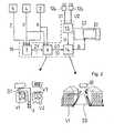
- a device 1 for displaying driver information for a vehicle Fhas a map memory 2, z. As a digital storage medium in the motor vehicle F or an externally provided, via remote data transmission with the motor vehicle F related map database. From the card memory 2 card signals K are output to a navigation device 3.
- the navigation device 3also takes from a position sensor 4 of a Global Positioning System (GPS) position signals P and from an input device 5 target data Z, z. B. entered by the driver destination coordinates or name information of a destination on.
- the navigation device 3calculates route guidance instructions in a manner known per se and sends corresponding route guidance signals ZF, which comprise a direction signal for direction assignment, to a vehicle Detection device 6 off.
- the determination device 6also records position data P of the position sensor 4 and map data K of the map memory 2 and determines therefrom first destination guidance objects G1 which correspond to a representation in a map of the driving environment.
- 3 relevant objectsfor. As buildings, landscapes, attractions, in the field of vision of the driver on the basis of map data K and position signals P determined and information signals I with information about these objects, eg. B. their names and functions are output to the determination device 6.
- the determination device 6determines information objects IO, z. B. panels with information about the objects.
- a calculation device 7receives the first route guidance objects G1, map data K and position data P and determines route guidance display objects ZO which contain information about form, size and coordinates in a display field 10.
- the destination guidance display objects ZOcan in particular be formed as projection images of the destination guidance objects G1 from the perspective of the driver.
- the information objects IOare forwarded to the calculation device 7, which calculates the coordinates of the information objects IO in the display field 10; In this case, the information objects IO can be changed.
- the calculation device 7transmits the destination guidance display objects ZO and the information objects IO including their coordinates to a projection device 8, which in turn throws them in this embodiment as light signals onto a display field 10 of a transparent viewing window 9.
- the lens 9is hereby arranged between the driver and the vehicle environment observed by him, ie in the field of vision of the driver; she can z. B. be the windshield itself or behind the windshield transparent lens 9.
- the driverthus takes the Ziel Resultssan Attache Congress ZO - in the embodiment shown, a left turn indicating arrow ZO - in the correct position in him true through the otherwise transparent display panel 10 seen vehicle environment.
- the navigation device 3, determination device 6 and calculation device 7can be integrated as a control device 11.
- the first route guidance objects G1 and information objects IOare determined as in the first embodiment and output to an image-generating device 14.
- a monocamera or two cameras 12a, 12b, the z. B. within the vehicle Fare arranged below the headliner, take the driving environment in the direction of the driver and give environmental image signals U1, U2 to an evaluation device 15, the first image signals U to the image forming device 14 outputs.
- the image generating device 14determines target guidance display objects ZO and superimposes them and the information objects IO on the first image signals U and outputs second image signals B to a display field 20 of the display device 22.
- the drivercan thus recognize the driving scene which is currently familiar to him in a real or reality-adapted image and allocate route guidance display objects ZO and information objects IO directly to road traffic, for which, however, he has to turn his gaze from the driving environment to the display device 22.
- the navigation device 3, determination device 6, evaluation device 15 and image-generating device 14can be integrated as a control device 16 with appropriate programming.
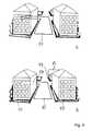
- the route guidance display objects ZO and information objects IOare output appropriately cropped to realistically adapt their perception to partial obscurations by obscuration objects in the driver's environment / field of view.
- the process of trimming, ie removing subregionscan either be done as in FIG. 3 shown in the map, ie at the objects G1, IO the Map representation, or even in the displayed on the display panel 10, 20 destination guidance display objects ZO and information objects IO done.
- the first route guidance objects G1 and information objects IO1are first output by the determination device 6 to a trimming device 21.
- the trimming device 21determines subregions TB of the route guidance objects G1 and information objects IO1 which lie behind a concealment object in the line of sight - straight line - ie between which and the driver's position at least one concealment object V1, V2 lies. Since a partial area TB is obscured due to the front position of the occluding object V1, it is removed or as a hidden area different, for. With different color, brightness, shading or dashed outlines.
- second destination guidance objects G2 and second information objects IO2are determined, which in turn are subsequently input to the calculation device 7 or the image-generating device 14 and, as in the above embodiments FIGS. 1 or 2 Destination guidance display objects ZO and information objects IO displayed on a display panel 10 and 20 respectively.
- the trimming device 21can in principle also be arranged behind the projection device 7 and thus detect and remove occlusions directly on the image to be displayed as overlaps of the two-dimensional surface regions.
- the navigation device 3, determination device 6, circumcision device 15 and calculation device 7can be integrated as a control device 23 with appropriate programming.
- additional acoustic signalscan be output.
- Fig. 2can in this case when output destination guidance display objects ZO and / or information objects IO or even when these objects ZO, IO acoustic signals are output, so that the driver briefly directs the view of the display panel 20.
Landscapes
- Engineering & Computer Science (AREA)
- Radar, Positioning & Navigation (AREA)
- Remote Sensing (AREA)
- Physics & Mathematics (AREA)
- General Physics & Mathematics (AREA)
- Automation & Control Theory (AREA)
- Navigation (AREA)
Description
Translated fromGermanDie Erfindung betrifft ein Verfahren und eine Vorrichtung zur Darstellung von Fahrerinformationen, insbesondere für ein Fahrzeug-Navigationssystem.The invention relates to a method and a device for displaying driver information, in particular for a vehicle navigation system.
Fahrzeug-Navigationssysteme ermitteln aus vom Fahrer eingegebenen Zieldaten, Positionsdaten und Kartendaten Zielführungsanweisungen, die den Fahrer entlang einer sicheren, schnellen und direkten Fahrtroute zu dem Ziel führen. Die Zielführungsanweisungen, insbesondere durchzuführende Manöver, werden vom Navigationssystem akustisch oder optisch durch Ausgabe von Pfeilen auf einer Anzeigeeinrichtung im Dashboardbereich des Fahrzeugs ausgegeben. Weiterhin können zum Teil durch Abstandssensoren Geschwindigkeiten des eigenen Fahrzeugs und anderer Verkehrsteilnehmer ermittelt und hierdurch Gefahrensituationen erkannt werden.Vehicle navigation systems determine from target data inputted by the driver, position data and map data guidance instructions that guide the driver to the destination along a safe, fast and direct route. The guidance instructions, in particular maneuvers to be carried out, are emitted acoustically or optically by the navigation system by issuing arrows on a display device in the dashboard area of the vehicle. Furthermore, speeds of the own vehicle and other road users can be determined in part by distance sensors and thus dangerous situations can be detected.
Bei der optischen Ausgabe von Zielführungsanweisungen mit der Darstellung auf einem Anzeigefeld einer Anzeigeeinrichtung werden im Allgemeinen generalisierte, insbesondere abstrahierte bzw. vereinfachte Fahrsituationsdarstellungen, z. B. Kreuzungsdarstellungen ausgegeben, in denen die durchzuführenden Fahrmanöver, z. B. ein Abbiegevorgang, hervorgehoben sind.In the optical output of route guidance instructions with the representation on a display field of a display device, generally generalized, in particular abstracted or simplified driving situation representations, e.g. B. intersection representations spent in which the driving maneuvers to be performed, z. B. a turn, highlighted.
Durch die generalisierte Darstellung der Fahrsituation und die grafisch hervorgehobenen Zielführungsanweisungen wird die Ablenkung des Fahrers vom Verkehrsgeschehen zwar gering gehalten und der technische Aufwand der aktuellen Kartenermittlung und Ermittlung der anzuzeigenden Zielführungssignale begrenzt. Dennoch wird die Aufmerksamkeit des Fahrers durch den erforderlichen zeitweisen Blick auf die Anzeigeeinrichtung, in der er sich jedes Mal zunächst neu zurechtfinden und die angezeigten Informationen auf seine Fahrumgebung, seine Position und Orientierung übertragen muss, beeinträchtigt, was zu einer Verringerung der Fahrsicherheit führt. Auch können von der Steuereinrichtung des Navigationssystems erkannte Gefahrensituationen zwar auf der Anzeigeeinrichtung und ggf. akustisch ausgegeben werden; hierbei wird der das Fahrumfeld betrachtende Fahrer diese Informationen jedoch oftmals nicht schnell genug der realen Situation zuordnen können und daher ggf. nicht schnell genug in entsprechender Weise auf die Gefahrensituation reagieren können. Die plötzliche Ausgabe von Gefahren- und Warnsignalen kann sogar zu einer Verwirrung des Fahrers in schwierigen Fahrsituationen führen, die seine Aufmerksamkeit beeinträchtigen.Due to the generalized presentation of the driving situation and the graphically highlighted route guidance instructions, the driver's distraction from the traffic situation is kept low and the technical complexity of the current map determination and determination of the route guidance signals to be displayed is limited. However, the driver's attention is hampered by the need for a temporary view of the display device, in which he must first reorient himself each time and transfer the displayed information to his driving environment, position and orientation. which leads to a reduction in driving safety. It is true that dangerous situations recognized by the control device of the navigation system can also be output acoustically on the display device and, if necessary, acoustically; In this case, however, the driver who views the driving environment is often unable to assign this information to the real situation quickly enough and therefore may not be able to react quickly enough to the dangerous situation in a corresponding manner. The sudden release of danger and warning signals can even lead to confusion of the driver in difficult driving situations that affect his attention.
Weiterhin ist insbesondere bei unübersichtlichen Kreuzungsgeometrien die Vermittlung der Zielführungsanweisungen problematisch, da z. B. Abbiegemanöver für den Fahrer oftmals nur schwer in richtiger Weise von der Anzeigeeinrichtung auf die Straßensituation zu übertragen sind; daher nimmt derzeit ein Fahrer bei komplexen Kreuzungsgeometrien oftmals eine zu frühe oder zu späte Abbiegemöglichkeit wahr. Zwar können hierzu zusätzlich Entfemungsangaben oder Darstellungen der Entfernung mit abnehmenden Balken ausgegeben werden, jedoch sind auch derartige zusätzliche Angaben oftmals für den Fahrer nur schwer auf die reale Fahrsituation zu übertragen und können seine Aufmerksamkeit - insbesondere bei schwieriger Kurvenführung, Gegenverkehr und schwer erfassbaren weiteren Verkehrsteilnehmern wie Fahrrädern und Fußgängern - weiter beeinträchtigen.Furthermore, especially in confusing intersection geometries, the placement of the route guidance instructions is problematic because z. B. turning maneuvers are often difficult for the driver to be transmitted in the right way from the display device to the road situation; Therefore, a driver often perceives a too early or too late turnabout in complex intersection geometries. Although it can be issued in addition Entfemungsangaben or representations of the distance with decreasing bars, however, such additional information is often difficult for the driver to transfer the real driving situation and his attention - especially in difficult cornering, oncoming traffic and difficult to detect other road users such Bicycles and pedestrians - continue to affect.
Bei Anzeigeeinrichtungen mit dreidimensionaler Kartendarstellung werden z. B. der zurückzulegende Weg, Hinweisschilder oder das Ziel selbst hervorgehoben dargestellt. Hierbei kann ein in Fahrtrichtung gerichteter Beobachtungsstandpunkt des Fahrers in einer in der Regel wählbaren Höhe über dem Fahrzeug gewählt werden. Aufgrund insbesondere des technischen Aufwandes ist der dargestellte Inhalt jedoch oftmals sehr abstrakt und lückenhaft gehalten. Hierdurch und durch Abweichungen des frei wählbaren Betrachtungswinkels von der tatsächlichen Perspektive des Fahrers wird für den Fahrer die Herstellung eines Zusammenhangs mit der von ihm real wahrgenommenen Fahrsituation erschwert.In display devices with three-dimensional map display z. As the road to be covered, signs or the target itself highlighted. In this case, an observation point of the driver directed in the direction of travel can be selected in a generally selectable height above the vehicle. Due to the technical complexity, however, the content shown is often very abstract and incomplete. In this way and by deviations of the freely selectable viewing angle from the driver's actual perspective, it is made more difficult for the driver to establish a relationship with the driving situation which he has actually perceived.
Weiterhin sind Verfahren und Systeme bekannt, bei denen dem Fahrer relevante Informationen direkt z. B. über Datenbrillen oder Head-Up-Displays in sein Sichtfeld eingeblendet werden. Hierdurch kann der Fahrer seinen Blick stets auf die Fahrbahn und die umgebende Fahrbahnsituation gerichtet halten und ergänzend Informationen aufnehmen. Die
Aus
Die
Aus der
Das erfindungsgemäße Verfahren und die erfindungsgemäße Vorrichtung bieten demgegenüber insbesondere den Vorteil, dass dem Fahrer Zielführungsanweisungen in realistischer Weise ohne allzu große kognitive Belastung und Ablenkung vom Verkehrsgeschehen übermittelt werden können. Hierbei werden die Fahranweisungen als Zielführungsobjekte und vorteilhafterweise zusätzliche Informationen als Informationsobjekte lagerichtig in einem realen bzw. realistischen Bild der Fahrzeugumgebung eingesetzt.In contrast, the method according to the invention and the device according to the invention have the particular advantage that route guidance instructions can be transmitted to the driver in a realistic manner without too much cognitive load and distraction from the traffic situation. Here, the driving instructions are used as destination objects and advantageously additional information as information objects in the correct position in a real or realistic image of the vehicle environment.
Die erfindungsgemäß ausgegebenen Zielführungsobjekte dienen als Zielführungsanweisungen können insbesondere Fahrtrichtungsangaben, z.B. sich über Abbiegungen, Kreuzungen oder ganze Kreisverkehrs- oder Kreuzungssysteme erstreckende Pfeile, sein. Zusätzliche Informationen können insbesondere zu Objekten der Umgebung, z. B. Hinweise auf Gebäude, ihre historische Bedeutung, Funktionen oder auf landschaftliche Gegebenheiten wie Flüsse, Berge, Seen, Landschaften, ausgegeben werden.The route guidance objects issued in accordance with the invention serve as route guidance instructions, in particular direction indications, e.g. be arrows over bends, intersections or whole roundabout or crossing systems. Additional information may in particular about objects of the environment, eg. For example, references to buildings, their historical significance, functions or to landscape conditions such as rivers, mountains, lakes, landscapes, are spent.
Der Fahrer kann erfindungsgemäß den Blick auf dem Verkehrsgeschehen halten und die Zielführungsanweisungen und ggf. weiteren Informationen aufgrund der lagerichtigen Zuordnung direkt den realen Positionen im Verkehrgeschehen zuordnen, ohne Abstraktionen der angezeigten Informationen durch z. B. Umsetzung einer Pfeilsymbolik auf reale Kreuzungssituationen vornehmen zu müssen. Somit ist er kognitiv geringer belastet und in seinen Entscheidungen sicherer.According to the invention, the driver can keep an eye on the traffic situation and assign the route guidance instructions and possibly further information on the basis of the positionally correct assignment directly to the real positions in the traffic situation, without abstractions of the displayed information by z. B. Implementation of an arrow symbol to make real crossroads situations. Thus, he is cognitively less burdened and safer in his decisions.
Erfindungsgemäß können die eingeblendeten Zielführungsobjekte unter Berücksichtigung von weiterhin im Blickfeld des Fahrers sichtbaren Verdeckungsobjekten bzw. Verdeckungsbereichen gebildet werden. Hierbei werden die ersten Zielführungsausgangsobjekten beschnitten, indem Verdeckungsbereiche berücksichtigt werden, die aus Kartendaten oder erfindungsgemäß aus von einem Sensor des Fahrzeugs ermittelten Hindernissen berechnet werden. Aus den ersten Zielführungsausgangsobjekten werden hierbei diejenigen Teilbereiche herausgeschnitten, die im Sichtfeld des Fahrers hinter Verdeckungsbereichen bzw. Verdeckungsobjekten liegen. Somit wird eine realistische Darstellung erreicht, bei der die angezeigten Zielführungsobjekte - und ggf. auch weiteren Informationsobjekte - in die vom Fahrer sichtbare Fahrumgebung eingebettet werden und somit ohne weitere gedankliche Umsetzung vom Fahrer der Fahrumgebung zugeordnet werden können.According to the invention, the displayed route guidance objects can be formed taking into account further masking objects or masking areas which are still visible in the field of vision of the driver. Here, the first route guidance exit objects are curtailed by taking account of coverage areas which are calculated from map data or from obstacles determined by a sensor of the vehicle according to the invention. From the first route guidance exit objects, those subareas are cut out in the field of view of the driver lie behind occlusion areas or obscuring objects. Thus, a realistic representation is achieved, in which the displayed route guidance objects - and possibly also other information objects - are embedded in the driver's visible driving environment and thus can be assigned to the driving environment without further intellectual implementation by the driver.
Die ggf. zu berücksichtigenden Verdeckungsobjekte können direkt aus den Kartendaten oder durch zusätzliche Sensoren des Fahrzeugs, z.B. Abstandssensoren auf Ultraschall-, Infrarot- oder Radarbasis, sowie auf der Auswertung von Stereobildern, insbesondere durch Photogrammetrie, ermittelt werden.The obscuring objects to be taken into account, if appropriate, can be obtained directly from the map data or by additional sensors of the vehicle, e.g. Distance sensors based on ultrasound, infrared or radar, as well as on the evaluation of stereo images, in particular by photogrammetry, are determined.
Erfindungsgemäß können die Zielführungsobjekte und ggf. weiteren Informationsobjekte vorteilhafterweise auf einer transparenten Sichtscheibe im Sichtfeld des Fahrers zwischen seiner Fahrumgebung und seiner Position, insbesondere auf der Windschutzscheibe selbst oder einer dahinter angeordneten Sichtscheibe, eingeblendet werden. Hierzu kann insbesondere eine Projektion auf die Windschutzscheibe oder eine dahinter angeordnete transparente Sichtscheibe erfolgen; weiterhin kann die Darstellung auch auf einer vom Fahrer selbst getragenen Sichtscheibe erfolgen, z. B. auf einer Datenbrille oder einem vorklappbaren Visier eines Helms.According to the invention, the route guidance objects and optionally further information objects can advantageously be superimposed on a transparent viewing window in the field of vision of the driver between his driving environment and his position, in particular on the windshield itself or a visor arranged behind it. For this purpose, in particular, a projection onto the windshield or a transparent viewing window arranged behind it can take place; Furthermore, the representation can also be made on a lens worn by the driver himself, z. B. on a data glasses or a hinged visor of a helmet.
Weiterhin ist es auch eine Darstellung der Zielführungsobjekte auf einer Anzeigeeinrichtung, z. B. im Dashboardbereich des Fahrzeuges, möglich. Hierbei wird die vom Fahrer real wahrgenommene Fahrumgebung bzw. Fahrszene durch z. B. eine an oder in dem Fahrzeug befestigte Kamera aufgenommen und als Kartendarstellung auf dem Anzeigefeld der Anzeigeeinrichtung zusammen mit den Zielführungsobjekten und ggf. Informationsobjekten wiedergegeben. Der Fahrer muss bei dieser erfindungsgemäßen Ausführungsform zwar kurz den Blick vom Sichtfeld der Straßensituation nehmen; da er in dem Anzeigefeld der Anzeigeeinrichtung jedoch direkt die auch von ihm gesehene Fahrumgebung realistisch wiederfindet, kann er die eingeblendeten Zielführungssignale und ggf. weiteren Objektinformationen direkt zuordnen.Furthermore, it is also a representation of the route guidance objects on a display device, for. B. in the dashboard area of the vehicle possible. Here, the driver perceived real driving environment or driving scene by z. For example, a camera attached to or in the vehicle is recorded and reproduced as a map representation on the display panel of the display device together with the route guidance objects and possibly information objects. The driver must take in this embodiment of the invention, although briefly the view from the field of vision of the road situation; However, since he realistically realistically finds in the display panel of the display device, the driving environment also seen by him, he can assign the displayed route guidance signals and possibly other object information directly.
Die Kartendaten können sowohl aus einem im Fahrzeug befindlichen Kartenspeicher, z. B. einem digitalen Datenträger wie einer CD-ROM, als auch über Datenfernübertragung erhalten werden. Die Positionsdaten können - in an sich bekannter Weise - von einem globalen Positionsbestimmungssystem, einem Wegstreckensensor oder einem Drehratensensor bzw. einer Kombination hiervon - ermittelt werden. Hierdurch werden die Position und Orientierung, d. h. Fahrtrichtung des Fahrzeugs, ermittelt und den Kartendaten in eindeutiger Weise zugeordnet. Die Zielführungsanweisungen werden in an sich bekannter Weise durch Navigationsalgorithmen aus vom Fahrer eingegebenen Zieldaten und den Positionsdaten des Fahrzeugs ermittelt.The map data can be from both an in-vehicle map memory, z. As a digital disk such as a CD-ROM, as well as via remote data transmission to be obtained. The position data can be determined - in a manner known per se - by a global position determination system, an odometer sensor or a rotation rate sensor or a combination thereof. As a result, the position and orientation, ie direction of travel of the vehicle, determined and assigned to the map data in a unique way. The route guidance instructions are determined in a manner known per se by navigation algorithms from the driver's input destination data and the position data of the vehicle.
Der Erfindung wird im Folgenden anhand der beiliegenden Zeichnungen an einigen Ausführungsformen näher erläutert. Es zeigen:
Fig. 1 ein Blockdiagramm einer Vorrichtung gemäß einer Ausführungsform mit einem Anzeigefeld im Sichtfeld des Fahrers;Fig. 2 ein Blockdiagramm gemäß einer weiteren Ausführungsform bei Anzeige auf einem Anzeigefeld einer Anzeigeeinrichtung;Fig. 3 ein Blockdiagramm gemäß einer weiteren Ausführungsform mit einer Berücksichtigung von Verdeckungen;Fig. 4a,b von dem Fahrer in den Anzeigen sichtbare Darstellungen bei a) den Ausführungsformen derFig. 1 ,2 und b) derFig.3 .
Fig. 1 a block diagram of an apparatus according to an embodiment with a display panel in the field of view of the driver;Fig. 2 a block diagram according to another embodiment when displayed on a display panel of a display device;Fig. 3 a block diagram according to another embodiment with a consideration of occlusions;Fig. 4a, b visible from the driver in the displays visible representations in a) the embodiments ofFig. 1 .2 and b) theFigure 3 ,
Eine Vorrichtung 1 zur Darstellung von Fahrerinformationen für ein Fahrzeug F weist einen Kartenspeicher 2 auf, z. B. ein digitales Speichermedium in dem Kraftfahrzeug F oder eine extern vorgesehene, über Datenfernübertragung mit dem Kraftfahrzeug F in Verbindung stehende Kartendatenbank. Aus dem Kartenspeicher 2 werden Kartensignale K an eine Navigationseinrichtung 3 ausgegeben. Die Navigationseinrichtung 3 nimmt weiterhin von einem Positionssensor 4 eines Globalen Positionsbestimmungssystems (GPS) Positionssignale P und von einer Eingabeeinrichtung 5 Zieldaten Z, z. B. vom Fahrer eingegebene Zielkoordinaten oder Namensangaben eines Zielortes, auf. Die Navigationseinrichtung 3 berechnet in an sich bekannter Weise Zielführungsanweisungen und gibt entsprechende Zielführungssignale ZF, die ein Orientierungssignal zur Fahrtrichtungszuordnung umfassen, an eine Ermittlungseinrichtung 6 aus. Die Ermittlungseinrichtung 6 nimmt weiterhin Positionsdaten P des Positionssensors 4 und Kartendaten K des Kartenspeichers 2 auf und ermittelt hieraus erste Zielführungsobjekte G1, die einer Darstellung in einer Karte der Fahrumgebung entsprechen.A
Weiterhin können von der Navigationseinrichtung 3 relevante Objekte, z. B. Gebäude, Landschaften, Sehenswürdigkeiten, im Blickfeld des Fahrers auf der Grundlage von Kartendaten K und Positionssignalen P ermittelt und Informationssignale I mit Informationen über diese Objekte, z. B. ihre Namen und Funktionen, an die Ermittlungseinrichtung 6 ausgegeben werden. Die Ermittlungseinrichtung 6 ermittelt Informationsobjekte IO, z. B. Tafeln mit Angaben über die Objekte.Furthermore, 3 relevant objects, for. As buildings, landscapes, attractions, in the field of vision of the driver on the basis of map data K and position signals P determined and information signals I with information about these objects, eg. B. their names and functions are output to the
Eine Berechnungseinrichtung 7 nimmt die ersten Zielführungsobjekte G1, Kartendaten K und Positionsdaten P auf und ermittelt Zielführungsanzeigeobjekte ZO, die Angaben über Form, Größe und Koordinaten in einem Anzeigefeld 10 enthalten. Die Zielführungsanzeigeobjekte ZO können insbesondere als Projektionsabbildungen der Zielführungsobjekte G1 aus Sicht des Fahrers gebildet werden. Weiterhin werden die Informationsobjekte IO an die Berechnungseinrichtung 7 weitergegeben, die die Koordinaten der Informationsobjekte IO im Anzeigefeld 10 berechnet; hierbei können die Informationsobjekte IO verändert werden.A
Die Berechnungseinrichtung 7 gibt die Zielführungsanzeigeobjekte ZO und die Informationsobjekte IO einschließlich ihrer Koordinaten an eine Projektionseinrichtung 8 weiter, die sie bei dieser Ausführungsform wiederum als Lichtsignale auf ein Anzeigefeld 10 einer transparenten Sichtscheibe 9 wirft. Die Sichtscheibe 9 ist hierbei zwischen dem Fahrer und der von ihm beobachteten Fahrzeugumgebung, d.h. im Blickfeld des Fahrers, angeordnet; sie kann z. B. die Windschutzscheibe selbst oder eine hinter der Windschutzscheibe angeordnete transparente Sichtscheibe 9 sein. Der Fahrer nimmt somit das Zielführungsanzeigeobjekt ZO - in der gezeigten Ausführungsform einen eine Linksabbiegung anzeigenden Pfeil ZO - lagerichtig in der von ihm durch das ansonsten transparente Anzeigefeld 10 gesehenen Fahrzeugumgebung wahr. Die Navigationseinrichtung 3, Ermittlungseinrichtung 6 und Berechnungseinrichtung 7 können integriert als eine Steuereinrichtung 11 ausgebildet sein.The
Bei der Ausführungsform der
Bei der Ausführungsform der
Die ersten Zielführungsobjekte G1 und Informationsobjekte IO1 werden von der Ermittlungseinrichtung 6 zunächst an eine Beschneidungseinrichtung 21 ausgegeben. Die Beschneidungseinrichtung 21 ermittelt Teilbereiche TB der Zielführungsobjekte G1 und Informationsobjekte IO1, die in Blickrichtung - gerader Linie - hinter einem Verdeckungsobjekt liegen, d.h. zwischen denen und der Position des Fahrers mindestens ein Verdeckungsobjekte V1, V2 liegt. Da ein Teilbereich TB aufgrund der vorderen Position des Verdeckungsobjektes V1 verdeckt wird, wird er entfernt oder als verdeckter Bereich anders, z. B. mit anderer Farbe, Helligkeit, Schattierung oder gestrichelten Umrisslinien, dargestellt. Hierdurch werden zweite Zielführungsobjekte G2 und zweite Informationsobjekte IO2 ermittelt, nachfolgend wiederum der Berechnungseinrichtung 7 bzw. der bilderzeugenden Einrichtung 14 eingegeben und wie bei den obigen Ausführungsformen der
Alternativ zu der gezeigten Ausführungsform kann die Beschneidungseinrichtung 21 grundsätzlich auch hinter der Projektionseinrichtung 7 angeordnet sein und somit Verdeckungen direkt auf dem anzuzeigenden Bild als Überlappungen der zweidimensionaler Flächenbereiche erkennen und entfernen. Die Navigationseinrichtung 3, Ermittlungseinrichtung 6, Beschneidungseinrichtung 15 und Berechnungseinrichtung 7 können integriert als eine Steuereinrichtung 23 mit entsprechender Programmierung ausgebildet sein.As an alternative to the embodiment shown, the trimming
Bei sämtlichen Ausführungsformen können ergänzend akustische Signale ausgegeben werden. Insbesondere bei der
Claims (8)
- Method for displaying information for a driver, having at least the following steps: the production of routing signals (ZF) from input destination data signals (Z), position signals (P) and map signals (K), determination of at least a first routing object (G1) from the routing signals (ZF), map signals (K) and position signals (P), determination of a routing display object (ZO) for positionally correct display in a display field (10, 20), wherein the routing display object (ZO) is determined from the first routing object (G1) and contains information about its position in the display field (10, 20), and outputting of the at least one routing display object (ZO) on the display field (10, 20), wherein the routing display object (ZO) is generated by at least one part (TB) of the first routing object (G1) or one routing display object which is generated on the basis of the first routing object (G1) is removed as a function of the map signals (K) and position signals (P), wherein a part (TB) of the routing object (G1) is removed if it is determined on the basis of the position signals (P) and map signals (K) that a concealing object (V1, V2, V3) is arranged between the position of the vehicle and a geographic position of the part (TB),characterized in that other movable objects, for example vehicles, which are sensed by at least one sensor of the vehicle, for example a radar sensor, stereo image sensor, mono image sensor, infrared sensor, ultrasonic sensor, are detected as concealing objects.
- Method according to Claim 1,characterized in that at least one information object (IO) is determined from the map signals (K) and position signals (P) and output on the display field (10, 20).
- Method according to Claim 2,characterized in that the information object (IO) is determined by generating information signals (I) from the map signals (K) and position signals (P), from which information signals (I) at least one first information object (IO1) is generated, from which a part (TB) is removed if it is determined on the basis of the position signals (P) and map signals (K) that a concealing object (V1, V2, V3) is arranged between the position of the vehicle and a geographic position of the part (T).
- Method according to one of the preceding claims,characterized in that the position signals (P) are output by at least one sensor (4), for example a sensor (4) of a global position-determining system (GPS) and/or an odometer and/or a rotational speed sensor.
- Method according to one of the preceding claims,characterized in that the display field (10) is a transparent area in the field of vision between the driver and a driving area of his vehicle.
- Method according to Claim 5,characterized in that the display field (10) is part of the windscreen of the vehicle, a transparent panel (9) behind the windscreen of the vehicle or part of an aiming device which is worn by the driver, for example a pair of glasses or an aiming device which can be folded down from a helmet.
- Method according to one of Claims 1-4,characterized in that the display field (20) is provided on a display device (22), for example in the dashboard area of the vehicle, wherein image signals (B), which comprise routing objects (ZO) and surroundings image signals (U) which are output by a camera device (12a, 12b) of the vehicle, are output on the display field (20).
- Device for displaying information for a driver, having a navigation device (3), a device (6) for determining a first routing object (G1), a device (7, 14) for calculating a routing display object (ZO) and a device (8,9,10;20,22) for displaying the routing display object (ZO), wherein a cutting device (21) is provided which removes at least one part (TB) from first routing objects (ZO) and/or information objects (101) if a concealing object (V1, V2) is detected between the part (TB) and the driver's position,characterized by at least one sensor of the vehicle for sensing other movable objects as concealing objects.
Priority Applications (2)
| Application Number | Priority Date | Filing Date | Title |
|---|---|---|---|
| EP20040101533EP1586861B1 (en) | 2004-04-15 | 2004-04-15 | Method and apparatus for displaying information for the driver taking into account other movable objects |
| ES04101533TES2298681T3 (en) | 2004-04-15 | 2004-04-15 | PROCEDURE AND DEVICE FOR THE REPRESENTATION OF INFORMATION FOR THE DRIVER TAKING INTO ACCOUNT OTHER MOBILE OBJECTS. |
Applications Claiming Priority (1)
| Application Number | Priority Date | Filing Date | Title |
|---|---|---|---|
| EP20040101533EP1586861B1 (en) | 2004-04-15 | 2004-04-15 | Method and apparatus for displaying information for the driver taking into account other movable objects |
Publications (2)
| Publication Number | Publication Date |
|---|---|
| EP1586861A1 EP1586861A1 (en) | 2005-10-19 |
| EP1586861B1true EP1586861B1 (en) | 2008-02-20 |
Family
ID=34928957
Family Applications (1)
| Application Number | Title | Priority Date | Filing Date |
|---|---|---|---|
| EP20040101533Expired - LifetimeEP1586861B1 (en) | 2004-04-15 | 2004-04-15 | Method and apparatus for displaying information for the driver taking into account other movable objects |
Country Status (2)
| Country | Link |
|---|---|
| EP (1) | EP1586861B1 (en) |
| ES (1) | ES2298681T3 (en) |
Cited By (2)
| Publication number | Priority date | Publication date | Assignee | Title |
|---|---|---|---|---|
| WO2013113500A1 (en) | 2012-02-02 | 2013-08-08 | Audi Ag | Driver assistance system and method for virtual representation of a road layout under obscured visibility and/or poor visibility conditions |
| DE102018133669A1 (en) | 2018-12-28 | 2020-07-02 | Volkswagen Aktiengesellschaft | Method and device for reproducing navigation instructions |
Families Citing this family (11)
| Publication number | Priority date | Publication date | Assignee | Title |
|---|---|---|---|---|
| DE102006054323A1 (en)* | 2006-11-17 | 2008-05-21 | Robert Bosch Gmbh | Method for locating an object |
| DE102007030243A1 (en)* | 2007-06-29 | 2009-01-08 | Robert Bosch Gmbh | Method and device for transmitting information to vehicle occupants |
| CN101910791B (en)* | 2007-12-28 | 2013-09-04 | 三菱电机株式会社 | Navigation device |
| DE112008003481T5 (en) | 2007-12-28 | 2010-12-30 | Mitsubishi Electric Corp. | navigation device |
| DE102012020568A1 (en)* | 2012-10-19 | 2014-04-24 | Audi Ag | Method for operating e.g. computer of passenger car, involves reproducing detected property and nature in natural image of environment, combining natural image with map of environment, and transmitting combined graph to display device |
| DE102013207064A1 (en)* | 2013-04-19 | 2014-10-23 | Bayerische Motoren Werke Aktiengesellschaft | Method for selecting an information source for display on data glasses |
| DE102013207063A1 (en) | 2013-04-19 | 2014-10-23 | Bayerische Motoren Werke Aktiengesellschaft | A method of selecting an information source from a plurality of information sources for display on a display of data glasses |
| DE102013011311B4 (en) | 2013-07-06 | 2018-08-09 | Audi Ag | Method for operating an information system of a motor vehicle and information system for a motor vehicle |
| DE102015007246B4 (en)* | 2015-06-05 | 2019-12-05 | Audi Ag | A method of operating a display system and display system for a motor vehicle |
| DE102016220521A1 (en) | 2016-10-19 | 2018-04-19 | Volkswagen Aktiengesellschaft | Method for determining a position of a motor vehicle and driver assistance system for a motor vehicle |
| DE102021124098A1 (en) | 2021-09-17 | 2023-03-23 | Bayerische Motoren Werke Aktiengesellschaft | Method and device for operating data glasses in a motor vehicle |
Family Cites Families (10)
| Publication number | Priority date | Publication date | Assignee | Title |
|---|---|---|---|---|
| NL8901695A (en)* | 1989-07-04 | 1991-02-01 | Koninkl Philips Electronics Nv | METHOD FOR DISPLAYING NAVIGATION DATA FOR A VEHICLE IN AN ENVIRONMENTAL IMAGE OF THE VEHICLE, NAVIGATION SYSTEM FOR CARRYING OUT THE METHOD AND VEHICLE FITTING A NAVIGATION SYSTEM. |
| US6169552B1 (en)* | 1996-04-16 | 2001-01-02 | Xanavi Informatics Corporation | Map display device, navigation device and map display method |
| JP3390624B2 (en)* | 1997-03-27 | 2003-03-24 | 富士通テン株式会社 | Navigation device |
| DE19813300C2 (en)* | 1998-03-26 | 2003-12-11 | Bosch Gmbh Robert | display device |
| US6285317B1 (en)* | 1998-05-01 | 2001-09-04 | Lucent Technologies Inc. | Navigation system with three-dimensional display |
| US6710774B1 (en)* | 1999-05-12 | 2004-03-23 | Denso Corporation | Map display device |
| DE29913292U1 (en)* | 1999-07-29 | 1999-12-09 | Bruce-Boye, Cecil O., Dr., 23558 Lübeck | GPS road user guide with three-dimensional representation as a navigation system |
| DE10037573B4 (en)* | 2000-08-02 | 2005-05-19 | Robert Bosch Gmbh | Navigation method in a motor vehicle |
| JP4672190B2 (en)* | 2001-04-26 | 2011-04-20 | 三菱電機株式会社 | Video navigation device |
| DE10138719A1 (en)* | 2001-08-07 | 2003-03-06 | Siemens Ag | Method and device for displaying driving instructions, especially in car navigation systems |
- 2004
- 2004-04-15EPEP20040101533patent/EP1586861B1/ennot_activeExpired - Lifetime
- 2004-04-15ESES04101533Tpatent/ES2298681T3/ennot_activeExpired - Lifetime
Cited By (2)
| Publication number | Priority date | Publication date | Assignee | Title |
|---|---|---|---|---|
| WO2013113500A1 (en) | 2012-02-02 | 2013-08-08 | Audi Ag | Driver assistance system and method for virtual representation of a road layout under obscured visibility and/or poor visibility conditions |
| DE102018133669A1 (en) | 2018-12-28 | 2020-07-02 | Volkswagen Aktiengesellschaft | Method and device for reproducing navigation instructions |
Also Published As
| Publication number | Publication date |
|---|---|
| EP1586861A1 (en) | 2005-10-19 |
| ES2298681T3 (en) | 2008-05-16 |
Similar Documents
| Publication | Publication Date | Title |
|---|---|---|
| EP3454013B1 (en) | Method, device and a computer readable storage medium with instructions for controlling a display of an augmented reality display device for a motor vehicle | |
| EP1563257B1 (en) | Navigation device | |
| DE102004064249B3 (en) | Vehicle information display system | |
| EP3765324B1 (en) | Method, device and computer-readable storage medium with instructions for controlling a display of an augmented reality display device for a motor vehicle | |
| DE10236221C1 (en) | Navigation information display method for vehicle with onboard navigation aid, has virtual representation of pilot vehicle superimposed on image of vehicle surrounding area | |
| EP1405124B1 (en) | Head-up display system and method for projecting a marking of a road sign with regard to the viewing direction of the driver | |
| WO2019170387A1 (en) | Overlaying additional information on a display unit | |
| EP1586861B1 (en) | Method and apparatus for displaying information for the driver taking into account other movable objects | |
| EP3008711B1 (en) | Method and device for signalling a traffic object that is at least partially visually concealed to a driver of a vehicle | |
| US11590902B2 (en) | Vehicle display system for displaying surrounding event information | |
| DE10256612B3 (en) | Automobile driver training method using training vehicle with virtual imaging of dangerous driving situations | |
| DE102009027026A1 (en) | Method and control device for providing a virtual navigation mark | |
| DE112017007631T5 (en) | Display system and display method | |
| WO2013113500A1 (en) | Driver assistance system and method for virtual representation of a road layout under obscured visibility and/or poor visibility conditions | |
| DE112018000786T5 (en) | A DEVICE AND METHOD FOR CONTROLLING A HEAD-UP VV DISPLAY OF A VEHICLE | |
| DE102004048347A1 (en) | Driving assistance device for opposite the field of view of the driver of a motor vehicle positionally correct representation of the further course of the road on a vehicle display | |
| DE102013016251A1 (en) | Method for augmented representation of additional information in image in e.g. vehicle environment, involves changing additional information in dependence on current driving and surrounding situation | |
| EP3685123B1 (en) | Method, device and computer readable storage medium with instructions for controlling a display of an augmented reality head-up display device for a motor vehicle | |
| DE102007024395A1 (en) | Presentation method for supporting a vehicle driver | |
| DE112020001221T5 (en) | Information processing device, information processing method, and mobile body device | |
| WO2020074280A1 (en) | Method and device for controlling display contents on an output means of a vehicle | |
| DE102016220647A1 (en) | A method of presenting at least one supplementary difference lane equipment | |
| WO2015049028A1 (en) | Method and device for representing navigation instructions of a navigation system on a display | |
| EP2936473B1 (en) | Apparatus for extended presentation of a surrounding area of a vehicle | |
| DE10313743B4 (en) | Method and device for displaying driver information |
Legal Events
| Date | Code | Title | Description |
|---|---|---|---|
| PUAI | Public reference made under article 153(3) epc to a published international application that has entered the european phase | Free format text:ORIGINAL CODE: 0009012 | |
| AK | Designated contracting states | Kind code of ref document:A1 Designated state(s):AT BE BG CH CY CZ DE DK EE ES FI FR GB GR HU IE IT LI LU MC NL PL PT RO SE SI SK TR | |
| AX | Request for extension of the european patent | Extension state:AL LT LV MK | |
| 17P | Request for examination filed | Effective date:20060419 | |
| AKX | Designation fees paid | Designated state(s):ES FR GB IT | |
| REG | Reference to a national code | Ref country code:DE Ref legal event code:8566 | |
| GRAP | Despatch of communication of intention to grant a patent | Free format text:ORIGINAL CODE: EPIDOSNIGR1 | |
| RTI1 | Title (correction) | Free format text:METHOD AND APPARATUS FOR DISPLAYING INFORMATION FOR THE DRIVER TAKING INTO ACCOUNT OTHER MOVABLE OBJECTS | |
| GRAS | Grant fee paid | Free format text:ORIGINAL CODE: EPIDOSNIGR3 | |
| GRAA | (expected) grant | Free format text:ORIGINAL CODE: 0009210 | |
| AK | Designated contracting states | Kind code of ref document:B1 Designated state(s):ES FR GB IT | |
| REG | Reference to a national code | Ref country code:GB Ref legal event code:FG4D Free format text:NOT ENGLISH | |
| REG | Reference to a national code | Ref country code:ES Ref legal event code:FG2A Ref document number:2298681 Country of ref document:ES Kind code of ref document:T3 | |
| ET | Fr: translation filed | ||
| PLBE | No opposition filed within time limit | Free format text:ORIGINAL CODE: 0009261 | |
| STAA | Information on the status of an ep patent application or granted ep patent | Free format text:STATUS: NO OPPOSITION FILED WITHIN TIME LIMIT | |
| 26N | No opposition filed | Effective date:20081121 | |
| PGFP | Annual fee paid to national office [announced via postgrant information from national office to epo] | Ref country code:GB Payment date:20140423 Year of fee payment:11 | |
| PGFP | Annual fee paid to national office [announced via postgrant information from national office to epo] | Ref country code:ES Payment date:20140417 Year of fee payment:11 | |
| GBPC | Gb: european patent ceased through non-payment of renewal fee | Effective date:20150415 | |
| PG25 | Lapsed in a contracting state [announced via postgrant information from national office to epo] | Ref country code:GB Free format text:LAPSE BECAUSE OF NON-PAYMENT OF DUE FEES Effective date:20150415 | |
| REG | Reference to a national code | Ref country code:FR Ref legal event code:PLFP Year of fee payment:13 | |
| REG | Reference to a national code | Ref country code:ES Ref legal event code:FD2A Effective date:20160804 | |
| PG25 | Lapsed in a contracting state [announced via postgrant information from national office to epo] | Ref country code:ES Free format text:LAPSE BECAUSE OF NON-PAYMENT OF DUE FEES Effective date:20150416 | |
| REG | Reference to a national code | Ref country code:FR Ref legal event code:PLFP Year of fee payment:14 | |
| REG | Reference to a national code | Ref country code:FR Ref legal event code:PLFP Year of fee payment:15 | |
| PGFP | Annual fee paid to national office [announced via postgrant information from national office to epo] | Ref country code:FR Payment date:20200421 Year of fee payment:17 | |
| PGFP | Annual fee paid to national office [announced via postgrant information from national office to epo] | Ref country code:IT Payment date:20200423 Year of fee payment:17 | |
| PG25 | Lapsed in a contracting state [announced via postgrant information from national office to epo] | Ref country code:FR Free format text:LAPSE BECAUSE OF NON-PAYMENT OF DUE FEES Effective date:20210430 | |
| PG25 | Lapsed in a contracting state [announced via postgrant information from national office to epo] | Ref country code:IT Free format text:LAPSE BECAUSE OF NON-PAYMENT OF DUE FEES Effective date:20200415 | |
| PG25 | Lapsed in a contracting state [announced via postgrant information from national office to epo] | Ref country code:IT Free format text:LAPSE BECAUSE OF NON-PAYMENT OF DUE FEES Effective date:20210415 |