EP0829704B1 - Information display system for vehicle navigation - Google Patents
Information display system for vehicle navigationDownload PDFInfo
- Publication number
- EP0829704B1 EP0829704B1EP97115617AEP97115617AEP0829704B1EP 0829704 B1EP0829704 B1EP 0829704B1EP 97115617 AEP97115617 AEP 97115617AEP 97115617 AEP97115617 AEP 97115617AEP 0829704 B1EP0829704 B1EP 0829704B1
- Authority
- EP
- European Patent Office
- Prior art keywords
- information
- icon
- map
- display
- user
- Prior art date
- Legal status (The legal status is an assumption and is not a legal conclusion. Google has not performed a legal analysis and makes no representation as to the accuracy of the status listed.)
- Expired - Lifetime
Links
- 230000015654memoryEffects0.000claimsdescription55
- 238000004891communicationMethods0.000claimsdescription27
- 238000004458analytical methodMethods0.000description15
- 238000010276constructionMethods0.000description12
- 238000000034methodMethods0.000description9
- 230000001413cellular effectEffects0.000description6
- 238000007405data analysisMethods0.000description6
- 230000006870functionEffects0.000description6
- 230000010365information processingEffects0.000description5
- 238000004364calculation methodMethods0.000description4
- 230000011664signalingEffects0.000description4
- 238000010295mobile communicationMethods0.000description3
- 230000008602contractionEffects0.000description2
- 241000424103Parapercis coliasSpecies0.000description1
- 230000001133accelerationEffects0.000description1
- 230000004308accommodationEffects0.000description1
- 230000009286beneficial effectEffects0.000description1
- 230000005540biological transmissionEffects0.000description1
- 230000007423decreaseEffects0.000description1
- 230000003247decreasing effectEffects0.000description1
- 230000000694effectsEffects0.000description1
- 230000005358geomagnetic fieldEffects0.000description1
- 239000004973liquid crystal related substanceSubstances0.000description1
- 239000013307optical fiberSubstances0.000description1
- 238000005457optimizationMethods0.000description1
- 230000002093peripheral effectEffects0.000description1
- 238000011946reduction processMethods0.000description1
- 230000003068static effectEffects0.000description1
Images


Classifications
- G—PHYSICS
- G01—MEASURING; TESTING
- G01C—MEASURING DISTANCES, LEVELS OR BEARINGS; SURVEYING; NAVIGATION; GYROSCOPIC INSTRUMENTS; PHOTOGRAMMETRY OR VIDEOGRAMMETRY
- G01C21/00—Navigation; Navigational instruments not provided for in groups G01C1/00 - G01C19/00
- G01C21/26—Navigation; Navigational instruments not provided for in groups G01C1/00 - G01C19/00 specially adapted for navigation in a road network
- G01C21/34—Route searching; Route guidance
- G01C21/36—Input/output arrangements for on-board computers
- G01C21/3679—Retrieval, searching and output of POI information, e.g. hotels, restaurants, shops, filling stations, parking facilities
- G01C21/3682—Retrieval, searching and output of POI information, e.g. hotels, restaurants, shops, filling stations, parking facilities output of POI information on a road map
- G—PHYSICS
- G08—SIGNALLING
- G08G—TRAFFIC CONTROL SYSTEMS
- G08G1/00—Traffic control systems for road vehicles
- G08G1/09—Arrangements for giving variable traffic instructions
- G08G1/0962—Arrangements for giving variable traffic instructions having an indicator mounted inside the vehicle, e.g. giving voice messages
- G08G1/0968—Systems involving transmission of navigation instructions to the vehicle
- G08G1/0969—Systems involving transmission of navigation instructions to the vehicle having a display in the form of a map
Definitions
- the present inventionrelates to an information display system, especially relates to a navigation system providing a course guidance to a predetermined place by calculating a car's position and displaying the car's position with a map therearound on a display, said navigation system providing information for a user intelligibly by obtaining said information from a network like the internet from which various kinds of data are provided.
- Navigation systemshows a car's calculated position based on various sensor information on a display, with a map surrounding the car's position, by taking out map data stored in a CD-ROM, and by setting a goal position, and a course guidance to the goal position is shown on the display.
- various information necessary for a driving carsuch as information about sightseeing spot or information of gas service station are inputted and indicated on the display according to a request of the user.
- the CD-ROMAs the CD-ROM is used only to be read out, it is not suitable for use as a medium to store information changing with time, for example, a traffic jam information. Even if it is assumed that a rewritable memory is used temporarily, it is troublesome for the user to input the information.
- any communication equipmentis provided in the car as a navigation equipment, and receives any facility data, so as to provide the information which is not provided by CD-ROM.
- a means of mobile communication like a cellular telephone systemneeds to be used.
- data transmission speed of the cellular telephone systemis slow, and further, when it is used by a running car, the channel of the cellular telephone system is easy to run out, and it is not suitable for sending a large quantity of data.
- a driver of the carwants to see the information during driving, the driver is averted from his driving depending on the information display method, and it is dangerous for the driver.
- the information sent by a communication meansshould be capable to be accessed for convenience of the user, and a good acquisition method of the information is needed.
- an object of the present inventionis to provide a navigation system, by which much information is capable to be accessed so as to suitably control the amount of the information to be communicated and the received information is capable to be displayed intelligibly.
- An navigation systemis constituted with an information display equipment indicating information received through a mobile communication system, information offering equipment which obtains the information by connecting to a network and transmits the obtained information to the information display equipment, and a communication equipment.
- the information offering equipmentcomprises a connecting means to be connected to the network and a memory means to store the information sent to the information display equipment, and obtains the information from information offering servers connected to a network and stores it in the memory means.
- the information offering equipmentcomprises a retrieval means to retrieve the information to be provided to the user from the memory means furthermore, and a communication means to transmit and receive data with the information display equipment, thereby a kind of information demanded by the user from the information display equipment is received and the information retrieved from the memory means is transmitted to the information display equipment.
- a data selection means and a data processing meansare prepared at need.
- the information display equipmentcomprises an input means to input a kind of the information that the user needs, and a communications means to transmit a retrieval key word input to the information offering equipment, or to receive the information provided from the information offering equipment.
- the information display equipmentfurther comprises a map memory means to store map data, a map display means to retrieve the map data from the map memory means and to display the map on the display, and an icon display means to display an icon to a position where the information provided from the information offering equipment is stored, on the map displayed by the map display means.
- the information display equipmentfurther comprises an icon select means by which a user selects the icon displayed on the display equipment, a retrieval means to retrieve the information about the selected icon from the information stored in a detailed information store means storing the information or the detailed information sent from the information offering equipment, and a detailed information display means to display the information retrieved to with the map on which an icon is displayed.
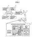
- Figure 1shows a constructive view of the navigation equipment to realize the present invention.
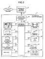
- Figure 2shows a constructive view of the information display equipment to realize the present invention.
- Figure 3shows a constructive view of the information display equipment to realize the present invention.
- Figure 4shows a view of hardware construction of the arithmetic processing department to realize the information display equipment.
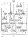
- Figure 5shows a functional construction figure of the arithmetic processing department to realize the information display equipment.
- Figure 6shows a function construction figure of the arithmetic processing department to realize the information display equipment.
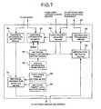
- Figure 7shows a function construction figure of the arithmetic processing department to realize the information offering equipment.
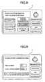
- Figure 8shows a view which shows the retrieve screen.
- Figure 9shows a view which retrieves by using a phone number.
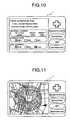
- Figure 10shows a view which sets an item retrieved with precedence.
- Figure 11shows a view which displays a retrieval range.
- Figure 12shows a view which shows the range retrieved with an acquisition time.
- Figure 13shows a view which shows a retrieval range when retrieving along with a path.
- Figure 14shows a view which shows an example of a fixed form format.
- Figure 15shows a view which shows an example of a free format.
- Figure 16shows a view which displays an icon contained by the information.
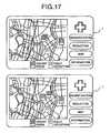
- Figure 17shows a view which shows an operation in which icons do not overlap.
- Figure 18shows a view which shows location of the information with an icon on the map top.
- Figure 19shows a view which shows the individual information by changing property of the icon.
- Figure 20shows a view which displays detailed information of an icon selected.
- Figure 21shows a view which displays detailed information of an icon selected with the map.
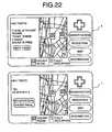
- Figure 22shows a view which shows that detailed information are divided to be displayed into several pages.
- Figure 23shows a view which shows to come back to a former screen after offering the information.
- the information provided to the useris sent from an information offering server through a network to information offering equipment, and the information that has been sent is stored in a memory equipment so as to be provided according to request of the user.
- the informationis retrieved from this memory equipment by a retrieval condition of the user, and is transmitted to the information display equipment.
- data which should be transmitted to the information display equipmentare selected and processed furthermore.
- the information requested by the user and transmitted to the information display equipment from the information offering equipmentis displayed with an icon to the position on the map where the information is stored.
- the detailed information which relates to the iconis displayed.
- a navigation system in this embodiment as shown in Fig. 1has information offering equipment 2 to obtain various information from an information offering server 3 connected through a network 4 such as the internet, and to provide it to a user, and an information display equipment 1 to display a car's position, to provide course guidance to the car, and to provide a presentation of the information from the information offering equipment 2 etc. according to the request of the user.
- the information display equipment 1will be explained using Fig. 2.
- the information display equipment 1has an arithmetic processing department 10, a display unit 11, a map memory 12, an internal information memory 13, a voice input and output unit 14, an input unit 15, a wheel speed sensor 16, a magnetic compass 17, a rate gyro 18, a GPS receiver 19, an icon image memory 20 and a display side communication equipment 21.
- the arithmetic processing department 10has a means to calculate a current position of a moving body like the car in which the navigation equipment is installed by using the information output from the above sensor 16,17,18 and the GPS receiver 19, and a means to select a most suitable road which connects current position with a goal position directed by the user and to notify them by using a sound and graphic display to the user.
- the arithmetic processing department 10sets a display domain according to the calculated current position of the moving body or scroll operation by the user, reads out the map data corresponding to the display domain from the map memory 12, provides graphic information from the map data which are read out, and performs a graphical processing so as to display it on the display unit 11.
- the current positionis displayed, the current position of the moving body is displayed by a mark with a graphics information corresponding to the map showing the neighborhood of the current position.
- the display unit 11is a unit to display the graphics information formed by the arithmetic processing department 10, and is constructed with a cathode ray tube or a liquid crystal display.
- the arithmetic processing department 10is connected to the display unit with a signaling S11 such as Red Green Blue signaling or NTSC signaling.
- the map memory 12reads out / writes in necessary data from a storage media such as a CD-ROM or an integrated circuit card by receiving outside indication.
- the voice input and output unit 14converts a message to be transmitted to the user, into a voice signal, and recognizes a voice generated by the user so as to transmit it to the arithmetic processing department.
- the input unit 15is a unit to accept indication from the user, and it is constructed with, for example, a joy stick to allow scrolling the map indicated, an electric switch such as a button, a touch panel put on the display unit etc.
- the wheel speed sensor 16measures the moving distance of the moving body from a product of the circumference of a wheel of the moving body and revolution speed of the wheel, and measures the turning angle of the moving body from difference of revolution speeds between a pair of wheels.
- the magnetic compass 17detects a geomagnetic field, and measures a direction where the moving body faces.
- the gyro 18has an optical fiber gyro or a vibration gyro, and measures the turning angle of the moving body when the moving body turns.
- the GPS receiver 19receives a signaling from GPS satellites and calculates a current position, a moving angle and a moving direction of the moving body by measuring distance and between the moving body and satellite and a change rate of the distance relating to three or more satellites. These sensors and equipment as above are used in order to detect the current position of moving body by a navigation processing.
- the icon image memory 20stores images of icons which is used when the information got from the information offering equipment 2 is displayed on the map.
- Said internal information memory 13memorizes various kinds of information to offer to the user, and most of the information is static information which are updated with a low frequency, for example, information of a sightseeing spot, information of a gas station, guide information of the accommodations or leisure facility, and tariff information of a toll road .
- the navigation system in the present inventionhas a function to offer the information depended on a map fundamentally in addition to above and there is location on a map equivalent a lot of said information to be offered.
- most of themare individual information that have location information which respectively correspond with the locations on the map, and the individual information is offered by appointing the location on the map, and the location of selected individual information are indicated on the map top as explained in the following.
- the display side communication device 21communicates with the information offering device 2, and obtains the information from the information offering device 2, which mainly changes with time and are updated with a high frequency, for example, traffic jam information of a road, vacant information of a hotel and a parking lot, weather information, and sale information of a store, as explained in the following.
- the information provided in this way from the information offering device 2are individual information having the location information respectively corresponding to locations on the map in the same way as the individual information memorized in the internal information memory 13.
- the communication volume which is most suitable for the mobile communication that is one of the most distinctive characteristics of the present inventionis determined by controlling not to send the information which are able to be stored by the internal information memory 13 and are not updated frequently.
- the information offering device 2As it is possible to select the individual information which is related to the individual information sent by the information offering device 2, according to the location on the map, from the individual information memorized in the internal information memory 13, the sufficient information is offered while communication channel capacity is low, by combining the individual information to be related according to the necessity.
- the memoryis sorted into the map memory, the internal information memory, and the icon image memory according to the kind of the information to be stored, however, it is possible to store plural kinds of the information with one memory.
- the memoryconsists of the map memory, the internal information memory, and the icon image memory according to a kind of the information to be stored, however one of the memories may store several kinds of the information.
- the arithmetic processing department 10is comprised of a central processing unit 31 to control the calculation and each device, a random access memory 32 to store the map data and calculation data temporarily, a read only memory 33 to store the system program, a DMA 34 to execute each data transfer between one memory and other memory at high speed and between the memory and each device, a display controller 35 to execute and indicate graphics information generation as to develop vector data in an image at high speed, a VRAM 36 to save graphics image data, a color pallet 37 to convert the image data into Red Green Blue codes, an analog-to-digital converter 38 to convert an analog signal into a digital signal, a SCI 39 to convert a serial signal into a parallel signal, a programmable input-output chip 40 to synchronize with the parallel signal and so as to output on the bus 30, a counter 41 to count pulse signal, and said bus 30 to connect between every devices.
- a central processing unit 31to control the calculation and each device
- a random access memory 32to store the map data and calculation data temporarily
- the arithmetic processing department 10is comprised of a user operation analysis means 50, a path account means 51, a course guidance means 52, a present position arithmetic means 55, a map match processing means 56, and a menu display means 58, as a means mainly relating to a navigation processing such as car ' s position calculation and course guidance.
- the present position arithmetic means 55respectively integrates distance pulse data measured with the wheel speed sensor 16 and angular acceleration data measured with the gyro 18, and calculates a position (X', Y ') of the moving body moved from an initial position (X, Y) by integrating the distance data and the angle data during one fixed cycle time obtained by the above calculation. Furthermore, in order to set an initial value of advance direction of the moving body, a relationship of an angle data provided from the gyro 18 and an absolute direction is set by using the directional data provided from the magnetic compass 17.
- the present position arithmetic means 55outputs current position information after having revised the sensor data with the position data provided from the GPS receiver 19 by a predetermined cycle time, thereby a sensor error to be accumulated is canceled by integrating the data provided from the sensor as stated the above.
- the map match processingcompares a road data contained in the map around the current position read in by a data read-in means 57 with a traveling trace obtained from the current position arithmetic means 55, thereby the current position is processed to match to the road where the mutual shape relation becomes highest .
- this map match processingin most case, the current position comes to correspond with the traveling road and the present position information may be output accurately.
- the user operation analysis means 50receives various operations requested from the user with the input unit 15, and controls the each unit contained in the arithmetic processing department 10 so as to execute the processing corresponding to the request of the user.
- a processing to operate a path from the current goal position to the goal positionis requested to a path account means 51, and the information to guide path to course guidance means 52 is requested to be shown to the user.
- a scroll display of the map domain designatedis requested to a map display means 54.
- the path account means 51decides an guidance path between two spots by retrieving a node connecting an interval between two spots (the present position and goal position) designated using Dijkstra algorithm.
- a path in which the distance between two spots becomes shortest, a course by which it becomes possible to arrive with a shortest time, a path by which a cost for it becomes the most economical etc.are provided by using different retrieval conditions.
- the course guidance means 52compares a link information of guidance path obtained by the path account means 51 with the present position information obtained by the position arithmetic means 55 and the map match processing means 56, and notifies to the user whether the car should turn to right or left, or go straight with a sound by using the sound input and output unit 14 before passing an intersections or by displaying the course for the car on the map on the display unit 11.
- the menu displaying means 58receives a command output from the user operation analysis means 50, and the command for displaying various kinds of a requested menu is sent to the graphics processing means 59.
- the arithmetic processing department 10has a data read-in means 57, a graphics processing means 59, a map display domain setting means 53, and a map display means 54 furthermore.
- the map display domain setting means 53sets a map domain that should be displayed according to an algorithm determined beforehand from the present position of the moving body output, from the map match processing means 56, or from a scroll information about a scroll direction corresponding to scroll operation input through the user operation analysis means 50.
- the data read-in means 57selects to read out the map data of the display domain which is set from the map memory 12.
- the map display means 54sends a command to display a designated object for the map data read out, with a designated contraction scale, in a state keeping a designated direction to an upper direction of the display unit 11, to a graphics processing means 59.
- a graphics processing means 59receives the display command formed by the map display means 54 and the menu displaying means 58, and applies the graphics image in the VRAM 36.
- the graphics image applied to the VRAMis managed with a collar numbering, and after being converted into RGB corresponding to the collar numbering with the collar pallet 37, it is displayed by the display unit.
- the arithmetic processing department 10comprises a retrieval range setting means 60, a received data analysis means 61, an icon setting means 62, an icon display position setting means 63 and an icon display means 64 furthermore, as a processing means in a navigation system to optimize amount of the information to be communicated and to display the information received intelligibly in this invention.
- the retrieval range setting means 60sets one or more items selected by the user from items shown by the menu display means 58 as a retrieve object property, and sets a specification spot on the map provided from the scroll information as a center of the retrieve neighborhood, said scroll information relating to the present position of the moving body output from the map match processing means 56, the goal position of the moving body input through the user operation analysis means 50 or the direction of the scroll corresponding to the scroll operation input through the user operation analysis means 50, and set a size of the retrieve neighborhood in a value decided beforehand furthermore.
- the retrieve object property, the center of the retrieve neighborhood and the size of the center set in this wayare sent to the information offering equipment 2 by using the display side communication equipment 21.
- the center of retrieve neighborhood which is setmay be set by using the information specifying a spot, elsewhere it is set from a position on the map. For example, phone number and a position of the information or an address stored in the internal information memory 13 are used. Input of the addresses is performed by using a letter input means, a place name select means chosen from a place name list, or a sound recognition means. An example of a method to set the center of the retrieve neighborhood by inputting the phone number will be shown in figure 9.
- the retrieve neighborhood that is setmay be set based on the domain and the contraction scale of the map displayed on display unit 11. For example, when the user is going to obtain the information, the map domain displayed by the display unit 11 may be used as the retrieve neighborhood.
- the size of the retrieve neighborhoodis set by the information display equipment, however it may be set by the information offering equipment. For example, referring to amount of the information sent to the information display equipment, it may be determined to be a range near to the center of the retrieve neighborhood. Further by providing a means to set intention by the user, suitable amount of the information may be set according to the user's intention.
- area size of retrieval neighborhoodis set with the information display, however, it is possible to set it with the information offering device. For example, considering amount of the information to send to the information display, the area size is set so that suitable amount of the information is obtained by selecting area sequentially near to the center of retrieval neighborhood. Furthermore, by providing a means for setting taste of the user, it may be set so that the amount of the information becomes suitable sequentially selecting the tasted information.
- the retrieval range that the retrieval entry means 60 setsin other words, the key word for retrieving, is retrieval object property, center of the retrieval neighborhood, or size of retrieval neighborhood, however, as it becomes a premise that it is on business or it may be utilized when information is demanded for the user, business hour information and vacant information may be automatically selected as the search conditions.
- the information provided by the retrievalbecomes to include the dynamic information that is changed with the time. For example, when it is applied to the retrieval of a service station, as the service station in business becomes retrieval object at retrieval point in time, it becomes possible to understand whether it is on business or not before going there actually, it becomes good beneficial information for the user.
- the communication line capacitymay be reduced.
- hotel and ferry informationare searched in the same way, date to utilize may be set, thereby search condition as that there is vacant on the date is automatically set.
- information of the car which the user uses or taste information of the usermay be set as the search condition.
- size information of the carmay be stored to be set.
- restaurant and service station informationare searched, credit card information that the user may utilize and chain store information that the user utilizes willingly may be set. In these cases, smooth information offering becomes possible for the user, reduction of communication line capacity becomes possible simultaneously, too.
- retrieval information described as abovemay be combined. These information are set by providing the setting means whenever the information is going to be obtained from the information offering device 2, however, they may be set automatically by preparing the means which will be registered itself with beforehand. An example to set the taste of the user is shown in Fig. 10.
- a retrieval range display meansmay be prepared in order to show the retrieve neighborhood set as the above, and By displaying the retrieve neighborhood, it becomes possible to easily recognize the range of the map on which the information to obtain belongs.
- the goal position neighborhoodis the retrieve neighborhood
- an example that displays the retrieve neighborhood with a circleis shown.
- a triangle mark in figure 11shows the present position
- a flag markshows the goal position, and they are shown in the same way in the following figures.
- the amount of the communication with the information offering equipmentmay be reduced, as the information is judged to be in the information display equipment even if the information offering equipment isn't accessed.
- a time when receiving said information in said temporary memory meansis displayed with retrieve area by the retrieval range display means, whether said information should be obtained from said information offering equipment may be referred.
- the center of retrieve areais one, however, such center may be set to be plural.
- the several nodes which connect the goal position with the present positionare set as the centers of every retrieve areas, it looks like as that the information along a course is referred to.
- a problem as that the user demands the information many times in order to get the information on pathdisappears.
- the nodes in the path from the present position to goal position shown with a thick lineare determined to be the centers of the every retrieve areas, an example representing the domain that became a range to be retrieved actually is shown in Fig. 13.
- a received data analysis means 61analyzes data to be provided through the display side communications equipment 21, selects several information contained by said data, and takes out information necessary for an afterward processing, for example, name, location on a map, property, affiliated information contained by respective information.
- information necessary for an afterward processingfor example, name, location on a map, property, affiliated information contained by respective information.
- a case storing the information with an order decided beforehandis shown by Fig. 14.
- a case that the form of the data is contained in the datais shown by Fig. 15.
- the data formmay be to be specified in the data regarding only the affiliated information.
- An icon setting means 62takes out a corresponding icon from the icon memory based on the property taken out with the received data analysis means 61 so as to set it as an icon showing represence of the information.
- the icon setting means 62further has an icon presence judgment means which judges whether the corresponding icon exists in the icon memory 20, and when the corresponding icon does not exist in the icon memory 20, the icon setting means 62 may require to transmit the corresponding icon to the information offering equipment 2. Otherwise, a means to add a letter or an icon such as an emblem to the information sent from the information offering equipment 2 are prepared and the icon may work may be taken out from the information sent in this way.
- Figure 16shows an example of the equipment which displays the information containing the icon which has been sent from the information offering equipment and the icon on a map based on this information.
- a icon drawing location setting means 63sets a location of the icon so that the corresponding information are displayed on a suitable location of the map based on a location information on the map taken out with the received data analysis means 61 and an information from the map display domain setting means 53.
- the location of iconis adjusted again suitably. If the data which have been sent are just indicated on the map, the icons are overlapped or the information isn't settled within a screen of the display sometimes. In such a case, for example, the reduction scale of the map by which the information sent is settled in the same screen is obtained to be notified to the map display domain setting means, and resetting of the location displaying the icon may be done according to the reduction scale changed.
- a overlap judgment means to judge the overlap of the iconsis provided, and when it was decided that the icons will overlap, the overlap information is notified to the icon display location setting means, and the icons are set so as not to overlap mutually by adjusting the displaying location of the icons overlapped with the icon displaying location setting means.
- Figure 17is an example in which overlap of the icons is avoided by resetting of the location of the icons when the two icons are overlapped. In a case of this example, actually, the display of the icons overlapped needn't be done, however, it is shown for describe the operation.
- An other method to avoid overlap of the iconsmay be adopted by, for example, changing the reduction scale of the map, or changing size of the icon.
- a icon display means 64sends a command which displays an image of the icon set by the icon setting means 62 to the graphics processing means 59 at a location set by the icon display location setting means 63.
- an icon property setting means 65may be provided furthermore as shown in the following.
- the icon property setting means 65sets property of an icon such as color and size, intensity, chroma, light on / light off, display / non display, based on information taken out with the received data analysis means 61. And, the icon display means 64 displays the icon based on the property set by the icon property setting means 65. When it is done in this way, the individual information besides the location of the information according to a color of the icon for example, may be displayed.
- FIG. 19An example will be explained using figure 19 in which received data are information about restaurant and the property of their color is set. For example, an icon of a restaurant which is not crowded is shown by blue (white in Fig. 19), an icon of a restaurant which is available if waiting a little, is shown by yellow (black in Fig.
- An arithmetic processing department 10relates to a navigation system processing to control amount of the information to be communicated so as to be suitable by the present invention furthermore, and to display the received information intelligibly, and has a received data /location memory means 66, an icon select means 67, an inside data retrieval means 68 and a detailed data display means 69.
- the received data / location store means 66stores each information provided by the received data analysis means 61, and the location at which the corresponding icon should be displayed is obtained from the icon display location setting means 63 and is stored with each related information.
- the icon select means 67decides which of the icon is selected by the location and the received data / location memory means 66 when detecting that the user selects one part of the screen by the user operation analysis means 50. Then, if the icon selected is decided, the information corresponding to the icon is retrieved from the received data / location memory means 66 and is transmitted to the inside data retrieval means 68.
- a pointing devicesuch as a touch panel having many pressure sensors on the screen is provided so as to be set so as to overlap on the screen.
- a cursor display means for displaying a cursor on the map, a cursor movement means to let the cursor moved, a cursor location acquisition means to calculate the location of the cursor on the map by detecting a quantity of movement of the cursor moved by the cursor movement means, and a means to recognize the determination of the userare prepared, and the user decides after the user let the cursor moved, thereby the location selected by the user is detected.
- Movement of the cursoris performed by moving the cursor for the screen while keeping the map fixed, or by moving the map for the screen while keeping the cursor fixed.
- the iconmay be recognized to be selected by detecting the location of the cursor provided by the cursor location acquisition means, on a specified icon, or the icon being most near from the cursor when a distance between the each icon and the cursor is compared with, or the icon being most near from the cursor when a distance between the each icon and the cursor is compared with and it is less than a predetermined set value may be selected. Further, one more example of the detecting means will be explained as following.
- the icon which the user wishes to selectmay be obtained by changing one display property of the icon which is displayed whenever the button is pushed.
- the icon which changes display propertymay be selected sequentially from the center of the screen, or by using the cursor movement input means, the icon almost being in cross course may be selected in the next selection.
- the inside data retrieval means 68obtains a receipt information corresponding to icon selected by the icon select means 67, the detailed information related to this receipt information is retrieved from the internal information memory 13.
- the individual information having the location information same as the location information on the map corresponding to the selected iconmay be retrieved from the internal information memory 13.
- the locations which should be the same each other on the mapmay not be equal strictly because of error which occurs on the data processing. In this case, for example, the information of the location which is in a distance within error degree being allowed and in the nearest location is selected as the individual information to be related.
- the overlapped areasare selected as the individual information to be related.
- Methods to search the individual information to be relatedare provided easily in the same way as above, for example, the title included in the receipt information may be searched as the key word, and the information common to the receipt information and the information from the internal information memory 13 such as serial number, phone number, and address may be set as the key word for the retrieval.
- a detailed data display means 69transmits a command to display the detailed information that was taken out by the inside data retrieval means 68, to graphics processing means 59. Otherwise, it takes out the receipt information corresponding to the icon selected from the icon select means 67 from the received data / location memory means 66, transmits the command to display this to the graphics processing means 59. Then, the receive data may be displayed according to a display format contained beforehand in the received data.
- the detailed information taken out from the inside data retrieval means 68 and the receipt information corresponding to the icon selectedare selectively displayed according to a request from the user by a user operation analysis means 50. Otherwise, the detailed information with a disposition decided beforehand and the receipt information may be displayed so as to be overlapped.
- a display method of the receipt informationis set beforehand, and the detailed information and the receipt information may be displayed according to this setting.
- Figure 20is an example, in which, the detailed information in the information selected and the receipt information are displayed so as to be overlapped.
- the iconis represented by the property and the name of the individual information, and the location of the icon is disposed in line in the screen, and it may displayed with an icon like an image thereof on the map.
- An arithmetic processing department 10relates to a navigation system processing to control amount of the information to be communicated so as to be suitable by the present invention furthermore, and to display the received information intelligibly, and has a select icon emphasis means 70, a detailed data display domain setting means 71 and a screen configuration change means 72.
- the select icon emphasis means 70controls the icon property setting means so that the icon which the user selected by the icon select means 67 may distinguish the other icon on the screen.
- the icon property setting means 65is set so as to change the property of the icon, for example, by changing a color of the selected icon, by raising a intensity of the selected icon, by flashing on and off the selected icon, by reducing the intensity of the icon which isn't selected, or by stopping the display of the icon which isn't selected (transparent color).
- Figure 21shows an example in which the intensity of the icon which wasn't selected is reduced .
- the detailed data display domain setting means 71sets a domain for indicating the detailed data so that the detailed information taken out with the inside data retrieval means may be displayed to a location on the screen set beforehand. For example, as exemplified in figure 21, left half of the screen is assigned as a domain for displaying the detailed data. As another embodiment is exemplified in figure 1, the location of the selected icon is retrieved from the receive data / location memory means and the domain which does not cover the location is obtained to be set.
- a screen configuration change means 72sets the display domain of the map according to this change, too. For example, when the detailed information is displayed on the left half of the screen, the map is to be displayed in the remaining right half. Then, because the location of the icon selected by the user is given, the screen configuration change means are set to scroll the map so that the selected icon comes into a center of right half of the screen, and the icon related to the detailed information is displayed in the central neighborhood of the map, thereby peripheral map information are easily understand.
- Figure 21shows an embodiment which displays the icon and the detailed information related thereto as stated above. This embodiment is effective for the user when the user selects one of the icon and watches the detailed information.
- the detailed data display means 69is provided to transmit the command to display the detailed information to a screen location set by the detailed data display domain setting means 71, to the graphics processing means 59.
- the detailed informationis divided into several pages, each of which become smaller than the domain where is set by the detailed data area setting means, and a display means to show existence of the former page or the next page is provided, and the page is constructed to be changed according to a request by the user, thereby the burden of the user is decreased.
- the arithmetic processing department 10has a screen configuration memory means 73 having a function to return to former display.
- a screen configuration memory means 73stores how to displays it on the screen according to the operations by the user, such as start to display of the received information, selection of the icon, closing of information display by user operation analysis means 50 , thereby it operates to return to the display state displayed formerly. For example, a case that the user demanded an information of a hotel of an objected position neighborhood from the information offering equipment will be explained by using figure 23. If a plane map which a present position is located in a center to display the whole screen at a point in time when the user demands the information, screen information is such as " right before information request, total plane map display, present position center " are stored.
- the userpushes " map " button so as to return to an original map screen by finishing the display of the information, thereby, the screen information is such as " right before information request, total plane map display, present position center " are transmitted to the map display domain setting means 53, the total screen returns to display the present position in the center of the map.
- the userdoes a change of the screen configuration, however, it may be assumed that change timing may be replaced after a predetermined time has passed, or it may be replaced when velocity of the car becomes faster than a predetermined value.
- the information offering equipment 2will be explained using figure 3.
- the information offering equipment 2has a mail server 23, a WWW server 24, an internet navigation server 25, a user authentication server 26, a control unit 22, a gateway 27 and an offering side communication equipment 28.
- the gateway 27has a unique address which is discriminated from other equipment connected to the network 4, it is connected with the network 4 and lead to communicate with the information offering server which is communicated with the network 4 , and it receives an information that has been sent through network 4 to the information offering equipment.
- the offering side communications equipment 28communicate with the information display equipment 1 so as to send or receive the information.
- the mail server 23stores an electronic mail sent to the user who is capable to access to the information offering equipment 2 and outputs the electronic mail which is received according to request of the user.
- the WWW server 24stores the information is such as a letter, a sound or a voice, a standstill drawing, and an animation, according to a format decided beforehand, and provides an information stored according to a request of the user.
- the internet navigation server 25stores the information provided through the gateway 27 and the offering side communication device with a format decided beforehand in order to indicate it on the information display 1, and outputs it to the information display 1 by request of the user.
- the internet navigation server 25receives the updating information from the information offering server 3, and stores the received updating information instead of the corresponding old information, and updates the information so that the information to offer to the information display 1 becomes to be new continuously.
- the user authentication server 26stores an information of the user who is capable to access to the information offering equipment 2 or an information to manage the service that the information offering equipment 2 may offer to every user, and is capable to limit the user who demand to connect or to limit the service provided to the user through the gateway 27 and the offering side communications equipment 28.
- the control unit 22controls the various servers 23, 24, 25, 26, the gateway 27, and the offering side communications equipment 28, and offers an electronic mail service performed in the world of a network such as internet etc. and a WWW (World Wide Web) service etc.. Furthermore, the information that the user demands is offered by processing as that the information provided to the information display equipment 1 is collected through network 4 , by processing as that the collected information is stored in the network 4, by processing as that the corrected information is changed into a suitable information formality in order to transmit and display it to the information display equipment, and by processing as that the information demanded by the user is referred to be taken out from the internet navigation server, and by processing as that a retrieve result is transmitted to the information display equipment.
- a networksuch as internet etc. and a WWW (World Wide Web) service etc.
- the information that the user demandsis offered by processing as that the information provided to the information display equipment 1 is collected through network 4 , by processing as that the collected information is stored in the network 4, by processing as that the corrected information is changed into a suitable information formality in order to
- control unit 22relates to a means for the navigation system processing in which the information provided to the information display equipment 1 is collected, the amount of the information to transmitted in this invention is optimized, and the received information is displayed intelligibly by the user, and has an individual information reception means 80, an individual information updating means 81, a user request analysis means 82, an information retrieval means 83 and an information processing means 84.
- the individual information reception means 80receives the individual information which the information offering server provided on the network top sends to the information offering equipment 2 through the gateway 27.
- the individual information updating means 81stores the individual information which is received by the individual information reception means 80 in the corresponding domain of the internet navigation server.
- the user request analysis means 82analyzes the request of the user based on the data sent from the information display equipment 1 and controls each unit in the control unit in order to execute the request. For example, when the request to offer vacant information has been sent together with a retrieve items such as coordinate of object position and hotel, the information is transmitted to the information retrieval means and a necessary information is retrieved from the internet navigation server 25 to be transmitted to the information display equipment 1.
- a registration information of the user who is capable to receive the service offered by the information offering equipment 2is stored in the user authentication server 26, an identification data of the user is obtained from the information display equipment 1, and the service that doesn't fit to a condition is operated not to be executed based on these information, thereby, for example, when a service charging a fee is prepared, it becomes impossible to prevent the user from escaping the charging of the fee.
- the information retrieval means 83searches the information that the user needs from the internet navigation server 25 according to the retrieval item that has been sent from the information display 1 and hands the search results to the information processing means 84.
- the retrieval item sent from the information display 1may include the conditions such as on business or available to be utilized. Such conditions may not be set in the information display 1, and the information retrieval means 83 may set it in the search condition automatically.
- the information processing means eight 4converts the plural information searched by the information retrieval means 83 into the data that the information display 1 is capable to process, and hands the converted data over to the offering side communication device 28, thereby, the retrieval information becomes to be possible to be indicated with the information display 1.
- the information which is updated with a low frequencysuch as the brief description of the facility is eliminated from the individual information to be sent to the information display 1.
- the communicated information amountchanges so that intermission of the communication line changes, and the reduction of the information may be executed by judging the change.
- the information processing means 84may be operated to change the amount of the information to be transmitted to the information display 1. For example, maximum amount of the information to transmit may be set beforehand, the communicated information amount sent by one time is transmitted not to exceed the maximum amount, or a processing to make the size of the image is performed when the image data are sent.
- the data reduction process as aboveis decided to be operated by obtaining the information as that the situation of the information display 1, for example, the setting car is running or not, the communications means is PHS or a cellular phone, and the display 11 of information display 1 is large or small.
- the above configuration examplepremises that the information is sent from the information offering server 3. Furthermore, a configuration of the control unit 22 that is capable to demand the individual information will be explained when the information offering equipment 2 directly access in the information offering server 3
- the control unit 22has a server information store means 85, a retrieve object server setting means 86 and an individual information request means 87 furthermore.
- the server information store means 85stores the information such as kind and contents, address, access method of the information that may be offered by every information offering server 3.
- the retrieve object server setting means 86sets the information offering server 3 in order to obtain the information necessary for the internet navigation server 25 based on the information stored by the server information store means 85. Then, in a case that the user request analysis means 82 is operated to obtain the information by accessing the information offering server 3 at a point in time when the user requests the information, the information offering server 3 which is capable to offer the information requested by the user, may be retrieved so as to be set.
- burden of the networkmay be reduced.
- the individual information request means 87accesses the information offering server 3 set as the retrieve object and outputs the request to offer the information.
- the timing for requesting an information offeringmay be obeyed to the indication by a timer which promotes a request starting in a time set previously, or the user request analysis means 82 operates to obtain the information by accessing the information offering server 3 at the point in time when the user request the information, and the timing may be a point in time when the retrieve object server setting means 86 sets the retrieve object server.
- the control unit 22has a fixed form format setting means 88 and a selection object data setting means 89 furthermore.
- the fixed form format setting means 88sets a format of the information stored in the internet navigation server 25, and makes for the individual information updating means 81 to be possible to update the information of the internet navigation server 25 according to this format.
- the formatis provided to fit to the information display equipment 1.
- a selection object data setting means 89sets whether the information is renewed according to every property of the information, and makes for the individual information updating means 81 to be possible to update the information of the internet navigation server 25 according to this setting. For example, if the information sent from the information offering server are divided in to several files, an extent that may be stored in the internet navigation server is sets utilizing the extent determined depending on the property.
- the information offering equipment 2is constituted expecting to send the information into the information display equipment 1, however, as the internet navigation server is one kind of the server too. Therefore, a construction as that the user on the internet accesses the information on the internet navigation server, may be provided, or other construction as that the user of the information display equipment 1 accesses the server on the network except the information offering equipment 2 through this information offering equipment 2, may be provided.
- the informationis sent from the information offering server connected to through a network when the information is updated, if the information sent is stored, the latest information may be stored. Furthermore, as the necessary information may be obtained by accessing the necessary information offering server on a timing that the user wants, the latest information may be accessed in this case too. Relating to the information provided to the user and sent from the information offering equipment to the information display equipment, the amount of the data is reduced at need, thereby it becomes possible to transmit the information in a short time, or communication by using a cellular telephone system becomes possible.
- the information that is sent from the information offering equipmentis displayed with an icon on the corresponding map top by using a location information of the information, the location of the information is easily understood, and because only of the icon is display, the gaze of the user isn't needed, it is easy for the driver to understand it. Because the detailed information of the corresponding information is displayed by selecting the icon displayed, the user may get the needed information by an minimum operation with a good retrieve efficiency.
- the information display equipmentit is possible to provide enough information for the user by showing the detailed information, and as there is no need to send the detailed information from the information offering equipment, communication amount of the data decreases, and it becomes possible to transmit it in a short time and the cellular telephone system becomes easy to be utilized still more.
Landscapes
- Engineering & Computer Science (AREA)
- Radar, Positioning & Navigation (AREA)
- Remote Sensing (AREA)
- Physics & Mathematics (AREA)
- General Physics & Mathematics (AREA)
- Automation & Control Theory (AREA)
- Navigation (AREA)
- Traffic Control Systems (AREA)
- Instructional Devices (AREA)
Description
Claims (2)
- A navigation display system for displaying a specified location on amap, comprising:said navigation display system beingcharacterized by comprising:a map memory (12) for storing map data;a map display (11) for displaying said map using said map data;retrieval condition setting means (60) for setting up a retrievalcondition corresponding to an icon on said map to be displayedon said map display (11); anda communication equipment (21) for transmitting said retrievalcondition to an information offering equipment (2) and forreceiving information which is retrieved according to saidretrieval condition in said information offering equipment (2)and is transmitted from said information offering equipment (2);an icon retrieving device (62) for retrieving shape information ofsaid icon according to said retrieval condition from said mapmemory (12), and for demanding said communicationequipment (21) when said icon retrieving device (62) may notretrieve said shape information from said map memory (12) soas to make said information offering equipment (2) retrieve saidinformation including said shape information of said iconaccording to said retrieval condition; andan icon display means (64) for displaying said icon based onsaid shape information at a position on said map correspondingto an icon position information, wherein
said received information includes position information and shapeinformation of said map icon. - A navigation display system as defined in claim 1, whereinsaid retrieval condition comprises a central position of retrievedarea of said map.
Applications Claiming Priority (3)
| Application Number | Priority Date | Filing Date | Title |
|---|---|---|---|
| JP24290496 | 1996-09-13 | ||
| JP8242904AJPH1089976A (en) | 1996-09-13 | 1996-09-13 | Information display device and navigation system |
| JP242904/96 | 1996-09-13 |
Publications (3)
| Publication Number | Publication Date |
|---|---|
| EP0829704A2 EP0829704A2 (en) | 1998-03-18 |
| EP0829704A3 EP0829704A3 (en) | 1999-06-16 |
| EP0829704B1true EP0829704B1 (en) | 2005-11-16 |
Family
ID=17095954
Family Applications (1)
| Application Number | Title | Priority Date | Filing Date |
|---|---|---|---|
| EP97115617AExpired - LifetimeEP0829704B1 (en) | 1996-09-13 | 1997-09-09 | Information display system for vehicle navigation |
Country Status (5)
| Country | Link |
|---|---|
| US (2) | US20030201914A1 (en) |
| EP (1) | EP0829704B1 (en) |
| JP (1) | JPH1089976A (en) |
| KR (1) | KR100551223B1 (en) |
| DE (1) | DE69734633T2 (en) |
Cited By (9)
| Publication number | Priority date | Publication date | Assignee | Title |
|---|---|---|---|---|
| US7330786B2 (en) | 2001-03-29 | 2008-02-12 | Intellisist, Inc. | Vehicle navigation system and method |
| US7634064B2 (en) | 2001-03-29 | 2009-12-15 | Intellisist Inc. | System and method for transmitting voice input from a remote location over a wireless data channel |
| US7877088B2 (en) | 2002-05-16 | 2011-01-25 | Intellisist, Inc. | System and method for dynamically configuring wireless network geographic coverage or service levels |
| US8175886B2 (en) | 2001-03-29 | 2012-05-08 | Intellisist, Inc. | Determination of signal-processing approach based on signal destination characteristics |
| US8554475B2 (en) | 2007-10-01 | 2013-10-08 | Mitac International Corporation | Static and dynamic contours |
| TWI413949B (en)* | 2009-07-27 | 2013-11-01 | Htc Corp | Method and mobile apparatus for recording parking information and computer program product using the method |
| US9185068B2 (en) | 2000-07-28 | 2015-11-10 | Silver State Intellectual Technologies, Inc. | Technique for effective organization and communication of information |
| US9299053B2 (en) | 2003-12-17 | 2016-03-29 | West View Research, Llc | Portable computerized wireless apparatus |
| US9412367B2 (en) | 1999-06-10 | 2016-08-09 | West View Research, Llc | Computerized information and display apparatus |
Families Citing this family (156)
| Publication number | Priority date | Publication date | Assignee | Title |
|---|---|---|---|---|
| US6185427B1 (en) | 1996-09-06 | 2001-02-06 | Snaptrack, Inc. | Distributed satellite position system processing and application network |
| JPH11120487A (en) | 1997-10-21 | 1999-04-30 | Toyota Motor Corp | Mobile terminal device, information providing device, information providing system, information providing method, and medium recording program for mobile terminal device |
| WO1999056144A1 (en)* | 1998-04-28 | 1999-11-04 | Snaptrack, Inc. | Method and apparatus for providing location-based information via a computer network |
| DE69912272T2 (en)* | 1998-05-05 | 2004-08-26 | Magellan Dis Inc., Rochester Hills | NAVIGATION SYSTEM WITH USER INTERFACE |
| US6873907B1 (en)* | 1998-05-05 | 2005-03-29 | Magellan Dis, Inc. | Navigation system with user interface |
| JPH11325923A (en)* | 1998-05-08 | 1999-11-26 | Sony Corp | Navigation system |
| JP4049456B2 (en)* | 1998-09-29 | 2008-02-20 | 富士通テン株式会社 | Voice information utilization system |
| WO2000024131A1 (en) | 1998-10-21 | 2000-04-27 | American Calcar, Inc. | Positional camera and gps data interchange device |
| DE19852660C2 (en) | 1998-11-16 | 2001-03-08 | Bosch Gmbh Robert | Device for entering travel destinations in a navigation device |
| WO2000031663A1 (en)* | 1998-11-24 | 2000-06-02 | Matsushita Electric Industrial Co., Ltd. | Data structure of digital map file |
| JP2002537593A (en)* | 1999-02-15 | 2002-11-05 | シーメンス アクチエンゲゼルシヤフト | Data retrieval method and retrieval device |
| SE520822C2 (en)* | 1999-02-17 | 2003-09-02 | Telia Ab | System for presenting user-adapted position-dependent information on terminal equipment |
| ATE403847T1 (en) | 1999-03-23 | 2008-08-15 | Sony Deutschland Gmbh | SYSTEM AND METHOD FOR AUTOMATICALLY MANAGING GEOLOCALIZATION INFORMATION |
| JP4254979B2 (en)* | 1999-04-14 | 2009-04-15 | 株式会社日立製作所 | Navigation device |
| DE60036471T2 (en)* | 1999-06-24 | 2008-06-19 | Telia Ab | Mobile navigation system |
| JP2001027536A (en)* | 1999-07-13 | 2001-01-30 | Alpine Electronics Inc | Navigation system |
| JP2001093087A (en)* | 1999-09-21 | 2001-04-06 | Mazda Motor Corp | Navigation device for vehicle, and system and method for communication navigation, and computer-readable storage medium |
| DE19945431A1 (en)* | 1999-09-22 | 2001-04-05 | Siemens Ag | Method for arranging route information within a road map and navigation device |
| US6501391B1 (en) | 1999-09-28 | 2002-12-31 | Robert Vincent Racunas, Jr. | Internet communication of parking lot occupancy |
| US6946974B1 (en) | 1999-09-28 | 2005-09-20 | Racunas Jr Robert Vincent | Web-based systems and methods for internet communication of substantially real-time parking data |
| KR100845568B1 (en) | 1999-10-19 | 2008-07-10 | 아메리칸 캘카어 인코포레이티드 | Technique for effective navigation based on user preferences |
| US7475057B1 (en) | 1999-10-27 | 2009-01-06 | American Calcar, Inc. | System and method for user navigation |
| JP4479028B2 (en) | 1999-11-18 | 2010-06-09 | 株式会社エクォス・リサーチ | Communication type in-vehicle information processing apparatus and communication type information center |
| DE19956112A1 (en)* | 1999-11-22 | 2001-05-23 | Mannesmann Vdo Ag | Navigation system with improved object selection |
| DE10062035A1 (en)* | 1999-12-16 | 2001-07-19 | Matsushita Electric Industrial Co Ltd | Internet terminal e.g. for automobile navigation device, supplies host computer with actual position for selection of corresponding sales information for internet user |
| JP4366801B2 (en)* | 1999-12-28 | 2009-11-18 | ソニー株式会社 | Imaging device |
| JP2001221643A (en)* | 2000-02-04 | 2001-08-17 | Pioneer Electronic Corp | Map information extraction device from car navigation system |
| JP2001282824A (en)* | 2000-03-31 | 2001-10-12 | Pioneer Electronic Corp | Menu display system |
| CA2405060A1 (en) | 2000-04-11 | 2001-10-18 | American Calcar, Inc. | Gps publication application server |
| JP4449162B2 (en)* | 2000-05-09 | 2010-04-14 | 株式会社エクォス・リサーチ | Map display device |
| KR20010112875A (en)* | 2000-06-15 | 2001-12-22 | 조상기 | The system of animated information-map and the method of electronic commerce for reservation and order in internet |
| JP2002013938A (en)* | 2000-06-28 | 2002-01-18 | Mazda Motor Corp | Information provision system, server device and on- vehicle device used in the same information provision system, and storage medium storing program readable by the same on-vehicle device or by computer |
| KR100684446B1 (en)* | 2000-08-23 | 2007-02-16 | 주식회사 케이티 | How to use electronic map information online |
| JP4490566B2 (en)* | 2000-09-13 | 2010-06-30 | 株式会社日立製作所 | Terminal device and navigation server |
| US6609004B1 (en)* | 2000-09-22 | 2003-08-19 | Motorola Inc | Communication management system for personalized mobility management of wireless services and method therefor |
| KR100719217B1 (en)* | 2000-10-31 | 2007-05-16 | 엘지전자 주식회사 | How to provide target location service in mobile communication network |
| JP4119088B2 (en)* | 2000-12-28 | 2008-07-16 | パイオニア株式会社 | Navigation information update system and navigation information distribution apparatus |
| US7444156B2 (en) | 2001-02-20 | 2008-10-28 | Microsoft Corporation | User-tagging of cellular telephone locations |
| US6735520B2 (en)* | 2001-03-13 | 2004-05-11 | Pioneer Corporation | Map information providing method, map information providing system, and recording medium on which the method programed is recorded |
| US6591168B2 (en) | 2001-08-31 | 2003-07-08 | Intellisist, Inc. | System and method for adaptable mobile user interface |
| JP3699913B2 (en)* | 2001-07-27 | 2005-09-28 | 株式会社テクノコム | Regional information processing apparatus and regional information display method |
| JP2003067721A (en)* | 2001-08-24 | 2003-03-07 | Pioneer Electronic Corp | Map image display system and method |
| EP1308694B1 (en) | 2001-11-01 | 2015-04-22 | Nissan Motor Company Limited | Navigation system, data server, travelling route establishing method and information providing method |
| US20040155816A1 (en)* | 2001-11-05 | 2004-08-12 | Soliman Samir S. | Wireless coordination and management system |
| JP2003162217A (en)* | 2001-11-26 | 2003-06-06 | Nec Corp | Map information display system, portable radio terminal and server |
| DE10160881A1 (en)* | 2001-12-12 | 2003-06-26 | Volkswagen Ag | Wireless information management involves wirelessly transmitting control data over second channel from control computer to receiver, processing information in accordance with control data |
| JP2003194557A (en)* | 2001-12-27 | 2003-07-09 | Toyota Motor Corp | Traffic information output device, traffic information distribution device, and distribution method |
| KR100425322B1 (en)* | 2002-01-29 | 2004-03-30 | 삼성전자주식회사 | Hand-held terminal displaying map information and displaying method thereof |
| JP2003254761A (en)* | 2002-02-28 | 2003-09-10 | Fujitsu Ten Ltd | Navigation device |
| GB0205130D0 (en)* | 2002-03-06 | 2002-04-17 | Symbian Ltd | A method of enabling a wireless information device to access data services |
| US7308358B2 (en)* | 2002-03-07 | 2007-12-11 | Increment P Corporation | Navigator, navigation system, navigation method, data processing apparatus, data processing method, program thereof, and recording medium thereof |
| KR100394308B1 (en)* | 2002-04-03 | 2003-08-09 | 주식회사 아이엠디비 | Geographic information terminal system providing a map painting service, and method thereof |
| DE10230479A1 (en)* | 2002-07-06 | 2004-01-15 | Robert Bosch Gmbh | Driver information device |
| JP4111320B2 (en)* | 2002-12-25 | 2008-07-02 | アルパイン株式会社 | Navigation device |
| JP2004354201A (en)* | 2003-05-29 | 2004-12-16 | Fujitsu Ten Ltd | Route information acquisition system using network, terminal device and relay device |
| JP4007263B2 (en)* | 2003-06-20 | 2007-11-14 | アイシン・エィ・ダブリュ株式会社 | Car navigation system |
| JP3928875B2 (en)* | 2004-01-20 | 2007-06-13 | マツダ株式会社 | Image display device for vehicle |
| JP4477378B2 (en)* | 2004-02-25 | 2010-06-09 | 株式会社ケンウッド | In-vehicle information providing apparatus and in-vehicle information providing method |
| US7327349B2 (en)* | 2004-03-02 | 2008-02-05 | Microsoft Corporation | Advanced navigation techniques for portable devices |
| WO2005089434A2 (en)* | 2004-03-17 | 2005-09-29 | Seadragon Software, Inc. | Method for encoding and serving geospatial or other vector data as images |
| JP4646538B2 (en)* | 2004-03-26 | 2011-03-09 | アルパイン株式会社 | Electronic device having navigation function and night view map display method |
| JP2005308543A (en)* | 2004-04-21 | 2005-11-04 | Denso Corp | Electronic equipment with map display function and program |
| JP4474996B2 (en)* | 2004-04-30 | 2010-06-09 | 日本電気株式会社 | Free information search system |
| JP4519515B2 (en)* | 2004-05-06 | 2010-08-04 | 三菱電機株式会社 | Peripheral facility search device |
| JP4436186B2 (en)* | 2004-05-12 | 2010-03-24 | アルパイン株式会社 | Navigation device and map display method |
| JP4688577B2 (en) | 2004-06-07 | 2011-05-25 | パナソニック株式会社 | Content display device and content display method |
| JP3842799B2 (en)* | 2004-06-15 | 2006-11-08 | 株式会社ザナヴィ・インフォマティクス | Map data providing device |
| FR2872620B1 (en)* | 2004-06-30 | 2006-11-10 | Siemens Vdo Automotive Sas | METHOD FOR MANAGING OVERLAYS OF GRAPHIC OBJECTS WHEN DISPLAYING A CARD |
| US8751156B2 (en)* | 2004-06-30 | 2014-06-10 | HERE North America LLC | Method of operating a navigation system using images |
| US20060058948A1 (en)* | 2004-07-28 | 2006-03-16 | Ms. Melanie Blass | Recordable location-based reminder system organizer |
| JP4719500B2 (en)* | 2004-11-04 | 2011-07-06 | アルパイン株式会社 | In-vehicle device |
| WO2006062324A1 (en)* | 2004-12-06 | 2006-06-15 | Electronics And Telecommunications Research Institute | Recoding medium for point of information/news information service frame structure, and apparatus for processing application service based on tpeg protocol using the same |
| US7489979B2 (en) | 2005-01-27 | 2009-02-10 | Outland Research, Llc | System, method and computer program product for rejecting or deferring the playing of a media file retrieved by an automated process |
| US7688227B1 (en)* | 2005-03-31 | 2010-03-30 | Verizon Data Services Llc | Dynamic location-based mapping system and method |
| US7227475B1 (en)* | 2005-04-13 | 2007-06-05 | Giorgio Provenzano | Public transportation interactive geographical advertisement system having world wide web access |
| US7519469B2 (en)* | 2005-04-28 | 2009-04-14 | Alpine Electronics, Inc. | Display method and apparatus for navigation system |
| US20060253251A1 (en)* | 2005-05-09 | 2006-11-09 | Puranik Nishikant N | Method for street name destination address entry using voice |
| US20060259574A1 (en)* | 2005-05-13 | 2006-11-16 | Outland Research, Llc | Method and apparatus for accessing spatially associated information |
| JP5325368B2 (en)* | 2005-07-04 | 2013-10-23 | 株式会社ゼンリンデータコム | Map display system, map display method, and map display device |
| US7519537B2 (en)* | 2005-07-19 | 2009-04-14 | Outland Research, Llc | Method and apparatus for a verbo-manual gesture interface |
| US7577522B2 (en) | 2005-12-05 | 2009-08-18 | Outland Research, Llc | Spatially associated personal reminder system and method |
| US7586032B2 (en) | 2005-10-07 | 2009-09-08 | Outland Research, Llc | Shake responsive portable media player |
| US20070090937A1 (en)* | 2005-10-21 | 2007-04-26 | Stabler Francis R | Method for alerting a vehicle user to refuel prior to exceeding a remaining driving distance |
| US20060227047A1 (en)* | 2005-12-13 | 2006-10-12 | Outland Research | Meeting locator system and method of using the same |
| WO2007077829A1 (en)* | 2005-12-28 | 2007-07-12 | Pioneer Corporation | Navigation device and guidance map display method |
| DE102006015287B4 (en)* | 2006-04-01 | 2016-10-13 | Volkswagen Ag | A street map display device and method for controlling a road map display device |
| JP4851223B2 (en)* | 2006-04-05 | 2012-01-11 | 株式会社Access | Information display device |
| US20090271745A1 (en)* | 2006-07-20 | 2009-10-29 | Navitime Japan Co., Ltd. | Map display system, map display device, map display method, and map distribution server |
| US8285481B2 (en)* | 2006-08-10 | 2012-10-09 | Alpine Electronics, Inc. | Method and apparatus for associating brand icon with POI location for navigation system |
| US8134481B2 (en)* | 2006-08-11 | 2012-03-13 | Honda Motor Co., Ltd. | Method and system for receiving and sending navigational data via a wireless messaging service on a navigation system |
| US8102281B2 (en)* | 2006-08-11 | 2012-01-24 | Honda Motor Co., Ltd. | Method and system for receiving and sending navigational data via a wireless messaging service on a navigation system |
| US7646296B2 (en)* | 2006-08-11 | 2010-01-12 | Honda Motor Co., Ltd. | Method and system for receiving and sending navigational data via a wireless messaging service on a navigation system |
| US7538667B2 (en)* | 2006-10-24 | 2009-05-26 | Webtech Wireless Inc. | Dynamically configurable wireless device |
| US8766791B2 (en)* | 2006-10-24 | 2014-07-01 | Webtech Wireless Inc. | Configurable geofences with inherit aspects and use thereof in configurable wireless devices |
| US8587420B2 (en)* | 2006-10-24 | 2013-11-19 | Webtech Wireless Inc. | Unified vehicle parameters |
| JP4974217B2 (en)* | 2006-11-27 | 2012-07-11 | アルパイン株式会社 | Navigation device |
| JP4869894B2 (en)* | 2006-12-07 | 2012-02-08 | 株式会社ソニー・コンピュータエンタテインメント | Content display method, content display device, and multiprocessor system |
| AU2007343390A1 (en)* | 2007-01-10 | 2008-07-17 | Tomtom International B.V. | Navigation device and method for displaying navigation information |
| JP2008180786A (en)* | 2007-01-23 | 2008-08-07 | Sanyo Electric Co Ltd | Navigation system and navigation device |
| JP5054987B2 (en)* | 2007-01-24 | 2012-10-24 | クラリオン株式会社 | Navigation device |
| US7940236B2 (en) | 2007-04-20 | 2011-05-10 | Global Oled Technology Llc | Passive matrix electro-luminescent display system |
| KR100948773B1 (en)* | 2007-05-16 | 2010-03-24 | 팅크웨어(주) | Peripheral search method and navigation system for route setting |
| US8302033B2 (en)* | 2007-06-22 | 2012-10-30 | Apple Inc. | Touch screen device, method, and graphical user interface for providing maps, directions, and location-based information |
| EP2176798B1 (en)* | 2007-07-12 | 2016-11-09 | Koninklijke Philips N.V. | Providing access to a collection of content items |
| US8947421B2 (en)* | 2007-10-29 | 2015-02-03 | Interman Corporation | Method and server computer for generating map images for creating virtual spaces representing the real world |
| KR100927741B1 (en)* | 2007-11-02 | 2009-11-18 | (주) 니스아트 | Travel Information Guide System |
| JP4732421B2 (en)* | 2007-11-06 | 2011-07-27 | 本田技研工業株式会社 | Navigation device |
| JP4937087B2 (en)* | 2007-11-21 | 2012-05-23 | 本田技研工業株式会社 | Navigation device |
| JP2009134105A (en)* | 2007-11-30 | 2009-06-18 | Pioneer Electronic Corp | Display device, display control method, display control program and recording medium |
| JP4605478B2 (en)* | 2007-12-19 | 2011-01-05 | ソニー株式会社 | Information processing apparatus, display control method, and display control program |
| JP2008116477A (en)* | 2008-01-28 | 2008-05-22 | Fujitsu Ten Ltd | Information providing system, terminal device, and repeating device |
| US8923890B1 (en)* | 2008-04-28 | 2014-12-30 | Open Invention Network, Llc | Providing information to a mobile device based on an event at a geographical location |
| US20100058235A1 (en)* | 2008-09-03 | 2010-03-04 | Ganz | Method and system for naming virtual rooms |
| JP5115862B2 (en)* | 2009-04-20 | 2013-01-09 | 株式会社エクォス・リサーチ | Route guidance device |
| JP4927904B2 (en)* | 2009-05-07 | 2012-05-09 | 富士通テン株式会社 | Vehicle driving support device |
| JP5191965B2 (en)* | 2009-07-22 | 2013-05-08 | 株式会社ナビタイムジャパン | Map display system, map display device, and map display method |
| US20110029904A1 (en)* | 2009-07-30 | 2011-02-03 | Adam Miles Smith | Behavior and Appearance of Touch-Optimized User Interface Elements for Controlling Computer Function |
| DE102009037835B4 (en)* | 2009-08-18 | 2012-12-06 | Metaio Gmbh | Method for displaying virtual information in a real environment |
| TWI402481B (en)* | 2009-10-16 | 2013-07-21 | Mitac Int Corp | Method for displaying activity information on a navigation device and related navigation device |
| JP5955493B2 (en)* | 2009-12-18 | 2016-07-20 | 株式会社 ミックウェア | Information processing system, map information display device, information processing method, and program |
| JP4927933B2 (en)* | 2009-12-25 | 2012-05-09 | 富士通テン株式会社 | Driving assistance device |
| US20110183654A1 (en)* | 2010-01-25 | 2011-07-28 | Brian Lanier | Concurrent Use of Multiple User Interface Devices |
| US20110181780A1 (en)* | 2010-01-25 | 2011-07-28 | Barton James M | Displaying Content on Detected Devices |
| KR101572892B1 (en)* | 2010-05-06 | 2015-11-30 | 엘지전자 주식회사 | Mobile terminal and Method for displying image thereof |
| WO2011148612A1 (en)* | 2010-05-24 | 2011-12-01 | 三菱電機株式会社 | Navigation device |
| JP5747673B2 (en)* | 2011-06-10 | 2015-07-15 | ソニー株式会社 | Information processing apparatus, information processing method, and program |
| JP2011227521A (en)* | 2011-07-19 | 2011-11-10 | Zenrin Datacom Co Ltd | Information providing system and information providing method |
| JP2013068532A (en)* | 2011-09-22 | 2013-04-18 | Clarion Co Ltd | Information terminal, server device, search system, and search method |
| JPWO2013136450A1 (en)* | 2012-03-13 | 2015-08-03 | パイオニア株式会社 | Display information generating apparatus, display information generating method, display information generating program, and information recording medium |
| US9015582B2 (en)* | 2012-05-01 | 2015-04-21 | Kabushiki Kaisha Toshiba | User interface for reordering thumbnails |
| WO2013169865A2 (en)* | 2012-05-09 | 2013-11-14 | Yknots Industries Llc | Device, method, and graphical user interface for moving a user interface object based on an intensity of a press input |
| EP3410287B1 (en) | 2012-05-09 | 2022-08-17 | Apple Inc. | Device, method, and graphical user interface for selecting user interface objects |
| CN108241465B (en) | 2012-05-09 | 2021-03-09 | 苹果公司 | Method and apparatus for providing haptic feedback for operations performed in a user interface |
| EP2847662B1 (en) | 2012-05-09 | 2020-02-19 | Apple Inc. | Device, method, and graphical user interface for providing feedback for changing activation states of a user interface object |
| JP5920463B2 (en)* | 2012-06-06 | 2016-05-18 | トヨタ自動車株式会社 | POSITION INFORMATION TRANSMISSION DEVICE AND POSITION INFORMATION TRANSMISSION SYSTEM |
| US9453740B2 (en)* | 2012-10-30 | 2016-09-27 | Alpine Electronics, Inc. | Method of displaying objects on navigation map |
| WO2014105279A1 (en) | 2012-12-29 | 2014-07-03 | Yknots Industries Llc | Device, method, and graphical user interface for switching between user interfaces |
| CN105264479B (en) | 2012-12-29 | 2018-12-25 | 苹果公司 | Apparatus, method and graphical user interface for navigating a user interface hierarchy |
| US9152679B2 (en)* | 2013-01-31 | 2015-10-06 | Hewlett-Packard Development Company, L.P. | Displaying recommended entities in a relevance map |
| US10510193B2 (en) | 2014-08-12 | 2019-12-17 | SVR Tracking, Inc. | Method and system for geofencing of vehicle impound yards |
| US9632664B2 (en) | 2015-03-08 | 2017-04-25 | Apple Inc. | Devices, methods, and graphical user interfaces for manipulating user interface objects with visual and/or haptic feedback |
| US10095396B2 (en) | 2015-03-08 | 2018-10-09 | Apple Inc. | Devices, methods, and graphical user interfaces for interacting with a control object while dragging another object |
| JP6794095B2 (en)* | 2015-04-23 | 2020-12-02 | 株式会社ナビタイムジャパン | Information processing systems, information processing programs, information processing devices, and information processing methods |
| US9860451B2 (en) | 2015-06-07 | 2018-01-02 | Apple Inc. | Devices and methods for capturing and interacting with enhanced digital images |
| US9880735B2 (en) | 2015-08-10 | 2018-01-30 | Apple Inc. | Devices, methods, and graphical user interfaces for manipulating user interface objects with visual and/or haptic feedback |
| US11423417B2 (en) | 2016-03-09 | 2022-08-23 | Positioning Universal, Inc. | Method and system for auditing and verifying vehicle identification numbers (VINs) on transport devices with audit fraud detection |
| US10896429B2 (en) | 2016-03-09 | 2021-01-19 | Talon Systems Software, Inc. | Method and system for auditing and verifying vehicle identification numbers (VINs) with crowdsourcing |
| US10796317B2 (en) | 2016-03-09 | 2020-10-06 | Talon Systems Software, Inc. | Method and system for auditing and verifying vehicle identification numbers (VINs) with audit fraud detection |
| JP6012061B1 (en) | 2016-03-22 | 2016-10-25 | 庸佑 壬生 | Navigation system and navigation program |
| JP6317849B1 (en)* | 2017-03-24 | 2018-04-25 | 株式会社オーガスタス | User interface method for parking selection |
| JP6609606B2 (en)* | 2017-09-28 | 2019-11-20 | 株式会社Subaru | Vehicle information display device |
| US11037378B2 (en) | 2019-04-18 | 2021-06-15 | IGEN Networks Corp. | Method and system for creating driver telematic signatures |
| DE102020102750A1 (en) | 2020-02-04 | 2021-08-05 | Bayerische Motoren Werke Aktiengesellschaft | Providing mixed card information |
| CN113448972B (en)* | 2020-03-25 | 2022-09-06 | 成都鼎桥通信技术有限公司 | Map display method, device, terminal and storage medium |
| WO2021236684A1 (en) | 2020-05-18 | 2021-11-25 | Apple Inc. | User interfaces for viewing and refining the current location of an electronic device |
| JP7445316B2 (en)* | 2022-01-12 | 2024-03-07 | 株式会社Session | Address display system and information management system |
Family Cites Families (23)
| Publication number | Priority date | Publication date | Assignee | Title |
|---|---|---|---|---|
| JPH0616320B2 (en)* | 1987-04-08 | 1994-03-02 | 株式会社日立製作所 | Vehicle driving guide device and method |
| JPH0795223B2 (en)* | 1989-10-24 | 1995-10-11 | 三菱電機株式会社 | Navigation device for mobile |
| US5293163A (en)* | 1990-06-06 | 1994-03-08 | Mazda Motor Corporation | Navigation apparatus for vehicles |
| US5579535A (en)* | 1991-07-01 | 1996-11-26 | Motorola, Inc. | Personal communication system providing supplemental information mode |
| US6748318B1 (en)* | 1993-05-18 | 2004-06-08 | Arrivalstar, Inc. | Advanced notification systems and methods utilizing a computer network |
| US5806018A (en)* | 1993-05-25 | 1998-09-08 | Intellectual Property Development Associates Of Connecticut, Incorporated | Methods and apparatus for updating navigation information in a motorized vehicle |
| EP0652418B1 (en)* | 1993-11-05 | 1998-02-04 | Koninklijke Philips Electronics N.V. | Vehicle navigation display system |
| NO179888C (en)* | 1993-12-17 | 1998-05-27 | Bellboy International As | booking System |
| WO1995019030A1 (en)* | 1994-01-05 | 1995-07-13 | Pois, Inc. | Apparatus and method for a personal onboard information system |
| JP4044971B2 (en)* | 1994-03-17 | 2008-02-06 | 株式会社日立製作所 | Search method using image information |
| US5729731A (en)* | 1994-03-18 | 1998-03-17 | Hitachi, Ltd. | Method of retrieving in a database through image information |
| JPH07271824A (en)* | 1994-04-01 | 1995-10-20 | Sumitomo Electric Ind Ltd | Menu display method in navigation device |
| US5802492A (en)* | 1994-06-24 | 1998-09-01 | Delorme Publishing Company, Inc. | Computer aided routing and positioning system |
| US5543789A (en)* | 1994-06-24 | 1996-08-06 | Shields Enterprises, Inc. | Computerized navigation system |
| DE69524340T2 (en)* | 1994-09-22 | 2002-08-14 | Aisin Aw Co | Touch display for an information entry system |
| JP3568621B2 (en)* | 1995-04-20 | 2004-09-22 | 株式会社日立製作所 | Map display device |
| US5904727A (en)* | 1995-05-17 | 1999-05-18 | Mobile Information Systems, Inc. | Graphical fleet management methods |
| WO1997006522A1 (en)* | 1995-08-09 | 1997-02-20 | Toyota Jidosha Kabushiki Kaisha | Travel plan preparing device |
| EP0785535A1 (en)* | 1996-01-16 | 1997-07-23 | Mitsubishi Denki Kabushiki Kaisha | Integrated guidance system for vehicles |
| US5930474A (en)* | 1996-01-31 | 1999-07-27 | Z Land Llc | Internet organizer for accessing geographically and topically based information |
| US20030212996A1 (en)* | 1996-02-08 | 2003-11-13 | Wolzien Thomas R. | System for interconnection of audio program data transmitted by radio to remote vehicle or individual with GPS location |
| KR100260760B1 (en)* | 1996-07-31 | 2000-07-01 | 모리 하루오 | Information display device with a touch panel |
| JP3546659B2 (en)* | 1997-09-25 | 2004-07-28 | トヨタ自動車株式会社 | Vehicle data processing system, in-vehicle terminal device and navigation device constituting the system |
- 1996
- 1996-09-13JPJP8242904Apatent/JPH1089976A/enactivePending
- 1997
- 1997-09-09DEDE69734633Tpatent/DE69734633T2/ennot_activeExpired - Lifetime
- 1997-09-09EPEP97115617Apatent/EP0829704B1/ennot_activeExpired - Lifetime
- 1997-09-12KRKR1019970047849Apatent/KR100551223B1/ennot_activeExpired - Lifetime
- 2003
- 2003-05-07USUS10/430,420patent/US20030201914A1/ennot_activeAbandoned
- 2003-07-07USUS10/613,031patent/US20040012506A1/ennot_activeAbandoned
Cited By (14)
| Publication number | Priority date | Publication date | Assignee | Title |
|---|---|---|---|---|
| US9412367B2 (en) | 1999-06-10 | 2016-08-09 | West View Research, Llc | Computerized information and display apparatus |
| US9185068B2 (en) | 2000-07-28 | 2015-11-10 | Silver State Intellectual Technologies, Inc. | Technique for effective organization and communication of information |
| US8379802B2 (en) | 2001-03-29 | 2013-02-19 | Intellisist, Inc. | System and method for transmitting voice input from a remote location over a wireless data channel |
| US8175886B2 (en) | 2001-03-29 | 2012-05-08 | Intellisist, Inc. | Determination of signal-processing approach based on signal destination characteristics |
| US7330786B2 (en) | 2001-03-29 | 2008-02-12 | Intellisist, Inc. | Vehicle navigation system and method |
| US7769143B2 (en) | 2001-03-29 | 2010-08-03 | Intellisist, Inc. | System and method for transmitting voice input from a remote location over a wireless data channel |
| US7634064B2 (en) | 2001-03-29 | 2009-12-15 | Intellisist Inc. | System and method for transmitting voice input from a remote location over a wireless data channel |
| USRE46109E1 (en) | 2001-03-29 | 2016-08-16 | Lg Electronics Inc. | Vehicle navigation system and method |
| US7877088B2 (en) | 2002-05-16 | 2011-01-25 | Intellisist, Inc. | System and method for dynamically configuring wireless network geographic coverage or service levels |
| US8027672B2 (en) | 2002-05-16 | 2011-09-27 | Intellisist, Inc. | System and method for dynamically configuring wireless network geographic coverage or service levels |
| US9299053B2 (en) | 2003-12-17 | 2016-03-29 | West View Research, Llc | Portable computerized wireless apparatus |
| US9396450B2 (en) | 2003-12-17 | 2016-07-19 | West View Research, Llc | Computerized apparatus and methods for transfer between locations |
| US8554475B2 (en) | 2007-10-01 | 2013-10-08 | Mitac International Corporation | Static and dynamic contours |
| TWI413949B (en)* | 2009-07-27 | 2013-11-01 | Htc Corp | Method and mobile apparatus for recording parking information and computer program product using the method |
Also Published As
| Publication number | Publication date |
|---|---|
| EP0829704A2 (en) | 1998-03-18 |
| DE69734633D1 (en) | 2005-12-22 |
| JPH1089976A (en) | 1998-04-10 |
| KR19980024791A (en) | 1998-07-06 |
| US20030201914A1 (en) | 2003-10-30 |
| EP0829704A3 (en) | 1999-06-16 |
| US20040012506A1 (en) | 2004-01-22 |
| DE69734633T2 (en) | 2006-07-27 |
| KR100551223B1 (en) | 2008-03-17 |
Similar Documents
| Publication | Publication Date | Title |
|---|---|---|
| EP0829704B1 (en) | Information display system for vehicle navigation | |
| JP3321536B2 (en) | Information providing system, information display device, and information providing device | |
| US7194356B2 (en) | Route search method in navigation system | |
| US5987375A (en) | Method and apparatus for selecting a destination in a vehicle navigation system | |
| JP3890825B2 (en) | Navigation device | |
| JPWO2003040654A1 (en) | Vehicle navigation apparatus and program | |
| JP4849237B2 (en) | Traveling route guidance device for vehicles | |
| JP3750323B2 (en) | Vehicle navigation device and storage medium storing program thereof | |
| JPH1030932A (en) | Vehicle-mounted navigation device | |
| JP2002243471A (en) | Onboard navigation system | |
| WO2005022086A1 (en) | Moving object position display device and method | |
| JP3661827B2 (en) | Data transfer method for navigation device | |
| JP4554754B2 (en) | Navigation device | |
| JPH0916077A (en) | Navigation device | |
| JP3344692B2 (en) | Information providing system, information display device, and information providing device | |
| JPH10161534A (en) | Information acquisition device for in-vehicle navigation system | |
| JPH1030931A (en) | Vehicle-mounted navigation device | |
| JP4983576B2 (en) | Facility information display device, facility information display method, facility information display program | |
| JP4674102B2 (en) | Navigation device | |
| JP2000003497A (en) | Travel position display device | |
| JP2008122340A (en) | Navigation system | |
| JP4254979B2 (en) | Navigation device | |
| JP2000028378A (en) | Travel position display device | |
| JP3769867B2 (en) | Navigation device | |
| JPH0635401A (en) | Map display device |
Legal Events
| Date | Code | Title | Description |
|---|---|---|---|
| PUAI | Public reference made under article 153(3) epc to a published international application that has entered the european phase | Free format text:ORIGINAL CODE: 0009012 | |
| AK | Designated contracting states | Kind code of ref document:A2 Designated state(s):DE FR GB | |
| PUAL | Search report despatched | Free format text:ORIGINAL CODE: 0009013 | |
| AK | Designated contracting states | Kind code of ref document:A3 Designated state(s):AT BE CH DE DK ES FI FR GB GR IE IT LI LU MC NL PT SE | |
| RIC1 | Information provided on ipc code assigned before grant | Free format text:6G 01C 21/20 A, 6G 08G 1/0969 B | |
| 17P | Request for examination filed | Effective date:19990609 | |
| AKX | Designation fees paid | Free format text:DE FR GB | |
| 17Q | First examination report despatched | Effective date:20031110 | |
| GRAP | Despatch of communication of intention to grant a patent | Free format text:ORIGINAL CODE: EPIDOSNIGR1 | |
| GRAS | Grant fee paid | Free format text:ORIGINAL CODE: EPIDOSNIGR3 | |
| RAP1 | Party data changed (applicant data changed or rights of an application transferred) | Owner name:XANAVI INFORMATICS CORPORATION Owner name:HITACHI, LTD. | |
| GRAA | (expected) grant | Free format text:ORIGINAL CODE: 0009210 | |
| AK | Designated contracting states | Kind code of ref document:B1 Designated state(s):DE FR GB | |
| REG | Reference to a national code | Ref country code:GB Ref legal event code:FG4D | |
| REF | Corresponds to: | Ref document number:69734633 Country of ref document:DE Date of ref document:20051222 Kind code of ref document:P | |
| ET | Fr: translation filed | ||
| PLBE | No opposition filed within time limit | Free format text:ORIGINAL CODE: 0009261 | |
| STAA | Information on the status of an ep patent application or granted ep patent | Free format text:STATUS: NO OPPOSITION FILED WITHIN TIME LIMIT | |
| 26N | No opposition filed | Effective date:20060817 | |
| REG | Reference to a national code | Ref country code:DE Ref legal event code:R082 Ref document number:69734633 Country of ref document:DE Representative=s name:BEETZ & PARTNER PATENT- UND RECHTSANWAELTE, DE | |
| REG | Reference to a national code | Ref country code:DE Ref legal event code:R082 Ref document number:69734633 Country of ref document:DE Representative=s name:BEETZ & PARTNER MBB PATENT- UND RECHTSANWAELTE, DE Effective date:20140311 Ref country code:DE Ref legal event code:R082 Ref document number:69734633 Country of ref document:DE Representative=s name:BEETZ & PARTNER MBB, DE Effective date:20140311 Ref country code:DE Ref legal event code:R082 Ref document number:69734633 Country of ref document:DE Representative=s name:BEETZ & PARTNER PATENT- UND RECHTSANWAELTE, DE Effective date:20140311 Ref country code:DE Ref legal event code:R081 Ref document number:69734633 Country of ref document:DE Owner name:CLARION CO., LTD., SAITAMA-SHI, JP Free format text:FORMER OWNERS: HITACHI, LTD., TOKYO, JP; XANAVI INFORMATICS CORP., TOKIO/TOKYO, JP Effective date:20140311 Ref country code:DE Ref legal event code:R081 Ref document number:69734633 Country of ref document:DE Owner name:HITACHI, LTD., JP Free format text:FORMER OWNERS: HITACHI, LTD., TOKYO, JP; XANAVI INFORMATICS CORP., TOKIO/TOKYO, JP Effective date:20140311 Ref country code:DE Ref legal event code:R081 Ref document number:69734633 Country of ref document:DE Owner name:CLARION CO., LTD., SAITAMA-SHI, JP Free format text:FORMER OWNER: HITACHI, LTD., XANAVI INFORMATICS CORP., , JP Effective date:20140311 Ref country code:DE Ref legal event code:R081 Ref document number:69734633 Country of ref document:DE Owner name:HITACHI, LTD., JP Free format text:FORMER OWNER: HITACHI, LTD., XANAVI INFORMATICS CORP., , JP Effective date:20140311 Ref country code:DE Ref legal event code:R081 Ref document number:69734633 Country of ref document:DE Owner name:CLARION CO., LTD., JP Free format text:FORMER OWNER: HITACHI, LTD., XANAVI INFORMATICS CORP., , JP Effective date:20140311 | |
| REG | Reference to a national code | Ref country code:GB Ref legal event code:732E Free format text:REGISTERED BETWEEN 20140417 AND 20140423 | |
| REG | Reference to a national code | Ref country code:FR Ref legal event code:TQ Owner name:CLARION CO., LTD., JP Effective date:20140526 Ref country code:FR Ref legal event code:TQ Owner name:HITACHI, LTD., JP Effective date:20140526 | |
| REG | Reference to a national code | Ref country code:FR Ref legal event code:PLFP Year of fee payment:20 | |
| PGFP | Annual fee paid to national office [announced via postgrant information from national office to epo] | Ref country code:DE Payment date:20160907 Year of fee payment:20 Ref country code:GB Payment date:20160907 Year of fee payment:20 | |
| PGFP | Annual fee paid to national office [announced via postgrant information from national office to epo] | Ref country code:FR Payment date:20160816 Year of fee payment:20 | |
| REG | Reference to a national code | Ref country code:DE Ref legal event code:R071 Ref document number:69734633 Country of ref document:DE | |
| REG | Reference to a national code | Ref country code:GB Ref legal event code:PE20 Expiry date:20170908 | |
| PG25 | Lapsed in a contracting state [announced via postgrant information from national office to epo] | Ref country code:GB Free format text:LAPSE BECAUSE OF EXPIRATION OF PROTECTION Effective date:20170908 |