EP0740772B1 - Threat avoidance method for aircraft - Google Patents
Threat avoidance method for aircraftDownload PDFInfo
- Publication number
- EP0740772B1 EP0740772B1EP95908577AEP95908577AEP0740772B1EP 0740772 B1EP0740772 B1EP 0740772B1EP 95908577 AEP95908577 AEP 95908577AEP 95908577 AEP95908577 AEP 95908577AEP 0740772 B1EP0740772 B1EP 0740772B1
- Authority
- EP
- European Patent Office
- Prior art keywords
- aircraft
- route
- threat
- intervisibility
- waypoint
- Prior art date
- Legal status (The legal status is an assumption and is not a legal conclusion. Google has not performed a legal analysis and makes no representation as to the accuracy of the status listed.)
- Expired - Lifetime
Links
- 238000000034methodMethods0.000titleclaimsdescription33
- 230000008859changeEffects0.000claimsdescription24
- 230000008569processEffects0.000description15
- 238000013459approachMethods0.000description9
- 101100371648Caenorhabditis elegans usp-14 geneProteins0.000description5
- 101150090882tgt-1 geneProteins0.000description5
- 238000012545processingMethods0.000description4
- 101100079124Arabidopsis thaliana NAC079 geneProteins0.000description3
- 238000001514detection methodMethods0.000description3
- 238000010586diagramMethods0.000description3
- 230000004044responseEffects0.000description3
- 230000009471actionEffects0.000description2
- 230000008901benefitEffects0.000description2
- 230000009118appropriate responseEffects0.000description1
- 230000003993interactionEffects0.000description1
- 238000012986modificationMethods0.000description1
- 230000004048modificationEffects0.000description1
- 238000011017operating methodMethods0.000description1
Images


Classifications
- G—PHYSICS
- G01—MEASURING; TESTING
- G01C—MEASURING DISTANCES, LEVELS OR BEARINGS; SURVEYING; NAVIGATION; GYROSCOPIC INSTRUMENTS; PHOTOGRAMMETRY OR VIDEOGRAMMETRY
- G01C21/00—Navigation; Navigational instruments not provided for in groups G01C1/00 - G01C19/00
- G01C21/005—Navigation; Navigational instruments not provided for in groups G01C1/00 - G01C19/00 with correlation of navigation data from several sources, e.g. map or contour matching
- F—MECHANICAL ENGINEERING; LIGHTING; HEATING; WEAPONS; BLASTING
- F41—WEAPONS
- F41G—WEAPON SIGHTS; AIMING
- F41G7/00—Direction control systems for self-propelled missiles
- F41G7/34—Direction control systems for self-propelled missiles based on predetermined target position data
- F41G7/343—Direction control systems for self-propelled missiles based on predetermined target position data comparing observed and stored data of target position or of distinctive marks along the path towards the target
- G—PHYSICS
- G05—CONTROLLING; REGULATING
- G05D—SYSTEMS FOR CONTROLLING OR REGULATING NON-ELECTRIC VARIABLES
- G05D1/00—Control of position, course, altitude or attitude of land, water, air or space vehicles, e.g. using automatic pilots
- G05D1/02—Control of position or course in two dimensions
- G05D1/0202—Control of position or course in two dimensions specially adapted to aircraft
Definitions
- This inventionrelates generally to computer-based systems for navigating aircraft and, more particularly, to a system and method for detecting and responding to unanticipated threats to aircraft.
- the planned routewhich is stored in the aircraft's computer system. includes a starting point, a number of intermediate waypoints. and an ending point. The distance between each waypoint is measured in nautical miles and is referred to as a leg.
- a planned routeconsists of a number of connected legs that angle around known threats to provide the shortest and safest route between the aircraft's starting point and its ultimate mission destination (endpoint).
- the routeis planned such that there is no "threat intervisibility.” i.e. the aircraft being detectable by the threat.
- the route planningmust also take into account the problem of unplanned threats, unknown at the time. which might "pop up” during the mission. When an unknown threat appears. steps must be taken to avoid detection by the threat without compromising the mission's objectives.
- Prior approaches to this problemare too inflexible.
- the aircraft's computer systemautomatically directs the aircraft to change course and steer along one of a number of predetermined evasive legs. While the aircraft is changing course. the system attempts to recognize the threat and to calculate the intervisibility of the threat. If the planned route intersects the threat's intervisibility. then a route change is calculated from the end of the evasive leg to the next waypoint. If the proposed route change still intersects the threat's intervisibility. then a second route change is calculated from the end of the evasive leg to the following waypoint. and so forth.
- this approachis too mechanical. It limits the options of the aircraft operator. forces evasive maneuvers that are not optimized for the unknown threat, and is often too slow.
- European patent application 0,381,178discloses an aircraft navigation system for use in mission involving unfamiliar terrain and/or terrain having hostile forces.
- digital terrain datastored in memory.
- a displayis generated for a pilot which shows the aircraft's position relative to the terrain below and around the aircraft. as well to known threats. Using this information the pilot can plot the best course.
- An object of the inventionis to provide an improved method for an airborne aircraft to respond to an unanticipated threat. More specifically. an object of the invention is to provide a system and method that rapidly responds to unknown threats in a timely and safe manner. With the method of the invention, quick decisions are made when required for close-range threats, yet the aircraft operator is given maximum flexibility to choose a response when time permits.
- the inventioncomprises a computer-based method and system for rapidly responding to previously unknown threats to an airborne aircraft.
- the methodmakes quick, automatic decisions when required for close-range threats, yet provides the aircraft operator an opportunity to choose the appropriate response when time permits.
- a previously unknown threatis detected before the threat detects the aircraft. It is then determined if the aircraft's planned route intersects intervisibility with the threat. If not, the planned route is maintained. However. if it is determined that the two will intersect. then the response depends on how far the intersection is from the aircraft. If the intersection is less than a predetermined distance, a route change is automatically executed. If the intersection is farther away and thus the aircraft has time to maneuver, the aircraft operator is notified. Meanwhile, the severity of the threat is checked against possible clearance levels to determine if the planned route may be "cleared.” i.e., maintained at a lower. acceptable clearance level (flying altitude). If an acceptable clearance level exists, the aircraft operator is permitted to maintain the planned route or to choose the route change. Thus. the operator is permitted to manually respond to a threat where such permission does not endanger the aircraft.
- the step of executing a route changemay include calculating a startpoint for the route change and determining the next waypoint in the planned route change beyond the startpoint. If the next waypoint is less than a predetermined distance from the aircraft, a waypoint following the next waypoint may be chosen as an endpoint for the route change. If the next waypoint is greater than the predetermined distance from the aircraft, the next waypoint may be chosen as the endpoint for the route change, unless the threat's intervisibility also intersects the route planned between the next waypoint and the following waypoint.
- a system for an airborne aircraft to respond to an unknown threatincludes means for detecting a previously unknown threat before the threat detects the aircraft.
- the systemalso includes means for determining if the aircraft's planned route intersects intervisibility with the threat and, if so, for responding in the manner described above.
- FIG. 1is a pictorial diagram of how an aircraft using a prior art approach responds to known and previously unknown threats.
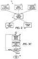
- FIG. 2is a structure chart of a threat avoidance system according to the invention, implemented in the aircraft's computer system.
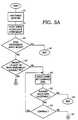
- FIGS. 3A through 3Care flow charts of a threat avoidance process according to the invention.
- FIGS. 4A, Bare pictorial diagrams of how an aircraft using the method and system of the invention responds to known and previously unknown threats.
- FIG. 1illustrates the prior art approach.
- Known threatssuch as T1. an antiaircraft battery, and T2, a radar site, are characterized in the route planning stage as centroids, each with maximum intervisibility. Intervisibility is the capability of both the threat and the aircraft to detect, or be visible to, each other. Ideally, the aircraft detects the threat before intersecting a threat's intervisibility. The nature of the terrain affects intervisibility. For example, the T1 centroid is not circular because a mountain range may block the view of the aircraft battery.
- a planned route 10includes a starting point 12, and ending point or destination 14, and a number of intermediate waypoints such as Alpha, TGT1 and Bravo, shown in the figure. Connecting each pair of waypoints of the route is a leg, such as leg 16 between waypoints TGTI and Bravo. A leg has a general compass heading and is measured in nautical miles (NM). The complete planned route thus looks like an articulated path, angling around known threats to avoid intersecting threat intervisibility regions.
- NMnautical miles
- the prior approachautomatically steers the aircraft 17 along one of a number of predetermined evasive headings.
- the computer systemcalculates the intervisibility for the new threat while the aircraft changes course to this new route.
- the aircraftis just beyond the waypoint Alpha when T3 is encountered. If the threat's maximum intervisibility radius R3 may intersect the route, the aircraft is automatically steered along evasive leg 18.
- a new legis then plotted from the end of the evasive leg 18 to the next waypoint TGTI and checked to determine if the new leg intersects the intervisibility radii of threats T1 through T3. If the new leg does intersect the threat, then another leg is plotted from the end of the evasive leg to the following waypoint Bravo. This process continues until a safe leg is found.
- the prior approachis effective, it has a number of drawbacks. First. it limits the options of the aircraft operator, who may be the pilot or an additional navigator. The initial, automatic route change is made before a determination whether the intervisibility of the previously unknown threat actually intersects the planned route. For example, the intervisibility of T3 does not actually intersect the leg 20. Secondly, it forces the aircraft operator to make unnecessarily large evasive maneuvers. Thirdly. the prior approach is relatively slow because it often causes an excessive number of route changes to be calculated in the pursuit of a safe route.
- FIG. 2is an architectural view of one embodiment of a system according to the invention. implemented in software within the aircraft's computer system.
- FIGS. 3A through 3Care flow charts of one embodiment of a method according to the invention, implemented as a computer process executed by the aircraft's computer system.
- FIGS. 4A, Bare pictorial diagrams of how an aircraft using the method and system of the invention responds to known and previously unknown threats.
- a threat avoidance process 22that executes the steps to be described hereinafter.
- the process 22communicates with a number of modules that provide it with data for its operation. These modules include a threat detection module 23 that detects new, previously unknown threats.
- a threat recognition module 24contains data about the type of threats and determines from the detection data what type of threat is detected.
- a planned route and waypoints module 25contains data on the planned route.
- a set clearance levels module 27contains data on the various set clearance levels. A set clearance refers to an altitude at which the aircraft is permitted to fly.
- An operator alerts module 28aids in communicating data to the aircraft operator.
- Other modulesmay be included.
- the modular datamay also be rearranged in equivalent ways using other modules.
- FIGS. 3A through 3Care flow charts that represent an embodiment of a method according to the invention. For clarity, each step of the method is numbered.
- the threat avoidance processcomes into play when a new, previously unknown threat is detected and recognized by the aircraft's computer system (40).
- the threatis then located and its intervisibility is calculated in nearly real time, typically in less than 200 milliseconds (42).
- the planned routeis then checked to determine if it is affected by the new threat's intervisibility, i.e., the planned route intersects the threat's intervisibility at the current set clearance level (44). If the planned route is not affected by the threat's intervisibility then the threat avoidance process is complete until a new threat is detected (46).
- step 50-54a check is made to see if there is another set clearance level acceptable to the operator, given the nature of the threat (steps 50-54). If so, then the operator may terminate the threat avoidance process and direct the aircraft to continue on the planned route (56). advisably at some lower set clearance. If there is no other acceptable set clearance level, then the operator executes a mission replan (step B in FIG. 3A and following steps in FIGS. 3B and 3C).
- a startpoint for a new legis on the current leg a few seconds ahead of the aircraft (60) (the time varies based on aircraft performance). For the situation where the operator is involved, the startpoint may differ. If the intervisibility of the new threat intersects the current leg of the planned route (62), then the startpoint is also on the current leg a few seconds ahead of the aircraft (60). However, if the intervisibility does not intersect the current leg. the process looks for the first waypoint before the intersection point (64).
- first waypointis within a predetermined distance of the intersection point (66), say, 2 NM, the startpoint is again on the current leg a few seconds ahead of the aircraft (60). If not, the first waypoint becomes the startpoint (68).
- the startpoint for the route changeis a point on the current leg a few seconds ahead of the aircraft (60), unless it is safe for the aircraft to proceed to the first waypoint ahead, i.e., at the end of the current leg (68).
- the destination. or endpoint. of the route changeis then calculated and becomes the next sequential waypoint following the startpoint.
- the processfinds the next waypoint beyond the intervisibility intersection point (70). For a startpoint on the current leg (60), the next waypoint would be the waypoint at the end of the current leg. For a startpoint at the first waypoint (68), the next waypoint would be the waypoint immediately beyond the first waypoint. This next waypoint becomes the destination (72, 74, 76), unless either of the following occurs. If the next waypoint is less than another predetermined distance from the aircraft (72), say 10 NM, or if the threat's intervisibility intersects both legs connecting to the next waypoint (74), then the following waypoint is the destination (78). This check (72, 74) minimizes the number of route changes by making sure that one route change is sufficient to avoid the new threat.
- the mission replanis now complete.
- the threat avoidance processthen executes the mission replan (80) and commands the aircraft to steer to the route change (82).
- This optimized evasive actionwhich is preferably automatic, is taken quickly after a new threat is detected.
- the processthen pauses to give the aircraft operator an opportunity to accept or reject the replan (84). If the operator rejects the replan, he can command the process to try an alternative route. Or, he can accept it and terminate the process (86).
- FIGS. 4A, Bare examples illustrating the operation of the threat avoidance process of the invention.
- a threatT4 pops up and intersects the current leg 100 at the current set clearance (44).
- the aircraft 17is less than 5 NM (48) from intersection point 102 and the intervisibility affects the current leg (62).
- a startpoint 104is thus selected a few seconds ahead (60) automatically.
- TGT1is the next waypoint beyond the intersection point 102 (70) and the aircraft distance to it is greater than 10 NM (72).
- the intervisibilitydoes not affect both legs 100 and 106 at TGTI (74), so TGT1 is selected as the destination waypoint (76).
- a replanis performed (80) and the aircraft is steered onto a new leg 108 (82). If the operator decides the route to TGT1 is acceptable (84), he can "accept,” and processing is complete (86). If he rejects it (84), TGT2 is selected as the destination waypoint and a replan is made along another leg 110 to TGT2. Typically the operator would accept this replan (84) and processing would again be complete (86).
- a threat T5pops up and intersects leg 120 further along the aircraft's route.
- the distance from aircraft 17 to the intersection point 122is greater than 5 NM (48).
- the operatornow has the option to select a lower set clearance (50) (altitude) which the threat intervisibility does not intersect.
- the planned routemay remain acceptable (52) and processing would be complete (56). If, however, the operator desires a new route, processing continues (54). Since the intervisibility affects the current leg 120 (62), a startpoint 124 is chosen a few seconds ahead of the aircraft (60). TGT1 is the next waypoint beyond the intersection (70) and the distance to it is greater than 10 NM (72).
Landscapes
- Engineering & Computer Science (AREA)
- Radar, Positioning & Navigation (AREA)
- Remote Sensing (AREA)
- Automation & Control Theory (AREA)
- Physics & Mathematics (AREA)
- General Physics & Mathematics (AREA)
- Aviation & Aerospace Engineering (AREA)
- General Engineering & Computer Science (AREA)
- Combustion & Propulsion (AREA)
- Chemical & Material Sciences (AREA)
- Traffic Control Systems (AREA)
- Radar Systems Or Details Thereof (AREA)
- Aiming, Guidance, Guns With A Light Source, Armor, Camouflage, And Targets (AREA)
- Navigation (AREA)
Description
Claims (4)
- A computerized method for an airborne aircraft to respond to anunknown threat where the aircraft detects a previously unknown threat and determines azone of intervisiblity for the unknown threat before the aircraft intersects the zone ofintervisibility and, comprising the following steps:determining if an aircraft's planned route intersects the zone of intervisibilitywith the threat:if not, maintaining the aircraft's planned route;if intersection of the aircraft's planned route with the zone of intervisibility isless than a predetermined distance from the aircraft, automatically executing a routechange:if intersection of the aircraft's planned route with the zone of intervisibility isgreater than the predetermined distance from the aircraft, notifying an aircraft operatorof the threat and determining whether the aircraft's planned route remains undetected ata other flying altitudes: andif a different flying altitude is found, permitting the operator to maintain theaircraft's planned route or to choose a different route.
- The method of claim 1 wherein the step of executing a route changecomprises:calculating a startpoint for the route change:determining the next waypoint in the planned route beyond the start point: andif the next waypoint is less than a predetermined distance from the aircraft.choosing a waypoint following the next waypoint as an endpoint for the route change.
- The method of claim I wherein the step of executing a route changefurther includes:if the next waypoint is greater than the predetermined distance from the aircraft.choosing the next waypoint as the endpoint for the route change. unless the threat's intervisibility also intersects the route planned between the next waypoint and thefollowing waypoint.
- The method of claim 1 including:
if the different flying altitude is not found, automatically executing a routechange.
Applications Claiming Priority (3)
| Application Number | Priority Date | Filing Date | Title |
|---|---|---|---|
| US18289294A | 1994-01-18 | 1994-01-18 | |
| US182892 | 1994-01-18 | ||
| PCT/US1995/000743WO1995019547A1 (en) | 1994-01-18 | 1995-01-17 | Threat avoidance system and method for aircraft |
Publications (2)
| Publication Number | Publication Date |
|---|---|
| EP0740772A1 EP0740772A1 (en) | 1996-11-06 |
| EP0740772B1true EP0740772B1 (en) | 1999-03-17 |
Family
ID=22670510
Family Applications (1)
| Application Number | Title | Priority Date | Filing Date |
|---|---|---|---|
| EP95908577AExpired - LifetimeEP0740772B1 (en) | 1994-01-18 | 1995-01-17 | Threat avoidance method for aircraft |
Country Status (6)
| Country | Link |
|---|---|
| US (1) | US5631640A (en) |
| EP (1) | EP0740772B1 (en) |
| JP (1) | JP3442786B2 (en) |
| DE (1) | DE69508381T2 (en) |
| IL (1) | IL112237A (en) |
| WO (1) | WO1995019547A1 (en) |
Families Citing this family (76)
| Publication number | Priority date | Publication date | Assignee | Title |
|---|---|---|---|---|
| DE69606804T2 (en)* | 1995-06-20 | 2000-06-15 | Honeywell, Inc. | Integrated system for basic collision avoidance |
| US5884223A (en)* | 1996-04-29 | 1999-03-16 | Sun Microsystems, Inc. | Altitude sparse aircraft display |
| FR2749686B1 (en)* | 1996-06-07 | 1998-09-11 | Sextant Avionique | METHOD FOR THE VEHICLE LATERAL AVOIDANCE OF A MOBILE AREA |
| FR2749650B1 (en)* | 1996-06-07 | 1998-09-11 | Sextant Avionique | STEERING METHOD OF A VEHICLE WITH A VIEW TO MAKING A CHANGE IN COURSE AND APPLICATION OF THE METHOD FOR SIDE BYPASSING OF A ZONE |
| FR2749677B1 (en)* | 1996-06-07 | 1998-09-11 | Sextant Avionique | AUTOMATIC STEERING METHOD OF A VEHICLE FOR THE LATERAL AVOIDANCE OF A FIXED AREA |
| US5838262A (en)* | 1996-12-19 | 1998-11-17 | Sikorsky Aircraft Corporation | Aircraft virtual image display system and method for providing a real-time perspective threat coverage display |
| FR2787587B1 (en)* | 1998-12-18 | 2001-10-05 | Sextant Avionique | PROCESS FOR THE REAL-TIME DEVELOPMENT OF TRAJECTORIES FOR AN AIRCRAFT |
| US6182007B1 (en) | 1999-03-11 | 2001-01-30 | Lockheed Martin Corp. | Incorporating aspect angle into route planners |
| US6289277B1 (en)* | 1999-10-07 | 2001-09-11 | Honeywell International Inc. | Interfaces for planning vehicle routes |
| US6222464B1 (en) | 1999-12-02 | 2001-04-24 | Sikorsky Aircraft Corporation | Self compensating target acquisition system for minimizing areas of threat |
| SE519339C2 (en)* | 2000-11-22 | 2003-02-18 | Sandvik Ab | Cutting tools coated with alumina and ways of manufacturing the same |
| US6452511B1 (en)* | 2001-08-08 | 2002-09-17 | Rockwell Collins, Inc. | Method and system for providing ground proximity warnings |
| US6525674B1 (en)* | 2001-08-08 | 2003-02-25 | Rockwell Collins, Inc. | Conditional hazard alerting display |
| AUPR772001A0 (en)* | 2001-09-17 | 2001-10-11 | Kenny, Craig Anthony | Aircraft avoidance system for preventing entry into an exclusion zone |
| EP1310425A1 (en)* | 2001-11-08 | 2003-05-14 | Gascom GmbH, Kompressortechnik | Self-destruction mechanism for aircraft |
| US6604044B1 (en) | 2002-02-14 | 2003-08-05 | The Mitre Corporation | Method for generating conflict resolutions for air traffic control of free flight operations |
| US7647232B2 (en) | 2002-02-21 | 2010-01-12 | Lockheed Martin Corporation | Real-time team coordination system for reconnaissance and surveillance missions |
| US6687606B1 (en) | 2002-02-21 | 2004-02-03 | Lockheed Martin Corporation | Architecture for automatic evaluation of team reconnaissance and surveillance plans |
| US6718261B2 (en) | 2002-02-21 | 2004-04-06 | Lockheed Martin Corporation | Architecture for real-time maintenance of distributed mission plans |
| US6725152B2 (en) | 2002-02-21 | 2004-04-20 | Lockheed Martin Corporation | Real-time route and sensor planning system with variable mission objectives |
| US6975246B1 (en) | 2003-05-13 | 2005-12-13 | Itt Manufacturing Enterprises, Inc. | Collision avoidance using limited range gated video |
| US7948404B2 (en)* | 2003-05-27 | 2011-05-24 | Honeywell International Inc. | Obstacle avoidance situation display generator |
| US7024287B2 (en) | 2003-07-25 | 2006-04-04 | Honeywell International Inc. | Flight management computer lateral route recapture |
| US7589646B2 (en)* | 2004-02-19 | 2009-09-15 | Honeywell International Inc. | Systems and methods for determining best path for avoidance of terrain, obstacles, or protected airspace |
| US20050195096A1 (en)* | 2004-03-05 | 2005-09-08 | Ward Derek K. | Rapid mobility analysis and vehicular route planning from overhead imagery |
| FR2870605B1 (en)* | 2004-05-18 | 2010-10-08 | Airbus France | METHOD AND APPARATUS FOR AUTOMATICALLY GUIDING AN AIRCRAFT FOR LOW-ALTITUDE AT LEAST PART FLIGHT |
| US7280897B2 (en)* | 2004-05-28 | 2007-10-09 | Lockheed Martin Corporation | Intervisibility determination |
| US7492965B2 (en)* | 2004-05-28 | 2009-02-17 | Lockheed Martin Corporation | Multiple map image projecting and fusing |
| US7242407B2 (en)* | 2004-05-28 | 2007-07-10 | Lockheed Martin Corporation | Reprojecting map images using graphical techniques |
| US7486840B2 (en)* | 2004-05-28 | 2009-02-03 | Lockheed Martin Corporation | Map image object connectivity |
| JP4622317B2 (en) | 2004-05-31 | 2011-02-02 | 株式会社デンソー | Route guidance apparatus and program |
| ES2245245B1 (en) | 2004-06-08 | 2007-02-16 | INSTITUTO NACIONAL DE TECNICA AEROESPACIAL "ESTEBAN TERRADAS" | SYSTEM AND METHOD OF CONTROL OF AN UNTRIPULATED AIR VEHICLE. |
| US7194353B1 (en) | 2004-12-03 | 2007-03-20 | Gestalt, Llc | Method and system for route planning of aircraft using rule-based expert system and threat assessment |
| US7769502B2 (en) | 2005-05-26 | 2010-08-03 | Lockheed Martin Corporation | Survivability/attack planning system |
| US7801649B2 (en)* | 2006-02-28 | 2010-09-21 | Honeywell International Inc. | Predicted path selection system and method for hazard coding in selectively constrained aircraft control systems |
| US20070288156A1 (en)* | 2006-05-17 | 2007-12-13 | The Boeing Company | Route search planner |
| US7848879B2 (en)* | 2006-12-04 | 2010-12-07 | Lockheed Martin Corporation | Survivability system |
| US7979199B2 (en) | 2007-01-10 | 2011-07-12 | Honeywell International Inc. | Method and system to automatically generate a clearance request to deviate from a flight plan |
| US7483790B2 (en)* | 2007-01-31 | 2009-01-27 | Honeywell International Inc. | Systems and methods for constructing variable offset paths |
| US7877197B2 (en)* | 2007-05-15 | 2011-01-25 | The Boeing Company | Systems and methods for real-time conflict-checked, operationally preferred flight trajectory revision recommendations |
| FR2921152B1 (en)* | 2007-09-14 | 2010-03-12 | Thales Sa | AIRCRAFT FLIGHT PLAN JOINT ASSISTANCE METHOD BY INTERCEPTING A FLIGHT SEGMENT CLOSE TO THE AIRCRAFT |
| US8527118B2 (en)* | 2007-10-17 | 2013-09-03 | The Boeing Company | Automated safe flight vehicle |
| US8255098B2 (en)* | 2007-10-17 | 2012-08-28 | The Boeing Company | Variably manned aircraft |
| US9513125B2 (en)* | 2008-01-14 | 2016-12-06 | The Boeing Company | Computing route plans for routing around obstacles having spatial and temporal dimensions |
| US8082102B2 (en)* | 2008-01-14 | 2011-12-20 | The Boeing Company | Computing flight plans for UAVs while routing around obstacles having spatial and temporal dimensions |
| US8935174B2 (en)* | 2009-01-16 | 2015-01-13 | The Boeing Company | Analyzing voyage efficiencies |
| US9115996B2 (en)* | 2009-07-29 | 2015-08-25 | Lockheed Martin Corporation | Threat analysis toolkit |
| US8692703B1 (en)* | 2010-09-17 | 2014-04-08 | Rockwell Collins, Inc. | Mapping, storage, retrieval and display of high energy electromagnetic radiation emitters |
| JP5818479B2 (en) | 2011-03-29 | 2015-11-18 | 三菱重工業株式会社 | Control device, display device, cooperative operation system, and control method |
| US9255808B2 (en)* | 2011-11-08 | 2016-02-09 | Saab Ab | Route planning system and method for minimizing exposure to threats |
| US9157746B2 (en)* | 2011-11-16 | 2015-10-13 | The Boeing Company | Vessel routing system |
| US8791836B2 (en)* | 2012-03-07 | 2014-07-29 | Lockheed Martin Corporation | Reflexive response system for popup threat survival |
| US9240001B2 (en) | 2012-05-03 | 2016-01-19 | Lockheed Martin Corporation | Systems and methods for vehicle survivability planning |
| US9030347B2 (en) | 2012-05-03 | 2015-05-12 | Lockheed Martin Corporation | Preemptive signature control for vehicle survivability planning |
| US8831793B2 (en) | 2012-05-03 | 2014-09-09 | Lockheed Martin Corporation | Evaluation tool for vehicle survivability planning |
| US8868328B1 (en)* | 2013-06-04 | 2014-10-21 | The Boeing Company | System and method for routing decisions in a separation management system |
| US9583012B1 (en)* | 2013-08-16 | 2017-02-28 | The Boeing Company | System and method for detection and avoidance |
| EP3754381A1 (en) | 2013-12-10 | 2020-12-23 | SZ DJI Technology Co., Ltd. | Sensor fusion |
| JP6133506B2 (en)* | 2014-04-17 | 2017-05-24 | エスゼット ディージェイアイ テクノロジー カンパニー リミテッドSz Dji Technology Co.,Ltd | Flight control for flight restricted areas |
| US10339816B2 (en)* | 2014-06-27 | 2019-07-02 | The Boeing Company | Automatic aircraft monitoring and operator preferred rerouting system and method |
| JP6278539B2 (en) | 2014-09-05 | 2018-02-14 | エスゼット ディージェイアイ テクノロジー カンパニー リミテッドSz Dji Technology Co.,Ltd | Flight mode selection based on situation |
| EP3103043B1 (en) | 2014-09-05 | 2018-08-15 | SZ DJI Technology Co., Ltd. | Multi-sensor environmental mapping |
| WO2016033795A1 (en) | 2014-09-05 | 2016-03-10 | SZ DJI Technology Co., Ltd. | Velocity control for an unmanned aerial vehicle |
| FR3027683B1 (en)* | 2014-10-28 | 2018-02-23 | Thales | METHOD FOR MANAGING THE EQUIVALENT RADAR SURFACE VALUE OF A VEHICLE PRESENTED WITH AT LEAST ONE RADAR AND ASSOCIATED SYSTEM |
| US10026324B2 (en) | 2014-11-04 | 2018-07-17 | Honeywell International Inc. | Systems and methods for enhanced adoptive validation of ATC clearance requests |
| CN113031652A (en) | 2015-03-31 | 2021-06-25 | 深圳市大疆创新科技有限公司 | Open platform for flight-limiting area |
| US9542849B1 (en)* | 2015-07-31 | 2017-01-10 | Rockwell Collins, Inc. | Risk-based flight path data generating system, device, and method |
| US10822110B2 (en) | 2015-09-08 | 2020-11-03 | Lockheed Martin Corporation | Threat countermeasure assistance system |
| CN106168807B (en)* | 2016-09-09 | 2018-01-09 | 腾讯科技(深圳)有限公司 | The flight control method and flight control assemblies of a kind of aircraft |
| IL255512B (en) | 2017-11-07 | 2019-06-30 | Elbit Systems Ltd | Transmission detection using line of sight |
| CN108089594B (en)* | 2017-12-13 | 2020-11-27 | 王俊梅 | Unmanned aerial vehicle sight dead angle steering escape flight method |
| WO2020014930A1 (en)* | 2018-07-19 | 2020-01-23 | 深圳市大疆创新科技有限公司 | Unmanned aerial vehicle control method and device and unmanned aerial vehicle |
| FR3085527B1 (en)* | 2018-09-05 | 2021-01-15 | Airbus Operations Sas | METHOD AND SYSTEM FOR GENERATION AND MONITORING OF AN OPTIMIZED FLIGHT PATH OF AN AIRCRAFT |
| CN110162095B (en)* | 2019-06-19 | 2022-05-27 | 西北工业大学 | Rapid return method of unmanned aerial vehicle in threat environment |
| EP4155676A1 (en)* | 2021-09-24 | 2023-03-29 | Nokia Technologies Oy | Dynamic waypoint management for constrained navigation |
| CN116486656B (en)* | 2023-06-25 | 2023-09-01 | 西安羚控电子科技有限公司 | Aircraft cruising method and system |
Family Cites Families (11)
| Publication number | Priority date | Publication date | Assignee | Title |
|---|---|---|---|---|
| US3668403A (en)* | 1969-05-05 | 1972-06-06 | Goodyear Aerospace Corp | Method and apparatus for vehicle traffic control |
| US4063073A (en)* | 1974-11-29 | 1977-12-13 | Strayer Larry G | Computer system to prevent collision between moving objects such as aircraft moving from one sector to another |
| US4760396A (en)* | 1986-07-11 | 1988-07-26 | Merit Technology Incorporated | Apparatus and method for adjusting set clearance altitude in a terrain following radar system |
| US4812990A (en)* | 1987-04-29 | 1989-03-14 | Merit Technology Incorporated | System and method for optimizing aircraft flight path |
| US4862373A (en)* | 1987-05-13 | 1989-08-29 | Texas Instruments Incorporated | Method for providing a collision free path in a three-dimensional space |
| US4914733A (en)* | 1987-10-30 | 1990-04-03 | Allied-Signal, Inc. | Traffic advisory-instantaneous vertical speed display |
| US4903216A (en)* | 1988-04-11 | 1990-02-20 | Hughes Aircraft Company | Method for displaying intervisibility data |
| US4882590A (en)* | 1988-05-18 | 1989-11-21 | Hughes Aircraft Company | Method for locating a radio frequency emitter |
| US5058024A (en)* | 1989-01-23 | 1991-10-15 | International Business Machines Corporation | Conflict detection and resolution between moving objects |
| EP0381178A1 (en)* | 1989-02-02 | 1990-08-08 | Honeywell Inc. | Method and apparatus for aircraft navigation |
| US5086396A (en)* | 1989-02-02 | 1992-02-04 | Honeywell Inc. | Apparatus and method for an aircraft navigation system having improved mission management and survivability capabilities |
- 1995
- 1995-01-03ILIL112237Apatent/IL112237A/ennot_activeIP Right Cessation
- 1995-01-17EPEP95908577Apatent/EP0740772B1/ennot_activeExpired - Lifetime
- 1995-01-17JPJP51922595Apatent/JP3442786B2/ennot_activeExpired - Fee Related
- 1995-01-17WOPCT/US1995/000743patent/WO1995019547A1/enactiveIP Right Grant
- 1995-01-17DEDE69508381Tpatent/DE69508381T2/ennot_activeExpired - Fee Related
- 1995-02-21USUS08/393,513patent/US5631640A/ennot_activeExpired - Lifetime
Also Published As
| Publication number | Publication date |
|---|---|
| JPH09507714A (en) | 1997-08-05 |
| DE69508381D1 (en) | 1999-04-22 |
| IL112237A0 (en) | 1995-03-30 |
| EP0740772A1 (en) | 1996-11-06 |
| US5631640A (en) | 1997-05-20 |
| WO1995019547A1 (en) | 1995-07-20 |
| JP3442786B2 (en) | 2003-09-02 |
| IL112237A (en) | 1998-03-10 |
| DE69508381T2 (en) | 1999-10-07 |
Similar Documents
| Publication | Publication Date | Title |
|---|---|---|
| EP0740772B1 (en) | Threat avoidance method for aircraft | |
| US7848879B2 (en) | Survivability system | |
| EP1936584B1 (en) | A device at an airborne vehicle and a method for collision avoidance | |
| EP1240636B1 (en) | System and method for avoidance of collision between vehicles | |
| RU2282157C2 (en) | Device for warning of dangerous pitch angle | |
| EP1151244B1 (en) | Ground proximity warning system | |
| EP1857904B1 (en) | Emergency flight plan | |
| US6546338B2 (en) | Method for working out an avoidance path in the horizontal plane for an aircraft to resolve a traffic conflict | |
| EP0750238B1 (en) | Integrated ground collision avoidance system | |
| CA2501903C (en) | Method and apparatus for reducing false taws warnings | |
| EP1873606B1 (en) | Termination secured route planning | |
| EP0790487B1 (en) | Aircraft terrain advisory system | |
| US7084785B2 (en) | Method and device for determining a final approach path of an aircraft for a non-precision approach for the purpose of landing the aircraft | |
| EP1787140B1 (en) | Collision avoidance system | |
| US20060025899A1 (en) | Flight management computer lateral route recapture | |
| US6871124B1 (en) | Method and system for guiding an aircraft along a preferred flight path having a random origin | |
| EP1583937B1 (en) | Shortened aircraft holding pattern exit paths | |
| JP5183621B2 (en) | Aircraft guidance system | |
| US10502584B1 (en) | Mission monitor and controller for autonomous unmanned vehicles | |
| KR20110113608A (en) | Autonomous Navigation Systems and Methods for Steerable Platforms | |
| SG184536A1 (en) | Determining emergency landing sites for aircraft | |
| US20060158350A1 (en) | Systems and methods for determining best path for avoidance of terrain, obstacles, or protected airspace | |
| JPH039211A (en) | Navigation system for aircraft and method of assisting navigation of aircraft during sortie | |
| US20080150785A1 (en) | Method and device for determining a decision height during an autonomous approach of an aircraft | |
| CA2180452C (en) | Threat avoidance system and method for aircraft |
Legal Events
| Date | Code | Title | Description |
|---|---|---|---|
| PUAI | Public reference made under article 153(3) epc to a published international application that has entered the european phase | Free format text:ORIGINAL CODE: 0009012 | |
| 17P | Request for examination filed | Effective date:19960712 | |
| AK | Designated contracting states | Kind code of ref document:A1 Designated state(s):DE FR GB | |
| GRAG | Despatch of communication of intention to grant | Free format text:ORIGINAL CODE: EPIDOS AGRA | |
| GRAG | Despatch of communication of intention to grant | Free format text:ORIGINAL CODE: EPIDOS AGRA | |
| GRAH | Despatch of communication of intention to grant a patent | Free format text:ORIGINAL CODE: EPIDOS IGRA | |
| GRAH | Despatch of communication of intention to grant a patent | Free format text:ORIGINAL CODE: EPIDOS IGRA | |
| 17Q | First examination report despatched | Effective date:19980824 | |
| GRAA | (expected) grant | Free format text:ORIGINAL CODE: 0009210 | |
| AK | Designated contracting states | Kind code of ref document:B1 Designated state(s):DE FR GB | |
| REF | Corresponds to: | Ref document number:69508381 Country of ref document:DE Date of ref document:19990422 | |
| ET | Fr: translation filed | ||
| PLBE | No opposition filed within time limit | Free format text:ORIGINAL CODE: 0009261 | |
| STAA | Information on the status of an ep patent application or granted ep patent | Free format text:STATUS: NO OPPOSITION FILED WITHIN TIME LIMIT | |
| 26N | No opposition filed | ||
| REG | Reference to a national code | Ref country code:GB Ref legal event code:IF02 | |
| PGFP | Annual fee paid to national office [announced via postgrant information from national office to epo] | Ref country code:DE Payment date:20090130 Year of fee payment:15 | |
| PGFP | Annual fee paid to national office [announced via postgrant information from national office to epo] | Ref country code:GB Payment date:20081211 Year of fee payment:15 | |
| PGFP | Annual fee paid to national office [announced via postgrant information from national office to epo] | Ref country code:FR Payment date:20090106 Year of fee payment:15 | |
| GBPC | Gb: european patent ceased through non-payment of renewal fee | Effective date:20100117 | |
| REG | Reference to a national code | Ref country code:FR Ref legal event code:ST Effective date:20100930 | |
| PG25 | Lapsed in a contracting state [announced via postgrant information from national office to epo] | Ref country code:FR Free format text:LAPSE BECAUSE OF NON-PAYMENT OF DUE FEES Effective date:20100201 | |
| PG25 | Lapsed in a contracting state [announced via postgrant information from national office to epo] | Ref country code:DE Free format text:LAPSE BECAUSE OF NON-PAYMENT OF DUE FEES Effective date:20100803 | |
| PG25 | Lapsed in a contracting state [announced via postgrant information from national office to epo] | Ref country code:GB Free format text:LAPSE BECAUSE OF NON-PAYMENT OF DUE FEES Effective date:20100117 | |
| P01 | Opt-out of the competence of the unified patent court (upc) registered | Effective date:20230525 |