DE102023003229A1 - Method for providing satellite images divided into individual satellite image tiles for a navigation system of a moving vehicle and navigation system of a vehicle - Google Patents
Method for providing satellite images divided into individual satellite image tiles for a navigation system of a moving vehicle and navigation system of a vehicleDownload PDFInfo
- Publication number
- DE102023003229A1 DE102023003229A1DE102023003229.8ADE102023003229ADE102023003229A1DE 102023003229 A1DE102023003229 A1DE 102023003229A1DE 102023003229 ADE102023003229 ADE 102023003229ADE 102023003229 A1DE102023003229 A1DE 102023003229A1
- Authority
- DE
- Germany
- Prior art keywords
- satellite image
- navigation system
- image tiles
- downloaded
- vehicle
- Prior art date
- Legal status (The legal status is an assumption and is not a legal conclusion. Google has not performed a legal analysis and makes no representation as to the accuracy of the status listed.)
- Pending
Links
Images


Classifications
- G—PHYSICS
- G06—COMPUTING OR CALCULATING; COUNTING
- G06F—ELECTRIC DIGITAL DATA PROCESSING
- G06F16/00—Information retrieval; Database structures therefor; File system structures therefor
- G06F16/20—Information retrieval; Database structures therefor; File system structures therefor of structured data, e.g. relational data
- G06F16/29—Geographical information databases
- G—PHYSICS
- G01—MEASURING; TESTING
- G01C—MEASURING DISTANCES, LEVELS OR BEARINGS; SURVEYING; NAVIGATION; GYROSCOPIC INSTRUMENTS; PHOTOGRAMMETRY OR VIDEOGRAMMETRY
- G01C21/00—Navigation; Navigational instruments not provided for in groups G01C1/00 - G01C19/00
- G01C21/38—Electronic maps specially adapted for navigation; Updating thereof
- G01C21/3804—Creation or updating of map data
- G01C21/3833—Creation or updating of map data characterised by the source of data
- G01C21/3852—Data derived from aerial or satellite images
- G—PHYSICS
- G08—SIGNALLING
- G08G—TRAFFIC CONTROL SYSTEMS
- G08G1/00—Traffic control systems for road vehicles
- G08G1/09—Arrangements for giving variable traffic instructions
- G08G1/0962—Arrangements for giving variable traffic instructions having an indicator mounted inside the vehicle, e.g. giving voice messages
- G08G1/0967—Systems involving transmission of highway information, e.g. weather, speed limits
- G08G1/096733—Systems involving transmission of highway information, e.g. weather, speed limits where a selection of the information might take place
- G08G1/096741—Systems involving transmission of highway information, e.g. weather, speed limits where a selection of the information might take place where the source of the transmitted information selects which information to transmit to each vehicle
- G—PHYSICS
- G08—SIGNALLING
- G08G—TRAFFIC CONTROL SYSTEMS
- G08G1/00—Traffic control systems for road vehicles
- G08G1/09—Arrangements for giving variable traffic instructions
- G08G1/0962—Arrangements for giving variable traffic instructions having an indicator mounted inside the vehicle, e.g. giving voice messages
- G08G1/0967—Systems involving transmission of highway information, e.g. weather, speed limits
- G08G1/096766—Systems involving transmission of highway information, e.g. weather, speed limits where the system is characterised by the origin of the information transmission
- G08G1/096775—Systems involving transmission of highway information, e.g. weather, speed limits where the system is characterised by the origin of the information transmission where the origin of the information is a central station
- G—PHYSICS
- G08—SIGNALLING
- G08G—TRAFFIC CONTROL SYSTEMS
- G08G1/00—Traffic control systems for road vehicles
- G08G1/09—Arrangements for giving variable traffic instructions
- G08G1/0962—Arrangements for giving variable traffic instructions having an indicator mounted inside the vehicle, e.g. giving voice messages
- G08G1/0968—Systems involving transmission of navigation instructions to the vehicle
- G08G1/0969—Systems involving transmission of navigation instructions to the vehicle having a display in the form of a map
- G—PHYSICS
- G01—MEASURING; TESTING
- G01C—MEASURING DISTANCES, LEVELS OR BEARINGS; SURVEYING; NAVIGATION; GYROSCOPIC INSTRUMENTS; PHOTOGRAMMETRY OR VIDEOGRAMMETRY
- G01C21/00—Navigation; Navigational instruments not provided for in groups G01C1/00 - G01C19/00
- G01C21/38—Electronic maps specially adapted for navigation; Updating thereof
- G01C21/3863—Structures of map data
- G01C21/387—Organisation of map data, e.g. version management or database structures
- G01C21/3881—Tile-based structures
Landscapes
- Engineering & Computer Science (AREA)
- Remote Sensing (AREA)
- Physics & Mathematics (AREA)
- General Physics & Mathematics (AREA)
- Radar, Positioning & Navigation (AREA)
- Theoretical Computer Science (AREA)
- Life Sciences & Earth Sciences (AREA)
- Atmospheric Sciences (AREA)
- Databases & Information Systems (AREA)
- Automation & Control Theory (AREA)
- General Engineering & Computer Science (AREA)
- Data Mining & Analysis (AREA)
- Navigation (AREA)
Abstract
Translated fromGerman
Description
Translated fromGermanDie vorliegende Erfindung betrifft ein Verfahren zur Bereitstellung von in einzelne Satellitenbildkacheln unterteilten Satellitenbildern für ein Navigationssystem eines fahrenden Fahrzeugs, wobei das Navigationssystem mit einem Backend-System datenaustauschend verbunden ist, und ein Navigationssystem eines Fahrzeugs.The present invention relates to a method for providing satellite images divided into individual satellite image tiles for a navigation system of a moving vehicle, wherein the navigation system is connected to a backend system for data exchange, and to a navigation system of a vehicle.
Mit Navigationssystemen in Fahrzeugen können nicht nur schematische oder gerenderte Kartendarstellungen auf einer Anzeige des Navigationssystems dargestellt werden, sondern komfortablere Navigationssysteme ermöglichen zur Fahrzeugposition passende Satellitenbilder, die einen geographischen Bereich darstellen, in dem sich das Fahrzeug befindet, auf der Anzeige des Navigationssystems darzustellen, wobei sogar eine 3D-Darstellung möglich ist. Aufgrund der großen Datenmengen, die mit der Darstellung solcher Satellitenbilder verbunden sind, ist es nicht oder nur mit unverhältnismäßig großem Hardware-Aufwand möglich, die Satellitenbilder einer umfassenden geographischen Karte, beispielsweise von einem ganzen Land oder einem ganzen Kontinent, im Fahrzeug zu speichern. Hierdurch unterscheiden sich solche gattungsgemäßen Navigationssysteme und Verfahren zur Bereitstellung von in einzelne Satellitenbildkacheln unterteilten Satellitenbildern für ein Navigationssystem eines Fahrzeugs von einfachen Kartennavigationssystemen, wie sie beispielsweise in
Ferner ist aus
Gattungsgemäße Navigationssysteme und Verfahren zur Bereitstellung von aktuellen Satellitenbildern bei der Fahrzeugnavigation, wie sie die vorliegende Erfindung betrifft, senden mit dem Navigationssystem des Fahrzeugs eine Anfrage an ein Backend-System, wobei die Anfrage die aktuelle Fahrzeugposition enthält. Hieraufhin sendet das Backend-System eine Liste von der aktuellen Fahrzeugposition zugeordneten, herunterzuladenden Satellitenbildkacheln an das Navigationssystem und das Navigationssystem lädt Satellitenbildkacheln gemäß der vom Backend-System gesendeten Liste in einen Speicher des Navigationssystems herunter und stellt, in Abhängigkeit des aktuellen eingestellten Kartenausschnitts, zumindest eine der aktuellen Fahrzeugposition entsprechende Positionssatellitenbildkachel aus der Liste auf der Anzeige im Fahrzeug dar. Die Liste enthält nicht nur die der aktuellen Fahrzeugposition entsprechenden Positionssatellitenbildkachel, sondern zusätzlich zu der Positionssatellitenbildkachel alle an die Positionssatellitenbildkachel angrenzenden Satellitenbildkacheln, vorliegend als Grenzsatellitenbildkacheln bezeichnet. Das Navigationssystem lädt die Kacheln der Liste in willkürlicher Reihenfolge herunter, bis alle Kacheln in dem Speicher gespeichert sind. Nach dem FIFIO-Prinzip (first in, first out) wird eine gewisse Anzahl bereits heruntergeladener Kacheln zwischengespeichert, sodass diese nicht erneut heruntergeladen werden müssen, wenn diese erneut angefordert werden. Wenn der Speicher voll ist, werden zuerst heruntergeladene Satellitenbildkacheln sukzessive gelöscht.Generic navigation systems and methods for providing current satellite images in vehicle navigation, as the present invention relates to, send a request to a backend system using the vehicle's navigation system, the request containing the current vehicle position. The backend system then sends a list of satellite image tiles to be downloaded that are associated with the current vehicle position to the navigation system, and the navigation system downloads satellite image tiles according to the list sent by the backend system into a memory of the navigation system and, depending on the currently set map section, displays at least one position satellite image tile from the list that corresponds to the current vehicle position on the display in the vehicle. The list contains not only the position satellite image tile that corresponds to the current vehicle position, but in addition to the position satellite image tile, all satellite image tiles that border the position satellite image tile, referred to here as border satellite image tiles. The navigation system downloads the tiles in the list in random order until all tiles are stored in the memory. According to the FIFIO principle (first in, first out), a certain number of tiles that have already been downloaded are cached so that they do not have to be downloaded again when they are requested again. When the memory is full, the satellite image tiles that were downloaded first are successively deleted.
Obwohl Grenzsatellitenbildkacheln vorsorglich heruntergeladen werden und damit alle Satellitenbildkacheln in einem gewisser Umkreis um die aktuelle Fahrzeugposition lokal im Speicher des Navigationssystem vorliegen und damit schnell abrufbar sind, verlangt dieses Verfahren eine vergleichsweise große Bandbreite in der Datenverbindung zwischen dem Navigationssystem und dem Backend-System, um zu verhindern, dass Lücken in der Darstellung auf der Anzeige entstehen, weil noch nicht alle vom Navigationssystem angeforderten Satellitenbildkacheln der vom Backend-System bereitgestellten Liste in den Speicher des Navigationssystems heruntergeladen wurden. Eine neue Anfrage wird vom Navigationssystem erst dann an das Backend-System gesendet, wenn alle Satellitenbildkacheln der Liste, die der in der Anfrage übermittelnden aktuellen Fahrzeugposition entsprechen, das heißt die Positionssatellitenbildkachel und die Grenzsatellitenbildkacheln, vollständig heruntergeladen wurden.Although border satellite image tiles are downloaded as a precaution and thus all satellite image tiles within a certain radius of the current vehicle position are available locally in the memory of the navigation system and can thus be retrieved quickly, this method requires a comparatively large bandwidth in the data connection between the navigation system and the backend system in order to prevent gaps in the representation on the display because not all satellite image tiles requested by the navigation system from the list provided by the backend system have been downloaded into the memory of the navigation system. A new request is only sent by the navigation system to the backend system when all satellite image tiles in the list that correspond to the list transmitted in the request have been downloaded. corresponding to the current vehicle position, that is, the position satellite image tile and the boundary satellite image tiles, have been fully downloaded.
In der Praxis gibt es jedoch immer noch Gebiete mit schlechter mobiler Datenverbindung, sodass das Navigationssystem bei der Satellitenbildnavigation die Satellitenbildkacheln nicht schnell genug herunterladen kann und sozusagen bei der Anzeige in Verzug geraten kann, was das Nutzerlebnis beeinträchtigt.In practice, however, there are still areas with poor mobile data connectivity, so that when using satellite image navigation, the navigation system cannot download the satellite image tiles quickly enough and may, so to speak, lag in display, which affects the user experience.
Der vorliegenden Erfindung liegt die Aufgabe zugrunde, das Verfahren zur Bereitstellung von in einzelne Satellitenbildkachel unterteilte Satellitenbilder für ein Navigationssystem eines fahrenden Fahrzeugs und das entsprechende Navigationssystem derart zu verbessern, dass das Nutzererlebnis bei der Darstellung von Satellitenbildern verbessert wird, indem die Darstellung flüssiger erfolgt und eine höhere Fehlertoleranz in Gebieten mit schlechter Mobilfunkabdeckung erreicht wird.The present invention is based on the object of improving the method for providing satellite images divided into individual satellite image tiles for a navigation system of a moving vehicle and the corresponding navigation system in such a way that the user experience when displaying satellite images is improved by making the display more fluid and achieving a higher error tolerance in areas with poor mobile phone coverage.
Die erfindungsgemäße Aufgabe wird durch ein Verfahren mit den Schritten von Anspruch 1 und ein Navigationssystem eines Fahrzeugs gemäß dem Anspruch 10 gelöst. Die abhängigen Ansprüche beschreiben vorteilhafte und besonders zweckmäßige Ausgestaltungen der Erfindung.The object according to the invention is achieved by a method with the steps of claim 1 and a navigation system of a vehicle according to claim 10. The dependent claims describe advantageous and particularly expedient embodiments of the invention.
Das erfindungsgemäße Verfahren zur Bereitstellung von in einzelne Satellitenbildkacheln unterteilten Satellitenbildern für ein Navigationssystem eines fahrenden Fahrzeugs, wobei das Navigationssystem mit einem Backend-System datenaustauschend verbunden ist, weist die folgenden Schritte auf:
- - Senden mit dem Navigationssystem einer Anfrage mit einer aktuellen Fahrzeugposition an das Backend-System;
- - in Reaktion auf die Anfrage Senden mit dem Backend-System einer Liste von der aktuellen Fahrzeugposition zugeordneten, herunterzuladenden Satellitenbildkacheln an das Navigationssystem;
- - Herunterladen in das Navigationssystem der Satellitenbildkacheln gemäß der vom Backend-System gesendeten Liste in einen Speicher des Navigationssystems und Darstellen zumindest einer der aktuellen Fahrzeugposition entsprechenden Positionssatellitenbildkachel aus der Liste auf einer Anzeige im Fahrzeug, wobei die Liste zusätzlich zu der Positionssatellitenbildkachel alle an die Positionssatellitenbildkachel angrenzenden Grenzsatellitenbildkacheln umfasst und die Positionssatellitenbildkachel vor den Grenzsatellitenbildkacheln heruntergeladen wird.
- - Sending a request with a current vehicle position to the backend system using the navigation system;
- - in response to the request, sending with the backend system a list of satellite image tiles to be downloaded that are associated with the current vehicle position to the navigation system;
- - Downloading into the navigation system the satellite image tiles according to the list sent by the backend system into a memory of the navigation system and displaying at least one position satellite image tile corresponding to the current vehicle position from the list on a display in the vehicle, wherein the list includes, in addition to the position satellite image tile, all border satellite image tiles adjacent to the position satellite image tile and the position satellite image tile is downloaded before the border satellite image tiles.
Wenn vorliegend auf die Fahrzeugposition Bezug genommen wird, so handelt es sich hierbei um die geographischen Fahrzeugposition.When reference is made here to the vehicle position, this refers to the geographical vehicle position.
Erfindungsgemäß bricht das Navigationssystem das Herunterladen der Satellitenbildkacheln aus der Liste ab, sobald sich das Fahrzeug aus dem geographischen Bereich bewegt hat, der von der Positionssatellitenbildkachel erfasst wird, und übermittelt in einer neuen Anfrage die aktuelle Fahrzeugposition an das Backend-System, worauf die Schritte des zur Verfügungstellens und der Herunterladens der Liste und der Satellitenbildkacheln für die neue Fahrzeugposition wiederholt werden.According to the invention, the navigation system stops downloading the satellite image tiles from the list as soon as the vehicle has moved out of the geographical area covered by the position satellite image tile and transmits the current vehicle position to the backend system in a new request, whereupon the steps of providing and downloading the list and the satellite image tiles are repeated for the new vehicle position.
Durch das erfindungsgemäße Verfahren kann vermieden werden, dass Bandbreite in der Datenverbindung zwischen dem Navigationssystem und dem Backend-System dafür genutzt wird, Grenzsatellitenbildkacheln herunterzuladen, die aufgrund der neuen Fahrzeugposition nicht mehr unmittelbar erforderlich sind. Eine neue Anfrage kann schneller vom Navigationssystem an das Backend-System gestellt werden, wodurch schneller wahrscheinlich notwendige darzustellende Satellitenbildkacheln heruntergeladen werden können und auch eine reduzierte Bandbreite besser ausgenutzt wird.The method according to the invention can prevent bandwidth in the data connection between the navigation system and the backend system from being used to download border satellite image tiles that are no longer immediately required due to the new vehicle position. A new request can be made more quickly from the navigation system to the backend system, which means that satellite image tiles that are probably necessary to be displayed can be downloaded more quickly and a reduced bandwidth is also better utilized.
Bevorzugt lädt das Navigationssystem nach dem Herunterladen aller Grenzsatellitenbildkacheln weitere Zusatzsatellitenbildkacheln aus dem Backend-System in den Speicher des Navigationssystems, solange sich das Fahrzeug in dem geographischen Bereich befindet, der von der aktuellen Positionssatellitenbildkachel erfasst wird. Auch das Herunterladen von Zusatzsatellitenbildkacheln wird abgebrochen, sobald sich das Fahrzeug aus dem geographischen Bereich hinausbewegt hat, der von der aktuellen Positionssatellitenbildkachel erfasst wird und somit eine neue Anfrage vom Navigationssystem and das Backend-System gesendet wird.Preferably, after downloading all boundary satellite image tiles, the navigation system loads additional satellite image tiles from the backend system into the navigation system's memory as long as the vehicle is in the geographical area covered by the current position satellite image tile. The downloading of additional satellite image tiles is also aborted as soon as the vehicle has moved out of the geographical area covered by the current position satellite image tile and a new request is sent from the navigation system to the backend system.
Ein solches Herunterladen von Zusatzsatellitenbildkacheln wird auch als Preloading bezeichnet und hat den Vorteil, dass, wenn das Herunterladen aller Grenzsatellitenbildkacheln abgeschlossen ist, bestehende Bandbreitenreserven in der Datenverbindung genutzt werden, weitere Satellitenbildkacheln herunterzuladen, die dann zur Verfügung stehen können, wenn später die Bandbreite in der Datenverbindung reduziert ist. Die Ausgangspositionen, die in solchen Anfragen an das Backend-System übermittelt werden, können im Speicher des Navigationssystems gespeichert werden, um später abzugleichen, ob entsprechende Anfragen schon an das Backend-System gesendet wurden. Dadurch können Ladevorgänge und Anfragen vermieden werden, für welche die Zusatzsatellitenbildkacheln bereits im Speicher des Navigationssystem gespeichert sind.Such downloading of additional satellite image tiles is also known as preloading and has the advantage that, when the downloading of all border satellite image tiles is complete, existing bandwidth reserves in the data connection are used to download further satellite image tiles, which can then be available when the bandwidth in the data connection is reduced later. The starting positions that are transmitted to the backend system in such requests can be stored in the navigation system's memory in order to later check whether corresponding requests have already been sent to the backend system. This can avoid loading processes and requests for which the additional satellite image tiles are already stored in the navigation system's memory.
Die Zusatzsatellitenbildkacheln können nach verschiedenen Strategien heruntergeladen werden.The additional satellite image tiles can be downloaded using different strategies.
Gemäß einer Ausführungsform des erfindungsgemäßen Verfahrens werden die Zusatzsatellitenbildkacheln gemäß den folgenden Bedingungen heruntergeladen:
- - wenn im Navigationssystem eine Routennavigation zu einem eingegebenen Ziel aktiviert ist, werden die Zusatzsatellitenbildkacheln entlang einer vom Navigationssystem berechneten Route heruntergeladen, und
- - wenn im Navigationssystem eine Routennavigation inaktiv ist und sich das Fahrzeug in einer geschlossenen Ortschaft befindet, werden Zusatzsatellitenbildkacheln heruntergeladen, auf denen sich alle in der Ortschaft vorhandenen für das Fahrzeug freigegebenen Straßen befinden, und
- - wenn im Navigationssystem eine Routennavigation inaktiv ist und sich das Fahrzeug außerhalb einer geschlossenen Ortschaft befindet, werden Zusatzsatellitenbildkacheln entlang einer Straße heruntergeladen, auf der sich das Fahrzeug befindet.
- - if route navigation to an entered destination is activated in the navigation system, the additional satellite image tiles are downloaded along a route calculated by the navigation system, and
- - if route navigation is inactive in the navigation system and the vehicle is in a built-up area, additional satellite image tiles are downloaded showing all roads in the built-up area that are open to the vehicle, and
- - If route navigation is inactive in the navigation system and the vehicle is outside a built-up area, additional satellite image tiles are downloaded along a road on which the vehicle is located.
Eine alternative Ausführungsform des erfindungsgemäßen Verfahrens sieht vor, dass die Zusatzsatellitenbildkacheln gemäß den folgenden Bedingungen heruntergeladen werden:
- - wenn im Navigationssystem eine Routennavigation zu einem eingegebenen Ziel aktiviert ist, werden die Zusatzsatellitenbildkacheln entlang einer vom Navigationssystem berechneten Route heruntergeladen, und
- - wenn im Navigationssystem eine Routennavigation inaktiv ist, wird vom Navigationssystem ein Umkreis um die aktuelle Fahrzeugposition so lange vergrößert, bis dieser eine Position erfasst, die außerhalb der Grenzsatellitenbildkacheln liegt, und diese Position wird in einer Anfrage als Ausgangsposition für eine neue Liste von dieser Ausgangsposition zugeordneten, herunterzuladenden Satellitenbildkacheln an das Backend-System gesendet, wobei die herunterzuladenden Satellitenbildkacheln der neuen Liste als Zusatzsatellitenbildkacheln in den Speicher des Navigationssystems geladen werden.
- - if route navigation to an entered destination is activated in the navigation system, the additional satellite image tiles are downloaded along a route calculated by the navigation system, and
- - if route navigation is inactive in the navigation system, the navigation system enlarges a radius around the current vehicle position until it detects a position that lies outside the boundary satellite image tiles, and this position is sent to the backend system in a request as the starting position for a new list of satellite image tiles to be downloaded that are assigned to this starting position, whereby the satellite image tiles to be downloaded from the new list are loaded into the memory of the navigation system as additional satellite image tiles.
Bei aktivierter Routennavigation können ausgehend von der Positionssatellitenbildkachel vorteilhaft sukzessive entlang der Route folgende Satellitenbildkacheln jeweils in einer neuen Anfrage vom Navigationssystem an das Backend-System als Ausgangsposition für eine neue Liste von dieser Ausgangsposition zugeordneten, herunterzuladenden Satellitenbildkacheln gesendet werden, wobei die herunterzuladenden Satellitenbildkacheln der neuen Liste als Zusatzsatellitenbildkacheln in den Speicher des Navigationssystems geladen werden.When route navigation is activated, starting from the position satellite image tile, the following satellite image tiles can advantageously be sent successively along the route in a new request from the navigation system to the backend system as a starting position for a new list of satellite image tiles to be downloaded that are assigned to this starting position, whereby the satellite image tiles to be downloaded from the new list are loaded into the memory of the navigation system as additional satellite image tiles.
Bevorzugt werden die in den Speicher des Navigationssystems geladenen Satellitenbildkacheln solange gespeichert, bis dieser um ein vorgegebenes Ausmaß, zum Beispiel zumindest im Wesentlichen vollständig, belegt ist. Erst dann werden Satellitenbildkacheln aus dem Speicher gelöscht, wobei die Löschung nicht nach dem FIFO-Prinzip erfolgen muss, sondern beispielsweise die Satellitenbildkacheln entlang der zurückgelegten Route beibehalten werden können, oder, wie nachfolgend noch beschrieben wird, Satellitenbildkacheln mit reduzierter Auflösung für eine 3D-Kartendarstellung der Fahrzeugumgebung auf der Anzeige des Navigationssystems beibehalten werden können.Preferably, the satellite image tiles loaded into the memory of the navigation system are stored until the memory is full to a predetermined extent, for example at least essentially completely. Only then are satellite image tiles deleted from the memory, whereby the deletion does not have to be carried out according to the FIFO principle, but for example the satellite image tiles can be retained along the route traveled or, as described below, satellite image tiles with reduced resolution can be retained for a 3D map representation of the vehicle surroundings on the display of the navigation system.
Bevorzugt prüft das Navigationssystem vor dem Herunterladen einer Satellitenbildkachel aus dem Backend-System in den Speicher des Navigationssystems, ob diese Satellitenbildkachel bereits im Speicher gespeichert ist, und das Navigationssystem lädt nur Satellitenbildkacheln aus dem Backend-System herunter, die nicht im Speicher gespeichert sind. Bevorzugt prüft das Navigationssystem, wie erwähnt, zusätzlich oder alternativ, ob die Anfrage für eine bestimmte Fahrzeugposition oder Ausgangsposition zuvor bereits an das Backend-System gesendet wurde, und falls ja, werden die zu dieser Anfrage gespeicherten Satellitenbildkacheln nicht erneut aus dem Backend-System heruntergeladen, sondern aus dem Speicher verwendet, wenn sie zuvor vollständig heruntergeladen wurden. Gegebenenfalls werden nur die noch fehlenden Satellitenbildkacheln der Anfrage heruntergeladen.Preferably, before downloading a satellite image tile from the backend system to the memory of the navigation system, the navigation system checks whether this satellite image tile is already stored in the memory, and the navigation system only downloads satellite image tiles from the backend system that are not stored in the memory. Preferably, as mentioned, the navigation system additionally or alternatively checks whether the request for a specific vehicle position or starting position has already been sent to the backend system before, and if so, the satellite image tiles stored for this request are not downloaded again from the backend system, but are used from the memory if they were previously completely downloaded. If applicable, only the satellite image tiles still missing from the request are downloaded.
Gemäß einer Ausführungsform der Erfindung werden die Positionssatellitenbildkachel und die Grenzsatellitenbildkacheln jeweils in der am höchsten verfügbaren Auflösung aus dem Backend-System in den Speicher des Navigationssystems geladen.According to one embodiment of the invention, the position satellite image tile and the boundary satellite image tiles are each loaded from the backend system into the memory of the navigation system in the highest available resolution.
Zusätzlich zu der Positionssatellitenbildkachel und den Grenzsatellitenbildkacheln werden bevorzugt Satellitenbildkacheln mit vergleichsweise reduzierter Auflösung als 3D-Satellitenbildkacheln aus dem Backend-System in den Speicher des Navigationssystems geladen und bei einer dreidimensionalen Darstellung zumindest der Positionssatellitenbildkachel auf der Anzeige verwendet. Die 3D-Satellitenbildkacheln mit vergleichsweise reduzierter Auflösung dienen in der 3D-Darstellung dem Darstellen des weiter entfernt von der aktuellen Fahrzeugposition liegenden geographischen Bereichs, für den eine nur kleinere Zoom-Stufe notwendig ist.In addition to the position satellite image tile and the border satellite image tiles, satellite image tiles with a comparatively reduced resolution are preferably loaded as 3D satellite image tiles from the backend system into the navigation system's memory and, in the case of a three-dimensional representation, at least the position satellite image tile is used on the display. The 3D satellite image tiles with a comparatively reduced resolution are used in the 3D representation to show the geographical area that is further away from the current vehicle position and for which only a smaller zoom level is necessary.
Bevorzugt lädt das Navigationssystem bei eingeschalteter 3D-Satellitenbilddarstellung die 3D-Satellitenbildkacheln, insbesondere in Abhängigkeit einer eingestellten Zoom-Stufe, vor den Zusatzsatellitenbildkacheln aus dem Backend-System in den Speicher herunter. Damit wird vermieden, dass bei der 3D-Satellitenbilddarstellung bei geringer zur Verfügung stehenden Bandbreite der Datenübertragung Lücken in der Darstellung entstehen.When the 3D satellite image display is switched on, the navigation system preferably downloads the 3D satellite image tiles, particularly depending on a set zoom level, from the backend system into the memory before the additional satellite image tiles. This prevents gaps in the display from occurring during the 3D satellite image display when the available data transmission bandwidth is low.
Ein erfindungsgemäßes Navigationssystem eines Fahrzeugs weist einen Speicher, eine Anzeige, eine Recheneinheit und eine Datenschnittstelle zur Kommunikation mit einem Backend-System auf, und das Navigationssystem ist eingerichtet, gemäß dem erfindungsgemäßen Verfahren über die Datenschnittstelle Anfragen an das Backend-System zu senden und Listen und Satellitenbildkacheln herunterzuladen und entsprechend Satellitenbildkacheln auf der Anzeige darzustellen.A navigation system of a vehicle according to the invention has a memory, a display, a computing unit and a data interface for communication with a backend system, and the navigation system is configured to send requests to the backend system via the data interface according to the method according to the invention and to download lists and satellite image tiles and to display corresponding satellite image tiles on the display.
Vorteilhafte Weiterbildungen des erfindungsgemäßen Verfahrens und des Navigationssystems bestehen darin, beispielsweise entsprechend der aus der Netzwerktechnik bekannten QOS-Verfahren (Quality of Service) dem Herunterladen der Satellitenbildkacheln Priorität gegenüber anderen Echtzeitoperationen einzuräumen. Bevorzugt wird nur einem Voice-Over-IP-Streaming eine höhere Priorität zugewiesen, jedoch wird die verbleibende Bandbreite der Datenübertragung für das erfindungsgemäße Verfahren vollständig ausgenutzt, solange nicht alle vom Navigationssystem angeforderten Satellitenbildkacheln heruntergeladen sind. Selbstverständlich können auch anderen Anwendungen noch höhere Prioritäten bei der Datenübertragung zugewiesen werden, beispielsweise einem Datenaustausch für das autonome Fahren des Fahrzeugs.Advantageous developments of the method according to the invention and of the navigation system consist in giving priority to downloading the satellite image tiles over other real-time operations, for example in accordance with the QOS (Quality of Service) method known from network technology. Preferably, only a voice-over-IP streaming is assigned a higher priority, but the remaining bandwidth of the data transmission is fully utilized for the method according to the invention as long as not all of the satellite image tiles requested by the navigation system have been downloaded. Of course, other applications can also be assigned even higher priorities for data transmission, for example a data exchange for autonomous driving of the vehicle.
Das erfindungsgemäß stets aktuelle Herunterladen von Satellitenbildkacheln kann zusätzlich zu einer Kartennavigation und/oder Verkehrsdatenübermittlung erfolgen. Bei der Kartennavigation ist eine mehr oder minder aktuelle Karte einer geographischen Region, beispielsweise eines ganzes Landes, mehrerer aneinander angrenzender Länder oder eines Kontinents in einem Speicher des Navigationssystems gespeichert, und bei einer Routennavigation wird auf diese Karte zurückgegriffen, die zum Beispiel in regelmäßigen Intervallen aktualisiert werden kann. Die Verkehrsdaten werden bevorzugt bei stets aktuell heruntergeladen.The always up-to-date downloading of satellite image tiles according to the invention can be carried out in addition to map navigation and/or traffic data transmission. In map navigation, a more or less up-to-date map of a geographical region, for example an entire country, several countries bordering each other or a continent, is stored in a memory of the navigation system, and this map is used for route navigation, which can be updated at regular intervals, for example. The traffic data is preferably downloaded when it is always up-to-date.
Die Erfindung soll nachfolgend anhand eines Ausführungsbeispiels und der Figuren exemplarisch beschrieben werden.The invention will be described below using an embodiment and the figures as examples.
Dabei zeigen:
1 eine exemplarische Darstellung eines erfindungsgemäßen Navigationssystems, das mit einem Backend-System kommuniziert;2 vom Navigationssystem bei nicht aktiver Routenführung heruntergeladene Satellitenbildkacheln entlang einer aktuell befahrenen Straße;3 bei nicht aktivierter Routennavigation vom Navigationssystem heruntergeladene Satellitenbildkacheln beim Durchfahren einer geschlossenen Ortschaft mit dem Fahrzeug; und4 bei aktivierter Routennavigation vom Navigationssystem heruntergeladene Satellitenbildkacheln entlang der Fahrzeugroute.
1 an exemplary representation of a navigation system according to the invention that communicates with a backend system;2 Satellite image tiles downloaded by the navigation system when route guidance is not active along a road currently being traveled;3 satellite image tiles downloaded from the navigation system when route navigation is not activated when driving through a built-up area with the vehicle; and4 When route navigation is activated, satellite image tiles downloaded from the navigation system along the vehicle route.
In der
Im Backend-System 3 sind Satellitenbildkacheln 1 gespeichert. Die Satellitenbildkacheln decken jeweils verschiedene geographische Bereiche ab. Das Navigationssystem 2 weist eine Recheneinheit 8, einen Speicher 4 und eine Anzeige 5 auf, sowie eine Datenschnittstelle 9, über welche das Navigationssystem 2 bzw. dessen Recheneinheit 8 mit dem Backend-System 3 kommuniziert, um dem Backend-System 3 Anfragen mit der aktuellen Fahrzeugposition und zusätzlich Anfragen mit weiteren Ausgangspositionen zukommen zu lassen, woraufhin das Backend-System 3 jeweils für diese Anfragen eine Liste mit der aktuellen Fahrzeugposition bzw. der übermittelten Ausgangsposition zugeordneten, herunterzuladenden Satellitenbildkacheln 1 zur Verfügung stellt, sodass das Navigationssystem 2 im Anschluss diese Satellitenbildkacheln 1 entsprechend der zur Verfügung gestellten Liste in den Speicher 4 herunterlädt, um auf der Anzeige 5 in Abhängigkeit eines eingestellten Kartenausschnitts zumindest die Satellitenbildkachel 1 der aktuellen Fahrzeugposition und gegebenenfalls weitere angrenzende Satellitenbildkacheln 1 auf der Anzeige 5 darzustellen.Satellite image tiles 1 are stored in the
Das Backend-System 3 kann durch eine Veränderung des Kartenausschnitts, die von einem Benutzer (Fahrer) vorgenommen wird, oder die sich durch die Änderung der aktuellen Position des Fahrzeugs ergibt, getriggert werden, das heißt das Navigationssystem 2 sendet entsprechend eine neue Anfrage an das Backend-System 3, und stellt entsprechend jeweils eine Liste, insbesondere mit Metadaten und der Download-URL für die herunterzuladenden Satellitenbildkacheln 1 dem Navigationssystem 2 zur Verfügung.The
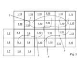
Wenn ein Routennavigationssystem im Navigationssystem 2 nicht aktiviert ist, werden, wie in der
Wenn sich hingegen das Fahrzeug innerhalb einer geschlossenen Ortschaft befindet, so werden bei nicht aktivierter Routennavigation zusätzlich zu der Positionssatellitenbildkachel 1.1 und den Grenzsatellitenbildkacheln 1.2-1.9 die Zusatzsatellitenbildkacheln 1.10 heruntergeladen, wie in der
In der
Anschließend wird auf der vom Navigationssystem berechneten Route die der Positionssatellitenbildkachel 1.1 folgende Grenzsatellitenbildkachel 1.3 in einer Anfrage als neue Ausgangsposition an das Backend-System 3 gesendet, sodass die hieran angrenzenden Satellitenbildkacheln in den Speicher des Navigationssystems 2 geladen werden, wenn sie noch nicht im Speicher gespeichert sind, nämlich die Zusatzsatellitenbildkacheln 1.10, die innerhalb des mit B markierten zweiten Iterationsschritts gezeigt sind. Entsprechend werden in einem mit C bezeichneten Iterationsschritt im Anschluss weitere Zusatzsatellitenbildkacheln 1.10 geladen, gefolgt von den Zusatzsatellitenbildkacheln 1.10 des Iterationsschritts D, E und weiteren nicht im Einzelnen gezeigten Iterationsschritten entlang der Route 6.Then, on the route calculated by the navigation system, the border satellite image tile 1.3 following the position satellite image tile 1.1 is sent in a request to the
Bezugszeichenlistelist of reference symbols
- 11
- Satellitenbildkachelsatellite image tile
- 1.11.1
- Positionssatellitenbildkachelposition satellite image tile
- 1.2-1.91.2-1.9
- Grenzsatellitenbildkachelborder satellite image tile
- 1.101.10
- Zusatzsatellitenbildkacheladditional satellite image tile
- 22
- Navigationssystemnavigation system
- 33
- Backend-Systembackend system
- 44
- Speichermemory
- 55
- AnzeigeAdvertisement
- 66
- Routeroute
- 77
- StraßeStreet
- 88
- Recheneinheitarithmetic unit
- 99
- Datenschnittstelledata interface
ZITATE ENTHALTEN IN DER BESCHREIBUNGQUOTES INCLUDED IN THE DESCRIPTION
Diese Liste der vom Anmelder aufgeführten Dokumente wurde automatisiert erzeugt und ist ausschließlich zur besseren Information des Lesers aufgenommen. Die Liste ist nicht Bestandteil der deutschen Patent- bzw. Gebrauchsmusteranmeldung. Das DPMA übernimmt keinerlei Haftung für etwaige Fehler oder Auslassungen.This list of documents listed by the applicant was generated automatically and is included solely for the better information of the reader. The list is not part of the German patent or utility model application. The DPMA accepts no liability for any errors or omissions.
Zitierte PatentliteraturCited patent literature
- DE 10 2020 113 975 A1 [0002]DE 10 2020 113 975 A1 [0002]
- DE 10 2022 001 838 A1 [0003]DE 10 2022 001 838 A1 [0003]
- EP 1 435 507 A2 [0004]EP 1 435 507 A2 [0004]
Claims (10)
Translated fromGermanPriority Applications (1)
| Application Number | Priority Date | Filing Date | Title |
|---|---|---|---|
| DE102023003229.8ADE102023003229A1 (en) | 2023-08-05 | 2023-08-05 | Method for providing satellite images divided into individual satellite image tiles for a navigation system of a moving vehicle and navigation system of a vehicle |
Applications Claiming Priority (1)
| Application Number | Priority Date | Filing Date | Title |
|---|---|---|---|
| DE102023003229.8ADE102023003229A1 (en) | 2023-08-05 | 2023-08-05 | Method for providing satellite images divided into individual satellite image tiles for a navigation system of a moving vehicle and navigation system of a vehicle |
Publications (1)
| Publication Number | Publication Date |
|---|---|
| DE102023003229A1true DE102023003229A1 (en) | 2025-02-06 |
Family
ID=94277272
Family Applications (1)
| Application Number | Title | Priority Date | Filing Date |
|---|---|---|---|
| DE102023003229.8APendingDE102023003229A1 (en) | 2023-08-05 | 2023-08-05 | Method for providing satellite images divided into individual satellite image tiles for a navigation system of a moving vehicle and navigation system of a vehicle |
Country Status (1)
| Country | Link |
|---|---|
| DE (1) | DE102023003229A1 (en) |
Citations (10)
| Publication number | Priority date | Publication date | Assignee | Title |
|---|---|---|---|---|
| EP1435507A2 (en) | 2002-12-31 | 2004-07-07 | Robert Bosch Gmbh | Hierarchical system and method for on-demand loading of data in a navigation system |
| DE60027499T2 (en)* | 1999-03-05 | 2006-11-16 | Hitachi, Ltd. | Information presentation system for mobile units |
| US20070080830A1 (en)* | 2005-08-11 | 2007-04-12 | Josh Sacks | Techniques for displaying and caching tiled map data on constrained-resource services |
| US20130325317A1 (en)* | 2012-06-05 | 2013-12-05 | Apple Inc. | Smart loading of map tiles |
| US8803920B2 (en)* | 2011-12-12 | 2014-08-12 | Google Inc. | Pre-fetching map tile data along a route |
| DE102015203929A1 (en)* | 2015-03-05 | 2016-09-08 | Bayerische Motoren Werke Aktiengesellschaft | Updating of map data of a navigation device for vehicles |
| DE102017218394A1 (en)* | 2017-10-13 | 2019-04-18 | Robert Bosch Gmbh | Method and system for loading digital geographic map tiles |
| US20200012416A1 (en)* | 2016-08-18 | 2020-01-09 | Mapbox, Inc. | Providing graphical indication of label boundaries in digital maps |
| DE102020113975A1 (en) | 2020-05-25 | 2021-11-25 | Bayerische Motoren Werke Aktiengesellschaft | Update of map data |
| DE102022001838A1 (en) | 2022-05-24 | 2022-07-14 | Mercedes-Benz Group AG | Method for providing traffic information along a route of a vehicle |
- 2023
- 2023-08-05DEDE102023003229.8Apatent/DE102023003229A1/enactivePending
Patent Citations (10)
| Publication number | Priority date | Publication date | Assignee | Title |
|---|---|---|---|---|
| DE60027499T2 (en)* | 1999-03-05 | 2006-11-16 | Hitachi, Ltd. | Information presentation system for mobile units |
| EP1435507A2 (en) | 2002-12-31 | 2004-07-07 | Robert Bosch Gmbh | Hierarchical system and method for on-demand loading of data in a navigation system |
| US20070080830A1 (en)* | 2005-08-11 | 2007-04-12 | Josh Sacks | Techniques for displaying and caching tiled map data on constrained-resource services |
| US8803920B2 (en)* | 2011-12-12 | 2014-08-12 | Google Inc. | Pre-fetching map tile data along a route |
| US20130325317A1 (en)* | 2012-06-05 | 2013-12-05 | Apple Inc. | Smart loading of map tiles |
| DE102015203929A1 (en)* | 2015-03-05 | 2016-09-08 | Bayerische Motoren Werke Aktiengesellschaft | Updating of map data of a navigation device for vehicles |
| US20200012416A1 (en)* | 2016-08-18 | 2020-01-09 | Mapbox, Inc. | Providing graphical indication of label boundaries in digital maps |
| DE102017218394A1 (en)* | 2017-10-13 | 2019-04-18 | Robert Bosch Gmbh | Method and system for loading digital geographic map tiles |
| DE102020113975A1 (en) | 2020-05-25 | 2021-11-25 | Bayerische Motoren Werke Aktiengesellschaft | Update of map data |
| DE102022001838A1 (en) | 2022-05-24 | 2022-07-14 | Mercedes-Benz Group AG | Method for providing traffic information along a route of a vehicle |
Similar Documents
| Publication | Publication Date | Title |
|---|---|---|
| DE19842430B4 (en) | Map data processing device and method, and map data processing system | |
| DE102015216266A1 (en) | Technique for navigating a vehicle to a parking lot | |
| DE102017209667A1 (en) | Storage of velocity information for the prediction of the future velocity trajectory | |
| DE102009031275A1 (en) | Navigation arrangement for a motor vehicle | |
| DE102009060358A1 (en) | Communication system for motor vehicles | |
| DE102006004130B4 (en) | Method for determining a future course of the road by communicating between motor vehicles | |
| EP2507588A1 (en) | Method and control device for controlling a hybrid drive of a vehicle | |
| DE102015007020A1 (en) | Method for operating a vehicle and vehicle | |
| DE10137632A1 (en) | Method and system for locating a location in a digital map | |
| EP3472820B1 (en) | Updating a digital map | |
| DE102018009903A1 (en) | Device for a vehicle for outsourcing computing power | |
| DE102022001838A1 (en) | Method for providing traffic information along a route of a vehicle | |
| DE102019212312A1 (en) | Control device and method for the transmission of data to the vehicle environment | |
| DE102018009716A1 (en) | Method for providing map data of a digital map and a route | |
| DE102018000596A1 (en) | Method for determining a forecast horizon of a vehicle without an active route | |
| DE102023003229A1 (en) | Method for providing satellite images divided into individual satellite image tiles for a navigation system of a moving vehicle and navigation system of a vehicle | |
| EP2416122A2 (en) | Method for operating a navigation system | |
| DE102006013297B4 (en) | Method for operating a navigation system | |
| DE102017010482A1 (en) | Method for updating map data | |
| DE102019103671A1 (en) | Control of a motor vehicle | |
| DE102018008323A1 (en) | Method for determining a route for a motor vehicle | |
| WO2009047077A1 (en) | Method for operating a navigation system | |
| DE60005489T2 (en) | METHOD FOR AVAILABLE NAVIGATION DATA IN A VEHICLE AND NAVIGATION SYSTEM | |
| DE102017010484A1 (en) | Method for consistent updating of parts of a road map | |
| DE102012220357A1 (en) | Method for outputting vehicle velocity information to central unit of information system for motor vehicle, involves determining current velocity data of vehicle based on received speed data, and transmitting speed data to onboard unit |
Legal Events
| Date | Code | Title | Description |
|---|---|---|---|
| R012 | Request for examination validly filed | ||
| R016 | Response to examination communication |