DE102020211649A1 - Method and system for creating a road model - Google Patents
Method and system for creating a road modelDownload PDFInfo
- Publication number
- DE102020211649A1 DE102020211649A1DE102020211649.0ADE102020211649ADE102020211649A1DE 102020211649 A1DE102020211649 A1DE 102020211649A1DE 102020211649 ADE102020211649 ADE 102020211649ADE 102020211649 A1DE102020211649 A1DE 102020211649A1
- Authority
- DE
- Germany
- Prior art keywords
- static
- objects
- dynamic objects
- road model
- creating
- Prior art date
- Legal status (The legal status is an assumption and is not a legal conclusion. Google has not performed a legal analysis and makes no representation as to the accuracy of the status listed.)
- Pending
Links
Images
Classifications
- B—PERFORMING OPERATIONS; TRANSPORTING
- B60—VEHICLES IN GENERAL
- B60W—CONJOINT CONTROL OF VEHICLE SUB-UNITS OF DIFFERENT TYPE OR DIFFERENT FUNCTION; CONTROL SYSTEMS SPECIALLY ADAPTED FOR HYBRID VEHICLES; ROAD VEHICLE DRIVE CONTROL SYSTEMS FOR PURPOSES NOT RELATED TO THE CONTROL OF A PARTICULAR SUB-UNIT
- B60W50/00—Details of control systems for road vehicle drive control not related to the control of a particular sub-unit, e.g. process diagnostic or vehicle driver interfaces
- G—PHYSICS
- G01—MEASURING; TESTING
- G01C—MEASURING DISTANCES, LEVELS OR BEARINGS; SURVEYING; NAVIGATION; GYROSCOPIC INSTRUMENTS; PHOTOGRAMMETRY OR VIDEOGRAMMETRY
- G01C21/00—Navigation; Navigational instruments not provided for in groups G01C1/00 - G01C19/00
- G01C21/38—Electronic maps specially adapted for navigation; Updating thereof
- G01C21/3804—Creation or updating of map data
- G01C21/3807—Creation or updating of map data characterised by the type of data
- G01C21/3815—Road data
- G01C21/3822—Road feature data, e.g. slope data
- G—PHYSICS
- G01—MEASURING; TESTING
- G01S—RADIO DIRECTION-FINDING; RADIO NAVIGATION; DETERMINING DISTANCE OR VELOCITY BY USE OF RADIO WAVES; LOCATING OR PRESENCE-DETECTING BY USE OF THE REFLECTION OR RERADIATION OF RADIO WAVES; ANALOGOUS ARRANGEMENTS USING OTHER WAVES
- G01S13/00—Systems using the reflection or reradiation of radio waves, e.g. radar systems; Analogous systems using reflection or reradiation of waves whose nature or wavelength is irrelevant or unspecified
- G01S13/88—Radar or analogous systems specially adapted for specific applications
- G01S13/89—Radar or analogous systems specially adapted for specific applications for mapping or imaging
- G—PHYSICS
- G01—MEASURING; TESTING
- G01S—RADIO DIRECTION-FINDING; RADIO NAVIGATION; DETERMINING DISTANCE OR VELOCITY BY USE OF RADIO WAVES; LOCATING OR PRESENCE-DETECTING BY USE OF THE REFLECTION OR RERADIATION OF RADIO WAVES; ANALOGOUS ARRANGEMENTS USING OTHER WAVES
- G01S13/00—Systems using the reflection or reradiation of radio waves, e.g. radar systems; Analogous systems using reflection or reradiation of waves whose nature or wavelength is irrelevant or unspecified
- G01S13/88—Radar or analogous systems specially adapted for specific applications
- G01S13/93—Radar or analogous systems specially adapted for specific applications for anti-collision purposes
- G01S13/931—Radar or analogous systems specially adapted for specific applications for anti-collision purposes of land vehicles
- B—PERFORMING OPERATIONS; TRANSPORTING
- B60—VEHICLES IN GENERAL
- B60W—CONJOINT CONTROL OF VEHICLE SUB-UNITS OF DIFFERENT TYPE OR DIFFERENT FUNCTION; CONTROL SYSTEMS SPECIALLY ADAPTED FOR HYBRID VEHICLES; ROAD VEHICLE DRIVE CONTROL SYSTEMS FOR PURPOSES NOT RELATED TO THE CONTROL OF A PARTICULAR SUB-UNIT
- B60W50/00—Details of control systems for road vehicle drive control not related to the control of a particular sub-unit, e.g. process diagnostic or vehicle driver interfaces
- B60W2050/0001—Details of the control system
- B60W2050/0019—Control system elements or transfer functions
- B60W2050/0028—Mathematical models, e.g. for simulation
- B—PERFORMING OPERATIONS; TRANSPORTING
- B60—VEHICLES IN GENERAL
- B60W—CONJOINT CONTROL OF VEHICLE SUB-UNITS OF DIFFERENT TYPE OR DIFFERENT FUNCTION; CONTROL SYSTEMS SPECIALLY ADAPTED FOR HYBRID VEHICLES; ROAD VEHICLE DRIVE CONTROL SYSTEMS FOR PURPOSES NOT RELATED TO THE CONTROL OF A PARTICULAR SUB-UNIT
- B60W2552/00—Input parameters relating to infrastructure
- B60W2552/05—Type of road, e.g. motorways, local streets, paved or unpaved roads
- B—PERFORMING OPERATIONS; TRANSPORTING
- B60—VEHICLES IN GENERAL
- B60W—CONJOINT CONTROL OF VEHICLE SUB-UNITS OF DIFFERENT TYPE OR DIFFERENT FUNCTION; CONTROL SYSTEMS SPECIALLY ADAPTED FOR HYBRID VEHICLES; ROAD VEHICLE DRIVE CONTROL SYSTEMS FOR PURPOSES NOT RELATED TO THE CONTROL OF A PARTICULAR SUB-UNIT
- B60W2554/00—Input parameters relating to objects
- B60W2554/20—Static objects
- B—PERFORMING OPERATIONS; TRANSPORTING
- B60—VEHICLES IN GENERAL
- B60W—CONJOINT CONTROL OF VEHICLE SUB-UNITS OF DIFFERENT TYPE OR DIFFERENT FUNCTION; CONTROL SYSTEMS SPECIALLY ADAPTED FOR HYBRID VEHICLES; ROAD VEHICLE DRIVE CONTROL SYSTEMS FOR PURPOSES NOT RELATED TO THE CONTROL OF A PARTICULAR SUB-UNIT
- B60W2554/00—Input parameters relating to objects
- B60W2554/40—Dynamic objects, e.g. animals, windblown objects
- B60W2554/404—Characteristics
- B60W2554/4042—Longitudinal speed
- B—PERFORMING OPERATIONS; TRANSPORTING
- B60—VEHICLES IN GENERAL
- B60W—CONJOINT CONTROL OF VEHICLE SUB-UNITS OF DIFFERENT TYPE OR DIFFERENT FUNCTION; CONTROL SYSTEMS SPECIALLY ADAPTED FOR HYBRID VEHICLES; ROAD VEHICLE DRIVE CONTROL SYSTEMS FOR PURPOSES NOT RELATED TO THE CONTROL OF A PARTICULAR SUB-UNIT
- B60W2554/00—Input parameters relating to objects
- B60W2554/40—Dynamic objects, e.g. animals, windblown objects
- B60W2554/404—Characteristics
- B60W2554/4043—Lateral speed
- B—PERFORMING OPERATIONS; TRANSPORTING
- B60—VEHICLES IN GENERAL
- B60W—CONJOINT CONTROL OF VEHICLE SUB-UNITS OF DIFFERENT TYPE OR DIFFERENT FUNCTION; CONTROL SYSTEMS SPECIALLY ADAPTED FOR HYBRID VEHICLES; ROAD VEHICLE DRIVE CONTROL SYSTEMS FOR PURPOSES NOT RELATED TO THE CONTROL OF A PARTICULAR SUB-UNIT
- B60W2555/00—Input parameters relating to exterior conditions, not covered by groups B60W2552/00, B60W2554/00
- B60W2555/60—Traffic rules, e.g. speed limits or right of way
Landscapes
- Engineering & Computer Science (AREA)
- Remote Sensing (AREA)
- Radar, Positioning & Navigation (AREA)
- Physics & Mathematics (AREA)
- General Physics & Mathematics (AREA)
- Automation & Control Theory (AREA)
- Electromagnetism (AREA)
- Computer Networks & Wireless Communication (AREA)
- Human Computer Interaction (AREA)
- Transportation (AREA)
- Mechanical Engineering (AREA)
- Traffic Control Systems (AREA)
Abstract
Translated fromGermanDescription
Translated fromGermanDie Erfindung betrifft ein Verfahren und ein System zum Erstellen eines Straßenmodells für ein Fahrerassistenzsystem eine Ego-Fahrzeugs.The invention relates to a method and a system for creating a road model for a driver assistance system of an ego vehicle.
Aktuelle Sensoren wie Radar oder Kamera erkennen bewegliche sowie statische Objekte und Strukturen, die für die Erstellung eines Umfeldmodells verwendet werden. Je nach Objekttyp, können die Objekte mit unterschiedlicher Güte und Genauigkeit erkannt und klassifiziert werden. Eine große Herausforderung ist z.B. die genaue Erkennung von Kreuzungen, Einmündungen und anderen Abzweigungen des aktuellen Straßenverlaufs.Current sensors such as radar or cameras detect moving and static objects and structures that are used to create an environment model. Depending on the object type, the objects can be recognized and classified with different quality and accuracy. A major challenge is, for example, the precise detection of intersections, junctions and other junctions in the current course of the road.
Kartenmaterial kann hier helfen, allerdings kann die Aktualität der Daten nicht beurteilt werden. Zudem müssen Kreuzungen, Einmündungen, etc. nicht unbedingt in der Karte vorhanden sein. Dies kann zum einen durch veraltete Daten passieren aber auch durch unvollständiges Kartenmaterial sowie unrelevante Nebenstraßen wie z.B. Hofeinfahrten, kleine Stichstraßen, Feldwege, etc. Für die Erkennung von Kreuzungen, Abbiegemöglichkeiten, Auf- und Abfahrten gibt es aktuell keine Technik oder Sensor, diese zuverlässig zu erkennen. Durch verschiedene Ansätze können diese teilweise erkannt werden. Bei den aktuellen sensorbasierten Techniken gibt es aber eine große Anzahl von falsch negativen Ergebnissen (also nicht erkannten aber vorhandenen Kreuzungen) sowie falsch positiven (also fälschlich erkannten Kreuzungen). Zudem können die aktuellen Techniken (Bis auf Kartendaten) keine Attribute wie Abbiegerichtung, Anzahl an Spuren etc. erkennen.Maps can help here, but the up-to-dateness of the data cannot be assessed. In addition, crossings, junctions, etc. do not necessarily have to be on the map. On the one hand, this can happen due to outdated data, but also due to incomplete map material and irrelevant side roads such as courtyard entrances, small cul-de-sacs, country lanes, etc. There is currently no technology or sensor for the detection of intersections, turning opportunities, uphill and downhill ramps that can be used reliably detect. These can be partially recognized by different approaches. With the current sensor-based techniques, however, there are a large number of false negative results (i.e. intersections that are not detected but are present) and false positives (i.e. intersections that are incorrectly detected). In addition, the current technologies (apart from map data) cannot recognize any attributes such as turning direction, number of lanes, etc.
Es ist eine Aufgabe der Erfindung ein Verfahren und ein System bereitzustellen, mittels welchen ein zuverlässiges und genaues Straßenmodell erstellt und einem Fahrerassistenzsystem bereitgestellt werden kann.It is an object of the invention to provide a method and a system by means of which a reliable and precise road model can be created and made available to a driver assistance system.
Diese Aufgabe wird durch den Gegenstand der unabhängigen Ansprüche 1 und 8 in vorteilhafter Weise gelöst.This object is solved by the subject matter of
Erste Überlegungen waren dahingehend, dass Fahrfunktionen wie z.B. EBA oder ACC für die typischen Anwendungsfälle (z.B. die NCAP-Szenarien) teilweise eine sehr zuverlässige und funktional sichere Erkennung von Kreuzungen benötigen. Beispielsweise muss der Notbremsassistent (EBA) potenzielle Zusammenstöße mit Fußgängern oder Fahrradfahrern durch rechtzeitiges Bremsen verhindern. Wird in einem Kreuzungsbereich ein Fußgänger erkannt und die Fahrfunktion prädiziert bzw. schätzt, dass das Ego-Fahrzeug abbiegen möchte, muss im Zweifel der Zusammenstoß verhindert werden.Initial considerations were that driving functions such as EBA or ACC for typical applications (e.g. NCAP scenarios) sometimes require a very reliable and functionally safe detection of intersections. For example, the emergency brake assistant (EBA) must prevent potential collisions with pedestrians or cyclists by braking in good time. If a pedestrian is detected in an intersection area and the driving function predicts or estimates that the ego vehicle wants to turn, the collision must be avoided in case of doubt.
Da diese Erkennung von Kreuzungen, Einmündungen und Abzweigungen oftmals ungenau ist oder die verwendeten Eingangsdaten funktional unsicher sind (z.B. Kartendaten), werden die Fahrfunktionen (insbesondere EBA, ACC) ihre Funktion nur dann auslösen, wenn sie sich bezüglich der Eingabedaten sicher sind, da es unbedingt gilt, falsch positive Auslösungen zu vermeiden.Since this detection of intersections, junctions and junctions is often imprecise or the input data used are functionally uncertain (e.g. map data), the driving functions (especially EBA, ACC) will only trigger their function if they are sure about the input data, since it it is imperative to avoid false positive trips.
Da die Fahrfunktion die Zukunft nicht kennt, muss sowohl für das Ego-Fahrzeug als auch für andere Verkehrsteilnehmer eine Prädiktion stattfinden, was vermutlich passieren wird (Intentionserkennung) .Since the driving function does not know the future, a prediction must take place both for the ego vehicle and for other road users, which will probably happen (intention recognition).
Es wird daher erfindungsgemäß ein Verfahren zum Erstellen eines Straßenmodells für ein Fahrerassistenzsystem eines Ego-Fahrzeugs mit den folgenden Schritten vorgeschlagen:
- - Aufzeichnen einer Umgebung des Ego-Fahrzeugs mittels zumindest eines Umfelderfassungssensors;
- - Detektieren von statischen und/oder dynamischen Objekten;
- - Erstellen einer Grid-Karte mit einer Vielzahl von Grid-Zellen;
- - Eintragen der statischen Objekte in die Grid-Karte als belegte Grid-Zellen und Tracken der statischen Objekte und/oder Tracken der dynamischen Objekte ;
- - Ableiten von Informationen über eine Straßenverlauf basierend auf den in der Grid-Karte eingetragenen Detektionen sowie den getrackten statischen und/oder dynamischen Objekten;
- - Erstellen eines Straßenmodells mit den abgeleiteten Informationen;
- - Bereitstellen des Straßenmodells für zumindest ein Fahrerassistenzsystem.
- - Recording an environment of the ego vehicle by means of at least one environment detection sensor;
- - Detection of static and/or dynamic objects;
- - Create a grid map with a variety of grid cells;
- - Entering the static objects in the grid map as occupied grid cells and tracking the static objects and/or tracking the dynamic objects;
- - Deriving information about the course of a road based on the detections entered in the grid map and the tracked static and/or dynamic objects;
- - creating a road model with the derived information;
- - Providing the road model for at least one driver assistance system.
Besonders bevorzugt handelt es sich bei dem Umfelderfassungssensor um einen Radar-Sensor. Denkbar wäre auch die Verwendung mehrerer Radar-Sensoren. Die Verwendung zumindest eines Radar-Sensors ist dahingehend vorteilhaft, da dieser eine Vielzahl von statischen und dynamischen Detektionen liefert, wobei die statischen Objekte in einer Grid-Karte akkumuliert werden können. Weiterhin können die statischen und die dynamischen Objekte zeitlich getrackt werden. Beim Tracken der dynamischen Objekte können alle im Zeitraum des Trackings detektierten Positionen gespeichert werden, um einen Bewegungsverlauf bzw. eine zurückgelegte Trajektorie des dynamischen Objekts zu erhalten. Unter statischen Objekten werden im Lichte der Erfindung z.B. Leitplanken, Bordsteinkanten, Wände, Zäune, usw. verstanden, die klare Fahrbarkeitsbegrenzungen angeben. Unter dynamischen Objekten werden insbesondere erkannte Verkehrsteilnehmer, vorzugsweise andere Fahrzeuge, verstanden, welche über eine längere Zeit beobachtet werden. Die Berechnung der Grid-Karte kann beispielsweise direkt auf der ECU des Radar-Sensors durchgeführt werden.The environment detection sensor is particularly preferably a radar sensor. The use of several radar sensors would also be conceivable. The use of at least one radar sensor is advantageous in that it supplies a large number of static and dynamic detections, with the static objects being able to be accumulated in a grid map. Furthermore, the static and dynamic objects can be tracked over time. When tracking the dynamic objects, all positions detected during the tracking period can be stored in order to obtain a course of movement or a trajectory covered by the dynamic object. In the light of the invention, static objects are understood to mean, for example, crash barriers, curbs, walls, fences, etc., which indicate clear drivability limitations. under dynamic Objects are understood to mean, in particular, recognized road users, preferably other vehicles, which are observed over a longer period of time. The grid map can be calculated directly on the ECU of the radar sensor, for example.
Alle detektierten statischen Objekte können als belegte Grid-Zellen in die Grid-Karte eingetragen werden. Die dynamischen Objekte werden lediglich zeitlich getrackt.All detected static objects can be entered into the grid map as occupied grid cells. The dynamic objects are only tracked in time.
Denkbar wäre auch, dass vor dem Bereitstellen des Straßenmodells an das Fahrerassistenzsystem, das Straßenmodell in einer Speichereinrichtung abgespeichert wird, damit es bei einem erneuten Befahren der Strecke bereits dem Assistenzsystem zur Verfügung steht. Es kann dann anhand der aktuellen Daten ein Abgleich vorgenommen werden, um ggf. Veränderungen in dem Straßenmodell zu erkennen und das gespeicherte Modell zu aktualisieren. Denkbar wäre auch Daten von anderen Sensoren, wie Kamera, Lidar und/oder Ultraschall, und/oder Kartendaten zu verwenden, um beispielsweise die von dem Radar-Sensor erkannten Detektionen und das daraus abgeleitete Straßenmodell zu verifizieren und das Straßenmodell noch sicherer zu gestalten.It would also be conceivable for the road model to be stored in a storage device before the road model is made available to the driver assistance system, so that it is already available to the assistance system when the route is driven on again. A comparison can then be made on the basis of the current data in order to detect any changes in the road model and to update the stored model. It would also be conceivable to use data from other sensors, such as cameras, lidar and/or ultrasound, and/or map data, for example to verify the detections recognized by the radar sensor and the road model derived from them and to make the road model even safer.
In einer bevorzugten Ausführungsform werden durch das Tracking der dynamischen Objekte semantische Eigenschaften der dynamischen Objekte ermittelt. Mittels der semantischen Eigenschaften lassen sich die dynamischen Objekte weiter bestimmen.In a preferred embodiment, semantic properties of the dynamic objects are determined by tracking the dynamic objects. The dynamic objects can be further defined by means of the semantic properties.
Besonders bevorzugt umfassen die semantischen Eigenschaften Art des Objekts, Ausrichtung des Objekts, Bewegungsrichtung und/oder Bewegungsgeschwindigkeit. Das Ermitteln dieser Eigenschaften ist vorteilhaft, da mit diesen Eigenschaften eine verbesserte Prädiktion der Trajektorie der dynamischen Objekte ermöglicht wird und somit ein genaueres Straßenmodell werden kann. So kann beispielweise die Art des Objekts aus den Radardetektionen ermittelt werden, da ein Auto beispielsweise andere Reflexionen erzeugt als ein Motorrad oder ein Fahrrad. Mit der Art des Objekts lässt sich beispielsweise ein Beschleunigungspotential bestimmen, da ein Motorrad in der Regel schneller beschleunigen kann als ein Auto. Weiterhin lässt sich so feststellen, ob z.B. ein Fahrrad auf einem Fahrradweg neben der Ego-Fahrspur fährt. Auch diese Information über das Vorhandensein eines Fahrradwegs kann in das Straßenmodell mit einfließen und dem Fahrerassistenzsystem bereitgestellt werden. Ein solcher Fahrradweg kann auch in der Grid-Karte mit Grid-Zellen beschrieben werden, die beispielsweise als „nicht zu befahren“ gekennzeichnet werden, welche dem Fahrerassistenzsystem mitteilen, dass dieser Fahrbahnabschnitt zwar befahren werden könnte, allerdings unter normalen Bedingungen nicht befahren werden soll.The semantic properties particularly preferably include the type of object, the orientation of the object, the direction of movement and/or the speed of movement. Determining these properties is advantageous because these properties enable an improved prediction of the trajectory of the dynamic objects, and a more precise road model can therefore be obtained. For example, the type of object can be determined from the radar detections, since a car, for example, generates different reflections than a motorcycle or a bicycle. The type of object can be used, for example, to determine an acceleration potential, since a motorcycle can usually accelerate faster than a car. Furthermore, it can be determined in this way whether, for example, a bicycle is riding on a bicycle path next to the ego lane. This information about the presence of a cycle path can also be included in the road model and made available to the driver assistance system. Such a cycle path can also be described in the grid map with grid cells, which are marked as “not to be used”, for example, which tell the driver assistance system that this section of the road could be used, but should not be used under normal conditions.
Aus der Bewegungsrichtung der anderen Verkehrsteilnehmer lässt sich vorteilhaft der weitere Straßenverlauf sowie die Richtung der Fahrspuren bestimmen.The further course of the road and the direction of the lanes can advantageously be determined from the direction of movement of the other road users.
In einer weiteren bevorzugten Ausführungsform umfassen die Informationen über den Straßenverlauf Abbiegemöglichkeiten, Kreuzungen und/oder Abbiegebeschränkungen. Abbiegemöglichkeiten können im Lichte der Erfindung nicht nur abzweigende Straßen sein, sondern auch Einfahrten zu Häusern oder Parkplätzen oder Feldwege sein. Unter eine Abbiegebeschränkung wird verstanden, dass aufgrund der detektierten statischen Objekte entlang der Trajektorie des Fahrzeugs keine Möglichkeit für das Fahrzeug besteht abzubiegen. Falls keine Objekte entlang der Trajektorie detektiert werden kann daraus allerdings nicht gefolgert werden, dass eine Abbiegemöglichkeit vorliegt, weswegen für die Erkennung einer Abbiegemöglichkeit weitere Daten ermittelt werden müssen. Bei einer erkannten Abbiegebeschränkung kann allerdings geschlussfolgert werden, dass beispielsweise bei einem erkannten Fußgänger hinter der Beschränkung nicht mit einer Kreuzung der Trajektorie des Ego-Fahrzeugs mit dem Fußgänger zu erwarten ist. Entsprechend können nachgeschaltete Fahrerassistenzsysteme beispielsweise Eingriffsschwellen anpassen.In a further preferred embodiment, the information about the course of the road includes turning options, intersections and/or turning restrictions. In the light of the invention, turning possibilities can not only be streets that branch off, but also driveways to houses or parking lots or country lanes. A turning restriction is understood to mean that there is no possibility for the vehicle to turn due to the detected static objects along the trajectory of the vehicle. If no objects are detected along the trajectory, however, it cannot be concluded from this that there is an opportunity to turn, which is why further data must be determined to identify an opportunity to turn. However, if a turning restriction is detected, it can be concluded that, for example, if a pedestrian is detected behind the restriction, an intersection of the trajectory of the ego vehicle with the pedestrian is not to be expected. Accordingly, downstream driver assistance systems can adjust intervention thresholds, for example.
Weiter werden besonders bevorzugt Abbiegemöglichkeiten und Kreuzungen mittels einer Verkehrsflussanalyse basierend auf den getrackten dynamischen Objekten ermittelt. Dieses Vorgehen ist vorteilhaft, da bei dem Tracking von dynamischen Objekten bzw. anderen Fahrzeugen mit einer sehr hohen Sicherheit ermittelt werden kann, ob ein Fahrzeug abbiegen kann, oder ob eine Kreuzung vorliegt, da sich ansonsten keine anderen Fahrzeuge in die entsprechende Richtung bewegen würden. Weiterhin kann mittels einer solchen Verkehrsflussanalyse besonders vorteilhaft auch eine Aussage über die Anzahl an Fahrspuren oder die Fahrtrichtung der Spuren getroffen werden.Furthermore, it is particularly preferred to determine turning possibilities and intersections by means of a traffic flow analysis based on the tracked dynamic objects. This procedure is advantageous because when tracking dynamic objects or other vehicles, it can be determined with a very high level of certainty whether a vehicle can turn off or whether there is an intersection, since otherwise no other vehicles would be moving in the corresponding direction. Furthermore, a statement about the number of lanes or the direction of travel of the lanes can also be made particularly advantageously by means of such a traffic flow analysis.
In einer weiteren besonders bevorzugten Ausgestaltung wird basierend auf der Verkehrsflussanalyse ein Konfidenzwert für die Abbiegemöglichkeiten und/oder Kreuzungen ermittelt. Je mehr Detektionen und Tracking-Informationen von Verkehrsteilnehmern vorliegen, welche sich in eine bestimmte Richtung bewegen, desto sicherer kann eine Aussage über eine Abbiegemöglichkeit oder eine Kreuzung getroffen werden. Entsprechend kann die erkannte Abbiegemöglichkeit oder Kreuzung mit einem Konfidenzwert versehen werden. Eine entsprechender Konfidenzwert kann ebenfalls für eine ermittelte Abbiegebeschränkung ermittelt werden, welcher dann auf den getrackten statischen Objekten beruht. Auch die Berechnung der jeweiligen Konfidenzwerte kann in der ECU des Radar-Sensors durchgeführt werden. Weiterhin eignet sich die Verkehrsflussanalyse dazu, die Richtung der Fahrspur sicher zu erkennen.In a further particularly preferred embodiment, a confidence value for the turning options and/or intersections is determined based on the traffic flow analysis. The more detections and tracking information there is from road users who are moving in a certain direction, the more reliable a statement can be made about a turning opportunity or an intersection. Accordingly, the recognized turning opportunity or intersection can be provided with a confidence value. A corresponding confidence value can also be used for a determined turning restriction, which is then based on the tracked static objects. The calculation of the respective confidence values can also be carried out in the ECU of the radar sensor. Furthermore, the traffic flow analysis is suitable for reliably recognizing the direction of the lane.
In einer bevorzugten Ausgestaltung werden Abbiegebeschränkungen basierend auf den getrackten statischen Objekten ermittelt. Mit dieser Methode lassen sich besonders vorteilhaft durchgehende Fahrbahnbegrenzungen erkennen, wie beispielsweise Leitplanken. Durch das Tracking können auch einzelne fehlende oder fehlerhafte Detektionen ausgeglichen werden.In a preferred embodiment, turning restrictions are determined based on the tracked static objects. With this method, continuous roadway boundaries, such as crash barriers, can be recognized particularly advantageously. Tracking can also be used to compensate for individual missing or faulty detections.
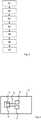
Weiter wird erfindungsgemäß ein System zum Erstellen eines Straßenmodells für ein Fahrerasssistenzsystem eines Ego-Fahrzeugs vorgeschlagen, wobei das System zumindest einen Umfelderfassungssensor zum Aufzeichnen der Umgebung sowie eine Recheneinheit aufweist, mittels welcher eine Grid-Karte erstellbar ist und detektierte statische Objekte in die Grid-Karte eintragbar sind sowie statische und/oder dynamische Objekte getrackt werden können, wobei die Recheneinheit weiter dazu ausgebildet ist, ein Straßenmodell zu erstellen und einem Fahrerassistenzsystem bereitzustellen.Furthermore, according to the invention, a system for creating a road model for a driver assistance system of an ego vehicle is proposed, the system having at least one environment detection sensor for recording the environment and a computing unit, by means of which a grid map can be created and detected static objects in the grid map can be entered and static and/or dynamic objects can be tracked, the computing unit being further designed to create a road model and provide it to a driver assistance system.
Die Recheneinheit kann hierbei beispielsweise die ECU des Umfelderfassungssensors sein. Der Umfelderfasssungssensor ist bevorzugt ein Radar-Sensor. Das Fahrerassistenzsystem kann beispielsweise ein EBA-System oder ein ACC-System sein. Denkbar wäre auch ein Abbiegeassistent und/oder ein Spurhalteassistent.In this case, the computing unit can be, for example, the ECU of the environment detection sensor. The environment detection sensor is preferably a radar sensor. The driver assistance system can be an EBA system or an ACC system, for example. A turning assistant and/or a lane keeping assistant would also be conceivable.
Weitere vorteilhafte Ausgestaltungen sind Gegenstand der Zeichnungen. Darin zeigen:
1 : eine schematische Darstellung einer Grid-Karte gemäß einer Ausführungsform der Erfindung;2 : eine schematische Darstellung eines Straßenmodells gemäß einer Ausführungsform der Erfindung;3 : ein schematisches Ablaufdiagramm eines Verfahrens gemäß einer Ausführungsform der Erfindung;4 : eine schematische Darstellung eines Systems gemäß einer Ausführungsform der Erfindung.
1 1: a schematic representation of a grid map according to an embodiment of the invention;2 1: a schematic representation of a road model according to an embodiment of the invention;3 1: a schematic flow diagram of a method according to an embodiment of the invention;4 1: a schematic representation of a system according to an embodiment of the invention.
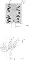
In
In Schritt S6 wird ein Straßenmodell M mit den abgeleiteten Informationen erstellt. Abschließend wird in Schritt S7 das Straßenmodell M für zumindest ein Fahrerassistenzsystem 6 bereitgestellt.
In step S6, a road model M is created with the derived information. Finally, in step S7 the road model M is made available for at least one
In
BezugszeichenlisteReference List
- 11
- Grid-Kartegrid map
- 1a1a
- Grid-Zellengrid cells
- 1b1b
- belegte Grid-Zellenoccupied grid cells
- 22
- Ego-Fahrzeugego vehicle
- 33
- Systemsystem
- 44
- UmfelderfassungssensorEnvironment detection sensor
- 55
- Recheneinheitunit of account
- 66
- Fahrerassistenzsystemdriver assistance system
- 77
- Speichereinrichtungstorage facility
- DD
- DatenverbindungData Connection
- Ff
- Fahrtrichtung Ego-Fahrzeugdirection of travel of the ego vehicle
- MM
- Straßenmodellstreet model
- PP
- Detektionspunktedetection points
- TT
- getrackte Bewegungtracked movement
- VV
- Verkehrsteilnehmerroad users
- S1-S7S1-S7
- Verfahrensschritteprocess steps
Claims (8)
Translated fromGermanPriority Applications (2)
| Application Number | Priority Date | Filing Date | Title |
|---|---|---|---|
| DE102020211649.0ADE102020211649A1 (en) | 2020-09-17 | 2020-09-17 | Method and system for creating a road model |
| US17/447,817US20220080982A1 (en) | 2020-09-17 | 2021-09-16 | Method and system for creating a road model |
Applications Claiming Priority (1)
| Application Number | Priority Date | Filing Date | Title |
|---|---|---|---|
| DE102020211649.0ADE102020211649A1 (en) | 2020-09-17 | 2020-09-17 | Method and system for creating a road model |
Publications (1)
| Publication Number | Publication Date |
|---|---|
| DE102020211649A1true DE102020211649A1 (en) | 2022-03-17 |
Family
ID=80351401
Family Applications (1)
| Application Number | Title | Priority Date | Filing Date |
|---|---|---|---|
| DE102020211649.0APendingDE102020211649A1 (en) | 2020-09-17 | 2020-09-17 | Method and system for creating a road model |
Country Status (2)
| Country | Link |
|---|---|
| US (1) | US20220080982A1 (en) |
| DE (1) | DE102020211649A1 (en) |
Cited By (1)
| Publication number | Priority date | Publication date | Assignee | Title |
|---|---|---|---|---|
| DE102022116954A1 (en) | 2022-07-07 | 2024-01-18 | Cariad Se | Method and system for creating a digital environment map, motor vehicle for such a system and method for operating a driver assistance system in a motor vehicle with the aid of a digital environment map |
Families Citing this family (1)
| Publication number | Priority date | Publication date | Assignee | Title |
|---|---|---|---|---|
| US12187315B2 (en)* | 2020-12-16 | 2025-01-07 | Mobileye Vision Technologies Ltd. | Safe and scalable model for culturally sensitive driving by automated vehicles |
Citations (7)
| Publication number | Priority date | Publication date | Assignee | Title |
|---|---|---|---|---|
| US20100034422A1 (en) | 2008-08-06 | 2010-02-11 | Toyota Motor Engineering & Manufacturing North America, Inc. | Object tracking using linear features |
| DE102010006828A1 (en) | 2010-02-03 | 2011-08-04 | Volkswagen AG, 38440 | Method for creating model of surrounding of vehicle, involves detecting surrounding of vehicle with help of sensor, where two surrounding models are produced automatically on basis of sensor data |
| DE102013223803A1 (en) | 2013-11-21 | 2015-05-21 | Robert Bosch Gmbh | Method and device for segmenting an occupancy grid for an environment model of a driver assistance system for a vehicle |
| DE102018121165A1 (en) | 2018-08-30 | 2020-03-05 | Valeo Schalter Und Sensoren Gmbh | Method for estimating the surroundings of a vehicle |
| DE102019200129A1 (en) | 2019-01-08 | 2020-07-09 | Zf Friedrichshafen Ag | Device and method for modeling an environment of a vehicle |
| DE102019201930A1 (en) | 2019-02-14 | 2020-08-20 | Continental Automotive Gmbh | Method for generating an environment model |
| DE102019214628A1 (en) | 2019-09-25 | 2021-03-25 | Zf Friedrichshafen Ag | Validation of surroundings detection using satellite images and SAR radar data |
Family Cites Families (11)
| Publication number | Priority date | Publication date | Assignee | Title |
|---|---|---|---|---|
| JP4561507B2 (en)* | 2005-07-08 | 2010-10-13 | 株式会社デンソー | Road shape recognition device |
| EP2960129A1 (en)* | 2014-06-26 | 2015-12-30 | Volvo Car Corporation | Confidence level determination for estimated road geometries |
| EP3032454B1 (en)* | 2014-12-10 | 2018-09-26 | Honda Research Institute Europe GmbH | Method and system for adaptive ray based scene analysis of semantic traffic spaces and vehicle equipped with such system |
| US11351989B2 (en)* | 2018-04-11 | 2022-06-07 | Hyundai Motor Company | Vehicle driving controller, system including the same, and method thereof |
| US11520335B2 (en)* | 2018-04-12 | 2022-12-06 | Baidu Usa Llc | Determining driving paths for autonomous driving vehicles based on map data |
| US10753750B2 (en)* | 2018-07-12 | 2020-08-25 | Toyota Research Institute, Inc. | System and method for mapping through inferences of observed objects |
| JP7136663B2 (en)* | 2018-11-07 | 2022-09-13 | 日立Astemo株式会社 | In-vehicle control device |
| US11016492B2 (en)* | 2019-02-28 | 2021-05-25 | Zoox, Inc. | Determining occupancy of occluded regions |
| US11250576B2 (en)* | 2019-08-19 | 2022-02-15 | Toyota Research Institute, Inc. | Systems and methods for estimating dynamics of objects using temporal changes encoded in a difference map |
| EP4058932A4 (en)* | 2019-11-13 | 2024-02-28 | Youval Nehmadi | Autonomous vehicle environmental perception software architecture |
| RU2744012C1 (en)* | 2019-12-24 | 2021-03-02 | Общество с ограниченной ответственностью "Яндекс Беспилотные Технологии" | Methods and systems for automated determination of objects presence |
- 2020
- 2020-09-17DEDE102020211649.0Apatent/DE102020211649A1/enactivePending
- 2021
- 2021-09-16USUS17/447,817patent/US20220080982A1/ennot_activeAbandoned
Patent Citations (7)
| Publication number | Priority date | Publication date | Assignee | Title |
|---|---|---|---|---|
| US20100034422A1 (en) | 2008-08-06 | 2010-02-11 | Toyota Motor Engineering & Manufacturing North America, Inc. | Object tracking using linear features |
| DE102010006828A1 (en) | 2010-02-03 | 2011-08-04 | Volkswagen AG, 38440 | Method for creating model of surrounding of vehicle, involves detecting surrounding of vehicle with help of sensor, where two surrounding models are produced automatically on basis of sensor data |
| DE102013223803A1 (en) | 2013-11-21 | 2015-05-21 | Robert Bosch Gmbh | Method and device for segmenting an occupancy grid for an environment model of a driver assistance system for a vehicle |
| DE102018121165A1 (en) | 2018-08-30 | 2020-03-05 | Valeo Schalter Und Sensoren Gmbh | Method for estimating the surroundings of a vehicle |
| DE102019200129A1 (en) | 2019-01-08 | 2020-07-09 | Zf Friedrichshafen Ag | Device and method for modeling an environment of a vehicle |
| DE102019201930A1 (en) | 2019-02-14 | 2020-08-20 | Continental Automotive Gmbh | Method for generating an environment model |
| DE102019214628A1 (en) | 2019-09-25 | 2021-03-25 | Zf Friedrichshafen Ag | Validation of surroundings detection using satellite images and SAR radar data |
Cited By (1)
| Publication number | Priority date | Publication date | Assignee | Title |
|---|---|---|---|---|
| DE102022116954A1 (en) | 2022-07-07 | 2024-01-18 | Cariad Se | Method and system for creating a digital environment map, motor vehicle for such a system and method for operating a driver assistance system in a motor vehicle with the aid of a digital environment map |
Also Published As
| Publication number | Publication date |
|---|---|
| US20220080982A1 (en) | 2022-03-17 |
Similar Documents
| Publication | Publication Date | Title |
|---|---|---|
| DE102011082600B4 (en) | Detection of driving on a vehicle in an impermissible direction of travel | |
| DE112012006226B4 (en) | Driver assistance device | |
| EP3490862B1 (en) | Method and device for determining a roadway model for the surroundings of a vehicle | |
| WO2015032707A1 (en) | Method, and control and detection device for plausibilizing the wrong-way driving of a motor vehicle | |
| DE102015105206A1 (en) | Method and system for detecting, tracking and estimating stationary roadside objects | |
| DE102013209502A1 (en) | Method for automatically intervening in an ego vehicle during a wrong-way drive, in particular a ghost ride | |
| DE102014208617A1 (en) | Method and control and detection device for plausibility of a wrong-way drive of a motor vehicle | |
| DE102013012324A1 (en) | Method and device for finding a route | |
| DE102008062708A1 (en) | Method for determining the road level of a parking space | |
| DE102016213782A1 (en) | A method, apparatus and computer readable storage medium having instructions for determining the lateral position of a vehicle relative to the lanes of a lane | |
| EP2116958B1 (en) | Method and device for calculating the drive path in the area in front of a vehicle | |
| WO2013174732A1 (en) | Carriageway recognition | |
| DE102012204948A1 (en) | Method for assisting driver when driving vehicle at changing lanes, involves assigning vehicle and detected objects to tracks of roadway, and generating warning signal when detected object regarding vehicle is located on relevant track | |
| DE102013215100A1 (en) | Providing an environment model in case of failure of a sensor of a vehicle | |
| WO2016066416A1 (en) | Method and apparatus for determining a current driving situation | |
| DE102014202385A1 (en) | Method for detecting a driver avoidance request in a driver assistance system for motor vehicles | |
| DE102020211649A1 (en) | Method and system for creating a road model | |
| DE102010022706A1 (en) | Method for adaptive parameterization of function driver assistance system of motor vehicle, involves providing motor vehicle with navigation system including digital map | |
| WO2023274746A1 (en) | Method and device for supporting the detection of the surroundings of a vehicle traveling in an automated manner | |
| DE102016122200A1 (en) | Forming a rescue lane considering their necessity | |
| WO2019081204A1 (en) | METHOD FOR ASSISTING A DRIVER IN A MANUAL PARKING PROCESS OF A MOTOR VEHICLE, WHICH INCLUDES A FIRST AND A SECOND INDICATOR, PARKASSISTENS SYSTEM AND MOTOR VEHICLE | |
| WO2021254906A1 (en) | Method for determining a usage type of a landmark pattern for a self-localization of a vehicle, and electronic self-localization system for a vehicle | |
| EP4238066A1 (en) | Method for analyzing the surroundings of a motor vehicle | |
| WO2021233741A1 (en) | Method and system for determining a position of a motor vehicle, and a motor vehicle equipped with such a system | |
| DE102019115788A1 (en) | Automatic identification of an ego lane and adaptation of a driving trajectory for an ego vehicle depending on the ego lane |
Legal Events
| Date | Code | Title | Description |
|---|---|---|---|
| R163 | Identified publications notified | ||
| R081 | Change of applicant/patentee | Owner name:CONTINENTAL AUTONOMOUS MOBILITY GERMANY GMBH, DE Free format text:FORMER OWNER: CONTI TEMIC MICROELECTRONIC GMBH, 90411 NUERNBERG, DE Owner name:AUMOVIO AUTONOMOUS MOBILITY GERMANY GMBH, DE Free format text:FORMER OWNER: CONTI TEMIC MICROELECTRONIC GMBH, 90411 NUERNBERG, DE | |
| R081 | Change of applicant/patentee | Owner name:AUMOVIO AUTONOMOUS MOBILITY GERMANY GMBH, DE Free format text:FORMER OWNER: CONTINENTAL AUTONOMOUS MOBILITY GERMANY GMBH, 85057 INGOLSTADT, DE |