DE102018201889A1 - Updating a geographical map - Google Patents
Updating a geographical mapDownload PDFInfo
- Publication number
- DE102018201889A1 DE102018201889A1DE102018201889.8ADE102018201889ADE102018201889A1DE 102018201889 A1DE102018201889 A1DE 102018201889A1DE 102018201889 ADE102018201889 ADE 102018201889ADE 102018201889 A1DE102018201889 A1DE 102018201889A1
- Authority
- DE
- Germany
- Prior art keywords
- tile
- information
- tiles
- map
- updating
- Prior art date
- Legal status (The legal status is an assumption and is not a legal conclusion. Google has not performed a legal analysis and makes no representation as to the accuracy of the status listed.)
- Withdrawn
Links
Images

Classifications
- G—PHYSICS
- G01—MEASURING; TESTING
- G01C—MEASURING DISTANCES, LEVELS OR BEARINGS; SURVEYING; NAVIGATION; GYROSCOPIC INSTRUMENTS; PHOTOGRAMMETRY OR VIDEOGRAMMETRY
- G01C21/00—Navigation; Navigational instruments not provided for in groups G01C1/00 - G01C19/00
- G01C21/38—Electronic maps specially adapted for navigation; Updating thereof
- G01C21/3863—Structures of map data
- G01C21/387—Organisation of map data, e.g. version management or database structures
- G01C21/3881—Tile-based structures
- G—PHYSICS
- G09—EDUCATION; CRYPTOGRAPHY; DISPLAY; ADVERTISING; SEALS
- G09B—EDUCATIONAL OR DEMONSTRATION APPLIANCES; APPLIANCES FOR TEACHING, OR COMMUNICATING WITH, THE BLIND, DEAF OR MUTE; MODELS; PLANETARIA; GLOBES; MAPS; DIAGRAMS
- G09B29/00—Maps; Plans; Charts; Diagrams, e.g. route diagram
- G09B29/10—Map spot or coordinate position indicators; Map reading aids
- G09B29/106—Map spot or coordinate position indicators; Map reading aids using electronic means
Landscapes
- Engineering & Computer Science (AREA)
- Radar, Positioning & Navigation (AREA)
- Remote Sensing (AREA)
- Databases & Information Systems (AREA)
- Automation & Control Theory (AREA)
- Physics & Mathematics (AREA)
- General Physics & Mathematics (AREA)
- Navigation (AREA)
- Traffic Control Systems (AREA)
- Instructional Devices (AREA)
Abstract
Translated fromGermanDescription
Translated fromGermanDie Erfindung betrifft die Aktualisierung einer geographischen Karte. Insbesondere betrifft die Erfindung die Aktualisierung einer geographischen Karte, die zur Steuerung eines Kraftfahrzeugs eingerichtet ist.The invention relates to the updating of a geographical map. In particular, the invention relates to the updating of a geographical map, which is set up to control a motor vehicle.
Ein Kraftfahrzeug kann auf der Basis einer geographischen Karte automatisch oder teilautomatisch gesteuert werden. Die geographische Karte soll regelmäßig aktualisiert werden, um die Steuerung auf der Basis möglichst aktueller Karteninformationen durchführen zu können. Dabei ist die Karte in Kacheln unterteilt, die jeweils ein vorbestimmtes geographisches Gebiet betreffen. Eine Aktualisierung der Karte wird üblicherweise durchgeführt, indem Informationen, die eine oder mehrere der Kacheln betreffen, aktualisiert werden. Informationen nicht betroffener Kacheln werden unverändert beibehalten.A motor vehicle can be controlled automatically or semi-automatically on the basis of a geographical map. The geographical map should be updated regularly in order to carry out the control on the basis of the most up-to-date map information. The map is divided into tiles, each of which relates to a predetermined geographic area. An update of the map is usually performed by updating information pertaining to one or more of the tiles. Information of unaffected tiles will be kept unchanged.
Zur Erhöhung der Steuersicherheit eines Kraftfahrzeugs auf der Basis der Karte werden die zu ändernden Informationen vor dem Aktualisieren der Karte überprüft, beispielsweise mittels eines Vergleichs mit Informationen aus anderen Quellen oder mittels Prüfung auf Konsistenz zwischen den Informationen. Wird dabei ein Fehler festgestellt, können nur die Informationen der primär betroffenen Kachel verworfen werden. Dabei kann sich allerdings eine Inkonsistenz zwischen einer geänderten und einer nicht geänderten Kachel ergeben. Zur Sicherung der Konsistenz der Karte können alternativ alle aktualisierten Informationen verworfen werden. Bis zur Bereitstellung einer fehlerfreien Aktualisierung kann eine längere Zeit vergehen, sodass die Karte in der Zwischenzeit stellenweise veraltet sein kann.To increase the control security of a motor vehicle based on the map, the information to be changed is checked prior to updating the map, for example by comparison with information from other sources or by checking for consistency between the information. If an error is detected, only the information of the tile primarily affected can be discarded. However, this may result in an inconsistency between a changed and an unmodified tile. Alternatively, to ensure consistency of the map, all updated information may be discarded. It may take a long time for a clean update to be available, which may mean that the card may be out of date in places.
Eine der Erfindung zu Grunde liegende Aufgabe besteht darin, eine verbesserte Technik zur Aktualisierung einer geographischen Karte anzugeben. Die Erfindung löst diese Aufgabe mittels der Gegenstände der unabhängigen Ansprüche. Unteransprüche geben bevorzugte Ausführungsformen wieder.An object underlying the invention is to provide an improved technique for updating a geographical map. The invention solves this problem by means of the subjects of the independent claims. Subclaims give preferred embodiments again.
Eine geographische Karte, insbesondere als Basis für die Steuerung eines Kraftfahrzeugs, umfasst eine Vielzahl erster Kacheln, wobei jede erste Kachel Informationen bezüglich eines vorbestimmten geographischen Gebiets enthält.A geographical map, in particular as the basis for the control of a motor vehicle, comprises a plurality of first tiles, each first tile containing information relating to a predetermined geographical area.
Nach einem ersten Aspekt der vorliegenden Erfindung umfasst ein Verfahren zum Aktualisieren der Karte Schritte des Erfassens einer Sammlung von zweiten Kacheln, wobei jeder zweiten Kachel eine erste Kachel zugeordnet ist und die zweite Kachel geänderte Informationen bezüglich des geographischen Gebiets der zugeordneten ersten Kachel enthält; des Bestimmens und Verwerfens einer zweiten Kachel, die fehlerhafte Informationen enthält; des rekursiven Verwerfens aller zweiten Kacheln, deren geographische Gebiete an das geographische Gebiet einer verworfenen zweiten Kachel angrenzen, und des Aktualisierens der geographischen Karte auf der Basis von Informationen verbleibender zweiter Kacheln.According to a first aspect of the present invention, a method of updating the map includes steps of capturing a collection of second tiles, each second tile having a first tile associated therewith and the second tile including altered information regarding the geographic area of the associated first tile; determining and discarding a second tile containing erroneous information; recursively discarding all second tiles whose geographic areas are adjacent to the geographic area of a discarded second tile and updating the geographic map based on information remaining second tiles.
Informationen einer zweiten Kachel sollen Informationen einer zugeordneten ersten Kachel ersetzen, wobei geographische Gebiete, auf die sich die beiden Kacheln beziehen, bevorzugt deckungsgleich sind. Erfindungsgemäß sollen bei Festellen eines Fehlers an den Informationen einer zweiten Kachel nicht nur die Informationen dieser zweiten Kachel, sondern auch die der daran angrenzenden zweiten Kacheln verworfen werden, und die der an diese zweiten Kacheln angrenzenden zweiten Kacheln und so fort. Dadurch kann sichergestellt werden, dass die aktualisierte Karte in sich konsistent ist und insbesondere keine aneinander angrenzenden Kacheln enthält, deren Informationen einander widersprechen bzw. nicht zusammen passen.Information from a second tile is intended to replace information from an associated first tile, with geographical areas to which the two tiles relate preferably being congruent. According to the invention, when a fault is detected in the information of a second tile, not only the information of this second tile but also the adjacent second tiles are discarded, and the second tiles adjacent to these second tiles, and so on. This will ensure that the updated map is inherently consistent and, in particular, does not contain contiguous tiles whose information contradicts or does not match.
Sollen beispielsweise Informationen über eine Autobahn, die sich über die geographischen Gebiete mehrerer Kacheln erstreckt, aktualisiert werden, so betrifft die Änderung alle Kacheln, in deren zugeordneten geographischen Gebieten sich jeweils ein Abschnitt der Autobahn erstreckt. Die Sammlung zweiter Kacheln enthält daher eine Menge von zweiten Kacheln, deren geographische Gebiete zusammenhängen und die jeweils einen Abschnitt der Autobahn enthalten. Wird in den Informationen einer der Kacheln dieser Menge ein Fehler erkannt, werden die Informationen aller zweiten Kacheln der Menge verworfen. Die geographische Korrelation der Kacheln kann so vorteilhaft ausgenutzt werden, um eine Fortpflanzung eines Fehlers über die zweiten Kacheln zu bestimmen. Informationen einer weiteren zweiten Kachel, die vom geographischen Gebiet der Autobahn bzw. der Teilmenge entfernt liegt, sind vom entdeckten Fehler jedoch nicht betroffen, sodass deren Informationen übernommen werden können.For example, if information about a highway extending over the geographic areas of multiple tiles is to be updated, the change will affect all tiles in which associated geographic areas each extend a section of the highway. The second tile collection therefore contains a set of second tiles whose geographic areas are contiguous, each containing a section of the freeway. If an error is detected in the information of one of the tiles of this set, the information of all second tiles of the set is discarded. The geographic correlation of the tiles can be exploited to advantage in determining propagation of a defect across the second tiles. However, information from another second tile, which is remote from the geographic area of the freeway or subset, is unaffected by the detected defect so that its information can be captured.
Dadurch kann erreicht werden, dass einerseits die Konsistenz der Karte gesichert ist, und andererseits möglichst viele der Informationen der zweiten Kacheln übernommen werden, um eine rasche Aktualisierung zu erlauben. Die Aktualität der Karte kann entscheidend für ihre Tauglichkeit zur Führung eines Kraftfahrzeugs sein, insbesondere wenn das Kraftfahrzeug vollautomatisch bzw. autonom gesteuert wird.This can be achieved on the one hand, the consistency of the map is secured, and on the other hand, as many of the information of the second tiles are taken over to allow rapid updating. The timeliness of the map can be decisive for its suitability for the guidance of a motor vehicle, in particular if the motor vehicle is controlled fully automatically or autonomously.
Das geographische Gebiet einer zweiten Kachel kann mit dem geographischen Gebiet der zugeordneten ersten Kachel übereinstimmen. Dadurch kann eine Zuordnung zwischen ersten und zweiten Kacheln vereinfacht sein. Insbesondere kann eine bijektiv Abbildung verwendet werden, die einen Vergleich von Informationen zwischen zwei Kacheln in beiden Richtungen erleichtert.The geographic area of a second tile may coincide with the geographic area of the associated first tile. As a result, an association between the first and second tiles can be simplified. In particular, a bijective image can be used that has a Comparison of information between two tiles in both directions is facilitated.
In einer bevorzugten Ausführungsform wird ein Hinweis auf eine verworfene zweite Kachel bereitgestellt. Der Hinweis kann insbesondere an eine Quelle der Sammlung bereitgestellt werden. Der Hinweis kann eine oder mehrere Informationen umfassen, die als fehlerhaft bestimmt wurden. Die Quelle der zweiten Kachel kann den Fehler dann beheben und eine korrigierte Version der betroffenen zweiten Kacheln bereitstellen.In a preferred embodiment, an indication of a discarded second tile is provided. In particular, the hint may be provided to a source of the collection. The hint may include one or more information determined to be incorrect. The source of the second tile can then fix the error and provide a corrected version of the affected second tiles.
Die geographischen Gebiete der zweiten Kacheln können schachbrettartig angeordnet sein, wobei zwei diagonal versetzte zweite Kacheln als aneinander angrenzend angesehen werden. Dadurch können auch Fälle, bei denen sich ein von einer Information einer zweiten Kachel betroffenes Objekt zwischen zwei diagonal versetzten zweiten Kacheln erstreckt, verbessert berücksichtigt werden. Die unverworfenen zweiten Kacheln können dadurch verbessert konsistent miteinander sein.The geographic areas of the second tiles may be arranged like a checkerboard, with two diagonally offset second tiles being considered adjacent to one another. As a result, cases in which an object affected by information of a second tile extends between two diagonally offset second tiles can be taken into account in an improved manner. The undistorted second tiles can thereby be more consistently consistent with each other.
In einer weiteren Ausführungsform können auch zweite Kacheln, die innerhalb eines vorbestimmten Abstands von einer verworfenen zweiten Kachel liegen, verworfen werden. Insbesondere dann, wenn die zweiten Kacheln dünn über die Fläche der Karte verteilt sind, können durch diese Maßnahme vorsorglich weitere Informationen verworfen werden, die mit einer fehlerhaften Information in Verbindung stehen könnten.In another embodiment, second tiles lying within a predetermined distance from a discarded second tile may also be discarded. In particular, if the second tiles are spread thinly over the area of the card, as a precaution, further information can be discarded by this measure, which could be associated with incorrect information.
Ausführungsformen der Erfindung können vorsehen, dass die einer zweiten Kachel zugeordneten Informationen lediglich Änderungen betreffen. Informationen, die sich zwischen einer ersten Kachel und der zugeordneten zweiten Kachel nicht ändern, müssen so nicht mehr übermittelt werden. Allerdings sollte dann seitens der Quelle der Sammlung bekannt sein, in welcher Version eine erste Kachel vorliegt, um die korrekten Änderungen bestimmen zu können.Embodiments of the invention may provide that the information associated with a second tile relates only to changes. Information that does not change between a first tile and the associated second tile no longer needs to be submitted. However, it should then be known from the source of the collection in which version a first tile is present in order to determine the correct changes.
Weiter vorzugsweise betreffen die einer zweiten Kachel zugeordneten Informationen alle vorhandenen Informationen des zugeordneten geographischen Gebiets. Dadurch werden zwar potentiell redundante Informationen vom Dienstleister zur zentralen Einrichtung übermittelt, andererseits muss keine Versionierung der Informationen der ersten Kacheln stattfinden bzw. seitens des Dienstleisters muss die Version einer bei der zentralen Einrichtung vorliegenden ersten Kachel nicht bekannt sein, um eine zugeordnete zweite Kachel mit geänderten Informationen zu versehen.Further preferably, the information associated with a second tile relates to all existing information of the assigned geographical area. As a result, potentially redundant information is transmitted from the service provider to the central facility; on the other hand, there is no need to version the information of the first tiles or the service provider does not need to know the version of a first tile available at the central facility to change an associated second tile with changed ones To provide information.
Fehlerhafte Informationen der zweiten Kachel können auf der Basis einer syntaktischen Struktur der Informationen, eines Formats der zweiten Kachel, einer Relation der Informationen zu Informationen einer angrenzenden ersten oder zweiten Kachel, eines Vergleichs von Informationen mit der Realität oder mittels Vergleich der Informationen mit Informationen aus einer anderen Quelle bestimmt werden. Dadurch kann eine unabhängige Prüfung der Informationen durchgeführt werden, um die Qualität der in der Karte enthaltenen Informationen weiter zu steigern.Faulty information of the second tile may be based on a syntactic structure of the information, a format of the second tile, a relation of the information to information of an adjacent first or second tile, a comparison of information with reality, or by comparison of the information with information from one be determined from another source. This allows independent verification of the information to further enhance the quality of the information contained in the map.
In einer Weiterentwicklung des Verfahrens werden Informationen eines Umfelds einer vorbestimmten geographischen Position abgetastet und mit Informationen einer die Position umfassenden ersten Kachel verglichen. Insbesondere kann ein Ausschnitt der Karte der zentralen Einrichtung an ein Kraftfahrzeug übermittelt werden, wo das Abtasten und Vergleichen dann stattfindet. Das Kraftfahrzeug kann so die Informationen einer ersten Kachel der Karte überprüfen und gegebenenfalls eine Abweichung an die zentrale Einrichtung oder den Dienstleister zurückmelden.In a further development of the method, information of an environment of a predetermined geographical position is scanned and compared with information of a first tile comprising the position. In particular, a section of the map of the central device can be transmitted to a motor vehicle, where the scanning and comparison then takes place. The motor vehicle can thus check the information of a first tile of the map and, if necessary, report a deviation to the central facility or the service provider.
Auf der Basis der Informationen der ersten Kachel und den abgetasteten Informationen können ferner Steuersignale für ein Kraftfahrzeug bereitgestellt werden. Das Kraftfahrzeug kann auf der Basis der Informationen insbesondere in Längs- und/oder Querrichtung gesteuert werden. Die Steuerung kann in unterschiedliche Autonomieklassen fallen und auch eine vollständig autonome Steuerung betreffen.Further, control signals for a motor vehicle may be provided based on the information of the first tile and the sampled information. The motor vehicle can be controlled on the basis of the information, in particular in the longitudinal and / or transverse direction. The control can fall into different autonomy classes and also relate to a completely autonomous control.
Eine Vorrichtung zur Aktualisierung der oben genannten einer geographischen Karte umfasst eine Schnittstelle zur Erfassung einer Sammlung von zweiten Kacheln, wobei jeder zweiten Kachel eine erste Kachel zugeordnet ist und die zweite Kachel geänderte Informationen bezüglich des geographischen Gebiets der zugeordneten ersten Kachel enthält; eine Verarbeitungseinrichtung, die dazu eingerichtet ist, eine zweite Kachel, die fehlerhafte Informationen enthält, zu bestimmen, die bestimmte zweite Kachel zu verwerfen; und die geographische Karte auf der Basis von Informationen verbleibender zweiter Kacheln zu aktualisieren. Dabei ist die Verarbeitungseinrichtung ferner dazu eingerichtet, vor dem Aktualisieren rekursiv alle zweiten Kacheln zu verwerfen, deren geographische Gebiete an das geographische Gebiet einer verworfenen zweiten Kachel angrenzen, zu verwerfen.An apparatus for updating the above-mentioned one geographic map comprises an interface for capturing a collection of second tiles, each second tile having a first tile associated therewith and the second tile including changed information regarding the geographic area of the associated first tile; a processing device configured to determine a second tile containing erroneous information to discard the particular second tile; and update the geographic map based on information of remaining second tiles. In this case, the processing device is further configured to recursively discard all second tiles whose geographical areas adjoin the geographical area of a discarded second tile prior to updating.
Die Vorrichtung kann insbesondere zur Durchführung eines hierin beschriebenen Verfahrens eingerichtet sein. Dazu kann Verarbeitungseinrichtung einen programmierbaren Mikrocomputer umfassen und das Verfahren kann als Computerprogrammprodukt vorliegen. Vorteile und Merkmale des Verfahrens können auf die Vorrichtung übertragen werden und umgekehrt.The device can be set up in particular for carrying out a method described herein. For this purpose, processing means may comprise a programmable microcomputer and the method may be present as a computer program product. Advantages and features of the method can be transferred to the device and vice versa.
Die Erfindung wird nun mit Bezug auf die beigefügten Zeichnungen genauer beschrieben, in denen
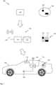
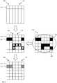
1 ein System mit einem Kraftfahrzeug, das auf der Basis einer geographischen Karte gesteuert werden kann;2 ein Ablaufdiagramm eines Verfahrens zum Aktualisieren einer geographischen Karte; und3 eine schematische Aktualisierung einer Karte
1 a system with a motor vehicle that can be controlled on the basis of a geographical map;2 a flowchart of a method for updating a geographical map; and3 a schematic update of a map
Die ersten Kacheln
Die Karte
Zur Aktualisierung bestimmt der Dienstleister
Die Sammlung
An Bord des Kraftfahrzeugs
Das Kraftfahrzeug
Die Steuervorrichtung
Es wird vorgeschlagen, dass seitens der zentralen Einrichtung
In weiteren Ausführungsformen kann das Verfahren
In einem Schritt
In einem nachfolgenden Schritt
Anschließend können in einem Schritt zweite Kacheln
Sind im Schritt
In allen Darstellungen sind die Kacheln
In der Überlagerung der dritten Darstellung
Die anderen zweiten Kacheln
In einem anschaulichen Beispiel können die verworfenen zweiten Kacheln
In der vierten Darstellung
BezugszeichenlisteLIST OF REFERENCE NUMBERS
- 100100
- Systemsystem
- 105105
- Kraftfahrzeugmotor vehicle
- 110110
- Kartemap
- 115115
- erste Kachelfirst tile
- 120120
- zentrale Einrichtungcentral facility
- 125125
- Verarbeitungseinrichtungprocessing device
- 130130
- Datenspeicherdata storage
- 135135
- Schnittstelle zur drahtlosen KommunikationInterface for wireless communication
- 140140
- Dienstleisterservice provider
- 145145
- zweite Kachelsecond tile
- 150150
- Sammlungcollection
- 155155
- Teilkartesupply card
- 160160
- Steuervorrichtungcontrol device
- 165165
- Schnittstelleinterface
- 170170
- Positioniereinrichtungpositioning
- 200200
- Verfahrenmethod
- 205205
- Bereitstellen erste KachelnProvide first tiles
- 210210
- Empfangen Sammlung zweite KachelnReceive collection of second tiles
- 215215
- Fehler?Error?
- 220220
- Kachel verwerfenDiscard tile
- 225225
- unverworfenen zweite Nachbarkacheln bestimmendetermine undistorted second neighboring roofs
- 230230
- gefunden?found?
- 235235
- Informationen restlicher zweite Kacheln übernehmenTake over information from remaining second tiles
- 305305
- erste Darstellungfirst presentation
- 310310
- zweite Darstellungsecond illustration
- 315315
- dritte Darstellungthird presentation
- 320320
- vierte Darstellungfourth illustration
Claims (10)
Translated fromGermanPriority Applications (4)
| Application Number | Priority Date | Filing Date | Title |
|---|---|---|---|
| DE102018201889.8ADE102018201889A1 (en) | 2018-02-07 | 2018-02-07 | Updating a geographical map |
| PCT/DE2019/100030WO2019154457A1 (en) | 2018-02-07 | 2019-01-15 | Updating a geographic map |
| CN201980009172.6ACN111630348B (en) | 2018-02-07 | 2019-01-15 | Updating of geographical map |
| EP19704719.4AEP3749928B1 (en) | 2018-02-07 | 2019-01-15 | Updating a geographic map |
Applications Claiming Priority (1)
| Application Number | Priority Date | Filing Date | Title |
|---|---|---|---|
| DE102018201889.8ADE102018201889A1 (en) | 2018-02-07 | 2018-02-07 | Updating a geographical map |
Publications (1)
| Publication Number | Publication Date |
|---|---|
| DE102018201889A1true DE102018201889A1 (en) | 2019-08-08 |
Family
ID=65408844
Family Applications (1)
| Application Number | Title | Priority Date | Filing Date |
|---|---|---|---|
| DE102018201889.8AWithdrawnDE102018201889A1 (en) | 2018-02-07 | 2018-02-07 | Updating a geographical map |
Country Status (4)
| Country | Link |
|---|---|
| EP (1) | EP3749928B1 (en) |
| CN (1) | CN111630348B (en) |
| DE (1) | DE102018201889A1 (en) |
| WO (1) | WO2019154457A1 (en) |
Families Citing this family (1)
| Publication number | Priority date | Publication date | Assignee | Title |
|---|---|---|---|---|
| JP7518973B2 (en) | 2021-06-22 | 2024-07-18 | ベイジン バイドゥ ネットコム サイエンス テクノロジー カンパニー リミテッド | Map data update method, device and electronic device |
Citations (3)
| Publication number | Priority date | Publication date | Assignee | Title |
|---|---|---|---|---|
| US20170120904A1 (en)* | 2015-11-04 | 2017-05-04 | Zoox, Inc. | Robotic vehicle active safety systems and methods |
| US20170248960A1 (en)* | 2015-02-10 | 2017-08-31 | Mobileye Vision Technologies Ltd. | Sparse map for autonomous vehicle navigation |
| US20170313319A1 (en)* | 2016-04-28 | 2017-11-02 | Toyota Jidosha Kabushiki Kaisha | Driving consciousness estimation device |
Family Cites Families (8)
| Publication number | Priority date | Publication date | Assignee | Title |
|---|---|---|---|---|
| JP4684228B2 (en)* | 2004-07-29 | 2011-05-18 | 日立オートモティブシステムズ株式会社 | Map data distribution device, communication terminal, and map distribution method |
| DE102006013297B4 (en)* | 2006-03-23 | 2016-10-13 | Robert Bosch Gmbh | Method for operating a navigation system |
| CN101608925B (en)* | 2009-07-10 | 2013-07-10 | 北京四维图新科技股份有限公司 | Feedback method, terminal and server of information of geographic elements of navigation electronic map |
| CN103095774B (en)* | 2011-10-31 | 2017-11-14 | 北京千橡网景科技发展有限公司 | Map constructing method and equipment and the method and apparatus that map structuring information is provided |
| EP2626668B1 (en)* | 2012-02-09 | 2016-11-30 | HERE Global B.V. | Testing of a map database update |
| DE102013200181A1 (en)* | 2013-01-09 | 2014-07-10 | Bayerische Motoren Werke Aktiengesellschaft | Method and device for managing map data of a digital map of a navigation device |
| EP2951532B1 (en)* | 2013-01-30 | 2019-10-09 | HERE Global B.V. | Method and apparatus for use in navigational applications |
| CN105893567A (en)* | 2016-03-31 | 2016-08-24 | 中国农业大学 | Determination method and device for geographical region areas |
- 2018
- 2018-02-07DEDE102018201889.8Apatent/DE102018201889A1/ennot_activeWithdrawn
- 2019
- 2019-01-15WOPCT/DE2019/100030patent/WO2019154457A1/ennot_activeCeased
- 2019-01-15CNCN201980009172.6Apatent/CN111630348B/enactiveActive
- 2019-01-15EPEP19704719.4Apatent/EP3749928B1/enactiveActive
Patent Citations (4)
| Publication number | Priority date | Publication date | Assignee | Title |
|---|---|---|---|---|
| US20170248960A1 (en)* | 2015-02-10 | 2017-08-31 | Mobileye Vision Technologies Ltd. | Sparse map for autonomous vehicle navigation |
| US20170120904A1 (en)* | 2015-11-04 | 2017-05-04 | Zoox, Inc. | Robotic vehicle active safety systems and methods |
| US20170248963A1 (en)* | 2015-11-04 | 2017-08-31 | Zoox, Inc. | Adaptive mapping to navigate autonomous vehicles responsive to physical environment changes |
| US20170313319A1 (en)* | 2016-04-28 | 2017-11-02 | Toyota Jidosha Kabushiki Kaisha | Driving consciousness estimation device |
Also Published As
| Publication number | Publication date |
|---|---|
| WO2019154457A1 (en) | 2019-08-15 |
| EP3749928A1 (en) | 2020-12-16 |
| EP3749928B1 (en) | 2022-03-16 |
| CN111630348B (en) | 2023-06-27 |
| CN111630348A (en) | 2020-09-04 |
Similar Documents
| Publication | Publication Date | Title |
|---|---|---|
| EP2507589B1 (en) | Method for simplifying a description of a route | |
| WO2017016799A1 (en) | Determining arrangement information for a vehicle | |
| WO2018019465A1 (en) | Method, device and computer-readable storage medium with instructions for determining the lateral position of a vehicle relative to the lanes of a road | |
| EP2641061A1 (en) | Method for automatically determining a boundary of a partial area of a total area | |
| DE102022002334B3 (en) | Procedure for determining and providing lane courses | |
| DE112013004890T5 (en) | Car navigation system | |
| DE112009004441T5 (en) | The vehicle drive assist device | |
| DE102017212908A1 (en) | Method for improving the transverse and / or longitudinal guidance of a vehicle | |
| DE102021208245B4 (en) | Method for operating a driver assistance system, driver assistance system and motor vehicle with a driver assistance system | |
| DE102019119002A1 (en) | Determining a lane boundary | |
| EP3472820B1 (en) | Updating a digital map | |
| DE102017217747A1 (en) | Method for operating a navigation system | |
| EP3749928B1 (en) | Updating a geographic map | |
| EP3875909B1 (en) | Generation of a new hybrid map for navigation | |
| DE102021107385A1 (en) | Method for determining which lane a vehicle is in and system for operating a driver assistance function | |
| DE102020118628A1 (en) | Method and device for determining a position of a vehicle | |
| EP3755972B1 (en) | Building a geographic map | |
| DE102018204293A1 (en) | Navigation of a motor vehicle | |
| EP2607851B1 (en) | Method for operating a navigation device with speed data that can be updated separately | |
| DE102018210681B4 (en) | Methods for optimizing map data | |
| DE102014223331B4 (en) | Improvement of a driving horizon system by self-learning of the most probable travel path | |
| DE102017202564A1 (en) | Method and device for determining a navigation route | |
| DE102023118703A1 (en) | Procedure for using at least two different digital maps | |
| DE112022007679T5 (en) | Route information generating device and route information generating method | |
| WO2017029220A1 (en) | Method and device for determining a roadside parking space |
Legal Events
| Date | Code | Title | Description |
|---|---|---|---|
| R163 | Identified publications notified | ||
| R119 | Application deemed withdrawn, or ip right lapsed, due to non-payment of renewal fee |