DE102014203665A1 - Dynamic filtering of navigation panel labels - Google Patents
Dynamic filtering of navigation panel labelsDownload PDFInfo
- Publication number
- DE102014203665A1 DE102014203665A1DE102014203665.8ADE102014203665ADE102014203665A1DE 102014203665 A1DE102014203665 A1DE 102014203665A1DE 102014203665 ADE102014203665 ADE 102014203665ADE 102014203665 A1DE102014203665 A1DE 102014203665A1
- Authority
- DE
- Germany
- Prior art keywords
- labels
- displayed
- label
- road user
- score
- Prior art date
- Legal status (The legal status is an assumption and is not a legal conclusion. Google has not performed a legal analysis and makes no representation as to the accuracy of the status listed.)
- Withdrawn
Links
- 238000001914filtrationMethods0.000titleclaimsdescription3
- 230000001419dependent effectEffects0.000claimsabstractdescription4
- 230000033001locomotionEffects0.000claimsdescription7
- 238000000034methodMethods0.000claimsdescription7
- 238000002372labellingMethods0.000claimsdescription3
- 238000011156evaluationMethods0.000claimsdescription2
- 238000011161developmentMethods0.000description2
- 230000018109developmental processEffects0.000description2
- 230000001105regulatory effectEffects0.000description1
- 210000002023somiteAnatomy0.000description1
- 230000002123temporal effectEffects0.000description1
- 230000000007visual effectEffects0.000description1
Images

Classifications
- G—PHYSICS
- G01—MEASURING; TESTING
- G01C—MEASURING DISTANCES, LEVELS OR BEARINGS; SURVEYING; NAVIGATION; GYROSCOPIC INSTRUMENTS; PHOTOGRAMMETRY OR VIDEOGRAMMETRY
- G01C21/00—Navigation; Navigational instruments not provided for in groups G01C1/00 - G01C19/00
- G01C21/26—Navigation; Navigational instruments not provided for in groups G01C1/00 - G01C19/00 specially adapted for navigation in a road network
- G01C21/34—Route searching; Route guidance
- G01C21/36—Input/output arrangements for on-board computers
- G01C21/3667—Display of a road map
- G01C21/3673—Labelling using text of road map data items, e.g. road names, POI names
- G—PHYSICS
- G09—EDUCATION; CRYPTOGRAPHY; DISPLAY; ADVERTISING; SEALS
- G09G—ARRANGEMENTS OR CIRCUITS FOR CONTROL OF INDICATING DEVICES USING STATIC MEANS TO PRESENT VARIABLE INFORMATION
- G09G5/00—Control arrangements or circuits for visual indicators common to cathode-ray tube indicators and other visual indicators
- G09G5/22—Control arrangements or circuits for visual indicators common to cathode-ray tube indicators and other visual indicators characterised by the display of characters or indicia using display control signals derived from coded signals representing the characters or indicia, e.g. with a character-code memory
- G09G5/30—Control of display attribute
- G—PHYSICS
- G09—EDUCATION; CRYPTOGRAPHY; DISPLAY; ADVERTISING; SEALS
- G09G—ARRANGEMENTS OR CIRCUITS FOR CONTROL OF INDICATING DEVICES USING STATIC MEANS TO PRESENT VARIABLE INFORMATION
- G09G5/00—Control arrangements or circuits for visual indicators common to cathode-ray tube indicators and other visual indicators
- G09G5/40—Control arrangements or circuits for visual indicators common to cathode-ray tube indicators and other visual indicators characterised by the way in which both a pattern determined by character code and another pattern are displayed simultaneously, or either pattern is displayed selectively, e.g. with character code memory and APA, i.e. all-points-addressable, memory
Landscapes
- Engineering & Computer Science (AREA)
- Radar, Positioning & Navigation (AREA)
- Remote Sensing (AREA)
- Physics & Mathematics (AREA)
- General Physics & Mathematics (AREA)
- Computer Hardware Design (AREA)
- Theoretical Computer Science (AREA)
- Automation & Control Theory (AREA)
- Navigation (AREA)
Abstract
Translated fromGermanDescription
Translated fromGermanDie vorliegende Erfindung betrifft eine Steuereinheit zum Bestimmen der anzuzeigenden Beschriftungen auf der Anzeige einer Navigationsvorrichtung und ein entsprechendes Verfahren.The present invention relates to a control unit for determining the labels to be displayed on the display of a navigation device and a corresponding method.
In Navigationssystemen für Verkehrsteilnehmer (bspw. Fahrzeuge, Portable Geräte, Handysoftware) wird eine 2D/3D Karte dargestellt. Darin werden unter anderem Straßenzüge und deren Beschriftungen angezeigt. Im Betrieb müssen die für den Benutzer relevanten Beschriftungen vom System gewählt und angezeigt werden.In navigation systems for road users (eg vehicles, portable devices, mobile phone software) a 2D / 3D map is displayed. In it, among other things, streets and their labels are displayed. During operation, the labels relevant to the user must be selected and displayed by the system.
Die einfache Filterung von Beschriftungen ist in heutigen Navigationssystemen präsent. Es bspw. werden nur Beschriftungen angezeigt, die innerhalb der aktuellen Ansicht sichtbar sind. Beschriftungen, die nahe der aktuellen Position des Verkehrsteilnehmers und entlang der aktuellen Route sind, werden höher priorisiert.The simple filtering of labels is present in today's navigation systems. For example, only labels that are visible within the current view are displayed. Labels that are near the current location of the road user and along the current route are prioritized higher.
Die im Stand der Technik verwendeten Filterungen für die Beschriftungen sind oft schwer nachvollziehbar. Oft werden sie falsch ausgesucht und unterstützen den Verkehrsteilnehmer beim Abfahren der Route nicht.The filters used in the prior art for the labels are often difficult to understand. Often they are wrongly selected and do not support the road user when driving down the route.
Die Aufgabe, die der Erfindung zugrunde liegt, ist es die oben genannten Nachteile des Standes der Technik zu überkommen.The object underlying the invention is to overcome the above-mentioned disadvantages of the prior art.
Die Aufgabe wird durch die Gegenstände der unabhängigen Ansprüche gelöst. Vorteilhafte Weiterbildungen sind in den abhängigen Ansprüchen definiert.The object is solved by the subject matters of the independent claims. Advantageous developments are defined in the dependent claims.
In einem Aspekt umfasst eine Steuereinheit zum Bestimmen der anzuzeigenden Beschriftungen für eine Landkarte auf der Anzeige einer Navigationsvorrichtung für einen Verkehrsteilnehmer: Laden von Beschriftungen, die für den angezeigten Teil der Landkarte verfügbar sind; Berechnen eines Score, also eine Maßzahl, für jede geladene Beschriftung Abhängig von einem ermittelten Kontext; Auswählen der Beschriftungen unter Berücksichtigung des Score und vordefinierten Sonderbestimmungen, die abhängig von dem ermittelten Kontext angewendet werden; Veranlassen des Anzeigens der ausgewählten Beschriftungen. Eine Beschriftung kann insbesondere Text sein, aber auch eine graphische Darstellung umfassen.In one aspect, a controller for determining the labels to display for a map on the display of a navigation device for a road user comprises: loading labels available for the displayed portion of the map; Calculating a score, that is a measure, for each loaded label Dependent on a determined context; Selecting the labels taking into account the score and predefined special provisions that are applied depending on the determined context; Causing the selected labels to be displayed. In particular, a caption may be text but may also include a graphical representation.
Hierin wird also vorgeschlagen die Beschriftungen abhängig von einem ermittelten Kontext auszuwählen und zwar basierend auf einem Score und Sonderbestimmungen. Die Abhängigkeit von dem ermittelten Kontext kann auch als eigener Schritt begriffen werden, in dem der Score und die Sonderbestimmungen angepasst werden, eine sogenannte „Vorkonditionierung“. Werden. Bspw. werden bei der Suche eines Restaurants die Restaurant-Beschriftungen höher priorisiert. Nach der Vorkonditionierung wird für jede Beschriftung innerhalb der aktuellen Ansicht ein „Scoring nach Kriterien“ (Bewertung) durchgeführt. Dadurch erhalten bspw. Straßen nah an der Route eine höhere Bewertung. Schließlich werden vordefinierte Sonderbestimmungen, hierin auch Regeln genannt, angewendet („Regelverfahren“). Bspw. werden dadurch alle Beschriftungen an Querstraßen selektiert. Als Ergebnis des dreistufigen Systems wird eine Liste von aktuell relevanten Beschriftungen erhalten. Dieses Filtersystem kann in vordefinierten Zeitschritten wiederholt durchgeführt werden, bspw. jede Sekunde.Herein, it is proposed to select the labels depending on a determined context, based on a score and special provisions. The dependence on the determined context can also be understood as a separate step, in which the score and the special provisions are adjusted, a so-called "preconditioning". Become. For example. When searching for a restaurant, the restaurant labels are given a higher priority. After preconditioning, a scoring by criteria (rating) is performed for each label within the current view. This gives, for example, roads close to the route a higher rating. Finally, predefined special provisions, also called rules, are used ("regulatory procedure"). For example. This will select all labels on cross streets. As a result of the three-level system, a list of currently relevant labels is obtained. This filter system can be carried out repeatedly in predefined time steps, for example every second.
In einer Implementierung wird der Kontext durch vorhergehend eingegebene Suchbegriffe, durch Auswertungen von Aufnahmen einer Kamera des Verkehrsteilnehmers oder dem Bewegungskontext definiert.In one implementation, the context is defined by previously entered search terms, by evaluations of recordings of a road user's camera, or the motion context.
In einer Weiterbildung werden bei der Berechnung des Score Kriterien berücksichtigt, insbesondere: Der Winkel, in dem die zu der Beschriftung gehörige Straße von der Straße abgeht, auf der sich der Verkehrsteilnehmer befindet; Das Verhältnis der Länge der zur Beschriftung gehörigen Straße auf der Anzeige zu der Länge der Beschriftung auf der Anzeige; Grundlegende Filterkriterien; Die bisherige Anzeige einer Beschriftung. Diese Kriterien werden für jede Beschriftung bewertet und schließlich verknüpft, um einen Wert für den Score einer Beschriftung zu erhalten.In a further development, criteria are taken into account in the calculation of the score, in particular: the angle at which the road belonging to the inscription goes off the road on which the road user is located; The ratio of the length of the road associated with the label on the display to the length of the label on the display; Basic filter criteria; The previous display of a label. These criteria are evaluated for each label and finally linked to get a value for the label's score.
Die grundlegenden Filterkriterien können eines oder mehrere der Folgenden umfassen: Die Distanz des zur Beschriftung gehörigen Objektes zur aktuellen Route und/oder die Distanz zur Position des Verkehrsteilnehmers; Die Bewegungsrichtung des Verkehrsteilnehmers, insbesondere ob das Objekt, zu dem die Beschriftung gehört, in Bewegungsrichtung vor dem Verkehrsteilnehmer liegt; Die Wichtigkeit des zur Beschriftung gehörenden Objektes, insbesondere die Bevölkerungszahl des Objektes, sofern dem Objekt eine solche Zahl zugeordnet ist. Diese grundlegenden Filterkriterien orientieren sich somit an objektiven Maßeinheiten, wie Distanzen oder Bevölkerungszahlen. The basic filter criteria may include one or more of: the distance of the object associated with the label from the current route and / or the distance to the location of the road user; The direction of movement of the road user, in particular whether the object to which the label belongs, lies in the direction of movement in front of the road user; The importance of the object belonging to the inscription, in particular the population number of the object, if the object is assigned such a number. These basic filter criteria are thus based on objective units of measure, such as distances or population numbers.
In einer bevorzugten Weiterbildung veranlasst die Steuereinheit anhand der Sonderbestimmungen eines oder mehrere der Folgenden, Dass der Name der letzten Querstraße, also derjenigen Straße, die auf der Navigationsroute vom Verkehrsteilnehmer zuletzt passiert wurde, angezeigt wird; Dass Beschriftungen, die zumindest teilweise außerhalb der Anzeige anzuzeigen wären, nicht angezeigt werden; Dass die Beschriftung von Querstraßen, also derjenigen Straßen, die von der Navigationsroute abgehen, angezeigt werden; Dass ab vordefinierten Zoomlevels Elemente doppelt beschriftet werden, insbesondere bei längeren Straßen der Name mehrfach angezeigt werden; Dass bei besonders großen Beschriftungen, diese auch teilweise außerhalb der Anzeige angezeigt werden. Diese Sonderbestimmungen stellen sicher, dass unabhängig vom Score, bestimmte Grundregeln eingehalten werden, die eine sinnvolle Anzeige von Beschriftungen ermöglichen.In a preferred refinement, the control unit initiates, on the basis of the special provisions, one or more of the following, that the name of the last crossroads, that is to say the road which was last passed by the road user on the navigation route, is displayed; That labels that would be at least partially displayed outside the ad are not displayed; That the labeling of cross roads, ie those roads that depart from the navigation route are displayed; That at predefined zoom levels elements are labeled twice, especially for longer streets the name is displayed several times; That with very large labels, these are sometimes displayed outside the display. These special provisions ensure that regardless of the score, certain basic rules are adhered to, which allow a meaningful display of labels.
In einem anderen Aspekt umfasst ein Verfahren zum Bestimmen der anzuzeigenden Beschriftungen für eine Landkarte auf der Anzeige einer Navigationsvorrichtung für einen Verkehrsteilnehmer: Laden von Beschriftungen, die für die angezeigte Landkarte verfügbar sind; Abhängig von einem ermittelten Kontext: Berechnen eines Score für jede geladene Beschriftung; Auswählen der Beschriftungen unter Berücksichtigung des Score und vordefinierten Sonderbestimmungen; Veranlassen des Anzeigens der ausgewählten Beschriftungen. Das Verfahren kann von der Steuereinheit ausgeführt werden. Die Steuereinheit kann ein Mikrocontroller, ein Universalprozessor oder ähnliches sein, der per Software zur dargestellten Funktionalität bzw. zur Ausführung des Verfahrens eingerichtet ist.In another aspect, a method for determining the indicia to display for a map on the display of a navigation device for a road user comprises: loading indicia available for the displayed map; Depending on a determined context: calculating a score for each loaded label; Selecting the labels taking into account the score and predefined special provisions; Causing the selected labels to be displayed. The method can be executed by the control unit. The control unit may be a microcontroller, a general-purpose processor or the like, which is set up by software for the displayed functionality or for carrying out the method.
KURZE BESCHREIBUNG DER ZEICHNUNGENBRIEF DESCRIPTION OF THE DRAWINGS
DETAILLIERTE BESCHREIBUNG DES AUSFÜHRUNGSBEISPIELSDETAILED DESCRIPTION OF THE EMBODIMENT
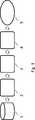
Im Schritt
Kriterien (s) sind beispielsweise:
Winkel der Straße, die der Beschriftung zugeordnet ist (um Querstraßen zu entdecken): Straßen die im 90° Winkel zur aktuellen Route stehen sind mit hoher Wahrscheinlichkeit eine Querstraße und somit wichtig. Wenn die von der Route abgehende Straße einen Winkel um 90° (bspw. 70° bis 110°) aufweist, gilt das Kriterium als erfüllt und w = 1. Solche Straßen werden also höher bewertet. Vorteil: Es wird keine Graphenrepräsentation des Straßennetzes (der umliegenden Straßen) benötigt und Querstraßen können mit wenig Rechenaufwand bestimmt werden.Criteria (s) are for example:
Angle of the road that is assigned to the lettering (to discover cross streets): Roads that are at 90 ° to the current route are most likely a crossroads and therefore important. If the road leaving the route has an angle of 90 ° (for example 70 ° to 110 °), the criterion is satisfied and w = 1. Such roads are therefore rated higher. Advantage: No graph representation of the road network (the surrounding streets) is needed and cross streets can be determined with little computational effort.
Verhältnis zwischen Straßenlänge zur Beschriftungslänge: Straßen deren Namen (Schriftzug) nicht auf der visuellen Repräsentation der Straße platziert werden können, erhalten eine geringere Bewertung. Ist das Verhältnis kleiner 1, wird dem Kriterium der Wert s = 0 zugewiesen.Relationship between road length and labeling length: Roads whose names (lettering) can not be placed on the visual representation of the road receive a lower rating. If the ratio is less than 1, the criterion is assigned the value s = 0.
Grundlegende Filterkriterien: Bewertung nach Distanz zur aktuellen Route und/oder Distanz zur aktuellen Position (Fahrzeug, Fußgänger). Dabei können Tabellen benutzt werden, die die Distanz in einen Wert s umrechnen. So kann eine Entfernung von 1 km in den Wert s = 0,5 umgesetzt werden. Bewertung nach der Fahrtrichtung: Beschriftungen in Bewegungsrichtung vor dem Benutzer werden höher gewichtet. So können Beschriftungen in Fahrtrichtung mit s = 0,8 bewertet werden, während Beschriftungen in Fahrtrichtung hinter dem Verkehrsteilnehmer mit s = 0 bewertet werden können. Bewertung nach der Wichtigkeit des Kartenelements (bspw. Großstadt wichtiger als Dorf). So kann die Einwohnerzahl einer Ansiedlung (sofern als Information gespeichert) gemäß einer Tabelle in einen Wert für s umgerechnet werden, z.B. kann eine Stadt mit mehr als 100000 Einwohnern den Wert s = 1 erhalten.Basic filter criteria: Rating by distance to the current route and / or distance to the current position (vehicle, pedestrian). You can use tables that convert the distance into a value s. Thus, a distance of 1 km can be converted into the value s = 0.5. Rating according to the direction of travel: Labels in the direction of movement in front of the user are weighted higher. Thus, labels can be rated in the direction of travel with s = 0.8, while labels in the direction of travel behind the road user with s = 0 can be evaluated. Rating according to the importance of the map element (eg city more important than village). Thus, the population of a settlement (if stored as information) can be converted into a value for s according to a table, e.g. For example, a city with more than 100,000 inhabitants can be given the value s = 1.
Zeitliche Kohärenz: Beschriftungen die bereits angezeigt werden, werden höher bewertet. Dadurch wird das ein/ausblenden von Beschriftungen verhindert. („Flackern“). Dies ergibt ein stabiles Erscheinungsbild.Temporal Coherence: Labels that are already displayed are rated higher. This prevents the fade in / out of labels. ("Flicker"). This gives a stable appearance.
Die Werte für w werden vorbestimmt und sind in einer Tabelle abgelegt.The values for w are predetermined and are stored in a table.
Anhand der Scores wird eine Auswahl an Beschriftungen getroffen, die anzuzeigen sind. Dabei können all jene Beschriftungen ausgewählt werden, die einen Score über einem Schwellwert aufweisen.The scores are used to make a selection of labels to be displayed. All those labels with a score above a threshold can be selected.
In Schritt
- 1. Der Name der letzten Querstraße wird immer angezeigt.
- 2. Beschriftungen außerhalb des angezeigten Bereiches (Sichtbereichs) werden nicht angezeigt („clipping Filter“)
- 3. Die Beschriftungen der Querstraßen werden immer angezeigt
- 4. Ab bestimmten Zoomlevels werden Elemente auch doppelt beschriftet, bspw. wird bei längeren Straßen der Name mehrfach angezeigt.
- 5. Bei besonders großen Beschriftungen (bspw. große POIs, WS-Beschriftungen), wird der clipping Filter nicht angewendet. Somit können diese Elemente aus dem Bildschirmrand herausragen und nicht sofort entfernt.
- 1. The name of the last cross street is always displayed.
- 2. Labels outside the displayed area (field of view) are not displayed ("clipping filter")
- 3. The labels of the cross streets are always displayed
- 4. At certain zoom levels, elements are also labeled twice, for example, the name is displayed multiple times on longer streets.
- 5. For very large labels (eg large POIs, WS labels), the clipping filter is not applied. Thus, these elements can protrude from the edge of the screen and not immediately removed.
Allen aufgrund des Scores oder Sonderbestimmungen anzuzeigenden Beschriftungen werden dann auf der Anzeige angezeigt. Beschriftungen, die zwar aufgrund ihres Scores anzuzeigen wären, jedoch aufgrund einer Sonderbestimmung nicht anzuzeigen sind, werden nicht angezeigt.All labels to be displayed based on the score or special conditions will then be displayed on the screen. Labels that are displayed due to their scores but can not be displayed due to a special purpose are not displayed.
Das Verfahren bzw. die Steuereinrichtung hat folgende Vorteile: Der Benutzer wird optimal unterstützt: Es werden ihm für seine aktuelle Situation sinnvolle/wichtige Beschriftungen angezeigt. Es werden weniger Beschriftungen angezeigt. Dadurch kann der Fahrer schneller die Einzelnen (ihm wichtigen) Beschriftungen erfassen. (Reduzierung der Komplexität des Bildes, schnellere Erfassung). System ist beherrschbar, da das nachgeschaltete Regelsystem klaren Regeln folgt. Ein Scoring ist sehr schnell ausführbar, einfach zu implementieren und verständlich. Eine Auswahl von Beschriftungen gemäß einem Scoring erzeugt ein stabiles System. Die Bewertung einer Beschriftung bleibt über die Zeit hinweg relativ konstant. (d.h. es gibt keine Ausreißer).The method or the control device has the following advantages: The user is optimally supported: Meaningful / important labels are displayed to him for his current situation. There are fewer labels displayed. This allows the driver to more quickly capture the individual (important to him) labels. (Reducing the complexity of the image, faster capture). System is manageable, since the downstream control system follows clear rules. Scoring is very fast, easy to implement and understandable. A selection of labels according to a scoring creates a stable system. The rating of a label remains relatively constant over time. (i.e., there are no outliers).
Claims (6)
Translated fromGermanPriority Applications (1)
| Application Number | Priority Date | Filing Date | Title |
|---|---|---|---|
| DE102014203665.8ADE102014203665A1 (en) | 2014-02-28 | 2014-02-28 | Dynamic filtering of navigation panel labels |
Applications Claiming Priority (1)
| Application Number | Priority Date | Filing Date | Title |
|---|---|---|---|
| DE102014203665.8ADE102014203665A1 (en) | 2014-02-28 | 2014-02-28 | Dynamic filtering of navigation panel labels |
Publications (1)
| Publication Number | Publication Date |
|---|---|
| DE102014203665A1true DE102014203665A1 (en) | 2015-09-03 |
Family
ID=53801398
Family Applications (1)
| Application Number | Title | Priority Date | Filing Date |
|---|---|---|---|
| DE102014203665.8AWithdrawnDE102014203665A1 (en) | 2014-02-28 | 2014-02-28 | Dynamic filtering of navigation panel labels |
Country Status (1)
| Country | Link |
|---|---|
| DE (1) | DE102014203665A1 (en) |
Cited By (1)
| Publication number | Priority date | Publication date | Assignee | Title |
|---|---|---|---|---|
| DE102018133384A1 (en) | 2018-12-21 | 2020-06-25 | Volkswagen Aktiengesellschaft | Method and device for displaying information on a screen of a navigation device |
Citations (6)
| Publication number | Priority date | Publication date | Assignee | Title |
|---|---|---|---|---|
| DE19741149C1 (en)* | 1997-09-18 | 1999-04-08 | Siemens Ag | Navigation device and method for map display |
| EP1643214A2 (en)* | 2004-10-01 | 2006-04-05 | Bose Corporation | Mobile navigation system and method for displaying information of such a system |
| DE102006038551A1 (en)* | 2006-08-17 | 2008-02-21 | Robert Bosch Gmbh | Method for displaying object information and navigation system therefor |
| WO2009072725A1 (en)* | 2007-12-04 | 2009-06-11 | Thinkware Systems Corporation | Method and system for arranging dynamic point of interest using unshared r-tree |
| US20090181650A1 (en)* | 2008-01-14 | 2009-07-16 | Research In Motion Limited | Dynamic prioritization of label downloads |
| DE102008061981A1 (en)* | 2007-12-12 | 2009-09-03 | Xanavi Informatics Corp., Zama | navigation device |
- 2014
- 2014-02-28DEDE102014203665.8Apatent/DE102014203665A1/ennot_activeWithdrawn
Patent Citations (6)
| Publication number | Priority date | Publication date | Assignee | Title |
|---|---|---|---|---|
| DE19741149C1 (en)* | 1997-09-18 | 1999-04-08 | Siemens Ag | Navigation device and method for map display |
| EP1643214A2 (en)* | 2004-10-01 | 2006-04-05 | Bose Corporation | Mobile navigation system and method for displaying information of such a system |
| DE102006038551A1 (en)* | 2006-08-17 | 2008-02-21 | Robert Bosch Gmbh | Method for displaying object information and navigation system therefor |
| WO2009072725A1 (en)* | 2007-12-04 | 2009-06-11 | Thinkware Systems Corporation | Method and system for arranging dynamic point of interest using unshared r-tree |
| DE102008061981A1 (en)* | 2007-12-12 | 2009-09-03 | Xanavi Informatics Corp., Zama | navigation device |
| US20090181650A1 (en)* | 2008-01-14 | 2009-07-16 | Research In Motion Limited | Dynamic prioritization of label downloads |
Cited By (1)
| Publication number | Priority date | Publication date | Assignee | Title |
|---|---|---|---|---|
| DE102018133384A1 (en) | 2018-12-21 | 2020-06-25 | Volkswagen Aktiengesellschaft | Method and device for displaying information on a screen of a navigation device |
Similar Documents
| Publication | Publication Date | Title |
|---|---|---|
| DE69819628T2 (en) | Position display device for navigation device with floor information | |
| DE112013007590T5 (en) | Driving assistance image generation device, driving assistance image display device, driving assistance image display system and driving assistance image generation program | |
| DE102010051050B4 (en) | A method for contextually displaying "points of interest" on a mobile navigation device according to the purpose of the journey | |
| DE112013007522T5 (en) | Driving assistance device and driver assistance method | |
| DE102018214510A1 (en) | Parking ticket generation on the street | |
| EP3365632A1 (en) | Method for visually displaying the positions of selected destinations in maps in an altered manner | |
| DE202015009170U1 (en) | Intuitive preview of pending navigation instructions | |
| EP2800671A1 (en) | Method and device for informing a driver | |
| EP1890112B1 (en) | Method for displaying object information and navigation system therefor | |
| DE112011105547B4 (en) | Navigation device | |
| DE102017215956A1 (en) | A method of outputting information about an object in an environment of a vehicle, system and automobile | |
| DE112013007437T5 (en) | Storage medium, card information processing apparatus, data generation method | |
| DE102014203665A1 (en) | Dynamic filtering of navigation panel labels | |
| DE102015007145B4 (en) | Procedure for automatic route evaluation | |
| DE112017001558T5 (en) | Map display system and map viewer | |
| DE102009019023A1 (en) | Display unit controlling method for vehicle, involves detecting detection positions of speed information, and outputting speed information on display unit depending upon detection position with respect to extension of driving route | |
| DE102019200035B3 (en) | Method for providing interest information, and electronic information provision system and motor vehicle | |
| DE112009005316T5 (en) | Navigation system and method with improved destination search | |
| EP2100097B1 (en) | Navigation device | |
| DE102013211134A1 (en) | Method and navigation system for displaying a driving route on a display device | |
| DE102013001747A1 (en) | Method for providing a rating of drive along traffic route traveled by learner-driver of motor car, involves detecting route data and evaluation data along busy route so as to assign the data to current geographical position of car | |
| DE102010042996A1 (en) | Method for creating and managing point of interest (POI) for navigation device, involves defining virtual VPOI in form of global positioning system data and identifying fixed digital object identifier based on VPOI | |
| DE102012213307A1 (en) | Method for determining representation of label elements of digital card using navigation system of vehicle e.g. passenger car, involves selecting representation modes to represent active and inactive label elements within digital card | |
| DE102009023775A1 (en) | Method for displaying set of e.g. point of interest targets, and set of time requirements on navigation system display of vehicle, involves displaying result list on navigation system display of vehicle | |
| DE102008026186A1 (en) | Method for displaying information in vehicle, involves determining travel route and route guidance by multiple output units of navigation device, where multiple travel information is issued on output units sequence |
Legal Events
| Date | Code | Title | Description |
|---|---|---|---|
| R079 | Amendment of ipc main class | Free format text:PREVIOUS MAIN CLASS: G01C0021360000 Ipc:G01C0021320000 | |
| R163 | Identified publications notified | ||
| R005 | Application deemed withdrawn due to failure to request examination |