DE102013200387A1 - Creation of a obstacle map - Google Patents
Creation of a obstacle mapDownload PDFInfo
- Publication number
- DE102013200387A1 DE102013200387A1DE102013200387.0ADE102013200387ADE102013200387A1DE 102013200387 A1DE102013200387 A1DE 102013200387A1DE 102013200387 ADE102013200387 ADE 102013200387ADE 102013200387 A1DE102013200387 A1DE 102013200387A1
- Authority
- DE
- Germany
- Prior art keywords
- cells
- obstacle
- motor vehicle
- environment
- road
- Prior art date
- Legal status (The legal status is an assumption and is not a legal conclusion. Google has not performed a legal analysis and makes no representation as to the accuracy of the status listed.)
- Withdrawn
Links
Images


Classifications
- G—PHYSICS
- G06—COMPUTING OR CALCULATING; COUNTING
- G06V—IMAGE OR VIDEO RECOGNITION OR UNDERSTANDING
- G06V20/00—Scenes; Scene-specific elements
- G06V20/50—Context or environment of the image
- G06V20/56—Context or environment of the image exterior to a vehicle by using sensors mounted on the vehicle
- G06V20/58—Recognition of moving objects or obstacles, e.g. vehicles or pedestrians; Recognition of traffic objects, e.g. traffic signs, traffic lights or roads
- B—PERFORMING OPERATIONS; TRANSPORTING
- B60—VEHICLES IN GENERAL
- B60W—CONJOINT CONTROL OF VEHICLE SUB-UNITS OF DIFFERENT TYPE OR DIFFERENT FUNCTION; CONTROL SYSTEMS SPECIALLY ADAPTED FOR HYBRID VEHICLES; ROAD VEHICLE DRIVE CONTROL SYSTEMS FOR PURPOSES NOT RELATED TO THE CONTROL OF A PARTICULAR SUB-UNIT
- B60W30/00—Purposes of road vehicle drive control systems not related to the control of a particular sub-unit, e.g. of systems using conjoint control of vehicle sub-units
- B60W30/08—Active safety systems predicting or avoiding probable or impending collision or attempting to minimise its consequences
- B60W30/09—Taking automatic action to avoid collision, e.g. braking and steering
- G—PHYSICS
- G05—CONTROLLING; REGULATING
- G05D—SYSTEMS FOR CONTROLLING OR REGULATING NON-ELECTRIC VARIABLES
- G05D1/00—Control of position, course, altitude or attitude of land, water, air or space vehicles, e.g. using automatic pilots
- G05D1/02—Control of position or course in two dimensions
- G05D1/021—Control of position or course in two dimensions specially adapted to land vehicles
- G05D1/0231—Control of position or course in two dimensions specially adapted to land vehicles using optical position detecting means
- G05D1/0238—Control of position or course in two dimensions specially adapted to land vehicles using optical position detecting means using obstacle or wall sensors
- G05D1/024—Control of position or course in two dimensions specially adapted to land vehicles using optical position detecting means using obstacle or wall sensors in combination with a laser
- G—PHYSICS
- G05—CONTROLLING; REGULATING
- G05D—SYSTEMS FOR CONTROLLING OR REGULATING NON-ELECTRIC VARIABLES
- G05D1/00—Control of position, course, altitude or attitude of land, water, air or space vehicles, e.g. using automatic pilots
- G05D1/02—Control of position or course in two dimensions
- G05D1/021—Control of position or course in two dimensions specially adapted to land vehicles
- G05D1/0268—Control of position or course in two dimensions specially adapted to land vehicles using internal positioning means
- G05D1/0274—Control of position or course in two dimensions specially adapted to land vehicles using internal positioning means using mapping information stored in a memory device
- G—PHYSICS
- G06—COMPUTING OR CALCULATING; COUNTING
- G06T—IMAGE DATA PROCESSING OR GENERATION, IN GENERAL
- G06T11/00—2D [Two Dimensional] image generation
- G06T11/20—Drawing from basic elements, e.g. lines or circles
- G06T11/203—Drawing of straight lines or curves
- G—PHYSICS
- G06—COMPUTING OR CALCULATING; COUNTING
- G06T—IMAGE DATA PROCESSING OR GENERATION, IN GENERAL
- G06T3/00—Geometric image transformations in the plane of the image
- G06T3/40—Scaling of whole images or parts thereof, e.g. expanding or contracting
- G06T3/4007—Scaling of whole images or parts thereof, e.g. expanding or contracting based on interpolation, e.g. bilinear interpolation
- B—PERFORMING OPERATIONS; TRANSPORTING
- B60—VEHICLES IN GENERAL
- B60W—CONJOINT CONTROL OF VEHICLE SUB-UNITS OF DIFFERENT TYPE OR DIFFERENT FUNCTION; CONTROL SYSTEMS SPECIALLY ADAPTED FOR HYBRID VEHICLES; ROAD VEHICLE DRIVE CONTROL SYSTEMS FOR PURPOSES NOT RELATED TO THE CONTROL OF A PARTICULAR SUB-UNIT
- B60W2420/00—Indexing codes relating to the type of sensors based on the principle of their operation
- B60W2420/40—Photo, light or radio wave sensitive means, e.g. infrared sensors
- B60W2420/403—Image sensing, e.g. optical camera
- B—PERFORMING OPERATIONS; TRANSPORTING
- B60—VEHICLES IN GENERAL
- B60W—CONJOINT CONTROL OF VEHICLE SUB-UNITS OF DIFFERENT TYPE OR DIFFERENT FUNCTION; CONTROL SYSTEMS SPECIALLY ADAPTED FOR HYBRID VEHICLES; ROAD VEHICLE DRIVE CONTROL SYSTEMS FOR PURPOSES NOT RELATED TO THE CONTROL OF A PARTICULAR SUB-UNIT
- B60W2420/00—Indexing codes relating to the type of sensors based on the principle of their operation
- B60W2420/40—Photo, light or radio wave sensitive means, e.g. infrared sensors
- B60W2420/408—Radar; Laser, e.g. lidar
- B—PERFORMING OPERATIONS; TRANSPORTING
- B60—VEHICLES IN GENERAL
- B60W—CONJOINT CONTROL OF VEHICLE SUB-UNITS OF DIFFERENT TYPE OR DIFFERENT FUNCTION; CONTROL SYSTEMS SPECIALLY ADAPTED FOR HYBRID VEHICLES; ROAD VEHICLE DRIVE CONTROL SYSTEMS FOR PURPOSES NOT RELATED TO THE CONTROL OF A PARTICULAR SUB-UNIT
- B60W2554/00—Input parameters relating to objects
- G—PHYSICS
- G06—COMPUTING OR CALCULATING; COUNTING
- G06T—IMAGE DATA PROCESSING OR GENERATION, IN GENERAL
- G06T2210/00—Indexing scheme for image generation or computer graphics
- G06T2210/21—Collision detection, intersection
- G—PHYSICS
- G06—COMPUTING OR CALCULATING; COUNTING
- G06T—IMAGE DATA PROCESSING OR GENERATION, IN GENERAL
- G06T2210/00—Indexing scheme for image generation or computer graphics
- G06T2210/61—Scene description
- G—PHYSICS
- G08—SIGNALLING
- G08G—TRAFFIC CONTROL SYSTEMS
- G08G1/00—Traffic control systems for road vehicles
- G08G1/16—Anti-collision systems
Landscapes
- Engineering & Computer Science (AREA)
- Physics & Mathematics (AREA)
- General Physics & Mathematics (AREA)
- Radar, Positioning & Navigation (AREA)
- Automation & Control Theory (AREA)
- Theoretical Computer Science (AREA)
- Aviation & Aerospace Engineering (AREA)
- Remote Sensing (AREA)
- Multimedia (AREA)
- Optics & Photonics (AREA)
- Electromagnetism (AREA)
- Mechanical Engineering (AREA)
- Transportation (AREA)
- Traffic Control Systems (AREA)
- Navigation (AREA)
Abstract
Translated fromGermanDescription
Translated fromGermanDie Erfindung betrifft ein Kraftfahrzeug mit einer Assistenzfunktion oder einer autonomen Steuerung. Insbesondere betrifft die Erfindung die Erstellung einer Hinderniskarte bezüglich einer Umgebung des Kraftfahrzeugs.The invention relates to a motor vehicle with an assistance function or an autonomous control. In particular, the invention relates to the creation of an obstacle map with respect to an environment of the motor vehicle.
Um ein automatisiertes oder teilautomatisiertes Steuern eines Kraftfahrzeugs zu ermöglichen ist es üblich, eine Umgebung des Kraftfahrzeugs mittels Sensoren abzutasten um zu bestimmen, wo sich Hindernisse befinden, mit denen das Kraftfahrzeug nicht kollidieren soll. Dazu wird die Umgebung üblicher Weise gedanklich in ein regelmäßiges Raster unterteilt und für jede Zelle des Rasters wird bestimmt, ob sich in ihr ein Hindernis befindet. Die so gewonnenen Informationen werden auf eine Hinderniskarte übertragen, die eine Anzahl Rasterpunkte umfasst, deren Anordnung der Anordnung der Zellen der Umgebung des Kraftfahrzeugs entspricht. Ein Rasterpunkt, der zu einer Zelle korrespondiert, die zu mehr als einem vorbestimmten Grad belegt ist, wird gekennzeichnet.In order to enable an automated or semi-automated control of a motor vehicle, it is customary to scan an environment of the motor vehicle by means of sensors to determine where obstacles are located with which the motor vehicle should not collide. For this purpose, the environment is usually thoughtfully divided into a regular grid and for each cell of the grid is determined whether there is an obstacle in it. The information thus obtained is transmitted to an obstacle map comprising a number of grid points whose arrangement corresponds to the arrangement of the cells of the environment of the motor vehicle. A halftone dot corresponding to a cell occupied to more than a predetermined degree is marked.
Auf der Basis der Hinderniskarte kann anschließend bestimmt werden, wie das Kraftfahrzeug gesteuert werden muss, um eine Kollision mit einem der Hindernisse zu vermeiden. Dazu kann insbesondere bestimmt werden, welche Zellen zu einem zukünftigen Zeitpunkt belegt sein werden. Dadurch kann eine Kollisionsvermeidung auch mit einem beliebigen Objekt realisiert werden.On the basis of the obstacle map can then be determined how the motor vehicle must be controlled in order to avoid a collision with one of the obstacles. In particular, it can be determined which cells will be occupied at a future time. As a result, a collision avoidance can also be realized with any object.
Eine derartige Technik ist beispielsweise in
Klassische Hinderniskarten der genannten Art müssen fein gerastert sein, um eine genügend genaue Steuerung des Kraftfahrzeugs zu erlauben. Dadurch kann die Komplexität der Verarbeitung der Hinderniskarte schnell Größen annehmen, die in einem Echtzeitsystem nur schwer zu realisieren sind. Umfasst die Hinderniskarte beispielsweise eine Matrix von 100 × 100 Rasterpunkten, so besteht sie aus 10.000 binären Rasterpunkten, die einer Anzahl von 210.000 möglichen Hinderniskarten entsprechen. Die oben angedeutete zeitliche Vorhersage einer zukünftigen Hinderniskarte auf der Basis einer bestehenden Hinderniskarte kann so zu einem praktisch unlösbaren Problem werden.Classic obstacle cards of the type mentioned must be finely rasterized to allow a sufficiently accurate control of the motor vehicle. As a result, the complexity of processing the obstacle card can quickly take on a size that is difficult to realize in a real-time system. For example, if the obstacle map has a matrix of 100 × 100 grid points, it consists of 10,000 binary grid points corresponding to a number of 210,000 possible obstacle maps. The above-indicated temporal prediction of a future obstacle map on the basis of an existing obstacle map can thus become a practically insoluble problem.
Es ist Aufgabe der Erfindung, eine Technik anzugeben, mit der eine verbesserte Hinderniskarte erstellt werden kann. Eine weitere Aufgabe besteht in der Angabe einer verbesserten Steuerung eines Kraftfahrzeugs auf der Basis einer Hinderniskarte. Die Erfindung löst diese Aufgabe mittels eines Verfahrens eines Computerprogrammprodukts und einer Vorrichtung mit den Merkmalen der unabhängigen Ansprüche. Unteransprüche geben bevorzugte Ausführungsformen wieder.It is an object of the invention to provide a technique with which an improved obstacle card can be created. Another object is to provide an improved control of a motor vehicle based on an obstacle map. The invention solves this object by means of a method of a computer program product and a device having the features of the independent claims. Subclaims give preferred embodiments again.
Nach einem ersten Aspekt umfasst ein erfindungsgemäßes Verfahren zum Erstellen einer Hinderniskarte einer Umgebung eines Kraftfahrzeugs auf einer Straße Schritte des Bereitstellens einer gerasterten Hinderniskarte, des Abtastens einer Umgebung des Kraftfahrzeugs, wobei die Umgebung Zellen unterteilt ist, des Erfassens von Zellen, die durch ein Hindernis belegt sind, und des Kennzeichnens von Rasterpunkten der Hinderniskarte, die zu belegten Zellen in der Umgebung korrespondieren. Dabei werden Ausdehnungen der Zellen in Abhängigkeit ihrer Lage bezüglich des Verlaufs der Straße bestimmt.According to a first aspect, an inventive method for creating an obstacle map of an environment of a motor vehicle on a road includes steps of providing a screened obstacle map, scanning an environment of the motor vehicle, wherein the environment is subdivided into cells, detecting cells occupied by an obstacle and identifying grid points of the obstacle map that correspond to occupied cells in the environment. In this case, expansions of the cells are determined as a function of their position with respect to the course of the road.
Auf diese Weise ist es möglich, ein vorgegebenes Gebiet in eine verringerte Anzahl von Zellen zu unterteilen, deren Ausdehnungen so gewählt sind, das Informationen aus weniger relevanten Teilen der Umgebung zusammenfasst sind. Der Rechenaufwand eines Bestimmungsverfahrens auf der Basis der Hinderniskarte kann so signifikant reduziert sein. Die Verwendung der Hinderniskarte kann insgesamt vereinfacht sein. Beispielsweise kann eine genauere zeitliche Vorhersage der Bewegung eines beweglichen Hindernisses ermöglicht sein. Insbesondere kann die Bewegung eines anderen Verkehrsteilnehmers entlang des Straßenverlaufs verbessert prädiziert werden.In this way, it is possible to divide a given area into a reduced number of cells whose extents are chosen to summarize information from less relevant parts of the environment. The computational effort of a determination method based on the obstacle map can thus be significantly reduced. The use of the obstacle card can be simplified as a whole. For example, a more accurate temporal prediction of the movement of a movable obstacle may be possible. In particular, the movement of another road user along the road can be predicated improved.
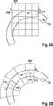
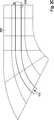
In einer Ausführungsform werden die geometrischen Formen der Zellen in Abhängigkeit ihrer Lagen bezüglich des Verlaufs der Straße bestimmt. Durch die Verwendung von Zellen, die nicht notwendiger Weise quadratisch sind, sondern beispielsweise die Form eines Rechtecks oder eines Kreissegments aufweisen, können die relevanten Informationen aus der Umgebung des Kraftfahrzeugs verbessert auf die Hinderniskarte abgebildet werden.In one embodiment, the geometric shapes of the cells are determined as a function of their positions with respect to the course of the road. By using cells that are not necessarily square, but have, for example, the shape of a rectangle or a circle segment, the relevant information from the environment of the motor vehicle can be displayed on the obstacle map in an improved manner.
In einer weiteren Ausführungsform weisen wenigstens einige Zellen eine Hauptachse auf, wobei die Hauptachsen dieser Zellen in Abhängigkeit des Verlaufs der Straße ausgerichtet sind. Ausgehend davon, dass sich das Kraftfahrzeug entlang der Straße bewegt, können sich die Zellen beispielsweise mit ihren Hauptachsen entlang der Straße erstrecken, sodass redundante Informationen nicht unnötig viel Speicherplatz für die Hinderniskarte einnehmen.In a further embodiment, at least some cells have a major axis, the major axes of these cells being aligned depending on the course of the road. For example, assuming that the motor vehicle is moving along the road, the cells may extend along the road with their major axes, so that redundant information does not take up unnecessarily much space for the obstacle card.
In einer weiteren Ausführungsform sind die Ausrichtungen der Zellen an ein Höhenprofil der Straße angepasst. Dadurch kann eine Entfernungsschätzung zwischen dem Kraftfahrzeug und dem Hindernis, insbesondere einem beweglichen Hindernis, verbessert durchgeführt werden, da nicht der Abstand in Längsoder Querrichtung des Kraftfahrzeugs geschätzt wird, sondern der tatsächliche Abstand entlang des Straßenverlaufs. Projektionsfehler können auf diese Weise verringert sein.In a further embodiment, the orientations of the cells are adapted to a height profile of the road. Thereby, a distance estimation between the motor vehicle and the obstacle, in particular a movable obstacle, can be improved, since not the distance in the longitudinal or transverse direction of the motor vehicle, but the actual distance along the course of the road. Projection errors can be reduced in this way.
Bevorzugterweise wird der Verlauf der Straße auf der Basis einer Folge von Wegpunkten interpoliert. Die Wegpunkte können beispielsweise von einem Navigationssystem bezogen werden, in dem der Verlauf der Straße abgelegt ist.Preferably, the course of the road is interpolated on the basis of a sequence of waypoints. The waypoints can for example be obtained from a navigation system in which the course of the road is stored.
In einer weiteren Ausführungsform steigt die Ausdehnung der Zellen in Bewegungsrichtung des Kraftfahrzeugs mit dem Abstand vom Kraftfahrzeug an. Je näher eine Zelle in Bewegungsrichtung des Kraftfahrzeugs am Kraftfahrzeug liegt, desto geringer ist folglich ihre Ausdehnung. Der für eine Kollisionsvermeidung besonders relevante Nahbereich des Kraftfahrzeugs kann so mit hoher Auflösung beschrieben sein, während ein weiter entfernt liegender Bereich mit geringerer Auflösung in der Hinderniskarte repräsentiert sein kann.In a further embodiment, the expansion of the cells in the direction of movement of the motor vehicle increases with the distance from the motor vehicle. The closer a cell is in the direction of movement of the motor vehicle to the motor vehicle, the lower is therefore their extent. The close range of the motor vehicle, which is particularly relevant for a collision avoidance, can thus be described with high resolution, while a region located further away with a lower resolution can be represented in the obstacle map.
Nach einem zweiten Aspekt umfasst ein Verfahren zum Steuern eines Kraftfahrzeugs Schritte des Erstellens einer Hinderniskarte mittels des oben beschriebenen Verfahrens und des Bereitstellens von Steuersignalen für das Kraftfahrzeug auf der Basis der Hinderniskarte, um eine Kollision zwischen dem Kraftfahrzeug und einem Hindernis zu vermeiden. Eine derartige Funktionalität kann beispielsweise als Fahrerassistenzsystem implementiert sein. Dabei kann insbesondere eine Vermeidung einer Kollision mit einem Gegenstand im Bereich der Straße realisiert sein.In a second aspect, a method of controlling a motor vehicle includes steps of creating an obstacle map by the method described above and providing control signals to the motor vehicle based on the obstacle map to avoid a collision between the motor vehicle and an obstacle. Such functionality may, for example, be implemented as a driver assistance system. In particular, an avoidance of a collision with an object in the area of the road can be realized.
Ein erfindungsgemäßes Computerprogrammprodukt umfasst Programmcodemittel zur Durchführung eines der beschriebenen Verfahren, wenn das Computerprogrammprodukt auf einer Verarbeitungseinrichtung abläuft oder auf einem computerlesbaren Datenträger gespeichert ist.A computer program product according to the invention comprises program code means for carrying out one of the methods described when the computer program product runs on a processing device or is stored on a computer-readable data carrier.
Nach einem weiteren Aspekt umfasst eine erfindungsgemäße Vorrichtung zur Erstellung einer Hinderniskarte einer Umgebung eines Kraftfahrzeugs auf einer Straße einen Speicher zur Aufnahme einer gerasterten Hinderniskarte, eine Abtasteinrichtung zur Abtastung einer Umgebung des Kraftfahrzeugs, wobei die Umgebung in Zellen unterteilt ist, eine Verarbeitungseinrichtung zur Erfassung von Zellen, die durch ein Hindernis belegt sind und zur Kennzeichnung von Rasterpunkten der Hinderniskarte, die zu belegten Zellen in der Umgebung korrespondieren, wobei die Verarbeitungseinrichtung ferner dazu eingerichtet ist, Ausdehnungen der Zellen in Abhängigkeit ihrer Lage bezüglich des Verlaufs der Straße zu bestimmen.According to a further aspect, an obstacle map device of an automotive environment on a road comprises a memory for receiving a screened obstacle map, a scanning device for scanning an environment of the automobile, the environment being divided into cells, processing means for detecting cells which are occupied by an obstacle and for identifying halftone dots of the obstacle card corresponding to occupied cells in the environment, wherein the processing means is further adapted to determine extensions of the cells as a function of their position with respect to the course of the road.
Die Vorrichtung kann zur effizienten Erstellung der Hinderniskarte eingerichtet sein. In einer weiteren Ausführungsform ist die Vorrichtung zusätzlich zur Auswertung der Hinderniskarte eingerichtet, wobei insbesondere eine Bereitstellung von Steuersignalen zum Beeinflussen einer Trajektorie des Kraftfahrzeugs umfasst sein kann. In einer Ausführungsform ist die Verarbeitungseinrichtung auch dazu eingerichtet, die Hinderniskarte für einen zukünftigen Zeitpunkt vorherzusagen. Die Bereitstellung der Steuersignale kann dann auf der Basis der vorhergesagten Hinderniskarte erfolgen.The device may be configured to efficiently create the obstacle card. In a further embodiment, the device is additionally set up for evaluating the obstacle card, wherein, in particular, a provision of control signals for influencing a trajectory of the motor vehicle can be included. In one embodiment, the processing device is also configured to predict the obstacle card for a future time. The provision of the control signals may then be on the basis of the predicted obstacle card.
Kurze Beschreibung der FigurenBrief description of the figures
Die Erfindung wird nun mit Bezug auf die beigefügten Figuren genauer beschrieben, in denen:The invention will now be described in more detail with reference to the attached figures, in which:
darstellt.
represents.
Genaue Beschreibung von AusführungsbeispielenDetailed description of embodiments
Die Vorrichtung
In der Darstellung von
Die Verarbeitungseinrichtung
In einer Ausführungsform ist die Verarbeitungseinrichtung
Es wird vorgeschlagen, dass die Aufteilung der Umgebung des Kraftfahrzeugs
Eine erste Zelle
Durch die Bestimmung der Ausdehnungen der Zellen
Für die Zellen
In einem ersten Schritt
In einem Schritt
In einem weiteren Schritt
In einem nachfolgenden Schritt
Auf der Basis der bereitgestellten Hinderniskarte
Anschließend kann das Verfahren zum Schritt
ZITATE ENTHALTEN IN DER BESCHREIBUNG QUOTES INCLUDE IN THE DESCRIPTION
Diese Liste der vom Anmelder aufgeführten Dokumente wurde automatisiert erzeugt und ist ausschließlich zur besseren Information des Lesers aufgenommen. Die Liste ist nicht Bestandteil der deutschen Patent- bzw. Gebrauchsmusteranmeldung. Das DPMA übernimmt keinerlei Haftung für etwaige Fehler oder Auslassungen.This list of the documents listed by the applicant has been generated automatically and is included solely for the better information of the reader. The list is not part of the German patent or utility model application. The DPMA assumes no liability for any errors or omissions.
Zitierte Nicht-PatentliteraturCited non-patent literature
- „Bayesian Occupancy Grid Filter for Dynamic Environments Using Prior Map Knowledge“, T. Gindele, S. Brechtel, J. Schröder, R. Dillmann; IEEE Intelligent Vehicles Symposium, S. 669–676, China, 2009[0004]"Bayesian Occupancy Grid Filter for Dynamic Environments Using Prior Map Knowledge", T. Gindele, S. Brechtel, J. Schröder, R. Dillmann; IEEE Intelligent Vehicles Symposium, pp. 669-676, China, 2009[0004]
Claims (9)
Translated fromGermanPriority Applications (5)
| Application Number | Priority Date | Filing Date | Title |
|---|---|---|---|
| DE102013200387.0ADE102013200387A1 (en) | 2013-01-14 | 2013-01-14 | Creation of a obstacle map |
| EP13798285.6AEP2943910B1 (en) | 2013-01-14 | 2013-11-21 | Creation of an obstacle map |
| CN201380070079.9ACN104919471B (en) | 2013-01-14 | 2013-11-21 | The building of barrier map |
| PCT/EP2013/074331WO2014108233A1 (en) | 2013-01-14 | 2013-11-21 | Creation of an obstacle map |
| US14/759,826US9738278B2 (en) | 2013-01-14 | 2013-11-21 | Creation of an obstacle map |
Applications Claiming Priority (1)
| Application Number | Priority Date | Filing Date | Title |
|---|---|---|---|
| DE102013200387.0ADE102013200387A1 (en) | 2013-01-14 | 2013-01-14 | Creation of a obstacle map |
Publications (1)
| Publication Number | Publication Date |
|---|---|
| DE102013200387A1true DE102013200387A1 (en) | 2014-07-17 |
Family
ID=49679497
Family Applications (1)
| Application Number | Title | Priority Date | Filing Date |
|---|---|---|---|
| DE102013200387.0AWithdrawnDE102013200387A1 (en) | 2013-01-14 | 2013-01-14 | Creation of a obstacle map |
Country Status (5)
| Country | Link |
|---|---|
| US (1) | US9738278B2 (en) |
| EP (1) | EP2943910B1 (en) |
| CN (1) | CN104919471B (en) |
| DE (1) | DE102013200387A1 (en) |
| WO (1) | WO2014108233A1 (en) |
Cited By (7)
| Publication number | Priority date | Publication date | Assignee | Title |
|---|---|---|---|---|
| CN105205841A (en)* | 2015-08-21 | 2015-12-30 | 通号通信信息集团有限公司 | Map generation method and system of geographic information system |
| DE102014224075A1 (en)* | 2014-11-26 | 2016-06-02 | Robert Bosch Gmbh | Method and device for assisted driving of a vehicle |
| CN109313855A (en)* | 2016-06-17 | 2019-02-05 | 罗伯特·博世有限公司 | For controlling the scheme of the traffic in parking lot |
| CN110889362A (en)* | 2019-11-21 | 2020-03-17 | 大连理工大学 | An obstacle detection method using height information of grid map |
| CN111913183A (en)* | 2020-07-27 | 2020-11-10 | 中国第一汽车股份有限公司 | Vehicle lateral obstacle avoidance method, device and equipment and vehicle |
| CN113479191A (en)* | 2021-06-30 | 2021-10-08 | 重庆长安汽车股份有限公司 | Lane-line-free lane boundary detection system and method for parking and vehicle |
| DE102013210263B4 (en)* | 2013-06-03 | 2025-06-12 | Robert Bosch Gmbh | Occupancy card for a vehicle |
Families Citing this family (34)
| Publication number | Priority date | Publication date | Assignee | Title |
|---|---|---|---|---|
| DE102013207904A1 (en)* | 2013-04-30 | 2014-10-30 | Bayerische Motoren Werke Aktiengesellschaft | Provide an efficient environment map for a vehicle |
| JP6246392B2 (en)* | 2014-12-09 | 2017-12-13 | 三菱電機株式会社 | Collision risk calculation device, collision risk display device, vehicle body control device |
| DE102015225472A1 (en)* | 2015-12-16 | 2017-06-22 | Robert Bosch Gmbh | Method and device for creating a map |
| DE102016202594A1 (en)* | 2016-02-19 | 2017-08-24 | Robert Bosch Gmbh | Method and device for interpreting a vehicle environment of a vehicle and vehicle |
| US9796390B2 (en)* | 2016-02-29 | 2017-10-24 | Faraday&Future Inc. | Vehicle sensing grid having dynamic sensing cell size |
| JP6406289B2 (en)* | 2016-03-14 | 2018-10-17 | オムロン株式会社 | Road surface shape measuring apparatus, measuring method, and program |
| DE102016204113A1 (en)* | 2016-03-14 | 2017-09-14 | Conti Temic Microelectronic Gmbh | Device and method for detecting an object |
| US10234568B2 (en)* | 2016-05-12 | 2019-03-19 | GM Global Technology Operations LLC | GNSS vehicle location involving overlapping roads |
| JP6674846B2 (en)* | 2016-05-31 | 2020-04-01 | 株式会社小松製作所 | Shape measuring system, work machine and shape measuring method |
| US10471904B2 (en) | 2016-08-08 | 2019-11-12 | Toyota Motor Engineering & Manufacturing North America, Inc. | Systems and methods for adjusting the position of sensors of an automated vehicle |
| JP6607526B2 (en)* | 2017-02-24 | 2019-11-20 | マツダ株式会社 | Vehicle driving support system and method |
| US11077756B2 (en)* | 2017-11-23 | 2021-08-03 | Intel Corporation | Area occupancy determining device |
| CN109840448A (en)* | 2017-11-24 | 2019-06-04 | 百度在线网络技术(北京)有限公司 | Information output method and device for automatic driving vehicle |
| US10303178B1 (en)* | 2017-12-15 | 2019-05-28 | Waymo Llc | Collision mitigation static occupancy grid |
| US10884422B2 (en)* | 2018-04-16 | 2021-01-05 | Baidu Usa Llc | Method for generating trajectories for autonomous driving vehicles (ADVS) |
| US11126199B2 (en)* | 2018-04-16 | 2021-09-21 | Baidu Usa Llc | Learning based speed planner for autonomous driving vehicles |
| JP7195073B2 (en)* | 2018-07-10 | 2022-12-23 | 古野電気株式会社 | graph generator |
| CN120027810A (en)* | 2019-02-25 | 2025-05-23 | 御眼视觉技术有限公司 | System and method for vehicle navigation |
| CN111717244A (en)* | 2019-12-18 | 2020-09-29 | 河南思维轨道交通技术研究院有限公司 | Train automatic driving sensing method and system |
| EP3882813B1 (en)* | 2020-03-20 | 2025-05-07 | Aptiv Technologies AG | Method for generating a dynamic occupancy grid |
| EP3888988B1 (en) | 2020-03-30 | 2024-09-04 | Aptiv Technologies AG | Method and system for determining a usable distance in front of a vehicle |
| EP3905106A1 (en) | 2020-04-27 | 2021-11-03 | Aptiv Technologies Limited | Method for determining a drivable area |
| EP3905105A1 (en)* | 2020-04-27 | 2021-11-03 | Aptiv Technologies Limited | Method for determining a collision free space |
| CN114200917B (en)* | 2020-08-27 | 2023-09-01 | 郑州宇通客车股份有限公司 | Vehicle lane change control method and device |
| US12142054B2 (en) | 2020-08-31 | 2024-11-12 | Aptiv Technologies AG | Vehicles, systems and methods for determining an occupancy map of a vicinity of a vehicle |
| EP4001962A1 (en) | 2020-11-23 | 2022-05-25 | Aptiv Technologies Limited | Free space determining device, free space determining method and free space determining program |
| EP4009228A1 (en) | 2020-12-02 | 2022-06-08 | Aptiv Technologies Limited | Method for determining a semantic free space |
| US12105192B2 (en) | 2020-12-17 | 2024-10-01 | Aptiv Technologies AG | Radar reference map generation |
| US11988741B2 (en) | 2020-12-17 | 2024-05-21 | Aptiv Technologies AG | Vehicle routing based on availability of radar-localization objects |
| US12174641B2 (en) | 2020-12-17 | 2024-12-24 | Aptiv Technologies AG | Vehicle localization based on radar detections |
| DE102021203809B4 (en)* | 2021-03-16 | 2023-05-04 | Continental Autonomous Mobility Germany GmbH | Driving course estimation in an environment model |
| US20230003533A1 (en)* | 2021-06-30 | 2023-01-05 | Motional Ad Llc | Fast collision free path generation by connecting c-slices through cell decomposition |
| US11810459B1 (en) | 2022-05-09 | 2023-11-07 | Aptiv Technologies Limited | Vehicle localization based on radar detections in garages |
| CN119299956B (en)* | 2024-10-09 | 2025-09-30 | 清华大学深圳国际研究生院 | A method and system for constructing and optimizing environmental maps based on ultra-wideband (UWB) |
Family Cites Families (21)
| Publication number | Priority date | Publication date | Assignee | Title |
|---|---|---|---|---|
| IT1240974B (en)* | 1990-07-05 | 1993-12-27 | Fiat Ricerche | METHOD AND EQUIPMENT TO AVOID THE COLLISION OF A VEHICLE AGAINST OBSTACLES. |
| JPH05265547A (en)* | 1992-03-23 | 1993-10-15 | Fuji Heavy Ind Ltd | On-vehicle outside monitoring device |
| CN1490201A (en)* | 2002-10-18 | 2004-04-21 | ���µ�����ҵ��ʽ���� | Movable vehicle obstacle testing method and device, obstacle testing, emergency treating method device and device thereof |
| US7424133B2 (en)* | 2002-11-08 | 2008-09-09 | Pictometry International Corporation | Method and apparatus for capturing, geolocating and measuring oblique images |
| JP4609695B2 (en)* | 2003-10-21 | 2011-01-12 | 日本精機株式会社 | Vehicle display device |
| JP2005219727A (en)* | 2004-01-08 | 2005-08-18 | Denso Corp | Collision protecting apparatus for vehicle |
| US7266477B2 (en)* | 2005-06-22 | 2007-09-04 | Deere & Company | Method and system for sensor signal fusion |
| JP4809019B2 (en)* | 2005-08-31 | 2011-11-02 | クラリオン株式会社 | Obstacle detection device for vehicle |
| US8050863B2 (en)* | 2006-03-16 | 2011-11-01 | Gray & Company, Inc. | Navigation and control system for autonomous vehicles |
| JP4994256B2 (en)* | 2008-01-28 | 2012-08-08 | 株式会社ジオ技術研究所 | Data structure of route guidance database |
| US8054201B2 (en)* | 2008-03-19 | 2011-11-08 | Mazda Motor Corporation | Surroundings monitoring device for vehicle |
| JP4582170B2 (en)* | 2008-03-27 | 2010-11-17 | トヨタ自動車株式会社 | Gradient information calculation device, vehicle travel control device, navigation system |
| US8611585B2 (en)* | 2008-04-24 | 2013-12-17 | GM Global Technology Operations LLC | Clear path detection using patch approach |
| US8725474B2 (en)* | 2008-10-01 | 2014-05-13 | Navteq B.V. | Bezier curves for advanced driver assistance system applications |
| US20110228980A1 (en) | 2009-10-07 | 2011-09-22 | Panasonic Corporation | Control apparatus and vehicle surrounding monitoring apparatus |
| JP5312367B2 (en)* | 2010-02-12 | 2013-10-09 | 村田機械株式会社 | Traveling cart system |
| JP5206752B2 (en)* | 2010-08-30 | 2013-06-12 | 株式会社デンソー | Driving environment recognition device |
| DE102011078615B4 (en)* | 2011-07-04 | 2022-07-14 | Toyota Jidosha Kabushiki Kaisha | OBJECT DETECTION DEVICE AND OBJECT DETECTION PROGRAM |
| KR20130127822A (en)* | 2012-05-15 | 2013-11-25 | 한국전자통신연구원 | Apparatus and method of processing heterogeneous sensor fusion for classifying and positioning object on road |
| US8930060B1 (en)* | 2013-07-15 | 2015-01-06 | Ford Global Technologies | Post-impact path assist for vehicles |
| US9216745B2 (en)* | 2013-09-16 | 2015-12-22 | Disney Enterprises, Inc. | Shared control of semi-autonomous vehicles including collision avoidance in multi-agent scenarios |
- 2013
- 2013-01-14DEDE102013200387.0Apatent/DE102013200387A1/ennot_activeWithdrawn
- 2013-11-21USUS14/759,826patent/US9738278B2/enactiveActive
- 2013-11-21WOPCT/EP2013/074331patent/WO2014108233A1/enactiveApplication Filing
- 2013-11-21EPEP13798285.6Apatent/EP2943910B1/enactiveActive
- 2013-11-21CNCN201380070079.9Apatent/CN104919471B/enactiveActive
Non-Patent Citations (1)
| Title |
|---|
| "Bayesian Occupancy Grid Filter for Dynamic Environments Using Prior Map Knowledge", T. Gindele, S. Brechtel, J. Schröder, R. Dillmann; IEEE Intelligent Vehicles Symposium, S. 669-676, China, 2009 |
Cited By (9)
| Publication number | Priority date | Publication date | Assignee | Title |
|---|---|---|---|---|
| DE102013210263B4 (en)* | 2013-06-03 | 2025-06-12 | Robert Bosch Gmbh | Occupancy card for a vehicle |
| DE102014224075A1 (en)* | 2014-11-26 | 2016-06-02 | Robert Bosch Gmbh | Method and device for assisted driving of a vehicle |
| CN105205841A (en)* | 2015-08-21 | 2015-12-30 | 通号通信信息集团有限公司 | Map generation method and system of geographic information system |
| CN105205841B (en)* | 2015-08-21 | 2018-05-25 | 通号通信信息集团有限公司 | The ground drawing generating method and system of GIS-Geographic Information System |
| CN109313855A (en)* | 2016-06-17 | 2019-02-05 | 罗伯特·博世有限公司 | For controlling the scheme of the traffic in parking lot |
| CN110889362A (en)* | 2019-11-21 | 2020-03-17 | 大连理工大学 | An obstacle detection method using height information of grid map |
| CN111913183A (en)* | 2020-07-27 | 2020-11-10 | 中国第一汽车股份有限公司 | Vehicle lateral obstacle avoidance method, device and equipment and vehicle |
| CN113479191A (en)* | 2021-06-30 | 2021-10-08 | 重庆长安汽车股份有限公司 | Lane-line-free lane boundary detection system and method for parking and vehicle |
| CN113479191B (en)* | 2021-06-30 | 2023-04-07 | 重庆长安汽车股份有限公司 | Lane-line-free lane boundary detection system and method for parking and vehicle |
Also Published As
| Publication number | Publication date |
|---|---|
| EP2943910A1 (en) | 2015-11-18 |
| EP2943910B1 (en) | 2016-10-05 |
| US20150353083A1 (en) | 2015-12-10 |
| CN104919471A (en) | 2015-09-16 |
| WO2014108233A1 (en) | 2014-07-17 |
| CN104919471B (en) | 2019-05-07 |
| US9738278B2 (en) | 2017-08-22 |
Similar Documents
| Publication | Publication Date | Title |
|---|---|---|
| EP2943910B1 (en) | Creation of an obstacle map | |
| DE102013018315B4 (en) | Environment model with adaptive grid | |
| EP3438901A1 (en) | Test drive scenario database system for realistic virtual test drive scenarios | |
| EP4238077B1 (en) | Method for providing information about road users | |
| EP3142913B1 (en) | Surroundings map for driving surface with any height profil | |
| EP3063732B1 (en) | Situation analysis for a driver assistance system | |
| DE102014208009A1 (en) | Capture static and dynamic objects | |
| DE102011111440A1 (en) | Method for representation of environment of vehicle, involves forming segments of same width from image points of equal distance in one of image planes, and modeling objects present outside free space in environment | |
| DE102018111935A1 (en) | Image processing system, image processing method, information processing apparatus and recording medium | |
| DE102019216235A1 (en) | Method for predicting the movement of a vehicle and at least one further vehicle | |
| DE102017206344A1 (en) | Driver assistance system for a vehicle | |
| EP2963631A1 (en) | Method for determining a parking space from a number of measuring points | |
| DE102013214632A1 (en) | Efficient provision of occupancy information for the environment of a vehicle | |
| DE102022119715A1 (en) | Method, system and computer program product for objectively evaluating the performance of an ADAS/ADS system | |
| DE102019119002A1 (en) | Determining a lane boundary | |
| EP2353958B1 (en) | Method for evaluating sensor data of the surroundings of a motor vehicle from at least one environment sensor and motor vehicle | |
| DE102021213538A1 (en) | Simulation to validate an automated driving function for a vehicle | |
| DE102019204196B4 (en) | Method for detecting the surroundings of a means of locomotion | |
| DE102020213496A1 (en) | Validation of lane lane models based on swarm data | |
| DE112020003817T5 (en) | OCCUPANCY GRID MAP MANAGEMENT DEVICE | |
| DE102019200129A1 (en) | Device and method for modeling an environment of a vehicle | |
| DE102021119319B4 (en) | Device and method for detecting and/or representing a signaling unit | |
| DE102019217586B4 (en) | Determination of a discrete representation of a road section in front of a vehicle | |
| DE102022000849A1 (en) | Method for generating an environment representation for a vehicle | |
| DE102017209977A1 (en) | Method and apparatus for determining a free object space and generating a defined boundary |
Legal Events
| Date | Code | Title | Description |
|---|---|---|---|
| R012 | Request for examination validly filed | ||
| R119 | Application deemed withdrawn, or ip right lapsed, due to non-payment of renewal fee |