CN201955092U - Platform type inertial navigation device based on geomagnetic assistance - Google Patents
Platform type inertial navigation device based on geomagnetic assistanceDownload PDFInfo
- Publication number
- CN201955092U CN201955092UCN 201120067040CN201120067040UCN201955092UCN 201955092 UCN201955092 UCN 201955092UCN 201120067040CN201120067040CN 201120067040CN 201120067040 UCN201120067040 UCN 201120067040UCN 201955092 UCN201955092 UCN 201955092U
- Authority
- CN
- China
- Prior art keywords
- inertial navigation
- navigation system
- platform
- geomagnetic
- navigation
- Prior art date
- Legal status (The legal status is an assumption and is not a legal conclusion. Google has not performed a legal analysis and makes no representation as to the accuracy of the status listed.)
- Expired - Fee Related
Links
- 238000004364calculation methodMethods0.000claimsabstractdescription9
- 239000000835fiberSubstances0.000claimsdescription5
- 239000010453quartzSubstances0.000claimsdescription5
- VYPSYNLAJGMNEJ-UHFFFAOYSA-Nsilicon dioxideInorganic materialsO=[Si]=OVYPSYNLAJGMNEJ-UHFFFAOYSA-N0.000claimsdescription5
- 230000005389magnetismEffects0.000claims5
- 230000008901benefitEffects0.000description5
- 238000012937correctionMethods0.000description5
- 238000000034methodMethods0.000description5
- 238000010586diagramMethods0.000description3
- 238000009434installationMethods0.000description3
- 230000008569processEffects0.000description3
- 230000001133accelerationEffects0.000description2
- 238000005259measurementMethods0.000description2
- 238000007792additionMethods0.000description1
- 238000004422calculation algorithmMethods0.000description1
- 238000013461designMethods0.000description1
- 238000011161developmentMethods0.000description1
- 230000018109developmental processEffects0.000description1
- 230000010354integrationEffects0.000description1
- 239000007788liquidSubstances0.000description1
- 230000007774longtermEffects0.000description1
- 238000012423maintenanceMethods0.000description1
- 238000012986modificationMethods0.000description1
- 230000004048modificationEffects0.000description1
- 230000003287optical effectEffects0.000description1
- 230000007903penetration abilityEffects0.000description1
- 230000008092positive effectEffects0.000description1
- 238000005295random walkMethods0.000description1
- 230000004044responseEffects0.000description1
- 230000035945sensitivityEffects0.000description1
Images

Landscapes
- Navigation (AREA)
Abstract
Translated fromChineseDescription
Translated fromChinese技术领域technical field
本实用新型涉及平台式惯性导航装置领域,具体地讲,涉及一种基于地磁辅助的平台式惯性导航装置。The utility model relates to the field of platform inertial navigation devices, in particular to a platform type inertial navigation device based on geomagnetic assistance.
背景技术Background technique
惯性导航系统是一种完全自主的导航系统,它不需要任何外部信息就可独立地完成运载体的导航任务,所以它比起诸如天文导航、无线电导航、多普勒导航、仪表导航以及地标导航等方式来说,具有其独特的优点:它不受外界(自然的或人工的)干扰因素的影响,因而它在导航事业发展的现阶段占有极其重要的地位。现代新型的航空、航天以及航海运载体大多是用它或用以它为中心的组合式导航系统进行导航。Inertial navigation system is a completely autonomous navigation system, it can independently complete the navigation task of the carrier without any external information, so it is compared with such as astronomical navigation, radio navigation, Doppler navigation, instrument navigation and landmark navigation In other ways, it has its unique advantages: it is not affected by external (natural or artificial) interference factors, so it occupies an extremely important position in the current stage of navigation development. Most of the modern new aviation, spaceflight and navigation vehicles use it or use it as the center of the combined navigation system for navigation.
惯性导航系统有平台式和捷联式两类。平台式惯导使用惯导平台来模拟导航坐标系,具有导航精度高的优点。而捷联式惯导将加速度计和陀螺仪直接固连在载体上,惯导平台的功能直接由计算机来完成。这使得捷联式惯导系统具有体积小、重量轻、成本低和便于安装维护的优点,但缺点是导航精度较低。目前,在高精度导航应用领域,平台式惯性导航系统应用较多。There are two types of inertial navigation systems: platform and strapdown. The platform inertial navigation uses the inertial navigation platform to simulate the navigation coordinate system, which has the advantage of high navigation accuracy. The strapdown inertial navigation directly connects the accelerometer and gyroscope to the carrier, and the functions of the inertial navigation platform are directly completed by the computer. This makes the strapdown inertial navigation system have the advantages of small size, light weight, low cost and easy installation and maintenance, but the disadvantage is that the navigation accuracy is low. At present, in the field of high-precision navigation applications, platform inertial navigation systems are widely used.
平台式惯性导航系统属于一种推算导航方式,即从一已知点的位置根据连续测得的运载体航向角和速度推算出其下一点的位置,因而可连续测出运动体的当前位置。惯性导航系统中的陀螺仪用来形成一个导航坐标系使加速度计的测量轴稳定在该坐标系中并给出航向和姿态角;加速度计用来测量运动体的加速度经过对时间的一次积分得到速度,速度再经过对时间的一次积分即可得到距离。从平台式惯性导航系统的积分工作过程可以看出,该系统在长时间工作过程中定位误差会随着时间的增加而增长。The platform inertial navigation system belongs to a reckoning navigation method, that is, the position of the next point is calculated from the position of a known point based on the continuously measured heading angle and velocity of the carrier, so that the current position of the moving body can be continuously measured. The gyroscope in the inertial navigation system is used to form a navigation coordinate system to stabilize the measurement axis of the accelerometer in this coordinate system and to give the heading and attitude angle; the accelerometer is used to measure the acceleration of the moving body after an integration of time. Velocity, and the distance can be obtained by integrating the velocity with time. It can be seen from the integral working process of the platform inertial navigation system that the positioning error of the system will increase with time during the long-term working process.
目前常用的解决方法为引入外部参考信息进行校正,一般将GPS信息作为校正参考信息,每隔一段时间用GPS系统输出的速度、位置信息来校正惯性导航系统的速度、位置信息,该方法将GPS接收机和惯导系统安装在一起,通过计算机控制实现GPS信息对惯性导航系统的校正。At present, the commonly used solution is to introduce external reference information for correction. Generally, GPS information is used as correction reference information, and the speed and position information output by the GPS system are used to correct the speed and position information of the inertial navigation system every once in a while. The receiver and the inertial navigation system are installed together, and the correction of the GPS information to the inertial navigation system is realized through computer control.
GPS辅助惯性导航系统中GPS的电波穿透能力差,几乎不能用于潜艇、矿井等水下或地下导航用户,而且有建筑、地形的遮挡时会严重影响导航精度;GPS的动态跟踪能力比较低,当载体作大机动运动时,环路极易失锁,产生“跳周”现象,GPS信号会完全丢失,因此会导致系统导航精度下降;GPS属非自主式定位,其应用受到美国政府的GPS政策和外界环境等多方面的限制。此为现有技术的不足之处。In the GPS-assisted inertial navigation system, the radio wave penetration ability of GPS is poor, and it can hardly be used for underwater or underground navigation users such as submarines and mines, and the navigation accuracy will be seriously affected when there are buildings and terrain occlusions; the dynamic tracking ability of GPS is relatively low , when the carrier makes a large maneuvering movement, the loop is very easy to lose the lock, resulting in a "skip cycle" phenomenon, and the GPS signal will be completely lost, which will lead to a decrease in the system navigation accuracy; GPS is a non-autonomous positioning, and its application is restricted by the US government There are many restrictions such as GPS policy and external environment. This is the weak point of prior art.
实用新型内容Utility model content
本实用新型要解决的技术问题是提供一种基于地磁辅助的平台式惯性导航装置。The technical problem to be solved by the utility model is to provide a platform type inertial navigation device based on geomagnetic assistance.
本实用新型采用如下技术手段实现发明目的:The utility model adopts following technical means to realize the purpose of the invention:
一种基于地磁辅助的平台式惯性导航装置,包括惯性导航系统和与其连接的导航解算计算机,其特征是:所述导航解算计算机连接磁强计。A platform-type inertial navigation device based on geomagnetic assistance, including an inertial navigation system and a navigation calculation computer connected to it, is characterized in that: the navigation calculation computer is connected to a magnetometer.
作为对本技术方案的进一步限定,所述磁强计为三分量高精度磁通门磁强计。As a further limitation of the technical solution, the magnetometer is a three-component high-precision fluxgate magnetometer.
作为对本技术方案的进一步限定,所述惯性导航系统包括惯性平台、三个陀螺仪和三个加速度计。As a further limitation to the technical solution, the inertial navigation system includes an inertial platform, three gyroscopes and three accelerometers.
作为对本技术方案的进一步限定,所述陀螺仪为VG095M型光纤陀螺仪.As a further limitation to this technical solution, the gyroscope is a VG095M fiber optic gyroscope.
作为对本技术方案的进一步限定,所述加速度计为JHT-II-C型石英挠性加速度计。As a further limitation of the technical solution, the accelerometer is a JHT-II-C quartz flexible accelerometer.
与现有技术相比,本实用新型的优点和积极效果是:本实用新型将通过磁强计测量得到的地磁信息引入到平台式惯性导航系统中,每隔一段时间对惯性导航系统的定位信息进行校正,从而提高导航系统的精度。地磁辅助惯性导航系统动态跟踪能力较好,不会发生信号丢失等问题,能保持较高的导航精度;地磁辅助惯性导航系统属于完全自主式导航,不收外界的控制,也不向外界发送信号,因此隐蔽性好,自主性强。Compared with the prior art, the advantages and positive effects of the utility model are: the utility model introduces the geomagnetic information measured by the magnetometer into the platform inertial navigation system, and the positioning information of the inertial navigation system is checked every once in a while. Corrections are made to improve the accuracy of the navigation system. The geomagnetic-assisted inertial navigation system has good dynamic tracking ability, no signal loss and other problems, and can maintain high navigation accuracy; the geomagnetic-assisted inertial navigation system is a completely autonomous navigation, which does not accept external control or send signals to the outside world , so the concealment is good and the autonomy is strong.
附图说明Description of drawings
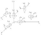
图1为本实用新型优选实施例的结构方框图。Fig. 1 is a structural block diagram of a preferred embodiment of the present utility model.
图2为惯性导航系统的光线陀螺仪的安装结构示意图。Fig. 2 is a schematic diagram of the installation structure of the optical gyroscope of the inertial navigation system.
图3为惯性导航系统的扰性加速度计安装结构示意图。Fig. 3 is a schematic diagram of the installation structure of the disturbance accelerometer of the inertial navigation system.
图2中, 


图3中,

具体实施方式Detailed ways
下面结合附图和优选实施例对本实用新型作更进一步的详细描述。Below in conjunction with accompanying drawing and preferred embodiment the utility model is described in further detail.
参见图1、图2、图3,本实用新型包括一种基于地磁辅助的平台式惯性导航装置,包括惯性导航系统和与其连接的导航解算计算机,所述导航解算计算机连接磁强计。所述磁强计为三分量高精度磁通门磁强计,所述惯性导航系统包括惯性平台、三个陀螺仪和三个加速度计,所述陀螺仪为VG095M型光纤陀螺仪,所述加速度计为JHT-II-C型石英挠性加速度计。Referring to Fig. 1, Fig. 2 and Fig. 3, the utility model includes a platform-type inertial navigation device based on geomagnetic assistance, including an inertial navigation system and a navigation solution computer connected thereto, and the navigation solution computer is connected to a magnetometer. The magnetometer is a three-component high-precision fluxgate magnetometer, the inertial navigation system includes an inertial platform, three gyroscopes and three accelerometers, the gyroscope is a VG095M type fiber optic gyroscope, and the acceleration The meter is a JHT-II-C quartz flexible accelerometer.
磁强计采用MAG-9300T型三分量高精度磁通门磁强计,具有灵敏度高、测量范围宽、稳定性好、便携式设计等一系列的优点。产品主要技术参数为:在100000nT的磁场下,分辨率≤1nT;基本精度达到±0.25% ;数据更新速率:2.5次/秒;频率响应:DC~10Hz。The magnetometer adopts the MAG-9300T three-component high-precision fluxgate magnetometer, which has a series of advantages such as high sensitivity, wide measurement range, good stability, and portable design. The main technical parameters of the product are: under a magnetic field of 100000nT, the resolution is ≤1nT; the basic accuracy reaches ±0.25%; the data update rate: 2.5 times/s; the frequency response: DC~10Hz.
惯性导航系统中,惯性平台采用精度较高的液浮平台;加速度计采用JHT-II-C型石英挠性加速度计,其主要技术参数为:偏值≤15 mg,偏值温度系数≤50μg/℃,标度因数3±0.5 mA/g,标度因数温度系数≤200 ppm/℃;陀螺仪采用VG095M型光纤陀螺仪,其主要技术参数为:零偏稳定性≤15 deg/h,比例系数≤12mV/deg/s,比例系数稳定性≤0.1 %,随机游走≤0.1 deg/ h2,测量范围≤300 deg/s。In the inertial navigation system, the inertial platform adopts a high-precision liquid floating platform; the accelerometer adopts the JHT-II-C quartz flexible accelerometer, and its main technical parameters are: bias ≤ 15 mg, bias temperature coefficient ≤ 50μg/ ℃, scale factor 3±0.5 mA/g, temperature coefficient of scale factor ≤200 ppm/℃; gyroscope adopts VG095M fiber optic gyroscope, its main technical parameters are: zero bias stability ≤15 deg/h, proportional coefficient ≤12mV/deg/s, proportional coefficient stability≤0.1%, random walk≤0.1 deg/ h2 , measuring range≤300 deg/s.
本实用新型的工作流程为:磁强计将测得的地磁信息发送到导航解算计算机,导航解算计算机也能够获得惯性导航系统中的速度、位置信息,计算机根据事先设置的地磁匹配算法进行计算,得到速度、位置反馈信息,发送到惯性导航系统进行校正。The working process of the utility model is: the magnetometer sends the measured geomagnetic information to the navigation calculation computer, and the navigation calculation computer can also obtain the speed and position information in the inertial navigation system, and the computer performs the calculation according to the geomagnetic matching algorithm set in advance. Calculate, obtain speed and position feedback information, and send it to the inertial navigation system for correction.
当然,上述说明并非对本实用新型的限制,本实用新型也不仅限于上述举例,本技术领域的普通技术人员在本实用新型的实质范围内所做出的变化、改型、添加或替换,也属于本实用新型的保护范围。Of course, the above descriptions are not limitations of the present utility model, and the present utility model is not limited to the above-mentioned examples. Changes, modifications, additions or replacements made by those of ordinary skill in the art within the essential scope of the present utility model also belong to Protection scope of the present utility model.
Claims (5)
Priority Applications (1)
| Application Number | Priority Date | Filing Date | Title |
|---|---|---|---|
| CN 201120067040CN201955092U (en) | 2011-03-15 | 2011-03-15 | Platform type inertial navigation device based on geomagnetic assistance |
Applications Claiming Priority (1)
| Application Number | Priority Date | Filing Date | Title |
|---|---|---|---|
| CN 201120067040CN201955092U (en) | 2011-03-15 | 2011-03-15 | Platform type inertial navigation device based on geomagnetic assistance |
Publications (1)
| Publication Number | Publication Date |
|---|---|
| CN201955092Utrue CN201955092U (en) | 2011-08-31 |
Family
ID=44499201
Family Applications (1)
| Application Number | Title | Priority Date | Filing Date |
|---|---|---|---|
| CN 201120067040Expired - Fee RelatedCN201955092U (en) | 2011-03-15 | 2011-03-15 | Platform type inertial navigation device based on geomagnetic assistance |
Country Status (1)
| Country | Link |
|---|---|
| CN (1) | CN201955092U (en) |
Cited By (10)
| Publication number | Priority date | Publication date | Assignee | Title |
|---|---|---|---|---|
| CN103076016A (en)* | 2012-12-29 | 2013-05-01 | 中国船舶重工集团公司第七一○研究所 | System for positioning mobile carrier |
| CN103940425A (en)* | 2014-04-22 | 2014-07-23 | 北京信息科技大学 | Magnetic-inertial combination strapdown measuring method |
| CN103968840A (en)* | 2014-05-22 | 2014-08-06 | 北京航天控制仪器研究所 | All-digital control platform type inertial navigation system |
| CN104634346A (en)* | 2015-02-13 | 2015-05-20 | 西安应用光学研究所 | Gesture detection method for photoelectric platform based on fiber-optic gyroscopes |
| CN105043387A (en)* | 2015-06-26 | 2015-11-11 | 武汉科技大学 | Personal indoor positioning system based on inertial navigation aiding geomagnetism |
| CN108120854A (en)* | 2016-11-30 | 2018-06-05 | 北京航天计量测试技术研究所 | A kind of inertial platform electric signal method for automatic measurement |
| CN109029455A (en)* | 2018-07-17 | 2018-12-18 | 济南浪潮高新科技投资发展有限公司 | A kind of indoor navigation method |
| CN109100768A (en)* | 2018-08-01 | 2018-12-28 | 南京科远自动化集团股份有限公司 | A kind of synthesized positioning method and positioning label |
| CN109579768A (en)* | 2017-09-29 | 2019-04-05 | 北京航空航天大学 | A kind of direct measuring method of inertially stabilized platform and passive damper relative rotation angle |
| CN110948478A (en)* | 2018-09-26 | 2020-04-03 | 上海云绅智能科技有限公司 | Method for controlling activity in designated area and robot |
- 2011
- 2011-03-15CNCN 201120067040patent/CN201955092U/ennot_activeExpired - Fee Related
Cited By (13)
| Publication number | Priority date | Publication date | Assignee | Title |
|---|---|---|---|---|
| CN103076016A (en)* | 2012-12-29 | 2013-05-01 | 中国船舶重工集团公司第七一○研究所 | System for positioning mobile carrier |
| CN103940425B (en)* | 2014-04-22 | 2017-03-01 | 北京信息科技大学 | A kind of magnetic inertia combines Strapdown inertial measurement method |
| CN103940425A (en)* | 2014-04-22 | 2014-07-23 | 北京信息科技大学 | Magnetic-inertial combination strapdown measuring method |
| CN103968840A (en)* | 2014-05-22 | 2014-08-06 | 北京航天控制仪器研究所 | All-digital control platform type inertial navigation system |
| CN104634346B (en)* | 2015-02-13 | 2017-04-19 | 西安应用光学研究所 | Gesture detection method for photoelectric platform based on fiber-optic gyroscopes |
| CN104634346A (en)* | 2015-02-13 | 2015-05-20 | 西安应用光学研究所 | Gesture detection method for photoelectric platform based on fiber-optic gyroscopes |
| CN105043387A (en)* | 2015-06-26 | 2015-11-11 | 武汉科技大学 | Personal indoor positioning system based on inertial navigation aiding geomagnetism |
| CN108120854A (en)* | 2016-11-30 | 2018-06-05 | 北京航天计量测试技术研究所 | A kind of inertial platform electric signal method for automatic measurement |
| CN109579768A (en)* | 2017-09-29 | 2019-04-05 | 北京航空航天大学 | A kind of direct measuring method of inertially stabilized platform and passive damper relative rotation angle |
| CN109029455A (en)* | 2018-07-17 | 2018-12-18 | 济南浪潮高新科技投资发展有限公司 | A kind of indoor navigation method |
| CN109100768A (en)* | 2018-08-01 | 2018-12-28 | 南京科远自动化集团股份有限公司 | A kind of synthesized positioning method and positioning label |
| CN109100768B (en)* | 2018-08-01 | 2020-08-14 | 南京科远智慧科技集团股份有限公司 | Comprehensive positioning method and positioning label |
| CN110948478A (en)* | 2018-09-26 | 2020-04-03 | 上海云绅智能科技有限公司 | Method for controlling activity in designated area and robot |
Similar Documents
| Publication | Publication Date | Title |
|---|---|---|
| CN201955092U (en) | Platform type inertial navigation device based on geomagnetic assistance | |
| CN105021192B (en) | A kind of implementation method of the integrated navigation system based on zero-speed correction | |
| CN104374388B (en) | Flight attitude determining method based on polarized light sensor | |
| CN106052682B (en) | A kind of hybrid inertial navigation system and air navigation aid | |
| CN110553646A (en) | Pedestrian navigation method based on inertia, magnetic heading and zero-speed correction | |
| CN106441357B (en) | An Axial Gyro Drift Correction Method for Single-axis Rotating SINS Based on Damping Network | |
| CN103743413B (en) | Heeling condition modulated is sought northern instrument alignment error On-line Estimation and is sought northern error compensating method | |
| CN110057356B (en) | Method and device for locating vehicle in tunnel | |
| CN105203129A (en) | Initial alignment method of inertial navigation device | |
| CN110044378A (en) | A kind of fiber strapdown inertial navigation high-accuracy position system and method for underwater bathyscaph | |
| CN106500721B (en) | A Dual Redundant Attitude Detection System for Underwater Robots | |
| CN104006787A (en) | High-precision attitude determination method for spacecraft attitude motion simulation platform | |
| CN104697520B (en) | Integrated gyro free strap down inertial navigation system and gps system Combinated navigation method | |
| CN103439727B (en) | A kind of measuring method of ground coordinate | |
| CN111024070A (en) | Inertial foot binding type pedestrian positioning method based on course self-observation | |
| CN103994763A (en) | SINS (Ship's Inertial Navigation System)/CNS (Celestial Navigation System) deep integrated navigation system of mar rover, and realization method of system | |
| CN102207386A (en) | North-finding method based on orientation effect error compensation | |
| CN103104251A (en) | Method used for improving accuracy of azimuthal angle and tool face angle of small well inclined downward fiber-optic gyroscope inclinometer | |
| CN101183004A (en) | A Method for Eliminating Oscillation Errors of Fiber Optic Gyro Strapdown Inertial Navigation System Online and Real Time | |
| CN104864874B (en) | A kind of inexpensive single gyro dead reckoning navigation method and system | |
| CN105910623B (en) | The method for carrying out the correction of course using magnetometer assisted GNSS/MINS tight integration systems | |
| RU2443978C1 (en) | Method of determining spatial coordinates of mobile objects and integrated navigation system for realising said method | |
| CN107063254A (en) | A kind of attitude algorithm method of gyro earth magnetism combination | |
| CN105928515A (en) | Navigation system for unmanned plane | |
| Gao et al. | An integrated land vehicle navigation system based on context awareness |
Legal Events
| Date | Code | Title | Description |
|---|---|---|---|
| C14 | Grant of patent or utility model | ||
| GR01 | Patent grant | ||
| C17 | Cessation of patent right | ||
| CF01 | Termination of patent right due to non-payment of annual fee | Granted publication date:20110831 Termination date:20120315 |