CN1327248C - Method for Determining Vertical and Horizontal Resistivity and Relative Dip in Anisotropic Formation - Google Patents
Method for Determining Vertical and Horizontal Resistivity and Relative Dip in Anisotropic FormationDownload PDFInfo
- Publication number
- CN1327248C CN1327248CCNB2003801082776ACN200380108277ACN1327248CCN 1327248 CCN1327248 CCN 1327248CCN B2003801082776 ACNB2003801082776 ACN B2003801082776ACN 200380108277 ACN200380108277 ACN 200380108277ACN 1327248 CCN1327248 CCN 1327248C
- Authority
- CN
- China
- Prior art keywords
- resistivity
- measurements
- prime
- formation
- borehole
- Prior art date
- Legal status (The legal status is an assumption and is not a legal conclusion. Google has not performed a legal analysis and makes no representation as to the accuracy of the status listed.)
- Expired - Fee Related
Links
Images


Classifications
- G—PHYSICS
- G01—MEASURING; TESTING
- G01V—GEOPHYSICS; GRAVITATIONAL MEASUREMENTS; DETECTING MASSES OR OBJECTS; TAGS
- G01V3/00—Electric or magnetic prospecting or detecting; Measuring magnetic field characteristics of the earth, e.g. declination, deviation
- G01V3/18—Electric or magnetic prospecting or detecting; Measuring magnetic field characteristics of the earth, e.g. declination, deviation specially adapted for well-logging
- G01V3/26—Electric or magnetic prospecting or detecting; Measuring magnetic field characteristics of the earth, e.g. declination, deviation specially adapted for well-logging operating with magnetic or electric fields produced or modified either by the surrounding earth formation or by the detecting device
- G01V3/28—Electric or magnetic prospecting or detecting; Measuring magnetic field characteristics of the earth, e.g. declination, deviation specially adapted for well-logging operating with magnetic or electric fields produced or modified either by the surrounding earth formation or by the detecting device using induction coils
Landscapes
- Physics & Mathematics (AREA)
- Engineering & Computer Science (AREA)
- Remote Sensing (AREA)
- Life Sciences & Earth Sciences (AREA)
- Electromagnetism (AREA)
- Environmental & Geological Engineering (AREA)
- Geology (AREA)
- General Life Sciences & Earth Sciences (AREA)
- General Physics & Mathematics (AREA)
- Geophysics (AREA)
- Geophysics And Detection Of Objects (AREA)
- Investigation Of Foundation Soil And Reinforcement Of Foundation Soil By Compacting Or Drainage (AREA)
Abstract
Description
Translated fromChinese技术领域technical field
本发明涉及对钻井环境内所关心参数的测量。更具体地,本发明涉及在确定各向异性地层钻眼内电阻率值和相对倾斜时使用的装置和方法。The present invention relates to the measurement of parameters of interest within the drilling environment. More specifically, the present invention relates to apparatus and methods for use in determining resistivity values and relative dips in boreholes in anisotropic formations.
背景技术Background technique
通常,应用电磁感应和电波传播的测井工具确定钻眼周围地层的电特性。此类测井工具可给出地层视在电阻率(或电导率)的测量值,通过适当分析,可用于判断地层的石油物理特性以及其中的气体。Typically, logging tools employing electromagnetic induction and propagation of electrical waves determine the electrical properties of the formations surrounding the borehole. Such logging tools give measurements of the formation's apparent resistivity (or conductivity), which, with proper analysis, can be used to determine the petrophysical properties of the formation and the gases within it.
电磁感应电阻率测井术的物理原理例如说明于1949年Richardson Tex.石油工程师协会的石油技术杂志vol.1 p.148上H.G.Doll的论文“感应测井介绍及其应用于泥浆采油钻井测量”。自从上述Doll论文发表以来,对电磁感应电阻率测量仪器已作出许多改进和修正。此类修正和改进的例子例如可以在颁给Barber的美国专利No.4,837,517、颁给Chandler等人的美国专利No.5,157,605和颁给Beard等人的美国专利No.5,452,761中见到。The physical principles of electromagnetic induction resistivity logging are e.g. described in the 1949 Richardson Tex. Petroleum Technical Journal of the Society of Petroleum Engineers vol.1 p.148 in H.G. Doll's paper "Introduction to Induction Logging and Its Application to Mud Oil Production Drilling Measurements" . Since the publication of the above-mentioned Doll paper, many improvements and modifications have been made to the electromagnetic induction resistivity measuring instrument. Examples of such corrections and improvements can be found, for example, in US Patent No. 4,837,517 to Barber, US Patent No. 5,157,605 to Chandler et al., and US Patent No. 5,452,761 to Beard et al.
其内容完全引入于此供参考的Beard等人的美国专利No.5,452,761中,公开了一种由感应测井工具对接收的信号进行数字处理的装置和方法,它包含一个发射机和多个接收机。由发射机发出振荡信号,它在频域、时域或频域的域组合域内引起周围地层内产生涡流。涡流大小与地层电导率成比例。涡流在接收机中转而产生感应电压,在比之所关心最高频率运动更高的采样频率上使接收的感应电压数字化。奈奎斯特采样准则规定,采样频率应是待数字化的信号中存在的最高频率的至少两倍以上。数字化的窗口与振荡电流信号的周期同步。在频域内观测时,振荡电流可以是各个正弦频率的组合,在时域内观测时,可以是重复性的瞬时电流源。时域观测中,测量数据需变换到频域内再作出电阻率测量的数据分析和处理,经转换后可确定地层电阻率模型的电阻率特性和结构特点。在很大数目的此种周期上累积相加每个周期内得到的相应样本,综合的样本形成堆叠信号。由相应的接收机线圈产生的堆叠信号传输至计算机上作频谱分析。将堆叠信号传输到地面,而不是各别地传输所有样本信号,以减少需要存储和传输的数据量。对堆叠信号进行傅里叶分析以得到所关心频率上接收机电压中同相分量和正交分量的幅度。从各个分量幅度中,能精确地得知地层的电导率。U.S. Patent No. 5,452,761 to Beard et al., the contents of which are fully incorporated herein by reference, discloses an apparatus and method for digitally processing signals received by an induction logging tool, which includes a transmitter and a plurality of receivers. machine. An oscillating signal is emitted by a transmitter, which induces eddy currents in the surrounding formation in the frequency domain, time domain, or a combination of domains of the frequency domain. The magnitude of the eddy current is proportional to the formation conductivity. The eddy currents in turn induce voltages in the receiver, which are digitized at a higher sampling frequency than the highest frequency motion of interest. The Nyquist sampling criterion states that the sampling frequency should be at least twice the highest frequency present in the signal to be digitized. The digitized window is synchronized with the period of the oscillating current signal. An oscillating current can be a combination of sinusoidal frequencies when viewed in the frequency domain, or a repetitive instantaneous current source when viewed in the time domain. In the time-domain observation, the measured data need to be transformed into the frequency domain to analyze and process the resistivity measurement data. After transformation, the resistivity characteristics and structural characteristics of the formation resistivity model can be determined. The corresponding samples obtained in each cycle are cumulatively added over a large number of such cycles, and the combined samples form a stacked signal. The stacked signals generated by the corresponding receiver coils are transferred to a computer for spectrum analysis. Transmits stacked signals to the ground rather than transmitting all samples individually to reduce the amount of data that needs to be stored and transmitted. Fourier analysis is performed on the stacked signal to obtain the magnitudes of the in-phase and quadrature components of the receiver voltage at the frequency of interest. From the magnitude of each component, the conductivity of the formation can be accurately known.
就诸如Beard等人论述的电磁感应电阻率测井仪器而言,其局限性在于,它们一般地包含卷绕的发射机线圈和接收机线圈,这些线圈的磁矩实质上只平行于仪器轴。本技术领域内已知的仪器中,在地层内感应的涡流来自于发射机线圈产生的磁场,此类涡流的流动路径与大地形成环路,实质上垂直于仪器轴。因此,接收机线圈内感应的电压与涡流大小有关。然而,一定的地层在构成上为导电的薄层地质与实质上不导电的薄层地质相交错。当各地层实质上与涡流流动路径平行时,典型的电磁感应电阻率测井仪器其响应很大程度上取决于导电层的电导率。实质上不导电的地层对仪器的总体响应只有小量的贡献,所以,它们的存在通常会被导电地层的存在所遮掩。然后,不导电地层典型地为蕴藏碳氢物质的地层,正是仪器用户最关心的。所以,一些可能有经济价值的地层会被使用本技术领域内已知的电磁感应电阻率测井仪器给出的测井数据资料疏漏掉。A limitation of electromagnetic induction resistivity logging tools such as those discussed by Beard et al. is that they generally contain wound transmitter and receiver coils whose magnetic moments are substantially parallel only to the tool axis. In instruments known in the art, eddy currents are induced in the formation from magnetic fields generated by transmitter coils, and the flow path of such eddy currents loops with the ground, substantially perpendicular to the axis of the instrument. Therefore, the voltage induced in the receiver coil is related to the size of the eddy current. However, certain formations are comprised of thin-bed geology that is conductive in composition and interspersed with thin-bed geology that is substantially non-conductive. When the formations are substantially parallel to the eddy current flow path, the response of a typical electromagnetic induction resistivity logging tool depends largely on the conductivity of the conductive layer. Substantially non-conductive formations contribute only a small amount to the overall response of the instrument, so their presence is usually masked by the presence of conductive formations. Non-conductive formations, however, are typically hydrocarbon-bearing formations, which are of greatest concern to instrument users. Therefore, some potentially economically valuable formations are missed by the well logging data given by the electromagnetic induction resistivity logging tools known in the art.
Strack等人的美国专利No.6,147,496中说明了一种感应式测井工具的应用,其中,至少一个发射机和至少一个接收机它们的排列方位限制于正交方向。通过测井工具在至少两个不同的频率上实施测量,有可能实质上减小钻眼效应和入侵效应而确定出测井工具相对于层理面的方位。US Patent No. 6,147,496 to Strack et al. describes the use of an induction logging tool in which at least one transmitter and at least one receiver are constrained in their alignment to orthogonal directions. By performing measurements at at least two different frequencies with the logging tool, it is possible to determine the orientation of the logging tool relative to the bedding plane with substantially reduced borehole and invasion effects.
其内容完全引入于此供参考的颁给Gupta等人的美国专利No.5,999,883中,公开了一种确定各向异性地层内水平如垂直电导率的方法。对感应接收机感应出的电磁感应信号,在沿着三个互相正交轴的方位上进行测量。电磁感应信号的测量上,应用的第一类接收机其每一个的磁矩平行于三个正交轴之一,应用的第二类接收机其每一个的磁矩垂直于三个正交轴之一,又垂直于仪器轴。从包括测得的垂直于仪器轴信号的接收信号中,计算垂直于该正交轴的磁矩的相对旋转角。通过使接收信号旋转一个与第一坐标变换对应的旋转角度的负值,计算出中间测量张量值。对于垂直电导率的方向,从该旋转量中可计算出平行于仪器轴的正交轴之一的相对倾斜角。初始旋转量是旋转一个与坐标变换对应的倾斜角的负值。参照横向各向异性(较简单的场合中)的主轴和层理面,对电阻率的各向异性特性作出估值。对于更一般的场合,类似的方法可以解析分层介质中Rhx不同于Rhy场合的双轴各向异性特性。第二步旋转后,可以接收信号的大小上计算出水平电导率。第二步旋转后,可从接收机信号值中计算出各向异性参数。从水平电导率和各向异性参数中,可计算出垂直电导率。US Patent No. 5,999,883 to Gupta et al., the contents of which are fully incorporated herein by reference, discloses a method of determining horizontal, as well as vertical, conductivity within an anisotropic formation. The electromagnetic induction signal induced by the inductive receiver is measured in azimuth along three mutually orthogonal axes. In the measurement of electromagnetic induction signals, the magnetic moment of each of the first type of receivers is parallel to one of the three orthogonal axes, and the magnetic moment of each of the second type of receivers is perpendicular to the three orthogonal axes One, again perpendicular to the instrument axis. From the received signal including the measured signal perpendicular to the instrument axis, the relative rotation angle of the magnetic moment perpendicular to the orthogonal axis is calculated. Intermediate measurement tensor values are computed by rotating the received signal by a negative value of the rotation angle corresponding to the first coordinate transformation. For the direction perpendicular to the conductivity, from this rotation the relative tilt angle of one of the orthogonal axes parallel to the instrument axis can be calculated. The initial rotation amount is rotated by a negative value of the tilt angle corresponding to the coordinate transformation. Estimates of the anisotropic nature of the resistivity are made with reference to the principal axes of transverse anisotropy (in simpler cases) and bedding planes. For more general cases, a similar approach can resolve the biaxial anisotropy properties of Rhx different from Rhhy in layered media. After the second step of rotation, the horizontal conductivity can be calculated from the magnitude of the received signal. After the second rotation, the anisotropy parameters can be calculated from the receiver signal values. From the horizontal conductivity and anisotropy parameters, the vertical conductivity can be calculated.
其内容完全引入于此供参考的Kriegshauser等人的美国专利申请序列号No.09/676,097中,论述了多分量感应式测井工具的使用,其中,记录5个磁场分量。市场上,该测井工具由Baker Hughes公司命名为3DEXJ型,它测量3个主分量Hxx、Hyy、Xzz和2个交叉分量Hxy、Hxz。由3DEXJ型测井工具给出的测量数据是不集聚的,因此,在分析3DEXJ的数据时需进行反演运算。US Patent Application Serial No. 09/676,097 to Kriegshauser et al., the contents of which are fully incorporated herein by reference, discusses the use of a multi-component induction logging tool in which five magnetic field components are recorded. On the market, this logging tool is named 3DEXJ type by Baker Hughes Company, which measures three principal components Hxx ,Hyy , Xzz and two cross components Hxy , Hxz . The measurement data given by the 3DEXJ logging tool is not clustered, so inversion calculation is required when analyzing the 3DEXJ data.
3DEXTM型装置中包含三个发射机和三个接收机,沿三个正交轴(x,y,z)定向,z分量沿着钻探工具的纵向轴。3DEXTM型装置给出电阻率信息,并提供数据的一般反演处理。在给定的初始条件的充分选取下,3DEXTM型装置对确定方位十分有用。然而,3DEXTM型装置是将非入侵地带上采集的数据放入其模型中的。此外,3DEXTM型装置对于在其数据反演中应用的初始条件很敏感。需要提供一种方法使3DEXTM数据反演有改进的初始条件,以改善运算结果的收敛性、精确性和稳定性。A 3DEX™ type device contains three transmitters and three receivers, oriented along three orthogonal axes (x, y, z), with the z component along the longitudinal axis of the drilling tool. The 3DEX™ type device gives resistivity information and provides general inversion processing of the data. Given a good selection of initial conditions, 3DEX™ type devices are very useful for determining orientation. However, the 3DEX™ type device incorporates data collected on non-invasive zones into its model. Furthermore, 3DEX™ type devices are sensitive to the initial conditions applied in their data inversion. It is necessary to provide a method for 3DEXTM data inversion with improved initial conditions to improve the convergence, accuracy and stability of the calculation results.
Zhang等人的待审批美国专利申请序列号No.10/091,310中,采用的方法是对多分量测井工具给出的测量值进行同时反演,以得到分层电阻率模型和地层的倾斜角与方位。应用包括水平和垂直电阻率的模型产生仿真的测井工具响应。使用全局目标函数可实施一种选代解法,能在模型输出与现场观察之间给出改善的匹配。全局目标函数定义为数据目标函数(模型输出与观察数据之间的差值)同模型目标函数之和,通过在每次迭代中对模型内大的变化作出取舍,全局目标函数可稳定反演过程。测量值由一种电磁测井工具给出,它具有一个相对于地层的层理面法线呈倾斜的轴。本发明的优选实施例中,数据目标函数在线圈坐标系统内作出规定。测井工具上的钻眼探测和定位传感器提供出必需信息,应用于使模型输出转换到线圈坐标系统中。In pending U.S. Patent Application Serial No. 10/091,310 to Zhang et al., the approach is to simultaneously invert measurements from multi-component logging tools to obtain layered resistivity models and formation dip angles and orientation. Applying a model including horizontal and vertical resistivities produces a simulated logging tool response. Using a global objective function implements an alternative solution that gives an improved match between model output and field observations. The global objective function is defined as the sum of the data objective function (the difference between the model output and the observed data) and the model objective function. By making trade-offs for large changes in the model in each iteration, the global objective function can stabilize the inversion process . Measurements are given by an electromagnetic logging tool that has an axis that is inclined relative to the normal to the bedding plane of the formation. In a preferred embodiment of the invention, the data objective function is specified within the coil coordinate system. Borehole detection and positioning sensors on the logging tool provide the information necessary to convert the model output into the coil coordinate system.
1996年6月16日至19日在新奥尔良召开的第37届SPWLA测井专题研讨年会上,一篇题目为“没有相对倾斜的先有资料下一种确定各向异性地层中水平电阻率的新方法”的技术论文内,Hagiwara公开了一种方法,应用两种常规的感应式电阻率测量法用以对偏斜钻眼或倾斜地层确定水平电阻率。然而,Hagiwara的方法不给出相对倾斜角。为得到相对倾斜角,必须知道地层的各向异性特性。而且,Hagiwara表明,对于常规感应式测井工具(其中,发射机和接收机的天线指向与测井工具是共轴的),不可能同时得到全部三个参数(水平电阻率、垂直电阻率和相对倾斜角)。这种应用常规感应式测井工具不可能达到这些答案同时求解的原因在于,在此类测井工具的响应上,垂直电阻率与相对倾斜角之间是耦联的(也就是,两者间相互不独立)。At the 37th Annual SPWLA Logging Symposium held in New Orleans from June 16th to 19th, 1996, a paper titled "Determination of Horizontal Resistivity in Anisotropic Formation Using Prior Data Without Relative Dip In his technical paper "A New Method", Hagiwara discloses a method for determining the horizontal resistivity of deviated boreholes or dipping formations using two conventional inductive resistivity measurement methods. However, Hagiwara's method does not give a relative tilt angle. To obtain the relative dip, the anisotropic properties of the formation must be known. Moreover, Hagiwara showed that for conventional induction logging tools (in which the antennas of the transmitter and receiver are pointed coaxially with the logging tool), it is impossible to obtain all three parameters (horizontal resistivity, vertical resistivity and relative inclination). The reason these answers are impossible to solve simultaneously using conventional induction logging tools is that there is a coupling between vertical resistivity and relative dip angle in the response of such logging tools (i.e., the relationship between the two not independent of each other).
Wu的欧洲专利申请No.0840142中,公开了一种方法和装置,应用于在钻探中确定水平电导率、垂直电导率和相对倾斜角。相对倾斜角不知道时,Wu的技术涉及列出地层介电常数与地层各向异性电导率之间关系的公式。然而,对上面的说明Hagiwara证明,介电常数为假定量,它们对相移电阻率的贡献极小。所以,即使介电常数已知,垂直电阻率与相对倾斜角仍然耦联,不可能同时求解它们。In European Patent Application No. 0840142 to Wu, a method and apparatus are disclosed for use in determining horizontal conductivity, vertical conductivity and relative inclination angle in drilling. When the relative dip angle is unknown, Wu's technique involves formulating the relationship between the dielectric constant of the formation and the anisotropic conductivity of the formation. However, Hagiwara demonstrates to the above statement that the dielectric constants are assumed quantities and their contribution to the phase shift resistivity is minimal. Therefore, even if the permittivity is known, vertical resistivity and relative tilt angle are still coupled, and it is impossible to solve them simultaneously.
颁给Bittar的美国专利No.6,136,155中公开了一种装置和方法,用于确定钻井环境内的电阻率。Bittar的发明针对一种改进的钻井方法和装置,应用于同时确定各向异性地层的水平电阻率、垂直电阻率和相对倾斜角。在天线配置上,发射机天线和接收机天线定向于不平行的平面内,使垂直电阻率与相对倾斜角之间无耦联关系。可取地,发射机或是接收机之一的天线按常规定向安装于与测井工具轴垂直的第一平面内,另一个天线安装于与第一平面不平行的第二平面内。虽然,该发明原本预定用于MWD或LWD场合,但也能应用于测井管线场合或其他场合。US Patent No. 6,136,155 to Bittar discloses an apparatus and method for determining resistivity within a drilling environment. Bittar's invention is directed to an improved drilling method and apparatus for simultaneous determination of horizontal resistivity, vertical resistivity and relative dip in anisotropic formations. In the antenna configuration, the transmitter antenna and receiver antenna are oriented in non-parallel planes, so that there is no coupling relationship between the vertical resistivity and the relative tilt angle. Preferably, the antenna of one of the transmitter or receiver is mounted with a conventional orientation in a first plane perpendicular to the axis of the logging tool, and the other antenna is mounted in a second plane non-parallel to the first plane. Although, the invention is originally intended for use in MWD or LWD applications, it can also be applied to well logging pipeline applications or other applications.
Bittar>155的方法应用二维几何学进行设计,它不包括在钻眼中需要考虑的相对方位角位置的测量,借以独一地求解各向异性特性中主轴的定向,从而求解Rh、Rv和相对倾斜。三维测量系统中要求正确地探测和分析电阻率张量,并确定它在各向异性介质中的定向。Bittar方法中,忽略在求解各向异性地层的主轴而且即使是简单的横断面各向异性(TI)地层的主轴中必需的方位角位置测量。在测量水平磁偶极子和垂直磁偶极子的概要方法中,进一步表明,技术要求可以是二维的,能够忽略求解各向异性地层的主轴而且即使是简单的横断面各向异性地层的主轴中必需的方位角位置测量。Bittar方法对于与感应电压相关的电阻率计算值和测量值,没有实施必需的参数化处理借以做到正确和精确地描述测量值以及它们相对于所探测电阻率张量方向的各别位置。本发明能够克服Bittar方法的缺点。The method of Bittar>155 uses two-dimensional geometry for design, it does not include the measurement of the relative azimuth angle position that needs to be considered in the drilling, so as to uniquely solve the orientation of the main axis in the anisotropy characteristic, thereby solving Rh , Rv and relative inclination. Proper detection and analysis of the resistivity tensor and determination of its orientation in anisotropic media are required in 3D measurement systems. In the Bittar method, the azimuthal position measurements necessary in resolving the principal axes of anisotropic formations and even simple transectal anisotropy (TI) formations are ignored. In the summary method for measuring horizontal and vertical magnetic dipoles, it is further shown that the specification can be two-dimensional, can ignore the main axis of solving anisotropic formations and even simple cross-sectional anisotropic formations Required azimuth position measurement in the main axis. The Bittar method does not implement the parametrization necessary to correctly and precisely describe the measured values and their respective positions with respect to the direction of the probed resistivity tensor for the calculated and measured resistivity values relative to the induced voltage. The present invention can overcome the disadvantages of the Bittar method.
在导电的钻眼环境下,需要一种快速和可靠的方法用于确定稳定和唯一的各向异性介质的求解结果。需要一个三维系统正确地探测和分析各向异性介质内的电阻率张量。本发明能满足这种要求。In a conductive drilling environment, a fast and reliable method for determining a stable and unique solution for anisotropic media is required. A 3D system is needed to properly probe and analyze the resistivity tensor in anisotropic media. The present invention satisfies this need.
发明内容Contents of the invention
本发明涉及一种装置和方法,用于对钻眼穿透的地层确定电阻率特性。在测井工具中使用多个多分量电阻率传感器,用于在钻眼内所述测井工具的多个工具表面角度上得到测量值。由电阻率传感器给出的测量值以工具表面角度关联的函数(诸如正弦函数)表示。从这些函数中可得到电阻率特性。测井工具可以用测井管线或钻探管筒传送进钻眼。工具表面角度可借助定向传感器获得,诸如地磁仪、加速度计或陀螺仪。The present invention relates to an apparatus and method for determining resistivity properties of formations penetrated by a borehole. Multiple multi-component resistivity sensors are used in a logging tool for obtaining measurements at multiple tool surface angles of the logging tool within a borehole. The measurements given by the resistivity sensor are expressed as a function, such as a sinusoidal function, associated with the tool surface angle. Resistivity properties can be obtained from these functions. The logging tool may be conveyed into the borehole by a logging line or drill tubular. Tool surface angles can be obtained with orientation sensors such as magnetometers, accelerometers or gyroscopes.
可以联合地分析在多个深度上给出的测量值。与数据的深度分段相结合,尤其是边钻探边测量时,多个深度上的测量能改善信噪比,从而改进电阻率的确定。Measurements given at multiple depths can be analyzed jointly. Combined with depth segmentation of the data, especially when measuring while drilling, measurements at multiple depths can improve the signal-to-noise ratio and thus improve the determination of resistivity.
附图说明Description of drawings
参考下面的附图能最佳地理解本专利申请,各附图中,类同的号码指类同的分量,各附图是:This patent application can best be understood by reference to the following drawings, in which like numbers refer to like components, each of which is:
图1(现有技术)示明在适用于本发明的打井中,供钻探和导向用的一种典型的孔底组件;Figure 1 (Prior Art) shows a typical bottom hole assembly for drilling and steering in well drilling suitable for use with the present invention;
图2示明由于井位偏斜而实际轨线偏离计划轨线;Figure 2 shows that the actual trajectory deviates from the planned trajectory due to the deviation of the well position;
图3示明预测地质模型偏离实际地质模型;Figure 3 shows that the predicted geological model deviates from the actual geological model;
图4示明在本发明坐标系统中的坐标轴旋转效应;Fig. 4 shows the effect of coordinate axis rotation in the coordinate system of the present invention;
图5示明三轴测井工具在低频率仿真上的测量;Figure 5 shows triaxial logging tool measurements on low frequency simulations;
图6示明典型的层理面地层;Figure 6 shows a typical bedding plane formation;
图7示明在钻眼内传送测量装置;Figure 7 shows the delivery of the measurement device within the borehole;
图8A示明本发明中的深度分段位置安排;FIG. 8A shows the arrangement of depth segment positions in the present invention;
图8B示明本发明中的方位角扇区划分安排;Figure 8B shows the azimuth sector division arrangement in the present invention;
图9示明使地层数据拟合相关的函数;Figure 9 illustrates a function for fitting correlation to formation data;
图10示明使数据拟合于相关函数的单种选择;Figure 10 illustrates a single option for fitting data to a correlation function;
图11示明地层数据的扇区划分;以及Figure 11 illustrates sectorization of stratigraphic data; and
图12示明本发明应用于偏心测量。Figure 12 shows the application of the invention to eccentricity measurement.
具体实施方式Detailed ways
图1示明适用于本发明的典型孔底组件的细节。组件40附装在钻眼壁24内的钻管段9处。孔底组件包含:软管11,弯头或子组件27,以及驱动钻头29围绕轴29A旋转的泥浆马达单元28。钻套11内有基于陀螺仪的探测工具10,它具有惯性角速率传感器装置。驱动钻头29旋转的泥浆马达受钻探泥浆流驱动,从地面上泵浦的泥浆流向下面通过钻管9的空心内腔25、并通过钻套11内的环形隔垫25A而围绕探测工具10。泥浆又通过弯头27流到泥浆马达单元28上。Figure 1 shows details of a typical well bottom assembly suitable for use in the present invention. The assembly 40 is attached at the
泥浆在钻套/钻管外面与钻眼壁24之间的环形空间或环形套筒26内流回地面。测井管线12在钻眼内连接至探测工具10上,通过指明于80处周知的子组件侧面上的入口从钻套的一侧引出。另外,测井管线在使泥浆从泥浆马达返回地面的同一环形空间26内到达地面。弯头子组件27的弯曲角根据所希望的方向-距离之变化率进行选定。一般,可以考虑弯曲角的范围在0.5°至3°之间。图中示明的参考方向矢量X_即29B是在弯头子组件轴29A上形成的竖直面内的直线。在定向钻探中周知,通过旋转包括孔底组件在内的整个钻具组,直至弯头子组件竖直面内的参考矢量指向所需方向,便能引导钻眼方向发生偏折。当指向所需方向时,钻头上钻具组的重量使钻头方向沿着该参考方向偏折。因此,引导钻头沿着所希望轨线前进的过程可看作是一种参考矢量29方向的测量,使该测量数据呈现给钻探人员,由钻探人员按照需要调整孔底组件的定向。由工具面标志或工具现场连接键能给出正确的方位角基准、或是磁矩测量和其他方位角测量的校准面。当接收机和发射机处于分开的子组件内时,这种校准面是关键性的。利用此类装置能给出的测量值包括钻眼成像(核子成像、声学成像、电阻率成像)、运动和位置检测测量(应用倾斜仪、地磁仪、陀螺仪、加速度仪等)及方位角深度敏感的声学和电阻率测量等。The mud flows back to the surface in the annular space or
图2示明地层内计划的钻探轨线201和实际的钻探轨线211。制定钻探计划时,如地层1、2和3所示地应用给定的地质模型设计钻井轨线,例如应用于水库建造。基于该模型,根据对钻井路径和地质模型作出方位角与深度关系间的测量值处理,创建二维图像。对计划轨线的井眼201描画出地层边界200,它与计划轨线的夹角为α(203)。对实际轨线的井眼211画出地层边界200的相交点,得到不同的夹角α”(213)。角度α”表明由于井位变化而产生倾斜偏差。在钻井时,根据实际的磁矩测量值处理另一个二维图像。将基于实际测量值的图像与基于计划井眼和地层模型数据的图像进行比较,可得到深部地层探测中的差值图像,应用来对钻探人员告警偏斜。根据操作人员对于图像的利用目的,这些图像可依据结构特点和物质特征进行加权。可以将浅层的钻眼图像数据结合入基于深部测量值的、上面讨论的图像制备和改善中。Figure 2 illustrates a planned drilling trajectory 201 and an actual drilling trajectory 211 within a formation. When making a drilling plan, a given geological model is used to design a drilling trajectory as shown in
图2示明当实际的井眼钻探位置偏离计划位置和地层模型时,给定边界层与井眼路径相交的相对倾斜角怎样偏离模型值。图3示明当预测模型偏离地质模型时,给定边界层与井眼路径相交的相对倾斜角有怎样的偏差。路径301表示计划的钻井路径。实际地质模型的边界层如320所示,而预测地质模型的边界层如310所示。312的角度α表示井眼路径301的预测相对倾斜,而322的角度α”表示由于地质模型相对于预测模型有变化的实际相对倾斜。Figure 2 shows how the relative inclination angle at which a given boundary layer intersects the borehole path deviates from the modeled value when the actual borehole drilling location deviates from the planned location and formation model. Figure 3 shows how the relative inclination angle at which a given boundary layer intersects the borehole path deviates when the predictive model deviates from the geological model. Path 301 represents the planned drilling path. The boundary layer of the actual geological model is shown at 320 and the boundary layer of the predicted geological model is shown at 310 . Angle α at 312 represents the predicted relative inclination of borehole path 301, while angle α" at 322 represents the actual relative inclination due to variations in the geological model relative to the predicted model.
图6示明一个各向异性的地层层理面。平行于地层面方向内的电阻率称为水平电阻率RH,垂直于地层面方向内的电阻率称为垂直电阻率RV。对于横向各向异性介质(TI)而言,特定场合下RV在图中的指向沿着对称主轴601。对于横向各向同性介质而言,水平电阻率RH的值在层理面603内不变化。相对倾斜角是钻眼轴(工具轴)与分层地层面法线之间的夹角。如果工具轴相对于地层面法线相当倾斜(也就是,非零的相对倾斜角),则各向异性的岩石也影响测得的水平电阻率测量值。Figure 6 shows an anisotropic stratigraphic bedding plane. The resistivity in the direction parallel to the ground plane is called the horizontal resistivity RH , and the resistivity in the direction perpendicular to the ground plane is called the vertical resistivity RV . For transversely anisotropic media (TI), RV is directed along the axis of
对于完善描述测井工具的定位而言,需考虑5种坐标系统。最一般的场合下,地层的层理面是倾斜的,层理面法线与绝对参考系(地球参考系)的z轴不一致。称为地球参考系(RV)的第一坐标系统的z轴指向地球重力的朝下方向。第二坐标系统RD指对应于倾斜层理面的坐标系统。RN和RD坐标系统的两个z轴所形成平面之法线定义为RN和RD两者共通的Y轴。每个参考系内的x轴是各别的ZY平面的法线。在地层不倾斜的场合下,这两个系统是同一的,其Y轴和X轴可分别选取为指向东和北。借助于围绕公共的Y轴使RD的Z轴旋转一个与层理面倾斜角对应的两个Z轴之间的夹角量而到达RN的Z轴,可将RD系统变换成RN系统。Five coordinate systems need to be considered for the complete description of the positioning of logging tools. In the most general case, the bedding plane of the stratum is inclined, and the normal line of the bedding plane is inconsistent with the z-axis of the absolute reference system (terrestrial reference system). The z-axis of the first coordinate system, called the Earth's reference frame (RV ), points in the downward direction of Earth's gravity. The second coordinate systemRD refers to the coordinate system corresponding to the inclined bedding plane. The normal of the plane formed by the two z-axes of theRN andRD coordinate systems is defined as the Y-axis common to bothRN andRD . The x-axis within each frame of reference is the normal to the respective ZY plane. Where the formation is not inclined, the two systems are identical and their Y and X axes can be chosen to point east and north, respectively. The RD system can be transformed into RN by rotating the Z axis of R D about the common Y axis by an angle between the two Z axes corresponding to the inclination angle of the bedding plane to reach the Z axis ofRN system.
图4示明对图1中的参考矢量X_即29B怎样确定其与地球固定坐标(RN)的关系,以应用于井眼计划、钻探导向和探测空间内的钻眼轨线。图(A)中,示明绝对参考系(地球参考系)RN的等角图,三个参考方向为北、东如下。北和东两个轴的指定只意味着为了简便的目的,并不限定本发明的范围。RN系统的方向分别标记为X、Y和Z。Figure 4 shows how the
第三个坐标系统RF这里是指地层系统,它包含由钻眼轨线和RN之Z轴组成的平面。在笔直的钻眼轨线中,角度φ是该平面的方位角,该平面内的工具是倾斜的,相对于地层系统RF的Z’轴进行测量。RF的Z’轴与RN的Z轴相同,将它作为旋转轴。通过围绕Z’轴使RN的X轴水平旋转角度φ,进入由钻眼轨线和Z轴组成的平面中,可得到RF的X’轴。RF的Y’轴与X’和Z’轴正交。在横向各向异性(TI)的各向异性介质中,地层面垂直于各向异性介质的主轴。对于此种各向异性(TI)介质,水平电阻率(RH)在地层的层理面内测量,该层理面内的各个方向上RH的值保持恒定。垂直电阻率(RV)在垂直于地层层理面的方向内测量。The third coordinate system RF is here referred to as the stratigraphic system and includes the plane formed by the borehole trajectory and the Z axis of RN . In a straight borehole trajectory, the angle φ is the azimuth angle in the plane in which the tool is tilted, measured relative to the Z' axis of the formation systemRF . The Z' axis of RF is the same as the Z axis of RN , and it is used as the rotation axis. The X' axis of RF is obtained by horizontally rotating the X axis of RN about the Z' axis by an angle φ, into the plane formed bythe borehole trajectory and the Z axis. The Y' axis of RF is orthogonal to the X' and Z' axes. In transversely anisotropic (TI) anisotropic media, formation layers are perpendicular to the main axis of the anisotropic media. For such anisotropic (TI) media, the horizontal resistivity (RH ) is measured within the bedding plane of the formation, and the value of RH remains constant in all directions within the bedding plane. Vertical resistivity (RV ) is measured in the direction perpendicular to the formation bedding plane.
图4的图(B)上,示明图(A)中的参考方向围绕Z轴旋转角度φ。角度φ定义为钻眼的方位角方向,得到的新轴标记为X’和Y’。方位角旋转时Z轴方向不变,但为了统一性,标记为Z’。On diagram (B) of FIG. 4 , it is shown that the reference direction in diagram (A) is rotated by an angle φ around the Z axis. The angle φ is defined as the azimuthal direction of the borehole, and the resulting new axes are labeled X' and Y'. The direction of the Z axis does not change when the azimuth is rotated, but for the sake of uniformity, it is marked as Z'.
第四个坐标系统RB是以钻眼轨线本身为准的坐标参考系。相对于RF的Z’轴,钻眼轨线有角度θ(相对倾斜角)。通过以Y’轴为旋转轴,使RF的Z’轴旋转角度θ进入钻眼轨线(Z”轴),可得到RB。所得到的RB的各个轴指定为X”、Y”和Z”,但Y”与Y’是同一的。The fourth coordinate system RB is the coordinate reference system based on the drilling trajectory itself. The borehole trajectory has an angle θ (relative inclination angle) with respect to the Z' axis ofRF . By taking the Y' axis as the rotation axis and making the Z' axis rotation angle θ ofRF enter the drilling trajectory (Z" axis),RB can be obtained. The respective axes of the obtainedRB are designated as X", Y" and Z", but Y" is identical to Y'.
图4的图(C)上,是示明沿图(B)上Y’矢量方向看过去的视图。图中所示是围绕Y’轴又旋转θ角。由于该视图内Y’轴是真正水平方向的,所以,该旋转定义为钻眼的倾斜旋转。应当指出,Z”轴仍然沿着钻眼轴。On the figure (C) of Fig. 4, it is to show the view seen along the Y' vector direction on the figure (B). The figure shows another rotation of θ around the Y' axis. Since the Y' axis in this view is truly horizontal, this rotation is defined as an oblique rotation of the borehole. It should be noted that the Z" axis is still along the borehole axis.
第五个系统是工具参考系RT,通过使RB的X”轴围绕其Z”(也就是,工具和钻眼轴)旋转角度β,可得到RT,角度β使所述X”轴与指向发射机线圈的X_轴对准。这些相应的轴指明为X_、Y_和Z_,它们与测井工具内测量线圈的X、Y和Z轴对准。A fifth system is the tool reference frame RT, which is obtained by rotating the X" axis ofRB about its Z" (i.e., tool and borehole axis) by an angle β that makes the X" axis Aligned with the X_ axis pointing towards the transmitter coil. These respective axes, designated X_, Y_, and Z_, are aligned with the X, Y, and Z axes of the measurement coil within the logging tool.
图(D)上是沿Z”轴或钻眼轴的视图,它示明最后旋转角度β的结果。矢量Z_的方向垂直于钻眼方向,弯头子组件(图1中的27)内的弯曲平面按定义安装于该方向内。因此,图(D)上的矢量X_与图1中所示的参考方向矢量X_即29B是同一的。Figure (D) is a view along the Z" axis or borehole axis, which shows the result of the final rotation angle β. The direction of the vector Z_ is perpendicular to the borehole direction, and the angle in the elbow subassembly (27 in Fig. 1) The curved plane is installed in this direction by definition. Therefore, the vector X_ on the diagram (D) is identical to the reference direction
这里,如下面所示,以矩阵形式表明各种坐标系统之间的旋转映射。从倾斜地层面坐标系统RD到地球参考系DN的映射如下式:Here, as shown below, the rotation mapping between various coordinate systems is indicated in matrix form. The mapping from the coordinate system RD of the inclined ground plane to the earth reference system DN is as follows:
Гα:RD→RNГα : RD → RN
旋转矩阵Γ_使各矢量旋转一个从地球参考系RN到钻眼面坐标系统RF的角度_:The rotation matrix Γ_ makes each vector rotate an angle from the earth reference system RN to the borehole surface coordinate system RF _:
Г_:RN→RFГ_ : RN → RF

从钻眼面坐标系统RF到钻眼轨线坐标系统RB的映射为:The mapping from the borehole surface coordinate system RF to the borehole trajectory coordinate system RB is:
Гθ:RF→RBГθ : RF → RB
从钻眼轨线坐标系统RB到工具本身参考系RT的映射由下式给出:The mapping from the borehole trajectory coordinate system RB to the tool's own reference frame RT is given by:
Гβ:RB→RTГβ : RB → RT
为了对工具参考系内每一个(X,Y,Z)发射机和接收机建模,在钻眼面坐标系统内可充分地求解它们。应用上面的变换,按下面的顺序可做到这一点:To model each (X, Y, Z) transmitter and receiver within the tool reference frame, they are adequately solved within the borehole surface coordinate system. Applying the transformation above, this is done in the following order:
RT→RB→RFRT →RB →RF
带双撇的坐标是指在工具参考系内见到的工具参考系坐标。左侧矩阵内的每一项表示在钻眼面参考系RF内球解出的发射机分量。因此,例如Mx”y是表示X发射机的钻眼面坐标系统内y方向中的分量。Coordinates with double primes refer to tool reference frame coordinates as seen within the tool reference frame. Each term in the matrix on the left represents the spherically resolved transmitter component in the borehole face reference frameRF . Thus, for example, Mx"y is the component in the y direction within the borehole coordinate system representing the X transmitter.
地层参考系内每个接收机中的磁场可以下式中得到:The magnetic field in each receiver in the formation reference frame can be obtained as follows:
式中,Guv是指在v方向接收机内得到的、由u方向发射机偶极子天线产生的磁场,Hu”v是指在地层参考系内的v方向接收机上得到的、由工具参考系内的u方向发射机偶极子天线产生的磁场。In the formula, Guv refers to the magnetic field obtained in the v-direction receiver and produced by the dipole antenna of the u-direction transmitter, Hu”v refers to the magnetic field obtained on the v-direction receiver in the formation reference The magnetic field produced by the u-directed transmitter dipole antenna in the reference frame.
上面的磁场矩阵需要变换回工具参考系,以便得到在其每一个接收机内由工具测得的场强。可以用下面的变换做到这一点:The above magnetic field matrix needs to be transformed back to the tool reference frame in order to get the field strengths measured by the tool in each of its receivers. This can be done with the following transform:
式中,Hu”v”是指工具参考系中的v方向接收机内得到的、由工具参考系中的u方向发射机产生的磁场。坐标系统及地层定向地特定选择,对某些张量分量可得出零值。式(7)内地层参考系中的磁场是按完全的各向异性张量这个最一般的情况写出的。在分层地层为横向各向异性(TI介质)的场合下,它们可简化成前面式(6)的磁场式子。In the formula, Hu"v" refers to the magnetic field generated by the u-direction transmitter in the tool reference frame obtained in the v-direction receiver in the tool reference frame. Certain choices of coordinate system and formation orientation may result in zero values for some tensor components. The magnetic field in the formation reference frame in Equation (7) is written in the most general case of a complete anisotropy tensor. In the case of stratified formations with transverse anisotropy (TI medium), they can be simplified to the magnetic field formula of the previous formula (6).
如果工具中只有两个发射机磁矩及相应的X和Z方向上的两个接收机,则只能测量Hx”x ”、Hx”z”(=Hz”x”)和Hz”z”。If there are only two transmitter magnetic moments and corresponding two receivers in the X and Z directions in the tool, only Hx”x ” , Hx”z” (=Hz”x” ) and Hz can be measured"z" .
有4个主要未知量(β,θ,Rh,Rv)待确定。作为中间步骤,首先确定β,θ,Gxx,Gzx,Gzz,Gyy。显然,没有足够测量信息用以求解全部未知量,除非从某些其他的独立测量中已知某些参数。There are 4 main unknowns (β, θ,Rh ,Rv ) to be determined. As an intermediate step, β, θ, Gxx , Gzx , Gzz , Gyy are first determined. Clearly, there is not enough measurement information to solve for all unknowns unless some parameters are known from some other independent measurement.
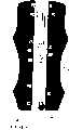
图5示明由三轴测井工具在等效低频率仿真上的测量结果,工具有一个沿工具轴(Z)定向的垂直磁偶极子(VMD)和两个垂直于工具轴定向,相互正交的水平(或偏斜)磁偶极子(HMDx和HMDy)。图5的例子中,以水平井孔钻探地层,地层的电阻率值为Rh=7Ωm,Rv=14Ωm。图中示明关于地层电阻率张量(也就是,TI各向异性场合的Rh和Rv)方面水平或偏斜的线圈测量值与相对方位角之工具位置间的关系。在低频率(60kHz)上,从接收的磁场测量值中计算出的视在电导率将伴随以电阻率各向异性张量定向为准的相对方位角位置而变。Hzz值显示出与角度定向无关,而Hxx和Hyy值相对于方位角呈正弦变化。交叉分量Hxy表明电导率测量值随方位角的变化,与Hzz有90°相位差。由曲线族能确定角度定向。Figure 5 shows the measurement results on an equivalent low frequency simulation by a triaxial logging tool with a vertical magnetic dipole (VMD) oriented along the tool axis (Z) and two perpendicular magnetic dipoles (VMD) oriented perpendicular to the tool axis, mutually Orthogonal horizontal (or skewed) magnetic dipoles (HMDx and HMDy). In the example shown in FIG. 5 , the formation is drilled with a horizontal wellbore, and the resistivity values of the formation are Rh =7Ωm and Rv =14Ωm. The graph shows the relationship between horizontal or skewed coil measurements in terms of formation resistivity tensors (ie,Rh andRv for the case of TI anisotropy) versus tool position relative to azimuth. At low frequencies (60 kHz), the apparent conductivity calculated from the received magnetic field measurements will vary with the relative azimuthal position relative to the orientation of the resistivity anisotropy tensor. The Hz values showed no dependence on angular orientation, while the Hxx and Hyy values varied sinusoidally with respect to azimuth. The cross component Hxy shows the variation of the conductivity measurement with azimuth, 90° out of phase with Hz. The angular orientation can be determined from the curve family.
求解相对倾斜及垂直和水平电阻率的反演程序中,利用由上面讨论的公式所描述的磁场方程式和测量值方面的正向横型。任一已证实的反演运算都能应用,例如,最小二乘方或Marquardt法。3DEXTM测量工具用的一种反演运算例子说明于Zhang等人的美国专利申请序列号No.10/091,310中,它与本申请有同一受让人,其内容引入于此供作参考。工具的测量值阵列Hzz、Hzy、Hxz、Hxx、Hxy、Hyx、Hyz、Hyy连同相对于外部参考(垂直/重力及磁场北,或是这两者)测得的各个相对方位角位置,都予以记录。Zhang等人的反演方法中使用的模型包含各地层的厚度、各地层的电阻率,以及人侵地带的长度和电阻率。在边钻探边测量的场合,入侵效应多半地很小。因此,完全应用Zhang等人的方法时,可能不需要附加的阵列测量以获得入侵地带的参数。The inversion procedure for solving the relative tilt and vertical and horizontal resistivities utilizes the positive transverse form in terms of the magnetic field equation and measurements described by the equations discussed above. Any proven inversion algorithm can be used, eg, least squares or Marquardt's method. An example of an inversion algorithm for the 3DEX(TM) measurement tool is described in US Patent Application Serial No. 10/091,310 to Zhang et al., of the same assignee as the present application, the contents of which are incorporated herein by reference. Tool's array of measurements Hzz , Hzy , Hxz , Hxx , Hxy , Hyx , Hyz , Hyy together with measurements relative to an external reference (vertical/gravity and magnetic north, or both) All relative azimuth positions are recorded. The model used in Zhang et al.'s inversion method included the thickness of each formation, the resistivity of each formation, and the length and resistivity of the human-invaded zone. In the case of measuring while drilling, the intrusion effect is likely to be small. Therefore, additional array measurements may not be required to obtain the parameters of the invasion zone when fully applying the method of Zhang et al.
Dubinsky等人的美国专利申请序列号No.10/167,322中说明一种方法,用于在钻探时的钻眼内确定所传送的钻井组件穿透速率,它与本申请有同一受让人,其内容引入于此供作参考。加速度仪是一种典型装置用于在钻井组件上进行测量,指明钻井组件的轴向运动。其他的典型装置包括的类别诸如地磁仪和陀螺仪等。本发明的一个实施例中,这些测量应用于确定运动的轴向速度。识别出最大速度和最小速度,并假定穿透为步进式发生的情况下,可确定穿透速率。另一种方式中,确定最大和最小的轴向位移,应用它们来得到深度的时间函数曲线。本发明的另一个实施例中,从钻井组件的平均加速度及其瞬时频率上确定穿透速率。然后,可以用确定的穿透速率控制钻探时测井工具的工作。特别地,对测井工具中发射机的激活进行控制,以得到在所需深度上的测量值。在诸如应用于钻眼补偿声学测井法的阵列式测井工具中,上面的特点是特别希望的。方位角方向的测量可应用钻井测量装置加以实施,诸如是地磁仪和/或加速度仪、陀螺仪,或是倾斜仪等。U.S. Patent Application Serial No. 10/167,322 to Dubinsky et al., of the same assignee as the present application, describes a method for determining the penetration rate of a conveyed drilling assembly within a borehole while drilling. The contents are incorporated herein by reference. Accelerometers are typically devices used to make measurements on drilling assemblies that indicate the axial movement of the drilling assembly. Other typical devices include categories such as magnetometers and gyroscopes. In one embodiment of the invention, these measurements are used to determine the axial velocity of motion. With the maximum and minimum velocities identified, and assuming that penetration occurs in steps, the rate of penetration can be determined. In another approach, the maximum and minimum axial displacements are determined and used to obtain a depth-as-a-time function curve. In another embodiment of the invention, the penetration rate is determined from the average acceleration of the drilling assembly and its instantaneous frequency. The determined penetration rate can then be used to control the operation of the logging tool while drilling. In particular, the activation of transmitters in the logging tool is controlled to obtain measurements at desired depths. The above features are particularly desirable in array logging tools such as those employed in borehole compensated acoustic logging. The measurement of the azimuth direction can be implemented using a drilling measurement device, such as a magnetometer and/or an accelerometer, a gyroscope, or an inclinometer.
图7示明沿着钻探路径2206在钻眼703内传送钻具组701。钻具组传送到钻眼内的至少一个深度上。钻眼组701内包含用于得到纵向运动测量值的装置705(也就是,加速度仪、陀螺仪、地磁仪等)以及用于测量相对旋转角的装置707。工具沿钻探路径以垂直速度Vz(t)和加速度az(t)行进。工具还如箭头2204指出地围绕其纵轴以角速度ω(t)和角加速度aω(t)旋转。所有这些动态变量能够反映钻眼内部基本的工具运动和位置状况。FIG. 7 illustrates conveying
本发明的方法能应用由测井管线中传送的测井仪器采集的数据,也能应用钻探时在钻筒内传送的(MWD)测量装置诸如钻具组或绕线管采集的数据。具体地,当应用MWD测量时,该方向信息可应用于控制钻探方向,并使钻眼相对于层理面保持于贴近的位置上。The method of the present invention can use data collected by logging tools carried in the well logging pipeline, as well as data collected by (MWD) measurement devices such as drill strings or bobbins carried in the drill bore while drilling. In particular, when using MWD measurements, this directional information can be used to control drilling direction and keep the borehole close to the bedding plane.
在钻眼内传送的MWD工具用各种发射机-接收机阵列组合和配置实施测量。这些测量对方位角很敏感,测量对工具轴可以对称或不对称。比之从MWD图像工具或其他浅方位角工具得到的数据,这些测量给出纵深的电磁数据。为改善信噪比和便于分析数据,可以将这些方位角测量值以深度区间(达到所需的深度分辨率)和方位角扇区进行组合。MWD tools delivered within the borehole conduct measurements with various transmitter-receiver array combinations and configurations. These measurements are sensitive to azimuth, and the measurements can be symmetric or asymmetric about the tool axis. These measurements give EM data in depth compared to data obtained from MWD imagery tools or other shallow azimuth tools. To improve the signal-to-noise ratio and facilitate data analysis, these azimuth measurements can be combined in depth bins (to achieve the desired depth resolution) and azimuth sectors.
图8A中所示的MWD工具的侧视图上表示出本发明中的深度分段,各个深度分段标记为z(n-2)、z(n-1)、z(n)、z(n+1)等。相邻的深度段之间诸如801与803或803与805之间,均间隔距离ΔZ。典型的各个深度段的长度例如深度段805的长度为ΔZ。所以,从每个深度段一侧到其中央的距离为ΔZ/2。可选地,当井眼路径轨线探测数据或井眼路径设计数据综合入真垂直深度(TVD)计算量中时,这些测量数据阵列可以放入TVD中。图8B中所示的MWD工具的横截面上,表示出在钻眼内划分成例如S(1)、S(2)、...、S(10)10个扇区的方位角位置。以标记为2202的一个方位角扇区作为例子。扇区的实际数目可由操作人员预先选定以做到优化使用。每个扇区的夹角等于360°/K,K为扇区数目。图8B的示例中有10个扇区,每个扇区的夹角为36°。Depth segments in the present invention are shown on the side view of the MWD tool shown in Fig. 8A, each depth segment is marked as z(n-2), z(n-1), z(n), z(n +1) etc. Adjacent depth segments such as 801 and 803 or 803 and 805 are spaced apart by a distance ΔZ. A typical length of each depth segment, such as the length of the
通常,与此种工具类型配合作出的辅助测量诸如有倾斜仪、陀螺仪(纤维、机械等)、加速度仪(1、2和3轴)和/或地磁仪,它们可提供附加数据以确认钻探路径、以及实施这些测量时工具对地层的相对位置。依靠此种可用数据,可以接收二维深度段内测得的原始数据(RD)以及井眼路径和工具对地层的相对位置数据。可以将原始数据组合入深度间隔(n)和方位角扇区(k)的群集内,得到原始数据阵列RD(n,k,ti)。RD(n,k,ti)是深度间隔n、扇区k和时间ti上的原始数据。由给定深度和方位角扇区上的许多测量值,能得出该深度和方位角扇区的平均值。此种场合下,平均值可从下列方程式中得到:Typically, auxiliary measurements such as inclinometers, gyroscopes (fiber, mechanical, etc.), accelerometers (1, 2 and 3 axes) and/or magnetometers are made with this tool type to provide additional data to confirm drilling path, and the relative position of the tool to the formation when these measurements were taken. With this available data, measured raw data (RD) over a two-dimensional depth interval as well as borehole path and tool relative position data to the formation can be received. The raw data can be combined into clusters of depth intervals (n) and azimuth sectors (k), resulting in a raw data array RD(n, k, ti). RD(n,k,ti) is the raw data at depth interval n, sector k and time ti. From many measurements over a given depth and azimuth sector, an average value for that depth and azimuth sector can be derived. In this case, the average value can be obtained from the following equation:
M(n,k)=AVG[F(RD(n,k,ti))]M(n,k)=AVG[F(RD(n,k,ti))]
式中,M(n,k)是对给定深度和方位角扇区得到的测量值记录。In the formula, M(n, k) is the record of measured values obtained for a given depth and azimuth sector.
对深度和相对方位角的加速度作出校正后,在两个步骤下进行平均以改善信噪比。第一步中,在至少一个深度和多个角度上得到测量值。将每一个深度段例如801(MD或TVD)和相对方位角扇区例如803上的测量值进行平均,以获得信噪比(S/N)的改善。第二步中,使给定深度上得到的各个方位角测量值同一个相对方位角函数作似合处理。After corrections for depth and relative azimuth accelerations, averaging is performed in two steps to improve the signal-to-noise ratio. In a first step, measurements are obtained at at least one depth and a plurality of angles. Measurements are averaged over each depth segment eg 801 (MD or TVD) and relative
由于工具旋转很可能与其发射机信号源的重复周期不同步,所以,相对于发射机信号源的重复周期而言,分配给一个方位角扇区的原始数据时间系列可能没的相等的时间间隔。对重新组合的原始数据作时间平均能够提高信噪比,并通过减小下式所示的原始数据的标准偏差以改善精确度:Since the tool rotation is likely to be out of sync with the repeat period of its transmitter source, the raw data time series assigned to an azimuth sector may not be equally spaced with respect to the repeat period of the transmitter source. Time averaging the recombined raw data improves the signal-to-noise ratio and improves precision by reducing the standard deviation of the raw data as shown by:
式中,σRD(n,k)表示在深度间隔n和方位角扇区K上得到的测量值标准偏差。N是在给定深度段和方位角扇区内实施测量的次数。测得的原始数据时间系列在各深度间隔和方位角扇区内进行群集,分配到在发射机信号源重复周期内的一个相对时间点上。可选地,至少在一个步骤上,可以使一部分工具静止面指向优选的方位角方位,对它得出原始数据(RD)时间系列。对于每一个深度间隔n和方位角扇区k,在各深度段和扇区内群集的和平均的数据M(n,k)能组成另一个阵列,如下表所示。In the formula, σRD (n, k) represents the standard deviation of the measured values obtained on the depth interval n and the azimuth sector K. N is the number of measurements performed within a given depth segment and azimuth sector. The measured raw data time series are clustered within each depth interval and azimuth sector, assigned to a relative point in time within the repeat period of the transmitter signal source. Optionally, at least in one step, a portion of the tool's stationary surface can be oriented at a preferred azimuth orientation, for which a raw data (RD) time series is derived. For each depth interval n and azimuth sector k, the clustered and averaged data M(n,k) within each depth segment and sector can form another array, as shown in the table below.
制定钻探计划时,井眼路径的确定例如根据水库的地质模型,水库物理参数的说明中包括与钻井的合理性目的关联的电阻率目标。这些电阻率目标有其响应特性。例如,图9示明对于一定的多分量感应测量(Hxx、Hyy、Hzz、Hyz),各个方位角与各电阻率分层间的响应关系。上面的表中示明的平均数据可应用于对已知特性的特定地层目标估计预期的测量值阵列的方位角响应,然后,可应用该估计对该地层目标的几何参数(距离、方向、厚度)和物质特征进行分析。图9中示明的全部例子依从三角正弦函数。每一次完整的工具旋转中Hxx905和Hyy903各有两个相同的循环,而每一次工具旋转中Hyz909和Hxz907各发生一次对称循环。When drilling is planned, the borehole path is determined, for example, based on a geological model of the reservoir, and the description of the physical parameters of the reservoir includes resistivity targets associated with the rationale for drilling purposes. These resistivity targets have their own response characteristics. For example, Figure 9 shows the response relationship between each azimuth angle and each resistivity layer for a given multi-component induction measurement (Hxx, Hyy, Hzz, Hyz). The averaged data shown in the table above can be applied to estimate the azimuthal response of the expected array of measurements for a particular formation target of known properties, and then this estimate can be applied to the formation target's geometric parameters (distance, orientation, thickness ) and material characteristics were analyzed. All the examples shown in Figure 9 follow the trigonometric sine function. There are two identical cycles each of Hxx 905 and Hyy 903 per full tool revolution, and one symmetrical cycle each of Hyz 909 and Hxz 907 per tool revolution.
不同的地层目标会给出不同的函数,例如,典型的有关函数为正弦曲线。如果给定的测量值阵列与特定的地层目标不能够正确匹配预期的函数,则将以可视方式或是在那类失配被认定(预期对实际)场合显示出概要报告,或是显示出与预期的地层响应相关联的预期关系方面的平均阵列数据M(n,k)与函数估计1010之间的误差(见图10)。不同方位角扇区的实际数据和预期函数示例于图9中所示的曲线圈上,它包含4个函数(F1至F4)。钻探时,该信息可应用于地质导向、钻凿和井位确定。Different stratigraphic objects will give different functions, for example, a typical related function is a sinusoidal curve. If a given array of measurements does not correctly match the expected function with a particular formation target, either a summary report is displayed visually where that type of mismatch is identified (expected versus actual), or a The error between the average array data M(n,k) and the function estimate 1010 in terms of the expected relationship associated with the expected formation response (see FIG. 10). Actual data and expected functions for different azimuth sectors are illustrated on the curve circle shown in Figure 9, which contains 4 functions (F1 to F4). While drilling, this information can be used for geosteering, drilling and well placement.
由于测量值信噪比的组合效应,该曲线拟合方法可降低反演处理结果内的不精确性。这种改善的获得是因为将相干和相关性的测量值组合起来应用于已知正弦函数的最佳拟合中。操作人员能够在选定的角度上选用拟合的测量值供反演程序应用。实施反深运算时,选取的数据包括外部的相对方位角参考数据并利用正向的建模,建模中包括上述的方程式、相对角度和三维参数。Due to the combined effect of the signal-to-noise ratio of the measurements, the curve-fitting method can reduce inaccuracies within the results of the inversion process. This improvement is achieved by combining the measurements of coherence and correlation to a best fit of a known sinusoidal function. The operator can select the fitted measurements at selected angles for use by the inversion program. When performing inverse depth calculation, the selected data includes external relative azimuth reference data and uses forward modeling, which includes the above-mentioned equations, relative angles and three-dimensional parameters.
特别地,测量值的反演能给出对钻眼轴(工具的Z轴)与层理面之间相对倾斜角的估计。许多情况下,希望钻眼的钻探持续处在特定的水库信息(诸如上面有油页岩的沙层)内。采用上述方法,如果相对倾斜角变得太大或不正确,可采取校正措施,以免井眼穿出水库或进入诸如油页岩的非生产性冠岩中。校正描述的实施或是由操作人员在地面上进行,或是应用钻井处理器调整钻探方向。In particular, inversion of the measurements can give an estimate of the relative dip angle between the borehole axis (Z-axis of the tool) and the bedding plane. In many cases, it is desirable to drill the borehole to continue within a specific reservoir profile, such as a sand formation with oil shale on it. Using the method described above, if the relative dip becomes too large or incorrect, corrective action can be taken to prevent the wellbore from penetrating the reservoir or into unproductive cap rock such as oil shale. Correction descriptions are implemented either by the operator at the surface, or by using the drilling processor to adjust the drilling direction.
另一种应用场合是使钻眼相对于水库内的液体界面总保持于优选位置上。多孔地层的电阻率取决于地层中存在的液体情况,与蕴藏石油的地层和蕴藏天然气的地层相比较,水润湿地带的电阻率较低。Another application is to maintain a preferred position of the borehole at all times relative to the liquid interface in the reservoir. The resistivity of porous formations depends on the presence of liquids in the formation, and is lower in water-wet zones than in oil- and gas-bearing formations.
作为另一种反演实施,可以应用正向建模预测测井仪器在沿所需井眼上预期的电阻率响应,并根据实际的和/或平均的测量值采取校正措施。此种方法说明于Wu等人关于传播电阻率工具的美国专利Re35,386中,它有着与本发明相同的受让人,其内容完全引入于此供参考。Wu的专利与本发明之间的重大差别在于,此处应用方向性传感器能够提高灵敏度,而Wu等人的传播电阻率工具本质上是无方向性的。As another inversion implementation, forward modeling can be applied to predict the expected resistivity response of logging tools along the desired borehole, and corrective actions can be taken based on actual and/or averaged measurements. Such a method is described in U.S. Patent Re 35,386 to Wu et al. on Propagation Resistivity Tool, which has the same assignee as the present invention, the contents of which are incorporated herein by reference in their entirety. A significant difference between Wu's patent and the present invention is that the application of a directional sensor here enables increased sensitivity, whereas the propagating resistivity tool of Wu et al. is inherently non-directional.
图11示明一个具有10个方位角扇区的例子中,发射机重复循环时间(Tr)1101、工具旋转循环时间1103和扇区时间间隔1105之间的定时同步情况。发射机信号由1110表示。图中指明,当信号源顺序射向每个方位角扇区时,方位角测量值的平均化和综合。另一种方式,可以在工具静止下进行测量。方位角测量值可以来自工具每旋转一周中信号源波形的特定部分上。可以使工具旋转与信号源波形同步于特定的方位角扇区上,该状态并能围绕全部扇区逐渐地变化。信号源重复周期可处于3种情况下:i)信号源重复周期小于扇区时间间隔;ii)信号源重复周期大于扇区时间间隔,但小于工具旋转时间间隔;iii)信号源重复周期大于工具旋转时间间隔。在情况iii)的场合,建议改变周期时间使之进入情况i)或情况ii)。Figure 11 shows the timing synchronization between transmitter repeat cycle time (Tr) 1101, tool rotation cycle time 1103 and sector time interval 1105 for an example with 10 azimuth sectors. The transmitter signal is represented by 1110. The figure indicates the averaging and integration of azimuth measurements as the source fires sequentially into each azimuth sector. Alternatively, measurements can be made with the tool stationary. Azimuth measurements can be made from specific portions of the source waveform per revolution of the tool. The tool rotation can be synchronized with the signal source waveform over a specific azimuth sector, and the state can be changed gradually around the entire sector. The signal source repetition period can be in three situations: i) the signal source repetition period is smaller than the sector time interval; ii) the signal source repetition period is greater than the sector time interval, but smaller than the tool rotation time interval; iii) the signal source repetition period is greater than the tool rotation time interval Rotation interval. In case of case iii), it is recommended to change the cycle time into case i) or case ii).
结合其他方面得到的微电阻率以及诸如核子,电阻率和声学钻眼图像之类的测井图像,可对数据作出分析用于地质导向场合。发射机可处于地面上或井眼附近。也可以将灵活地电路应用于其他的辅助和补充的电磁测量中,供地质导向和地层评估两方面使用。Combined with microresistivity from other sources and well log images such as nuclear, resistivity and acoustic borehole images, the data can be analyzed for geosteering applications. The transmitter can be on the surface or near the borehole. The flexible circuit can also be applied to other auxiliary and supplementary electromagnetic surveys for both geosteering and formation evaluation.
作为实施测量的另一种或附加的方式是在曲线拟合后实质上配置连续旋转的传感器组件,借助于应用来自定向传感器的信号作为钻井处理器的输入,用以触发在规定的工具面角度上获得的电阻率测量值,这也能得到信噪比的改善。如果钻探中穿透速率慢,通过对多个多分量电阻率传感器之每一个给出的测量值进行简单的平均,能够得到充分质量的数据值供反演运算。An alternative or additional way to implement the measurements is to deploy the sensor assembly in substantially continuous rotation after curve fitting, by applying the signal from the orientation sensor as an input to the drilling processor to trigger the This also results in an improved signal-to-noise ratio. If the rate of penetration is slow during drilling, data values of sufficient quality for inversion calculations can be obtained by simple averaging of the measurements given by each of the multiple multi-component resistivity sensors.
存在另一个有关的影响因素,当感应线圈轴相对于工具纵轴例如显著偏斜时,电磁天线的旋转和位置会在横方向上有不同的灵敏度。Wang等人(SPWLA2001)示明一个涉及横向感应线圈的例子,即在垂直于空间灵敏度对称性的电磁天线轴方向上,钻眼偏心会影响横向感应线圈。这一点示明于图12,其中,工具1153在钻眼1151内处于偏心位置上。当钻眼不是圆形时会有类似的效应。此后,用术语偏心率包括这两种情况,即圆形钻孔内工具偏离圆心以及井眼非圆形的情况。Another related influencing factor is that the rotation and position of the electromagnetic antenna have different sensitivities in the lateral direction if the axis of the induction coil is, for example, significantly skewed relative to the longitudinal axis of the tool. Wang et al. (SPWLA2001) show an example involving transverse induction coils that are affected by borehole eccentricity in the direction perpendicular to the electromagnetic antenna axis of spatial sensitivity symmetry. This is illustrated in FIG. 12 , where the tool 1153 is in an off-center position within the borehole 1151 . A similar effect occurs when the borehole is not circular. Hereafter, the term eccentricity is used to cover both cases, ie, the tool is off-center in a circular borehole and the case of a non-circular borehole.
应用声学法或其他测径器,可得到在不同方向内与钻眼壁的距离,图12中标记为D1、D2、D3和D4。Wang等人表明,偏心率影响由横向感应线圈给出的测量值。有两种校正此种偏心效应的方法。Using acoustic methods or other calipers, the distances to the borehole wall can be obtained in different directions, labeled D1 , D2 , D3 and D4 in Figure 12 . showed that eccentricity affects the measurements given by transverse induction coils. There are two methods of correcting for this eccentricity effect.
本发明的优选实施例中,采用多频率集聚校正此种偏心率效应。颁给Rabinovich等人的美国专利No.5,884,227中公开一种对于感应式测井仪器内的趋肤效应调整感应式接收机信号的方法,感应式测井仪器内有多个间隔开的接收机和一个发射机,发射机在多个频率上产生交变磁场。方法中包括对多个频率上测得的接收机信号大小进行外推的步骤,根据在仪器周围介质内感应的交变磁场的检测,外推出在零频率上会得到的响应。通过对外推的量值进行反演处理,可得到仪器周围介质内的电导率分布模型。该专利具有与本发明相同的受让人。Rabinovich等人的美国专利No.5,884,227文献基于一种假设,即感应式工具装置具有完善的电导率。在边钻探边测量的装置中,不能遵从这种假设。然而,Tabarovsky于2002年11月15日提出的、处于委托审查的美国专利申请号No.414-29441中叙述了一种对MWD测井工具给出的测量值进行校正的方法,将只具有有限电导率的测井工具给出的测量值校正到由具有无限电导率的理想测井工具给出的测量值上,随之可应用多频率集聚方法。该专利具有与本申请相同的受让人,其内容完全引入于此供参考。In a preferred embodiment of the invention, multi-frequency clustering is used to correct for such eccentricity effects. U.S. Patent No. 5,884,227 to Rabinovich et al. discloses a method of adjusting an inductive receiver signal for skin effect in an induction logging tool having a plurality of spaced apart receivers and A transmitter that produces alternating magnetic fields at multiple frequencies. The method includes the step of extrapolating the magnitude of the receiver signal measured at a plurality of frequencies to extrapolate the response that would be obtained at zero frequency based on the detection of an alternating magnetic field induced in the medium surrounding the instrument. Through the inversion process of the extrapolated value, the conductivity distribution model in the medium around the instrument can be obtained. This patent has the same assignee as the present invention. US Patent No. 5,884,227 to Rabinovich et al. is based on the assumption that inductive tool devices have perfect electrical conductivity. In a measure-while-drilling setup, this assumption cannot be honored. However, a method for correcting measurements given by MWD logging tools, described in assigned U.S. Patent Application No. 414-29441 filed November 15, 2002, by Tabarovsky, will have limited The measurements given by the conductivity logging tool are corrected to the measurements given by the ideal logging tool with infinite conductivity, whereupon the multi-frequency clustering method can be applied. This patent has the same assignee as the present application, the contents of which are fully incorporated herein by reference.
另一种处理偏心率的方法是应用已知的钻眼几何尺寸以及粘眼内测井工具的位置对数据进行反演。可取地,此种反演应基于钻眼内泥浆电阻率的已知值。Another way to deal with eccentricity is to invert the data using known borehole geometry and location of logging tools within the viscous borehole. Desirably, such inversion should be based on known values of mud resistivity within the borehole.
虽然,上述公开内容是针对本发明的优选实施例的,但对之作出各种修正对本技术领域内的熟练人员是显而易见的。在所附权利要求书的范围和精神内的所有变型,均应包含于上述公开内容内。While the foregoing disclosure is of a preferred embodiment of this invention, various modifications thereto will be apparent to those skilled in the art. All modifications within the scope and spirit of the appended claims are intended to be embraced by the foregoing disclosure.
Claims (25)
Translated fromChineseApplications Claiming Priority (2)
| Application Number | Priority Date | Filing Date | Title |
|---|---|---|---|
| US10/302,239US6819111B2 (en) | 2002-11-22 | 2002-11-22 | Method of determining vertical and horizontal resistivity, and relative dip in anisotropic earth formations having an arbitrary electro-magnetic antenna combination and orientation with additional rotation and position measurements |
| US10/302,239 | 2002-11-22 |
Publications (2)
| Publication Number | Publication Date |
|---|---|
| CN1764851A CN1764851A (en) | 2006-04-26 |
| CN1327248Ctrue CN1327248C (en) | 2007-07-18 |
Family
ID=32324718
Family Applications (1)
| Application Number | Title | Priority Date | Filing Date |
|---|---|---|---|
| CNB2003801082776AExpired - Fee RelatedCN1327248C (en) | 2002-11-22 | 2003-11-21 | Method for Determining Vertical and Horizontal Resistivity and Relative Dip in Anisotropic Formation |
Country Status (8)
| Country | Link |
|---|---|
| US (1) | US6819111B2 (en) |
| EP (1) | EP1565766B1 (en) |
| CN (1) | CN1327248C (en) |
| AU (1) | AU2003295849A1 (en) |
| CA (1) | CA2507013C (en) |
| DE (1) | DE10393770T5 (en) |
| RU (1) | RU2368922C2 (en) |
| WO (1) | WO2004049010A1 (en) |
Families Citing this family (95)
| Publication number | Priority date | Publication date | Assignee | Title |
|---|---|---|---|---|
| US7659722B2 (en)* | 1999-01-28 | 2010-02-09 | Halliburton Energy Services, Inc. | Method for azimuthal resistivity measurement and bed boundary detection |
| US7463035B2 (en)* | 2002-03-04 | 2008-12-09 | Baker Hughes Incorporated | Method and apparatus for the use of multicomponent induction tool for geosteering and formation resistivity data interpretation in horizontal wells |
| US7375530B2 (en)* | 2002-03-04 | 2008-05-20 | Baker Hughes Incorporated | Method for signal enhancement in azimuthal propagation resistivity while drilling |
| US6952101B2 (en)* | 2003-01-16 | 2005-10-04 | Kjt Enterprises, Inc. | Method for determining direction to a target formation from a wellbore by analyzing multi-component electromagnetic induction signals |
| US6944545B2 (en)* | 2003-03-25 | 2005-09-13 | David A. Close | System and method for determining the inclination of a wellbore |
| US7382135B2 (en)* | 2003-05-22 | 2008-06-03 | Schlumberger Technology Corporation | Directional electromagnetic wave resistivity apparatus and method |
| US8060310B2 (en)* | 2004-06-15 | 2011-11-15 | Baker Hughes Incorporated | Geosteering in earth formations using multicomponent induction measurements |
| US7392137B2 (en)* | 2004-06-15 | 2008-06-24 | Baker Hughes Incorporated | Determination of formation anistrophy, dip and azimuth |
| US8112227B2 (en)* | 2004-06-15 | 2012-02-07 | Baker Hughes Incorporated | Processing of multi-component induction measurements in a biaxially anisotropic formation |
| US7269515B2 (en) | 2004-06-15 | 2007-09-11 | Baker Hughes Incorporated | Geosteering in anisotropic formations using multicomponent induction measurements |
| US7274991B2 (en)* | 2004-06-15 | 2007-09-25 | Baker Hughes Incorporated | Geosteering in anisotropic formations using multicomponent induction measurements |
| US7191850B2 (en)* | 2004-10-28 | 2007-03-20 | Williams Danny T | Formation dip geo-steering method |
| US8875806B2 (en) | 2004-10-28 | 2014-11-04 | Danny T. Williams | Formation dip geo-steering method |
| US8960326B2 (en) | 2004-10-28 | 2015-02-24 | Danny T. Williams | Formation dip geo-steering method |
| US10544666B1 (en) | 2004-10-28 | 2020-01-28 | Danny T. Williams | Formation dip geo-steering method |
| US10316638B1 (en) | 2004-10-28 | 2019-06-11 | Danny T. Williams | Formation dip geo-steering method |
| US7317991B2 (en)* | 2005-01-18 | 2008-01-08 | Baker Hughes Incorporated | Multicomponent induction measurements in cross-bedded and weak anisotropy approximation |
| CA2599656A1 (en)* | 2005-03-04 | 2006-09-14 | Baker Hughes Incorporated | Geosteering in anisotropic formations using multicomponent induction measurements |
| US7599825B2 (en)* | 2005-04-18 | 2009-10-06 | Schlumberger Technology Corporation | Shoulder bed effects removal |
| EP1922660A1 (en)* | 2005-07-22 | 2008-05-21 | ExxonMobil Upstream Research Company | Method for determining receiver orientations |
| GB0516153D0 (en)* | 2005-08-05 | 2005-09-14 | Mtem Ltd | Multi-transient dc resistivity measurements |
| CA2625012C (en)* | 2005-08-08 | 2016-05-03 | Halliburton Energy Services, Inc. | Methods and systems for design and/or selection of drilling equipment based on wellbore drilling simulations |
| WO2007094846A2 (en)* | 2006-02-14 | 2007-08-23 | Exxonmobil Upstream Research Company | Source monitoring for electromagnetic surveying |
| US7496451B2 (en)* | 2006-03-06 | 2009-02-24 | Baker Hughes Incorporated | Real time data quality control and determination of formation angles from multicomponent induction measurements using neural networks |
| US7545145B2 (en)* | 2006-05-03 | 2009-06-09 | Baker Hughes Incorporated | Method and apparatus for tensorial micro-resistivity imaging in oil-based muds |
| AU2006344741B2 (en)* | 2006-06-19 | 2011-07-07 | Halliburton Energy Services, Inc. | Antenna cutout in a downhole tubular |
| US7778778B2 (en)* | 2006-08-01 | 2010-08-17 | Baker Hughes Incorporated | Correction of multi-component measurements for tool eccentricity in deviated wells |
| US7629791B2 (en)* | 2006-08-01 | 2009-12-08 | Baker Hughes Incorporated | Method and apparatus for making multi-component measurements in deviated wells |
| KR100837910B1 (en)* | 2006-12-05 | 2008-06-13 | 현대자동차주식회사 | Height retainer of active headrest |
| US7759940B2 (en)* | 2007-04-04 | 2010-07-20 | Baker Hughes Incorporated | Mutual shielding of collocated induction coils in multi-component induction logging instruments |
| US7558675B2 (en)* | 2007-07-25 | 2009-07-07 | Smith International, Inc. | Probablistic imaging with azimuthally sensitive MWD/LWD sensors |
| US7647183B2 (en)* | 2007-08-14 | 2010-01-12 | Schlumberger Technology Corporation | Method for monitoring seismic events |
| RU2475780C2 (en)* | 2007-11-30 | 2013-02-20 | Эксонмобил Апстрим Рисерч Компани | Method of detecting reservoir and cross bed fracturing using triaxial/multicomponent resistivity anisotropy measurements |
| JP5662804B2 (en) | 2007-12-18 | 2015-02-04 | シュルンベルジェ ホールディングス リミテッドSchlnmberger Holdings Limited | System and method for improving surface electromagnetic exploration |
| AU2009244627A1 (en) | 2008-04-17 | 2009-11-12 | Richard H. Hardman | Methods for producing a log of material properties |
| EP2113794A1 (en)* | 2008-04-29 | 2009-11-04 | ExxonMobil Upstream Research Company | Method for Reservoir Fracture and Cross Beds Detection Using Tri-axial/Multi-component Resistivity Anisotropy Measurements |
| US8204690B2 (en)* | 2008-06-03 | 2012-06-19 | Los Alamos National Security, Llc | Analytical effective tensor for flow-through composites |
| EA201170261A1 (en)* | 2008-07-30 | 2011-08-30 | Шеврон Ю.Эс.Эй. Инк. | Method of propagation of pseudoacoustic quasi-wave in an anisotropic medium |
| US8200437B2 (en)* | 2008-09-30 | 2012-06-12 | Schlumberger Technology Corporation | Method for borehole correction, formation dip and azimuth determination and resistivity determination using multiaxial induction measurements |
| CN101403216B (en)* | 2008-11-18 | 2010-06-23 | 中国电力工程顾问集团西南电力设计院 | Method for confirming excavation cubage soil resistivity |
| US8095318B2 (en)* | 2008-12-19 | 2012-01-10 | Schlumberger Technology Corporation | Method for estimating formation dip using combined multiaxial induction and formation image measurements |
| US8908473B2 (en)* | 2008-12-23 | 2014-12-09 | Schlumberger Technology Corporation | Method of subsurface imaging using microseismic data |
| WO2011077300A2 (en)* | 2009-12-23 | 2011-06-30 | Schlumberger Technology Bv | Processing of geological data |
| US9151822B2 (en)* | 2009-12-31 | 2015-10-06 | Optimal Ranging, Inc. | Precise positioning using a distributed sensor network |
| US8271199B2 (en)* | 2009-12-31 | 2012-09-18 | Smith International, Inc. | Binning method for borehole imaging |
| US8600115B2 (en) | 2010-06-10 | 2013-12-03 | Schlumberger Technology Corporation | Borehole image reconstruction using inversion and tool spatial sensitivity functions |
| US8441261B2 (en)* | 2010-06-16 | 2013-05-14 | Schlumberger Technology Corporation | Determination of conductive formation orientation by making wellbore sonde error correction |
| GB2500100B (en) | 2010-08-26 | 2016-01-20 | Smith International | Apparatus and method for microresistivity imaging in nonconductive drilling fluid |
| US9529113B2 (en) | 2010-08-31 | 2016-12-27 | Halliburton Energy Services, Inc. | Method and apparatus for downhole measurement tools |
| BR112013007669B1 (en) | 2010-10-01 | 2020-12-01 | Baker Hughes Incorporated | method and apparatus for estimating at least one resistivity parameter of a formation |
| US8554481B2 (en)* | 2010-12-06 | 2013-10-08 | Chevron U.S.A Inc. | System and method for declustering well log samples |
| CN102540251B (en)* | 2010-12-16 | 2014-04-16 | 中国石油天然气集团公司 | Two-dimensional transverse anisotropy HTI (transversely isotropicmedia with a horizontal symmetry axis) prestack depth migration modeling method and device |
| CN102918426B (en)* | 2010-12-30 | 2017-09-29 | 优化极限公司 | Precise localization using distributed sensor networks |
| US8614577B2 (en)* | 2011-05-18 | 2013-12-24 | Halliburton Energy Services, Inc. | Automatic anisotropy, azimuth and dip determination from upscaled image log data |
| AU2011373690B2 (en)* | 2011-07-26 | 2015-01-22 | Halliburton Energy Services, Inc. | Cross-coupling based determination of anisotropic formation properties |
| BR112013009286B1 (en)* | 2011-08-03 | 2020-05-26 | Halliburton Energy Services, Inc. | “METHOD, SYSTEM AND APPLIANCE FOR CONDUCTING A WELL IN A VIEWED AREA, AND MACHINE-READABLE STORAGE DEVICE |
| US10371852B2 (en)* | 2011-12-21 | 2019-08-06 | Schlumberger Technology Corporation | Formation properties from conductivity tensor |
| US9540922B2 (en) | 2012-03-29 | 2017-01-10 | Schlumberger Technology Corporation | Electromagnetic method for obtaining dip azimuth angle |
| CN102635347B (en)* | 2012-03-30 | 2014-12-10 | 中国电子科技集团公司第二十二研究所 | Method for quantitatively enabling thin interbed to be equivalent to formation with horizontal and vertical resistivities |
| US9052406B2 (en)* | 2012-06-18 | 2015-06-09 | Baker Hughes Incorporated | Processing azimuthal measurement data |
| EP3037847B1 (en) | 2012-12-19 | 2023-11-08 | Halliburton Energy Services, Inc. | Method and apparatus for optimizing deep resistivity measurements with multi-component antennas |
| CA2895018C (en)* | 2012-12-31 | 2019-02-12 | Halliburton Energy Services, Inc. | Deep azimuthal system with multi-pole sensors |
| BR112015012050A2 (en) | 2012-12-31 | 2019-12-17 | Halliburton Energy Services Inc | formation imaging with multipole antennas |
| WO2014113008A1 (en)* | 2013-01-17 | 2014-07-24 | Halliburton Energy Services, Inc. | Fast formation dip angle estimation systems and methods |
| EP2926175A1 (en) | 2013-03-13 | 2015-10-07 | Halliburton Energy Services, Inc. | Calibrating resistivity tools in enviroments with radio-frequency noise |
| CN110725650A (en)* | 2013-03-29 | 2020-01-24 | 普拉德研究及开发股份有限公司 | Closed loop control of drilling toolface |
| US9575202B2 (en)* | 2013-08-23 | 2017-02-21 | Baker Hughes Incorporated | Methods and devices for extra-deep azimuthal resistivity measurements |
| EP3055716B1 (en) | 2013-10-08 | 2018-06-06 | Exxonmobil Upstream Research Company | Automatic dip picking from wellbore azimuthal image logs |
| CN103774989B (en)* | 2013-12-10 | 2016-08-17 | 刘俊 | Treat that drilling well Trajectory Design horizontal well geosteering analyzes method with boring dynamic modeling |
| US20150252623A1 (en)* | 2014-03-04 | 2015-09-10 | Magnetic Field Effects, LLC | Directional drilling instrument |
| US10365395B2 (en) | 2014-03-11 | 2019-07-30 | Halliburton Energy Services, Inc. | Multi-component induction logging systems and methods using blended-model inversion |
| US9581721B2 (en) | 2014-03-29 | 2017-02-28 | Schlumberger Technology Corporation | Method for making downhole electromagnetic logging while drilling measurements |
| US9423525B2 (en) | 2014-03-29 | 2016-08-23 | Schlumberger Technology Corporation | Gain compensated directional propagation measurements |
| US10295698B2 (en) | 2014-04-03 | 2019-05-21 | Halliburton Energy Services, Inc. | Multi-component induction logging systems and methods using selected frequency inversion |
| US9529112B2 (en)* | 2014-04-11 | 2016-12-27 | Schlumberger Technology Corporation | Resistivity of chemically stimulated reservoirs |
| US10400589B2 (en)* | 2014-04-18 | 2019-09-03 | Halliburton Energy Services, Inc. | Log processing and fracture characterization in biaxially anisotropic formations |
| CN104088630B (en)* | 2014-07-09 | 2016-08-10 | 中国石油集团长城钻探工程有限公司 | With boring the method that azimuthal resistivity logger obtains stratigraphic boundary distance |
| US9618647B2 (en) | 2014-10-27 | 2017-04-11 | Schlumberger Technology Corporation | Gain compensated symmetrized and anti-symmetrized angles |
| US9766365B2 (en) | 2014-10-27 | 2017-09-19 | Schlumberger Technology Corporation | Compensated deep measurements using a tilted antenna |
| US10386529B2 (en)* | 2014-11-19 | 2019-08-20 | Schlumberger Technology Corporation | Subsurface estimation of level of organic maturity |
| US9784880B2 (en) | 2014-11-20 | 2017-10-10 | Schlumberger Technology Corporation | Compensated deep propagation measurements with differential rotation |
| RU2611204C1 (en)* | 2015-11-03 | 2017-02-21 | Общество с ограниченной ответственностью "ГЕРС Технолоджи" | Electromagnetic logging method |
| WO2017082905A1 (en) | 2015-11-12 | 2017-05-18 | Halliburton Energy Services, Inc. | Multi-component induction logging data processing in non-circular boreholes |
| WO2017127058A1 (en)* | 2016-01-20 | 2017-07-27 | Halliburton Energy Services, Inc. | Fracture interpretation with resistivity and sonic logs in biaxial anisotropic formations |
| AU2016393668A1 (en)* | 2016-02-16 | 2018-05-17 | Halliburton Energy Services, Inc. | Methods of selecting an earth model from a plurality of earth models |
| CN106339356B (en)* | 2016-08-16 | 2020-08-04 | 上海交通大学 | Drill bit drilling segmentation data fitting method |
| US11263801B2 (en) | 2017-03-31 | 2022-03-01 | Schlumberger Technology Corporation | Smooth surface wrapping of features in an imaged volume |
| CN107942393B (en)* | 2017-11-02 | 2018-10-23 | 中国科学院地质与地球物理研究所 | One kind is with brill orientation acoustic logging collecting method |
| US11231517B2 (en)* | 2018-02-27 | 2022-01-25 | Sanvean Technologies Llc | Azimuthal measurement for geosteering |
| RU2687998C1 (en)* | 2018-08-10 | 2019-05-17 | федеральное государственное бюджетное образовательное учреждение высшего образования "Пермский национальный исследовательский политехнический университет" | Method of rotary drilling of wells with modular controlled system of small diameter |
| CN110485996B (en)* | 2019-09-02 | 2020-07-31 | 中国石油天然气集团有限公司 | Centered imaging oil reservoir parameter measuring tool |
| US11408272B2 (en)* | 2020-05-12 | 2022-08-09 | Halliburton Energy Services, Inc. | Mud angle determination for electromagnetic imager tools |
| CN112505790B (en)* | 2020-09-27 | 2021-12-24 | 山东大学 | High spatial resolution composite resistivity detection calculation method |
| CN113138421B (en)* | 2021-04-30 | 2022-01-28 | 西南石油大学 | Buried depth and trend detection method for buried metal pipeline |
| CN113756787B (en)* | 2021-10-11 | 2022-08-30 | 中国石油天然气股份有限公司 | Borehole trajectory inversion method, system and equipment |
Citations (5)
| Publication number | Priority date | Publication date | Assignee | Title |
|---|---|---|---|---|
| DE1548156A1 (en)* | 1966-09-13 | 1970-07-16 | Chevron Res | Method for mapping salt domes |
| US5999883A (en)* | 1996-07-26 | 1999-12-07 | Western Atlas International, Inc. | Conductivity anisotropy estimation method for inversion processing of measurements made by a transverse electromagnetic induction logging instrument |
| US6181138B1 (en)* | 1999-02-22 | 2001-01-30 | Halliburton Energy Services, Inc. | Directional resistivity measurements for azimuthal proximity detection of bed boundaries |
| GB2369890A (en)* | 2000-07-14 | 2002-06-12 | Schlumberger Holdings | Electromagnetic induction well logging |
| WO2002082124A1 (en)* | 2001-04-06 | 2002-10-17 | Halliburton Energy Services, Inc. | Method and apparatus for determining the high side of a drill string during gamma mwd operations and correlating gamma events therewith |
Family Cites Families (21)
| Publication number | Priority date | Publication date | Assignee | Title |
|---|---|---|---|---|
| US35386A (en)* | 1862-05-27 | Improvement in water-elevators | ||
| US5157605A (en) | 1987-04-27 | 1992-10-20 | Schlumberger Technology Corporation | Induction logging method and apparatus including means for combining on-phase and quadrature components of signals received at varying frequencies and including use of multiple receiver means associated with a single transmitter |
| SU1444959A1 (en)* | 1987-05-27 | 1988-12-15 | Институт кибернетики им.В.М.Глушкова | Position code to large-base code converter |
| US4837517A (en) | 1987-07-16 | 1989-06-06 | Schlumberger Technology Corporation | Spatial frequency method and apparatus for investigating earth conductivity with high vertical resolution by induction techniques |
| US4909336A (en) | 1988-09-29 | 1990-03-20 | Applied Navigation Devices | Drill steering in high magnetic interference areas |
| US4916400A (en)* | 1989-03-03 | 1990-04-10 | Schlumberger Technology Corporation | Method for determining characteristics of the interior geometry of a wellbore |
| US5230386A (en) | 1991-06-14 | 1993-07-27 | Baker Hughes Incorporated | Method for drilling directional wells |
| US5200705A (en)* | 1991-10-31 | 1993-04-06 | Schlumberger Technology Corporation | Dipmeter apparatus and method using transducer array having longitudinally spaced transducers |
| US5452761A (en) | 1994-10-31 | 1995-09-26 | Western Atlas International, Inc. | Synchronized digital stacking method and application to induction logging tools |
| EP0909398B1 (en) | 1996-07-01 | 2002-09-11 | Shell Internationale Researchmaatschappij B.V. | Electrical logging of a laminated earth formation |
| EP0840142B1 (en) | 1996-10-30 | 2004-04-14 | Baker Hughes Incorporated | Method and apparatus for determining dip angle, and horizontal and vertical conductivities |
| US6476609B1 (en)* | 1999-01-28 | 2002-11-05 | Dresser Industries, Inc. | Electromagnetic wave resistivity tool having a tilted antenna for geosteering within a desired payzone |
| US6136155A (en) | 1999-06-04 | 2000-10-24 | Berg; Lloyd | Separation of mesitylene from 1,2,4-trimetyhlbenzene by azeotropic distillation |
| US6366088B1 (en)* | 1999-12-03 | 2002-04-02 | Halliburton Energy Services, Inc. | Method to enhance vertical resolution of time-decay log using forward modeling deconvolution of time-decay spectra |
| US6307073B1 (en) | 2000-07-25 | 2001-10-23 | Arco Chemical Technology, L.P. | Direct epoxidation process using a mixed catalyst system |
| US6538447B2 (en)* | 2000-12-13 | 2003-03-25 | Halliburton Energy Services, Inc. | Compensated multi-mode elctromagnetic wave resistivity tool |
| US6573722B2 (en) | 2000-12-15 | 2003-06-03 | Schlumberger Technology Corporation | Method and apparatus for cancellation of borehole effects due to a tilted or transverse magnetic dipole |
| US6643589B2 (en)* | 2001-03-08 | 2003-11-04 | Baker Hughes Incorporated | Simultaneous determination of formation angles and anisotropic resistivity using multi-component induction logging data |
| US6636045B2 (en)* | 2001-04-03 | 2003-10-21 | Baker Hughes Incorporated | Method of determining formation anisotropy in deviated wells using separation of induction mode |
| US6541975B2 (en) | 2001-08-23 | 2003-04-01 | Kjt Enterprises, Inc. | Integrated borehole system for reservoir detection and monitoring |
| CA2468865A1 (en)* | 2001-12-03 | 2003-06-12 | Shell Internationale Research Maatschappij B.V. | Method for determining anisotropic resistivity and dip angle in an earth formation |
- 2002
- 2002-11-22USUS10/302,239patent/US6819111B2/ennot_activeExpired - Lifetime
- 2003
- 2003-11-21WOPCT/US2003/037483patent/WO2004049010A1/ennot_activeApplication Discontinuation
- 2003-11-21AUAU2003295849Apatent/AU2003295849A1/ennot_activeAbandoned
- 2003-11-21CNCNB2003801082776Apatent/CN1327248C/ennot_activeExpired - Fee Related
- 2003-11-21EPEP03787061Apatent/EP1565766B1/ennot_activeExpired - Lifetime
- 2003-11-21DEDE10393770Tpatent/DE10393770T5/ennot_activeWithdrawn
- 2003-11-21RURU2005119651/28Apatent/RU2368922C2/ennot_activeIP Right Cessation
- 2003-11-21CACA2507013Apatent/CA2507013C/ennot_activeExpired - Fee Related
Patent Citations (5)
| Publication number | Priority date | Publication date | Assignee | Title |
|---|---|---|---|---|
| DE1548156A1 (en)* | 1966-09-13 | 1970-07-16 | Chevron Res | Method for mapping salt domes |
| US5999883A (en)* | 1996-07-26 | 1999-12-07 | Western Atlas International, Inc. | Conductivity anisotropy estimation method for inversion processing of measurements made by a transverse electromagnetic induction logging instrument |
| US6181138B1 (en)* | 1999-02-22 | 2001-01-30 | Halliburton Energy Services, Inc. | Directional resistivity measurements for azimuthal proximity detection of bed boundaries |
| GB2369890A (en)* | 2000-07-14 | 2002-06-12 | Schlumberger Holdings | Electromagnetic induction well logging |
| WO2002082124A1 (en)* | 2001-04-06 | 2002-10-17 | Halliburton Energy Services, Inc. | Method and apparatus for determining the high side of a drill string during gamma mwd operations and correlating gamma events therewith |
Also Published As
| Publication number | Publication date |
|---|---|
| WO2004049010A1 (en) | 2004-06-10 |
| WO2004049010B1 (en) | 2004-08-19 |
| US6819111B2 (en) | 2004-11-16 |
| CN1764851A (en) | 2006-04-26 |
| DE10393770T5 (en) | 2005-10-27 |
| EP1565766B1 (en) | 2008-05-21 |
| RU2005119651A (en) | 2006-02-10 |
| CA2507013A1 (en) | 2004-06-10 |
| RU2368922C2 (en) | 2009-09-27 |
| AU2003295849A1 (en) | 2004-06-18 |
| EP1565766A1 (en) | 2005-08-24 |
| US20040100263A1 (en) | 2004-05-27 |
| CA2507013C (en) | 2013-07-02 |
Similar Documents
| Publication | Publication Date | Title |
|---|---|---|
| CN1327248C (en) | Method for Determining Vertical and Horizontal Resistivity and Relative Dip in Anisotropic Formation | |
| US9547102B2 (en) | Resistivity logging systems and methods employing ratio signal set for inversion | |
| US10358911B2 (en) | Tilted antenna logging systems and methods yielding robust measurement signals | |
| US8274289B2 (en) | Antenna coupling component measurement tool having rotating antenna configuration | |
| US10655463B2 (en) | Signal processing methods for steering to an underground target | |
| US7629791B2 (en) | Method and apparatus for making multi-component measurements in deviated wells | |
| US20040117120A1 (en) | Method for resistivity anisotropy determination in conductive borehole environments | |
| WO2009009342A1 (en) | Determining formation parameters using electromagnetic coupling components | |
| US9429675B2 (en) | Anisotropy processing in low angle wells | |
| CN104956177B (en) | Identifying unconventional formations |
Legal Events
| Date | Code | Title | Description |
|---|---|---|---|
| C06 | Publication | ||
| PB01 | Publication | ||
| C10 | Entry into substantive examination | ||
| SE01 | Entry into force of request for substantive examination | ||
| C14 | Grant of patent or utility model | ||
| GR01 | Patent grant | ||
| C17 | Cessation of patent right | ||
| CF01 | Termination of patent right due to non-payment of annual fee | Granted publication date:20070718 Termination date:20121121 |