CN116266380A - Environment data reconstruction method, device, system and storage medium - Google Patents
Environment data reconstruction method, device, system and storage mediumDownload PDFInfo
- Publication number
- CN116266380A CN116266380ACN202111518675.1ACN202111518675ACN116266380ACN 116266380 ACN116266380 ACN 116266380ACN 202111518675 ACN202111518675 ACN 202111518675ACN 116266380 ACN116266380 ACN 116266380A
- Authority
- CN
- China
- Prior art keywords
- information
- environment
- obstacle
- vehicle
- traffic
- Prior art date
- Legal status (The legal status is an assumption and is not a legal conclusion. Google has not performed a legal analysis and makes no representation as to the accuracy of the status listed.)
- Pending
Links
Images


Classifications
- G—PHYSICS
- G06—COMPUTING OR CALCULATING; COUNTING
- G06T—IMAGE DATA PROCESSING OR GENERATION, IN GENERAL
- G06T17/00—Three dimensional [3D] modelling, e.g. data description of 3D objects
- G06T17/05—Geographic models
- G—PHYSICS
- G06—COMPUTING OR CALCULATING; COUNTING
- G06T—IMAGE DATA PROCESSING OR GENERATION, IN GENERAL
- G06T19/00—Manipulating 3D models or images for computer graphics
- G06T19/003—Navigation within 3D models or images
- Y—GENERAL TAGGING OF NEW TECHNOLOGICAL DEVELOPMENTS; GENERAL TAGGING OF CROSS-SECTIONAL TECHNOLOGIES SPANNING OVER SEVERAL SECTIONS OF THE IPC; TECHNICAL SUBJECTS COVERED BY FORMER USPC CROSS-REFERENCE ART COLLECTIONS [XRACs] AND DIGESTS
- Y02—TECHNOLOGIES OR APPLICATIONS FOR MITIGATION OR ADAPTATION AGAINST CLIMATE CHANGE
- Y02T—CLIMATE CHANGE MITIGATION TECHNOLOGIES RELATED TO TRANSPORTATION
- Y02T10/00—Road transport of goods or passengers
- Y02T10/10—Internal combustion engine [ICE] based vehicles
- Y02T10/40—Engine management systems
Landscapes
- Engineering & Computer Science (AREA)
- Physics & Mathematics (AREA)
- Software Systems (AREA)
- Geometry (AREA)
- Remote Sensing (AREA)
- Computer Graphics (AREA)
- General Physics & Mathematics (AREA)
- Theoretical Computer Science (AREA)
- Radar, Positioning & Navigation (AREA)
- Computer Hardware Design (AREA)
- General Engineering & Computer Science (AREA)
- Traffic Control Systems (AREA)
Abstract
Translated fromChinese
Description
Translated fromChinese技术领域technical field
本发明涉及车辆自动驾驶技术领域,尤其涉及一种环境数据重建方法、装置、系统及存储介质。The present invention relates to the technical field of vehicle automatic driving, in particular to an environment data reconstruction method, device, system and storage medium.
背景技术Background technique
自动驾驶车辆由于其具有提高交通安全性、减少能源消耗以及提升出行便利性等潜能,被认为是未来汽车发展的主要方向。当前主流自动驾驶系统通常包含定位导航装置、环境感知装置、决策规划装置和车辆控制装置等。Self-driving vehicles are considered to be the main direction of future automobile development due to their potential to improve traffic safety, reduce energy consumption, and improve travel convenience. Current mainstream autonomous driving systems usually include positioning and navigation devices, environment perception devices, decision-making planning devices, and vehicle control devices.
其中,定位导航装置用于获取高精度地图,并基于高精度地图对车辆的行驶路径进行实时定位规划,获得车辆的参考路径;环境感知装置通过各类传感器采集环境信息,并利用深度学习模型对动态障碍物进行趋势预测,动态获取车辆周围的实时环境信息;决策规划装置针对定位导航装置和环境感知装置输出的数据,进行信息融合处理后进行自动驾驶决策规划,以使车辆控制装置根据决策方案控制车辆。但车辆行驶过程中环境变化较高,高精度地图和环境信息的信息复杂度高,决策规划装置进行信息处理和融合需要时间较长,导致决策规划装置决策规划的效率较低,无法快速规划出最优路径。Among them, the positioning and navigation device is used to obtain a high-precision map, and based on the high-precision map to carry out real-time positioning planning for the driving path of the vehicle, and obtain the reference path of the vehicle; the environmental perception device collects environmental information through various sensors, and uses the deep learning model to Trend prediction of dynamic obstacles, dynamic acquisition of real-time environmental information around the vehicle; decision-making planning device for data output from the positioning navigation device and environmental perception device, after information fusion processing, automatic driving decision-making planning, so that the vehicle control device according to the decision-making plan Take control of the vehicle. However, the environment changes greatly during the driving process of the vehicle, and the information complexity of high-precision maps and environmental information is high. It takes a long time for the decision-making and planning device to process and integrate information, resulting in low efficiency of decision-making and planning of the decision-making and planning device, and it is impossible to quickly plan. optimal path.
发明内容Contents of the invention
本发明提供一种环境数据重建方法、装置、系统及存储介质,以解决现有自动驾驶策略中,决策规划装置处理的信息复杂度高,导致决策规划的效率较低,无法快速规划出最优路径的问题。The present invention provides an environment data reconstruction method, device, system and storage medium to solve the problem that in the existing automatic driving strategy, the complexity of information processed by the decision-making and planning device is high, resulting in low efficiency of decision-making and planning, and it is impossible to quickly plan the optimal solution. path problem.
提供一种环境数据重建方法,包括:A method for reconstruction of environmental data is provided, including:
获取对车辆进行实时定位导航获得的静态地图信息和多个参考路径,并获取对车辆周围的行车环境进行实时感知的环境感知信息;Obtain static map information and multiple reference paths obtained by real-time positioning and navigation of the vehicle, and obtain environmental perception information for real-time perception of the driving environment around the vehicle;
对静态地图信息和环境感知信息进行匹配融合,以获得校正后的环境融合信息,环境融合信息包括车辆周围的障碍物信息和交通信号灯信息;Match and fuse the static map information and environmental perception information to obtain corrected environmental fusion information, which includes obstacle information and traffic signal information around the vehicle;
根据障碍物信息和交通信号灯信息,确定每一参考路径的通行状态优先级;Determine the traffic status priority of each reference path according to obstacle information and traffic light information;
根据环境融合信息、多个参考路径以及参考路径的通行状态优先级,生成环境重建数据,并将环境重建数据发送至决策规划装置,以实现对车辆进行自动驾驶。According to the environment fusion information, multiple reference routes and the priority of traffic status of the reference routes, the environment reconstruction data is generated, and the environment reconstruction data is sent to the decision-making and planning device, so as to realize the automatic driving of the vehicle.
提供一种环境数据重建装置,包括:An environment data reconstruction device is provided, comprising:
获取模块,用于获取对车辆进行实时定位导航获得的静态地图信息和多个参考路径,并获取对车辆周围的行车环境进行实时感知的环境感知信息;The obtaining module is used to obtain static map information and multiple reference paths obtained by real-time positioning and navigation of the vehicle, and to obtain environmental perception information for real-time perception of the driving environment around the vehicle;
融合模块,用于对静态地图信息和环境感知信息进行匹配融合,以获得校正后的环境融合信息,环境融合信息包括车辆周围的障碍物信息和交通信号灯信息;The fusion module is used to match and fuse static map information and environmental perception information to obtain corrected environmental fusion information. The environmental fusion information includes obstacle information and traffic signal light information around the vehicle;
确定模块,用于根据障碍物信息和交通信号灯信息,确定每一参考路径的通行状态优先级;A determining module, configured to determine the traffic status priority of each reference path according to the obstacle information and the traffic signal light information;
生成模块,用于根据环境融合信息、多个参考路径以及参考路径的通行状态优先级,生成环境重建数据,并将环境重建数据发送至决策规划装置,以实现对车辆进行自动驾驶。The generation module is used to generate environment reconstruction data according to the environment fusion information, multiple reference paths and the traffic status priority of the reference paths, and send the environment reconstruction data to the decision-making and planning device, so as to realize the automatic driving of the vehicle.
提供一种环境数据重建装置,包括存储器、处理器以及存储在存储器中并可在处理器上运行的计算机程序,处理器执行计算机程序时实现上述环境数据重建方法的步骤。An environment data reconstruction device is provided, comprising a memory, a processor, and a computer program stored in the memory and operable on the processor. When the processor executes the computer program, the steps of the above environment data reconstruction method are realized.
提供一种车辆自动驾驶系统,包括:A vehicle automatic driving system is provided, comprising:
定位导航装置,用于对车辆进行实时定位导航,以获得静态地图信息和多个参考路径;The positioning and navigation device is used for real-time positioning and navigation of the vehicle to obtain static map information and multiple reference paths;
环境感知装置,用于对车辆周围的行车环境进行实时感知,以获得的环境感知信息;The environment perception device is used for real-time perception of the driving environment around the vehicle to obtain environment perception information;
环境数据重建装置,用于根据地图路径信息和环境感知信息生成环境重建数据,并发送环境重建数据至决策规划装置;The environmental data reconstruction device is used to generate environmental reconstruction data according to the map path information and environmental perception information, and send the environmental reconstruction data to the decision-making planning device;
决策规划装置,用于根据环境重建数据进行自动驾驶决策规划以获得自动驾驶方案;A decision-making and planning device for performing automatic driving decision-making planning according to environment reconstruction data to obtain an automatic driving scheme;
车辆控制装置,用于根据自动驾驶方案对车辆进行自动驾驶控制。The vehicle control device is used for performing automatic driving control on the vehicle according to the automatic driving scheme.
提供一种可读存储介质,该可读存储介质存储有计算机程序,计算机程序被处理器执行时实现上述环境数据重建方法的步骤。A readable storage medium is provided, the readable storage medium stores a computer program, and when the computer program is executed by a processor, the steps of the above environmental data reconstruction method are realized.
上述环境数据重建方法、装置、系统及存储介质所提供的一个方案中,通过获取对车辆进行实时定位导航获得的静态地图信息和多个参考路径,并获取对车辆周围的行车环境进行实时感知的环境感知信息,然后对静态地图信息和环境感知信息进行匹配融合,以获得校正后的环境融合信息,环境融合信息包括车辆周围的障碍物信息和交通信号灯信息,再根据障碍物信息和交通信号灯信息,确定每一参考路径的通行状态优先级,最后根据环境融合信息、多个参考路径以及参考路径的通行状态优先级,生成环境重建数据,并将环境重建数据发送至决策规划装置,以实现对车辆进行自动驾驶;本发明中,通过将提前环境感知信息与静态地图信息的融合分析,有选择地输出为环境融合数据,并基于环境融合数据确定参考路径的通行状态优先级,然后生成环境重建数据输出给决策规划装置,为决策规划模块提供更为完备、精确的环境重建数据,且无需决策规划装置对未经筛选的原始信息进行处理,降低了决策规划的信息复杂度,提高了决策规划的效率,从而能够基于高精度环境重建数据快速规划出最优路径。In one solution provided by the above environment data reconstruction method, device, system and storage medium, the static map information and multiple reference paths obtained by real-time positioning and navigation of the vehicle are obtained, and the real-time perception of the driving environment around the vehicle is obtained. Environmental perception information, and then match and fuse static map information and environmental perception information to obtain corrected environmental fusion information. Environmental fusion information includes obstacle information and traffic signal information around the vehicle, and then according to obstacle information and traffic signal information , to determine the traffic state priority of each reference path, and finally generate environment reconstruction data according to the environment fusion information, multiple reference paths, and the traffic state priority of the reference path, and send the environment reconstruction data to the decision-making planning device to realize the The vehicle performs automatic driving; in the present invention, through the fusion analysis of the advance environment perception information and the static map information, selectively output as environment fusion data, and determine the traffic status priority of the reference path based on the environment fusion data, and then generate the environment reconstruction The data is output to the decision-making planning device, which provides more complete and accurate environment reconstruction data for the decision-making planning module, and does not require the decision-making planning device to process the unscreened original information, which reduces the information complexity of decision-making planning and improves decision-making planning. The efficiency, so that the optimal path can be quickly planned based on high-precision environmental reconstruction data.
附图说明Description of drawings
为了更清楚地说明本发明实施例的技术方案,下面将对本发明实施例的描述中所需要使用的附图作简单地介绍,显而易见地,下面描述中的附图仅仅是本发明的一些实施例,对于本领域普通技术人员来讲,在不付出创造性劳动性的前提下,还可以根据这些附图获得其他的附图。In order to more clearly illustrate the technical solutions of the embodiments of the present invention, the following will briefly introduce the accompanying drawings that need to be used in the description of the embodiments of the present invention. Obviously, the accompanying drawings in the following description are only some embodiments of the present invention , for those skilled in the art, other drawings can also be obtained according to these drawings without paying creative labor.
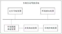
图1是本发明一实施例中车辆自动驾驶系统的一结构示意图;Fig. 1 is a structural schematic diagram of a vehicle automatic driving system in an embodiment of the present invention;
图2是本发明一实施例中车辆自动驾驶方法的一流程示意图;2 is a schematic flow chart of a vehicle automatic driving method in an embodiment of the present invention;
图3是图2中步骤S30的一实现流程示意图;FIG. 3 is a schematic diagram of an implementation process of step S30 in FIG. 2;
图4是本发明一实施例中车辆自动驾驶装置的一结构示意图;Fig. 4 is a schematic structural diagram of a vehicle automatic driving device in an embodiment of the present invention;
图5是本发明一实施例中车辆自动驾驶装置的另一结构示意图。Fig. 5 is another structural schematic diagram of a vehicle automatic driving device in an embodiment of the present invention.
具体实施方式Detailed ways
下面将结合本发明实施例中的附图,对本发明实施例中的技术方案进行清楚、完整地描述,显然,所描述的实施例是本发明一部分实施例,而不是全部的实施例。基于本发明中的实施例,本领域普通技术人员在没有作出创造性劳动前提下所获得的所有其他实施例,都属于本发明保护的范围。The following will clearly and completely describe the technical solutions in the embodiments of the present invention with reference to the accompanying drawings in the embodiments of the present invention. Obviously, the described embodiments are some of the embodiments of the present invention, but not all of them. Based on the embodiments of the present invention, all other embodiments obtained by persons of ordinary skill in the art without creative efforts fall within the protection scope of the present invention.
本发明实施例提供的环境数据重建方法,可应用在如图1所示的车辆自动驾驶系统中,该车辆自动驾驶系统包括定位导航装置、环境感知装置、环境数据重建装置、决策规划装置和车辆控制装置。其中,定位导航装置、环境感知装置、环境数据重建装置、车辆控制装置,通过总线与决策规划装置进行通信。The environment data reconstruction method provided by the embodiment of the present invention can be applied in the vehicle automatic driving system as shown in Figure 1. The vehicle automatic driving system includes a positioning navigation device, an environment perception device, an environment data reconstruction device, a decision planning device and a vehicle control device. Among them, the positioning and navigation device, the environment perception device, the environment data reconstruction device, and the vehicle control device communicate with the decision-making and planning device through the bus.
其中,定位导航装置用于对车辆进行实时定位导航,以获得静态地图信息和多个参考路径。环境感知装置用于对车辆周围的行车环境进行实时感知,以获得的环境感知信息。环境数据重建装置用于根据地图路径信息和环境感知信息生成环境重建数据,并发送环境重建数据至决策规划装置。决策规划装置用于根据环境重建数据进行自动驾驶决策规划以获得自动驾驶方案。车辆控制装置,用于根据自动驾驶方案对车辆进行自动驾驶控制。Among them, the positioning and navigation device is used for real-time positioning and navigation of the vehicle to obtain static map information and multiple reference routes. The environment perception device is used for real-time perception of the driving environment around the vehicle to obtain better environment perception information. The environment data reconstruction device is used to generate environment reconstruction data according to map path information and environment perception information, and send the environment reconstruction data to the decision planning device. The decision planning device is used for performing automatic driving decision planning according to the environment reconstruction data to obtain an automatic driving solution. The vehicle control device is used for performing automatic driving control on the vehicle according to the automatic driving scheme.
其中,环境数据重建装置根据地图路径信息和环境感知信息生成环境重建数据,包括:Wherein, the environmental data reconstruction device generates environmental reconstruction data according to map path information and environmental perception information, including:
通过获取对车辆进行实时定位导航获得的静态地图信息和多个参考路径,并获取对车辆周围的行车环境进行实时感知的环境感知信息,然后对静态地图信息和环境感知信息进行匹配融合,以获得校正后的环境融合信息,环境融合信息包括车辆周围的障碍物信息和交通信号灯信息,再根据障碍物信息和交通信号灯信息,确定每一参考路径的通行状态优先级,最后根据环境融合信息、多个参考路径以及参考路径的通行状态优先级,生成环境重建数据,并将环境重建数据发送至决策规划装置,以实现对车辆进行自动驾驶。By obtaining the static map information and multiple reference paths obtained by real-time positioning and navigation of the vehicle, and obtaining the environmental perception information for real-time perception of the driving environment around the vehicle, and then matching and fusing the static map information and environmental perception information to obtain The corrected environment fusion information, the environment fusion information includes the obstacle information around the vehicle and the traffic light information, and then according to the obstacle information and traffic light information, determine the traffic status priority of each reference path, and finally according to the environment fusion information, multiple Each reference path and the traffic status priority of the reference path are generated to generate environment reconstruction data and send the environment reconstruction data to the decision-making planning device to realize automatic driving of the vehicle.
本实施例中,在定位导航装置获得静态地图信息和多个参考路径,环境感知装置获得环境感知信息之后,环境数据重建装置通过将提前环境感知信息与静态地图信息的融合分析,有选择地输出为环境融合数据,并基于环境融合数据确定参考路径的通行状态优先级,然后生成环境重建数据输出给决策规划装置,为决策规划模块提供更为完备、精确的环境重建数据,且无需决策规划装置对未经筛选的原始信息进行处理,降低了决策规划的信息复杂度,提高了决策规划的效率,从而能够基于高精度环境重建数据快速规划出最优路径,以使车辆控制装置根据规划出最优路径,对车辆进行自动驾驶控制,提高了车辆自动驾驶系统的决策准确性和高响应性,进而保持了自动驾驶的安全性。In this embodiment, after the positioning and navigation device obtains static map information and multiple reference paths, and the environment perception device obtains environment perception information, the environment data reconstruction device selectively outputs Fusion data for the environment, and determine the traffic status priority of the reference path based on the environment fusion data, and then generate environment reconstruction data to output to the decision-making planning device, providing more complete and accurate environment reconstruction data for the decision-making planning module, without the need for a decision-making planning device Processing the unscreened original information reduces the information complexity of decision-making planning and improves the efficiency of decision-making planning, so that the optimal path can be quickly planned based on high-precision environmental reconstruction data, so that the vehicle control device can calculate the optimal path according to the planning. The optimal path is used to control the automatic driving of the vehicle, which improves the decision-making accuracy and high responsiveness of the automatic driving system of the vehicle, thereby maintaining the safety of automatic driving.
本实施例中,车辆自动驾驶系统包括定位导航装置、环境感知装置、环境数据重建装置、决策规划装置和车辆控制装置,仅为示例性说明,在其他实施例中,车辆自动驾驶系统还包括其他装置,例如用于执行车辆控制装置的控制指令的线控执行装置。In this embodiment, the vehicle automatic driving system includes a positioning and navigation device, an environment sensing device, an environmental data reconstruction device, a decision-making planning device and a vehicle control device, which are only illustrative. In other embodiments, the vehicle automatic driving system also includes other A device, such as a drive-by-wire device for executing control commands from a vehicle control device.
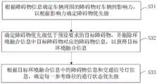
在一实施例中,如图2所示,提供一种环境数据重建方法,以该方法应用在图1中的车辆自动驾驶系统为例进行说明,包括如下步骤:In one embodiment, as shown in FIG. 2 , a method for reconstructing environmental data is provided, and the method is described by taking the vehicle automatic driving system in FIG. 1 as an example, including the following steps:
S10:获取对车辆进行实时定位导航获得的静态地图信息和多个参考路径,并获取对车辆周围的行车环境进行实时感知的环境感知信息。S10: Acquiring static map information and multiple reference routes obtained by real-time positioning and navigation of the vehicle, and obtaining environment perception information for real-time perception of the driving environment around the vehicle.
在车辆行驶过程中,车辆的定位导航装置会对车辆进行实时定位,获取车辆行驶道路的道路类型、几何结构、车道线及车道的坡度、曲率等数据属性,以及车辆所在车道周围的固定对象信息,如红绿灯、交通标志、限高限速等道路细节信息,作为世界坐标系下高精度的静态地图信息,同时,基于对车辆进行实时导航,通过GPS/IMU组合导航、点云匹配等方式获取车辆的定位信息,定位信息包括车辆当前的经纬度信息、车速、位姿等,然后根据车辆的定位信息、车辆的起点和终点,利用静态地图信息规划出车道级的参考路径,参考路径由车道中心线的离散点(即路点)集表示,并根据实时定位信息修正参考路径规划。During the driving process of the vehicle, the positioning and navigation device of the vehicle will locate the vehicle in real time, and obtain data attributes such as road type, geometric structure, lane line, slope, and curvature of the road where the vehicle is driving, as well as information about fixed objects around the lane where the vehicle is located. , such as traffic lights, traffic signs, height limit and speed limit and other road details, as high-precision static map information in the world coordinate system, and at the same time, based on real-time navigation of vehicles, it is obtained through GPS/IMU integrated navigation, point cloud matching, etc. The positioning information of the vehicle, the positioning information includes the current latitude and longitude information of the vehicle, vehicle speed, pose, etc., and then according to the positioning information of the vehicle, the starting point and the ending point of the vehicle, a lane-level reference path is planned by using the static map information. The reference path is determined by the center of the lane The set of discrete points (that is, waypoints) on the line is represented, and the reference path planning is revised according to the real-time positioning information.
在车辆行驶过程中,车辆的环境感知装置通过各类传感器(包括激光雷达、毫米波雷达、摄像头等),对车辆周围的环境信息进行捕捉以获得,获得环境信息,然后利用深度学习模型对环境信息进行障碍物、车道线、红绿灯等进行检测,获得车辆坐标系下的障碍物信息(包括障碍物的坐标位置、尺寸、速度、加速度和运动轨迹等信息)、车道信息(包括车道类型、车道线类型等)、交通信号灯信息(包括交通信号灯的位置、颜色、倒计时数字等),最终汇总为车辆周围动态的实时环境信息。During the driving process of the vehicle, the vehicle's environmental perception device captures the environmental information around the vehicle through various sensors (including lidar, millimeter-wave radar, camera, etc.), obtains the environmental information, and then uses the deep learning model to analyze the environment. information to detect obstacles, lane lines, traffic lights, etc., and obtain obstacle information in the vehicle coordinate system (including the coordinate position, size, speed, acceleration, and motion trajectory of obstacles, etc.), lane information (including lane type, lane Line type, etc.), traffic light information (including traffic signal position, color, countdown number, etc.), and finally aggregated into dynamic real-time environmental information around the vehicle.
然后,环境数据重建装置获取定位导航装置对车辆进行实时定位导航后,获得的静态地图信息和多个参考路径,并获取环境感知装置对车辆周围的行车环境进行实时感知处理后,获得的环境感知信息。Then, the environment data reconstruction device obtains the static map information and multiple reference routes obtained after the positioning and navigation device performs real-time positioning and navigation on the vehicle, and obtains the environment perception obtained after the environment perception device performs real-time perception processing on the driving environment around the vehicle. information.
本实施例中,多个参考路径包括3个参考路径,3个参考路径包括第一参考路径、第二参考路径、第三参考路径。In this embodiment, the multiple reference paths include 3 reference paths, and the 3 reference paths include a first reference path, a second reference path, and a third reference path.
第一参考路径为车辆(自车)所在车道;第二参考路径为车辆所在车道的左侧车道,即左侧车道;第三参考路径为车辆所在车道的右侧车道,即右侧车道。当车辆某一侧无车道时,则该参考路径空缺。The first reference path is the lane where the vehicle (own vehicle) is located; the second reference path is the left lane of the lane where the vehicle is located, i.e. the left lane; the third reference path is the right lane of the lane where the vehicle is located, i.e. the right lane. When there is no lane on one side of the vehicle, the reference path is empty.
S20:对静态地图信息和环境感知信息进行匹配融合,以获得校正后的环境融合信息,环境融合信息包括车辆周围的障碍物信息和交通信号灯信息。S20: Match and fuse the static map information and the environment perception information to obtain corrected environment fusion information, where the environment fusion information includes obstacle information and traffic signal light information around the vehicle.
在获得静态地图信息和环境感知信息之后,环境数据重建装置将静态地图信息和环境感知信息投影至同一坐标系中,以使静态地图信息和环境感知信息处于同一维度,然后将坐标系转换后的静态地图信息和环境感知信息进行匹配,以将无法匹配的信息剔除,实现信息校正,然后将校正后的环境感知信息和静态地图信息,按照响应坐标位置进行融合,以获得环境融合信息。其中,环境融合信息包括车辆周围的障碍物信息、交通信号灯信息、交通标志信息等。After obtaining the static map information and environmental awareness information, the environmental data reconstruction device projects the static map information and environmental awareness information into the same coordinate system, so that the static map information and environmental awareness information are in the same dimension, and then transforms the coordinate system into Static map information and environmental perception information are matched to eliminate unmatched information to achieve information correction, and then the corrected environmental perception information and static map information are fused according to the response coordinate position to obtain environmental fusion information. Among them, the environment fusion information includes obstacle information around the vehicle, traffic signal light information, traffic sign information, and the like.
S30:根据障碍物信息和交通信号灯信息,确定每一参考路径的通行状态优先级。S30: Determine the traffic state priority of each reference path according to the obstacle information and the traffic signal light information.
在对静态地图信息和环境感知信息进行匹配融合,以获得校正后的环境融合信息之后,根据环境融合信息中的障碍物信息和交通信号灯信息,确定每一参考路径的通行状态优先级。根据障碍物信息确定障碍物的坐标信息,根据障碍物的坐标信息确定位于每一参考路径上的目标障碍物,并根据交通信号灯信息中,交通信号灯的位置确定参考路径所属的目标交通信号灯,然后根据目标障碍物的相关信息(包括加速度、速度、坐标位置和运动轨迹),以及目标交通信号灯的相关信息(包括交通信号灯的颜色、倒计时数字)等,确定每一参考路径的通行状态优先级。After matching and merging the static map information and environmental perception information to obtain the corrected environmental fusion information, the traffic status priority of each reference path is determined according to the obstacle information and traffic signal information in the environmental fusion information. Determine the coordinate information of the obstacle according to the obstacle information, determine the target obstacle located on each reference path according to the obstacle information, and determine the target traffic light to which the reference path belongs according to the position of the traffic signal light in the traffic signal light information, and then According to the relevant information of the target obstacle (including acceleration, velocity, coordinate position and motion trajectory), and the relevant information of the target traffic signal light (including the color of the traffic signal light, countdown number), etc., determine the traffic status priority of each reference path.
参考路径上的目标障碍物数量越多、障碍物移动速度越慢,参考路径的通行状态优先级越低;目标交通信号灯为红色的参考路径比目标交通信号灯为绿色的通行状态优先级低,目标交通信号灯的倒计时数字越小,通行状态优先级越低。The greater the number of target obstacles on the reference path and the slower the moving speed of the obstacles, the lower the priority of the traffic state of the reference path; the reference path with a red target traffic light has a lower priority than the traffic state with a green target traffic light. The smaller the countdown number of the traffic light, the lower the priority of the traffic state.
例如,当车辆接近交通信号灯(红绿灯)所在路口时,交通信号灯状态(颜色)指示车辆同向车道均为不可通行状态,且车辆所在车道(第一参考路径)两侧为长实线,此时第一参考路径的通行状态优先级,将高于其他两个参考路径的通行状态优先级;当车辆在非路口道路行驶时,车辆所在车道的左侧车道(第二参考路径)的车道线为实线,右侧车道(第三参考路径)的车道线为虚线,且车辆所在车道的前方有低速行驶车辆,右侧车道无行驶车辆,则此时右侧车道(第三参考路径)的通行状态优先级最高,左侧车道(第二参考路径)的通行状态优先级最低。For example, when a vehicle approaches the intersection where a traffic signal light (traffic light) is located, the status (color) of the traffic signal light indicates that the lanes in the same direction of the vehicle are all impassable, and both sides of the lane where the vehicle is located (the first reference path) are long solid lines. The traffic state priority of the first reference path will be higher than the traffic state priority of the other two reference paths; when the vehicle is driving on a non-intersection road, the lane line of the left lane (second reference path) of the vehicle lane is Solid line, the lane line of the right lane (the third reference path) is a dotted line, and there are low-speed vehicles in front of the lane where the vehicle is located, and there is no vehicle in the right lane, then the traffic in the right lane (third reference path) at this time The state has the highest priority, and the traffic state of the left lane (the second reference path) has the lowest priority.
S40:根据环境融合信息、多个参考路径以及参考路径的通行状态优先级,生成环境重建数据,并将环境重建数据发送至决策规划装置,以实现对车辆进行自动驾驶。S40: Generate environment reconstruction data according to the environment fusion information, multiple reference routes, and traffic status priorities of the reference routes, and send the environment reconstruction data to the decision-making and planning device, so as to realize automatic driving of the vehicle.
在确定参考路径的通行状态优先级之后,根据环境融合信息、多个参考路径以及参考路径的通行状态优先级,生成环境重建数据,并将环境重建数据发送至决策规划装置,以实现对车辆进行自动驾驶。例如,可以直接将环境融合信息、多个参考路径以及参考路径的通行状态优先级,汇总为环境重建数据,然后将环境重建数据发送给决策规划装置,决策规划装置接收决策规划装置之后,根据环境重建数据的参考路径的通行状态优先级,选择满足控制需求的参考路径,得到自动驾驶方案,以使车辆控制装置按照自动驾驶方案对车辆进行自动驾驶控制。After determining the traffic state priority of the reference path, according to the environment fusion information, multiple reference paths, and the traffic state priority of the reference path, generate environment reconstruction data, and send the environment reconstruction data to the decision-making planning device, so as to realize the vehicle Autopilot. For example, the environment fusion information, multiple reference paths, and the traffic status priorities of the reference paths can be directly aggregated into environment reconstruction data, and then the environment reconstruction data is sent to the decision-making planning device. Reconstruct the traffic status priority of the reference path of the data, select the reference path that meets the control requirements, and obtain the automatic driving scheme, so that the vehicle control device performs automatic driving control on the vehicle according to the automatic driving scheme.
本实施例中,通过获取对车辆进行实时定位导航获得的静态地图信息和多个参考路径,并获取对车辆周围的行车环境进行实时感知的环境感知信息,然后对静态地图信息和环境感知信息进行匹配融合,以获得校正后的环境融合信息,环境融合信息包括车辆周围的障碍物信息和交通信号灯信息,再根据障碍物信息和交通信号灯信息,确定每一参考路径的通行状态优先级,最后根据环境融合信息、多个参考路径以及参考路径的通行状态优先级,生成环境重建数据,并将环境重建数据发送至决策规划装置,以实现对车辆进行自动驾驶;通过将提前环境感知信息与静态地图信息的融合分析,有选择地输出为环境融合数据,并基于环境融合数据确定参考路径的通行状态优先级,然后生成环境重建数据输出给决策规划装置,为决策规划模块提供更为完备、精确的环境重建数据,且无需决策规划装置对未经筛选的原始信息进行处理,降低了决策规划的信息复杂度,提高了决策规划的效率,从而能够基于高精度环境重建数据快速规划出最优路径。In this embodiment, the static map information and multiple reference paths obtained by real-time positioning and navigation of the vehicle are obtained, and the environment perception information for real-time perception of the driving environment around the vehicle is obtained, and then the static map information and the environment perception information are obtained. Matching and fusion to obtain the corrected environment fusion information. The environment fusion information includes obstacle information and traffic light information around the vehicle, and then according to the obstacle information and traffic light information, determine the traffic status priority of each reference path, and finally according to Environmental fusion information, multiple reference routes and the priority of the traffic status of the reference routes generate environmental reconstruction data and send the environmental reconstruction data to the decision-making planning device to realize automatic driving of the vehicle; by combining the environmental perception information in advance with the static map Information fusion analysis, selectively output as environment fusion data, and based on the environment fusion data to determine the traffic status priority of the reference path, and then generate environment reconstruction data to output to the decision-making planning device, providing more complete and accurate information for the decision-making planning module The environment reconstruction data does not require a decision-making planning device to process unscreened raw information, which reduces the information complexity of decision-making planning and improves the efficiency of decision-making planning, so that the optimal path can be quickly planned based on high-precision environment reconstruction data.
在一实施例中,步骤S20中,即对静态地图信息和环境感知信息进行匹配融合,以获得校正后的环境融合信息,具体包括如下步骤:In one embodiment, in step S20, the static map information and the environmental awareness information are matched and fused to obtain the corrected environment fusion information, which specifically includes the following steps:
S21:将环境感知信息和静态地图信息,投影至同一坐标系中,以获得第一感知信息和第一地图信息。S21: Project the environmental perception information and the static map information into the same coordinate system to obtain the first perception information and the first map information.
在获取环境感知信息和静态地图信息之后,将环境感知信息和静态地图信息,投影至同一坐标系中,以获得第一感知信息和第一地图信息。After the environment perception information and the static map information are acquired, the environment perception information and the static map information are projected into the same coordinate system to obtain the first perception information and the first map information.
其中,先根据车辆坐标系下的环境感知信息(包括障碍物信息和交通信号灯信息),确定障碍物的坐标信息和交通信号灯的坐标信息,然后将车辆坐标系下障碍物和交通信号灯的的坐标信息,分别投影到世界坐标系(如UTM坐标系或WGS84坐标系)下,所采用的投影变换公式为:Among them, according to the environmental perception information (including obstacle information and traffic signal light information) in the vehicle coordinate system, the coordinate information of the obstacle and the traffic signal light are determined first, and then the coordinate information of the obstacle and the traffic signal light in the vehicle coordinate system Information, respectively projected to the world coordinate system (such as UTM coordinate system or WGS84 coordinate system), the projection transformation formula adopted is:

其中,[ux、uy、uz]表示UTM坐标系下的坐标信息,ux、uy、uz分别表示UTM坐标系下x轴、y轴和z轴的坐标;[vx、vy、vz]表示世界坐标系下的坐标信息,vx、vy、vz分别表示世界坐标系下x轴、y轴和z轴的坐标;R表示旋转矩阵,由车辆(自车)在UTM坐标系下的姿态计算得到;T表示平移矩阵,由车辆(自车)在UTM坐标系下的坐标信息表示。Among them, [ux , uy , uz ] represent the coordinate information in the UTM coordinate system, ux , uy , uz represent the coordinates of the x-axis, y-axis and z-axis in the UTM coordinate system respectively; [vx , vy , vz ] represent the coordinate information in the world coordinate system, vx , vy , vz represent the coordinates of the x-axis, y-axis and z-axis in the world coordinate system respectively; R represents the rotation matrix, and the vehicle (self-vehicle ) is calculated from the attitude in the UTM coordinate system; T represents the translation matrix, which is represented by the coordinate information of the vehicle (self-vehicle) in the UTM coordinate system.
由于静态地图信息往往采用WGS84坐标系或UTM坐标系表示,因此可调用C++开源库PROJ的API,对环境感知信息进行WGS坐标系和UTM坐标系的转换。通过C++开源库PROJ的API,可以直接将据此环境感知信息与地图信息投影到同一UTM坐标系,使得环境感知信息与地图信息处于同一维度,以便后续进行信息处理分析和融合。Since the static map information is often represented by the WGS84 coordinate system or the UTM coordinate system, the API of the C++ open source library PROJ can be called to convert the WGS coordinate system and the UTM coordinate system for the environmental perception information. Through the API of the C++ open source library PROJ, the environmental perception information and map information can be directly projected to the same UTM coordinate system, so that the environmental perception information and map information are in the same dimension for subsequent information processing analysis and fusion.
S22:根据障碍物的位置,剔除第一感知信息中对车辆无影响的障碍物信息,以获得第二感知信息。S22: According to the position of the obstacle, eliminate the obstacle information that has no influence on the vehicle in the first sensing information, so as to obtain the second sensing information.
在获得第一感知信息之后,根据第一感知信息中障碍物的位置(坐标信息),剔除第一感知信息中对车辆未来一段时间内无影响的障碍物信息,以获得第二感知信息。After obtaining the first sensing information, according to the position (coordinate information) of the obstacle in the first sensing information, remove the obstacle information in the first sensing information that has no influence on the vehicle for a period of time in the future, so as to obtain the second sensing information.
其中,根据第一感知信息中障碍物的位置(坐标信息),剔除第一感知信息中对车辆未来一段时间内无影响的障碍物信息,以获得第二感知信息,包括:先根据障碍物的坐标信息判断障碍物所属区域;Wherein, according to the position (coordinate information) of the obstacle in the first sensing information, the obstacle information in the first sensing information that has no influence on the vehicle for a period of time in the future is eliminated to obtain the second sensing information, including: Coordinate information to determine the area to which the obstacle belongs;
当障碍物所属区域为第一地图信息中的非可行驶区域,该障碍物对车辆未来一段时间内无影响,则丢弃该障碍物信息;若障碍物所属区域不是车辆(自车)的行驶道路,如障碍物所属区域在车辆的对向车道、障碍物所属区域为不同位面的道路(高架桥)、障碍物所属区域与车辆的行驶道路中间有不可逾越区域(如护栏、隔离带等),确定障碍物所属区域不是车辆(自车)的行驶道路,该障碍物对车辆未来一段时间内无影响,则丢弃该障碍物信息,其他障碍物信息则保留做后续处理,以获得第二感知信息。When the region to which the obstacle belongs is a non-drivable region in the first map information, and the obstacle has no influence on the vehicle for a period of time in the future, then discard the obstacle information; if the region to which the obstacle belongs is not the driving road of the vehicle (self-car) , if the area to which the obstacle belongs is in the opposite lane of the vehicle, the area to which the obstacle belongs is a road of a different plane (viaduct), and there is an insurmountable area (such as guardrails, isolation belts, etc.) between the area to which the obstacle belongs and the driving road of the vehicle, If it is determined that the area to which the obstacle belongs is not the driving road of the vehicle (self-vehicle), and the obstacle will not affect the vehicle for a period of time in the future, then discard the obstacle information, and keep other obstacle information for subsequent processing to obtain the second perception information .
S23:对第二感知信息和第一地图信息中的交通信号灯进行匹配融合,并剔除不属于参考路径的交通信号灯信息,以获得校正后的环境融合信息。S23: Matching and fusing the traffic lights in the second perception information and the first map information, and removing the traffic lights information that does not belong to the reference path, so as to obtain corrected environment fusion information.
在获得第二感知信息之后,对第二感知信息和第一地图信息中的交通信号灯进行匹配融合,并剔除不属于参考路径的交通信号灯信息,以获得校正后的环境融合信息。After the second perception information is obtained, the second perception information and the traffic lights in the first map information are matched and fused, and the traffic lights information that does not belong to the reference path are eliminated, so as to obtain the corrected environment fusion information.
例如,在获得第二感知信息之后,确定车辆(自车)的预设范围内(如200米范围内),是否存在交通信号灯;若存在交通信号灯,则将第二感知信息中交通信号灯的位置(坐标信息),与第一地图信息中交通信号灯的位置(坐标信息)进行匹配,确定交通信号灯是否为指示参考路径的交通信号灯;若该交通信号灯为指示参考路径的交通信号灯,则保留,若该交通信号灯不是指示参考路径的交通信号灯,则丢弃不属于参考路径的交通信号灯信息,遍历预设范围内所有交通信号灯,以获得校正后的环境融合信息。For example, after obtaining the second perception information, it is determined whether there is a traffic light within the preset range (such as within 200 meters) of the vehicle (ego vehicle); if there is a traffic light, the position of the traffic light in the second perception information (coordinate information), match with the position (coordinate information) of the traffic light in the first map information, determine whether the traffic light is the traffic light indicating the reference route; if the traffic signal is the traffic signal indicating the reference route, then keep, if If the traffic signal is not a traffic signal indicating the reference route, the traffic signal information that does not belong to the reference route is discarded, and all traffic signals within a preset range are traversed to obtain corrected environment fusion information.
本实施例中,通过将环境感知信息和静态地图信息,投影至同一坐标系中,以获得第一感知信息和第一地图信息;根据障碍物的位置,剔除第一感知信息中对车辆无影响的障碍物信息,以获得第二感知信息;对第二感知信息和第一地图信息中的交通信号灯进行匹配融合,并剔除不属于参考路径的交通信号灯信息,以获得校正后的环境融合信息,明确了对静态地图信息和环境感知信息进行匹配融合,以获得校正后的环境融合信息的具体步骤,在对环境感知信息和静态地图信息进行融合时,预先剔除不符合要求的障碍物信息和交通信号灯信息,能够有效剔除无效信息,从而有效降低信息复杂度。In this embodiment, the environment perception information and the static map information are projected into the same coordinate system to obtain the first perception information and the first map information; according to the position of the obstacle, the first perception information that has no effect on the vehicle is eliminated Obstacle information to obtain the second perception information; Match and fuse the traffic lights in the second perception information and the first map information, and remove the traffic lights information that does not belong to the reference path to obtain the corrected environment fusion information, Specific steps for matching and merging static map information and environmental perception information to obtain corrected environmental fusion information are clarified. When merging environmental perception information and static map information, obstacle information and traffic information that do not meet the requirements are eliminated in advance. Signal light information can effectively eliminate invalid information, thereby effectively reducing the complexity of information.
在一实施例中,如图3所示,步骤S30中,即根据障碍物信息和交通信号灯信息,确定每一参考路径的通行状态优先级,具体包括如下步骤:In one embodiment, as shown in FIG. 3, in step S30, namely, according to the obstacle information and the traffic signal light information, the traffic state priority of each reference path is determined, which specifically includes the following steps:
S31:根据障碍物信息确定车辆周围的障碍物对车辆的影响力,以根据影响力确定障碍物优先级。S31: Determine the influence of the obstacles around the vehicle on the vehicle according to the obstacle information, so as to determine the obstacle priority according to the influence.
在对静态地图信息和环境感知信息进行匹配融合,以获得校正后的环境融合信息之后,先根据环境融合信息中的障碍物信息,确定车辆周围的障碍物对车辆的影响力,以根据影响力确定车辆周围障碍物的障碍物优先级。其中,车辆周围的障碍物距离车辆越远和/或障碍物移动越慢,影响力越低,则障碍物优先级越低。After matching and fusing the static map information and environmental perception information to obtain the corrected environmental fusion information, first determine the influence of the obstacles around the vehicle on the vehicle according to the obstacle information in the environmental fusion information, and then use the Determines obstacle priority for obstacles around the vehicle. Wherein, the farther the obstacle around the vehicle is from the vehicle and/or the slower the obstacle moves and the lower the influence, the lower the priority of the obstacle.
S32:确定障碍物优先级低于预设要求的目标障碍物,并剔除环境融合信息中目标障碍物对应的障碍物信息,以获得目标环境融合信息。S32: Determine the target obstacle whose obstacle priority is lower than the preset requirement, and eliminate the obstacle information corresponding to the target obstacle in the environment fusion information, so as to obtain the target environment fusion information.
在确定车辆周围障碍物的障碍物优先级之后,将障碍物优先级低于预设要求(如优先级低于一定阈值)的障碍物作为目标障碍物,然后剔除环境融合信息中目标障碍物对应的障碍物信息,以获得目标环境融合信息。After determining the obstacle priority of the obstacles around the vehicle, the obstacle whose priority is lower than the preset requirement (for example, the priority is lower than a certain threshold) is taken as the target obstacle, and then the target obstacle corresponding to the target obstacle in the environment fusion information is eliminated. obstacle information to obtain target environment fusion information.
S33:根据目标环境融合信息中的障碍物信息和交通信号灯信息,确定每一参考路径的通行状态优先级。S33: According to the obstacle information and traffic signal light information in the target environment fusion information, determine the priority of the traffic status of each reference path.
在剔除掉低障碍物优先级的障碍物信息之后,根据目标环境融合信息中的障碍物信息和交通信号灯信息,确定每一参考路径的通行状态优先级。障碍物优先级低于一定阈值的障碍物即认为对车辆行驶不会产生影响,在后续决策规划中将不予考虑,因此丢弃该障碍物信息,减少后续的数据处理量和复杂度,进而减少系统负担。After eliminating the obstacle information with low obstacle priority, according to the obstacle information and traffic light information in the target environment fusion information, the traffic status priority of each reference path is determined. Obstacles with an obstacle priority lower than a certain threshold are considered to have no impact on vehicle driving and will not be considered in subsequent decision-making planning. Therefore, the obstacle information is discarded to reduce subsequent data processing and complexity, thereby reducing system burden.
本实施例中,根据障碍物信息确定车辆周围的障碍物对车辆的影响力,以根据影响力确定障碍物优先级;确定障碍物优先级低于预设要求的目标障碍物,并剔除环境融合信息中目标障碍物对应的障碍物信息,以获得目标环境融合信息;根据目标环境融合信息中的障碍物信息和交通信号灯信息,确定每一参考路径的通行状态优先级,细化了根据障碍物信息和交通信号灯信息,确定每一参考路径的通行状态优先级的具体步骤,在计算通行状态优先级之前,先剔除掉低障碍物优先级的障碍物信息,精简环境融合信息,以便减少后续根据障碍物信息确定参考路径的通行状态优先级的计算量,也减少后续决策规划装置的计算量,减少系统负担。In this embodiment, the influence of the obstacles around the vehicle on the vehicle is determined according to the obstacle information, so as to determine the obstacle priority according to the influence; determine the target obstacle whose priority is lower than the preset requirement, and eliminate the environment fusion The obstacle information corresponding to the target obstacle in the information is used to obtain the target environment fusion information; according to the obstacle information and traffic signal light information in the target environment fusion information, the traffic status priority of each reference path is determined, and the information based on the obstacle is refined. Information and traffic light information, the specific steps to determine the traffic status priority of each reference path, before calculating the traffic status priority, first eliminate the obstacle information with low obstacle priority, simplify the environment fusion information, in order to reduce the subsequent basis Obstacle information determines the calculation amount of the traffic state priority of the reference path, and also reduces the calculation amount of the subsequent decision-making and planning device, and reduces the system burden.
在一实施例中,步骤S31中,即根据障碍物信息确定车辆周围的障碍物对车辆的影响力,以根据影响力确定障碍物优先级,具体包括如下步骤:In one embodiment, in step S31, the influence of the obstacles around the vehicle on the vehicle is determined according to the obstacle information, so as to determine the obstacle priority according to the influence, which specifically includes the following steps:
S311:根据环境融合信息对障碍物的运动轨迹进行预测,以获得障碍物的预测轨迹,并根据障碍物的预测轨迹和车道信息,确定障碍物的换道意图。S311: Predict the movement trajectory of the obstacle according to the environment fusion information to obtain the predicted trajectory of the obstacle, and determine the lane-changing intention of the obstacle according to the predicted trajectory of the obstacle and lane information.
在获取环境融合信息之后,根据环境融合信息中提取出每一障碍物的障碍物信息,障碍物信息包括障碍物的坐标信息、加速度、速度、历史轨迹等信息。根据障碍物的历史轨迹、对障碍物的运动轨迹进行预测,以获得障碍物的预测轨迹,并根据障碍物的预测轨迹和车道信息,确定障碍物的换道意图。After the environment fusion information is obtained, the obstacle information of each obstacle is extracted according to the environment fusion information. The obstacle information includes the coordinate information, acceleration, speed, historical trajectory and other information of the obstacle. According to the historical trajectory of the obstacle, the trajectory of the obstacle is predicted to obtain the predicted trajectory of the obstacle, and the lane change intention of the obstacle is determined according to the predicted trajectory of the obstacle and the lane information.
在获取环境融合信息之后,将车辆所在车道的车道中心线作为参考线,对障碍物信息进行Frenet坐标系转换,以获得障碍物在Frenet坐标系下的障碍物信息。After the environment fusion information is obtained, the lane centerline of the lane where the vehicle is located is used as a reference line, and the obstacle information is converted to the Frenet coordinate system to obtain the obstacle information of the obstacle in the Frenet coordinate system.
其中,车辆所在车道的车道中心线(即参考线)为一组有序的离散路点集,将离车辆(自车)最近的路点为参考线的零点,并截取零点后(即车辆的后方车道中心线)100米和零点前(即车辆的前方车道中心线)200米范围内的路点组成参考线。在获得参考线后,计算每个障碍物在参考线上的投影点,并求投影点到零点的累计距离作为障碍物在Frenet坐标系下的横坐标,障碍物到投影点的距离作为障碍物在Frenet坐标系下的纵坐标,并计算障碍物在Frenet坐标系下的航向角、速度、加速度等;然后根据障碍物在Frenet坐标系下的坐标信息及各车道宽度,判断障碍物所在车道;根据障碍物的历史运动轨迹预测其未来轨迹,以获得障碍物的预测轨迹;结合预测轨迹和车道信息,判断障碍物的驾驶意图。Among them, the lane centerline (i.e. the reference line) of the lane where the vehicle is located is an ordered set of discrete waypoints, the waypoint closest to the vehicle (self-vehicle) is taken as the zero point of the reference line, and after the zero point is intercepted (i.e. the vehicle’s The reference line is composed of waypoints within 100 meters from the rear lane centerline) and 200 meters before the zero point (that is, the front lane centerline of the vehicle). After obtaining the reference line, calculate the projection point of each obstacle on the reference line, and calculate the cumulative distance from the projection point to the zero point as the abscissa of the obstacle in the Frenet coordinate system, and the distance from the obstacle to the projection point as the obstacle The ordinate in the Frenet coordinate system, and calculate the heading angle, velocity, acceleration, etc. of the obstacle in the Frenet coordinate system; then judge the lane where the obstacle is located according to the coordinate information of the obstacle in the Frenet coordinate system and the width of each lane; Predict the future trajectory of the obstacle according to the historical trajectory of the obstacle to obtain the predicted trajectory of the obstacle; combine the predicted trajectory and lane information to judge the driving intention of the obstacle.
其中,可以将障碍物的历史运动轨迹和车道信息作为轨迹预设模型的输入,以使轨迹预设模型对障碍物的未来运动轨迹进行预测,并获得轨迹预设模型的输出结果,作为障碍物的预测轨迹。Among them, the historical trajectory and lane information of the obstacle can be used as the input of the trajectory preset model, so that the trajectory preset model can predict the future trajectory of the obstacle, and the output result of the trajectory preset model can be obtained as the obstacle predicted trajectory.
其中,根据障碍物的坐标信息和车道信息确定障碍物所在车道,然后根据障碍物所在车道、预测轨迹和周围其他车道信息,确定障碍物的换道意图。其中,障碍物的换道意图包括:当前车道内车道保持、当前车道内往左换道、当前车道往右换道、当前车道静止、左车道内车道保持、左车道往外换道、左车道往当前车道换道、左车道静止、右车道内车道保持、右车道往外换道、右车道往当前车道换道、右车道静止、左外车道往左车道换道、右外车道往右车道换道、左外车道往当前车道换道、右外车道往当前车道换道等。Among them, the lane where the obstacle is located is determined according to the coordinate information and lane information of the obstacle, and then the lane change intention of the obstacle is determined according to the lane where the obstacle is located, the predicted trajectory and other surrounding lane information. Among them, the lane changing intention of the obstacle includes: lane keeping in the current lane, lane changing to the left in the current lane, lane changing in the current lane to the right, stationary lane in the current lane, lane keeping in the left lane, lane changing in the left lane outward, lane turning in the left lane Current lane change, left lane stationary, right lane lane keeping, right lane change outward, right lane change right to current lane, right lane stationary, left outer lane change to left lane, right outer lane change right lane , Change lanes from the left outer lane to the current lane, change lanes from the right outer lane to the current lane, etc.
S312:根据障碍物信息确定障碍物的坐标信息、加速度和速度。S312: Determine the coordinate information, acceleration and speed of the obstacle according to the obstacle information.
同时,确定障碍物信息确定障碍物的坐标信息、加速度和速度。At the same time, determine the obstacle information and determine the coordinate information, acceleration and speed of the obstacle.
S313:对障碍物的换道意图、坐标信息、加速度和速度,进行加权评分计算,以获得障碍物的影响力评分值。S313: Perform weighted score calculation on the lane-changing intention, coordinate information, acceleration and velocity of the obstacle to obtain an influence score value of the obstacle.
在确定障碍物的换道意图、坐标信息、加速度和速度之后,根据预先设定的权重赋予规则,确定障碍物的换道意图、坐标信息、加速度和速度赋对应的权重,并根据预先设定的评分规则,确定障碍物的换道意图、坐标信息、加速度和速度的对应评分,然后根据障碍物的换道意图、坐标信息、加速度和速度的对应权重和对应评分,进行加权计算,以获得障碍物的影响力评分值,用于表征障碍物对车辆的影响力。可以将环境融合信息中,影响力评分值第一移动评分阈值的障碍物剔除,以获得目标环境融合信息。After determining the lane-changing intention, coordinate information, acceleration and speed of the obstacle, according to the preset weighting rules, determine the corresponding weight of the obstacle's lane-changing intention, coordinate information, acceleration and speed, and according to the preset According to the scoring rules of the obstacle, determine the lane-changing intention, coordinate information, acceleration and velocity corresponding scores of the obstacle, and then perform weighted calculation according to the corresponding weight and corresponding score of the obstacle lane-changing intention, coordinate information, acceleration and velocity, to obtain The influence score value of the obstacle, which is used to represent the influence of the obstacle on the vehicle. In the environment fusion information, the obstacles whose influence score value is the first moving score threshold can be removed to obtain the target environment fusion information.
S314:根据障碍物的影响力评分值,确定障碍物的障碍物优先级。S314: Determine the obstacle priority of the obstacle according to the influence score value of the obstacle.
在计算障碍物的影响力评分值之后,根据障碍物的影响力评分值,确定障碍物的障碍物优先级。影响力评分值越高,障碍物优先级越高。After the influence score value of the obstacle is calculated, the obstacle priority of the obstacle is determined according to the influence score value of the obstacle. The higher the influence score value, the higher the obstacle priority.
本实施例中,根据环境融合信息对障碍物的运动轨迹进行预测,以获得障碍物的预测轨迹,并根据障碍物的预测轨迹和车道信息,确定障碍物的换道意图;根据障碍物信息确定障碍物的坐标信息、加速度和速度;对障碍物的换道意图、坐标信息、加速度和速度,进行加权评分计算,以获得障碍物的影响力评分值;根据障碍物的影响力评分值,确定障碍物的障碍物优先级,明确了根据障碍物信息确定车辆周围的障碍物对车辆的影响力,以根据影响力确定障碍物优先级的具体步骤,对障碍物的换道意图、坐标信息、加速度和速度,进行加权评分计算,能够精确地计算出障碍物的影响力评分值,准确评估障碍物对车辆的影响力,进而提高了后续障碍物优先级的准确性。In this embodiment, the trajectory of the obstacle is predicted according to the environment fusion information to obtain the predicted trajectory of the obstacle, and the lane change intention of the obstacle is determined according to the predicted trajectory of the obstacle and the lane information; The coordinate information, acceleration and speed of the obstacle; the weighted score calculation is performed on the lane change intention, coordinate information, acceleration and speed of the obstacle to obtain the influence score value of the obstacle; according to the influence score value of the obstacle, determine Obstacle priority of obstacles, clarifying the influence of obstacles around the vehicle on the vehicle according to the obstacle information, and the specific steps to determine the priority of obstacles according to the influence, the lane change intention, coordinate information, Acceleration and speed, weighted score calculation, can accurately calculate the impact score value of obstacles, accurately evaluate the influence of obstacles on the vehicle, and then improve the accuracy of subsequent obstacle priority.
在一实施例中,步骤S30或S33中,即根据障碍物信息和交通信号灯信息,确定每一参考路径的通行状态优先级,具体包括如下步骤:In one embodiment, in step S30 or S33, that is, according to the obstacle information and the traffic signal light information, determining the traffic state priority of each reference path specifically includes the following steps:
S31:根据交通信号灯信息确定参考路径上的交通信号灯状态,并确定参考路径的车道线信息。S31: Determine the state of the traffic signal light on the reference route according to the traffic signal light information, and determine the lane line information of the reference route.
在获取目标环境融合信息之后,根据目标环境融合信息中的交通信号灯信息,确定参考路径上的交通信号灯状态,并确定参考路径的车道线信息。其中,交通信号灯状态包括红灯状态、绿灯状态和黄灯状态。参考路径的车道线信息包括参考路径的车道线类型和车道属性。After obtaining the target environment fusion information, according to the traffic signal light information in the target environment fusion information, determine the traffic signal light status on the reference path, and determine the lane line information of the reference path. Wherein, the traffic signal light state includes a red light state, a green light state and a yellow light state. The lane line information of the reference path includes the lane line type and lane attribute of the reference path.
S32:根据障碍物信息,确定参考路径上的目标障碍物,并确定目标障碍物的坐标信息、换道意图、加速度和速度。S32: Determine the target obstacle on the reference path according to the obstacle information, and determine the coordinate information, lane change intention, acceleration and speed of the target obstacle.
在确定参考路径上的交通信号灯状态,并确定参考路径的车道线信息之后,根据目标环境融合信息中的障碍物信息(包括障碍物的坐标信息、换道意图、加速度和速度),确定参考路径上的目标障碍物,并确定目标障碍物的坐标信息、换道意图、加速度和速度。After determining the state of the traffic lights on the reference path and determining the lane line information of the reference path, the reference path is determined according to the obstacle information in the fusion information of the target environment (including the coordinate information of the obstacle, lane change intention, acceleration and speed). and determine the coordinate information, lane change intention, acceleration and velocity of the target obstacle.
S33:对参考路径的通信号灯状态、车道线信息,以及目标障碍物的坐标信息、换道意图、加速度和速度,进行加权评分计算,以获得参考路径的通行状态评分。S33: Carry out weighted score calculation on the traffic signal status of the reference path, lane line information, and coordinate information of the target obstacle, lane change intention, acceleration and speed, so as to obtain the traffic status score of the reference path.
然后,对参考路径的通信号灯状态、车道线信息,以及目标障碍物的坐标信息、换道意图、加速度和速度,进行加权评分计算,以获得参考路径的通行状态评分。Then, the weighted score calculation is performed on the traffic signal status of the reference path, lane line information, and the coordinate information of the target obstacle, lane-changing intention, acceleration, and speed to obtain the traffic status score of the reference path.
其中,先按照预先设定的评分规则,对参考路径的通信号灯状态、车道线信息,以及目标障碍物的坐标信息、换道意图、加速度和速度进行评分,并按照预先设定的权重赋予规则,确定参考路径的交通信号灯状态、车道线信息,以及目标障碍物的坐标信息、换道意图、加速度和速度的对应权重,最后根据通信号灯状态、车道线信息,以及目标障碍物的坐标信息、换道意图、加速度和速度,所对应的评分和对应权重,进行加权计算,获得参考路径的通行状态评分,以表征参考路径的通行状态,即参考路径的通畅状态。Among them, according to the preset scoring rules, the traffic signal status of the reference path, the lane line information, and the coordinate information of the target obstacle, lane changing intention, acceleration and speed are scored, and according to the preset weighting rules , determine the traffic signal status, lane line information of the reference path, and the coordinate information of the target obstacle, lane change intention, acceleration and speed corresponding weights, and finally according to the traffic signal status, lane line information, and the coordinate information of the target obstacle, Lane-changing intention, acceleration and speed, the corresponding scores and corresponding weights are weighted to obtain the traffic status score of the reference path to represent the traffic status of the reference path, that is, the unobstructed state of the reference path.
S34:根据参考路径的通行状态评分,确定参考路径的通行状态优先级。S34: Determine the traffic status priority of the reference route according to the traffic status score of the reference route.
在计算获得参考路径的通行状态评分之后,根据参考路径的通行状态评分,确定参考路径的通行状态优先级。通行状态评分越高,参考路径的通行状态优先级越高。After the traffic status score of the reference route is obtained through calculation, the traffic status priority of the reference route is determined according to the traffic status score of the reference route. The higher the traffic status score, the higher the traffic status priority of the reference route.
本实施例中,根据交通信号灯信息确定参考路径上的交通信号灯状态,并确定参考路径的车道线信息;根据障碍物信息,确定参考路径上的目标障碍物,并确定目标障碍物的坐标信息、换道意图、加速度和速度;对参考路径的通信号灯状态、车道线信息,以及目标障碍物的坐标信息、换道意图、加速度和速度,进行加权评分计算,以获得参考路径的通行状态评分;根据参考路径的通行状态评分,确定参考路径的通行状态优先级,明确了根据障碍物信息和交通信号灯信息,确定每一参考路径的通行状态优先级的具体过程,对参考路径的通信号灯状态、车道线信息,以及目标障碍物的坐标信息、换道意图、加速度和速度,进行加权评分计算,能够精确地计算出参考路径的通行状态评分,准确评估参考路径的通行状态,进而提高了计算的通行状态优先级的准确性,为后续进行决策规划提供了准确基础。In this embodiment, the state of the traffic signal light on the reference path is determined according to the traffic signal light information, and the lane line information of the reference path is determined; the target obstacle on the reference path is determined according to the obstacle information, and the coordinate information of the target obstacle is determined, Lane-changing intention, acceleration and speed; carry out weighted score calculation on the traffic signal status of the reference path, lane line information, and coordinate information of the target obstacle, lane-changing intention, acceleration and speed, to obtain the traffic status score of the reference path; According to the traffic state score of the reference path, the traffic state priority of the reference path is determined, and the specific process of determining the traffic state priority of each reference path according to the obstacle information and traffic signal light information is clarified. Lane line information, as well as coordinate information of target obstacles, lane-changing intentions, acceleration and speed, carry out weighted score calculations, which can accurately calculate the traffic status score of the reference path, accurately evaluate the traffic status of the reference path, and thus improve the calculation efficiency. The accuracy of traffic status priority provides an accurate basis for subsequent decision-making planning.
在一实施例中,步骤S40中,即根据环境融合信息、多个参考路径以及参考路径的通行状态优先级,生成环境重建数据,具体包括如下步骤:In one embodiment, in step S40, the environment reconstruction data is generated according to the environment fusion information, multiple reference paths, and the traffic state priorities of the reference paths, which specifically includes the following steps:
S41:根据环境融合信息中的交通信号灯信息,确定参考路径的允许通行状态。S41: According to the traffic light information in the environment fusion information, determine the allowable state of the reference route.
在确定多个参考路径以及参考路径的通行状态优先级之后,确定环境融合信息中参考路径对应的交通信号灯信息,然后根据交通信号灯信息中交通信号灯的颜色、倒计时数字确定参考路径的允许通行状态,After determining a plurality of reference paths and the priority of the traffic state of the reference path, determine the traffic light information corresponding to the reference path in the environment fusion information, and then determine the allowed traffic state of the reference path according to the color of the traffic signal light and the countdown number in the traffic signal light information,
其中,允许通行状态包括允许通行和不允许通行。当参考路径对应的通信号灯的颜色为红色或黄色时,参考路径的允许通行状态为不允许通行;当参考路径对应的通信号灯的颜色为绿色时,参考路径的允许通行状态为允许通行;当参考路径对应的通信号灯的倒计时数字小于或者等于预设数字(如5)时,则参考路径的允许通行状态为不允许通行;当参考路径对应的通信号灯的倒计时数字大于预设数字(如5)时,则参考路径的允许通行状态为允许通行。Wherein, the allowed state includes allowed and not allowed. When the color of the traffic signal light corresponding to the reference route is red or yellow, the allowable state of the reference route is not allowable; when the color of the traffic signal light corresponding to the reference route is green, the allowable state of the reference route is allowable; when When the countdown number of the communication signal light corresponding to the reference path is less than or equal to the preset number (such as 5), the allowed passage state of the reference path is not allowed to pass; when the countdown number of the traffic signal light corresponding to the reference path is greater than the preset number (such as 5 ), the allowable state of the reference route is allowable.
S42:根据参考路径的允许通行状态,确定参考路径的停止线位置。S42: Determine the position of the stop line of the reference route according to the allowable state of the reference route.
在确定参考路径的允许通行状态之后,当参考路径的允许通行状态为不允许通行时,在参考路径上设置停止线,以确定参考路径的停止线位置。停止线位置用于表示交通信号灯指示为不允许通行的位置。After determining the allowable state of the reference path, when the allowable state of the reference path is not allowable, set a stop line on the reference path to determine the position of the stop line of the reference path. Stop line locations are used to denote locations where traffic lights indicate that no traffic is allowed.
S43:根据环境融合信息、多个参考路径,以及参考路径的通行状态优先级和停止线位置,生成预设数据格式的环境重建数据。S43: Generate environment reconstruction data in a preset data format according to the environment fusion information, multiple reference paths, and the traffic status priorities and stop line positions of the reference paths.
在确定参考路径的停止线位置之后,根据环境融合信息、多个参考路径,以及参考路径的通行状态优先级和停止线位置,生成环境重建数据。After the location of the stop line of the reference path is determined, environment reconstruction data is generated according to the environment fusion information, multiple reference paths, and the priority of the traffic state of the reference path and the location of the stop line.
本实施例中,根据环境融合信息中的交通信号灯信息,确定参考路径的允许通行状态;根据参考路径的允许通行状态,确定参考路径的停止线位置,停止线位置用于表示交通信号灯指示为不允许通行的位置;根据环境融合信息、多个参考路径,以及参考路径的通行状态优先级和停止线位置,生成环境重建数据,明确了根据环境融合信息、多个参考路径以及参考路径的通行状态优先级,生成预设数据格式的环境重建数据的具体步骤,增加了参考路径的停止线位置,便于后续进行决策规划选出最优路径,并将环境重建数据设置为预设数据格式,便于后续决策规划装置根据预设数据格式对环境重建数据进行分析处理,有利于提高数据处理速度,从而提高决策速度。In this embodiment, according to the traffic signal light information in the environment fusion information, determine the allowable state of the reference path; according to the allowable state of the reference path, determine the position of the stop line of the reference path, the position of the stop line is used to indicate that the traffic signal light indicates that it is not The position where traffic is allowed; according to the environment fusion information, multiple reference paths, and the traffic status priority and stop line position of the reference path, the environment reconstruction data is generated, and the traffic status of the environment fusion information, multiple reference paths, and the reference path is clarified Priority, the specific steps for generating environment reconstruction data in the preset data format, adding the stop line position of the reference path to facilitate subsequent decision-making and planning to select the optimal path, and setting the environment reconstruction data to the preset data format, which is convenient for follow-up The decision-making planning device analyzes and processes the environment reconstruction data according to the preset data format, which is conducive to improving the speed of data processing, thereby improving the speed of decision-making.
在一实施例中,步骤S43中,即根据环境融合信息、多个参考路径,以及参考路径的通行状态优先级和停止线位置,生成预设数据格式的环境重建数据,具体包括如下步骤:In one embodiment, in step S43, the environment reconstruction data in a preset data format is generated according to the environment fusion information, multiple reference paths, and the traffic status priority and stop line position of the reference paths, specifically including the following steps:
S431:根据环境融合信息确定每一参考路径的车道信息,并确定环境融合信息中障碍物信息和交通信号灯信息。S431: Determine lane information of each reference path according to the environment fusion information, and determine obstacle information and traffic signal light information in the environment fusion information.
根据环境融合信息(目标环境融合信息)确定每一参考路径的车道信息,并确定环境融合信息中障碍物信息和交通信号灯信息。Determine the lane information of each reference path according to the environment fusion information (target environment fusion information), and determine the obstacle information and traffic signal light information in the environment fusion information.
其中,障碍物信息包括障碍物的驾驶意图,以及障碍物在世界坐标系下的坐标信息、朝向(航向角)、速度、加速度、尺寸,以及障碍物在Frenet坐标系下的坐标信息、朝向(航向角)、速度、加速度、尺寸等信息。交通信号灯信息包括交通信号灯的坐标信息、颜色和倒计时数字等。Among them, the obstacle information includes the driving intention of the obstacle, and the coordinate information of the obstacle in the world coordinate system, heading (course angle), speed, acceleration, size, and the coordinate information of the obstacle in the Frenet coordinate system, heading ( heading angle), speed, acceleration, size and other information. The traffic signal light information includes the coordinate information, color and countdown number of the traffic signal light.
其中,参考路径的车道信息包括曲率、曲率导数、车道宽度、道路宽度、车道类型、两侧车道线类型、两侧道路类型、限速值等,由于参考路径由预设路段内(如车辆后方100米、前方200米范围内)的路点构成,因此,参考路径的车道信息由预设路段内的路点信息组成,其中,每个路点信息包含该路点在世界坐标系下的坐标信息、累加距离(从初始路点至该路点的累加距离)、朝向(航向角)、曲率、曲率导数、车道宽度(该路点到该车道两侧车道线的直线长度)、道路宽度(该路点到该道路两侧边缘线的直线长度)、车道类型、两侧车道线类型、两侧道路类型、限速值等。Wherein, the lane information of the reference path includes curvature, curvature derivative, lane width, road width, lane type, lane line type on both sides, road type on both sides, speed limit, etc. 100 meters and 200 meters ahead), therefore, the lane information of the reference route is composed of waypoint information in the preset road section, where each waypoint information contains the coordinates of the waypoint in the world coordinate system Information, accumulated distance (accumulated distance from the initial waypoint to the waypoint), orientation (heading angle), curvature, curvature derivative, lane width (straight line length from the waypoint to the lane lines on both sides of the lane), road width ( The straight line length from the waypoint to the edge lines on both sides of the road), lane type, lane line type on both sides, road type on both sides, speed limit value, etc.
S432:将多个参考路径、参考路径的通行状态优先级、车道信息和停止线位置,组合为参考路径信息。S432: Combine multiple reference routes, traffic status priorities of the reference routes, lane information, and stop line positions into reference route information.
然后,将多个参考路径、参考路径的通行状态优先级、车道信息和停止线位置,组合为参考路径信息。Then, multiple reference routes, traffic status priorities of the reference routes, lane information and stop line positions are combined into reference route information.
S433:将障碍物信息和障碍物优先级组合为目标障碍物信息。S433: Combine obstacle information and obstacle priority into target obstacle information.
将环境融合信息(目标环境融合信息)中的障碍物信息和障碍物优先级组合为目标障碍物信息,即目标障碍物信息包括障碍物的驾驶意图、障碍物优先级,以及障碍物在世界坐标系下的坐标信息、朝向(航向角)、速度、加速度、尺寸,以及障碍物在Frenet坐标系下的坐标信息、朝向(航向角)、速度、加速度、尺寸等信息。交通信号灯信息包括交通信号灯的坐标信息、颜色和倒计时数字等。Combine the obstacle information and obstacle priority in the environment fusion information (target environment fusion information) into the target obstacle information, that is, the target obstacle information includes the driving intention of the obstacle, the priority of the obstacle, and the coordinates of the obstacle in the world The coordinate information, orientation (course angle), speed, acceleration, size, and the coordinate information, orientation (course angle), speed, acceleration, size and other information of obstacles in the Frenet coordinate system. The traffic signal light information includes the coordinate information, color and countdown number of the traffic signal light.
S434:根据参考路径信息、目标障碍物信息和交通信号灯信息,生成预设数据结构的环境重建数据。S434: Generate environment reconstruction data with a preset data structure according to the reference route information, target obstacle information, and traffic signal light information.
最后,将根据参考路径信息、目标障碍物信息和交通信号灯信息,汇总生成环境重建数据。Finally, based on the reference path information, target obstacle information, and traffic light information, the environment reconstruction data will be aggregated and generated.
本实施例中,根据环境融合信息确定每一参考路径的车道信息,并确定环境融合信息中障碍物信息和交通信号灯信息;将多个参考路径、参考路径的通行状态优先级、车道信息和停止线位置,组合为参考路径信息;将障碍物信息和障碍物优先级组合为目标障碍物信息;根据参考路径信息、目标障碍物信息和交通信号灯信息,生成环境重建数据,明确了根据环境融合信息、多个参考路径,以及参考路径的通行状态优先级和停止线位置,生成预设数据格式的环境重建数据的具体过程,将环境融合信息划分为参考路径信息、目标障碍物信息和交通信号灯信息,降低信息复杂度,便于后续决策规划装置直接读取相关信息,减少信息处理的计算量。In this embodiment, determine the lane information of each reference path according to the environment fusion information, and determine the obstacle information and traffic signal light information in the environment fusion information; Line position, combined into reference path information; obstacle information and obstacle priority combined into target obstacle information; according to reference path information, target obstacle information and traffic signal information, the environment reconstruction data is generated, and the fusion information according to the environment is clarified , multiple reference paths, as well as the priority of the traffic status and the position of the stop line of the reference path, the specific process of generating the environment reconstruction data in the preset data format, and dividing the environment fusion information into reference path information, target obstacle information and traffic signal information , reduce the complexity of information, facilitate subsequent decision-making and planning devices to directly read relevant information, and reduce the amount of calculation for information processing.
应理解,上述实施例中各步骤的序号的大小并不意味着执行顺序的先后,各过程的执行顺序应以其功能和内在逻辑确定,而不应对本发明实施例的实施过程构成任何限定。It should be understood that the sequence numbers of the steps in the above embodiments do not mean the order of execution, and the execution order of each process should be determined by its functions and internal logic, and should not constitute any limitation to the implementation process of the embodiment of the present invention.
在一实施例中,提供一种环境数据重建装置,该环境数据重建装置与上述实施例中环境数据重建方法一一对应。如图4所示,该环境数据重建装置包括获取模块401、融合模块402、确定模块403和生成模块404。各功能模块详细说明如下:In one embodiment, an environment data reconstruction device is provided, and the environment data reconstruction device corresponds to the environment data reconstruction method in the above-mentioned embodiments one by one. As shown in FIG. 4 , the environment data reconstruction device includes an
获取模块401,用于获取对车辆进行实时定位导航获得的静态地图信息和多个参考路径,并获取对车辆周围的行车环境进行实时感知的环境感知信息;The obtaining
融合模块402,用于对静态地图信息和环境感知信息进行匹配融合,以获得校正后的环境融合信息,环境融合信息包括车辆周围的障碍物信息和交通信号灯信息;The
确定模块403,用于根据障碍物信息和交通信号灯信息,确定每一参考路径的通行状态优先级;A determining
生成模块404,用于根据环境融合信息、多个参考路径以及参考路径的通行状态优先级,生成环境重建数据,并将环境重建数据发送至决策规划装置,以实现对车辆进行自动驾驶。The
进一步地,确定模块403具体用于:Further, the determining
根据障碍物信息确定车辆周围的障碍物对车辆的影响力,以根据影响力确定障碍物优先级;Determine the influence of the obstacles around the vehicle on the vehicle according to the obstacle information, so as to determine the obstacle priority according to the influence;
确定障碍物优先级低于预设要求的目标障碍物,并剔除环境融合信息中目标障碍物对应的障碍物信息,以获得目标环境融合信息;Determine the target obstacle whose obstacle priority is lower than the preset requirement, and eliminate the obstacle information corresponding to the target obstacle in the environment fusion information to obtain the target environment fusion information;
根据目标环境融合信息中的障碍物信息和交通信号灯信息,确定每一参考路径的通行状态优先级。According to the obstacle information and traffic light information in the fusion information of the target environment, the traffic status priority of each reference path is determined.
进一步地,确定模块403具体还用于:Further, the determining
根据环境融合信息对障碍物的运动轨迹进行预测,以获得障碍物的预测轨迹,并根据障碍物的预测轨迹和车道信息,确定障碍物的换道意图;Predict the trajectory of the obstacle based on the fusion information of the environment to obtain the predicted trajectory of the obstacle, and determine the lane-changing intention of the obstacle based on the predicted trajectory of the obstacle and lane information;
根据障碍物信息确定障碍物的坐标信息、加速度和速度;Determine the coordinate information, acceleration and speed of the obstacle according to the obstacle information;
对障碍物的换道意图、坐标信息、加速度和速度,进行加权评分计算,以获得障碍物的影响力评分值;Carry out weighted score calculation on the obstacle's lane-changing intention, coordinate information, acceleration and speed to obtain the obstacle's influence score value;
根据障碍物的影响力评分值,确定障碍物的障碍物优先级。Determine the obstacle priority of the obstacle according to the influence score value of the obstacle.
进一步地,确定模块403具体还用于:Further, the
根据交通信号灯信息确定参考路径上的交通信号灯状态,并确定参考路径的车道线信息;Determine the status of the traffic lights on the reference route according to the traffic signal information, and determine the lane line information of the reference route;
根据障碍物信息,确定参考路径上的目标障碍物,并确定目标障碍物的坐标信息、换道意图、加速度和速度;According to the obstacle information, determine the target obstacle on the reference path, and determine the coordinate information, lane change intention, acceleration and speed of the target obstacle;
对参考路径的通信号灯状态、车道线信息,以及目标障碍物的坐标信息、换道意图、加速度和速度,进行加权评分计算,以获得参考路径的通行状态评分;Carry out weighted scoring calculations on the traffic signal status, lane line information, and target obstacle coordinate information, lane-changing intention, acceleration, and speed of the reference path to obtain the traffic status score of the reference path;
根据参考路径的通行状态评分,确定参考路径的通行状态优先级。According to the traffic state score of the reference path, the traffic state priority of the reference path is determined.
进一步地,生成模块404具体用于:Further, the
根据环境融合信息中的交通信号灯信息,确定参考路径的允许通行状态;According to the traffic light information in the environment fusion information, determine the allowable state of the reference route;
根据参考路径的允许通行状态,确定参考路径的停止线位置,停止线位置用于表示交通信号灯指示为不允许通行的位置;According to the allowable state of the reference path, determine the position of the stop line of the reference path, and the position of the stop line is used to indicate the position where the traffic signal light indicates that no passage is allowed;
根据环境融合信息、多个参考路径,以及参考路径的通行状态优先级和停止线位置,生成预设数据格式的环境重建数据。According to the environment fusion information, multiple reference paths, and the traffic status priority and stop line position of the reference paths, environment reconstruction data in a preset data format is generated.
进一步地,生成模块404具体还用于:Further, the
根据环境融合信息确定每一参考路径的车道信息,并确定环境融合信息中障碍物信息和交通信号灯信息;Determine the lane information of each reference path according to the environment fusion information, and determine the obstacle information and traffic signal light information in the environment fusion information;
将多个参考路径、参考路径的通行状态优先级、车道信息和停止线位置,组合为参考路径信息;Combining multiple reference routes, traffic status priorities of reference routes, lane information and stop line positions into reference route information;
将障碍物信息和障碍物优先级组合为目标障碍物信息;Combining obstacle information and obstacle priority into target obstacle information;
根据参考路径信息、目标障碍物信息和交通信号灯信息,生成环境重建数据。Based on the reference path information, target obstacle information, and traffic light information, environment reconstruction data is generated.
进一步地,融合模块402具体用于:Further, the
将环境感知信息和静态地图信息,投影至同一坐标系中,以获得第一感知信息和第一地图信息;Projecting the environmental perception information and the static map information into the same coordinate system to obtain the first perception information and the first map information;
根据障碍物的位置,剔除第一感知信息中对车辆无影响的障碍物信息,以获得第二感知信息;According to the position of the obstacle, the obstacle information that has no influence on the vehicle in the first perception information is eliminated to obtain the second perception information;
对第二感知信息和第一地图信息中的交通信号灯进行匹配融合,并剔除不属于参考路径的交通信号灯信息,以获得校正后的环境融合信息。The second perception information and the traffic lights in the first map information are matched and fused, and the traffic lights information that does not belong to the reference path is eliminated, so as to obtain the corrected environment fusion information.
关于环境数据重建装置的具体限定可以参见上文中对于环境数据重建方法的限定,在此不再赘述。上述环境数据重建装置中的各个模块可全部或部分通过软件、硬件及其组合来实现。上述各模块可以硬件形式内嵌于或独立于计算机设备中的处理器中,也可以以软件形式存储于计算机设备中的存储器中,以便于处理器调用执行以上各个模块对应的操作。For specific limitations on the environment data reconstruction device, please refer to the above limitation on the environment data reconstruction method, which will not be repeated here. Each module in the above-mentioned environmental data reconstruction device can be fully or partially realized by software, hardware and a combination thereof. The above-mentioned modules can be embedded in or independent of the processor in the computer device in the form of hardware, and can also be stored in the memory of the computer device in the form of software, so that the processor can call and execute the corresponding operations of the above modules.
在一个实施例中,提供了一种环境数据重建装置,该环境数据重建装置可以是车载终端。该环境数据重建装置包括通过系统总线连接的处理器、存储器。其中,该环境数据重建装置的处理器用于提供计算和控制能力。该环境数据重建装置的存储器包括存储介质、内存储器。该存储介质存储有操作系统和计算机程序。该内存储器为存储介质中的操作系统和计算机程序的运行提供环境。该计算机程序被处理器执行时以实现一种环境数据重建方法。In one embodiment, an environment data reconstruction device is provided, and the environment data reconstruction device may be a vehicle-mounted terminal. The environment data reconstruction device includes a processor and a memory connected through a system bus. Wherein, the processor of the environmental data reconstruction device is used to provide calculation and control capabilities. The memory of the environment data reconstruction device includes a storage medium and an internal memory. The storage medium stores an operating system and computer programs. The internal memory provides an environment for the operation of the operating system and computer programs in the storage medium. When the computer program is executed by a processor, a method for reconstructing environment data is realized.
在一个实施例中,如图5所示,提供了一种环境数据重建装置,包括存储器、处理器及存储在存储器上并可在处理器上运行的计算机程序,处理器执行计算机程序时实现上述环境数据重建方法的步骤。In one embodiment, as shown in FIG. 5 , an environmental data reconstruction device is provided, including a memory, a processor, and a computer program stored on the memory and operable on the processor. When the processor executes the computer program, the above-mentioned Steps of the environment data reconstruction method.
在一个实施例中,提供了一种计算机可读存储介质,其上存储有计算机程序,计算机程序被处理器执行时实现上述环境数据重建方法的步骤。In one embodiment, a computer-readable storage medium is provided, on which a computer program is stored, and when the computer program is executed by a processor, the steps of the above environmental data reconstruction method are realized.
本领域普通技术人员可以理解实现上述实施例方法中的全部或部分流程,是可以通过计算机程序来指令相关的硬件来完成,所述的计算机程序可存储于一计算机可读取存储介质中,该计算机程序在执行时,可包括如上述各方法的实施例的流程。其中,本申请所提供的各实施例中所使用的对存储器、存储、数据库或其它介质的任何引用,均可包括非易失性和/或易失性存储器。Those of ordinary skill in the art can understand that realizing all or part of the processes in the methods of the above embodiments can be completed by instructing related hardware through a computer program, and the computer program can be stored in a computer-readable storage medium. When the computer program is executed, it may include the processes of the embodiments of the above-mentioned methods. Wherein, any references to memory, storage, database or other media used in the various embodiments provided in the present application may include non-volatile and/or volatile memory.
所属领域的技术人员可以清楚地了解到,为了描述的方便和简洁,仅以上述各功能单元、模块的划分进行举例说明,实际应用中,可以根据需要而将上述功能分配由不同的功能单元、模块完成,即将所述装置的内部结构划分成不同的功能单元或模块,以完成以上描述的全部或者部分功能。Those skilled in the art can clearly understand that for the convenience and brevity of description, only the division of the above-mentioned functional units and modules is used for illustration. In practical applications, the above-mentioned functions can be assigned to different functional units, Completion of modules means that the internal structure of the device is divided into different functional units or modules to complete all or part of the functions described above.
以上所述实施例仅用以说明本发明的技术方案,而非对其限制;尽管参照前述实施例对本发明进行了详细的说明,本领域的普通技术人员应当理解:其依然可以对前述各实施例所记载的技术方案进行修改,或者对其中部分技术特征进行等同替换;而这些修改或者替换,并不使相应技术方案的本质脱离本发明各实施例技术方案的精神和范围,均应包含在本发明的保护范围之内。The above-described embodiments are only used to illustrate the technical solutions of the present invention, rather than to limit them; although the present invention has been described in detail with reference to the foregoing embodiments, those of ordinary skill in the art should understand that: it can still carry out the foregoing embodiments Modifications to the technical solutions recorded in the examples, or equivalent replacement of some of the technical features; and these modifications or replacements do not make the essence of the corresponding technical solutions deviate from the spirit and scope of the technical solutions of the various embodiments of the present invention, and should be included in within the protection scope of the present invention.
Claims (10)
Translated fromChinesePriority Applications (1)
| Application Number | Priority Date | Filing Date | Title |
|---|---|---|---|
| CN202111518675.1ACN116266380A (en) | 2021-12-13 | 2021-12-13 | Environment data reconstruction method, device, system and storage medium |
Applications Claiming Priority (1)
| Application Number | Priority Date | Filing Date | Title |
|---|---|---|---|
| CN202111518675.1ACN116266380A (en) | 2021-12-13 | 2021-12-13 | Environment data reconstruction method, device, system and storage medium |
Publications (1)
| Publication Number | Publication Date |
|---|---|
| CN116266380Atrue CN116266380A (en) | 2023-06-20 |
Family
ID=86742734
Family Applications (1)
| Application Number | Title | Priority Date | Filing Date |
|---|---|---|---|
| CN202111518675.1APendingCN116266380A (en) | 2021-12-13 | 2021-12-13 | Environment data reconstruction method, device, system and storage medium |
Country Status (1)
| Country | Link |
|---|---|
| CN (1) | CN116266380A (en) |
Cited By (5)
| Publication number | Priority date | Publication date | Assignee | Title |
|---|---|---|---|---|
| CN116611603A (en)* | 2023-07-20 | 2023-08-18 | 青岛迪迪车联信息技术有限公司 | Vehicle path scheduling method, device, computer and storage medium |
| CN116804560A (en)* | 2023-08-23 | 2023-09-26 | 四川交通职业技术学院 | Unmanned automobile safety navigation method and device under controlled road section |
| CN117292358A (en)* | 2023-10-12 | 2023-12-26 | 昆易电子科技(上海)有限公司 | Target recognition method, device, electronic equipment and computer readable storage medium |
| CN117289278A (en)* | 2023-11-24 | 2023-12-26 | 广州市德赛西威智慧交通技术有限公司 | Lane attribute determining method and device based on traffic radar |
| CN118470670A (en)* | 2024-04-15 | 2024-08-09 | 零束科技有限公司 | Road environment sensing method, system and medium based on ground-air multi-sensor fusion |
- 2021
- 2021-12-13CNCN202111518675.1Apatent/CN116266380A/enactivePending
Cited By (10)
| Publication number | Priority date | Publication date | Assignee | Title |
|---|---|---|---|---|
| CN116611603A (en)* | 2023-07-20 | 2023-08-18 | 青岛迪迪车联信息技术有限公司 | Vehicle path scheduling method, device, computer and storage medium |
| CN116611603B (en)* | 2023-07-20 | 2023-11-28 | 青岛迪迪车联信息技术有限公司 | Vehicle path scheduling method, device, computer and storage medium |
| CN116804560A (en)* | 2023-08-23 | 2023-09-26 | 四川交通职业技术学院 | Unmanned automobile safety navigation method and device under controlled road section |
| CN116804560B (en)* | 2023-08-23 | 2023-11-03 | 四川交通职业技术学院 | Unmanned automobile safety navigation method and device under controlled road section |
| CN117292358A (en)* | 2023-10-12 | 2023-12-26 | 昆易电子科技(上海)有限公司 | Target recognition method, device, electronic equipment and computer readable storage medium |
| CN117292358B (en)* | 2023-10-12 | 2025-07-11 | 昆易电子科技(上海)有限公司 | Target recognition method, device, electronic equipment and computer readable storage medium |
| CN117289278A (en)* | 2023-11-24 | 2023-12-26 | 广州市德赛西威智慧交通技术有限公司 | Lane attribute determining method and device based on traffic radar |
| CN117289278B (en)* | 2023-11-24 | 2024-02-02 | 广州市德赛西威智慧交通技术有限公司 | Lane attribute determining method and device based on traffic radar |
| CN118470670A (en)* | 2024-04-15 | 2024-08-09 | 零束科技有限公司 | Road environment sensing method, system and medium based on ground-air multi-sensor fusion |
| CN118470670B (en)* | 2024-04-15 | 2025-06-24 | 零束科技有限公司 | Road environment sensing method, system and medium based on ground-air multi-sensor fusion |
Similar Documents
| Publication | Publication Date | Title |
|---|---|---|
| CN110333714B (en) | A method and device for path planning of an unmanned vehicle | |
| CN116266380A (en) | Environment data reconstruction method, device, system and storage medium | |
| US11545033B2 (en) | Evaluation framework for predicted trajectories in autonomous driving vehicle traffic prediction | |
| US11186276B2 (en) | Adjusting speeds along a path for autonomous driving vehicles | |
| JP7520444B2 (en) | Vehicle-based data processing method, data processing device, computer device, and computer program | |
| US11520335B2 (en) | Determining driving paths for autonomous driving vehicles based on map data | |
| US20200265710A1 (en) | Travelling track prediction method and device for vehicle | |
| US10816985B2 (en) | Method on moving obstacle representation for trajectory planning | |
| Lei et al. | Automated lane change behavior prediction and environmental perception based on SLAM technology | |
| CN111582189B (en) | Traffic signal lamp identification method and device, vehicle-mounted control terminal and motor vehicle | |
| JP2020034906A (en) | High-precision map generation method, high-precision map generation device, computer equipment, non-transient computer-readable memory medium, and computer program product | |
| CN111873995A (en) | System and method for automatically driving on-off ramps on highway | |
| CN111076734B (en) | A high-precision map construction method for unstructured roads in closed areas | |
| CN107121980A (en) | A kind of automatic driving vehicle paths planning method based on virtual constraint | |
| CN106802954A (en) | Unmanned vehicle semanteme cartographic model construction method and its application process on unmanned vehicle | |
| JP6956268B2 (en) | Driving environment information generation method, driving control method, driving environment information generation device | |
| CN110751847A (en) | Decision-making method and system for automatically driving vehicle behaviors | |
| US20230018996A1 (en) | Method, device, and computer program for providing driving guide by using vehicle position information and signal light information | |
| WO2023097874A1 (en) | Method and device for planning driving track | |
| CN117382670A (en) | Vehicle control method, automatic driving prompting method and related devices | |
| CN115112138A (en) | Trajectory planning information generation method, device, electronic device, and storage medium | |
| CN115164928A (en) | Navigation method, system and vehicle based on local relative map passing intersection | |
| CN115494772A (en) | Automatic driving control method and automatic driving control device based on high-precision map | |
| CN114852079A (en) | Behavior decision information generation method, device, electronic device and storage medium | |
| CN116499477B (en) | Map fusion method, device, medium and vehicle |
Legal Events
| Date | Code | Title | Description |
|---|---|---|---|
| PB01 | Publication | ||
| PB01 | Publication | ||
| SE01 | Entry into force of request for substantive examination | ||
| SE01 | Entry into force of request for substantive examination |