CN116202530A - Object positioning and slope equation creation method and device and electronic equipment - Google Patents
Object positioning and slope equation creation method and device and electronic equipmentDownload PDFInfo
- Publication number
- CN116202530A CN116202530ACN202310250245.9ACN202310250245ACN116202530ACN 116202530 ACN116202530 ACN 116202530ACN 202310250245 ACN202310250245 ACN 202310250245ACN 116202530 ACN116202530 ACN 116202530A
- Authority
- CN
- China
- Prior art keywords
- slope
- target
- coordinate system
- target object
- equation
- Prior art date
- Legal status (The legal status is an assumption and is not a legal conclusion. Google has not performed a legal analysis and makes no representation as to the accuracy of the status listed.)
- Pending
Links
Images


Classifications
- G—PHYSICS
- G01—MEASURING; TESTING
- G01C—MEASURING DISTANCES, LEVELS OR BEARINGS; SURVEYING; NAVIGATION; GYROSCOPIC INSTRUMENTS; PHOTOGRAMMETRY OR VIDEOGRAMMETRY
- G01C21/00—Navigation; Navigational instruments not provided for in groups G01C1/00 - G01C19/00
- G01C21/20—Instruments for performing navigational calculations
Landscapes
- Engineering & Computer Science (AREA)
- Radar, Positioning & Navigation (AREA)
- Remote Sensing (AREA)
- Automation & Control Theory (AREA)
- Physics & Mathematics (AREA)
- General Physics & Mathematics (AREA)
- Image Processing (AREA)
Abstract
Translated fromChinese
Description
Translated fromChinese技术领域technical field
本申请涉及定位领域,具体而言,涉及一种物体的定位及斜坡方程创建方法、装置、电子设备。The present application relates to the field of positioning, in particular, to a method, device, and electronic equipment for positioning an object and creating a slope equation.
背景技术Background technique
目前,在车路协同中,目标物体的定位通常是先在图像中检测图像中检测出车辆,然后再通过相机的标定参数将该目标物体投影到地面上,以确定该目标物体的实际坐标。但是这种确定目标物体的实际坐标的方式常常在投影时会出现偏差,使得对目标物体的定位不准确。At present, in vehicle-road coordination, the positioning of the target object is usually to detect the vehicle in the image first, and then project the target object onto the ground through the calibration parameters of the camera to determine the actual coordinates of the target object. However, this method of determining the actual coordinates of the target object often produces deviations during projection, making the positioning of the target object inaccurate.
发明内容Contents of the invention
有鉴于此,本申请实施例的目的在于提供一种物体的定位及斜坡方程创建方法、装置、电子设备,能够提高目标物体在坡面定位的准确性。In view of this, the purpose of the embodiments of the present application is to provide an object positioning and slope equation creation method, device, and electronic equipment, which can improve the accuracy of target object positioning on a slope.
第一方面,本申请实施例提供了一种物体的定位方法,包括:将目标物体从图像采集装置坐标系投影到目标坐标系,以得到所述目标物体的投影坐标,所述目标坐标系为以图像采集装置所在的安装设备建立的局部坐标系或世界坐标系;根据所述投影坐标判断所述目标物体是否在坡面上;若所述目标物体在坡面上,通过目标射线与斜坡方程确定所述目标物体投影到所述目标坐标系的实际位置;其中,所述斜坡方程通过高精地图上的车道线的轨迹信息创建得到,所述目标射线通过所述投影坐标和所述图像采集装置的坐标确定。In the first aspect, an embodiment of the present application provides a method for locating an object, including: projecting the target object from the coordinate system of the image acquisition device to the target coordinate system to obtain the projected coordinates of the target object, and the target coordinate system is Using the local coordinate system or the world coordinate system established by the installation equipment where the image acquisition device is located; judging whether the target object is on the slope according to the projected coordinates; if the target object is on the slope, through the target ray and the slope equation Determining the actual position of the target object projected to the target coordinate system; wherein, the slope equation is created through track information of lane lines on the high-precision map, and the target ray is obtained through the projected coordinates and the image acquisition The coordinates of the device are determined.
在上述实现过程中,在将目标物体的坐标从图像采集装置坐标系投影到目标坐标系后,对于处于坡面的目标物体,由于坡面具有一定的角度,在直接投影时,得到的投影坐标可能会存在误差。通过根据高精地图上的车道线的轨迹信息创建得到的斜坡方程对目标物体进行重新定位,由于该斜坡方程是根据高精地图中预先存储的轨迹信息创建的,且高精地图具有高精度、高粒度、实时性等特点,因而该斜坡方程能够更加准确的对目标物体的实际位置进行定位修正,提高了对目标物体定位的准确性。In the above implementation process, after projecting the coordinates of the target object from the coordinate system of the image acquisition device to the target coordinate system, for the target object on the slope, because the slope has a certain angle, when directly projected, the obtained projected coordinates Errors may exist. The target object is repositioned through the slope equation created based on the track information of the lane line on the high-precision map. Since the slope equation is created based on the track information pre-stored in the high-precision map, and the high-precision map has high precision, High granularity, real-time and other characteristics, so the slope equation can more accurately correct the actual position of the target object, improving the accuracy of the target object positioning.
在一个实施例中,所述通过目标射线与斜坡方程确定所述目标物体投影到所述目标坐标系的实际位置,包括:根据所述目标射线所在的直线方程和所述斜坡方程建立联合方程;通过求解所述联合方程确定所述目标物体的实际位置。In one embodiment, the determining the actual position of the target object projected to the target coordinate system through the target ray and the slope equation includes: establishing a joint equation according to the line equation where the target ray is located and the slope equation; The actual position of the target object is determined by solving the joint equation.
在上述实现过程中,通过斜坡方程对目标射线进行修正,以确定出修正后的射线与地平面的交点,进而得到该目标图像在该目标坐标系中的实际坐标位置。由于该实际坐标位置是通过斜坡方程进行修正的,而该斜坡方程是基于高精地图中预先存储的轨迹信息创建的,且高精地图具有高精度、高粒度、实时性等特点,因而该斜坡方程能够更加准确的对目标物体的实际位置进行定位修正,提高了对目标物体定位的准确性。In the above implementation process, the target ray is corrected by the slope equation to determine the intersection point of the corrected ray and the ground plane, and then the actual coordinate position of the target image in the target coordinate system is obtained. Since the actual coordinate position is corrected by the slope equation, and the slope equation is created based on the pre-stored trajectory information in the high-precision map, and the high-precision map has the characteristics of high precision, high granularity, and real-time performance, so the slope The equation can more accurately correct the actual position of the target object, improving the accuracy of the target object positioning.
在一个实施例中,所述将目标物体从图像采集装置坐标系投影到目标坐标系,以得到所述目标物体的投影坐标,包括:将所述目标物体在所述图像采集装置所在坐标系中的坐标进行归一化处理;根据归一化后的坐标和牛顿迭代法计算非畸变点坐标;根据所述图像采集装置的预设参数和所述非畸变点坐标确定所述目标物体的投影坐标。In one embodiment, the projecting the target object from the coordinate system of the image acquisition device to the target coordinate system to obtain the projected coordinates of the target object includes: projecting the target object in the coordinate system of the image acquisition device Coordinates are normalized; according to the normalized coordinates and the Newton iteration method to calculate the non-distortion point coordinates; according to the preset parameters of the image acquisition device and the coordinates of the non-distortion point to determine the projected coordinates of the target object .
在上述实现过程中,在确定目标物体的投影坐标之前,先对目标物体在图像采集装置中的坐标进行归一化处理后,再通过牛顿迭代法去畸变,以获得非畸变点坐标。由于图像采集装置在制作、安装等工艺过程中可能会造成误差,进而产生畸变点,通过牛顿迭代法可以将该畸变点进行逆向去畸变处理,进而减少因图像采集装置的误差影响目标物体在图像采集装置坐标系中坐标的准确性,提高了目标物体投影到地面坐标中的投影坐标的准确性。In the above implementation process, before determining the projected coordinates of the target object, the coordinates of the target object in the image acquisition device are first normalized, and then de-distorted by the Newton iteration method to obtain undistorted point coordinates. Since the image acquisition device may cause errors in the process of production and installation, and then produce distortion points, the distortion points can be reversed by the Newton iteration method, thereby reducing the impact of the error of the image acquisition device on the image of the target object. The accuracy of the coordinates in the coordinate system of the acquisition device improves the accuracy of the projected coordinates of the target object projected into the ground coordinates.
第二方面,本申请实施例还提供一种斜坡方程创建方法,包括:根据目标路面在高精地图中的车道线的轨迹信息确定所述目标地面中的坡面;基于所述坡面上的车道轨迹点确定斜坡方程;其中,所述斜坡方程用于上述第一方面、或第一方面的任一种可能的实施方式中目标物体在目标坐标系中的实际位置计算,所述目标坐标系为以图像采集装置所在的安装设备建立的局部坐标系或世界坐标系。In the second aspect, the embodiment of the present application also provides a slope equation creation method, including: determining the slope in the target ground according to the trajectory information of the lane line of the target road in the high-precision map; Lane track points determine a slope equation; wherein, the slope equation is used for the calculation of the actual position of the target object in the target coordinate system in the above-mentioned first aspect, or in any possible implementation of the first aspect, and the target coordinate system The local coordinate system or world coordinate system established for the installation device where the image acquisition device is located.
在上述实现过程中,通过对预先存储在高精地图中的车道线的轨迹信息进行拟合等处理,并建立斜坡方程,由于该斜坡方程是基于目标路面的真实轨迹信息建立的,且高精地图具有高精度、高粒度、实时性等特点,因而提高了该斜坡方程的准确性和真实性。另外,由于该斜坡方程可以真实且准确的反映出真实的坡面位置,进而通过该斜坡方程计算目标物体的实际位置,可以提高计算得到的目标物体的实际位置的准确性。In the above implementation process, the slope equation is established by fitting the trajectory information of the lane line pre-stored in the high-precision map. Since the slope equation is established based on the real trajectory information of the target road surface, and the high-precision The map has the characteristics of high precision, high granularity, and real-time performance, thus improving the accuracy and authenticity of the slope equation. In addition, since the slope equation can truly and accurately reflect the real slope position, the calculation of the actual position of the target object through the slope equation can improve the accuracy of the calculated actual position of the target object.
在一个实施例中,所述轨迹信息包括轨迹点,所述根据目标路面在高精地图中的所述轨迹信息确定所述目标地面中的坡面,包括:计算所述高精地图中的轨迹点的导数;确定所述轨迹点的导数大于预设值的轨迹点为坡面上的轨迹点。In one embodiment, the trajectory information includes trajectory points, and the determining the slope of the target ground according to the trajectory information of the target road surface in the high-precision map includes: calculating the trajectory in the high-precision map The derivative of the point; determine that the track point whose derivative of the track point is greater than the preset value is the track point on the slope.
在上述实现过程中,通过对轨迹点进行求导,可以确定轨迹信息中为导数中的拐点为交汇点,进而根据该交汇点处的预设值和轨迹点导数的关系可以确定出坡面上的轨迹点,以实现对地平面和坡面的划分。通过这种简单的求导计算实现对地平面和坡面的划分,减少了坡面划分的难度,提高了坡面划分的效率。In the above implementation process, by deriving the trajectory point, the inflection point in the derivative in the trajectory information can be determined as the intersection point, and then according to the relationship between the preset value at the intersection point and the derivative of the trajectory point, the slope on the slope can be determined. The trajectory points of the ground plane and the slope can be divided. The division of ground plane and slope surface is realized through this simple derivation calculation, which reduces the difficulty of slope surface division and improves the efficiency of slope surface division.
在一个实施例中,所述基于所述坡面上的车道轨迹点确定斜坡方程,包括:从地平面与坡面的交汇点开始获取所述坡面的车道轨迹点,所述交汇点为所述轨迹点的导数小于所述预设值的最后一个轨迹点;根据所述坡面的车道轨迹点确定坡面倾斜角;根据所述坡面倾斜角和地平面的平面法向量确定坡面法向量;根据所述坡面法向量和所述交汇点确定斜坡方程。In one embodiment, the determining the slope equation based on the lane track points on the slope includes: obtaining the lane track points on the slope from the intersection point of the ground plane and the slope surface, the intersection point being the The last track point whose derivative of the track point is less than the preset value; determine the slope angle according to the lane track point of the slope; determine the slope method according to the plane normal vector of the slope angle and the ground plane vector; determine the slope equation according to the slope normal vector and the intersection point.
在上述实现过程中,通过根据坡面法向量来确定斜坡方程,由于法向量是用于计算空间中面角、点面距等距离的向量方程,因而通过坡面法向量可以准确的反映出交汇点和坡面上的轨迹点的关系,进而可以建立真实、准确的斜坡方程,提高了斜坡方程的准确性。In the above implementation process, the slope equation is determined according to the normal vector of the slope. Since the normal vector is a vector equation used to calculate the plane angle and the distance between points and planes in space, the intersection can be accurately reflected by the normal vector of the slope. The relationship between the points and the track points on the slope surface can establish a real and accurate slope equation, which improves the accuracy of the slope equation.
在一个实施例中,所述斜坡方程为:-sinθ*(x-x0)+cosθ*z=0其中,θ为坡面倾斜角,x0为坡面与地平面交汇点在目标坐标系的第一坐标轴坐标点,x为目标物体在目标坐标系的第一坐标轴上的实际位置,z为目标物体在目标坐标系的第三坐标轴上的实际位置。In one embodiment, the slope equation is: -sinθ*(xx0 )+cosθ*z=0 wherein, θ is the inclination angle of the slope, and x0 is the first intersection point of the slope and the ground plane in the target coordinate system One coordinate axis coordinate point, x is the actual position of the target object on the first coordinate axis of the target coordinate system, and z is the actual position of the target object on the third coordinate axis of the target coordinate system.
在一个实施例中,若所述目标坐标系为以图像采集装置所在的安装设备建立的局部坐标系,所述根据高精地图中的轨迹信息确定所述目标地面中的坡面,包括:将目标路面在高精地图中的轨迹信息从世界坐标系投影到所述局部坐标系;根据所述局部坐标系中的所述轨迹信息确定所述目标地面中的坡面。In one embodiment, if the target coordinate system is a local coordinate system established by the installation equipment where the image acquisition device is located, the determining the slope of the target ground according to the trajectory information in the high-precision map includes: The trajectory information of the target road surface in the high-precision map is projected from the world coordinate system to the local coordinate system; and the slope of the target ground is determined according to the trajectory information in the local coordinate system.
在上述实现过程中,通过将高精地图中的轨迹信息投影到局部坐标系,以在局部坐标系中进行目标路面坡面以及斜坡方程的建立,由于局部坐标系具有直观、简单的优势,因而能够降低斜坡方程创建的计算难度。In the above implementation process, by projecting the trajectory information in the high-precision map to the local coordinate system, the target road slope and the slope equation can be established in the local coordinate system. Since the local coordinate system has the advantages of intuition and simplicity, therefore Can reduce the computational difficulty of slope equation creation.
第三方面,本申请实施例还提供一种物体的定位装置,包括:第一投影模块,用于将目标物体从图像采集装置坐标系投影到目标坐标系,以得到所述目标物体的投影坐标,所述目标坐标系为以图像采集装置所在的安装设备建立的局部坐标系或世界坐标系;判断模块,用于根据所述投影坐标判断所述目标物体是否在坡面上;第一确定模块,用于若所述目标物体在坡面上,通过目标射线与斜坡方程确定所述目标物体投影到所述目标坐标系的实际位置;其中,所述斜坡方程通过高精地图上的车道线的轨迹信息创建得到,所述目标射线通过所述投影坐标和所述图像采集装置的坐标确定。In the third aspect, the embodiment of the present application further provides an object positioning device, including: a first projection module, configured to project the target object from the coordinate system of the image acquisition device to the target coordinate system, so as to obtain the projected coordinates of the target object , the target coordinate system is a local coordinate system or a world coordinate system established by the installation equipment where the image acquisition device is located; a judging module is used to judge whether the target object is on the slope according to the projected coordinates; the first determining module , if the target object is on a slope, determine the actual position of the target object projected to the target coordinate system through the target ray and the slope equation; wherein, the slope equation is determined by the lane line on the high-precision map The trajectory information is created, and the target ray is determined by the projection coordinates and the coordinates of the image acquisition device.
第四方面,本申请实施例还提供一种斜坡方程创建装置,包括:第二确定模块,用于根据目标路面在高精地图中的车道线的轨迹信息确定所述目标地面中的坡面;第三确定模块,用于基于所述坡面上的车道轨迹点确定斜坡方程;其中,所述斜坡方程用于计算目标物体在目标坐标系中的实际位置,所述目标坐标系为以图像采集装置所在的安装设备建立的局部坐标系或世界坐标系。In a fourth aspect, the embodiment of the present application further provides a device for creating a slope equation, including: a second determining module, configured to determine the slope of the target road surface in the target road surface according to the trajectory information of the lane line in the high-precision map; The third determination module is used to determine the slope equation based on the lane track points on the slope; wherein, the slope equation is used to calculate the actual position of the target object in the target coordinate system, and the target coordinate system is acquired by image The local coordinate system or the world coordinate system established by the installation equipment where the device is located.
第五方面,本申请实施例还提供一种电子设备,包括:处理器、存储器,所述存储器存储有所述处理器可执行的机器可读指令,当电子设备运行时,所述机器可读指令被所述处理器执行时执行上述第一方面、或第一方面的任一种可能的实施方式中、第二方面、或第二方面的任一种可能的实施方式中的方法的步骤。In the fifth aspect, the embodiment of the present application further provides an electronic device, including: a processor and a memory, the memory stores machine-readable instructions executable by the processor, and when the electronic device is running, the machine-readable When the instructions are executed by the processor, the above-mentioned first aspect, or any possible implementation manner of the first aspect, the second aspect, or the steps of the method in any possible implementation manner of the second aspect are executed.
第六方面,本申请实施例还提供一种计算机可读存储介质,该计算机可读存储介质上存储有计算机程序,该计算机程序被处理器运行时执行上述第一方面,或第一方面的任一种可能的实施方式、第二方面、或第二方面的任一种可能的实施方式中方法的步骤。In the sixth aspect, the embodiments of the present application also provide a computer-readable storage medium, on which a computer program is stored, and when the computer program is run by a processor, the above-mentioned first aspect, or any of the first aspects, can be executed. A step in a method of one possible embodiment, the second aspect, or any of the possible embodiments of the second aspect.
为使本申请的上述目的、特征和优点能更明显易懂,下文特举实施例,并配合所附附图,作详细说明如下。In order to make the above objects, features and advantages of the present application more comprehensible, the following specific embodiments are described in detail in conjunction with the accompanying drawings.
附图说明Description of drawings
为了更清楚地说明本申请实施例的技术方案,下面将对实施例中所需要使用的附图作简单地介绍,应当理解,以下附图仅示出了本申请的某些实施例,因此不应被看作是对范围的限定,对于本领域普通技术人员来讲,在不付出创造性劳动的前提下,还可以根据这些附图获得其他相关的附图。In order to more clearly illustrate the technical solutions of the embodiments of the present application, the accompanying drawings that are required in the embodiments will be briefly introduced below. It should be understood that the following drawings only show some embodiments of the present application, and thus It should be regarded as a limitation on the scope, and those skilled in the art can also obtain other related drawings based on these drawings without creative work.
图1为本申请实施例提供的图像采集装置与电子设备进行交互的示意图;FIG. 1 is a schematic diagram of the interaction between an image acquisition device provided in an embodiment of the present application and an electronic device;
图2为本申请实施例提供的电子设备的方框示意图;FIG. 2 is a schematic block diagram of an electronic device provided in an embodiment of the present application;
图3为本申请实施例提供的物体的定位方法的流程图;FIG. 3 is a flowchart of an object positioning method provided in an embodiment of the present application;
图4为本申请实施例提供的物体的地面坐标系示意图;Fig. 4 is a schematic diagram of the ground coordinate system of the object provided by the embodiment of the present application;
图5为本申请实施例提供的斜坡方程创建方法的流程图;FIG. 5 is a flow chart of a method for creating a slope equation provided in an embodiment of the present application;
图6为本申请实施例提供的物体的定位装置的功能模块示意图;FIG. 6 is a schematic diagram of functional modules of an object positioning device provided in an embodiment of the present application;
图7为本申请实施例提供的斜坡方程创建装置的功能模块示意图。FIG. 7 is a schematic diagram of functional modules of the device for creating a slope equation provided in the embodiment of the present application.
具体实施方式Detailed ways
下面将结合本申请实施例中附图,对本申请实施例中的技术方案进行描述。The technical solutions in the embodiments of the present application will be described below with reference to the drawings in the embodiments of the present application.
应注意到:相似的标号和字母在下面的附图中表示类似项,因此,一旦某一项在一个附图中被定义,则在随后的附图中不需要对其进行进一步定义和解释。同时,在本申请的描述中,术语“第一”、“第二”等仅用于区分描述,而不能理解为指示或暗示相对重要性。It should be noted that like numerals and letters denote similar items in the following figures, therefore, once an item is defined in one figure, it does not require further definition and explanation in subsequent figures. Meanwhile, in the description of the present application, the terms "first", "second" and the like are only used to distinguish descriptions, and cannot be understood as indicating or implying relative importance.
由于自动驾驶的便利性和智能性,自动驾驶技术得到快速发展,自动驾驶技术已经成为一种重要的辅助驾驶技术。在自动驾驶中,需要实时获取车辆位置信息、环境信息等信息,以根据实时的车辆位置信息、环境信息等信息对车辆的行驶速度和行驶方向进行调整。但是目前自动驾驶中对车辆进行自动调整还是存在一定的误差。Due to the convenience and intelligence of automatic driving, automatic driving technology has developed rapidly, and automatic driving technology has become an important auxiliary driving technology. In automatic driving, it is necessary to obtain information such as vehicle location information and environmental information in real time, so as to adjust the driving speed and driving direction of the vehicle according to the real-time vehicle location information, environmental information and other information. However, there are still certain errors in the automatic adjustment of the vehicle in automatic driving.
本申请发明人经长期研究发现,在自动驾驶中,若车路协同出现误差,则会影响对车辆的自动调整。而在车路协同中,车辆实际位置的准确性是保证车辆自动调整的基础。但是,目前的定位方法只针对水平地面的车辆有效果,对于坡面上的车辆常常就会出现偏差。The inventors of the present application have found through long-term research that in automatic driving, if there is an error in the vehicle-road coordination, it will affect the automatic adjustment of the vehicle. In vehicle-road coordination, the accuracy of the actual position of the vehicle is the basis for automatic vehicle adjustment. However, the current positioning method is only effective for vehicles on level ground, and deviations often occur for vehicles on slopes.
有鉴于此,本申请发明人提出一种物体的定位方法,通过根据高精地图中的车道线的轨迹信息建立斜坡方程,再基于斜坡方程对目标物体在目标坐标系中的投影坐标进行修正,以对目标物体进行重新定位。由于高精地图具有高精度、高粒度、实时性等特点,能够提高目标物体定位的实时性和准确性。In view of this, the inventor of the present application proposes an object positioning method, by establishing a slope equation based on the trajectory information of the lane line in the high-precision map, and then correcting the projected coordinates of the target object in the target coordinate system based on the slope equation, to reposition the target object. Since the high-precision map has the characteristics of high precision, high granularity, and real-time performance, it can improve the real-time and accuracy of target object positioning.
为便于对本实施例进行理解,首先对执行本申请实施例所公开的一种物体的定位方法和/或斜坡方程创建方法的运行环境进行详细介绍。In order to facilitate the understanding of this embodiment, an operating environment for executing a method for locating an object and/or a method for creating a slope equation disclosed in the embodiments of the present application is firstly introduced in detail.
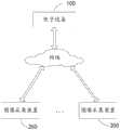
如图1所示,是本申请实施例提供的图像采集装置与电子设备进行交互的示意图。这里的电子设备100通过网络与一个或多个图像采集装置200进行通信连接,以进行数据通信或交互。该电子设备100可以是网络服务器、数据库服务器、个人电脑(personalcomputer,PC)、平板电脑、智能手机、个人数字助理(personal digital assistant,PDA)等。该图像采集装置可以是相机、摄像头、天眼等获取目标物体的装置。As shown in FIG. 1 , it is a schematic diagram of interaction between an image acquisition device provided in an embodiment of the present application and an electronic device. Here, the
这里的图像采集装置200设置在目标路面的道路一侧或两侧,该图像采集装置200还可以设置在给目标路面的上方。该图像采集装置200的设置方式可以根据实际情况进行调整,本申请不做具体限制。Here, the
上述的电子设备100用于获取图像采集装置采集到的目标物体图像,以根据该目标物体图像计算目标物体的实际位置。The above-mentioned
在一些实施例中,该电子设备100中存储有高精地图,该高精地图中包括有目标路面的车道线的轨迹信息。In some embodiments, a high-definition map is stored in the
下面对执行本申请实施例所公开的方法的电子设备进行详细介绍。可以理解地,本申请的物体的定位方法和斜坡方程创建方法可以通过同一电子设备执行,也可以通过不同电子设备执行。The electronic device that executes the method disclosed in the embodiment of the present application will be introduced in detail below. It can be understood that the method for locating an object and the method for creating a slope equation in the present application may be executed by the same electronic device, or may be executed by different electronic devices.
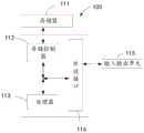
如图2所示,是电子设备的方框示意图。电子设备100可以包括存储器111、存储控制器112、处理器113、外设接口114、输入输出单元115。本领域普通技术人员可以理解,图2所示的结构仅为示意,其并不对电子设备100的结构造成限定。例如,电子设备100还可包括比图2中所示更多或者更少的组件,或者具有与图2所示不同的配置。As shown in FIG. 2 , it is a schematic block diagram of an electronic device. The
上述的存储器111、存储控制器112、处理器113、外设接口114及输入输出单元115各元件相互之间直接或间接地电性连接,以实现数据的传输或交互。例如,这些元件相互之间可通过一条或多条通讯总线或信号线实现电性连接。上述的处理器113用于执行存储器中存储的可执行模块。The
其中,存储器111可以是,但不限于,随机存取存储器(Random Access Memory,简称RAM),只读存储器(Read Only Memory,简称ROM),可编程只读存储器(ProgrammableRead-Only Memory,简称PROM),可擦除只读存储器(Erasable Programmable Read-OnlyMemory,简称EPROM),电可擦除只读存储器(Electric Erasable Programmable Read-OnlyMemory,简称EEPROM)等。其中,存储器111用于存储程序,所述处理器113在接收到执行指令后,执行所述程序,本申请实施例任一实施例揭示的过程定义的电子设备100所执行的方法可以应用于处理器113中,或者由处理器113实现。Wherein, the
上述的处理器113可能是一种集成电路芯片,具有信号的处理能力。上述的处理器113可以是通用处理器,包括中央处理器(Central Processing Unit,简称CPU)、网络处理器(Network Processor,简称NP)等;还可以是数字信号处理器(digital signalprocessor,简称DSP)、专用集成电路(Application Specific Integrated Circuit,简称ASIC)、现场可编程门阵列(FPGA)或者其他可编程逻辑器件、分立门或者晶体管逻辑器件、分立硬件组件。可以实现或者执行本申请实施例中的公开的各方法、步骤及逻辑框图。通用处理器可以是微处理器或者该处理器也可以是任何常规的处理器等。The above-mentioned
上述的外设接口114将各种输入/输出装置耦合至处理器113以及存储器111。在一些实施例中,外设接口114,处理器113以及存储控制器112可以在单个芯片中实现。在其他一些实例中,他们可以分别由独立的芯片实现。The aforementioned
上述的输入输出单元115用于提供给用户输入数据。所述输入输出单元115可以是,但不限于,鼠标和键盘等。The aforementioned input and
本实施例中的电子设备100可以用于执行本申请实施例提供的各个方法中的各个步骤。下面通过几个实施例详细描述物体的定位方法和/或斜坡方程创建方法的实现过程。The
请参阅图3,是本申请实施例提供的物体的定位方法的流程图。下面将对图3所示的具体流程进行详细阐述。Please refer to FIG. 3 , which is a flow chart of the object positioning method provided by the embodiment of the present application. The specific process shown in FIG. 3 will be described in detail below.
步骤201,将目标物体从图像采集装置坐标系投影到目标坐标系,以得到目标物体的投影坐标。
其中,该目标坐标系为以图像采集装置所在的安装设备建立的局部坐标系或世界坐标系。Wherein, the target coordinate system is a local coordinate system or a world coordinate system established by the installation device where the image acquisition device is located.
如图4所示,若目标坐标系为以图像采集装置所在的安装设备建立的局部坐标系,则该目标坐标系的原点为图像采集装置所在的安装设备与目标路面的交点,安装设备沿目标路面前进的方向为目标坐标系的第一坐标轴,第一坐标轴的方向为图像采集装置的摄像头拍摄前方,安装设备垂直目标路面前进方向一侧的方向为地面坐标系的第二坐标轴,第二坐标轴的方向为图像采集装置的摄像头右侧方向,安装设备的高度方向为地面坐标系的第三坐标轴,第三坐标轴的方向为所述安装设备远离目标地面的方向。As shown in Figure 4, if the target coordinate system is a local coordinate system established by the installation equipment where the image acquisition device is located, the origin of the target coordinate system is the intersection point between the installation equipment where the image acquisition device is located and the target road surface, and the installation equipment moves along the target road. The advancing direction of the road surface is the first coordinate axis of the target coordinate system, the direction of the first coordinate axis is the front of the camera of the image acquisition device, and the direction of the installation equipment perpendicular to the advancing direction of the target road surface is the second coordinate axis of the ground coordinate system, The direction of the second coordinate axis is the right direction of the camera of the image acquisition device, the height direction of the installation equipment is the third coordinate axis of the ground coordinate system, and the direction of the third coordinate axis is the direction that the installation equipment is away from the target ground.
上述的局部坐标系的建立仅是示例性地,该局部坐标系还可以在该坐标系的基础上平移、旋转等。The above-mentioned establishment of the local coordinate system is only exemplary, and the local coordinate system can also be translated, rotated, etc. based on the coordinate system.
这里的目标物体可以是目标车辆、目标机器人、目标穿梭车等。该图像采集装置可以是相机、摄像头等可以用于获取目标物体图像的装置。The target object here may be a target vehicle, a target robot, a target shuttle, and the like. The image acquisition device may be a device such as a camera or a camera that can be used to acquire an image of a target object.
可以理解地,图像采集装置在获取到目标物体的图像后,可以确定出该目标物体在该图像采集装置坐标系中的坐标位置。It can be understood that after the image acquisition device acquires the image of the target object, it can determine the coordinate position of the target object in the coordinate system of the image acquisition device.
由于图像采集装置是固定的,因而该图像采集装置的参数信息也是确定,进而可以根据该图像采集装置的参数信息将该目标物体从图像采集装置坐标系投影到目标坐标系,以得到该目标图像在地面坐标系中的投影坐标。Since the image acquisition device is fixed, the parameter information of the image acquisition device is also determined, and then the target object can be projected from the coordinate system of the image acquisition device to the target coordinate system according to the parameter information of the image acquisition device to obtain the target image Projected coordinates in the ground coordinate system.
上述的投影坐标可以是:(x,y,0。其中,x为投影点的第一坐标轴坐标点,y为投影点的第二坐标轴坐标点。The above projection coordinates may be: (x, y, 0. Wherein, x is the coordinate point of the first coordinate axis of the projection point, and y is the coordinate point of the second coordinate axis of the projection point.
步骤202,根据投影坐标判断目标物体是否在坡面上。
可以理解地,如图4所示,在将目标物体从图像采集装置坐标系投影到目标坐标系后,会在目标坐标系产生一个投影点,该投影点在目标坐标系中的坐标值为该目标物体的投影坐标。Understandably, as shown in FIG. 4, after projecting the target object from the coordinate system of the image acquisition device to the target coordinate system, a projected point will be generated in the target coordinate system, and the coordinate value of the projected point in the target coordinate system is the The projected coordinates of the target object.
在一些实施例中,通过根据该投影坐标与坐标阈值的关系确定该目标物体是在地平面上还是坡面上。这里的坐标阈值可以是预先设置的坐标值,也可以是坡面与地平面交汇点的坐标值等。In some embodiments, it is determined whether the target object is on the ground plane or on a slope according to the relationship between the projected coordinates and the coordinate threshold. The coordinate threshold here may be a preset coordinate value, or the coordinate value of the intersection point of the slope surface and the ground plane, etc.
示例性地,如图4所示,假设图像采集装置的摄像头拍摄前方为第一坐标轴的方向,则可以确定若投影坐标在第一坐标轴上的坐标点大于交汇点在第一坐标轴上的坐标点时,目标物体在坡面上。若投影坐标在第一坐标轴上的坐标点小于等于交汇点在第一坐标轴上的坐标点时,目标物体在地平面上。Exemplarily, as shown in FIG. 4 , assuming that the front of the camera of the image acquisition device is the direction of the first coordinate axis, it can be determined that if the coordinate point of the projection coordinate on the first coordinate axis is greater than the intersection point on the first coordinate axis When the coordinate point of , the target object is on the slope. If the coordinate point of the projected coordinates on the first coordinate axis is less than or equal to the coordinate point of the intersection point on the first coordinate axis, the target object is on the ground plane.
在另一些实施例中,还可以通过图像采集装置与目标物体的连线与安装设备之间的夹角和夹角阈值的关系确定该目标物体是在地平面上还是坡面上。这里的夹角阈值可以是预先设置的夹角值,也可以是坡面与地平面交汇点与图像采集装置的连线与安装设备之间的夹角等。In some other embodiments, it can also be determined whether the target object is on the ground plane or on a slope through the relationship between the angle between the line connecting the image acquisition device and the target object and the installation equipment and the angle threshold. The included angle threshold here may be a preset included angle value, or may be an included angle between a line connecting the intersection point of the slope surface and the ground plane and the image acquisition device and the installation equipment, and the like.
步骤203,若目标物体在坡面上,通过目标射线与斜坡方程确定目标物体投影到目标坐标系的实际位置。
其中,斜坡方程通过高精地图上的车道线的轨迹信息创建得到。目标射线通过投影坐标和图像采集装置的坐标确定,该投影坐标和图像采集装置的坐标均在该射线上。Among them, the slope equation is created through the trajectory information of the lane line on the high-precision map. The target ray is determined by the projection coordinates and the coordinates of the image acquisition device, and the projection coordinates and the coordinates of the image acquisition device are both on the ray.
这里的轨迹信息可以包括目标路面上各个轨迹点在世界坐标系中的坐标。该高精地图中存储有目标路面的轨迹信息。The trajectory information here may include the coordinates of each trajectory point on the target road surface in the world coordinate system. The track information of the target road surface is stored in the high-precision map.
在一些实施例中,若目标坐标系为以图像采集装置所在的安装设备建立的局部坐标系,在获取高精地图中目标路面的轨迹信息后,将该轨迹信息中的各个轨迹点在世界坐标系中的坐标转换到目标坐标系中,并通过转后的坐标创建斜坡方程。In some embodiments, if the target coordinate system is a local coordinate system established by the installation equipment where the image acquisition device is located, after obtaining the track information of the target road surface in the high-precision map, each track point in the track information is placed in the world coordinate system. The coordinates in the coordinate system are transformed into the target coordinate system, and the slope equation is created from the transformed coordinates.
在另一些实施例中,若目标坐标系为世界坐标系,在获取高精地图中目标路面的轨迹信息后,直接根据该轨迹信息中各个轨迹点在世界坐标系中的坐标创建斜坡方程。In other embodiments, if the target coordinate system is the world coordinate system, after obtaining the track information of the target road surface in the high-precision map, the slope equation is directly created according to the coordinates of each track point in the track information in the world coordinate system.
上述的目标射线为连接图像采集装置与目标物体的投影点的连接线。The above-mentioned target ray is a connection line connecting the image acquisition device and the projection point of the target object.
示例性地,假设图像采集装置在目标坐标系中的坐标为(xc,yc,h),目标物体在目标坐标系中的坐标为(x,y,z),则该目标射线为:Exemplarily, assuming that the coordinates of the image acquisition device in the target coordinate system are (xc , yc , h), and the coordinates of the target object in the target coordinate system are (x, y, z), then the target ray is:
d=(x-xc,y-yc,z-h)=(A0,B0,C0);d=(xxc , yyc , zh)=(A0, B0, C0);
可以理解地,在确定目标物体在坡面时,可以确定在将目标物体从图像采集装置坐标系投影到目标坐标系时,该目标物体的投影坐标可能存在偏差。此时,需要进一步对该目标物体在目标坐标系中的实际位置进行纠正。Understandably, when it is determined that the target object is on the slope, it may be determined that when the target object is projected from the coordinate system of the image acquisition device to the target coordinate system, there may be a deviation in the projected coordinates of the target object. At this point, it is necessary to further correct the actual position of the target object in the target coordinate system.
在对该目标物体在目标坐标系中的实际位置进行纠正时,通过该目标射线与斜坡方程的交点可以确定出该目标射线与坡面的交点,该交点即为该目标物体投影到目标坐标系的实际位置。When correcting the actual position of the target object in the target coordinate system, the intersection point of the target ray and the slope surface can be determined through the intersection point of the target ray and the slope equation, and the intersection point is the projection of the target object to the target coordinate system actual location.
在上述实现过程中,在将目标物体的坐标从图像采集装置坐标系投影到目标坐标系后,对于处于坡面的目标物体,由于坡面具有一定的角度,在直接投影时,得到的投影坐标可能会存在误差。通过根据高精地图上的车道线的轨迹信息创建得到的斜坡方程对目标物体进行重新定位,由于该斜坡方程是根据高精地图中预先存储的轨迹信息创建的,且高精地图具有高精度、高粒度、实时性等特点,因而该斜坡方程能够更加准确的对目标物体的实际位置进行定位修正,提高了对目标物体定位的准确性。In the above implementation process, after projecting the coordinates of the target object from the coordinate system of the image acquisition device to the target coordinate system, for the target object on the slope, because the slope has a certain angle, when directly projected, the obtained projected coordinates Errors may exist. The target object is repositioned through the slope equation created based on the track information of the lane line on the high-precision map. Since the slope equation is created based on the track information pre-stored in the high-precision map, and the high-precision map has high precision, High granularity, real-time and other characteristics, so the slope equation can more accurately correct the actual position of the target object, improving the accuracy of the target object positioning.
在一种可能的实现方式中,步骤203,包括:根据目标射线所在的直线方程和斜坡方程建立联合方程;通过求解联合方程确定目标物体的实际位置。In a possible implementation manner,
该联合方程为:The joint equation is:

其中,θ为坡面倾斜角,x0为坡面与地平面交汇点的第一坐标轴坐标点,(xc,yc,h)为图像采集装置在目标坐标系中的坐标,(x,y,z)为目标物体投影到目标坐标系的实际位置,A0为目标物体的投影坐标与交汇点在目标坐标系的第一坐标轴上的距离,B0为目标物体的投影坐标与交汇点在目标坐标系的第二坐标轴上的距离,C0为目标物体的投影坐标与交汇点在目标坐标系的第三坐标轴上的距离。Among them, θ is the inclination angle of the slope, x0 is the coordinate point of the first coordinate axis of the intersection point of the slope and the ground plane, (xc , yc , h) is the coordinate of the image acquisition device in the target coordinate system, (x , y, z) is the actual position of the target object projected to the target coordinate system, A0 is the distance between the projected coordinates of the target object and the intersection point on the first coordinate axis of the target coordinate system, and B0 is the distance between the projected coordinates of the target object and The distance of the intersection point on the second coordinate axis of the target coordinate system, C0 is the distance between the projected coordinates of the target object and the intersection point on the third coordinate axis of the target coordinate system.
在上述实现过程中,通过斜坡方程对目标射线进行修正,以确定出修正后的射线与地平面的交点,进而得到该目标图像在该目标坐标系中的实际坐标位置。由于该实际坐标位置是通过斜坡方程进行修正的,而该斜坡方程是基于高精地图中预先存储的轨迹信息创建的,且高精地图具有高精度、高粒度、实时性等特点,因而该斜坡方程能够更加准确的对目标物体的实际位置进行定位修正,提高了对目标物体定位的准确性。In the above implementation process, the target ray is corrected by the slope equation to determine the intersection point of the corrected ray and the ground plane, and then the actual coordinate position of the target image in the target coordinate system is obtained. Since the actual coordinate position is corrected by the slope equation, and the slope equation is created based on the pre-stored trajectory information in the high-precision map, and the high-precision map has the characteristics of high precision, high granularity, and real-time performance, so the slope The equation can more accurately correct the actual position of the target object, improving the accuracy of the target object positioning.
在一种可能的实现方式中,步骤201,包括:将目标物体在图像采集装置坐标系中的坐标进行归一化处理;根据归一化后的坐标和牛顿迭代法计算非畸变点坐标;根据图像采集装置的预设参数和非畸变点坐标确定目标物体的投影坐标。In a possible implementation,
这里的归一化处理的公式可以为:The normalization formula here can be:


其中,K为图像采集装置的内参数矩阵,(u,v)为图像采集装置坐标系中目标物体的坐标点,(xd,yd)为图像采集装置坐标系中目标物体的坐标点归一化处理后的坐标值,fx为使用像素来描述第一坐标轴方向焦距的长度,fy为使用像素来描述第二坐标轴方向焦距的长度,cx为使用偏移量来描述第一坐标轴方向焦距的长度,cy为使用偏移量来描述第二坐标轴方向焦距的长度。Among them, K is the internal parameter matrix of the image acquisition device, (u, v) is the coordinate point of the target object in the coordinate system of the image acquisition device, (xd , yd ) is the coordinate point normalization of the target object in the coordinate system of the image acquisition device Coordinate value after normalization, fx is to use pixels to describe the length of the focal length in the direction of the first coordinate axis, fy is to use pixels to describe the length of the focal length in the direction of the second coordinate axis, cx is to use the offset to describe the length of the first coordinate axis The length of the focal length in the direction of the first coordinate axis, andcy is the length of the focal length in the direction of the second coordinate axis using the offset.
可以理解地,图像采集装置的光学系统在制作和安装过程中,由于技术问题会使各种零件之间存在不同程度的安装误差,进而使得进入镜头的光路偏移其理想线路,并使成像点偏移其理想位置,以产生光学畸变,并形成畸变点。It is understandable that during the production and installation of the optical system of the image acquisition device, due to technical problems, there will be various installation errors between various parts, which will cause the optical path entering the lens to deviate from its ideal line, and make the imaging point Offset from its ideal position to create optical distortions and create distortion points.
对于上述畸变点,可以通过牛顿法、拟牛顿法、梯度下降法、共轭梯度法等方式进行去畸变,以获得非畸变点。For the above-mentioned distorted points, de-distortion can be performed by Newton method, quasi-Newton method, gradient descent method, conjugate gradient method, etc. to obtain undistorted points.
上述图像采集装置的预设参数可以使图像采集装置的外参数,该外参数是图像采集装置在世界坐标系中参数,如图像采集装置的位置、旋转方向等。The preset parameters of the above-mentioned image acquisition device may be external parameters of the image acquisition device, and the external parameters are parameters of the image acquisition device in the world coordinate system, such as the position and rotation direction of the image acquisition device.
在一些实施例中,根据图像采集装置的预设参数和非畸变点坐标确定目标物体的投影坐标可以包括:In some embodiments, determining the projected coordinates of the target object according to the preset parameters of the image acquisition device and the coordinates of the undistorted point may include:
假设图像采集装置的安装坐标为Pb(xb,yb,zb),图像采集装置坐标系中的坐标进行归一化处理后的点为(xm,ym,1),则将该图像采集装置坐标系中的坐标进行归一化处理后的点转到目标坐标系下为:Assuming that the installation coordinates of the image acquisition device are Pb (xb , yb , zb ), and the coordinates in the coordinate system of the image acquisition device are normalized to (xm , ym , 1), then the After the coordinates in the coordinate system of the image acquisition device are normalized, the point transferred to the target coordinate system is:
(xw,yw,zw)T=(xm,ym,1)T*R-1+(xb,yb,zb)T;(xw , yw , zw )T = (xm , ym , 1)T * R-1 + (xb , yb , zb )T ;
其中,R为目标坐标系到图像采集装置坐标系的转换矩阵,(xw,yw,zw)为归一化处理后目标物体在目标坐标系中的坐标。Wherein, R is a conversion matrix from the target coordinate system to the image acquisition device coordinate system, and (xw , yw , zw ) are the coordinates of the target object in the target coordinate system after normalization processing.
进一步地,根据相似三角形原理:Further, according to the principle of similar triangles:

进而可以确定出目标物体的投影坐标为:Then the projected coordinates of the target object can be determined as:


其中,(xt,yt)为目标物体的投影坐标。Among them, (xt , yt ) is the projected coordinates of the target object.
在上述实现过程中,在确定目标物体的投影坐标之前,先对目标物体在图像采集装置中的坐标进行归一化处理后,再通过牛顿迭代法去畸变,以获得非畸变点坐标。由于图像采集装置在制作、安装等工艺过程中可能会造成误差,进而产生畸变点,通过牛顿迭代法可以将该畸变点进行逆向去畸变处理,进而减少因图像采集装置的误差影响目标物体在图像采集装置坐标系中坐标的准确性,提高了目标物体投影到地面坐标中的投影坐标的准确性。In the above implementation process, before determining the projected coordinates of the target object, the coordinates of the target object in the image acquisition device are first normalized, and then de-distorted by the Newton iteration method to obtain undistorted point coordinates. Since the image acquisition device may cause errors in the process of production and installation, and then produce distortion points, the distortion points can be reversed by the Newton iteration method, thereby reducing the impact of the error of the image acquisition device on the image of the target object. The accuracy of the coordinates in the coordinate system of the acquisition device improves the accuracy of the projected coordinates of the target object projected into the ground coordinates.
在一种可能的实现方式中,根据归一化后的坐标和牛顿迭代法计算非畸变点坐标的计算公式为:In a possible implementation, the calculation formula for calculating the coordinates of the undistorted points according to the normalized coordinates and the Newton iteration method is:

其中,(xd,yd)为归一化后的坐标,distortion()为图像采集装置畸变函数,dx为归一化后的坐标与非畸变点坐标在目标坐标系的第一坐标轴上的误差,dy为归一化后的坐标与非畸变点坐标在目标坐标系的第二坐标轴上的误差,(xm,ym)为非畸变点坐标。Among them, (xd , yd ) is the normalized coordinates, distortion() is the distortion function of the image acquisition device, and dx is the first coordinate axis of the normalized coordinates and the undistorted point coordinates in the target coordinate system , dy is the error between the normalized coordinates and the undistorted point coordinates on the second coordinate axis of the target coordinate system, and (xm , ym ) is the undistorted point coordinates.
在上述实现过程中,通过牛顿迭代法逆向去畸变进而计算非畸变点坐标,由于牛顿迭代法具有方法简单、迭代速度快等优点,可以在减少非畸变点计算难度的同时提高非畸变点的计算效率。In the above implementation process, the Newton iterative method is used to reverse the distortion and then calculate the coordinates of the undistorted point. Because the Newton iterative method has the advantages of simple method and fast iteration speed, it can reduce the difficulty of calculating the undistorted point and improve the calculation of the undistorted point. efficiency.
请参阅图5,是本申请实施例提供的斜坡方程创建方法的流程图。下面将对图5所示的具体流程进行详细阐述。Please refer to FIG. 5 , which is a flow chart of a method for creating a slope equation provided by an embodiment of the present application. The specific process shown in FIG. 5 will be described in detail below.
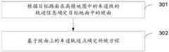
步骤301,根据目标路面在高精地图中的车道线的轨迹信息确定目标地面中的坡面。Step 301: Determine the slope of the target ground according to the track information of the lane line of the target road in the HD map.
可以理解地,在确定目标地面中的坡面之前,需要先确定地平面与坡面的交汇点,以通过判断轨迹信息中各轨迹点与该交汇点的关系确定该轨迹点处于地平面还是坡面,进而确定出目标地面中的坡面。Understandably, before determining the slope in the target ground, it is necessary to determine the intersection point of the ground plane and the slope, so as to determine whether the trajectory point is on the ground plane or on the slope by judging the relationship between each trajectory point in the trajectory information and the intersection point. Surface, and then determine the slope of the target ground.
在一些实施例中,以通过建立轨迹信息中各个轨迹点的轨迹方程,进而对该轨迹方程进行求导处理,确定出轨迹方程一阶导的拐点,该拐点即为该地平面与坡面的交汇点。In some embodiments, by establishing the trajectory equation of each trajectory point in the trajectory information, and then deriving the trajectory equation, the inflection point of the first derivative of the trajectory equation is determined, and the inflection point is the difference between the ground plane and the slope surface. Intersection.
步骤303,基于坡面上的车道轨迹点确定斜坡方程。Step 303, determine the slope equation based on the lane track points on the slope.
其中,该斜坡方程用于计算目标物体在目标坐标系中的实际位置。该目标坐标系为以图像采集装置所在的安装设备建立的局部坐标系或世界坐标系。Wherein, the slope equation is used to calculate the actual position of the target object in the target coordinate system. The target coordinate system is a local coordinate system or a world coordinate system established by the installation device where the image acquisition device is located.
可以理解地,可以通过将车道线上各个轨迹点拟合为斜坡平面,进而得到斜坡方程。Understandably, the slope equation can be obtained by fitting each track point on the lane line to a slope plane.
这里的斜坡方程用于计算目标物体的实际位置。由于该斜坡方程是通过地面上预先存储的目标路面的车道线的轨迹信息,经坐标转换、拟合等处理得到的,因而该斜坡方程可以真实的反映实际坡面位置,进而通过该斜坡方程计算出的目标物体的实际位置更加准确。Here the slope equation is used to calculate the actual position of the target object. Since the slope equation is obtained through coordinate conversion, fitting, etc. through the track information of the lane line of the target road surface stored in advance on the ground, the slope equation can truly reflect the actual slope position, and then the slope equation can be calculated The actual position of the target object is more accurate.
在上述实现过程中,通过对预先存储在高精地图中的车道线的轨迹信息进行拟合等处理,并建立斜坡方程,由于该斜坡方程是基于目标路面的真实轨迹信息建立的,且高精地图具有高精度、高粒度、实时性等特点,因而提高了该斜坡方程的准确性和真实性。另外,由于该斜坡方程可以真实且准确的反映出真实的坡面位置,进而通过该斜坡方程计算目标物体的实际位置,可以提高计算得到的目标物体的实际位置的准确性。In the above implementation process, the slope equation is established by fitting the trajectory information of the lane line pre-stored in the high-precision map. Since the slope equation is established based on the real trajectory information of the target road surface, and the high-precision The map has the characteristics of high precision, high granularity, and real-time performance, thus improving the accuracy and authenticity of the slope equation. In addition, since the slope equation can truly and accurately reflect the real slope position, the calculation of the actual position of the target object through the slope equation can improve the accuracy of the calculated actual position of the target object.
在一种可能的实现方式中,步骤302,包括:计算高精地图中的轨迹点的导数;确定轨迹点的导数大于预设值的轨迹点为坡面上的轨迹点。In a possible implementation manner,
示例性地,计算高精地图中的轨迹点的导数可以通过下述步骤实现:Exemplarily, calculating the derivative of the track point in the high-precision map can be realized through the following steps:
假设目标路面的轨迹点坐标为:Suppose the track point coordinates of the target road surface are:
(x1,y1,z1),(x2,y2,z2),...(xn,yn,zn);(x1 , y1 , z1 ), (x2 , y2 , z2 ), ... (xn , yn , zn );
则该轨迹点的一阶导为:Then the first order derivative of the trajectory point is:

其中,k=1,2,...n-1。Wherein, k=1, 2, . . . n-1.
上述的预设值为判定为坡面的最小角度的阈值。示例性地,若最小角度为30度倾斜角,即预设值th=tan 30/80*π。The aforementioned preset value is the threshold value of the minimum angle determined as the slope. Exemplarily, if the minimum angle is an inclination angle of 30 degrees, that is, the preset value th=tan 30/80*π.
在一些实施例中,在确定出轨迹点的导数后,可以通过比较轨迹点和预设值大关系,分别确定出每个轨迹点分别是地平面还是坡面,进而通过确定出的坡面轨迹点形成坡面。In some embodiments, after determining the derivative of the track point, it can be determined whether each track point is a ground plane or a slope by comparing the relationship between the track point and the preset value, and then the determined slope track Points form slopes.
在上述实现过程中,通过对轨迹点进行求导,可以确定轨迹信息中为导数中的拐点为交汇点,进而根据该交汇点处的预设值和轨迹点导数的关系可以确定出坡面上的轨迹点,以实现对地平面和坡面的划分。通过这种简单的求导计算实现对地平面和坡面的划分,减少了坡面划分的难度,提高了坡面划分的效率。In the above implementation process, by deriving the trajectory point, the inflection point in the derivative in the trajectory information can be determined as the intersection point, and then according to the relationship between the preset value at the intersection point and the derivative of the trajectory point, the slope on the slope can be determined. The trajectory points of the ground plane and the slope can be divided. The division of ground plane and slope surface is realized through this simple derivation calculation, which reduces the difficulty of slope surface division and improves the efficiency of slope surface division.
在一种可能的实现方式中,步骤303,包括:从地平面与坡面的交汇点开始获取坡面的车道轨迹点;根据坡面的车道轨迹点确定坡面倾斜角;根据坡面倾斜角和地平面的平面法向量确定坡面法向量;根据坡面法向量和交汇点确定斜坡方程。In a possible implementation, step 303 includes: obtaining the lane track point of the slope from the intersection point of the ground plane and the slope; determining the slope angle according to the lane track point of the slope; The slope normal vector is determined according to the plane normal vector of the ground plane and the slope normal vector; the slope equation is determined according to the slope normal vector and the intersection point.
这里的交汇点为轨迹点的导数小于预设值的最后一个轨迹点。The intersection point here is the last track point whose derivative of the track point is smaller than a preset value.
在一些实施例中,根据坡面的车道轨迹点确定坡面倾斜角,包括:In some embodiments, determining the inclination angle of the slope according to the track point of the lane on the slope includes:
根据坡面上的轨迹点计算坡面倾斜角:Calculate the slope angle of the slope from the track points on the slope:

历遍所有坡面轨迹点,确定倾角均值为坡面倾斜角:Traversing all slope track points, determine the mean inclination angle as the slope inclination angle:

其中,θ为坡面倾斜角,(xi,yi,zi)为第i个轨迹点在目标坐标系中的坐标,n为坡面上的所有轨迹点数量。Among them, θ is the inclination angle of the slope, (xi , yi , zi ) is the coordinate of the i-th track point in the target coordinate system, and n is the number of all track points on the slope.
可以理解地,由于斜坡方程是反映坡面的真实位置的方程,而法向量是用于计算空间中面角、点面距等距离的向量方程,因而在确定斜坡方程时,可以通过坡面法向量来确定。It can be understood that since the slope equation is an equation reflecting the real position of the slope surface, and the normal vector is a vector equation used to calculate the face angle and distance between points and surfaces in space, when determining the slope equation, the slope method can be used vector to determine.
由于坡面倾斜角为θ,则坡面与地平面的夹角为θ,则该坡面法向量可以通过地平面法向量确定:Since the inclination angle of the slope is θ, the angle between the slope and the ground plane is θ, and the normal vector of the slope can be determined by the normal vector of the ground plane:
对于地平面,其法向量为(0,0,1),则坡面法向量为:For the ground plane, its normal vector is (0, 0, 1), then the slope normal vector is:

进一步地,在确定出坡面法向量后,基于该坡面法向量和该坡面经过的交汇点可以确定出斜坡方程。Further, after the slope normal vector is determined, a slope equation can be determined based on the slope normal vector and the intersection point that the slope passes through.
在上述实现过程中,通过根据坡面法向量来确定斜坡方程,由于法向量是用于计算空间中面角、点面距等距离的向量方程,因而通过坡面法向量可以准确的反映出交汇点和坡面上的轨迹点的关系,进而可以建立真实、准确的斜坡方程,提高了斜坡方程的准确性。In the above implementation process, the slope equation is determined according to the normal vector of the slope. Since the normal vector is a vector equation used to calculate the plane angle and the distance between points and planes in space, the intersection can be accurately reflected by the normal vector of the slope. The relationship between the points and the track points on the slope surface can establish a real and accurate slope equation, which improves the accuracy of the slope equation.
在一种可能的实现方式中,该斜坡方程为:In a possible implementation, the slope equation is:
-sinθ*(x-x0)+cosθ*z=0;- sinθ*(xx0 )+cosθ*z=0;
其中,θ为坡面倾斜角,x0为坡面与地平面交汇点在目标坐标系的第一坐标轴坐标点,x为目标物体在目标坐标系的第一坐标轴的实际位置,z为目标物体在目标坐标系的第三坐标轴的实际位置。Among them, θ is the inclination angle of the slope, x0 is the coordinate point of the intersection point of the slope and the ground plane on the first coordinate axis of the target coordinate system, x is the actual position of the target object on the first coordinate axis of the target coordinate system, and z is The actual position of the target object on the third axis of the target coordinate system.
在一种可能的实现方式中,步骤301包括:将目标路面在高精地图中的轨迹信息从世界坐标系投影到局部坐标系;根据局部坐标系中的轨迹信息确定目标地面中的坡面。In a possible implementation,
其中,局部坐标系的原点为图像采集装置所在的安装设备与目标路面的交点,安装设备沿目标路面前进的方向为地面坐标系的第一坐标轴,第一坐标轴的方向为图像采集装置的摄像头拍摄前方,安装设备垂直目标路面前进方向一侧的方向为地面坐标系的第二坐标轴,第二坐标轴的方向为图像采集装置的摄像头右侧方向,安装设备的高度方向为地面坐标系的第三坐标轴,第三坐标轴的方向为安装设备远离目标地面的方向。Wherein, the origin of the local coordinate system is the intersection point between the installation equipment where the image acquisition device is located and the target road surface, the direction in which the installation equipment advances along the target road surface is the first coordinate axis of the ground coordinate system, and the direction of the first coordinate axis is the direction of the image acquisition device. The camera shoots the front, the direction of the installation equipment perpendicular to the direction of the target road is the second coordinate axis of the ground coordinate system, the direction of the second coordinate axis is the right side of the camera of the image acquisition device, and the height direction of the installation equipment is the ground coordinate system The third coordinate axis, the direction of the third coordinate axis is the direction in which the installation equipment is away from the target ground.
上述的局部坐标系的建立仅是示例性地,该局部坐标系还可以在该坐标系的基础上平移、旋转等。The above-mentioned establishment of the local coordinate system is only exemplary, and the local coordinate system can also be translated, rotated, etc. based on the coordinate system.
这里的高精地图中存储有目标路面的轨迹信息,该轨迹信息可以是目标路面中各个轨迹点在世界高精地图中的坐标。The high-precision map here stores track information of the target road surface, and the track information may be the coordinates of each track point on the target road surface in the world high-precision map.
上述的目标路面为目标物体所在的路面。该目标路面中可以包括地平面、坡面以及地平面和坡面综合路段。该目标路面可以设置一个或多个图像采集装置,用于获取该目标路面中目标物体的图像。The aforementioned target road surface is the road surface where the target object is located. The target road surface may include a ground plane, a slope surface, and a comprehensive road section of the ground plane and the slope surface. The target road surface may be provided with one or more image acquisition devices for acquiring images of target objects on the target road surface.
在上述实现过程中,通过将高精地图中的车道线的轨迹信息投影到局部坐标系,以在局部坐标系中进行目标路面坡面以及斜坡方程的建立,由于局部坐标系具有直观、简单的优势,因而能够降低斜坡方程创建的计算难度。基于同一申请构思,本申请实施例中还提供了与物体的定位方法对应的物体的定位装置,由于本申请实施例中的装置解决问题的原理与前述的物体的定位方法实施例相似,因此本实施例中的装置的实施可以参见上述方法的实施例中的描述,重复之处不再赘述。In the above implementation process, by projecting the trajectory information of the lane lines in the high-precision map to the local coordinate system, the target road slope and the slope equation can be established in the local coordinate system. Since the local coordinate system has an intuitive and simple advantage, thus reducing the computational difficulty of slope equation creation. Based on the same application idea, the embodiment of the present application also provides an object positioning device corresponding to the object positioning method. Since the problem-solving principle of the device in the embodiment of the present application is similar to the aforementioned embodiment of the object positioning method, this For the implementation of the device in the embodiment, reference may be made to the description in the embodiment of the above method, and repeated descriptions will not be repeated.
请参阅图6,是本申请实施例提供的物体的定位装置的功能模块示意图。本实施例中的物体的定位装置中的各个模块用于执行上述方法实施例中的各个步骤。物体的定位装置包括第一投影模块401、判断模块402、第一确定模块403;其中,Please refer to FIG. 6 , which is a schematic diagram of functional modules of the object positioning device provided by the embodiment of the present application. Each module in the object positioning device in this embodiment is used to execute each step in the above method embodiment. The object positioning device includes a
第一投影模块401用于将目标物体从图像采集装置坐标系投影到目标坐标系,以得到所述目标物体的投影坐标,所述目标坐标系为以图像采集装置所在的安装设备建立的局部坐标系或世界坐标系。The
判断模块402用于根据所述投影坐标判断所述目标物体是否在坡面上。The judging
第一确定模块403用于若所述目标物体在坡面上,通过目标射线与斜坡方程确定所述目标物体投影到所述目标坐标系的实际位置。The first determining
一种可能的实施方式中,第一投影模块401,还用于:将所述目标物体在所述图像采集装置所在坐标系中的坐标进行归一化处理;根据归一化后的坐标和牛顿迭代法计算非畸变点坐标;根据所述图像采集装置的预设参数计算所述图像采集装置坐标系所在平面到地平面的单应性矩阵;根据所述非畸变点坐标和所述单应性矩阵确定所述目标物体的投影坐标。In a possible implementation manner, the
基于同一申请构思,本申请实施例中还提供了与斜坡方程创建方法对应的斜坡方程创建装置,由于本申请实施例中的装置解决问题的原理与前述的斜坡方程创建方法实施例相似,因此本实施例中的装置的实施可以参见上述方法的实施例中的描述,重复之处不再赘述。Based on the same application concept, the embodiment of the present application also provides a slope equation creation device corresponding to the slope equation creation method. Since the problem-solving principle of the device in the embodiment of the present application is similar to the aforementioned embodiment of the slope equation creation method, this article For the implementation of the device in the embodiment, reference may be made to the description in the embodiment of the above method, and repeated descriptions will not be repeated.
请参阅图7,是本申请实施例提供的斜坡方程创建装置的功能模块示意图。本实施例中的斜坡方程创建装置中的各个模块用于执行上述方法实施例中的各个步骤。斜坡方程创建装置包括第二投影模块501、第二确定模块502、第三确定模块503;其中,Please refer to FIG. 7 , which is a schematic diagram of functional modules of the slope equation creation device provided by the embodiment of the present application. Each module in the device for creating a slope equation in this embodiment is used to execute each step in the above method embodiment. The slope equation creation device includes a
第二确定模块502用于根据目标路面在高精地图中的车道线的轨迹信息确定所述目标地面中的坡面。The
第三确定模块503基于所述坡面上的车道轨迹点确定斜坡方程;其中,所述斜坡方程用于上述目标物体在目标坐标系中的实际位置计算,所述目标坐标系为以图像采集装置所在的安装设备建立的局部坐标系或世界坐标系。The third determination module 503 determines the slope equation based on the lane track points on the slope; wherein, the slope equation is used for calculating the actual position of the target object in the target coordinate system, and the target coordinate system is based on the image acquisition device The local coordinate system or the world coordinate system established by the installed device.
一种可能的实施方式中,第二确定模块502,还用于:计算所述高精地图中的轨迹点的导数;确定所述轨迹点的导数大于预设值的轨迹点为坡面上的轨迹点。In a possible implementation manner, the
一种可能的实施方式中,第二确定模块502,具体用于:从地平面与坡面的交汇点开始获取所述坡面的车道轨迹点,所述交汇点为所述轨迹点的导数小于所述预设值的最后一个轨迹点;根据所述坡面的车道轨迹点确定坡面倾斜角;根据所述坡面倾斜角和地平面的平面法向量确定坡面法向量;根据所述坡面法向量和所述交汇点确定斜坡方程。In a possible implementation manner, the
一种可能的实施方式中,第二确定模块502,具体用于:将目标路面在高精地图中的车道线的轨迹信息从世界坐标系投影到所述局部坐标系;根据所述局部坐标系中的所述轨迹信息确定所述目标地面中的坡面。In a possible implementation manner, the
此外,本申请实施例还提供一种计算机可读存储介质,该计算机可读存储介质上存储有计算机程序,该计算机程序被处理器运行时执行上述方法实施例中所述的物体的定位和/或斜坡方程创建方法的步骤。In addition, an embodiment of the present application also provides a computer-readable storage medium, on which a computer program is stored, and when the computer program is run by a processor, the object positioning and/or or the steps of the slope equation creation method.
本申请实施例所提供的物体的定位和/或斜坡方程创建方法的计算机程序产品,包括存储了程序代码的计算机可读存储介质,所述程序代码包括的指令可用于执行上述方法实施例中所述的物体的定位和/或斜坡方程创建方法的步骤,具体可参见上述方法实施例,在此不再赘述。The computer program product of the object positioning and/or slope equation creation method provided by the embodiments of the present application includes a computer-readable storage medium storing program codes, and the instructions included in the program codes can be used to execute the methods described in the above method embodiments For the steps of the method for locating an object and/or creating a slope equation described above, reference may be made to the above method embodiment for details, and details are not repeated here.
在本申请所提供的几个实施例中,应该理解到,所揭露的装置和方法,也可以通过其它的方式实现。以上所描述的装置实施例仅仅是示意性的,例如,附图中的流程图和框图显示了根据本申请的多个实施例的装置、方法和计算机程序产品的可能实现的体系架构、功能和操作。在这点上,流程图或框图中的每个方框可以代表一个模块、程序段或代码的一部分,所述模块、程序段或代码的一部分包含一个或多个用于实现规定的逻辑功能的可执行指令。也应当注意,在有些作为替换的实现方式中,方框中所标注的功能也可以以不同于附图中所标注的顺序发生。例如,两个连续的方框实际上可以基本并行地执行,它们有时也可以按相反的顺序执行,这依所涉及的功能而定。也要注意的是,框图和/或流程图中的每个方框、以及框图和/或流程图中的方框的组合,可以用执行规定的功能或动作的专用的基于硬件的系统来实现,或者可以用专用硬件与计算机指令的组合来实现。In the several embodiments provided in this application, it should be understood that the disclosed devices and methods may also be implemented in other ways. The device embodiments described above are only illustrative. For example, the flowcharts and block diagrams in the accompanying drawings show the architecture, functions and possible implementations of devices, methods and computer program products according to multiple embodiments of the present application. operate. In this regard, each block in a flowchart or block diagram may represent a module, program segment, or part of code that includes one or more Executable instructions. It should also be noted that, in some alternative implementations, the functions noted in the block may occur out of the order noted in the figures. For example, two blocks in succession may, in fact, be executed substantially concurrently, or they may sometimes be executed in the reverse order, depending upon the functionality involved. It should also be noted that each block of the block diagrams and/or flowchart illustrations, and combinations of blocks in the block diagrams and/or flowchart illustrations, can be implemented by a dedicated hardware-based system that performs the specified function or action , or may be implemented by a combination of dedicated hardware and computer instructions.
另外,在本申请各个实施例中的各功能模块可以集成在一起形成一个独立的部分,也可以是各个模块单独存在,也可以两个或两个以上模块集成形成一个独立的部分。In addition, each functional module in each embodiment of the present application may be integrated to form an independent part, each module may exist independently, or two or more modules may be integrated to form an independent part.
所述功能如果以软件功能模块的形式实现并作为独立的产品销售或使用时,可以存储在一个计算机可读取存储介质中。基于这样的理解,本申请的技术方案本质上或者说对现有技术做出贡献的部分或者该技术方案的部分可以以软件产品的形式体现出来,该计算机软件产品存储在一个存储介质中,包括若干指令用以使得一台计算机设备(可以是个人计算机,服务器,或者网络设备等)执行本申请各个实施例所述方法的全部或部分步骤。而前述的存储介质包括:U盘、移动硬盘、只读存储器(ROM,Read-Only Memory)、随机存取存储器(RAM,Random Access Memory)、磁碟或者光盘等各种可以存储程序代码的介质。需要说明的是,在本文中,诸如第一和第二等之类的关系术语仅仅用来将一个实体或者操作与另一个实体或操作区分开来,而不一定要求或者暗示这些实体或操作之间存在任何这种实际的关系或者顺序。而且,术语“包括”、“包含”或者其任何其他变体意在涵盖非排他性的包含,从而使得包括一系列要素的过程、方法、物品或者设备不仅包括那些要素,而且还包括没有明确列出的其他要素,或者是还包括为这种过程、方法、物品或者设备所固有的要素。在没有更多限制的情况下,由语句“包括……”限定的要素,并不排除在包括所述要素的过程、方法、物品或者设备中还存在另外的相同要素。If the functions are implemented in the form of software function modules and sold or used as independent products, they can be stored in a computer-readable storage medium. Based on this understanding, the technical solution of the present application is essentially or the part that contributes to the prior art or the part of the technical solution can be embodied in the form of a software product, and the computer software product is stored in a storage medium, including Several instructions are used to make a computer device (which may be a personal computer, a server, or a network device, etc.) execute all or part of the steps of the methods described in the various embodiments of the present application. The aforementioned storage medium includes: U disk, mobile hard disk, read-only memory (ROM, Read-Only Memory), random access memory (RAM, Random Access Memory), magnetic disk or optical disk and other media that can store program codes. . It should be noted that in this article, relational terms such as first and second are only used to distinguish one entity or operation from another entity or operation, and do not necessarily require or imply that there is a relationship between these entities or operations. There is no such actual relationship or order between them. Furthermore, the term "comprises", "comprises" or any other variation thereof is intended to cover a non-exclusive inclusion such that a process, method, article, or apparatus comprising a set of elements includes not only those elements, but also includes elements not expressly listed. other elements of or also include elements inherent in such a process, method, article, or device. Without further limitations, an element defined by the statement "comprising..." does not exclude the presence of additional same elements in the process, method, article or device comprising said element.
以上所述仅为本申请的优选实施例而已,并不用于限制本申请,对于本领域的技术人员来说,本申请可以有各种更改和变化。凡在本申请的精神和原则之内,所作的任何修改、等同替换、改进等,均应包含在本申请的保护范围之内。应注意到:相似的标号和字母在下面的附图中表示类似项,因此,一旦某一项在一个附图中被定义,则在随后的附图中不需要对其进行进一步定义和解释。The above descriptions are only preferred embodiments of the present application, and are not intended to limit the present application. For those skilled in the art, there may be various modifications and changes in the present application. Any modifications, equivalent replacements, improvements, etc. made within the spirit and principles of this application shall be included within the protection scope of this application. It should be noted that like numerals and letters denote similar items in the following figures, therefore, once an item is defined in one figure, it does not require further definition and explanation in subsequent figures.
以上所述,仅为本申请的具体实施方式,但本申请的保护范围并不局限于此,任何熟悉本技术领域的技术人员在本申请揭露的技术范围内,可轻易想到变化或替换,都应涵盖在本申请的保护范围之内。因此,本申请的保护范围应以权利要求的保护范围为准。The above is only a specific implementation of the application, but the scope of protection of the application is not limited thereto. Anyone familiar with the technical field can easily think of changes or substitutions within the technical scope disclosed in the application. Should be covered within the protection scope of this application. Therefore, the protection scope of the present application should be based on the protection scope of the claims.
Claims (12)
Translated fromChinesePriority Applications (1)
| Application Number | Priority Date | Filing Date | Title |
|---|---|---|---|
| CN202310250245.9ACN116202530A (en) | 2023-03-14 | 2023-03-14 | Object positioning and slope equation creation method and device and electronic equipment |
Applications Claiming Priority (1)
| Application Number | Priority Date | Filing Date | Title |
|---|---|---|---|
| CN202310250245.9ACN116202530A (en) | 2023-03-14 | 2023-03-14 | Object positioning and slope equation creation method and device and electronic equipment |
Publications (1)
| Publication Number | Publication Date |
|---|---|
| CN116202530Atrue CN116202530A (en) | 2023-06-02 |
Family
ID=86515790
Family Applications (1)
| Application Number | Title | Priority Date | Filing Date |
|---|---|---|---|
| CN202310250245.9APendingCN116202530A (en) | 2023-03-14 | 2023-03-14 | Object positioning and slope equation creation method and device and electronic equipment |
Country Status (1)
| Country | Link |
|---|---|
| CN (1) | CN116202530A (en) |
Cited By (1)
| Publication number | Priority date | Publication date | Assignee | Title |
|---|---|---|---|---|
| CN119251293A (en)* | 2024-08-21 | 2025-01-03 | 易显智能科技有限责任公司 | Method and device for judging fixed-point parking on ramp, electronic device and storage medium |
Citations (7)
| Publication number | Priority date | Publication date | Assignee | Title |
|---|---|---|---|---|
| JPH06307812A (en)* | 1993-04-22 | 1994-11-04 | Mazda Motor Corp | Method and device for measuring three-dimensional position on curved surface |
| CN106646508A (en)* | 2016-11-24 | 2017-05-10 | 中国科学院自动化研究所 | Slope angle estimation method for slope region based on multiline laser radar |
| CN111504267A (en)* | 2020-04-20 | 2020-08-07 | 上海联适导航技术有限公司 | Slope rectifying method, device and equipment based on GNSS single-antenna satellite |
| CN113093218A (en)* | 2021-05-14 | 2021-07-09 | 汤恩智能科技(苏州)有限公司 | Slope detection method, drive device, and storage medium |
| CN113238267A (en)* | 2021-06-21 | 2021-08-10 | 多伦科技股份有限公司 | Method and device for positioning vehicle on ramp |
| CN113759363A (en)* | 2020-06-02 | 2021-12-07 | 杭州海康威视数字技术股份有限公司 | Target positioning method, device, monitoring system and storage medium |
| WO2023000337A1 (en)* | 2021-07-23 | 2023-01-26 | 华为技术有限公司 | Road gradient determination method and apparatus, lane line projection method and apparatus, and lane line display method and apparatus |
- 2023
- 2023-03-14CNCN202310250245.9Apatent/CN116202530A/enactivePending
Patent Citations (7)
| Publication number | Priority date | Publication date | Assignee | Title |
|---|---|---|---|---|
| JPH06307812A (en)* | 1993-04-22 | 1994-11-04 | Mazda Motor Corp | Method and device for measuring three-dimensional position on curved surface |
| CN106646508A (en)* | 2016-11-24 | 2017-05-10 | 中国科学院自动化研究所 | Slope angle estimation method for slope region based on multiline laser radar |
| CN111504267A (en)* | 2020-04-20 | 2020-08-07 | 上海联适导航技术有限公司 | Slope rectifying method, device and equipment based on GNSS single-antenna satellite |
| CN113759363A (en)* | 2020-06-02 | 2021-12-07 | 杭州海康威视数字技术股份有限公司 | Target positioning method, device, monitoring system and storage medium |
| CN113093218A (en)* | 2021-05-14 | 2021-07-09 | 汤恩智能科技(苏州)有限公司 | Slope detection method, drive device, and storage medium |
| CN113238267A (en)* | 2021-06-21 | 2021-08-10 | 多伦科技股份有限公司 | Method and device for positioning vehicle on ramp |
| WO2023000337A1 (en)* | 2021-07-23 | 2023-01-26 | 华为技术有限公司 | Road gradient determination method and apparatus, lane line projection method and apparatus, and lane line display method and apparatus |
Cited By (1)
| Publication number | Priority date | Publication date | Assignee | Title |
|---|---|---|---|---|
| CN119251293A (en)* | 2024-08-21 | 2025-01-03 | 易显智能科技有限责任公司 | Method and device for judging fixed-point parking on ramp, electronic device and storage medium |
Similar Documents
| Publication | Publication Date | Title |
|---|---|---|
| CN112912932B (en) | Calibration method, device and terminal equipment for vehicle-mounted camera | |
| EP3879494A2 (en) | Method, apparatus, electronic device, computer readable medium and program for calibrating external parameter of camera | |
| US12394096B2 (en) | Error correction method and device for line structured light 3D camera, computer device and computer-readable storage medium | |
| CN112419423B (en) | A calibration method, device, electronic device and storage medium | |
| US12046008B2 (en) | Pose calibration method, robot and computer readable storage medium | |
| US12380602B2 (en) | Optical axis calibration method and apparatus of optical axis detection system, terminal, system, and medium | |
| CN112927306A (en) | Calibration method and device of shooting device and terminal equipment | |
| US11034028B2 (en) | Pose determining method for mobile robot and apparatus and mobile robot thereof | |
| WO2022078301A1 (en) | Data processing method and apparatus | |
| CN115018922B (en) | Distortion parameter calibration method, electronic device and computer-readable storage medium | |
| CN116202530A (en) | Object positioning and slope equation creation method and device and electronic equipment | |
| CN113240746A (en) | Speckle structure light calibration method and device based on ideal imaging plane | |
| CN119295541A (en) | Target detection method, device, electronic device and storage medium | |
| CN112001857A (en) | Image correction method, system and equipment based on binocular camera and readable storage medium | |
| WO2022204953A1 (en) | Method and apparatus for determining pitch angle, and terminal device | |
| US10215628B2 (en) | Image calibrating method and device of testing apparatus for thin film transistor substrate | |
| CN116485907A (en) | Method and device for determining external parameters of all-round camera and all-round aerial view acquisition system | |
| CN116038698A (en) | Robot guiding method and device, electronic equipment and storage medium | |
| WO2023062994A1 (en) | Learning device, learning method, learning program, camera parameter calculating device, camera parameter calculating method, and camera parameter calculating program | |
| CN116777816A (en) | Image data processing method and device and electronic equipment | |
| CN116939176A (en) | Error correction method, device, electronic equipment and storage medium for projector | |
| CN113128352A (en) | Method, device, equipment and storage medium for determining electronic warning tape | |
| CN117765047B (en) | Workpiece registration method, device, computer equipment and storage medium | |
| CN117523004A (en) | Camera external parameter calibration methods, devices, equipment and vehicles | |
| CN118790273A (en) | Method, device, electronic device and storage medium for correcting perceived information |
Legal Events
| Date | Code | Title | Description |
|---|---|---|---|
| PB01 | Publication | ||
| PB01 | Publication | ||
| SE01 | Entry into force of request for substantive examination | ||
| SE01 | Entry into force of request for substantive examination |