CN116129376A - Road edge detection method and device - Google Patents
Road edge detection method and deviceDownload PDFInfo
- Publication number
- CN116129376A CN116129376ACN202211290713.7ACN202211290713ACN116129376ACN 116129376 ACN116129376 ACN 116129376ACN 202211290713 ACN202211290713 ACN 202211290713ACN 116129376 ACN116129376 ACN 116129376A
- Authority
- CN
- China
- Prior art keywords
- road
- point
- road edge
- points
- vehicle
- Prior art date
- Legal status (The legal status is an assumption and is not a legal conclusion. Google has not performed a legal analysis and makes no representation as to the accuracy of the status listed.)
- Pending
Links
Images


Classifications
- G—PHYSICS
- G01—MEASURING; TESTING
- G01S—RADIO DIRECTION-FINDING; RADIO NAVIGATION; DETERMINING DISTANCE OR VELOCITY BY USE OF RADIO WAVES; LOCATING OR PRESENCE-DETECTING BY USE OF THE REFLECTION OR RERADIATION OF RADIO WAVES; ANALOGOUS ARRANGEMENTS USING OTHER WAVES
- G01S17/00—Systems using the reflection or reradiation of electromagnetic waves other than radio waves, e.g. lidar systems
- G01S17/88—Lidar systems specially adapted for specific applications
- G01S17/89—Lidar systems specially adapted for specific applications for mapping or imaging
- G—PHYSICS
- G01—MEASURING; TESTING
- G01S—RADIO DIRECTION-FINDING; RADIO NAVIGATION; DETERMINING DISTANCE OR VELOCITY BY USE OF RADIO WAVES; LOCATING OR PRESENCE-DETECTING BY USE OF THE REFLECTION OR RERADIATION OF RADIO WAVES; ANALOGOUS ARRANGEMENTS USING OTHER WAVES
- G01S17/00—Systems using the reflection or reradiation of electromagnetic waves other than radio waves, e.g. lidar systems
- G01S17/86—Combinations of lidar systems with systems other than lidar, radar or sonar, e.g. with direction finders
- G—PHYSICS
- G01—MEASURING; TESTING
- G01S—RADIO DIRECTION-FINDING; RADIO NAVIGATION; DETERMINING DISTANCE OR VELOCITY BY USE OF RADIO WAVES; LOCATING OR PRESENCE-DETECTING BY USE OF THE REFLECTION OR RERADIATION OF RADIO WAVES; ANALOGOUS ARRANGEMENTS USING OTHER WAVES
- G01S17/00—Systems using the reflection or reradiation of electromagnetic waves other than radio waves, e.g. lidar systems
- G01S17/88—Lidar systems specially adapted for specific applications
- G01S17/93—Lidar systems specially adapted for specific applications for anti-collision purposes
- G01S17/931—Lidar systems specially adapted for specific applications for anti-collision purposes of land vehicles
- G—PHYSICS
- G01—MEASURING; TESTING
- G01S—RADIO DIRECTION-FINDING; RADIO NAVIGATION; DETERMINING DISTANCE OR VELOCITY BY USE OF RADIO WAVES; LOCATING OR PRESENCE-DETECTING BY USE OF THE REFLECTION OR RERADIATION OF RADIO WAVES; ANALOGOUS ARRANGEMENTS USING OTHER WAVES
- G01S7/00—Details of systems according to groups G01S13/00, G01S15/00, G01S17/00
- G01S7/48—Details of systems according to groups G01S13/00, G01S15/00, G01S17/00 of systems according to group G01S17/00
- G01S7/4808—Evaluating distance, position or velocity data
- G—PHYSICS
- G06—COMPUTING OR CALCULATING; COUNTING
- G06F—ELECTRIC DIGITAL DATA PROCESSING
- G06F18/00—Pattern recognition
- G06F18/20—Analysing
- G06F18/23—Clustering techniques
- G—PHYSICS
- G06—COMPUTING OR CALCULATING; COUNTING
- G06T—IMAGE DATA PROCESSING OR GENERATION, IN GENERAL
- G06T7/00—Image analysis
- G06T7/10—Segmentation; Edge detection
- G06T7/13—Edge detection
- G—PHYSICS
- G06—COMPUTING OR CALCULATING; COUNTING
- G06T—IMAGE DATA PROCESSING OR GENERATION, IN GENERAL
- G06T7/00—Image analysis
- G06T7/60—Analysis of geometric attributes
- G—PHYSICS
- G06—COMPUTING OR CALCULATING; COUNTING
- G06V—IMAGE OR VIDEO RECOGNITION OR UNDERSTANDING
- G06V20/00—Scenes; Scene-specific elements
- G06V20/50—Context or environment of the image
- G06V20/56—Context or environment of the image exterior to a vehicle by using sensors mounted on the vehicle
- G06V20/588—Recognition of the road, e.g. of lane markings; Recognition of the vehicle driving pattern in relation to the road
- G—PHYSICS
- G06—COMPUTING OR CALCULATING; COUNTING
- G06T—IMAGE DATA PROCESSING OR GENERATION, IN GENERAL
- G06T2207/00—Indexing scheme for image analysis or image enhancement
- G06T2207/10—Image acquisition modality
- G06T2207/10028—Range image; Depth image; 3D point clouds
- G—PHYSICS
- G06—COMPUTING OR CALCULATING; COUNTING
- G06T—IMAGE DATA PROCESSING OR GENERATION, IN GENERAL
- G06T2207/00—Indexing scheme for image analysis or image enhancement
- G06T2207/30—Subject of image; Context of image processing
- G06T2207/30248—Vehicle exterior or interior
- G06T2207/30252—Vehicle exterior; Vicinity of vehicle
- G06T2207/30256—Lane; Road marking
Landscapes
- Engineering & Computer Science (AREA)
- Physics & Mathematics (AREA)
- General Physics & Mathematics (AREA)
- Remote Sensing (AREA)
- Radar, Positioning & Navigation (AREA)
- Theoretical Computer Science (AREA)
- Computer Networks & Wireless Communication (AREA)
- Electromagnetism (AREA)
- Multimedia (AREA)
- Data Mining & Analysis (AREA)
- Computer Vision & Pattern Recognition (AREA)
- Bioinformatics & Cheminformatics (AREA)
- Evolutionary Biology (AREA)
- Evolutionary Computation (AREA)
- General Engineering & Computer Science (AREA)
- Bioinformatics & Computational Biology (AREA)
- Artificial Intelligence (AREA)
- Life Sciences & Earth Sciences (AREA)
- Geometry (AREA)
- Traffic Control Systems (AREA)
- Optical Radar Systems And Details Thereof (AREA)
- Length Measuring Devices By Optical Means (AREA)
Abstract
Description
Translated fromChinese技术领域technical field
本发明涉及自动驾驶领域,特别涉及一种道路边缘检测方法和装置。The invention relates to the field of automatic driving, in particular to a road edge detection method and device.
背景技术Background technique
自动驾驶车辆的导航技术是根据感知车辆的位置和运动情况,自动地控制车辆向目的地行驶的技术。自动驾驶车辆导航在人们出行、货物运输和服务提供方面有重要的应用。自动驾驶技术的一个组成部分就是道路边缘检测,该技术能够保证车辆和乘客以及附近的人和物的安全。The navigation technology of self-driving vehicles is a technology that automatically controls the vehicle to drive to the destination based on the perceived position and movement of the vehicle. Autonomous vehicle navigation has important applications in people travel, goods transportation and service provision. An integral part of autonomous driving technology is road edge detection, which keeps the vehicle and its passengers safe, as well as those nearby.
发明内容Contents of the invention
鉴于上述问题,本申请提供一种道路边缘检测方法和装置,以实现准确地检测道路边缘曲线。In view of the above problems, the present application provides a road edge detection method and device, so as to accurately detect road edge curves.
根据本申请的一个方面,提供了一种道路边缘检测方法,包括:According to one aspect of the present application, a road edge detection method is provided, including:
在车辆行驶过程中,车载道路边缘检测装置获取车载激光雷达扫描周围环境生成的点云数据;其中,点云数据中包括多个点的三维坐标值以及反射强度值;During the driving process of the vehicle, the vehicle-mounted road edge detection device obtains the point cloud data generated by the vehicle-mounted lidar scanning the surrounding environment; wherein, the point cloud data includes the three-dimensional coordinate values and reflection intensity values of multiple points;
确定点云数据中每个点的局部几何特征,局部几何特征包括点的法向以及法向曲率;Determine the local geometric features of each point in the point cloud data, the local geometric features include the normal and normal curvature of the point;
在点云数据中选择多个种子点,使用区域生长方法、根据种子点和各个点的局部几何特征,生成多个点簇;Select multiple seed points in the point cloud data, and use the region growing method to generate multiple point clusters according to the local geometric characteristics of the seed points and each point;
确定包括的点数最多的一个点簇为可行驶路面点簇,在可行驶路面点簇中确定多个道路边缘点;Determine a point cluster that includes the most points as the drivable road surface point cluster, and determine multiple road edge points in the drivable road surface point cluster;
根据确定的多个道路边缘点拟合得到道路边缘曲线。A road edge curve is obtained by fitting a plurality of determined road edge points.
根据本申请的另一个方面,提供了一种道路边缘检测装置,包括一个处理器和至少一个存储器;至少一个存储器中存储有至少一条机器可执行指令,处理器执行至少一条机器可执行指令实现道路边缘检测处理,道路边缘检测处理包括:According to another aspect of the present application, a road edge detection device is provided, including a processor and at least one memory; at least one machine-executable instruction is stored in at least one memory, and the processor executes at least one machine-executable instruction to realize road Edge detection processing, road edge detection processing includes:
在车辆行驶过程中,车载道路边缘检测装置获取车载激光雷达扫描周围环境生成的点云数据;其中,点云数据中包括多个点的三维坐标值以及反射强度值;During the driving process of the vehicle, the vehicle-mounted road edge detection device obtains the point cloud data generated by the vehicle-mounted lidar scanning the surrounding environment; wherein, the point cloud data includes the three-dimensional coordinate values and reflection intensity values of multiple points;
确定点云数据中每个点的局部几何特征,局部几何特征包括点的法向以及法向曲率;Determine the local geometric features of each point in the point cloud data, the local geometric features include the normal and normal curvature of the point;
在点云数据中选择多个种子点,使用区域生长方法、根据种子点和各个点的局部几何特征,生成多个点簇;Select multiple seed points in the point cloud data, and use the region growing method to generate multiple point clusters according to the local geometric characteristics of the seed points and each point;
确定包括的点数最多的一个点簇为可行驶路面点簇,在可行使路面点簇中确定多个道路边缘点;Determine a point cluster that includes the most points as the drivable road surface point cluster, and determine multiple road edge points in the drivable road surface point cluster;
根据确定的多个道路边缘点拟合得到道路边缘曲线。A road edge curve is obtained by fitting a plurality of determined road edge points.
根据本申请的另一个方面,提供了一种非易失性存储装置,存储有至少一条机器可执行指令,处理器执行至少一条机器可执行指令实现道路边缘检测处理,道路边缘检测处理包括:According to another aspect of the present application, a non-volatile storage device is provided, which stores at least one machine-executable instruction, and a processor executes at least one machine-executable instruction to implement road edge detection processing. The road edge detection processing includes:
在车辆行驶过程中,车载道路边缘检测装置获取车载激光雷达扫描周围环境生成的点云数据;其中,点云数据中包括多个点的三维坐标值以及反射强度值;During the driving process of the vehicle, the vehicle-mounted road edge detection device obtains the point cloud data generated by the vehicle-mounted lidar scanning the surrounding environment; wherein, the point cloud data includes the three-dimensional coordinate values and reflection intensity values of multiple points;
确定点云数据中每个点的局部几何特征,局部几何特征包括点的法向以及法向曲率;Determine the local geometric features of each point in the point cloud data, the local geometric features include the normal and normal curvature of the point;
在点云数据中选择多个种子点,使用区域生长方法、根据种子点和各个点的局部几何特征,生成多个点簇;Select multiple seed points in the point cloud data, and use the region growing method to generate multiple point clusters according to the local geometric characteristics of the seed points and each point;
确定包括的点数最多的一个点簇为可行驶路面点簇,在可行使路面点簇中确定多个道路边缘点;Determine a point cluster that includes the most points as the drivable road surface point cluster, and determine multiple road edge points in the drivable road surface point cluster;
根据确定的多个道路边缘点拟合得到道路边缘曲线。A road edge curve is obtained by fitting a plurality of determined road edge points.
根据本申请实施例提供的技术方案,根据点云数据中点的局部几何特征来确定得到可行驶路面点簇,通过可行驶路面点簇的边缘点确定得到道路边缘,相比于现有技术中直接通过点级别的特征来识别道路边缘,能够降低噪声、遮挡和路边物体的影响,提高检测的准确度。According to the technical solution provided by the embodiment of the present application, the drivable road surface point cluster is determined according to the local geometric features of the points in the point cloud data, and the road edge is obtained by determining the edge points of the drivable road surface point cluster. Compared with the prior art Recognizing road edges directly through point-level features can reduce the influence of noise, occlusion and roadside objects, and improve the accuracy of detection.
附图说明Description of drawings
附图用来提供对本发明的进一步理解,并且构成说明书的一部分,与本发明的实施例一起用于解释本发明,并不构成对本发明的限制。The accompanying drawings are used to provide a further understanding of the present invention, and constitute a part of the description, and are used together with the embodiments of the present invention to explain the present invention, and do not constitute a limitation to the present invention.
图1为本申请实施例提供的道路边缘检测处理的注释示意图;FIG. 1 is a schematic diagram of annotations for road edge detection processing provided by an embodiment of the present application;
图2为使用凹包算法和凸包算法确定道路边缘点的示意图;Fig. 2 is the schematic diagram that uses concave-hull algorithm and convex-hull algorithm to determine road edge point;
图3为本申请实施例提供的道路边缘检测方法的处理流程图;Fig. 3 is the processing flowchart of the road edge detection method provided by the embodiment of the present application;
图4A为实施本申请实施例提供的道路边缘检测方法的示例结果的示意图;FIG. 4A is a schematic diagram of an example result of implementing the road edge detection method provided by the embodiment of the present application;
图4B为实施本申请实施例提供的道路边缘检测方法的另一示例结果的示意图;FIG. 4B is a schematic diagram of another example result of implementing the road edge detection method provided by the embodiment of the present application;
图5为实施本申请实施例提供的道路边缘检测装置的硬件平台的示意图。Fig. 5 is a schematic diagram of a hardware platform for implementing the road edge detection device provided by the embodiment of the present application.
具体实施方式Detailed ways
为了使本技术领域的人员更好地理解本发明中的技术方案,下面将结合本发明实施例中的附图,对本发明实施例中的技术方案进行清楚、完整地描述,显然,所描述的实施例仅仅是本发明一部分实施例,而不是全部的实施例。基于本发明中的实施例,本领域普通技术人员在没有做出创造性劳动前提下所获得的所有其他实施例,都应当属于本发明保护的范围。In order to enable those skilled in the art to better understand the technical solutions in the present invention, the technical solutions in the embodiments of the present invention will be clearly and completely described below in conjunction with the drawings in the embodiments of the present invention. Obviously, the described The embodiments are only some of the embodiments of the present invention, not all of them. Based on the embodiments of the present invention, all other embodiments obtained by persons of ordinary skill in the art without making creative efforts shall fall within the protection scope of the present invention.
道路边缘用于表示道路一侧与人行道相交的边缘。换句话说,道路边缘通常表示了道路可行驶表面的边界。对于自动驾驶系统安全且合法地驱使车辆而言,准确且稳定的马路边缘检测是非常有用的。近年来在自动驾驶和远程感知的研究和实施中,基于激光雷达(LIDAR)的道路边缘检测是一个活跃的领域。例如,道路边缘检测对于自动驾驶卡车也是非常有用的。自动驾驶卡车通常行驶在高速公路上,从一个始发货物集散中心行驶到一个目的货物集散中心,但是在到达起点和终点的最后一公里中需要行驶过城市道路。Road edge is used to represent the edge where the side of the road meets the sidewalk. In other words, road edges generally represent the boundaries of the road's drivable surface. Accurate and stable road edge detection is very useful for autonomous driving systems to drive vehicles safely and legally. Lidar-based (LIDAR)-based road edge detection is an active field in the research and implementation of autonomous driving and remote sensing in recent years. For example, road edge detection is also very useful for self-driving trucks. Self-driving trucks typically travel on highways from an origin cargo hub to a destination cargo hub, but need to drive through urban roads for the last mile to the origin and destination.
传统的道路边缘检测实施方式中使用单个的或者累积的点云帧作为输入,使用点级别的特征来检测道路边缘,例如高度差或者LIDAR环半径压缩。然而,这些传统方法都是直接检测道路边缘,从而很容易受到“疑似道路边缘(curb-like)”噪声的影响,例如道路上的车辆或者道路侧的矮树丛。Traditional road edge detection implementations use single or accumulated point cloud frames as input, and use point-level features to detect road edges, such as height difference or LIDAR ring radius compression. However, these traditional methods directly detect the road edge, and thus are easily affected by "curb-like" noise, such as vehicles on the road or bushes on the side of the road.
基于LIDAR的道路边缘检测方法面临很多挑战。例如,当道路边缘远离传感器时,大部分的道路边缘特征(例如高度差、环半径压缩、和法向变化)变弱从而更加难以识别。进一步,该方法还会受到与道路边缘具有类似特征的遮蔽或者路边物体的影响。道路边缘类别的多样性也需要通过费力地设置参数来调整传统的道路边缘检测方法,来实现有效检测。The road edge detection method based on LIDAR faces many challenges. For example, most road edge features (such as height difference, ring radius compression, and normal change) become weaker and more difficult to identify when the road edge is farther away from the sensor. Further, the method is also affected by occlusions or roadside objects that have similar characteristics to road edges. The diversity of road edge categories also requires tuning traditional road edge detection methods by painstakingly setting parameters for effective detection.
本申请实施例提供了一种道路边缘检测方案,在该方案中确定点云数据中每个点的局部几何特征,并通过区域生长法根据点的局部几何特征生成多个点簇。基于先验知识点云数据的中心是LIDAR也即自动驾驶车辆的中心,确定在车辆周围包括点数最多的点簇代表可行驶路面区域。并进一步确定可行驶路面点簇的边缘点为道路边缘点,通过多个道路边缘点拟合得到道路边缘曲线。本申请实施例提供的技术方案根据点云数据中点的局部几何特征来确定得到可行驶路面点簇,通过可行驶路面点簇的边缘点确定得到道路边缘,相比于现有技术中直接通过点级别的特征来识别道路边缘,能够降低噪声、遮挡和路边物体的影响,提高检测的准确度。The embodiment of the present application provides a road edge detection scheme, in which the local geometric features of each point in the point cloud data are determined, and a plurality of point clusters are generated according to the local geometric features of the points by a region growing method. Based on prior knowledge, the center of the point cloud data is LIDAR, that is, the center of the self-driving vehicle, and it is determined that the point cluster that includes the most points around the vehicle represents the drivable road surface area. And further determine the edge points of the drivable road surface point clusters as road edge points, and obtain the road edge curve by fitting multiple road edge points. The technical solution provided by the embodiment of the present application determines the drivable road surface point cluster according to the local geometric features of the points in the point cloud data, and obtains the road edge by determining the edge points of the drivable road surface point cluster. Point-level features are used to identify road edges, which can reduce the influence of noise, occlusion and roadside objects, and improve the accuracy of detection.
图1中示出了本申请实施例提供的基于LIDAR的道路边缘检测处理100的示意图。该处理过程包括一个数据获取过程110,使用一个车载LIDAR扫描车辆周围的环境,生成该环境的点云数据。例如图1中的112示出了一个示例性的点云数据,在一些实施例中点云数据中包括多个点的数据,每个点的数据包括该点的三维坐标值以及激光反射强度值。FIG. 1 shows a schematic diagram of a LIDAR-based road
在一些实施例中,点云数据通常被存储为一个四维矩阵,其中的三维对应于被扫描的环境的三维坐标,还有一维对应于LIDAR感知到的激光反射强度。在另一些实施例中,还可以用一个多维矩阵来存储点云数据,其中的三维为三维空间坐标,其它的维度对应于多个传感器以及它们对应的激光反射强度。In some embodiments, the point cloud data is usually stored as a four-dimensional matrix, where three dimensions correspond to the three-dimensional coordinates of the scanned environment, and one dimension corresponds to the laser reflection intensity perceived by the LIDAR. In some other embodiments, a multi-dimensional matrix can also be used to store point cloud data, where the three dimensions are three-dimensional space coordinates, and the other dimensions correspond to multiple sensors and their corresponding laser reflection intensities.
处理过程100中还可以包括一个预处理过程(又称为数据累积处理)120,该预处理过程根据从全球定位系统(Global Position System,GPS)惯性测量单元(InertialMeasurement Unit)获取的运动信息,将一段时间内LIDAR生成的多个单帧点云数据分别标定到一个公共的坐标系中,得到累积的点云数据,如图1中的122所示。累积的点云数据中点的密度大于单帧的点云数据的密度。累积的点云数据相比单帧的点云数据包括更多的点,能够稀释和降低噪声的影响,能够更加有利于后续检测到可行驶路面点簇。The
图1中的以下处理可以在数据获取处理110获得的单帧点云数据的基础上进行处理,也可以在预处理120获得的累积的点云数据的基础上进行处理。The following processing in FIG. 1 can be processed on the basis of the single frame point cloud data obtained by the
在处理过程100中还包括一个道路边缘检测处理过程130,在该处理过程中,计算得到点云数据中的每个点的局部几何特征,包括每个点的法向和法向曲率。通过法向可以区别出点云数据中不同的点所属的不同平面,也即可以判断出一个点归属的类别,例如可行驶路面的点的法向是垂直于道路表面的,动态物体表面上的点的法向是垂直于该物体的表面的。通过法向曲率可以将相同类别的点归属到该类别中,例如道路表面的多个点的法向曲率处在一定的曲率范围内。The
在检测过程130中,根据点的局部几何特征使用区域生长(region-growth)的方法得到多个点簇(clusters)。在使用区域生长方法时,在累积的点云数据中选择多个种子点,通过判断一个种子点和周围其他点是否满足预定的判断准则,将与种子点具有相类似局部几何特征的点聚类到同一个点簇中,从而能够得到代表不同物体表面的点簇。在本申请中使用一个先验知识LIDAR处于点云数据的中心,或者说LIDAR所处的车辆处于点云数据的中心,从而接近车辆的行驶路径且包含了点数最多的点簇即为可行驶路面点簇。从而,在通过区域生成方法得到多个点簇后,将包含点数最多的点簇确定为可行驶路面点簇。In the
进一步在可行驶路面点簇中确定得到代表路面边缘的多个道路边缘点,通过多个道路边缘点拟合得到道路边缘。在确定道路边缘点的过程中,为了确定得到更加准确的道路边缘点,使用凹包(concave hull)算法来确定得到道路边缘点,如图1中的132所示。进一步在拟合过程中,为了降低噪声干扰,采用随机抽样一致(Random Sample Consensus)算法来拟合二次曲线得到道路边缘,可以得到准确的道路边缘曲线。Further, a plurality of road edge points representing road surface edges are determined in the drivable road surface point cluster, and the road edge is obtained by fitting the plurality of road edge points. In the process of determining the road edge points, in order to determine more accurate road edge points, a concave hull algorithm is used to determine the road edge points, as shown by 132 in FIG. 1 . Further in the fitting process, in order to reduce noise interference, the random sample consensus (Random Sample Consensus) algorithm is used to fit the quadratic curve to obtain the road edge, and an accurate road edge curve can be obtained.
图1中还包括一个后处理过程140,在后处理对拟合得到的道路边缘进行平滑处理,得到平滑的道路边缘曲线,如图1中142所示。FIG. 1 also includes a
下面对本申请实施例提供的道路边缘检测方法进行详细说明。The road edge detection method provided by the embodiment of the present application will be described in detail below.
图3中示出了本申请实施例提供的道路边缘检测方法300的处理流程图,包括:FIG. 3 shows a processing flow chart of a road
步骤310、在车辆行驶过程中,车载道路边缘检测装置获取车载激光雷达扫描周围环境生成的点云数据;其中,点云数据中包括多个点的三维坐标值以及反射强度值。
通常LIDAR可以以多种扫描频率进行工作,例如以20Hz的扫描频率扫描周围环境。由于使用高频率、高波速进行感知,LIDAR不会受到车速的影响,可以在车速5mph(英里/小时)到70mph的情况下进行工作。LIDAR的工作参数还包括转速、分辨率和帧率等。本申请实施例不对LIDAR的工作参数做具体限定。Generally, LIDAR can work with multiple scanning frequencies, for example, scanning the surrounding environment at a scanning frequency of 20 Hz. Due to the use of high frequency and high wave speed for perception, LIDAR will not be affected by the speed of the vehicle and can work at a speed of 5mph (miles per hour) to 70mph. The working parameters of LIDAR also include speed, resolution and frame rate. The embodiment of the present application does not specifically limit the working parameters of the LIDAR.
在一些实施例中,可以对LIDAR获取的单帧点云数据进行后续处理。In some embodiments, subsequent processing can be performed on the single-frame point cloud data acquired by LIDAR.
在一些实施例中,还可以对多帧点云数据进行预处理得到密度更高的点云数据,包括:获取在当前时间段内LIDAR生成的多帧点云数据,以及车载全球定位系统(GPS)测量的定位信息以及惯性测量单元(IMU)测量的姿态信息,将多帧点云数据标定到一个公共的坐标系中,得到一个累积的点云数据。坐标标定的方法可以是本申请之前的方法,也可以是本申请之后的方法。其中,多帧点云数据可以是连续的多帧数据,也可以是非连续的多帧数据。In some embodiments, multi-frame point cloud data can also be preprocessed to obtain point cloud data with higher density, including: obtaining multi-frame point cloud data generated by LIDAR in the current time period, and vehicle-mounted global positioning system (GPS ) and the attitude information measured by the inertial measurement unit (IMU), the multi-frame point cloud data is calibrated to a common coordinate system to obtain a cumulative point cloud data. The method of coordinate marking may be the method before this application, or the method after this application. Wherein, the multi-frame point cloud data may be continuous multi-frame data or discontinuous multi-frame data.
步骤320、确定点云数据中每个点的局部几何特征,局部几何特征包括点的法向以及法向曲率;
在一些实施例中,该处理可以包括:In some embodiments, this processing may include:
步骤321、对于点云数据中的一个点,通过该点及该点周围的多个相邻点的三维坐标,拟合得到一个平面,确定该点在拟合的平面上的法向。Step 321 , for a point in the point cloud data, a plane is obtained by fitting the point and the three-dimensional coordinates of multiple adjacent points around the point, and the normal direction of the point on the fitted plane is determined.
其中,在搜索一个点的多个相邻点时,可通过多种方法搜索确定得到。例如,可以通过K维树的方法在点云数据中搜索得到一个点周围的多个相邻点。多个相邻点包括冯诺依曼相邻点,也即一个点周围的四个相接的相邻点,或者摩尔相邻点,也即一个点周围的八个相接的相邻点。本申请实施例还可以通过其它方法来搜索确定一个点的多个相邻点。Among them, when searching for multiple adjacent points of a point, it can be searched and determined by various methods. For example, a plurality of adjacent points around a point can be searched in the point cloud data by means of a K-dimensional tree. The multiple neighbors include von Neumann neighbors, ie four contiguous neighbors around a point, or Moore neighbors, ie eight contiguous neighbors around a point. In this embodiment of the present application, other methods may also be used to search and determine multiple adjacent points of a point.
通过多个空间离散点拟合空间平面的处理,可以通过本申请之前的多种方法实现,例如平面拟合算法、随机抽样一致(RANSAC)算法或者迭代最近点(ICP)算法。也可以使用本申请之后的其它算法来实现。The process of fitting a spatial plane through multiple spatial discrete points can be realized through various methods before this application, such as a plane fitting algorithm, a random sampling consensus (RANSAC) algorithm or an iterative closest point (ICP) algorithm. It can also be implemented using other algorithms following this application.
步骤322、确定该点及该点周围的多个相邻点构成的协方差矩阵以及协方差矩阵的多个特征值,根据多个特征值确定得到该点的法向曲率。Step 322 : Determine the covariance matrix formed by the point and a plurality of adjacent points around the point and a plurality of eigenvalues of the covariance matrix, and determine the normal curvature of the point according to the plurality of eigenvalues.
在通过多个点构成协方差矩阵后,即可得到协方差矩阵的多个特征值。由于采用点云数据中点的三维坐标值来生成协方差矩阵,可以得到三个特征值,即λ0、λ1、λ2,且,λ0<λ1<λ2,从而确定λ0/(λ0+λ1+λ2)的值为该点的法向曲率。After the covariance matrix is formed by multiple points, multiple eigenvalues of the covariance matrix can be obtained. Since the covariance matrix is generated by using the three-dimensional coordinate values of the points in the point cloud data, three eigenvalues can be obtained, namely λ0 , λ1 , λ2 , and λ0 <λ1 <λ2 , thus determining λ0 / The value of (λ0 +λ1 +λ2 ) is the normal curvature of the point.
步骤330、在点云数据中选择多个种子点,使用区域生长方法、根据种子点和各个点的局部几何特征,生成多个点簇;
在一些实施例中,该处理可以包括:In some embodiments, this processing may include:
步骤331、在点云数据中选择预定数量的多个种子点;其中,种子点的数量可以是预先设定的,例如10000个;在进行选择时,可以是随机选择,也可以是在点云数据中进行均匀选择。Step 331, select a predetermined number of seed points in the point cloud data; wherein, the number of seed points can be preset, such as 10,000; when selecting, it can be randomly selected, or it can be selected in the point cloud Uniform selection in the data.
步骤332、迭代执行区域生长操作,得到多个点簇;Step 332, iteratively execute the region growing operation to obtain multiple point clusters;
区域生长操作包括:对于每个种子点,判断该种子点周围的一个点是否满足预定的判断准则,在满足的情况下,确定将该点加入到该种子点所属的点簇;将该点簇的多个外围点确定为新的种子点。The region growing operation includes: for each seed point, judging whether a point around the seed point satisfies a predetermined judgment criterion, and if so, determining to add the point to the point cluster to which the seed point belongs; The multiple peripheral points of are determined as new seed points.
其中,预定的判断准则包括:判断一个周围点与种子点在三维坐标中的高度差是否处于预定的高度差范围内、该周围点与种子点的法向差是否处在预定的法向差范围内、以及该周围点与种子点的法向曲率差是否处在预定的法向曲率差范围内。Among them, the predetermined judgment criteria include: judging whether the height difference between a surrounding point and the seed point in the three-dimensional coordinates is within the predetermined height difference range, whether the normal difference between the surrounding point and the seed point is within the predetermined normal difference range and whether the normal curvature difference between the surrounding point and the seed point is within the predetermined normal curvature difference range.
可以在车辆行驶在某个场景之前预先选定预定的判断准则,不同的道路条件对应于不同的判断准则。在不同的场景中,有的道路表面中间高、边缘低,有的道路的表面高度差别不大,导致这两种道路上点的高度范围、法向范围和法向曲率范围不相同,不同物体平面对应的点簇具有的局部几何特征也不一样。从而可以通过经验数据来设定不同场景或道路条件对应的判断准则。Predetermined judging criteria can be pre-selected before the vehicle drives in a certain scene, and different road conditions correspond to different judging criteria. In different scenarios, some road surfaces have a high center and low edges, and some roads have little difference in surface height, resulting in different height ranges, normal ranges, and normal curvature ranges of points on these two roads. Different objects The local geometric characteristics of the point clusters corresponding to the plane are also different. Therefore, judgment criteria corresponding to different scenarios or road conditions can be set through empirical data.
在迭代判断过程中,在判断在两个点簇的点之间满足预定的判断规则的情况下,将该两个点簇合并为一个点簇。例如,在一个点簇的种子点和另一个点簇的种子点互为周围点的情况下,根据判断准则判断这两个点之间的高度差是否在预定的高度差范围内、法向差是否在预定的法向差范围内、并且法向曲率差是否在预定的法向曲率差范围内。In the iterative judging process, if it is judged that the predetermined judging rule is satisfied between the points of the two point clusters, the two point clusters are merged into one point cluster. For example, when the seed point of one point cluster and the seed point of another point cluster are surrounding points, judge whether the height difference between the two points is within the predetermined range of height difference and whether the normal difference Whether it is within the predetermined normal difference range, and whether the normal curvature difference is within the predetermined normal curvature difference range.
在生成多个点簇的过程中,在点云数据中的点的数量小于预定的第一数量的情况下,停止生成多个点簇;和/或,在一个点簇中的点的数量大于预定的第二数量的情况下,停止生成该点簇。In the process of generating multiple point clusters, when the number of points in the point cloud data is less than a predetermined first number, stop generating multiple point clusters; and/or, the number of points in a point cluster is greater than In the case of the predetermined second number, stop generating the point cluster.
步骤340、确定包括的点数最多的一个点簇为可行驶路面点簇,在可行驶路面点簇中确定多个道路边缘点;
在一些实施例中,在可行驶路面点簇中确定多个道路边缘点的处理包括:In some embodiments, the process of determining a plurality of road edge points in the drivable road surface point cluster includes:
步骤341、通过凹包算法确定得到可行驶路面点簇的多个边缘点;Step 341, determine and obtain multiple edge points of the drivable road surface point cluster through the concave packet algorithm;
步骤342、确定可行驶路面点簇的多个边缘点为多个道路边缘点。Step 342, determining the multiple edge points of the drivable road surface point cluster as multiple road edge points.
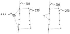
通过凹包算法(concave hull)来确定可行驶路面点簇的多个边缘点可以确定得到较为准确的边缘点。相反地,如果采用凸包(convex hull)算法确定得到道路边缘点时,可能会将不可行驶的区域均确定为道路边缘,这样确定得到的道路边缘点的准确性较低。图2中的210为根据凸包算法确定得到的多个边缘点,220为根据凹包算法确定得到的多个边缘点。使用凸包算法时,将被认为是不可行驶区域确定为道路边缘,在210中将一个异常点和道路边缘205的两个顶点确定为道路边缘点,从而跳过了真正的道路边缘205上的点。在使用凹包算法时,虽然也会将异常点确定为道路边缘点,但是确定得到的道路边缘点220中不会跳过或漏掉真正的道路边缘205上的点。可见,通过凹包算法能够更为准确地识别出道路边缘上的点。A more accurate edge point can be determined by using the concave hull algorithm to determine multiple edge points of the drivable road surface point cluster. On the contrary, if the convex hull algorithm is used to determine the road edge points, the non-drivable areas may be determined as the road edges, and the accuracy of the road edge points determined in this way is low. 210 in FIG. 2 is a plurality of edge points determined according to the convex hull algorithm, and 220 is a plurality of edge points determined according to the concave hull algorithm. When using the convex hull algorithm, the non-drivable area is considered to be determined as the road edge, and an abnormal point and two vertices of the
步骤350、根据确定的多个道路边缘点拟合得到道路边缘曲线。
在一些实施例中,可以通过随机抽样一致(RANSAC)方法根据道路边缘上的点来拟合得到道路边缘曲线。RANSAC方法能够从一组包含异常数据(outliers)的数据集中,通过迭代方法估计数学模型的参数。RANSAC方法的基本假设包括:a、数据由正常数据(inliers)组成,例如数据的分布可以用一些模型参数来解释;b、异常数据是不能适应模型的数据;c、除此以外的数据属于噪声。通过使用RANSAC方法,能够在确定的多个道路边缘点包括异常点(例如图2中的异常点)的情况下,拟合二次曲线得到较为准确的道路边缘曲线。In some embodiments, the road edge curve can be obtained by fitting according to the points on the road edge by a random sampling consensus (RANSAC) method. The RANSAC method can estimate the parameters of a mathematical model through an iterative method from a set of data sets containing outliers. The basic assumptions of the RANSAC method include: a. The data is composed of normal data (inliers), for example, the distribution of the data can be explained by some model parameters; b. Abnormal data is data that cannot adapt to the model; c. Other data are noise . By using the RANSAC method, a more accurate road edge curve can be obtained by fitting a quadratic curve under the condition that a plurality of determined road edge points include abnormal points (such as the abnormal points in FIG. 2 ).
在图3的基础上,在步骤350之后,还可以对拟合得到的道路边缘曲线进行平滑处理,在一些实施例中,可以使用样条函数(spline function)来对拟合得到的道路边缘曲线进行平滑。On the basis of Fig. 3, after
在有些场景中,当车辆的侧面在本次处理过程中被比车辆更大的动态物体例如大型卡车遮挡后,可能无法在本次处理过程中检测得到道路边缘,也即,上述步骤350的处理结果可能是无法拟合得到道路边缘曲线。在这种情况下,可以根据对同一路段在不同次处理中拟合的多个道路边缘曲线,确定得到该路段的道路边缘曲线。例如在A次处理过程中未检测到一个路段的道路边缘,在B次处理过程中检测到该路段的道路边缘,可以结合A次处理和B次处理的检测结果确定得到该路段的道路边缘。又例如,在A次处理过程中检测到一个路段的部分道路边缘,在B次处理过程中检测到该路段的另一部分道路边缘,可以将A次处理和B次处理检测到的道路边缘合并为该路段的道路边缘。在A次处理的结果和B次处理结果可以是同一个车辆检测得到的,也可以是不同的车辆检测得到的。下面具体进行具体说明。In some scenarios, when the side of the vehicle is blocked by a dynamic object larger than the vehicle during this processing, such as a large truck, it may not be possible to detect the edge of the road during this processing, that is, the processing of the
图4A和图4B示出了通过图3所示的方法进行道路边缘检测的结果示意图。图4A和图4B中的403表示应用图3所示方法的自动驾驶车辆,又称为本车。在本车403上搭载有LIDAR 410,相邻车辆413为接近于本车403的车辆。FIG. 4A and FIG. 4B are schematic diagrams showing the result of road edge detection by the method shown in FIG. 3 . 403 in FIG. 4A and FIG. 4B represents the self-driving vehicle to which the method shown in FIG. 3 is applied, also referred to as the self-driving vehicle. The
在图4A中,相邻车辆413相比于本车403更接近于道路边缘405。由于本车403的视角限制,车辆413被检测为一个L形,如图4A中符号“x”所示,道路边缘405的一部分被检测到,如图4A中符号“*”所示。In FIG. 4A ,
在一些实施例中,在拟合道路边缘的过程中,不考虑对应于相邻车辆413被检测到的部分(如图4A中符号“x”所示),根据检测到对应于道路边缘的点(如图4A中符号“*”所示)以及被相邻车辆413遮挡的部分(如图4A中道路边缘未被检测到的部分)来拟合道路边缘,以实现准确地检测道路边缘。In some embodiments, in the process of fitting the road edge, the detected part corresponding to the adjacent vehicle 413 (shown by the symbol "x" in FIG. 4A ) is not considered, and according to the detected (Shown by the symbol "*" in FIG. 4A ) and the part blocked by the adjacent vehicle 413 (the undetected part of the road edge in FIG. 4A ) to fit the road edge to achieve accurate detection of the road edge.
在另一些实施例中,由于图4A中道路边缘点(如图4A中符号“*”所示)之间的距离太大,使得道路边缘拟合算法可能无法根据图4A中检测到的道路边缘点进行准确的检测,也即无法通过如图4A中的道路边缘点拟合得到一条连续的道路边缘曲线,例如无法拟合得到道路边缘曲线、或者拟合得到断续的多段道路边缘曲线。在该场景中,可以根据多次检测的结果来实现最终准确的道路边缘检测。在一些实施例中,该处理可以包括:In some other embodiments, since the distance between the road edge points in FIG. 4A (shown by the symbol "*" in FIG. 4A) is too large, the road edge fitting algorithm may not be able to detect the road edge in FIG. 4A Points are accurately detected, that is, a continuous road edge curve cannot be obtained by fitting the road edge points as shown in Figure 4A, for example, the road edge curve cannot be fitted, or an intermittent multi-segment road edge curve cannot be obtained by fitting. In this scenario, the final accurate road edge detection can be achieved based on the results of multiple detections. In some embodiments, this processing may include:
步骤351’、在本次对一个路段确定得到的多个道路边缘点无法拟合得到一条连续的道路边缘曲线的情况下,获取其它次对该路段确定得到的道路边缘曲线。Step 351', in the case that multiple road edge points determined for a road section this time cannot be fitted to obtain a continuous road edge curve, obtain road edge curves determined for the road section for other times.
在获取其它次对该路段确定得到的道路边缘曲线时,可以获取本车在其它次处理得到的道路边缘曲线,也可以获取其它车对该路段确定得到的道路边缘曲线。本车与其它车进行通信时,通信方式可以包括V2X通信、Wi-Fi通信、移动通信、等多种通信方式。本车与其它车的通信,可以是车与车之间的直接通信、车与车通过路侧设备的间接通信、车与车通过远程服务器或云端服务器等的间接通信。When obtaining the road edge curves determined for the road section in other times, the road edge curves obtained by the own vehicle in other times of processing may be obtained, or the road edge curves determined by other vehicles for the road section may be obtained. When the vehicle communicates with other vehicles, the communication methods may include V2X communication, Wi-Fi communication, mobile communication, and other communication methods. The communication between the vehicle and other vehicles can be direct communication between vehicles, indirect communication between vehicles through roadside equipment, and indirect communication between vehicles through remote servers or cloud servers.
步骤352’、根据其它次对该路段确定得到的道路边缘曲线、以及本次对该路段的前后相邻路段确定得到的道路边缘曲线,拟合得到该路段的道路边缘曲线。Step 352': According to the road edge curves determined for the road section in other times and the road edge curves determined for the adjacent road sections before and after the road section this time, the road edge curve of the road section is obtained by fitting.
该拟合处理包括:The fitting process includes:
步骤3521’、对其它次确定得到的该路段的道路边缘曲线、本次对该路段的前后相邻路段确定得到的道路边缘曲线进行抽样,得到按照空间位置分布的多个道路边缘点;Step 3521', sampling the road edge curves of the road section determined for other times, and the road edge curves determined for the adjacent road sections before and after the road section this time, to obtain a plurality of road edge points distributed according to the spatial position;
步骤3522’、根据抽样得到的多个道路边缘点拟合得到该路段和前后相邻路段的道路边缘曲线。其中,进行拟合的算法可以是样条函数(spline function)。Step 3522', according to a plurality of road edge points obtained by sampling, the road edge curves of the road section and adjacent road sections are obtained by fitting. Wherein, the algorithm for fitting may be a spline function (spline function).
进一步,还可以通过多数投票算法(majority voting)、均值滤波(meanfiltering)和/或中间值滤波(median filtering)的方法来消除道路边缘检测的假阳性问题,实现最终准确的道路边缘检测。Further, the false positive problem of road edge detection can also be eliminated by means of majority voting, mean filtering and/or median filtering, and finally accurate road edge detection can be achieved.
在图4B中,本车403比相邻车辆413更接近道路边缘405,LIDAR410能够分辨出道路边缘以及其它车辆。在该场景中,如前所述,点云数据中对应于车辆413的点不满足预定的判断准则,在进行道路边缘拟合时不考虑这部分点。In FIG. 4B ,
如图4A和4B所示,应用本申请实施例提供的方法能够准确、有效且稳定地检测得到车辆检测到的道路边缘、或者被部分遮挡的道路边缘。As shown in FIGS. 4A and 4B , applying the method provided by the embodiment of the present application can accurately, effectively and stably detect the edge of the road detected by the vehicle, or the edge of the road that is partially blocked.
根据申请实施例提供的道路边缘检测方案,确定点云数据中每个点的局部几何特征,并通过区域生长法根据点的局部几何特征生成多个点簇。基于先验知识点云数据的中心是LIDAR也即自动驾驶车辆,确定在车辆周围包括点数最多的点簇代表可行驶路面区域。并进一步确定可行驶路面点簇的边缘点为道路边缘点,通过多个道路边缘点拟合得到道路边缘曲线。本申请实施例提供的技术方案根据点云数据中点的局部几何特征来确定得到可行驶路面点簇,通过可行驶路面点簇的边缘点确定得到道路边缘,相比于现有技术中直接通过点级别的特征来识别道路边缘,能够降低噪声、遮挡和路边物体的影响,提高检测的准确度。According to the road edge detection scheme provided in the embodiment of the application, the local geometric characteristics of each point in the point cloud data are determined, and multiple point clusters are generated according to the local geometric characteristics of the points through the region growing method. Based on prior knowledge, the center of the point cloud data is LIDAR, that is, the self-driving vehicle, and it is determined that the point cluster with the largest number of points around the vehicle represents the drivable road surface area. And further determine the edge points of the drivable road surface point clusters as road edge points, and obtain the road edge curve by fitting multiple road edge points. The technical solution provided by the embodiment of the present application determines the drivable road surface point cluster according to the local geometric features of the points in the point cloud data, and obtains the road edge by determining the edge points of the drivable road surface point cluster. Point-level features are used to identify road edges, which can reduce the influence of noise, occlusion and roadside objects, and improve the accuracy of detection.
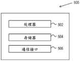
基于相同的发明构思,本申请实施例还提供了一种道路边缘检测装置。如图5所示,包括一个处理器502和至少一个存储器504。该道路边缘检测装置可以位于一个硬件平台500中。Based on the same inventive concept, the embodiment of the present application also provides a road edge detection device. As shown in FIG. 5 , a
至少一个存储器504中存储有至少一条机器可执行指令,处理器502执行至少一条机器可执行指令实现如图3所示的道路边缘检测处理。道路边缘检测处理包括:在车辆行驶过程中,车载道路边缘检测装置获取车载激光雷达扫描周围环境生成的点云数据;其中,点云数据中包括多个点的三维坐标值以及反射强度值;确定点云数据中每个点的局部几何特征,局部几何特征包括点的法向以及法向曲率;在点云数据中选择多个种子点,使用区域生长方法、根据种子点和各个点的局部几何特征,生成多个点簇;确定包括的点数最多的一个点簇为可行驶路面点簇,在可行使路面点簇中确定多个道路边缘点;根据确定的多个道路边缘点拟合得到道路边缘曲线。At least one machine-executable instruction is stored in at least one
在一些实施例中,处理器502执行至少一条机器可执行指令实现获取车载激光雷达生成的点云数据,包括:获取激光雷达生成的多帧点云数据,以及车载全球定位系统GPS测量的定位信息和惯性测量单元IMU测量的姿态信息,将多帧点云数据标定到一个公共的坐标系中,得到一个累积的点云数据。In some embodiments, the
在一些实施例中,处理器502执行至少一条机器可执行指令实现确定点云数据中每个点的局部几何特征,包括:对于点云数据中的一个点,通过该点及该点周围的多个相邻点的三维坐标,拟合得到一个平面,确定该点在拟合的平面上的法向;确定该点及该点周围的多个相邻点构成的协方差矩阵以及协方差矩阵的多个特征值,根据多个特征值确定得到该点的法向曲率。In some embodiments, the
在一些实施例中,处理器502执行至少一条机器可执行指令还实现:通过K维树方法在点云数据中搜索确定得到一个点周围的多个相邻点;多个相邻点包括冯诺依曼相邻点,或者摩尔相邻点。In some embodiments, the
在一些实施例中,处理器502执行至少一条机器可执行指令根据多个特征值确定得到该点的法向曲率,包括:协方差矩阵的特征值包括λ0、λ1、λ2,确定λ0/(λ0+λ1+λ2)为该点的法向曲率。In some embodiments, the
在一些实施例中,处理器502执行至少一条机器可执行指令实现在点云数据中选择多个种子点,包括:在点云数据中随机选择预定数量的多个种子点;或者,在点云数据中均匀选择预定数量的多个种子点。In some embodiments, the
在一些实施例中,处理器502执行至少一条机器可执行指令实现使用区域生长方法、根据种子点和各个点的局部几何特征,生成多个点簇,包括:迭代执行区域生长操作,得到多个点簇,区域生长操作包括:对于每个种子点,判断该种子点周围的一个点是否满足预定的判断准则,在满足的情况下,确定将该点加入到该种子点所属的点簇;将该点簇的多个外围点确定为新的种子点;预定的判断准则包括:判断一个周围点与种子点在三维坐标中的高度差是否处于预定的高度差范围内、该周围点与种子点的法向差是否处于预定的法向差范围内、以及该周围点与种子点的法向曲率差是否处在预定的法向曲率差范围内。In some embodiments, the
在一些实施例中,不同的道路条件对应于不同的判断准则。In some embodiments, different road conditions correspond to different judgment criteria.
在一些实施例中,处理器502执行至少一条机器可执行指令实现生成多个点簇的过程中,在点云数据中的点的数量小于预定的第一数量的情况下,停止生成多个点簇;和/或,在一个点簇中的点的数量大于预定的第二数量的情况下,停止生成该点簇。In some embodiments, the
在一些实施例中,处理器502执行至少一条机器可执行指令实现在一个点簇的种子点和另一个点簇的种子点互为周围点的情况下,在这两个点满足预定的判断准则时,将该两个点簇合并为一个点簇。In some embodiments, the
在一些实施例中,处理器502执行至少一条机器可执行指令实现在可行驶路面点簇中确定多个道路边缘点,包括:通过凹包算法确定得到可行驶路面点簇的多个边缘点;确定可行驶路面点簇的多个边缘点为多个道路边缘点。In some embodiments, the
在一些实施例中,处理器502执行至少一条机器可执行指令实现根据确定的多个道路边缘点拟合得到道路边缘曲线,包括:使用随机抽样一致方法通过多个道路边缘点拟合得到道路边缘曲线。In some embodiments, the
在一些实施例中,处理器502执行至少一条机器可执行指令还实现:对拟合得到的道路边缘曲线进行平滑处理,得到平滑后的道路边缘曲线。In some embodiments, the execution of at least one machine-executable instruction by the
在一些实施例中,处理器502执行至一条机器可执行指令还包括:在本次对一个路段确定得到的多个道路边缘点无法拟合得到一条连续的道路边缘曲线的情况下,获取其它次对该路段确定得到的道路边缘曲线;根据其它次对该路段确定得到的道路边缘曲线、以及本次对该路段的前后相邻路段确定得到的道路边缘曲线,拟合得到该路段的道路边缘曲线。In some embodiments, the execution of a machine-executable instruction by the
在一些实施例中,处理器502执行至一条机器可执行指令实现根据其它次对该路段确定得到的道路边缘曲线、以及本次对该路段的前后相邻路段确定得到的道路边缘曲线,拟合得到该路段的道路边缘曲线,包括:对其它次确定得到的该路段的道路边缘曲线、本次对该路段的前后相邻路段确定得到的道路边缘曲线进行抽样,得到按照空间位置分布的多个道路边缘点;根据抽样得到的多个道路边缘点拟合得到该路段和前后相邻路段的道路边缘曲线。In some embodiments, the
进一步地,图5所示的硬件平台500还可以包括一个通信接口506,该通信接口506可以应用一种或多种通信协议(LTE、Wi-Fi以及其它协议)。Further, the
本申请实施例提供的技术方案根据点云数据中点的局部几何特征来确定得到可行驶路面点簇,通过可行驶路面点簇的边缘点确定得到道路边缘,相比于现有技术中直接通过点级别的特征来识别道路边缘,能够降低噪声、遮挡和路边物体的影响,提高检测的准确度。The technical solution provided by the embodiment of the present application determines the drivable road surface point cluster according to the local geometric features of the points in the point cloud data, and obtains the road edge by determining the edge points of the drivable road surface point cluster. Point-level features are used to identify road edges, which can reduce the influence of noise, occlusion and roadside objects, and improve the accuracy of detection.
基于相同的发明构思,本申请实施例还提供了一种非易失性存储介质。该存储介质中存储有至少一条机器可执行指令,处理器执行至少一条机器可执行指令实现如图3所示的道路边缘检测处理。Based on the same inventive concept, the embodiment of the present application also provides a non-volatile storage medium. The storage medium stores at least one machine-executable instruction, and the processor executes at least one machine-executable instruction to implement the road edge detection process as shown in FIG. 3 .
本申请实施例提供的技术方案根据点云数据中点的局部几何特征来确定得到可行驶路面点簇,通过可行驶路面点簇的边缘点确定得到道路边缘,相比于现有技术中直接通过点级别的特征来识别道路边缘,能够降低噪声、遮挡和路边物体的影响,提高检测的准确度。The technical solution provided by the embodiment of the present application determines the drivable road surface point cluster according to the local geometric features of the points in the point cloud data, and obtains the road edge by determining the edge points of the drivable road surface point cluster. Point-level features are used to identify road edges, which can reduce the influence of noise, occlusion and roadside objects, and improve the accuracy of detection.
本申请实施例的实质内容和功能性描述可以被实施为各种系统、数字电子电路、或者计算机软件、固件或者硬件,其中包括本申请实施例公开的结构、以及它们的等同结构、或者这些结构中一个或者多个的结合。本申请实施例的实质内容和功能性描述可以被实施为计算机程序产品,例如计算机程序指令的一个或者多个模块,且被存储在一个有形的、非易失性的计算机可读存储介质中,该计算机程序产品被数据处理装置执行后用于控制数据处理装置的操作。计算机可读存储介质可以是一个机器可读存储装置、机器可读存储基质、存储装置、影响机器可读传输信号的化合物、或者上述装置中一个或多个的组合。术语“数据处理单元”或者“数据处理装置”包括所有的装置、设备和用于处理数据的机器,示例性地包括可编程处理器、计算机、或者多个处理器或者多个计算机。该装置除了包括硬件外,还包括为计算机程序建立执行环境的代码、例如,组成处理器固件的代码、协议栈代码、数据库管理系统代码、操作系统、或者上述中一个或多个的组合。The substantive content and functional descriptions of the embodiments of the present application can be implemented as various systems, digital electronic circuits, or computer software, firmware or hardware, including the structures disclosed in the embodiments of the present application, their equivalent structures, or these structures A combination of one or more of them. The substantive content and functional descriptions of the embodiments of the present application may be implemented as computer program products, such as one or more modules of computer program instructions, and stored in a tangible, non-volatile computer-readable storage medium, The computer program product is used to control the operation of the data processing device after being executed by the data processing device. The computer-readable storage medium can be a machine-readable storage device, a machine-readable storage substrate, a storage device, a compound that affects a machine-readable transmission signal, or a combination of one or more of the above-mentioned devices. The term "data processing unit" or "data processing means" includes all apparatuses, devices and machines for processing data, exemplarily including a programmable processor, a computer, or multiple processors or multiple computers. In addition to hardware, the device also includes codes for establishing an execution environment for computer programs, for example, codes constituting processor firmware, protocol stack codes, database management system codes, operating systems, or a combination of one or more of the above.
计算机程序(也被称为程序、软件、软件应用、脚本、或者代码)可以以任何编程语言进行编写,包括汇编或者翻译语言,且可以被以任何形式进行部署,包括独立的程序、或者模块、构件、子程序、或者适用于计算环境的单元。计算机程序不必对应于一个文件系统中的一个文件。程序可以存储为一个文件中的一部分,该文件中还存储有其它的程序或者数据(例如一个标记语言文件中存储一个或者多个脚本),或者存储为单独的文件,或者存储在多个协调的文件中(例如用于存储一个或者多个模块、子程序或者代码部分的多个文件)。计算机程序可以在一个或者多个计算机上执行,一个或者多个电脑具有同一个地址、或者具有多个分布式的地址并通信网络互联。Computer programs (also known as programs, software, software applications, scripts, or code) can be written in any programming language, including assembly or translated languages, and can be deployed in any form, including stand-alone programs, or modules, A component, subroutine, or unit applicable to a computing environment. A computer program does not necessarily correspond to a file in a file system. A program can be stored as part of a file that also stores other programs or data (such as one or more scripts stored in a markup language file), or stored as a separate file, or stored in multiple coordinated files (such as multiple files used to store one or more modules, subroutines, or code sections). A computer program can be executed on one or more computers, and one or more computers have the same address, or have multiple distributed addresses and are interconnected by a communication network.
本申请公开的处理或者逻辑过程,可以通过一个或多个可编程处理器根据输入数据执行一个或多个计算机程序来实现多个功能得到执行,并且生成输出。处理或者逻辑过程、以及装置也可以被专用逻辑电路执行,例如可编程逻辑门阵列(FPGA,Fieldprogrammable gate array)或者特定用途集成电路(ASIC,Application specificintegrated circuit)。The processing or logic process disclosed in the present application can be implemented by one or more programmable processors executing one or more computer programs according to the input data to implement multiple functions and generate output. The processing or logic process, and the device can also be executed by a dedicated logic circuit, such as a programmable logic gate array (FPGA, Field programmable gate array) or an application specific integrated circuit (ASIC, Application specific integrated circuit).
适用于执行计算机程序的处理器,示例性地包括通用或者专用微处理器,以及任何一个或者多个任何类型的数字计算机的处理器。通常,处理器可以从给一个只读存储器和/或随机接入存储器中存储指令和数据。计算机的基本单元包括一个执行指令的处理器和一个或多个存储指令和数据的存储装置。通常,计算机还可以包括或者操作性地连接到一个或多个大容量存储装置,来接收或者发送数据,包括磁盘、磁光盘、或者光盘。但是,一个计算机不必包括所有的这些装置。适于存储计算机程序指令和数据的计算机可读介质,包括所有形式的非易失性存储器、介质、存储器装置,示例性的包括半导体存储装置,例如,EPROM、EEPROM,以及闪存装置。处理器和存储器可以被单独或结合实施为特定用途逻辑电路。Processors suitable for the execution of computer programs include, illustratively, general or special purpose microprocessors, and any one or more processors of any type of digital computer. Generally, a processor can store instructions and data from a read only memory and/or random access memory. The basic units of a computer include a processor for executing instructions and one or more storage devices for storing instructions and data. Generally, a computer may also include or be operatively connected to one or more mass storage devices for receiving or transmitting data, including magnetic, magneto-optical, or optical disks. However, a computer does not have to include all of these devices. Computer-readable media suitable for storing computer program instructions and data include all forms of non-volatile memory, media, and memory devices, including semiconductor memory devices, such as EPROM, EEPROM, and flash memory devices, for example. The processor and memory may be implemented alone or in combination as special purpose logic.
虽然本申请说明书包括了多种实施例,但是这些实施例不能被解释为对本申请保护范围的限制,只被解释为特定实施例的特征描述。本申请不同实施例中描述的一些特征也可以在一个单独的实施例中得到实施。一个单独的实施例中描述的多个特征也可以被分散地或者结合地实施在多个实施例中。并且,上述以组合的方式描述了一些特征,但是组合的多个特征中也可以去掉其中的一个或者多个特征,从组合的特征也可以得到多个字组合的特征,或者子组合的组合。Although the description of the present application includes various embodiments, these embodiments should not be construed as limiting the protection scope of the present application, but only as descriptions of characteristics of specific embodiments. Some features described in different embodiments of this application can also be implemented in a single embodiment. Features described in a single embodiment may also be implemented in multiple embodiments separately or in combination. Moreover, some features are described above in combination, but one or more of the combined features can also be removed, and the features of multiple word combinations, or combinations of sub-combinations can also be obtained from the combined features.
相类似地,附图中以一定的顺序描述了多个操作,但是应该理解的是这样的多个操作可以以所示出的顺序得到执行,也可以以特定的顺序得到执行,以达到所需的效果。并且,本申请的多个实施例中描述了多个系统构件的分离设置,但是不能被理解为所有的实施例中都具有这样的分离设置。Similarly, the drawings depict operations in a certain order, but it should be understood that such operations may be performed in the order shown or in a specific order to achieve the desired Effect. Moreover, multiple embodiments of the present application describe the separate arrangement of multiple system components, but it cannot be understood that all the embodiments have such separate arrangement.
本申请实施例中只描述了一些实施方式和实例,其它的实施例和改进以及变形也可以基于本申请描述的内容得到。The embodiments of the present application only describe some implementations and examples, and other embodiments, improvements and variations can also be obtained based on the content described in the present application.
Claims (32)
Applications Claiming Priority (3)
| Application Number | Priority Date | Filing Date | Title |
|---|---|---|---|
| US201862665994P | 2018-05-02 | 2018-05-02 | |
| US62/665,994 | 2018-05-02 | ||
| CN201910337021.5ACN110458854B (en) | 2018-05-02 | 2019-04-25 | Road edge detection method and device |
Related Parent Applications (1)
| Application Number | Title | Priority Date | Filing Date |
|---|---|---|---|
| CN201910337021.5ADivisionCN110458854B (en) | 2018-05-02 | 2019-04-25 | Road edge detection method and device |
Publications (1)
| Publication Number | Publication Date |
|---|---|
| CN116129376Atrue CN116129376A (en) | 2023-05-16 |
Family
ID=68385368
Family Applications (2)
| Application Number | Title | Priority Date | Filing Date |
|---|---|---|---|
| CN202211290713.7APendingCN116129376A (en) | 2018-05-02 | 2019-04-25 | Road edge detection method and device |
| CN201910337021.5AActiveCN110458854B (en) | 2018-05-02 | 2019-04-25 | Road edge detection method and device |
Family Applications After (1)
| Application Number | Title | Priority Date | Filing Date |
|---|---|---|---|
| CN201910337021.5AActiveCN110458854B (en) | 2018-05-02 | 2019-04-25 | Road edge detection method and device |
Country Status (2)
| Country | Link |
|---|---|
| US (2) | US11500101B2 (en) |
| CN (2) | CN116129376A (en) |
Families Citing this family (26)
| Publication number | Priority date | Publication date | Assignee | Title |
|---|---|---|---|---|
| CA3131838A1 (en) | 2019-02-25 | 2020-09-03 | Emily A. CARRIGG | System and method for surface feature detection and traversal |
| US11927457B2 (en) | 2019-07-10 | 2024-03-12 | Deka Products Limited Partnership | System and method for real time control of an autonomous device |
| CN111126211B (en)* | 2019-12-13 | 2023-08-29 | 北京四维图新科技股份有限公司 | Label identification method and device and electronic equipment |
| JP7310658B2 (en)* | 2020-03-06 | 2023-07-19 | 株式会社デンソー | Object recognition device |
| WO2021189420A1 (en)* | 2020-03-27 | 2021-09-30 | 华为技术有限公司 | Data processing method and device |
| CN111580131B (en)* | 2020-04-08 | 2023-07-07 | 西安邮电大学 | Method for 3D lidar smart car to recognize vehicles on the highway |
| WO2021217669A1 (en)* | 2020-04-30 | 2021-11-04 | 华为技术有限公司 | Target detection method and apparatus |
| CN111798700B (en)* | 2020-06-30 | 2022-02-25 | 北京行易道科技有限公司 | Blind area monitoring alarm method and device |
| WO2022047744A1 (en)* | 2020-09-04 | 2022-03-10 | 华为技术有限公司 | Road surface extraction method and device for map |
| WO2022087916A1 (en)* | 2020-10-28 | 2022-05-05 | 华为技术有限公司 | Positioning method and apparatus, and electronic device and storage medium |
| WO2022164289A1 (en)* | 2021-01-29 | 2022-08-04 | 주식회사 에스오에스랩 | Method for generating intensity information having extended expression range by reflecting geometric characteristic of object, and lidar apparatus performing same method |
| CN112837333A (en)* | 2021-02-04 | 2021-05-25 | 南京抒微智能科技有限公司 | A kind of outdoor unmanned sweeper welt cleaning method and equipment |
| CN112965077B (en)* | 2021-02-09 | 2022-02-11 | 上海同陆云交通科技有限公司 | Road inspection system and method based on vehicle-mounted laser radar |
| CN112595728B (en)* | 2021-03-03 | 2021-05-25 | 腾讯科技(深圳)有限公司 | Road problem determination method and related device |
| CN112946603B (en)* | 2021-03-08 | 2024-03-26 | 安徽乐道智能科技有限公司 | Road maintenance detection system based on laser radar and detection method thereof |
| CN113673360B (en)* | 2021-07-28 | 2025-04-11 | 浙江大华技术股份有限公司 | Human body distribution detection method, aerial photography equipment, electronic device and storage medium |
| CN114019469B (en)* | 2021-10-29 | 2024-06-21 | 中国人民解放军海军航空大学航空作战勤务学院 | Sea surface target detection method and equipment based on concave packet judgment, medium and product |
| CN114425774B (en)* | 2022-01-21 | 2023-11-03 | 深圳优地科技有限公司 | Robot walking road recognition method, robot walking road recognition device, and storage medium |
| CN114663397B (en)* | 2022-03-22 | 2023-05-23 | 小米汽车科技有限公司 | Method, device, equipment and storage medium for detecting drivable area |
| CN116338726A (en)* | 2022-04-20 | 2023-06-27 | 浙江零跑科技股份有限公司 | A laser radar point cloud roadside detection method and device |
| CN115330819B (en)* | 2022-10-12 | 2023-02-10 | 杭州蓝芯科技有限公司 | Soft package segmentation positioning method, industrial personal computer and robot grabbing system |
| CN118310546A (en)* | 2023-01-05 | 2024-07-09 | 广州汽车集团股份有限公司 | Path planning method, path planning device, vehicle and storage medium |
| WO2024148469A1 (en)* | 2023-01-09 | 2024-07-18 | 华为技术有限公司 | Road edge detection method and apparatus |
| CN115840227B (en)* | 2023-02-27 | 2023-07-04 | 福思(杭州)智能科技有限公司 | Road edge detection method and device |
| CN115984827B (en)* | 2023-03-06 | 2024-02-02 | 安徽蔚来智驾科技有限公司 | Point cloud sensing method, computer equipment and computer readable storage medium |
| CN116202874B (en)* | 2023-05-05 | 2023-07-14 | 青岛宇通管业有限公司 | Drainage pipe flexibility testing method and system |
Family Cites Families (215)
| Publication number | Priority date | Publication date | Assignee | Title |
|---|---|---|---|---|
| DE2608513A1 (en) | 1976-03-02 | 1977-09-08 | Standard Elektrik Lorenz Ag | Remote-controlled vehicle steering system with fail-safe - stores control data for comparison with positional signals from actuator |
| AU642638B2 (en) | 1989-12-11 | 1993-10-28 | Caterpillar Inc. | Integrated vehicle positioning and navigation system, apparatus and method |
| US5877897A (en) | 1993-02-26 | 1999-03-02 | Donnelly Corporation | Automatic rearview mirror, vehicle lighting control and vehicle interior monitoring system using a photosensor array |
| US6822563B2 (en) | 1997-09-22 | 2004-11-23 | Donnelly Corporation | Vehicle imaging system with accessory control |
| US7103460B1 (en) | 1994-05-09 | 2006-09-05 | Automotive Technologies International, Inc. | System and method for vehicle diagnostics |
| US7783403B2 (en) | 1994-05-23 | 2010-08-24 | Automotive Technologies International, Inc. | System and method for preventing vehicular accidents |
| US7655894B2 (en) | 1996-03-25 | 2010-02-02 | Donnelly Corporation | Vehicular image sensing system |
| US6084870A (en) | 1996-07-22 | 2000-07-04 | Qualcomm Incorporated | Method and apparatus for the remote monitoring and configuration of electronic control systems |
| US6263088B1 (en) | 1997-06-19 | 2001-07-17 | Ncr Corporation | System and method for tracking movement of objects in a scene |
| JP3183501B2 (en) | 1997-07-07 | 2001-07-09 | 本田技研工業株式会社 | Travel control device for vehicles |
| US6594821B1 (en) | 2000-03-30 | 2003-07-15 | Transmeta Corporation | Translation consistency checking for modified target instructions by comparing to original copy |
| US8711217B2 (en) | 2000-10-24 | 2014-04-29 | Objectvideo, Inc. | Video surveillance system employing video primitives |
| US7363149B2 (en) | 2001-12-13 | 2008-04-22 | Robert Bosch Gmbh | Autonomous in-vehicle navigation system and diagnostic system |
| US7167519B2 (en) | 2001-12-20 | 2007-01-23 | Siemens Corporate Research, Inc. | Real-time video object generation for smart cameras |
| ES2391556T3 (en) | 2002-05-03 | 2012-11-27 | Donnelly Corporation | Object detection system for vehicles |
| US9007197B2 (en) | 2002-05-20 | 2015-04-14 | Intelligent Technologies International, Inc. | Vehicular anticipatory sensor system |
| US6975923B2 (en) | 2002-10-01 | 2005-12-13 | Roke Manor Research Limited | Autonomous vehicle guidance on or near airports |
| US6777904B1 (en) | 2003-02-25 | 2004-08-17 | Ford Global Technologies, Llc | Method and system for controlling a motor |
| US8855405B2 (en) | 2003-04-30 | 2014-10-07 | Deere & Company | System and method for detecting and analyzing features in an agricultural field for vehicle guidance |
| EP2068269A3 (en) | 2004-04-08 | 2009-10-07 | Mobileye Technologies Limited | Collision warning system |
| WO2005098739A1 (en) | 2004-04-08 | 2005-10-20 | Mobileye Technologies Limited | Pedestrian detection |
| WO2005098751A1 (en) | 2004-04-08 | 2005-10-20 | Mobileye Technologies Limited | Crowd detection |
| US7526103B2 (en) | 2004-04-15 | 2009-04-28 | Donnelly Corporation | Imaging system for vehicle |
| US8078338B2 (en) | 2004-10-22 | 2011-12-13 | Irobot Corporation | System and method for behavior based control of an autonomous vehicle |
| US7742841B2 (en) | 2005-02-23 | 2010-06-22 | Panasonic Electric Works Co., Ltd. | Autonomous vehicle and planar obstacle recognition method |
| KR100802511B1 (en) | 2005-10-11 | 2008-02-13 | 주식회사 코리아 와이즈넛 | Topic based search service provision system and method |
| US7843448B2 (en)* | 2005-11-21 | 2010-11-30 | Leica Geosystems Ag | Identification of occluded edge regions from 3D point data |
| US8553088B2 (en) | 2005-11-23 | 2013-10-08 | Mobileye Technologies Limited | Systems and methods for detecting obstructions in a camera field of view |
| US8164628B2 (en) | 2006-01-04 | 2012-04-24 | Mobileye Technologies Ltd. | Estimating distance to an object using a sequence of images recorded by a monocular camera |
| US8265392B2 (en) | 2006-02-07 | 2012-09-11 | Qualcomm Incorporated | Inter-mode region-of-interest video object segmentation |
| US8150155B2 (en) | 2006-02-07 | 2012-04-03 | Qualcomm Incorporated | Multi-mode region-of-interest video object segmentation |
| US7689559B2 (en) | 2006-02-08 | 2010-03-30 | Telenor Asa | Document similarity scoring and ranking method, device and computer program product |
| US8050863B2 (en) | 2006-03-16 | 2011-11-01 | Gray & Company, Inc. | Navigation and control system for autonomous vehicles |
| US8417060B2 (en) | 2006-03-20 | 2013-04-09 | Arizona Board Of Regents For And On Behalf Of Arizona State University | Methods for multi-point descriptors for image registrations |
| US8108092B2 (en) | 2006-07-14 | 2012-01-31 | Irobot Corporation | Autonomous behaviors for a remote vehicle |
| US7786898B2 (en) | 2006-05-31 | 2010-08-31 | Mobileye Technologies Ltd. | Fusion of far infrared and visible images in enhanced obstacle detection in automotive applications |
| EP1930863B1 (en) | 2006-12-06 | 2011-08-03 | Mobileye Technologies Limited | Detecting and recognizing traffic signs |
| US20080249667A1 (en) | 2007-04-09 | 2008-10-09 | Microsoft Corporation | Learning and reasoning to enhance energy efficiency in transportation systems |
| US7839292B2 (en) | 2007-04-11 | 2010-11-23 | Nec Laboratories America, Inc. | Real-time driving danger level prediction |
| US8229163B2 (en) | 2007-08-22 | 2012-07-24 | American Gnc Corporation | 4D GIS based virtual reality for moving target prediction |
| US8041111B1 (en) | 2007-10-15 | 2011-10-18 | Adobe Systems Incorporated | Subjective and locatable color theme extraction for images |
| US9176006B2 (en) | 2008-01-15 | 2015-11-03 | Mobileye Vision Technologies Ltd. | Detection and classification of light sources using a diffraction grating |
| US9117133B2 (en) | 2008-06-18 | 2015-08-25 | Spectral Image, Inc. | Systems and methods for hyperspectral imaging |
| US20100049397A1 (en) | 2008-08-22 | 2010-02-25 | Garmin Ltd. | Fuel efficient routing |
| US8126642B2 (en) | 2008-10-24 | 2012-02-28 | Gray & Company, Inc. | Control and systems for autonomously driven vehicles |
| US8345956B2 (en) | 2008-11-03 | 2013-01-01 | Microsoft Corporation | Converting 2D video into stereo video |
| US9459515B2 (en) | 2008-12-05 | 2016-10-04 | Mobileye Vision Technologies Ltd. | Adjustable camera mount for a vehicle windshield |
| US8175376B2 (en) | 2009-03-09 | 2012-05-08 | Xerox Corporation | Framework for image thumbnailing based on visual similarity |
| WO2010109419A1 (en) | 2009-03-26 | 2010-09-30 | Koninklijke Philips Electronics N.V. | Method and apparatus for modifying an image by using a saliency map based on color frequency |
| US8271871B2 (en) | 2009-04-30 | 2012-09-18 | Xerox Corporation | Automated method for alignment of document objects |
| US8392117B2 (en) | 2009-05-22 | 2013-03-05 | Toyota Motor Engineering & Manufacturing North America, Inc. | Using topological structure for path planning in semi-structured environments |
| US9683854B2 (en) | 2009-07-19 | 2017-06-20 | Aaron T. Emigh | Pricing by historical comparison |
| DE102009046124A1 (en) | 2009-10-28 | 2011-05-05 | Ifm Electronic Gmbh | Method and apparatus for calibrating a 3D TOF camera system |
| TWI393074B (en) | 2009-12-10 | 2013-04-11 | Ind Tech Res Inst | Apparatus and method for moving object detection |
| JP2011176748A (en) | 2010-02-25 | 2011-09-08 | Sony Corp | Image processing apparatus and method, and program |
| US8726305B2 (en) | 2010-04-02 | 2014-05-13 | Yahoo! Inc. | Methods and systems for application rendering and management on internet television enabled displays |
| KR101145112B1 (en) | 2010-05-11 | 2012-05-14 | 국방과학연구소 | Steering control device of autonomous vehicle, autonomous vehicle having the same and steering control method of autonomous vehicle |
| US9753128B2 (en) | 2010-07-23 | 2017-09-05 | Heptagon Micro Optics Pte. Ltd. | Multi-path compensation using multiple modulation frequencies in time of flight sensor |
| US9043078B2 (en) | 2010-08-13 | 2015-05-26 | Deere & Company | Method and system for performing diagnostics or software maintenance for a vehicle |
| US9280711B2 (en) | 2010-09-21 | 2016-03-08 | Mobileye Vision Technologies Ltd. | Barrier and guardrail detection using a single camera |
| US9118816B2 (en) | 2011-12-06 | 2015-08-25 | Mobileye Vision Technologies Ltd. | Road vertical contour detection |
| US8509982B2 (en) | 2010-10-05 | 2013-08-13 | Google Inc. | Zone driving |
| EP2448251B1 (en) | 2010-10-31 | 2019-09-25 | Mobileye Vision Technologies Ltd. | Bundling night vision and other driver assistance systems (DAS) using near infra red (NIR) illumination and a rolling shutter |
| WO2012068154A1 (en) | 2010-11-15 | 2012-05-24 | Huawei Technologies Co., Ltd. | Method and system for video summarization |
| EP2993654B1 (en) | 2010-12-07 | 2017-05-03 | Mobileye Vision Technologies Ltd. | Method and system for forward collision warning |
| US9823339B2 (en) | 2010-12-21 | 2017-11-21 | Microsoft Technology Licensing, Llc | Plural anode time-of-flight sensor |
| EP2663916A1 (en) | 2011-01-14 | 2013-11-20 | BAE Systems Plc. | Data transfer system and method thereof |
| US9323250B2 (en) | 2011-01-28 | 2016-04-26 | Intouch Technologies, Inc. | Time-dependent navigation of telepresence robots |
| AU2012221159B2 (en) | 2011-02-21 | 2015-11-26 | Stratech Systems Limited | A surveillance system and a method for detecting a foreign object, debris, or damage in an airfield |
| US8401292B2 (en) | 2011-04-26 | 2013-03-19 | Eastman Kodak Company | Identifying high saliency regions in digital images |
| US9233659B2 (en) | 2011-04-27 | 2016-01-12 | Mobileye Vision Technologies Ltd. | Pedestrian collision warning system |
| KR101777875B1 (en) | 2011-04-28 | 2017-09-13 | 엘지디스플레이 주식회사 | Stereoscopic image display and method of adjusting stereoscopic image thereof |
| US9183447B1 (en) | 2011-06-09 | 2015-11-10 | Mobileye Vision Technologies Ltd. | Object detection using candidate object alignment |
| US20120314070A1 (en) | 2011-06-09 | 2012-12-13 | GM Global Technology Operations LLC | Lane sensing enhancement through object vehicle information for lane centering/keeping |
| GB2492848A (en) | 2011-07-15 | 2013-01-16 | Softkinetic Sensors Nv | Optical distance measurement |
| JP5564620B2 (en) | 2011-07-28 | 2014-07-30 | 本田技研工業株式会社 | Wireless power transmission method |
| US8744123B2 (en) | 2011-08-29 | 2014-06-03 | International Business Machines Corporation | Modeling of temporarily static objects in surveillance video data |
| DE102011083749B4 (en) | 2011-09-29 | 2015-06-11 | Aktiebolaget Skf | Rotor blade of a wind turbine with a device for detecting a distance value and method for detecting a distance value |
| US8891820B2 (en) | 2011-09-29 | 2014-11-18 | The Boeing Company | Multi-modal sensor fusion |
| US20140143839A1 (en) | 2011-11-16 | 2014-05-22 | Flextronics Ap, Llc. | On board vehicle remote control module |
| CN104115197A (en) | 2011-12-05 | 2014-10-22 | 布莱特瓦维森有限公司 | Smart traffic sign system and method |
| US9297641B2 (en) | 2011-12-12 | 2016-03-29 | Mobileye Vision Technologies Ltd. | Detection of obstacles at night by analysis of shadows |
| FR2984254B1 (en) | 2011-12-16 | 2016-07-01 | Renault Sa | CONTROL OF AUTONOMOUS VEHICLES |
| US8810666B2 (en) | 2012-01-16 | 2014-08-19 | Google Inc. | Methods and systems for processing a video for stabilization using dynamic crop |
| JP5605381B2 (en) | 2012-02-13 | 2014-10-15 | 株式会社デンソー | Cruise control equipment |
| US9042648B2 (en) | 2012-02-23 | 2015-05-26 | Microsoft Technology Licensing, Llc | Salient object segmentation |
| US8457827B1 (en) | 2012-03-15 | 2013-06-04 | Google Inc. | Modifying behavior of autonomous vehicle based on predicted behavior of other vehicles |
| US9476970B1 (en) | 2012-03-19 | 2016-10-25 | Google Inc. | Camera based localization |
| US8737690B2 (en) | 2012-04-06 | 2014-05-27 | Xerox Corporation | Video-based method for parking angle violation detection |
| US8718861B1 (en) | 2012-04-11 | 2014-05-06 | Google Inc. | Determining when to drive autonomously |
| US9549158B2 (en) | 2012-04-18 | 2017-01-17 | Brightway Vision Ltd. | Controllable single pixel sensors |
| US9088744B2 (en) | 2012-04-18 | 2015-07-21 | Brightway Vision Ltd. | Mulitple gated pixel per readout |
| US9723233B2 (en) | 2012-04-18 | 2017-08-01 | Brightway Vision Ltd. | Controllable gated sensor |
| CN104364673B (en) | 2012-05-29 | 2018-03-13 | 布莱特瓦维森有限公司 | Gated Imaging Using Adaptive Depth of Field |
| US9134402B2 (en) | 2012-08-13 | 2015-09-15 | Digital Signal Corporation | System and method for calibrating video and lidar subsystems |
| CN104769653B (en) | 2012-08-21 | 2017-08-04 | 布莱特瓦维森有限公司 | The traffic light signals in different range are illuminated simultaneously |
| US9025880B2 (en) | 2012-08-29 | 2015-05-05 | Disney Enterprises, Inc. | Visual saliency estimation for images and video |
| US9165190B2 (en) | 2012-09-12 | 2015-10-20 | Avigilon Fortress Corporation | 3D human pose and shape modeling |
| US9120485B1 (en) | 2012-09-14 | 2015-09-01 | Google Inc. | Methods and systems for smooth trajectory generation for a self-driving vehicle |
| US9383753B1 (en)* | 2012-09-26 | 2016-07-05 | Google Inc. | Wide-view LIDAR with areas of special attention |
| US9111444B2 (en) | 2012-10-31 | 2015-08-18 | Raytheon Company | Video and lidar target detection and tracking system and method for segmenting moving targets |
| EP2925494B1 (en) | 2012-12-03 | 2020-07-08 | ABB Schweiz AG | Teleoperation of machines having at least one actuated mechanism and one machine controller comprising a program code including instructions for transferring control of the machine from said controller to a remote control station |
| WO2014095539A1 (en) | 2012-12-17 | 2014-06-26 | Pmdtechnologies Gmbh | Light propagation time camera with a motion detector |
| US9602807B2 (en) | 2012-12-19 | 2017-03-21 | Microsoft Technology Licensing, Llc | Single frequency time of flight de-aliasing |
| US9081385B1 (en) | 2012-12-21 | 2015-07-14 | Google Inc. | Lane boundary detection using images |
| US9092430B2 (en) | 2013-01-02 | 2015-07-28 | International Business Machines Corporation | Assigning shared catalogs to cache structures in a cluster computing system |
| US8788134B1 (en) | 2013-01-04 | 2014-07-22 | GM Global Technology Operations LLC | Autonomous driving merge management system |
| JP6285958B2 (en) | 2013-01-15 | 2018-02-28 | モービルアイ ビジョン テクノロジーズ リミテッド | Stereo support with rolling shutter |
| US9277132B2 (en) | 2013-02-21 | 2016-03-01 | Mobileye Vision Technologies Ltd. | Image distortion correction of a camera with a rolling shutter |
| US9111355B1 (en) | 2013-03-13 | 2015-08-18 | Hrl Laboratories, Llc | Selective color processing for vision systems that enables optimal detection and recognition |
| US9147255B1 (en) | 2013-03-14 | 2015-09-29 | Hrl Laboratories, Llc | Rapid object detection by combining structural information from image segmentation with bio-inspired attentional mechanisms |
| US9652860B1 (en) | 2013-03-15 | 2017-05-16 | Puretech Systems, Inc. | System and method for autonomous PTZ tracking of aerial targets |
| US9342074B2 (en) | 2013-04-05 | 2016-05-17 | Google Inc. | Systems and methods for transitioning control of an autonomous vehicle to a driver |
| CN103198128A (en) | 2013-04-11 | 2013-07-10 | 苏州阔地网络科技有限公司 | Method and system for data search of cloud education platform |
| AU2013205548A1 (en) | 2013-04-30 | 2014-11-13 | Canon Kabushiki Kaisha | Method, system and apparatus for tracking objects of a scene |
| US9438878B2 (en) | 2013-05-01 | 2016-09-06 | Legend3D, Inc. | Method of converting 2D video to 3D video using 3D object models |
| US9025825B2 (en) | 2013-05-10 | 2015-05-05 | Palo Alto Research Center Incorporated | System and method for visual motion based object segmentation and tracking |
| US9729860B2 (en) | 2013-05-24 | 2017-08-08 | Microsoft Technology Licensing, Llc | Indirect reflection suppression in depth imaging |
| CN111024099B (en) | 2013-06-13 | 2023-10-27 | 移动眼视力科技有限公司 | Mobile device, non-transitory machine-readable medium, and apparatus for navigation |
| IL227265A0 (en) | 2013-06-30 | 2013-12-31 | Brightway Vision Ltd | Smart camera flash |
| KR102111784B1 (en) | 2013-07-17 | 2020-05-15 | 현대모비스 주식회사 | Apparatus and method for discernmenting position of car |
| US9315192B1 (en) | 2013-09-30 | 2016-04-19 | Google Inc. | Methods and systems for pedestrian avoidance using LIDAR |
| US9122954B2 (en) | 2013-10-01 | 2015-09-01 | Mobileye Vision Technologies Ltd. | Performing a histogram using an array of addressable registers |
| US9738280B2 (en) | 2013-10-03 | 2017-08-22 | Robert Bosch Gmbh | Adaptive cruise control with on-ramp detection |
| US9299004B2 (en) | 2013-10-24 | 2016-03-29 | Adobe Systems Incorporated | Image foreground detection |
| US9330334B2 (en) | 2013-10-24 | 2016-05-03 | Adobe Systems Incorporated | Iterative saliency map estimation |
| US20150120244A1 (en)* | 2013-10-31 | 2015-04-30 | Here Global B.V. | Method and apparatus for road width estimation |
| EP3514032B1 (en) | 2013-12-04 | 2024-02-07 | Mobileye Vision Technologies Ltd. | Adjusting velocity of a vehicle for a curve |
| EP2887311B1 (en) | 2013-12-20 | 2016-09-14 | Thomson Licensing | Method and apparatus for performing depth estimation |
| US9285230B1 (en)* | 2013-12-20 | 2016-03-15 | Google Inc. | Methods and systems for detecting road curbs |
| WO2015103159A1 (en) | 2013-12-30 | 2015-07-09 | Tieman Craig Arnold | Connected vehicle system with infotainment interface for mobile devices |
| US9248832B2 (en) | 2014-01-30 | 2016-02-02 | Mobileye Vision Technologies Ltd. | Systems and methods for detecting traffic signal details |
| EP3108264A2 (en) | 2014-02-20 | 2016-12-28 | Mobileye Vision Technologies Ltd. | Advanced driver assistance system based on radar-cued visual imaging |
| CN103793925B (en) | 2014-02-24 | 2016-05-18 | 北京工业大学 | Merge the video image vision significance degree detection method of space-time characteristic |
| US9981389B2 (en) | 2014-03-03 | 2018-05-29 | California Institute Of Technology | Robotics platforms incorporating manipulators having common joint designs |
| US9476730B2 (en) | 2014-03-18 | 2016-10-25 | Sri International | Real-time system for multi-modal 3D geospatial mapping, object recognition, scene annotation and analytics |
| DE102014205170A1 (en) | 2014-03-20 | 2015-11-26 | Bayerische Motoren Werke Aktiengesellschaft | Method and device for determining a trajectory for a vehicle |
| US9739609B1 (en) | 2014-03-25 | 2017-08-22 | Amazon Technologies, Inc. | Time-of-flight sensor with configurable phase delay |
| US9471889B2 (en) | 2014-04-24 | 2016-10-18 | Xerox Corporation | Video tracking based method for automatic sequencing of vehicles in drive-thru applications |
| CN105100134A (en) | 2014-04-28 | 2015-11-25 | 思科技术公司 | Screen shared cache management |
| EP3143607A1 (en) | 2014-05-14 | 2017-03-22 | Mobileye Vision Technologies Ltd. | Systems and methods for curb detection and pedestrian hazard assessment |
| US9720418B2 (en) | 2014-05-27 | 2017-08-01 | Here Global B.V. | Autonomous vehicle monitoring and control |
| US10572744B2 (en) | 2014-06-03 | 2020-02-25 | Mobileye Vision Technologies Ltd. | Systems and methods for detecting an object |
| US9457807B2 (en) | 2014-06-05 | 2016-10-04 | GM Global Technology Operations LLC | Unified motion planning algorithm for autonomous driving vehicle in obstacle avoidance maneuver |
| IL233356A (en) | 2014-06-24 | 2015-10-29 | Brightway Vision Ltd | Gated sensor based imaging system with minimized delay time between sensor exposures |
| US9628565B2 (en) | 2014-07-23 | 2017-04-18 | Here Global B.V. | Highly assisted driving platform |
| US9766625B2 (en) | 2014-07-25 | 2017-09-19 | Here Global B.V. | Personalized driving of autonomously driven vehicles |
| US20160026787A1 (en) | 2014-07-25 | 2016-01-28 | GM Global Technology Operations LLC | Authenticating messages sent over a vehicle bus that include message authentication codes |
| US9554030B2 (en) | 2014-09-29 | 2017-01-24 | Yahoo! Inc. | Mobile device image acquisition using objects of interest recognition |
| US9248834B1 (en) | 2014-10-02 | 2016-02-02 | Google Inc. | Predicting trajectories of objects based on contextual information |
| US9746550B2 (en) | 2014-10-08 | 2017-08-29 | Ford Global Technologies, Llc | Detecting low-speed close-range vehicle cut-in |
| US9779276B2 (en) | 2014-10-10 | 2017-10-03 | Hand Held Products, Inc. | Depth sensor based auto-focus system for an indicia scanner |
| US9773155B2 (en) | 2014-10-14 | 2017-09-26 | Microsoft Technology Licensing, Llc | Depth from time of flight camera |
| US9959903B2 (en) | 2014-10-23 | 2018-05-01 | Qnap Systems, Inc. | Video playback method |
| US9547985B2 (en) | 2014-11-05 | 2017-01-17 | Here Global B.V. | Method and apparatus for providing access to autonomous vehicles based on user context |
| KR101664582B1 (en) | 2014-11-12 | 2016-10-10 | 현대자동차주식회사 | Path Planning Apparatus and Method for Autonomous Vehicle |
| KR102312273B1 (en) | 2014-11-13 | 2021-10-12 | 삼성전자주식회사 | Camera for depth image measure and method of operating the same |
| US9494935B2 (en) | 2014-11-13 | 2016-11-15 | Toyota Motor Engineering & Manufacturing North America, Inc. | Remote operation of autonomous vehicle in unexpected environment |
| WO2016090282A1 (en) | 2014-12-05 | 2016-06-09 | Cowbyt Technologies Llc | Autonomous navigation system |
| CN104463872B (en)* | 2014-12-10 | 2018-01-12 | 武汉大学 | Sorting technique based on vehicle-mounted LiDAR point cloud data |
| US9347779B1 (en) | 2014-12-10 | 2016-05-24 | Here Global B.V. | Method and apparatus for determining a position of a vehicle based on driving behavior |
| US9805294B2 (en) | 2015-02-12 | 2017-10-31 | Mitsubishi Electric Research Laboratories, Inc. | Method for denoising time-of-flight range images |
| US10115024B2 (en) | 2015-02-26 | 2018-10-30 | Mobileye Vision Technologies Ltd. | Road vertical contour detection using a stabilized coordinate frame |
| JP6421684B2 (en) | 2015-04-17 | 2018-11-14 | 井関農機株式会社 | Riding mower |
| US9649999B1 (en) | 2015-04-28 | 2017-05-16 | Sprint Communications Company L.P. | Vehicle remote operations control |
| US10635761B2 (en) | 2015-04-29 | 2020-04-28 | Energid Technologies Corporation | System and method for evaluation of object autonomy |
| US9483839B1 (en) | 2015-05-06 | 2016-11-01 | The Boeing Company | Occlusion-robust visual object fingerprinting using fusion of multiple sub-region signatures |
| CN104850834A (en)* | 2015-05-11 | 2015-08-19 | 中国科学院合肥物质科学研究院 | Road boundary detection method based on three-dimensional laser radar |
| US10345809B2 (en) | 2015-05-13 | 2019-07-09 | Uber Technologies, Inc. | Providing remote assistance to an autonomous vehicle |
| US9613273B2 (en) | 2015-05-19 | 2017-04-04 | Toyota Motor Engineering & Manufacturing North America, Inc. | Apparatus and method for object tracking |
| US9690290B2 (en) | 2015-06-04 | 2017-06-27 | Toyota Motor Engineering & Manufacturing North America, Inc. | Situation-based transfer of vehicle sensor data during remote operation of autonomous vehicles |
| DE102015211926A1 (en) | 2015-06-26 | 2016-12-29 | Robert Bosch Gmbh | Method and device for determining or evaluating a desired trajectory of a motor vehicle |
| WO2017013875A1 (en) | 2015-07-23 | 2017-01-26 | 日本電気株式会社 | Route switching device, route switching system, and route switching method |
| US9989965B2 (en) | 2015-08-20 | 2018-06-05 | Motionloft, Inc. | Object detection and analysis via unmanned aerial vehicle |
| US10282591B2 (en) | 2015-08-24 | 2019-05-07 | Qualcomm Incorporated | Systems and methods for depth map sampling |
| US9587952B1 (en) | 2015-09-09 | 2017-03-07 | Allstate Insurance Company | Altering autonomous or semi-autonomous vehicle operation based on route traversal values |
| CN107209854A (en) | 2015-09-15 | 2017-09-26 | 深圳市大疆创新科技有限公司 | Systems and methods for supporting smooth object following |
| CN105354829A (en)* | 2015-10-08 | 2016-02-24 | 西北农林科技大学 | Self-adaptive point cloud data segmenting method |
| US9507346B1 (en) | 2015-11-04 | 2016-11-29 | Zoox, Inc. | Teleoperation system and method for trajectory modification of autonomous vehicles |
| WO2017079349A1 (en) | 2015-11-04 | 2017-05-11 | Zoox, Inc. | System for implementing an active safety system in an autonomous vehicle |
| US9754490B2 (en) | 2015-11-04 | 2017-09-05 | Zoox, Inc. | Software application to request and control an autonomous vehicle service |
| US9630619B1 (en) | 2015-11-04 | 2017-04-25 | Zoox, Inc. | Robotic vehicle active safety systems and methods |
| US9734455B2 (en) | 2015-11-04 | 2017-08-15 | Zoox, Inc. | Automated extraction of semantic information to enhance incremental mapping modifications for robotic vehicles |
| US10127685B2 (en) | 2015-12-16 | 2018-11-13 | Objectvideo Labs, Llc | Profile matching of buildings and urban structures |
| US10102434B2 (en) | 2015-12-22 | 2018-10-16 | Omnivision Technologies, Inc. | Lane detection system and method |
| US9568915B1 (en) | 2016-02-11 | 2017-02-14 | Mitsubishi Electric Research Laboratories, Inc. | System and method for controlling autonomous or semi-autonomous vehicle |
| US9760837B1 (en) | 2016-03-13 | 2017-09-12 | Microsoft Technology Licensing, Llc | Depth from time-of-flight using machine learning |
| WO2017165627A1 (en) | 2016-03-23 | 2017-09-28 | Netradyne Inc. | Advanced path prediction |
| US9535423B1 (en) | 2016-03-29 | 2017-01-03 | Adasworks Kft. | Autonomous vehicle with improved visual detection ability |
| US9776638B1 (en) | 2016-04-20 | 2017-10-03 | GM Global Technology Operations LLC | Remote interrogation and override for automated driving system |
| CN105957076B (en)* | 2016-04-27 | 2018-09-21 | 深圳积木易搭科技技术有限公司 | A kind of point cloud segmentation method and system based on cluster |
| US10362429B2 (en) | 2016-04-28 | 2019-07-23 | California Institute Of Technology | Systems and methods for generating spatial sound information relevant to real-world environments |
| US9672446B1 (en) | 2016-05-06 | 2017-06-06 | Uber Technologies, Inc. | Object detection for an autonomous vehicle |
| CN113140125B (en) | 2016-08-31 | 2022-06-17 | 北京万集科技股份有限公司 | Vehicle-road cooperative auxiliary driving method and road side equipment |
| US10261574B2 (en) | 2016-11-30 | 2019-04-16 | University Of Macau | Real-time detection system for parked vehicles |
| US11295458B2 (en) | 2016-12-01 | 2022-04-05 | Skydio, Inc. | Object tracking by an unmanned aerial vehicle using visual sensors |
| CN106781591A (en) | 2016-12-19 | 2017-05-31 | 吉林大学 | A kind of city vehicle navigation system based on bus or train route collaboration |
| CN106778749B (en)* | 2017-01-11 | 2020-04-17 | 哈尔滨工业大学 | Method for extracting border of itinerant operation area based on concentration and Delaunay triangular reconstruction |
| US9953236B1 (en) | 2017-03-10 | 2018-04-24 | TuSimple | System and method for semantic segmentation using dense upsampling convolution (DUC) |
| US10147193B2 (en) | 2017-03-10 | 2018-12-04 | TuSimple | System and method for semantic segmentation using hybrid dilated convolution (HDC) |
| US10209089B2 (en) | 2017-04-03 | 2019-02-19 | Robert Bosch Gmbh | Automated image labeling for vehicles based on maps |
| US20180373980A1 (en) | 2017-06-27 | 2018-12-27 | drive.ai Inc. | Method for training and refining an artificial intelligence |
| US10762673B2 (en) | 2017-08-23 | 2020-09-01 | Tusimple, Inc. | 3D submap reconstruction system and method for centimeter precision localization using camera-based submap and LiDAR-based global map |
| US10223806B1 (en) | 2017-08-23 | 2019-03-05 | TuSimple | System and method for centimeter precision localization using camera-based submap and LiDAR-based global map |
| US10223807B1 (en) | 2017-08-23 | 2019-03-05 | TuSimple | Feature extraction from 3D submap and global map system and method for centimeter precision localization using camera-based submap and lidar-based global map |
| US10565457B2 (en) | 2017-08-23 | 2020-02-18 | Tusimple, Inc. | Feature matching and correspondence refinement and 3D submap position refinement system and method for centimeter precision localization using camera-based submap and LiDAR-based global map |
| US10410055B2 (en) | 2017-10-05 | 2019-09-10 | TuSimple | System and method for aerial video traffic analysis |
| US10666730B2 (en) | 2017-10-28 | 2020-05-26 | Tusimple, Inc. | Storage architecture for heterogeneous multimedia data |
| US10812589B2 (en) | 2017-10-28 | 2020-10-20 | Tusimple, Inc. | Storage architecture for heterogeneous multimedia data |
| CN108010360A (en) | 2017-12-27 | 2018-05-08 | 中电海康集团有限公司 | A kind of automatic Pilot context aware systems based on bus or train route collaboration |
| AU2019206509A1 (en) | 2018-01-09 | 2020-07-23 | Tusimple, Inc. | Real-time remote control of vehicles with high redundancy |
| CN108182817A (en) | 2018-01-11 | 2018-06-19 | 北京图森未来科技有限公司 | Automatic Pilot auxiliary system, trackside end auxiliary system and vehicle-mounted end auxiliary system |
| CN115834617A (en) | 2018-01-11 | 2023-03-21 | 图森有限公司 | Monitoring system for autonomous vehicle operation |
| US10685244B2 (en) | 2018-02-27 | 2020-06-16 | Tusimple, Inc. | System and method for online real-time multi-object tracking |
| CN109685821A (en)* | 2018-12-26 | 2019-04-26 | 中国科学院大学 | Region growing 3D rock mass point cloud plane extracting method based on high quality voxel |
- 2019
- 2019-04-25CNCN202211290713.7Apatent/CN116129376A/enactivePending
- 2019-04-25CNCN201910337021.5Apatent/CN110458854B/enactiveActive
- 2019-05-02USUS16/401,772patent/US11500101B2/enactiveActive
- 2022
- 2022-10-19USUS18/048,011patent/US20230111722A1/enactivePending
Also Published As
| Publication number | Publication date |
|---|---|
| US20190340447A1 (en) | 2019-11-07 |
| US20230111722A1 (en) | 2023-04-13 |
| CN110458854B (en) | 2022-11-15 |
| CN110458854A (en) | 2019-11-15 |
| US11500101B2 (en) | 2022-11-15 |
Similar Documents
| Publication | Publication Date | Title |
|---|---|---|
| CN110458854B (en) | Road edge detection method and device | |
| CN110687549B (en) | Obstacle detection method and device | |
| US11709058B2 (en) | Path planning method and device and mobile device | |
| JP7069927B2 (en) | Object recognition device and object recognition method | |
| CN108419446B (en) | System and method for laser depth map sampling | |
| CN104833370B (en) | System and method for mapping, localization and pose correction | |
| US9110163B2 (en) | Lidar-based classification of object movement | |
| US20200117947A1 (en) | Segmentation processing of image data for lidar-based vehicle tracking system and method | |
| KR101843866B1 (en) | Method and system for detecting road lane using lidar data | |
| CN113158864B (en) | Method and device for determining included angle between truck head and trailer | |
| CN110674705B (en) | Small-sized obstacle detection method and device based on multi-line laser radar | |
| CN112513679A (en) | Target identification method and device | |
| JP6826023B2 (en) | Target identification device, program and method for identifying a target from a point cloud | |
| US20200118277A1 (en) | Point cluster refinement processing of image data for lidar-based vehicle tracking system and method | |
| CN111553946A (en) | Method and device for removing ground point cloud and obstacle detection method and device | |
| US12181584B2 (en) | Systems and methods for monitoring LiDAR sensor health | |
| RU2767949C2 (en) | Method (options) and system for calibrating several lidar sensors | |
| WO2020127151A1 (en) | Method for improved object detection | |
| CN112823353A (en) | Object localization using machine learning | |
| US20230025981A1 (en) | Method and apparatus with grid map generation | |
| US10628920B2 (en) | Generating a super-resolution depth-map | |
| WO2019188509A1 (en) | Radar image processing device, radar image processing method, and storage medium | |
| JP2019002839A (en) | Information processing apparatus, moving body, information processing method, and program | |
| CN117173257A (en) | 3D target detection and calibration parameter enhancement method, electronic equipment and medium | |
| CN112558035A (en) | Method and apparatus for estimating ground |
Legal Events
| Date | Code | Title | Description |
|---|---|---|---|
| PB01 | Publication | ||
| PB01 | Publication | ||
| SE01 | Entry into force of request for substantive examination | ||
| SE01 | Entry into force of request for substantive examination | ||
| CB02 | Change of applicant information | ||
| CB02 | Change of applicant information | Country or region after:China Address after:No. 56, South Liangmaqiao Road, Chaoyang District, Beijing 100016 Applicant after:Beijing Original Generation Interactive Technology Co.,Ltd. Address before:No. 56, South Liangmaqiao Road, Chaoyang District, Beijing 100016 Applicant before:BEIJING TUSEN WEILAI TECHNOLOGY Co.,Ltd. Country or region before:China |