CN116129067A - Urban live-action three-dimensional modeling method based on multi-source geographic information coupling - Google Patents
Urban live-action three-dimensional modeling method based on multi-source geographic information couplingDownload PDFInfo
- Publication number
- CN116129067A CN116129067ACN202211665621.2ACN202211665621ACN116129067ACN 116129067 ACN116129067 ACN 116129067ACN 202211665621 ACN202211665621 ACN 202211665621ACN 116129067 ACN116129067 ACN 116129067A
- Authority
- CN
- China
- Prior art keywords
- urban
- data
- point cloud
- image data
- model
- Prior art date
- Legal status (The legal status is an assumption and is not a legal conclusion. Google has not performed a legal analysis and makes no representation as to the accuracy of the status listed.)
- Pending
Links
Images


Classifications
- G—PHYSICS
- G06—COMPUTING OR CALCULATING; COUNTING
- G06T—IMAGE DATA PROCESSING OR GENERATION, IN GENERAL
- G06T17/00—Three dimensional [3D] modelling, e.g. data description of 3D objects
- G06T17/05—Geographic models
- G—PHYSICS
- G06—COMPUTING OR CALCULATING; COUNTING
- G06F—ELECTRIC DIGITAL DATA PROCESSING
- G06F30/00—Computer-aided design [CAD]
- G06F30/10—Geometric CAD
- G06F30/13—Architectural design, e.g. computer-aided architectural design [CAAD] related to design of buildings, bridges, landscapes, production plants or roads
- G—PHYSICS
- G06—COMPUTING OR CALCULATING; COUNTING
- G06T—IMAGE DATA PROCESSING OR GENERATION, IN GENERAL
- G06T5/00—Image enhancement or restoration
- G06T5/50—Image enhancement or restoration using two or more images, e.g. averaging or subtraction
- G—PHYSICS
- G06—COMPUTING OR CALCULATING; COUNTING
- G06T—IMAGE DATA PROCESSING OR GENERATION, IN GENERAL
- G06T7/00—Image analysis
- G06T7/30—Determination of transform parameters for the alignment of images, i.e. image registration
- G—PHYSICS
- G06—COMPUTING OR CALCULATING; COUNTING
- G06T—IMAGE DATA PROCESSING OR GENERATION, IN GENERAL
- G06T2200/00—Indexing scheme for image data processing or generation, in general
- G06T2200/08—Indexing scheme for image data processing or generation, in general involving all processing steps from image acquisition to 3D model generation
- G—PHYSICS
- G06—COMPUTING OR CALCULATING; COUNTING
- G06T—IMAGE DATA PROCESSING OR GENERATION, IN GENERAL
- G06T2207/00—Indexing scheme for image analysis or image enhancement
- G06T2207/10—Image acquisition modality
- G06T2207/10028—Range image; Depth image; 3D point clouds
- G—PHYSICS
- G06—COMPUTING OR CALCULATING; COUNTING
- G06T—IMAGE DATA PROCESSING OR GENERATION, IN GENERAL
- G06T2207/00—Indexing scheme for image analysis or image enhancement
- G06T2207/10—Image acquisition modality
- G06T2207/10032—Satellite or aerial image; Remote sensing
- G06T2207/10044—Radar image
- G—PHYSICS
- G06—COMPUTING OR CALCULATING; COUNTING
- G06T—IMAGE DATA PROCESSING OR GENERATION, IN GENERAL
- G06T2207/00—Indexing scheme for image analysis or image enhancement
- G06T2207/20—Special algorithmic details
- G06T2207/20212—Image combination
- G06T2207/20221—Image fusion; Image merging
- G—PHYSICS
- G06—COMPUTING OR CALCULATING; COUNTING
- G06T—IMAGE DATA PROCESSING OR GENERATION, IN GENERAL
- G06T2207/00—Indexing scheme for image analysis or image enhancement
- G06T2207/30—Subject of image; Context of image processing
- G06T2207/30248—Vehicle exterior or interior
- G06T2207/30252—Vehicle exterior; Vicinity of vehicle
- G—PHYSICS
- G06—COMPUTING OR CALCULATING; COUNTING
- G06T—IMAGE DATA PROCESSING OR GENERATION, IN GENERAL
- G06T2210/00—Indexing scheme for image generation or computer graphics
- G06T2210/04—Architectural design, interior design
- Y—GENERAL TAGGING OF NEW TECHNOLOGICAL DEVELOPMENTS; GENERAL TAGGING OF CROSS-SECTIONAL TECHNOLOGIES SPANNING OVER SEVERAL SECTIONS OF THE IPC; TECHNICAL SUBJECTS COVERED BY FORMER USPC CROSS-REFERENCE ART COLLECTIONS [XRACs] AND DIGESTS
- Y02—TECHNOLOGIES OR APPLICATIONS FOR MITIGATION OR ADAPTATION AGAINST CLIMATE CHANGE
- Y02A—TECHNOLOGIES FOR ADAPTATION TO CLIMATE CHANGE
- Y02A30/00—Adapting or protecting infrastructure or their operation
- Y02A30/60—Planning or developing urban green infrastructure
Landscapes
- Engineering & Computer Science (AREA)
- Physics & Mathematics (AREA)
- Theoretical Computer Science (AREA)
- Geometry (AREA)
- General Physics & Mathematics (AREA)
- Computer Hardware Design (AREA)
- Software Systems (AREA)
- Computer Graphics (AREA)
- Architecture (AREA)
- Civil Engineering (AREA)
- Remote Sensing (AREA)
- Structural Engineering (AREA)
- Computational Mathematics (AREA)
- Mathematical Analysis (AREA)
- Mathematical Optimization (AREA)
- Pure & Applied Mathematics (AREA)
- Evolutionary Computation (AREA)
- General Engineering & Computer Science (AREA)
- Computer Vision & Pattern Recognition (AREA)
- Processing Or Creating Images (AREA)
Abstract
Description
Translated fromChinese技术领域technical field
本发明涉及三维建模技术领域,特别是涉及一种基于多源地理信息耦合的城市实景三维建模方法。The invention relates to the technical field of three-dimensional modeling, in particular to a method for three-dimensional modeling of urban reality based on multi-source geographic information coupling.
背景技术Background technique
近年来,随着数字化、智慧化城市管理对空间精密性、动态可视性的需求强烈升级,快速、高效地构建可视化三维城市实景模型逐步进入快速发展阶段。三维模型的建立已由最初的手工方式进步至基于成套化建模工具进行模型重建,现又发展至运用三维激光扫描仪采集点云数据和倾斜摄影技术采集多角度影像进行模型重建的建模方式。In recent years, with the strong escalation of demand for spatial precision and dynamic visibility in digital and smart city management, the rapid and efficient construction of visual 3D city real-scene models has gradually entered a stage of rapid development. The establishment of 3D models has progressed from the initial manual method to model reconstruction based on a complete set of modeling tools, and now it has developed to the modeling method of using 3D laser scanners to collect point cloud data and oblique photography technology to collect multi-angle images for model reconstruction .
倾斜摄影技术的主要应用有:构建多方向的影像立体模型,实现精细三维建模;提供丰富的地物纹理信息,实现快速的精细纹理贴图。国外有Armin等使用三线阵航飞系统采集影像作为数据源建立了横滨市的三维模型。Frueh等结合了地面激光扫描数据和航空影像数据构建了城市三维模型。国内有四川省遥感信息测绘院将倾斜摄影用于资阳市城区三维“数字城市”建设,构建的三维模型精度评定的结果完全满足1:1000大比例尺成图的要求。在国外已有十几年的应用,国内2010年才开始引进,大量专家学者进行了一系列研究试验,但整体技术水平较国外先进技术仍存在一定差距。The main applications of oblique photography technology include: constructing multi-directional image stereo models to realize fine 3D modeling; providing rich texture information of ground objects to realize fast fine texture mapping. Abroad, Armin et al. established a 3D model of Yokohama City using images collected by a three-line array aerial flight system as a data source. Frueh et al. combined ground laser scanning data and aerial image data to construct a 3D model of the city. In China, the Sichuan Provincial Institute of Remote Sensing Information Surveying and Mapping used oblique photography in the construction of a three-dimensional "digital city" in the urban area of Ziyang City. The results of the accuracy assessment of the constructed three-dimensional model fully met the requirements for large-scale mapping of 1:1000. It has been used in foreign countries for more than ten years, and it was only introduced in China in 2010. A large number of experts and scholars have conducted a series of research experiments, but there is still a certain gap between the overall technical level and foreign advanced technology.
基于倾斜摄影技术的三维实体建模工作效率、精度等相比传统的三维建模技术有了飞跃性的提升,但目前仍存在以下明显的不足:(1)在利用倾斜摄影技术进行三维建模过程中,由于航摄盲区和匹配错误等因素会导致重建模型底部区域变形(纹理拉花、结构扭曲、破面缺面等),部分三维模型悬浮空中,严重影响模型的重建效果,国内外主要运用后处理软件对模型进行重新修饰来解决上述问题。(2)倾斜摄影影像重建出的三维模型只是附着纹理的表面模型,不具备矢量信息,无法满足数字城市的地物模型数据矢量信息需求。近年来,采用Li DAR(Light Detection And Ranging,LiDAR)技术测量目标对象而获取高精度的三维点云矢量数据已成为当前研究的热点。Compared with the traditional 3D modeling technology, the work efficiency and accuracy of 3D solid modeling based on oblique photography technology have been greatly improved, but there are still the following obvious deficiencies: (1) In the use of oblique photography technology for 3D modeling During the process, due to factors such as aerial photography blind spots and matching errors, the bottom area of the reconstructed model will be deformed (texture scratches, structure distortion, broken surfaces, etc.), and some 3D models are suspended in the air, which seriously affects the reconstruction effect of the model. Use post-processing software to re-modify the model to solve the above problems. (2) The 3D model reconstructed from oblique photographic images is only a surface model with texture attached, without vector information, and cannot meet the vector information requirements of digital city ground object model data. In recent years, the use of LiDAR (Light Detection And Ranging, LiDAR) technology to measure target objects to obtain high-precision 3D point cloud vector data has become a current research hotspot.
综上,针对倾斜摄影技术在三维实体建模中存在的问题,目前的解决方法主要为模型后处理修饰,或结合机载LiDAR测量技术提高三维模型的实景效果,但仍存在以下问题:(1)没有解决遮挡的根源性问题,后处理修饰模型成本高、工作强度大;(2)Li DAR测量技术需构建特定匹配算法将云数据与纹理模型匹配;(3)航空摄影及机载LiDAR数据对地物侧面的信息获取有限。To sum up, in view of the problems existing in the 3D solid modeling of oblique photography technology, the current solution is mainly to modify the model after processing, or combine the airborne LiDAR measurement technology to improve the real scene effect of the 3D model, but there are still the following problems: (1 ) does not solve the root problem of occlusion, and the cost of post-processing and modifying the model is high and the work intensity is high; (2) Li DAR measurement technology needs to build a specific matching algorithm to match the cloud data with the texture model; (3) aerial photography and airborne LiDAR data The information on the side of the feature is limited.
发明内容Contents of the invention
本发明实施例提供了一种基于多源地理信息耦合的城市实景三维建模方法,可以解决现有技术中存在的问题。The embodiment of the present invention provides a method for three-dimensional modeling of urban reality based on the coupling of multi-source geographic information, which can solve the problems existing in the prior art.
本发明提供一种基于多源地理信息耦合的城市实景三维建模方法,包括以下步骤:The present invention provides a method for three-dimensional modeling of urban reality based on multi-source geographic information coupling, comprising the following steps:
通过多个激光雷达获取城市建筑的地面和高空的点云数据,得到城市建筑的三维信息;Obtain the ground and high-altitude point cloud data of urban buildings through multiple lidars, and obtain the three-dimensional information of urban buildings;
通过无人机倾斜摄影获取城市建筑的多角度影像数据,通过车载相机获取城市建筑底部的影像数据;Obtain multi-angle image data of urban buildings through oblique photography of drones, and image data of the bottom of urban buildings through vehicle-mounted cameras;
根据获取的多角度影像数据和底部影像数据,得到城市建筑的三维纹理信息;According to the obtained multi-angle image data and bottom image data, the three-dimensional texture information of urban buildings is obtained;
将获取的城市建筑的点云数据和影像数据进行匹配融合,建立城市实景三维模型。The point cloud data and image data of the acquired urban buildings are matched and fused to establish a 3D model of the urban real scene.
优选的,所述无人机倾斜摄影获取城市建筑的俯视视角、前倾斜视角、后倾斜视角、左倾斜视角和右倾斜视角5个角度的影像信息。Preferably, the oblique photography of the UAV acquires image information of five angles of urban buildings, namely, the top view angle, the front angle angle, the rear angle angle, the left angle angle and the right angle angle.
优选的,在获取的多角度影像数据和底部影像数据后,需要对总的影像信息进行几何校正、空三加密、图像匹配预处理,得到城市建筑的三维纹理信息。Preferably, after the multi-angle image data and bottom image data are acquired, it is necessary to perform geometric correction, spatial three-encryption, and image matching preprocessing on the total image information to obtain three-dimensional texture information of urban buildings.
优选的,多个激光雷达设置在多个扫描站点,采用基于ICP的配准拼接方法对多个扫描站点获取的点云数据进行配准拼接,统一到相同的坐标系中,得到城市建筑的三维信息。Preferably, multiple lidars are set at multiple scanning sites, and the point cloud data obtained by multiple scanning sites are registered and stitched using an ICP-based registration and stitching method, and unified into the same coordinate system to obtain a three-dimensional image of the urban building. information.
优选的,所述通过基于ICP的配准拼接方法对多个扫描站点获取的点云数据进行配准拼接,包括以下步骤:Preferably, the registration and stitching of the point cloud data obtained by multiple scanning sites by the registration and stitching method based on ICP includes the following steps:
选取任两个站点,将某一个站点作为基准站点,另一站点作为待拼接站点;Select any two sites, use one site as the reference site, and the other site as the site to be spliced;
对两个站点的公共部分点云数据进行提取,得到部分公共点在各自的局部坐标值;Extract the common point cloud data of the two sites, and obtain the local coordinate values of some common points;
对于待拼接站点中的点集在基准站点找到相应的最近点,令误差阈值ξ=0.01;Find the corresponding closest point at the reference site for the point set in the site to be spliced, and make the error threshold ξ=0.01;
利用SVD法求得两个站点间的旋转矩阵R和平移矩阵T,计算最终转换矩阵Q;Use the SVD method to obtain the rotation matrix R and translation matrix T between the two sites, and calculate the final transformation matrix Q;
将待拼接站点的所有点云数据按照转换矩阵Q配准拼接到基准站点,完成拼接工作;All the point cloud data of the site to be spliced are registered and spliced to the reference site according to the transformation matrix Q to complete the splicing work;
将其它的站点按照上述方法依次拼接在基准站点上,最终完成整体建筑的点云数据拼接工作。The other sites are sequentially spliced on the reference site according to the above method, and finally the point cloud data splicing work of the whole building is completed.
优选的,采用基于改进特征点配准算法将获取的城市建筑的点云数据和影像数据进行匹配融合,包括以下步骤:Preferably, the point cloud data and image data of the acquired urban buildings are matched and fused by using an improved feature point registration algorithm, including the following steps:
通过手工提取同名特征点对,计算求解旋转矩阵R1和平移矩阵T1,对两者数据进行粗拼接;By manually extracting feature point pairs with the same name, calculate and solve the rotation matrix R1 and translation matrix T1, and perform rough splicing of the two data;
利用Kd-Tree近邻点搜索算法计算粗拼接后数据拟合平面的法向量,对不可用的同名点进行剔除,优化同名特征点;Use the Kd-Tree nearest neighbor point search algorithm to calculate the normal vector of the data fitting plane after rough splicing, eliminate unavailable points with the same name, and optimize the feature points with the same name;
设激光点云数据原始坐标是A,倾斜摄影测量数据坐标是B,根据同名特征点位在A和B的坐标值,求出旋转矩阵R和平移矩阵T,根据旋转矩阵R和平移矩阵T,计算最终转换矩阵Q;Suppose the original coordinate of the laser point cloud data is A, and the coordinate of the oblique photogrammetry data is B. According to the coordinate values of the feature points with the same name in A and B, the rotation matrix R and the translation matrix T are obtained. According to the rotation matrix R and the translation matrix T, Calculate the final transformation matrix Q;
根据得到的转换矩阵的数值,将倾斜摄影模型B中各点坐标分别代入两站点之间的转换公式中,即可得到倾斜模型B中数据在激光点云模型A中的坐标值,完成倾斜摄影模型B向点云模型A的数据配准融合。According to the value of the conversion matrix obtained, the coordinates of each point in the oblique photography model B are substituted into the conversion formula between the two sites, and the coordinate values of the data in the oblique model B in the laser point cloud model A can be obtained, and the oblique photography is completed Data registration and fusion of model B to point cloud model A.
与现有技术相比,本发明的有益效果是:Compared with prior art, the beneficial effect of the present invention is:
基于“倾斜摄影+机载激光雷达+车载信息采集”的多源地理信息耦合技术来获取建筑三维模型体和纹理影像,通过统一的数学基准处理不同数据源,并利用相关匹配技术自动配准模型与纹理,来快速建立城市实景三维模型,实现城市建筑三维模型真实化、单体化、可量测化。总之,本发明不仅为城市三维实景建模提供高标准、高精度、高效率的解决方案,也可为后续变电站、输配电线路三维建模和历史建筑的规划管理和修缮、保护利用工程、宣传展示提供坚实的数据支撑,为保护工作提供新思路、新路线。Based on the multi-source geographic information coupling technology of "oblique photography + airborne lidar + vehicle information collection" to obtain building 3D model body and texture image, process different data sources through a unified mathematical benchmark, and use relevant matching technology to automatically register the model and textures, to quickly build a 3D model of the city's real scene, and realize the reality, individualization, and measurability of the 3D model of urban buildings. In short, the present invention not only provides high-standard, high-precision, and high-efficiency solutions for urban 3D real scene modeling, but also can be used for subsequent substations, 3D modeling of power transmission and distribution lines, and planning management and repair of historical buildings, protection and utilization projects, The publicity display provides solid data support, and provides new ideas and new routes for protection work.
附图说明Description of drawings
为了更清楚地说明本发明实施例或现有技术中的技术方案,下面将对实施例或现有技术描述中所需要使用的附图作简单地介绍,显而易见地,下面描述中的附图仅仅是本发明的一些实施例,对于本领域普通技术人员来讲,在不付出创造性劳动的前提下,还可以根据这些附图获得其他的附图。In order to more clearly illustrate the technical solutions in the embodiments of the present invention or the prior art, the following will briefly introduce the drawings that need to be used in the description of the embodiments or the prior art. Obviously, the accompanying drawings in the following description are only These are some embodiments of the present invention. Those skilled in the art can also obtain other drawings based on these drawings without creative work.
图1本发明的一种基于多源地理信息耦合的城市实景三维建模方法的流程图;Fig. 1 is a flow chart of a kind of urban reality three-dimensional modeling method based on multi-source geographic information coupling of the present invention;
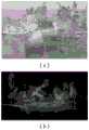
图2(a)为本发明的扫描站点1的点云数据示意图;Fig. 2 (a) is the point cloud data schematic diagram of scanning station 1 of the present invention;
图2(b)为本发明的扫描站点2的点云数据示意图;Fig. 2 (b) is the point cloud data schematic diagram of scanning station 2 of the present invention;
图2(c)为本发明的扫描站点3的点云数据示意图;Fig. 2 (c) is the point cloud data schematic diagram of scanning station 3 of the present invention;
图3(a)为本发明的3个站点配准拼接后的完整点云数据的示意图;Fig. 3 (a) is the schematic diagram of the complete point cloud data after 3 sites of the present invention are registered and spliced;
图3(b)为本发明的3个站点配准拼接后的完整点云数据渲染图;Fig. 3 (b) is the complete point cloud data rendering diagram after registration and mosaic of 3 sites of the present invention;
图4为本发明的改进特征点配准算法的流程示意图;Fig. 4 is a schematic flow chart of the improved feature point registration algorithm of the present invention;
具体实施方式Detailed ways
下面将结合本发明实施例中的附图,对本发明实施例中的技术方案进行清楚、完整地描述,显然,所描述的实施例仅仅是本发明一部分实施例,而不是全部的实施例。基于本发明中的实施例,本领域普通技术人员在没有做出创造性劳动前提下所获得的所有其他实施例,都属于本发明保护的范围。The following will clearly and completely describe the technical solutions in the embodiments of the present invention with reference to the accompanying drawings in the embodiments of the present invention. Obviously, the described embodiments are only some, not all, embodiments of the present invention. Based on the embodiments of the present invention, all other embodiments obtained by persons of ordinary skill in the art without making creative efforts belong to the protection scope of the present invention.
参照图1和图2,本发明提供了一种基于多源地理信息耦合的城市实景三维建模方法,包括以下步骤:With reference to Fig. 1 and Fig. 2, the present invention provides a kind of urban real scene 3D modeling method based on multi-source geographical information coupling, comprises the following steps:
通过多个激光雷达获取城市建筑的地面和高空的点云数据,得到城市建筑的三维信息。The ground and high-altitude point cloud data of urban buildings are obtained through multiple lidars, and the three-dimensional information of urban buildings is obtained.
机载LiDAR,集成GNSS定位、激光测距与惯性导航(INS)技术构建的三维空间信息采集系统。其采用动态差分GNSS设备获取扫描仪中心空间坐标、激光测距采集待定点信息、INS惯导测定姿态参数,并可采用CCD相机采集地表影像,便于后期制作DOM。Airborne LiDAR, a three-dimensional space information collection system built by integrating GNSS positioning, laser ranging and inertial navigation (INS) technology. It uses dynamic differential GNSS equipment to obtain the spatial coordinates of the scanner center, laser ranging to collect information on points to be fixed, INS inertial navigation to measure attitude parameters, and a CCD camera to collect surface images, which is convenient for post-production DOM.
通过无人机倾斜摄影获取城市建筑的多角度影像数据,通过车载相机获取城市建筑底部的影像数据;根据获取的多角度影像数据和底部影像数据,得到城市建筑的三维纹理信息。Obtain multi-angle image data of urban buildings through oblique photography of drones, and image data of the bottom of urban buildings through vehicle-mounted cameras; according to the acquired multi-angle image data and bottom image data, the three-dimensional texture information of urban buildings is obtained.
倾斜摄影测量,即采用多拼相机传感器平台,打破传统单一角度航摄的局限,分别从1个垂直、4个倾斜方位的多视点、视角方式同时完成数据采集,添加纹理数据后可直观用于三维城市建模处理。Oblique photogrammetry, which uses a multi-camera sensor platform, breaks the limitations of traditional single-angle aerial photography, and simultaneously completes data collection from one vertical and four oblique azimuths, multi-viewpoints, and viewing angles. After adding texture data, it can be used intuitively 3D city modeling process.
车载信息采集系统是通过在一辆采集车顶安装影像采集设备和激光采集设备,同时配备GPS和IMU导航定位系统,在车辆快速行进过程中,能够快速采集沿途道路周边的影像和点云数据,能够快速提取感兴趣的建筑物影像以及道路、路灯、树木、广告牌、交通设施等地理信息数据的综合性地面移动采集系统The vehicle-mounted information collection system installs image collection equipment and laser collection equipment on the roof of a collection vehicle, and is equipped with GPS and IMU navigation and positioning systems. When the vehicle is moving rapidly, it can quickly collect images and point cloud data around the road along the way. A comprehensive ground mobile acquisition system that can quickly extract images of buildings of interest and geographical information data such as roads, street lights, trees, billboards, and traffic facilities
城市三维模型体依靠机载的LiDAR和车载LiDAR分别获取高空和地面的点云数据,合并点云数据构建高精度的三维场景模型。三维模型纹理通过无人机倾斜摄影获取下视角,前后、左右4个倾斜视角5个不同的角度地面影像信息,倾斜摄影能够获取同一建筑物的顶部、四周侧面影像信息加上车载的相机对建筑底部的影像数据为三维模型提供真实的纹理贴图。将获取的城市建筑的点云数据和影像数据进行匹配融合,建立城市实景三维模型。The 3D model of the city relies on airborne LiDAR and vehicle LiDAR to obtain high-altitude and ground point cloud data respectively, and combines the point cloud data to construct a high-precision 3D scene model. The 3D model texture obtains the downward angle of view through the oblique photography of the drone, and the ground image information of 4 oblique angles of front and rear, left and right, and 5 different angles. The oblique photography can obtain the top and surrounding side image information of the same building. The image data at the bottom provides realistic texture maps for the 3D model. The point cloud data and image data of the acquired urban buildings are matched and fused to establish a 3D model of the urban real scene.
多个激光雷达设置在多个扫描站点,采用基于ICP的配准拼接方法对多个扫描站点获取的点云数据进行配准拼接,统一到相同的坐标系中,得到城市建筑的三维信息。Multiple lidars are set up at multiple scanning sites, and the point cloud data obtained by multiple scanning sites are registered and stitched using the ICP-based registration and stitching method, and unified into the same coordinate system to obtain 3D information of urban buildings.
参照图2和图3,通过基于ICP的配准拼接方法对多个扫描站点获取的点云数据进行配准拼接,包括以下步骤:Referring to Figures 2 and 3, the registration and stitching of the point cloud data acquired by multiple scanning sites is carried out through the registration and stitching method based on ICP, including the following steps:
选取任两个站点,将某一个站点作为基准站点,另一站点作为待拼接站点;Select any two sites, use one site as the reference site, and the other site as the site to be spliced;
对两个站点的公共部分点云数据进行提取,得到部分公共点在各自的局部坐标值;Extract the common point cloud data of the two sites, and obtain the local coordinate values of some common points;
对于待拼接站点中的点集在基准站点找到相应的最近点,令误差阈值ξ=0.01;Find the corresponding closest point at the reference site for the point set in the site to be spliced, and make the error threshold ξ=0.01;
利用SVD法求得两个站点间的旋转矩阵R和平移矩阵T,计算最终转换矩阵Q;Use the SVD method to obtain the rotation matrix R and translation matrix T between the two sites, and calculate the final transformation matrix Q;
将待拼接站点的所有点云数据按照转换矩阵Q配准拼接到基准站点,完成拼接工作;All the point cloud data of the site to be spliced are registered and spliced to the reference site according to the transformation matrix Q to complete the splicing work;
将其它的站点按照上述方法依次拼接在基准站点上,最终完成整体建筑的点云数据拼接工作。The other sites are sequentially spliced on the reference site according to the above method, and finally the point cloud data splicing work of the whole building is completed.
参照图4,采用基于改进特征点配准算法进行数据融合,即在激光点云数据模型和倾斜摄影测量模型数据,其特征点匹配算法基本原理主要通过手动选取同名特征点计算旋转矩阵和平移矩阵,本发明则是在其基础上先通过Kd-Tree近邻点搜索算法来计算其拟合平面的法向量,进行约束选取的同名特征点是否可行,从而对不可用的同名点进行剔除,来优化同名点,使得计算的得到变换矩阵更加准确,从而使配准精度更高,技术路线如图4所示。Referring to Figure 4, the improved feature point registration algorithm is used for data fusion, that is, in the laser point cloud data model and oblique photogrammetry model data, the basic principle of the feature point matching algorithm is mainly to calculate the rotation matrix and translation matrix by manually selecting feature points with the same name , the present invention calculates the normal vector of the fitting plane through the Kd-Tree nearest neighbor point search algorithm on its basis, and checks whether the feature points with the same name selected by constraints are feasible, so as to eliminate unusable points with the same name to optimize Points with the same name make the calculated transformation matrix more accurate, so that the registration accuracy is higher. The technical route is shown in Figure 4.
(1)先通过手工提取同名特征点对,计算求解旋转矩阵R1和平移矩阵T1对两者数据进行粗拼接。(1) First, manually extract feature point pairs with the same name, calculate and solve the rotation matrix R1 and translation matrix T1, and perform rough splicing of the two data.
(2)对粗拼接后的数据,利用Kd-Tree近邻点搜索算法,先获取M个与点T(x,y,z)距离最近的数据点,利用这M个点云坐标建立点T的最小二乘面,计算最小二乘面的法向量a。(2) For the data after rough splicing, use the Kd-Tree neighbor point search algorithm to first obtain M data points closest to the point T (x, y, z), and use these M point cloud coordinates to establish the point T. Least squares surface, calculate the normal vector a of the least squares surface.
(3)同样利用Kd-Tree近邻点搜索方法,从两者数据中各获取M/2个与点T(x,y,z)距离最近的数据点,构建点T的最小二乘面,计算最小二乘面的法向量
分别计算法向量
基于特征点配准算法步骤如下:在两种数据融合过程中,设激光点云数据原始坐标是A,倾斜摄影测量数据坐标是B,根据同名点位在A和B的坐标值,由公式(4-11)、(4-12)可求出旋转矩阵R和平移矩阵T。The steps of the registration algorithm based on feature points are as follows: In the fusion process of the two kinds of data, the original coordinate of the laser point cloud data is A, and the coordinate of the oblique photogrammetry data is B. According to the coordinate values of the points with the same name in A and B, the formula ( 4-11), (4-12) can obtain the rotation matrix R and the translation matrix T.
其中:PA表示同名点位在激光点云模型A的坐标值,PB表示为同名点在倾斜摄影测量模型B的坐标值。R为两个模型之间的旋转转换矩阵,其次,由激光点云模型A和倾斜摄影测量模型B中的三组同名特征点位的三维空间坐标值通过最小二乘法,即可求得两种数据配准的坐标转换所需的6个参数(α,β,γ,t 1,t2,t3),即得到旋转矩阵R和平移矩阵T的数值。计算最终转换矩阵Q;Among them: PA represents the coordinate value of the point with the same name in the laser point cloud model A, and PB represents the coordinate value of the point with the same name in the oblique photogrammetry model B. R is the rotation transformation matrix between the two models. Secondly, the three-dimensional space coordinate values of the three groups of feature points with the same name in the laser point cloud model A and the oblique photogrammetry model B can be obtained by the least square method. The 6 parameters (α, β, γ, t 1, t2, t3) required for the coordinate transformation of data registration are the values of the rotation matrix R and translation matrix T. Calculate the final transformation matrix Q;
根据得到的转换矩阵的数值,将倾斜摄影模型B中各点坐标(XBi,YBi,ZBi)分别代入两站点之间的转换公式中,即可得到倾斜模型B中数据在激光点云模型A中的坐标值(XAi,YAi,ZAi),即完成倾斜摄影模型B向点云模型A的数据配准融合。According to the value of the transformation matrix obtained, the coordinates (XBi , YBi , ZBi ) of each point in the oblique photographic model B are substituted into the conversion formula between the two sites, and the data in the oblique model B can be obtained in the laser point cloud The coordinate values (XAi , YAi , ZAi ) in model A are to complete the data registration and fusion of oblique photographic model B to point cloud model A.
本发明在采集点云数据过程,所用激光扫描仪器全自动采集、实时性强、能够全天候作业,不受黑暗环境等空间和时间的影响,减小了人工参与量。突破传统测绘技术的单点测量模式,发展为面数据采集方式,可快速、完整获取建筑物内外部各类设备信息,大大提高工作效率。无需接触对象就可以精确地获取建筑物的完整三维信息,且数据精度高,可进行三维实体模型信息的存档管理。最后,基于“倾斜摄影+机载激光雷达+车载信息采集”的多源地理信息耦合技术来获取建筑三维模型体和纹理影像,通过统一的数学基准处理不同数据源,并利用相关匹配技术自动配准模型与纹理,来快速建立城市实景三维模型,实现城市建筑三维模型真实化、单体化、可量测化。总之,本发明不仅为城市三维实景建模提供高标准、高精度、高效率的解决方案,也可为后续变电站、输配电线路三维建模和历史建筑的规划管理和修缮、保护利用工程、宣传展示提供坚实的数据支撑,为保护工作提供新思路、新路线。In the process of collecting point cloud data, the present invention uses a laser scanning instrument for automatic collection, strong real-time performance, and can work around the clock without being affected by space and time such as dark environments, thereby reducing the amount of manual participation. Break through the single-point measurement mode of traditional surveying and mapping technology, and develop into a surface data collection method, which can quickly and completely obtain various equipment information inside and outside the building, greatly improving work efficiency. The complete three-dimensional information of the building can be accurately obtained without touching the object, and the data accuracy is high, and the archive management of the three-dimensional solid model information can be carried out. Finally, based on the multi-source geographic information coupling technology of "oblique photography + airborne lidar + vehicle information collection", the 3D model body and texture image of the building are obtained, different data sources are processed through a unified mathematical benchmark, and the relevant matching technology is used to automatically match the data. Quasi-models and textures are used to quickly build a 3D model of a city's real scene, and to realize the reality, individualization, and measurability of a 3D model of urban buildings. In short, the present invention not only provides high-standard, high-precision, and high-efficiency solutions for urban 3D real scene modeling, but also can be used for subsequent substations, 3D modeling of power transmission and distribution lines, and planning management and repair of historical buildings, protection and utilization projects, The publicity display provides solid data support, and provides new ideas and new routes for protection work.
尽管已描述了本发明的优选实施例,但本领域内的技术人员一旦得知了基本创造性概念,则可对这些实施例作出另外的变更和修改。所以,所附权利要求意欲解释为包括优选实施例以及落入本发明范围的所有变更和修改。While preferred embodiments of the invention have been described, additional changes and modifications to these embodiments can be made by those skilled in the art once the basic inventive concept is appreciated. Therefore, it is intended that the appended claims be construed to cover the preferred embodiment as well as all changes and modifications which fall within the scope of the invention.
显然,本领域的技术人员可以对本发明进行各种改动和变型而不脱离本发明的精神和范围。这样,倘若本发明的这些修改和变型属于本发明权利要求及其等同技术的范围之内,则本发明也意图包含这些改动和变型在内。Obviously, those skilled in the art can make various changes and modifications to the present invention without departing from the spirit and scope of the present invention. Thus, if these modifications and variations of the present invention fall within the scope of the claims of the present invention and their equivalent technologies, the present invention also intends to include these modifications and variations.
Claims (6)
Translated fromChinesePriority Applications (1)
| Application Number | Priority Date | Filing Date | Title |
|---|---|---|---|
| CN202211665621.2ACN116129067A (en) | 2022-12-23 | 2022-12-23 | Urban live-action three-dimensional modeling method based on multi-source geographic information coupling |
Applications Claiming Priority (1)
| Application Number | Priority Date | Filing Date | Title |
|---|---|---|---|
| CN202211665621.2ACN116129067A (en) | 2022-12-23 | 2022-12-23 | Urban live-action three-dimensional modeling method based on multi-source geographic information coupling |
Publications (1)
| Publication Number | Publication Date |
|---|---|
| CN116129067Atrue CN116129067A (en) | 2023-05-16 |
Family
ID=86311005
Family Applications (1)
| Application Number | Title | Priority Date | Filing Date |
|---|---|---|---|
| CN202211665621.2APendingCN116129067A (en) | 2022-12-23 | 2022-12-23 | Urban live-action three-dimensional modeling method based on multi-source geographic information coupling |
Country Status (1)
| Country | Link |
|---|---|
| CN (1) | CN116129067A (en) |
Cited By (9)
| Publication number | Priority date | Publication date | Assignee | Title |
|---|---|---|---|---|
| CN116503705A (en)* | 2023-06-28 | 2023-07-28 | 成都市数字城市运营管理有限公司 | Fusion method of digital city multi-source data |
| CN116844068A (en)* | 2023-09-01 | 2023-10-03 | 山东省地质矿产勘查开发局第五地质大队(山东省第五地质矿产勘查院) | Building mapping method, system, computer equipment and storage medium |
| CN118015055A (en)* | 2024-04-08 | 2024-05-10 | 江苏狄诺尼信息技术有限责任公司 | Multi-source survey data fusion processing method and system based on depth fusion algorithm |
| CN118333989A (en)* | 2024-04-23 | 2024-07-12 | 江苏长三角智慧水务研究院有限公司 | Pavement water accumulation based identification method and device |
| CN119129085A (en)* | 2024-11-12 | 2024-12-13 | 成都云智天下科技股份有限公司 | A method for constructing and optimizing the operation of digital twin cities based on cloud computing and big data technology |
| CN119251404A (en)* | 2024-09-25 | 2025-01-03 | 广东省测绘技术有限公司 | Method, system and device for constructing real-scene three-dimensional model based on digital city |
| CN119516127A (en)* | 2025-01-16 | 2025-02-25 | 核工业北京地质研究院 | Method for extracting chamber structure information |
| CN119991928A (en)* | 2024-12-10 | 2025-05-13 | 北京博维仕科技股份有限公司 | A three-dimensional real scene modeling method and system based on unmanned aerial vehicle |
| CN120147572A (en)* | 2025-02-27 | 2025-06-13 | 安康市自然资源信息科技有限公司 | A comprehensive modeling method for real-life three-dimensional maps with intelligent collection |
Citations (3)
| Publication number | Priority date | Publication date | Assignee | Title |
|---|---|---|---|---|
| CN101976467A (en)* | 2010-09-13 | 2011-02-16 | 天津市星际空间地理信息工程有限公司 | High-precision three-dimensional urban scene construction method integrating airborne LIDAR (Laser Intensity Direction And Ranging) technology and vehicle-mounted mobile laser scanning technology |
| CN106327573A (en)* | 2016-08-25 | 2017-01-11 | 成都慧途科技有限公司 | Real scene three-dimensional modeling method for urban building |
| CN112927360A (en)* | 2021-03-24 | 2021-06-08 | 广州蓝图地理信息技术有限公司 | Three-dimensional modeling method and system based on fusion of tilt model and laser point cloud data |
- 2022
- 2022-12-23CNCN202211665621.2Apatent/CN116129067A/enactivePending
Patent Citations (3)
| Publication number | Priority date | Publication date | Assignee | Title |
|---|---|---|---|---|
| CN101976467A (en)* | 2010-09-13 | 2011-02-16 | 天津市星际空间地理信息工程有限公司 | High-precision three-dimensional urban scene construction method integrating airborne LIDAR (Laser Intensity Direction And Ranging) technology and vehicle-mounted mobile laser scanning technology |
| CN106327573A (en)* | 2016-08-25 | 2017-01-11 | 成都慧途科技有限公司 | Real scene three-dimensional modeling method for urban building |
| CN112927360A (en)* | 2021-03-24 | 2021-06-08 | 广州蓝图地理信息技术有限公司 | Three-dimensional modeling method and system based on fusion of tilt model and laser point cloud data |
Non-Patent Citations (1)
| Title |
|---|
| 郭林凯;: "基于"倾斜+LiDAR+车载"的实景三维建模实现", 城市勘测, no. 01, 28 February 2017 (2017-02-28), pages 71 - 75* |
Cited By (14)
| Publication number | Priority date | Publication date | Assignee | Title |
|---|---|---|---|---|
| CN116503705A (en)* | 2023-06-28 | 2023-07-28 | 成都市数字城市运营管理有限公司 | Fusion method of digital city multi-source data |
| CN116503705B (en)* | 2023-06-28 | 2023-10-13 | 成都市数字城市运营管理有限公司 | Fusion method of digital city multi-source data |
| CN116844068A (en)* | 2023-09-01 | 2023-10-03 | 山东省地质矿产勘查开发局第五地质大队(山东省第五地质矿产勘查院) | Building mapping method, system, computer equipment and storage medium |
| CN116844068B (en)* | 2023-09-01 | 2023-12-26 | 山东省地质矿产勘查开发局第五地质大队(山东省第五地质矿产勘查院) | Building mapping method, system, computer equipment and storage medium |
| CN118015055B (en)* | 2024-04-08 | 2024-08-09 | 江苏狄诺尼信息技术有限责任公司 | Multi-source survey data fusion processing method and system based on depth fusion algorithm |
| CN118015055A (en)* | 2024-04-08 | 2024-05-10 | 江苏狄诺尼信息技术有限责任公司 | Multi-source survey data fusion processing method and system based on depth fusion algorithm |
| CN118333989A (en)* | 2024-04-23 | 2024-07-12 | 江苏长三角智慧水务研究院有限公司 | Pavement water accumulation based identification method and device |
| CN118333989B (en)* | 2024-04-23 | 2024-09-27 | 江苏长三角智慧水务研究院有限公司 | A method and device for identifying road surface water |
| CN119251404A (en)* | 2024-09-25 | 2025-01-03 | 广东省测绘技术有限公司 | Method, system and device for constructing real-scene three-dimensional model based on digital city |
| CN119129085A (en)* | 2024-11-12 | 2024-12-13 | 成都云智天下科技股份有限公司 | A method for constructing and optimizing the operation of digital twin cities based on cloud computing and big data technology |
| CN119129085B (en)* | 2024-11-12 | 2025-01-24 | 成都云智天下科技股份有限公司 | Digital twin city construction and operation optimization method based on cloud computing and big data technology |
| CN119991928A (en)* | 2024-12-10 | 2025-05-13 | 北京博维仕科技股份有限公司 | A three-dimensional real scene modeling method and system based on unmanned aerial vehicle |
| CN119516127A (en)* | 2025-01-16 | 2025-02-25 | 核工业北京地质研究院 | Method for extracting chamber structure information |
| CN120147572A (en)* | 2025-02-27 | 2025-06-13 | 安康市自然资源信息科技有限公司 | A comprehensive modeling method for real-life three-dimensional maps with intelligent collection |
Similar Documents
| Publication | Publication Date | Title |
|---|---|---|
| CN116129067A (en) | Urban live-action three-dimensional modeling method based on multi-source geographic information coupling | |
| CN111597666B (en) | Method for applying BIM to transformer substation construction process | |
| CN109410327B (en) | BIM and GIS-based three-dimensional city modeling method | |
| CN111540048B (en) | Fine live-action three-dimensional modeling method based on space-ground fusion | |
| CN110503080B (en) | Investigation method based on unmanned aerial vehicle oblique photography auxiliary sewage draining exit | |
| CN113936108B (en) | A drone shooting and reconstruction method and device for fine modeling of building facades | |
| CN110648389A (en) | 3D reconstruction method and system for city street view based on cooperation of unmanned aerial vehicle and edge vehicle | |
| CN107504957A (en) | The method that three-dimensional terrain model structure is quickly carried out using unmanned plane multi-visual angle filming | |
| CN102074047A (en) | High-fineness urban three-dimensional modeling method | |
| CN116883604A (en) | Three-dimensional modeling technical method based on space, air and ground images | |
| Zhou et al. | Application of UAV oblique photography in real scene 3d modeling | |
| CN118691776A (en) | A 3D real scene modeling and dynamic updating method based on multi-source data fusion | |
| CN104933223A (en) | Power transmission line channel digital surveying method | |
| CN108388995A (en) | A kind of method for building up of road asset management system and establish system | |
| CN117315146A (en) | Reconstruction method and storage method of three-dimensional model based on trans-scale multi-source data | |
| CN115017454A (en) | Unmanned aerial vehicle and mobile measuring vehicle air-ground cooperative networking remote sensing data acquisition system | |
| Gu et al. | Surveying and mapping of large-scale 3D digital topographic map based on oblique photography technology | |
| CN116129064A (en) | Electronic map generation method, device, equipment and storage medium | |
| CN116385639A (en) | Complex surface color model reconstruction method based on UAV and TLS point cloud fusion | |
| He et al. | Construction of 3D Model of Tunnel Based on 3D Laser and Tilt Photography. | |
| Yijing et al. | Construction and analysis of 3D scene model of landscape space based on UAV oblique photography and 3D laser scanner | |
| Wang et al. | Automated measurement method for cable shapes based on laser scanners and cameras | |
| CN112150630A (en) | Using fixed-wing and multi-rotor UAV to solve high-precision modeling method of industrial park | |
| CN117346742A (en) | Hydropower station surveying and mapping system based on airborne lidar and oblique photogrammetry | |
| Liang et al. | Accuracy analysis of oblique photogrammetry measurement in 3D modeling of power line selection design |
Legal Events
| Date | Code | Title | Description |
|---|---|---|---|
| PB01 | Publication | ||
| PB01 | Publication | ||
| SE01 | Entry into force of request for substantive examination | ||
| SE01 | Entry into force of request for substantive examination |