CN115989674A - Image processing apparatus and method - Google Patents
Image processing apparatus and methodDownload PDFInfo
- Publication number
- CN115989674A CN115989674ACN202180052304.0ACN202180052304ACN115989674ACN 115989674 ACN115989674 ACN 115989674ACN 202180052304 ACN202180052304 ACN 202180052304ACN 115989674 ACN115989674 ACN 115989674A
- Authority
- CN
- China
- Prior art keywords
- image
- angle
- depth
- unit
- data
- Prior art date
- Legal status (The legal status is an assumption and is not a legal conclusion. Google has not performed a legal analysis and makes no representation as to the accuracy of the status listed.)
- Withdrawn
Links
Images


Classifications
- G—PHYSICS
- G06—COMPUTING OR CALCULATING; COUNTING
- G06T—IMAGE DATA PROCESSING OR GENERATION, IN GENERAL
- G06T9/00—Image coding
- H—ELECTRICITY
- H04—ELECTRIC COMMUNICATION TECHNIQUE
- H04N—PICTORIAL COMMUNICATION, e.g. TELEVISION
- H04N19/00—Methods or arrangements for coding, decoding, compressing or decompressing digital video signals
- H04N19/50—Methods or arrangements for coding, decoding, compressing or decompressing digital video signals using predictive coding
- H04N19/597—Methods or arrangements for coding, decoding, compressing or decompressing digital video signals using predictive coding specially adapted for multi-view video sequence encoding
- G—PHYSICS
- G06—COMPUTING OR CALCULATING; COUNTING
- G06T—IMAGE DATA PROCESSING OR GENERATION, IN GENERAL
- G06T9/00—Image coding
- G06T9/001—Model-based coding, e.g. wire frame
- G—PHYSICS
- G06—COMPUTING OR CALCULATING; COUNTING
- G06T—IMAGE DATA PROCESSING OR GENERATION, IN GENERAL
- G06T9/00—Image coding
- G06T9/004—Predictors, e.g. intraframe, interframe coding
- G—PHYSICS
- G06—COMPUTING OR CALCULATING; COUNTING
- G06T—IMAGE DATA PROCESSING OR GENERATION, IN GENERAL
- G06T2210/00—Indexing scheme for image generation or computer graphics
- G06T2210/56—Particle system, point based geometry or rendering
Landscapes
- Engineering & Computer Science (AREA)
- Multimedia (AREA)
- Physics & Mathematics (AREA)
- General Physics & Mathematics (AREA)
- Theoretical Computer Science (AREA)
- Signal Processing (AREA)
- Compression Or Coding Systems Of Tv Signals (AREA)
Abstract
Description
Translated fromChinese技术领域technical field
本公开内容涉及图像处理装置和方法,并且更具体地,涉及能够减少点云的质量的降低的图像处理装置和方法。The present disclosure relates to an image processing device and method, and more particularly, to an image processing device and method capable of reducing degradation in quality of point clouds.
背景技术Background technique
常规地,将三维形状的对象表达为点的集合的点云数据的编码/解码已经被运动图像专家组(MPEG)标准化(例如,参考非专利文献1)。Conventionally, encoding/decoding of point cloud data expressing a three-dimensionally shaped object as a set of points has been standardized by the Moving Picture Experts Group (MPEG) (for example, refer to Non-Patent Document 1).
此外,已经提出了这样的方法(在下文中,也被称为基于视频的方法),其中针对每个小区域,将点云的几何数据和属性数据投影到二维平面上,将投影到二维平面上的图像(图块(patch))设置在帧图像中,并且通过用于二维图像的编码方法对帧图像进行编码(例如,参考非专利文献2至非专利文献4)。In addition, methods (hereinafter, also referred to as video-based methods) have been proposed in which, for each small area, the geometric data and attribute data of the point cloud are projected onto a two-dimensional plane, and the two-dimensional Images (patches) on a plane are set in a frame image, and the frame image is encoded by an encoding method for a two-dimensional image (for example, refer to Non-Patent Document 2 to Non-Patent Document 4).
此外,已经构想了这样的方法,其中如以上描述的基于视频的方法那样,通过用于二维图像的编码方法对LiDAR(光检测和测距、或激光成像检测和测距)数据进行编码,该LiDAR数据是通过测量相对于光照射的散射光并且分析与长距离处的主体的距离和主体的特性而获得的(例如,参考非专利文献5和专利文献1)。Furthermore, methods have been conceived in which LiDAR (Light Detection and Ranging, or Laser Imaging Detection and Ranging) data are encoded by encoding methods for two-dimensional images like the video-based approaches described above, This LiDAR data is obtained by measuring scattered light with respect to light irradiation and analyzing the distance from a subject at a long distance and the characteristics of the subject (for example, refer to Non-Patent
引文列表Citation list
非专利文献non-patent literature
非专利文献1:“Information technology-MPEG-I(Coded Representation ofImmersive Media)-Part 9:Geometry-based Point Cloud Compression”,ISO/IEC23090-9:2019(E)Non-Patent Document 1: "Information technology-MPEG-I (Coded Representation of Immersive Media)-Part 9: Geometry-based Point Cloud Compression", ISO/IEC23090-9:2019(E)
非专利文献2:Tim Gollaand Reinhard Klein,“Real-time Point CloudCompression”,IEEE,2015Non-Patent Document 2: Tim Golla and Reinhard Klein, "Real-time Point CloudCompression", IEEE, 2015
非专利文献3:K.Mammou,“Video-based and Hierarchical Approaches PointCloud Compression”,MPEG m41649,2017年10月Non-Patent Document 3: K. Mammou, "Video-based and Hierarchical Approaches PointCloud Compression", MPEG m41649, October 2017
非专利文献4:K.Mammou,“PCC Test Model Category 2v0”,N17248MPEG outputdocument,2017年10月Non-Patent Document 4: K.Mammou, "PCC Test Model Category 2v0", N17248MPEG outputdocument, October 2017
非专利文献5:Peter van Beek;Intel&Mobileye Silicon Valley InnovationCenter;San Jose,California,USA,“Image-based Compression of Lidar SensorData”,Society for Imaging Science and Technology,2019,https://www.ingentaconnect.com/contentone/ist/ei/2019/00002019/00000015/art00013?crawler=true&mimetype=application/pdfNon-Patent Document 5: Peter van Beek; Intel&Mobileye Silicon Valley Innovation Center; San Jose, California, USA, "Image-based Compression of Lidar SensorData", Society for Imaging Science and Technology, 2019, https://www.ingentaconnect.com/ contentone/ist/ei/2019/00002019/00000015/art00013? crawler=true&mimetype=application/pdf
专利文献patent documents
专利文献1:US 2019/0051017Patent Document 1: US 2019/0051017
发明内容Contents of the invention
本发明要解决的问题The problem to be solved by the present invention
然而,在非专利文献5或专利文献1中描述的方法的情况下,当将LiDAR数据变换成图像时,LiDAR数据与二维图像中的像素位置对准,并且因此存在减少几何数据的信息量的可能性。因此,存在降低点云数据的质量的可能性。However, in the case of the method described in
本发明是鉴于这样的情况而做出的,并且其目的是减少由于编码/解码而引起的点云的质量的降低。The present invention has been made in view of such circumstances, and an object thereof is to reduce degradation in quality of point clouds due to encoding/decoding.
问题的解决方案problem solution
根据本技术的一个方面的图像处理装置包括:角度图像生成单元,其生成角度图像,该角度图像具有指示将三维形状的对象表达为点的集合的点云的几何数据的角度分量的信息作为像素值;以及角度图像编码单元,其对由角度图像生成单元生成的角度图像进行编码。An image processing apparatus according to an aspect of the present technology includes: an angle image generation unit that generates an angle image having, as pixels, information indicating an angle component of geometric data of a point cloud expressing an object of a three-dimensional shape as a set of points value; and an angle image encoding unit that encodes the angle image generated by the angle image generation unit.
根据本技术的一个方面的图像处理方法包括:生成角度图像,该角度图像具有指示将三维形状的对象表达为点的集合的点云的几何数据的角度分量的信息作为像素值;以及对所生成的角度图像进行编码。An image processing method according to an aspect of the present technology includes: generating an angle image having, as a pixel value, information indicating an angle component of geometric data of a point cloud expressing an object of a three-dimensional shape as a set of points; The angle image is encoded.
根据本技术的另一方面的图像处理装置包括:角度图像解码单元,其对编码数据进行解码以生成角度图像,该角度图像具有指示将三维形状的对象表达为点的集合的点云的几何数据的角度分量的信息作为像素值;以及构造单元,其通过使用由角度图像解码单元生成的角度图像来构造点云。An image processing device according to another aspect of the present technology includes: an angle image decoding unit that decodes encoded data to generate an angle image having geometric data indicating a point cloud expressing a three-dimensionally shaped object as a set of points information of the angle component of as a pixel value; and a construction unit that constructs a point cloud by using the angle image generated by the angle image decoding unit.
根据本技术的另一方面的图像处理方法包括:对编码数据进行解码以生成角度图像,该角度图像具有指示将三维形状的对象表达为点的集合的点云的几何数据的角度分量的信息作为像素值;以及通过使用所生成的角度图像构造点云。An image processing method according to another aspect of the present technology includes: decoding encoded data to generate an angle image having information indicating an angle component of geometric data of a point cloud expressing an object of a three-dimensional shape as a set of points as pixel values; and constructing a point cloud by using the generated angle images.
在根据本技术的一个方面的图像处理装置和方法中,生成角度图像并且对所生成的角度图像进行编码,该角度图像具有指示将三维形状的对象表达为点的集合的点云的几何数据的角度分量的信息作为像素值。In the image processing apparatus and method according to one aspect of the present technology, an angle image having geometric data indicating a point cloud expressing a three-dimensionally shaped object as a collection of points is generated and encoded, and the generated angle image is encoded. The information of the angular components as pixel values.
在根据本技术的另一方面的图像处理装置和方法中,对编码数据进行解码以生成角度图像,并且通过使用所生成的角度图像构造点云,该角度图像具有指示将三维形状的对象表达为点的集合的点云的几何数据的角度分量的信息作为像素值。In an image processing apparatus and method according to another aspect of the present technology, coded data is decoded to generate an angle image, and a point cloud is constructed by using the generated angle image having an object indicating a three-dimensional shape expressed as Information about the angular component of the geometric data of the point cloud as a collection of points as pixel values.
附图说明Description of drawings
图1是描述LiDAR数据的图。Figure 1 is a diagram depicting LiDAR data.
图2是描述将二维图像编码应用于LiDAR数据的图。Figure 2 is a diagram describing the application of two-dimensional image coding to LiDAR data.
图3是描述用于对LiDAR数据进行编码的方法的图。FIG. 3 is a diagram describing a method for encoding LiDAR data.
图4是描述角度图像的图。Fig. 4 is a diagram describing an angle image.
图5是描述角度图像的图。Fig. 5 is a diagram describing an angle image.
图6是描述深度图像的分层的图。FIG. 6 is a diagram describing layering of a depth image.
图7是示出编码装置的主要配置示例的框图。Fig. 7 is a block diagram showing a main configuration example of an encoding device.
图8是描述编码处理的流程的示例的流程图。FIG. 8 is a flowchart describing an example of the flow of encoding processing.
图9是示出解码装置的主要配置示例的框图。Fig. 9 is a block diagram showing a main configuration example of a decoding device.
图10是描述解码处理的流程的示例的流程图。Fig. 10 is a flowchart describing an example of the flow of decoding processing.
图11是示出计算机的主要配置示例的框图。Fig. 11 is a block diagram showing a main configuration example of a computer.
具体实施方式Detailed ways
下面将描述用于实施本公开内容的方式(在下文中,被称为实施方式)。注意,将按以下顺序进行描述。A mode for implementing the present disclosure (hereinafter, referred to as an embodiment) will be described below. Note that description will be made in the following order.
1.LiDAR数据的二维图像编码1. Two-dimensional image encoding of LiDAR data
2.第一实施方式(编码装置)2. First Embodiment (Coding Device)
3.第二实施方式(解码装置)3. Second Embodiment (Decoding Device)
4.补充说明4. Supplementary instructions
<1.LiDAR数据的二维图像编码><1. Two-dimensional image encoding of LiDAR data>
<支持技术内容/技术术语的文献等><Documents etc. supporting technical content/technical terms>
在本技术中公开的范围不仅包括在实施方式中描述的内容,而且还包括在提交时已知的以下非专利文献等中描述的内容、在以下非专利文献中引用的其他文献的内容等。The scope disclosed in the present technology includes not only the contents described in the embodiments but also the contents described in the following non-patent documents and the like known at the time of filing, the contents of other documents cited in the following non-patent documents, and the like.
非专利文献1:(如上所述)Non-Patent Document 1: (as mentioned above)
非专利文献2:(如上所述)Non-Patent Document 2: (as mentioned above)
非专利文献3:(如上所述)Non-Patent Document 3: (as mentioned above)
非专利文献4:(如上所述)Non-Patent Document 4: (mentioned above)
非专利文献5:(如上所述)Non-Patent Document 5: (as mentioned above)
非专利文献6:Kangying CAI,Vladyslav Zakharcchenko,Dejun ZHANG,“[VPCC][New proposal]Patch skip mode syntax proposal”,ISO/IEC JTC1/SC29/WG11MPEG2019/m47472,March 2019,Geneva,CHNon-Patent Document 6: Kangying CAI, Vladyslav Zakharcchenko, Dejun ZHANG, “[VPCC][New proposal] Patch skip mode syntax proposal”, ISO/IEC JTC1/SC29/WG11MPEG2019/m47472, March 2019, Geneva, CH
非专利文献7:“Text of ISO/IEC DIS 23090-5Video-based Point CloudCompression”,ISO/IEC JTC 1/SC 29/WG 11N18670,2019-10-10Non-Patent Document 7: "Text of ISO/IEC DIS 23090-5 Video-based Point CloudCompression", ISO/IEC JTC 1/SC 29/WG 11N18670, 2019-10-10
非专利文献8:Danillo Graziosiand Ali Tabatabai,“[V-PCC]NewContribution on Patch Coding”,ISO/IEC JTC1/SC29/WG11MPEG2018/m47505,March2019,Geneva,CHNon-Patent Document 8: Danillo Graziosiand Ali Tabatabai, "[V-PCC] New Contribution on Patch Coding", ISO/IEC JTC1/SC29/WG11MPEG2018/m47505, March2019, Geneva, CH
专利文献1:(如上所述)Patent Document 1: (As mentioned above)
即,上述非专利文献和专利文献中描述的内容、上述非专利文献和专利文献中引用的其他文献的内容等用作用于确定支持要求的基础。That is, the contents described in the above-mentioned non-patent documents and patent documents, the contents of other documents cited in the above-mentioned non-patent documents and patent documents, and the like are used as a basis for determining support requirements.
<点云><point cloud>
常规地,存在诸如利用点位置信息、属性信息等表示三维结构的点云的3D数据。Conventionally, there is 3D data such as a point cloud representing a three-dimensional structure with point position information, attribute information, and the like.
例如,在点云的情况下,三维结构(三维形状的对象)被表达为大量点的集合。点云的数据(也被称为点云数据)包括每个点的位置信息(也被称为几何数据)和每个点的属性信息(也被称为属性数据)。属性数据可以包括任何信息。例如,每个点的颜色信息、反射率信息、法线信息等可以包括在属性数据中。因此,点云数据具有相对简单的数据结构,并且可以通过使用足够大量的点以足够的准确度表达任意三维结构。For example, in the case of point clouds, 3D structures (objects of 3D shape) are represented as collections of a large number of points. Data of a point cloud (also referred to as point cloud data) includes position information (also referred to as geometric data) of each point and attribute information (also referred to as attribute data) of each point. Attribute data can include any information. For example, color information, reflectance information, normal line information, etc. of each point may be included in the attribute data. Therefore, point cloud data has a relatively simple data structure, and arbitrary three-dimensional structures can be expressed with sufficient accuracy by using a sufficiently large number of points.
<基于视频的方法的概述><Overview of video-based methods>
在基于视频的方法中,针对每个小区域,将这样的点云的几何数据和属性数据投影到二维平面上。通过将几何数据和属性数据投影到二维平面上而获得的图像也被称为投影图像。此外,每个小区域中的投影图像被称为图块。例如,在几何数据的投影图像(图块)中,将点的位置信息表示为在与投影平面垂直的方向(深度方向)上的位置信息(深度值(Depth))。In video-based methods, for each small area, the geometric and attribute data of such a point cloud are projected onto a two-dimensional plane. An image obtained by projecting geometric data and attribute data onto a two-dimensional plane is also called a projected image. Also, the projected image in each small area is called a tile. For example, in a projection image (tile) of geometric data, position information of a point is expressed as position information (depth value (Depth)) in a direction (depth direction) perpendicular to the projection plane.
然后,将以这种方式生成的每个图块设置在帧图像中。其中布置有几何数据的图块的帧图像也被称为几何视频帧。此外,其中布置有属性数据的图块的帧图像也被称为颜色视频帧。例如,几何视频帧的每个像素值指示上述深度值。Each tile generated in this way is then set in the frame image. A frame image in which tiles of geometric data are arranged is also referred to as a geometric video frame. Also, a frame image in which tiles of attribute data are arranged is also referred to as a color video frame. For example, each pixel value of a geometric video frame indicates the aforementioned depth value.
然后,例如通过诸如高级视频编码(AVC)或高效视频编码(HEVC)的用于二维图像的编码方法对这些视频帧进行编码。即,可以通过使用用于二维图像的编解码器对作为表示三维结构的3D数据的点云数据进行编码。These video frames are then coded, eg by a coding method for two-dimensional images such as Advanced Video Coding (AVC) or High Efficiency Video Coding (HEVC). That is, point cloud data that is 3D data representing a three-dimensional structure can be encoded by using a codec for two-dimensional images.
<占用图(occupancy map)><occupancy map>
注意,在这样的基于视频的方法的情况下,还可以使用占用图。占用图是指示几何视频帧中存在或不存在投影图像(图块)的图信息。例如,在几何视频帧或颜色视频帧中,占用图通过使用值“1”指示存在图块的区域,并且通过使用值“0”指示不存在图块的区域。Note that in case of such a video-based approach, occupancy maps can also be used. An occupancy map is map information indicating the presence or absence of a projected image (tile) in a geometric video frame. For example, in a geometry video frame or a color video frame, an occupancy map indicates areas where tiles exist by using a value of "1" and indicates areas where no tiles exist by using a value of "0".
这样的占用图被编码为与几何视频帧或颜色视频帧不同的数据,并且被发送至解码侧。解码器可以参考占用图掌握该区域是否是存在图块的区域,并且因此可以减少由编码/解码造成的噪声等的影响,并且可以更准确地恢复3D数据。例如,即使深度值由于编码/解码而改变,解码器也可以参考占用图而忽略不存在图块的区域的深度值(不将深度值作为3D数据的位置信息进行处理)。Such an occupancy map is encoded as data different from geometric or color video frames and sent to the decoding side. The decoder can grasp whether the area is an area where tiles exist with reference to the occupancy map, and thus can reduce the influence of noise or the like caused by encoding/decoding, and can restore 3D data more accurately. For example, even if the depth value changes due to encoding/decoding, the decoder can refer to the occupancy map and ignore the depth value of an area where no tile exists (not process the depth value as position information of 3D data).
注意,与几何视频帧、颜色视频帧等类似,占用图也可以作为视频帧发送(即,可以通过用于二维图像的编解码器进行编码/解码)。Note that similar to geometry video frames, color video frames, etc., occupancy maps can also be sent as video frames (ie, can be encoded/decoded by a codec for 2D images).
<极坐标系><polar coordinate system>
尽管点云的几何数据通常表示每个点在正交坐标系(x,y,z)中的三维位置,但是例如每个点的三维位置也可以在例如极坐标系的使用角度分量的坐标系中表示。在极坐标系的情况下,点的三维位置由距参考点(原点)的距离r、水平方向(X-Y平面上)上的角度
<LiDAR数据><LiDAR data>
顺便提及,存在通过测量相对于光照射的散射光并且通过分析与长距离处的主体的距离和主体的特性而获得的LiDAR(光检测和测距、或激光成像检测和测距)数据。Incidentally, there is LiDAR (Light Detection and Ranging, or Laser Imaging Detection and Ranging) data obtained by measuring scattered light with respect to light irradiation and by analyzing the distance to a subject at a long distance and characteristics of the subject.
例如,当生成LiDAR数据时,在改变极坐标系中的角度θ的同时执行线性扫描。然后,在改变极坐标系中的
非专利文献5和专利文献1提出了这样的方法,其中如上述基于视频的方法那样,利用用于二维图像的编码方法对这样的LiDAR数据进行编码。例如,通过组合LiDAR数据的多个线性扫描数据将LiDAR数据变换成图像,如图2的A所示。即,LiDAR数据的每个扫描数据变为二维图像中彼此不同的一个像素列。由于点云数据(扫描数据)包括几何数据(位置信息)和属性数据(属性信息),因此通过上述方法生成了深度图像21和属性图像22,深度图像21具有深度信息作为像素值,该深度信息指示从观察点到检测到的本体(点)的距离,如图2的B所示,属性图像22具有每个点的属性数据(例如,纹理、反射率等)作为像素值,如图2的C所示。即,深度图像21和属性图像22是通过以平面形状布置扫描数据而获得的。
深度图像21将深度信息指示为每个像素的像素值(亮度值)。例如,距观察点的距离越短,像素值越大(亮度越高),而距观察点的距离越远,像素值越小(亮度越低)。The
在图2的B中的示例的情况下,在深度图像21中检测到圆形对象、三角形对象和圆角矩形对象。在这些对象中,最亮(较白)的圆形对象最接近观察点,而最暗(较黑)的圆角矩形对象距观察点最远。注意,除了这些对象之外的部分的像素用无穷大的深度值(即,黑色)表示。In the case of the example in B of FIG. 2 , a circular object, a triangular object, and a rounded rectangular object are detected in the
属性图像22将属性数据(例如,纹理、反射率等)指示为每个像素的像素值。例如,在与深度图像21中的每个对象对应的位置处的像素中,对象的属性数据被表示为像素值。The
然后,通过用于二维图像的编码方法对这些图像进行编码。These images are then encoded by the encoding method used for two-dimensional images.
在解码侧,通过用于二维图像的解码方法对编码数据进行解码以生成图2的中B的深度图像21和图2的C中的属性图像22,并且通过重新布置扫描数据中的每一个重建图1的B所示的LiDAR数据11。On the decoding side, the encoded data is decoded by a decoding method for two-dimensional images to generate a
因此,可以采用用于二维图像的编码/解码方法,其比用于三维数据的编码/解码方法更一般,并且因此,可以更容易地对LiDAR数据进行编码/解码。因此,可以减少编码/解码的成本的增加或者以较高速度执行处理。Therefore, encoding/decoding methods for two-dimensional images can be employed, which are more general than those for three-dimensional data, and thus, LiDAR data can be encoded/decoded more easily. Therefore, it is possible to reduce an increase in cost of encoding/decoding or to perform processing at a higher speed.
然而,在该方法的情况下,每个扫描数据与二维图像中的像素位置对准,但是可能存在各个点的位置与像素位置不完全一致的情况。即使传感器的运动或感测率被控制成使得点位置与像素位置一致,实际上也可能存在由于例如传感器的位置或运动的偏差(误差)的发生等,各个点的位置与像素位置不完全一致的情况。例如,一个扫描数据可能是弯曲的。如上所述,存在这样的可能性:当扫描数据与二维图像中的像素位置对准时,位置被量化并且几何数据的信息量减少,由此点云的质量降低。However, in the case of this method, each scan data is aligned with a pixel position in a two-dimensional image, but there may be cases where the position of each point does not exactly coincide with the pixel position. Even if the motion or sensing rate of the sensor is controlled so that the dot position coincides with the pixel position, there may actually be cases where the position of each dot does not exactly coincide with the pixel position due to, for example, the occurrence of a deviation (error) in the position or motion of the sensor, etc. Case. For example, a scan data may be curved. As described above, there is a possibility that when scan data is aligned with pixel positions in a two-dimensional image, the positions are quantified and the amount of information of the geometric data is reduced, thereby degrading the quality of the point cloud.
<角度信息的传输><Transmission of angle information>
因此,如图3中示出的表的从顶部起的第一行(最上行)所示,以包括角度的坐标系表达点云的每个点的位置,并且每个点的角度分量(角度信息)作为视频帧被发送(方法1)。Therefore, as shown in the first row from the top (uppermost row) of the table shown in FIG. information) are sent as video frames (method 1).
例如,生成具有指示将三维形状的对象表达为点的集合的点云的几何数据的角度分量的信息作为像素值的角度图像,并且对生成的角度图像进行编码。For example, an angle image having, as a pixel value, information indicating an angle component of geometric data of a point cloud expressing a three-dimensionally shaped object as a set of points is generated, and the generated angle image is encoded.
例如,在图像处理装置中,设置有角度图像生成单元和角度图像编码单元,角度图像生成单元生成具有指示将三维形状的对象表达为点的集合的点云的几何数据的角度分量的信息作为像素值的角度图像,角度图像编码单元对由角度图像生成单元生成的角度图像进行编码。For example, in an image processing apparatus, an angle image generation unit and an angle image encoding unit are provided, and the angle image generation unit generates information having an angle component of geometric data indicating a point cloud expressing a three-dimensionally shaped object as a set of points as pixels value, the angle image encoding unit encodes the angle image generated by the angle image generation unit.
因此,角度信息可以被提供给接收侧。在接收侧,通过使用角度信息来构造点云。Therefore, angle information can be provided to the receiving side. On the receiving side, the point cloud is constructed by using the angle information.
例如,对编码数据进行解码以生成具有指示将三维形状的对象表达为点的集合的点云的几何数据的角度分量的信息作为像素值的角度图像,并且通过使用生成的角度图像来构造点云。For example, encoded data is decoded to generate an angle image having, as pixel values, information indicating an angle component of geometric data of a point cloud expressing a three-dimensionally shaped object as a collection of points, and the point cloud is constructed by using the generated angle image .
例如,在图像处理装置中,设置有角度图像解码单元和构造单元,角度图像解码单元对编码数据进行解码以生成具有指示将三维形状的对象表达为点的集合的点云的几何数据的角度分量的信息作为像素值的角度图像,构造单元通过使用由角度图像解码单元生成的角度图像来构造点云。For example, in an image processing apparatus, an angle image decoding unit that decodes encoded data to generate an angle component having geometric data indicating a point cloud expressing a three-dimensionally shaped object as a collection of points, and a construction unit are provided The information of is an angle image as a pixel value, and the construction unit constructs a point cloud by using the angle image generated by the angle image decoding unit.
因此,可以减少由于编码/解码而引起的几何数据的信息量的减少。即,可以减少点云的质量的降低。Therefore, reduction of the information amount of geometric data due to encoding/decoding can be reduced. That is, it is possible to reduce the reduction in the quality of the point cloud.
注意,表示每个点的位置的上述“包括角度的坐标系”可以是例如具有角度分量θ和


此外,表示每个点的位置的上述“包括角度的坐标系”可以是例如具有角度分量θ的圆柱坐标系,如图3中示出的表的中从顶部起的第三行所述(方法1-2)。圆柱坐标系由z轴(相对于X-Y平面的垂直方向)坐标z、距z轴的距离r和水平方向(X-Y平面上)上的角度θ表示。在这种情况下,角度信息包括一个分量θ。即,在这种情况下,针对深度图像生成一个角度图像。In addition, the above-mentioned "coordinate system including angles" representing the position of each point may be, for example, a cylindrical coordinate system having an angle component θ, as described in the third row from the top of the table shown in FIG. 3 (method 1-2). The cylindrical coordinate system is represented by a z-axis (vertical direction with respect to the X-Y plane) coordinate z, a distance r from the z-axis, and an angle θ in the horizontal direction (on the X-Y plane). In this case, the angle information includes a component θ. That is, in this case, one angle image is generated for the depth image.
例如,当以极坐标系表达几何数据时,相对于图4的A中示出的深度图像51生成如图4的B所示的角度图像52和角度图像53。与图2的B中的深度图像21类似,深度图像51是具有指示从观察点到检测到的本体(点)的距离的深度信息作为像素值的图像。For example, when geometric data is expressed in a polar coordinate system, an angle image 52 and an angle image 53 as shown in B of FIG. 4 are generated with respect to a depth image 51 shown in A of FIG. 4 . Similar to the
此外,角度图像52是其中几何数据的角度分量θ用作像素值的图像。角度图像52的每个像素对应于深度图像51的每个像素。即,角度图像52的每个像素的像素值指示获得与深度图像51对应的像素的像素值(深度信息)的感测方向(角度分量θ)。例如,较大像素值(亮度值)指示较大值θ,而较小像素值(亮度值)指示较小值θ。由于在一条扫描数据中角度分量θ改变,因此角度图像52的像素值在纵向方向上改变,如图4的B中的示例。然而,一般地,如上所述,由于传感器的运动的误差等,角度图像52的像素值的改变在整个图像中并不完全均匀(理想状态)。Furthermore, the angle image 52 is an image in which the angle component θ of geometric data is used as a pixel value. Each pixel of the angle image 52 corresponds to each pixel of the depth image 51 . That is, the pixel value of each pixel of the angle image 52 indicates the sensing direction (angle component θ) for obtaining the pixel value (depth information) of the pixel corresponding to the depth image 51 . For example, a larger pixel value (brightness value) indicates a larger value θ, and a smaller pixel value (brightness value) indicates a smaller value θ. Since the angle component θ changes in a piece of scan data, the pixel values of the angle image 52 change in the longitudinal direction, as in the example in B of FIG. 4 . Generally, however, as described above, changes in pixel values of the angle image 52 are not completely uniform throughout the image due to errors in the movement of the sensor or the like (ideal state).
角度图像53是其中几何数据的角度分量


对于这样的角度图像52和角度图像53,例如,如图3中示出的表的从顶部起的第四行所述,每个像素值可以被配置有每个点的几何数据的角度分量(θ或
例如,如图3中示出的表的从顶部起的第五行所述,角度图像的每个像素值可以配置有预测残差,该预测残差是与每个点的几何数据的角度分量的预测值的差(方法1-4)。例如,对于包括角度分量θ的角度图像52,通过预定方法得出如图5的A所示的包括预测值的图像61。在角度图像52与其图像61之间,对于每个像素得出差值(预测残差)。然后,得出如图5的B所示的包括预测残差的角度图像62。类似地,对于包括角度分量
在解码侧,通过使用通过对编码数据进行解码而生成的角度图像62和64的预测残差来得出每个点的角度分量,并且通过使用得出的角度分量来构造点云。On the decoding side, an angle component of each point is derived by using prediction residuals of the angle images 62 and 64 generated by decoding encoded data, and a point cloud is constructed by using the derived angle component.
由于角度图像62和64的像素值由预测残差配置,因此像素值通常小于角度图像52和53的像素值,并且可以减少编码量的增加。Since the pixel values of the angle images 62 and 64 are configured by prediction residuals, the pixel values are generally smaller than those of the angle images 52 and 53, and an increase in the encoding amount can be reduced.
用于得出预测值的方法是任意的。此外,可以用信号通知关于得出预测值的预测的信息。例如,可以对关于预测的信息进行编码。此外,可以对编码数据进行解码以生成关于预测的信息。The method used to derive the predicted value is arbitrary. Furthermore, information about the prediction from which the predicted value was derived may be signaled. For example, information about predictions can be encoded. Additionally, encoded data can be decoded to generate information about predictions.
例如,如图3中示出的表的从顶部起的第六行所述,可以基于通过主成分分析(PCA)的平面预测来得出预测值(方法1-4-1)。即,可以通过PCA从每个像素值获得平面(ax+by+c=z),并且被更新以位于平面上的每个像素值可以用作预测值。For example, as described in the sixth row from the top of the table shown in FIG. 3 , predicted values can be derived based on planar prediction by principal component analysis (PCA) (method 1-4-1). That is, a plane (ax+by+c=z) can be obtained from each pixel value by PCA, and each pixel value updated to lie on the plane can be used as a predicted value.
此外,如图3中示出的表的从顶部起的第七行所述,可以用信号通知表示平面的参数(例如,预测公式ax+by+c=z的系数a、b和c)(方法1-4-1-1)。即,可以对参数进行编码。此外,可以对编码数据进行解码以生成参数。Furthermore, as described in the seventh row from the top of the table shown in FIG. 3 , parameters representing the plane (eg, coefficients a, b, and c of the prediction formula ax+by+c=z) can be signaled ( method 1-4-1-1). That is, parameters can be encoded. Additionally, encoded data can be decoded to generate parameters.
例如,如图3中示出的表的从顶部起的第八行所述,可以基于曲面预测来得出预测值(方法1-4-2)。即,可以从每个像素值获得曲面,并且被更新以位于曲面上的每个像素值可以用作预测值。此外,可以用信号通知表示曲面的参数。For example, as described in the eighth row from the top of the table shown in FIG. 3 , predicted values can be derived based on curved surface prediction (method 1-4-2). That is, a curved surface can be obtained from each pixel value, and each pixel value updated to lie on the curved surface can be used as a predicted value. Furthermore, parameters representing the surface can be signaled.
例如,如图3中示出的表的从顶部起的第九行所述,可以基于相机参数来得出预测值(方法1-4-3)。即,可以基于与用作传感器的相机的位置或运动有关的参数来预测相机的运动,并且可以基于预测的运动来得出每个像素的预测值。即,在不存在误差、噪声等的理想状态下感测中的角度分量可以用作预测值。For example, as described in the ninth row from the top of the table shown in FIG. 3 , prediction values can be derived based on camera parameters (method 1-4-3). That is, the motion of the camera can be predicted based on parameters related to the position or motion of the camera used as a sensor, and a predicted value for each pixel can be derived based on the predicted motion. That is, an angle component in sensing in an ideal state where there is no error, noise, etc. can be used as a predictive value.
此外,如图3中示出的表的从顶部起的第10行所述,可以用信号通知相机参数(方法1-4-3-1)。即,可以对相机参数进行编码。此外,可以对编码数据进行解码以生成相机参数。Furthermore, as described in the tenth row from the top of the table shown in FIG. 3 , camera parameters may be signaled (method 1-4-3-1). That is, camera parameters can be encoded. Additionally, encoded data can be decoded to generate camera parameters.
例如,如图3中示出的表的从顶部起的第11行所述,可以得出每个扫描线的像素值的平均值作为预测值(方法1-4-4)。即,可以针对每个像素列得出像素值的平均值并将其用作预测值。For example, as described in the 11th row from the top of the table shown in FIG. 3 , the average value of the pixel values for each scanning line can be found as the prediction value (method 1-4-4). That is, pixel values can be averaged for each pixel column and used as a predicted value.
此外,如图3中示出的表的从顶部起的第12行所述,可以用信号通知每个扫描线的平均值(方法1-4-4-1)。即,可以对平均值进行编码。此外,可以对编码数据进行解码以生成平均值。Furthermore, as described in the twelfth row from the top of the table shown in FIG. 3 , an average value per scanline can be signaled (method 1-4-4-1). That is, the average value can be encoded. Additionally, the encoded data can be decoded to generate an average.
<划分深度图像以得到多个层><Divide the depth image to get multiple layers>
尽管深度图像的每个像素值是深度信息,但是通常,LiDAR的检测范围宽,并且因此深度值范围趋于宽。即,如果深度值范围太宽,则深度图像的像素值的位深度不足,并且可能不能表达所有深度值。例如,即使深度图像的位深度是16位,深度值范围也可能比其更宽,并且可能存在不能用16位表达所有的准确度的情况。此外,例如,可能存在深度值具有其中范围趋于更宽的浮动准确度的情况。Although each pixel value of a depth image is depth information, in general, the detection range of LiDAR is wide, and thus the depth value range tends to be wide. That is, if the depth value range is too wide, the bit depth of the pixel values of the depth image is insufficient, and all depth values may not be expressed. For example, even if the bit depth of a depth image is 16 bits, the range of depth values may be wider than that, and there may be cases where all accuracy cannot be expressed with 16 bits. Also, for example, there may be cases where the depth value has floating accuracy in which the range tends to be wider.
因此,如图3中示出的表的从顶部起的第13行所述,深度数据可以被划分以得到多个层并且被发送(方法1-5)。即,可以根据深度图像的每个像素值(深度值)的大小对深度图像的每个像素值(深度值)进行分类,并且可以在深度图像中生成多个层。此外,可以对编码数据进行解码以针对根据深度值的大小分类的每个层生成深度图像。Therefore, as described in the 13th row from the top of the table shown in FIG. 3 , the depth data may be divided into multiple layers and transmitted (Methods 1-5). That is, each pixel value (depth value) of the depth image may be classified according to its magnitude, and a plurality of layers may be generated in the depth image. Also, encoded data may be decoded to generate a depth image for each layer classified according to the magnitude of a depth value.
例如,假设图6的A中示出的深度图像71是包括短距离到长距离(具有宽范围)的深度图像。假设深度图像71包括圆形对象72、三角形对象73和圆角矩形对象74的深度值。如图6的B所示,在这些对象中,圆形对象72最接近相机75(双头箭头72A)。三角形对象73接下来较接近相机75(双头箭头73A)。与这些对象相比,圆角矩形对象74距相机75相当远(双头箭头74A)。在这样的情况下,如果如深度图像71那样包括所有对象,则深度值范围对于位深度太宽,并且存在其表达困难的可能性。For example, assume that the depth image 71 shown in A of FIG. 6 is a depth image including a short distance to a long distance (with a wide range). Assume that the depth image 71 includes depth values of a circular object 72 , a
因此,可以基于深度图像71的每个像素的深度值对深度图像71的每个像素进行分类,并且如图6的C所示,可以生成包括近侧的深度值的层76(近区域)和包括远侧的深度值的层77(远区域)。在图6的C中的示例的情况下,层76包括近侧的对象72和73。层77包括远侧的对象74。Therefore, each pixel of the depth image 71 can be classified based on the depth value of each pixel of the depth image 71, and as shown in C of FIG. A layer 77 comprising depth values of the far side (far region). In the case of the example in C of FIG. 6 , layer 76 includes
通过以这种方式划分深度图像以得到多个层,即使当深度值范围宽时,也可以用比其更少的位深度来表示所有深度值。因此,可以减少点云的质量的降低。By dividing the depth image in this way to obtain multiple layers, even when the range of depth values is wide, all depth values can be expressed with less bit depth than it. Therefore, degradation of the quality of the point cloud can be reduced.
换言之,通过应用本技术,通过使用能够处理图像的窄位深度的廉价(低性能)编码器/解码器,可以对具有比其位深度更宽的位深度的图像进行编码/解码。因此,可以减少成本的增加。In other words, by applying the present technology, it is possible to encode/decode an image having a wider bit depth than its bit depth by using an inexpensive (low-performance) encoder/decoder capable of handling the narrow bit depth of the image. Therefore, an increase in cost can be reduced.
另外,基于深度值的大小(即,如图6的D所示,从作为观察点的相机75到点的距离)来执行该分层。即,例如,从相机75观察时位于彼此不同的方向上的点78和点79也可以被分类并放置到彼此不同的层中。In addition, this layering is performed based on the magnitude of the depth value (ie, as shown in D of FIG. 6 , the distance from the camera 75 as an observation point to the point). That is, for example, the
注意,层的数目是任意的。可以形成三个或更多个层。层的数目可以是可变的。此外,分配给每个层的深度值的范围是任意的。层的深度值的范围可以彼此相同或不同。此外,每个层的深度值的范围可以是可变的。可表达的准确度可以根据深度值的范围的宽度来设置。例如,对于包括具有高优先级的部分的层,例如与接近侧的深度值对应的层或者包括具有高的点密度的深度值的层,深度值的范围可以被设置为较宽。此外,对于仅包括具有低优先级的部分的层,例如与远侧的深度值对应的层或者包括具有低的点密度的深度值的层,深度值的范围可以被设置为较窄。Note that the number of layers is arbitrary. Three or more layers may be formed. The number of layers can be variable. Furthermore, the range of depth values assigned to each layer is arbitrary. The ranges of depth values of the layers may be the same as or different from each other. Furthermore, the range of depth values for each layer may be variable. The expressive accuracy can be set according to the width of the range of depth values. For example, for a layer including a portion with a high priority, such as a layer corresponding to a depth value near the side or a layer including a depth value with a high dot density, the range of depth values may be set wider. Also, for a layer including only a portion with low priority, such as a layer corresponding to a depth value on the far side or a layer including depth values with a low dot density, the range of depth values may be set narrower.
此外,在深度图像中,不具有深度值的像素(没有检测到本体的位置)的像素值可以是0,或者可以是除了0之外的值,例如,周边像素值的平均值等。当应用其中参考周边像素执行预测的用于二维图像的编码方法时,通常,与该像素值被设置为0的情况相比,如果该像素值被设置为除了0之外的值,则可以更多地减少编码效率的降低。在该像素值被设置为除了0之外的值的情况下,当通过解包从深度图像提取深度值时,仅需要通过使用占用图来排除该像素值。Also, in the depth image, the pixel value of a pixel having no depth value (position where no body is detected) may be 0, or may be a value other than 0, for example, an average value of surrounding pixel values, or the like. When applying an encoding method for a two-dimensional image in which prediction is performed with reference to peripheral pixels, in general, if the pixel value is set to a value other than 0 compared to the case where the pixel value is set to 0, it is possible to The decrease in coding efficiency is reduced more. In case the pixel value is set to a value other than 0, it is only necessary to exclude the pixel value by using the occupancy map when extracting the depth value from the depth image by unpacking.
<占用图><occupancy map>
可以向深度图像用信号通知指示深度图像中的区域的占用图,该区域包括有用信息。即,可以对这样的占用图进行编码。此外,可以对编码数据进行解码以生成这样的占用图。An occupancy map may be signaled to the depth image indicating an area in the depth image, the area comprising useful information. That is, such an occupancy map can be encoded. Furthermore, encoded data can be decoded to generate such an occupancy map.
在这种情况下,对于每个像素或对于多个像素中的每一个,占用图可以指示深度图像中的区域,上述区域包括有用信息。例如,占用图的每个像素对应于深度图像的每个像素。在占用图中具有值“1”的像素指示在深度图像中的相同位置处的像素具有有用深度值。在占用图中具有值“0”的像素指示在深度图像中的相同位置处的像素中不存在深度值。通过经由利用具有这样的配置的占用图来执行深度图像的解包,可以更容易地提取有用深度值。In this case, for each pixel or for each of a plurality of pixels, the occupancy map may indicate regions in the depth image that include useful information. For example, each pixel of the occupancy map corresponds to each pixel of the depth image. A pixel with a value of "1" in the occupancy map indicates that the pixel at the same position in the depth image has a useful depth value. A pixel with a value of "0" in the occupancy map indicates that there is no depth value in the pixel at the same position in the depth image. By performing unpacking of the depth image by utilizing an occupancy map with such a configuration, useful depth values can be extracted more easily.
当深度图像具有多个层时,如图3中示出的表的从顶部起的第14行(底行)所述,可以针对每个层生成占用图并将其发送(方法1-5-1)。即,可以针对深度图像的每个层生成占用图。此外,可以对编码数据进行解码以针对深度图像的每个层生成占用图。对编码数据进行解码以生成针对深度图像的每个层生成的、并且指示深度图像中的区域的占用图,该区域包括有用信息。因此,在解包时,可以更容易地从深度图像的每个层提取有用深度值。When the depth image has multiple layers, as described in the table shown in Figure 3, row 14 from the top (bottom row), an occupancy map can be generated for each layer and sent (Methods 1-5- 1). That is, an occupancy map can be generated for each layer of the depth image. Furthermore, the encoded data can be decoded to generate occupancy maps for each layer of the depth image. The encoded data is decoded to generate occupancy maps generated for each layer of the depth image and indicating regions in the depth image that include useful information. Therefore, it is easier to extract useful depth values from each layer of the depth image when unpacking.
<2.第一实施方式><2. First Embodiment>
<编码装置><coding device>
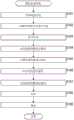
图7是示出作为应用本技术的图像处理装置的实施方式的编码装置的配置的示例的框图。图7中示出的编码装置100是通过用于二维图像的编码方法将点云数据(LiDAR数据)编码为视频帧的装置。FIG. 7 is a block diagram showing an example of a configuration of an encoding device as an embodiment of an image processing device to which the present technology is applied. The
注意,图7示出了包括处理单元、数据流等的主要配置,并且图7中示出的处理单元和数据流不一定是全部。即,在编码装置100中,可以存在未在图7中示出为块的处理单元,或者可以存在未在图7中示出为箭头等的处理或数据流。Note that FIG. 7 shows a main configuration including processing units, data flows, and the like, and the processing units and data flows shown in FIG. 7 are not necessarily all. That is, in the
如图7所示,编码装置100包括分解处理单元(decomposition processing unit)111、辅助图块信息压缩单元112、打包单元113、几何视频帧编码单元114、属性视频帧编码单元115、占用图编码单元116、角度视频帧编码单元117和复用器118。As shown in FIG. 7 , the
分解处理单元111执行与几何数据的分解有关的处理。例如,分解处理单元111获取LiDAR数据,该LiDAR数据是点云并被输入至编码装置100。此外,如以上在<1.LiDAR数据的二维图像编码>中所述,分解处理单元111分解获取的LiDAR数据的以极坐标(包括角度分量的坐标系)表达的几何数据以提取角度分量,并且生成包括角度分量的角度信息。换言之,分解处理单元111生成作为相对于观察点的距离分量的深度信息。The
分解处理单元111将生成的角度信息和深度信息连同属性数据一起提供给打包单元113。此外,分解处理单元111向辅助图块信息压缩单元112提供用于角度信息或深度信息的生成的信息(例如,关于观察点位置的信息、相机参数等)作为辅助图块信息。The
辅助图块信息压缩单元112执行与辅助图块信息的压缩有关的处理。例如,辅助图块信息压缩单元112获取从分解处理单元111提供的辅助图块信息。辅助图块信息压缩单元112通过除了用于二维图像的编码方法之外的编码方法对获取的辅助图块信息进行编码(压缩)。辅助图块信息可以包括从分解处理单元111提供的关于得出预测值的预测的信息。此外,编码方法是任意的,只要该方法不是用于二维图像即可。辅助图块信息压缩单元112将获得的辅助图块信息的编码数据提供给复用器118。The auxiliary tile
打包单元113执行与数据打包有关的处理。例如,打包单元113获取从分解处理单元111提供的几何数据(深度信息或角度信息)和属性数据。此外,如以上在<1.LiDAR数据的二维图像编码>中所述,打包单元113生成深度图像,该深度图像是具有获取的深度信息作为像素值的二维图像。此时,打包单元113还可以划分深度图像以得到多个层。打包单元113将深度图像视为视频帧,并且生成几何视频帧。当划分深度图像以得到多个层时,打包单元113将深度图像的每个层视为视频帧,并且生成几何视频帧。The
此外,如以上在<1.LiDAR数据的二维图像编码>中所述,打包单元113生成角度图像,该角度图像是具有获取的角度信息(或者从角度信息得出的信息)作为像素值的二维图像。打包单元113将角度图像视为视频帧,并且生成角度视频帧。In addition, as described above in <1. Two-dimensional image encoding of LiDAR data>, the
此外,打包单元113生成属性图像,该属性图像是具有获取的属性数据作为像素值的二维图像。打包单元113将属性图像视为视频帧,并且生成属性视频帧。Furthermore, the
此外,如以上在<1.LiDAR数据的二维图像编码>中所述,打包单元113生成占用图,该占用图向深度图像指示区域是否包括有用信息。注意,当深度图像包括多个层时,打包单元113可以针对每个层生成占用图。Furthermore, as described above in <1. Two-dimensional Image Coding of LiDAR Data>, the
打包单元113将占用图视为视频帧。注意,当针对深度图像的每个层生成占用图时,打包单元113将与每个深度图像对应的占用图视为视频帧。The
打包单元113将它们提供给后续阶段中的处理单元。例如,打包单元113将几何视频帧提供给几何视频帧编码单元114。此外,打包单元113将属性视频帧提供给属性视频帧编码单元115。此外,打包单元113将占用图提供给占用图编码单元116。此外,打包单元113将角度视频帧提供给角度视频帧编码单元117。
几何视频帧编码单元114执行与几何视频帧的编码有关的处理。例如,几何视频帧编码单元114获取从打包单元113提供的几何视频帧。此外,如以上在<1.LiDAR数据的二维图像编码>中所述,几何视频帧编码单元114通过用于二维图像的编码方法对获取的几何视频帧进行编码,并且生成几何视频帧的编码数据。用于二维图像的编码方法是任意的,并且例如可以是高级视频编码(AVC)、高效视频编码(HEVC)等。几何视频帧编码单元114将几何视频帧的编码数据提供给复用器118。The geometric video
属性视频帧编码单元115执行与属性视频帧的编码有关的处理。例如,属性视频帧编码单元115获取从打包单元113提供的属性视频帧。此外,例如,属性视频帧编码单元115通过用于二维图像的任意编码方法(例如,AVC或HEVC)对获取的属性视频帧进行编码。属性视频帧编码单元115向复用器118提供通过编码获得的属性视频帧的编码数据。The attribute video
占用图编码单元116执行与占用图的视频帧的编码有关的处理。例如,占用图编码单元116获取从打包单元113提供的占用图。此外,如以上在<1.LiDAR数据的二维图像编码>中所述,占用图编码单元116通过例如用于二维图像的任意编码方法对获取的占用图进行编码。占用图编码单元116向复用器118提供通过编码获得的占用图的编码数据。Occupancy
角度视频帧编码单元117执行与角度视频帧的编码有关的处理。例如,角度视频帧编码单元117获取从打包单元113提供的角度视频帧。此外,如以上在<1.LiDAR数据的二维图像编码>中所述,角度视频帧编码单元117通过例如用于二维图像的任意编码方法(例如,AVC或HEVC)对获取的角度视频帧进行编码。角度视频帧编码单元117向复用器118提供通过编码获得的角度视频帧的编码数据。The angle video
复用器118执行与复用有关的处理。例如,复用器118获取辅助图块信息的编码数据,该编码数据是从辅助图块信息压缩单元112提供的。此外,复用器118获取几何视频帧的编码数据,该编码数据是从几何视频帧编码单元114提供的。此外,复用器118获取属性视频帧的编码数据,该编码数据是从属性视频帧编码单元115提供的。此外,复用器118获取占用图的编码数据,该编码数据是从占用图编码单元116提供的。此外,复用器118获取角度视频帧的编码数据,该编码数据是从角度视频帧编码单元117提供的。The
复用器118对这些获取的信息进行复用以生成比特流。复用器118将生成的比特流输出至编码装置100外部。The
在具有这样的配置的编码装置100中,从分解处理单元111到复用器118的处理单元中的每一个通过应用上述本技术执行<1.LiDAR数据的二维图像编码>中的处理。因此,如以上在<1.LiDAR数据的二维图像编码>中所述,编码装置100可以减少点云的质量的降低。In the
注意,这些处理单元(分解处理单元111到复用器118)具有任意配置。例如,处理单元中的每一个可以包括实现上述处理的逻辑电路。此外,处理单元中的每一个可以具有例如中央处理单元(CPU)、只读存储器(ROM)、随机存取存储器(RAM)等,并且通过使用CPU、ROM、RAM等执行程序以实现上述处理。不用说,处理单元中的每一个可以具有这两种配置,并且上述处理的一部分可以通过逻辑电路来实现,而另一部分可以通过执行程序来实现。处理单元的配置可以彼此独立。例如,在处理单元中,一些处理单元可以利用逻辑电路实现上述处理的一部分,一些其他处理单元可以通过执行程序实现上述处理,并且又一些其他处理单元可以利用逻辑电路和程序的执行两者实现上述处理。Note that these processing units (
<编码处理的流程><Flow of Encoding Processing>
将参照图8中的流程图描述由编码装置100执行的编码处理的流程的示例。An example of the flow of encoding processing performed by the
当编码处理开始时,在步骤S101中,编码装置100的分解处理单元111分解几何数据以生成角度信息(和深度信息)。When the encoding process starts, in step S101, the
在步骤S102中,辅助图块信息压缩单元112对通过步骤S101中的处理获得的辅助图块信息进行压缩。In step S102, the auxiliary tile
在步骤S103中,打包单元113通过使用在步骤S101中生成的深度信息来生成深度图像,并且生成几何视频帧。此外,打包单元113通过使用在步骤S101中生成的角度信息来生成角度图像,并且生成角度视频帧。此外,打包单元113通过使用属性数据来生成属性视频帧。此外,打包单元113生成与深度图像对应的占用图。In step S103, the
在步骤S104中,几何视频帧编码单元114通过用于二维图像的编码方法对通过步骤S103中的处理获得的几何视频帧进行编码。In step S104, the geometric video
在步骤S105中,属性视频帧编码单元115通过用于二维图像的编码方法对通过步骤S103中的处理获得的属性视频帧进行编码。In step S105, the attribute video
在步骤S106中,占用图编码单元116通过用于二维图像的编码方法对通过步骤S103中的处理获得的占用图进行编码。In step S106, the occupancy
在步骤S107中,角度视频帧编码单元117通过用于二维图像的编码方法对通过步骤S103中的处理获得的角度视频帧进行编码。In step S107, the angle video
在步骤S108中,复用器118对如上所述生成的各种信息进行复用,并且生成包括这些信息的比特流。在步骤S109中,复用器118将通过步骤S108中的处理生成的比特流输出至编码装置100外部。当步骤S109中的处理结束时,编码处理结束。In step S108, the
在这样的流程中的编码处理中,从分解处理单元111到复用器118的处理单元中的每一个通过应用上述本技术执行<1.LiDAR数据的二维图像编码>中的处理。因此,如以上在<1.LiDAR数据的二维图像编码>中所述,编码装置100可以减少点云的质量的降低。In encoding processing in such a flow, each of the processing units from the
<3.第二实施方式><3. Second Embodiment>
<解码装置><decoder>
图9是示出作为应用本技术的图像处理装置的一方面的解码装置的配置的示例的框图。图9中示出的解码装置200是这样的装置:其通过用于二维图像的解码方法对通过利用用于二维图像的编码方法对作为视频帧的点云数据(LiDAR数据)进行编码而获得的编码数据进行解码,并且重建点云(LiDAR数据)。FIG. 9 is a block diagram showing an example of a configuration of a decoding device as an aspect of an image processing device to which the present technology is applied. The
注意,图9示出了包括处理单元、数据流等的主要配置,并且图9中示出的处理单元和数据流不一定是全部。即,在解码装置200中,可以存在未在图9中示出为块的处理单元,或者可以存在未在图9中示出为箭头等的处理或数据流。Note that FIG. 9 shows a main configuration including processing units, data flows, and the like, and the processing units and data flows shown in FIG. 9 are not necessarily all. That is, in the
如图9所示,解码装置200包括解复用器211、辅助图块信息解码单元212、几何视频帧解码单元213、属性视频帧解码单元214、占用图解码单元215、角度视频帧解码单元216、解包单元217和3D重建单元218。As shown in FIG. 9 , the
解复用器211执行与数据的解复用有关的处理。例如,解复用器211可以获取输入至解码装置200的比特流。例如,比特流是从编码装置100提供的。The
此外,解复用器211可以对比特流进行解复用。例如,通过解复用,解复用器211可以从比特流提取辅助图块信息的编码数据。此外,通过解复用,解复用器211可以从比特流提取几何视频帧的编码数据。此外,通过解复用,解复用器211可以从比特流提取属性视频帧的编码数据。此外,通过解复用,解复用器211可以从比特流提取占用图的编码数据。此外,通过解复用,解复用器211可以从比特流提取角度视频帧的编码数据。In addition, the
此外,解复用器211可以将提取的数据提供给后续阶段中的处理单元。例如,解复用器211可以将提取的辅助图块信息的编码数据提供给辅助图块信息解码单元212。此外,解复用器211可以将提取的几何视频帧的编码数据提供给几何视频帧解码单元213。此外,解复用器211可以将提取的属性视频帧的编码数据提供给属性视频帧解码单元214。此外,解复用器211可以将提取的占用图的编码数据提供给占用图解码单元215。此外,解复用器211可以将提取的角度视频帧的编码数据提供给角度视频帧解码单元216。Furthermore, the
辅助图块信息解码单元212执行与辅助图块信息的编码数据的解码有关的处理。例如,辅助图块信息解码单元212可以获取辅助图块信息的编码数据,该编码数据是从解复用器211提供的。此外,辅助图块信息解码单元212可以对编码数据进行解码以生成辅助图块信息。辅助图块信息可以包括关于得出角度信息的预测值的预测的信息。此外,解码方法是任意的,只要该方法是与编码时应用的编码方法(例如,由辅助图块信息压缩单元112应用的编码方法)对应的方法(不是用于二维图像的解码方法)即可。此外,辅助图块信息解码单元212将辅助图块信息提供给3D重建单元218。The auxiliary tile
几何视频帧解码单元213执行与几何视频帧的编码数据的解码有关的处理。例如,几何视频帧解码单元213可以获取几何视频帧的编码数据,该编码数据是从解复用器211提供的。此外,几何视频帧解码单元213可以对编码数据进行解码以生成几何视频帧。此外,几何视频帧解码单元213可以将几何视频帧提供给解包单元217。The geometric video
属性视频帧解码单元214执行与属性视频帧的编码数据的解码有关的处理。例如,属性视频帧解码单元214可以获取属性视频帧的编码数据,该编码数据是从解复用器211提供的。此外,属性视频帧解码单元214可以对编码数据进行解码以生成属性视频帧。此外,属性视频帧解码单元214可以将属性视频帧提供给解包单元217。The attribute video
占用图解码单元215执行与占用图的编码数据的解码有关的处理。例如,占用图解码单元215可以获取占用图的编码数据,该编码数据是从解复用器211提供的。此外,占用图解码单元215可以对编码数据进行解码以生成占用图。此外,占用图解码单元215可以将占用图提供给解包单元217。The occupancy
角度视频帧解码单元216执行与角度视频帧的编码数据的解码有关的处理。例如,角度视频帧解码单元216可以获取角度视频帧的编码数据,该编码数据是从解复用器211提供的。此外,角度视频帧解码单元216可以对编码数据进行解码以生成角度视频帧。此外,角度视频帧解码单元216可以将角度视频帧提供给解包单元217。The angle video
解包单元217执行与解包有关的处理。例如,解包单元217可以获取从几何视频帧解码单元213提供的几何视频帧。此外,解包单元217可以获取从属性视频帧解码单元214提供的属性视频帧。此外,解包单元217可以获取从占用图解码单元215提供的占用图。此外,解包单元217可以获取从角度视频帧解码单元216提供的角度视频帧。The unpacking
此外,解包单元217可以基于占用图对几何视频帧、属性视频帧和角度视频帧进行解包,并且可以生成(恢复)深度信息、角度信息、属性数据等。Furthermore, the unpacking
此外,解包单元217可以向3D重建单元218提供生成的深度信息、角度信息、属性数据等。In addition, the unpacking
3D重建单元218执行与3D数据的重建有关的处理。例如,3D重建单元218可以获取从辅助图块信息解码单元212提供的辅助图块信息。此外,3D重建单元218可以获取从解包单元217提供的深度信息、角度信息、属性数据(即,几何数据和属性数据)等。3D重建单元218通过使用这些信息对点云(LiDAR数据)进行重建。The
3D重建单元218将通过这样的处理获得的点云数据(LiDAR数据)输出至解码装置200外部。例如,在显示单元上渲染和显示点云数据(LiDAR数据),将点云数据(LiDAR数据)记录在记录介质上,或者经由通信将点云数据(LiDAR数据)提供给其他装置。The
在具有这样的配置的解码装置200中,从解复用器211到3D重建单元218的处理单元中的每一个通过应用上述本技术来执行<1.LiDAR数据的二维图像编码>中的处理。因此,如以上在<1.LiDAR数据的二维图像编码>中所述,解码装置200可以减少点云的质量的降低。In the
注意,这些处理单元(解复用器211到3D重建单元218)具有任意配置。例如,处理单元中的每一个可以包括实现上述处理的逻辑电路。此外,处理单元中的每一个可以具有例如CPU、ROM、RAM等,并且通过使用CPU、ROM、RAM等执行程序,以实现上述处理。不用说,处理单元中的每一个可以具有这两种配置,并且上述处理的一部分可以通过逻辑电路来实现,而另一部分可以通过执行程序来实现。处理单元的配置可以彼此独立。例如,在处理单元中,一些处理单元可以利用逻辑电路实现上述处理的一部分,一些其他处理单元可以通过执行程序实现上述处理,并且又一些其他处理单元可以利用逻辑电路和程序的执行两者实现上述处理。Note that these processing units (
<解码处理的流程><Flow of decoding process>
将参照图10中的流程图来描述由这样的解码装置200执行的解码处理的流程的示例。An example of the flow of decoding processing performed by such a
当解码处理开始时,在步骤S201中,解码装置200的解复用器211对比特流进行解复用。When the decoding process starts, in step S201, the
在步骤S202中,辅助图块信息解码单元212对辅助图块信息的编码数据进行解码,该编码数据是通过步骤S201中的处理从比特流提取的。In step S202, the auxiliary tile
在步骤S203中,几何视频帧解码单元213对几何视频帧的编码数据进行解码,该编码数据是通过步骤S201中的处理从比特流提取的。In step S203, the geometric video
在步骤S204中,属性视频帧解码单元214对属性视频帧的编码数据进行解码,该编码数据是通过步骤S201中的处理从比特流提取的。In step S204, the attribute video
在步骤S205中,占用图解码单元215对占用图的编码数据进行解码,该编码数据是通过步骤S201中的处理从比特流提取的。In step S205, the occupancy
在步骤S206中,角度视频帧解码单元216对角度视频帧的编码数据进行解码,该编码数据是通过步骤S201中的处理从比特流提取的。In step S206, the angle video
在步骤S207中,解包单元217基于占用图等对几何视频帧进行解包,并且生成(恢复)深度信息。此外,解包单元217基于占用图等对属性视频帧进行解包,并且生成(恢复)属性数据。此外,解包单元217基于占用图等对角度视频帧进行解包,并且生成(恢复)角度信息。In step S207, the unpacking
在步骤S208中,3D重建单元218基于在步骤S202中生成的辅助图块信息和在步骤S207中获得的各种信息来重建点云数据(LiDAR数据)。当步骤S208中的处理结束时,解码处理结束。In step S208, the
在这样的流程中的解码处理中,从解复用器211到3D重建单元218的处理单元中的每一个通过应用上述本技术来执行<1.LiDAR数据的二维图像编码>中的处理。因此,如以上在<1.LiDAR数据的二维图像编码>中所述,解码装置200可以减少点云的质量的降低。In the decoding processing in such a flow, each of the processing units from the
<4.补充说明><4. Supplementary explanation>
<点云数据><point cloud data>
尽管在上面作为点云数据的示例描述了LiDAR数据,但是点云数据可以是除了LiDAR数据之外的点云数据。即,本技术可以应用于任意点云数据。Although LiDAR data is described above as an example of point cloud data, the point cloud data may be point cloud data other than LiDAR data. That is, the present technique can be applied to arbitrary point cloud data.
<计算机><computer>
上述一系列处理可以通过硬件来执行或者可以通过软件来执行。当通过软件执行一系列处理时,将软件中包括的程序安装在计算机上。这里,计算机的示例包括结合在专用硬件中的计算机、例如能够通过安装各种程序来执行各种功能的通用个人计算机等。The series of processing described above can be executed by hardware or can be executed by software. When a series of processing is performed by software, a program included in the software is installed on a computer. Here, examples of the computer include a computer incorporated in dedicated hardware, such as a general-purpose personal computer capable of executing various functions by installing various programs, and the like.
图11是示出通过程序执行上述一系列处理的计算机的硬件的配置示例的框图。FIG. 11 is a block diagram showing a configuration example of hardware of a computer that executes the above-described series of processing by a program.
在图11中示出的计算机900中,中央处理单元(CPU)901、只读存储器(ROM)902和随机存取存储器(RAM)903经由总线904相互连接。In a
此外,输入/输出接口910连接至总线904。输入单元911、输出单元912、存储单元913、通信单元914和驱动器915连接至输入/输出接口910。Furthermore, an input/
输入单元911包括例如键盘、鼠标、麦克风、触摸面板、输入端子等。输出单元912包括例如显示器、扬声器、输出端子等。存储单元913包括例如硬盘、RAM盘和非易失性存储器等。通信单元914包括例如网络接口。驱动器915驱动诸如磁盘、光盘、磁光盘或半导体存储器的可移除介质921。The
在如上配置的计算机中,例如通过CPU 901经由输入/输出接口910和总线904将存储在存储单元913中的程序加载至RAM 903中并执行该程序来执行上述一系列处理。适当地,RAM 903还存储CPU 901执行各种处理所需的数据。In the computer configured as above, the series of processing described above is performed, for example, by the
例如,由计算机执行的程序可以通过记录在作为封装介质的可移除介质921等上来应用。在这种情况下,可以通过将可移除介质921附接至驱动器915,经由输入/输出接口910将程序安装在存储单元913上。For example, a program executed by a computer can be applied by being recorded on the removable medium 921 or the like as a package medium. In this case, the program can be installed on the
此外,还可以经由诸如局域网、因特网或数字卫星广播的有线或无线传输介质来提供程序。在这种情况下,程序可以由通信单元914接收并安装在存储单元913上。In addition, the program can also be provided via a wired or wireless transmission medium such as a local area network, the Internet, or digital satellite broadcasting. In this case, the program can be received by the
另外,可以将程序预先安装在ROM 902或存储单元913上。In addition, the program may be preinstalled on the
<应用本技术的对象><Objects to which this technology is applied>
尽管在上面作为本技术的应用示例描述了编码装置、解码装置等,但是本技术可以应用于任意配置。Although the encoding device, the decoding device, and the like are described above as application examples of the present technology, the present technology can be applied to arbitrary configurations.
例如,本技术可以应用于各种电子设备,例如用于卫星广播、诸如有线电视的有线广播、因特网上的分发或通过蜂窝通信到终端的分发的发送器或接收器(例如,电视接收器或移动电话)、在诸如光盘、磁盘或闪速存储器的介质上记录图像或从存储介质重新生成图像的装置(例如,硬盘记录器或相机)等。For example, the present technology can be applied to various electronic devices such as transmitters or receivers (for example, television receivers or mobile phone), a device that records images on a medium such as an optical disc, magnetic disk, or flash memory or reproduces an image from a storage medium (for example, a hard disk recorder or a camera), and the like.
此外,例如,还可以将本技术实现为装置的部分配置,例如作为系统大规模集成(LSI)等的处理器(例如,视频处理器)、使用多个处理器等的模块(例如,视频模块)、使用多个模块等的单元(例如,视频单元)、或者通过进一步添加其他功能至单元而获得的设备(set)(例如,视频设备)。In addition, for example, the present technology can also be realized as a partial configuration of an apparatus, for example, as a processor (for example, a video processor) of a system large-scale integration (LSI) or the like, a module using a plurality of processors, etc. (for example, a video module ), a unit (for example, a video unit) using a plurality of modules, etc., or a set obtained by further adding other functions to the unit (for example, a video device).
此外,例如,本技术还可以应用于包括多个装置的网络系统。例如,本技术可以实现为云计算,其中本技术由多个装置经由网络共享和共同处理。例如,本技术可以在将与图像(运动图像)有关的服务提供给诸如计算机、视听(AV)装置、便携式信息处理终端或物联网(IoT)设备的任意终端的云服务中实现。Furthermore, for example, the present technology can also be applied to a network system including a plurality of devices. For example, the present technology may be implemented as cloud computing in which the present technology is shared and jointly processed by a plurality of devices via a network. For example, the present technology can be implemented in a cloud service that provides services related to images (moving images) to arbitrary terminals such as computers, audiovisual (AV) devices, portable information processing terminals, or Internet of Things (IoT) devices.
注意,在本说明书中,系统意指一组多个部件(装置、模块(部分)等),而不考虑所有部件是否在同一壳体中。因此,容纳在分开的壳体中并且经由网络连接的多个装置以及将多个模块存储在一个壳体中的一个装置均是系统。Note that, in this specification, a system means a set of multiple components (device, module (section), etc.), regardless of whether all the components are in the same housing or not. Therefore, a plurality of devices accommodated in separate housings and connected via a network, and one device storing a plurality of modules in one housing are both systems.
<本技术适用的领域/应用><Fields/Applications where this technology is applicable>
例如,应用本技术的系统、装置、处理单元等可以用在诸如交通、医疗护理、犯罪预防、农业、畜牧业、采矿、美容、工厂、家用电器、天气或自然监测的任意领域中。此外,其应用也是任意的。For example, systems, devices, processing units, etc. to which the present technology is applied can be used in any fields such as transportation, medical care, crime prevention, agriculture, animal husbandry, mining, beauty, factories, home appliances, weather or nature monitoring. In addition, its application is also arbitrary.
<其他><other>
此外,可以以任何形式发送或记录与编码数据(比特流)有关的各种信息(元数据等),只要该信息与编码数据相关联即可。这里,术语“关联”意指例如当处理一个数据时,可能利用其他数据(可能链接其他数据)。即,彼此相关联的数据可以被收集为一个数据或者可以是分开的数据。例如,与编码数据(图像)相关联的信息可以在与编码数据(图像)的传输线不同的传输路径上发送。此外,例如,与编码数据(图像)相关联的信息可以记录在与编码数据(图像)的记录介质不同(或相同)的记录介质上。注意,可以对数据的一部分而不是整个数据应用“关联”。例如,图像和与图像对应的信息可以以诸如多个帧、一帧或帧中的一部分的单位的任意单位相互关联。Furthermore, various information (metadata, etc.) related to encoded data (bit stream) may be transmitted or recorded in any form as long as the information is associated with the encoded data. Here, the term "associate" means that, for example, when one data is processed, other data may be utilized (possibly linked to other data). That is, data associated with each other may be collected as one data or may be separate data. For example, information associated with coded data (images) may be transmitted on a transmission line different from that of the coded data (images). Also, for example, information associated with encoded data (image) may be recorded on a recording medium different from (or the same as) that of the encoded data (image). Note that a "relation" can be applied to a portion of the data rather than to the entire data. For example, an image and information corresponding to the image may be associated with each other in an arbitrary unit such as a unit of a plurality of frames, a frame, or a part of a frame.
注意,在本说明书中,诸如“组合”、“复用”、“添加”、“集成”、“包括”、“存储”、“包含”、“放入”或“插入”的术语意指将多个项收集为一个,例如将编码数据和元数据收集为一个数据,并且意指上述“关联”的一种方法。Note that in this specification, terms such as "combine", "multiplex", "add", "integrate", "comprise", "store", "comprise", "put into" or "insert" mean that Collecting multiple items as one, such as coded data and metadata as one, and means a method of "association" described above.
此外,本技术的实施方式不限于上述实施方式,并且在不脱离本技术的范围的情况下可以进行各种改变。In addition, the embodiments of the present technology are not limited to the above-described embodiments, and various changes can be made without departing from the scope of the present technology.
例如,被描述为一个装置(或处理单元)的配置可以被划分且被配置为多个装置(或处理单元)。相反,上述作为多个装置(或处理单元)的配置可以被共同配置为一个装置(或处理单元)。此外,不用说,可以将除了上述配置之外的配置添加至每个装置(或每个处理单元)的配置。此外,如果整个系统的配置和操作基本相同,则特定装置(或处理单元)的配置的一部分可以被包括在其他装置(或其他处理单元)的配置中。For example, a configuration described as one device (or processing unit) may be divided and configured as a plurality of devices (or processing units). Conversely, the configuration described above as a plurality of devices (or processing units) may be collectively configured as one device (or processing unit). In addition, it goes without saying that a configuration other than the above-described configuration may be added to the configuration of each device (or each processing unit). Also, if the configuration and operation of the entire system are substantially the same, a part of the configuration of a specific device (or processing unit) may be included in the configuration of other devices (or other processing units).
此外,例如,可以在任意装置中执行上述程序。在这种情况下,装置仅需要具有必要的功能(功能块等),使得可以获取必要的信息。Also, for example, the above-described program can be executed in an arbitrary device. In this case, the device only needs to have necessary functions (function blocks, etc.) so that necessary information can be acquired.
此外,例如,一个流程图中的每个步骤可以由一个装置执行,或者可以通过由多个装置共享来执行。此外,当在一个步骤中包括多个处理时,多个处理可以由一个装置执行,或者可以通过由多个装置共享来执行。换言之,一个步骤中包括的多个处理可以作为多个步骤的处理来执行。相反,被描述为多个步骤的处理可以作为一个步骤共同执行。Also, for example, each step in one flowchart may be executed by one device, or may be executed by being shared by a plurality of devices. Also, when a plurality of processes are included in one step, the plurality of processes may be executed by one device, or may be performed by being shared by a plurality of devices. In other words, a plurality of processes included in one step can be performed as processes of a plurality of steps. On the contrary, processing described as a plurality of steps may be collectively performed as one step.
此外,例如,由计算机执行的程序可以是其中以本说明书中描述的顺序按时间序列执行描述程序的步骤的处理的程序,或者其中可以并行地或者在诸如进行调用时的必要定时单独地执行处理的程序。即,除非存在矛盾,否则可以以与上述顺序不同的顺序执行每个步骤的处理。此外,描述程序的步骤的处理可以与其他程序的处理并行执行,或者可以与其他程序的处理组合执行。In addition, for example, the program executed by the computer may be a program in which the processing describing the steps of the program is executed in time series in the order described in this specification, or in which the processing may be executed individually in parallel or at necessary timing such as when a call is made program of. That is, unless there is a contradiction, the processing of each step may be performed in an order different from the above-described order. Furthermore, the processing describing the steps of the program may be executed in parallel with the processing of other programs, or may be executed in combination with the processing of other programs.
此外,例如,除非存在矛盾,否则可以将与本技术有关的多个技术独立地实现为单个技术。不用说,多个任意本技术可以组合使用。例如,任何实施方式中描述的本技术的一部分或全部可以与其他实施方式中描述的本技术的一部分或全部组合实现。此外,上述本技术的任何部分或全部可以与上面未描述的其他技术组合实现。Also, for example, a plurality of techniques related to the present technique can be independently implemented as a single technique unless there is a contradiction. It goes without saying that a plurality of arbitrary present techniques can be used in combination. For example, part or all of the present technology described in any embodiment mode can be implemented in combination with part or all of the present technology described in other embodiment modes. Furthermore, any part or all of the present technology described above may be implemented in combination with other technologies not described above.
注意,本技术可以具有以下配置。Note that the present technology may have the following configurations.
(1)一种图像处理装置,包括:(1) An image processing device, comprising:
角度图像生成单元,所述角度图像生成单元生成角度图像,所述角度图像具有指示将三维形状的对象表达为点的集合的点云的几何数据的角度分量的信息作为像素值,以及an angle image generation unit that generates an angle image having, as a pixel value, information indicating an angle component of geometric data of a point cloud expressing an object of a three-dimensional shape as a set of points, and
角度图像编码单元,所述角度图像编码单元对由所述角度图像生成单元生成的所述角度图像进行编码。An angle image encoding unit that encodes the angle image generated by the angle image generation unit.
(2)根据(1)所述的图像处理装置,(2) The image processing device according to (1),
其中,所述角度图像的每个像素对应于具有深度值作为像素值的深度图像的每个像素,所述深度值是所述几何数据的距离分量。Wherein, each pixel of the angle image corresponds to each pixel of the depth image having a depth value as a pixel value, the depth value being a distance component of the geometric data.
(3)根据(1)所述的图像处理装置,(3) The image processing device according to (1),
其中,所述角度图像包括具有每个点的所述几何数据的角度分量的绝对值作为像素值的图像。Wherein, the angle image includes an image having an absolute value of an angle component of the geometric data of each point as a pixel value.
(4)根据(1)所述的图像处理装置,(4) The image processing device according to (1),
其中,所述角度图像包括具有预测残差作为像素值的图像,所述预测残差是与每个点的所述几何数据的角度分量的预测值的差。Wherein the angular image comprises an image having as pixel values a prediction residual which is a difference from a predicted value of the angular component of the geometric data for each point.
(5)根据(4)所述的图像处理装置,所述图像处理装置还包括(5) The image processing device according to (4), further comprising
预测信息编码单元,所述预测信息编码单元对关于得出所述预测值的预测的信息进行编码。A prediction information encoding unit that encodes information on a prediction from which the predicted value is derived.
(6)根据(1)所述的图像处理装置,所述图像处理装置还包括角度分量提取单元,所述角度分量提取单元从所述几何数据提取所述角度分量,(6) The image processing device according to (1), further comprising an angle component extraction unit that extracts the angle component from the geometric data,
其中,所述角度图像生成单元通过使用由所述角度分量提取单元提取的所述角度分量来生成所述角度图像。Wherein, the angle image generation unit generates the angle image by using the angle component extracted by the angle component extraction unit.
(7)根据(1)所述的图像处理装置,所述图像处理装置还包括:(7) The image processing device according to (1), further comprising:
深度图像编码单元,所述深度图像编码单元对具有深度值作为像素值的深度图像进行编码,所述深度值是所述几何数据的距离分量,a depth image encoding unit that encodes a depth image having as pixel values a depth value that is a distance component of the geometric data,
属性图像编码单元,所述属性图像编码单元对具有所述点云的属性数据作为像素值的属性图像进行编码,以及an attribute image encoding unit that encodes an attribute image having attribute data of the point cloud as pixel values, and
占用图编码单元,所述占用图编码单元对指示所述深度图像中的区域的占用图进行编码,所述区域包括有用的信息。an occupancy map encoding unit that encodes an occupancy map indicating regions in the depth image, the regions including useful information.
(8)根据(7)所述的图像处理装置,(8) The image processing device according to (7),
其中,所述深度图像包括根据所述深度值的大小分类的多个层,并且Wherein, the depth image includes a plurality of layers classified according to the magnitude of the depth value, and
所述深度图像编码单元针对每个所述层对所述深度图像进行编码。The depth image encoding unit encodes the depth image for each of the layers.
(9)根据(8)所述的图像处理装置,(9) The image processing device according to (8),
其中,针对所述深度图像的每个所述层生成所述占用图,并且wherein said occupancy map is generated for each said layer of said depth image, and
所述占用图编码单元对每个所述层的所述占用图进行编码。The occupancy map encoding unit encodes the occupancy map of each of the layers.
(10)一种图像处理方法,包括:(10) An image processing method, comprising:
生成角度图像,所述角度图像具有指示将三维形状的对象表达为点的集合的点云的几何数据的角度分量的信息作为像素值,以及generating an angle image having, as pixel values, information indicating an angle component of geometric data of a point cloud expressing an object of a three-dimensional shape as a set of points, and
对所生成的角度图像进行编码。Encode the resulting angle image.
(11)一种图像处理装置,包括:(11) An image processing device, comprising:
角度图像解码单元,所述角度图像解码单元对编码数据进行解码以生成角度图像,所述角度图像具有指示将三维形状的对象表达为点的集合的点云的几何数据的角度分量的信息作为像素值,以及an angle image decoding unit that decodes the encoded data to generate an angle image having, as pixels, information indicating an angle component of geometric data of a point cloud expressing a three-dimensionally shaped object as a set of points value, and
构造单元,所述构造单元通过使用由所述角度图像解码单元生成的所述角度图像来构造所述点云。a construction unit that constructs the point cloud by using the angle image generated by the angle image decoding unit.
(12)根据(11)所述的图像处理装置,(12) The image processing device according to (11),
其中,所述角度图像的每个像素对应于具有深度值作为像素值的深度图像的每个像素,所述深度值是所述几何数据的距离分量。Wherein, each pixel of the angle image corresponds to each pixel of the depth image having a depth value as a pixel value, the depth value being a distance component of the geometric data.
(13)根据(11)所述的图像处理装置,(13) The image processing device according to (11),
其中,所述角度图像包括具有每个点的所述几何数据的角度分量的绝对值作为像素值的图像。Wherein, the angle image includes an image having an absolute value of an angle component of the geometric data of each point as a pixel value.
(14)根据(11)所述的图像处理装置,(14) The image processing device according to (11),
其中,所述角度图像包括具有预测残差作为像素值的图像,所述预测残差是与每个点的所述几何数据的角度分量的预测值的差,并且wherein said angular image comprises an image having as pixel values a prediction residual which is the difference from the predicted value of the angular component of said geometric data for each point, and
所述构造单元通过使用所述预测残差得出每个点的所述角度分量,并且通过使用所得出的角度分量来构造所述点云。The construction unit derives the angle component of each point by using the prediction residual, and constructs the point cloud by using the derived angle component.
(15)根据(14)所述的图像处理装置,所述图像处理装置还包括:(15) The image processing device according to (14), further comprising:
预测信息解码单元,所述预测信息解码单元对编码数据进行解码以生成关于得出所述预测值的预测的信息,a prediction information decoding unit that decodes the encoded data to generate information on a prediction from which the predicted value is derived,
其中,所述构造单元通过使用所述预测残差和由所述预测信息解码单元生成的所述信息来得出每个点的所述角度分量。Wherein, the construction unit obtains the angle component of each point by using the prediction residual and the information generated by the prediction information decoding unit.
(16)根据(11)所述的图像处理装置,所述图像处理装置还包括:(16) The image processing device according to (11), further comprising:
深度图像解码单元,所述深度图像解码单元对编码数据进行解码以生成具有深度值作为像素值的深度图像,所述深度值是所述几何数据的距离分量,以及a depth image decoding unit that decodes the encoded data to generate a depth image having as pixel values depth values that are distance components of the geometry data, and
属性图像解码单元,所述属性图像解码单元对编码数据进行解码以生成具有所述点云的属性数据作为像素值的属性图像,an attribute image decoding unit that decodes the encoded data to generate an attribute image having attribute data of the point cloud as pixel values,
其中,所述构造单元Among them, the structural unit
通过使用由所述深度图像解码单元生成的所述深度图像和由所述角度图像解码单元生成的所述角度图像来生成所述点云的几何数据,以及generating geometric data of the point cloud by using the depth image generated by the depth image decoding unit and the angle image generated by the angle image decoding unit, and
通过使用所生成的几何数据和由所述属性图像解码单元生成的所述属性图像中包括的所述属性数据来构造所述点云。The point cloud is constructed by using the generated geometric data and the attribute data included in the attribute image generated by the attribute image decoding unit.
(17)根据(16)所述的图像处理装置,所述图像处理装置还包括:(17) The image processing device according to (16), further comprising:
占用图解码单元,所述占用图解码单元对编码数据进行解码以生成指示所述深度图像中的区域的占用图,所述区域包括有用的信息,以及an occupancy map decoding unit that decodes the encoded data to generate an occupancy map indicative of regions in the depth image, the regions comprising useful information, and
提取单元,所述提取单元通过使用由所述占用图解码单元生成的所述占用图,从所述深度图像和所述角度图像提取有用的所述信息,an extraction unit that extracts the useful information from the depth image and the angle image by using the occupancy map generated by the occupancy map decoding unit,
其中,所述构造单元通过使用由所述提取单元提取的所述信息来生成所述点云的几何数据。Wherein, the construction unit generates the geometric data of the point cloud by using the information extracted by the extraction unit.
(18)根据(16)所述的图像处理装置,(18) The image processing device according to (16),
其中,所述深度图像解码单元针对根据所述深度值的大小分类的每个层生成所述深度图像,并且wherein the depth image decoding unit generates the depth image for each layer classified according to the magnitude of the depth value, and
所述构造单元通过使用由所述深度图像解码单元生成的包括多个所述层的所述深度图像和由所述角度图像解码单元生成的所述角度图像来生成所述点云的几何数据。The construction unit generates geometric data of the point cloud by using the depth image including a plurality of the layers generated by the depth image decoding unit and the angle image generated by the angle image decoding unit.
(19)根据(18)所述的图像处理装置,所述图像处理装置还包括:(19) The image processing device according to (18), further comprising:
占用图解码单元,所述占用图解码单元对编码数据进行解码以生成占用图,所述占用图是针对所述深度图像的每个所述层生成的并且指示所述深度图像中的区域,所述区域包括有用的信息,以及an occupancy map decoding unit that decodes encoded data to generate an occupancy map generated for each of said layers of said depth image and indicating regions in said depth image, The above areas contain useful information, and
提取单元,所述提取单元通过使用由所述占用图解码单元生成的每个所述层的所述占用图,从包括多个所述层的所述深度图像和所述角度图像提取有用的所述信息,an extracting unit that extracts all useful information from the depth image and the angle image including a plurality of the layers by using the occupancy map of each of the layers generated by the occupancy map decoding unit stated information,
其中,所述构造单元通过使用由所述提取单元提取的所述信息来生成所述点云的几何数据。Wherein, the construction unit generates the geometric data of the point cloud by using the information extracted by the extraction unit.
(20)一种图像处理方法,包括:(20) An image processing method, comprising:
对编码数据进行解码以生成角度图像,所述角度图像具有指示将三维形状的对象表达为点的集合的点云的几何数据的角度分量的信息作为像素值,以及decoding the encoded data to generate an angle image having, as a pixel value, information indicating an angle component of geometric data of a point cloud expressing a three-dimensionally shaped object as a set of points, and
通过使用所生成的角度图像构造所述点云。The point cloud is constructed by using the generated angle images.
附图标记列表List of reference signs
100编码装置,111分解处理单元,112辅助图块信息压缩单元,113打包单元,114几何视频帧编码单元,115属性视频帧编码单元,116占用图编码单元,117角度视频帧编码单元,118复用器,200解码装置,211解复用器,212辅助图块信息解码单元,213几何视频帧解码单元,214属性视频帧解码单元,215占用图解码单元,216角度视频帧解码单元,217解包单元,218 3D重建单元,900计算机。100 coding device, 111 decomposition processing unit, 112 auxiliary block information compression unit, 113 packaging unit, 114 geometric video frame coding unit, 115 attribute video frame coding unit, 116 occupancy map coding unit, 117 angle video frame coding unit, 118 complex User, 200 decoding device, 211 demultiplexer, 212 auxiliary block information decoding unit, 213 geometric video frame decoding unit, 214 attribute video frame decoding unit, 215 occupancy map decoding unit, 216 angle video frame decoding unit, 217 solution Package units, 218 3D reconstruction units, 900 computers.
Claims (20)
Applications Claiming Priority (3)
| Application Number | Priority Date | Filing Date | Title |
|---|---|---|---|
| JP2020148334 | 2020-09-03 | ||
| JP2020-148334 | 2020-09-03 | ||
| PCT/JP2021/030600WO2022050088A1 (en) | 2020-09-03 | 2021-08-20 | Image processing device and method |
Publications (1)
| Publication Number | Publication Date |
|---|---|
| CN115989674Atrue CN115989674A (en) | 2023-04-18 |
Family
ID=80490844
Family Applications (1)
| Application Number | Title | Priority Date | Filing Date |
|---|---|---|---|
| CN202180052304.0AWithdrawnCN115989674A (en) | 2020-09-03 | 2021-08-20 | Image processing apparatus and method |
Country Status (5)
| Country | Link |
|---|---|
| US (1) | US20230334705A1 (en) |
| EP (1) | EP4203477A4 (en) |
| JP (1) | JPWO2022050088A1 (en) |
| CN (1) | CN115989674A (en) |
| WO (1) | WO2022050088A1 (en) |
Families Citing this family (1)
| Publication number | Priority date | Publication date | Assignee | Title |
|---|---|---|---|---|
| CN118055255A (en)* | 2021-02-08 | 2024-05-17 | 荣耀终端有限公司 | Point cloud coding and decoding method and device based on two-dimensional regularized plane projection |
Family Cites Families (6)
| Publication number | Priority date | Publication date | Assignee | Title |
|---|---|---|---|---|
| US8538166B2 (en)* | 2006-11-21 | 2013-09-17 | Mantisvision Ltd. | 3D geometric modeling and 3D video content creation |
| US20190178628A1 (en)* | 2016-05-13 | 2019-06-13 | Olympus Corporation | System and method for depth estimation using a movable image sensor and illumination source |
| US10491885B1 (en)* | 2018-06-13 | 2019-11-26 | Luminar Technologies, Inc. | Post-processing by lidar system guided by camera information |
| US10796457B2 (en) | 2018-06-26 | 2020-10-06 | Intel Corporation | Image-based compression of LIDAR sensor data with point re-ordering |
| WO2021071992A1 (en)* | 2019-10-07 | 2021-04-15 | Boston Polarimetrics, Inc. | Systems and methods for augmentation of sensor systems and imaging systems with polarization |
| WO2022025280A1 (en)* | 2020-07-31 | 2022-02-03 | パナソニック インテレクチュアル プロパティ コーポレーション オブ アメリカ | Three-dimensional data encoding method, three-dimensional data decoding method, three-dimensional data encoding device, and three-dimensional data decoding device |
- 2021
- 2021-08-20CNCN202180052304.0Apatent/CN115989674A/ennot_activeWithdrawn
- 2021-08-20USUS18/042,537patent/US20230334705A1/ennot_activeAbandoned
- 2021-08-20WOPCT/JP2021/030600patent/WO2022050088A1/ennot_activeCeased
- 2021-08-20EPEP21864146.2Apatent/EP4203477A4/ennot_activeWithdrawn
- 2021-08-20JPJP2022546231Apatent/JPWO2022050088A1/janot_activeAbandoned
Also Published As
| Publication number | Publication date |
|---|---|
| WO2022050088A1 (en) | 2022-03-10 |
| JPWO2022050088A1 (en) | 2022-03-10 |
| EP4203477A4 (en) | 2024-02-28 |
| EP4203477A1 (en) | 2023-06-28 |
| US20230334705A1 (en) | 2023-10-19 |
Similar Documents
| Publication | Publication Date | Title |
|---|---|---|
| JP7552828B2 (en) | Image processing device and method | |
| KR102596507B1 (en) | Image processing apparatus and method | |
| US11699248B2 (en) | Image processing apparatus and method | |
| US11922579B2 (en) | Image processing apparatus and method for image processing by deriving voxel and mesh data to generate point cloud data | |
| WO2019198523A1 (en) | Image processing device and method | |
| US11356690B2 (en) | Image processing apparatus and method | |
| JP7331852B2 (en) | Image processing device and method | |
| KR102841822B1 (en) | Image processing device and method | |
| KR20230022165A (en) | Information processing device and method | |
| JP7396302B2 (en) | Image processing device and method | |
| CN115989674A (en) | Image processing apparatus and method | |
| CN116018618A (en) | Image processing device and method | |
| CN115917601A (en) | Information processing apparatus and method | |
| CN115398916B (en) | Information processing device and information processing method | |
| US20220303578A1 (en) | Image processing apparatus and method | |
| CN116636220A (en) | Image processing device and method | |
| CN119999192A (en) | Information processing device and method | |
| CN118318444A (en) | Information processing apparatus and method | |
| HK40029724A (en) | Image processing device and method |
Legal Events
| Date | Code | Title | Description |
|---|---|---|---|
| PB01 | Publication | ||
| PB01 | Publication | ||
| SE01 | Entry into force of request for substantive examination | ||
| SE01 | Entry into force of request for substantive examination | ||
| WW01 | Invention patent application withdrawn after publication | Application publication date:20230418 | |
| WW01 | Invention patent application withdrawn after publication |