CN115981337A - Underground unmanned vehicle decision making system and method based on multi-source information - Google Patents
Underground unmanned vehicle decision making system and method based on multi-source informationDownload PDFInfo
- Publication number
- CN115981337A CN115981337ACN202310065735.1ACN202310065735ACN115981337ACN 115981337 ACN115981337 ACN 115981337ACN 202310065735 ACN202310065735 ACN 202310065735ACN 115981337 ACN115981337 ACN 115981337A
- Authority
- CN
- China
- Prior art keywords
- radar sensor
- vehicle
- obstacle
- data
- distance
- Prior art date
- Legal status (The legal status is an assumption and is not a legal conclusion. Google has not performed a legal analysis and makes no representation as to the accuracy of the status listed.)
- Granted
Links
Images

Classifications
- G—PHYSICS
- G01—MEASURING; TESTING
- G01S—RADIO DIRECTION-FINDING; RADIO NAVIGATION; DETERMINING DISTANCE OR VELOCITY BY USE OF RADIO WAVES; LOCATING OR PRESENCE-DETECTING BY USE OF THE REFLECTION OR RERADIATION OF RADIO WAVES; ANALOGOUS ARRANGEMENTS USING OTHER WAVES
- G01S17/00—Systems using the reflection or reradiation of electromagnetic waves other than radio waves, e.g. lidar systems
- G01S17/86—Combinations of lidar systems with systems other than lidar, radar or sonar, e.g. with direction finders
- G—PHYSICS
- G05—CONTROLLING; REGULATING
- G05D—SYSTEMS FOR CONTROLLING OR REGULATING NON-ELECTRIC VARIABLES
- G05D1/00—Control of position, course, altitude or attitude of land, water, air or space vehicles, e.g. using automatic pilots
- B—PERFORMING OPERATIONS; TRANSPORTING
- B61—RAILWAYS
- B61L—GUIDING RAILWAY TRAFFIC; ENSURING THE SAFETY OF RAILWAY TRAFFIC
- B61L15/00—Indicators provided on the vehicle or train for signalling purposes
- B61L15/0062—On-board target speed calculation or supervision
- B—PERFORMING OPERATIONS; TRANSPORTING
- B61—RAILWAYS
- B61L—GUIDING RAILWAY TRAFFIC; ENSURING THE SAFETY OF RAILWAY TRAFFIC
- B61L23/00—Control, warning or like safety means along the route or between vehicles or trains
- B61L23/04—Control, warning or like safety means along the route or between vehicles or trains for monitoring the mechanical state of the route
- B61L23/041—Obstacle detection
- G—PHYSICS
- G01—MEASURING; TESTING
- G01S—RADIO DIRECTION-FINDING; RADIO NAVIGATION; DETERMINING DISTANCE OR VELOCITY BY USE OF RADIO WAVES; LOCATING OR PRESENCE-DETECTING BY USE OF THE REFLECTION OR RERADIATION OF RADIO WAVES; ANALOGOUS ARRANGEMENTS USING OTHER WAVES
- G01S13/00—Systems using the reflection or reradiation of radio waves, e.g. radar systems; Analogous systems using reflection or reradiation of waves whose nature or wavelength is irrelevant or unspecified
- G01S13/86—Combinations of radar systems with non-radar systems, e.g. sonar, direction finder
- G01S13/862—Combination of radar systems with sonar systems
- G—PHYSICS
- G01—MEASURING; TESTING
- G01S—RADIO DIRECTION-FINDING; RADIO NAVIGATION; DETERMINING DISTANCE OR VELOCITY BY USE OF RADIO WAVES; LOCATING OR PRESENCE-DETECTING BY USE OF THE REFLECTION OR RERADIATION OF RADIO WAVES; ANALOGOUS ARRANGEMENTS USING OTHER WAVES
- G01S13/00—Systems using the reflection or reradiation of radio waves, e.g. radar systems; Analogous systems using reflection or reradiation of waves whose nature or wavelength is irrelevant or unspecified
- G01S13/86—Combinations of radar systems with non-radar systems, e.g. sonar, direction finder
- G01S13/865—Combination of radar systems with lidar systems
- G—PHYSICS
- G01—MEASURING; TESTING
- G01S—RADIO DIRECTION-FINDING; RADIO NAVIGATION; DETERMINING DISTANCE OR VELOCITY BY USE OF RADIO WAVES; LOCATING OR PRESENCE-DETECTING BY USE OF THE REFLECTION OR RERADIATION OF RADIO WAVES; ANALOGOUS ARRANGEMENTS USING OTHER WAVES
- G01S13/00—Systems using the reflection or reradiation of radio waves, e.g. radar systems; Analogous systems using reflection or reradiation of waves whose nature or wavelength is irrelevant or unspecified
- G01S13/86—Combinations of radar systems with non-radar systems, e.g. sonar, direction finder
- G01S13/867—Combination of radar systems with cameras
- G—PHYSICS
- G01—MEASURING; TESTING
- G01S—RADIO DIRECTION-FINDING; RADIO NAVIGATION; DETERMINING DISTANCE OR VELOCITY BY USE OF RADIO WAVES; LOCATING OR PRESENCE-DETECTING BY USE OF THE REFLECTION OR RERADIATION OF RADIO WAVES; ANALOGOUS ARRANGEMENTS USING OTHER WAVES
- G01S13/00—Systems using the reflection or reradiation of radio waves, e.g. radar systems; Analogous systems using reflection or reradiation of waves whose nature or wavelength is irrelevant or unspecified
- G01S13/88—Radar or analogous systems specially adapted for specific applications
- G01S13/93—Radar or analogous systems specially adapted for specific applications for anti-collision purposes
- G01S13/931—Radar or analogous systems specially adapted for specific applications for anti-collision purposes of land vehicles
- G—PHYSICS
- G01—MEASURING; TESTING
- G01S—RADIO DIRECTION-FINDING; RADIO NAVIGATION; DETERMINING DISTANCE OR VELOCITY BY USE OF RADIO WAVES; LOCATING OR PRESENCE-DETECTING BY USE OF THE REFLECTION OR RERADIATION OF RADIO WAVES; ANALOGOUS ARRANGEMENTS USING OTHER WAVES
- G01S15/00—Systems using the reflection or reradiation of acoustic waves, e.g. sonar systems
- G01S15/88—Sonar systems specially adapted for specific applications
- G01S15/93—Sonar systems specially adapted for specific applications for anti-collision purposes
- G01S15/931—Sonar systems specially adapted for specific applications for anti-collision purposes of land vehicles
- G—PHYSICS
- G01—MEASURING; TESTING
- G01S—RADIO DIRECTION-FINDING; RADIO NAVIGATION; DETERMINING DISTANCE OR VELOCITY BY USE OF RADIO WAVES; LOCATING OR PRESENCE-DETECTING BY USE OF THE REFLECTION OR RERADIATION OF RADIO WAVES; ANALOGOUS ARRANGEMENTS USING OTHER WAVES
- G01S17/00—Systems using the reflection or reradiation of electromagnetic waves other than radio waves, e.g. lidar systems
- G01S17/88—Lidar systems specially adapted for specific applications
- G01S17/89—Lidar systems specially adapted for specific applications for mapping or imaging
- G—PHYSICS
- G01—MEASURING; TESTING
- G01S—RADIO DIRECTION-FINDING; RADIO NAVIGATION; DETERMINING DISTANCE OR VELOCITY BY USE OF RADIO WAVES; LOCATING OR PRESENCE-DETECTING BY USE OF THE REFLECTION OR RERADIATION OF RADIO WAVES; ANALOGOUS ARRANGEMENTS USING OTHER WAVES
- G01S17/00—Systems using the reflection or reradiation of electromagnetic waves other than radio waves, e.g. lidar systems
- G01S17/88—Lidar systems specially adapted for specific applications
- G01S17/93—Lidar systems specially adapted for specific applications for anti-collision purposes
- G01S17/931—Lidar systems specially adapted for specific applications for anti-collision purposes of land vehicles
- B—PERFORMING OPERATIONS; TRANSPORTING
- B61—RAILWAYS
- B61L—GUIDING RAILWAY TRAFFIC; ENSURING THE SAFETY OF RAILWAY TRAFFIC
- B61L2210/00—Vehicle systems
- B61L2210/02—Single autonomous vehicles
- G—PHYSICS
- G01—MEASURING; TESTING
- G01S—RADIO DIRECTION-FINDING; RADIO NAVIGATION; DETERMINING DISTANCE OR VELOCITY BY USE OF RADIO WAVES; LOCATING OR PRESENCE-DETECTING BY USE OF THE REFLECTION OR RERADIATION OF RADIO WAVES; ANALOGOUS ARRANGEMENTS USING OTHER WAVES
- G01S13/00—Systems using the reflection or reradiation of radio waves, e.g. radar systems; Analogous systems using reflection or reradiation of waves whose nature or wavelength is irrelevant or unspecified
- G01S13/88—Radar or analogous systems specially adapted for specific applications
- G01S13/93—Radar or analogous systems specially adapted for specific applications for anti-collision purposes
- G01S13/931—Radar or analogous systems specially adapted for specific applications for anti-collision purposes of land vehicles
- G01S2013/9328—Rail vehicles
Landscapes
- Engineering & Computer Science (AREA)
- Radar, Positioning & Navigation (AREA)
- Remote Sensing (AREA)
- Physics & Mathematics (AREA)
- General Physics & Mathematics (AREA)
- Computer Networks & Wireless Communication (AREA)
- Electromagnetism (AREA)
- Mechanical Engineering (AREA)
- Acoustics & Sound (AREA)
- Aviation & Aerospace Engineering (AREA)
- Automation & Control Theory (AREA)
- Radar Systems Or Details Thereof (AREA)
- Traffic Control Systems (AREA)
Abstract
Translated fromChinese
Description
Translated fromChinese技术领域technical field
本发明涉及煤矿智能化辅助运输技术领域,具体涉及基于多源信息的井下无人驾驶车辆的决策系统及方法。The invention relates to the technical field of coal mine intelligent auxiliary transportation, in particular to a decision-making system and method for an underground unmanned vehicle based on multi-source information.
背景技术Background technique
矿井无人驾驶车辆是煤矿辅助运输领域研究的主要内容之一,研究人员常利用多种类型传感器来增强矿井无人驾驶车辆的环境感知能力。各类传感器均具备不同的数据类型与感知优势,如超声波雷达提供声波距离数据,适合在慢速条件下对障碍信息的距离进行感知;激光雷达提供点云数据,可在单轨吊运行过程中根据多种点云计算方法判断障碍物距离。Unmanned vehicles in mines are one of the main research contents in the field of auxiliary transportation in coal mines. Researchers often use various types of sensors to enhance the environmental awareness of unmanned vehicles in mines. Various sensors have different data types and perception advantages. For example, ultrasonic radar provides acoustic distance data, which is suitable for sensing the distance of obstacle information under slow conditions; lidar provides point cloud data, which can be used during the operation of monorail cranes according to A variety of point cloud computing methods to judge the obstacle distance.
但是,矿井井下无人驾驶车辆运行在煤矿巷道中,与地面环境相比环境较为恶劣,巷道内粉尘大、照度低、视野狭长,这就对矿井无人驾驶车辆的决策提出了更高的要求,而现有的矿井无人驾驶车辆决策方法并不能充分发挥不同传感器性能优势来克服恶劣环境。However, unmanned vehicles in mines operate in coal mine roadways. Compared with the ground environment, the environment is harsher, with large dust in the roadways, low illumination, and narrow field of vision, which puts forward higher requirements for the decision-making of unmanned vehicles in mines. , and the existing mine unmanned vehicle decision-making methods cannot give full play to the performance advantages of different sensors to overcome the harsh environment.
发明内容Contents of the invention
为了克服上述现有技术的不足之处,本发明公开了一种矿井无人驾驶车辆多源信息智能决策系统及方法,通过采集汇总井下无人驾驶车辆多种传感器感知的数据,根据不同传感器性能对多源感知信息进行决策,以发挥不同传感器优势,利用多源感知信息对矿井无人驾驶车辆进行高效准确的决策,确保矿井无人驾驶车辆在井下巷道内的安全行驶,实现矿井无人驾驶车辆无人化、少人化作业。In order to overcome the shortcomings of the above-mentioned prior art, the present invention discloses a multi-source information intelligent decision-making system and method for mine unmanned vehicles. Make decisions on multi-source perception information to give full play to the advantages of different sensors, use multi-source perception information to make efficient and accurate decisions for mine unmanned vehicles, ensure the safe driving of mine unmanned vehicles in underground roadways, and realize mine unmanned driving Unmanned vehicles and operations with fewer people.
根据本发明的目的提出的基于多源信息的井下无人驾驶车辆的决策系统,包括用于采集车辆行驶前方区域三维点云数据的激光雷达传感器;用于采集车辆行驶前方区域二维点云数据的毫米波雷达传感器;用于采集车辆行驶前方区域声波距离数据的超声波雷达传感器;用于采集车辆前方行驶区域景深数据与目标类别数据的双目相机;用于井下建图与实时位置计算的边缘计算模块;用于将超声波雷达传感器数据、毫米波雷达传感器数据以及边缘计算模块定位信息从can传输方式转换为以太网传输的can转以太网模块;用于连接双目相机、激光雷达传感器、can转以太网模块和车载工控机的交换机;用于与交换机直接连接,采集所有数据的车载工控机。The decision-making system for underground unmanned vehicles based on multi-source information proposed according to the purpose of the present invention includes a laser radar sensor for collecting three-dimensional point cloud data in the area ahead of the vehicle; it is used to collect two-dimensional point cloud data in the area in front of the vehicle The millimeter-wave radar sensor; the ultrasonic radar sensor used to collect the sound wave distance data of the driving area in front of the vehicle; the binocular camera used to collect the depth of field data and target category data of the driving area ahead of the vehicle; the edge used for underground mapping and real-time position calculation Calculation module; can-to-Ethernet module for converting ultrasonic radar sensor data, millimeter-wave radar sensor data, and edge computing module positioning information from can transmission to Ethernet transmission; used to connect binocular cameras, lidar sensors, can Switch to Ethernet module and vehicle-mounted industrial computer; used for direct connection with the switch to collect all data from the vehicle-mounted industrial computer.
本发明另外公开的基于多源信息的井下无人驾驶车辆的决策方法,包括以下步骤:The decision-making method of an underground unmanned vehicle based on multi-source information disclosed by the present invention further comprises the following steps:
步骤一:井下无人驾驶车辆上电,采集解析激光雷达传感器、毫米波雷达传感器、超声波雷达传感器、双目相机数据。Step 1: Power on the unmanned underground vehicle, collect and analyze data from lidar sensors, millimeter-wave radar sensors, ultrasonic radar sensors, and binocular cameras.
步骤二:井下无人驾驶车辆开始行驶,同时判断毫米波雷达传感器和超声波雷达传感器信息;当毫米波雷达传感器检测到车辆前方有横穿行人或横穿动态障碍物和或超声波雷达传感器判断车辆前方2米内存在障碍物时,快速对井下无人驾驶车辆进行制动,待障碍物清除后再启动,否则车辆正常行驶。Step 2: The underground unmanned vehicle starts driving, and judges the information of the millimeter-wave radar sensor and the ultrasonic radar sensor at the same time; when the millimeter-wave radar sensor detects that there are crossing pedestrians or crossing dynamic obstacles in front of the vehicle and/or the ultrasonic radar sensor judges the front of the vehicle When there is an obstacle within 2 meters, quickly brake the underground unmanned vehicle, and start it after the obstacle is cleared, otherwise the vehicle will run normally.
步骤三:判断井下无人驾驶车辆车速,当车速大于2m/s时停止超声波雷达传感器的距离监测,采集解析车辆定位数据;否则继续保持超声波雷达传感器的距离监测。Step 3: Determine the speed of the unmanned underground vehicle, stop the distance monitoring of the ultrasonic radar sensor when the speed is greater than 2m/s, and collect and analyze the vehicle positioning data; otherwise, continue to maintain the distance monitoring of the ultrasonic radar sensor.
步骤四:根据定位信息判断当前巷道环境为恶劣环境巷道还是优良环境巷道;当定位信息显示井底车场、辅助运输大巷、辅助运输上山、辅助运输下山,则判断巷道类型为优良环境巷道,通过调用双目相机、毫米波雷达传感器、激光雷达传感器,采集毫米波雷达传感器探测到的障碍物坐标位置信息、激光雷达传感器采集到的障碍物的坐标位置信息以及双目相机采集到的坐标位置信息与类别信息;当定位信息显示轨道运输顺槽,则判断巷道类型为恶劣环境巷道,通过调用毫米波雷达传感器、激光雷达传感器,采集毫米波雷达传感器探测到的障碍物坐标位置信息与类别信息、激光雷达传感器采集到的障碍物的坐标位置信息。Step 4: According to the positioning information, judge whether the current roadway environment is a roadway with a bad environment or a roadway with a good environment; Call the binocular camera, millimeter-wave radar sensor, and lidar sensor to collect the coordinate position information of obstacles detected by the millimeter-wave radar sensor, the coordinate position information of obstacles collected by the lidar sensor, and the coordinate position information collected by the binocular camera and category information; when the positioning information shows that the track is transported along the trough, it is judged that the roadway type is a harsh environment roadway, and by calling the millimeter-wave radar sensor and the laser radar sensor, the obstacle coordinate position information and category information detected by the millimeter-wave radar sensor are collected. The coordinate position information of the obstacle collected by the lidar sensor.
步骤五:利用公式对采集到的不同传感器感知数据进行融合:Step 5: Use the formula to fuse the collected sensory data from different sensors:
在优良环境巷道内,若存在障碍物,则设毫米波雷达传感器探测障碍物的位置坐标为(xm,ym,zm),激光雷达传感器探测障碍物的位置坐标为(xl,yl,zl),双目相机探测障碍物的位置坐标为(xc,yc,zc),若xl-xm<de且xl-xc<de,则开始进行数据融合,融合公式为:D=xlwl+xmwm+xcwc,结合双目相机检测到的障碍物类别信息,确定前方障碍物的类别与距离;否则D=xl,确定前方障碍物的最终距离;其中,w为不同传感器对检测距离的权重,de为最大误差值,取值0.1m,D为障碍物最终距离;若未监测到障碍物,则车辆正常匀速行驶。In the roadway of good environment, if there is an obstacle, the position coordinates of the obstacle detected by the millimeter-wave radar sensor are (xm , ym , zm ), and the position coordinates of the obstacle detected by the laser radar sensor are (xl , yl , zl ), the position coordinates of the obstacle detected by the binocular camera are (xc , yc , zc ), if xl -xm <de and xl -xc <de , start data processing Fusion, the fusion formula is: D=xl wl +xm wm +xc wc , combined with the obstacle category information detected by the binocular camera, determine the category and distance of the obstacle in front; otherwise D=xl , Determine the final distance of the obstacle in front; where, w is the weight of different sensors on the detection distance, de is the maximum error value, the value is 0.1m, and D is the final distance of the obstacle; if no obstacle is detected, the vehicle is at a normal speed drive.
在恶劣环境巷道内,若存在障碍物,则设毫米波雷达传感器探测障碍物的位置坐标为(xm,ym,zm),激光雷达传感器探测障碍物的位置坐标为(xl,yl,zl),若xl-xm<de,则开始进行数据融合,融合公式为:D=xlwl+xmwm,否则D=xl,确定前方障碍物的最终距离;其中,w为不同传感器对检测距离的权重,de为最大误差值,取值0.1m,D为障碍物最终距离;若未监测到障碍物,则车辆正常匀速行驶。In the roadway of harsh environment, if there is an obstacle, the position coordinates of the obstacle detected by the millimeter-wave radar sensor are (xm , ym , zm ), and the position coordinates of the obstacle detected by the laser radar sensor are (xl , yl ,zl ), if xl -xm <de , start data fusion, the fusion formula is: D=xl wl +xm wm , otherwise D=xl , determine the final Distance; among them, w is the weight of different sensors on the detection distance, de is the maximum error value, the value is 0.1m, and D is the final distance of obstacles; if no obstacles are detected, the vehicle will drive normally at a constant speed.
步骤六:根据步骤五得到的障碍物最终距离D,向井下无人驾驶车辆发送不同控制指令,当距离为小于2米时,车辆停止;当距离为2-7米时车辆减速运行;当距离大于7米时,车辆匀速运行。Step 6: According to the final distance D of the obstacle obtained in
步骤七:清除障碍物后,车辆正常匀速行驶,重复二-六持续进行障碍物监测。Step 7: After clearing the obstacles, the vehicle runs at a normal speed, and repeats 2-6 for continuous obstacle monitoring.
优选的,激光雷达传感器通过ros话题进行数据的传播,车载工控机订阅激光雷达话题,采集点云数据;毫米波雷达传感器通过can转以太网进行数据传播,车载工控机利用socket通信协议解析毫米波雷达数据;超声波雷达传感器通过can转以太网进行数据传播,车载工控机利用socket通信协议解析超声波雷达数据;双目相机通过以太网进行数据的传播,车载工控机利用rtsp协议解析图像流数据。Preferably, the laser radar sensor transmits data through the ros topic, and the vehicle-mounted industrial computer subscribes to the laser radar topic to collect point cloud data; the millimeter-wave radar sensor transmits data through CAN to Ethernet, and the vehicle-mounted industrial computer uses the socket communication protocol to analyze the millimeter wave Radar data; the ultrasonic radar sensor transmits data through CAN to Ethernet, and the vehicle-mounted industrial computer uses the socket communication protocol to analyze ultrasonic radar data; the binocular camera transmits data through Ethernet, and the vehicle-mounted industrial computer uses the rtsp protocol to analyze image stream data.
优选的,步骤三中,通过边缘计算模块获取井下建图与实时位置计算,通过can转以太网将定位信息传输,车载工控机利用socket通信协议解析定位数据。Preferably, in
与现有技术相比,本发明公开的基于多源信息的井下无人驾驶车辆的决策系统及方法的优点是:Compared with the prior art, the advantages of the multi-source information-based decision-making system and method for underground unmanned vehicles disclosed in the present invention are:
本发明通过采集解析井下无人驾驶车辆多种传感器感知的数据,根据不同传感器性能以及适应场景,确定车辆在不同环境下传感器的最优组合方案,充分发挥不同传感器的优势,调用最优方案下的传感器,利用最优方案下的多源感知信息对矿井无人驾驶车辆进行高效准确的决策。本发明充分考虑了矿井车辆运行环境的特殊性,可以高效发挥矿井无人驾驶车辆不同传感器的性能,决策速度快,实时动态监测车辆行驶环境,及时控制车辆躲避障碍物,保障矿井无人驾驶车辆在井下巷道内安全行驶,实现矿井无人驾驶车辆无人化、少人化作业。The present invention collects and analyzes data sensed by various sensors of unmanned underground vehicles, and according to different sensor performances and adaptation scenarios, determines the optimal combination scheme of the vehicle's sensors in different environments, gives full play to the advantages of different sensors, and calls the optimal scheme. The sensor, using the multi-source perception information under the optimal scheme, makes efficient and accurate decision-making for unmanned vehicles in mines. The invention fully considers the particularity of the operating environment of the mine vehicle, can efficiently utilize the performance of different sensors of the mine unmanned vehicle, has a fast decision-making speed, real-time dynamic monitoring of the vehicle driving environment, timely controls the vehicle to avoid obstacles, and ensures the mine unmanned vehicle. Drive safely in the underground tunnel, and realize unmanned and less-manned operation of unmanned vehicles in mines.
附图说明Description of drawings
为了更清楚的说明本发明实施例或现有技术的技术方案,下面将对实施例或现有技术描述中所需要使用的附图做简单的介绍,显而易见的,下面描述中的附图仅仅是本发明的一些实施例,对于本领域中的普通技术人员来说,在不付出创造性劳动的前提下,还可根据这些附图获得其他附图。In order to more clearly illustrate the embodiments of the present invention or the technical solutions of the prior art, the following will briefly introduce the accompanying drawings that are required in the description of the embodiments or the prior art. Obviously, the accompanying drawings in the following description are only For some embodiments of the present invention, for those skilled in the art, other drawings can also be obtained according to these drawings without creative work.
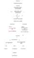
图1为本发明实施例中决策方法的流程示意图。FIG. 1 is a schematic flowchart of a decision-making method in an embodiment of the present invention.
图2为本发明实施例中决策系统结构图。Fig. 2 is a structural diagram of the decision-making system in the embodiment of the present invention.
图中:1-激光雷达传感器;2-双目相机;3-毫米波雷达传感器;4-超声波雷达传感器;5-边缘计算模块;6-can转以太网模块;7-车载工控机;8-交换机。In the figure: 1-lidar sensor; 2-binocular camera; 3-millimeter wave radar sensor; 4-ultrasonic radar sensor; 5-edge computing module; 6-can to Ethernet module; 7-vehicle industrial computer; 8- switch.
具体实施方式Detailed ways
下面结合附图对本发明的具体实施方式做简要说明。显然,所描述的实施例仅仅是本发明的一部分实施例,而不是全部实施例,基于本发明中的实施例,本领域普通技术人员在没有做出创造性劳动的前提下所获得的所有其他实施例,均属于本发明保护的范围。The specific embodiments of the present invention will be briefly described below in conjunction with the accompanying drawings. Apparently, the described embodiments are only some of the embodiments of the present invention, not all of them. Based on the embodiments of the present invention, all other implementations obtained by those skilled in the art without creative work Examples, all belong to the protection scope of the present invention.
图1-图2以单轨吊为例,对本发明进行了详细的剖析。Fig. 1-Fig. 2 has carried out detailed analysis to the present invention with monorail crane as example.
如图2所示,该决策系统包括用于采集单轨吊行驶前方区域三维点云数据的激光雷达传感器1;用于采集单轨吊行驶前方区域二维点云数据的毫米波雷达传感器3;用于采集单轨吊行驶前方区域声波距离数据的超声波雷达传感器4;用于采集单轨吊前方行驶区域景深数据与目标类别数据的双目相机2;用于井下建图与实时位置计算的边缘计算模块5;用于将超声波雷达传感器4数据、毫米波雷达传感器3数据以及边缘计算模块5定位信息从can传输方式转换为以太网传输的can转以太网模块6;用于连接双目相机2、激光雷达传感器1、can转以太网模块6和车载工控机7的交换机8;用于与交换机8直接连接,采集所有数据的车载工控机7。As shown in Figure 2, the decision-making system includes a laser radar sensor 1 for collecting three-dimensional point cloud data of the area in front of the monorail crane; a millimeter-
如图1所示,本发明另外公开的基于多源信息的井下无人驾驶车辆的决策方法,包括以下步骤:As shown in Figure 1, the decision-making method of the underground unmanned vehicle based on multi-source information disclosed by the present invention comprises the following steps:
步骤一:单轨吊上电,采集解析激光雷达传感器1、毫米波雷达传感器3、超声波雷达传感器4、双目相机2数据。这个时候解析数据是对每个传感器的数据都进行决策了,目的是后期根据环境调用不同的传感器组合时可以直接根据步骤一每个传感器决策的结果进行融合决策。Step 1: Power on the monorail crane, collect and analyze the data of lidar sensor 1, millimeter
激光雷达传感器1通过ros话题进行数据的传播,车载工控机7订阅激光雷达话题,采集点云数据;毫米波雷达传感器3通过can转以太网进行数据传播,车载工控机7利用socket通信协议解析毫米波雷达数据;超声波雷达传感器4通过can转以太网进行数据传播,车载工控机7利用socket通信协议解析超声波雷达数据;双目相机2通过以太网进行数据的传播,车载工控机7利用rtsp协议解析图像流数据。The laser radar sensor 1 transmits data through the ros topic, and the vehicle-mounted
步骤二:单轨吊开始行驶,同时判断毫米波雷达传感器3和超声波雷达传感器4信息;当毫米波雷达传感器3检测到单轨吊前方有横穿行人或横穿动态障碍物和或超声波雷达传感器4判断单轨吊前方2米内存在障碍物时,快速对单轨吊进行制动,待障碍物清除后再启动,否则单轨吊正常行驶。Step 2: The monorail crane starts to drive, and judge the information of the millimeter
步骤三:判断单轨吊车速,当车速大于2m/s时停止超声波雷达传感器4的距离监测,通过边缘计算模块5获取井下建图与实时位置计算,通过can转以太网将定位信息传输,车载工控机7利用socket通信协议解析定位数据;否则继续保持超声波雷达传感器4的距离监测。Step 3: Judging the speed of the monorail crane, when the speed is greater than 2m/s, stop the distance monitoring of the
步骤四:根据定位信息判断当前巷道环境为恶劣环境巷道还是优良环境巷道;当定位信息显示井底车场、辅助运输大巷、辅助运输上山、辅助运输下山,则判断巷道类型为优良环境巷道,通过调用双目相机2、毫米波雷达传感器3、激光雷达传感器1,采集毫米波雷达传感器3探测到的障碍物坐标位置信息、激光雷达传感器1采集到的障碍物的坐标位置信息以及双目相机2采集到的坐标位置信息与类别信息;当定位信息显示轨道运输顺槽,则判断巷道类型为恶劣环境巷道,通过调用毫米波雷达传感器3、激光雷达传感器1,采集毫米波雷达传感器3探测到的障碍物坐标位置信息与类别信息、激光雷达传感器1采集到的障碍物的坐标位置信息。Step 4: According to the positioning information, judge whether the current roadway environment is a roadway with a bad environment or a roadway with a good environment; Call
步骤五:利用公式对采集到的不同传感器感知数据进行融合:Step 5: Use the formula to fuse the collected sensory data from different sensors:
在优良环境巷道内,若存在障碍物,则设毫米波雷达传感器3探测障碍物的位置坐标为(xm,ym,zm),激光雷达传感器1探测障碍物的位置坐标为(xl,yl,zl),双目相机2探测障碍物的位置坐标为(xc,yc,zc),其中,x代表正前方方向,y代表正左方向,z代表垂直方向,以x来代表障碍物到单轨吊的距离,对激光雷达传感器1、毫米波雷达传感器3、双目相机2所监测的距离进行融合计算,若xl-xm<de且xl-xc<de,则开始进行数据融合,融合公式为:D=xlwl+xmwm+xcwc,结合双目相机2检测到的障碍物类别信息,确定前方障碍物的类别与距离;否则D=xl,确定前方障碍物的最终距离;其中,w为不同传感器对检测距离的权重,为可变参数,取值范围大于0小于1,需根据工程现场状况,实测后进行调参确定最优值;de为最大误差值,取值0.1m,D为障碍物最终距离;若未监测到障碍物,则单轨吊正常匀速行驶。In the roadway of good environment, if there is an obstacle, the position coordinates of the obstacle detected by the millimeter-
在恶劣环境巷道内,若存在障碍物,则设毫米波雷达传感器3探测障碍物的位置坐标为(xm,ym,zm),激光雷达传感器1探测障碍物的位置坐标为(xl,yl,zl),其中,x代表正前方方向,y代表正左方向,z代表垂直方向,以x来代表障碍物到单轨吊的距离,对激光雷达传感器1、毫米波雷达传感器3所监测的距离进行融合计算,若xl-xm<de,则开始进行数据融合,融合公式为:D=xlwl+xmwm,否则D=xl,确定前方障碍物的最终距离;其中,w为不同传感器对检测距离的权重,为可变参数,取值范围大于0小于1,需根据工程现场状况,实测后进行调参确定最优值;de为最大误差值,取值0.1m,D为障碍物最终距离;若未监测到障碍物,则单轨吊正常匀速行驶。In the roadway of harsh environment, if there is an obstacle, the position coordinates of the obstacle detected by the millimeter-
步骤六:根据步骤五得到的障碍物最终距离D,向单轨吊发送不同控制指令,当距离为小于2米时,单轨吊停止;当距离为2-7米时单轨吊减速运行;当距离大于7米时,单轨吊匀速运行。Step 6: According to the final obstacle distance D obtained in
步骤七:清除障碍物后,单轨吊正常匀速行驶,重复二-六持续进行障碍物监测。Step 7: After clearing the obstacles, the monorail crane runs normally and at a constant speed, and repeats 2-6 to continuously monitor obstacles.
对所公开的实施例的上述说明,使本领域专业技术人员能够实现和使用本发明。对这些实施例的多种修改方式对本领域的专业技术人员来说将是显而易见的,本文中所定义的一般原理可以在不脱离本发明的精神和范围的情况下,在其他实施例中实现。因此,本发明将不会被限制于本文所示的这些实施例,而是要符合本文所公开的原理和新颖特点相一致的最宽的范围。The above description of the disclosed embodiments will enable any person skilled in the art to make and use the invention. Various modifications to these embodiments will be readily apparent to those skilled in the art, and the general principles defined herein may be implemented in other embodiments without departing from the spirit and scope of the invention. Therefore, the present invention will not be limited to the embodiments shown herein, but is to be accorded the widest scope consistent with the principles and novel features disclosed herein.
Claims (4)
Priority Applications (3)
| Application Number | Priority Date | Filing Date | Title |
|---|---|---|---|
| CN202310065735.1ACN115981337B (en) | 2023-01-18 | 2023-01-18 | Underground unmanned vehicle decision-making system and method based on multi-source information |
| GB2408638.1AGB2629497A (en) | 2023-01-18 | 2023-12-11 | Decision-making system and method for underground unmanned vehicle based on multi-source information |
| PCT/CN2023/137757WO2024152793A1 (en) | 2023-01-18 | 2023-12-11 | Multi-source-information-based decision-making system and method for downhole unmanned vehicle |
Applications Claiming Priority (1)
| Application Number | Priority Date | Filing Date | Title |
|---|---|---|---|
| CN202310065735.1ACN115981337B (en) | 2023-01-18 | 2023-01-18 | Underground unmanned vehicle decision-making system and method based on multi-source information |
Publications (2)
| Publication Number | Publication Date |
|---|---|
| CN115981337Atrue CN115981337A (en) | 2023-04-18 |
| CN115981337B CN115981337B (en) | 2023-11-17 |
Family
ID=85972387
Family Applications (1)
| Application Number | Title | Priority Date | Filing Date |
|---|---|---|---|
| CN202310065735.1AActiveCN115981337B (en) | 2023-01-18 | 2023-01-18 | Underground unmanned vehicle decision-making system and method based on multi-source information |
Country Status (3)
| Country | Link |
|---|---|
| CN (1) | CN115981337B (en) |
| GB (1) | GB2629497A (en) |
| WO (1) | WO2024152793A1 (en) |
Cited By (6)
| Publication number | Priority date | Publication date | Assignee | Title |
|---|---|---|---|---|
| CN117308900A (en)* | 2023-11-30 | 2023-12-29 | 中国矿业大学 | Underground transport vehicle movement measurement system and carrying traffic state simulation and monitoring method |
| CN117788592A (en)* | 2024-02-26 | 2024-03-29 | 北京理工大学前沿技术研究院 | Radar point cloud processing device, method, equipment and medium for mine vehicle |
| CN118254779A (en)* | 2024-03-26 | 2024-06-28 | 理工雷科智途(北京)科技有限公司 | A vehicle-road cooperative anti-collision system for underground mine tunnel environment |
| CN118289652A (en)* | 2024-06-06 | 2024-07-05 | 山东济矿鲁能煤电股份有限公司阳城煤矿 | Unmanned system of monorail crane |
| WO2024152793A1 (en)* | 2023-01-18 | 2024-07-25 | 中国矿业大学 | Multi-source-information-based decision-making system and method for downhole unmanned vehicle |
| CN119723925A (en)* | 2025-02-25 | 2025-03-28 | 理工雷科智途(北京)科技有限公司 | A vehicle-road cooperative perception and parking method and system for an underground mine chute environment |
Families Citing this family (2)
| Publication number | Priority date | Publication date | Assignee | Title |
|---|---|---|---|---|
| CN118731925B (en)* | 2024-09-04 | 2025-01-21 | 泰安万川电器设备有限公司 | Underground coal mine vehicle positioning monitoring method and system based on ranging radar |
| CN119828683A (en)* | 2024-12-03 | 2025-04-15 | 中国煤炭科工集团太原研究院有限公司 | Intelligent unmanned mine chassis model self-adaptive updating method based on DT |
Citations (4)
| Publication number | Priority date | Publication date | Assignee | Title |
|---|---|---|---|---|
| CN111824180A (en)* | 2020-06-29 | 2020-10-27 | 安徽海博智能科技有限责任公司 | Unmanned mine car automatic driving control system with fusion obstacle avoidance function |
| CN113110434A (en)* | 2021-04-06 | 2021-07-13 | 中国矿业大学 | Cab-free underground unmanned electric locomotive and control method thereof |
| WO2021259344A1 (en)* | 2020-06-24 | 2021-12-30 | 中国第一汽车股份有限公司 | Vehicle detection method and device, vehicle, and storage medium |
| CN114841260A (en)* | 2022-04-28 | 2022-08-02 | 西安交通大学 | Mine underground multi-sensor information fusion autonomous obstacle avoidance navigation method |
Family Cites Families (2)
| Publication number | Priority date | Publication date | Assignee | Title |
|---|---|---|---|---|
| CN113002396B (en)* | 2020-04-14 | 2022-06-10 | 青岛慧拓智能机器有限公司 | A environmental perception system and mining vehicle for automatic driving mining vehicle |
| CN115981337B (en)* | 2023-01-18 | 2023-11-17 | 中国矿业大学 | Underground unmanned vehicle decision-making system and method based on multi-source information |
- 2023
- 2023-01-18CNCN202310065735.1Apatent/CN115981337B/enactiveActive
- 2023-12-11WOPCT/CN2023/137757patent/WO2024152793A1/enactivePending
- 2023-12-11GBGB2408638.1Apatent/GB2629497A/enactivePending
Patent Citations (4)
| Publication number | Priority date | Publication date | Assignee | Title |
|---|---|---|---|---|
| WO2021259344A1 (en)* | 2020-06-24 | 2021-12-30 | 中国第一汽车股份有限公司 | Vehicle detection method and device, vehicle, and storage medium |
| CN111824180A (en)* | 2020-06-29 | 2020-10-27 | 安徽海博智能科技有限责任公司 | Unmanned mine car automatic driving control system with fusion obstacle avoidance function |
| CN113110434A (en)* | 2021-04-06 | 2021-07-13 | 中国矿业大学 | Cab-free underground unmanned electric locomotive and control method thereof |
| CN114841260A (en)* | 2022-04-28 | 2022-08-02 | 西安交通大学 | Mine underground multi-sensor information fusion autonomous obstacle avoidance navigation method |
Non-Patent Citations (2)
| Title |
|---|
| DANIEL GUSLAND ET AL.: "Imaging radar for navigation and surveillance on an autonomous unmanned ground vehicle capable of detecting obstacles obscured by vegetation", 2019 IEEE RADAR CONFERENCE (RADARCONF)* |
| 宋德军等: "少人化智能煤矿掘进、辅助运输、辅助作业技术与装备", 智能矿山, vol. 3, no. 7, pages 63 - 69* |
Cited By (9)
| Publication number | Priority date | Publication date | Assignee | Title |
|---|---|---|---|---|
| WO2024152793A1 (en)* | 2023-01-18 | 2024-07-25 | 中国矿业大学 | Multi-source-information-based decision-making system and method for downhole unmanned vehicle |
| GB2629497A (en)* | 2023-01-18 | 2024-10-30 | Univ China Mining | Decision-making system and method for underground unmanned vehicle based on multi-source information |
| CN117308900A (en)* | 2023-11-30 | 2023-12-29 | 中国矿业大学 | Underground transport vehicle movement measurement system and carrying traffic state simulation and monitoring method |
| CN117308900B (en)* | 2023-11-30 | 2024-02-09 | 中国矿业大学 | Underground transport vehicle movement measurement system and carrying traffic state simulation and monitoring method |
| CN117788592A (en)* | 2024-02-26 | 2024-03-29 | 北京理工大学前沿技术研究院 | Radar point cloud processing device, method, equipment and medium for mine vehicle |
| CN117788592B (en)* | 2024-02-26 | 2024-06-07 | 北京理工大学前沿技术研究院 | Radar point cloud processing device, method, equipment and medium for mine vehicle |
| CN118254779A (en)* | 2024-03-26 | 2024-06-28 | 理工雷科智途(北京)科技有限公司 | A vehicle-road cooperative anti-collision system for underground mine tunnel environment |
| CN118289652A (en)* | 2024-06-06 | 2024-07-05 | 山东济矿鲁能煤电股份有限公司阳城煤矿 | Unmanned system of monorail crane |
| CN119723925A (en)* | 2025-02-25 | 2025-03-28 | 理工雷科智途(北京)科技有限公司 | A vehicle-road cooperative perception and parking method and system for an underground mine chute environment |
Also Published As
| Publication number | Publication date |
|---|---|
| GB2629497A (en) | 2024-10-30 |
| WO2024152793A1 (en) | 2024-07-25 |
| CN115981337B (en) | 2023-11-17 |
| GB202408638D0 (en) | 2024-07-31 |
Similar Documents
| Publication | Publication Date | Title |
|---|---|---|
| CN115981337B (en) | Underground unmanned vehicle decision-making system and method based on multi-source information | |
| CN110217225B (en) | Vehicle control device, vehicle control method, and storage medium | |
| CN110239547B (en) | Vehicle control device, vehicle control method, and storage medium | |
| CN106379319B (en) | Automobile auxiliary driving system and control method | |
| US10239539B2 (en) | Vehicle travel control method and vehicle travel control device | |
| CN112009524B (en) | System and method for tramcar obstacle detection | |
| JP2019536163A (en) | An uncontrolled intersection and a method of autonomously traveling at a controlled intersection | |
| CN108345305A (en) | Railless free-wheeled vehicle intelligent vehicle-mounted system, underground vehicle scheduling system and control method | |
| WO2020228393A1 (en) | Deep learning type intelligent driving environment perception system based on internet of things | |
| CN116811916A (en) | Automatic driving system based on 5G vehicle road cooperation | |
| JP2016533289A (en) | Adaptive cruise control with on-ramp detection | |
| CN114783170A (en) | Intelligent unmanned vehicle formation system | |
| JP2017026562A (en) | Navigation device for autonomous vehicles | |
| JPH11212640A (en) | Autonomous vehicle and method for controlling autonomous vehicle | |
| JP7043279B2 (en) | Vehicle control systems, vehicle control methods, and programs | |
| WO2021110166A1 (en) | Road structure detection method and device | |
| CN114967705A (en) | A road-vehicle fusion control method based on roadside guidance | |
| CN113002588B (en) | Train track foreign matter detection method and system | |
| CN118254779A (en) | A vehicle-road cooperative anti-collision system for underground mine tunnel environment | |
| JP2024051892A (en) | Area monitoring system and area monitoring method | |
| JP2021064056A (en) | Zebra zone recognition device, vehicle control device, zebra zone recognition method, and program | |
| CN204124125U (en) | A kind of front vehicles state of kinematic motion follows the trail of prediction unit | |
| JP2020083019A (en) | Vehicle control device, vehicle control method, and program | |
| CN114822083A (en) | Intelligent vehicle formation auxiliary control system | |
| JP2022051230A (en) | Roadside monitoring system and vehicle driving control method |
Legal Events
| Date | Code | Title | Description |
|---|---|---|---|
| PB01 | Publication | ||
| PB01 | Publication | ||
| SE01 | Entry into force of request for substantive examination | ||
| SE01 | Entry into force of request for substantive examination | ||
| GR01 | Patent grant | ||
| GR01 | Patent grant |