CN115951681A - Path search domain construction method based on rasterized 3D space path planning - Google Patents
Path search domain construction method based on rasterized 3D space path planningDownload PDFInfo
- Publication number
- CN115951681A CN115951681ACN202310032050.7ACN202310032050ACN115951681ACN 115951681 ACN115951681 ACN 115951681ACN 202310032050 ACN202310032050 ACN 202310032050ACN 115951681 ACN115951681 ACN 115951681A
- Authority
- CN
- China
- Prior art keywords
- grid
- adjacent
- free
- grid body
- adjacency
- Prior art date
- Legal status (The legal status is an assumption and is not a legal conclusion. Google has not performed a legal analysis and makes no representation as to the accuracy of the status listed.)
- Granted
Links
- 238000010276constructionMethods0.000titleclaimsdescription18
- 239000011159matrix materialSubstances0.000claimsabstractdescription41
- 230000000694effectsEffects0.000claimsabstractdescription18
- 238000004891communicationMethods0.000claimsabstractdescription11
- 238000000034methodMethods0.000abstractdescription18
- 238000004364calculation methodMethods0.000abstractdescription4
- 238000005457optimizationMethods0.000abstractdescription3
- 230000009286beneficial effectEffects0.000abstract1
- 238000012163sequencing techniqueMethods0.000abstract1
- 230000000007visual effectEffects0.000abstract1
- 238000004088simulationMethods0.000description16
- 238000010586diagramMethods0.000description5
- 238000002474experimental methodMethods0.000description5
- 238000011160researchMethods0.000description4
- 238000004422calculation algorithmMethods0.000description3
- 238000012545processingMethods0.000description3
- 230000008569processEffects0.000description2
- 230000009467reductionEffects0.000description2
- 230000009466transformationEffects0.000description2
- 230000004888barrier functionEffects0.000description1
- 238000006243chemical reactionMethods0.000description1
- 230000000052comparative effectEffects0.000description1
- 230000010339dilationEffects0.000description1
- 238000011156evaluationMethods0.000description1
- 238000013508migrationMethods0.000description1
- 230000005012migrationEffects0.000description1
- 238000012552reviewMethods0.000description1
- 230000003068static effectEffects0.000description1
- 230000008022sublimationEffects0.000description1
- 238000000859sublimationMethods0.000description1
- 238000010200validation analysisMethods0.000description1
Images


Landscapes
- Control Of Position, Course, Altitude, Or Attitude Of Moving Bodies (AREA)
- Management, Administration, Business Operations System, And Electronic Commerce (AREA)
Abstract
Description
Translated fromChinese技术领域technical field
本发明涉及路径规划技术领域,具体涉及一种基于栅格化三维空间路径规划的路径搜索域构建方法。The invention relates to the technical field of route planning, in particular to a method for constructing a route search domain based on gridded three-dimensional space route planning.
背景技术Background technique
机器人路径规划领域在路径探索时,需要正确的路径搜索域以供路径构造,大多数研究是以栅格法进行环境建模。正确的路径搜索域可以保证规划路径的安全性。目前已有的保障路径安全的方法有障碍物膨胀法,安全评估系数法。路径探索的方式有降维处理,维度转化等。In the field of robot path planning, the correct path search domain is needed for path construction during path exploration. Most of the research is based on grid method for environment modeling. The correct path search domain can ensure the security of the planned path. At present, the existing methods to ensure path safety include the obstacle expansion method and the safety evaluation coefficient method. Ways of path exploration include dimension reduction processing, dimension transformation, etc.
搜索域构建在路径规划问题解决中的重要性,如文献[1]:Zhang H Y,Lin W M,Chen A X.Path Planning for the Mobile Robot:A Review[J].Symmetry,2018,10(10).路径规划问题的解决流程,环境建模,构建搜素域,路径构造,路径优化,算法求解。栅格法环境建模,如文献[2]:KennyDaniel;AlexNash;SvenKoenig;ArielFelner.Theta*:Any-Angle Path Planning on Grids[J].Computer Science.2014.The importance of search domain construction in path planning problem solving, such as literature [1]: Zhang H Y, Lin W M, Chen A X. Path Planning for the Mobile Robot: A Review [J]. Symmetry, 2018, 10( 10). The process of solving path planning problems, environment modeling, building search domains, path construction, path optimization, and algorithm solution. Grid environment modeling, such as literature [2]: KennyDaniel; AlexNash; SvenKoenig; ArielFelner.Theta*:Any-Angle Path Planning on Grids[J].Computer Science.2014.
维度转化,如文献[3]:Chagas,Caroline1;Zacarias,Eliakim2;de Lima Silva,LuísAlvaro3;Pignaton de Freitas,Edison1.Hierarchical and smoothed topographicpath planning for large-scale virtual simulation environments.[J].ExpertSystems with Applications.2022.Dimension transformation, such as literature [3]: Chagas, Caroline1; Zacarias, Eliakim2; de Lima Silva, Luís Alvaro3; Pignaton de Freitas, Edison1.Hierarchical and smoothed topographic path planning for large-scale virtual simulation environments.[J].ExpertSystems with Applications. 2022.
障碍物膨胀法,如文献[4]:张天瑞,吴宝库,周福强.面向机器人全局路径规划的改进蚁群算法研究[J].计算机工程与应用,2022,58(1):10.Obstacle expansion method, such as literature [4]: Zhang Tianrui, Wu Baoku, Zhou Fuqiang. Research on improved ant colony algorithm for robot global path planning [J]. Computer Engineering and Application, 2022, 58(1): 10.
降维处理,如文献[5]:韩忠华,冯兴浩,吕哲,等.一种改进的无人机路径规划环境建模方法[J].信息与控制,2018,47(3):8.Dimensionality reduction processing, such as literature [5]: Han Zhonghua, Feng Xinghao, Lv Zhe, etc. An improved path planning environment modeling method for UAVs [J]. Information and Control, 2018, 47(3): 8.
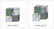
目前,就路径规划研究问题更多是二维规模,针对三维问题的研究方法基本是从二维情况迁移升华所得。并没有完全利用到三维空间宽泛的视野。且仅靠栅格活性来筛选搜索域,会出现“穿越障碍物”,“碰触障碍物”的错误路径情况,如图1和图2所示的情况。At present, most of the research problems on path planning are two-dimensional scale, and the research methods for three-dimensional problems are basically derived from the migration and sublimation of two-dimensional situations. The wide field of view of three-dimensional space is not fully utilized. And only relying on grid activity to filter the search domain, there will be wrong paths of "passing through obstacles" and "touching obstacles", as shown in Figure 1 and Figure 2.
发明内容Contents of the invention
为解决上述技术问题,本发明提供一种基于栅格化三维空间路径规划搜索的空间安全联通邻接搜索域构建方法,该方法以一个自由栅格体为中心,通过三种邻接拓展规则向外围拓展正确联通的自由栅格体构建为搜索域。三种邻接拓展规则:面邻接拓展规则、棱邻接拓展规则和点邻接拓展规则;每种邻接拓展规则包含两个判断准则;邻接位置判断准则和邻接联通关系判断准则。正确的栅格联通关系下,路径结果不会出现上述碰触障碍物的问题,可达到空间安全避障的目的。In order to solve the above-mentioned technical problems, the present invention provides a method for constructing the adjacency search domain of space safety Unicom based on gridded three-dimensional space path planning search. The method takes a free grid body as the center and expands to the periphery through three adjacency expansion rules The correctly connected free grid body is constructed as a search domain. Three kinds of adjacency expansion rules: surface adjacency expansion rule, edge adjacency expansion rule and point adjacency expansion rule; each adjacency expansion rule contains two judgment criteria: adjacency position judgment criterion and adjacency connection relationship judgment criterion. Under the correct grid connection relationship, the path result will not have the above-mentioned problem of touching obstacles, and the purpose of space safe obstacle avoidance can be achieved.
本发明采取的技术方案为:The technical scheme that the present invention takes is:
基于栅格化三维空间路径规划的路径搜索域构建方法,包括以下步骤:A path search domain construction method based on rasterized three-dimensional space path planning, comprising the following steps:
步骤一:离散化三维空间,进行栅格排序和空间定位;Step 1: discretize the three-dimensional space, perform grid sorting and spatial positioning;
步骤二:根据三维空间障碍物的分布情况,设障碍栅格活性值为Inf,自由栅格活性值为0,形成栅格地图信息矩阵field;Step 2: According to the distribution of obstacles in the three-dimensional space, set the activity value of the obstacle grid to Inf, and the activity value of the free grid to 0 to form a grid map information matrix field;
步骤三:初始化栅格联通信息矩阵N,该矩阵包含每对栅格是否安全联通的判断信息;Step 3: Initialize the grid interconnection information matrix N, which contains the judgment information whether each pair of grids is securely interconnected;
步骤四:拓展面联通邻接域,第一次更新栅格联通信息矩阵N;Step 4: expand the area to connect the adjacent domain, and update the grid connection information matrix N for the first time;
步骤五:拓展棱联通邻接域,第二次更新栅格联通信息矩阵N;Step 5: Expand the adjacent domain of edge connectivity, and update the grid connectivity information matrix N for the second time;
步骤六:拓展点联通邻接域,第三次更新栅格联通信息矩阵N;Step 6: Expand the adjacent domain of point connectivity, and update the grid connectivity information matrix N for the third time;
步骤七:根据步骤四、步骤五、步骤六更新后的栅格联通信息矩阵N,形成空间联通邻接搜索域集合D。Step 7: According to the grid connectivity information matrix N updated in
所述步骤一中,将三维空间栅格离散化,根据路径规划的精度,确立栅格的粒度和尺寸。基于空间直角坐标系,以每个栅格的中心为空间定位点,记为(xi,yi,zi),xi,yi,zi表示序号为i的栅格的空间位置基于空间直角坐标系的投影参数,先X轴增量方向,然后Y轴增量方向、最后Z轴增量方向进行栅格排序,记为i,i表示序号为i的栅格。In the first step, the three-dimensional space grid is discretized, and the granularity and size of the grid are established according to the accuracy of path planning. Based on the spatial Cartesian coordinate system, the center of each grid is used as the spatial positioning point, denoted as (xi, yi ,zi ), and xi, yi ,zi represent the spatial position of the grid with the serial number i based on The projection parameters of the spatial Cartesian coordinate system, first the X-axis incremental direction, then the Y-axis incremental direction, and finally the Z-axis incremental direction are used for grid sorting, denoted as i, and i represents the grid with the serial number i.
所述步骤二中,根据三维空间障碍物的分布情况,表达栅格活性值,当栅格i为自由栅格时,则栅格活性值为0;当栅格i为障碍栅格时,则栅格活性值为1。In the second step, according to the distribution of obstacles in three-dimensional space, the grid activity value is expressed. When grid i is a free grid, the grid activity value is 0; when grid i is an obstacle grid, then The raster activity value is 1.
所述步骤四中,确定中心栅格中心自由栅格体u(xu,yu,zu),xu,yu,zu表示序号为u的栅格的空间位置基于空间直角坐标系的投影参数,根据面邻接位置关系判断准则和面邻接联通关系判断准则,拓展面联通邻接域,第一次更新栅格联通信息矩阵N。In the fourth step, determine the free grid body u(xu , yu , zu ) of the central grid center, where xu , yu , zu represent the spatial position of the grid with the serial number u based on the spatial Cartesian coordinate system According to the projection parameters of the area adjacency position relationship judgment criterion and the area adjacency Unicom relationship judgment criterion, the area Unicom adjacency domain is expanded, and the raster Unicom information matrix N is updated for the first time.
所述步骤四中,面邻接位置关系判断准则和面邻接联通关系判断准则,具体如下:In said
S4.1:面邻接位置关系判断准则:S4.1: Judgment criteria for surface adjacency position relationship:
若未知联通自由栅格体v(xv,yv,zv)和中心自由栅格体u(xu,yu,zu),满足If the connected free grid volume v(xv ,yv ,zv ) and the central free grid volume u(xu ,yu ,zu ) are unknown, satisfy
xu-xv|+|yu-yv|+|zu-zv|=1,则自由栅格体v处于自由栅格体u的面邻接位置处;xu -xv |+|yu -yv |+|zu -zv |=1, then the free grid body v is at the adjacent position of the free grid body u;
xv,yv,zv表示序号为v的栅格的空间位置基于空间直角坐标系的三个坐标轴的投影参数;xv , yv , zv represent the projection parameters of the spatial position of the grid with serial number v based on the three coordinate axes of the spatial Cartesian coordinate system;
S4.2:面邻接联通关系判断准则:S4.2: Criteria for judging the relationship between area adjacency and China Unicom:
未知联通自由栅格体v(xv,yv,zv)处于中心自由栅格体u(xu,yu,zu)的面邻接位置处时,若field(u)=0且field(v)=0,field(u)、field(v)分别表示u、v处的栅格地图信息,则存在一个辅助栅格体w,该辅助栅格体w即为中心自由栅格体u(xu,yu,zu)自身。When the unknown connected free grid volume v(xv ,yv ,zv ) is at the adjacent position of the central free grid volume u(xu ,yu ,zu) , if field(u)=0 and field (v)=0, field(u) and field(v) represent the grid map information at u and v respectively, then there is an auxiliary grid body w, and this auxiliary grid body w is the central free grid body u (xu , yu , zu ) itself.
当NumberF-w(u,v)=1时,则N(u,v)=1,栅格联通信息矩阵N,N(u,v)表示u到v的联通关系,为“1”联通成立,NumberF-w(u,v)表示面联通辅助栅格个数;When NumberFw (u, v) = 1, then N (u, v) = 1, the grid Unicom information matrix N, N (u, v) represents the Unicom relationship from u to v, and is established for "1" Unicom, NumberFw (u, v) indicates the number of auxiliary grids connected to the area;
未知联通自由栅格体v(xv,yv,zv)和中心自由栅格体u(xu,yu,zu)的面邻接联通关系成立。The plane adjacency relationship between the unknown connected free grid volume v(xv , yv , zv ) and the central free grid volume u(xu , yu , zu ) is established.
所述步骤五中,确定中心自由栅格u(xu,yu,zu),根据棱邻接位置关系判断准则和棱邻接联通关系判断准则,拓展棱联通邻接域,第二次更新栅格联通信息矩阵N。In the fifth step, determine the center free grid u(xu , yu , zu ), expand the edge-connected adjacency domain according to the judgment criterion of the edge-adjacent position relationship and the edge-adjacent connectivity relationship, and update the grid for the second time China Unicom information matrix N.
所述步骤五中,棱位置关系判断准则和棱邻接联通关系判断准则,具体如下:In the step five, the edge position relationship judgment criterion and the edge adjacency Unicom relationship judgment criterion are as follows:
S5.1:棱邻接位置关系判断准则:S5.1: Criteria for judging edge-adjacent positional relationship:
若未知联通自由栅格体v(xv,yv,zv)和中心自由栅格体u(xu,yu,zu)邻接,满足:If the unknown connected free grid body v(xv ,yv ,zv ) is adjacent to the central free grid body u(xu ,yu ,zu ), satisfy:
条件一:|xu-xv|=1∧|yu-yv|=1∧|zu-zv|=0;Condition 1: |xu -xv |=1∧|yu -yv |=1∧|zu -zv |=0;
条件二:|xu-xv|=1∧|yu-yv|=0∧|zu-zv|=1;Condition 2: |xu -xv |=1∧|yu -yv |=0∧|zu -zv |=1;
条件三:|xu-xv|=0∧|yu-yv|=1∧|zu-zv|=1,之一,Condition 3: |xu -xv |=0∧|yu -yv |=1∧|zu -zv |=1, one of
则未知联通自由栅格体v(xv,yv,zv)处于中心自由栅格体u(xu,yu,zu)的棱邻接位置处。Then the unknown connected free grid body v(xv , yv , zv ) is at the edge-adjacent position of the central free grid body u(xu , yu , zu ).
S5.2:棱邻接联通关系判断准则:S5.2: Criteria for judging edge-adjacent connection relationship:
未知联通自由栅格体v(xv,yv,zv)在中心自由栅格体u(xu,yu,zu)的棱拓展栅格位置处时,若满足栅格体w同时是中心自由栅格体u(xu,yu,zu)和未知联通自由栅格体v(xv,yv,zv)的面邻接栅格,则栅格体w是一个辅助栅格体。NumberE-w(u,v)表示棱联通辅助栅格个数;当NumberE-w(u,v)=2,则N(u,v)=1,未知联通自由栅格体v(xv,yv,zv)与中心自由栅格体u(xu,yu,zu)的棱邻接联通关系成立。When the unknown connected free grid body v(xv , yv , zv ) is at the grid position of the edge expansion grid of the central free grid body u(xu , yu , zu ), if the grid body w is satisfied at the same time is the adjacent grid of the central free grid body u(xu ,yu ,zu ) and the unknown connected free grid body v(xv ,yv ,zv ), then the grid body w is an auxiliary grid Grid. NumberEw (u, v) indicates the number of edge-connected auxiliary grids; when NumberEw (u, v) = 2, then N(u, v) = 1, the unknown Unicom free grid body v(xv , yv , zv ) and the central free grid u(xu , yu , zu ) are established.
所述步骤六中,确定中心栅格中心自由栅格体u(xu,yu,zu),根据点邻接位置关系判断准则和点邻接联通关系判断准则,拓展点联通邻接域,第三次更新栅格联通信息矩阵N。In the sixth step, determine the free grid body u(xu , yu , zu ) of the center grid, and expand the point-connected adjacency domain according to the judging criterion of the point-adjacent position relationship and the judging criterion of the point-adjacent Unicom relationship, and the third Update grid connectivity information matrix N for the second time.
所述步骤六中,点邻接位置关系判断准则和点邻接联通关系判断准则具体如下:In said step six, the criteria for judging the point-adjacent positional relationship and the judging criterion for the point-adjacent Unicom relationship are as follows:
S6.1:点邻接位置关系判断准则:S6.1: Judgment criteria for point adjacency position relationship:
若未知联通自由栅格体v(xv,yv,zv)在中心自由栅格体u(xu,yu,zu),满足If the unknown connected free grid v(xv ,yv ,zv ) is in the central free grid u(xu ,yu ,zu ), satisfy
xu-xv|=1∧|yu-yv|=1∧|zu-zv|=1,则未知联通自由栅格体v(xv,yv,zv)处于中心自由栅格体u(xu,yu,zu)的点邻接位置处;xu -xv |=1∧|yu -yv |=1∧|zu -zv |=1, then the unknown connected free grid v(xv ,yv ,zv ) is in the center free The points adjacent to the grid body u(xu , yu , zu );
S6.2:点邻接联通关系判断准则:S6.2: Criteria for judging point adjacency Unicom relationship:
未知联通自由栅格体v(xv,yv,zv)在中心自由栅格体u(xu,yu,zu)的点邻接位置处时。若满足栅格体w同时是中心自由栅格体u(xu,yu,zu)的棱邻接栅格和未知联通自由栅格体v(xv,yv,zv)的面邻接栅格,则栅格体w是一个辅助栅格体。NumberP-w(u,v)表示点联通辅助栅格个数;当NumberP-w(u,v)=3时,N(u,v)=1,未知联通自由栅格体v(xv,yv,zv)与中心自由栅格体u(xu,yu,zu)的点邻接联通关系成立。When the unknown connected free-grid body v(xv ,yv ,zv ) is at the point-adjacent position of the central free-grid body u(xu ,yu ,zu) . If it is satisfied that the grid w is adjacent to the edge of the central free grid u(xu , yu ,zu ) and the face adjacent to the unknown connected free grid v(xv , yv , zv ) grid, then the grid body w is an auxiliary grid body. NumberPw (u, v) indicates the number of point-connected auxiliary grids; when NumberPw (u, v) = 3, N(u, v) = 1, the unknown Unicom free grid body v(xv , yv , zv ) and the central free grid u(xu , yu , zu ) have a point-adjacent connectivity relationship established.
所述步骤七中,汇总步骤四、步骤五、步骤六更新后的栅格联通信息矩阵N,形成空间联通邻接搜索域集合D。In said step seven, the grid connectivity information matrix N updated in steps four, five, and six is aggregated to form a set D of spatially connected adjacent search domains.
本发明一种基于栅格化三维空间路径规划的路径搜索域构建方法,技术效果如下:The present invention is a method for constructing a path search domain based on gridded three-dimensional space path planning, and the technical effects are as follows:
1)本发明基于空间安全联通邻接搜索域构建方法,运用于路径规划问题路径构造环节,保证空间安全联通的思路,可以筛选出无碰撞静态障碍物的自由搜索空间。1) The present invention is based on the construction method of the adjacency search domain of space security communication, which is applied to the path construction link of the path planning problem, and the idea of ensuring space security communication can screen out the free search space without collision static obstacles.
2)本发明以一个栅格为中心,按照空间的连接关系向外围拓展搜索域,可以实现实质意义的空间搜索,扩大搜索视野,减小路径规划计算的压力,利于后续的路径优化。2) The present invention takes a grid as the center and expands the search domain to the periphery according to the spatial connection relationship, which can realize substantial spatial search, expand the search field of view, reduce the pressure of path planning and calculation, and facilitate subsequent path optimization.
附图说明Description of drawings
下面结合附图和实施例对本发明作进一步说明:Below in conjunction with accompanying drawing and embodiment the present invention will be further described:
图1为背景技术中所述的“穿越”型联通错误示意图。FIG. 1 is a schematic diagram of the "pass through" type of Unicom errors described in the background art.
图2为背景技术中所述的“碰触”型联通错误示意图。FIG. 2 is a schematic diagram of the "touch" type of communication error described in the background art.
图3为无障碍影响下,应用面拓展规则所得空间安全联通邻接搜索域的仿真结果图。Figure 3 is the simulation result of the space security Unicom adjacency search domain obtained by applying the surface expansion rule under the influence of barrier-free.
图4为无障碍影响下,应用棱拓展规则所得空间安全联通邻接搜索域的仿真结果图。Fig. 4 is the simulation result of the adjacency search domain of the space security Unicom obtained by applying the edge expansion rule under the influence of barrier-free.
图5为无障碍影响下,应用点拓展规则所得空间安全联通邻接搜索域的仿真结果图。Fig. 5 is a simulation result diagram of the adjacency search domain of the space security Unicom obtained by applying the point expansion rule under the influence of barrier-free.
图6为无障碍影响下,应用面-棱-点拓展规则所得空间安全联通邻接搜索域的仿真结果图。Fig. 6 is the simulation result of the adjacency search domain of the space security Unicom obtained by applying the surface-edge-point expansion rule under the influence of barrier-free.
图7为本发明的流程示意图。Fig. 7 is a schematic flow chart of the present invention.
图8为栅格化实验用仿真环境示意图。FIG. 8 is a schematic diagram of a simulation environment for rasterization experiments.
具体实施方式Detailed ways
如图7所示,基于栅格化三维空间路径规划的路径搜索域构建方法,包括以下步骤:As shown in Figure 7, the path search domain construction method based on rasterized three-dimensional space path planning includes the following steps:
步骤一:离散化三维空间,进行栅格排序和空间定位;Step 1: discretize the three-dimensional space, perform grid sorting and spatial positioning;
步骤二:根据三维空间障碍物的分布情况,设障碍栅格活性值为Inf,自由栅格活性值为0,形成栅格地图信息矩阵field;Step 2: According to the distribution of obstacles in the three-dimensional space, set the activity value of the obstacle grid to Inf, and the activity value of the free grid to 0 to form a grid map information matrix field;
步骤三:初始化栅格联通信息矩阵N,该矩阵包含每对栅格是否安全联通的判断信息;Step 3: Initialize the grid interconnection information matrix N, which contains the judgment information whether each pair of grids is securely interconnected;
步骤四:拓展面联通邻接域,第一次更新栅格联通信息矩阵N;Step 4: expand the area to connect the adjacent domain, and update the grid connection information matrix N for the first time;
步骤五:拓展棱联通邻接域,第二次更新栅格联通信息矩阵N;Step 5: Expand the adjacent domain of edge connectivity, and update the grid connectivity information matrix N for the second time;
步骤六:拓展点联通邻接域,第三次更新栅格联通信息矩阵N;Step 6: Expand the adjacent domain of point connectivity, and update the grid connectivity information matrix N for the third time;
步骤七:根据步骤四、步骤五、步骤六更新后的栅格联通信息矩阵N,形成空间联通邻接搜索域集合D。Step 7: According to the grid connectivity information matrix N updated in
步骤一中:将水下工作空间B×E×F用单个栅格尺寸进行离散化,形成b*e*f的立方栅格域。其中,b行数,e列数,f层数,式(1)中,ceil(·)为向上取整操作。Step 1: discretize the underwater workspace B×E×F with a single grid size to form a cubic grid domain of b*e*f. Among them, the number of rows in b, the number of columns in e, and the number of layers in f, in formula (1), ceil( ) is an upward rounding operation.

令栅格序号i等于代表该位置通行情况矩阵参数的索引值。序号i与栅格中心点坐标(xi,yi,zi)的转化公式,如式(2)所示:Let the grid number i be equal to the index value of the matrix parameter representing the traffic situation at this location. The conversion formula between serial number i and grid center point coordinates (xi,y , zi) is shown in formula (2):

式(2)中:i为栅格体序号;xi,yi,zi是其三维空间直角坐标系参数;Mod(·)是取余操作;Floor(·)是向下取整操作。In formula (2): i is the serial number of the grid body; xi , yi ,zi are the parameters of its three-dimensional space Cartesian coordinate system; Mod(·) is the remainder operation; Floor(·) is the rounding down operation.
步骤二中:汇总障碍物分布情况,设障碍栅格活性值为Inf,自由栅格活性值为0。形成栅格地图信息矩阵field。Step 2: Summarize the distribution of obstacles, set the activity value of the obstacle grid as Inf, and set the activity value of the free grid as 0. Form the grid map information matrix field.
步骤三中:初始化栅格联通信息矩阵N,矩阵包含每对栅格是否安全联通的判断信息;In Step 3: Initialize grid connectivity information matrix N, the matrix contains information for judging whether each pair of grids is securely connected;
步骤四中:确定中心栅格中心自由栅格体u(xu,yu,zu),xu,yu,zu分别表示序号为u的栅格的空间位置基于空间直角坐标系的三个坐标轴的投影参数,根据面邻接位置关系判断准则和面邻接联通关系判断准则,拓展面联通邻接域,第一次更新栅格联通信息矩阵N。Step 4: Determine the free grid body u(xu , yu , zu ) in the center of the central grid, xu , yu , zu represent the spatial position of the grid with the serial number u respectively based on the spatial Cartesian coordinate system For the projection parameters of the three coordinate axes, according to the judging criteria of the plane adjacency position relationship and the judging criterion of the plane adjacency Unicom relationship, the plane Unicom adjacency domain is expanded, and the raster Unicom information matrix N is updated for the first time.
所述步骤四中,面邻接位置关系判断准则和面邻接联通关系判断准则,具体如下:In said
S4.1:面邻接位置关系判断准则:S4.1: Judgment criteria for surface adjacency position relationship:
若未知联通自由栅格体v(xv,yv,zv)和中心自由栅格体u(xu,yu,zu),满足|xu-xv|+|yu-yv|+|zu-zv|=1,则自由栅格体v处于自由栅格体u的面邻接位置处;If the connected free grid body v(xv ,yv ,zv ) and the central free grid body u(xu ,yu ,zu ) are unknown, satisfy |xu -xv |+|yu -yv |+|zu -zv |=1, then the free grid body v is at the adjacent position of the free grid body u;
xv,yv,zv表示序号为v的栅格的空间位置基于空间直角坐标系的三个坐标轴的投影参数;xv , yv , zv represent the projection parameters of the spatial position of the grid with serial number v based on the three coordinate axes of the spatial Cartesian coordinate system;
S4.2:面邻接联通关系判断准则:S4.2: Criteria for judging the relationship between area adjacency and China Unicom:
未知联通自由栅格体v(xv,yv,zv)处于中心自由栅格体u(xu,yu,zu)的面邻接位置处时,若field(u)=0且field(v)=0,field(u)、field(v)分别表示u、v处的栅格地图信息;则存在一个辅助栅格体w,该辅助栅格体w即为中心自由栅格体u(xu,yu,zu)自身。When the unknown connected free grid volume v(xv ,yv ,zv ) is at the adjacent position of the central free grid volume u(xu ,yu ,zu) , if field(u)=0 and field (v)=0, field(u) and field(v) represent the grid map information at u and v respectively; then there is an auxiliary grid body w, and this auxiliary grid body w is the central free grid body u (xu , yu , zu ) itself.
NumberF-w(u,v)表示面联通辅助栅格个数,N(u,v)代表u到v的联通关系,为“1”联通成立;当NumberF-w(u,v)=1时,则N(u,v)=1;未知联通自由栅格体v(xv,yv,zv)和中心自由栅格体u(xu,yu,zu)的面邻接联通关系成立。面邻接联通判断辅助点个数记为NumberF-w(u,v)。NumberFw (u, v) represents the number of connected auxiliary grids, and N(u, v) represents the connection relationship from u to v, which is established for "1"; when NumberFw (u, v) = 1, then N(u,v)=1; the plane adjacency connection relationship between the unknown connected free grid volume v(xv ,yv ,zv ) and the central free grid volume u(xu ,yu ,zu) is established. The number of auxiliary points for judging the plane adjacency and Unicom connection is recorded as NumberFw (u, v).
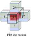
图3为无障碍影响下,应用面拓展规则所得空间安全联通邻接搜索域的仿真结果图。图3中,理想条件下以红色栅格“14”为中心栅格,应用面拓展规则拓展出的安全联通的各面邻接栅格构成的空间联通域。空间定位准则在实现了空间搜索路径的视野,空间联通准则校验了空间联通的安全性,从图3中可看出产生了6个方向选择。Figure 3 is the simulation result of the space security Unicom adjacency search domain obtained by applying the surface expansion rule under the influence of barrier-free. In Figure 3, under ideal conditions, the red grid "14" is the central grid, and the spatial connectivity domain formed by the adjacent grids on each side of the safe communication expanded by the application of the surface expansion rule. The spatial positioning criterion realizes the vision of the space search path, and the spatial connectivity criterion verifies the security of the spatial connectivity. It can be seen from Figure 3 that six directions are selected.
所述步骤五中,确定中心自由栅格u(xu,yu,zu),根据棱邻接位置关系判断准则和棱邻接联通关系判断准则,拓展棱联通邻接域,第二次更新栅格联通信息矩阵N。In the fifth step, determine the center free grid u(xu , yu , zu ), expand the edge-connected adjacency domain according to the judgment criterion of the edge-adjacent position relationship and the edge-adjacent connectivity relationship, and update the grid for the second time China Unicom information matrix N.
所述步骤五中,棱位置关系判断准则和棱邻接联通关系判断准则,具体如下:In the step five, the edge position relationship judgment criterion and the edge adjacency Unicom relationship judgment criterion are as follows:
S5.1:棱邻接位置关系判断准则:S5.1: Criteria for judging edge-adjacent positional relationship:
若未知联通自由栅格体v(xv,yv,zv)和中心自由栅格体u(xu,yu,zu)邻接,满足:If the unknown connected free grid body v(xv ,yv ,zv ) is adjacent to the central free grid body u(xu ,yu ,zu ), satisfy:
条件一:|xu-xv|=1∧|yu-yv|=1∧|zu-zv|=0;Condition 1: |xu -xv |=1∧|yu -yv |=1∧|zu -zv |=0;
条件二:|xu-xv|=1∧|yu-yv|=0∧|zu-zv|=1;Condition 2: |xu -xv |=1∧|yu -yv |=0∧|zu -zv |=1;
条件三:|xu-xv|=0∧|yu-yv|=1∧|zu-zv|=1,之一,Condition 3: |xu -xv |=0∧|yu -yv |=1∧|zu -zv |=1, one of
则未知联通自由栅格体v(xv,yv,zv)处于中心自由栅格体u(xu,yu,zu)的棱邻接位置处。Then the unknown connected free grid body v(xv , yv , zv ) is at the edge-adjacent position of the central free grid body u(xu , yu , zu ).
S5.2:棱邻接联通关系判断准则:S5.2: Criteria for judging edge-adjacent connection relationship:
未知联通自由栅格体v(xv,yv,zv)在中心自由栅格体u(xu,yu,zu)的棱拓展栅格位置处时,若满足栅格体w同时是中心自由栅格体u(xu,yu,zu)和未知联通自由栅格体v(xv,yv,zv)的面邻接栅格,则栅格体w是一个辅助栅格体。When the unknown connected free grid body v(xv , yv , zv ) is at the grid position of the edge expansion grid of the central free grid body u(xu , yu , zu ), if the grid body w is satisfied at the same time is the adjacent grid of the central free grid body u(xu ,yu ,zu ) and the unknown connected free grid body v(xv ,yv ,zv ), then the grid body w is an auxiliary grid Grid.
N(u,v)代表u到v的联通关系,为“1”联通成立;N(u,v) represents the Unicom relationship from u to v, which is established for "1" Unicom;
当NumberE-w(u,v)=2,则N(u,v)=1,未知联通自由栅格体v(xv,yv,zv)与中心自由栅格体u(xu,yu,zu)的棱邻接联通关系成立。棱邻接联通判断辅助点个数NumberE-w(u,v)。When NumberEw (u,v)=2, then N(u,v)=1, the unknown Unicom free grid body v(xv ,yv ,zv ) and the central free grid body u(xu ,yu , zu ) The edge-adjacent connectivity relationship is established. NumberEw (u,v) of auxiliary points for edge-adjacent Unicom judgment.
图4为无障碍影响下,应用棱拓展规则所得空间安全联通邻接搜索域的仿真结果图。图4中,理想条件下以红色栅格“14”为中心栅格,应用棱拓展规则拓展出的安全联通的各棱邻接栅格构成的空间联通域。空间定位准则在实现了空间搜索路径的视野,空间联通准则校验了空间联通的安全性,从图4中可看出产生了12个方向选择。Fig. 4 is the simulation result of the adjacency search domain of the space security Unicom obtained by applying the edge expansion rule under the influence of barrier-free. In Figure 4, under ideal conditions, the red grid "14" is the central grid, and the spatial connectivity domain formed by the adjacent grids of each edge of security communication is expanded by applying the edge expansion rule. The spatial positioning criterion realizes the vision of the spatial search path, and the spatial connectivity criterion verifies the security of the spatial connectivity. It can be seen from Figure 4 that 12 directions are selected.
所述步骤六中,确定中心栅格中心自由栅格体u(xu,yu,zu),根据点邻接位置关系判断准则和点邻接联通关系判断准则,拓展点联通邻接域,第三次更新栅格联通信息矩阵N。In the sixth step, determine the free grid body u(xu , yu , zu ) of the center grid, and expand the point-connected adjacency domain according to the judging criterion of the point-adjacent position relationship and the judging criterion of the point-adjacent Unicom relationship, and the third Update grid connectivity information matrix N for the second time.
所述步骤六中,点邻接位置关系判断准则和点邻接联通关系判断准则具体如下:In said step six, the criteria for judging the point-adjacent positional relationship and the judging criterion for the point-adjacent Unicom relationship are as follows:
S6.1:点邻接位置关系判断准则:S6.1: Judgment criteria for point adjacency position relationship:
若未知联通自由栅格体v(xv,yv,zv)在中心自由栅格体u(xu,yu,zu),满足If the unknown connected free grid v(xv ,yv ,zv ) is in the central free grid u(xu ,yu ,zu ), satisfy
xu-xv|=1∧|yu-yv|=1∧|zu-zv|=1,则未知联通自由栅格体v(xv,yv,zv)处于中心自由栅格体u(xu,yu,zu)的点邻接位置处;xu -xv |=1∧|yu -yv |=1∧|zu -zv |=1, then the unknown connected free grid v(xv ,yv ,zv ) is in the center free The points adjacent to the grid body u(xu , yu , zu );
S6.2:点邻接联通关系判断准则:S6.2: Criteria for judging point adjacency Unicom relationship:
未知联通自由栅格体v(xv,yv,zv)在中心自由栅格体u(xu,yu,zu)的点邻接位置处时。若满足栅格体w同时是中心自由栅格体u(xu,yu,zu)的棱邻接栅格和未知联通自由栅格体v(xv,yv,zv)的面邻接栅格,则栅格体w是一个辅助栅格体。NumberP-w(u,v)表示点联通辅助栅格个数,N(u,v)代表u到v的联通关系,为“1”联通成立;当NumberP-w(u,v)=3时,N(u,v)=1,未知联通自由栅格体v(xv,yv,zv)与中心自由栅格体u(xu,yu,zu)的点邻接联通关系成立。点邻接联通判断辅助点个数NumberP-w(u,v)。When the unknown connected free-grid body v(xv ,yv ,zv ) is at the point-adjacent position of the central free-grid body u(xu ,yu ,zu) . If it is satisfied that the grid w is adjacent to the edge of the central free grid u(xu , yu ,zu ) and the face adjacent to the unknown connected free grid v(xv , yv , zv ) grid, then the grid body w is an auxiliary grid body. NumberPw (u, v) indicates the number of point-connected auxiliary grids, and N(u, v) represents the connection relationship between u and v, which is established for "1"; when NumberPw (u, v)=3, N (u,v)=1, the point adjacency connection relationship between the unknown connected free grid volume v(xv ,yv ,zv ) and the central free grid volume u(xu ,yu ,zu) is established. NumberPw (u,v) of auxiliary points for judging point adjacency and Unicom.
图5为无障碍影响下,应用点拓展规则所得空间安全联通邻接搜索域的仿真结果图。图5中,理想条件下以红色栅格“14”为中心栅格,应用点拓展规则拓展出的安全联通的各点邻接栅格构成的空间联通域。空间定位准则在实现了空间搜索路径的视野,空间联通准则校验了空间联通的安全性,从图5中可看出产生了8个方向选择。Fig. 5 is a simulation result diagram of the adjacency search domain of the space security Unicom obtained by applying the point expansion rule under the influence of barrier-free. In Figure 5, under ideal conditions, the red grid "14" is the central grid, and the application of the point expansion rule expands the spatial connectivity domain formed by the adjoining grids of each point of security connectivity. The spatial positioning criterion realizes the vision of the spatial search path, and the spatial connectivity criterion verifies the security of the spatial connectivity. It can be seen from Figure 5 that eight directions are selected.
所述步骤七中,汇总步骤四、步骤五、步骤六更新后的栅格联通信息矩阵N,形成空间联通邻接搜索域集合D。In said step seven, the grid connectivity information matrix N updated in steps four, five, and six is aggregated to form a set D of spatially connected adjacent search domains.
图6为无障碍影响下,应用面-棱-点拓展规则所得空间安全联通邻接搜索域的仿真结果图。图6中,理想条件下以红色栅格“14”为中心栅格,应用面-棱-点拓展规则拓展出的安全联通的所有邻接栅格构成的空间联通域。空间定位准则在实现了空间搜索路径的视野,空间联通准则校验了空间联通的安全性,从图6中可看出产生了26个方向选择。Fig. 6 is the simulation result of the adjacency search domain of the space security Unicom obtained by applying the surface-edge-point expansion rule under the influence of barrier-free. In Figure 6, under ideal conditions, the red grid "14" is the central grid, and the spatial connectivity domain formed by all the adjacent grids of safe communication is expanded by applying the surface-edge-point expansion rule. The spatial positioning criterion realizes the vision of the spatial search path, and the spatial connectivity criterion verifies the security of the spatial connectivity. It can be seen from Figure 6 that 26 directions are selected.
实施例:Example:
该方法的具体实施依靠计算机的数学计算,选择Matlabb2017为运行环境。在连接关系判断中嵌套了辅助栅格点的位置关系判断和连接关系判断。因此为避免计算的繁冗,该方法的实施分为三个阶段:第一阶段-面拓展阶段,第二阶段-点拓展阶段和第三阶段-棱拓展阶段。上一阶段的结果也是下一阶段的输入。The specific implementation of this method relies on the mathematical calculation of the computer, and Matlabb2017 is selected as the operating environment. The location relationship judgment and connection relationship judgment of auxiliary grid points are nested in the connection relationship judgment. Therefore, in order to avoid the cumbersome calculation, the implementation of this method is divided into three stages: the first stage-surface expansion stage, the second stage-point expansion stage and the third stage-edge expansion stage. The result of the previous stage is also the input of the next stage.
实施流程:Implementation process:
设:中心自由栅格体u(xu,yu,zu),未知联通自由栅格体v(xv,yv,zv),N(u,v)记录两栅格体的联通关系,MM是栅格总数。Assume: the central free grid body u(xu ,yu ,zu ), the unknown connected free grid body v(xv ,yv ,zv ), N(u,v) records the connection between the two grid bodies relation, MM is the total number of rasters.
第一阶段-面拓展阶段的实施步骤如下:The implementation steps of the first stage - surface expansion stage are as follows:
步骤1-1.根据面拓展阶段位置关系判断准则,标记中心自由栅格体u(xu,yu,zu)的面拓展栅格位置处未知联通自由栅格体v(xv,yv,zv);Step 1-1. According to the positional relationship judgment criterion in the area expansion stage, mark the unknown connected free grid body v(x v ,y) at the area expansion grid positionof the central free grid body u(xu ,yu ,zuv , zv );
步骤1-2.根据面拓展阶段连接关系判断准则,判断未知联通自由栅格体v(xv,yv,zv)与中心自由栅格体u(xu,yu,zu)的连接关系,更新,;Step 1-2. According to the criteria for judging the connection relationship in the area expansion stage, judge the relationship between the unknown connected free grid body v(xv ,yv ,zv ) and the central free grid body u(xu ,yu ,zu) connect relationship, update,;
步骤1-3.判断,的值是否为0;Step 1-3. Determine whether the value of is 0;
步骤1-4.若,不为0。连接关系成立,计算未知联通自由栅格体v(xv,yv,zv)到中心自由栅格体u(xu,yu,zu)的距离,保存至,。否则到步骤1-5;Steps 1-4. If, is not 0. When the connection relationship is established, calculate the distance from the unknown connected free grid body v(xv ,yv ,zv ) to the central free grid body u(xu ,yu ,zu) , and save it to . Otherwise go to steps 1-5;
步骤1-5.令v=v+1,如果v<=MM,则转至步骤1-2,否则到步骤1-6;Step 1-5. Make v=
步骤1-6.令=+1,如果<=MM,则转至步骤1-1,否则本阶段结束。Step 1-6. Let=+1, if <=MM, go to step 1-1, otherwise this stage ends.
第二阶段-棱拓展阶段的实施步骤如下:The implementation steps of the second stage-edge expansion stage are as follows:
步骤2-1.根据棱拓展阶段位置关系判断准则,标记中心自由栅格体u(xu,yu,zu)的棱拓展栅格位置处未知联通自由栅格体v(xv,yv,zv);Step 2-1. According to thecriterion for judging theposition relationship in the edge expansion stage, mark the unknown connected free grid body v(xv , yv , zv );
步骤2-2.根据棱拓展阶段连接关系判断准则,判断未知联通自由栅格体v(xv,yv,zv)与中心自由栅格体u(xu,yu,zu)的连接关系,更新,;Step 2-2. According to the judgment criterion of the connection relationship in the edge expansion stage, judge the connection between the unknown connected free grid body v(xv ,yv ,zv ) and the central free grid body u(xu ,yu ,zu) connect relationship, update,;
步骤2-3.判断,的值是否为0;Step 2-3. Determine whether the value of is 0;
步骤2-4.若,不为0。连接关系成立,计算未知联通自由栅格体v(xv,yv,zv)到中心自由栅格体u(xu,yu,zu)的距离,保存至,。否则到步骤2-5;Step 2-4. If, is not 0. When the connection relationship is established, calculate the distance from the unknown connected free grid body v(xv ,yv ,zv ) to the central free grid body u(xu ,yu ,zu) , and save it to . Otherwise go to steps 2-5;
步骤2-5.令v=v+1,如果v<=MM,则转至步骤2-2,否则到步骤2-6;Step 2-5. Make v=
步骤2-6.令=+1,如果<=MM,则转至步骤2-1,否则本阶段结束。Step 2-6. Let=+1, if <=MM, go to step 2-1, otherwise this stage ends.
第三阶段-点拓展阶段的实施步骤如下:The implementation steps of the third stage-point expansion stage are as follows:
步骤3-1.根据点拓展阶段位置关系判断准则,标记中心自由栅格体u(xu,yu,zu)的点拓展栅格位置处未知联通自由栅格体v(xv,yv,zv);Step 3-1. According to the criterion for judgingthe location relationshipin the point expansion stage, mark the unknown connected free grid body v(xv , yv , zv );
步骤3-2.根据点拓展阶段连接关系判断准则,判断未知联通自由栅格体v(xv,yv,zv)与中心自由栅格体u(xu,yu,zu)的连接关系,更新,;Step 3-2. According to the criteria for judging the connection relationship in the point expansion stage, judge the relationship between the unknown connected free grid body v(xv ,yv ,zv ) and the central free grid body u(xu ,yu ,zu) connect relationship, update,;
步骤3-3.判断,的值是否为0;Step 3-3. Determine whether the value of is 0;
步骤3-4.若,不为0。连接关系成立,计算未知联通自由栅格体v(xv,yv,zv)到中心自由栅格体u(xu,yu,zu)的距离,保存至,。否则到步骤3-5;Step 3-4. If, is not 0. When the connection relationship is established, calculate the distance from the unknown connected free grid body v(xv ,yv ,zv ) to the central free grid body u(xu ,yu ,zu) , and save it to . Otherwise go to step 3-5;
步骤3-5.令v=v+1,如果v<=MM,则转至步骤3-2,否则到步骤3-6;Step 3-5. Make v=
步骤3-6.令=+1,如果<=MM,则转至步骤3-1,否则本阶段结束。Step 3-6. Let=+1, if <=MM, go to step 3-1, otherwise this stage ends.
验证分析:Validation analysis:
栅格化实验用三维水下环境,环境中有1000个路径遍历点,环境规模为10*10*10,如图8所示。基于仿真环境,应用基本蚁群算法做两例仿真实验:The grid experiment uses a three-dimensional underwater environment. There are 1000 path traversal points in the environment, and the environment scale is 10*10*10, as shown in Figure 8. Based on the simulation environment, apply the basic ant colony algorithm to do two simulation experiments:
仿真实验I组:实施膨胀物障碍处理分平面搜索;Simulation experiment group I: implement split-plane search for swell obstacle processing;
仿真实验Ⅱ组:本发明构建的搜索域。Simulation experiment group II: the search domain constructed by the present invention.
表1仿真实验I组、Ⅱ组仿真结果对比表Table 1 Comparison table of simulation results of simulation experiment group I and group II
从上表1结果分析,两种策略的实施均满足了路径规划AUVA安全航行的基本要求。空间联通邻接域搜索策略,避免了环境建模中不必要的障碍物设置,保证了路径搜索可遍历空间的规模,为最优解创造了更大的解集空间,路径搜索成功比例提高了3%。两组实验路径长度结果差异不大,但实施本发明策略的实验结果,路径转折次数从19次直降到15次,路径曲折度减缓了21.05%,所得到的路径结果适应性明显优于对比组。可见本发明设计的基于栅格化三维空间路径规划搜索的空间安全联通邻接搜索域构建方法,具有明显的合理性和优越性,更助于符合AUV运动学特性的平滑路径规划。From the analysis of the results in Table 1 above, the implementation of the two strategies both meet the basic requirements for path planning AUVA safe navigation. The space-communication adjacent domain search strategy avoids unnecessary obstacle setting in environment modeling, ensures the scale of the path search traversable space, creates a larger solution set space for the optimal solution, and increases the success ratio of path search by 3 %. There is little difference in the path length results of the two groups of experiments, but the experimental results of implementing the strategy of the present invention, the number of path turning times has been reduced from 19 to 15, and the path tortuosity has been slowed down by 21.05%. The adaptability of the obtained path results is obviously better than that of the comparison Group. It can be seen that the method for constructing the space security Unicom adjacency search domain based on the gridded three-dimensional space path planning search designed by the present invention has obvious rationality and superiority, and is more conducive to smooth path planning that conforms to the AUV kinematics characteristics.
Claims (10)
Translated fromChinesePriority Applications (1)
| Application Number | Priority Date | Filing Date | Title |
|---|---|---|---|
| CN202310032050.7ACN115951681B (en) | 2023-01-10 | 2023-01-10 | Path search domain construction method based on rasterized three-dimensional space path planning |
Applications Claiming Priority (1)
| Application Number | Priority Date | Filing Date | Title |
|---|---|---|---|
| CN202310032050.7ACN115951681B (en) | 2023-01-10 | 2023-01-10 | Path search domain construction method based on rasterized three-dimensional space path planning |
Publications (2)
| Publication Number | Publication Date |
|---|---|
| CN115951681Atrue CN115951681A (en) | 2023-04-11 |
| CN115951681B CN115951681B (en) | 2024-03-15 |
Family
ID=87282420
Family Applications (1)
| Application Number | Title | Priority Date | Filing Date |
|---|---|---|---|
| CN202310032050.7AActiveCN115951681B (en) | 2023-01-10 | 2023-01-10 | Path search domain construction method based on rasterized three-dimensional space path planning |
Country Status (1)
| Country | Link |
|---|---|
| CN (1) | CN115951681B (en) |
Cited By (1)
| Publication number | Priority date | Publication date | Assignee | Title |
|---|---|---|---|---|
| CN118051035A (en)* | 2024-04-15 | 2024-05-17 | 山东大学 | A multi-AGV scheduling method based on local range vision reinforcement learning |
Citations (10)
| Publication number | Priority date | Publication date | Assignee | Title |
|---|---|---|---|---|
| CN107806877A (en)* | 2017-10-11 | 2018-03-16 | 湖北工业大学 | A kind of trajectory planning optimization method of four rotor wing unmanned aerial vehicles based on ant group algorithm |
| CN108413963A (en)* | 2018-02-12 | 2018-08-17 | 淮安信息职业技术学院 | Bar-type machine people's paths planning method based on self study ant group algorithm |
| WO2020134082A1 (en)* | 2018-12-28 | 2020-07-02 | 歌尔股份有限公司 | Path planning method and apparatus, and mobile device |
| CN111707269A (en)* | 2020-06-23 | 2020-09-25 | 东南大学 | A method of UAV path planning in 3D environment |
| CN111880534A (en)* | 2020-07-17 | 2020-11-03 | 桂林电子科技大学 | Secondary path planning method based on grid map |
| CN112034836A (en)* | 2020-07-16 | 2020-12-04 | 北京信息科技大学 | Mobile robot path planning method for improving A-x algorithm |
| CN113110473A (en)* | 2021-04-26 | 2021-07-13 | 珠海市一微半导体有限公司 | Connectivity-based region determination method, chip and robot |
| CN113405552A (en)* | 2021-06-17 | 2021-09-17 | 北京理工大学 | Aircraft path planning method and device |
| DE102020119954A1 (en)* | 2020-07-29 | 2022-02-03 | Valeo Schalter Und Sensoren Gmbh | Method for generating an occupancy grid map for at least one static object, computer program product, computer-readable storage medium and assistance system |
| CN115167465A (en)* | 2022-08-10 | 2022-10-11 | 哈尔滨理工大学 | Three-dimensional path planning method of unmanned submersible vehicle based on artificial potential field grid method |
- 2023
- 2023-01-10CNCN202310032050.7Apatent/CN115951681B/enactiveActive
Patent Citations (10)
| Publication number | Priority date | Publication date | Assignee | Title |
|---|---|---|---|---|
| CN107806877A (en)* | 2017-10-11 | 2018-03-16 | 湖北工业大学 | A kind of trajectory planning optimization method of four rotor wing unmanned aerial vehicles based on ant group algorithm |
| CN108413963A (en)* | 2018-02-12 | 2018-08-17 | 淮安信息职业技术学院 | Bar-type machine people's paths planning method based on self study ant group algorithm |
| WO2020134082A1 (en)* | 2018-12-28 | 2020-07-02 | 歌尔股份有限公司 | Path planning method and apparatus, and mobile device |
| CN111707269A (en)* | 2020-06-23 | 2020-09-25 | 东南大学 | A method of UAV path planning in 3D environment |
| CN112034836A (en)* | 2020-07-16 | 2020-12-04 | 北京信息科技大学 | Mobile robot path planning method for improving A-x algorithm |
| CN111880534A (en)* | 2020-07-17 | 2020-11-03 | 桂林电子科技大学 | Secondary path planning method based on grid map |
| DE102020119954A1 (en)* | 2020-07-29 | 2022-02-03 | Valeo Schalter Und Sensoren Gmbh | Method for generating an occupancy grid map for at least one static object, computer program product, computer-readable storage medium and assistance system |
| CN113110473A (en)* | 2021-04-26 | 2021-07-13 | 珠海市一微半导体有限公司 | Connectivity-based region determination method, chip and robot |
| CN113405552A (en)* | 2021-06-17 | 2021-09-17 | 北京理工大学 | Aircraft path planning method and device |
| CN115167465A (en)* | 2022-08-10 | 2022-10-11 | 哈尔滨理工大学 | Three-dimensional path planning method of unmanned submersible vehicle based on artificial potential field grid method |
Non-Patent Citations (2)
| Title |
|---|
| PEI-CHENG SONG: "A parallel compact cuckoo search algorithm for three-dimensional", 《APPLIED SOFT COMPUTING JOURNAL》, pages 1 - 16* |
| 游天: "一种面向室内导航的通行区域模型及其自动提取算法", 《武汉大学学报(信息科学版)》, vol. 44, no. 2, pages 177 - 184* |
Cited By (1)
| Publication number | Priority date | Publication date | Assignee | Title |
|---|---|---|---|---|
| CN118051035A (en)* | 2024-04-15 | 2024-05-17 | 山东大学 | A multi-AGV scheduling method based on local range vision reinforcement learning |
Also Published As
| Publication number | Publication date |
|---|---|
| CN115951681B (en) | 2024-03-15 |
Similar Documents
| Publication | Publication Date | Title |
|---|---|---|
| CN110703762B (en) | Hybrid path planning method for unmanned surface vehicle in complex environment | |
| CN112947415B (en) | Indoor path planning method based on meaning information of barrier | |
| WO2018176596A1 (en) | Unmanned bicycle path planning method based on weight-improved particle swarm optimization algorithm | |
| CN112066976B (en) | An adaptive expansion processing method, system, robot and storage medium | |
| CN110887484A (en) | Mobile robot path planning method based on improved genetic algorithm and storage medium | |
| CN112797999A (en) | A multi-unmanned vehicle cooperative traversal path planning method and system | |
| CN111080786A (en) | BIM-based indoor map model construction method and device | |
| CN108319293A (en) | A kind of UUV Realtime collision free planing methods based on LSTM networks | |
| CN106017497A (en) | Route planning method based on map orientation capacity | |
| CN113253744B (en) | Multi-robot cooperative trajectory planning method, device, electronic device and storage medium | |
| CN115951681A (en) | Path search domain construction method based on rasterized 3D space path planning | |
| CN110909961A (en) | BIM-based indoor path query method and device | |
| CN113985892A (en) | Intelligent ship path planning method based on improved Ao algorithm | |
| CN118129763A (en) | A multi-robot path planning method based on conflict search under uncertain time | |
| CN108537263A (en) | Grid map fusion method based on maximum public subgraph | |
| CN112241173B (en) | Artificial potential field-based intelligent planning method for multi-agent aggregation points | |
| CN117464677A (en) | A robot arm obstacle avoidance path planning method | |
| Wei et al. | A collaborative displacement approach for spatial conflicts in urban building map generalization | |
| US7181377B1 (en) | Method of modifying a volume mesh using sheet extraction | |
| CN115270500A (en) | Boolean difference calculation method and device and electronic equipment | |
| Fan et al. | Research and implementation of multi-robot path planning based on genetic algorithm | |
| CN119596950A (en) | A boundary-based multi-robot collaborative exploration and mapping method | |
| CN115859524B (en) | A Method of Cylindrical Boolean Difference Based on STL Model | |
| CN114924575B (en) | Mobile robot path planning method and device, electronic equipment and storage medium | |
| CN118331248A (en) | A modular robot chain self-reconfiguration sequence planning method |
Legal Events
| Date | Code | Title | Description |
|---|---|---|---|
| PB01 | Publication | ||
| PB01 | Publication | ||
| SE01 | Entry into force of request for substantive examination | ||
| SE01 | Entry into force of request for substantive examination | ||
| GR01 | Patent grant | ||
| GR01 | Patent grant |