CN115862382A - High-speed entrance ramp vehicle cooperative collision avoidance system and method - Google Patents
High-speed entrance ramp vehicle cooperative collision avoidance system and methodDownload PDFInfo
- Publication number
- CN115862382A CN115862382ACN202211571440.3ACN202211571440ACN115862382ACN 115862382 ACN115862382 ACN 115862382ACN 202211571440 ACN202211571440 ACN 202211571440ACN 115862382 ACN115862382 ACN 115862382A
- Authority
- CN
- China
- Prior art keywords
- vehicle
- ramp
- collision avoidance
- road side
- max
- Prior art date
- Legal status (The legal status is an assumption and is not a legal conclusion. Google has not performed a legal analysis and makes no representation as to the accuracy of the status listed.)
- Pending
Links
- 238000000034methodMethods0.000titleclaimsabstractdescription21
- 230000004044responseEffects0.000claimsabstractdescription37
- 230000001133accelerationEffects0.000claimsdescription41
- 238000004891communicationMethods0.000claimsdescription41
- 238000012545processingMethods0.000claimsdescription19
- 230000010365information processingEffects0.000claimsdescription11
- 230000003993interactionEffects0.000claimsdescription8
- 238000006073displacement reactionMethods0.000claimsdescription3
- 230000035484reaction timeEffects0.000claimsdescription3
- 238000004364calculation methodMethods0.000description6
- 230000006870functionEffects0.000description6
- 230000004913activationEffects0.000description4
- 230000008569processEffects0.000description4
- 230000009471actionEffects0.000description3
- 238000001514detection methodMethods0.000description3
- 238000005516engineering processMethods0.000description3
- 238000011160researchMethods0.000description3
- 238000013528artificial neural networkMethods0.000description2
- 230000005540biological transmissionEffects0.000description2
- 238000010586diagramMethods0.000description2
- 238000000605extractionMethods0.000description2
- 230000004048modificationEffects0.000description2
- 238000012986modificationMethods0.000description2
- 206010039203Road traffic accidentDiseases0.000description1
- 230000009286beneficial effectEffects0.000description1
- 230000008859changeEffects0.000description1
- 238000006243chemical reactionMethods0.000description1
- 238000010276constructionMethods0.000description1
- 238000007405data analysisMethods0.000description1
- 230000007812deficiencyEffects0.000description1
- 230000008030eliminationEffects0.000description1
- 238000003379elimination reactionMethods0.000description1
- 230000008676importEffects0.000description1
- 230000006872improvementEffects0.000description1
- 238000012544monitoring processMethods0.000description1
- 238000010606normalizationMethods0.000description1
- 230000008447perceptionEffects0.000description1
- 238000007781pre-processingMethods0.000description1
- 230000006403short-term memoryEffects0.000description1
- 230000000007visual effectEffects0.000description1
Images

Landscapes
- Traffic Control Systems (AREA)
Abstract
Description
Translated fromChinese技术领域technical field
本发明属于车辆协同技术领域,具体涉及一种高速入口匝道车辆协同避撞系统与方法。The invention belongs to the technical field of vehicle coordination, and in particular relates to a system and method for cooperative collision avoidance of high-speed on-ramp vehicles.
背景技术Background technique
高速公路入口和出口处一直是交通事故高发地。即使目前很多车辆已经安装具有辅助驾驶功能的主动避撞系统,但是由于传感器盲区限制和避撞场景限制等问题,并不能辅助车辆汇入主车道时避免与后方车辆发生碰撞。当前高速公路路侧监测和通信设备(即路侧单元)正在大规模建设,能否利用路侧单元辅助车辆进行环境感知和行车参数提取与处理,通过V2X通信设备协同后方车辆对匝道入口车辆汇入主车道进行协同避撞和预警,降低交通安全隐患,提高交通效率是一个亟待解决的问题。目前针对高速匝道入口的合流控制研究主要有东南大学庄伟超团队提出的一种用于高速匝道入口的多智能网联车辆协同合流控制方法以及高速匝道入口合流的控制方法,该研究的交通流主体是智能网联车辆,通过所提出的车辆最优轨迹算法对匝道车辆汇入主道的轨迹进行最优化控制,减少高速入口匝道对主道交通流产生负面影响,该研究没能充分利用路侧单元进行交通流数据采集以及不能对现有的混合交通流(包括智能网联车辆和人工驾驶车辆)进行合流控制和车辆间的协同避撞预警与控制。Highway entrances and exits have always been a high incidence of traffic accidents. Even though many vehicles have installed active collision avoidance systems with assisted driving functions, due to problems such as sensor blind spot restrictions and collision avoidance scene restrictions, they cannot assist vehicles to avoid collisions with rear vehicles when they merge into the main lane. Currently, roadside monitoring and communication equipment (that is, roadside units) on expressways are being constructed on a large scale. Can roadside units be used to assist vehicles in environment perception and extraction and processing of driving parameters, and use V2X communication equipment to cooperate with rear vehicles to collect vehicles at the entrance of the ramp? Collaborative collision avoidance and early warning in the main lane, reducing traffic safety hazards and improving traffic efficiency are urgent problems to be solved. At present, research on merging control at high-speed ramp entrances mainly includes a collaborative merging control method for multi-intelligent networked vehicles for high-speed ramp entrances and a merging control method for high-speed ramp entrances proposed by Zhuang Weichao’s team at Southeast University. The main body of traffic flow in this research is Intelligent networked vehicles, through the proposed vehicle optimal trajectory algorithm, optimize the trajectory of the ramp vehicle into the main road, and reduce the negative impact of the high-speed entrance ramp on the main road traffic flow. This research failed to make full use of the roadside unit Collect traffic flow data and fail to perform merge control and collaborative collision avoidance warning and control between vehicles for existing mixed traffic flows (including intelligent networked vehicles and human-driven vehicles).
发明内容Contents of the invention
针对现有技术中存在不足,本发明提供了一种高速入口匝道车辆协同避撞系统与方法,可有效避免匝道入口车辆汇入高速道路主车道时与高速道路主车道后方车辆发生碰撞追尾事故,降低高速入口匝道汇车碰撞事故率,保证高速道路交通行车安全。Aiming at the deficiencies in the prior art, the present invention provides a high-speed on-ramp vehicle cooperative collision avoidance system and method, which can effectively avoid collision and rear-end accidents with vehicles behind the main lane of the expressway when the ramp-entrance vehicle merges into the main lane of the expressway. Reduce the collision accident rate of high-speed entrance ramps and ensure the safety of high-speed road traffic.
本发明是通过以下技术手段实现上述技术目的的。The present invention achieves the above-mentioned technical purpose through the following technical means.
一种高速入口匝道车辆协同避撞方法:A method for cooperative collision avoidance of high-speed on-ramp vehicles:
云端数据中心接收路侧系统发送的车辆行驶轨迹数据,对主路侧和匝道侧的车辆行驶轨迹进行预测,并根据匝道侧的预测行驶轨迹计算出虚拟碰撞点的位置坐标,进而计算出主路侧车辆和匝道侧车辆的位置距离D0,通过比对响应阈值来确定系统响应级别,并发出协同避撞指令,车载智能系统根据所述协同避撞指令控制车辆进行协同避撞,人工驾驶车辆车载智能系统根据所述协同避撞指令通过人机交互终端提醒驾驶员控制车辆进行协同避撞,智能网联车辆车载智能系统根据所述协同避撞指令通过自动驾驶终端控制车辆进行协同避撞。The cloud data center receives the vehicle trajectory data sent by the roadside system, predicts the vehicle trajectory on the main road side and the ramp side, and calculates the position coordinates of the virtual collision point according to the predicted trajectory on the ramp side, and then calculates the main road The position distance D0 of the side vehicle and the ramp side vehicle is determined by comparing the response threshold to determine the system response level and issue a cooperative collision avoidance command. The on-board intelligent system controls the vehicle to perform cooperative collision avoidance according to the cooperative collision avoidance command. The on-board intelligent system reminds the driver to control the vehicle to perform cooperative collision avoidance through the human-computer interaction terminal according to the cooperative collision avoidance instruction, and the intelligent networked vehicle on-board intelligent system controls the vehicle to perform cooperative collision avoidance through the automatic driving terminal according to the cooperative collision avoidance instruction.
进一步地,所述位置距离D0通过以下公式计算:


进一步地,所述响应阈值包括预碰撞安全距离Lf、预制动安全距离Lb和最小制动安全距离Lmin,具体的系统响应级别为:Further, the response threshold includes the pre-collision safety distance Lf , the pre-braking safety distance Lb and the minimum braking safety distance Lmin , and the specific system response level is:
当D0>Lf,安全等级为一级,系统协同响应为正常行驶;When D0 >Lf , the safety level is level one, and the system coordinated response is normal driving;
当Lb<D0≤Lf,安全等级为二级,系统协同响应为碰撞预警;When Lb <D0 ≤Lf , the safety level is level two, and the system cooperative response is collision warning;
当Lmin<D0≤Lb,安全等级为三级,系统协同响应为制动预警;When Lmin <D0 ≤Lb , the safety level is level three, and the system cooperative response is braking warning;
当D0≤Lmin,安全等级为四级,系统协同响应为制动预碰撞。When D0 ≤ Lmin , the safety level is level four, and the system cooperative response is braking pre-collision.
进一步地,设
安全等级为一级时,前后车按当前车速正常行驶;When the safety level is level 1, the front and rear vehicles run normally at the current speed;
安全等级为二级时,前车以超过自车最大加速度30%的加速度进行加速行驶,后车以超过自车最大减速度30%的减速度降低车速;When the safety level is level two, the vehicle in front accelerates at an acceleration exceeding 30% of the maximum acceleration of the vehicle, and the vehicle behind slows down at a deceleration exceeding 30% of the maximum deceleration of the vehicle;
安全等级为三级时,前车以超过自车最大加速度50%的加速度进行急加速,后车以超过自车最大减速度50%的减速度进行急减速或者转向避撞;When the safety level is level 3, the front vehicle accelerates sharply with an acceleration exceeding 50% of the maximum acceleration of the own vehicle, and the rear vehicle rapidly decelerates or turns to avoid collision with a deceleration exceeding 50% of the maximum deceleration of the own vehicle;
安全等级为四级时,前车进行紧急加速,后车进行紧急减速。When the safety level is level 4, the vehicle in front performs emergency acceleration, and the vehicle behind performs emergency deceleration.
进一步地:further:


其中:τ1为制动系统协调时间,τ2为制动减速度增长时间,vfront为前车速度,vrear为后车的速度,afront为前车加速度,arear为后车加速度,arear_min为车辆开始采取制动时的最小减速度,arear_max为车辆开始采取制动时的最大减速度,tdriver为驾驶员反应时间,Dsafe为驾驶员认知的最小安全距离。Among them: τ1 is the coordination time of the braking system, τ2 is the growth time of the braking deceleration, vfront is the speed of the front vehicle, vrear is the speed of the rear vehicle, afront is the acceleration of the front vehicle, arear is the acceleration of the rear vehicle, arear_min is the minimum deceleration when the vehicle starts to brake, arear_max is the maximum deceleration when the vehicle starts to brake, tdriver is the driver's reaction time, and Dsafe is the minimum safety distance recognized by the driver.
进一步地,路侧系统发送的车辆行驶轨迹数据是当车辆通过虚拟预警线时,路侧单元采集的。Furthermore, the vehicle trajectory data sent by the roadside system is collected by the roadside unit when the vehicle passes the virtual warning line.
进一步地,所述虚拟预警线分别设置在匝道侧和主路侧,具体的预设距离为:Further, the virtual warning lines are respectively set on the ramp side and the main road side, and the specific preset distance is:
主路侧虚拟预警线的预设距离dL=(dLmin+dLmax)/2,其中dLmin=max{dL_min,d′L_min},dLmax=min{dL_max,d′L_max},d′L_min为主路侧路侧系统前方的可视区间与汇入区间起点的距离最小值,d′L_max为主路侧路侧系统前方的可视区间与汇入区间起点的距离最大值,主路侧虚拟预警线设置的最小距离dL_min=vL_min×(tL_pre_need+tL_com_need),主路侧虚拟预警线设置的最大距离dL_max=vL_max×(tL_pre_need+tL_com_need),vL_min、vL_max分别为交通信息数据库允许的速度最小值和最大值,tL_pre_need为云端数据中心所需预测主路侧车辆未来轨迹的最小历史轨迹时间序列的时长,tL_com_need为主路侧路侧系统和云端数据中心所需的通信时间和数据计算时间;The preset distance of the virtual warning line on the main road side dL =(dLmin +dLmax )/2, where dLmin =max{dL_min , d′L_min }, dLmax =min{dL_max , d′L_max }, d'L_min is the minimum value of the distance between the visible section in front of the roadside system on the main road side and the starting point of the merging section, and d'L_max is the maximum distance between the visible section in front of the roadside system on the main road side and the starting point of the merging section, The minimum distance dL_min =vL_min ×(tL_pre_need +tL_com_need ), the maximum distance dL_max =vL_max ×(tL_pre_need +tL_com_need ), vL_min , vL_max are the minimum and maximum speeds allowed by the traffic information database, tL_pre_need is the minimum historical trajectory time series required by the cloud data center to predict the future trajectory of the main roadside vehicle, tL_com_need is the main roadside roadside system The communication time and data calculation time required by the cloud data center;
匝道侧虚拟预警线的预设距离dZ=(dZmin+dZmax)/2,其中dZmin=max{dZ_min,d′Z_min,d″Z_min},dZmax=min{dZ_max,d′Z_max,d″Z_max},匝道侧虚拟预警线设置的最小距离dZ_min=vZ_min×(tZ_pre_need+tZ_com_need),匝道侧虚拟预警线设置的最大距离dZ_max=vZ_max×(tZ_pre_need+tZ_com_need),vZ_min、vZ_max分别为当前匝道的最小值和最大值,tZ_pre_need为云端数据中心所需预测匝道侧车辆轨迹的最小历史轨迹时间序列的时长,tZ_com_need为匝道侧路侧系统和云端数据中心所需的通信时间和数据计算时间,d′Z_min为匝道侧路侧系统前方的可视区间与汇入区间起点的距离最小值,d′Z_max为匝道侧路侧系统前方的可视区间与汇入区间起点的距离最大值,(d″Z_min,d″Z_max)为匝道长度区间。The preset distance of the virtual warning line on the ramp side dZ =(dZmin +dZmax )/2, where dZmin =max{dZ_min , d′Z_min ,d″Z_min }, dZmax =min{dZ_max ,d′Z_max , d″Z_max }, the minimum distance dZ_min =vZ_min ×(tZ_pre_need +tZ_com_need ), the maximum distance dZ_max =vZ_max ×(tZ_pre_need +tZ_com_need ), vZ_min and vZ_max are the minimum and maximum values of the current ramp respectively, tZ_pre_need is the minimum time series of historical trajectory time series required by the cloud data center to predict the vehicle trajectory on the ramp side, tZ_com_need is the roadside system and The communication time and data calculation time required by the cloud data center, d′Z_min is the minimum distance between the visible interval in front of the roadside system on the ramp side and the starting point of the merge interval, and d′Z_max is the visible distance in front of the roadside system on the ramp side. The maximum distance between the interval and the starting point of the merge interval, (d″Z_min , d″Z_max ) is the ramp length interval.
进一步地,所述虚拟碰撞点定义为车辆质心在匝道经加速车道跨过加速车道左侧车道线的位置。Further, the virtual collision point is defined as the position where the center of mass of the vehicle crosses the left lane line of the acceleration lane through the acceleration lane on the ramp.
一种高速入口匝道车辆协同避撞系统,包括:A high-speed on-ramp vehicle cooperative collision avoidance system, comprising:
高速公路云端数据中心,包括数据处理模块、5G通信模块和交通信息数据库,交通信息数据库中存储有速度数据和响应阈值,数据处理模块用于处理接收路侧系统发送的车辆行驶轨迹数据;The expressway cloud data center includes a data processing module, a 5G communication module and a traffic information database. The traffic information database stores speed data and response thresholds. The data processing module is used to process and receive vehicle trajectory data sent by the roadside system;
路侧系统,包括路侧单元、路侧数据处理中心和路侧通信模块,路侧单元包括主路侧路侧单元和匝道侧路侧单元,路侧数据处理中心对路侧单元采集的数据进行预处理;The roadside system includes a roadside unit, a roadside data processing center and a roadside communication module. The roadside unit includes a main roadside roadside unit and a ramp side roadside unit. The roadside data processing center processes the data collected by the roadside unit. preprocessing;
车载智能系统,用于接收协同避撞指令,提醒或控制车辆进行协同避撞;The on-board intelligent system is used to receive cooperative collision avoidance instructions, remind or control vehicles to perform cooperative collision avoidance;
所述车载智能系统包括人工驾驶车辆车载智能系统和智能网联车辆车载智能系统,其中人工驾驶车辆车载智能系统包括车载通信模块、人机交互终端和车载信息处理中心,智能网联车辆车载智能系统包括车载通信模块、自动驾驶终端和车载信息处理中心,所述车载信息处理中心对协同避撞指令进行解码,分别发送给人机交互终端和自动驾驶终端,控制车辆进行协同避撞。The vehicle-mounted intelligent system includes a vehicle-mounted intelligent system for a human-driven vehicle and a vehicle-mounted intelligent system for an intelligent networked vehicle, wherein the vehicle-mounted intelligent system for a human-driven vehicle includes a vehicle-mounted communication module, a human-computer interaction terminal, and a vehicle-mounted information processing center, and the vehicle-mounted intelligent system for an intelligent networked vehicle It includes a vehicle-mounted communication module, an automatic driving terminal and a vehicle-mounted information processing center. The vehicle-mounted information processing center decodes the cooperative collision avoidance command and sends it to the human-machine interaction terminal and the automatic driving terminal respectively to control the vehicle to perform cooperative collision avoidance.
本发明的有益效果为:The beneficial effects of the present invention are:
(1)本发明可充分利用现有路侧设备和云端数据处理中心,不需要架设专门的路侧设备和云端数据处理中心,使设备资源进一步得到利用,降低高速公路设施的修建成本;(1) The present invention can make full use of the existing roadside equipment and cloud data processing center, and does not need to set up special roadside equipment and cloud data processing center, so that equipment resources can be further utilized and the construction cost of expressway facilities can be reduced;
(2)本发明采用5G通信技术,实现车辆与路侧系统、车辆与云端数据中心、路侧系统与云端数据中心的多维通讯,加强了对匝道入口待汇入车辆和主车道后方车辆的预警和协同避撞的快速性与精确性;(2) The present invention adopts 5G communication technology to realize the multi-dimensional communication between the vehicle and the roadside system, the vehicle and the cloud data center, and the roadside system and the cloud data center, and strengthens the early warning of vehicles to be merged into the ramp entrance and vehicles behind the main lane and the speed and accuracy of collaborative collision avoidance;
(3)本发明利用现有路侧系统来采集车辆行驶数据与通信,以及通过云端数据中心对主路车辆和匝道待汇入车辆进行协同避撞控制,可弥补单车协同避撞系统的盲区限制和避撞场景限制,进一步增强单车行车安全;(3) The present invention uses the existing roadside system to collect vehicle driving data and communication, and through the cloud data center to perform collaborative collision avoidance control on the main road vehicles and the vehicles to be merged into the ramp, which can make up for the blind spot limitation of the single-vehicle cooperative collision avoidance system and collision avoidance scene restrictions to further enhance the safety of bicycle driving;
(4)本发明可同时对人工驾驶车辆和智能网联车辆进行管理和控制,云端数据中心根据路侧单元的数据分析结果,可将预警信息(包括建议的车速等信息)发送至车载智能终端,从而提高了混合交通流的行车安全性和匝道入口处的通行效率;(4) The present invention can manage and control the artificially driven vehicle and the intelligent networked vehicle at the same time, and the cloud data center can send early warning information (including suggested vehicle speed and other information) to the vehicle-mounted intelligent terminal according to the data analysis results of the roadside unit , thus improving the driving safety of the mixed traffic flow and the traffic efficiency at the entrance of the ramp;
(5)本发明基于路侧系统设置的虚拟预警线,可根据天气条件和车速限制进行自主调节,保证对车辆历史行驶轨迹数据的充分提取和整个协同避撞系统对数据处理的实时性。(5) The present invention is based on the virtual early warning line set by the roadside system, which can be independently adjusted according to weather conditions and vehicle speed limits, so as to ensure the full extraction of vehicle historical driving trajectory data and the real-time performance of data processing by the entire collaborative collision avoidance system.
附图说明Description of drawings
图1为本发明所述高速入口匝道车辆协同避撞系统框图;1 is a block diagram of a high-speed on-ramp vehicle cooperative collision avoidance system according to the present invention;
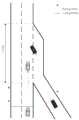
图2为本发明所述可视区间设置预警线示意图。Fig. 2 is a schematic diagram of setting an early warning line in a visible interval according to the present invention.
具体实施方式Detailed ways
下面结合附图以及具体实施例对本发明作进一步的说明,但本发明的保护范围并不限于此。The present invention will be further described below in conjunction with the accompanying drawings and specific embodiments, but the protection scope of the present invention is not limited thereto.
如图1所示,本发明一种高速入口匝道车辆协同避撞系统,包括高速公路云端数据中心、路侧系统和车载智能系统。As shown in Figure 1, the present invention provides a high-speed on-ramp vehicle cooperative collision avoidance system, which includes a highway cloud data center, a roadside system, and a vehicle-mounted intelligent system.
高速公路云端数据中心包括数据处理模块、5G通信模块和交通信息数据库,交通信息数据库中存储有速度数据;5G通信模块和数据处理模块进行数据通信,数据处理模块和交通信息数据库进行数据通信。The expressway cloud data center includes a data processing module, a 5G communication module and a traffic information database. The traffic information database stores speed data; the 5G communication module and the data processing module perform data communication, and the data processing module performs data communication with the traffic information database.
路侧系统包括路侧单元、路侧数据处理中心和路侧通信模块,路侧单元采集的数据发送给路侧数据处理中心,路侧数据处理中心与路侧通信模块进行数据通信;路侧单元包括主路侧路侧单元和匝道侧路侧单元,在实际使用时,主路路侧单元和匝道路侧单元均采用高清视觉摄像头,并在高清视觉摄像头的可视区域内设置一条虚拟预警线;路侧通信模块采用5G通信模块;路侧数据处理中心具体采用数据处理算法对采集的数据进行预处理,如去噪。The roadside system includes a roadside unit, a roadside data processing center and a roadside communication module. The data collected by the roadside unit is sent to the roadside data processing center, and the roadside data processing center communicates with the roadside communication module for data communication; the roadside unit Including the roadside unit on the main road side and the roadside unit on the ramp side. In actual use, both the roadside unit on the main road and the roadside unit on the ramp side use high-definition vision cameras, and a virtual warning line is set in the visible area of the high-definition vision camera ; The roadside communication module adopts a 5G communication module; the roadside data processing center specifically uses a data processing algorithm to preprocess the collected data, such as denoising.
车载智能系统包括人工驾驶车辆车载智能系统和智能网联车辆车载智能系统,其中人工驾驶车辆车载智能系统包括车载通信模块(采用5G通信模块)、人机交互终端和车载信息处理中心,车载通信模块与人机交互终端进行数据通信,人机交互终端与车载信息处理中心进行通信;智能网联车辆车载智能系统包括车载通信模块、自动驾驶终端、车载信息处理中心,自动驾驶终端分别与车载通信模块、车载信息处理中心进行数据通信。The vehicle-mounted intelligent system includes the vehicle-mounted intelligent system of the artificially driven vehicle and the vehicle-mounted intelligent system of the intelligent networked vehicle. Carry out data communication with the human-computer interaction terminal, and the human-computer interaction terminal communicates with the vehicle-mounted information processing center; the vehicle-mounted intelligent system of the intelligent networked vehicle includes a vehicle-mounted communication module, an automatic driving terminal, and a vehicle-mounted information processing center, and the automatic driving terminal communicates with the vehicle-mounted communication module , Car information processing center for data communication.
车载智能系统与路侧系统之间、车载智能系统与云端数据中心之间、路侧系统与云端数据中心之间通过采用5G通信技术进行通信。Communication between the on-board intelligent system and the roadside system, between the on-board intelligent system and the cloud data center, and between the roadside system and the cloud data center is carried out by using 5G communication technology.
在路侧系统前方的可视区间(即高清视觉摄像头的探测距离)内设置一条虚拟预警线,如图2所示,该虚拟预警线的作用等同于车辆检测器,用以检测匝道侧和主路侧是否有车辆通行,以便进一步触发路侧单元采集该车辆的行驶数据,经路侧数据处理中心处理后作为历史轨迹数据发送给云端数据中心预测车辆的未来轨迹。虚拟预警线设置距离(即虚拟预警线预设位置与汇入区间起点之间的距离d)会根据天气情况(如雾天会限速)和不同车道行驶速度的不同而进行动态调整;具体的虚拟预警线预设距离如下:Set a virtual early warning line in the visible area in front of the roadside system (that is, the detection distance of the high-definition vision camera), as shown in Figure 2, the function of the virtual early warning line is equivalent to the vehicle detector to detect the ramp side and the main road. Whether there is a vehicle passing on the roadside, so as to further trigger the roadside unit to collect the driving data of the vehicle, which will be processed by the roadside data processing center and sent to the cloud data center as historical trajectory data to predict the future trajectory of the vehicle. The setting distance of the virtual warning line (that is, the distance d between the preset position of the virtual warning line and the starting point of the converging interval) will be dynamically adjusted according to the weather conditions (such as speed limit in foggy days) and the speed of different lanes; the specific The preset distance of the virtual warning line is as follows:
(1)主路侧虚拟预警线预设距离(1) The preset distance of the virtual warning line on the main road side
设当前车道的车速在云端数据中心的交通信息数据库所允许的速度区间(vL_min,vL_max),云端数据中心所需预测主路侧车辆未来轨迹的最小历史轨迹时间序列的时长为tL_pre_need,同时主路侧路侧系统和云端数据中心所需的通信时间和数据计算时间为tL_com_need;Assuming that the speed of the current lane is in the speed range (vL_min , vL_max ) allowed by the traffic information database of the cloud data center, the minimum time series of historical trajectory time series required by the cloud data center to predict the future trajectory of the vehicle on the main road side is tL_pre_need , At the same time, the communication time and data calculation time required by the main roadside roadside system and the cloud data center are tL_com_need ;
则虚拟预警线设置的最小距离dL_min=vL_min×(tL_pre_need+tL_com_need),虚拟预警线设置的最大距离dL_max=vL_max×(tL_pre_need+tL_com_need);又因为主路侧路侧系统前方的可视区间与汇入区间起点的距离范围为(d′L_min,d′L_max),则要保证dL_min≥d′L_min,dL_max≤d′L_max;Then the minimum distance dL_min =vL_min ×(tL_pre_need +tL_com_need ) set by the virtual warning line, and the maximum distance dL_max =vL_max ×(tL_pre_need +tL_com_need ) set by the virtual warning line; The distance between the visible area in front of the system and the starting point of the import area is (d′L_min , d′L_max ), then it must be ensured that dL_min ≥ d′L_min , dL_max ≤ d′L_max ;
若计算所得d′L_min<d′L_min,则取dLmin=max{d′L_min,d′L_min};若计算所得dL_max>d′L_max,则取dLmax=min{dL_max,d′L_max};If the calculated d'L_min <d'L_min , then take dLmin = max{d'L_min , d'L_min }; if the calculated dL_max >d'L_max , then take dLmax = min{dL_max , d'L_max };
最终的主路侧路侧系统前方的可视区间与汇入区间起点的距离范围为(dLmin,dLmax),取dL=(dLmin+dLmax)/2为主路侧虚拟预警线的预设距离。The final distance between the visible section in front of the roadside system on the main road side and the starting point of the merged section is (dLmin , dLmax ), and dL = (dLmin +dLmax )/2 is the virtual warning line on the main road side preset distance.
(2)匝道侧虚拟预警线预设距离(2) The preset distance of the virtual warning line on the ramp side
设当前匝道的限速区间(vZ_min,vZ_max),云端数据中心所需预测匝道侧车辆轨迹的最小历史轨迹时间序列的时长为tZ_pre_need,同时匝道侧路侧系统和云端数据中心所需的通信时间和数据计算时间为tZ_com_need;Assuming the speed limit interval of the current ramp (vZ_min , vZ_max ), the minimum time series of historical trajectory time series required by the cloud data center to predict the vehicle trajectory on the ramp side is tZ_pre_need , and at the same time the roadside system on the ramp side and the cloud data center require Communication time and data calculation time are tZ_com_need ;
考虑到匝道的曲率和长度一定,设匝道长度区间为(d″Z_min,d″Z_max),则虚拟预警线设置的最小距离dZ_min=vZ_min×(tZ_pre_need+tZ_com_need),虚拟预警线设置的最大距离dZ_max=vZ_max×(tZ_pre_need+tZ_com_need),又因为匝道侧路侧系统前方的可视区间与汇入区间起点的距离为(d′Z_min,d′Z_max),则取dZmin=max{dZ_min,d′Z_min,d″Z_min},取dZmax=min{dZ_max,d′Z_max,d″Z_max};Considering that the curvature and length of the ramp are fixed, and the length interval of the ramp is set as (d″Z_min , d″Z_max ), then the minimum distance dZ_min = vZ_min × (tZ_pre_need +tZ_com_need ) set by the virtual warning line, the setting of the virtual warning line dZ_max =vZ_max ×(tZ_pre_need +tZ_com_need ), and because the distance between the visible section in front of the roadside system on the ramp side and the starting point of the merge-in section is (d′Z_min , d′Z_max ), then dZmin =max{dZ_min , d′Z_min , d″Z_min }, get dZmax =min{dZ_max , d′Z_max , d″Z_max };
最终的匝道侧路侧系统前方的可视区间与汇入区间起点的距离为(dZmin,dZmax),取dZ=(dZmin+dZmax)/2为匝道侧虚拟预警线的预设距离。The final distance between the visible section in front of the ramp-side roadside system and the starting point of the merge-in section is (dZmin , dZmax ), and dZ = (dZmin +dZmax )/2 is taken as the preset of the virtual warning line on the ramp side distance.
当匝道侧路侧单元检测到有车辆通过虚拟预警线,若车辆为人工驾驶车辆,则通过高清视觉摄像头测定车辆的行驶轨迹数据,包括位置


当主路侧路侧单元检测到有车辆通过虚拟预警线下游(即车辆已经通过了主路侧虚拟预警线),若车辆为人工驾驶车辆,则检测车辆的行驶轨迹数据(包括车辆ID(Vel ID)、车辆所处的车道编号ID(Line ID)、位置


所述云端数据中心的数据处理模块在接收路侧系统发来的车辆行驶轨迹数据(包括车辆ID(Vel ID)、车辆所处的车道编号ID(Line ID)、位置P、速度v和加速度a),运用长短期记忆(LSTM)神经网络算法对主路侧和匝道侧的车辆行驶轨迹进行预测,并根据匝道侧的预测行驶轨迹计算出虚拟碰撞点的位置坐标,进而计算出主路侧车辆和匝道侧车辆的位置距离,并通过比对响应阈值来确定系统协同响应级别;具体步骤如下:The data processing module of the cloud data center receives the vehicle trajectory data (including vehicle ID (Vel ID), vehicle lane number ID (Line ID), position P, speed v and acceleration a) sent by the roadside system. ), use the long short-term memory (LSTM) neural network algorithm to predict the vehicle trajectory on the main road side and the ramp side, and calculate the position coordinates of the virtual collision point according to the predicted driving trajectory on the ramp side, and then calculate the main road side vehicle The position distance from the vehicle on the ramp side, and by comparing the response threshold to determine the system cooperative response level; the specific steps are as follows:
步骤一:将匝道侧路侧单元的历史行驶轨迹数据定义为历史行驶轨迹特征向量X={X1,X2,...,Xi},数据处理模块将车辆行驶轨迹序列Xi拆分成不同的轨迹段,如将行驶轨迹序列Xi拆分为Xi={x1,x2,...,xk},接着通过LSTM计算得到行驶轨迹序列的隐藏向量数据H={h1,h2,...,hj},然后通过Sigmoid激活函数进行隐藏向量数据的归一化处理,作为一种门控状态;最后通过Tanh激活函数进行隐藏向量数据转换,继而得到输出的预测行驶轨迹序列y={y1,y2,...,yk};Step 1: Define the historical driving trajectory data of the roadside unit on the ramp side as the historical driving trajectory feature vector X={X1 , X2 ,...,Xi }, and the data processing module splits the vehicle driving trajectory sequenceXi into different trajectory segments, such as splitting the driving trajectory sequence Xi into Xi ={x1 , x2 ,...,xk }, and then calculating the hidden vector data H of the driving trajectory sequence through LSTM = {h1 , h2 ,..., hj }, and then use the Sigmoid activation function to normalize the hidden vector data as a gating state; finally use the Tanh activation function to convert the hidden vector data, and then get the output Predicted driving track sequence y={y1 , y2 ,...,yk };
步骤二:将主路侧路侧单元的历史行驶轨迹数据定义为行驶轨迹特征向量S1(t)={X′1,X′2,...,X′i},将主路侧车辆所处的车道信息(包括车道编号LineID和车辆所处车道距离道路左侧车道线的距离dy)定义为S2(t)={Lane ID,dy},LSTM神经网络的输入则为X(t)={S1(t),S2(t)},数据处理模块首先将车辆行驶轨迹序列切分成不同的轨迹段,如将行驶轨迹序列X′i拆分为X′i={x′1,x′2,...,x′m},接着通过LSTM计算得到序列的隐藏向量数据H′={h1,h2,...,hn},然后通过Sigmoid激活函数进行隐藏向量数据的归一化处理,作为一种门控状态;最后通过Tanh激活函数进行隐藏向量数据转换,继而得到输出的预测行驶轨迹序列y′={y1,y2,...,yp};Step 2: Define the historical driving trajectory data of the main roadside roadside unit as the driving trajectory feature vector S1 (t)={X′1 , X′2 ,...,X′i }, and the main roadside vehicle The lane information (including the lane number LineID and the distance dy between the lane of the vehicle and the lane line on the left side of the road) is defined as S2 (t)={Lane ID, dy}, and the input of the LSTM neural network is X(t )={S1 (t), S2 (t)}, the data processing module first divides the vehicle trajectory sequence into different trajectory segments, such as splitting the driving trajectory sequence X′i into X′i ={x′1 , x′2 ,...,x′m }, and then calculate the hidden vector data H′={h1 , h2 ,...,hn } of the sequence through LSTM, and then hide it through the Sigmoid activation function The normalization processing of vector data is used as a gating state; finally, the hidden vector data conversion is performed through the Tanh activation function, and then the output predicted driving trajectory sequence y′={y1 , y2 ,...,yp };
步骤三:云端数据中心的数据处理模块由预测到的匝道侧车辆行驶轨迹y={y1,y2,...,yk}包含的时间序列计算出车辆到达虚拟碰撞点的时间T0,并根据预测的匝道侧车辆行驶轨迹数据确定虚拟碰撞点的坐标位置C,设C的位置坐标为(XC,YC);其中计算时间T0和确定坐标位置C的过程均为现有技术;其中虚拟碰撞点定义为:车辆质心在匝道经加速车道跨过加速车道左侧车道线的位置。Step 3: The data processing module of the cloud data center calculates the time T0 when the vehicle reaches the virtual collision point from the time series contained in the predicted ramp-side vehicle trajectory y={y1 , y2 ,...,yk } , and determine the coordinate position C of the virtual collision point according to the predicted vehicle trajectory data on the ramp side, let the position coordinates of C be (XC , YC ); where the calculation time T0 and the process of determining the coordinate position C are existing technology; where the virtual collision point is defined as: the position where the center of mass of the vehicle passes through the acceleration lane on the ramp and crosses the left lane line of the acceleration lane.
步骤四:云端数据中心根据速度vj和加速度aj计算出主路侧车辆在T0时间内的运动距离,计算公式为


步骤五:数据处理模块比对D0与交通信息数据库里的协同避撞系统响应阈值,确定主路侧车辆与匝道侧切入车辆即将采取的避撞措施;协同避撞系统响应阈值包括预碰撞安全距离Lf、预制动安全距离Lb和最小制动安全距离Lmin;Step 5: The data processing module compares D0 with the response threshold of the cooperative collision avoidance system in the traffic information database, and determines the collision avoidance measures to be taken by the vehicle on the main road side and the vehicle on the ramp side; the response threshold of the cooperative collision avoidance system includes the pre-collision safety Distance Lf , pre-braking safety distance Lb and minimum braking safety distance Lmin ;
根据车辆紧急制动对加速度的变化情况将汽车制动过程分为四个阶段,分别为:According to the change of acceleration caused by emergency braking of the vehicle, the braking process of the vehicle is divided into four stages, which are:
阶段一:制动系统协调时间τ1,在此阶段车辆制动距离为
阶段二:制动减速度增长时间τ2,此阶段包括制动器元件消除间隙时间τ′2和制动器增长时间τ″2,在此阶段车辆制动距离为
阶段三:制动持续时间τ3,在此阶段车辆制动距离为
阶段四:制动器放松时间τ4,由于此阶段为车辆完成制动达到制动预期速度以后所采取的行动,故对此阶段的运动距离不做计算。Stage 4: Brake relaxation time τ4 , since this stage is the action taken after the vehicle completes braking and reaches the expected braking speed, so the movement distance of this stage is not calculated.
设Lfront为前车的制动距离,Lrear为后车的制动距离,Dsafe为驾驶员认知的最小安全距离;则两车之间的安全距离为:Let Lfront be the braking distance of the front car, Lrear the braking distance of the rear car, and Dsafe the minimum safe distance recognized by the driver; then the safe distance between the two cars is:
L=Lrear-Lfront+DsafeL=Lrear -Lfront +Dsafe
一般情况下匝道汇入车辆在汇入主车道之后会保持匀速或者加速状态,则后车减速至前车速度时的制动距离为:Under normal circumstances, the ramp-merging vehicle will maintain a constant speed or accelerate after merging into the main lane, so the braking distance when the rear vehicle decelerates to the speed of the front vehicle is:

前车的制动距离为:The braking distance of the vehicle in front is:

代入安全距离公式得:Substituting into the safety distance formula:

式中:vfront为前车速度,vrear为后车的速度,afront为前车加速度,arear为后车加速度;In the formula: vfront is the speed of the front vehicle, vrear is the speed of the rear vehicle, afront is the acceleration of the front vehicle, and arear is the acceleration of the rear vehicle;
根据安全距离确认协同避撞系统响应阈值预碰撞安全距离Lf、预制动安全距离Lb和最小制动安全距离Lmin:According to the safety distance, confirm the response threshold of the cooperative collision avoidance system, the pre-collision safety distance Lf , the pre-braking safety distance Lb and the minimum braking safety distance Lmin :


式中:tdriver为驾驶员反应时间,一般取1.5s,arear_min为车辆开始采取制动时的最小减速度,arear_max为车辆开始采取制动时的最大减速度;根据实验数据和交通数据分析,确定制动最小减速度为:arear_min=min(4m/s2,μg);制动最大减速度为:arear_max=max(7m/s2,μg)。In the formula: tdriver is the driver’s reaction time, generally 1.5s, arear_min is the minimum deceleration when the vehicle starts to brake, and arear_max is the maximum deceleration when the vehicle starts to brake; according to the experimental data and traffic data Analyze and determine the minimum braking deceleration as: arear_min =min(4m/s2 , μg); the maximum braking deceleration as: arear_max =max(7m/s2 , μg).
通过判断D0与预碰撞安全距离Lf、预制动安全距离Lb和最小制动安全距离Lmin,协同避撞系统做出不用级别的系统响应,具体系统响应如下:By judging D0 and the pre-collision safety distance Lf , pre-braking safety distance Lb and minimum braking safety distance Lmin , the collaborative collision avoidance system makes system responses of different levels, and the specific system responses are as follows:
系统响应等级分级标准System Response Level Grading Standard

步骤六:云端数据中心根据系统协同响应等级发出协同避撞指令Step 6: The cloud data center issues a collaborative collision avoidance command according to the system collaborative response level
(1)若ΔY>0,即匝道车汇入主车道后,主路侧车辆为前车(Vel ID:Front_L001),匝道侧车为后车(Vel ID:Rear_Z001);(1) If ΔY>0, that is, after the ramp vehicle merges into the main lane, the vehicle on the main road side is the front vehicle (Vel ID: Front_L001), and the ramp side vehicle is the rear vehicle (Vel ID: Rear_Z001);
情况一:D0>Lf时,安全等级为:一级,系统协同响应为:正常行驶,两车无碰撞风险,云端数据中心通过5G通信模块发送给两车((Vel ID:Front_L001)、(Vel ID:Rear_Z001))提示信息,提示两车按当前车速正常行驶;Situation 1: When D0 >Lf , the safety level is: Level 1, and the coordinated response of the system is: normal driving, no risk of collision between the two vehicles, and the cloud data center sends to the two vehicles through the 5G communication module ((Vel ID: Front_L001), (Vel ID: Rear_Z001)) prompt information, prompting the two vehicles to drive normally at the current speed;
情况二:Lb<D0≤Lf时,安全等级为:二级,系统协同响应为:碰撞预警,此时云端数据中心通过5G通信模块向两车((Vel ID:Front_L001)、(Vel ID:Rear_Z001))发出碰撞预警指令,提醒主路侧车辆(Vel ID:Front_L001)以超过自车最大加速度30%的加速度进行加速行驶,匝道侧车辆(Vel ID:Rear_Z001)以超过自车最大减速度30%的减速度降低车速,以增大安全距离;Situation 2: When Lb < D0 ≤ Lf , the security level is: Level 2, and the system cooperative response is: collision warning. At this time, the cloud data center sends two vehicles ((Vel ID: Front_L001), (Vel ID: Rear_Z001)) sends a collision warning command to remind the main roadside vehicle (Vel ID: Front_L001) to accelerate at an acceleration exceeding 30% of the vehicle's maximum acceleration, and the ramp side vehicle (Vel ID: Rear_Z001) The deceleration of 30% of the speed reduces the speed of the vehicle to increase the safety distance;
情况三:Lmin<D0≤Lb时,安全等级为:三级,系统协同响应为:制动预警,云端数据中心通过5G通信模块发送给两车((Vel ID:Front_L001)、(Vel ID:Rear_Z001))制动预警指令,提醒主路侧车辆(Vel ID:Front_L001)以超过自车最大加速度50%的加速度进行急加速,匝道侧车辆(Vel ID:Rear_Z001)以超过自车最大减速度50%的减速度进行急减速或者紧急转向避撞,以增大安全距离;Situation 3: When Lmin < D0 ≤ Lb , the safety level is: Level 3, and the system cooperative response is: brake warning, which is sent by the cloud data center to the two vehicles ((Vel ID: Front_L001), (Vel ID: Rear_Z001)) brake warning command, reminding the main roadside vehicle (Vel ID: Front_L001) to accelerate rapidly at an acceleration exceeding 50% of the vehicle’s maximum acceleration, and the ramp side vehicle (Vel ID: Rear_Z001) to accelerate at a speed exceeding the maximum Decelerate at 50% of the speed for rapid deceleration or emergency steering to avoid collisions to increase the safety distance;
情况四:D0≤Lmin时,安全等级为:四级,系统协同响应为:制动预碰撞,云端数据中心通过5G通信模块发送给两车((Vel ID:Front_L001)、(Vel ID:Rear_Z001))发出制动预碰撞指令,提醒两车有碰撞危险,提醒主路侧车辆(Vel ID:Front_L001)进行紧急加速行驶(加速度最大),匝道侧车辆(Vel ID:Rear_Z001)进行紧急减速(减速度最大),进一步减轻碰撞程度。Situation 4: When D0 ≤ Lmin , the safety level is: level 4, and the system cooperative response is: brake pre-collision, and the cloud data center sends the two vehicles ((Vel ID: Front_L001), (Vel ID: Rear_Z001)) sends a brake pre-collision command to remind the two vehicles of the risk of collision, remind the main road side vehicle (Vel ID: Front_L001) to accelerate urgently (maximum acceleration), and the ramp side vehicle (Vel ID: Rear_Z001) to perform emergency deceleration ( deceleration maximum), further reducing the degree of collision.
(2)若ΔY≤0,即匝道车汇入主车道后,匝道侧车辆为前车(Vel ID:Front_Z001),主路侧车辆为后车(Vel ID:Rear_L001);(2) If ΔY≤0, that is, after the ramp vehicle merges into the main lane, the vehicle on the ramp side is the front vehicle (Vel ID: Front_Z001), and the vehicle on the main road side is the rear vehicle (Vel ID: Rear_L001);
情况一:D0>Lf时,安全等级为:一级,系统协同响应为:正常行驶,两车无碰撞风险,云端数据中心通过5G通信模块发送给两车((Vel ID:Front_Z001)、(Vel ID:Rear_L001))提示信息,提示两车按当前车速正常行驶;Situation 1: When D0 >Lf , the safety level is: Level 1, and the system cooperative response is: normal driving, no risk of collision between the two vehicles, and the cloud data center sends to the two vehicles through the 5G communication module ((Vel ID: Front_Z001), (Vel ID: Rear_L001)) prompt information, prompting the two vehicles to drive normally at the current speed;
情况二:Lb<D0≤Lf时,安全等级为:二级,系统协同响应为:碰撞预警,此时云端数据中心通过5G通信模块发送给两车((Vel ID:Front_Z001)、(Vel ID:Rear_L001))发出碰撞预警指令,提醒匝道待车辆(Vel ID:Front_Z001)以超过自车最大加速度30%的加速度进行加速行驶,主路侧车辆(Vel ID:Rear_L001)以超过自车最大减速度30%的减速度降低车速,以增大安全距离;Case 2: When Lb < D0 ≤ Lf , the safety level is: Level 2, and the system cooperative response is: collision warning. At this time, the cloud data center sends the two vehicles ((Vel ID: Front_Z001), (Vel ID: Front_Z001) and ( Vel ID: Rear_L001)) sends a collision warning command to remind the waiting vehicle on the ramp (Vel ID: Front_Z001) to accelerate at an acceleration exceeding 30% of the vehicle's maximum acceleration, and the main road side vehicle (Vel ID: Rear_L001) to exceed the Deceleration 30% deceleration reduces the vehicle speed to increase the safety distance;
情况三:Lmin<D0≤Lb时,安全等级为:三级,系统协同响应为:制动预警,云端数据中心通过5G通信模块发送给两车((Vel ID:Front_Z001)、(Vel ID:Rear_L001))发出制动预警指令,提醒匝道侧车辆(Vel ID:Front_Z001)以超过自车最大加速度50%的加速度进行急加速,主路侧车辆(Vel ID:Rear_L001)以超过自车最大减速度50%的减速度进行急减速或者紧急转向避撞,以增大安全距离;Situation 3: When Lmin < D0 ≤ Lb , the safety level is: Level 3, and the system cooperative response is: brake warning, which is sent by the cloud data center to the two vehicles ((Vel ID: Front_Z001), (Vel ID: Rear_L001)) sends a brake warning command to remind the ramp side vehicle (Vel ID: Front_Z001) to accelerate rapidly at an acceleration exceeding 50% of the vehicle's maximum acceleration, and the main road side vehicle (Vel ID: Rear_L001) to exceed the vehicle's maximum acceleration Deceleration of 50% deceleration for rapid deceleration or emergency steering to avoid collisions to increase the safety distance;
情况四:D0≤Lmin时,安全等级为:四级,系统协同响应为:制动预碰撞,云端数据中心通过5G通信模块发送给两车((Vel ID:Front_Z001)、(Vel ID:Rear_L001)))发出制动预碰撞指令,提醒两车有碰撞危险,提醒匝道侧车辆(Vel ID:Front_Z001)紧急加速行驶(加速度最大),主路侧车辆(Vel ID:Rear_L001))进行紧急减速(减速度最大),进一步减轻碰撞程度。Situation 4: When D0 ≤ Lmin , the safety level is: level 4, and the system cooperative response is: brake pre-collision, and the cloud data center sends the two vehicles ((Vel ID: Front_Z001), (Vel ID: Rear_L001))) sends a brake pre-collision command to remind the two vehicles of the risk of collision, remind the ramp side vehicle (Vel ID: Front_Z001) to accelerate urgently (maximum acceleration), and the main road side vehicle (Vel ID: Rear_L001)) to decelerate urgently (maximum deceleration), further reducing the degree of collision.
人工驾驶车辆的车载智能系统为主动式服务系统,在保持网络状态良好的情况下,通过自身的5G通信模块接收来自云端数据中心发送的协同避撞指令和预警信息,通过车载信息处理中心解码,并发送给人机交互终端提醒驾驶员及时对车辆进行协同避撞动作;智能网联车辆车载智能系统可将自车越过虚拟预警线的行驶数据发送给云端数据中心,同时实时接收云端数据中心发送过来的协同避撞指令,通过车载信息处理中心解码,并发送给自动驾驶终端,自动驾驶根据协同避撞指令对车辆进行控制,进而使车辆做出协同避撞动作。The on-board intelligent system of the human-driven vehicle is an active service system. When the network is in good condition, it receives the collaborative collision avoidance instructions and early warning information sent from the cloud data center through its own 5G communication module, and decodes them through the on-board information processing center. And send it to the human-computer interaction terminal to remind the driver to take coordinated collision avoidance actions for the vehicle in time; the vehicle intelligent system of the intelligent networked vehicle can send the driving data of the vehicle crossing the virtual warning line to the cloud data center, and at the same time receive the data sent by the cloud data center in real time. The incoming cooperative collision avoidance command is decoded by the on-board information processing center and sent to the automatic driving terminal. The automatic driving controls the vehicle according to the cooperative collision avoidance command, and then makes the vehicle perform a cooperative collision avoidance action.
所述实施例为本发明的优选的实施方式,但本发明并不限于上述实施方式,在不背离本发明的实质内容的情况下,本领域技术人员能够做出的任何显而易见的改进、替换或变型均属于本发明的保护范围。The described embodiment is a preferred implementation of the present invention, but the present invention is not limited to the above-mentioned implementation, without departing from the essence of the present invention, any obvious improvement, replacement or modification that those skilled in the art can make Modifications all belong to the protection scope of the present invention.
Claims (10)


Priority Applications (1)
| Application Number | Priority Date | Filing Date | Title |
|---|---|---|---|
| CN202211571440.3ACN115862382A (en) | 2022-12-08 | 2022-12-08 | High-speed entrance ramp vehicle cooperative collision avoidance system and method |
Applications Claiming Priority (1)
| Application Number | Priority Date | Filing Date | Title |
|---|---|---|---|
| CN202211571440.3ACN115862382A (en) | 2022-12-08 | 2022-12-08 | High-speed entrance ramp vehicle cooperative collision avoidance system and method |
Publications (1)
| Publication Number | Publication Date |
|---|---|
| CN115862382Atrue CN115862382A (en) | 2023-03-28 |
Family
ID=85671090
Family Applications (1)
| Application Number | Title | Priority Date | Filing Date |
|---|---|---|---|
| CN202211571440.3APendingCN115862382A (en) | 2022-12-08 | 2022-12-08 | High-speed entrance ramp vehicle cooperative collision avoidance system and method |
Country Status (1)
| Country | Link |
|---|---|
| CN (1) | CN115862382A (en) |
Cited By (3)
| Publication number | Priority date | Publication date | Assignee | Title |
|---|---|---|---|---|
| CN116612660A (en)* | 2023-04-10 | 2023-08-18 | 山东高速建设管理集团有限公司 | Method and equipment for early warning vehicle conflict in highway reconstruction and expansion construction area |
| CN116978257A (en)* | 2023-08-11 | 2023-10-31 | 山东大学 | Highway merging area conflict early warning method and system based on trajectory prediction |
| CN119078867A (en)* | 2024-08-30 | 2024-12-06 | 上海朗尚传感技术有限公司 | A safety assessment-based assisted driving method, device, equipment and medium |
Citations (5)
| Publication number | Priority date | Publication date | Assignee | Title |
|---|---|---|---|---|
| CN105761549A (en)* | 2016-05-05 | 2016-07-13 | 东南大学 | Method for safety control of highway entrance ramp based on vehicle-vehicle networking |
| CN109859500A (en)* | 2018-12-17 | 2019-06-07 | 中电海康集团有限公司 | A kind of high speed merging area safe early warning method based on bus or train route collaboration |
| CN112927512A (en)* | 2021-02-24 | 2021-06-08 | 山东科技大学 | Expressway ramp confluence control system and method |
| CN113744540A (en)* | 2021-09-29 | 2021-12-03 | 中汽创智科技有限公司 | Vehicle import method, system, equipment and storage medium |
| CN115171401A (en)* | 2022-06-20 | 2022-10-11 | 高新兴科技集团股份有限公司 | Ramp afflux method, device and medium |
- 2022
- 2022-12-08CNCN202211571440.3Apatent/CN115862382A/enactivePending
Patent Citations (5)
| Publication number | Priority date | Publication date | Assignee | Title |
|---|---|---|---|---|
| CN105761549A (en)* | 2016-05-05 | 2016-07-13 | 东南大学 | Method for safety control of highway entrance ramp based on vehicle-vehicle networking |
| CN109859500A (en)* | 2018-12-17 | 2019-06-07 | 中电海康集团有限公司 | A kind of high speed merging area safe early warning method based on bus or train route collaboration |
| CN112927512A (en)* | 2021-02-24 | 2021-06-08 | 山东科技大学 | Expressway ramp confluence control system and method |
| CN113744540A (en)* | 2021-09-29 | 2021-12-03 | 中汽创智科技有限公司 | Vehicle import method, system, equipment and storage medium |
| CN115171401A (en)* | 2022-06-20 | 2022-10-11 | 高新兴科技集团股份有限公司 | Ramp afflux method, device and medium |
Cited By (5)
| Publication number | Priority date | Publication date | Assignee | Title |
|---|---|---|---|---|
| CN116612660A (en)* | 2023-04-10 | 2023-08-18 | 山东高速建设管理集团有限公司 | Method and equipment for early warning vehicle conflict in highway reconstruction and expansion construction area |
| CN116612660B (en)* | 2023-04-10 | 2024-05-28 | 山东高速建设管理集团有限公司 | Method and equipment for early warning vehicle conflict in highway reconstruction and expansion construction area |
| CN116978257A (en)* | 2023-08-11 | 2023-10-31 | 山东大学 | Highway merging area conflict early warning method and system based on trajectory prediction |
| CN116978257B (en)* | 2023-08-11 | 2024-05-24 | 山东大学 | Highway confluence region conflict early warning method and system based on track prediction |
| CN119078867A (en)* | 2024-08-30 | 2024-12-06 | 上海朗尚传感技术有限公司 | A safety assessment-based assisted driving method, device, equipment and medium |
Similar Documents
| Publication | Publication Date | Title |
|---|---|---|
| CN115862382A (en) | High-speed entrance ramp vehicle cooperative collision avoidance system and method | |
| CN114312772B (en) | Safe driving control method in zebra crossing scene | |
| CN107346612B (en) | Vehicle anti-collision method and system based on Internet of vehicles | |
| CN112590801B (en) | Front collision early warning control method based on fatigue degree of driver | |
| CN110077398B (en) | Risk handling method for intelligent driving | |
| CN109584571A (en) | Intersection pre-warning and control method and system and sensing device used | |
| CN112026761A (en) | Automobile auxiliary driving method based on data sharing | |
| CN109774473B (en) | Speed limit control method based on camera and navigation data fusion | |
| CN110745128A (en) | A vehicle forced deceleration system and control method based on minimum safety distance | |
| CN110335504A (en) | Intelligent collision warning system and method based on bus or train route collaboration under vehicle follow gallop state | |
| CN113119945B (en) | Automobile advanced driver assistance system based on environment model | |
| CN110641467A (en) | A vehicle distance control method and device for an adaptive cruise system | |
| CN114464012B (en) | Vehicle and pedestrian collision early warning method and system based on Internet of vehicles | |
| CN110525431B (en) | Special vehicle anti-collision method applied to airport based on intelligent control | |
| CN103606287A (en) | Variable speed limit control method for preventing rear-end collision at tunnel entrance and tunnel exit | |
| CN117208021B (en) | Unmanned vehicle control method for complex road conditions | |
| CN117104221A (en) | Vehicle emergency collision avoidance decision planning method suitable for multiple dangerous working conditions | |
| CN113255540A (en) | Courtesy pedestrian system and method based on fusion of millimeter wave radar and camera | |
| CN116758779A (en) | A collaborative lane-changing decision-making method for intelligent network-connected vehicles under mixed traffic flow | |
| CN119527250B (en) | Automobile automatic emergency braking system and control method based on fusion data | |
| CN111994075A (en) | Driving assistance method based on artificial intelligence | |
| KR20240060071A (en) | method and device for test evaluation of autonomous car driving | |
| CN113830084B (en) | Control method based on active collision avoidance of multi-lane vehicle and vehicle | |
| CN110775027A (en) | Rear-end collision prevention braking system and method based on rear vehicle driving mode | |
| CN115257722A (en) | Pedestrian avoidance method and device oriented to safety and efficiency |
Legal Events
| Date | Code | Title | Description |
|---|---|---|---|
| PB01 | Publication | ||
| PB01 | Publication | ||
| SE01 | Entry into force of request for substantive examination | ||
| SE01 | Entry into force of request for substantive examination |