CN115524470A - A Method for Measuring Soil Moisture Using an Android Smartphone - Google Patents
A Method for Measuring Soil Moisture Using an Android SmartphoneDownload PDFInfo
- Publication number
- CN115524470A CN115524470ACN202211241201.1ACN202211241201ACN115524470ACN 115524470 ACN115524470 ACN 115524470ACN 202211241201 ACN202211241201 ACN 202211241201ACN 115524470 ACN115524470 ACN 115524470A
- Authority
- CN
- China
- Prior art keywords
- signal
- smart phone
- reflected signal
- peak power
- direct
- Prior art date
- Legal status (The legal status is an assumption and is not a legal conclusion. Google has not performed a legal analysis and makes no representation as to the accuracy of the status listed.)
- Granted
Links
Images

Classifications
- G—PHYSICS
- G01—MEASURING; TESTING
- G01N—INVESTIGATING OR ANALYSING MATERIALS BY DETERMINING THEIR CHEMICAL OR PHYSICAL PROPERTIES
- G01N33/00—Investigating or analysing materials by specific methods not covered by groups G01N1/00 - G01N31/00
- G01N33/24—Earth materials
- G01N33/246—Earth materials for water content
- G—PHYSICS
- G06—COMPUTING OR CALCULATING; COUNTING
- G06F—ELECTRIC DIGITAL DATA PROCESSING
- G06F17/00—Digital computing or data processing equipment or methods, specially adapted for specific functions
- G06F17/10—Complex mathematical operations
- G06F17/14—Fourier, Walsh or analogous domain transformations, e.g. Laplace, Hilbert, Karhunen-Loeve, transforms
- G—PHYSICS
- G06—COMPUTING OR CALCULATING; COUNTING
- G06F—ELECTRIC DIGITAL DATA PROCESSING
- G06F17/00—Digital computing or data processing equipment or methods, specially adapted for specific functions
- G06F17/10—Complex mathematical operations
- G06F17/18—Complex mathematical operations for evaluating statistical data, e.g. average values, frequency distributions, probability functions, regression analysis
Landscapes
- Engineering & Computer Science (AREA)
- Physics & Mathematics (AREA)
- General Physics & Mathematics (AREA)
- Mathematical Physics (AREA)
- Data Mining & Analysis (AREA)
- Theoretical Computer Science (AREA)
- Computational Mathematics (AREA)
- Mathematical Analysis (AREA)
- Mathematical Optimization (AREA)
- Pure & Applied Mathematics (AREA)
- Life Sciences & Earth Sciences (AREA)
- Algebra (AREA)
- General Engineering & Computer Science (AREA)
- Software Systems (AREA)
- Databases & Information Systems (AREA)
- Chemical & Material Sciences (AREA)
- Health & Medical Sciences (AREA)
- General Life Sciences & Earth Sciences (AREA)
- Remote Sensing (AREA)
- Geology (AREA)
- Environmental & Geological Engineering (AREA)
- Food Science & Technology (AREA)
- Medicinal Chemistry (AREA)
- Analytical Chemistry (AREA)
- Biochemistry (AREA)
- General Health & Medical Sciences (AREA)
- Immunology (AREA)
- Pathology (AREA)
- Bioinformatics & Cheminformatics (AREA)
- Bioinformatics & Computational Biology (AREA)
- Evolutionary Biology (AREA)
- Operations Research (AREA)
- Probability & Statistics with Applications (AREA)
- Monitoring And Testing Of Transmission In General (AREA)
Abstract
Translated fromChinese
Description
Translated fromChinese技术领域technical field
本发明涉及土壤湿度测量领域,特别是涉及一种利用安卓智能手机测量土壤湿度的方法。The invention relates to the field of soil moisture measurement, in particular to a method for measuring soil moisture using an Android smart phone.
背景技术Background technique
中国位于亚洲大陆的东部,东西南北跨度都在5000公里以上,横跨温带和热带部分地区,土壤类型复杂。准确测量土壤水分含量变化是保护生态系统最重要的环节之一,一直以来都是研究人员关注的重点。土壤水分含量又称为土壤湿度,通常用自由水体积与土壤体积比来表示土壤湿度。传统的测量方法主要包括烘干称重法、探针法以及光学遥感,存在着操作复杂、检测范围小以及设备昂贵的问题。China is located in the eastern part of the Asian continent, with a span of more than 5,000 kilometers from east to west, from north to south, and across temperate and tropical regions, with complex soil types. Accurately measuring changes in soil moisture content is one of the most important aspects of protecting ecosystems and has long been a focus of researchers. Soil moisture content, also known as soil moisture, is usually expressed as the ratio of free water volume to soil volume. Traditional measurement methods mainly include drying weighing method, probe method and optical remote sensing, which have the problems of complicated operation, small detection range and expensive equipment.
发明内容Contents of the invention
本发明的目的是提供一种利用安卓智能手机测量土壤湿度的方法,以降低设备安装的复杂度。The purpose of the present invention is to provide a method for measuring soil moisture using an Android smart phone, so as to reduce the complexity of equipment installation.
为实现上述目的,本发明提供了如下方案:To achieve the above object, the present invention provides the following scheme:
一种利用安卓智能手机测量土壤湿度的方法,包括:A method for measuring soil moisture using an Android smart phone, comprising:
利用安卓智能手机获取原始干涉信号;Use the Android smart phone to obtain the original interference signal;
对所述原始干涉信号利用经验模态分解算法进行分解,得到不同频率分量;Decomposing the original interference signal using an empirical mode decomposition algorithm to obtain different frequency components;
根据所述原始干涉信号提取直射信号和反射信号;extracting a direct signal and a reflected signal according to the original interference signal;
根据所述不同频率分量利用LSP谱估计算法确定所述安卓智能手机与土壤表面的垂直距离;Utilize the LSP spectrum estimation algorithm to determine the vertical distance between the Android smart phone and the soil surface according to the different frequency components;
根据所述垂直距离和安卓智能手机实际架设高度对所述直射信号和所述反射信号进行筛选,得到筛选直射信号和筛选反射信号;Screen the direct signal and the reflected signal according to the vertical distance and the actual erection height of the Android smart phone, to obtain the filtered direct signal and the filtered reflected signal;
根据所述筛选直射信号和所述筛选反射信号利用希尔伯特变换方法确定峰值功率比;determining the peak power ratio by using the Hilbert transform method according to the screened direct signal and the screened reflected signal;
根据所述峰值功率比确定土壤湿度。Soil moisture is determined from the peak power ratio.
可选地,在所述对所述原始干涉信号利用经验模态分解算法进行分解,得到不同频率分量之前,还包括:Optionally, before decomposing the original interference signal using an empirical mode decomposition algorithm to obtain different frequency components, it also includes:
获取不同卫星的高度角和方位角信息;Obtain altitude and azimuth information of different satellites;
根据测量需求确定观测范围;Determine the observation range according to the measurement requirements;
根据所述观测范围、所述高度角和所述方位角信息对所述原始干涉信号进行筛选,得到高度角和方位角均位于所述观测范围的卫星的原始干涉信号。The original interference signal is screened according to the observation range, the altitude angle and the azimuth angle information to obtain the original interference signal of the satellite whose altitude angle and azimuth angle are both located in the observation range.
可选地,所述根据所述垂直距离和安卓智能手机实际架设高度对所述直射信号和所述反射信号进行筛选,得到筛选直射信号和筛选反射信号,具体包括:Optionally, the direct signal and the reflected signal are screened according to the vertical distance and the actual erection height of the Android smart phone to obtain the screened direct signal and the screened reflected signal, which specifically includes:
判断所述垂直距离和所述安卓智能手机实际架设高度差的绝对值是否小于设定阈值,得到判断结果;Judging whether the absolute value of the vertical distance and the actual erection height difference of the Android smart phone is less than a set threshold, to obtain a judgment result;
若所述判断结果为是,则将所述直射信号作为筛选直射信号并将所述反射信号作为筛选反射信号;If the judgment result is yes, the direct signal is used as the filtered direct signal and the reflected signal is used as the filtered reflected signal;
若所述判断结果为否,则去除所述直射信号和所述反射信号,并返回步骤“利用安卓智能手机获取原始干涉信号”。If the judgment result is no, then remove the direct signal and the reflected signal, and return to the step of "using an Android smart phone to obtain the original interference signal".
可选地,所述根据所述筛选直射信号和所述筛选反射信号利用希尔伯特变换方法确定峰值功率比,具体包括:Optionally, the determining the peak power ratio by using the Hilbert transform method according to the screening direct signal and the screening reflection signal specifically includes:
对所述筛选反射信号进行希尔伯特变换,得到反射信号峰值功率;performing a Hilbert transform on the filtered reflected signal to obtain the peak power of the reflected signal;
根据所述筛选反射信号和所述反射信号峰值功率构建解析信号;constructing an analysis signal according to the filtered reflected signal and the peak power of the reflected signal;
根据所述解析信号确定反射信号峰值;determining the peak value of the reflection signal according to the analysis signal;
根据所述反射信号峰值和所述筛选直射信号确定峰值功率比。A peak power ratio is determined based on the reflected signal peak value and the filtered direct signal.
可选地,所述根据所述解析信号确定反射信号峰值,具体包括:Optionally, the determining the reflection signal peak value according to the analysis signal specifically includes:
对所述解析信号求绝对值,得到筛选反射信号包络;Calculate the absolute value of the analytical signal to obtain the envelope of the filtered reflected signal;
根据所述筛选反射信号包络中多个震荡周期信号的峰值确定反射信号峰值。The peak value of the reflected signal is determined according to the peak values of multiple oscillation period signals in the envelope of the filtered reflected signal.
可选地,所述根据所述反射信号峰值和所述筛选直射信号确定峰值功率比,具体包括:Optionally, the determining the peak power ratio according to the peak value of the reflected signal and the filtered direct signal specifically includes:
根据所述反射信号峰值确定所述反射信号峰值功率;determining the peak power of the reflected signal according to the peak value of the reflected signal;
根据所述筛选直射信号确定直射信号峰值功率;determining the peak power of the direct signal according to the filtered direct signal;
将所述反射信号峰值功率除以所述直射信号峰值功率得到峰值功率比。A peak power ratio is obtained by dividing the peak power of the reflected signal by the peak power of the direct signal.
可选地,所述土壤湿度的表达式为:Optionally, the expression of the soil moisture is:

其中,Γ为峰值功率比,mv为土壤湿度。where Γ is the peak power ratio andmv is the soil moisture.
根据本发明提供的具体实施例,本发明公开了以下技术效果:According to the specific embodiments provided by the invention, the invention discloses the following technical effects:
本发明利用安卓智能手机获取原始干涉信号;对所述原始干涉信号利用经验模态分解算法进行分解,得到不同频率分量;根据所述原始干涉信号提取直射信号和反射信号;根据所述不同频率分量利用LSP谱估计算法确定所述安卓智能手机与土壤表面的垂直距离;根据所述垂直距离和安卓智能手机实际架设高度对所述直射信号和所述反射信号进行筛选,得到筛选直射信号和筛选反射信号;根据所述筛选直射信号和所述筛选反射信号利用希尔伯特变换方法确定峰值功率比;根据所述峰值功率比确定土壤湿度。直接采用安卓智能手机即可实现土壤湿度的测量,从而降低设备安装的复杂度。In the present invention, the Android smart phone is used to obtain the original interference signal; the original interference signal is decomposed by using the empirical mode decomposition algorithm to obtain different frequency components; the direct signal and the reflected signal are extracted according to the original interference signal; according to the different frequency components Utilize the LSP spectrum estimation algorithm to determine the vertical distance between the Android smart phone and the soil surface; filter the direct signal and the reflected signal according to the vertical distance and the actual erection height of the Android smart phone, and obtain the filtered direct signal and the filtered reflection signal; determine the peak power ratio by using the Hilbert transform method according to the screening direct signal and the screening reflection signal; determine soil moisture according to the peak power ratio. Soil moisture measurement can be realized directly by using an Android smartphone, thereby reducing the complexity of equipment installation.
附图说明Description of drawings
为了更清楚地说明本发明实施例或现有技术中的技术方案,下面将对实施例中所需要使用的附图作简单地介绍,显而易见地,下面描述中的附图仅仅是本发明的一些实施例,对于本领域普通技术人员来讲,在不付出创造性劳动性的前提下,还可以根据这些附图获得其他的附图。In order to more clearly illustrate the technical solutions in the embodiments of the present invention or the prior art, the following will briefly introduce the accompanying drawings required in the embodiments. Obviously, the accompanying drawings in the following description are only some of the present invention. Embodiments, for those of ordinary skill in the art, other drawings can also be obtained according to these drawings without paying creative labor.
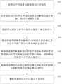
图1为本发明提供的利用安卓智能手机测量土壤湿度的方法流程图;Fig. 1 utilizes the method flow chart of the method for measuring soil moisture of Android smartphone provided by the present invention;
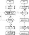
图2为本发明提供的利用安卓智能手机测量土壤湿度的方法示意图;Fig. 2 is a schematic diagram of a method for utilizing an Android smart phone to measure soil moisture provided by the present invention;
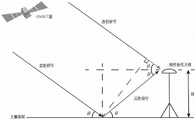
图3为GNSS干涉信号传播几何模型图;Fig. 3 is a geometric model diagram of GNSS interference signal propagation;
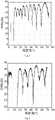
图4为采集的原始信噪比序列图。Figure 4 is the sequence diagram of the original signal-to-noise ratio collected.
具体实施方式detailed description
下面将结合本发明实施例中的附图,对本发明实施例中的技术方案进行清楚、完整地描述,显然,所描述的实施例仅仅是本发明一部分实施例,而不是全部的实施例。基于本发明中的实施例,本领域普通技术人员在没有做出创造性劳动前提下所获得的所有其他实施例,都属于本发明保护的范围。The following will clearly and completely describe the technical solutions in the embodiments of the present invention with reference to the accompanying drawings in the embodiments of the present invention. Obviously, the described embodiments are only some, not all, embodiments of the present invention. Based on the embodiments of the present invention, all other embodiments obtained by persons of ordinary skill in the art without making creative efforts belong to the protection scope of the present invention.
本发明的目的是提供一种利用安卓智能手机测量土壤湿度的方法,以降低设备安装的复杂度。The purpose of the present invention is to provide a method for measuring soil moisture using an Android smart phone, so as to reduce the complexity of equipment installation.
为使本发明的上述目的、特征和优点能够更加明显易懂,下面结合附图和具体实施方式对本发明作进一步详细的说明。In order to make the above objects, features and advantages of the present invention more comprehensible, the present invention will be further described in detail below in conjunction with the accompanying drawings and specific embodiments.
全球导航卫星干涉系统(Global Navigation Satellite SystemInterferometric Reflectometry,GNSS-IR)是一种新兴的无源遥感技术,具有精度高、覆盖范围广、设备便携、无需特定信号源的优点。测绘接收机所采用的导航天线为右旋圆极化(right-handed circle polarized,RHCP),主要用于接收视距传输的GNSS信号,也可以同时接收经过土壤反射的卫星高度角较低的GNSS信号,与直射信号叠加形成干涉现象。智能手机GNSS天线采用线性极化设计,通常在水平放置时可以接收右旋圆极化电磁波的水平分量,其功率要低于圆极化3dB。线性极化经过反射面反射时不易发生极性变化,所以智能手机可以接收到几乎所有高度角卫星的反射信号的线性极化分量,可以弥补圆极化天线无法接收高仰角卫星反射信号的缺陷。Global Navigation Satellite System Interferometric Reflectometry (GNSS-IR) is an emerging passive remote sensing technology, which has the advantages of high precision, wide coverage, portable equipment, and no specific signal source. The navigation antenna used by the surveying and mapping receiver is right-handed circular polarized (RHCP), which is mainly used to receive GNSS signals transmitted by line-of-sight, and can also receive GNSS signals with lower elevation angles reflected by the soil at the same time. Signal, superimposed with the direct signal to form an interference phenomenon. Smartphone GNSS antenna adopts linear polarization design, usually when it is placed horizontally, it can receive the horizontal component of right-hand circularly polarized electromagnetic waves, and its power is 3dB lower than that of circular polarization. Linear polarization is not easy to change polarity when it is reflected by the reflector, so the smartphone can receive the linear polarization component of the reflected signal of almost all altitude angle satellites, which can make up for the defect that the circularly polarized antenna cannot receive the reflected signal of high elevation angle satellites.
在传统的卫星信号接收中,接收机收到的除了视距传播的直射信号外,还有经过多个路径反射后的信号,又称为多径反射信号。虽然多径信号会对导航定位产生影响,但是其与反射面的物理特征(如土壤湿度)具有一定相关性。对于岸基GNSS接收机,所接收到的直射和反射信号频率几乎相同,但由于两者的传播路径不同,反射信号相对于直射信号存在路径延迟,当使用同一天线同时接收直反射信号时会发生较为稳定的干涉现象,形成干涉信号。安卓智能手机将这种干涉信号以信噪比(SNR,signal-to-noise ratio)的形式记录存储在设备记录中,存储形式为Rinex。干涉现象的变化决定于土壤表面的反射特性,因此,可以利用这种干涉现象反演反射面土壤湿度等一些重要物理属性。记接收机接收到的直射信号与反射信号的干涉信号SNR的数学模型可用下式表示:In traditional satellite signal reception, in addition to the direct signal transmitted by line-of-sight, the receiver also has signals reflected by multiple paths, also known as multi-path reflected signals. Although the multipath signal will affect the navigation and positioning, it has a certain correlation with the physical characteristics of the reflective surface (such as soil moisture). For shore-based GNSS receivers, the frequency of the received direct and reflected signals is almost the same, but due to the different propagation paths of the two, there is a path delay for the reflected signal relative to the direct signal, which will occur when the same antenna is used to receive the direct reflected signal at the same time A relatively stable interference phenomenon forms an interference signal. The Android smart phone records and stores this interference signal in the form of signal-to-noise ratio (SNR, signal-to-noise ratio) in the device record, and the storage form is Rinex. The change of the interference phenomenon is determined by the reflective properties of the soil surface. Therefore, this interference phenomenon can be used to retrieve some important physical properties such as soil moisture on the reflective surface. The mathematical model of the interference signal SNR between the direct signal and the reflected signal received by the receiver can be expressed by the following formula:

其中,Ad为直射信号幅值,Am为反射信号幅值,
如图1和图2所示,本发明提供的一种利用安卓智能手机测量土壤湿度的方法,首先利用安卓智能手机线性极化导航天线采集GNSS原始信噪比(SNR,signal-to-noiseratio)数据,接着使用经验模态分解(EMD,Empirical Mode Decomposition)提取干涉信号不同频率分量,并分离GNSS直射信号和经过地面反射的信号,然后通过计算计算峰值功率比得到直反射信号功率反射率,最后使用经验模型计算土壤湿度。具体包括:As shown in Fig. 1 and Fig. 2, a kind of method that utilizes Android smart phone to measure soil moisture provided by the present invention, first utilizes Android smart phone linear polarization navigation antenna to collect GNSS original signal-to-noise ratio (SNR, signal-to-noiseratio) Data, then use Empirical Mode Decomposition (EMD, Empirical Mode Decomposition) to extract different frequency components of the interference signal, and separate the GNSS direct signal and the signal reflected by the ground, and then calculate the peak power ratio to obtain the power reflectivity of the direct reflection signal, and finally Calculate soil moisture using an empirical model. Specifically include:
步骤101:利用安卓智能手机获取原始干涉信号。Step 101: Using an Android smart phone to acquire original interference signals.
将安卓智能手机水平放置,听筒一侧朝向需要测量的区域,将智能手机屏幕设置为常亮,打开开源软件GEO++进行GNSS原始数据采集,采集过程中需保持手机屏幕常亮从而完成原始信噪比信号采集。Place the Android smartphone horizontally, with the earpiece side facing the area to be measured, set the screen of the smartphone to be always on, open the open source software GEO++ to collect GNSS raw data, keep the screen of the phone always on during the collection process to complete the original signal-to-noise ratio Signal Acquisition.
在所述对所述原始干涉信号利用经验模态分解算法进行分解,得到不同频率分量之前,还包括:获取不同卫星的高度角和方位角信息;根据测量需求确定观测范围;根据所述观测范围、所述高度角和所述方位角信息对所述原始干涉信号进行筛选,得到高度角和方位角均位于所述测量范围的卫星的原始干涉信号。Before decomposing the original interference signal using the empirical mode decomposition algorithm to obtain different frequency components, it also includes: obtaining the altitude angle and azimuth angle information of different satellites; determining the observation range according to the measurement requirements; according to the observation range , the altitude angle and the azimuth angle information are used to screen the original interference signal to obtain the original interference signal of the satellite whose altitude angle and azimuth angle are both within the measurement range.
根据卫星方位角选取测试区域的数据。假设观测区域位于智能手机方向为:(AZMmin,AZMmax),其中AZMmin为方位角开始值,AZMmax为方位角结束值。若计算的卫星方位角在上述方向范围内,则选取此时数据进行步骤102的处理。Select the data of the test area according to the satellite azimuth. Assume that the observation area is located in the direction of the smartphone: (AZMmin , AZMmax ), where AZMmin is the start value of the azimuth, and AZMmax is the end value of the azimuth. If the calculated satellite azimuth angle is within the above-mentioned direction range, the data at this time is selected for processing in
步骤102:对所述原始干涉信号利用经验模态分解算法进行分解,得到不同频率分量。Step 102: Decompose the original interference signal using an empirical mode decomposition algorithm to obtain different frequency components.
利用经验模态分解算法分离干涉信号中的不同频率分量,其中直流分量为直射信号,其他频率分量为反射信号,从而得到直反射信号分量。The empirical mode decomposition algorithm is used to separate the different frequency components in the interference signal, in which the DC component is the direct signal, and the other frequency components are the reflected signal, so as to obtain the direct reflected signal component.
设原始干涉信号的信噪比序列为x(t),如图4所示,图4中的(a)为GPS24号星SNR图;图4中的(b)为GPS 15号星SNR图;图4中的(c)为GPS 18号星SNR图;图4中的(d)为GPS 5号星SNR图;按照如下步骤进行:Let the signal-to-noise ratio sequence of the original interference signal be x(t), as shown in Figure 4, (a) in Figure 4 is the SNR map of GPS No. 24 star; (b) in Fig. 4 is the SNR map of GPS No. 15 star; (c) in Fig. 4 is the SNR diagram of GPS No. 18 star; (d) in Fig. 4 is the SNR diagram of GPS No. 5 star; proceed as follows:
1)初始化r0(t)=x(t),i=1;r0(t)为初始信号序列,i为第i次操作。1) Initialize r0 (t)=x(t), i=1; r0 (t) is the initial signal sequence, and i is the ith operation.
2)令hj(t)=ri(t);hj(t)为第j次拟合时序,ri(t)为第i次信号序列。2) Let hj (t)=ri (t); hj (t) is the j-th fitting time series, ri (t) is the i-th signal sequence.
3)利用3次样条拟合时序h(t)的上下极值点的包络线emax(t)和emin(t),以及上下极值包络线的平均值m(t)。3) Use cubic splines to fit the envelopes emax (t) and emin (t) of the upper and lower extreme points of the time series h(t), and the average value m(t) of the upper and lower extreme envelopes.
4)在时序h(t)中减去平均值m(t)得到新时序hj+1(t),并判断hj+1(t)是否满足内涵模态分量的条件,若满足则令hi(t)=hj+1(t),否则令hj(t)=hj+1(t)并重复步骤3)和4)。4) Subtract the average value m(t) from the time series h(t) to obtain a new time series hj+1 (t), and judge whether hj+1 (t) satisfies the condition of the connotative modal component, and if so, set hi (t)=hj+1 (t), otherwise let hj (t)=hj+1 (t) and repeat steps 3) and 4).
5)从时序ri(t)减去第i个分解模态分量hi(t)得到残余分量ri+1(t),判断ri+1(t)中是否存在两个以上极值,若是则并重复2)~5),否则结束完成分解。5) Subtract the i-th decomposed modal component hi (t) from the time series ri (t) to obtain the residual component ri+1 (t), and judge whether there are more than two extreme values in ri+1 (t) , if so, repeat 2) to 5), otherwise end and complete the decomposition.
步骤103:根据所述原始干涉信号提取直射信号和反射信号。Step 103: Extract a direct signal and a reflected signal according to the original interference signal.
步骤104:根据所述不同频率分量利用LSP谱估计算法确定所述安卓智能手机与土壤表面的垂直距离。利用LSP谱估计算法计算反射信号频谱特性,并计算智能手机与土壤表面的垂直距离。Step 104: Determine the vertical distance between the Android smart phone and the soil surface by using the LSP spectrum estimation algorithm according to the different frequency components. The LSP spectrum estimation algorithm is used to calculate the spectral characteristics of the reflected signal, and the vertical distance between the smartphone and the soil surface is calculated.
步骤105:根据所述垂直距离和安卓智能手机实际架设高度对所述直射信号和所述反射信号进行筛选,得到筛选直射信号和筛选反射信号。Step 105: Screen the direct signal and the reflected signal according to the vertical distance and the actual erection height of the Android smartphone to obtain the filtered direct signal and the filtered reflected signal.
步骤105,具体包括:判断所述垂直距离和所述安卓智能手机实际架设高度差的绝对值是否小于设定阈值,得到判断结果。若所述判断结果为是,则将所述直射信号作为筛选直射信号并将所述反射信号作为筛选反射信号。若所述判断结果为否,则去除所述直射信号和所述反射信号,并返回步骤“利用安卓智能手机获取原始干涉信号”。Step 105 specifically includes: judging whether the absolute value of the difference between the vertical distance and the actual installation height of the Android smart phone is less than a set threshold, and obtaining a judging result. If the determination result is yes, the direct signal is used as the filtered direct signal and the reflected signal is used as the filtered reflected signal. If the judgment result is no, then remove the direct signal and the reflected signal, and return to the step of "using an Android smart phone to obtain the original interference signal".
对比垂直距离与实际智能手机的架设高度进行卫星数据质量控制。Satellite data quality control is performed by comparing the vertical distance to the actual smartphone erection height.
若两者满足如下条件:If both meet the following conditions:
|h'-H|<0.2m|h'-H|<0.2m
其中,h'为计算得到的垂直距离,H为实际智能手机的架设高度。若两者的差值小于0.2m,则认为当前数据所承载的信号为经过测量区域反射的信号,即该数据可用。Among them, h' is the calculated vertical distance, and H is the erection height of the actual smartphone. If the difference between the two is less than 0.2m, it is considered that the signal carried by the current data is the signal reflected by the measurement area, that is, the data is available.
若两者不满足如上关系,则认为此时数据所承载的信号为其他区域反射的信号或干扰信号,即舍掉该数据。If the two do not satisfy the above relationship, it is considered that the signal carried by the data at this time is a signal reflected by other areas or an interference signal, that is, the data is discarded.
步骤106:根据所述筛选直射信号和所述筛选反射信号利用希尔伯特变换方法确定峰值功率比。Step 106: Determine the peak power ratio by using the Hilbert transform method according to the screened direct signal and the screened reflected signal.
步骤106,具体包括:Step 106 specifically includes:
对所述筛选反射信号进行希尔伯特变换,得到反射信号峰值功率.Hilbert transform is performed on the filtered reflection signal to obtain the peak power of the reflection signal.
根据所述筛选反射信号和所述反射信号峰值功率构建解析信号。An analysis signal is constructed according to the filtered reflection signal and the peak power of the reflection signal.
根据所述解析信号确定反射信号峰值。所述根据所述解析信号确定反射信号峰值,具体包括:对所述解析信号求绝对值,得到筛选反射信号包络;根据所述筛选反射信号包络中多个震荡周期信号的峰值确定反射信号峰值。A reflection signal peak value is determined based on the analysis signal. The determining the peak value of the reflection signal according to the analysis signal specifically includes: calculating the absolute value of the analysis signal to obtain the envelope of the screening reflection signal; determining the reflection signal according to the peak values of multiple oscillation period signals in the envelope of the screening reflection signal peak.
根据所述反射信号峰值和所述筛选直射信号确定峰值功率比。所述根据所述反射信号峰值和所述筛选直射信号确定峰值功率比,具体包括:根据所述反射信号峰值确定所述反射信号峰值功率;根据所述筛选直射信号确定直射信号峰值功率;将所述反射信号峰值功率除以所述直射信号峰值功率得到峰值功率比。A peak power ratio is determined based on the reflected signal peak value and the filtered direct signal. The determining the peak power ratio according to the peak value of the reflected signal and the filtered direct signal specifically includes: determining the peak power of the reflected signal according to the peak value of the reflected signal; determining the peak power of the direct signal according to the filtered direct signal; The peak power ratio is obtained by dividing the peak power of the reflected signal by the peak power of the direct signal.
计算经过筛选的数据中直反射信号峰值功率比,并计算同一颗卫星四个振荡周期均值。Calculate the peak power ratio of the direct reflection signal in the filtered data, and calculate the mean value of the four oscillation cycles of the same satellite.
首先利用希尔伯特变换提取反射信号的峰值功率,具体步骤如下:Firstly, the peak power of the reflected signal is extracted by Hilbert transform. The specific steps are as follows:
假设原始反射干涉信号为:Suppose the original reflection interference signal is:

A(t)为原始干涉信号幅值,
对其进行希尔伯特变换,希尔变换后的信号

H[·]为希尔伯特变换符号,τ为积分变量。H[·] is the Hilbert transform symbol, and τ is the integral variable.
其频率特性为:Its frequency characteristics are:


其中:in:

构建一个解析信号

最终可得:Finally get:

其中:ejwt为复载波信号,
最后,取原始信号包络信号3个振荡周期信号峰值的均值作为反射信号峰值,并计算峰值功率比Γ:Finally, take the mean value of the signal peak value of the original signal envelope signal in three oscillation periods as the peak value of the reflected signal, and calculate the peak power ratio Γ:

其中,Ar为反射信号峰值功率,Ar为直射信号峰值功率。Among them,Ar is the peak power of the reflected signal, andAr is the peak power of the direct signal.
步骤107:根据所述峰值功率比确定土壤湿度。将峰值功率比作为输入,通过半经验模型计算土壤湿度。Step 107: Determine soil moisture according to the peak power ratio. Taking the peak power ratio as input, the soil moisture was calculated by a semi-empirical model.
所述土壤湿度的表达式为:The expression of described soil moisture is:

其中,Γ为峰值功率比,mv为土壤湿度。本发明的土壤湿度公式为改进的Topp经验公式。where Γ is the peak power ratio andmv is the soil moisture. The soil moisture formula of the present invention is an improved Topp empirical formula.
本发明提供了一种利用安卓智能手机测量土壤湿度的方法,该方法可以提高空间分辨率、覆盖率,同时可降低存储空间占用率,设备安装简易。The invention provides a method for measuring soil moisture by using an android smart phone. The method can improve spatial resolution and coverage rate, and at the same time can reduce storage space occupancy rate, and the device is easy to install.
本发明还提供了一种利用安卓智能手机测量土壤湿度的方法应用的系统,其中系统包括原始信噪比采集模块、卫星信息提取模块、直反射信号分离模块、频谱估计模块和土壤湿度反演模块。如图3所示,首先原始信噪比采集模块利用安卓智能手机GNSS天线采集原始信噪比数据,并记录为Rinex2.0的形式;接着卫星信息提取模块利用GNSS星历信息和智能手机定位信息联合提取卫星的高度角、方位角信息;然后直反射信号分离模块利用经验模态分解分离干涉信号中的不同频率分量,并提取直射信号的直流分量和经过土壤反射的低频分量;其次频谱估计模块使用LSP(Lomb-Scargle Periodogram)谱估计方法计算反射信号的频谱特性;最后土壤湿度反演模块通过计算直反射信号的峰值功率比并使用经验模型计算土壤湿度真值。The present invention also provides a system for the application of the method of measuring soil moisture using an Android smart phone, wherein the system includes an original signal-to-noise ratio acquisition module, a satellite information extraction module, a direct reflection signal separation module, a spectrum estimation module and a soil moisture inversion module . As shown in Figure 3, first the original SNR acquisition module uses the GNSS antenna of the Android smart phone to collect the original SNR data, and records it in the form of Rinex2.0; then the satellite information extraction module uses the GNSS ephemeris information and the smart phone positioning information Jointly extract the altitude angle and azimuth angle information of the satellite; then the direct reflection signal separation module uses empirical mode decomposition to separate different frequency components in the interference signal, and extracts the direct current component of the direct signal and the low frequency component reflected by the soil; secondly, the spectrum estimation module Using the LSP (Lomb-Scargle Periodogram) spectral estimation method to calculate the spectral characteristics of the reflected signal; finally, the soil moisture inversion module calculates the true value of soil moisture by calculating the peak power ratio of the direct reflected signal and using the empirical model.
所述的原始信噪比采集模块首先使用GEO++软件采集原始信噪比数据,并存储为Rinex2.0格式,通过USB-A接口将数据传输到上位机。The original signal-to-noise ratio acquisition module first uses GEO++ software to collect the original signal-to-noise ratio data, and stores it in Rinex2.0 format, and transmits the data to the host computer through the USB-A interface.
所述的卫星信息提取模块通过所采集的GNSS数据定位信息和GNSS星历信息计算每颗可见卫星的高度角和方位角。The satellite information extraction module calculates the elevation angle and azimuth angle of each visible satellite through the collected GNSS data positioning information and GNSS ephemeris information.
所述的直反射信号分离模块使用经验模态分解算法分离出干涉信号中不同频率分量,并提取直射信号的直流分量和经过地面反射的低频分量。The direct reflection signal separation module uses the empirical mode decomposition algorithm to separate different frequency components in the interference signal, and extracts the direct current component of the direct signal and the low frequency component reflected by the ground.
所述的频谱估计模块使用LSP谱估计算法对反射信号进行频谱估计,根据谱估计计算的智能手机与土壤表面的垂直距离与实际测量距离的偏离程度进行数据质量控制。The spectrum estimation module uses the LSP spectrum estimation algorithm to estimate the spectrum of the reflected signal, and performs data quality control according to the degree of deviation between the vertical distance between the smart phone and the soil surface calculated by the spectrum estimation and the actual measurement distance.
所述的土壤湿度反演模块首先分别提取直射和反射信号的峰值功率,通过3个振荡周期的峰值功率比计算土壤对GNSS信号的功率反射率。通过土壤湿度反演经验模型计算土壤湿度。The soil moisture inversion module first extracts the peak power of the direct and reflected signals respectively, and calculates the power reflectivity of the soil to the GNSS signal through the peak power ratio of the three oscillation cycles. Soil moisture was calculated by inverting the empirical model of soil moisture.
本发明可以提高土壤湿度测量的空间分辨率、土壤湿度测量的覆盖面积,降低数据占用测量设备的存储空间占用率和设备安装的复杂度。The invention can improve the spatial resolution of the soil moisture measurement and the coverage area of the soil moisture measurement, and reduce the storage space occupancy rate of the data occupancy measurement equipment and the complexity of equipment installation.
本说明书中各个实施例采用递进的方式描述,每个实施例重点说明的都是与其他实施例的不同之处,各个实施例之间相同相似部分互相参见即可。Each embodiment in this specification is described in a progressive manner, each embodiment focuses on the difference from other embodiments, and the same and similar parts of each embodiment can be referred to each other.
本文中应用了具体个例对本发明的原理及实施方式进行了阐述,以上实施例的说明只是用于帮助理解本发明的方法及其核心思想;同时,对于本领域的一般技术人员,依据本发明的思想,在具体实施方式及应用范围上均会有改变之处。综上所述,本说明书内容不应理解为对本发明的限制。In this paper, specific examples have been used to illustrate the principle and implementation of the present invention. The description of the above embodiments is only used to help understand the method of the present invention and its core idea; meanwhile, for those of ordinary skill in the art, according to the present invention Thoughts, there will be changes in specific implementation methods and application ranges. In summary, the contents of this specification should not be construed as limiting the present invention.
Claims (7)
Translated fromChinese
Priority Applications (1)
| Application Number | Priority Date | Filing Date | Title |
|---|---|---|---|
| CN202211241201.1ACN115524470B (en) | 2022-10-11 | 2022-10-11 | Method for measuring soil humidity by using android smart phone |
Applications Claiming Priority (1)
| Application Number | Priority Date | Filing Date | Title |
|---|---|---|---|
| CN202211241201.1ACN115524470B (en) | 2022-10-11 | 2022-10-11 | Method for measuring soil humidity by using android smart phone |
Publications (2)
| Publication Number | Publication Date |
|---|---|
| CN115524470Atrue CN115524470A (en) | 2022-12-27 |
| CN115524470B CN115524470B (en) | 2025-07-25 |
Family
ID=84701074
Family Applications (1)
| Application Number | Title | Priority Date | Filing Date |
|---|---|---|---|
| CN202211241201.1AActiveCN115524470B (en) | 2022-10-11 | 2022-10-11 | Method for measuring soil humidity by using android smart phone |
Country Status (1)
| Country | Link |
|---|---|
| CN (1) | CN115524470B (en) |
Cited By (2)
| Publication number | Priority date | Publication date | Assignee | Title |
|---|---|---|---|---|
| CN117571968A (en)* | 2024-01-12 | 2024-02-20 | 山东大学 | A soil moisture calculation method based on GNSS-IR |
| CN119556355A (en)* | 2025-01-24 | 2025-03-04 | 山东大学 | A sea ice detection method based on GNSS-IR power ratio data |
Citations (6)
| Publication number | Priority date | Publication date | Assignee | Title |
|---|---|---|---|---|
| US20110307177A1 (en)* | 2010-03-05 | 2011-12-15 | Korea Meteorological Administration | System and method for detecting volumetric soil water content |
| CN104698150A (en)* | 2014-12-24 | 2015-06-10 | 山东航向电子科技有限公司 | Device and method for measuring surface domain soil humidity based on global navigation satellite system-reflection (GNSS-R) |
| CN105467222A (en)* | 2015-12-01 | 2016-04-06 | 厦门大学 | Ground surface medium parameter inversion method based on single-base measurement |
| KR102034994B1 (en)* | 2019-06-19 | 2019-10-21 | 세종대학교산학협력단 | Apparatus and method for calculating soil moisture content using GPS reflection signal |
| CN113791091A (en)* | 2021-09-14 | 2021-12-14 | 西北农林科技大学 | GNSS-IR-based real-time continuous monitoring method for soil moisture content |
| KR20220120327A (en)* | 2021-02-23 | 2022-08-30 | 포항공과대학교 산학협력단 | Humidity detecting method using nanowire and humidity detecting apparatus using nanowire |
- 2022
- 2022-10-11CNCN202211241201.1Apatent/CN115524470B/enactiveActive
Patent Citations (6)
| Publication number | Priority date | Publication date | Assignee | Title |
|---|---|---|---|---|
| US20110307177A1 (en)* | 2010-03-05 | 2011-12-15 | Korea Meteorological Administration | System and method for detecting volumetric soil water content |
| CN104698150A (en)* | 2014-12-24 | 2015-06-10 | 山东航向电子科技有限公司 | Device and method for measuring surface domain soil humidity based on global navigation satellite system-reflection (GNSS-R) |
| CN105467222A (en)* | 2015-12-01 | 2016-04-06 | 厦门大学 | Ground surface medium parameter inversion method based on single-base measurement |
| KR102034994B1 (en)* | 2019-06-19 | 2019-10-21 | 세종대학교산학협력단 | Apparatus and method for calculating soil moisture content using GPS reflection signal |
| KR20220120327A (en)* | 2021-02-23 | 2022-08-30 | 포항공과대학교 산학협력단 | Humidity detecting method using nanowire and humidity detecting apparatus using nanowire |
| CN113791091A (en)* | 2021-09-14 | 2021-12-14 | 西北农林科技大学 | GNSS-IR-based real-time continuous monitoring method for soil moisture content |
Non-Patent Citations (3)
| Title |
|---|
| PERRY TANEJA, 等: "Multi-algorithm comparison to predict soil organic matter and soil moisture content from cell phone images", GEODERMA, vol. 385, 9 December 2020 (2020-12-09), XP086459705, DOI: 10.1016/j.geoderma.2020.114863* |
| 何荣胜;闫柳州;贺月;李美琦;: "应用HHT方法分析实验中的反射波信号", 油气地球物理, no. 02, 26 April 2018 (2018-04-26)* |
| 李杰,等: "GNSS 线极化天线干涉信号反演土壤湿度算法研究与测试", 北京航空航天大学学报, 8 August 2022 (2022-08-08), pages 1 - 10* |
Cited By (3)
| Publication number | Priority date | Publication date | Assignee | Title |
|---|---|---|---|---|
| CN117571968A (en)* | 2024-01-12 | 2024-02-20 | 山东大学 | A soil moisture calculation method based on GNSS-IR |
| CN117571968B (en)* | 2024-01-12 | 2024-04-05 | 山东大学 | A soil moisture calculation method based on GNSS-IR |
| CN119556355A (en)* | 2025-01-24 | 2025-03-04 | 山东大学 | A sea ice detection method based on GNSS-IR power ratio data |
Also Published As
| Publication number | Publication date |
|---|---|
| CN115524470B (en) | 2025-07-25 |
Similar Documents
| Publication | Publication Date | Title |
|---|---|---|
| Bilich et al. | Correction published 29 March 2008: Mapping the GPS multipath environment using the signal-to-noise ratio (SNR) | |
| CN106768179B (en) | Tide Level Measurement Method Based on Signal-to-Noise Ratio Data of Continuously Operating GNSS Stations | |
| WO2022005619A2 (en) | Ocean surface wind direction retrieval from reflected radio signals on space-borne platforms | |
| CN113253233B (en) | Analysis and processing method and system based on all-sky meteor radar signal | |
| CN115524470A (en) | A Method for Measuring Soil Moisture Using an Android Smartphone | |
| CN101846746A (en) | Carrier phase height measurement device based on GNSS-R technology and method thereof | |
| CN104020180A (en) | Soil humidity inversion method based on low elevation signal received by Beidou base station | |
| CN113805208A (en) | A GNSS-IR Altimetry Method for Navigation Receivers | |
| CN111337549A (en) | GPS multi-satellite fusion soil humidity monitoring method based on fuzzy entropy | |
| Hobiger et al. | GLONASS-R: GNSS reflectometry with a frequency division multiple access-based satellite navigation system | |
| CN106290408A (en) | Based on the soil moisture measurement method running GNSS station signal-to-noise ratio data continuously | |
| CN103336274A (en) | Two-way multi-order related detection method for dual-polarization weather radar | |
| Li et al. | Development of a GNSS-IR instrument based on low-cost positioning chips and its performance evaluation for estimating the reflector height | |
| CN117420581B (en) | Single-frequency satellite buoy time differential carrier phase wave parameter inversion method and system | |
| Harris et al. | A robust automatic ionospheric O/X mode separation technique for vertical incidence sounders | |
| CN113031014A (en) | Sea surface ice flow detection system based on GNSS reflected signal imaging | |
| CN107132423A (en) | A kind of method and device of ionization detection layer electron density sum | |
| CN104678078B (en) | A kind of soil moisture calibration measuring method based on GPS reflected signal | |
| CN110673147A (en) | Post-flood evaluation method | |
| Yan et al. | Soil moisture estimation based on BeiDou B1 interference signal analysis | |
| CN118533147A (en) | A wave information monitoring method and system based on RTK | |
| Obenberger et al. | Experimenting with frequency-and-angular sounding to characterize traveling ionospheric disturbances using the LWA-SV radio telescope and a DPS4D | |
| CN117471509A (en) | Method and system for continuously monitoring tide level based on dual-antenna GNSS-R code delay | |
| CN116643029A (en) | Method and system for monitoring soil salinity by using foundation GNSS-IR data | |
| Parvizi et al. | Coordination of GNSS signals with lidar for reflectometry |
Legal Events
| Date | Code | Title | Description |
|---|---|---|---|
| PB01 | Publication | ||
| PB01 | Publication | ||
| SE01 | Entry into force of request for substantive examination | ||
| SE01 | Entry into force of request for substantive examination | ||
| GR01 | Patent grant | ||
| GR01 | Patent grant |