CN115516277A - Navigating Vehicles Using the Electronic Horizon - Google Patents
Navigating Vehicles Using the Electronic HorizonDownload PDFInfo
- Publication number
- CN115516277A CN115516277ACN202180026079.3ACN202180026079ACN115516277ACN 115516277 ACN115516277 ACN 115516277ACN 202180026079 ACN202180026079 ACN 202180026079ACN 115516277 ACN115516277 ACN 115516277A
- Authority
- CN
- China
- Prior art keywords
- host vehicle
- map
- vehicle
- road
- navigation
- Prior art date
- Legal status (The legal status is an assumption and is not a legal conclusion. Google has not performed a legal analysis and makes no representation as to the accuracy of the status listed.)
- Pending
Links
Images


Classifications
- G—PHYSICS
- G06—COMPUTING OR CALCULATING; COUNTING
- G06T—IMAGE DATA PROCESSING OR GENERATION, IN GENERAL
- G06T11/00—2D [Two Dimensional] image generation
- G06T11/20—Drawing from basic elements, e.g. lines or circles
- G06T11/203—Drawing of straight lines or curves
- G—PHYSICS
- G01—MEASURING; TESTING
- G01C—MEASURING DISTANCES, LEVELS OR BEARINGS; SURVEYING; NAVIGATION; GYROSCOPIC INSTRUMENTS; PHOTOGRAMMETRY OR VIDEOGRAMMETRY
- G01C21/00—Navigation; Navigational instruments not provided for in groups G01C1/00 - G01C19/00
- G01C21/26—Navigation; Navigational instruments not provided for in groups G01C1/00 - G01C19/00 specially adapted for navigation in a road network
- G01C21/34—Route searching; Route guidance
- B—PERFORMING OPERATIONS; TRANSPORTING
- B60—VEHICLES IN GENERAL
- B60W—CONJOINT CONTROL OF VEHICLE SUB-UNITS OF DIFFERENT TYPE OR DIFFERENT FUNCTION; CONTROL SYSTEMS SPECIALLY ADAPTED FOR HYBRID VEHICLES; ROAD VEHICLE DRIVE CONTROL SYSTEMS FOR PURPOSES NOT RELATED TO THE CONTROL OF A PARTICULAR SUB-UNIT
- B60W30/00—Purposes of road vehicle drive control systems not related to the control of a particular sub-unit, e.g. of systems using conjoint control of vehicle sub-units
- B60W30/10—Path keeping
- B60W30/12—Lane keeping
- B—PERFORMING OPERATIONS; TRANSPORTING
- B60—VEHICLES IN GENERAL
- B60W—CONJOINT CONTROL OF VEHICLE SUB-UNITS OF DIFFERENT TYPE OR DIFFERENT FUNCTION; CONTROL SYSTEMS SPECIALLY ADAPTED FOR HYBRID VEHICLES; ROAD VEHICLE DRIVE CONTROL SYSTEMS FOR PURPOSES NOT RELATED TO THE CONTROL OF A PARTICULAR SUB-UNIT
- B60W30/00—Purposes of road vehicle drive control systems not related to the control of a particular sub-unit, e.g. of systems using conjoint control of vehicle sub-units
- B60W30/14—Adaptive cruise control
- B60W30/143—Speed control
- B—PERFORMING OPERATIONS; TRANSPORTING
- B60—VEHICLES IN GENERAL
- B60W—CONJOINT CONTROL OF VEHICLE SUB-UNITS OF DIFFERENT TYPE OR DIFFERENT FUNCTION; CONTROL SYSTEMS SPECIALLY ADAPTED FOR HYBRID VEHICLES; ROAD VEHICLE DRIVE CONTROL SYSTEMS FOR PURPOSES NOT RELATED TO THE CONTROL OF A PARTICULAR SUB-UNIT
- B60W30/00—Purposes of road vehicle drive control systems not related to the control of a particular sub-unit, e.g. of systems using conjoint control of vehicle sub-units
- B60W30/18—Propelling the vehicle
- B60W30/18009—Propelling the vehicle related to particular drive situations
- B60W30/18109—Braking
- B—PERFORMING OPERATIONS; TRANSPORTING
- B60—VEHICLES IN GENERAL
- B60W—CONJOINT CONTROL OF VEHICLE SUB-UNITS OF DIFFERENT TYPE OR DIFFERENT FUNCTION; CONTROL SYSTEMS SPECIALLY ADAPTED FOR HYBRID VEHICLES; ROAD VEHICLE DRIVE CONTROL SYSTEMS FOR PURPOSES NOT RELATED TO THE CONTROL OF A PARTICULAR SUB-UNIT
- B60W30/00—Purposes of road vehicle drive control systems not related to the control of a particular sub-unit, e.g. of systems using conjoint control of vehicle sub-units
- B60W30/18—Propelling the vehicle
- B60W30/18009—Propelling the vehicle related to particular drive situations
- B60W30/18163—Lane change; Overtaking manoeuvres
- G—PHYSICS
- G01—MEASURING; TESTING
- G01C—MEASURING DISTANCES, LEVELS OR BEARINGS; SURVEYING; NAVIGATION; GYROSCOPIC INSTRUMENTS; PHOTOGRAMMETRY OR VIDEOGRAMMETRY
- G01C21/00—Navigation; Navigational instruments not provided for in groups G01C1/00 - G01C19/00
- G01C21/005—Navigation; Navigational instruments not provided for in groups G01C1/00 - G01C19/00 with correlation of navigation data from several sources, e.g. map or contour matching
- G—PHYSICS
- G01—MEASURING; TESTING
- G01C—MEASURING DISTANCES, LEVELS OR BEARINGS; SURVEYING; NAVIGATION; GYROSCOPIC INSTRUMENTS; PHOTOGRAMMETRY OR VIDEOGRAMMETRY
- G01C21/00—Navigation; Navigational instruments not provided for in groups G01C1/00 - G01C19/00
- G01C21/26—Navigation; Navigational instruments not provided for in groups G01C1/00 - G01C19/00 specially adapted for navigation in a road network
- G01C21/265—Navigation; Navigational instruments not provided for in groups G01C1/00 - G01C19/00 specially adapted for navigation in a road network constructional aspects of navigation devices, e.g. housings, mountings, displays
- G—PHYSICS
- G01—MEASURING; TESTING
- G01C—MEASURING DISTANCES, LEVELS OR BEARINGS; SURVEYING; NAVIGATION; GYROSCOPIC INSTRUMENTS; PHOTOGRAMMETRY OR VIDEOGRAMMETRY
- G01C21/00—Navigation; Navigational instruments not provided for in groups G01C1/00 - G01C19/00
- G01C21/26—Navigation; Navigational instruments not provided for in groups G01C1/00 - G01C19/00 specially adapted for navigation in a road network
- G01C21/28—Navigation; Navigational instruments not provided for in groups G01C1/00 - G01C19/00 specially adapted for navigation in a road network with correlation of data from several navigational instruments
- G—PHYSICS
- G01—MEASURING; TESTING
- G01C—MEASURING DISTANCES, LEVELS OR BEARINGS; SURVEYING; NAVIGATION; GYROSCOPIC INSTRUMENTS; PHOTOGRAMMETRY OR VIDEOGRAMMETRY
- G01C21/00—Navigation; Navigational instruments not provided for in groups G01C1/00 - G01C19/00
- G01C21/38—Electronic maps specially adapted for navigation; Updating thereof
- G01C21/3804—Creation or updating of map data
- G01C21/3807—Creation or updating of map data characterised by the type of data
- G01C21/3811—Point data, e.g. Point of Interest [POI]
- G—PHYSICS
- G01—MEASURING; TESTING
- G01C—MEASURING DISTANCES, LEVELS OR BEARINGS; SURVEYING; NAVIGATION; GYROSCOPIC INSTRUMENTS; PHOTOGRAMMETRY OR VIDEOGRAMMETRY
- G01C21/00—Navigation; Navigational instruments not provided for in groups G01C1/00 - G01C19/00
- G01C21/38—Electronic maps specially adapted for navigation; Updating thereof
- G01C21/3804—Creation or updating of map data
- G01C21/3807—Creation or updating of map data characterised by the type of data
- G01C21/3815—Road data
- G—PHYSICS
- G01—MEASURING; TESTING
- G01C—MEASURING DISTANCES, LEVELS OR BEARINGS; SURVEYING; NAVIGATION; GYROSCOPIC INSTRUMENTS; PHOTOGRAMMETRY OR VIDEOGRAMMETRY
- G01C21/00—Navigation; Navigational instruments not provided for in groups G01C1/00 - G01C19/00
- G01C21/38—Electronic maps specially adapted for navigation; Updating thereof
- G01C21/3804—Creation or updating of map data
- G01C21/3833—Creation or updating of map data characterised by the source of data
- G01C21/3848—Data obtained from both position sensors and additional sensors
- G—PHYSICS
- G01—MEASURING; TESTING
- G01C—MEASURING DISTANCES, LEVELS OR BEARINGS; SURVEYING; NAVIGATION; GYROSCOPIC INSTRUMENTS; PHOTOGRAMMETRY OR VIDEOGRAMMETRY
- G01C21/00—Navigation; Navigational instruments not provided for in groups G01C1/00 - G01C19/00
- G01C21/38—Electronic maps specially adapted for navigation; Updating thereof
- G01C21/3863—Structures of map data
- G01C21/387—Organisation of map data, e.g. version management or database structures
- G—PHYSICS
- G01—MEASURING; TESTING
- G01C—MEASURING DISTANCES, LEVELS OR BEARINGS; SURVEYING; NAVIGATION; GYROSCOPIC INSTRUMENTS; PHOTOGRAMMETRY OR VIDEOGRAMMETRY
- G01C21/00—Navigation; Navigational instruments not provided for in groups G01C1/00 - G01C19/00
- G01C21/38—Electronic maps specially adapted for navigation; Updating thereof
- G01C21/3885—Transmission of map data to client devices; Reception of map data by client devices
- G01C21/3889—Transmission of selected map data, e.g. depending on route
- G—PHYSICS
- G01—MEASURING; TESTING
- G01C—MEASURING DISTANCES, LEVELS OR BEARINGS; SURVEYING; NAVIGATION; GYROSCOPIC INSTRUMENTS; PHOTOGRAMMETRY OR VIDEOGRAMMETRY
- G01C21/00—Navigation; Navigational instruments not provided for in groups G01C1/00 - G01C19/00
- G01C21/38—Electronic maps specially adapted for navigation; Updating thereof
- G01C21/3885—Transmission of map data to client devices; Reception of map data by client devices
- G01C21/3896—Transmission of map data from central databases
- G—PHYSICS
- G06—COMPUTING OR CALCULATING; COUNTING
- G06V—IMAGE OR VIDEO RECOGNITION OR UNDERSTANDING
- G06V20/00—Scenes; Scene-specific elements
- G06V20/50—Context or environment of the image
- G06V20/56—Context or environment of the image exterior to a vehicle by using sensors mounted on the vehicle
- G06V20/588—Recognition of the road, e.g. of lane markings; Recognition of the vehicle driving pattern in relation to the road
- B—PERFORMING OPERATIONS; TRANSPORTING
- B60—VEHICLES IN GENERAL
- B60W—CONJOINT CONTROL OF VEHICLE SUB-UNITS OF DIFFERENT TYPE OR DIFFERENT FUNCTION; CONTROL SYSTEMS SPECIALLY ADAPTED FOR HYBRID VEHICLES; ROAD VEHICLE DRIVE CONTROL SYSTEMS FOR PURPOSES NOT RELATED TO THE CONTROL OF A PARTICULAR SUB-UNIT
- B60W2552/00—Input parameters relating to infrastructure
- B60W2552/53—Road markings, e.g. lane marker or crosswalk
- G—PHYSICS
- G06—COMPUTING OR CALCULATING; COUNTING
- G06T—IMAGE DATA PROCESSING OR GENERATION, IN GENERAL
- G06T2207/00—Indexing scheme for image analysis or image enhancement
- G06T2207/30—Subject of image; Context of image processing
- G06T2207/30248—Vehicle exterior or interior
- G06T2207/30252—Vehicle exterior; Vicinity of vehicle
- G06T2207/30256—Lane; Road marking
Landscapes
- Engineering & Computer Science (AREA)
- Remote Sensing (AREA)
- Radar, Positioning & Navigation (AREA)
- Automation & Control Theory (AREA)
- Physics & Mathematics (AREA)
- General Physics & Mathematics (AREA)
- Mechanical Engineering (AREA)
- Transportation (AREA)
- Databases & Information Systems (AREA)
- Theoretical Computer Science (AREA)
- Multimedia (AREA)
- Traffic Control Systems (AREA)
- Navigation (AREA)
Abstract
Translated fromChinese
Description
Translated fromChinese相关申请的交叉引用Cross References to Related Applications
本申请要求在2020年3月30日提交的美国临时申请No.63/001,733;和在2021年2月24日提交的美国临时申请No.63/152,925的优先权的权益。前述申请通过引用以其整体而被结合在本文中。This application claims the benefit of priority to U.S. Provisional Application No. 63/001,733, filed March 30, 2020; and U.S. Provisional Application No. 63/152,925, filed February 24, 2021. The foregoing applications are hereby incorporated by reference in their entirety.
技术领域technical field
本公开一般涉及自主交通工具导航。The present disclosure generally relates to autonomous vehicle navigation.
背景技术Background technique
随着技术不断进步,能够在道路上导航的全自主交通工具的目标即将实现。自主交通工具可能需要考虑多种因素,并且基于那些因素做出适当判定,以安全且准确地到达预计目的地。例如,自主交通工具可能需要处理和解释视觉信息(例如从摄像机所捕获的信息),并且还可能使用从其它来源(例如从GPS装置、速度传感器、加速计、悬架传感器等)所获得的信息。同时,为了导航到目的地,自主交通工具还可能需要标识它在特定道路内的位置(例如多车道道路内的特定车道),与其它交通工具并排导航,避开障碍物和行人,观察交通信号和标志,并且在适当十字路口或立交桥从一个道路行驶到另一个道路。利用和解释由自主交通工具在交通工具行驶到其目的地时所收集的大量信息造成许多设计挑战。自主交通工具可能需要分析、访问和/或存储的大量数据(例如所捕获的图像数据、地图数据、GPS数据、传感器数据等)造成实际上可能限制或者甚至不利地影响自主导航的挑战。此外,如果自主交通工具依靠传统绘图技术进行导航,则存储和更新地图所需的大量数据造成巨大挑战。As technology continues to advance, the goal of fully autonomous vehicles capable of navigating the road is within reach. Autonomous vehicles may need to consider a variety of factors and make appropriate decisions based on those factors in order to safely and accurately reach their intended destination. For example, an autonomous vehicle may need to process and interpret visual information (e.g., captured from cameras) and may also use information obtained from other sources (e.g., from GPS devices, speed sensors, accelerometers, suspension sensors, etc.) . Also, in order to navigate to a destination, an autonomous vehicle may also need to identify its position within a specific road (e.g. a specific lane within a multi-lane road), navigate alongside other vehicles, avoid obstacles and pedestrians, and observe traffic signals and signs, and travel from one road to another at appropriate intersections or overpasses. Utilizing and interpreting the large amount of information collected by an autonomous vehicle as the vehicle travels to its destination poses many design challenges. The large amounts of data that autonomous vehicles may need to analyze, access, and/or store (eg, captured image data, map data, GPS data, sensor data, etc.) pose challenges that may actually limit or even adversely affect autonomous navigation. Furthermore, if autonomous vehicles rely on traditional mapping techniques for navigation, the large amount of data required to store and update maps poses a formidable challenge.
发明内容Contents of the invention
根据本公开的实施例提供了用于交通工具导航的系统和方法。Embodiments according to the present disclosure provide systems and methods for vehicle navigation.
在实施例中,一种系统可以包括至少一个电子地平线(horizon)处理器,该处理器可以包括电路和存储器。存储器可以包括指令,所述指令当由电路执行时可以使至少一个电子地平线处理器访问表示主交通工具在上面行驶或预期行驶的至少路段的地图,并接收由至少一个交通工具传感器提供的输出。该至少一个交通工具传感器可以包括配置为捕获主交通工具的环境的图像的一个或多个摄像机。接收的输出可以包括由一个或多个摄像机捕获的至少一个图像。指令还可以使至少一个电子地平线处理器基于对由一个或多个摄像机捕获的至少一个图像的分析,相对于地图定位主交通工具。指令还可以使至少一个电子地平线处理器基于主交通工具相对于地图的定位来确定主交通工具的电子地平线。指令还可以使至少一个电子地平线处理器生成包括与确定的电子地平线相关联的信息的导航信息分组。导航信息分组可以包括报头部分和可变大小的有效载荷部分。报头部分可以指定可变大小的有效载荷部分中包括什么信息。指令可以进一步使至少一个电子地平线处理器将生成的导航信息分组输出到一个或多个导航系统处理器,该导航系统处理器配置为使主交通工具基于导航信息分组中包含的信息执行至少一个导航操纵(maneuver)。In an embodiment, a system may include at least one electronic horizon processor, which may include circuitry and memory. The memory may include instructions that, when executed by the circuitry, cause the at least one electronic horizon processor to access a map representing at least a road segment on which the host vehicle is traveling or expected to travel, and to receive output provided by at least one vehicle sensor. The at least one vehicle sensor may include one or more cameras configured to capture images of the environment of the host vehicle. The received output may include at least one image captured by one or more cameras. The instructions may also cause the at least one electronic horizon processor to position the host vehicle relative to the map based on analysis of at least one image captured by the one or more cameras. The instructions may also cause the at least one electronic horizon processor to determine the electronic horizon of the host vehicle based on the location of the host vehicle relative to the map. The instructions may also cause the at least one electronic horizon processor to generate a navigation information packet including information associated with the determined electronic horizon. A navigation information packet may include a header portion and a payload portion of variable size. The header section may specify what information is included in the variable-sized payload section. The instructions may further cause the at least one electronic horizon processor to output the generated navigation information packets to one or more navigation system processors configured to cause the host vehicle to perform at least one navigation based on information contained in the navigation information packets Manipulate.
在实施例中,一种非暂时计算机可读介质可以包含指令,所述指令当由至少一个电子地平线处理器执行时,使至少一个电子地平线处理器执行包括访问表示主交通工具在上面行驶或预期行驶的至少路段的地图的操作。操作还可以包括接收由至少一个交通工具传感器提供的输出。该至少一个交通工具传感器可以包括配置为捕获主交通工具的环境的图像的一个或多个摄像机。接收的输出可以包括由一个或多个摄像机捕获的至少一个图像。操作可以进一步包括基于对由一个或多个摄像机捕获的至少一个图像的分析,相对于地图定位主交通工具。操作还可以包括基于主交通工具相对于地图的定位来确定主交通工具的电子地平线。操作可以进一步包括生成包括与确定的电子地平线相关联的信息的导航信息分组。导航信息分组可以包括报头部分和可变大小的有效载荷部分。报头部分可以指定可变大小的有效载荷部分中包括什么信息。操作还可以包括将生成的导航信息分组输出到一个或多个导航系统处理器,该导航系统处理器配置为使主交通工具基于导航信息分组中包含的信息执行至少一个导航操纵。In an embodiment, a non-transitory computer-readable medium may contain instructions that, when executed by at least one electronic horizon processor, cause at least one electronic horizon processor to perform operations including accessing information indicating that a host vehicle is driving on or is expected to The operation of the map of at least road segments traveled. Operations may also include receiving output provided by at least one vehicle sensor. The at least one vehicle sensor may include one or more cameras configured to capture images of the environment of the host vehicle. The received output may include at least one image captured by one or more cameras. The operations may further include locating the host vehicle relative to the map based on the analysis of the at least one image captured by the one or more cameras. The operations may also include determining an electronic horizon of the host vehicle based on the location of the host vehicle relative to the map. The operations may further include generating a navigation information packet including information associated with the determined electronic horizon. A navigation information packet may include a header portion and a payload portion of variable size. The header section may specify what information is included in the variable-sized payload section. Operations may also include outputting the generated navigation information packets to one or more navigation system processors configured to cause the host vehicle to perform at least one navigation maneuver based on information contained in the navigation information packets.
在实施例中,一种系统可以包括至少一个电子地平线处理器,该处理器可以包括电路和存储器。存储器可以包括指令,所述指令当由电路执行时可使至少一个电子地平线处理器访问表示主交通工具在上面行驶或预期行驶的道路的地图。在地图中,道路可以被表示为两个映射节点之间的节点间路段,并且在地图中,节点间路段可以进一步被划分为多个节点间路子段。指令还可以使至少一个电子地平线处理器接收由至少一个交通工具传感器提供的输出。该至少一个交通工具传感器可以包括配置为捕获主交通工具的环境的图像的一个或多个摄像机,并且接收的输出可以包括由一个或多个摄像机捕获的至少一个图像。指令还可以使至少一个电子地平线处理器基于对由一个或多个摄像机捕获的至少一个图像的分析,相对于至少一个映射特征来定位主交通工具。指令还可以使至少一个电子地平线处理器基于主交通工具相对于至少一个映射特征的定位来确定主交通工具的电子地平线。指令还可以使至少一个电子地平线处理器确定包括在电子地平线中的节点间路子段集合。指令可以进一步使至少一个电子地平线处理器生成一个或多个导航信息分组,其包括与包括在电子地平线中的节点间路子段集合相关联的信息。指令还可以使至少一个电子地平线处理器将生成的一个或多个导航信息分组输出到一个或多个导航系统处理器,该导航系统处理器配置为使主交通工具基于导航信息分组中包含的信息执行至少一个导航操纵。In an embodiment, a system may include at least one electronic horizon processor, which may include circuitry and memory. The memory may include instructions that, when executed by the circuitry, cause the at least one electronic horizon processor to access a map representing roads on which the host vehicle is traveling or expected to travel. In a map, a road can be represented as an inter-node road segment between two map nodes, and in the map, an inter-node road segment can be further divided into a plurality of inter-node road sub-segments. The instructions may also cause at least one electronic horizon processor to receive output provided by at least one vehicle sensor. The at least one vehicle sensor may include one or more cameras configured to capture images of an environment of the host vehicle, and the received output may include at least one image captured by the one or more cameras. The instructions may also cause the at least one electronic horizon processor to locate the host vehicle relative to the at least one mapped feature based on an analysis of the at least one image captured by the one or more cameras. The instructions may also cause the at least one electronic horizon processor to determine the electronic horizon of the host vehicle based on the location of the host vehicle relative to the at least one mapped feature. The instructions may also cause the at least one electronic horizon processor to determine a set of internode road subsegments to include in the electronic horizon. The instructions may further cause the at least one electronic horizon processor to generate one or more navigation information packets including information associated with the set of internode road subsegments included in the electronic horizon. The instructions may also cause the at least one electronic horizon processor to output the generated one or more navigation information packets to one or more navigation system processors configured to cause the host vehicle to Perform at least one navigation manipulation.
在实施例中,一种非暂时计算机可读介质可以包含指令,所述指令当由至少一个电子地平线处理器执行时,使至少一个电子地平线处理器执行包括访问表示主交通工具在上面行驶或预期行驶的道路的地图的操作。在地图中,道路可以被表示为两个映射节点之间的节点间路段,并且在地图中,节点间路段可以进一步被划分为多个节点间路子段。操作还可以包括接收由至少一个交通工具传感器提供的输出。该至少一个交通工具传感器可以包括配置为捕获主交通工具的环境的图像的一个或多个摄像机,并且接收的输出可以包括由一个或多个摄像机捕获的至少一个图像。操作可以进一步包括基于对由一个或多个摄像机捕获的至少一个图像的分析,相对于至少一个映射特征定位主交通工具。操作还可以包括基于主交通工具相对于至少一个映射特征的定位来确定主交通工具的电子地平线。操作可以进一步包括确定包括在电子地平线中的节点间路子段集合。操作还可以包括生成一个或多个导航信息分组,其包括与包括在电子地平线中的节点间路子段集合相关联的信息。操作可以进一步包括将生成的一个或多个导航信息分组输出到一个或多个导航系统处理器,该导航系统处理器配置为使主交通工具基于导航信息分组中包含的信息执行至少一个导航操纵。In an embodiment, a non-transitory computer-readable medium may contain instructions that, when executed by at least one electronic horizon processor, cause at least one electronic horizon processor to perform operations including accessing information indicating that a host vehicle is driving on or is expected to Operation of the map of the road traveled. In a map, a road can be represented as an inter-node road segment between two map nodes, and in the map, an inter-node road segment can be further divided into a plurality of inter-node road sub-segments. Operations may also include receiving output provided by at least one vehicle sensor. The at least one vehicle sensor may include one or more cameras configured to capture images of an environment of the host vehicle, and the received output may include at least one image captured by the one or more cameras. The operations may further include locating the host vehicle relative to the at least one mapped feature based on the analysis of the at least one image captured by the one or more cameras. The operations may also include determining an electronic horizon of the host vehicle based on the location of the host vehicle relative to the at least one mapped feature. The operations may further include determining a set of inter-node road sub-segments to include in the electronic horizon. The operations may also include generating one or more navigation information packets including information associated with the set of inter-node road sub-segments included in the electronic horizon. The operations may further include outputting the generated one or more navigation information packets to one or more navigation system processors configured to cause the host vehicle to perform at least one navigation maneuver based on information contained in the navigation information packets.
在实施例中,一种系统可以包括至少一个电子地平线处理器,该处理器可以包括电路和存储器。存储器可以包括指令,所述指令当由电路执行时,可以使至少一个电子地平线处理器访问表示主交通工具在上面行驶或预期行驶的至少路段的地图。地图中的点可以相对于初始地图原点进行参考。指令可以进一步使至少一个电子地平线处理器接收由至少一个交通工具传感器提供的输出。该至少一个交通工具传感器可以包括配置为捕获主交通工具的环境的图像的一个或多个摄像机,并且接收的输出可以包括由一个或多个摄像机捕获的至少一个图像。指令可以进一步使至少一个电子地平线处理器基于对由一个或多个摄像机捕获的至少一个图像的分析,相对于地图定位主交通工具。指令还可以使至少一个电子地平线处理器基于主交通工具相对于地图的定位来确定主交通工具的电子地平线。指令可以进一步使至少一个电子地平线处理器生成导航信息分组,其包括与确定的电子地平线中包括的映射特征相关联的信息。指令还可以使至少一个电子地平线处理器将生成的导航信息分组输出到一个或多个导航系统处理器,该导航系统处理器配置为使主交通工具基于导航信息分组中包含的信息执行至少一个导航操纵。指令可以进一步使至少一个电子地平线处理器检测地图原点改变事件。指令还可以使至少一个电子地平线处理器响应于检测到的地图原点改变事件而确定更新的地图原点,并向一个或多个导航系统处理器发送指示从初始地图原点到更新的地图原点的改变的通知。In an embodiment, a system may include at least one electronic horizon processor, which may include circuitry and memory. The memory may include instructions that, when executed by the circuitry, cause the at least one electronic horizon processor to access a map representing at least a road segment on which the host vehicle is traveling or expected to travel. Points in the map can be referenced relative to the initial map origin. The instructions may further cause at least one electronic horizon processor to receive output provided by at least one vehicle sensor. The at least one vehicle sensor may include one or more cameras configured to capture images of an environment of the host vehicle, and the received output may include at least one image captured by the one or more cameras. The instructions may further cause the at least one electronic horizon processor to position the host vehicle relative to the map based on the analysis of the at least one image captured by the one or more cameras. The instructions may also cause the at least one electronic horizon processor to determine the electronic horizon of the host vehicle based on the location of the host vehicle relative to the map. The instructions may further cause the at least one electronic horizon processor to generate a navigation information packet including information associated with mapped features included in the determined electronic horizon. The instructions may also cause the at least one electronic horizon processor to output the generated navigation information packets to one or more navigation system processors configured to cause the host vehicle to perform at least one navigation based on information contained in the navigation information packets. manipulate. The instructions may further cause the at least one electronic horizon processor to detect a map origin change event. The instructions may also cause the at least one electronic horizon processor to determine an updated map origin in response to a detected map origin change event and to send a message indicating a change from the initial map origin to the updated map origin to the one or more navigation system processors. Notice.
在实施例中,一种非暂时计算机可读介质可以包含指令,所述指令当由至少一个电子地平线处理器执行时,使至少一个电子地平线处理器执行包括访问表示主交通工具在上面行驶或预期行驶的至少路段的地图的操作。地图中的点可以相对于初始地图原点进行参考。操作还可以包括接收由至少一个交通工具传感器提供的输出。该至少一个交通工具传感器可以包括配置为捕获主交通工具的环境的图像的一个或多个摄像机,并且接收的输出可以包括由一个或多个摄像机捕获的至少一个图像。操作可以进一步包括基于对由一个或多个摄像机捕获的至少一个图像的分析,相对于地图定位主交通工具。操作还可以包括基于主交通工具相对于地图的定位来确定主交通工具的电子地平线。操作可以进一步包括生成导航信息分组,其包括与确定的电子地平线中包括的映射特征相关联的信息。操作还可以包括将生成的导航信息分组输出到一个或多个导航系统处理器,该导航系统处理器配置为使主交通工具基于导航信息分组中包含的信息执行至少一个导航操纵。操作可以进一步包括检测地图原点改变事件。操作还可以包括响应于检测到的地图原点改变事件而确定更新的地图原点,并向一个或多个导航系统处理器发送指示从初始地图原点到更新的地图原点的改变的通知。In an embodiment, a non-transitory computer-readable medium may contain instructions that, when executed by at least one electronic horizon processor, cause at least one electronic horizon processor to perform operations including accessing information indicating that a host vehicle is driving on or is expected to The operation of the map of at least road segments traveled. Points in the map can be referenced relative to the initial map origin. Operations may also include receiving output provided by at least one vehicle sensor. The at least one vehicle sensor may include one or more cameras configured to capture images of an environment of the host vehicle, and the received output may include at least one image captured by the one or more cameras. The operations may further include locating the host vehicle relative to the map based on the analysis of the at least one image captured by the one or more cameras. The operations may also include determining an electronic horizon of the host vehicle based on the location of the host vehicle relative to the map. The operations may further include generating a navigation information packet including information associated with mapped features included in the determined electronic horizon. Operations may also include outputting the generated navigation information packets to one or more navigation system processors configured to cause the host vehicle to perform at least one navigation maneuver based on information contained in the navigation information packets. Operations may further include detecting a map origin change event. Operations may also include determining an updated map origin in response to the detected map origin change event and sending a notification to one or more navigation system processors indicating a change from the initial map origin to the updated map origin.
在实施例中,一种系统可以包括至少一个电子地平线处理器,该处理器可以包括电路和存储器。存储器可以包括指令,所述指令当由电路执行时,可以使至少一个电子地平线处理器访问表示主交通工具在上面行驶或预期行驶的至少路段的地图。地图可以包括表示与路段相关联的道路特征的一个或多个样条(spline)。指令还可以使至少一个电子地平线处理器接收由至少一个交通工具传感器提供的输出。该至少一个交通工具传感器可以包括配置为捕获主交通工具的环境的图像的一个或多个摄像机。接收的输出可以包括由一个或多个摄像机捕获的至少一个图像。指令还可以使至少一个电子地平线处理器相对于在一个或多个样条中表示的主交通工具的可驾驶路径来定位主交通工具。定位可以基于对由一个或多个摄像机捕获的至少一个图像的分析。指令可以进一步使至少一个电子地平线处理器基于主交通工具相对于主交通工具的可驾驶路径的定位来确定与一个或多个样条相关联的点集合。指令还可以使至少一个电子地平线处理器生成导航信息分组,其包括与一个或多个样条以及相对于一个或多个样条的确定的点集合相关联的信息。指令可以进一步使至少一个电子地平线处理器将生成的导航信息分组输出到一个或多个导航系统处理器,该导航系统处理器配置为使主交通工具基于导航信息分组中包含的信息执行至少一个导航操纵。In an embodiment, a system may include at least one electronic horizon processor, which may include circuitry and memory. The memory may include instructions that, when executed by the circuitry, cause the at least one electronic horizon processor to access a map representing at least a road segment on which the host vehicle is traveling or expected to travel. The map may include one or more splines representing road features associated with road segments. The instructions may also cause at least one electronic horizon processor to receive output provided by at least one vehicle sensor. The at least one vehicle sensor may include one or more cameras configured to capture images of the environment of the host vehicle. The received output may include at least one image captured by one or more cameras. The instructions may also cause the at least one electronic horizon processor to position the host vehicle relative to a drivable path of the host vehicle represented in the one or more splines. Positioning may be based on analysis of at least one image captured by one or more cameras. The instructions may further cause the at least one electronic horizon processor to determine a set of points associated with the one or more splines based on the host vehicle's location relative to the host vehicle's drivable path. The instructions may also cause the at least one electronic horizon processor to generate a navigation information packet including information associated with the one or more splines and the determined set of points relative to the one or more splines. The instructions may further cause the at least one electronic horizon processor to output the generated navigation information packets to one or more navigation system processors configured to cause the host vehicle to perform at least one navigation based on information contained in the navigation information packets manipulate.
在实施例中,一种非暂时计算机可读介质可以包含指令,所述指令当由至少一个电子地平线处理器执行时,使至少一个电子地平线处理器执行包括访问表示主交通工具在上面行驶或预期行驶的至少路段的地图的操作。地图可以包括表示与路段相关联的道路特征的一个或多个样条,并接收由至少一个交通工具传感器提供的输出。该至少一个交通工具传感器可以包括配置为捕获主交通工具的环境的图像的一个或多个摄像机,并且接收的输出可以包括由一个或多个摄像机捕获的至少一个图像。操作还可以包括相对于在一个或多个样条中表示的主交通工具的可驾驶路径来定位主交通工具。定位可以基于对由一个或多个摄像机捕获的至少一个图像的分析。操作可以进一步包括基于主交通工具相对于主交通工具的可驾驶路径的定位来确定与一个或多个样条相关联的点集合。操作还可以包括生成导航信息分组,其包括与一个或多个样条以及相对于一个或多个样条的确定的点集合相关联的信息。操作可以进一步包括将生成的导航信息分组输出到一个或多个导航系统处理器,该导航系统处理器配置为使主交通工具基于导航信息分组中包含的信息执行至少一个导航操纵。In an embodiment, a non-transitory computer-readable medium may contain instructions that, when executed by at least one electronic horizon processor, cause at least one electronic horizon processor to perform operations including accessing information indicating that a host vehicle is driving on or is expected to The operation of the map of at least road segments traveled. The map may include one or more splines representing road characteristics associated with road segments and receive output provided by at least one vehicle sensor. The at least one vehicle sensor may include one or more cameras configured to capture images of an environment of the host vehicle, and the received output may include at least one image captured by the one or more cameras. The operations may also include positioning the host vehicle relative to a drivable path of the host vehicle represented in the one or more splines. Positioning may be based on analysis of at least one image captured by one or more cameras. The operations may further include determining a set of points associated with the one or more splines based on the location of the host vehicle relative to the host vehicle's drivable path. Operations may also include generating a navigation information packet including information associated with the one or more splines and the determined set of points relative to the one or more splines. The operations may further include outputting the generated navigation information packets to one or more navigation system processors configured to cause the host vehicle to perform at least one navigation maneuver based on information contained in the navigation information packets.
前面的一般描述和下面的详细描述仅是示例性和解释性的,并不是限制权利要求。The foregoing general description and the following detailed description are exemplary and explanatory only and are not restrictive of the claims.
附图说明Description of drawings
结合在本公开中并且构成本公开的一部分的附图示出各个所公开实施例。在附图中:The accompanying drawings, which are incorporated in and constitute a part of this disclosure, illustrate various disclosed embodiments. In the attached picture:
图1是按照所公开实施例的示例性系统的图解表示。Figure 1 is a diagrammatic representation of an exemplary system in accordance with the disclosed embodiments.
图2A是包括按照所公开实施例的系统的示例性交通工具的图解侧视图表示。2A is a diagrammatic side view representation of an exemplary vehicle including a system in accordance with the disclosed embodiments.
图2B是按照所公开实施例、图2所示的交通工具和系统的图解顶视图表示。2B is a diagrammatic top view representation of the vehicle and system shown in FIG. 2 in accordance with the disclosed embodiments.
图2C是包括按照所公开实施例的系统的交通工具的另一个实施例的图解顶视图表示。Figure 2C is a diagrammatic top view representation of another embodiment of a vehicle including a system in accordance with the disclosed embodiments.
图2D是包括按照所公开实施例的系统的交通工具的又一个实施例的图解顶视图表示。Figure 2D is a diagrammatic top view representation of yet another embodiment of a vehicle including a system in accordance with the disclosed embodiments.
图2E是包括按照所公开实施例的系统的交通工具的又一个实施例的图解顶视图表示。Figure 2E is a diagrammatic top view representation of yet another embodiment of a vehicle including a system in accordance with the disclosed embodiments.
图2F是按照所公开实施例的示例性交通工具控制系统的图解表示。Figure 2F is a diagrammatic representation of an exemplary vehicle control system in accordance with the disclosed embodiments.
图3A是按照所公开实施例、包括后视镜以及用于交通工具成像系统的用户接口的交通工具内部的图解表示。3A is a diagrammatic representation of a vehicle interior including a rearview mirror and a user interface for a vehicle imaging system, in accordance with the disclosed embodiments.
图3B是按照所公开实施例、配置成在后视镜后面并倚靠交通工具挡风玻璃所定位的摄像机支架的示例的图示。3B is an illustration of an example of a camera mount configured to be positioned behind a rearview mirror and against a vehicle windshield, in accordance with disclosed embodiments.
图3C是按照所公开实施例、从不同角度的图3B所示摄像机支架的图示。Figure 3C is an illustration of the camera mount shown in Figure 3B from a different angle, in accordance with the disclosed embodiments.
图3D是按照所公开实施例、配置成在后视镜后面并倚靠交通工具挡风玻璃所定位的摄像机支架的示例的图示。3D is an illustration of an example of a camera mount configured to be positioned behind a rearview mirror and against a vehicle windshield, in accordance with disclosed embodiments.
图4是按照所公开实施例、配置成存储用于执行一个或多个操作的指令的存储器的示例性框图。4 is an exemplary block diagram of a memory configured to store instructions for performing one or more operations, in accordance with the disclosed embodiments.
图5A是示出按照所公开实施例、基于单目图像分析来引起一个或多个导航响应的示例性过程的流程图。5A is a flow diagram illustrating an exemplary process for eliciting one or more navigational responses based on monocular image analysis in accordance with the disclosed embodiments.
图5B是示出按照所公开实施例、检测图像集合中的一个或多个交通工具和/或行人的示例性过程的流程图。5B is a flowchart illustrating an exemplary process for detecting one or more vehicles and/or pedestrians in a set of images, in accordance with the disclosed embodiments.
图5C是示出按照所公开实施例、检测图像集合中的道路标记和/或车道几何信息的示例性过程的流程图。5C is a flowchart illustrating an exemplary process for detecting road markings and/or lane geometry information in a collection of images, in accordance with the disclosed embodiments.
图5D是示出按照所公开实施例、检测图像集合中的交通灯的示例性过程的流程图。FIG. 5D is a flowchart illustrating an exemplary process for detecting traffic lights in a collection of images, in accordance with the disclosed embodiments.
图5E是示出按照所公开实施例、基于交通工具路径来引起一个或多个导航响应的示例性过程的流程图。FIG. 5E is a flow diagram illustrating an example process for eliciting one or more navigational responses based on a vehicle route in accordance with the disclosed embodiments.
图5F是示出按照所公开实施例、确定前行交通工具(leading vehicle)是否正变更车道的示例性过程的流程图。FIG. 5F is a flowchart illustrating an example process for determining whether a leading vehicle is changing lanes, according to disclosed embodiments.
图6是示出按照所公开实施例、基于立体图像分析来引起一个或多个导航响应的示例性过程的流程图。FIG. 6 is a flowchart illustrating an exemplary process for eliciting one or more navigational responses based on stereoscopic image analysis in accordance with the disclosed embodiments.
图7是示出按照所公开实施例、基于对三组图像的分析来引起一个或多个导航响应的示例性过程的流程图。7 is a flowchart illustrating an exemplary process for eliciting one or more navigational responses based on the analysis of three sets of images in accordance with the disclosed embodiments.
图8示出按照所公开实施例、用于提供自主交通工具导航的稀疏地图。Figure 8 illustrates a sparse map for providing autonomous vehicle navigation in accordance with the disclosed embodiments.
图9A示出按照所公开实施例的路段的一部分的多项式表示。Figure 9A shows a polynomial representation of a portion of a road segment in accordance with the disclosed embodiments.
图9B示出按照所公开实施例的三维空间中的曲线,该曲线表示稀疏地图中包含的交通工具对特定路段的目标轨迹。FIG. 9B illustrates a curve in three-dimensional space representing the target trajectory of a vehicle contained in a sparse map for a particular road segment, in accordance with a disclosed embodiment.
图10示出按照所公开实施例、可被包含在稀疏地图中的示例路标。FIG. 10 illustrates example waypoints that may be included in a sparse map in accordance with the disclosed embodiments.
图11A示出按照所公开实施例的轨迹的多项式表示。Figure 11A shows a polynomial representation of a trajectory in accordance with the disclosed embodiments.
图11B和图11C示出按照所公开实施例、沿多车道道路的目标轨迹。11B and 11C illustrate object trajectories along a multi-lane road, in accordance with the disclosed embodiments.
图11D示出按照所公开实施例的示例道路签名简档。Figure 11D illustrates an example road signature profile in accordance with the disclosed embodiments.
图12是按照所公开实施例的系统的示意图,该系统将从多个交通工具所接收的众包数据(crowd sourcing data)用于自主交通工具导航。12 is a schematic diagram of a system that uses crowd sourcing data received from a plurality of vehicles for autonomous vehicle navigation in accordance with disclosed embodiments.
图13示出按照所公开实施例、通过多个三维样条所表示的示例自主交通工具道路导航模型。13 illustrates an example autonomous vehicle road navigation model represented by a plurality of three-dimensional splines in accordance with the disclosed embodiments.
图14示出按照所公开实施例、从组合来自多次驾驶的位置信息所生成的地图概略图(map skeleton)。Figure 14 illustrates a map skeleton generated from combining location information from multiple drives in accordance with disclosed embodiments.
图15示出按照所公开实施例、两次驾驶与作为路标的示例标志纵向对齐的示例。Figure 15 shows an example of two drives aligned longitudinally with an example sign as a road sign, in accordance with the disclosed embodiments.
图16示出按照所公开实施例、多次驾驶与作为路标的示例标志纵向对齐的示例。FIG. 16 illustrates an example of longitudinal alignment of multiple drives with example signs as road signs, in accordance with the disclosed embodiments.
图17是按照所公开实施例、使用摄像机、交通工具和服务器来生成驾驶数据的系统的示意图。17 is a schematic diagram of a system for generating driving data using cameras, vehicles, and servers in accordance with the disclosed embodiments.
图18是按照所公开实施例、用于众包稀疏地图的系统的示意图。Figure 18 is a schematic diagram of a system for crowdsourcing a sparse map in accordance with the disclosed embodiments.
图19是示出按照所公开实施例、生成沿路段的自主交通工具导航的稀疏地图的示例性过程的流程图。19 is a flowchart illustrating an exemplary process for generating a sparse map for autonomous vehicle navigation along road segments, in accordance with disclosed embodiments.
图20示出按照所公开实施例的服务器的框图。Figure 20 shows a block diagram of a server in accordance with the disclosed embodiments.
图21示出按照所公开实施例的存储器的框图。Figure 21 shows a block diagram of a memory in accordance with the disclosed embodiments.
图22示出按照所公开实施例、聚类与交通工具关联的交通工具轨迹的过程。Figure 22 illustrates a process for clustering vehicle trajectories associated with a vehicle, in accordance with the disclosed embodiments.
图23示出按照所公开实施例的交通工具的导航系统,该导航系统可用于自主导航。Figure 23 illustrates a navigation system for a vehicle that may be used for autonomous navigation in accordance with the disclosed embodiments.
图24A、图24B、图24C和图24D示出按照所公开实施例、可被检测的示例性车道标记。24A, 24B, 24C, and 24D illustrate exemplary lane markings that may be detected in accordance with the disclosed embodiments.
图24E示出按照所公开实施例的示例性映射车道标记。Figure 24E illustrates exemplary mapped lane markings in accordance with the disclosed embodiments.
图24F示出按照所公开实施例、与检测车道标记关联的示例性异常。Figure 24F illustrates an example anomaly associated with detecting lane markings in accordance with the disclosed embodiments.
图25A示出按照所公开实施例、基于映射车道标记的导航的交通工具周围环境的示例性图像。25A illustrates an exemplary image of a vehicle's surroundings for navigation based on mapped lane markings, in accordance with the disclosed embodiments.
图25B示出按照所公开实施例、交通工具在道路导航模型中基于映射车道标记的横向定位校正。25B illustrates lateral positioning correction of a vehicle based on mapped lane markings in a road navigation model, according to disclosed embodiments.
图25C和25D提供了用于使用稀疏地图中所包括的映射特征来沿着目标轨迹定位主交通工具的定位技术的概念表示。25C and 25D provide a conceptual representation of a localization technique for localizing a host vehicle along a target trajectory using mapped features included in a sparse map.
图26A是示出按照所公开的实施例的用于映射车道标记以供自主交通工具导航使用的示例性过程的流程图。26A is a flowchart illustrating an exemplary process for mapping lane markings for use in autonomous vehicle navigation in accordance with disclosed embodiments.
图26B是示出按照所公开的实施例的用于使用映射的车道标记沿着路段自主导航主交通工具的示例性过程的流程图。26B is a flowchart illustrating an example process for autonomously navigating a host vehicle along a road segment using mapped lane markings in accordance with disclosed embodiments.
图27示出按照所公开的实施例的用于向一个或多个交通工具提供一个或多个地图段的示例性系统。FIG. 27 illustrates an example system for providing one or more map segments to one or more vehicles in accordance with the disclosed embodiments.
图28A、28B、28C和28D示出按照所公开的实施例的用于交通工具的示例性潜在行驶包络(travel envelope)。28A, 28B, 28C, and 28D illustrate exemplary potential travel envelopes for a vehicle in accordance with disclosed embodiments.
图28E、图28F、图28G和图28H示出按照所公开的实施例的与用于交通工具的潜在行驶包络相关联的示例性地图图块(map tile)。28E, 28F, 28G, and 28H illustrate example map tiles associated with potential travel envelopes for vehicles in accordance with disclosed embodiments.
图29A和图29B示出按照所公开的实施例的示例性地图图块。29A and 29B illustrate exemplary map tiles in accordance with disclosed embodiments.
图30示出按照所公开的实施例的用于检索地图图块的示例性过程。Figure 30 illustrates an exemplary process for retrieving map tiles in accordance with the disclosed embodiments.
图31A、图31B、图31C和图31D示出按照所公开的实施例的用于解码地图图块的示例性过程。31A, 31B, 31C, and 31D illustrate exemplary processes for decoding map tiles in accordance with disclosed embodiments.
图32是示出按照所公开的实施例的用于向一个或多个交通工具提供一个或多个地图段的示例性过程的流程图。32 is a flowchart illustrating an example process for providing one or more map segments to one or more vehicles in accordance with the disclosed embodiments.
图33是描述按照所公开的实施例的由示例性系统发送给交通工具的消息的结构的示意图。Figure 33 is a schematic diagram depicting the structure of a message sent by an exemplary system to a vehicle in accordance with the disclosed embodiments.
图34是按照所公开的实施例的由示例性系统发送给交通工具的消息的示例。Figure 34 is an example of a message sent by the example system to a vehicle in accordance with the disclosed embodiments.
图35是按照所公开的实施例的示例性电子地平线地图数据的示意图。Figure 35 is a schematic diagram of exemplary electronic horizon map data in accordance with disclosed embodiments.
图36是按照所公开的实施例的示例性车道边界的示意图。FIG. 36 is a schematic diagram of exemplary lane boundaries in accordance with disclosed embodiments.
图37示出按照所公开的实施例的用于改变电子地平线坐标系的示例性过程。Figure 37 illustrates an exemplary process for changing the electronic horizon coordinate system in accordance with the disclosed embodiments.
图38是按照所公开的实施例的与路段相关联的样条的示例性索引和子索引的示意图。Figure 38 is a schematic illustration of exemplary indices and sub-indices of splines associated with road segments in accordance with disclosed embodiments.
图39是按照所公开的实施例的在预定米数的设定距离内每样条十个点的示例性可驾驶路径投影的示意图。39 is a schematic diagram of an exemplary drivable path projection of ten points per spline within a set distance of a predetermined number of meters, in accordance with disclosed embodiments.
图40是示出按照所公开的实施例的在点间的动态距离与自我(ego)速度之间的示例性关系的示意图。FIG. 40 is a schematic diagram illustrating an exemplary relationship between dynamic distance between points and ego speed in accordance with disclosed embodiments.
图41是按照所公开的实施例的示例性可驾驶路径合并点的示意图。FIG. 41 is a schematic diagram of exemplary drivable path merge points in accordance with disclosed embodiments.
图42是示出按照所公开的实施例的交通工具的示例性组件的框图。FIG. 42 is a block diagram illustrating exemplary components of a vehicle in accordance with the disclosed embodiments.
图43是示出按照所公开的实施例的用于导航交通工具的示例性过程的流程图。FIG. 43 is a flowchart illustrating an example process for navigating a vehicle in accordance with the disclosed embodiments.
图44是示出按照所公开的实施例的用于导航交通工具的示例性过程的流程图。FIG. 44 is a flowchart illustrating an example process for navigating a vehicle in accordance with the disclosed embodiments.
图45是示出按照所公开的实施例的用于导航交通工具的示例性过程的流程图。FIG. 45 is a flowchart illustrating an example process for navigating a vehicle in accordance with the disclosed embodiments.
图46是示出按照所公开的实施例的交通工具在各种时间点的示例性预测位置的示意图。FIG. 46 is a schematic diagram illustrating an exemplary predicted position of a vehicle at various points in time in accordance with disclosed embodiments.
图47是示出按照所公开的实施例的用于导航交通工具的示例性过程的流程图。Figure 47 is a flowchart illustrating an example process for navigating a vehicle in accordance with the disclosed embodiments.
具体实施方式detailed description
以下详细描述参照附图。在可能的情况下,相同参考标号在附图和以下描述中用来表示相同或相似部件。虽然本文描述若干说明性实施例,但是修改、自适应和其它实现是可能的。例如,可对附图所示的组件进行置换、添加或修改,并且可通过对所公开方法置换、重排序、去除或添加步骤来修改本文所述的说明性方法。相应地,以下详细描述并不局限于所公开的实施例和示例。适当范围而是通过所附权利要求书来限定。The following detailed description refers to the accompanying drawings. Wherever possible, the same reference numbers are used in the drawings and the following description to refer to the same or like parts. While several illustrative embodiments are described herein, modifications, adaptations, and other implementations are possible. For example, substitutions, additions, or modifications may be made to components shown in the figures, and the illustrative methods described herein may be modified by substituting, reordering, removing, or adding steps to the disclosed methods. Accordingly, the following detailed description is not limited to the disclosed embodiments and examples. Rather, the proper scope is defined by the appended claims.
自主交通工具概述Overview of Autonomous Vehicles
如本公开通篇所使用的术语“自主交通工具”表示能够在无需驾驶员输入的情况下实现至少一个导航变更的交通工具。“导航变更”表示交通工具的转向、制动或者加速度的一个或多个的变化。要成为自主的,交通工具无需是全自动的(例如没有驾驶员或者没有驾驶员输入的全面操作)。自主交通工具而是包括能够在某些时间段期间在驾驶员控制下以及在其它时间段期间在没有驾驶员控制的情况下进行操作的那些交通工具。自主交通工具还可包括一些交通工具,所述交通工具仅控制交通工具导航的一些方面,例如转向(例如以将交通工具路线保持在交通工具车道约束之间),而可将其它方面留给驾驶员(例如制动)。在一些情况下,自主交通工具可操控交通工具的制动、速度控制和/或转向的部分或全部方面。The term "autonomous vehicle" as used throughout this disclosure means a vehicle capable of at least one navigational change without driver input. A "navigation change" means a change in one or more of a vehicle's steering, braking, or acceleration. To be autonomous, a vehicle need not be fully autonomous (eg, fully operational without a driver or without driver input). Rather, autonomous vehicles include those vehicles that are capable of operating under driver control during certain periods of time and without driver control during other periods of time. Autonomous vehicles may also include vehicles that only control some aspects of vehicle navigation, such as steering (e.g., to keep the vehicle's route within the vehicle's lane constraints), while other aspects may be left to the driver personnel (e.g. braking). In some cases, an autonomous vehicle may handle some or all aspects of the vehicle's braking, speed control, and/or steering.
由于人类驾驶员通常依靠视觉线索和观察来控制交通工具,因此相应地构建运输基础设施,其中车道标记、交通标志和交通灯全部设计成向驾驶员提供视觉信息。鉴于运输基础设施的这些设计特性,自主交通工具可包括摄像机和处理单元,该处理单元分析从交通工具的环境所捕获的视觉信息。视觉信息可包括例如驾驶员可观察的运输基础设施的组件(例如车道标记、交通标志、交通灯等)以及其它障碍物(例如其它交通工具、行人、碎片等)。另外,自主交通工具还可使用所存储信息,例如在导航时提供交通工具环境的模型的信息。例如,交通工具可在正行驶的同时使用GPS数据、传感器数据(例如来自加速计、速度传感器、悬架传感器等)和/或其它地图数据来提供与其环境相关的信息,并且交通工具(以及其它交通工具)可使用该信息在模型上定位自身。Since human drivers often rely on visual cues and observations to control vehicles, the transportation infrastructure is built accordingly, where lane markings, traffic signs, and traffic lights are all designed to provide visual information to the driver. Given these design characteristics of transportation infrastructure, autonomous vehicles may include cameras and a processing unit that analyzes visual information captured from the vehicle's environment. Visual information may include, for example, components of the transportation infrastructure (eg, lane markings, traffic signs, traffic lights, etc.) observable by a driver, as well as other obstacles (eg, other vehicles, pedestrians, debris, etc.). In addition, the autonomous vehicle may also use stored information, such as information that provides a model of the vehicle's environment when navigating. For example, a vehicle may use GPS data, sensor data (e.g., from accelerometers, speed sensors, suspension sensors, etc.), and/or other map data to provide information about its environment while the vehicle is driving, and the vehicle (and other Vehicles) can use this information to position themselves on the model.
在本公开的一些实施例中,自主交通工具可使用进行导航的同时所获得(例如来自摄像机、GPS装置、加速计、速度传感器、悬架传感器等)的信息。在其它实施例中,自主交通工具可在进行导航的同时使用交通工具(或其它交通工具)从以往导航所获得的信息。在又一些实施例中,自主交通工具可使用进行导航的同时所获得的信息以及从以往导航所获得的信息的组合。以下部分提供按照所公开实施例的概述,之后接着按照该系统的前向成像系统和方法的概述。以下部分公开用于构建、使用和更新自主交通工具导航的稀疏地图的系统和方法。In some embodiments of the present disclosure, autonomous vehicles may use information obtained while navigating (eg, from cameras, GPS devices, accelerometers, speed sensors, suspension sensors, etc.). In other embodiments, the autonomous vehicle may use information obtained by the vehicle (or other vehicles) from previous navigations while navigating. In yet other embodiments, the autonomous vehicle may use a combination of information obtained while navigating and information obtained from past navigations. The following sections provide an overview in accordance with the disclosed embodiments, followed by an overview of forward imaging systems and methods in accordance with the system. The following sections disclose systems and methods for building, using, and updating sparse maps for autonomous vehicle navigation.
系统概述System Overview
图1是按照所公开示例性实施例的系统100的框图表示。系统100根据特定实现的要求可包括各种组件。在一些实施例中,系统100可包括处理单元110、图像获取单元120、位置传感器130、一个或多个存储器单元140和150、地图数据库160、用户接口170和无线收发器172。处理单元110可包括一个或多个处理装置。在一些实施例中,处理单元110可包括应用处理器180、图像处理器190或者任何其它适当处理装置。类似地,图像获取单元120根据特定应用的要求可包括任何数量的图像获取装置和组件。在一些实施例中,图像获取单元120可包括一个或多个图像捕获装置(例如摄像机),例如图像捕获装置122、图像捕获装置124和图像捕获装置126。系统100还可包括数据接口128,该数据接口128在通信上将处理单元110连接到图像获取装置120。例如,数据接口128可包括一个或多个任何有线和/或无线链路,以用于将图像获取装置120所获取的图像数据传送给处理单元110。FIG. 1 is a block diagram representation of a
无线收发器172可包括一个或多个装置,所述装置配置成通过使用射频、红外频率、磁场或电场经由空中接口交换对一个或多个网络(例如蜂窝、因特网等)的传输。无线收发器172可使用任何已知标准来传送和/或接收数据(例如Wi-Fi、
应用处理器180和图像处理器190均可包括各种类型的处理装置。例如,应用处理器180和图像处理器190的任一个或两者均可包括微处理器、预处理器(例如图像预处理器)、图形处理单元(GPU)、中央处理器(CPU)、支持电路、数字信号处理器、集成电路、存储器或者适合于运行应用并且适合于图像处理和分析的任何其它类型的装置。在一些实施例中,应用处理器180和/或图像处理器190可包括任何类型的单核或多核处理器、移动装置微控制器、中央处理器等。可使用各种处理装置,包括例如从诸如


在一些实施例中,应用处理器180和/或图像处理器190可包括从


本文所公开的处理装置的任一个可配置成执行某些功能。将处理装置(例如所述EyeQ处理器或者另一控制器或微处理器的任一个)配置成执行某些功能可包括对计算机可执行指令的编程,并且使这些指令是处理装置在操作期间可用于执行的。在一些实施例中,配置处理装置可包括采用架构指令直接对处理装置进行编程。例如,可使用例如一个或多个硬件描述语言(HDL)来配置处理装置(例如现场可编程门阵列(FPGA)、专用集成电路(ASIC)等)。Any of the processing devices disclosed herein may be configured to perform certain functions. Configuring a processing device (such as either the EyeQ processor or another controller or microprocessor) to perform certain functions may include programming computer-executable instructions and making these instructions available to the processing device during operation for execution. In some embodiments, configuring the processing device may include directly programming the processing device with architectural instructions. For example, a processing device (eg, field programmable gate array (FPGA), application specific integrated circuit (ASIC), etc.) may be configured using, for example, one or more hardware description languages (HDL).
在其它实施例中,配置处理装置可包括在存储器上存储可执行指令,该存储器是处理装置在操作期间可访问的。例如,处理装置可在操作期间访问存储器,以获得和执行所存储指令。在任一种情况下,配置成执行本文所公开的感测、图像分析和/或导航功能的处理装置表示控制主交通工具的多个基于硬件的组件的专用基于硬件的系统。In other embodiments, configuring the processing device may include storing executable instructions on a memory that is accessible to the processing device during operation. For example, a processing device may, during operation, access memory to obtain and execute stored instructions. In either case, a processing device configured to perform the sensing, image analysis, and/or navigation functions disclosed herein represents a dedicated hardware-based system that controls multiple hardware-based components of a host vehicle.
虽然图1示出处理单元110中包含的两个独立处理装置,但是可使用更多或更少的处理装置。例如,在一些实施例中,单个处理装置可用来完成应用处理器180和图像处理器190的任务。在其它实施例中,这些任务可由多于两个处理装置来执行。此外,在一些实施例中,系统100可包括处理单元110的一个或多个,而没有包括其它组件(例如图像获取单元120)。Although FIG. 1 shows two separate processing devices included in
处理单元110可包括各种类型的装置。例如,处理单元110可包括各种装置,例如控制器、图像处理器、中央处理器(CPU)、图形处理单元(GPU)、支持电路、数字信号处理器、集成电路、存储器或者用于图像处理和分析的任何其它类型的装置。图像预处理器可包括视频处理器,以用于捕获、数字化和处理来自图像传感器的影像。CPU可包括任何数量的微控制器或微处理器。GPU还可包括任何数量的微控制器或微处理器。支持电路可以是本领域一般众所周知的任何数量的电路,包括高速缓存、电力供应装置、时钟和输入-输出电路。存储器可存储软件,所述软件在由处理器执行时控制系统的操作。存储器可包括数据库和图像处理软件。存储器可包括任何数量的随机存取存储器、只读存储器、闪速存储器、磁盘驱动器、光存储装置、磁带存储装置、可拆卸存储装置和其它类型的存储装置。在一个实例中,存储器可与处理单元110分离。在另一个实例中,存储器可被集成到处理单元110中。The
每个存储器140、150可包括软件指令,所述软件指令在由处理器(例如应用处理器180和/或图像处理器190)执行时可控制系统100的各个方面的操作。这些存储器单元可包括各种数据库和图像处理软件以及已训练系统(例如神经网络或深度神经网络)。存储器单元可包括随机存取存储器(RAM)、只读存储器(ROM)、闪速存储器、磁盘驱动器、光存储装置、磁带存储装置、可拆卸存储装置和/或其它类型的存储装置。在一些实施例中,存储器单元140、150可与应用处理器180和/或图像处理器190分离。在其它实施例中,这些存储器单元可被集成到应用处理器180和/或图像处理器190中。Each
位置传感器130可包括适合于确定与系统100的至少一个组件关联的位置的任何类型的装置。在一些实施例中,位置传感器130可包括GPS接收器。这类接收器能够通过处理全球定位系统卫星所广播的信号来确定用户位置和速度。可使来自位置传感器130的位置信息是应用处理器180和/或图像处理器190可用的。
在一些实施例中,系统100可包括组件,例如用于测量交通工具200的速度的速度传感器(例如转速计、速度计)和/或用于测量交通工具200的加速度的加速计(单轴或多轴)。In some embodiments, the
用户接口170可包括适合于向系统100的一个或多个用户提供信息或者从系统100的一个或多个用户接收输入的任何装置。在一些实施例中,用户接口170可包括用户输入装置,包括例如触摸屏、话筒、键盘、指针装置、轨迹轮、摄像机、旋钮、按钮等。通过这类输入装置,用户可以能够通过键入指令或信息、提供语音命令、使用按钮、指针或眼球跟踪能力在屏幕上选择菜单选项或者通过用于向系统100传递信息的任何其它适当技术,向系统100提供信息输入或命令。
用户接口170可配备有一个或多个处理装置,所述处理装置配置成向/从用户提供/接收信息,并且处理那个信息以供例如应用处理器180使用。在一些实施例中,这类处理装置可执行指令,以用于识别和跟踪眼球移动、接收和解释语音命令、识别和解释触摸屏上进行的触摸和/或手势、响应键盘输入或菜单选择等。在一些实施例中,用户接口170可包括显示器、扬声器、触觉装置和/或用于向用户提供输出信息的任何其它装置。The
地图数据库160可包括任何类型的数据库,以用于存储对系统100有用的地图数据。在一些实施例中,地图数据库160可包括与参考坐标系中的位置相关的各种物品(包括道路、水特征、地理特征、商务、感兴趣点、餐饮、加油站等)的数据。地图数据库160可以不仅存储这类物品的位置,而且还存储与那些物品相关的描述符,包括例如与所存储特征的任一个关联的名称。在一些实施例中,地图数据库160可在物理上随系统100的其它组件来定位。作为替代或补充,地图数据库160或者其一部分可相对系统100的其它组件(例如处理单元110)远程定位。在这类实施例中,可通过到网络的有线或无线数据连接(例如通过蜂窝网络和/或因特网等)来下载来自地图数据库160的信息。在一些情况下,地图数据库160可存储稀疏数据模型,该稀疏数据模型包含主交通工具的某些道路特征(例如车道标记)或目标轨迹的多项式表示。下面参照图8-19来论述生成这种地图的系统和方法。
图像捕获装置122、124和126各自可包括适合于从环境捕获至少一个图像的任何类型的装置。此外,任何数量的图像捕获装置可用来获取图像以供输入到图像处理器。一些实施例可以仅包括单图像捕获装置,而其它实施例可包括两个、三个或者甚至四个或更多图像捕获装置。下面将参照图2B-2E进一步描述图像捕获装置122、124和126。
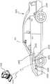
系统100或者其各种组件可被结合到各种不同平台中。在一些实施例中,系统100可被包含在交通工具200上,如图2A所示。例如,交通工具200可配备有处理单元110以及系统100的其它组件的任一个,如以上相对于图1所述。虽然在一些实施例中,交通工具200可以仅配备有单图像捕获装置(例如摄像机),但是在诸如结合图2B-2E所述实施例等的其它实施例中,可使用多个图像捕获装置。例如,如图2A所示,交通工具200的图像捕获装置122和124的任一个可以是ADAS(高级驾驶员辅助系统)成像集合的组成部分。
作为图像获取单元120的组成部分被包含在交通工具200上的图像捕获装置可定位在任何适当位置。在一些实施例中,如图2A-2E和图3A-3C所示,图像捕获装置122可位于后视镜附近。这个位置可提供与交通工具200的驾驶员相似的视线,这可帮助确定驾驶员可见和不可见的内容。图像捕获装置122可被定位在后视镜附近的任何位置,但是将图像捕获装置122放置在后视镜的驾驶员侧可进一步帮助获得表示驾驶员的视场和/或视线的图像。Image capture devices included on
也可使用图像捕获单元120的图像捕获装置的其它位置。例如,图像捕获装置124可位于交通工具200的保险杠之上或之中。这种位置可特别适合于具有宽视场的图像捕获装置。保险杠定位的图像捕获装置的视线能够与驾驶员的视线不同,并且因此保险杠图像捕获装置和驾驶员可能不一定看到相同对象。图像捕获装置(例如图像捕获装置122、124和126)还可位于其它位置。例如,图像捕获装置可位于交通工具200的侧镜之一或两者之上或之中、交通工具200的车顶上、交通工具200的发动机罩上、交通工具200的后备箱上、交通工具200的侧面,安装在交通工具200的车窗的任一个之上、定位在其后面或者定位在其正面,以及安装在交通工具200的正面和/或背面上的光象之中或附近等。Other locations of the image capture device of
除了图像捕获装置之外,交通工具200还可包括系统100的各种其它组件。例如,处理单元110可被包含在交通工具200上,与交通工具的发动机控制单元(ECU)集成或者分离。交通工具200还可配备有位置传感器130(例如GPS接收器),并且还可包括地图数据库160以及存储器单元140和150。In addition to the image capture device,
如先前所述,无线收发器172可以和/或通过一个或多个网络(例如蜂窝网络、因特网等)接收数据。例如,无线收发器172可向一个或多个服务器上传系统100所收集的数据,并且从一个或多个服务器下载数据。经由无线收发器172,系统100可接收对地图数据库160、存储器140和/或存储器150中存储的数据的周期或按需更新。类似地,无线收发器172可从系统100向一个或多个服务器上传任何数据(例如图像获取单元120所捕获的图像、位置传感器130或其它传感器、交通工具控制系统等所接收的数据)和/或处理单元110所处理的任何数据。As previously described, the
系统100可基于隐私等级设定向服务器(例如向云)上传数据。例如,系统100可实现隐私等级设定,以调节或限制被发送给服务器的数据的类型(包括元数据),所述数据可唯一地标识交通工具和/或交通工具的驾驶员/所有者。这类设定可由用户经由例如无线收发器172来设置,通过工厂缺省设定或者通过无线收发器172所接收的数据来初始化。
在一些实施例中,系统100可按照“高”隐私等级来上传数据,并且在设置设定下,系统100可传送数据(例如与路线相关的位置信息、所捕获图像等),而无需与特定交通工具和/或驾驶员/所有者有关的任何细节。例如,当按照“高”隐私设定上传数据时,系统100可以不包括交通工具标识号(VIN)或者交通工具的驾驶员或所有者的姓名,而是可传送数据,例如所捕获图像和/或与路线相关的有限位置信息。In some embodiments, the
考虑其它隐私等级。例如,系统100可按照“中间”隐私等级向服务器传送数据,并且包括“高”隐私等级下未包含的附加信息,例如交通工具的品牌和/或型号和/或交通工具类型(例如乘用车、运动型多功能车、卡车等)。在一些实施例中,系统100可按照“低”隐私等级上传数据。在“低”隐私等级设定下,系统100可上传数据,并且包括足以唯一标识特定交通工具、所有者/驾驶员和/或交通工具所行驶路线的一部分或全部的信息。这种“低”隐私等级数据可包括以下中的一个或多个:例如VIN、驾驶员/所有者姓名、交通工具出发前的起点、交通工具的预计目的地、交通工具的品牌和/或型号、交通工具的类型等。Consider other privacy levels. For example,
图2A是按照所公开实施例的示例性交通工具成像系统的图解侧视图表示。图2B是图2A所示实施例的图解顶视图图示。如图2B所示,所公开实施例可包括交通工具200,该交通工具200在车身中包括系统100,其中具有定位在后视镜附近和/或交通工具200的驾驶员附近的第一图像捕获装置122、定位在交通工具200的保险杠区域(例如保险杠区域210之一)之上或之中的第二图像捕获装置124以及处理单元110。2A is a diagrammatic side view representation of an exemplary vehicle imaging system in accordance with the disclosed embodiments. Figure 2B is a diagrammatic top view illustration of the embodiment shown in Figure 2A. As shown in FIG. 2B , the disclosed embodiments may include a
如图2C所示,图像捕获装置122和124均可定位在后视镜附近和/或交通工具200的驾驶员附近。另外,虽然在图2B和图2C中示出两个图像捕获装置122和124,但是应当理解,其它实施例可包括多于两个图像捕获装置。例如,在图2D和图2E所示的实施例中,第一、第二和第三图像捕获装置122、124和126被包含在交通工具200的系统100中。As shown in FIG. 2C , both
如图2D所示,图像捕获装置122可定位在后视镜附近和/或交通工具200的驾驶员附近,以及图像捕获装置124和126可定位在交通工具200的保险杠区域(例如保险杠区域210之一)之上或之中。以及如图2E所示,图像捕获装置122、124和126可定位在后视镜附近和/或交通工具200的驾驶员座椅附近。所公开实施例并不局限于图像捕获装置的任何特定数量和配置,并且图像捕获装置可定位在交通工具200之内和/或之上的任何适当位置。As shown in FIG. 2D ,
要理解,所公开实施例并不局限于交通工具,而是可能应用于其它上下文。还要理解,所公开实施例并不局限于特定类型的交通工具200,而是可以可适用于所有类型的交通工具,包括汽车、卡车、拖车和其它类型的交通工具。It is to be understood that the disclosed embodiments are not limited to vehicles, but may have application in other contexts. It is also to be understood that the disclosed embodiments are not limited to a particular type of
第一图像捕获装置122可包括任何适当类型的图像捕获装置。图像捕获装置122可包括光轴。在一个实例中,图像捕获装置122可包括具有全局快门的Aptina M9V024 WVGA传感器。在其它实施例中,图像捕获装置122可提供1280×960像素的分辨率,并且可包括卷帘快门。图像捕获装置122可包括各种光学元件。在一些实施例中,可包括一个或多个透镜,例如以便为图像捕获装置提供期望焦距和视场。在一些实施例中,图像捕获装置122可与6mm透镜或12mm透镜关联。在一些实施例中,图像捕获装置122可配置成捕获具有预期视场(FOV)202的图像,如图2D所示。例如,图像捕获装置122可配置成具有例如在40度至56度的范围之内的常规FOV,包括46度FOV、50度FOV、52度FOV或以上。备选地,图像捕获装置122可配置成具有23至40度的范围中的窄FOV,例如28度FOV或36度FOV。另外,图像捕获装置122可配置成具有100至180度的范围中的宽FOV。在一些实施例中,图像捕获装置122可包括广角保险杠摄像机或者高达180度FOV的摄像机。在一些实施例中,图像捕获装置122可以是宽高比为大约2:1(例如H×V=3800×1900像素)的7.2M像素图像捕获装置,其中具有大约100度水平FOV。这种图像捕获装置可用来代替三图像捕获装置配置。由于显著透镜失真,在图像捕获装置使用径向对称透镜的实现中,这种图像捕获装置的垂直FOV可明显小于50度。例如,这种透镜可能不是径向对称的,这允许大于50度的垂直FOV,其中具有100度水平FOV。The first
第一图像捕获装置122可获取相对于与交通工具200关联的场景的多个第一图像。多个第一图像的每个可作为一系列图像扫描线来获取,所述图像扫描线可使用卷帘快门来捕获。每个扫描线可包括多个像素。The first
第一图像捕获装置122可具有与图像扫描线的第一系列的每个的获取关联的扫描速率。扫描速率可表示图像传感器能够获取与特定扫描线中包含的每个像素关联的图像数据的速率。The first
图像捕获装置122、124和126可包含任何适当类型和数量的图像传感器,例如包括CCD传感器或CMOS传感器。在一个实施例中,CMOS图像传感器可连同卷帘快门一起使用,使得一行中的每个像素每次一个被读取,以及行的扫描逐行进行,直到已经捕获整个图像帧。在一些实施例中,可相对于帧从上到下顺序捕获行。
在一些实施例中,本文所公开的图像捕获装置的一个或多个(例如图像捕获装置122、124和126)可构成高分辨率成像器,并且可具有大于5M像素、7M像素、10M像素或以上的分辨率。In some embodiments, one or more of the image capture devices disclosed herein (e.g.,
卷帘快门的使用可使不同行中的像素在不同时间被曝光和捕获,这可引起所捕获图像帧中的偏斜和其它图像伪影。另一方面,当图像捕获装置122配置成与全局或同步快门配合操作时,所有像素可在共同曝光周期期间被曝光相同时间量。因此,从采用全局快门的系统所收集的帧中的图像数据表示在特定时间的整个FOV(例如FOV 202)的快照。相比之下,在卷帘快门应用中,帧中的每一行被曝光,以及数据在不同时间被捕获。因此,在具有卷帘快门的图像捕获装置中,移动对象可能出现失真。下面将更详细描述这种现象。The use of a rolling shutter can cause pixels in different rows to be exposed and captured at different times, which can cause skew and other image artifacts in the captured image frames. On the other hand, when
第二图像捕获装置124和第三图像捕获装置126可以是任何类型的图像捕获装置。与第一图像捕获装置122相似,图像捕获装置124和126的每个可包括光轴。在一个实施例中,图像捕获装置124和126的每个可包括具有全局快门的Aptina M9V024 WVGA传感器。备选地,图像捕获装置124和126的每个可包括卷帘快门。与图像捕获装置122相似,图像捕获装置124和126可配置成包括各种透镜和光学元件。在一些实施例中,与关联图像捕获装置122的FOV(例如FOV 202)相比,关联图像捕获装置124和126的透镜可提供相同或更窄的FOV(例如FOV 204和206)。例如,图像捕获装置124和126可具有40度、30度、26度、23度、20度或以下的FOV。Second
图像捕获装置124和126可获取相对于与交通工具200关联的场景的多个第二图像和第三图像。多个第二图像和第三图像的每个可作为第二和第三系列图像扫描线来获取,所述图像扫描线可使用卷帘快门来捕获。每个扫描线或行可具有多个像素。图像捕获装置124和126可具有与第二和第三系列中包含的图像扫描线的每个的获取关联的第二和第三扫描速率。
每个图像捕获装置122、124和126可相对于交通工具200以任何适当位置和取向来定位。图像捕获装置122、124和126的相对定位可被选择成帮助将从图像捕获装置所获取的信息融合在一起。例如,在一些实施例中,关联图像捕获装置124的FOV(例如FOV204)可与关联图像捕获装置122的FOV(例如FOV 202)和关联图像捕获装置126的FOV(例如FOV 206)部分或完全重叠。Each
图像捕获装置122、124和126可位于交通工具200上的任何适当相对高度。在一个实例中,图像捕获装置122、124和126之间可存在高度差,这可提供实现立体分析的充分视差信息。例如,如图2A所示,两个图像捕获装置122和124处于不同高度。图像捕获装置122、124和126之间还可存在横向位移差,从而例如给出附加视差信息以供处理单元110进行立体分析。横向位移的差可通过dx表示,如图2C和图2D所示。在一些实施例中,前或后位移(例如范围位移)可存在于图像捕获装置122、124和126之间。例如,图像捕获装置122可位于图像捕获装置124和/或图像捕获装置126后面0.5至2米或以上。这种类型的位移可使图像捕获装置之一能够覆盖其它(一个或多个)图像捕获装置的潜在盲点。
图像捕获装置122可具有任何适当分辨率能力(例如与图像传感器关联的像素的数量),以及与关联图像捕获装置124和126的(一个或多个)图像传感器的分辨率相比,关联图像捕获装置122的(一个或多个)图像传感器的分辨率可以更高、更低或相同。在一些实施例中,与图像捕获装置122和/或图像捕获装置124和126关联的(一个或多个)图像传感器可具有640×480、1024×768、1280×960的分辨率或者任何其它适当分辨率。
帧率(例如图像捕获装置在继续捕获与下一个图像帧关联的像素数据之前获取一个图像帧的像素数据集合的速率)可以是可控的。与关联图像捕获装置124和126的帧率相比,关联图像捕获装置122的帧率可以更高、更低或相同。与图像捕获装置122、124和126关联的帧率可取决于多种因素,所述因素可影响帧率的定时。例如,图像捕获装置122、124和126的一个或多个可包括在获取与图像捕获装置122、124和/或126中的图像传感器的一个或多个像素关联的图像数据之前或之后所施加的可选择像素延迟周期。一般来说,可按照装置的时钟速率来获取与每个像素对应的图像数据(例如每时钟循环一个像素)。另外,在包括卷帘快门的实施例中,图像捕获装置122、124和126的一个或多个可包括在获取与图像捕获装置122、124和/或126中的图像传感器的一行像素关联的图像数据之前或之后所施加的可选择水平消隐周期。此外,图像捕获装置122、124和126的一个或多个可包括在获取与图像捕获装置122、124和/或126的图像帧关联的图像数据之前或之后所施加的可选择垂直消隐周期。The frame rate (eg, the rate at which the image capture device acquires a set of pixel data for one image frame before continuing to capture pixel data associated with the next image frame) may be controllable. The frame rate of associated
这些定时控制可实现与图像捕获装置122、124和126关联的帧率的同步,甚至在每个的线扫描速率是不同的情况下。另外,如下面将更详细论述,这些可选择定时控制以及其它因素(例如图像传感器分辨率、最大线扫描速率等)可实现来自图像捕获装置122的FOV与图像捕获装置124和126的一个或多个FOV重叠的区域的图像捕获的同步,甚至在图像捕获装置122的视场与图像捕获装置124和126的FOV不同的情况下。These timing controls may enable synchronization of frame rates associated with
图像捕获装置122、124和126中的帧率定时可取决于关联图像传感器的分辨率。例如,假定两种装置的相似线扫描速率,如果一个装置包括分辨率为640×480的图像传感器而另一个装置包括分辨率为1280×960的图像传感器,则将要求更多时间从具有更高分辨率的传感器获取图像数据帧。Frame rate timing in
可影响图像捕获装置122、124和126中的图像数据获取的定时的另一个因素是最大线扫描速率。例如,从图像捕获装置122、124和126中包含的图像传感器获取一行图像数据将要求某个最小时间量。假定没有增加像素延迟周期,用于获取一行图像数据的这个最小时间量将与特定装置的最大线扫描速率相关。与具有更低最大线扫描速率的装置相比,提供更高最大线扫描速率的装置具有提供更高帧速率的潜力。在一些实施例中,图像捕获装置124和126的一个或多个可具有比关联图像捕获装置122的最大线扫描速率要高的最大线扫描速率。在一些实施例中,图像捕获装置124和/或126的最大线扫描速率可以是图像捕获装置122的最大线扫描速率的1.25、1.5、1.75或2倍或以上。Another factor that may affect the timing of image data acquisition in
在另一个实施例中,图像捕获装置122、124和126可具有相同最大线扫描速率,但是图像捕获装置122可工作在小于或等于其最大扫描速率的扫描速率。该系统可配置成使得图像捕获装置124和126的一个或多个工作在等于图像捕获装置122的线扫描速率的线扫描速率。在其它实例中,该系统可配置成使得图像捕获装置124和/或图像捕获装置126的线扫描速率可以是图像捕获装置122的线扫描速率的1.25、1.5、1.75或2倍或以上。In another embodiment,
在一些实施例中,图像捕获装置122、124和126可以是不对称的。也就是说,它们可包括具有不同视场(FOV)和焦距的摄像机。图像捕获装置122、124和126的视场可包括例如相对于交通工具200的环境的任何预期区域。在一些实施例中,图像捕获装置122、124和126的一个或多个可配置成从交通工具200正面、交通工具200后面、交通工具200侧面或者它们的组合的环境来获取图像数据。In some embodiments,
此外,与每个图像捕获装置122、124和/或126关联的焦距可以是可选择的(例如通过包含适当透镜等),使得每个装置获取相对于交通工具200的预期距离范围处的对象的图像。例如,在一些实施例中,图像捕获装置122、124和126可获取离交通工具几米之内的特写对象的图像。图像捕获装置122、124和126还可配置成获取离交通工具更远距离的范围(例如25m、50m、100m、150m或以上)处的对象的图像。此外,图像捕获装置122、124和126的焦距可被选择成使得一个图像捕获装置(例如图像捕获装置122)能够获取相对靠近交通工具(例如10m之内或20m之内)的对象的图像,而其它图像捕获装置(例如图像捕获装置124和126)能够获取离交通工具200更远对象(例如大于20m、50m、100m、150m等)的图像。Additionally, the focal length associated with each
按照一些实施例,一个或多个图像捕获装置122、124和126的FOV可具有广角。例如,具有140度的FOV可能是有利的,尤其对于可用来捕获交通工具200附近的区域的图像的图像捕获装置122、124和126。例如,图像捕获装置122可用来捕获交通工具200右边或左边的区域的图像,以及在这类实施例中,可期望图像捕获装置122具有宽FOV(例如至少140度)。According to some embodiments, the FOV of one or more
与图像捕获装置122、124和126的每个关联的视场可取决于相应焦距。例如,随着焦距增加,对应视场减小。The field of view associated with each of
图像捕获装置122、124和126可配置成具有任何适当视场。在一个特定示例中,图像捕获装置122可具有46度的水平FOV,图像捕获装置124可具有23度的水平FOV,以及图像捕获装置126可具有23与46度之间的水平FOV。在另一个实例中,图像捕获装置122可具有52度的水平FOV,图像捕获装置124可具有26度的水平FOV,以及图像捕获装置126可具有26与52度之间的水平FOV。在一些实施例中,图像捕获装置122的FOV与图像捕获装置124和/或图像捕获装置126的FOV的比率可从1.5至2.0改变。在其它实施例中,这个比率可在1.25与2.25之间改变。
系统100可配置成使得图像捕获装置122的视场与图像捕获装置124和/或图像捕获装置126的视场至少部分或完全重叠。在一些实施例中,系统100可配置成使得图像捕获装置124和126的视场例如落入图像捕获装置122的视场之内(例如更窄)并且与图像捕获装置122的视场共享共同中心。在其它实施例中,图像捕获装置122、124和126可捕获相邻FOV,或者可在其FOV中具有部分重叠。在一些实施例中,图像捕获装置122、124和126的视场可对齐成使得较窄FOV图像捕获装置124和/或126的中心可位于较宽FOV装置122的视场的下半部。
图2F是按照所公开实施例的示例性交通工具控制系统的图解表示。如图2F所示,交通工具200可包括节流系统220、制动系统230和转向系统240。系统100可通过一个或多个数据链路(例如用于传送数据的一个或多个任何有线和/或无线链路)向节流系统220、制动系统230和转向系统240的一个或多个提供输入(例如控制信号)。例如,基于对图像捕获装置122、124和/或126所获取的图像的分析,系统100可向节流系统220、制动系统230和转向系统240的一个或多个提供控制信号,以导航交通工具200(例如通过引起加速度、转弯、车道变换等)。此外,系统100可从节流系统220、制动系统230和转向系统24的一个或多个接收指示交通工具200的操作条件(例如速度、交通工具200是否正在制动和/或转弯等)的输入。下面结合图4-7提供其它细节。Figure 2F is a diagrammatic representation of an exemplary vehicle control system in accordance with the disclosed embodiments. As shown in FIG. 2F ,
如图3A所示,交通工具200还可包括用户接口170,以用于与交通工具200的驾驶员或乘客进行交互。例如,交通工具应用中的用户接口170可包括触摸屏320、旋钮330、按钮340和话筒350。交通工具200的驾驶员或乘客还可使用手柄(例如位于交通工具200的转向柱之上或附近,包括例如转弯信号手柄)、按钮(例如位于交通工具200的方向盘上)等与系统100进行交互。在一些实施例中,话筒350可定位成与后视镜310相邻。类似地,在一些实施例中,图像捕获装置122可位于后视镜310附近。在一些实施例中,用户接口170还可包括一个或多个扬声器360(例如交通工具音频系统的扬声器)。例如,系统100可经由扬声器360提供各种通知(例如警报)。As shown in FIG. 3A , the
图3B-3D是按照所公开实施例的示例性摄像机支架370的图示,该摄像机支架370配置成在后视镜(例如后视镜310)后面倚靠交通工具挡风玻璃所定位。如图3B所示,摄像机支架370可包括图像捕获装置122、124和126。图像捕获装置124和126可被定位在遮光罩(glare shield)380后面,该遮光罩380可与交通工具挡风玻璃齐平,并且包括膜和/或抗反射材料的组件。例如,遮光罩380可被定位成使得遮光罩与具有匹配斜面的交通工具挡风玻璃对齐。在一些实施例中,图像捕获装置122、124和126的每个可被定位在遮光罩380后面,如图3D所示。所公开实施例并不局限于图像捕获装置122、124和126、摄像机支架370以及遮光罩380的任何特定配置。图3C是从正面角度的图3B所示摄像机支架370的图示。3B-3D are illustrations of an
如获益于本公开的本领域的技术人员将会理解,可对以上所公开实施例进行许多变更和/或修改。例如,并非所有组件都是系统100的操作必不可少的。此外,任何组件可位于系统100的任何适当部分,并且组件可重新布置为多种配置,同时提供所公开实施例的功能性。因此,上述配置是示例,以及不管以上所述的配置,系统100能够提供大范围的功能性来分析交通工具200的周围环境,并且响应该分析而导航交通工具200。Many variations and/or modifications may be made to the above disclosed embodiments, as will be appreciated by those skilled in the art having the benefit of this disclosure. For example, not all components are essential to the operation of
如下面更详细论述并且按照各个所公开实施例,系统100可提供与自主驾驶和/或驾驶员辅助技术相关的多种特征。例如,系统100可分析图像数据、位置数据(例如GPS位置信息)、地图数据、速度数据和/或来自交通工具200中包含的传感器的数据。系统100可从例如图像获取单元120、位置传感器130和其它传感器来收集数据以供分析。此外,系统100可分析所收集数据,以确定交通工具200是否应当采取某个动作,并且然后自动采取所确定动作而无需人工干预。例如,当交通工具200在没有人工干预的情况下进行导航时,系统100可自动控制交通工具200的制动、加速度和/或转向(例如通过向节流系统220、制动系统230和转向系统240的一个或多个发送控制信号)。此外,系统100可分析所收集数据,并且基于对所收集数据的分析向交通工具乘员发出警告和/或警报。下面提供与系统100所提供的各个实施例有关的附加细节。As discussed in more detail below and in accordance with various disclosed embodiments, the
前向多成像系统forward multiple imaging system
如上所述,系统100可提供使用多摄像机系统的驾驶辅助功能性。多摄像机系统可使用面向交通工具的前向的一个或多个摄像机。在其它实施例中,多摄像机系统可包括面向交通工具侧面或者交通工具后部的一个或多个摄像机。在一个实施例中,例如,系统100可使用二摄像机成像系统,其中第一摄像机和第二摄像机(例如图像捕获装置122和124)可被定位在交通工具(例如交通工具200)的正面和/或侧面。第一摄像机可具有大于、小于第二摄像机的视场或者与其部分重叠的视场。另外,第一摄像机可被连接到第一图像处理器,以执行对第一摄像机所提供的图像的单目图像分析,以及第二摄像机可被连接到第二图像处理器,以执行对第二摄像机所提供的图像的单目图像分析。第一和第二图像处理器的输出(例如经处理信息)可相组合。在一些实施例中,第二图像处理器可从第一摄像机和第二摄像机接收图像,以执行立体分析。在另一个实施例中,系统100可使用三摄像机成像系统,其中摄像机的每个具有不同视场。因此,这种系统可基于从位于交通工具的前方和侧面的变化距离的对象所得出的信息进行判定。对单目图像分析的提法可表示基于从单个视点(例如从单个摄像机)所捕获的图像来执行图像分析的实例。立体图像分析可表示基于采用图像捕获参数的一个或多个变化所捕获的两个或更多图像来执行图像分析的实例。例如,适合于执行立体图像分析的所捕获图像可包括通过下列方式所捕获的图像:从两个或更多不同位置、从不同视场、使用不同焦距、连同视差信息等。As noted above,
例如,在一个实施例中,系统100可使用图像捕获装置122、124和126来实现三摄像机配置。在这种配置中,图像捕获装置122可提供窄视场(例如34度,或者从大约20至45度的范围所选的其它值等),图像捕获装置124可提供宽视场(例如150度,或者从大约100至大约180度的范围所选的其它值),以及图像捕获装置126可提供中间视场(例如46度,或者从大约35至大约60度的范围所选的其它值)。在一些实施例中,图像捕获装置126可充当主要或主摄像机。图像捕获装置122、124和126可被定位在后视镜310后面,并且基本上并排定位(例如分开6cm)。此外,在一些实施例中,如上所述,图像捕获装置122、124和126的一个或多个可被安装在遮光罩380后面,所述遮光罩380与交通工具200的挡风玻璃齐平。这种屏蔽可起作用以最小化来自汽车内部的任何反射对图像捕获装置122、124和126的影响。For example, in one embodiment,
在另一个实施例中,如以上结合图3B和图3C所述,宽视场摄像机(例如上述示例中的图像捕获装置124)可被安装成低于窄和主视场摄像机(例如上述示例中的图像装置122和126)。这个配置可提供来自宽视场摄像机的自由视线。为了减少反射,摄像机可被安装成靠近交通工具200的挡风玻璃,并且可包括摄像机上的偏振片,以阻尼反射光。In another embodiment, as described above in connection with FIGS. 3B and 3C , a wide field of view camera (such as
三摄像机系统可提供某些性能特性。例如,一些实施例可包括基于来自另一个摄像机的检测结果来验证一个摄像机对于对象的检测的能力。在上述三摄像机配置中,处理单元110可包括例如三个处理装置(例如,如上所述的三个EyeQ系列的处理器芯片),其中每个处理装置专用于处理图像捕获装置122、124和126的一个或多个所捕获的图像。Three-camera systems may offer certain performance characteristics. For example, some embodiments may include the ability to verify the detection of an object by one camera based on detection results from another camera. In the three-camera configuration described above, processing
在三摄像机系统中,第一处理装置可从主摄像机和窄视场摄像机接收图像,并且执行窄FOV摄像机的视觉处理,例如以检测其它交通工具、行人、车道标记、交通标志、交通灯和其它道路对象。此外,第一处理装置可计算来自主摄像机和窄摄像机的图像之间的像素的差异,并且创建交通工具200的环境的3D重构。第一处理装置然后可将3D重构与3D地图数据或者与基于来自另一个摄像机的信息所计算的3D信息相组合。In a three-camera system, the first processing device may receive images from the main camera and the narrow field of view camera and perform vision processing of the narrow FOV camera, for example to detect other vehicles, pedestrians, lane markings, traffic signs, traffic lights and other road object. Furthermore, the first processing means may calculate the difference in pixels between the images from the main camera and the narrow camera and create a 3D reconstruction of the environment of the
第二处理装置可从主摄像机接收图像,并且执行视觉处理,以检测其它交通工具、行人、车道标记、交通标志、交通灯和其它道路对象。另外,第二处理装置可计算摄像机位移,以及基于该位移来计算连续图像之间的像素的差异,并且创建场景的3D重构(例如来自运动的结构)。第二处理装置可向第一处理装置发送来自基于运动的3D重构的结构,以便与立体3D图像相组合。The second processing device may receive images from the main camera and perform vision processing to detect other vehicles, pedestrians, lane markings, traffic signs, traffic lights and other road objects. In addition, the second processing means may calculate the camera displacement, and based on this displacement calculate the difference in pixels between successive images and create a 3D reconstruction of the scene (eg structures from motion). The second processing means may send the structure from the motion-based 3D reconstruction to the first processing means for combination with the stereoscopic 3D image.
第三处理装置可从宽FOV摄像机接收图像,并且处理图像,以检测交通工具、行人、车道标记、交通标志、交通灯和其它道路对象。第三处理装置可进一步执行附加处理指令,以分析图像,以便标识图像中移动的对象,例如变更车道的交通工具、行人等。A third processing device may receive images from the wide FOV camera and process the images to detect vehicles, pedestrians, lane markings, traffic signs, traffic lights, and other road objects. The third processing device may further execute additional processing instructions to analyze the image to identify moving objects in the image, such as vehicles changing lanes, pedestrians, etc.
在一些实施例中,使基于图像的信息的流被单独捕获和处理可提供用于提供系统中的冗余度的机会。这种冗余度可包括例如使用第一图像捕获装置以及从那个装置所处理的图像来验证和/或补充通过捕获和处理来自至少第二图像捕获装置的图像信息所获得的信息。In some embodiments, having streams of image-based information captured and processed separately may provide an opportunity for providing redundancy in the system. Such redundancy may include, for example, using a first image capture device and images processed from that device to verify and/or supplement information obtained by capturing and processing image information from at least a second image capture device.
在一些实施例中,系统100可将两个图像捕获装置(例如图像捕获装置122和124)用于为交通工具200提供导航辅助中,以及使用第三图像捕获装置(例如图像捕获装置126)来提供冗余度,并且验证从另外两个图像捕获装置所接收的数据的分析。例如,在这种配置中,图像捕获装置122和124可提供图像以供系统100进行立体分析,以用于导航交通工具200,而图像捕获装置126可提供图像以供系统100进行单目分析,以提供基于从图像捕获装置122和/或图像捕获装置124所捕获的图像所获得的信息的冗余度和验证。也就是说,图像捕获装置126(和对应处理装置)可被认为提供冗余子系统,以用于提供对于从图像捕获装置122和124所得出的分析的检查(例如提供自动紧急制动(AEB)系统)。此外,在一些实施例中,可基于从一个或多个传感器(例如雷达、激光雷达、声学传感器、从交通工具外部的一个或多个收发器所接收的信息等)所接收的信息来补充所接收数据的冗余度和验证。In some embodiments,
本领域的技术人员将会知道,上述摄像机配置、摄像机放置、摄像机的数量、摄像机位置等只是示例。可在多种不同配置中组装和使用这些组件以及相对于整个系统所述的其它组件,而没有背离所公开实施例的范围。与多摄像机系统用来提供驾驶员辅助和/或自主交通工具功能性有关的其它细节如下。Those skilled in the art will appreciate that the camera configurations, camera placements, number of cameras, camera locations, etc. described above are examples only. These components, and other components described with respect to the overall system, can be assembled and used in a variety of different configurations without departing from the scope of the disclosed embodiments. Additional details regarding the use of multi-camera systems to provide driver assistance and/or autonomous vehicle functionality are as follows.
图4是按照所公开实施例、可存储/编程有用于执行一个或多个操作的指令的存储器140和/或150的示例性功能框图。虽然下文参照存储器140,但是本领域的技术人员将会知道,指令可被存储在存储器140和/或150中。4 is an exemplary functional block diagram of
如图4所示,存储器140可存储单目图像分析模块402、立体图像分析模块404、速度和加速度模块406以及导航响应模块408。所公开的实施例并不局限于存储器140的任何特定配置。此外,应用处理器180和/或图像处理器190可执行存储器140中包含的模块402、404、406和408的任一个中存储的指令。本领域的技术人员将会理解,以下论述中对处理单元110的提法可单独或共同表示应用处理器180和图像处理器190。相应地,下列过程的任一个的步骤可由一个或多个处理装置执行。As shown in FIG. 4 , the
在一个实施例中,单目图像分析模块402可存储指令(例如计算机视觉软件),所述指令在由处理单元110执行时执行对图像捕获装置122、124和126其中之一所获取的图像集合的单目图像分析。在一些实施例中,处理单元110可把来自图像集合的信息与附加感测信息(例如来自雷达、激光雷达等的信息)相组合,以执行单目图像分析。如以下结合图5A-5D所述,单目图像分析模块402可包括用于检测图像集合内的特征集合(例如车道标记、交通工具、行人、道路标志、高速公路出口匝道、交通灯、危险物体以及与交通工具的环境关联的任何其它特征)的指令。基于该分析,系统100(例如经由处理单元110)可引起交通工具200中的一个或多个导航响应,例如转弯、车道变换、加速度的变化等,如下面结合导航响应模块408所述。In one embodiment, monocular
在一个实施例中,立体图像分析模块404可存储指令(例如计算机视觉软件),所述指令在由处理单元110执行时执行对于从图像捕获装置122、124和126的任一个所选的图像捕获装置的组合所获取的第一和第二组图像的立体图像分析。在一些实施例中,处理单元110可把来自第一和第二组图像的信息与附加感测信息(例如来自雷达的信息)相组合,以执行立体图像分析。例如,立体图像分析模块404可包括用于基于图像捕获装置124所获取的图像的第一集合和图像捕获装置126所获取的图像的第二集合来执行立体图像分析的指令。如以下结合图6所述,立体图像分析模块404可包括用于检测第一和第二组图像内的特征集合(例如车道标记、交通工具、行人、道路标志、高速公路出口匝道、交通灯、危险物体等)的指令。基于该分析,处理单元110可引起交通工具200中的一个或多个导航响应,例如转弯、车道变换、加速度的变化等,如下面结合导航响应模块408所述。此外,在一些实施例中,立体图像分析模块404可实现与已训练系统(例如神经网络或深度神经网络)或者未训练系统(例如可配置成使用计算机视觉算法来检测和/或标记从其中捕获和处理感测信息的环境中的对象的系统)关联的技术。在一个实施例中,立体图像分析模块404和/或其它图像处理模块可配置成使用已训练和未训练系统的组合。In one embodiment, stereoscopic
在一个实施例中,速度和加速度模块406可存储软件,所述软件配置成分析从交通工具200中的一个或多个计算和机电装置所接收的数据,所述装置配置成引起交通工具200的速度和/或加速度的变化。例如,处理单元110可执行与速度和加速度模块406关联的指令,以基于从单目图像分析模块402和/或立体图像分析模块404的执行所得出的数据来计算交通工具200的目标速度。这种数据可包括例如目标位置、速度和/或加速度、交通工具200相对于附近交通工具、行人或道路物体的位置和/或速度、交通工具200相对于道路的车道标记的位置信息等。另外,处理单元110可基于感测输入(例如来自雷达的信息)以及来自交通工具200的其它系统(例如交通工具200的节流系统220、制动系统230和/或转向系统240)的输入来计算交通工具200的目标速度。基于所计算目标速度,处理单元110可向交通工具200的节流系统220、制动系统230和/或转向系统240传送电子信号,以通过例如物理上压下制动器或者松开交通工具200的加速器来触发速度和/或加速度的变化。In one embodiment, the velocity and
在一个实施例中,导航响应模块408可存储由处理单元110可执行的软件,以基于从单目图像分析模块402和/或立体图像分析模块404的执行所得出的数据来确定预期导航响应。这种数据可包括与附近交通工具、行人和道路物体关联的位置和速度信息、交通工具200的目标位置信息等。另外,在一些实施例中,导航响应可(部分或完全)基于地图数据、交通工具200的预定位置和/或交通工具200与从单目图像分析模块402和/或立体图像分析模块404的执行所检测的一个或多个对象之间的相对速度或相对加速度。导航响应模块408还可基于感测输入(例如来自雷达的信息)以及来自交通工具200的其它系统(例如交通工具200的节流系统220、制动系统230和转向系统240)的输入来确定预期导航响应。基于预期导航响应,处理单元110可向交通工具200的节流系统220、制动系统230和转向系统240传送电子信号,以通过例如转动交通工具200的方向盘以取得预定角度的旋转来触发预期导航响应。在一些实施例中,处理单元110可使用导航响应模块408的输出(例如预期导航响应)作为对速度和加速度模块406的执行的输入,以用于计算交通工具200的速度的变化。In one embodiment,
此外,本文所公开模块(例如模块402、404和406)的任一个可实现与已训练系统(例如神经网络或深度神经网络)或未训练系统关联的技术。Furthermore, any of the modules disclosed herein (eg,
图5A是示出按照所公开实施例、基于单目图像分析来引起一个或多个导航响应的示例性过程500A的流程图。在步骤510,处理单元110可经由处理单元110与图像获取单元120之间的数据接口128来接收多个图像。例如,图像获取单元120(例如具有视场202的图像捕获装置122)中包含的摄像机可捕获交通工具200前方(或者例如交通工具的侧面或后部)的区域的多个图像,并且通过数据连接(例如数字、有线、USB、无线、Bluetooth等)将它们传送给处理单元110。处理单元110可在步骤520执行单目图像分析模块402,以分析多个图像,如以下结合图5B-5D更详细描述。通过执行分析,处理单元110可检测图像集合内的特征集合,例如车道标记、交通工具、行人、道路标志、高速公路出口匝道、交通灯等。FIG. 5A is a flowchart illustrating an
处理单元110还可在步骤520执行单目图像分析模块402,以检测各种道路危险,例如卡车轮胎的部件、跌落的道路标志、松散的货物、小动物等。道路危险可在结构、形状、大小和颜色上改变,这可使这类危险的检测更为棘手。在一些实施例中,处理单元110可执行单目图像分析模块402,以便对多个图像执行多帧分析,以检测道路危险。例如,处理单元110可估计连续图像帧之间的摄像机运动,并且计算帧之间的像素的差异,以构建道路的3D地图。处理单元110然后可使用3D地图来检测路面以及路面上方存在的危险。The
在步骤530,处理单元110可执行导航响应模块408,以基于在步骤520所执行的分析以及以上结合图4所述的技术来引起交通工具200中的一个或多个导航响应。导航响应可包括例如转弯、车道变换、加速度的变化等。在一些实施例中,处理单元110可使用从速度和加速度模块406的执行所得出的数据来引起一个或多个导航响应。另外,多个导航响应可同时、顺序或者按照它们的任何组合出现。例如,处理单元110可通过例如顺序地向交通工具200的转向系统240和节流系统220传送控制信号,使交通工具200变换一个车道,并且然后加速。备选地,处理单元110可通过例如同时向交通工具200的制动系统230和转向系统240传送控制信号,使交通工具200制动,同时变换车道。At
图5B是示出按照所公开实施例、检测图像集合中的一个或多个交通工具和/或行人的示例性过程500B的流程图。处理单元110可执行单目图像分析模块402,以实现过程500B。在步骤540,处理单元110可确定表示可能的交通工具和/或行人的候选对象集合。例如,处理单元110可扫描一个或多个图像,将图像与一个或多个预定模式进行比较,并且在每个图像内标识可包含感兴趣对象(例如交通工具、行人或者其部分)的可能位置。预定模式可按照实现高“误命中”率和低“未命中”率的方式来设计。例如,处理单元110可使用与预定模式的相似性的低阈值将候选对象标识为可能的交通工具或行人。这样做可允许处理单元110降低未命中(例如未标识)表示交通工具或行人的候选对象的概率。FIG. 5B is a flowchart illustrating an
在步骤542,处理单元110可基于分类标准来过滤候选对象集合,以排除某些候选(例如无关或不太相关的对象)。这类标准可从与数据库(例如存储器140中存储的数据库)中存储的对象类型关联的各种性质得出。性质可包括对象形状、尺寸、纹理、位置(例如相对于交通工具200)等。因此,处理单元110可使用标准的一个或多个集合从候选对象集合中排除伪候选。In
在步骤544,处理单元110可分析图像的多个帧,以确定候选对象集合中的对象是否表示交通工具和/或行人。例如,处理单元110可跨连续帧跟踪所检测候选对象,并且累加与所检测对象关联的逐帧数据(例如大小、相对于交通工具200的位置等)。另外,处理单元110可估计所检测对象的参数,并且将对象的逐帧位置数据与预测位置进行比较。In
在步骤546,处理单元110可构建所检测对象的测量集合。这类测量可包括例如与所检测对象关联的位置、速度和加速度值(相对于交通工具200)。在一些实施例中,处理单元110可基于使用一系列基于时间的观察的估计技术(例如卡尔曼(Kalman)滤波器或线性二次估计(LQE))和/或基于不同对象类型(例如汽车、卡车、行人、自行车、道路标志等)的可用建模数据来构建测量。卡尔曼滤波器可基于对象标度的测量,其中标度测量与碰撞时间(例如交通工具200到达对象的时间量)成比例。因此,通过执行步骤540-546,处理单元110可标识所捕获图像集合内出现的交通工具和行人,并且得出与交通工具和行人关联的信息(例如位置、速度、大小)。基于标识和所得出信息,处理单元110可引起交通工具200中的一个或多个导航响应,如以上结合图5A所述。In
在步骤548,处理单元110可执行对一个或多个图像的光流分析,以降低检测“误命中”和未命中表示交通工具或行人的候选对象的概率。光流分析可表示例如分析与其它交通工具和行人关联的一个或多个图像中相对于交通工具200的运动模式,所述运动模式与路面运动是不同的。处理单元110可通过跨不同时间所捕获的多个图像帧观察对象的不同位置来计算候选对象的运动。处理单元110可使用位置和时间值作为对数学模型的输入,以用于计算候选对象的运动。因此,光流分析可提供检测交通工具200附近的交通工具和行人的另一种方法。处理单元110可结合步骤540-546来执行光流分析,以提供检测交通工具和行人的冗余度,并且增加系统100的可靠性。At
图5C是示出按照所公开实施例、检测图像集合中的道路标记和/或车道几何信息的示例性过程500C的流程图。处理单元110可执行单目图像分析模块402,以实现过程500C。在步骤550,处理单元110可通过扫描一个或多个图像来检测对象集合。为了检测车道标记段、车道几何信息和其它相关道路标记,处理单元110可过滤对象集合,以排除被确定为不相关的那些对象(例如小坑洞、小岩石等)。在步骤552,处理单元110可将在步骤550所检测的属于同一道路标记或车道标记的段编组在一起。基于编组,处理单元110可开发表示所检测段的模型,例如数学模型。FIG. 5C is a flowchart illustrating an
在步骤554,处理单元110可构建与所检测段关联的测量集合。在一些实施例中,处理单元110可创建所检测段从图像平面到现实世界平面的投影。可使用具有与物理性质(例如所检测道路的位置、坡度、曲率和曲率导数)对应的系数的三次多项式来表征投影。在生成投影中,处理单元110可考虑路面的变化以及与交通工具200关联的倾斜和滚动速率。另外,处理单元110可通过分析路面上存在的位置和运动线索对道路高程进行建模。此外,处理单元110可通过跟踪一个或多个图像中的特征点集合来估计与交通工具200关联的倾斜和滚动速率。In
在步骤556,处理单元110可通过例如跨连续图像帧跟踪所检测段并且累加与所检测段关联的逐帧数据来执行多帧分析。当处理单元110执行多帧分析时,在步骤554所构建的测量集合可变得更可靠并且与越来越高的置信度水平关联。因此,通过执行步骤550、552、554和556,处理单元110可标识所捕获图像集合内出现的道路标记,并且得出车道几何信息。基于标识和所得出信息,处理单元110可引起交通工具200中的一个或多个导航响应,如以上结合图5A所述。In
在步骤558,处理单元110可考虑附加信息源,以在周围环境的上下文中进一步开发交通工具200的安全模型。处理单元110可使用安全模型来定义系统100可采用安全方式执行交通工具200的自主控制的上下文。为了开发安全模型,在一些实施例中,处理单元110可考虑其它交通工具的位置和运动、所检测道路边缘和屏障和/或从地图数据(例如来自地图数据库160的数据)所提取的一般道路形状描述。通过考虑附加信息源,处理单元110可提供检测道路标记和车道几何形状的冗余度,并且增加系统100的可靠性。In
图5D是示出按照所公开实施例、检测图像集合中的交通灯的示例性过程500D的流程图。处理单元110可执行单目图像分析模块402,以实现过程500D。在步骤560,处理单元110可扫描图像集合,并且标识在图像中可能包含交通灯的位置出现的对象。例如,处理单元110可过滤所标识对象,以构建候选对象集合,从而排除不可能与交通灯对应的那些对象。过滤可基于与交通灯关联的各种性质进行,例如形状、尺寸、纹理、位置(例如相对于交通工具200)等。这类性质可基于交通灯和交通控制信号的多个示例,并且被存储在数据库中。在一些实施例中,处理单元110可对反映可能的交通灯的候选对象集合执行多帧分析。例如,处理单元110可跨连续图像帧跟踪候选对象,估计候选对象的现实世界位置,并且滤出正在移动(不可能是交通灯)的那些对象。在一些实施例中,处理单元110可对候选对象执行颜色分析,并且标识可能的交通灯内部出现的所检测颜色的相对位置。FIG. 5D is a flowchart illustrating an
在步骤562,处理单元110可分析交叉口的几何形状。分析可基于下列的任何组合:(i)在交通工具200的任一侧所检测的车道的数量,(ii)在道路上检测的标记(例如箭头标记),以及(iii)从地图数据(例如来自地图数据库160的数据)所提取的交叉口的描述。处理单元110可使用从单目分析模块402的执行所得出的信息进行分析。另外,处理单元110可确定在步骤560所检测的交通灯与交通工具200附近出现的车道之间的对应性。At
当交通工具200接近交叉口时,在步骤564,处理单元110可更新与所分析交叉口几何形状和所检测交通灯关联的置信度水平。例如,如与实际出现在交叉口的交通灯的数量相比,被估计出现在交叉口的数量可影响置信度水平。因此,基于置信度水平,处理单元110可将控制权委托给给交通工具200的驾驶员,以便改进安全条件。通过执行步骤560、562和564,处理单元110可标识所捕获图像集合内出现的交通灯,并且分析交叉口几何信息。基于标识和分析,处理单元110可引起交通工具200中的一个或多个导航响应,如以上结合图5A所述。As the
图5E是示出按照所公开实施例、基于交通工具路径来引起交通工具200中的一个或多个导航响应的示例性过程500E的流程图。在步骤570,处理单元110可构建与交通工具200关联的初始交通工具路径。可使用按照坐标(x,z)所表达的点集合来表示交通工具路径,并且点集合中的两个点之间的距离di可落入1至5米的范围中。在一个实施例中,处理单元110可使用两个多项式(例如左和右道路多项式)来构建初始交通工具路径。处理单元110可两个多项式之间的计算几何中点,并且在存在的情况下将所产生交通工具路径中包含的每个点偏移预定偏移量(例如智能车道偏移量)(零偏移量可对应于车道中间的行驶)。偏移可沿与交通工具路径中的任何两个点之间的段垂直的方向。在另一个实施例中,处理单元110可使用一个多项式和估计车道宽度将交通工具路径中的每个点偏移估计车道宽度的一半加上预定偏移量(例如智能车道偏移量)。FIG. 5E is a flowchart illustrating an
在步骤572,处理单元110可更新在步骤570所构建的交通工具路径。处理单元110可使用更高分辨率来重构在步骤570所构建的交通工具路径,使得表示交通工具路径的点集合中的两个点之间的距离dk小于上述距离di。例如,距离dk可落入0.1至0.3米的范围中。处理单元110可使用抛物线样条算法来重构交通工具路径,该抛物线样条算法可产生与交通工具路径的总长度对应的累加距离向量S(即,基于表示交通工具路径的点集合)。At
在步骤574,处理单元110可基于在步骤572所构建的已更新交通工具路径来确定前视点(按照坐标表达为(xl,zl))。处理单元110可从累加距离向量S中提取前视点,以及前视点可与前视距离和前视时间关联。前视距离可具有范围从10至20米的下限,可作为交通工具200的速度与前视时间的乘积来计算。例如,随着交通工具200的速度减小,前视距离也可减小(例如直至它达到下限)。前视时间的范围可从0.5至1.5秒,可与关联引起交通工具200中的导航响应的一个或多个控制环路(例如航向误差跟踪控制环路)的增益成反比。例如,航向误差跟踪控制环路的增益可取决于偏航率环路、转向致动器环路、汽车横向动力学等的带宽。因此,航向误差跟踪控制环路的增益越高,则前视时间越短。At
在步骤576,处理单元110可基于在步骤574所确定的前视点来确定航向误差和偏航率命令。处理单元110可通过计算前视点的反正切(例如arctan(xl/zl))来确定航向误差。处理单元110可将偏航率命令确定为航向误差与高级控制增益的乘积。高级控制增益可等于:(2/前视时间),若前视距离不是处于下限。否则,高级控制增益可等于:(2*交通工具200的速度/前视距离)。At
图5F是示出按照所公开实施例、确定前行交通工具是否正变更车道的示例性过程500F的流程图。在步骤580,处理单元110可确定与前行交通工具(例如在交通工具200前面行驶的交通工具)关联的导航信息。例如,处理单元110可使用以上结合图5A和图5B所述的技术来确定前行交通工具的位置、速度(例如方向和速度)和/或加速度。处理单元110还可使用以上结合图5E所述的技术来确定一个或多个道路多项式、前视点(与交通工具200关联)和/或蜗牛尾迹(snail trail)(例如描述前行交通工具所采取的路径的点集合)。FIG. 5F is a flowchart illustrating an
在步骤582,处理单元110可分析在步骤580所确定的导航信息。在一个实施例中,处理单元110可计算蜗牛尾迹与道路多项式之间(例如沿尾迹)的距离。如果沿尾迹的这个距离的变化超过预定阈值(例如笔直道路上的0.1至0.2米、中等弯曲道路上的0.3至0.4米以及具有急弯的道路上的0.5至0.6米),则处理单元110可确定前行交通工具可能正变更车道。在检测到多个交通工具在交通工具200前面行驶的情况下,处理单元110可比较与每个交通工具关联的蜗牛尾迹。基于该比较,处理单元110可确定其蜗牛尾迹与其它交通工具的蜗牛尾迹不匹配的交通工具可能正变更车道。处理单元110还可将(与前行交通工具关联的)蜗牛尾迹的曲率与前行交通工具正行驶的路段的预计曲率进行比较。可从地图数据(例如来自地图数据库160的数据)、从道路多项式、从其它交通工具的蜗牛尾迹、从与道路有关的先验知识等中提取预计曲率。如果蜗牛尾迹的曲率和路段的预计曲率的差超过预定阈值,则处理单元110可确定前行交通工具可能正变更车道。At
在另一个实施例中,处理单元110可在特定时间段(例如0.5至1.5秒)内将前行交通工具的瞬时位置与(与交通工具200关联的)前视点进行比较。如果前行交通工具的瞬时位置与前视点之间的距离在特定时间段期间改变,并且变化的累加总和超过预定阈值(例如笔直道路上的0.3至0.4米、中等弯曲道路上的0.7至0.8米以及具有急弯的道路上的1.3至1.7米),则处理单元110可确定前行交通工具可能正变更车道。在另一个实施例中,处理单元110可通过将沿尾迹行驶的横向距离与蜗牛尾迹的预计曲率进行比较,来分析蜗牛尾迹的几何形状。预计曲率半径可按照下列计算确定:(δz2+δx2)/2/(δx),其中δx表示所行驶的横向距离,以及δz表示所行驶的纵向距离。如果所行驶的横向距离与预计曲率之间的差超过预定阈值(例如500至700米),则处理单元110可确定前行交通工具可能正变更车道。在另一个实施例中,处理单元110可分析前行交通工具的位置。如果前行交通工具的位置遮挡道路多项式(例如前行交通工具覆盖在道路多项式之上),则处理单元110可确定前行交通工具可能正变更车道。在前行交通工具的位置是使得在前行交通工具前面检测到另一个交通工具并且两个交通工具的蜗牛尾迹不平行的情况下,处理单元110可确定(更近的)前行交通工具可能正变更车道。In another embodiment, the
在步骤584,处理单元110可基于在步骤582所执行的分析来确定前行交通工具200是否正变更车道。例如,处理单元110可基于在步骤582所执行的单独分析的加权平均进行确定。在这种方案下,例如,由处理单元110基于特定类型的分析进行的关于前行交通工具可能正变更车道的判定可被指派值“1”(而“0”表示关于前行交通工具不可能变更车道)。在步骤582所执行的不同分析可被指派不同权重,以及所公开实施例并不局限于分析和权重的任何特定组合。At
图6是示出按照所公开实施例、基于立体图像分析来引起一个或多个导航响应的示例性过程600的流程图。在步骤610,处理单元110可经由数据接口128接收第一和第二多个图像。例如,图像获取单元120中包含的摄像机(例如具有视场202和204的图像捕获装置122和124)可捕获交通工具200前方的区域的第一和第二多个图像,并且通过数字连接(例如USB、无线、Bluetooth等)将它们传送给处理单元110。在一些实施例中,处理单元110可经由两个或更多数据接口接收第一和第二多个图像。所公开的实施例并不局限于任何特定数据接口配置或协议。FIG. 6 is a flowchart illustrating an
在步骤620,处理单元110可执行立体图像分析模块404,以执行对第一和第二多个图像的立体图像分析,以便创建交通工具前面的道路的3D地图,并且检测图像内的特征,例如车道标记、交通工具、行人、道路标志、高速公路出口匝道、交通灯、道路危险等。立体图像分析可按照与以上结合图5A-5D所述步骤相似的方式执行。例如,处理单元110可执行立体图像分析模块404,以检测第一和第二多个图像内的候选对象(例如交通工具、行人、道路标记、交通灯、道路危险等),基于各种标准来滤出候选对象的子集,以及执行多帧分析,构建测量,并且确定其余候选对象的置信度水平。在执行上述步骤中,处理单元110可考虑来自第一和第二多个图像的信息而不是单独来自图像的一个集合的信息。例如,处理单元110可分析第一和第二多个图像中出现的候选对象的像素级数据(或者来自两个所捕获图像流之中的其它数据子集)的差异。作为另一个示例,处理单元110可通过观察对象出现在多个图像的一个图像中而不是另一个图像中,或者相对于其它差异(所述差异相对于出现在两个图像流中的对象可存在),来估计候选对象的位置和/或速度(例如相对于交通工具200)。例如,可基于与图像流之一或两者中出现的对象关联的特征的轨迹、位置、移动特性等确定相对于交通工具200的位置、速度和/或加速度。At
在步骤630,处理单元110可执行导航响应模块408,以基于在步骤620所执行的分析以及以上结合图4所述的技术来引起交通工具200中的一个或多个导航响应。导航响应可包括例如转弯、车道变换、加速度的变化、速度的变化、制动等。在一些实施例中,处理单元110可使用从速度和加速度模块406的执行所得出的数据来引起一个或多个导航响应。另外,多个导航响应可同时、顺序或者按照它们的任何组合出现。At
图7是示出按照所公开实施例、基于对三组图像的分析来引起一个或多个导航响应的示例性过程700的流程图。在步骤710,处理单元110可经由数据接口128接收第一、第二和第三多个图像。例如,图像获取单元120中包含的摄像机(例如具有视场202、204和206的图像捕获装置122、124和126)可捕获交通工具200前方和/或侧面的区域的第一、第二和第三多个图像,并且通过数字连接(例如USB、无线、Bluetooth等)将它们传送给处理单元110。在一些实施例中,处理单元110可经由三个或更多数据接口接收第一、第二和第三多个图像。例如,图像捕获装置122、124、126的每个可具有关联数据接口,以用于向处理单元110传递数据。所公开的实施例并不局限于任何特定数据接口配置或协议。FIG. 7 is a flowchart illustrating an
在步骤720,处理单元110可分析第一、第二和第三多个图像,以检测图像内的特征,例如车道标记、交通工具、行人、道路标志、高速公路出口匝道、交通灯、道路危险等。分析可按照与以上结合图5A-5D和图6所述步骤相似的方式执行。例如,处理单元110可对第一、第二和第三多个图像的每个执行单目图像分析(例如经由单目图像分析模块402的执行并且基于以上结合图5A-5D所述的步骤)。备选地,处理单元110可对第一和第二多个图像、第二和第三多个图像和/或第一和第三多个图像执行立体图像分析(例如经由立体图像分析模块404的执行并且基于以上结合图6所述的步骤)。可组合与第一、第二和/或第三多个图像的分析对应的所处理信息。在一些实施例中,处理单元110可执行单目和立体图像分析的组合。例如,处理单元110可对第一多个图像执行单目图像分析(例如经由单目图像分析模块402的执行),并且对第二和第三多个图像执行立体图像分析(例如经由立体图像分析模块404的执行)。图像捕获装置122、124和126的配置—包括其相应位置和视场202、204和206—可影响对第一、第二和第三多个图像进行的分析的类型。所公开实施例并不局限于图像捕获装置122、124和126的特定配置或者对第一、第二和第三多个图像进行的分析的类型。At
在一些实施例中,处理单元110可基于在步骤710和720所获取和分析的图像对系统100执行测试。这种测试可提供系统100对图像捕获装置122、124和126的某些配置的总体性能的指示符。例如,处理单元110可确定“误命中”(例如系统100不正确地确定交通工具或行人的存在的情况)和“未命中”的比例。In some embodiments, processing
在步骤730,处理单元110可基于从第一、第二和第三多个图像的两个所得出的信息来引起交通工具200中的一个或多个导航响应。第一、第二和第三多个图像的两个的选择可取决于各种因素,例如多个图像的每个中检测的对象的数量、类型和大小。处理单元110还可基于图像质量和分辨率、图像中反映的有效视场、所捕获帧的数量、一个或多个感兴趣对象实际出现在帧中的程度(例如对象出现的帧的百分比、每个这种帧中出现的对象的比例等)等进行选择。At
在一些实施例中,处理单元110可通过确定从一个图像源所得出的信息与从其它图像源所得出的信息一致的程度来选择从第一、第二和第三多个图像的两个所得出的信息。例如,处理单元110可组合从图像捕获装置122、124和126的每个所得出的所处理信息(无论是通过单目分析、立体分析还是两者的任何组合),并且确定跨从图像捕获装置122、124和126的每个所捕获的图像是一致的视觉指示符(例如车道标记、所检测交通工具及其位置和/或路径、所检测交通灯等)。处理单元110还可排除跨所捕获图像不一致的信息(例如交通工具变更车道、车道模型指示过于靠近交通工具200的交通工具等)。因此,处理单元110可基于一致和不一致信息的确定来选择从第一、第二和第三多个图像的两个所得出的信息。In some embodiments, processing
导航响应可包括例如转弯、车道变换、加速度的变化等。处理单元110可基于在步骤720所执行的分析以及如以上结合图4所述的技术来引起一个或多个导航响应。处理单元110还可使用从速度和加速度模块406的执行所得出的数据来引起一个或多个导航响应。在一些实施例中,处理单元110可基于交通工具200与第一、第二和第三多个图像的任一个内所检测的对象之间的相对位置、相对速度和/或相对加速度来引起一个或多个导航响应。多个导航响应可同时、顺序或者按照它们的任何组合出现。Navigation responses may include, for example, turns, lane changes, changes in acceleration, and the like.
自主交通工具导航的稀疏道路模型Sparse road models for autonomous vehicle navigation
在一些实施例中,所公开的系统和方法可使用自主交通工具导航的稀疏地图。特别是,稀疏地图可用于沿路段的自主交通工具导航。例如,稀疏地图可为导航自主交通工具提供充分信息,而无需存储和/或更新大量数据。如下面更详细论述,自主交通工具可使用稀疏地图基于一个或多个所存储轨迹来导航一个或多个道路。In some embodiments, the disclosed systems and methods may use sparse maps for autonomous vehicle navigation. In particular, sparse maps can be used for autonomous vehicle navigation along road segments. For example, sparse maps can provide sufficient information to navigate autonomous vehicles without storing and/or updating large amounts of data. As discussed in more detail below, an autonomous vehicle may use a sparse map to navigate one or more roads based on one or more stored trajectories.
自主交通工具导航的稀疏地图Sparse maps for autonomous vehicle navigation
在一些实施例中,所公开的系统和方法可生成自主交通工具导航的稀疏地图。例如,稀疏地图可为导航提供充分信息,而无需过多数据存储或数据传输速率。如下面更详细描述,交通工具(该交通工具可以是自主交通工具)可使用稀疏地图来导航一个或多个道路。例如,在一些实施例中,稀疏地图可包括与道路以及潜在地与沿道路的路标相关的数据,所述数据对于交通工具导航可以是充分的,但是也呈现小数据占用面积。例如,如与包括详细地图信息(例如沿道路所收集的图像数据)的数字地图相比,以下详细描述的稀疏数据地图可要求明显更少的存储空间和数据传输带宽。In some embodiments, the disclosed systems and methods can generate sparse maps for autonomous vehicle navigation. For example, sparse maps can provide sufficient information for navigation without requiring excessive data storage or data transfer rates. As described in more detail below, a vehicle (which may be an autonomous vehicle) may use a sparse map to navigate one or more roads. For example, in some embodiments, a sparse map may include data related to roads and potentially landmarks along roads, which may be sufficient for vehicle navigation, but also present a small data footprint. For example, the sparse data maps described in detail below may require significantly less storage space and data transfer bandwidth as compared to digital maps that include detailed map information, such as image data collected along roads.
例如,不是存储路段的详细表示,稀疏数据地图而是可存储沿道路的优选交通工具路径的三维多项式表示。这些路径可要求极少数据存储空间。另外,在所述的稀疏数据地图中,路标可被标识并且包含在稀疏地图道路模型中以帮助导航。这些路标可以以适合于实现交通工具导航的任何间距来定位,但是在一些情况下,这类路标无需以高密度和短间距来标识并且包含在模型中。而是在一些情况下,导航基于间隔开至少50米、至少100米、至少500米、至少1公里或者至少2公里的路标可以是可能的。如在其它部分将更详细论述,稀疏地图可基于由配备有各种传感器和装置(例如图像捕获装置、全球定位系统传感器、运动传感器等)的交通工具在沿道路行驶时所收集或测量的数据来生成。在一些情况下,稀疏地图可基于一个或多个交通工具沿特定道路的多次行驶期间所收集的数据来生成。使用一个或多个交通工具的多次行驶来生成稀疏地图可称作“众包”稀疏地图。For example, rather than storing detailed representations of road segments, a sparse data map may store a three-dimensional polynomial representation of preferred vehicle paths along roads. These paths may require very little data storage space. Additionally, in the sparse data map described, waypoints may be identified and included in the sparse map road model to aid in navigation. These waypoints may be positioned at any spacing suitable to enable vehicle navigation, but in some cases such waypoints need not be identified and included in the model at high density and short spacing. Rather, in some cases, navigation may be possible based on signposts spaced at least 50 meters, at least 100 meters, at least 500 meters, at least 1 kilometer, or at least 2 kilometers apart. As will be discussed in more detail elsewhere, the sparse map may be based on data collected or measured by vehicles equipped with various sensors and devices (e.g., image capture devices, GPS sensors, motion sensors, etc.) to generate. In some cases, a sparse map may be generated based on data collected during multiple trips of one or more vehicles along a particular road. Generating a sparse map using multiple trips by one or more vehicles may be referred to as a "crowdsourced" sparse map.
按照所公开实施例,自主交通工具系统可将稀疏地图用于导航。例如,所公开的系统和方法可分发稀疏地图以用于生成自主交通工具的道路导航模型,并且可使用稀疏地图和/或所生成道路导航模型沿路段导航自主交通工具。按照本公开的稀疏地图可包括一个或多个三维轮廓,所述三维轮廓可表示自主交通工具在沿关联路段移动时可穿过的预定轨迹。According to disclosed embodiments, an autonomous vehicle system may use sparse maps for navigation. For example, the disclosed systems and methods can distribute a sparse map for use in generating a road navigation model for an autonomous vehicle, and can use the sparse map and/or the generated road navigation model to navigate the autonomous vehicle along a road segment. A sparse map according to the present disclosure may include one or more three-dimensional contours, which may represent predetermined trajectories that an autonomous vehicle may traverse while moving along an associated road segment.
按照本公开的稀疏地图还可包括表示一个或多个道路特征的数据。这类道路特征可包括所识别的路标、道路签名简档以及导航交通工具中有用的任何其它道路相关特征。按照本公开的稀疏地图可基于稀疏地图中包含的较小数据量来实现交通工具的自主导航。例如,不是包含道路的详细表示(例如道路边缘、道路曲率、与路段关联的图像或者详述与路段关联的其它物理特征的数据),稀疏地图的所公开实施例可要求相对极少存储空间(以及当稀疏地图的部分被传输给交通工具时的相对极小带宽),但是仍然可充分提供自主交通工具导航。下面更详细论述的所公开稀疏地图的小数据占用面积在一些实施例中可通过存储要求小数据量但是仍然实现自主导航的道路相关元素的表示来实现。A sparse map according to the present disclosure may also include data representing one or more road features. Such road features may include recognized road signs, road signature profiles, and any other road-related features useful in navigating a vehicle. A sparse map according to the present disclosure may enable autonomous navigation of a vehicle based on the small amount of data contained in the sparse map. For example, rather than containing detailed representations of roads (such as road edges, road curvature, images associated with road segments, or data detailing other physical characteristics associated with road segments), the disclosed embodiments of the sparse map may require relatively little storage space ( and relatively minimal bandwidth when parts of the sparse map are transmitted to the vehicle), but still adequately provide for autonomous vehicle navigation. The small data footprint of the disclosed sparse maps, discussed in more detail below, may in some embodiments be achieved by storing representations of road-related elements that require a small amount of data but still enable autonomous navigation.
例如,不是存储道路的各个方面的详细表示,所公开的稀疏地图而是可存储交通工具可沿道路前进的一个或多个轨迹的多项式表示。因此,不是存储(或者必须传输)与道路的物理性质有关的细节以实现沿道路的导航,使用所公开的稀疏地图,交通工具而是可沿特定路段被导航,而无需在一些情况下解释道路的物理方面,而是通过将其行驶路径与沿特定路段的轨迹(例如多项式样条)对齐。这样,交通工具可主要基于所存储轨迹(例如多项式样条)来导航,所存储轨迹可要求比涉及道路图像、道路参数、道路布局等的存储的方式要少许多的存储空间。For example, rather than storing detailed representations of various aspects of a road, the disclosed sparse map may store a polynomial representation of one or more trajectories a vehicle may follow along the road. Thus, rather than storing (or having to transmit) details about the physical properties of the road to enable navigation along the road, using the disclosed sparse map, vehicles can be navigated along specific road segments without in some cases interpreting the road , but by aligning its travel path with a trajectory (such as a polynomial spline) along a specific road segment. In this way, a vehicle may navigate primarily based on stored trajectories (eg, polynomial splines), which may require significantly less storage space than approaches involving storage of road images, road parameters, road layout, etc.
除了沿路段的轨迹的所存储多项式表示之外,所公开的稀疏地图还可包括可表示道路特征的小数据对象。在一些实施例中,小数据对象可包括数字签名,所述数字签名从沿路段行驶的交通工具上的传感器(例如摄像机或另一传感器,例如悬架传感器)所获得的数字图像(或数字信号)来得出。数字签名相对于传感器所获取的信号可具有减小的大小。在一些实施例中,数字签名可被创建为与分类器功能兼容,该分类器功能配置成例如从传感器在后续驾驶期间所获取的信号来检测和标识道路特征。在一些实施例中,数字签名可被创建成使得数字签名具有尽可能小的占用面积,同时保持基于由沿同一路段行驶的交通工具上的摄像机在后续时间所捕获的道路特征的图像(或者传感器所生成的数字信号,如果所存储签名不是基于图像和/或包括其它数据)将道路特征与所存储签名相互关连或匹配的能力。In addition to stored polynomial representations of trajectories along road segments, the disclosed sparse maps may also include small data objects that may represent road features. In some embodiments, the small data object may include a digital signature of a digital image (or digital signal) obtained from a sensor on a vehicle traveling along the road segment, such as a camera or another sensor, such as a suspension sensor. ) to draw. The digital signature may have a reduced size relative to the signal acquired by the sensor. In some embodiments, the digital signature may be created to be compatible with a classifier function configured to detect and identify road features, eg, from signals acquired by sensors during subsequent driving. In some embodiments, the digital signature may be created such that the digital signature has the smallest possible footprint while maintaining the image based on road features captured at a subsequent time by a camera (or sensor) on a vehicle traveling along the same road segment. The generated digital signal, if the stored signature is not based on an image and/or includes other data) the ability to correlate or match road features with the stored signature.
在一些实施例中,数据对象的大小可进一步与道路特征的唯一性关联。例如,对于由交通工具上的摄像机可检测的道路特征,以及在交通工具上的摄像机系统被耦合到能够将与那个道路特征对应的图像数据区分为与特定类型的道路特征(例如道路标志)关联的分类器的情况下,并且在这种道路标志在那个区域中是本地唯一的(例如附近不存在相同的道路标志或者相同类型的道路标志),存储指示道路特征的类型及其位置的数据可以是充分的。In some embodiments, the size of the data object may further be associated with the uniqueness of the road feature. For example, for a road feature detectable by a camera on a vehicle, and a camera system on the vehicle coupled to be able to distinguish image data corresponding to that road feature as being associated with a particular type of road feature (such as a road sign) In the case of a classifier for , and where such road signs are locally unique in that area (e.g. no identical road signs or road signs of the same type exist nearby), storing data indicating the type of road feature and its location can is sufficient.
如下面将更详细论述,道路特征(例如沿路段的路标)可被存储为小数据对象,所述小数据对象可通过较少字节来表示道路特征,同时提供识别和使用这种特征进行导航的充分信息。在一个示例中,道路标志可被识别为作为交通工具的导航的基础的所标识路标。道路标志的表示可被存储在稀疏地图中,以包括例如指示路标的类型(例如停止标志)的几个字节的数据以及指示路标的位置(例如坐标)的几个字节的数据。基于路标的这类数据-灯(data-light)表示(例如使用足以基于路标进行定位、识别和导航的表示)的导航可提供与稀疏地图关联的预期水平的导航功能性,而无需显著增加与稀疏地图关联的数据开销。路标(和其它道路特征)的这个精益表示(lean representation)可利用这类交通工具上包含的传感器和处理器所述传感器和处理器配置成检测、标识和/或分类某些道路特征。As will be discussed in more detail below, road features (such as road signs along a road segment) can be stored as small data objects that can represent road features in fewer bytes while providing the ability to identify and use such features for navigation sufficient information. In one example, road signs may be identified as identified waypoints on which the navigation of the vehicle is based. Representations of road signs may be stored in a sparse map to include, for example, a few bytes of data indicating the type of road sign (eg stop sign) and a few bytes of data indicating the location of the road sign (eg coordinates). Navigation based on such a data-light representation of landmarks (e.g., using a representation sufficient for localization, recognition, and navigation based on landmarks) can provide the expected level of navigation functionality associated with sparse maps without requiring significant increases in communication with Data overhead for sparse map associations. This lean representation of road signs (and other road features) may utilize sensors and processors included on such vehicles that are configured to detect, identify and/or classify certain road features.
当例如标志或者甚至特定类型的标志在给定区域中为本地唯一时(例如当不存在另一标志或者不存在相同类型的另一标志时),稀疏地图可使用指示路标的类型(标志或者特定类型的标志)的数据,以及在自主交通工具上的摄像机捕获包括标志(或者特定类型的标志)的区域的图像时的导航(例如自主导航)期间,处理器可处理该图像,检测标志(若实际存在于图像中),将图像分类为标志(或者分类为特定类型的标志),并且将图像的位置与如稀疏地图中存储的标志的位置相互关连。Sparse maps can be used to indicate the type of signpost (sign or specific type) when, for example, a sign or even a sign of a particular type is locally unique in a given area (such as when there is no other sign or another sign of the same type). type of sign), and during navigation (e.g., autonomous navigation) when a camera on the autonomous vehicle captures an image of an area including a sign (or a sign of a particular type), the processor may process the image, detect the sign (if actually present in the image), classify the image as a landmark (or as a specific type of landmark), and correlate the location of the image with the location of the landmark as stored in the sparse map.
稀疏地图可以包括沿着路段标识的对象的任何合适的表示。在一些情况下,对象可以被称为语义对象或非语义对象。语义对象可以包括例如与预定类型分类相关联的对象。这种类型分类可以有用于减少描述在环境中识别的语义对象所需的数据量,这在采集阶段(例如,减少与用于将驾驶信息从多个采集交通工具传输到服务器的带宽相关联的成本)中和在导航阶段(例如,地图数据的减少可加速地图图块从服务器到导航交通工具的传输,并且还可减少与用于这种传输的带宽相关联的成本)期间均是有益的。语义对象分类类型可以被指派给期望沿道路遇到的任何类型的对象或特征。The sparse map may include any suitable representation of objects identified along road segments. In some cases, objects may be referred to as semantic objects or non-semantic objects. Semantic objects may include, for example, objects associated with predetermined type classifications. This type classification can be useful in reducing the amount of data required to describe semantic objects identified in the environment, which is during the acquisition phase (e.g., reducing the bandwidth associated with transferring driving information from multiple acquisition vehicles to a server). cost) and during the navigation phase (e.g., the reduction of map data can speed up the transfer of map tiles from the server to the navigation vehicle, and can also reduce the cost associated with the bandwidth used for such transfer) . Semantic object classification types can be assigned to any type of object or feature expected to be encountered along the road.
语义对象还可以被分成两个或更多个逻辑组。例如,在一些情况下,一组语义对象类型可以与预定维度相关联。这样的语义对象可以包括某些限速标志、让行标志、合并标志、停止标志、交通灯、道路上的方向箭头、检修孔盖、或可以与标准化大小相关联的任何其它类型的对象。由这样的语义对象提供的一个好处是可需要非常少的数据来表示/完全定义对象。例如,如果限速大小的标准化大小是已知的,则采集交通工具可仅需要标识(通过对所捕获的图像的分析)限速标志(识别的类型)的存在连同检测到的限速标志的位置的指示(例如,标志的中心或标志的某一角在所捕获的图像中的2D位置(或者,备选地,在现实世界坐标中的3D位置))来为服务器侧上的地图生成提供足够的信息。在将2D图像位置传输到服务器的情况下,还可传输与检测到标志的所捕获图像相关联的位置,使得服务器可确定标志的现实世界位置(例如,通过使用来自一个或多个采集交通工具的多个所捕获图像的运动技术中的结构)。即使通过这种有限的信息(仅需要几个字节来定义每个检测到的对象),服务器也可以基于从一个或多个采集交通工具接收的类型分类(表示限速标志)连同检测到的标志的位置信息来构造包括完整表示的限速标志的地图。Semantic objects can also be divided into two or more logical groups. For example, in some cases, a set of semantic object types may be associated with predetermined dimensions. Such semantic objects may include certain speed limit signs, yield signs, merge signs, stop signs, traffic lights, directional arrows on roads, manhole covers, or any other type of object that may be associated with a standardized size. One benefit provided by such semantic objects is that very little data may be required to represent/fully define the object. For example, if the normalized size of the speed limit size is known, capturing the vehicle may only need to identify (by analysis of the captured images) the presence of a speed limit sign (type of recognition) along with the detected speed limit sign's An indication of the position (e.g., the 2D position of the center of the marker or a certain corner of the marker in the captured image (or, alternatively, the 3D position in real-world coordinates)) to provide sufficient information for map generation on the server side Information. Where the 2D image location is transmitted to the server, the location associated with the captured image where the landmark was detected can also be transmitted so that the server can determine the real world location of the landmark (e.g., by using data from one or more capturing vehicles). structure in motion technology of multiple captured images). Even with this limited information (requiring only a few bytes to define each detected object), the server can classify (indicating speed limit signs) based on the type received from one or more collecting vehicles together with the detected The location information of the signs is used to construct a map that includes a complete representation of the speed limit signs.
语义对象还可以包括不与某些标准化特性相关联的其它识别的对象或特征类型。这样的对象或特征可以包括坑洞、柏油接缝、灯杆、非标准化标志、路缘、树、树枝、或具有一个或多个可变特性(例如,可变尺寸)的任何其它类型的识别的对象类型。在这种情况下,除了向服务器传输检测到的对象或特征类型(例如坑洞、杆等)的指示和检测到的对象或特征的位置信息之外,采集交通工具还可以传输对象或特征的大小的指示。大小可以以2D图像维度(例如,具有边界框或一个或多个维度值)或现实世界维度(通过运动计算中的结构、基于LIDAR或RADAR系统输出、基于训练的神经网络输出等来确定)来表达。Semantic objects may also include other recognized object or feature types that are not associated with certain standardized properties. Such objects or features may include potholes, tarmac joints, light poles, non-standardized signs, curbs, trees, branches, or any other type of identification that has one or more variable characteristics (e.g., variable size) of the object type. In this case, in addition to transmitting an indication of the type of object or feature detected (e.g., pothole, pole, etc.) and location information of the detected object or feature to the server, the collection vehicle may also transmit size indication. Size can be in 2D image dimensions (e.g., with a bounding box or one or more dimensional values) or real-world dimensions (determined by structures in motion calculations, output from LIDAR or RADAR-based systems, output from trained neural networks, etc.) Express.
非语义对象或特征可包括落在所识别的类别或类型之外但仍可在地图生成中提供有价值信息的任何可检测对象或特征。在一些情况下,这种非语义特征可以包括检测到的建筑物拐角或检测到的建筑物窗户拐角、道路附近的独特石头或对象、道路路肩中的混凝土泼溅物、或任何其它可检测的对象或特征。在检测到这种对象或特征时,一个或多个采集交通工具可以向地图生成服务器传送与所检测到的对象/特征相关联的一个或多个点(2D图像点或3D现实世界点)的位置。另外,可以为包括所检测到的对象或特征的所捕获图像的区域生成压缩的或简化的图像片段(例如,图像散列)。该图像散列可以基于预定的图像处理算法来计算,并且可以形成所检测到的非语义对象或特征的有效签名。这种签名对于相对于包括非语义特征或对象的稀疏地图的导航是有用的,因为穿过道路的交通工具可以应用与用于生成图像散列的算法类似的算法,以便确认/验证所映射的非语义特征或对象在所捕获图像中的存在。使用此技术,非语义特征可增加稀疏地图的丰富度(例如,以增强其在导航中的有用性)而不增加显著的数据开销。Non-semantic objects or features may include any detectable object or feature that falls outside of the recognized class or type but can still provide valuable information in map generation. In some cases, such non-semantic features may include detected building corners or detected building window corners, unique stones or objects near roads, concrete splatters in road shoulders, or any other detectable object or feature. Upon detection of such an object or feature, one or more collection vehicles may transmit to the map generation server a map of one or more points (either 2D image points or 3D real world points) associated with the detected object/feature. Location. Additionally, compressed or simplified image segments (eg, image hashes) may be generated for regions of the captured image that include detected objects or features. The image hash can be calculated based on a predetermined image processing algorithm and can form a valid signature of the detected non-semantic objects or features. Such signatures are useful for navigation relative to sparse maps that include non-semantic features or objects, since vehicles crossing the road can apply algorithms similar to those used to generate image hashes in order to validate/verify the mapped The presence of non-semantic features or objects in captured images. Using this technique, non-semantic features can add richness to a sparse map (eg, to enhance its usefulness in navigation) without adding significant data overhead.
如上所述,目标轨迹可以存储在稀疏地图中。这些目标轨迹(例如,3D样条)可以表示道路的每个可用车道的优选或推荐路径、通过交叉口的每个有效路径以用于并入和离开等。除了目标轨迹之外,还可以以表示性样条的形式在稀疏地图中检测、采集和合并其它道路特征。此类特征可以包括例如道路边缘、车道标记、路缘、护栏、或沿道路或路段延伸的任何其它对象或特征。As mentioned above, object trajectories can be stored in a sparse map. These target trajectories (eg, 3D splines) may represent preferred or recommended paths for each available lane of a road, each valid path through an intersection for merging and exiting, and the like. In addition to object trajectories, other road features can be detected, collected and incorporated in the sparse map in the form of representational splines. Such features may include, for example, road edges, lane markings, curbs, guardrails, or any other object or feature extending along a road or road segment.
生成稀疏地图generate sparse map
在一些实施例中,稀疏地图可包括沿路段延伸的路面特征的至少一个线表示以及与该路段关联的多个路标。在某些方面,稀疏地图可例如通过当一个或多个交通工具穿过路段时所获取的多个图像的图像分析经由“众包”来生成。In some embodiments, the sparse map may include at least one line representation of road surface features extending along a road segment and a plurality of landmarks associated with the road segment. In certain aspects, a sparse map may be generated via "crowdsourcing," eg, by image analysis of multiple images acquired as one or more vehicles traverse a road segment.
图8示出例如交通工具200(可以是自主交通工具)等的一个或多个交通工具可访问以用于提供自主交通工具导航的稀疏地图800。稀疏地图800可被存储在存储器(例如存储器140或150)中。这类存储器装置可包括任何类型的非暂时存储装置或计算机可读介质。例如,在一些实施例中,存储器140或150可包括硬盘驱动器、致密光盘、闪速存储器、基于磁的存储器装置、基于光的存储器装置等。在一些实施例中,稀疏地图800可被存储在数据库(例如地图数据库160)中,该数据库可被存储在存储器140或150或者其它类型的存储装置中。FIG. 8 illustrates a sparse map 800 that one or more vehicles, such as vehicle 200 (which may be an autonomous vehicle), may access for use in providing autonomous vehicle navigation. Sparse map 800 may be stored in a memory (eg,
在一些实施例中,稀疏地图800可被存储在交通工具200上提供的存储装置或者非暂时计算机可读介质(例如交通工具200上的导航系统中包含的存储装置)上。交通工具200上提供的处理器(例如处理单元110)可访问交通工具200上提供的存储装置或计算机可读介质中存储的稀疏地图800,以便在交通工具穿过路段时生成用于引导自主交通工具200的导航指令。In some embodiments, the sparse map 800 may be stored on a storage device provided on the
但是无需相对交通工具本地存储稀疏地图800。在一些实施例中,稀疏地图800可被存储在远程服务器上提供的存储装置或计算机可读介质上,该远程服务器与交通工具200或者关联交通工具200的装置进行通信。交通工具200上提供的处理器(例如处理单元110)可从远程服务器接收稀疏地图800中包含的数据,并且可执行该数据以用于引导交通工具200的自主驾驶。在这类实施例中,远程服务器可存储全部稀疏地图800或者仅存储它的一部分。相应地,交通工具200上和/或一个或多个附加交通工具上的存储装置或计算机可读介质可存储稀疏地图800的其余(一个或多个)部分。But there is no need to store the sparse map 800 locally with respect to the vehicle. In some embodiments, the sparse map 800 may be stored on a storage device or computer-readable medium provided on a remote server in communication with the
此外,在这类实施例中,可使稀疏地图800是穿过各种路段的多个交通工具(例如数十、数百、数千或数百万个交通工具等)可访问的。还应当注意,稀疏地图800可包括多个子地图。例如,在一些实施例中,稀疏地图800可包括可用于导航交通工具中的数百、数千、数百万或更多子地图(例如地图图块)。这类子地图可称作本地地图或地图图块,以及沿道路行驶的交通工具可访问与该交通工具正行驶的位置相关的任何数量的本地地图。可存储稀疏地图800的本地地图部分,其中全球导航卫星系统(GNSS)密钥作为稀疏地图800的数据库的索引。因此,虽然本系统中用于导航主交通工具的转向角的计算可在不依靠主交通工具的GNSS位置、道路特征或路标的情况下执行,但是这种GNSS信息可用于检索相关本地地图。Furthermore, in such embodiments, sparse map 800 may be made accessible to multiple vehicles (eg, tens, hundreds, thousands, or millions of vehicles, etc.) traversing various road segments. It should also be noted that sparse map 800 may include multiple submaps. For example, in some embodiments, sparse map 800 may include hundreds, thousands, millions, or more submaps (eg, map tiles) that may be used to navigate a vehicle. Such submaps may be referred to as local maps or map tiles, and a vehicle traveling along a road may have access to any number of local maps related to where the vehicle is traveling. The local map portion of the sparse map 800 may be stored with a global navigation satellite system (GNSS) key as an index into the database of the sparse map 800 . Thus, while the calculation of the steering angle used in the present system to navigate the host vehicle can be performed without relying on the host vehicle's GNSS position, road features or landmarks, such GNSS information can be used to retrieve relevant local maps.
一般来说,稀疏地图800可基于从一个或多个交通工具在沿道路行驶时所收集的数据(例如驾驶信息)来生成。例如,使用一个或多个交通工具上的传感器(例如摄像机、速度计、GPS、加速计等),一个或多个交通工具沿道路行驶的轨迹可被记录,以及用于交通工具沿道路进行后续行程的优选轨迹的多项式表示可基于一个或多个交通工具所行驶的所收集轨迹来确定。类似地,由一个或多个交通工具所收集的数据可帮助标识沿特定道路的潜在路标。从正穿过交通工具所收集的数据也可用来标识道路简档(road profile)信息,例如道路宽度简档、道路粗糙度简档、交通线间距简档、道路条件等。使用所收集信息,稀疏地图800可被生成和分发(例如供本地存储或者经由即时数据传输),以供导航一个或多个自主交通工具中使用。但是,在一些实施例中,地图生成可能不在地图的初始生成时结束。如下面将更详细论述,稀疏地图800可基于在交通工具继续穿过稀疏地图800中包含的道路时从那些交通工具所收集的数据来连续或周期更新。In general, sparse map 800 may be generated based on data (eg, driving information) collected from one or more vehicles while driving along a road. For example, using sensors on one or more vehicles (e.g., cameras, speedometers, GPS, accelerometers, etc.), the trajectory of one or more vehicles traveling along a road can be recorded and used for subsequent follow-up of the vehicle along the road. A polynomial representation of a preferred trajectory for a trip may be determined based on collected trajectories traveled by one or more vehicles. Similarly, data collected by one or more vehicles can help identify potential landmarks along a particular road. Data collected from passing vehicles may also be used to identify road profile information, such as road width profile, road roughness profile, traffic line spacing profile, road conditions, and the like. Using the collected information, sparse map 800 may be generated and distributed (eg, for local storage or via immediate data transmission) for use in navigating one or more autonomous vehicles. However, in some embodiments, map generation may not end with the initial generation of the map. As will be discussed in more detail below, sparse map 800 may be continuously or periodically updated based on data collected from vehicles as those vehicles continue to traverse the roads included in sparse map 800 .
稀疏地图800中记录的数据可包括基于全球定位系统(GPS)数据的位置信息。例如,位置信息可被包含在稀疏地图800中以用于各种地图元素,包括例如路标位置、道路简档位置等。可使用从穿过道路的交通工具所收集的GPS数据来获得稀疏地图800中包含的地图元素的位置。例如,通过所标识路标的交通工具可使用与交通工具关联的GPS位置信息以及所标识路标相对于交通工具的位置的确定(例如基于从交通工具上的一个或多个摄像机所收集的数据的图像分析)来确定所标识路标的位置。所标识路标(或者稀疏地图800中包含的任何其它特征)的这类位置确定可在附加交通工具通过所标识路标的位置时重复进行。附加位置确定的部分或全部可用来相对于所标识路标来细化稀疏地图800中存储的位置信息。例如,在一些实施例中,相对于稀疏地图800中存储的特定特征的多个位置测量可被共同求平均。但是,任何其它数学运算也可用来基于地图元素的多个所确定位置来细化地图元素的所存储位置。The data recorded in the sparse map 800 may include location information based on global positioning system (GPS) data. For example, location information may be included in sparse map 800 for various map elements including, for example, landmark locations, road profile locations, and the like. The locations of map elements contained in sparse map 800 may be obtained using GPS data collected from vehicles crossing the road. For example, a vehicle passing an identified signpost may use GPS location information associated with the vehicle and a determination of the position of the identified signpost relative to the vehicle (eg, an image based on data collected from one or more cameras on the vehicle) analysis) to determine the location of the identified landmarks. This type of location determination of the identified landmark (or any other feature included in the sparse map 800 ) may be repeated as additional vehicles pass the location of the identified landmark. Some or all of the additional location determination may be used to refine the location information stored in the sparse map 800 relative to the identified landmarks. For example, in some embodiments, multiple position measurements relative to a particular feature stored in sparse map 800 may be averaged together. However, any other mathematical operation may also be used to refine the stored location of the map element based on the multiple determined locations of the map element.
在特定示例中,采集交通工具可穿过特定路段。每个采集交通工具捕获其各自环境的图像。可以以任何合适的帧捕获速率(例如,9Hz等)来收集图像。每个采集交通工具上的(一个或多个)图像分析处理器分析所捕获的图像以检测语义和/或非语义特征/对象的存在。在高级别,采集交通工具向映射服务器传送语义和/或非语义对象/特征的检测指示以及与那些对象/特征相关联的位置。更详细地,类型指示符、尺寸指示符等可以与位置信息一起传送。位置信息可以包括用于使映射服务器能够将检测到的对象/特征聚合成导航中有用的稀疏地图的任何合适的信息。在一些情况下,位置信息可以包括曾检测到语义或非语义特征/对象的所捕获图像中的一个或多个2D图像位置(例如,X-Y像素位置)。这种图像位置可以对应于特征/对象的中心、角等。在这种情况下,为了帮助映射服务器重构驾驶信息并对齐来自多个采集交通工具的驾驶信息,每个采集交通工具还可以向服务器提供曾捕获每个图像的位置(例如,GPS位置)。In a particular example, the acquisition vehicle may traverse a particular road segment. Each acquisition vehicle captures images of its respective environment. Images may be collected at any suitable frame capture rate (eg, 9 Hz, etc.). The image analysis processor(s) on each capture vehicle analyze the captured images to detect the presence of semantic and/or non-semantic features/objects. At a high level, the acquisition vehicle transmits detection indications of semantic and/or non-semantic objects/features and the locations associated with those objects/features to the mapping server. In more detail, a type indicator, a size indicator, etc. may be transmitted together with the location information. The location information may include any suitable information for enabling the mapping server to aggregate detected objects/features into a sparse map useful in navigation. In some cases, the location information may include one or more 2D image locations (eg, X-Y pixel locations) in the captured image where semantic or non-semantic features/objects were detected. Such image locations may correspond to centers, corners, etc. of features/objects. In this case, to help the mapping server reconstruct driving information and align driving information from multiple capturing vehicles, each capturing vehicle may also provide the server with the location (eg, GPS location) at which each image was captured.
在其它情况下,采集交通工具可以向服务器提供与检测到的对象/特征相关联的一个或多个3D现实世界点。这样的3D点可以与预定原点(例如驾驶段的原点)有关,并且可以通过任何合适的技术来确定。在一些情况下,运动技术中的结构可用于确定检测到的对象/特征的3D现实世界位置。例如,可以在两个或更多个捕获的图像中检测诸如特定限速标志的某个对象。使用诸如所捕获图像之间的采集交通工具的已知自我运动(速度、轨迹、GPS位置等)之类的信息,连同所观察到的所捕获图像中的限速标志的变化(X-Y像素位置的变化、大小的变化等),可以确定与限速标志相关联的一个或多个点的现实世界位置,并将其传递到映射服务器。这种方法是可选的,因为它需要采集交通工具系统的部分上的更多计算。所公开实施例的稀疏地图可使用较小存储数据量来实现交通工具的自主导航。在一些实施例中,稀疏地图800可具有小于每公里道路2Mb、小于每公里道路1Mb、小于每公里道路500kB或者小于每公里道路100kB的数据密度(例如包括表示目标轨迹、路标和任何其它所存储道路特征的数据)。在一些实施例中,稀疏地图800的数据密度可小于每公里道路10kB或者甚至小于每公里道路2kB(例如每公里1.6kB),或者不超过每公里道路10kB或者不超过每公里道路20kB。在一些实施例中,美国道路的大部分(即使不是全部)可使用具有总共4GB或更少数据的稀疏地图来自主导航。这些数据密度值可表示对整个稀疏地图800、对稀疏地图800内的本地地图和/或对稀疏地图800内的特定路段的平均数。In other cases, the acquisition vehicle may provide the server with one or more 3D real world points associated with the detected object/feature. Such 3D points may be related to a predetermined origin (eg, the origin of the driving segment), and may be determined by any suitable technique. In some cases, structures in motion technology can be used to determine the 3D real-world position of a detected object/feature. For example, a certain object such as a particular speed limit sign may be detected in two or more captured images. Using information such as the known ego-motion (velocity, trajectory, GPS position, etc.) of the acquired vehicle between captured images, along with observed changes in speed limit signs in the captured images (X-Y pixel position of change in size, change in size, etc.), the real-world location of one or more points associated with the speed limit sign can be determined and passed to the mapping server. This approach is optional as it requires more calculations on parts of the acquisition vehicle system. The sparse map of the disclosed embodiments can enable autonomous navigation of vehicles using a small amount of stored data. In some embodiments, the sparse map 800 may have a data density of less than 2 Mb per kilometer of road, less than 1 Mb per kilometer of road, less than 500 kB per kilometer of road, or less than 100 kB per kilometer of road (e.g., road feature data). In some embodiments, the data density of the sparse map 800 may be less than 10 kB per kilometer of road, or even less than 2 kB per kilometer of road (eg, 1.6 kB per kilometer), or no more than 10 kB per kilometer of road, or no more than 20 kB per kilometer of road. In some embodiments, most, if not all, of US roads can be autonomously navigated using sparse maps with a total of 4GB of data or less. These data density values may represent averages over the entire sparse map 800 , over a local map within the sparse map 800 , and/or over specific road segments within the sparse map 800 .
如所述,稀疏地图800可包括多个目标轨迹810的表示,以用于引导沿路段的自主驾驶或导航。这类目标轨迹可被存储为三维样条。稀疏地图800中存储的目标轨迹例如可基于交通工具沿特定路段的先前穿过的两个或更多重构轨迹来确定。路段可与单个目标轨迹或者多个目标轨迹关联。例如,在二车道道路上,第一目标轨迹可被存储以表示沿道路在第一方向的预计行驶路径,以及第二目标轨迹可被存储以表示沿道路在另一方向(例如与第一方向相反)的预计行驶路径。可相对特定路段来存储附加目标轨迹。例如,在多车道道路上,一个或多个目标轨迹可被存储,表示与多车道道路关联的一个或多个车道中的交通工具的预计行驶路径。在一些实施例中,多车道道路的每个车道可与其自己的目标轨迹关联。在其它实施例中,可存在比多车道道路上存在的车道要少的所存储目标轨迹。在这类情况下,行驶于多车道道路的交通工具可通过考虑与其目标轨迹被存储的车道的车道偏移量,使用所存储目标轨迹的任一个来引导其导航(例如,如果交通工具在三车道道路的最左侧车道中行驶,并且仅对道路的中间车道存储目标轨迹,则交通工具可通过在生成导航指令时考虑中间车道与最左侧车道之间的车道偏移量,使用中间车道的目标轨迹进行导航)。As mentioned, sparse map 800 may include representations of
在一些实施例中,目标轨迹可表示交通工具在行驶时应当采取的理想路径。目标轨迹可位于例如行驶车道的近似中心。在其它情况下,目标轨迹可位于相对于路段的其它位置。例如,目标轨迹可与道路的中心、道路的边缘或者车道的边缘等大致一致。在这类情况下,基于目标轨迹的导航可包括相对于目标轨迹的位置将被保持的所确定偏移量。此外,在一些实施例中,相对于目标轨迹的位置将被保持的所确定偏移量基于交通工具的类型可有所不同(例如,包括两个车轴的乘用车沿目标轨迹的至少一部分可具有与包括多于两个车轴的卡车不同的偏移量)。In some embodiments, the target trajectory may represent an ideal path that the vehicle should take while driving. The target trajectory can be located, for example, in the approximate center of the driving lane. In other cases, the target trajectory may be located at other locations relative to the road segment. For example, the target trajectory may roughly coincide with the center of the road, the edge of the road, or the edge of the lane. In such cases, target trajectory based navigation may include a determined offset relative to which the position of the target trajectory is to be maintained. Furthermore, in some embodiments, the determined offset by which the position from the target trajectory is to be maintained may vary based on the type of vehicle (e.g., a passenger vehicle including two axles may have a different offset than trucks that include more than two axles).
稀疏地图800还可包括与多个预定路标820相关的数据,所述路标820与特定路段、本地地图等关联。如下面更详细论述,这些路标可用于自主交通工具的导航中。例如,在一些实施例中,路标可用来确定交通工具相对于所存储目标轨迹的当前位置。通过这个位置信息,自主交通工具可以能够调整航向方向,以匹配所确定位置处的目标轨迹的方向。Sparse map 800 may also include data related to a plurality of predetermined landmarks 820 associated with particular road segments, local maps, and the like. As discussed in more detail below, these waypoints can be used in the navigation of autonomous vehicles. For example, in some embodiments, waypoints may be used to determine the vehicle's current location relative to a stored target trajectory. With this position information, the autonomous vehicle may be able to adjust the heading direction to match the direction of the target trajectory at the determined position.
多个路标820可以以任何适当间距来标识并且存储在稀疏地图800中。在一些实施例中,可以以较高密度(例如每数米或以上)来存储路标。但是,在一些实施例中,可采用明显更大的路标间距值。例如,在稀疏地图800中,所标识(或者所识别)路标可间隔开10米、20米、50米、100米、1公里或2公里。在一些情况下,所标识路标可位于甚至分开多于2公里的距离。Multiple waypoints 820 may be identified and stored in sparse map 800 at any suitable spacing. In some embodiments, waypoints may be stored at a higher density (eg, every few meters or more). However, in some embodiments, significantly larger values of signpost spacing may be used. For example, in sparse map 800 , the identified (or identified) landmarks may be spaced apart by 10 meters, 20 meters, 50 meters, 100 meters, 1 kilometer, or 2 kilometers. In some cases, the identified landmarks may be located even at a distance of more than 2 kilometers apart.
在路标之间并且因此在相对于目标轨迹的交通工具位置的确定之间,交通工具可基于航位推测进行导航,其中交通工具使用传感器来确定其自我运动,并且估计它相对于目标轨迹的位置。因为误差在通过航位推测的导航期间可能累积,所以随时间推移,相对于目标轨迹的位置确定可变得越来越不精确。交通工具可使用稀疏地图800中出现的路标(及其已知位置)来去除位置确定中的航位推测引起的误差。这样,稀疏地图800中包含的所标识路标可用作导航锚点,从其中可确定交通工具相对于目标轨迹的精确位置。因为一定误差量在位置定位中可以是可接受的,所以所标识路标无需始终是自主交通工具可用的。适当导航而是如上所述甚至基于10米、20米、50米、100米、500米、1公里、2公里或以上的路标间距也可以是可能的。在一些实施例中,每1km道路1个所标识路标的密度可足以将纵向位置确定精度保持在1m之内。因此,并非沿路段出现的每一个潜在路标都需要被存储在稀疏地图800中。Between the landmarks and thus the determination of the vehicle's position relative to the target trajectory, the vehicle can navigate based on dead reckoning, where the vehicle uses sensors to determine its ego motion and estimate its position relative to the target trajectory . Because errors may accumulate during navigation by dead reckoning, the determination of position relative to the target trajectory may become increasingly imprecise over time. Vehicles may use the landmarks present in the sparse map 800 (and their known positions) to remove dead reckoning-induced errors in position determination. In this way, the identified landmarks contained in the sparse map 800 can be used as navigational anchors from which the precise position of the vehicle relative to the target trajectory can be determined. Because a certain amount of error may be acceptable in position fixes, the identified landmarks need not always be available to the autonomous vehicle. Proper navigation may also be possible as described above even based on signpost spacing of 10 metres, 20 metres, 50 metres, 100 metres, 500 metres, 1 km, 2 km or more. In some embodiments, a density of 1 identified landmark per 1 km of road may be sufficient to maintain a longitudinal position determination accuracy within 1 m. Therefore, not every potential landmark that occurs along a road segment needs to be stored in the sparse map 800 .
此外,在一些实施例中,车道标记可在路标间距期间用于交通工具的定位。通过在路标间距期间使用车道标记,可最小化通过航位推测的导航期间的误差累积。Additionally, in some embodiments, lane markings may be used for vehicle positioning during signpost spacing. By using lane markings during sign spacing, error accumulation during navigation by dead reckoning can be minimized.
除了目标轨迹和所标识路标之外,稀疏地图800还可包括与各种其它道路特征相关的信息。例如,图9A示出可被存储在稀疏地图800中的沿特定路段的曲线的表示。在一些实施例中,道路的单车道可通过道路的左侧和右侧的三维多项式描述来建模。表示单个车道的左侧和右侧的这类多项式在图9A中示出。不管道路具有多少车道,都可按照与图9A所示相似的方式使用多项式来表示该道路。例如,多车道道路的左侧和右侧可通过与图9A所示相似的多项式来表示,以及多车道道路上包含的中间车道标记(例如表示车道边界的虚线标记、表示沿不同方向行驶的车道之间的边界的黄实线等)也可使用例如图9A所示的多项式来表示。In addition to object trajectories and identified landmarks, sparse map 800 may also include information related to various other road features. For example, FIG. 9A shows a representation of a curve along a particular road segment that may be stored in sparse map 800 . In some embodiments, a single lane of a road may be modeled by a three-dimensional polynomial description of the left and right sides of the road. Such polynomials representing the left and right sides of a single lane are shown in Figure 9A. Regardless of how many lanes a road has, the road can be represented using a polynomial in a similar manner to that shown in FIG. 9A. For example, the left and right sides of a multi-lane road can be represented by polynomials similar to those shown in FIG. The yellow solid line of the boundary between, etc.) can also be expressed using, for example, a polynomial as shown in FIG. 9A.
如图9A所示,可使用多项式(例如一阶、二阶、三阶或者任何适当阶数的多项式)来表示车道900。为了便于说明,车道900示为二维车道,以及多项式示为二维多项式。如图9A所示,车道900包括左侧910和右侧920。在一些实施例中,多于一个多项式可用来表示道路或车道边界的每侧的位置。例如,左侧910和右侧920的每个可通过任何适当长度的多个多项式来表示。在一些情况下,多项式可具有大约100m的长度,但是也可使用大于或小于100m的其它长度。另外,多项式能够相互重叠,以便促进基于主交通工具沿道路行驶时随后遇到的多项式的导航中的无缝过渡。例如,左侧910和右侧920的每个可通过多个三阶多项式来表示,所述多项式被分为大约100米长的段(第一预定范围的示例),并且相互重叠大约50米。表示左侧910和右侧920的多项式可以或者可以不具有相同阶数。例如在一些实施例中,一些多项式可以是二阶多项式,一些可以是三阶多项式,以及一些可以是四阶多项式。As shown in FIG. 9A , polynomials (eg, polynomials of first, second, third, or any suitable order) may be used to represent
在图9A所示的示例中,车道900的左侧910通过两组三阶多项式来表示。第一组包括多项式段911、912和913。第二组包括多项式段914、915和916。两个编组虽然基本上相互平行,但是跟随道路的相应侧的位置。多项式段911、912、913、914、915和916具有大约100米的长度,并且重叠系列中的相邻段大约50米。但是,如先前所述,也可使用不同长度和不同重叠量的多项式。例如,多项式可具有500m、1km或以上的长度,以及重叠量可从0至50m、50m至100m或者大于100m改变。另外,虽然图9A示为表示在2D空间(例如在纸张表面)延伸的多项式,但是要理解,这些多项式可表示在三维(例如包括高度分量)延伸的曲线,以除了X-Y曲率之外还表示路段的高程变化。在图9A所示的示例中,车道900的右侧920进一步通过具有多项式段921、922和923的第一组以及具有多项式段924、925和926的第二组来表示。In the example shown in FIG. 9A , the
回到稀疏地图800的目标轨迹,图9B示出表示沿特定路段行驶的交通工具的目标轨迹的三维多项式。目标轨迹不仅表示主交通工具应当沿特定路段行驶的X-Y路径,而且还表示主交通工具在沿该路段行驶时将遇到的高程变化。因此,稀疏地图800中的每个目标轨迹可通过一个或多个三维多项式(例如图9B所示的三维多项式950)来表示。稀疏地图800可包括多个轨迹(例如数百万或数十亿或以上,以表示交通工具沿全世界的道路的各种路段的轨迹)。在一些实施例中,每个目标轨迹可对应于连接三维多项式段的样条。Returning to the target trajectory of the sparse map 800, FIG. 9B shows a three-dimensional polynomial representing the target trajectory of a vehicle traveling along a particular road segment. The target trajectory not only represents the X-Y path that the host vehicle should travel along a particular road segment, but also represents the elevation change that the host vehicle will encounter while driving along that road segment. Accordingly, each target trajectory in sparse map 800 may be represented by one or more three-dimensional polynomials (eg, three-dimensional polynomial 950 shown in FIG. 9B ). Sparse map 800 may include multiple trajectories (eg, millions or billions or more, to represent the trajectories of vehicles along various segments of roads around the world). In some embodiments, each target trajectory may correspond to a spline connecting three-dimensional polynomial segments.
关于稀疏地图800中存储的多项式的数据占用面积,在一些实施例中,每个三次多项式可通过各自要求四字节数据的四个参数来表示。可采用对每100m要求大约192字节的数据的三次多项式来获得适当表示。这可转化成对于大约以100km/hr行驶的主交通工具的数据使用/传输要求中的大致每小时200kB。Regarding the data footprint of the polynomials stored in sparse map 800, in some embodiments, each cubic polynomial may be represented by four parameters that each require four bytes of data. A suitable representation can be obtained using a cubic polynomial requiring about 192 bytes of data per 100m. This translates to approximately 200 kB per hour in data usage/transfer requirements for a host vehicle traveling at approximately 100 km/hr.
稀疏地图800可使用几何描述符和元数据的组合来描述车道网络。几何形状可通过如上所述的多项式或样条来描述。元数据可描述车道的数量、特殊特性(例如汽车共用车道)和可能的其它稀疏标签。这类指示符的总占用面积可以是可忽略的。Sparse map 800 may describe the lane network using a combination of geometric descriptors and metadata. Geometries can be described by polynomials or splines as described above. Metadata may describe the number of lanes, special characteristics (such as car-sharing lanes), and possibly other sparse labels. The total footprint of such indicators may be negligible.
相应地,按照本公开的实施例的稀疏地图可包括沿路段延伸的路面特征的至少一个线表示,每个线表示将表示沿路段与路面特征基本上对应的路径。在一些实施例中,如上所述,路面特征的至少一个线表示可包括样条、多项式表示或曲线。此外,在一些实施例中,路面特征可包括道路边缘或车道标记的至少一个。此外,如下面针对“众包”所述,路面特征可通过在一个或多个交通工具穿过路段时所获取的多个图像的图像分析来标识。Accordingly, a sparse map according to an embodiment of the present disclosure may include at least one line representation of road surface features extending along a road segment, each line representation will represent a path substantially corresponding to a road surface feature along the road segment. In some embodiments, as described above, the at least one line representation of pavement features may include splines, polynomial representations, or curves. Additionally, in some embodiments, the pavement features may include at least one of road edges or lane markings. Additionally, as described below for "crowdsourcing," road surface features may be identified through image analysis of multiple images acquired as one or more vehicles traverse the road segment.
如先前所述,稀疏地图800可包括与路段关联的多个预定路标。不是存储路标的实际图像并且依靠例如基于所捕获图像和所存储图像的图像识别分析,可使用比所存储的实际图像原本要求的要少的数据来表示和识别稀疏地图800中的每个路标。表示路标的数据仍然可包括用于描述或识别沿道路的路标的充分信息。存储描述路标的特性的数据而不是路标的实际图像可减小稀疏地图800的大小。As previously described, sparse map 800 may include a plurality of predetermined waypoints associated with road segments. Rather than storing actual images of landmarks and relying on, for example, image recognition analysis based on captured and stored images, each landmark in sparse map 800 may be represented and identified using less data than would otherwise be required by the actual images stored. Data representing signposts may still include sufficient information to describe or identify signposts along the road. Storing data describing characteristics of the landmarks rather than actual images of the landmarks may reduce the size of the sparse map 800 .
图10示出可在稀疏地图800中表示的路标的类型的示例。路标可包括沿路段的任何可见和可标识对象。路标可被选择成使得它们是固定的,并且相对其位置和/或内容不会经常改变。稀疏地图800中包含的路标可在确定交通工具200穿过特定路段时相对目标轨迹的位置中是有用的。路标的示例可包括交通标志、方向标志、一般标志(例如矩形标志)、路边固定装置(例如灯柱、反射镜等)和任何其它适当类别。在一些实施例中,道路上的车道标记还可作为稀疏地图800中的路标被包含。FIG. 10 shows an example of the types of landmarks that may be represented in a sparse map 800 . Signposts may include any visible and identifiable objects along a road segment. Signposts may be chosen such that they are fixed and do not change frequently relative to their position and/or content. The landmarks contained in the sparse map 800 may be useful in determining the position of the
图10所示路标的示例包括交通标志、方向标志、路边固定装置和一般标志。交通标志可包括例如限速标志(例如限速标志1000)、让行标志(例如让行标志1005)、路线编号标志(例如路线编号标志1010)、交通灯标志(例如交通灯标志1015)、停止标志(例如停止标志1020)。方向标志可包括标志,该标志包括指示到不同地点的一个或多个方向的一个或多个箭头。例如,方向标志可包括:道路标志1025,具有用于将交通工具引导到不同道路或地点的箭头;出口标志1030,具有用于引导交通工具离开道路的箭头;等等。相应地,多个路标的至少一个可包括道路标志。Examples of road signs shown in FIG. 10 include traffic signs, directional signs, roadside fixtures, and general signs. Traffic signs may include, for example, speed limit signs (eg, speed limit sign 1000), yield signs (eg, yield sign 1005), route number signs (eg, route number sign 1010), traffic light signs (eg, traffic light sign 1015), stop Signs (eg stop sign 1020). Directional signs may include signs that include one or more arrows indicating one or more directions to different locations. For example, directional signs may include:
一般标志可与交通不相关。例如,一般标志可包括用于广告的广告牌或者与两个国家、州、县、城市或城镇之间的边界相邻的欢迎牌。图10示出一般标志1040(“Joe’sRestaurant”(Joe的餐厅))。虽然一般标志1040如图10所示可具有矩形形状,但是一般标志1040可具有其它形状,例如正方形、圆形、三角形等。General signs may not be traffic related. For example, general signs may include billboards for advertising or welcome signs adjacent to the border between two countries, states, counties, cities or towns. FIG. 10 shows a generic logo 1040 ("Joe's Restaurant" (Joe's Restaurant)). While the
路标还可包括路边固定装置。路边固定装置可能不是标志的对象,并且可能不是与交通或方向相关的。例如,路边固定装置可包括灯柱(例如灯柱1035)、电线柱、交通灯柱等。Road signs may also include roadside fixtures. Curbside fixtures may not be the subject of signs and may not be traffic or direction related. For example, roadside fixtures may include light posts (eg, light post 1035 ), electric wire posts, traffic light posts, and the like.
路标还可包括信标,所述信标可专门设计成供自主交通工具导航系统中使用。例如,这类信标可包括以预定间隔所放置的独立结构,以帮助导航主交通工具。这类信标还可包括被添加到现有道路标志的视觉/图形信息(例如图标、徽章、条形码等),所述信息可由沿路段行驶的交通工具所标识或识别。这类信标还可包括电子组件。在这类实施例中,电子信标(例如RFID标签等)可用来向主交通工具传送非视觉信息。这种信息可包括例如主交通工具在确定沿目标轨迹的位置中可使用的路标标识和/或路标位置信息。Waypoints may also include beacons, which may be specifically designed for use in autonomous vehicle navigation systems. For example, such beacons may include separate structures placed at predetermined intervals to aid in the navigation of the host vehicle. Such beacons may also include visual/graphic information (eg, icons, badges, barcodes, etc.) added to existing road markings that may be identified or recognized by vehicles traveling along the road segment. Such beacons may also include electronic components. In such embodiments, electronic beacons (eg, RFID tags, etc.) may be used to communicate non-visual information to the host vehicle. Such information may include, for example, landmark identification and/or landmark location information that the host vehicle may use in determining a position along the target trajectory.
在一些实施例中,稀疏地图800中包含的路标可通过预定大小的数据对象来表示。表示路标的数据可包括用于标识特定路标的任何适当参数。例如,在一些实施例中,稀疏地图800中存储的路标可包括诸如路标的物理大小(例如以支持基于已知大小/标度来估计到路标的距离)、到前一路标的距离、横向偏移、高度、类型代码(例如路标类型—哪一种类型的方向标志、交通标志等)、GPS坐标(例如以支持全球定位)和任何其它适当参数之类的参数。每个参数可与数据大小关联。例如,可使用8字节的数据来存储路标大小。可使用12字节的数据来指定到前一路标的距离、横向偏移和高度。与路标(例如方向标志或交通标志)关联的类型代码可要求大约2字节的数据。对于一般标志,可使用50字节的数据存储来存储实现一般标志的标识的图像签名。路标GPS位置可与16字节的数据存储关联。每个参数的这些数据大小只是示例,并且也可使用其它数据大小。按照这种方式在稀疏地图800中表示路标可提供用于有效地表示数据库中的路标的瘦解决方案。在一些实施例中,对象可称作标准语义对象或非标准语义对象。标准语义对象可以包括任何对象分类,对于所述对象存在特性的标准化集合(例如,具有已知尺寸或其它特性的限速标志,警告标志,方向标志,交通灯等)。非标准语义对象可以包括不与特性的标准化集合相关联的任何对象(例如,通用广告标志,标识商业机构的标志,坑洞,树等,其可以具有可变的尺寸)。每个非标准语义对象可以用38字节的数据表示(例如,用于大小的8字节;用于与先前标志的距离,横向偏移和高度的12字节;用于类型代码的2字节;以及用于位置坐标的16字节)。标准语义对象可以使用甚至更少的数据来表示,因为映射服务器可能不需要大小信息来完整表示稀疏地图中的对象。In some embodiments, waypoints included in sparse map 800 may be represented by data objects of a predetermined size. Data representing a landmark may include any suitable parameters for identifying a particular landmark. For example, in some embodiments, landmarks stored in sparse map 800 may include information such as the physical size of landmarks (e.g., to support estimation of distance to landmarks based on known size/scale), distance to previous landmarks, lateral offset , altitude, type code (eg signpost type - which type of direction sign, traffic sign etc.), GPS coordinates (eg to support global positioning) and any other suitable parameters. Each parameter can be associated with a data size. For example, 8 bytes of data may be used to store the signpost size. 12 bytes of data may be used to specify the distance to the previous landmark, lateral offset and height. A type code associated with a road sign, such as a direction sign or a traffic sign, may require approximately 2 bytes of data. For general signs, 50 bytes of data storage may be used to store an image signature enabling identification of the general sign. A waypoint GPS location can be associated with 16 bytes of data storage. These data sizes for each parameter are examples only, and other data sizes may also be used. Representing landmarks in sparse map 800 in this manner may provide a thin solution for efficiently representing landmarks in a database. In some embodiments, objects may be referred to as standard semantic objects or non-standard semantic objects. Standard semantic objects may include any class of objects for which there exists a standardized set of properties (eg, speed limit signs, warning signs, directional signs, traffic lights, etc.) with known dimensions or other properties. Non-standard semantic objects may include any object not associated with a standardized set of properties (eg, a generic advertising sign, a sign identifying a business establishment, a pothole, a tree, etc., which may have variable dimensions). Each non-standard semantic object can be represented with 38 bytes of data (e.g. 8 bytes for size; 12 bytes for distance from previous flag, lateral offset and height; 2 bytes for type code section; and 16 bytes for position coordinates). Standard semantic objects can be represented using even less data, since the map server may not need size information to fully represent objects in a sparse map.
稀疏地图800可使用标签系统来表示路标类型。在一些情况下,每个交通标志或方向标志可与其自己的标签关联,所述标签可作为路标标识的组成部分被存储在数据库中。例如,数据库可包括表示各种交通标志的大约1000个不同标签以及表示方向标志的大约10000个不同标签。当然,可使用任何适当数量的标签,并且可根据需要创建附加标签。在一些实施例中可使用少于大约100字节来表示通用标志(例如大约86字节,包括:8字节用于大小;12字节用于到前一路标的距离、横向偏移和高度;50字节用于图像签名;以及16字节用于GPS坐标)。Sparse map 800 may use a labeling system to represent signpost types. In some cases, each traffic sign or directional sign may be associated with its own tag, which may be stored in the database as part of the signpost identification. For example, the database may include about 1000 different tags representing various traffic signs and about 10000 different tags representing directional signs. Of course, any suitable number of tags can be used, and additional tags can be created as desired. In some embodiments less than about 100 bytes may be used to represent a generic marker (e.g. about 86 bytes comprising: 8 bytes for size; 12 bytes for distance to previous landmark, lateral offset and height; 50 bytes for the image signature; and 16 bytes for the GPS coordinates).
因此,对于不要求图像签名的语义道路标志,对稀疏地图800的数据密度影响甚至在每50m大约1个的较高路标密度下也可为大约每公里760字节(例如每公里20个路标×每路标38个字节=760个字节)。甚至对于包括图像签名分量的通用标志,数据密度影响也为大约每公里1.72kB(每公里20个路标×每路标86个字节=1720个字节)。对于语义道路标志,这相当于对于以100km/hr行驶的交通工具的大约每小时76kB的数据使用。对于通用标志,这相当于对于以100km/hr行驶的交通工具的大约每小时170kB。应注意,在一些环境(例如,城市环境)中,可存在可用于包括在稀疏地图中的高得多的检测对象密度(可能每米多于一个)。在一些实施例中,一般矩形的对象(例如矩形标志)可在稀疏地图800中通过不超过100字节的数据来表示。稀疏地图800中的一般矩形的对象(例如一般标志1040)的表示可包括与一般矩形对象关联的压缩图像签名或图像散列(例如压缩图像签名1045)。这个压缩图像签名/图像散列可使用任何合适的图像散列算法来确定并可例如用来帮助标识通用标志,例如标识为所识别的路标。这种压缩图像签名(例如从表示对象的实际图像数据所得出的图像信息)可避免需要存储对象的实际图像或者需要对实际图像所执行的比较图像分析以便识别路标。Thus, for semantic road signs that do not require image signatures, the data density impact on the sparse map 800 may be approximately 760 bytes per kilometer (e.g., 20 road signs per kilometer x 38 bytes per signpost = 760 bytes). Even for common signs including image signature components, the data density impact is about 1.72 kB per kilometer (20 signposts per kilometer x 86 bytes per signpost = 1720 bytes). For semantic road signs, this equates to approximately 76kB per hour of data usage for a vehicle traveling at 100km/hr. For common signs, this equates to approximately 170 kB per hour for a vehicle traveling at 100 km/hr. It should be noted that in some environments (eg urban environments) there may be a much higher density of detected objects (possibly more than one per meter) available for inclusion in a sparse map. In some embodiments, generally rectangular objects (eg, rectangular markers) may be represented in sparse map 800 by no more than 100 bytes of data. A representation of a generally rectangular object (eg, a generic sign 1040 ) in sparse map 800 may include a compressed image signature or image hash (eg, compressed image signature 1045 ) associated with the generally rectangular object. This compressed image signature/image hash may be determined using any suitable image hashing algorithm and may, for example, be used to help identify common landmarks, such as identified road signs. Such a compressed image signature (eg, image information derived from actual image data representing an object) may avoid the need to store the actual image of the object or perform comparative image analysis on the actual image in order to identify landmarks.
参照图10,稀疏地图800可包括或存储与一般标志1040关联的压缩图像签名1045而不是一般标志1040的实际图像。例如,在图像捕获装置(例如图像捕获装置122、124或126)捕获一般标志1040的图像之后,处理器(例如图像处理器190或者能够处理主交通工具上或者相对于主交通工具远程定位的图像的任何其它处理器)可执行图像分析,以提取/创建压缩图像签名1045,所述压缩图像签名1045包括与一般标志1040关联的唯一签名或模式。在一个实施例中,压缩图像签名1045可包括形状、颜色模式、亮度模式或者可从一般标志1040的图像所提取的用于描述一般标志1040的任何其它特征。Referring to FIG. 10 , the sparse map 800 may include or store a
例如,在图10中,压缩图像签名1045中所示的圆形、三角形和星形可表示不同颜色的区域。通过圆形、三角形和星形所表示的图案可被存储在稀疏地图800中,例如在被指定为包括图像签名的50字节内。值得注意,圆形、三角形和星形不一定意在指示这类形状作为图像签名的组成部分来存储。这些形状而是意在在概念上表示具有可辨别颜色差异的可识别区域、文本区域、图形区域或者可与通用标志关联的特性的其它变化。这类压缩图像签名能够用来标识采取一般标志形式的路标。例如,压缩图像签名能够用来基于所存储的压缩图像签名与例如使用自主交通工具上的摄像机所捕获的图像数据的比较来执行相同-不相同(same-not-same)分析。For example, in FIG. 10, the circles, triangles, and stars shown in the
相应地,多个路标可通过在一个或多个交通工具穿过路段时所获取的多个图像的图像分析来标识。如下面针对“众包”所述,在一些实施例中,标识多个路标的图像分析可包括在路标出现的图像与路标没有出现的图像的比率超过阈值时接受潜在路标。此外,在一些实施例中,标识多个路标的图像分析可包括在路标没有出现的图像与路标出现的图像的比率超过阈值时拒绝潜在路标。Accordingly, a plurality of road signs may be identified by image analysis of a plurality of images acquired while one or more vehicles traverse the road segment. As described below for "crowdsourcing," in some embodiments, image analysis to identify a plurality of landmarks may include accepting potential landmarks when the ratio of images in which the landmark is present to images in which the landmark is not present exceeds a threshold. Furthermore, in some embodiments, image analysis identifying a plurality of landmarks may include rejecting potential landmarks when a ratio of images in which landmarks do not appear to images in which landmarks occur exceeds a threshold.
回到主交通工具可用来导航特定路段的目标轨迹,图11A示出构建或保持稀疏地图800的过程期间捕获的多项式表示轨迹。稀疏地图800中包含的目标轨迹的多项式表示可基于交通工具沿同一路段的先前穿过的两个或更多重构轨迹来确定。在一些实施例中,稀疏地图800中包含的目标轨迹的多项式表示可以是交通工具沿同一路段的先前穿过的两个或更多重构轨迹的聚合。在一些实施例中,稀疏地图800中包含的目标轨迹的多项式表示可以是交通工具沿同一路段的先前穿过的两个或更多重构轨迹的平均。其它数学运算也可用来基于从沿路段行驶的交通工具所收集的重构轨迹来构建沿道路路径的目标轨迹。Returning to the target trajectory that the host vehicle can use to navigate a particular road segment, FIG. 11A shows polynomial representation trajectories captured during the process of building or maintaining the sparse map 800 . The polynomial representation of the target trajectory contained in the sparse map 800 may be determined based on two or more reconstructed trajectories previously traversed by the vehicle along the same road segment. In some embodiments, the polynomial representation of the target trajectory contained in the sparse map 800 may be an aggregation of two or more reconstructed trajectories previously traversed by the vehicle along the same road segment. In some embodiments, the polynomial representation of the target trajectory contained in the sparse map 800 may be the average of two or more reconstructed trajectories previously traversed by the vehicle along the same road segment. Other mathematical operations may also be used to construct target trajectories along the road path based on reconstructed trajectories collected from vehicles traveling along the road segment.
如图11A所示,路段1100可在不同时间由多个交通工具200行驶。每个交通工具200可收集与该交通工具沿路段所采取的路径相关的数据。由特定交通工具所行驶的路径可基于摄像机数据、加速计信息、速度传感器信息和/或GPS信息以及其它潜在来源来确定。这种数据可用来重构沿路段行驶的交通工具的轨迹,以及基于这些重构轨迹,可对特定路段确定目标轨迹(或者多个目标轨迹)。这类目标轨迹可表示主交通工具(例如由自主导航系统所引导)在沿路段行驶时的优选路径。As shown in FIG. 11A ,
在图11A所示的示例中,第一重构轨迹1101可基于从第一时间段(例如第1天)穿过路段1100的第一交通工具所接收的数据来确定,第二重构轨迹1102可从第二时间段(例如第2天)穿过路段1100的第二交通工具来获得,以及第三重构轨迹1103可从第三时间段(例如第3天)穿过路段1100的第三交通工具来获得。每个轨迹1101、1102和1103可通过多项式(例如三维多项式)来表示。应当注意,在一些实施例中,重构轨迹的任一个可在穿过路段1100的交通工具上装配。In the example shown in FIG. 11A , a first
作为补充或替代,这类重构轨迹可在服务器侧基于从穿过路段1100的交通工具所接收的信息来确定。例如,在一些实施例中,交通工具200可向一个或多个服务器传送与它们沿路段1100的运动相关的数据(例如转向角、航向、时间、位置、速度、所感测道路几何形状和/或所感测路标等等)。服务器可基于所接收数据来重构交通工具200的轨迹。服务器还可基于第一、第二和第三轨迹1101、1102和1103来生成目标轨迹,以用于引导以后将沿同一路段1100行驶的自主交通工具的导航。虽然目标轨迹可与路段的单个先前穿过关联,但是在一些实施例中,稀疏地图800中包含的每个目标轨迹可基于穿过同一路段的交通工具的两个或更多重构轨迹来确定。在图11A中,目标轨迹通过1110来表示。在一些实施例中,目标轨迹1110可基于第一、第二和第三轨迹1101、1102和1103的平均数来生成。在一些实施例中,稀疏地图800中包含的目标轨迹1110可以是两个或更多重构轨迹的聚合(例如加权组合)。Additionally or alternatively, such reconstructed trajectories may be determined at the server side based on information received from vehicles traversing
在映射服务器处,服务器可以从穿过特定路段的多个采集交通工具接收该路段的实际轨迹。为了针对沿着路段的每个有效路径(例如,每个车道、每个驾驶方向、通过交叉口的每个路径等)生成目标轨迹,可以对齐所接收的实际轨迹。对齐过程可以包括使用沿着路段所标识的检测到的对象/特征连同那些检测到的对象/特征的采集位置来使实际的、所采集的轨迹彼此相关。一旦对齐,可以基于聚合的、相关的/对齐的实际轨迹来确定每个可用车道的平均或“最佳拟合”目标轨迹等。At the mapping server, the server may receive actual trajectories for a particular road segment from the plurality of collected vehicles that traversed that road segment. The received actual trajectories may be aligned in order to generate a target trajectory for each valid path along the road segment (eg, each lane, each driving direction, each path through an intersection, etc.). The alignment process may include using the detected objects/features identified along the road segment along with the acquisition locations of those detected objects/features to correlate the actual, acquired trajectories with each other. Once aligned, an average or "best fit" target trajectory for each available lane can be determined based on the aggregated, correlated/aligned actual trajectories, etc.
图11B和图11C进一步示出与地理区域1111内存在的路段关联的目标轨迹的概念。如图11B所示,地理区域1111内的第一路段1120可包括多车道道路,该多车道道路包括被指定用于沿第一方向的交通工具行驶的两个车道1122以及被指定用于沿与第一方向相反的第二方向的交通工具行驶的两个附加车道1124。车道1122和车道1124可通过双黄线1123分隔。地理区域1111还可包括与路段1120相交的分支路段1130。路段1130可包括二车道道路,每个车道被指定用于不同行驶方向。地理区域1111还可包括其它道路特征,例如停止线1132、停止标志1134、限速标志1136和危险标志1138。11B and 11C further illustrate the concept of target trajectories associated with road segments existing within geographic area 1111 . As shown in FIG. 11B , a
如图11C所示,稀疏地图800可包括本地地图1140,该本地地图1140包括用于辅助地理区域1111内的交通工具的自主导航的道路模型。例如,本地地图1140可包括与地理区域1111内的路段1120和/或1130关联的一个或多个车道的目标轨迹。例如,本地地图1140可包括自主交通工具在穿过车道1122时可访问或依靠的目标轨迹1141和/或1142。类似地,本地地图1140可包括自主交通工具在穿过车道1124时可访问或依靠的目标轨迹1143和/或1144。此外,本地地图1140可包括自主交通工具在穿过路段1130时可访问或依靠的目标轨迹1145和/或1146。目标轨迹1147表示自主交通工具在从车道1120(以及具体来说相对于与车道1120的最右侧车道关联的目标轨迹1141)过渡到路段1130(以及具体来说相对于与路段1130的第一侧关联的目标轨迹1145)时应当跟随的优选路径。类似地,目标轨迹1148表示自主交通工具在从路段1130(以及具体来说相对于目标轨迹1146)过渡到路段1124的一部分(以及具体来说如所示相对于与车道1124的左侧车道关联的目标轨迹1143)时应当跟随的优选路径。As shown in FIG. 11C , the sparse map 800 may include a
稀疏地图800还可包括与地理区域1111关联的其它道路相关特征的表示。例如,稀疏地图800还可包括地理区域1111中标识的一个或多个路标的表示。这类路标可包括与停止线1132关联的第一路标1150、与停止标志1134关联的第二路标1152、与限速标志1154关联的第三路标以及与危险标志1138关联的第四路标1156。这类路标可例如用来帮助自主交通工具确定它相对于所示目标轨迹的任一个的当前位置,使得交通工具可调整其航向以匹配所确定位置处的目标轨迹的方向。Sparse map 800 may also include representations of other road-related features associated with geographic area 1111 . For example, sparse map 800 may also include a representation of one or more waypoints identified in geographic area 1111 . Such signposts may include a
在一些实施例中,稀疏地图800还可包括道路签名简档。这类道路签名简档可与关联道路的至少一个参数的任何可辨别/可测量变化关联。例如,在一些情况下,这类简档可与路面信息的变化(例如特定路段的表面粗糙度的变化、对特定路段的道路宽度的变化、沿特定路段所绘制的虚线之间的距离的变化、沿特定路段的道路曲率的变化等)关联。图11D示出道路签名简档1160的示例。虽然简档1160可表示上述参数等的任一个,但是在一个示例中,简档1160可表示如通过监测一个或多个传感器所获得的路面粗糙度的量度,所述传感器提供指示交通工具行驶特定路段时的悬架位移量的输出。In some embodiments, sparse map 800 may also include road signature profiles. Such a road signature profile may be associated with any discernible/measurable change in at least one parameter of the associated road. For example, in some cases, such profiles may be correlated with changes in road surface information (e.g., changes in surface roughness for a particular road segment, changes in road width for a particular road segment, changes in the distance between dashed lines drawn along a particular road segment) , changes in road curvature along a particular road segment, etc.) FIG. 11D shows an example of a
备选或并发地,简档1160可表示如基于经由行驶特定路段的交通工具上的摄像机所获得的图像数据所确定的道路宽度的变化。这类简档例如在确定自主交通工具相对于特定目标轨迹的特定位置中可以是有用的。也就是说,当自主交通工具穿过路段时,它可测量与关联该路段的一个或多个参数关联的简档。如果所测量简档能够与绘制相对沿路段的位置的参数变化的预定简档相互关连/匹配,则可使用所测量和预定的简档(例如通过重叠所测量和预定的简档的对应部分),以便确定沿路段的当前位置并且确定相对于路段的目标轨迹的当前位置。Alternatively or concurrently,
在一些实施例中,稀疏地图800可包括基于与自主交通工具的用户关联的不同特性、环境条件和/或与驾驶相关的其它参数的不同轨迹。例如,在一些实施例中,可基于不同用户偏好和/或简档来生成不同轨迹。包括这类不同轨迹的稀疏地图800可被提供给不同用户的不同自主交通工具。例如,一些用户可能更喜欢避开收费道路,而其它用户可能更喜欢采取最短或最快路线,而不管路线上是否存在收费道路。所公开系统可基于这类不同用户偏好或简档来生成具有不同轨迹的不同稀疏地图。作为另一个示例,一些用户可能更喜欢在快速移动车道上行驶,而其它用户可能更喜欢始终保持中心车道中的位置。In some embodiments, sparse map 800 may include different trajectories based on different characteristics associated with a user of the autonomous vehicle, environmental conditions, and/or other parameters related to driving. For example, in some embodiments, different trajectories may be generated based on different user preferences and/or profiles. A sparse map 800 including such different trajectories may be provided to different autonomous vehicles of different users. For example, some users may prefer to avoid toll roads, while other users may prefer to take the shortest or fastest route regardless of the existence of toll roads on the route. The disclosed system can generate different sparse maps with different trajectories based on such different user preferences or profiles. As another example, some users may prefer to drive in fast moving lanes, while other users may prefer to maintain a position in the center lane at all times.
不同轨迹可基于不同环境条件(例如白天和夜晚、雪、雨、雾等)来生成并且包含在稀疏地图800中。在不同环境条件下驾驶的自主交通工具可被提供有基于这类不同环境条件所生成的稀疏地图800。在一些实施例中,自主交通工具上提供的摄像机可检测环境条件,并且又可向生成和提供稀疏地图的服务器提供这种信息。例如,服务器可生成或更新已经生成的稀疏地图800,以包括对于在所检测环境条件下的自主驾驶可以是更适合或安全的轨迹。基于环境条件对稀疏地图800的更新可在自主交通工具沿道路行驶时动态执行。Different trajectories may be generated and included in sparse map 800 based on different environmental conditions (eg, day and night, snow, rain, fog, etc.). An autonomous vehicle driving under different environmental conditions may be provided with a sparse map 800 generated based on such different environmental conditions. In some embodiments, cameras provided on the autonomous vehicle can detect environmental conditions and, in turn, can provide this information to a server that generates and provides the sparse map. For example, the server may generate or update the already generated sparse map 800 to include trajectories that may be more suitable or safe for autonomous driving under the detected environmental conditions. Updates to the sparse map 800 based on environmental conditions may be performed dynamically as the autonomous vehicle travels along the road.
与驾驶相关的其它不同参数也可用作用于生成不同稀疏地图并且提供给不同自主交通工具的基础。例如,当自主交通工具正高速行驶时,转弯可能会更紧。与特定车道而不是道路关联的轨迹可被包含在稀疏地图800中,使得自主交通工具可在跟随特定轨迹时可保持在特定车道之内。当自主交通工具上的摄像机所捕获的图像指示交通工具已经漂移到车道之外(例如穿过车道标记)时,可在交通工具内触发动作,以按照特定轨迹将交通工具带回所指定车道。Other different parameters related to driving can also be used as a basis for generating different sparse maps and providing to different autonomous vehicles. For example, when an autonomous vehicle is traveling at high speeds, turns may be tighter. Trajectories associated with particular lanes rather than roads can be included in sparse map 800 so that an autonomous vehicle can stay within a particular lane while following a particular trajectory. When images captured by a camera on an autonomous vehicle indicate that the vehicle has drifted outside of a lane (eg, crossing lane markings), actions may be triggered within the vehicle to bring the vehicle back to the assigned lane on a specific trajectory.
众包稀疏地图Crowdsourced Sparse Maps
所公开的稀疏地图可以通过众包的能力来高效地(且被动地)生成。例如,配备有摄像机(例如,通常作为当今交通工具上的OEM设备而被包括的简单的低分辨率摄像机)和适当的图像分析处理器的任何私人或商用交通工具可以用作采集交通工具。不需要特殊设备(例如,高清晰度成像和/或定位系统)。作为所公开的众包技术的结果,所生成的稀疏地图可以是极其准确的,并且可以包括极其精细的位置信息(允许10cm或更小的导航误差限制),而不需要任何专门的成像或感测设备作为对地图生成过程的输入。众包还使能对所生成的地图进行更快速得多(且廉价)的更新,因为来自由最低程度地装备以还用作采集交通工具的私人或商用交通工具穿过的任何道路的新的驾驶信息持续可用于映射服务器系统。不需要配备有高清晰度成像和映射传感器的指定交通工具。因此,可以避免与建造这种专用交通工具相关联的费用。此外,对当前公开的稀疏地图的更新可以比依赖于专用的、专门的映射交通工具(其由于其费用和专用设备而典型地被限于数量远低于已经可用于执行所公开的采集技术的私人或商业交通工具的数量的专用交通工具车队)的系统更快得多。The disclosed sparse maps can be efficiently (and passively) generated through the power of crowdsourcing. For example, any private or commercial vehicle equipped with a video camera (eg, a simple low-resolution camera typically included as OEM equipment on today's vehicles) and an appropriate image analysis processor can be used as a collection vehicle. No special equipment (eg, high-definition imaging and/or localization systems) is required. As a result of the disclosed crowdsourcing techniques, the resulting sparse maps can be extremely accurate and can include extremely fine-grained positional information (allowing a 10cm or less limit for navigational error) without requiring any specialized imaging or sensing. measuring equipment as input to the map generation process. Crowdsourcing also enables much faster (and cheaper) updates to the generated maps, since new data from any road crossed by private or commercial vehicles minimally equipped to also serve as a collection vehicle Driving information is continuously available to the mapping server system. Designated vehicles equipped with high-definition imaging and mapping sensors are not required. Accordingly, the costs associated with building such specialized vehicles can be avoided. Furthermore, updates to the currently disclosed sparse maps may be more efficient than relying on dedicated, specialized mapping vehicles (which, due to their expense and specialized equipment, are typically limited in number to far less than the number of private individuals already available to perform the disclosed acquisition techniques). or the number of commercial vehicles) systems are much faster.
通过众包生成的所公开的稀疏地图可以是极其准确的,因为它们可以基于来自已经沿特定路段收集了驾驶信息的多个(数十、数百、数百万等)采集交通工具的许多输入来生成。例如,沿着特定路段行驶的每个采集交通工具可以记录其实际轨迹,并且可以确定相对于沿路段的检测到的对象/特征的位置信息。该信息从多个采集交通工具传递到服务器。实际轨迹被聚合以生成用于沿着路段的每个有效驾驶路径的细化的目标轨迹。另外,还可以聚合针对沿着路段的每个检测到的对象/特征(语义或非语义)从多个采集交通工具收集的位置信息。作为结果,每个检测到的对象/特征的所映射位置可以构成每个检测到的对象/特征的数百、数千或数百万个单独确定的位置的平均值。这种技术可以针对检测到的对象/特征产生及其准确的映射位置。Published sparse maps generated through crowdsourcing can be extremely accurate because they can be based on many inputs from multiple (tens, hundreds, millions, etc.) collecting vehicles that have collected driving information along a particular road segment to generate. For example, each harvesting vehicle traveling along a particular road segment may record its actual trajectory, and position information relative to detected objects/features along the road segment may be determined. This information is passed from the plurality of collection vehicles to the server. Actual trajectories are aggregated to generate refined target trajectories for each valid driving path along the road segment. Additionally, location information collected from multiple acquisition vehicles for each detected object/feature (semantic or non-semantic) along the road segment can also be aggregated. As a result, the mapped position of each detected object/feature may constitute an average of hundreds, thousands or millions of individually determined positions of each detected object/feature. This technique produces extremely accurate mapped locations for detected objects/features.
在一些实施例中,所公开的系统和方法可生成自主交通工具导航的稀疏地图。例如,所公开的系统和方法可将众包数据用于生成一个或多个自主交通工具可用来沿道路系统进行导航的稀疏地图。如本文所使用的“众包”意味着从不同时间在路段上行驶的各种交通工具(例如自主交通工具)接收数据,并且这种数据用来生成和/或更新道路模型,包括稀疏地图图块。模型或其稀疏地图图块中的任何图块又可被传送给交通工具或者以后沿路段行驶的其它交通工具,以用于帮助自主交通工具导航。道路模型可包括表示自主交通工具在穿过路段时应当跟随的优选轨迹的多个目标轨迹。目标轨迹可与从穿过路段的交通工具所收集的重构的实际轨迹相同,该重构的实际轨迹可从交通工具传送给服务器。在一些实施例中,目标轨迹可与一个或多个交通工具先前穿过路段时所采取的实际轨迹不同。目标轨迹可基于实际轨迹来生成(例如通过求平均或者任何其它适当操作)。In some embodiments, the disclosed systems and methods can generate sparse maps for autonomous vehicle navigation. For example, the disclosed systems and methods can use crowdsourced data to generate a sparse map that one or more autonomous vehicles can use to navigate along a road system. "Crowdsourcing" as used herein means receiving data from various vehicles (e.g., autonomous vehicles) traveling on road segments at different times, and this data is used to generate and/or update road models, including sparse maps piece. The model or any of its sparse map tiles may in turn be communicated to the vehicle, or other vehicles later traveling along the road segment, for use in aiding autonomous vehicle navigation. The road model may include a number of target trajectories representing preferred trajectories that the autonomous vehicle should follow when traversing the road segment. The target trajectory may be the same as a reconstructed actual trajectory collected from vehicles traversing the road segment, which reconstructed actual trajectory may be transmitted from the vehicle to the server. In some embodiments, the target trajectory may be different from the actual trajectory taken by one or more vehicles when previously traversing the road segment. The target trajectory may be generated based on the actual trajectory (eg, by averaging or any other suitable operation).
交通工具可上传给服务器的交通工具轨迹数据可与交通工具的实际重构轨迹对应,或者可对应于推荐轨迹,该推荐轨迹可基于交通工具的实际重构轨迹或者与其相关,但是可与实际重构轨迹有所不同。例如,交通工具可修改其实际重构轨迹,并且向服务器提交(例如推荐)修改的实际轨迹。道路模型可使用推荐的修改轨迹作为其它交通工具的自主导航的目标轨迹。The vehicle trajectory data that the vehicle may upload to the server may correspond to the actual reconstructed trajectory of the vehicle, or may correspond to a recommended trajectory, which may be based on or related to the actual reconstructed trajectory of the vehicle, but may be related to the actual reconstructed trajectory. The trajectories are different. For example, a vehicle may modify its actual reconstructed trajectory, and submit (eg, recommend) the modified actual trajectory to the server. The road model can use the recommended modified trajectory as a target trajectory for autonomous navigation of other vehicles.
除了轨迹信息之外,构建稀疏数据地图800中可能使用的其它信息还可包括与潜在路标候选相关的信息。例如,通过信息的众包,所公开的系统和方法可标识环境中的潜在路标,并且细化路标位置。路标可由自主交通工具的导航系统用来确定和/或调整沿目标轨迹的交通工具的位置。In addition to trajectory information, other information that may be used in constructing the sparse data map 800 may also include information related to potential landmark candidates. For example, through crowdsourcing of information, the disclosed systems and methods can identify potential landmarks in an environment and refine landmark locations. Landmarks may be used by the autonomous vehicle's navigation system to determine and/or adjust the vehicle's position along the target trajectory.
交通工具在沿道路行驶时可生成的重构轨迹可通过任何适当方法来获得。在一些实施例中,可通过使用例如自我运动估计(例如摄像机并且因此交通工具的车身的三维平移和三维旋转)将交通工具的运动段拼接在一起,来形成重构轨迹。旋转和平移估计可基于一个或多个图像捕获装置所捕获的图像连同来自其它传感器或装置(例如惯性传感器和速度传感器)的信息的分析来确定。例如,惯性传感器可包括配置成测量车体的平移和/或旋转的变化的加速计或其它适当传感器。交通工具可包括速度传感器,该速度传感器测量交通工具的速度。A reconstructed trajectory that may be generated by a vehicle as it travels along a road may be obtained by any suitable method. In some embodiments, the reconstructed trajectory may be formed by stitching together motion segments of the vehicle using, for example, ego-motion estimation (eg, 3D translation and 3D rotation of the camera and thus the vehicle's body). Rotation and translation estimates may be determined based on analysis of images captured by one or more image capture devices along with information from other sensors or devices such as inertial sensors and velocity sensors. For example, inertial sensors may include accelerometers or other suitable sensors configured to measure changes in translation and/or rotation of the vehicle body. A vehicle may include a speed sensor that measures the speed of the vehicle.
在一些实施例中,摄像机(并且因此车体)的自我运动可基于所捕获图像的光流分析来估计。图像序列的光流分析从图像序列中标识像素的移动,并且基于所标识移动来确定交通工具的运动。自我运动可随时间并且沿路段来整合,以重构与交通工具已经跟随的路段关联的轨迹。In some embodiments, the ego-motion of the camera (and thus the vehicle body) can be estimated based on optical flow analysis of the captured images. Optical flow analysis of the sequence of images identifies movement of pixels from the sequence of images, and determines motion of the vehicle based on the identified movement. Ego motion can be integrated over time and along road segments to reconstruct the trajectory associated with the road segments the vehicle has followed.
由多个交通工具在不同时间沿路段的多次驾驶中所收集的数据(例如重构轨迹)可用来构建稀疏地图800中包含的道路模型(例如包括目标轨迹等)。由多个交通工具在不同时间沿路段的多次驾驶中所收集的数据也可被求平均,以增加模型的精度。在一些实施例中,可从不同时间通过公共路段行驶的多个交通工具来接收与道路几何形状和/或路标有关的数据。从不同交通工具所接收的这种数据可被组合,以生成道路模型和/或更新道路模型。Data collected during multiple drives along road segments by multiple vehicles at different times (eg, reconstructed trajectories) may be used to construct road models contained in sparse map 800 (eg, including target trajectories, etc.). Data collected by multiple vehicles over multiple drives along the road segment at different times may also be averaged to increase the accuracy of the model. In some embodiments, data related to road geometry and/or landmarks may be received from multiple vehicles traveling through a common road segment at different times. Such data received from different vehicles may be combined to generate and/or update a road model.
沿路段的重构轨迹(以及还有目标轨迹)的几何形状可通过三维空间中的曲线来表示,该曲线可以是连接三维多项式的样条。重构轨迹曲线可从交通工具上安装的摄像机所捕获的视频流或者多个图像的分析来确定。在一些实施例中,在交通工具的当前位置前面几米的每个帧或图像中标识位置。这个位置是预计交通工具在预定时间段要行驶到的位置。这个操作可逐帧重复进行,并且同时交通工具可计算摄像机的自我运动(旋转和平移)。在每个帧或图像,由交通工具在被附连到摄像机的参考系中生成预期路径的短程模型。短程模型可被拼接在一起,以获得某个坐标系中的道路的三维模型,所述坐标系可以是任意或预定坐标系。然后可通过样条来拟合道路的三维模型,该样条可包括或连接适当阶数的一个或多个多项式。The geometry of the reconstructed trajectory (and also the target trajectory) along the road segment can be represented by a curve in three-dimensional space, which can be a spline connecting three-dimensional polynomials. The reconstructed trajectory curve may be determined from a video stream captured by a camera mounted on the vehicle or from an analysis of multiple images. In some embodiments, a location is identified in each frame or image several meters ahead of the vehicle's current location. This location is the location where the vehicle is expected to travel within the predetermined time period. This operation can be repeated frame by frame, and at the same time the vehicle can calculate the camera's ego motion (rotation and translation). At each frame or image, a short-range model of the expected path is generated by the vehicle in a frame of reference attached to the camera. Short-range models can be stitched together to obtain a three-dimensional model of the road in some coordinate system, which can be an arbitrary or predetermined coordinate system. The three-dimensional model of the roadway may then be fitted by a spline, which may include or connect one or more polynomials of appropriate order.
为了在每个帧推断短程道路模型,可使用一个或多个检测模块。例如,可使用自底向上(bottom-up)车道检测模块。在道路上绘制车道标记时,自底向上车道检测模块可以是有用的。这个模块可在图像中查找边缘,并且将它们组装在一起,以形成车道标记。第二模块可连同自底向上车道检测模块一起使用。第二模块是端对端深度神经网络,该端对端深度神经网络可被训练成从输入图像来预测正确短程路径。在两种模块中,道路模型可在图像坐标系中被检测,并且被变换成三维空间,该三维空间可虚拟地附连到摄像机。To infer the short-range road model at each frame, one or more detection modules may be used. For example, a bottom-up lane detection module may be used. A bottom-up lane detection module can be useful when drawing lane markings on roads. This module finds edges in images and assembles them together to form lane markings. The second module can be used together with the bottom-up lane detection module. The second module is an end-to-end deep neural network that can be trained to predict the correct short-range path from input images. In both modules, the road model can be detected in the image coordinate system and transformed into a three-dimensional space, which can be virtually attached to the camera.
虽然重构轨迹建模方法可能因自我运动对长时间段的整合而引入误差的累积(可包括噪声分量),但是这类误差可以是无关紧要的,因为所生成模型可提供对本地标度的导航的充分精度。另外,有可能通过使用外部信息源(例如卫星图像或大地测量)来消除整合误差。例如,所公开的系统和方法可使用GNSS接收器来消除累积误差。但是,GNSS定位信号可能不一定是可用和精确的。所公开的系统和方法可实现转向应用,该转向应用微弱地取决于GNSS定位的可用性和精度。在这类系统中,GNSS信号的使用可受到限制。例如,在一些实施例中,所公开的系统可以仅为了便于数据库索引而使用GNSS信号。While reconstructive trajectory modeling methods may introduce an accumulation of errors (which may include a noise component) due to the integration of ego-motion over long periods of time, such errors can be insignificant since the resulting model provides navigation to a local scale sufficient precision. Additionally, it is possible to eliminate integration errors by using external sources of information such as satellite imagery or geodesy. For example, the disclosed systems and methods can use GNSS receivers to cancel accumulated errors. However, GNSS positioning signals may not always be available and accurate. The disclosed systems and methods enable steering applications that are weakly dependent on the availability and accuracy of GNSS positioning. In such systems, the use of GNSS signals may be limited. For example, in some embodiments, the disclosed system may use GNSS signals only for the convenience of database indexing.
在一些实施例中,与自主交通工具导航转向应用可以是相关的范围标度(例如本地标度)可以为大约50米、100米、200米、300米等。可使用这类距离,因为几何道路模型主要用于两个目的:计划前面的轨迹,以及在道路模型上定位交通工具。在一些实施例中,当控制算法按照位于前面1.3秒(或者任何其它时间,例如1.5秒、1.7秒、2秒等)的目标点来操纵交通工具时,计划任务可使用对前面40米(或者前面任何其它适当距离,例如20米、30米、50米)的典型范围使用模型。定位任务按照另一部分更详细描述的称作“尾部对齐”的方法对汽车后面60米(或者任何其它适当距离,例如50米、100米、150米等)的典型范围使用道路模型。所公开的系统和方法可生成几何模型,该几何模型对特定范围(例如100米)具有充分精度,使得计划轨迹与车道中心将不会偏离超过例如30cm。In some embodiments, the range scale (eg, local scale) that may be relevant for autonomous vehicle navigation steering applications may be approximately 50 meters, 100 meters, 200 meters, 300 meters, etc. Such distances can be used because the geometric road model is primarily used for two purposes: planning the trajectory ahead, and locating vehicles on the road model. In some embodiments, when the control algorithm steers the vehicle with a target point located 1.3 seconds ahead (or any other time, e.g., 1.5 seconds, 1.7 seconds, 2 seconds, etc.), the planned mission may use the 40 meters ahead (or Typical ranges ahead of any other suitable distance, such as 20 metres, 30 metres, 50 metres, use the model. The localization task uses a road model for a typical range of 60 meters behind the car (or any other suitable distance, eg 50 meters, 100 meters, 150 meters, etc.) according to a method called "tail alignment" described in more detail in another section. The disclosed system and method can generate a geometric model with sufficient accuracy to a certain range (eg 100 meters) that the planned trajectory will not deviate from the center of the lane by more than eg 30cm.
如上所述,可通过检测短程部分并且将它们拼接在一起,来构建三维道路模型。可通过使用摄像机所捕获的视频和/或图像、来自反映交通工具的运动的惯性传感器的数据以及主交通工具速度信号计算六度自我运动模型,来实现拼接。累积误差对某个本地范围标度可以足够小,例如大约100米。这个方面全部可在通过特定路段的单次驾驶中完成。As described above, a three-dimensional road model can be constructed by detecting short-range sections and stitching them together. Stitching may be achieved by calculating a six degree ego-motion model using video and/or images captured by the cameras, data from inertial sensors reflecting the vehicle's motion, and host vehicle velocity signals. The cumulative error may be small enough for some local range scale, eg about 100 meters. This aspect can all be accomplished in a single drive through a specific road segment.
在一些实施例中,多次驾驶可用来对所产生模型求平均,并且进一步增加其精度。同一汽车可能多次行驶同一路线,或者多个汽车可将它们所收集的模型数据发送给中央服务器。在任何情况下,可执行匹配过程,以标识重叠模型,并且实现平均,以便生成目标轨迹。一旦满足收敛标准,所构建模型(例如包括目标轨迹)可用于操纵。后续驾驶可用于其它模型改进,并且为了适应基础设施变化。In some embodiments, multiple drives can be used to average the resulting model and further increase its accuracy. The same car may drive the same route multiple times, or multiple cars may send the model data they have collected to a central server. In any case, a matching process can be performed to identify overlapping models and averaged to generate the target trajectory. Once the convergence criteria are met, the constructed model (eg, including target trajectories) can be used for manipulation. Subsequent drives can be used for other model improvements, and to accommodate infrastructure changes.
多个汽车之间的驾驶体验(例如所感测数据)的共享在它们被连接到中央服务器时成为可行。每个交通工具客户可存储通用道路模型的部分副本,该部分副本可与其当前位置是相关的。交通工具与服务器之间的双向更新过程可由交通工具和服务器执行。以上所述的小占用面积概念使所公开系统和方法能够使用很小带宽来执行双向更新。Sharing of driving experience (eg sensed data) between multiple cars becomes possible when they are connected to a central server. Each vehicle client may store a partial copy of the generic road model, which may be relevant to its current location. The bi-directional update process between the vehicle and the server can be performed by the vehicle and the server. The small footprint concept described above enables the disclosed systems and methods to perform bi-directional updates using very little bandwidth.
与潜在路标相关的信息也可被确定并且转发给中央服务器。例如,所公开的系统和方法可基于包括路标的一个或多个图像来确定潜在路标的一个或多个物理性质。物理性质可包括路标的物理大小(例如高度、宽度)、从交通工具到路标的距离、路标到前一路标之间的距离、路标的横向位置(例如路标相对于行驶车道的位置)、路标的GPS坐标、路标的类型、路标上的文本的标识等。例如,交通工具可分析摄像机所捕获的一个或多个图像,以检测潜在路标(例如限速标志)。Information related to potential waypoints may also be determined and forwarded to the central server. For example, the disclosed systems and methods may determine one or more physical properties of potential landmarks based on one or more images including landmarks. Physical properties may include the physical size of the signpost (e.g. height, width), distance from the vehicle to the signpost, distance from the signpost to the previous signpost, lateral position of the signpost (e.g. position of the signpost relative to the lane of travel), position of the signpost GPS coordinates, type of signpost, identification of text on signpost, etc. For example, a vehicle may analyze one or more images captured by a camera to detect potential road signs (eg, speed limit signs).
交通工具可以基于对一个或多个图像的分析来确定从交通工具到路标或与路标相关联的位置(例如,沿着路段的任何语义或非语义对象或特征)的距离。在一些实施例中,可以基于使用合适的图像分析方法(例如缩放方法和/或光流方法)对路标的图像的分析来确定距离。如前所述,对象/特征的位置可以包括与对象/特征相关联的一个或多个点的2D图像位置(例如,一个或多个所捕获图像中的X-Y像素位置),或者可以包括一个或多个点的3D现实世界位置(例如,通过运动/光流技术中的结构、LIDAR或RADAR信息等来确定)。在一些实施例中,所公开的系统和方法可以被配置为确定潜在路标的类型或分类。在交通工具确定某个潜在路标对应于存储在稀疏地图中的预定类型或分类的情况下,交通工具将陆标的类型或分类的指示与其位置一起传送到服务器可能就足够了。服务器可以存储这样的指示。在稍后的时间,在导航期间,导航交通工具可以捕获包括路标的表示的图像,处理该图像(例如,使用分类器),并且比较结果路标以便确认对所映射的路标的检测,并且在相对于稀疏地图来定位导航交通工具时使用所映射的路标。A vehicle may determine a distance from the vehicle to a landmark or a location associated with a landmark (eg, any semantic or non-semantic object or feature along the road segment) based on an analysis of the one or more images. In some embodiments, the distance may be determined based on analysis of images of landmarks using suitable image analysis methods, such as scaling methods and/or optical flow methods. As previously mentioned, the location of an object/feature may include the 2D image location of one or more points associated with the object/feature (e.g., an X-Y pixel location in one or more captured images), or may include one or more 3D real-world positions of multiple points (e.g. determined by structures in motion/optical flow techniques, LIDAR or RADAR information, etc.). In some embodiments, the disclosed systems and methods may be configured to determine a type or classification of potential landmarks. In the event the vehicle determines that a certain potential landmark corresponds to a predetermined type or classification stored in the sparse map, it may be sufficient for the vehicle to transmit an indication of the landmark's type or classification to the server together with its location. The server may store such indications. At a later time, during navigation, the navigating vehicle may capture an image that includes a representation of a landmark, process the image (e.g., using a classifier), and compare the resulting landmarks to confirm detection of the mapped landmarks, and compare The mapped waypoints are used when locating and navigating vehicles on a sparse map.
在一些实施例中,在路段上行驶的多个自主交通工具可与服务器进行通信。交通工具(或客户)可生成描述它在任意坐标系中的驾驶的曲线(例如通过自我运动整合)。交通工具可检测路标,并且将它们定位在同一帧中。交通工具可向服务器上传曲线和路标。服务器可对多次驾驶从交通工具收集数据,并且生成统一道路模型。例如,如下面针对图19所述,服务器可使用所上传曲线和路标来生成具有统一道路模型的稀疏地图。In some embodiments, multiple autonomous vehicles traveling on a road segment may communicate with a server. A vehicle (or client) can generate a curve describing its driving in an arbitrary coordinate system (eg, through ego-motion integration). Vehicles can detect landmarks and position them in the same frame. Vehicles can upload curves and road signs to the server. The server may collect data from vehicles for multiple drives and generate a unified road model. For example, as described below with respect to FIG. 19, the server may use the uploaded curves and landmarks to generate a sparse map with a unified road model.
服务器还可将模型分发给客户(例如交通工具)。例如,服务器可将稀疏地图分发给一个或多个交通工具。服务器可在从交通工具接收新数据时连续或周期更新模型。例如,服务器可处理新数据,以评估数据是否包括应当触发更新或者创建服务器上的新数据的信息。服务器可向交通工具分发已更新模型或更新,以用于提供自主交通工具导航。The server can also distribute the model to clients (eg vehicles). For example, a server may distribute a sparse map to one or more vehicles. The server may continuously or periodically update the model as new data is received from the vehicle. For example, a server may process new data to evaluate whether the data includes information that should trigger an update or creation of new data on the server. The server may distribute updated models or updates to vehicles for use in providing autonomous vehicle navigation.
服务器可将一个或多个标准用于确定从交通工具所接收的新数据是否应当触发对模型的更新或者触发新数据的创建。例如,当新数据指示在特定位置的先前识别的路标不再存在或者被另一个路标取代时,服务器可确定新数据应当触发对模型的更新。作为另一个示例,当新数据指示路段已经关闭时,并且当这通过来自其它交通工具的数据所证实时,服务器可确定新数据应当触发对模型的更新。The server may use one or more criteria to determine whether new data received from the vehicle should trigger an update to the model or trigger the creation of new data. For example, when new data indicates that a previously identified landmark at a particular location no longer exists or has been replaced by another landmark, the server may determine that the new data should trigger an update to the model. As another example, when new data indicates that a road segment has been closed, and when this is confirmed by data from other vehicles, the server may determine that the new data should trigger an update to the model.
服务器可将已更新模型(或者模型的已更新部分)分发给在对模型的更新所关联的路段上正行驶的一个或多个交通工具。服务器还可将已更新模型分发给将要在对模型的更新所关联的路段上行驶的交通工具或者其计划行程包括该路段的交通工具。例如,虽然自主交通工具在到达更新所关联的路段之前沿另一个路段行驶,但是服务器可在自主交通工具到达该路段之前将更新或者已更新模型分发给该交通工具。The server may distribute the updated model (or updated portion of the model) to one or more vehicles traveling on the road segment associated with the update to the model. The server may also distribute the updated model to vehicles that are about to travel on the road segment associated with the update to the model or whose planned itinerary includes the road segment. For example, although the autonomous vehicle traveled along another road segment before reaching the road segment associated with the update, the server may distribute the update or updated model to the autonomous vehicle before the vehicle reaches the road segment.
在一些实施例中,远程服务器可从多个客户(例如沿公共路段行驶的交通工具)收集轨迹和路标。服务器可使用路标来匹配曲线,并且基于从多个交通工具所收集的轨迹来创建平均道路模型。服务器还可计算道路的图表以及路段的每个节点或联结处的最可能路径。例如,远程服务器可对齐轨迹,以从所收集轨迹来生成众包稀疏地图。In some embodiments, a remote server may collect trajectories and waypoints from multiple clients, such as vehicles traveling along a public road segment. The server can use road signs to match curves and create an average road model based on trajectories collected from multiple vehicles. The server can also calculate a graph of the road and the most probable path at each node or junction of the road segment. For example, a remote server can align trajectories to generate a crowdsourced sparse map from the collected trajectories.
服务器可对于从沿公共路段行驶的多个交通工具所接收的路标性质求平均,例如由多个交通工具所测量的一个路标到另一个路标(例如沿路段的前一路标)之间的距离,以确定弧长参数,并且支持沿路径的定位以及每个客户交通工具的速度校准。服务器可对于沿公共路段行驶并且识别同一路标的多个交通工具所测量的路标的物理尺寸求平均。平均物理尺寸可用来支持距离估计,例如从交通工具到路标的距离。服务器可对于如沿公共路段所行驶并且识别同一路标的多个交通工具所测量的路标的横向位置(例如从交通工具正行驶的车道到路标的位置)求平均。平均横向位置可用来支持车道指派。服务器可对于沿同一路段行驶并且识别同一路标的多个交通工具所测量的路标的GPS坐标求平均。路标的平均GPS坐标可用来支持道路模型中的路标的全球定域或定位。The server may average landmark properties received from a plurality of vehicles traveling along a common road segment, such as distances measured by the plurality of vehicles from one landmark to another landmark (e.g., a previous landmark along the road segment), to determine arc length parameters and support positioning along the route and speed calibration of each customer vehicle. The server may average the physical size of the road sign measured by multiple vehicles traveling along the common road segment and recognizing the same road sign. The average physical size can be used to support distance estimates, such as the distance from a vehicle to a road sign. The server may average the lateral position of the landmark (eg, from the lane in which the vehicle is traveling to the location of the landmark) as measured by multiple vehicles traveling along the common road segment and recognizing the same landmark. The average lateral position can be used to support lane assignment. The server may average the GPS coordinates of the landmarks measured by multiple vehicles traveling along the same road segment and recognizing the same landmarks. The average GPS coordinates of the landmarks can be used to support the global localization or positioning of the landmarks in the road model.
在一些实施例中,服务器可基于从交通工具所接收的数据来标识模型变化,例如构造、绕行、新标志、标志的去除等。服务器可在从交通工具接收新数据时连续或周期或即时更新模型。服务器可向交通工具分发对模型的更新或者已更新模型,以用于提供自主导航。例如,如下面进一步论述,服务器可使用众包数据来滤出交通工具所检测的“虚”路标。In some embodiments, the server may identify model changes, such as configurations, detours, new signs, removal of signs, etc. based on data received from the vehicle. The server may update the model continuously or periodically or on the fly as new data is received from the vehicle. The server may distribute updates to the model, or the updated model, to the vehicle for use in providing autonomous navigation. For example, as discussed further below, the server may use crowdsourced data to filter out "fake" road signs detected by vehicles.
在一些实施例中,服务器可分析自主驾驶期间的驾驶员干预。服务器可分析在干预发生的时间和位置从交通工具所接收的数据和/或在干预发生之前所接收的数据。服务器可标识引起干预或者与干预密切相关的数据的某些部分,例如指示临时车道关闭建立的数据、指示道路中的行人的数据。服务器可基于所标识数据来更新模型。例如,服务器可修改模型中存储的一个或多个轨迹。In some embodiments, the server may analyze driver intervention during autonomous driving. The server may analyze data received from the vehicle at the time and location of the intervention and/or data received before the intervention occurred. The server may identify certain parts of the data that caused the intervention or were closely related to the intervention, such as data indicating the establishment of a temporary lane closure, data indicating pedestrians in the road. The server can update the model based on the identified data. For example, the server may modify one or more trajectories stored in the model.
图12是使用众包来生成稀疏地图(以及使用众包稀疏地图进行分发和导航)的系统的示意图。图12示出包括一个或多个车道的路段1200。多个交通工具1205、1210、1215、1220和1225可在相同时间或者在不同时间在路段1200上行驶(尽管图12中示为在相同时间出现在路段1200上)。交通工具1205、1210、1215、1220和1225的至少一个可以是自主交通工具。为了本示例的简洁起见,所有交通工具1205、1210、1215、1220和1225都被假定为自主交通工具。12 is a schematic diagram of a system that uses crowdsourcing to generate a sparse map (as well as use the crowdsourced sparse map for distribution and navigation). FIG. 12 shows a
每个交通工具可与其它实施例中公开的交通工具(例如交通工具200)相似,并且可包括其它实施例中公开的交通工具中包含或者与其关联的组件或装置。每个交通工具可被配备有图像捕获装置或摄像机(例如图像捕获装置122或摄像机122)。每个交通工具可经过无线通信路径1235(如虚线所示)经由一个或多个网络(例如通过蜂窝网络和/或因特网等)与远程服务器1230进行通信。每个交通工具可向服务器1230传送数据,并且从服务器1230接收数据。例如,服务器1230可从在不同时间在路段1200上行驶的多个交通工具来收集数据,并且可处理所收集数据,以生成自主交通工具道路导航模型或者对模型的更新。服务器1230可向交通工具(所述交通工具向服务器1230传送数据)传送自主交通工具道路导航模型或者对模型的更新。服务器1230可向以后在路段1200上行驶的其它交通工具传送自主交通工具道路导航模型或者对模型的更新。Each vehicle may be similar to vehicles disclosed in other embodiments (eg, vehicle 200 ), and may include components or devices contained in or associated with vehicles disclosed in other embodiments. Each vehicle may be equipped with an image capture device or camera (eg,
当交通工具1205、1210、1215、1220和1225在路段1200上行驶时,由交通工具1205、1210、1215、1220和1225所收集(例如检测、感测或测量)的导航信息可被传送给服务器1230。在一些实施例中,导航信息可与公共路段1200关联。导航信息可包括在交通工具1205、1210、1215、1220和1225的每个通过路段1200行驶时与每个交通工具关联的轨迹。在一些实施例中,轨迹可基于交通工具1205上提供的各种传感器和装置所感测的数据来重构。例如,轨迹可基于加速计数据、速度数据、路标数据、道路几何或简档数据、交通工具定位数据和自我运动数据的至少一个来重构。在一些实施例中,轨迹可基于来自惯性传感器(例如加速计)的数据以及速度传感器所感测的交通工具1205的速度来重构。另外,在一些实施例中,轨迹可由交通工具1205、1210、1215、1220和1225的每个上的处理器基于摄像机的所感测自我运动来确定,其可指示三维平移和/或三维旋转(或旋转运动)。摄像机(并且因此车身)的自我运动可从摄像机所捕获的一个或多个图像的分析来确定。As
在一些实施例中,交通工具1205的轨迹可由交通工具1205上提供的处理器来确定,并且被传送给服务器1230。在其它实施例中,服务器1230可接收交通工具1205中提供的各种传感器和装置所感测的数据,并且基于从交通工具1205所接收的数据来确定轨迹。In some embodiments, the trajectory of the
在一些实施例中,从交通工具1205、1210、1215、1220和1225传送给服务器1230的导航信息可包括与路面、道路几何形状或道路简档有关的数据。路段1200的几何形状可包括车道结构和/或路标。车道结构可包括路段1200的车道的总数、车道的类型(例如单向车道、双向车道、行车道、超车道等)、车道上的标记、车道的宽度等。在一些实施例中,导航信息可包括车道指派,例如交通工具在多个车道的哪一个车道中行驶。例如,车道指派可与数值“3”关联,该数值“3”指示交通工具在从左侧或右侧的第三车道上行驶。作为另一个示例,车道指派可与文本值“中心车道”关联,该文本值“中心车道”指示交通工具在中心车道上行驶。In some embodiments, the navigation information transmitted from
服务器1230可在非暂时计算机可读介质(例如硬盘驱动器、致密光盘、磁带、存储器等)上存储导航信息。服务器1230可基于从多个交通工具1205、1210、1215、1220和1225所接收的导航信息来生成(例如通过服务器1230中包含的处理器)公共路段1200的自主交通工具道路导航模型的至少一部分,并且可将该模型作为稀疏地图的一部分来存储。服务器1230可基于从在不同时间在路段的车道上行驶的多个交通工具(例如1205、1210、1215、1220和1225)所接收的众包数据(例如导航信息)来确定与每个车道关联的轨迹。服务器1230可基于根据众包导航数据所确定的多个轨迹来生成自主交通工具道路导航模型或者模型的一部分(例如已更新部分)。服务器1230可将模型或者该模型的已更新部分传送给路段1200上行驶的自主交通工具1205、1210、1215、1220和1225的一个或多个或者以后在路段上行驶的任何其它自主交通工具,以用于更新交通工具的导航系统中提供的现有自主交通工具道路导航模型。自主交通工具道路导航模型可由自主交通工具用于沿公共路段1200进行自主导航中。
如上所述,自主交通工具道路导航模型可被包含在稀疏地图(例如图8所示的稀疏地图800)中。稀疏地图800可包括与沿道路的道路几何形状和/或路标相关的数据的稀疏记录,所述记录可提供引导自主交通工具的自主导航的充分信息,但是不要求过多数据存储。在一些实施例中,自主交通工具道路导航模型可与稀疏地图800分开存储,并且可在模型被执行以供导航时使用来自稀疏地图800的地图数据。在一些实施例中,自主交通工具道路导航模型可将稀疏地图800中包含的地图数据用于确定沿路段1200的目标轨迹,以用于引导自主交通工具1205、1210、1215、1220和1225或者以后沿路段1200行驶的其它交通工具的自主导航。例如,当自主交通工具道路导航模型由交通工具1205的导航系统中包含的处理器来执行时,该模型可使处理器将基于从交通工具1205所接收的导航信息所确定的轨迹与稀疏地图800中包含的预定轨迹进行比较,以验证和/或校正交通工具1205的当前行驶路线。As described above, an autonomous vehicle road navigation model may be included in a sparse map (eg, sparse map 800 shown in FIG. 8 ). Sparse map 800 may include sparse records of data related to road geometry and/or landmarks along roads that may provide sufficient information to guide autonomous navigation of autonomous vehicles, but without requiring excessive data storage. In some embodiments, the autonomous vehicle road navigation model may be stored separately from the sparse map 800 and the map data from the sparse map 800 may be used when the model is executed for navigation. In some embodiments, the autonomous vehicle road navigation model may use the map data contained in the sparse map 800 to determine a target trajectory along the
在自主交通工具道路导航模型中,道路特征或目标轨迹的几何形状可通过三维空间中的曲线来编码。在一个实施例中,曲线可以是三维样条,包括连接三维多项式的一个或多个样条。如本领域的技术人员会理解,样条可以是数值函数,该数值函数通过一系列多项式来分段定义,以用于拟合数据。用于拟合道路的三维几何数据的样条可包括线性样条(一阶)、二次样条(二阶)、三次样条(三阶)或者任何其它样条(其它阶数)或者它们的组合。样条可包括连接(例如拟合)道路的三维几何数据的数据点的不同阶数的一个或多个三维多项式。在一些实施例中,自主交通工具道路导航模型可包括与沿公共路段(例如路段1200)或者路段1200的车道的目标轨迹对应的三维样条。In road navigation models for autonomous vehicles, the geometry of road features or object trajectories can be encoded by curves in 3D space. In one embodiment, the curve may be a three-dimensional spline, comprising one or more splines connecting three-dimensional polynomials. As will be appreciated by those skilled in the art, a spline may be a numerical function defined piecewise by a series of polynomials for fitting data. The splines used to fit the three-dimensional geometric data of the road may include linear splines (first order), quadratic splines (second order), cubic splines (third order) or any other splines (other orders) or their The combination. A spline may comprise one or more three-dimensional polynomials of different orders connecting (eg, fitting) the data points of the three-dimensional geometric data of the road. In some embodiments, the autonomous vehicle road navigation model may include three-dimensional splines corresponding to target trajectories along a common road segment (eg, road segment 1200 ) or lanes of
如上所述,稀疏地图中包含的自主交通工具道路导航模型可包括其它信息,例如沿路段1200的至少一个路标的标识。路标在交通工具1205、1210、1215、1220和1225的每个上安装的摄像机(例如摄像机122)的视场内是可见的。在一些实施例中,摄像机122可捕获路标的图像。交通工具1205上提供的处理器(例如处理器180、190或者处理单元110)可处理路标的图像,以提取路标的标识信息。路标标识信息而不是路标的实际图像可被存储在稀疏地图800中。路标标识信息可要求比实际图像要少许多的存储空间。其它传感器或系统(例如GPS系统)也可提供路标的某个标识信息(例如路标的位置)。路标可包括交通标志、箭头标记、车道标记、虚线车道标记、交通灯、停止线、方向标志(例如具有指示方向的高速公路出口标志、具有指向不同方向或地点的箭头的高速公路标志)、路标信标或灯柱的至少一个。路标信标表示沿路段所安装的装置(例如RFID装置),该装置将信号传送或反射到交通工具上安装的接收器,使得当交通工具通过该装置时,由交通工具所接收的信标和装置的位置(例如从装置的GPS位置所确定)可用作将被包含在自主交通工具道路导航模型和/或稀疏地图800中的路标。As noted above, the autonomous vehicle road navigation model included in the sparse map may include other information, such as the identification of at least one landmark along the
至少一个路标的标识可包括至少一个路标的位置。路标的位置可基于使用与多个交通工具1205、1210、1215、1220和1225关联的传感器系统(例如全球定位系统、基于惯性的定位系统、路标信标等)所执行的位置测量来确定。在一些实施例中,可通过对于不同交通工具1205、1210、1215、1220和1225上的传感器系统经过多次驾驶所检测、收集或接收的位置测量求平均来确定路标的位置。例如,交通工具1205、1210、1215、1220和1225可向服务器1230传送位置测量数据,服务器1230可平均位置测量,并且使用平均位置测量作为路标的位置。可通过在后续驾驶中从交通工具所接收的测量来连续细化路标的位置。The identification of the at least one waypoint may include the location of the at least one waypoint. The location of the landmarks may be determined based on position measurements performed using sensor systems (eg, global positioning systems, inertial-based positioning systems, landmark beacons, etc.) associated with the plurality of
路标的标识可包括路标的大小。交通工具(例如1205)上提供的处理器可基于图像的分析来估计路标的物理大小。服务器1230可通过不同驾驶从不同交通工具接收同一路标的物理大小的多个估计。服务器1230可对不同估计求平均,以得出路标的物理大小,并且在道路模型中存储那个路标大小。物理大小估计可用来进一步确定或估计从交通工具到路标的距离。可基于交通工具的当前速度以及根据图像中出现的路标相对于摄像机的扩展焦点的位置的扩展标度来估计到路标的距离。例如,到路标的距离可通过Z=V*dt*R/D来估计,其中V是交通工具的速度,R是图像中从时间t1的路标到扩展焦点的距离,以及D是图像中从t1到t2的路标的距离的变化。dt表示(t2-t1)。例如,到路标的距离可通过Z=V*dt*R/D来估计,其中V是交通工具的速度,R是图像路标与扩展焦点之间的距离,dt是时间间隔,以及D是路标沿核线的图像位移。与上式等效的其它等式(例如Z=V*ω/Δω)可用于估计到路标的距离。在这里,V是交通工具速度,ω是图像长度(例如对象宽度),以及Δω是单位时间中的那个图像长度的变化。The identification of the signpost may include the size of the signpost. A processor provided on the vehicle (eg, 1205) can estimate the physical size of the road sign based on the analysis of the image. The
当路标的物理大小为已知时,到路标的距离也可基于下式来确定:Z=f*W/ω,其中f是焦距,W是路标的大小(例如高度或宽度),ω是路标离开图像时的像素的数量。从上式,可使用ΔZ=f*W*Δω/ω2+f*ΔW/ω来计算距离Z的变化,其中ΔW通过求平均衰减为零,并且其中Δω是表示图像中的边界框精度的像素的数量。可通过对服务器侧的多个观察求平均来计算估计路标的物理大小的值。距离估计中的所产生误差可以很小。存在使用上述公式时可出现的两个误差源,即ΔW和Δω。它们对距离误差的份额通过ΔZ=f*W*Δω/ω2+f*ΔW/ω给出。但是,ΔW通过求平均衰减为零;因此ΔZ通过Δω(例如图像中的边界框的不精确性)来确定。When the physical size of the signpost is known, the distance to the signpost can also be determined based on the following formula: Z=f*W/ω, where f is the focal length, W is the size of the signpost (e.g. height or width), and ω is the signpost The number of pixels when leaving the image. From the above formula, the change in distance Z can be calculated using ΔZ=f*W*Δω/ω2 +f*ΔW/ω, where ΔW decays to zero by averaging, and where Δω is the bounding box accuracy in the image the number of pixels. The value estimating the physical size of the signpost can be calculated by averaging multiple observations at the server side. The resulting error in the distance estimate can be small. There are two sources of error, ΔW and Δω, that can arise when using the above formula. Their contribution to the distance error is given by ΔZ=f*W*Δω/ω2 +f*ΔW/ω. However, ΔW decays to zero by averaging; thus ΔZ is determined by Δω (eg, the imprecision of the bounding box in the image).
对于未知尺寸的路标,到路标的距离可通过跟踪连续帧之间的路标上的特征点来估计。例如,可在两个或更多图像帧之间跟踪限速标志上出现的某些特征。基于这些所跟踪特征,可生成每特征点的距离分布。可从距离分布来提取距离估计。例如,距离分布中出现的最频繁距离可用作距离估计。作为另一个示例,距离分布的平均数可用作距离估计。For landmarks of unknown size, the distance to the landmark can be estimated by tracking the feature points on the landmark between consecutive frames. For example, certain features appearing on a speed limit sign can be tracked between two or more image frames. Based on these tracked features, a distance distribution per feature point can be generated. A distance estimate may be extracted from the distance distribution. For example, the most frequent distance occurring in the distance distribution can be used as a distance estimate. As another example, the mean of the distance distribution can be used as the distance estimate.
图13示出通过多个三维样条1301、1302和1303所表示的示例自主交通工具道路导航模型。图13所示的曲线1301、1302和1303仅为了便于说明。每个样条可包括连接多个数据点1310的一个或多个三维多项式。每个多项式可以是一阶多项式、二阶多项式、三阶多项式或者具有不同阶数的任何适当多项式的组合。每个数据点1310可与从交通工具1205、1210、1215、1220和1225所接收的导航信息关联。在一些实施例中,每个数据点1310可关联于与路标(例如路标的大小、位置和标识信息)和/或道路签名简档(例如道路几何形状、道路粗糙度简档、道路曲率简档、道路宽度简档)相关的数据。在一些实施例中,一些数据点1310可关联与路标相关的数据,而其它数据点可关联与道路签名简档相关的数据。FIG. 13 shows an example autonomous vehicle road navigation model represented by a number of three-
图14示出从五次单独驾驶所接收的原始位置数据1410(例如GPS数据)。一次驾驶在相同时间由单独交通工具、在单独时间由同一交通工具或者在单独时间由单独交通工具所穿过时可与另一次驾驶分开。为了考虑位置数据1410的误差以及同一车道内的交通工具的不同位置(例如,一个交通工具可能比另一个交通工具更靠近车道左侧驾驶),服务器1230可使用一个或多个统计技术来生成地图概略图1420,以确定原始位置数据1410的变化是否表示实际差异或者统计误差。概略图1420内的每个路径又可被链接到形成该路径的原始数据1410。例如,概略图1420内的A与B之间的路径被链接到来自驾驶2、3、4和5但不是来自驾驶1的原始数据1410。概略图1420可能不够详细而无法用来导航交通工具(例如因为与上述样条不同,它组合来自同一道路上的多个车道的驾驶),但是可提供有用拓扑信息,并且可用来定义十字路口。FIG. 14 shows raw location data 1410 (eg, GPS data) received from five separate drives. A drive may be separated from another drive when traversed by a separate vehicle at the same time, by the same vehicle at a separate time, or by a separate vehicle at a separate time. To account for errors in
图15示出示出示例,通过该示例,可对地图概略图段(例如略图1420内的段A到B)内的稀疏地图生成附加细节。如图15所示,数据(例如自我运动数据、道路标记数据等)可示为沿驾驶的位置S(或者S1或S2)的函数。服务器1230可通过标识驾驶1510的路标1501、1503和1505与驾驶1520的路标1507和1509之间的唯一匹配来标识稀疏地图的路标。这种匹配算法可产生路标1511、1513和1515的标识。但是本领域的技术人员会知道,可使用其它匹配算法。例如,概率优化可用来代替唯一匹配或者与其结合。服务器1230可纵向对齐驾驶,以对齐匹配路标。例如,服务器1230可选择一次驾驶(例如驾驶1520)作为参考驾驶,并且然后偏移和/或弹性拉伸其它(一个或多次)驾驶(例如驾驶1510)以供对齐。FIG. 15 illustrates an example by which additional detail can be generated for a sparse map within a map outline segment (eg, segments A to B within outline 1420 ). As shown in FIG. 15, data (eg, ego-motion data, road marking data, etc.) can be shown as a function of position S (either S1 or S2 ) along the drive.
图16示出供稀疏地图中使用的对齐路标数据的示例。在图16的示例中,路标1610包括道路标志。图16的示例进一步示出来自多个驾驶1601、1603、1605、1607、1609、1611和1613的数据。在图16的示例中,来自驾驶1613的数据由“虚”路标组成,以及服务器1230可这样标识它,因为没有驾驶1601、1603、1605、1607、1609和1611包括驾驶1613中的所标识路标附近的路标的标识。相应地,服务器1230在路标出现的图像与路标没有出现的图像的比率超过阈值时可接受潜在路标,和/或在路标没有出现的图像与路标出现的图像的比率超过阈值时可拒绝潜在路标。Figure 16 shows an example of aligned landmark data for use in a sparse map. In the example of FIG. 16 ,
图17示出用于生成可用来众包稀疏地图的驾驶数据的系统1700。如图17所示,系统1700可包括摄像机1701和定位装置1703(例如GPS定位器)。摄像机1701和定位装置1703可被安装在交通工具(例如交通工具1205、1210、1215、1220和1225其中之一)上。摄像机1701可产生多种类型的多个数据,例如自我运动数据、交通标志数据、道路数据等。摄像机数据和位置数据可被分割为驾驶段1705。例如,驾驶段1705各自可具有来自小于1km的驾驶的摄像机数据和位置数据。FIG. 17 shows a
在一些实施例中,系统1700可去除驾驶段1705中的冗余度。例如,如果路标出现在来自摄像机1701的多个图像中,则系统1700可剥离冗余数据,使得驾驶段1705仅包含路标的位置的一个副本以及与路标相关的任何元数据。作为另一示例,如果车道标记出现在来自摄像机1701的多个图像中,则系统1700可剥离冗余数据,使得驾驶段1705仅包含车道标记的位置的一个副本以及与车道标记相关的任何元数据。In some embodiments,
系统1700还包括服务器(例如服务器1230)。服务器1230可从交通工具接收驾驶段1705,并且将驾驶段1705重新组合为单次驾驶1707。这种布置可在交通工具与服务器之间传输数据时允许降低带宽要求,同时还允许服务器存储与整个驾驶相关的数据。
图18示出进一步配置用于众包稀疏地图的图17的系统1700。如同图17中一样,系统1700包括交通工具1810,所述交通工具1810使用例如摄像机(该摄像机产生例如自我运动数据、交通标志数据、道路数据等)和定位装置(例如GPS定位器)来捕获驾驶数据。如同图17中一样,交通工具1810将所收集数据分割为驾驶段(图18中示为“DS1 1”、“DS2 1”、“DSN1”)。服务器1230然后接收驾驶段,并且从所接收段重构驾驶(图18中示为“驾驶1”)。FIG. 18 shows the
如图18进一步所示,系统1700还从附加交通工具接收数据。例如,交通工具1820还使用例如摄像机(该摄像机产生例如自我运动数据、交通标志数据、道路数据等)和定位装置(例如GPS定位器)来捕获驾驶数据。与交通工具交通工具1810相似,交通工具1820将所收集数据分割为驾驶段(图18中示为“DS1 2”、“DS2 2”、“DSN 2”)。服务器1230然后接收驾驶段,并且从所接收段重构驾驶(图18中示为“驾驶2”)。可使用任何数量的附加交通工具。例如,图18还包括“汽车N”,所述“汽车N”捕获驾驶数据,将它分割为驾驶段(图18中示为“DS1N”、“DS2 N”、“DSN N”),并且将它发送给服务器1230,以供重构为驾驶(图18中示为“驾驶N”)。As further shown in FIG. 18, the
如图18所示,服务器1230可使用从多个交通工具(例如“汽车1”(又标记为1810)、“汽车2”(又标记为汽车1820)和“汽车N”)所收集的重构驾驶(例如“驾驶1”、“驾驶2”和“驾驶N”)来构建稀疏地图。As shown in FIG. 18, the
图19是示出生成沿路段的自主交通工具导航的稀疏地图的示例过程1900的流程图。过程1900可由服务器1230中包含的一个或多个处理装置执行。19 is a flowchart illustrating an
过程1900可包括接收当一个或多个交通工具穿过路段时获取的多个图像(步骤1905)。服务器1230可从交通工具1205、1210、1215、1220和1225的一个或多个内包含的摄像机接收图像。例如,摄像机122可在交通工具1205沿路段1200行驶时捕获交通工具1205周围的环境的一个或多个图像。在一些实施例中,服务器1230还可接收剥离图像数据,所述剥离图像数据由交通工具1205上的处理器去除了冗余,如以上针对图17所述。
过程1900可进一步包括基于多个图像来标识沿路段延伸的路面特征的至少一个线表示(步骤1910)。每个线表示可表示与路面特征基本上对应的沿路段的路径。例如,服务器1230可分析从摄像机122所接收的环境图像,以标识道路边缘或车道标记,并且确定与道路边缘或车道标记关联的沿路段1200的行驶轨迹。在一些实施例中,轨迹(或者线表示)可包括样条、多项式表示或曲线。服务器1230可基于在步骤1905所接收的摄像机自我运动(例如三维平移和/或三维旋转运动)来确定交通工具1205的行驶轨迹。
过程1900还可包括基于多个图像来标识与路段关联的多个路标(步骤1910)。例如,服务器1230可分析从摄像机122所接收的环境图像,以标识一个或多个路标(例如沿路段1200的道路标志)。服务器1230可使用在一个或多个交通工具穿过路段时所获取的多个图像的分析来标识路标。为了实现众包,分析可包括与接受和拒绝关联路段的可能路标有关的规则。例如,分析可包括在路标出现的图像与路标没有出现的图像的比率超过阈值时接受潜在路标,和/或在路标没有出现的图像与路标出现的图像的比率超过阈值时拒绝潜在路标。
过程1900可包括服务器1230所执行的其它操作或步骤。例如,导航信息可包括交通工具沿路段行驶的目标轨迹,以及过程1900可包括由服务器1230聚类与路段上行驶的多个交通工具相关的交通工具轨迹,并且基于聚类交通工具轨迹来确定目标轨迹,如下面更详细论述。聚类交通工具轨迹可包括由服务器1230基于交通工具的绝对航向或者交通工具的车道指派的至少一个将与路段上行驶的交通工具相关的多个轨迹聚类为多个聚类。生成目标轨迹可包括由服务器对聚类轨迹求平均。作为另一示例,过程1900可包括对齐在步骤1905所接收的数据。如上所述,由服务器1230所执行的其它过程或步骤也可被包含在过程1900中。
所公开的系统和方法可包括其它特征。例如,所公开的系统可使用局部坐标而不是全局坐标。对于自主驾驶,一些系统可在世界坐标中呈现数据。例如,可使用地球表面的经度和纬度坐标。为了将地图用于操纵,主交通工具可确定它相对于地图的位置和取向。似乎很自然的是,使用车载GPS装置,以便在地图上定位交通工具,以及以便查找车身参考系与世界参考系之间的旋转变换(例如北、东和下)。一旦车身参考系与地图参考系对齐,可在车身参考系中表达预期路线,并且可计算或生成转向指令。The disclosed systems and methods may include other features. For example, the disclosed system may use local coordinates rather than global coordinates. For autonomous driving, some systems can present data in world coordinates. For example, longitude and latitude coordinates on the surface of the earth may be used. To use the map for maneuvering, the host vehicle can determine its position and orientation relative to the map. It seems natural to use an on-board GPS unit in order to locate the vehicle on a map and in order to find the rotational transformation between the body frame of reference and the world frame of reference (eg north, east and down). Once the body frame of reference is aligned with the map frame of reference, the intended course can be expressed in the body frame of reference and steering commands can be calculated or generated.
所公开的系统和方法可采用低占用面积模型来实现自主交通工具导航(例如转向控制),所述低占用面积模型可由自主交通工具本身来收集,而无需借助昂贵的勘测设备。为了支持自主导航(例如转向应用),道路模型可包括稀疏地图,该稀疏地图具有道路的几何形状、其车道结构和路标,可用来确定交通工具沿模型中包含的轨迹的定位或位置。如上所述,稀疏地图的生成可由远程服务器执行,该远程服务器与道路上行驶的交通工具进行通信并且从交通工具接收数据。数据可包括所感测数据、基于所感测数据所重构的轨迹和/或可表示修改的重构轨迹的推荐轨迹。如下面所述,服务器可将模型回传给交通工具或者以后在道路上行驶的其它交通工具,以帮助自主导航。The disclosed systems and methods enable autonomous vehicle navigation (eg, steering control) using low-footprint models that can be collected by the autonomous vehicle itself without resorting to expensive survey equipment. To support autonomous navigation (such as steering applications), a road model may include a sparse map with the geometry of the road, its lane structure, and landmarks that can be used to determine the location or position of a vehicle along the trajectory contained in the model. As noted above, the generation of the sparse map may be performed by a remote server that communicates with and receives data from vehicles traveling on the road. The data may include sensed data, a reconstructed trajectory based on the sensed data, and/or a recommended trajectory that may represent a modified reconstructed trajectory. As described below, the server can transmit the model back to the vehicle, or other vehicles later on the road, to aid in autonomous navigation.
图20示出服务器1230的框图。服务器1230可包括通信单元2005,该通信单元2005可包括硬件组件(例如通信控制电路、交换机和天线)和软件组件(例如通信协议、计算机代码)。例如,通信单元2005可包括至少一个网络接口。服务器1230可通过通信单元2005与交通工具1205、1210、1215、1220和1225进行通信。例如,服务器1230可通过通信单元2005接收从交通工具1205、1210、1215、1220和1225所传送的导航信息。服务器1230可通过通信单元2005向一个或多个自主交通工具分发自主交通工具道路导航模型。FIG. 20 shows a block diagram of the
服务器1230可包括至少一个非暂时存储介质2010,例如硬盘驱动器、致密光盘、磁带等。存储装置1410可配置成存储数据,例如从交通工具1205、1210、1215、1220和1225所接收的导航信息和/或服务器1230基于导航信息生成的自主交通工具道路导航模型。存储装置2010可配置成存储任何其它信息,例如稀疏地图(例如以上针对图8所述的稀疏地图800)。The
作为存储装置2010的补充或替代,服务器1230可包括存储器2015。存储器2015可与存储器140或150相似或者不同。存储器2015可以是非暂时存储器,例如闪速存储器、随机存取存储器等。存储器2015可配置成存储数据,例如由处理器(例如处理器2020)可执行的计算机代码或指令、地图数据(例如稀疏地图800的数据)、自主交通工具道路导航模型和/或从交通工具1205、1210、1215、1220和1225所接收的导航信息。In addition to or instead of storage device 2010 ,
服务器1230可包括至少一个处理装置2020,所述处理装置2020配置成执行存储器2015中存储的计算机代码或指令,以执行各种功能。例如,处理装置2020可分析从交通工具1205、1210、1215、1220和1225所接收的导航信息,并且基于该分析来生成自主交通工具道路导航模型。处理装置2020可控制通信单元1405将自主交通工具道路导航模型分发给一个或多个自主交通工具(例如交通工具1205、1210、1215、1220和1225的一个或多个或者以后在路段1200上行驶的任何交通工具)。处理装置2020可与处理器180、190或处理单元110相似或者不同。
图21示出存储器2015的框图,所述存储器2015可存储计算机代码或指令,以用于执行生成供自主交通工具导航中使用的道路导航模型的一个或多个操作。如图21所示,存储器2015可存储一个或多个模块,以用于执行处理交通工具导航信息的操作。例如,存储器2015可包括模型生成模块2105和模型分发模块2110。处理器2020可执行存储器2015中包含的模块2105和2110的任一个中存储的指令。21 shows a block diagram of a memory 2015 that may store computer code or instructions for performing one or more operations of generating a road navigation model for use in autonomous vehicle navigation. As shown in FIG. 21 , the memory 2015 may store one or more modules for performing operations for processing vehicle navigation information. For example, memory 2015 may include
模型生成模块2105可存储指令,所述指令在由处理器2020执行时可基于从交通工具1205、1210、1215、1220和1225所接收的导航信息来生成公共路段(例如路段1200)的自主交通工具道路导航模型的至少一部分。例如,在生成自主交通工具道路导航模型中,处理器2020可将沿公共路段1200的交通工具轨迹聚类为不同聚类。处理器2020可基于不同聚类的每个的聚类交通工具轨迹来确定沿公共路段1200的目标轨迹。这种操作可包括查找每个聚类中的聚类交通工具轨迹的均值或平均轨迹(例如通过对表示聚类交通工具轨迹的数据求平均)。在一些实施例中,目标轨迹可与公共路段1200的单个车道关联。
道路模型和/或稀疏地图可存储与路段关联的轨迹。这些轨迹可称作目标轨迹,所述目标轨迹被提供给自主交通工具以供自主导航。目标轨迹可从多个交通工具接收,或者可基于从多个交通工具所接收的实际轨迹或推荐轨迹(具有某些修改的实际轨迹)来生成。可采用从其它交通工具所接收的新轨迹来连续更新道路模型或稀疏地图中包含的目标轨迹(或者对其求平均)。Road models and/or sparse maps can store trajectories associated with road segments. These trajectories may be referred to as target trajectories, which are provided to the autonomous vehicle for autonomous navigation. The target trajectory may be received from multiple vehicles, or may be generated based on actual trajectories or recommended trajectories (actual trajectories with some modifications) received from multiple vehicles. The target trajectory contained in the road model or sparse map may be continuously updated (or averaged) with new trajectories received from other vehicles.
在路段上行驶的交通工具可通过各种传感器收集数据。数据可包括路标、道路签名简档、交通工具运动(例如加速计数据、速度数据)、交通工具位置(例如GPS数据),并且可重构实际轨迹本身或者将数据传送给服务器,该服务器将重构交通工具的实际轨迹。在一些实施例中,交通工具可向服务器1230传送与轨迹相关的数据(例如任意参考系中的曲线)、路标数据以及沿行驶路径的车道对齐。在多次驾驶沿同一路段行驶的各种交通工具可具有不同轨迹。服务器1230可从通过聚类过程自交通工具所接收的轨迹来标识与每个车道关联的路线或轨迹。Vehicles driving on road segments can collect data through various sensors. The data may include road signs, road signature profiles, vehicle motion (e.g. accelerometer data, speed data), vehicle location (e.g. GPS data), and the actual trajectory itself may be reconstructed or the data transmitted to a server which will reconstruct the actual trajectory of the vehicle. In some embodiments, the vehicle may transmit to the
图22示出聚类与交通工具1205、1210、1215、1220和1225关联的交通工具轨迹以用于确定公共路段(例如路段1200)的目标轨迹的过程。从聚类过程所确定的目标轨迹或者多个目标轨迹可被包含在自主交通工具道路导航模型或稀疏地图800中。在一些实施例中,沿路段1200行驶的交通工具1205、1210、1215、1220和1225可向服务器1230传送多个轨迹2200。在一些实施例中,服务器1230可基于路标、道路几何形状以及从交通工具1205、1210、1215、1220和1225所接收的交通工具运动信息来生成轨迹。为了生成自主交通工具道路导航模型,服务器1230可将交通工具轨迹1600聚类为多个聚类2205、2210、2215、2220和2230,如图22所示。FIG. 22 illustrates the process of clustering vehicle trajectories associated with
可使用各种标准来执行聚类。在一些实施例中,聚类中的所有驾驶相对沿路段1200的绝对航向可以是相似的。可从交通工具1205、1210、1215、1220和1225所接收的GPS信号来获得绝对航向。在一些实施例中,可使用航位推测来获得绝对航向。如本领域的技术人员会理解,航位推测可用来通过使用先前确定的位置、估计速度等,来确定当前位置并且因此确定交通工具1205、1210、1215、1220和1225的航向。通过绝对航向所聚类的轨迹对于标识沿道路的路线可以是有用的。Clustering can be performed using various criteria. In some embodiments, all drives in a cluster may be similar with respect to absolute heading along
在一些实施例中,聚类中的所有驾驶相对沿路段1200上的驾驶的车道指派(例如在交叉口之前和之后的同一车道中)可以是相似的。通过车道指派所聚类的轨迹对于标识沿道路的车道可以是有用的。在一些实施例中,两种标准(例如绝对航向和车道指派)均可用于聚类。In some embodiments, the lane assignments of all drives in a cluster relative to drives on road segment 1200 (eg, in the same lane before and after an intersection) may be similar. Trajectories clustered by lane assignments can be useful for identifying lanes along a road. In some embodiments, both criteria (eg, absolute heading and lane assignment) can be used for clustering.
在每个聚类2205、2210、2215、2220、2225和2230中,轨迹可被求平均,以获得与特定聚类关联的目标轨迹。例如,来自与同一车道聚类关联的多次驾驶的轨迹可被求平均。平均轨迹可以是与特定车道关联的目标轨迹。为了对轨迹聚类求平均,服务器1230可选择任意轨迹C0的参考系。对于所有其它轨迹(C1、...、Cn),服务器1230可查找将Ci映射到C0的刚性变换,其中i=1、2、...、n,其中n为正整数,对应于聚类中包含的轨迹的总数。服务器1230可计算C0参考系中的平均曲线或轨迹。Within each
在一些实施例中,路标可定义不同驾驶之间的弧长匹配,该弧长匹配可用于轨迹与车道的对齐。在一些实施例中,交叉口之前和之后的车道标记可用于轨迹与车道的对齐。In some embodiments, road signs may define arc length matches between different drives, which may be used for alignment of trajectories to lanes. In some embodiments, lane markings before and after the intersection may be used for trajectory to lane alignment.
为了从轨迹组装车道,服务器1230可选择任意车道的参考系。服务器1230可将部分重叠车道映射到所选参考系。服务器1230可继续映射,直到所有车道处于同一参考系中。彼此相邻的车道可被对齐,好像它们是同一车道一样,并且它们以后可被横向偏移。To assemble lanes from trajectories,
沿路段所识别的路标可被映射到公共参考系,首先在车道级,然后在交叉口级。例如,相同路标可被多个交通工具在多次驾驶中识别多次。与在不同驾驶中接收的相同路标有关的数据可略有不同。这类数据可被求平均并且映射到同一参考系,例如C0参考系。作为补充或替代,可计算在多次驾驶中接收的同一路标的数据的变化。Signposts identified along road segments can be mapped to a common frame of reference, first at the lane level and then at the intersection level. For example, the same road sign may be recognized multiple times by multiple vehicles over multiple drives. Data related to the same road sign received on different drives may vary slightly. Such data can be averaged and mapped to the same reference frame, such as the C0 reference frame. Additionally or alternatively, changes in data received for the same road sign over multiple drives can be calculated.
在一些实施例中,路段120的每个车道可与目标轨迹和某些路标关联。目标轨迹或者多个这类目标轨迹可被包含在自主交通工具道路导航模型中,所述自主交通工具道路导航模型以后可由沿同一路段1200行驶的其它自主交通工具使用。由交通工具1205、1210、1215、1220和1225在沿路段1200行驶的同时所标识的路标可与目标轨迹关联地记录。可采用在后续驾驶中从其它交通工具所接收的新数据来连续或周期更新目标轨迹和路标的数据。In some embodiments, each lane of
对于自主交通工具的定位,所公开的系统和方法可使用扩展卡尔曼滤波器。可基于三维位置数据和/或三维取向数据、通过自我运动的整合对交通工具当前位置前面的将来位置的预测来确定交通工具的位置。交通工具的定位可通过路标的图像观察来校正或调整。例如,当交通工具检测摄像机所捕获的图像内的路标时,可将路标与道路模型或稀疏地图800内存储的已知路标进行比较。已知路标可具有沿道路模型和/或稀疏地图800中存储的目标轨迹的已知位置(例如GPS数据)。基于当前速度和路标的图像,可估计从交通工具到路标的距离。沿目标轨迹的位置可基于到路标的距离和路标的已知位置(被存储在道路模型或稀疏地图800中)来调整。道路模型和/或稀疏地图800中存储的路标的位置/定位数据(例如来自多次驾驶的平均值)可被假定是精确的。For localization of autonomous vehicles, the disclosed systems and methods may use an extended Kalman filter. The position of the vehicle may be determined based on the three-dimensional position data and/or the three-dimensional orientation data, a prediction of a future position ahead of the vehicle's current position by integration of ego-motion. The positioning of the vehicle can be corrected or adjusted by visual observation of road signs. For example, when a vehicle detects a landmark within an image captured by a camera, the landmark may be compared to a road model or known landmarks stored within the sparse map 800 . Known landmarks may have known locations (eg, GPS data) along road models and/or object trajectories stored in sparse map 800 . Based on the current speed and the image of the signpost, the distance from the vehicle to the signpost can be estimated. The position along the target trajectory can be adjusted based on the distance to the landmarks and the known locations of the landmarks (stored in the road model or sparse map 800). The road model and/or the location/positioning data of the landmarks stored in the sparse map 800 (eg, averaged from multiple drives) may be assumed to be accurate.
在一些实施例中,所公开的系统可形成闭环子系统,其中交通工具六自由度位置(例如三维位置数据加上三维取向数据)的估计可用于导航自主交通工具(例如操纵其方向盘)以到达预期点(例如所存储前面的1.3秒)。从操纵和实际导航所测量的数据又可用来估计六自由度位置。In some embodiments, the disclosed system can form a closed-loop subsystem in which an estimate of the vehicle's six-degree-of-freedom position (e.g., three-dimensional position data plus three-dimensional orientation data) can be used to navigate the autonomous vehicle (e.g., steer its steering wheel) to reach Expected point (eg 1.3 seconds ahead as stored). Data measured from maneuvering and actual navigation can in turn be used to estimate six degrees of freedom position.
在一些实施例中,沿道路的灯杆(例如灯柱和电力或电缆线杆)可用作用于定位交通工具的路标。其它路标(例如交通标志、交通灯、道路上的箭头、停止线)以及沿路段的对象的静态特征或签名也可用作用于定位交通工具的路标。当杆用于定位时,可使用杆的x观察(即,从交通工具的视角)而不是y观察(即,到杆的距离),因为杆的底部可被遮蔽,并且有时它们不在道路平面上。In some embodiments, light poles along roadways, such as light posts and power or cable poles, can be used as signposts for locating vehicles. Other landmarks (eg, traffic signs, traffic lights, arrows on the road, stop lines) and static features or signatures of objects along road segments may also be used as landmarks for locating vehicles. When poles are used for positioning, the x-view of the pole (i.e. the view from the vehicle) can be used rather than the y-view (i.e. the distance to the pole) since the bottom of the poles can be obscured and sometimes they are not on the road plane .
图23示出交通工具的导航系统,该导航系统可用于使用众包稀疏地图的自主导航。为了便于说明,交通工具称作交通工具1205。图23所示的交通工具可以是本文所公开的任何其它交通工具,包括例如交通工具1210、1215、1220和1225以及其它实施例中所示的交通工具200。如图12所示,交通工具1205可与服务器1230进行通信。交通工具1205可包括图像捕获装置122(例如摄像机122)。交通工具1205可包括导航系统2300,该导航系统2300配置用于为交通工具1205在道路(例如路段1200)上行驶提供导航引导。交通工具1205还可包括其它传感器,例如速度传感器2320和加速计2325。速度传感器2320可配置成检测交通工具1205的速度。加速计2325可配置成检测交通工具1205的加速度或减速度。图23所示的交通工具1205可以是自主交通工具,以及导航系统2300可用于为自主驾驶提供导航引导。备选地,交通工具1205也可以是非自主的人工控制交通工具,以及导航系统2300仍然可用于提供导航引导。Figure 23 shows a navigation system for a vehicle that can be used for autonomous navigation using crowdsourced sparse maps. For ease of illustration, the vehicle is referred to as
导航系统2300可包括通信单元2305,该通信单元2305配置成通过通信路径1235与服务器1230进行通信。导航系统2300还可包括GPS单元2310,该GPS单元2310配置成接收和处理GPS信号。导航系统2300可进一步包括至少一个处理器2315,所述处理器2315配置成处理数据,例如GPS信号、来自稀疏地图800(所述稀疏地图800可被存储在交通工具1205上提供的存储装置上和/或从服务器1230接收)的地图数据、由道路简档传感器2330所感测的道路几何形状、由摄像机122所捕获的图像和/或从服务器1230所接收的自主交通工具道路导航模型。道路简档传感器2330可包括用于测量不同类型的道路简档(例如路面粗糙度、道路宽度、道路高程、道路曲率等)的不同类型的装置。例如,道路简档传感器2330可包括一种装置,该装置测量交通工具2305的悬架的运动,以得出道路粗糙度简档。在一些实施例中,道路简档传感器2330可包括雷达传感器,以测量从交通工具1205到道路两侧(例如道路两侧的屏障)的距离,由此测量道路的宽度。在一些实施例中,道路简档传感器2330可包括配置用于测量道路的上下高程的装置。在一些实施例中,道路简档传感器2330可包括配置成测量道路曲率的装置。例如,摄像机(例如摄像机122或另一个摄像机)可用来捕获显示道路曲率的道路的图像。交通工具1205可使用这类图像来检测道路曲率。
至少一个处理器2315可被编程为从摄像机122接收与交通工具1205关联的至少一个环境图像。至少一个处理器2315可分析至少一个环境图像,以确定与交通工具1205相关的导航信息。导航信息可包括与交通工具1205沿路段1200的行驶相关的轨迹。至少一个处理器2315可基于摄像机122(并且因此交通工具)的运动(例如三维平移和三维旋转运动)来确定轨迹。在一些实施例中,至少一个处理器2315可基于对摄像机122所获取的多个图像的分析来确定摄像机122的平移和旋转运动。在一些实施例中,导航信息可包括车道指派信息(例如交通工具1205沿路段1200在哪一个车道中行驶)。从交通工具1205传送给服务器1230的导航信息可由服务器用来生成和/或更新自主交通工具道路导航模型,该自主交通工具道路导航模型可从服务器1230回传给交通工具1205,以用于为交通工具1205提供自主导航引导。At least one
至少一个处理器2315还可被编程为将导航信息从交通工具1205传送给服务器1230。在一些实施例中,导航信息可连同道路信息一起被传送给服务器1230。道路位置信息可包括GPS单元2310所接收的GPS信号、路标信息、道路几何形状、车道信息等的至少一个。至少一个处理器2315可从服务器1230接收自主交通工具道路导航模型或者该模型的一部分。从服务器1230所接收的自主交通工具道路导航模型可包括基于从交通工具1205传送给服务器1230的导航信息的至少一个更新。从服务器1230传送给交通工具1205的模型的部分可包括模型的已更新部分。至少一个处理器2315可基于所接收的自主交通工具道路导航模型或者该模型的已更新部分来引起交通工具1205进行的至少一个导航操纵(例如,转向,例如转弯、制动、加速、超过另一个交通工具等)。At least one
至少一个处理器2315可配置成与交通工具1205中包含的各种传感器和组件(包括通信单元1705、GPS单元2315、摄像机122、速度传感器2320、加速计2325和道路简档传感器2330)进行通信。至少一个处理器2315可从各种传感器和组件收集信息或数据,并且通过通信单元2305将信息或数据传送给服务器1230。作为替代或补充,交通工具1205的各种传感器或组件还可与服务器1230进行通信,并且向服务器1230传送传感器或组件所收集的数据或信息。At least one
在一些实施例中,交通工具1205、1210、1215、1220和1225可相互通信,并且可相互共享导航信息,使得交通工具1205、1210、1215、1220和1225的至少一个可例如基于其它交通工具所共享的信息使用众包来生成自主交通工具道路导航模型。在一些实施例中,交通工具1205、1210、1215、1220和1225可相互共享导航信息,并且每个交通工具可更新交通工具中提供的它自己的自主交通工具道路导航模型。在一些实施例中,交通工具1205、1210、1215、1220和1225的至少一个(例如交通工具1205)可用作中枢交通工具。中枢交通工具(例如交通工具1205)的至少一个处理器2315可执行由服务器1230所执行的功能的部分或全部。例如,中枢交通工具的至少一个处理器2315可与其它交通工具进行通信,并且从其它交通工具接收导航信息。中枢交通工具的至少一个处理器2315可基于从其它交通工具所接收的共享信息来生成自主交通工具道路导航模型或者对该模型的更新。中枢交通工具的至少一个处理器2315可向其它交通工具传送自主交通工具道路导航模型或者对该模型的更新,以用于提供自主导航引导。In some embodiments, the
基于稀疏地图的导航Navigation based on sparse maps
如先前所述,包括稀疏地图800的自主交通工具道路导航模型可包括与路段关联的多个映射车道标记和多个映射对象/特征。如下面更详细论述,当自主交通工具导航时,可使用这些映射车道标记、对象和特征。例如,在一些实施例中,映射对象和特征可用于相对于地图(例如,相对于映射目标轨迹)来定位主交通工具。映射车道标记可用来(例如作为检查)确定相对于计划或目标轨迹的横向位置和/或取向。通过这个位置信息,自主交通工具可以能够调整航向方向,以匹配所确定位置处的目标轨迹的方向。As previously described, an autonomous vehicle road navigation model including sparse map 800 may include a plurality of mapped lane markings and a plurality of mapped objects/features associated with road segments. As discussed in more detail below, these mapped lane markings, objects, and features may be used when the autonomous vehicle navigates. For example, in some embodiments, mapped objects and features may be used to locate a host vehicle relative to a map (eg, relative to a mapped target trajectory). Mapped lane markings may be used (eg, as a check) to determine lateral position and/or orientation relative to a planned or target trajectory. With this position information, the autonomous vehicle may be able to adjust the heading direction to match the direction of the target trajectory at the determined position.
交通工具200可配置成检测给定路段中的车道标记。路段可包括道路上的任何标记,以用于引导道路上的交通工具交通。例如,车道标记可以是区分行驶车道的边缘的连续线或虚线。车道标记还可包括双线,例如双连续线、双虚线或者连续线和虚线的组合,指示例如相邻车道中是否准许超车。车道标记还可包括指示例如出口匝道的减速车道的高速公路入口和出口标记或者指示车道仅转弯或者车道结束的虚线。标记可进一步指示工作区、临时车道变换、通过十字路口的行驶路径、中间带、专用车道(例如自行车车道、HOV车道等)或者其它各种各样的标记(例如人行横道、减速带、铁路道口、停止线等)。
交通工具200可使用摄像机(例如图像获取单元120中包含的图像捕获装置122和124)来捕获周围车道标记的图像。交通工具200可分析图像,以基于所捕获图像的一个或多个内所标识的特征来检测与车道标记关联的点位置。这些点位置可被上传到服务器,以表示稀疏地图800中的车道标记。取决于摄像机的位置和视场,可从单个图像同时对交通工具两侧检测车道标记。在其它实施例中,不同摄像机可用来捕获交通工具多侧的图像。不是上传车道标记的实际图像,标记而是可作为样条或一系列点被存储在稀疏地图800中,因此减小稀疏地图800的大小和/或必须由交通工具远程上传的数据。
图24A-24D示出可由交通工具200所检测以表示特定车道标记的示例性点位置。与上述路标相似,交通工具200可使用各种图像识别算法或软件来标识所捕获图像内的点位置。例如,交通工具200可识别一系列边缘点、角点或者与特定车道标记关联的各种其它点位置。图24A示出可由交通工具200所检测的连续车道标记2410。车道标记2410可表示道路的外侧边缘,通过连续白线所表示。如图24A所示,交通工具200可配置成检测沿车道标记的多个边缘位置点2411。可以以足以创建稀疏地图中的映射车道标记的任何间隔来收集位置点2411,以表示车道标记。例如,可通过每米检测边缘一个点、每五米检测边缘一个点或者以其它适当间距来表示车道标记。在一些实施例中,间距可通过其它因素而不是以设置间隔来确定,例如基于交通工具200具有检测点的位置的最高置信度评级的点。虽然图24A示出车道标记2410的内边缘上的边缘位置点,但是可在线条的外侧边缘或者沿两个边缘来收集点。此外,虽然图24A中示出单线,但是可对双连续线检测相似边缘点。例如,可沿连续线的一个或两者的边缘来检测点2411。24A-24D illustrate example point locations that may be detected by the
交通工具200还可根据车道标记的类型或形状以不同方式表示车道标记。图24B示出可由交通工具200所检测的示例性虚线车道标记2420。不是如图24A中一样标识边缘点,交通工具而是可检测表示车道虚线的角的一系列角点2421,以定义虚线的完整边界。虽然图24B示出所定位的给定虚线标记的每个角,但是交通工具200可检测或上传该图所示的点的子集。例如,交通工具200可检测给定虚线标记的前缘或前角,或者可检测最靠近车道内部的两个角点。此外,并非可捕获每一个虚线标记,例如,交通工具200可捕获和/或记录表示虚线标记的样本(例如每隔一个、每第三个、每第五个等)或者以预定义间距(例如每米、每五米、每十米等)的虚线标记的点。还可对相似车道标记来检测角点,例如显示车道用于出口匝道、特定车道结束的标记或者可具有可检测角点的其它各种车道标记。还可对于由双虚线或者连续线和虚线的组合所组成的车道标记来检测角点。The
在一些实施例中,被上传到服务器以生成映射车道标记的点可表示除了所检测边缘点或角点之外的其它点。图24C示出可表示给定车道标记的中心线的一系列点。例如,连续车道2410可通过沿车道标记的中心线2440的中心线点2441来表示。在一些实施例中,交通工具200可配置成使用各种图像识别技术(例如卷积神经网络(CNN)、尺度不变特征变换(SIFT)、定向梯度直方图(HOG)特征或其它技术)来检测这些中心点。备选地,交通工具200可检测其它点(例如图24A所示的边缘点2411),并且可例如通过检测沿每个边缘的点并且确定边缘点之间的中点来计算中心线点2441。类似地,虚线车道标记2420可通过沿车道标记的中心线2450的中心线点2451来表示。中心线点可如图24C所示位于虚线的边缘,或者位于沿中心线的各种其它位置。例如,每个虚线可通过虚线的几何中心中的单个点来表示。点也可沿中心线以预定间隔隔开(例如每米、5米、10米等)。中心线点2451可由交通工具200直接检测,或者可基于其它所检测参考点(例如角点2421,如图24B所示)来计算。中心线还可用来使用如上所述的类似技术来表示其它车道标记类型(例如双线)。In some embodiments, the points uploaded to the server to generate mapped lane markings may represent other points than detected edge or corner points. Figure 24C shows a series of points that may represent the centerline of a given lane marking. For example,
在一些实施例中,交通工具200可标识表示其它特征的点,例如两个相交车道标记之间的顶点。图24D示出表示两个车道标记2460和2465之间的相交点的示例性点。交通工具200可计算表示两个车道标记之间的相交点的顶点2466。例如,车道标记2460或2465其中之一可表示路段中的列车穿过区域或另一穿过区域。虽然车道标记2460和2465被示为相互垂直相交,但是可检测各种其它配置。例如,车道标记2460和2465可以以其它角度相交,或者车道标记的一个或两者可端接在顶点2466。类似技术还可适用于虚线或其它车道标记类型之间的相交点。除了顶点2466之外,各种其它点2467还可被检测,从而提供与车道标记2460和2465的取向有关的其它信息。In some embodiments,
交通工具200可将现实世界坐标与车道标记的每个所检测点关联。例如,可生成包括每个点的坐标的位置标识符,以上传到服务器以供映射车道标记。位置标识符可进一步包括与点有关的其它标识信息,包括点是否表示角点、边缘点、中心点等。因此,交通工具200可配置成基于图像的分析来确定每个点的现实世界位置。例如,交通工具200可检测图像中的其它特征(例如以上所述的各种路标),以定位车道标记的现实世界位置。这可涉及确定图像中的车道标记相对于所检测路标的位置,或者基于所检测路标来确定交通工具的位置并且然后确定从交通工具(或者交通工具的目标轨迹)到车道标记的距离。当路标不可用时,车道标记点的位置可相对于基于航位推测所确定的交通工具的位置来确定。位置标识符中包含的现实世界坐标可被表示为绝对坐标(例如纬度/经度坐标),或者可相对于其它特征,例如基于沿目标轨迹的纵向位置以及离目标轨迹的横向距离。位置标识符然后可被上传到服务器,以供生成导航模型(例如稀疏地图800)中的映射车道标记。在一些实施例中,服务器可构建表示路段的车道标记的样条。备选地,交通工具200可生成样条,并且将它上传到服务器,以便被记录在导航模型中。The
图24E示出包括映射车道标记的对应路段的示例性导航模型或稀疏地图。稀疏地图可包括交通工具沿路段要跟随的目标轨迹2475。如上所述,目标轨迹2475可表示交通工具在行驶于对应路段时所采取的理想路径,或者可位于道路上的其它位置(例如道路的中心线等)。可通过以上所述的各种方法,例如基于穿过同一路段的交通工具的两个或更多重构轨迹的聚合(例如加权组合),来计算目标轨迹2475。Figure 24E shows an example navigation model or sparse map including corresponding road segments with mapped lane markings. The sparse map may include
在一些实施例中,可对所有交通工具类型并且对所有道路、交通工具和/或环境条件同等地生成目标轨迹。但是,在其它实施例中,在生成目标轨迹中还可考虑各种其它因素或变量。可对不同类型的交通工具(例如私家车、轻型卡车和全挂车)生成不同的目标轨迹。例如,与较大的半挂车相比,可对小型私家车生成具有较小转弯半径的目标轨迹。在一些实施例中,也可考虑道路、交通工具和环境条件。例如,可对于不同的道路条件(例如潮湿、结冰、干燥等)、交通工具条件(例如轮胎条件或估计轮胎条件、制动条件或估计制动条件、剩余燃油量等)或环境因素(例如时刻、能见度、天气等)生成不同的目标轨迹。目标轨迹还可取决于特定路段的一个或多个方面或特征(例如限速、转弯的频率和大小、坡度等)。在一些实施例中,各种用户设定也可用来确定目标轨迹,例如设置驾驶模式(例如预期驾驶侵略性、经济模式等)。In some embodiments, target trajectories may be generated equally for all vehicle types and for all road, vehicle, and/or environmental conditions. However, in other embodiments, various other factors or variables may also be considered in generating the target trajectory. Different target trajectories can be generated for different types of vehicles such as private cars, light trucks and trailers. For example, a target trajectory with a smaller turning radius can be generated for a small private car compared to a larger semi-trailer. In some embodiments, road, vehicle, and environmental conditions may also be considered. For example, different road conditions (such as wet, icy, dry, etc.), vehicle conditions (such as tire conditions or estimated tire conditions, braking conditions or estimated braking conditions, remaining fuel level, etc.) or environmental factors (such as time, visibility, weather, etc.) to generate different target trajectories. The target trajectory may also depend on one or more aspects or characteristics of a particular road segment (eg, speed limit, frequency and size of turns, grade, etc.). In some embodiments, various user settings may also be used to determine the target trajectory, such as setting the driving mode (eg, desired driving aggressiveness, economy mode, etc.).
稀疏地图还可包括表示沿路段的车道标记的映射车道标记2470和2480。映射车道标记可通过多个位置标识符2471和2481来表示。如上所述,位置标识符可包括与所检测车道标记关联的点的现实世界坐标中的位置。与模型中的目标轨迹相似,车道标记也可包括高程数据,并且可被表示为三维空间中的曲线。例如,曲线可以是连接适当阶数的三维多项式的样条,曲线可基于位置标识符来计算。映射车道标记还可包括与车道标记有关的其它信息或元数据,例如车道标记的类型的标识符(例如具有相同行驶方向的两个车道之间、相反行驶方向的两个车道之间、道路的边缘等)和/或车道标记的其它特性(例如连续、虚线、单线、双线、黄色、白色等)。在一些实施例中,可例如使用众包技术在模型内连续更新映射车道标记。同一交通工具可在行驶于同一路段的多个时机期间上传位置标识符,或者数据可从在不同时间行驶于该路段的多个交通工具(例如1205、1210、1215、1220和1225)来选择。稀疏地图800然后可基于从交通工具所接收并且存储在系统中的后续位置标识符来更新或细化。当映射车道标记被更新和细化时,已更新道路导航模型和/或稀疏地图可被分发给多个自主交通工具。The sparse map may also include mapped
生成稀疏地图中的映射车道标记还可包括基于图像中或者实际车道标记本身中的异常来检测和/或减轻错误。图24F示出与检测车道标记2490关联的示例性异常2495。异常2495可出现在由交通工具200例如从阻隔车道标记的摄像机视图的物体、透镜上的碎片等所捕获的图像中。在一些情况下,异常可归因于车道标记本身,所述车道标志可能被损坏或磨损或者例如被道路上的灰尘、碎片、水、雪或其它材料部分覆盖。异常2495可导致错误点2491被交通工具200所检测。稀疏地图800可提供正确的映射车道标记而排除错误。在一些实施例中,交通工具200可例如通过检测图像中的异常2495或者通过基于异常之前和之后的所检测车道标记点标识错误,来检测错误点2491。基于检测异常,交通工具可忽略点2491,或者可将它调整为与其它所检测点一致。在其它实施例中,例如通过基于同一行程期间所上传的其它点或者基于来自沿同一路段的先前行程的数据的聚合确定点处于预计阈值之外,可在已经上传点之后校正错误。Generating the mapped lane markings in the sparse map may also include detecting and/or mitigating errors based on anomalies in the images or in the actual lane markings themselves. FIG. 24F illustrates an
导航模型和/或稀疏地图中的映射车道标记也可用于行驶于对应道路的自主交通工具进行的导航。例如,沿目标轨迹进行导航的交通工具可周期地使用稀疏地图中的映射车道标记将自身与目标轨迹对齐。如上所述,在路标之间,交通工具可基于航位推测进行导航,其中交通工具使用传感器来确定其自我运动,并且估计它相对于目标轨迹的位置。误差可随时间推移而累积,以及相对于目标轨迹的交通工具位置确定可变得越来越不精确。相应地,交通工具可使用稀疏地图800中出现的车道标记(及其已知位置)来减少位置确定中的航位推测引起的误差。这样,稀疏地图800中包含的所标识车道标记可用作导航锚点,从其中可确定交通工具相对于目标轨迹的精确位置。Mapped lane markings in the navigation model and/or the sparse map can also be used for navigation by an autonomous vehicle driving the corresponding road. For example, a vehicle navigating along a target trajectory may periodically use mapped lane markings in a sparse map to align itself to the target trajectory. As described above, between landmarks, the vehicle can navigate based on dead reckoning, where the vehicle uses sensors to determine its ego motion and estimate its position relative to the target trajectory. Errors may accumulate over time, and vehicle position determinations relative to target trajectories may become increasingly imprecise. Accordingly, vehicles may use the lane markings (and their known positions) present in sparse map 800 to reduce dead reckoning-induced errors in position determination. In this way, the identified lane markings contained in the sparse map 800 can be used as navigational anchors from which the vehicle's precise position relative to the target trajectory can be determined.
图25A示出可用于基于映射车道标记的导航的交通工具周围环境的示例性图像2500。图像2500可例如由交通工具200通过图像获取单元120中包含的图像捕获装置122和124来捕获。图像2500可包括至少一个车道标记2510的图像,如图25A所示。图像2500还可包括如上所述用于导航的一个或多个路标2521,例如道路标志。还示出图25A所示的一些元素以供参考,例如所捕获图像2500中未出现但是被交通工具200所检测和/或确定的元素2511、2530和2520。FIG. 25A shows an
使用以上针对图24A-D和图24F所述的各种技术,交通工具可分析图像2500,以标识车道标记2510。各种点2511可被检测为对应于图像中的车道标记的特征。例如点2511可对应于车道标记的边缘、车道标记的角、车道标记的中点、两个相交车道标记之间的顶点或者各种其它特征或位置。点2511检测为对应于从服务器所接收的导航模型中存储的点的位置。例如,如果接收包含表示映射车道标记的中心线的点的稀疏地图,则还可基于车道标记2510的中心线来检测点2511。Using the various techniques described above with respect to FIGS. 24A-D and 24F , a vehicle may analyze
交通工具还可确定元素2520所表示并且沿目标轨迹定位的纵向位置。例如通过检测图像2500内的路标2521并且将测量位置与道路模型或稀疏地图800中存储的已知路标位置进行比较,可从图像2500来确定纵向位置2520。沿目标轨迹的位置然后可基于到路标的距离和路标的已知位置来确定。纵向位置2520还可从除了用来确定车道标记的位置的图像之外的图像来确定。例如,可通过检测与图像2500同时或接近同时拍摄的、来自图像获取单元120内的其它摄像机的图像中的路标,来确定纵向位置2520。在一些情况下,交通工具可能没有靠近任何路标或者用于确定纵向位置2520的其它参考点。在这类情况下,交通工具可基于航位推测进行导航,并且因此可使用传感器来确定其自我运动,并且估计相对于目标轨迹的纵向位置2520。交通工具还可确定表示交通工具与(一个或多个)所捕获图像中所观察的车道标记2510之间的实际距离的距离2530。在确定距离2530中可考虑摄像机角度、交通工具的速度、交通工具的宽度或者各种其它因素。The vehicle may also determine the longitudinal position represented by
图25B示出交通工具在道路导航模型中基于映射车道标记的横向定位校正。如上所述,交通工具200可使用交通工具200所捕获的一个或多个图像来确定交通工具200与车道标记2510之间的距离2530。交通工具200还可有权访问道路导航模型(例如稀疏地图800),该道路导航模型可包括映射车道标记2550和目标轨迹2555。可使用上述技术、例如使用多个交通工具所捕获的众包位置标识符对映射车道标记2550进行建模。还可使用先前所述的各种技术来生成目标轨迹2555。交通工具200还可如以上针对图25A所述来确定或估计沿目标轨迹2555的纵向位置2520。交通工具200然后可基于目标轨迹2555与对应于纵向位置2520的映射车道标记之间的横向距离来确定预计距离2540。可通过将使用(一个或多个)所捕获图像所测量的实际距离2530与来自模型的预计距离2540进行比较,来校正或调整交通工具200的横向定位。Figure 25B shows the lateral positioning correction of a vehicle based on mapped lane markings in a road navigation model. As described above,
图25C和图25D提供了与用于在导航期间基于稀疏地图中的所映射路标/对象/特征来定位主交通工具的另一示例相关联的图示。图25C概念性地表示从沿着路段2560导航的交通工具捕获的一系列图像。在该示例中,路段2560包括由道路边缘2561和2562以及中央车道标记2563描绘的两车道分开的高速公路的直段。如所示,主交通工具正沿着与映射的目标轨迹2565相关联的车道2564导航。因此,在理想情况下(并且在没有影响者的情况下,例如在道路中存在目标交通工具或对象等),当主交通工具沿着路段2560的车道2564导航时,主交通工具应当紧密地跟踪所映射的目标轨迹2565。实际上,当主交通工具沿着映射的目标轨迹2565导航时,主交通工具可能经历漂移。对于有效且安全的导航,该漂移应维持在可接受的限度内(例如,距离目标轨迹2565+/-10cm的横向位移或任何其它合适的阈值)。为了周期性地考虑漂移并进行任何所需的路线校正以确保主交通工具遵循目标轨迹2565,所公开的导航系统可以能够使用被包括在稀疏地图中的一个或多个所映射特征/对象沿目标轨迹2565来定位主交通工具(例如,确定主交通工具相对于目标轨迹2565的横向和纵向位置)。25C and 25D provide illustrations associated with another example for locating a host vehicle during navigation based on mapped landmarks/objects/features in a sparse map. FIG. 25C conceptually represents a series of images captured from a vehicle navigating along
作为简单的示例,图25C示出了限速标志2566,当主交通工具沿着路段2560导航时,限速标志2566可以出现在五个不同的、顺序捕获的图像中。例如,在第一时间t0,标志2566可以出现在接近地平线的所捕获图像中。当主交通工具接近标志2566时,在时间t1、t2、t3和t4的后续捕获的图像中,标志2566将出现在所捕获图像的不同2D X-Y像素位置处。例如,在所捕获的图像空间中,标志2566将沿着曲线2567(例如,延伸通过五个所捕获图像帧中的每一个图像帧中的标志中心的曲线)向下和向右移动。当标志2566被主交通工具接近时,标志2566看起来在大小方面也将增加(即,它将占据后续捕获的图像中的大量像素)。As a simple example, FIG. 25C shows a
可以利用诸如标志2566之类的对象的图像空间表示中的这些变化来确定主交通工具沿目标轨迹的局部位置。例如,如本发明中所描述,任何可检测对象或特征(例如,像如标志2566的语义特征或可检测非语义特征)可由先前穿过路段(例如,路段2560)的一个或多个采集交通工具标识。映射服务器可以从多个交通工具收集所采集的驾驶信息、聚合并关联该信息、并且生成稀疏地图,其包括例如用于路段2560的车道2564的目标轨迹2565。稀疏地图还可存储标志2566的位置(连同类型信息等)。在导航期间(例如,在进入路段2560之前),可向主交通工具提供包括路段2560的稀疏地图的地图图块。为了在路段2560的车道2564中导航,主交通工具可遵循所映射的目标轨迹2565。These changes in the image-space representation of objects such as
标志2566的所映射表示可由主交通工具用于相对于目标轨迹来定位其自身。例如,主交通工具上的摄像机将捕获主交通工具的环境的图像2570,并且所捕获的图像2570可以包括具有某个大小和某个X-Y图像位置的标志2566的图像表示,如图25D中所示。该大小和X-Y图像位置可用于确定主交通工具相对于目标轨迹2565的位置。例如,基于包括标志2566的表示的稀疏地图,主交通工具的导航处理器可以确定响应于沿目标轨迹2565行驶的主交通工具,标志2566的表示应当出现在捕获的图像中,使得标志2566的中心将沿线2567移动(在图像空间中)。如果诸如图像2570之类的捕获的图像示出了偏离线2567的中心(或其它参考点)(例如,预期图像空间轨迹),则主交通工具导航系统可以确定在捕获的图像的时间它没有位于目标轨迹2565上。然而,根据图像,导航处理器可以确定适当的导航校正以使主交通工具返回到目标轨迹2565。例如,如果分析示出标志2566的图像位置(其在图像中向线2567上的预期图像空间位置的左边移位了距离2572,则导航处理器可以引起主交通工具的朝向改变(例如,改变车轮的转向角)以将主交通工具向左移动距离2573。以这种方式,每个捕获的图像可以被用作反馈回路过程的一部分,使得标志2566的观察图像位置与预期图像轨迹2567之间的差异可以被最小化,以确保主交通工具沿着目标轨迹2565以很小偏差到没有偏差而继续。当然,可用的映射对象越多,所描述的定位技术可以使用得越频繁,这可以减少或消除漂移引起的与目标轨迹2565的偏差。The mapped representation of
上述过程可用于检测主交通工具相对于目标轨迹的横向取向或位移。主交通工具相对于目标轨迹2565的定位还可以包括确定目标交通工具沿着目标轨迹的纵向位置。例如,捕获的图像2570包括具有某个图像大小(例如,2D X-Y像素区域)的标志2566的表示。当映射的标志2566沿着线2567行驶通过图像空间时(例如,当标记的大小逐渐增加时,如图25C中所示),该大小可以与映射的标志2566的预期图像大小相比较。基于图像2570中的标志2566的图像大小,并且基于相对于所映射的目标轨迹2565的图像空间中的预期大小进展,主交通工具可以确定其相对于目标轨迹2565的纵向位置(在图像2570被捕获时)。如上所述,与相对于目标轨迹2565的任何横向位移相耦合的该纵向位置允许当主交通工具沿道路2560导航时主交通工具相对于目标轨迹2565的完全定位。The process described above can be used to detect the lateral orientation or displacement of the host vehicle relative to the target trajectory. Positioning of the host vehicle relative to the
图25C和图25D仅提供了使用单个映射对象和单个目标轨迹的所公开定位技术的一个示例。在其它示例中,可以有更多得多的目标轨迹(例如,用于多车道高速公路、城市街道、复杂交叉口路口等的每个可行车道的一个目标轨迹),并且可以有更多得多的映射可用于定位。例如,表示城市环境的稀疏地图可以包括每米可用于定位的许多对象。25C and 25D provide only one example of the disclosed localization techniques using a single mapped object and a single target trajectory. In other examples, there may be many more target trajectories (e.g., one target trajectory per feasible lane for multi-lane highways, city streets, complex intersection intersections, etc.), and there may be many more A map of can be used for positioning. For example, a sparse map representing an urban environment may include many objects per meter that can be used for localization.
图26A是示出按照所公开实施例、映射车道标记以供自主交通工具导航中使用的示例性过程2600A的流程图。在步骤2610,过程2600A可包括接收与所检测车道标记关联的两个或更多位置标识符。例如,步骤2610可由服务器1230或者与服务器关联的一个或多个处理器来执行。位置标识符可包括与所检测车道标记关联的点的现实世界坐标中的位置,如以上针对图24E所述。在一些实施例中,位置标识符还可包含其它数据,例如与路段或车道标记有关的附加信息。附加数据也可在步骤2610期间接收,例如加速计数据、速度数据、路标数据、道路几何或简档数据、交通工具定位数据、自我运动数据或者如上所述的各种其它形式的数据。位置标识符可由交通工具(例如交通工具1205、1210、1215、1220和1225)基于该交通工具所捕获的图像来生成。例如,可基于从与主交通工具关联的摄像机对表示主交通工具的环境的至少一个图像的获取、对至少一个图像的分析以检测主交通工具的环境中的车道标记以及对至少一个图像的分析以确定所检测车道标记相对于与主交通工具关联的位置的位置,来确定标识符。如上所述,车道标记可包括多种不同标记类型,以及位置标识符可对应于相对于车道标记的多种点。例如,在所检测车道标记是标记车道边界的虚线的一部分的情况下,点可对应于车道标记的所检测角。在所检测车道标记是标记车道边界的连续线的一部分的情况下,点可对应于车道标记的所检测边缘,其中具有如上所述的各种间距。在一些实施例中,点可如图24C所示对应于所检测车道标记的中心线,或者可如图24D所示对应于两个相交车道标记与关联相交车道标记的至少一个两个其它点之间的顶点。FIG. 26A is a flowchart illustrating an
在步骤2612,过程2600A可包括将所检测车道标记与对应路段关联。例如,服务器1230可分析现实世界坐标或者在步骤2610期间所接收的其它信息,并且将坐标或其它信息与自主交通工具道路导航模型中存储的位置信息进行比较。服务器1230可确定模型中与检测车道标记的现实世界路段对应的路段。At
在步骤2614,过程2600A可包括基于与所检测车道标记关联的两个或更多位置标识符来更新相对于对应路段的自主交通工具道路导航模型。例如,自主道路导航模型可以是稀疏地图800,以及服务器1230可更新稀疏地图,以包括或调整模型中的映射车道标记。服务器1230可基于以上针对图24E所述的各种方法或过程来更新模型。在一些实施例中,更新自主交通工具道路导航模型可包括在所检测车道标记的现实世界坐标中存储位置的一个或多个指示符。自主交通工具道路导航模型还可包括交通工具沿对应路段要跟随的至少一个目标轨迹,如图24E所示。At
在步骤2616,过程2600A可包括将已更新自主交通工具道路导航模型分发给多个自主交通工具。例如,服务器1230可将已更新自主交通工具道路导航模型分发给交通工具1205、1210、1215、1220和1225,所述交通工具可将该模型用于导航。可经过如图12所示的无线通信路径1235经由一个或多个网络(例如通过蜂窝网络和/或因特网等)来分发自主交通工具道路导航模型。At
在一些实施例中,可使用例如通过如以上针对图24E所述的众包技术从多个交通工具所接收的数据来映射车道标记。例如,过程2600A可包括从第一主交通工具接收包括与所检测车道标记关联的位置标识符的第一通信,并且从第二主交通工具接收包括与所检测车道标记关联的附加位置标识符的第二通信。例如,可从同一路段上行驶的后续交通工具或者从沿同一路段的后续行程的同一交通工具接收第二通信。过程2600A可进一步包括基于在第一通信中接收的位置标识符并且基于在第二通信中接收的附加位置标识符来细化与所检测车道标记关联的至少一个位置的确定。这可包括使用多个位置标识符的平均,和/或滤出可能不反映车道标记的现实世界位置的“虚”标识符。In some embodiments, lane markings may be mapped using data received from multiple vehicles, eg, through crowdsourcing techniques as described above for FIG. 24E . For example,
图26B是示出使用映射车道标记沿路段自主导航主交通工具的示例性过程2600B的流程图。过程2600B可例如由自主交通工具200的处理单元110执行。在步骤2620,过程2600B可包括从基于服务器的系统接收自主交通工具道路导航模型。在一些实施例中,自主交通工具道路导航模型可包括沿路段的主交通工具的目标轨迹以及与关联路段的一个或多个车道标记关联的位置标识符。例如,交通工具200可接收稀疏地图800或者使用过程2600A所开发的另一个道路导航模型。在一些实施例中,目标轨迹可被表示为三维样条,例如图9B所示。如以上针对图24A-F所述,位置标识符可包括与车道标记关联的点的现实世界坐标中的位置(例如虚线车道标记的角点、连续车道标记的边缘点、两个相交车道标记与关联相交车道标记的其它点之间的顶点、与车道标记关联的中心线等)。26B is a flowchart illustrating an
在步骤2621,过程2600B可包括接收表示交通工具的环境的至少一个图像。可例如通过图像获取单元120中包含的图像捕获装置122和124从交通工具的图像捕获装置接收图像。图像可包括一个或多个车道标记的图像,与上述图像2500相似。At
在步骤2622,过程2600B可包括确定沿目标轨迹的主交通工具的纵向位置。如以上针对图25A所述,这可基于所捕获图像(例如路标等)中的其它信息或者通过所检测路标之间的交通工具的航位推测。At
在步骤2623,过程2600B可包括基于沿目标轨迹的主交通工具的所确定纵向位置并且基于与至少一个车道标记关联的两个或更多位置标识符来确定到车道标记的预计横向距离。例如,交通工具200可使用稀疏地图800来确定到车道标记的预计横向距离。如图25B所示,可在步骤2622确定沿目标轨迹2555的纵向位置2520。使用稀疏地图800,交通工具200可确定到与纵向位置2520对应的映射车道标记2550的预计距离2540。At
在步骤2624,过程2600B可包括分析至少一个图像,以标识至少一个车道标记。例如,交通工具200可使用各种图像识别技术或算法来标识图像内的车道标记,如上所述。例如,可通过图像2500的图像分析来检测车道标记2510,如图25A所示。At
在步骤2625,过程2600B可包括基于至少一个图像的分析来确定到至少一个车道标记的实际横向距离。例如,交通工具如图25A所示可确定表示交通工具与车道标记2510之间的实际距离的距离2530。在确定距离2530中可考虑摄像机角度、交通工具的速度、交通工具的宽度、摄像机相对于交通工具的位置或者各种其它因素。At
在步骤2626,过程2600B可包括基于到至少一个车道标记的预计横向距离与到至少一个车道标记的所确定实际横向距离之间的差来确定主交通工具的自主转向动作。例如,如以上针对图25B所述,交通工具200可将实际距离2530与预计距离2540进行比较。实际与预计距离之间的差可指示交通工具的实际位置与将被交通工具跟随的目标轨迹之间的误差(及其幅值)。相应地,交通工具可基于该差来确定自主转向动作或另一自主动作。例如,如果如图25B所示实际距离2530小于预计距离2540,则交通工具可确定自主转向动作,以向左引导交通工具离开车道标记2510。因此,可校正相对于目标轨迹的交通工具的位置。过程2600B可用来例如改进路标之间的交通工具的导航。At
过程2600A和2600B仅提供可用于使用所公开的稀疏地图来导航主交通工具的技术的示例。在其它示例中,也可采用与相对于图25C和图25D所描述的那些过程一致的过程。
使用电子地平线的地图管理Map Management Using Electronic Horizon
虽然处理能力和存储容量已经增长并且变得成本更低,但可能仍然需要更有效地使用它们。本文公开的系统和方法可允许交通工具动态地接收和加载与其行驶路线相关的地图数据,而不是加载交通工具可能在旅行期间不使用的一大组地图数据。在这样做时,系统和方法可以通过接收和处理交通工具有可能需要的地图数据来减少交通工具的硬件需求。此外,系统和方法还可以允许在交通工具与例如部署地图数据的中央服务器之间交换的数据的传输成本的降低。此外,所公开的系统和方法可以允许交通工具接收交通工具可能更频繁地需要的最新地图数据。例如,系统和方法可以基于导航信息,例如交通工具的位置、速度、驾驶方向等,确定交通工具的潜在行驶区域(或潜在行驶包络)。系统和方法还可以配置为从交通工具确定与潜在行驶区域相关联的一个或多个路段,并将与路段相关的地图数据传送给交通工具。交通工具(和/或驾驶员)可以根据接收的地图数据进行导航。While processing power and storage capacity have grown and become less expensive, there may still be a need to use them more efficiently. The systems and methods disclosed herein may allow a vehicle to dynamically receive and load map data related to its route of travel, rather than loading a large set of map data that the vehicle may not use during travel. In doing so, the systems and methods may reduce the hardware requirements of the vehicle by receiving and processing map data that the vehicle may require. Additionally, the systems and methods may also allow for a reduction in transmission costs for data exchanged between a vehicle and, for example, a central server where map data is deployed. Additionally, the disclosed systems and methods may allow a vehicle to receive the latest map data that the vehicle may need more frequently. For example, the systems and methods can determine a vehicle's potential travel area (or potential travel envelope) based on navigation information, such as the vehicle's location, speed, driving direction, etc. The systems and methods may also be configured to determine from the vehicle one or more road segments associated with potential travel areas and to transmit map data associated with the road segments to the vehicle. The vehicle (and/or driver) can navigate based on the received map data.
图27示出按照所公开的实施例的用于向一个或多个交通工具提供一个或多个地图段的示例性系统。如图27中所示,系统2700可以包括服务器2701、一个或多个交通工具2702和与交通工具相关联的一个或多个交通工具装置2703、数据库2704、网络2705以及与可安装在交通工具上的一个或多个图像捕获装置相关联的处理单元2706。服务器2701可以配置为基于从一个或多个交通工具(和/或与交通工具相关联的一个或多个交通工具装置)接收的导航信息向一个或多个交通工具提供一个或多个地图段。例如,处理单元2706和/或交通工具装置2703可以配置为收集导航信息,并且向服务器2701传送导航信息。服务器2701可以基于接收的导航信息向处理单元2706和/或交通工具装置2703发送包括地理区域的地图信息的一个或多个地图段。数据库2704可以配置成存储系统2700的组件(例如,服务器2701、交通工具装置2703、和/或处理单元2706)的信息。网络2705可配置成促进系统2700的组件之间的通信。FIG. 27 illustrates an example system for providing one or more map segments to one or more vehicles in accordance with the disclosed embodiments. As shown in Figure 27, the
服务器2701可以配置为从交通工具装置2703和/或处理单元2706接收导航信息。在一些实施例中,导航信息可以包括交通工具2702的位置、交通工具2702的速度和交通工具2702的行驶方向。服务器2701还可以配置为分析接收的导航信息,并确定交通工具2702的潜在行驶包络。交通工具的潜在行驶包络可以是围绕交通工具的区域。例如,交通工具的潜在行驶包络可以包括覆盖以下的区域:在交通工具的驾驶方向上距交通工具的第一预定距离、在与交通工具的驾驶方向相反的方向上距交通工具的第二预定距离、在交通工具的左边距交通工具的第三预定距离以及在交通工具的右边距交通工具的第四预定距离。在一些实施例中,在交通工具的驾驶方向上距交通工具的第一预定距离可以包括交通工具前方的预定距离,该距离可以构成交通工具的电子地平线。在一些实施例中,交通工具的潜在行驶包络可以包括一个或多个距离(一个、两个、三个、…、n个)或者在交通工具的相对于其当前位置的一个或多个(或所有)可能驾驶方向上距交通工具的距离的任何等效(例如,给定速度参数的某个时间段等)。在一些实施例中,交通工具的潜在行驶包络可包括在交通工具的相对于其当前位置的一个或多个(或所有)可能驾驶方向上并且在其中交通工具可能相对于其当前位置驾驶的方向(例如,如果交通工具能够在相对于其当前位置的那个行驶方向上驾驶,则驾驶方向可以包括在交通工具的潜在行驶包络中)上距交通工具的一个或多个距离(一个、两个、三个、…、n个)。例如,在其中交通工具可能能够进行掉头(U-turn)的道路上,除了在至少前进方向上的预定距离外,交通工具的潜在行驶包络还可以还包括在相反方向上距交通工具的预定距离,因为交通工具可能执行掉头并且可能在(通常)与其当前运动方向相反的方向上导航。作为另一个示例,如果在当前位置不可能以相反方向行驶(例如,存在物理障碍),并且在当前位置之前的某个距离不可能掉头,则强效的(potent)行驶包络可能不包括相反方向上的距离。因此,如果交通工具的潜在行驶包络为例如1000米,并且有在交通工具的当前位置前方800米处开始的掉头,则潜在行驶包络可以包括交通工具的当前行驶方向上1000米以及从交通工具的当前位置(在其行驶方向上)前方800米开始的反向(掉头后)行驶方向上200米的距离。类似地,如果在远离当前位置350米处开始的掉头是可能的,并且潜在行驶包络包括500米的距离,则潜在行驶包络可以包括交通工具的当前行驶方向上500米以及从交通工具的当前位置(在其行驶方向上)前方350米处开始的反向(掉头后)行驶方向上150米的距离。可能在潜在行驶包络内在不同(可能)方向上多个掉头是可能的,并且对于每个此类掉头,掉头后的行驶方向上的距离可以被包括在潜在行驶包络内。与现实世界中的实际地平线类似,电子地平线可以与某个时间参数,例如时间窗口(30秒、1分钟、3分钟、15分钟、1小时、2小时等)内交通工具的潜在行驶距离相关,并且基于速度参数,例如基于当前速度、估计速度、包含在主交通工具的潜在行驶包络中的相关路段的典型速度和当前行驶方向。服务器2701可以进一步配置为向交通工具装置2703和/或处理单元2706发送一个或多个地图段,其包括与交通工具2702的潜在行驶包络至少部分重叠的地理区域的地图信息。
在一些实施例中,服务器2701可以是执行本文公开的功能的云服务器。术语“云服务器”是指经由诸如因特网的网络提供服务的计算机平台。在该示例配置中,服务器2701可以使用可不对应于单个硬件的虚拟机。例如,计算和/或存储能力可通过从诸如数据中心或分布式计算环境之类的可缩放存储库分配期望的计算/存储能力的适当部分来实现。在一个示例中,服务器2701可以使用定制的硬连线逻辑、一个或多个专用集成电路(ASIC)或现场可编程门阵列(FPGA)、固件、和/或程序逻辑来实现本文描述的方法,所述定制的硬连线逻辑、一个或多个专用集成电路(ASIC)或现场可编程门阵列(FPGA)、固件、和/或程序逻辑连同计算机系统使服务器2701成为专用机器。In some embodiments,
处理单元2706和/或交通工具装置2703可以配置为收集导航信息并将导航信息传送给服务器2701。例如,处理单元2706和/或交通工具装置2703可以配置为从一个或多个传感器接收数据并基于接收的数据确定导航信息,例如交通工具的位置、速度和/或驾驶方向。在一些实施例中,导航信息可以包括从与交通工具2702相关联的一个或多个传感器(例如,从GPS装置、速度传感器、加速计、悬架传感器、摄像机、激光雷达装置、视觉检测和测距(VIDAR)装置等或其组合)接收的传感器数据。处理单元2706和/或交通工具装置2703还可以配置为经由例如网络2705将导航信息传送给服务器2701。备选地或者额外地,处理单元2706和/或交通工具装置2703可以配置为将传感器数据传送给服务器2701。处理单元2706和/或交通工具装置2703还可以配置为经由例如网络2705从服务器2701接收地图信息。在一个示例中,处理单元2706与服务器2701通信以获得地图信息,并且之后将相关地图信息传递给交通工具装置2703。地图信息可以包括与各种项目的在参考坐标系中的位置相关的数据,所述项目例如包括道路、水特征、地理特征、企业、兴趣点、餐馆、加油站、包括某些道路特征(例如车道标记)的多项式表示的稀疏数据模型、主交通工具的目标轨迹等、或者其组合。在一些实施例中,处理单元2706和/或交通工具装置2703可以配置为根据地图信息规划寻路(routing)路径和/或导航交通工具2702。例如,处理单元2706和/或交通工具装置2703可以配置为基于地图信息确定到目的地的路线。备选地或额外地,处理单元2706和/或交通工具装置2703可以配置为基于接收的地图信息确定至少一个导航动作(例如,转弯、停在位置处等)。在一些实施例中,处理单元2706可以包括具有与上述处理单元110类似配置和/或执行类似功能的装置。备选地或额外地,交通工具装置2703可以控制节流系统220、制动系统230或转向系统240中的至少一个或与之通信。The
数据库2704可以包括被配置成为系统2700的组件(例如,服务器2701、处理单元2706和/或交通工具装置2703)存储地图数据的地图数据库。在一些实施例中,服务器2701、处理单元2706和/或交通工具装置2703可以被配置成访问数据库2704,并且经由网络2705从数据库2704获得存储的数据和/或将数据上载到数据库2704。例如,服务器2701可以将与地图信息相关的数据传送到数据库2704供存储。处理单元2706和/或交通工具装置2703可以从数据库2704下载地图信息和/或数据。在一些实施例中,数据库2704可以包括与各种项目的在参考坐标系中的位置相关的数据,所述项目包括道路、水特征、地理特征、企业、兴趣点、餐馆、加油站等、或其组合。在一些实施例中,数据库2704可以包括类似于在本公开中的其它地方描述的地图数据库160的数据库。
网络2705可以是任何类型的网络(包括基础设施),其提供通信、交换信息和/或促进系统2700的组件之间的信息的交换。例如,网络2705可以包括因特网、局域网、无线网络(例如Wi-Fi/302.11网络)或其它合适的连接,或是其一部分。在其它实施例中,系统2700的一个或多个组件可以通过诸如例如以下的专用通信链路直接通信:电话网络、外联网、内联网、因特网、卫星通信、离线通信、无线通信、转发器通信、局域网(LAN)、广域网(WAN)、虚拟专用网(VPN)等。
如在本公开中的其它地方所述,处理单元2706可以经由网络2705将与交通工具2702相关联的导航信息传送给服务器2701。服务器2701可以分析从处理单元2706接收的导航信息,并基于对导航信息的分析确定交通工具2702的潜在行驶包络。潜在行驶包络可以包含交通工具2702的位置。在一些实施例中,潜在行驶包络可以呈现任何形状(任意形状),并由相对于交通工具的当前位置和交通工具的当前行驶方向的任何可能驾驶方向上两点之间的距离确定。在一些实施例中,潜在行驶包络可以包括边界。潜在行驶包络的边界可以具有例如包括以下的形状:三角形形状、四边形形状、平行四边形形状、矩形形状、正方形(或基本正方形)形状、梯形形状、菱形形状、六边形形状、八角形形状、圆形(或基本圆形)形状、椭圆形形状、蛋形形状、不规则形状等、或其组合。图28A-28D示出根据所公开的实施例的在区域2800中交通工具的示例性潜在行驶包络。如图28A中所示,服务器2701可以为交通工具2702确定具有边界2811的潜在行驶包络,该边界2811可以包括梯形形状。作为另一个示例,如图28B中所示,服务器2701可以为交通工具2702确定具有边界2812的潜在行驶包络,该边界2812可以包括椭圆形形状。作为另一个示例,如图28C中所示,服务器2701可以为交通工具2702确定具有边界2813的潜在行驶包络,该边界2813可以包括三角形形状。作为另一个示例,如图28D中所示,服务器2701可以为交通工具2702确定具有边界2814的潜在行驶包络,该边界2814可以包括矩形形状。备选地或者额外地,潜在行驶包络的形状可以具有由从交通工具的位置(例如,当前位置)开始的、交通工具可以在上面行驶的一个或多个潜在路径而确定的边界。本领域技术人员将理解,潜在行驶包络的形状不限于本公开中所述的示例性形状。其它形状也是可能的。例如,潜在行驶包络可以与非距离相关约束(例如国家、州、县、城市和/或道路)和道路终点约束相关联。潜在行驶包络能够包括不规则形状,例如以适应此类非距离相关约束和/或本文所述的任何形状的一部分。As described elsewhere in this disclosure,
如本公开中的其它地方所述,服务器2701还可以配置为向处理单元2706传送一个或多个地图段,其包括与交通工具的潜在行驶包络至少部分重叠的地理区域的地图信息。在一些实施例中,发送给处理单元2706和/或交通工具装置2703的一个或多个地图段可以包括表示预定维度的区域的一个或多个图块。图块的大小和/或形状可以变化。在一些实施例中,区域中图块的维度可以在0.25到100平方公里的范围内,该范围可以被限制在0.25平方公里到1平方公里、1平方公里到10平方公里、和10到25平方公里、25到50平方公里和50到100平方公里的子范围内。在一些实施例中,(一个或多个)图块的预定维度可以小于或等于10平方公里。备选地,(一个或多个)图块的预定维度可以小于或等于1平方公里。备选地,(一个或多个)图块的预定维度可以小于或等于10平方公里。备选地或额外地,图块的大小可以基于图块所在的区域的类型而变化。例如,农村区域或具有更少道路的区域中图块的大小可以大于城市区域或具有更多道路的区域中图块的大小。在一些实施例中,图块的大小可以基于交通工具的当前位置(或其中数据被获取的位置)周围的信息的密度、交通工具的可能路径、区域中可能路线的数量、区域中路线的类型(例如,主要、城市、农村、泥土等)以及一般导航模式和/或相关区域中的趋势来确定。例如,如果大百分比的交通工具通常停留在特定区域或地区的主要道路上,则可以检索沿旁侧道路的小距离的地图信息。如果交通工具实际导航到通常较少行驶的旁侧道路上,则该旁侧道路(例如,沿该旁侧道路的更大距离)的更多地图信息可以被获取和/或传送给交通工具。在一些实施例中,图块可以具有矩形形状、方形形状、六边形形状等、或其组合。本领域技术人员将理解,图块的形状不限于本公开中所述的形状。例如,图块可以包括(例如,至少根据约束和管辖区(州、县、市或镇)或其它区域(例如街道、公路)的边界确定的)不规则形状。备选地或额外地,图块可以包括本文公开的任何形状的一部分。As described elsewhere in this disclosure, the
图28E-28H示出根据所公开的实施例的用于交通工具的潜在行驶包络的示例性地图图块。如图28E-28H中所示,服务器2701可以将区域2800(或者更小或更大的区域)划分为多个图块2811。服务器2701还可以配置为确定与交通工具2702的潜在行驶包络至少部分重叠的一个或多个图块。例如,如图28E中所示,服务器2701可以确定具有图块的区域2831,所述图块与交通工具2702的潜在行驶包络的边界2821相交或在其内。作为另一个示例,如图28F中所示,服务器2701可以确定具有图块的区域2832,所述图块与交通工具2702的潜在行驶包络的边界2822相交或在其内。作为另一个示例,如图28G中所示,服务器2701可以确定具有图块的区域2833,所述图块与交通工具2702的潜在行驶包络的边界2823相交或在其内。作为另一个示例,如图28H中所示,服务器2701可以确定具有图块的区域2834,所述图块与交通工具2702的潜在行驶包络的边界2824相交或在其内。在一些实施例中,服务器2701可以将与所确定区域中的一个或多个路段相关的地图信息和/或数据传送给交通工具2702。28E-28H illustrate example map tiles for a potential travel envelope of a vehicle in accordance with disclosed embodiments. As shown in FIGS. 28E-28H ,
图29A和29B示出根据所公开的实施例的示例性地图图块。如图29A中所示,可以将区域(或地图)划分为在不同级别的多个图块。例如,在一些实施例中,区域可以划分为在级别1的多个图块,每个图块可以划分为在级别2的多个图块。在级别2的每个图块可以划分为在级别3的多个图块,依此类推。图29B示出区域中的多个图块。备选地或者额外地,区域或国家可以基于管辖区(例如州、县、市、镇)和/或其它区域(例如街道、公路)划分为多个图块。在一些实施例中,图块的维度可以变化。例如,如图29A和29B中所示,区域(或地图)可以划分为不同级别,并且在特定级别的图块可以具有特定维度。29A and 29B illustrate exemplary map tiles in accordance with disclosed embodiments. As shown in Figure 29A, an area (or map) can be divided into tiles at different levels. For example, in some embodiments, a region may be divided into tiles at
在一些实施例中,图块可以在数据片(blob)中呈现,该数据片可以包括元数据块(例如64字节)、签名块(例如256字节)和编码的地图数据块(例如MapBox格式中的各种大小)。In some embodiments, tiles may be presented in data blobs, which may include metadata chunks (eg, 64 bytes), signature chunks (eg, 256 bytes), and encoded map data blobs (eg, MapBox formats in various sizes).
在一些实施例中,服务器2701可以检索与区域中的一个或多个图块相关的数据,并经由例如网络2705将数据传送给处理单元2706。In some embodiments,
备选地或额外地,处理单元2706可以从存储装置检索与一个或多个图块相关的数据。例如,处理单元2706可以从服务器2701接收一个或多个路段,如本公开中的其它地方所述。处理单元2706还可以将接收的一个或多个路段存储到本地存储中,并将包括在一个或多个路段中的一个或多个图块加载到存储器中以进行处理。备选地,不是从服务器2701接收一个或多个路段,处理单元2706可以与配置为存储一个或多个路段的本地存储通信并从本地存储检索与一个或多个路段相关的数据。Alternatively or additionally,
在一些实施例中,处理单元2706可以基于交通工具的位置检索与一个或多个图块相关的数据(例如,地图信息)。例如,处理单元2706可以确定交通工具的当前位置(如本公开中的其它地方所述),并确定当前位置停留其中的第一图块。处理单元2706还可以检索第一图块和与第一图块相邻的一个或多个(或所有)图块。备选地或额外地,处理单元2706可以检索距第一图块预定距离内的一个或多个(或所有)图块。备选地或额外地,处理单元2706可以检索与第一图块的预定分离度内的一个或多个(或所有)图块(例如,在第二分离度内的一个或多个(或所有)图块);即,与第一图块相邻或者与相邻于第一图块的图块相邻的一个或多个(或所有)图块)。当交通工具2702移动到第二图块时,处理单元2706可以检索第二图块。处理单元2706还可以检索第一图块和与第二图块相邻的一个或多个(或所有)图块。备选地或额外地,处理单元2706可以检索距第二图块预定距离内的一个或多个(或所有)图块。备选地或额外地,处理单元2706可以检索与第二图块的预定分离度内的一个或多个(或所有)图块(例如,在第二分离度内的一个或多个(或所有)图块;即,与第二图块相邻或与相邻于第二图块的图块相邻的一个或多个(或所有)图块)。在一些实施例中,处理单元2706还可以删除(或覆写)第一图块和/或先前检索的与第二图块不相邻的图块。备选地或额外地,处理单元2706可以删除(或覆写)一个或多个先前检索的不在距第二图块预定距离内的图块。备选地或额外地,处理单元2706可以删除(或覆写)一个或多个(或所有)先前检索的不在与第二图块的预定分离度内的图块。In some embodiments, the
图30示出用于检索一个或多个图块的示例性过程。如图30中所示,处理单元2706(和/或服务器2701)可配置为确定在时间点1交通工具2702的位置在图块5中。处理单元2706还可配置为检索(或加载)相邻的图块1-4和6-9。在时间点2,处理单元2706(和/或服务器2701)可以配置为确定交通工具2702的位置从图块5移动到图块3。处理单元2706可以配置为检索(或加载)与图块3相邻的新图块10-14。处理单元2706还可以配置为保留图块2、3、5和6,并删除图块1、4和7-9。如此,处理单元2706可以一次检索(或加载)图块的子集(例如,9个图块),以减少存储器使用和/或计算负载。在一些实施例中,处理单元2706可以配置为在将数据加载到存储器中之前将图块解码。FIG. 30 illustrates an example process for retrieving one or more tiles. As shown in FIG. 30 , the processing unit 2706 (and/or the server 2701 ) may be configured to determine that the position of the
备选地或额外地,处理单元2706可以确定图块的其位置落入图块内的子部分,并加载与该子部分相邻的图块。例如,如图31A中所示,处理单元2706可以确定交通工具2702的位置在子图块(在块5中具有点图案的子块)中,并将与该子图块相邻的图块(即,图块4、7和9)的地图数据加载到存储器中进行处理。作为另一个示例,如图31B中所示,处理单元2706可以确定交通工具2702的位置在图块5的左上角子图块中。处理单元2706还可以加载与图块5的左上角子图块相邻的图块(即,图块1、2和4)。如此,处理单元2706可以一次检索(或加载)图块的子集(例如,4个图块),以减少存储器使用和/或计算负载。作为另一个示例,如图31C中所示,处理单元2706可以确定交通工具2702的位置在右上角子图块中,并将与该子图块相邻的图块(即,图块2、3和6)的地图数据加载到存储器中进行处理。作为另一个示例,如图31D中所示,处理单元2706可以确定交通工具2702的位置在右下角子图块中,并将与该子图块相邻的图块(即,图块6、8和9)的地图数据加载到存储器中进行处理。在一些实施例中,处理单元2706可以配置为在将数据加载到存储器中之前将图块解码。Alternatively or additionally, the
图32是示出根据所公开的实施例的用于向一个或多个交通工具提供一个或多个地图段的示例性过程的流程图。过程3200的一个或多个步骤可以由处理装置(例如,处理单元2706)、与主交通工具相关联的装置(例如,交通工具装置2703)和/或服务器(例如,服务器2701)执行。虽然下面提供的过程3200的描述使用服务器2701作为示例,但本领域技术人员将领会,过程3200的一个或多个步骤可以由处理装置(例如,处理单元2706)和交通工具装置(例如,交通工具装置2703)执行。例如,处理单元2706可以基于导航信息确定潜在行驶包络。作为从服务器2701接收地图数据的补充或替代,处理单元2706可以从本地存储检索与潜在行驶包络相关的地图数据的部分,并将检索的数据加载到存储器中进行处理。32 is a flowchart illustrating an example process for providing one or more map segments to one or more vehicles in accordance with the disclosed embodiments. One or more steps of
在步骤3201,可以从交通工具接收导航信息。例如,服务器2701可以经由例如网络2705从处理单元2706接收导航信息。在一些实施例中,从处理单元2706接收的导航信息可以包括交通工具的位置的指示符、交通工具的速度的指示符和交通工具的行驶方向的指示符。例如,处理单元2706可以配置为从交通工具装置2703或直接从一个或多个传感器接收数据,所述传感器包括例如GPS装置、速度传感器、加速计、悬架传感器等、或其组合。处理单元2706还可以配置为基于接收的数据确定导航信息,例如交通工具的位置、速度和/或驾驶方向。处理单元2706还可以配置为经由例如网络2705将导航信息传送给服务器2701。备选地或额外地,处理单元2706可以配置为将传感器数据传送给服务器2701。服务器2701可以配置为基于接收的传感器数据确定导航信息,其可以包括交通工具2702的位置、交通工具2702的速度和/或交通工具2702的行驶方向。At
在一些实施例中,处理单元2706可以连续地向服务器2701传送导航信息(和/或传感器数据)。备选地,处理单元2706可以间歇性地将导航信息(和/或传感器数据)传送给服务器2701。例如,处理单元2706可以在一段时间内多次向服务器2701传送导航信息(和/或传感器数据)。通过示例方式,处理单元2706可以每分钟一次地向服务器2701传送导航信息(和/或传感器数据)。备选地,处理单元2706可以在其具有对更可靠和/或更快的网络(例如,具有更强无线信号、经由WIFI连接等)的访问时传送导航信息。In some embodiments, the
在步骤3202,可以分析接收的导航信息,并可以确定交通工具的潜在行驶包络。例如,服务器2701可以分析交通工具2702的位置、速度和/或驾驶方向,并确定潜在行驶包络,该潜在行驶包络可以包括相对于交通工具2702的确定的区域。通过示例方式,如图28A中所示,服务器2701可以确定包含交通工具2702的位置的区域,并基于确定的区域确定具有边界2811的潜在行驶包络。At
在一些实施例中,服务器2701可以配置为确定从交通工具2702的位置延伸并围绕交通工具2702的位置的潜在行驶包络。例如,如图28A中所示,服务器2701可以确定穿过交通工具2702的位置(或交通工具2702的质心)的线2802。服务器2701还可以配置为确定潜在行驶包络的边界在交通工具2702的行驶方向上的一侧,并确定潜在行驶包络的边界在与行驶方向相反的方向上的另一侧。通过示例方式,服务器2701可以确定潜在行驶包络在交通工具2702的行驶方向上的上边界,并确定潜在行驶包络在与交通工具2702的行驶方向相反的方向上的下边界。在一些实施例中,潜在行驶包络可以进一步沿交通工具的行驶方向而不是在与交通工具的行驶方向相反的方向上延伸。例如,如图28A中所示,潜在行驶包络的上边界可以具有距线2802的距离2803(或距交通工具2702的位置的第一距离),并且潜在行驶包络的下边界具有距线2802的距离2804(或距交通工具2702的位置的第二距离)。距离2803可以大于距离2804(和/或第一距离可以大于第二距离)。在一些实施例中,边界的质心的位置可以沿交通工具2702的行驶方向从交通工具2702的位置偏移。In some embodiments,
备选地或额外地,在确定交通工具2702的潜在行驶包络时,服务器2701可以考虑一段时间(或时间窗口)内的潜在行驶距离。例如,服务器2701可以确定在预定时间量内的潜在行驶距离,并确定包括该潜在行驶距离的潜在行驶包络。在一些实施例中,预定时间量内的潜在行驶距离可以基于交通工具2702的位置和/或交通工具2702的速度确定。在一些实施例中,服务器2701可以进一步基于选择的或预定的时间窗口确定潜在行驶包络。时间窗口可以基于交通工具的速度的指示符选择或确定。预定时间量(或时间窗口)可以在0.1秒到24小时的范围内。在一些实施例中,可以将预定时间量(或时间窗口)限制在0.1秒到1秒、1秒到5秒、5到10秒、7.5到50秒、15到60秒、1分钟到5分钟、5到10分钟、10到60分钟、1小时到5小时、5到10小时和10到24小时的子范围内。在一些实施例中,预定时间量(或时间窗口)可以基于导航信息从交通工具2702到服务器2701的传输频率确定。例如,服务器2701可以基于来自交通工具2702的导航信息的两个传输之间的间隔来确定预定时间量(或时间窗口)。服务器2701可以确定更长时间段,用于确定更长传输间隔的潜在行驶距离。Alternatively or additionally, the
在一些实施例中,潜在行驶包络可以包括边界。潜在行驶包络的边界可以具有例如包括以下的形状:三角形形状、四边形形状、平行四边形形状、矩形形状、正方形(或基本正方形)形状、梯形形状、菱形形状、六边形形状、八角形形状、圆形(或基本圆形)形状、椭圆形形状、蛋形形状、不规则形形状等、或其组合。图28A-28D示出根据所公开的实施例的区域2800中交通工具的示例性潜在行驶包络。如图28A中所示,服务器2701可以为交通工具2702确定具有边界2811的潜在行驶包络,该边界2811可以包括梯形形状。作为另一个示例,如图28B中所示,服务器2701可以为交通工具2702确定具有边界2812的潜在行驶包络,该边界2812可以包括椭圆形形状。作为另一个示例,如图28中所示,服务器2701可以为交通工具2702确定具有边界2813的潜在行驶包络,该边界2813可以包括三角形形状。作为另一个示例,如图28中所示,服务器2701可以为交通工具2702确定具有边界2814的潜在行驶包络,该边界2814可以包括矩形形状。In some embodiments, the potential travel envelope may include boundaries. The boundaries of the potential travel envelope may have shapes including, for example, a triangular shape, a quadrilateral shape, a parallelogram shape, a rectangular shape, a square (or substantially square) shape, a trapezoidal shape, a rhombus shape, a hexagonal shape, an octagonal shape, Circular (or substantially circular) shape, oval shape, egg-shaped shape, irregular shape, etc., or combinations thereof. 28A-28D illustrate example potential travel envelopes for vehicles in
在其它实施例中,处理单元2706(和/或交通工具装置2703)可以基于导航信息确定潜在行驶包络。In other embodiments, the processing unit 2706 (and/or the vehicle device 2703) may determine potential travel envelopes based on navigation information.
在步骤3203,可以向交通工具2702发送一个或多个地图段。在一些实施例中,(一个或多个)地图段可以包括与交通工具2702的潜在行驶包络至少部分重叠的地理区域的地图信息。例如,服务器2701可以经由网络2705向处理单元2706发送一个或多个地图段,该地图段包括与交通工具2702的潜在行驶包络至少部分重叠的地理区域的地图数据。At
在一些实施例中,一个或多个地图段包括表示预定维度的区域的一个或多个图块。例如,如图28E中所示,服务器2701可以确定与交通工具2702的潜在行驶包络(即,具有边界2821的潜在行驶包络)至少部分重叠的一个或多个图块2831,并经由网络2705将与图块2831相关的地图数据传送给交通工具2702。In some embodiments, the one or more map segments include one or more tiles representing an area of predetermined dimensions. For example, as shown in FIG. 28E ,
在一些实施例中,发送给处理单元2706的图块的维度可以变化。例如,如图29A和29B中所示,区域(或地图)可以划分为不同的级别,并且在特定级别的图块可以具有特定维度。在一些实施例中,发送给处理单元2706的(一个或多个)图块的预定维度可以在0.25到100平方公里的范围内,该范围可以被限制在0.25平方公里到1平方公里、1平方公里到10平方公里、和10到25平方公里、25到50平方公里和50到100平方公里的子范围内。在一些实施例中,(一个或多个)图块的预定维度可以小于或等于10平方公里。备选地,(一个或多个)图块的预定维度可以小于或等于1平方公里。备选地,(一个或多个)图块的预定维度可以小于或等于10平方公里。在一些实施例中,图块可以具有矩形形状、方形形状、六边形形状等、或其组合。In some embodiments, the dimensions of the tiles sent to the
在一些实施例中,发送给处理单元2706的地图信息可以包括沿一个或多个路段的目标轨迹的多项式表示,如本公开中的其它地方所述。例如,地图信息可以包括根据在图9A、图9B和图11A中所示的所公开实施例的路段的一部分的多项式表示。例如,地图信息可以包括目标轨迹的多项式表示,该目标轨迹基于交通工具沿一个或多个路段的先前穿过的两个或更多重构轨迹来确定。In some embodiments, the map information sent to the
在一些实施例中,在接收一个或多个路段后,处理单元2706和/或交通工具装置2703可以根据一个或多个路段导航交通工具2702,如本公开中的其它地方所述。例如,交通工具2702可配置为基于接收的一个或多个路段执行一个或多个导航动作(例如转弯、停在位置处等)。备选地或额外地,交通工具2702可配置为基于沿一个或多个路段的目标轨迹的多项式表示来执行一个或多个导航动作。In some embodiments, upon receiving the one or more road segments, the
在一些实施例中,处理单元2706可以接收一个或多个路段,并将一个或多个路段存储到存储装置中。处理单元2706还可以将包括在一个或多个路段中的一个或多个图块加载到存储器中进行处理。例如,如图30中所示,处理单元2706(和/或服务器2701)可以配置为确定在时间点1交通工具2702的位置在图块5中。处理单元2706还可以配置为检索(或加载)相邻的图块1-4和6-9。在时间点2,处理单元2706(和/或服务器2701)可以配置为确定交通工具2702的位置从图块5移动到图块3。处理单元2706可以配置为检索(或加载)与图块3相邻的新图块10-14。交通工具2702还可以配置为保留图块2、3、5和6,并删除图块1、4和7-9。In some embodiments, the
备选地或者额外地,处理单元2706可以确定图块的其位置落入图块内的子部分,并加载与该子部分相邻的图块。通过示例方式,如图31A中所示,处理单元2706可以确定交通工具2702的位置在子图块(在图块5中具有点图案的子图块)中,并将与该子图块相邻的图块(即,图块4、7和9)的地图数据加载到存储器中进行处理。作为另一个示例,如图31B中所示,处理单元2706可以确定交通工具2702的位置在图块5的左上角子图块中。处理单元2706还可以加载与图块5的左上角子图块相邻的图块(即,图块1、2和4)。在一些实施例中,处理单元2706可以配置为在将数据加载到存储器中之前将图块解码。Alternatively or additionally, the
在一些实施例中,不是通过网络2705从服务器2701接收一个或多个路段,处理单元2706可以从本地存储检索一个或多个路段。例如,处理单元2706可以基于对导航信息的分析确定潜在行驶包络,并确定一个或多个路段,该路段包括与交通工具2702的潜在行驶包络至少部分重叠的地理区域的地图信息。处理单元2706还可以从本地存储中检索一个或多个路段的数据。在一些实施例中,处理单元2706可以将一个或多个路段的数据加载到其存储器中进行处理。In some embodiments, instead of receiving the one or more road segments from the
电子地平线:车道信息Electronic Horizon: Lane Information
根据本公开,所公开的系统为交通工具提供给每个特定交通工具定制的相关信息。例如,服务器2701可以确定与交通工具2702的潜在行驶包络至少部分重叠的一个或多个图块2831,但是作为向处理单元2706传送与图块2831相关的地图数据的替代(或补充),服务器2701可以传送相关车道信息。备选地,如上所述,服务器2701可以检索与区域中的一个或多个图块相关的数据,并经由例如网络2705将地图数据传送给处理单元2706。此后,处理单元2706可以从接收的地图数据确定给每个特定交通工具定制的相关车道信息,并将相关车道信息递送给交通工具装置2703。相关车道信息可以包括关于交通工具2702沿其驾驶路径可能遇到的对象(例如,样条、道路几何形状、道路结构和特征等)的细节。在一个实施例中,相关信息可以基于特定交通工具的位置和/或行驶方向确定。例如,处理单元2706(或服务器2701)可以从可用车道中确定交通工具2702当前处于哪个车道(即自我车道),并将与那个车道相关联的信息传递给交通工具装置2703。处理单元2706(或服务器2701)还可以确定并向交通工具装置2703递送沿表示车道中目标行驶路径的样条的位置。相关信息可以以定制的方式递送。例如,不同的交通工具制造商可能要求向其交通工具递送不同的数据。此外,递送给交通工具装置2703的相关信息可以被划分为子段,供更容易的删除和管理。在另一个实施例中,处理单元2706(或服务器2701)可以在向交通工具装置2703传送数据时使用动态数据字段(例如,动态报头)。动态数据字段可以包括给交通工具2702的相关地图信息和/或相关车道信息。具体来说,提供给交通工具装置2703的相关信息可以在驾驶会话期间基于遇到的场景动态地变化。为了解决相关信息的改变,处理单元2706(或服务器2701)可以在发送给交通工具装置2703的数据分组中使用动态数据字段。动态数据字段可以允许处理单元2706(或服务器2701)使包括在传送的数据分组中的信息以使交通工具装置2703能够知道正在发送什么、它在该分组中位于何处、多长等的方式变化。In accordance with the present disclosure, the disclosed system provides vehicles with relevant information customized to each specific vehicle. For example, the
现在返回到图32,在步骤3204,可以向交通工具装置2703提供车道信息。在一些实施例中,车道信息可以特定于包括在交通工具2702的潜在行驶包络内的一个或多个道路。例如,处理单元2706(或服务器2701)可以为包括在交通工具2702的潜在行驶包络内的道路提供车道信息。根据一些实施例,不是使交通工具装置2703基于存储在本地存储器中的数据计算和确定车道信息,交通工具装置2703可以从处理单元2706(或服务器2701)接收相关车道信息。例如,服务器2701可以基于对导航信息的分析来确定潜在行驶包络,并且处理单元2706可以在与交通工具2702的潜在行驶包络至少部分重叠的地理区域内包括的道路的任何部分中确定可以包括车道的分配和/或描述的车道信息。从处理单元2706(或服务器2701)接收相关车道信息可以使交通工具装置2703免于接收和存储一个或多个地图段的大量数据,以及免于处理数据以确定相关车道信息。此外,由处理单元2706确定的车道信息可以比由交通工具装置2703在本地确定的任何车道信息更准确。Returning now to FIG. 32 , at
在本公开的第一方面中,车道信息可以包括与交通工具2702相关的车道分配信息。根据本公开,车道分配信息可以包括交通工具2702前方确定距离内的车道的描述。确定距离可以在1米和5公里的范围内。在一些实施例中,可以将该距离限制在任何子范围内,例如1到50米、5到500米、10到200米、10到750米、5米到1公里、50米到2公里、100米到2.5公里以及更多。该距离也可以从如上参考与“使用电子地平线的地图管理”相关的部分所述的时间参数和速度参数中得出。具体来说,车道信息可以包括在道路的交通工具2702当前驾驶的部分中的车道的列表以及关于哪个车道是自我车道的指示。每个车道可以包括右相邻车道的列表、左相邻车道的列表和继任者(successor)的列表。每个车道还可以包括关于它是交通工具2702的驾驶方向的方向上的车道还是即将到来的车道的布尔指示。例如,车道分配信息可以包括关于与交通工具2702相关联的自我车道以及在自我车道的右边和/或左边的一个或两个相邻车道的细节。在一个实施例中,系统的输出可以是可配置的,使得对其提供分配信息的车道的数量可以变化。在一些实施例中,可以使用车道的更详细指定(两位、字节等)来适应多个可能方向上的车道(例如,从十字路口分流的车道、多个可能掉头等)的指定。In the first aspect of the present disclosure, the lane information may include lane assignment information related to the
在本公开的第二方面中,车道信息可以包括交通工具2702的潜在行驶包络内包括的道路的任何部分中车道的描述。根据本公开,车道的描述可以包括以下中的至少一个:交通工具2702在自我车道中的位置、驾驶路径轮廓(例如,自我车道中的建议驾驶路径轮廓(垂直、纵向或两者))、停止点(例如,自我车道上的存在在地图上标记但物理上不明显的虚拟停止线或停止线的点。在某些情况下,虚拟停止线可以基于与交通工具在特定位置处的典型停止位置有关的众包信息创建)、车道标记点(例如,自我车道上的车道标记例如从虚线变为实线的点)、车道拓扑(例如,车道之间的关系)以及更多。在一个实施例中,车道的描述可以包括交通工具2702前方车道的描述。例如,车道的描述可以包括车道以及它们之间拓扑关系(即连接性)的列表。具体来说,每条车道可能有继任者、前任(predecessor)和邻居。在车道分开(split)的情况下一个车道有多于一个继任者,并且在车道合并的情况下一个车道有多于一个前任。车道信息的供应可以使交通工具装置2703能够自主地导航交通工具2702或监督人类驾驶员作出的决定,并在驾驶员做出错误判断和/或危险决定(例如,可能违反安全政策或驾驶政策(诸如以色列耶路撒冷Mobileye Vision Technology Ltd开发的RSS)的决定)的情况下潜在地干预。例如,在启动车道改变操纵、停留在车道边界内以及更多时,交通工具的与交通工具装置2703相关联的导航系统可以使用车道的描述(和车道分配信息)来控制交通工具2702的驾驶路径。在另一个实施例中,车道的描述还可以帮助交通工具装置2703相对于检测的目标交通工具进行导航。例如,交通工具装置2703可能能够基于相邻或相交车道的映射和采样的可驾驶路径来确定或预测一个或多个目标交通工具将行驶的路径。当交通工具装置2703正在收集与道路分段相关的信息(例如,自动确定和报告由交通工具2702、目标交通工具等在某个车道内行驶的平均速度)时,车道信息也可以是有用的。In a second aspect of the present disclosure, lane information may include a description of lanes in any portion of the road included within the potential travel envelope of the
在一些实施例中,车道信息可以包括车道分配信息和交通工具2702在确定的时间窗口期间可访问的道路中车道的描述。例如,时间窗口可以基于交通工具的速度的指示符来选择或确定。确定的时间窗口可以在0.1秒到24小时的范围内。在一些实施例中,时间窗口可以被限制在0.1秒到1秒、1秒到5秒、5到10秒、7.5到50秒、15到60秒、1分钟到5分钟、5到10分钟、10到60分钟、1小时到5小时、5到10小时和10到24小时的子范围内。如上所提及的,时间窗口可以基于导航信息从交通工具2702和服务器2701的传输频率来确定。In some embodiments, the lane information may include lane assignment information and a description of lanes in the roadway that are accessible to the
服务器2701和交通工具装置2703之间的通信和/或处理单元2706和交通工具装置2703之间的通信可以由专用通信协议管控。在一些情况下,通信协议可以是单向协议,使得数据可以从处理单元2706(或服务器2701)发送给交通工具装置2703。单向通信协议中的消息可以包括至少两个部分:用于描述消息中包括的对象的动态数据字段(例如,动态报头)以及有效载荷数据可以包括与车道信息相关联的不同类型的对象。有效载荷数据可以按照其在动态报头(例如,对象的类型及其长度字段)中出现的相同顺序布置。单向协议可呈现有效的折衷。通过使用预先配置的参数(例如,潜在行驶包络中需要包含作用多少秒或多少距离的数据),通信可以被精简或简化。潜在地,由于处理单元2706(或服务器2701)不暴露于损坏的信息,因此单向协议的使用还可以提供安全性优势。在其它情况下,通信协议可以是双向协议,使得数据可以从处理单元2706(或服务器2701)发送给交通工具装置2703,并且数据也可以从交通工具装置2703发送给处理单元2706(或服务器2701)。从交通工具装置2703到处理单元2706(或服务器2701)的双向通信协议中的响应消息可以包括关于由处理单元2706(或服务器2701)发送的信息的准确性的细节。例如,响应消息可以用于确认交通工具2702的环境中某些对象的位置和/或身份。Communications between
图33是描述可以从处理单元2706(或服务器2701)发送给交通工具装置2703的消息的结构的示意图。根据本公开,消息3300包括描述消息的结构的动态报头、消息中每个对象的大小以及消息有效载荷内每个对象的内容。报头3310可用作用于解析消息有效载荷和重构车道信息的字典。在一个实施例中,报头3310还可以提供关于如何解码有效载荷3320中提供的数据的信息。报头3310可以包括版本字段3311(即,使用的版本号);对象数量字段3312(即,消息中包含的对象的数量);大小字段3313(即,当前消息中有效载荷对象的大小)、段ID字段3314(即,该消息中包括的地图段的ID);以及对象的类型和长度阵列字段3315(即,为消息中的每个对象指定其类型和大小的对象描述符的列表)。该列表的长度可以是有效载荷中对象的数量。报头3310的动态特性可以使处理单元2706(或服务器2701)能够传送包含有可能由交通工具装置2703使用的信息的消息并且避免向交通工具装置2703发送不相关信息。因此,例如,报头3310的动态特性可以减少通过网络2705交换的消息的大小。FIG. 33 is a schematic diagram describing the structure of a message that may be sent from the processing unit 2706 (or server 2701 ) to the
在一些实施例中,有效载荷3302可以包括SegmentsInEH对象3321、DrivablePathSpline对象3322、DrivablePathProfile对象3323和一个或多个有效载荷对象3324。每次在交通工具2702的潜在行驶包络内的所包含地图段的列表中存在改变(添加新地图段或删除旧地图段)时,SegmentsInEH对象3321可以由处理单元2706(或服务器2701)发送。在一个示例中,SegmentsInEH对象3321可以是SegmentID(例如,每个32位无符号整数)的向量,其列出交通工具2702的潜在行驶包络中覆盖的地图段ID。交通工具装置2703可以从其本地存储器中删除与列表中不包括的SegmentsInEH相关联的数据。DrivablePathSpline对象3322可以包括与可驾驶路径相关联的样条的数据。在一个示例中,DrivablePathSpline对象3322可以包括样条ID和车道信息,其描述可驾驶路径样条与交通工具2702的潜在行驶包络内包括的道路的任何部分中的车道之间的关系。DrivablePathSpline对象3323可以包括沿可驾驶路径样条的值的阵列。例如,可驾驶路径轮廓内的数据可以包括驾驶路径上不同点(例如,纵向位置)上的平均速度。In some embodiments, payload 3302 may include
在一些实施例中,从处理单元2706(或服务器2701)传送给交通工具装置2703的车道信息可以被包括在有效载荷对象3324中。有效载荷对象3324的示例可以包括以下中至少一个:车道拓扑对象,其描述驾驶路径中车道之间的关系;车道掩盖(mask)对象,其表示与样条相关的车道;驾驶路径边界对象,其描述车道标记样条或道路边缘样条与驾驶路径的一致(congruent);合并/分开点,其包括地图坐标系中的分开或合并点的通知;道路边缘改变点对象,其包含道路边缘类型改变发生的样条上的速度点的阵列;标志(sign)路标对象,其描述交通标志和交通灯;杆路标对象,其包括关于位于自我车道相邻的杆的细节;以及更多。换言之,传送给交通工具装置2703的有效载荷对象3324可以描述道路几何形状、语义(例如,交通工具2702的潜在行驶包络内包括的道路的任何部分中的车道拓扑)以及主交通工具相对于车道的拓扑位于哪里的指示。例如,当在公路上驾驶时,交通工具装置2703可以通过消息3300接收指示,右边车道将成为用于在350米后离开公路的车道。图34描述发送给主交通工具的实际消息的示例。In some embodiments, lane information communicated from processing unit 2706 (or server 2701 ) to
在额外的实施例中,在接收一个或多个地图段和车道信息后,交通工具装置2703可以导航交通工具2702,如本公开中的其它地方所述。例如,交通工具装置2703可以配置为基于接收的一个或多个地图段和车道信息执行一个或多个导航动作(例如,转弯、停在位置、加速、制动等)。备选地或额外地,交通工具装置2703可以配置为基于目标轨迹的多项式表示来执行一个或多个导航动作。在又其他的实施例中,在接收一个或多个地图段和车道信息后,交通工具装置2703可以使用计算机视觉和AI在任何给定点或位置创建环境模型。在又其他的实施例中,在接收一个或多个地图段和车道信息后,交通工具装置2703可以创建本公开中早先进一步详细讨论的地图(例如,诸如稀疏地图)。在又其他的实施例中,在接收环境模型、一个或多个地图段和车道信息后,如果人类驾驶员的一个或多个动作会导致至少一个驾驶政策规则和/或与驾驶政策相关联的安全约束的违反,则交通工具装置2703可以应用驾驶政策来监督人类驾驶员并进行干预(例如,使交通工具执行一个或多个导航动作,例如转弯、停在位置、加速、制动等)。In additional embodiments,
额外电子地平线特征Additional Electronic Horizon Features
如本公开中的其它地方所述,所公开的系统和方法可以使用电子地平线在预定义区域(例如,在具有预定半径的区域中)有效加载或使用地图数据。所公开的系统和方法可以优化带宽消耗并且为地图用户提供最相关的数据,同时考虑交通工具位置、自我速度和轨迹。本公开描述电子地平线(“EH”)逻辑和构建块,因为它们被从地图中推断并经由相关协议传递,所公开的系统和方法可以使用所述逻辑和构建块来实现本文所公开的一个或多个功能。As described elsewhere in this disclosure, the disclosed systems and methods can efficiently load or use map data in a predefined area (eg, in an area with a predetermined radius) using an electronic horizon. The disclosed systems and methods can optimize bandwidth consumption and provide map users with the most relevant data, taking into account vehicle position, ego speed and trajectory. This disclosure describes the Electronic Horizon (“EH”) logic and building blocks as they are inferred from the map and communicated via the associated protocols, which the disclosed systems and methods can use to implement one or more of the methods disclosed herein. multiple functions.
在一些实施例中,系统可以包括一个或多个EH处理器(其在本文中也可以被称为EH构造器),其被编程以确定主交通工具前方(或周围)区域的地图数据,并将确定的地图数据输出到一个或多个导航系统处理器。例如,一个或多个EH处理器可以确定交通工具前方预定半径(其在本文中也可以被称为EH半径)的地图数据。EH半径可覆盖主交通工具前方的时间段(例如,一秒的小部分或几秒),主交通工具可以在该时间段内以当前速度行驶。备选地或者额外地,EH半径可以具有最小距离(例如,100米)。可以配置EH半径的时间段和/或最小距离。通过示例方式,如果该时间段设置为15秒,并且主交通工具以每小时60公里的速度行驶,则一个或多个EH处理器可以获取主交通工具可以在250米的EH半径内到达的所有路段(或其一部分)的地图数据。In some embodiments, the system may include one or more EH processors (which may also be referred to herein as EH constructors) programmed to determine map data for the area in front of (or around) the host vehicle, and The determined map data is output to one or more navigation system processors. For example, one or more EH processors may determine map data for a predetermined radius ahead of the vehicle (which may also be referred to herein as an EH radius). The EH radius may cover a period of time (eg, a fraction of a second or a few seconds) ahead of the host vehicle during which the host vehicle can travel at the current speed. Alternatively or additionally, the EH radius may have a minimum distance (eg, 100 meters). The time period and/or minimum distance of the EH radius can be configured. By way of example, if the time period is set to 15 seconds, and the host vehicle is traveling at 60 kilometers per hour, one or more EH processors can fetch all Map data for road segments (or parts thereof).
图35是根据所公开的实施例的示例性电子地平线地图数据的示意图示。如图35中所示,交通工具3501可以沿路段行驶。一个或多个EH处理器可以确定由EH半径覆盖的3502区域,并获取区域3502内所有路段的地图数据。一个或多个电子地平线处理器可以将地图数据输出到一个或多个导航系统处理器。Figure 35 is a schematic illustration of exemplary electronic horizon map data according to disclosed embodiments. As shown in Figure 35, a
一个或多个导航系统处理器可以根据从一个或多个EH处理器接收的地图数据控制主交通工具的导航系统。例如,一个或多个导航系统处理器可以被编程,以基于由一个或多个交通工具上传感器提供的输出来确定主交通工具相对于与地图数据相关联的地图的位置。一个或多个导航系统处理器还可以被编程以使主交通工具(例如,经由其导航系统)根据主交通工具相对于地图的位置执行至少一个导航操纵。在一些实施例中,输出的地图数据可以在地图坐标系中表示(例如,用纬度/经度点表示)。The one or more navigation system processors may control the host vehicle's navigation system based on map data received from the one or more EH processors. For example, one or more navigation system processors may be programmed to determine the location of the host vehicle relative to a map associated with the map data based on output provided by one or more on-vehicle sensors. The one or more navigation system processors may also be programmed to cause the host vehicle (eg, via its navigation system) to perform at least one navigation maneuver based on the host vehicle's location relative to the map. In some embodiments, the output map data may be represented in a map coordinate system (eg, in latitude/longitude points).
本公开提供如下所述的用于管理电子地平线数据的示例性特征、功能性和协议。这些示例性特征、功能性和协议可以在所公开的系统和方法中使用,但不应被解释为限制示例。The present disclosure provides exemplary features, functionality, and protocols for managing electronic horizon data as described below. These exemplary features, functionality, and protocols may be used in the disclosed systems and methods, but should not be construed as limiting examples.
缩略词和术语Acronyms and Terms
为简洁起见,本公开中使用表1中列出的以下术语和缩写。For brevity, the following terms and abbreviations listed in Table 1 are used in this disclosure.
表1:缩略词和术语Table 1: Acronyms and terms


数据类型定义data type definition
表2中列出的以下数据类型可以由所公开的系统和方法使用。The following data types listed in Table 2 can be used by the disclosed systems and methods.
表2:示例性数据类型Table 2: Exemplary data types
电子地平线功能性Electronic Horizon Functionality
EH协议可以充当接口,通过该接口将地图数据发送给外部功能和/或重构器(例如,一个或多个导航系统处理器)。在一些实施例中,EH信号可以具有最大输出频率。换句话说,地图数据可以以最大频率输出。例如,地图数据可以以36Hz的最大频率(即,每秒36次)输出。在一些实施例中,每个地图元素(例如,如本公开中的其它地方所述的地图图块)可只发送一次。重构器(例如,一个或多个导航系统处理器)可以负责缓冲和管理EH地图数据。EH协议可以在地图数据不再被EH半径覆盖时使EH处理器发信号通知重构器,并且地图数据可以从存储由一个或多个电子地平线处理器输出的EH地图数据的缓冲器中被删除。The EH protocol can act as an interface through which map data is sent to external functions and/or reconstructors (eg, one or more navigation system processors). In some embodiments, the EH signal may have a maximum output frequency. In other words, map data can be output with maximum frequency. For example, map data may be output at a maximum frequency of 36 Hz (ie, 36 times per second). In some embodiments, each map element (eg, a map tile as described elsewhere in this disclosure) may be sent only once. A reconstructor (eg, one or more navigation system processors) may be responsible for buffering and managing EH map data. The EH protocol can cause the EH processor to signal the reconstructor when the map data is no longer covered by the EH radius, and the map data can be deleted from the buffer storing the EH map data output by one or more electronic horizon processors .
地图数据分段Map Data Segmentation
在一些实施例中,地图(例如,稀疏地图)可以由边缘构成。边缘可以是两个交叉口、环岛、道路合并或道路分开之间的道路。每个RB元素(可驾驶路径、车道标记、道路边缘、交通标志、杆等)可以被包含在边缘内。边缘段可以是包含由构造器发送的地图数据的逻辑单元。EH构造器可以将每个边缘划分为几个段。EH构造器可以发信号通知重构器以边缘段的粒度删除数据。因为边缘可能相当长,所以将边缘划分为子段可以减少在两侧(构造器和重构器)的存储器消耗。In some embodiments, a map (eg, a sparse map) may be composed of edges. An edge can be a road between two intersections, a roundabout, a road merge, or a road split. Each RB element (drivable path, lane markings, road edges, traffic signs, poles, etc.) can be contained within an edge. An edge segment may be a logical unit containing the map data sent by the builder. The EH constructor can divide each edge into several segments. The EH constructor can signal the reconstructor to delete data at the granularity of edge segments. Since edges can be quite long, dividing edges into sub-segments can reduce memory consumption on both sides (constructor and reconstructor).
在一些实施例中,边缘段可以通过三个参数来标识:In some embodiments, edge segments can be identified by three parameters:
EdgeID:段所属的原始边缘的ID。EdgeID: The ID of the original edge to which the segment belongs.
tStart:该段在原始边缘中的以米的起点。tStart: The segment's starting point in meters in the original edge.
tEnd:该段在原始边缘中的以米的结束。tEnd: The segment's end in meters in the original edge.
构造器可以为每个边缘段分派在本文中称为segmentId的标识符(ID)。构造器可以向重构器发送segmentID的列表,以指示在EH半径中包括哪些边缘段。每次当EH半径中包含的边缘段的列表改变时,构造器可以在单独的“控制”时隙(slot)中发送更新的segmentID的列表。The constructor may assign an identifier (ID), referred to herein as segmentId, to each edge segment. The constructor may send a list of segmentIDs to the reconstructor to indicate which edge segments are included in the EH radius. The constructor may send an updated list of segmentIDs in a separate "control" slot each time the list of edge segments contained in the EH radius changes.
在一些实施例中,构造器可以通过发送更新的segmentID列表而不是该段ID来发信号通知重构器,边缘段能够被删除。重构器能够删除列表中不包含且已经收到的任何segmentID。重构器可以负责删除需要在其一侧删除的任何通过边缘段数据。在一些实施例中,由于驾驶期间的速度改变,重构器已经呈现的段可不被删除。In some embodiments, the constructor may signal to the reconstructor that edge segments can be deleted by sending an updated segmentID list instead of the segmentID. The reconstructor is able to delete any segmentID that was not included in the list and was already received. A reconstructor can be responsible for removing any passing edge segment data that needs to be removed on its side. In some embodiments, segments already rendered by the reconstructor may not be deleted due to speed changes during driving.
在一些实施例中,边缘可以被划分为具有预定数量(或X)米的段,或在车道数量正在改变的点处被划分为段,无论哪个都产生所需的最小段大小。如果段小于X/4,则可以不创建新段,并且该数据可以被包含在前一段中。In some embodiments, edges may be divided into segments of a predetermined number (or X) of meters, or at points where the number of lanes is changing, whichever yields the minimum required segment size. If the segment is smaller than X/4, no new segment may be created and the data may be contained in the previous segment.
在一些实施例中,每个边缘段可以包含其表示的边缘的物理部分中包括的所有RB元素。In some embodiments, each edge segment may contain all RB elements included in the physical portion of the edge it represents.
在一些实施例中,样条(例如,可驾驶路径、车道标记、道路边缘等)还可以在边缘分段过程中被分开。样条可以由控制点(CP)和节点(knot)阵列构成。CP和节点可以描述样条的b样条数学模型。分段过程可切割样条。切割的段可包括来自样条阵列的开始处的前一段的四个CP和四个节点,以及来自节点阵列的结束处的下一段的四个节点(且没有CP)。这可以使重构器独立地估计边缘段的数据。In some embodiments, splines (eg, drivable paths, lane markings, road edges, etc.) may also be split during edge segmentation. Splines can be constructed from control point (CP) and node (knot) arrays. CPs and nodes can describe the b-spline mathematical model of splines. The segment process cuts the spline. The cut segment may include four CPs and four nodes from the previous segment at the beginning of the spline array, and four nodes (and no CPs) from the next segment at the end of the node array. This allows the reconstructor to independently estimate data for edge segments.
地图(道路手册)元素Map (roadbook) element
每个递送段可以包括以预定义格式打包的地图对象。例如,段可以包括以下中至少一个:样条(车道标记、道路边缘和可驾驶路径)、杆、交通标志、段中车道的数量、样条和车道之间的关系(哪个样条属于哪个车道)、可驾驶路径轮廓、DP样条上点中的平均速度/法定速度、车道标记改变点(类型改变)、车道标记颜色(关于改变的车道标记的成对信息)、道路边缘类型改变点、车道拓扑、车道边界等、或其组合。Each delivery segment can include a map object packaged in a predefined format. For example, a segment may include at least one of: splines (lane markings, road edges, and drivable paths), bars, traffic signs, number of lanes in the segment, relationships between splines and lanes (which spline belongs to which lane ), drivable path profile, average speed/legal speed in points on DP spline, lane marking change point (type change), lane marking color (pair information about changed lane marking), road edge type change point, Lane topology, lane boundaries, etc., or a combination thereof.
协议描述protocol description
如本公开中的其它地方所述,通信协议消息(例如,EH消息)可以包括两个部分:报头和有效载荷。可以使用两种类型的消息,有效载荷消息和控制消息。下面的表5示出示例性EH消息。As described elsewhere in this disclosure, a communication protocol message (eg, an EH message) may include two parts: a header and a payload. Two types of messages can be used, payload messages and control messages. Table 5 below shows exemplary EH messages.
表5:示例性EH消息Table 5: Exemplary EH messages

在一些实施例中,有效载荷数据可以按照与其在报头(例如,类型+长度字段)中出现的相同顺序排列。构造器和重构器之间的协议可以包括两种类型的消息:EH有效载荷控制和EH有效载荷数据。有效载荷控制消息可以包括两种单独传送的对象:EH中的段和参考改变点。有效载荷数据消息可以是存储所有其它类型的事件的时隙,如不同EH消息部分和示例的以下描述中所述。段可以包括“新段”描述(参见下文表7),除非它们包含来自以前报告的新段的数据。在一些实施例中,只有段的第一EH分组可以被包括在“段描述”对象中。In some embodiments, payload data may be arranged in the same order as it appears in the header (eg, type+length fields). The protocol between the constructor and the reconstructor may include two types of messages: EH Payload Control and EH Payload Data. A payload control message may include two separately conveyed objects: segments in the EH and reference change points. The payload data message may be a slot storing all other types of events, as described in the following description of the different EH message parts and examples. Segments may include a "new segment" description (see Table 7 below), unless they contain data from a previously reported new segment. In some embodiments, only the first EH packet of a segment may be included in the "segment description" object.
EH报头可以描述EH消息有效载荷内的内容。它可以用作用于解析消息有效载荷和重构EH数据的字典。如本公开中的其它地方所述,EH消息可以包括一个边缘段或其一部分的数据。由于用于携带EH数据的传输层(例如,CAN、串行外围接口(SPI)、以太网等)的约束/限制,可发生部分边缘段在EH消息中的包含。表6示出示例性EH报头。The EH header may describe the content within the EH message payload. It can be used as a dictionary for parsing message payloads and reconstructing EH data. As described elsewhere in this disclosure, an EH message may include data for an edge segment or a portion thereof. The inclusion of partial edge segments in EH messages may occur due to constraints/limitations of the transport layer (eg, CAN, Serial Peripheral Interface (SPI), Ethernet, etc.) used to carry EH data. Table 6 shows an exemplary EH header.
表4:示例性EH报头Table 4: Exemplary EH header


在一些实施例中,EH对象可以是包含在EH消息有效载荷中的元素。这些对象有助于构造器和重构器侧描述任意点处EH中包含的边缘段。对象可以是RB元素。In some embodiments, an EH object may be an element contained in an EH message payload. These objects help the constructor and reconstructor sides describe the edge segments contained in the EH at any point. Objects can be RB elements.
每次当EH半径中的包含的边缘段的列表随着添加的新段或删除的旧段而改变时,构造器可以发送SegmentInEH对象。SegmentInEH对象可以包括segmentID向量(每个uint32),其列出可以在EH半径中覆盖的边缘段ID。它可以在单独的时隙中发送(重构器可以将该时隙用于数据更新并且不用于数据存储)。重构器可以删除可以没有包含在列表中的任何接收的segmentID。The constructor may send a SegmentInEH object each time the list of contained edge segments in the EH radius changes with new segments added or old segments removed. A SegmentInEH object may include a segmentID vector (uint32 each) listing the edge segment IDs that may be covered in the EH radius. It can be sent in a separate slot (the reconstructor can use this slot for data updates and not for data storage). The reconstructor may delete any received segmentIDs that may not be included in the list.
段描述符可以描述边缘段。该描述可以由构造器在边缘段的每第一EH消息中发送。表7示出示例性新段描述符。A segment descriptor can describe edge segments. This description may be sent by the builder in every first EH message of the edge segment. Table 7 shows exemplary new segment descriptors.
表7:新段描述符Table 7: New Segment Descriptor
样条容器可以包含单个样条(例如,道路边缘、车道标记、可驾驶路径等)的数据。表8示出示例性样条对象。A spline container can contain data for a single spline (eg, road edges, lane markings, drivable paths, etc.). Table 8 shows exemplary spline objects.
表5:样条对象Table 5: Spline Objects


可驾驶路径(DP)轮廓对象可以是沿DP样条的值的阵列。轮廓内的数据可以是DP上那个点(纵向位置)上的平均速度。阵列中的每个“v”点可以描述样条上的纵向点。表9示出示例性可驾驶路径轮廓对象。A drivable path (DP) profile object may be an array of values along a DP spline. The data within the profile may be the average velocity at that point (longitudinal position) on the DP. Each "v" point in the array can describe a longitudinal point on the spline. Table 9 shows exemplary drivable path profile objects.
表6:可驾驶路径轮廓(DrivablePathProfile)Table 6: DrivablePathProfile
车道标记改变点对象可以包含样条上的“v”点的阵列,其中可以表示车道标记中的改变。对于v_spline_coordinate阵列中的每个值,可以在change_events阵列中表示(类型、颜色)的元组。表10示出示例性车道标记改变点对象。A lane marking change points object may contain an array of "v" points on a spline where changes in lane markings may be represented. For each value in the v_spline_coordinate array, a tuple of (type, color) can be represented in the change_events array. Table 10 shows an exemplary lane marking change point object.
表7:车道标记改变点对象(LaneMarkChangePoint)Table 7: Lane Mark Change Point Object (LaneMarkChangePoint)

下文在表11中列出示例性事件类型。Exemplary event types are listed in Table 11 below.
表8:事件类型Table 8: Event Types


道路边缘改变点对象可以包含发生RE类型改变的样条上“v”点的阵列。下文在表12中示出示例性道路边缘改变点对象。The RoadEdgeChangedPoints object can contain an array of "v" points on the spline where the RE type change occurred. An exemplary road edge change point object is shown in Table 12 below.
表9:道路边缘改变点对象(RoadEdgeChangePoint)Table 9: Road Edge Change Point Object (RoadEdgeChangePoint)

下文在表13示出示例性支持类型。Exemplary support types are shown in Table 13 below.
表10:道路边缘改变点对象-支持类型Table 10: Road Edge Change Point Objects - Supported Types

标志路标对象可以描述交通标志和交通灯。EH消息可以包含此类对象的阵列。系统类型和交通标志可以指的是如交通标志识别(TSR)感测技术ENUM列表中映射的标志的类型。表14示出示例性标志路标对象。Signs Signpost objects can describe traffic signs and traffic lights. EH messages can contain arrays of such objects. System Type and Traffic Sign may refer to the type of sign as mapped in the Traffic Sign Recognition (TSR) Sensing Technology ENUM list. Table 14 shows exemplary signpost objects.
表11:标志路标对象[SignLandmark]Table 11: Sign Landmark Object [SignLandmark]

杆路标对象可以表示一个或多个杆。EH消息可包含此类对象的阵列。表15示出示例性杆对象。A pole signpost object can represent one or more poles. An EH message may contain an array of such objects. Table 15 shows exemplary rod objects.
表12:杆路标对象[PolesLandmark]Table 12: Poles Landmark Object [PolesLandmark]

车道拓扑可以描述车道(DP)之间的关系。每个车道可以有继任者、前任和邻居。车道和DP在道路手册中可以是等同的。在一些实施例中,每个车道可以具有一个DP,并且每个DP可以属于一个车道。在一些实施例中,如果发生车道分开,则车道可以有多个继任者,并且当车道合并时车道可以有多于一个前任。在一些实施例中,继任者/前任ID的阵列大小当前可以是3。Lane topology can describe the relationship between lanes (DP). Each lane can have successors, predecessors and neighbors. Lane and DP can be equated in the road book. In some embodiments, each lane may have one DP, and each DP may belong to a lane. In some embodiments, a lane may have multiple successors if a lane split occurs, and may have more than one predecessor when a lane merge occurs. In some embodiments, the array size of successor/predecessor IDs may currently be three.
表16示出DpSuccessor对象。表17示出DpPredecessor对象。Table 16 shows the DpSuccessor object. Table 17 shows the DpPredecessor object.
表13:DpPredecessor对象Table 13: DpPredecessor object
表14:DpPredecessor对象Table 14: DpPredecessor object
车道邻居可以是车道左边和右边的车道。车道邻居可以定义为从u=x到u=y(此DP的“u”)。车道在其一侧可有多于一个邻居(在不同的“u”间隔内)。表18示出示例性DpNeighbor对象。Lane neighbors can be lanes to the left and right of the lane. Lane neighbors can be defined from u=x to u=y ("u" of this DP). A lane can have more than one neighbor (within different "u" intervals) on one side of it. Table 18 shows an exemplary DpNeighbor object.
表15:DpNeighbor对象Table 15: DpNeighbor object
方向可以使用三个enum值的集合来参考自我DP定位DP:“从”和“至”值描述样条的一致部分,其中车道邻居对象可以是相关的;无效=-1,右边=0,左边=1;当U=0可位于DP样条的起始时,“U”值可以用作样条上纵向位置的描述符。Direction can use a set of three enum values to position the DP with reference to the self DP: "from" and "to" values describe the consistent part of the spline where lane neighbor objects can be relevant; void = -1, right = 0, left = 1; when U=0 can be located at the start of a DP spline, the "U" value can be used as a descriptor of the longitudinal position on the spline.
DpBorders对象可以描述车道标记样条或道路边缘样条与DP的一致性。该对象可以定义DP和边界样条(道路边缘或车道标记)的间隔,其中两个样条可相切。表19示出示例性DpBorders对象。A DpBorders object can describe the consistency of a lane marking spline or a road edge spline with DP. This object can define the interval of DP and boundary splines (road edges or lane markings), where two splines can be tangent. Table 19 shows an exemplary DpBorders object.
表16:LaneBorder对象[DpBorders]Table 16: LaneBorder object [DpBorders]


在一些实施例中,所有“U”值可以对应于其中可以共享边界的样条点。图36是根据所公开的实施例的示例性车道边界的示意图。In some embodiments, all "U" values may correspond to spline points where boundaries may be shared. 36 is a schematic illustration of exemplary lane boundaries, according to disclosed embodiments.
在一些实施例中,车道交点类型的对象可以通过其在RB坐标系中的X-Y-Z坐标定义分开/合并点。“Dps out”和“Dps in”可以始终依据两个项目的最大大小表示,其中dpId字段中的“-1”值发信号通知阵列的结束(当可能存在少于三个项目时)。表20示出示例性LaneIntersectionPoints对象。In some embodiments, a lane intersection type object may define a split/merge point by its X-Y-Z coordinates in the RB coordinate system. "Dps out" and "Dps in" can always be expressed in terms of a maximum size of two items, where a "-1" value in the dpId field signals the end of the array (when there may be less than three items). Table 20 shows an exemplary LaneIntersectionPoints object.
表17:LaneIntersectionPoints对象描述Table 17: LaneIntersectionPoints object description

表21示出示例性参考点改变事件对象。Table 21 shows an exemplary reference point change event object.
表18:参考点改变事件对象(ReferencePointChangeEvent)Table 18: Reference Point Change Event Object (ReferencePointChangeEvent)


地图坐标系原点改变事件Map coordinate system origin change event
为了避免精度误差在距离上产生累积偏差,一个或多个EH处理器可以动态地改变地图坐标系的原点。这可以在交通工具的与原点的距离变得大于预定阈值时发生。在该点可以根据新坐标系变换所有地图对象。当该事件发生时,一个或多个EH处理器可以发送ReferencePointChangeEvent对象,以发信号通知地图坐标已改变。EH先前的段可以被闪现(flash)在重构器侧,并由构建器在新坐标系中传送。当改变发生时,定位输出改变为“未定位”状态。图37示出根据所公开的实施例的用于改变EH坐标系的示例性过程。To avoid accumulating biases in distance from accuracy errors, one or more EH processors can dynamically change the origin of the map coordinate system. This may occur when the vehicle's distance from the origin becomes greater than a predetermined threshold. At this point all map objects can be transformed according to the new coordinate system. When this event occurs, one or more EH handlers can send a ReferencePointChangeEvent object to signal that the map coordinates have changed. The previous segment of the EH can be flashed on the reconstructor side and transferred by the builder in the new coordinate system. When a change occurs, the in-position output changes to the "not in position" state. Figure 37 illustrates an exemplary process for changing the EH coordinate system in accordance with disclosed embodiments.
下文的表19描述可以在所公开的系统和方法中使用的EH对象中每个的类型值和长度值的含义。具有控制点长度向量的对象可以在报头中的对象定义中定义样条的形式(例如,控制点数量)。Table 19 below describes the meaning of the type and length values for each of the EH objects that may be used in the disclosed systems and methods. An object with a vector of control point lengths can define the form of the spline (eg, number of control points) in the object definition in the header.
表19:对象描述符Table 19: Object Descriptors


通过示例方式,下文在表23、表24和表25中提供三个示例性EH消息用于说明目的,其不应被解释为限制性示例。By way of example, three exemplary EH messages are provided below in Table 23, Table 24, and Table 25 for illustrative purposes and should not be construed as limiting examples.
表20:具有段描述符的示例性消息(边缘段中的第一消息)Table 20: Exemplary message with segment descriptor (first message in edge segment)

表21:没有段描述符的示例性消息(不是边缘段中的第一消息)Table 21: Exemplary message without segment descriptor (not first message in edge segment)


表22:示例性控制消息-EH更新中的段。Table 22: Segments in an exemplary control message - EH update.

用于控制的地图定位Map positioning for control
所公开的系统和方法可以使用“用于控制的定位”引擎来使用地图元素提供交通工具近范围内的采样道路几何形状和车道语义数据。该定位信息可以用于通过了解前方道路来改进控制应用。本公开描述了用于“用于控制的定位”(在本文中也可以被称为“L4C”)的示例性逻辑和过程,通过该逻辑和过程构建块可以从地图中推断,并经由本文所述的相关协议进行传递。L4C定位控制接口可以传送在交通工具坐标系(例如,以交通工具的中心或交通工具上激光雷达系统的中心为原点)中比较靠近交通工具位置的地图元素。在一些实施例中,L4C协议可以传递分类为不同类型的路段几何形状数据,其可以包括样条上的3D采样点、车道分配数据、分开/合并点、停止点等、或其组合。这些技术可以形成互补集合,该集合适用于依赖地图数据和驾驶模式(profile)的不同交通工具控制应用。The disclosed systems and methods can use a "localization for control" engine to provide sampled road geometry and lane semantic data in the near range of a vehicle using map elements. This positioning information can be used to improve control applications by understanding the road ahead. This disclosure describes exemplary logic and processes for "Location for Control" (which may also be referred to herein as "L4C") by which building blocks can be inferred from maps and The relevant agreement mentioned above is transmitted. The L4C position control interface may communicate map elements that are relatively close to the vehicle's position in the vehicle's coordinate system (eg, originating from the center of the vehicle or the center of the lidar system on the vehicle). In some embodiments, the L4C protocol may deliver road segment geometry data categorized into different types, which may include 3D sample points on splines, lane assignment data, split/merge points, stop points, etc., or combinations thereof. These techniques can form a complementary set suitable for different vehicle control applications that rely on map data and driving profiles.
在一些实施例中,L4C可以创建道路几何形状的抽象概念,以揭示前方路线中车道的结构。默认情况下L4C可以被启用,但它可依赖于道路手册中交通工具的定位,以计算和输出数据。以帧速率[36Hz]运行,L4C协议可以为客户功能,诸如车道保持、车道改变和其它ACC功能,提供基本逻辑。然而,在某些情况下,由于协议的地图内容可能受限,可以推荐针对复杂的实现使用EH输出协议。In some embodiments, L4C can create an abstraction of road geometry to reveal the structure of lanes in the route ahead. L4C can be enabled by default, but it can rely on the positioning of vehicles in the road book for calculations and output data. Running at frame rate [36Hz], the L4C protocol can provide the basic logic for client functions such as lane keeping, lane changing and other ACC functions. However, in some cases, the use of the EH output protocol may be recommended for complex implementations due to the potentially limited map content of the protocol.
在一些实施例中,算法元素可以作为与补充协议的两个或更多个接口输出,该补充协议被设计成减少带宽消耗。例如,道路边缘、车道标记和可驾驶路径的踪迹可以作为采样的三维点(取自地图源样条)的子集发送,所述点可以分为两个协议,以在SPI级别上实现更高的灵活性。在一些实施例中,使用预定义的可配置参数,可以通过改变以下中至少一项来改变覆盖车道的数量:点网格应覆盖的距离、要输出的车道的数量、启用/禁用车道标记和/或道路边缘数据、每个样条上点的数量、点之间的距离、启用点之间的速度相关距离、或根据连续点之间的角度的点过滤。对于近的车道分配,协议可以提供在交通工具前方预定数量(例如50)米中的车道地图(树)的描述。In some embodiments, algorithm elements may be exported as two or more interfaces with a supplementary protocol designed to reduce bandwidth consumption. For example, traces of road edges, lane markings, and drivable paths can be sent as a subset of sampled 3D points (taken from map source splines) that can be separated into two protocols to achieve higher flexibility. In some embodiments, using predefined configurable parameters, the number of covered lanes can be changed by changing at least one of: the distance the point grid should cover, the number of lanes to output, enabling/disabling lane markings, and and/or road edge data, number of points on each spline, distance between points, enable velocity dependent distance between points, or point filtering based on angle between consecutive points. For near lane assignments, the protocol may provide a description of the lane map (tree) in a predetermined number (eg 50) meters ahead of the vehicle.
采样样条点Sampling Spline Points
地图点可以包括交通工具坐标系中DP、LM和RE样条的3D采样点。点输出可以基于预定义的属性集合,所述属性在开发阶段中可以是可配置的。每个项目能够确定要采样和输出的样条(车道)的数量。例如,使用此信息可以为以下各项保存足够的配置:Map points may include 3D sample points of DP, LM and RE splines in the vehicle coordinate system. Point output may be based on a predefined set of properties, which may be configurable during the development phase. Each item is able to determine the number of splines (lanes) to sample and output. For example, use this information to save enough configuration for:
maxNumofDPs=5[0,5]maxNumofDPs=5[0,5]
maxNumofLMs=6[0,6]maxNumofLMs=6[0,6]
maxNumofREs=4[0,4]maxNumofREs=4[0,4]
每个样条及其继任者样条可以由30个点的最大值来描述。表26示出示例性控制点对象。Each spline and its successor splines can be described by a maximum of 30 points. Table 26 shows exemplary control point objects.
表26:控制点对象描述Table 26: Control Point Object Description

在一些实施例中,在达到了点数量限制(如由点配置设置的)的情况下,丢弃多余点的逻辑可以首先丢弃最高索引和子索引(没有针对左边/右边索引的优先级),同时要丢弃的样条类型优先级可以如下:1.RE;2.LM;和3.DP。In some embodiments, where a limit on the number of points (as set by the point configuration) is reached, the logic for discarding excess points may discard the highest index and sub-indices first (with no priority for left/right indexes), while The discarded spline type priorities may be as follows: 1. RE; 2. LM; and 3. DP.
属性字段可以存储语义数据,该语义数据根据点可以表示的样条的类型而变化。表27示出示例性属性字段。Attribute fields can store semantic data that varies depending on the type of spline that the points can represent. Table 27 shows exemplary attribute fields.
表27:示例性属性字段Table 27: Exemplary attribute fields

属性的描述如下:The properties are described as follows:
“Cha.”-被改变,可以指示呈现的3D点是否已经指示以下参数中之一的改变:“开始”-可以是点可以是样条的起始;“结束”-可以是点可以是样条的结束;“类型”-LM/RE的类型;“颜色”-车道标志的颜色;和宽度–10cm仓(bin)中车道标记的宽度。"Cha." - is changed, can indicate whether the rendered 3D point has indicated a change in one of the following parameters: "start" - can be a point can be the start of a spline; "end" - can be a point can be a spline End of bar; "type" - type of LM/RE; "color" - color of lane marking; and width - width of lane marking in 10cm bin.
“公共速度”-对于可驾驶路径类型点,属性_1值可以存储以km/h的测量众包速度。'Public Speed' - For drivable path type points, the attribute_1 value can store the measured crowdsourced speed in km/h.
点可以根据本公开中的其它地方描述的配置输出到协议。缓冲利用的顺序可以是自我、邻居和邻居的邻居,其可以包括各种类型,例如可驾驶路径、车道标记、道路边缘等。点的各集合可以随额外信息输出,该额外信息覆盖样条ID、类型、索引、子索引驾驶方向、车道左边/右边指示等、或其组合。在一些实施例中,如果自我为0,则左边车道可以是-1和-2,并且右边车道可以是1、2、3等。Points can be exported to protocols according to configurations described elsewhere in this disclosure. The order of buffer utilization can be self, neighbors, and neighbors of neighbors, which can include various types such as drivable paths, lane markings, road edges, etc. Each set of points can be output with additional information covering spline ID, type, index, sub-index driving direction, lane left/right indication, etc., or a combination thereof. In some embodiments, if ego is 0, then the left lane may be -1 and -2, and the right lane may be 1, 2, 3, etc.
样条编索引spline indexing
道路手册可以覆盖所有类型的场景(包括交叉口),其中样条可以被分开为朝不同方向行进的多个样条。关于连续样条及其ID的信息可以在子索引中给出,该子索引可以是每个样条描述的一部分。Roadbooks can cover all types of scenarios (including intersections) where splines can be split into multiple splines traveling in different directions. Information about continuous splines and their IDs can be given in a sub-index that can be part of each spline description.
图38是根据所公开的实施例的与路段相关联的样条的示例性索引和子索引的示意图。如图38中所示,交通工具可以在主要道路的中间行驶,并且它可以位于当前帧中。它可以接收有关形成右边的道路的车道(DP、LM、RE)以及还有有关可能在前方更远的分开的信息。限制可以是可能被传送的距离和/或点的最大数量(无论哪个均可以首先达到)。38 is a schematic diagram of exemplary indices and sub-indices of splines associated with road segments, according to disclosed embodiments. As shown in Figure 38, the vehicle may be traveling in the middle of the main road, and it may be located in the current frame. It can receive information about the lanes (DP, LM, RE) forming the road to the right and also about possible further divergences ahead. The limit may be the distance that may be teleported and/or the maximum number of points (whichever may be reached first).
在一些实施例中,每个样条可以包括索引、子索引或左边/右边指示中的至少一个,其可以提供与车道相对于交通工具位置的位置有关的信息(如图38中所示)。属于车道的所有样条可以得到该车道的索引。可能与两个车道相关的路标可以获得这些车道中之一的索引。在一些实施例中,在RE不与被索引车道相邻的情况下,其可以分配有配置的最大索引。例如,假设在自我车道(即,主交通工具在其中行驶的车道)的左边有4个车道,并且只可以配置3个dp(0,1,-1),则左边RE将被分配索引-1L。In some embodiments, each spline may include at least one of an index, a sub-index, or a left/right indication, which may provide information about the position of the lane relative to the position of the vehicle (as shown in FIG. 38 ). All splines belonging to a lane can get an index of that lane. Signposts that may be associated with two lanes may get an index for one of these lanes. In some embodiments, where an RE is not adjacent to an indexed lane, it may be assigned the configured maximum index. For example, assuming there are 4 lanes to the left of the ego lane (i.e., the lane in which the host vehicle is driving) and only 3 dp(0, 1, -1) can be configured, the left RE will be assigned index -1L .
在一些实施例中,在车道分开的情况下,分叉车道及其相对样条的索引可以保持与它们从中分叉的原始车道相同,但不同子索引指示分叉。例如,如图38中所示,车道索引1分叉为两个车道。两个车道都得到索引1,但右边一个得到子索引2,并且左边一个得到子索引1。在图38中,指示子索引值的数字可以是小数点后的数字,但在实际协议中,索引和子索引可以是两个单独的字段。“索引”和子索引可以描述车道编索引,因此同一车道的所有样条可以得到相同索引和子索引。如果具有子索引2的车道也分叉为两个车道,则其索引保持1,但它们中一个可以得到子索引21,并且另一个可以得到子索引22。In some embodiments, in the event of a lane divergence, the indices of the forking lane and its relative spline may remain the same as the original lane from which they forked, but with different sub-indices indicating the divergence. For example, as shown in FIG. 38,
在一些实施例中,可以指示样条是在其右侧还是左侧与车道毗邻的左边/右边指示可以用于道路边缘和车道标记样条。图39是根据所公开的实施例的、在预定数量的米的设定距离内每样条10个点的示例性DP投影的示意图。In some embodiments, a left/right indication, which may indicate whether a spline adjoins a lane on its right or left, may be used for road edge and lane marking splines. 39 is a schematic diagram of an exemplary DP projection of 10 points per spline within a set distance of a predetermined number of meters, according to disclosed embodiments.
在一些实施例中,当启用点之间的动态距离时,点之间的距离如下确定:In some embodiments, when dynamic distance between points is enabled, the distance between points is determined as follows:
1)在速度=0时,distance(距离)=distanceBetweenPoints(点之间的距离);或1) When speed=0, distance (distance)=distanceBetweenPoints (distance between points); or
2)当速度>0时,距离将遵循以下等式(1):2) When speed > 0, the distance will follow the following equation (1):

其中dist=distanceBetweenPoints,maxDist=maxDistanceBetweenPoints(点之间的最大距离)。次要车道可以类似表现;即,dist=maxDistanceBetweenPoints(点与次要车道之间的距离)。图40是示出根据所公开的实施例的点之间的动态距离和自我速度(ego speed)之间的示例性关系的示意图。where dist=distanceBetweenPoints, maxDist=maxDistanceBetweenPoints (maximum distance between points). Secondary lanes may behave similarly; ie, dist=maxDistanceBetweenPoints(distance between points and secondary lanes). FIG. 40 is a schematic diagram illustrating an exemplary relationship between dynamic distances between points and ego speed according to disclosed embodiments.
车道分配lane assignment
车道分配消息可以将车道之间的拓扑描述为树结构,其中树的根可以是交通工具在自我车道中的位置。该消息可以包括车道的列表,其中每个车道可以包括左边相邻车道、右边相邻车道的子列表和继任者车道的子列表。在一些实施例中,车道分配消息还可以包括该车道是在驾驶方向还是在即将到来车道上的布尔指示。在一些实施例中,协议中的数据本身可以不以任何形式排序,实际对象除外。然而,每个车道可以包含足够的信息,以便在示出的地图表面上对其正确定位。Lane assignment messages may describe the topology between lanes as a tree structure, where the root of the tree may be the vehicle's position in the ego lane. The message may include a list of lanes, where each lane may include a sublist of a left adjacent lane, a right adjacent lane, and a sublist of a successor lane. In some embodiments, the lane assignment message may also include a Boolean indication of whether the lane is in the driving direction or in the oncoming lane. In some embodiments, the data in the protocol itself may not be ordered in any way, other than the actual objects. However, each lane may contain enough information to correctly locate it on the map surface shown.
表28示出示例性车道对象。Table 28 shows exemplary lane objects.
表28:车道对象描述Table 28: Lane object description

可驾驶路径停止点drivable path stop
十字路口或人行横道前的停止线可以被映射在道路手册中,并由停止线前的线指示。DP样条和停止线标记可以共享协议中的3D交点。表29示出示例性DP停止点对象。Stop lines before intersections or pedestrian crossings can be mapped in road manuals and indicated by a line before the stop line. DP splines and stop line markers can share 3D intersection points in the protocol. Table 29 shows an exemplary DP stop point object.
表29:DP停止点对象描述Table 29: DP stop point object description

交点Intersection
交点可以是合并点和分开点共同的描述。在一些实施例中,由于这些点具有相似属性,因此使用同一对象来描述它们可以是可能的。合并/分开点可以是可以在DP相交/分开处计算和呈现的语义信息节点。与其它RB数据一样,该信息可以从最常见的驾驶模式得到。项目需要该投影的相关距离的配置以及要呈现的点的数量可以使用以下属性预定义:enableStopPoints[bool]-True/False;以及stopPointsDistance[uint]-最大值可以为200米。表30示出示例性交点对象。图41是根据所公开的实施例的示例性可驾驶路径合并点的示意图。An intersection point may be a common description of a merge point and a split point. In some embodiments, since these points have similar properties, it may be possible to describe them using the same object. Merge/divide points can be semantic information nodes that can be computed and presented at DP intersection/divide. As with other RB data, this information can be derived from the most common driving patterns. Configuration of relative distances that the project requires for this projection and the number of points to render can be predefined using the following properties: enableStopPoints[bool] - True/False; and stopPointsDistance[uint] - the maximum value can be 200 meters. Table 30 shows exemplary intersection objects. FIG. 41 is a schematic diagram of exemplary drivable path merge points according to disclosed embodiments.
表8:交点对象描述Table 8: Intersection object description

电子地平线:可变报头和对象有效载荷Electron Horizon: Variable Headers and Object Payloads
如本公开中的其它地方所述,主交通工具的至少一个EH处理器可编程为接收地图数据(例如,来自服务器2701的REM地图图块)并接收由一个或多个交通工具传感器(例如,运动传感器、摄像机、GPS装置等)提供的输出。EH处理器还可编程为基于接收的地图数据和由(一个或多个)传感器提供的输出来确定交通工具的位置并确定交通工具的适当电子地平线(包括例如交通工具可能在预定时间段内行驶在哪里)。在一些实施例中,电子地平线还可以包括特定位置或区域的地图信息。此外,确定电子地平线可以包括考虑交通工具的路径的几何形状,以确定提供交通工具的点的密度(例如,直接或直线路线可能不需要那么多点),并如与相邻车道相反可以为其中交通工具行驶的自我车道提供更密集的信息。此外,电子地平线可以包括关于速度(例如,平均速度或法定速度)、车道的类型等的信息。As described elsewhere in this disclosure, at least one EH processor of the host vehicle can be programmed to receive map data (e.g., REM map tiles from the server 2701) and receive data generated by one or more vehicle sensors (e.g., output provided by motion sensors, cameras, GPS units, etc.). The EH processor can also be programmed to determine the position of the vehicle based on the map data received and the output provided by the sensor(s) and to determine an appropriate electronic horizon for the vehicle (including, for example, the vehicle may be traveling within a predetermined period of time) Where). In some embodiments, the electronic horizon may also include map information for a particular location or area. Additionally, determining the electronic horizon may include considering the geometry of the vehicle's path to determine the density of points at which the vehicle is provided (e.g., a direct or straight route may not require as many points), and as opposed to adjacent lanes may provide The ego lanes the vehicle travels on provide more dense information. Additionally, the electronic horizon may include information about speed (eg, average or legal speed), types of lanes, and the like.
通过示例方式,参考回图35,交通工具3501的EH处理器可以基于由一个或多个交通工具上传感器提供的输出确定交通工具3501相对于地图的位置。EH处理器还可以确定覆盖交通工具可能在例如10秒内行驶的路段的区域3502(即,电子地平线)。在一些实施例中,EH处理器还可以生成导航信息分组,其包括与确定的电子地平线(例如,图35中所示的区域3502)相关联的信息。EH处理器可以进一步将导航信息分组传送给导航系统处理器,该导航系统处理器可以负责基于从EH处理器接收新导航分组而缓冲和更新接收的电子地平线信息。导航系统处理器还可以使主交通工具基于接收的导航信息分组进行导航。By way of example, referring back to FIG. 35 , the EH processor of the
在一些实施例中,由EH处理器生成的导航信息分组可以包括报头部分和有效载荷部分。通过示例方式,早先讨论的表5示出示例性导航信息分组,其可以采用是根据本公开中的其它地方描述的EH协议在EH处理器和导航系统处理器之间传递的消息的形式。导航信息分组可以包括报头部分和有效载荷部分。如本公开中的其它地方所述,报头部分可以被用作用于解析有效载荷部分和重构EH数据的字典。例如,报头部分可以指定在有效载荷部分中包括什么信息。通过示例方式,早先讨论的表6示出导航信息分组的示例性报头部分。报头部分可以包括信息,诸如有效载荷部分中包括的(一个或多个)对象的数量、(一个或多个)对象中每个的大小、与(一个或多个)对象中每个相关联的段ID、(一个或多个)对象中每个的描述等。In some embodiments, a navigation information packet generated by an EH processor may include a header portion and a payload portion. By way of example, Table 5 discussed earlier shows an exemplary navigation information packet that may be in the form of a message passed between the EH processor and the navigation system processor according to the EH protocol described elsewhere in this disclosure. A navigation information packet may include a header portion and a payload portion. As described elsewhere in this disclosure, the header portion can be used as a dictionary for parsing the payload portion and reconstructing the EH data. For example, the header section may specify what information is included in the payload section. By way of example, Table 6 discussed earlier shows an exemplary header portion of a navigation information packet. The header portion may include information such as the number of object(s) included in the payload portion, the size of each of the object(s), the Segment ID, description of each of the object(s), etc.
有效载荷部分可以包括和与EH中路段相关联的(一个或多个)对象中每个相关的信息。如本公开中的其它地方所述,有效载荷部分中指定的(一个或多个)对象可以包括与路段相关联的一个或多个地图元素,例如样条对象(例如,车道标记、道路边缘、可驾驶路径等)、杆对象、交通标志对象、车道数量对象(指示与路段相关联的车道的数量)、样条和车道之间的关系(哪个样条属于哪个车道)、可驾驶路径轮廓、可驾驶路径样条上点中的平均速度和/或法定速度、车道标记改变点(一个车道标记类型被改变为另一车道标记类型)、车道标记颜色(其可以包括有关改变车道标记的成对信息)、道路边缘类型改变点、车道拓扑和车道边界。例如,有效载荷部分可以包括样条对象(例如,可驾驶路径、道路边缘、车道标记等)。样条对象可以包括相对于样条的点的预定集合,所述点包括例如在当前主交通工具位置之前以预定间隔(例如,当前主交通工具位置之前1秒、2秒、5秒等)在可驾驶路径上的点。对于相邻车道中的可驾驶道路也可以如此。预定间隔可以是可选择的,或者可以随交通工具速度变化。本公开中的其它地方已经提供与有效载荷部分中包括的对象有关的信息的详细描述,为了简洁目的,这里不再对其重复。The payload portion may include information related to each of the object(s) associated with the road segment in the EH. As described elsewhere in this disclosure, the object(s) specified in the payload section may include one or more map elements associated with road segments, such as spline objects (e.g., lane markings, road edges, drivable paths, etc.), pole objects, traffic sign objects, lane count objects (indicating the number of lanes associated with a road segment), relationships between splines and lanes (which spline belongs to which lane), drivable path contours, Average speed and/or legal speed in points on the drivable path spline, lane marking change points (one lane marking type is changed to another lane marking type), lane marking color (which can include pairwise information), road edge type change points, lane topology and lane boundaries. For example, the payload portion may include spline objects (eg, drivable paths, road edges, lane markings, etc.). The spline object may include a predetermined set of points relative to the spline, including, for example, at predetermined intervals (e.g., 1 second, 2 seconds, 5 seconds, etc. before the current host vehicle position) before the current host vehicle position. Points on the drivable path. The same may be true for drivable roads in adjacent lanes. The predetermined interval may be selectable, or may vary with vehicle speed. A detailed description of information related to objects included in the payload section has been provided elsewhere in this disclosure and will not be repeated here for the sake of brevity.
在一些实施例中,导航信息分组的有效载荷部分的大小可以取决于有效载荷部分中包含的(一个或多个)对象而变化。例如,如早先讨论的表5中所示,本示例中导航信息分组的有效载荷部分可以包括三个对象。不同导航信息分组的有效载荷部分可以包括更多或更少的对象,那个导航信息分组的有效载荷部分的大小可以不同于表5中所示的有效载荷部分。具有可变大小的有效载荷部分(和可变大小的导航信息分组)的优点之一是提供灵活性并降低处理成本。设计成覆盖所有可能场景和遇到的对象的标准化导航分组可以是庞大的,并且在更新事件期间多数字段将是空的。所公开的系统和方法提供用于在定制为递送相关信息的分组中传递电子地平线信息(例如,可驾驶路径、遇到的对象和位置等)的解决方案。In some embodiments, the size of the payload portion of the navigation information packet may vary depending on the object(s) contained in the payload portion. For example, as shown in Table 5 discussed earlier, the payload portion of the navigation information packet in this example may include three objects. The payload portion of a different navigation information packet may include more or fewer objects, and the size of the payload portion of that navigation information packet may differ from the payload portion shown in Table 5. One of the advantages of having variable sized payload sections (and variable sized navigation information packets) is to provide flexibility and reduce processing costs. A standardized navigation grouping designed to cover all possible scenarios and objects encountered can be bulky, and most fields will be empty during an update event. The disclosed systems and methods provide a solution for delivering electronic horizon information (eg, drivable paths, encountered objects and locations, etc.) in packets customized to deliver relevant information.
图42示出交通工具2702的示例性组件,所述组件配置为执行其在本文中所述的功能。如图42中所示,交通工具2702可以包括一个或多个电子地平线处理器4210、一个或多个导航系统处理器4220、存储器4230、存储装置4240、通信端口4250、一个或多个传感器4260、激光雷达系统4270和导航系统4280。FIG. 42 illustrates example components of a
电子地平线处理器4210可以配置为执行本公开中所述的EH处理器(和/或EH构造器)的一个或多个功能。电子地平线处理器4210可以包括微处理器、预处理器(例如图像预处理器)、图形处理单元(GPU)、中央处理单元(CPU)、支持电路、数字信号处理器、集成电路、存储器或任何其它类型的适合于运行应用或执行计算任务的装置。在一些实施例中,电子地平线处理器4210可以包括任何类型的单核或多核处理器、移动装置微控制器、中央处理单元等。可以使用各种处理装置,包括例如从诸如


在一些实施例中,电子地平线处理器4210可以包括电路4211和存储器4212。存储器4212可以存储指令,该指令在由电路4211执行时可以使电子地平线处理器4210执行本文所述的电子地平线处理器4210的功能。电路4211可以包括本文所述的任何一个或多个示例。In some embodiments, electronic horizon processor 4210 may include circuitry 4211 and memory 4212 . Memory 4212 may store instructions that, when executed by circuitry 4211 , may cause electronic horizon processor 4210 to perform the functions of electronic horizon processor 4210 as described herein. Circuitry 4211 may include any one or more of the examples described herein.
导航系统处理器4220可以配置为执行本公开中所述的导航系统处理器(和/或EH重构器)的一个或多个功能。在一些实施例中,导航系统处理器4220可以包括电路4221和存储器4222。存储器4222可以存储指令,该指令在由电路4221执行时可以使导航系统处理器4220执行本文所述的导航系统处理器4220的功能。电路4221可以包括本文所述的任何一个或多个示例。Navigation system processor 4220 may be configured to perform one or more functions of the navigation system processor (and/or EH reconstructor) described in this disclosure. In some embodiments, the navigation system processor 4220 may include circuitry 4221 and memory 4222 . Memory 4222 may store instructions that, when executed by circuitry 4221 , may cause navigation system processor 4220 to perform the functions of navigation system processor 4220 as described herein. Circuitry 4221 may include any one or more of the examples described herein.
交通工具2702可以包括存储器4230,该存储器可以存储交通工具2702的各种组件的指令。例如,存储器4230可存储指令,该指令在由电子地平线处理器4210(和/或导航系统处理器4220)执行时,可以配置为使电子地平线处理器4210(和/或导航系统处理器4220)执行本文所述的一个或多个功能。存储器4230可以包括任意数量的随机存取存储器、只读存储器、闪存、磁盘驱动器、光存储、磁带存储、可移动存储和其它类型的存储。在一个实例中,存储器4230可以与电子地平线处理器4210和/或导航系统处理器4220分离。在另一个实例中,存储器4230可以被集成到电子地平线处理器4210和/或导航系统处理器4220中。在一些实施例中,存储器4230可以包括用于执行一个或多个计算任务以及训练的系统,例如神经网络或深度神经网络,的软件。
存储装置4240可以配置为存储交通工具2702的一个或多个组件的各种数据和信息。存储装置4240可包括一个或多个硬盘驱动器、磁带、一个或多个固态驱动器、任何适合写入和读取数据的装置等、或其组合。存储装置4240可以存储可以由电子地平线处理器4210和/或导航系统处理器4220访问的地图数据,包括例如一个或多个地图段的数据。在一些实施例中,存储装置4240可以存储地图数据库。电子地平线处理器4210可以从地图数据库检索一个或多个地图段的数据。例如,电子地平线处理器4210和/或导航系统处理器4220可以检索与地图段相关联的地图数据。
通信端口4250可以配置为便于交通工具2702和本文所述的所公开系统的一个或多个组件之间经由网络的数据通信。例如,通信端口4250可以配置为经由一个或多个公共或私有网络从服务器接收数据并将数据传送给服务器,所述网络包括因特网、内联网、WAN(广域网)、MAN(城域网)、符合IEEE 802.11a/b/g/n标准的无线网络、租用线路等。Communication port 4250 may be configured to facilitate data communication over a network between
传感器4260可以配置为收集与交通工具2702和/或交通工具2702的环境有关的信息。传感器4260可包括以下中的一个或多个:图像传感器(例如,摄像机)、雷达装置、激光雷达装置、速度传感器、加速度传感器、制动传感器、悬架传感器、定位装置(例如,全球定位系统(GPS)装置)、加速计、陀螺仪传感器、速度计等、或其组合。例如,交通工具2702可包括图像传感器(例如,摄像机),其配置为捕获其环境的一个或多个图像,该图像可包括对象(或其至少一部分)的表示。在一些实施例中,交通工具2702可以包括一个或多个图像传感器,其类似于本公开中的其它地方描述的图像捕获装置122、图像捕获装置124和/或图像捕获装置126。作为另一个示例,交通工具2702可以包括GPS装置,其配置为收集在一段时间内与交通工具2702的位置相关联的定位数据。
LIDAR系统4270可以包括一个或多个LIDAR单元。在一些实施例中,一个或多个LIDAR单元可被定位在交通工具2702的顶上。此类单元可包括旋转单元,其配置为在交通工具2702周围的360度视野内或从360度视野的任何子段(例如,一个或多个各自表示小于360度的FOV)收集LIDAR反射信息。在一些实施例中,LIDAR单元可定位在交通工具2702上的前方位置(例如,靠近头灯、在前格栅中、靠近雾灯、在前保险杠或在任何其它合适位置)。在某些情况下,安装在交通工具2702的前部的一个或多个LIDAR单元可以从交通工具2702前面的环境中的视野收集反射信息。LIDAR系统4270收集的数据可以提供给电子地平线处理器4210。备选地或者额外地,可以经由网络将数据传送给服务器和/或数据库,如本公开中的其它地方所述。
交通工具2702上可包括任何合适类型的LIDAR单元。在一些情况下,LIDAR系统4270可包括一个或多个闪光LIDAR装置(例如,3D闪光LIDAR)以及传感器,在所述闪光LIDAR装置中整个LIDAR视场(FOV)用单个激光脉冲照明,并且所述传感器包括像素的行和列以记录返回的光强度和飞行时间(time of flight)/深度信息。这种闪光系统可以照明场景并每秒多次收集LIDAR“图像”。也可以采用扫描LIDAR单元。这种扫描LIDAR单元可以依赖于一种或多种用于在特定视场上分散激光束的技术。在一些情况下,扫描LIDAR单元可包括扫描镜,该扫描镜朝向FOV内的对象偏转并引导激光束。扫描镜可以旋转通过整个360度或者可以沿单轴或多轴旋转少于360度,以朝向预定FOV引导激光。在一些情况下,LIDAR单元可扫描一条水平线。在其它情况下,LIDAR单元可以扫描FOV内的多条水平线,每秒多次有效地将特定FOV光栅化。Any suitable type of LIDAR unit may be included on
LIDAR系统4270中的LIDAR单元可以包括任何合适的激光源。在一些实施例中,LIDAR单元可以采用连续激光器。在其它情况下,LIDAR单元可以依赖脉冲激光发射。此外,可以采用任何合适的激光波长。在某些情况下,可使用约600nm至约1000nm之间的波长。A LIDAR unit in
LIDAR系统4270中的(一个或多个)LIDAR单元还可以包括任何合适类型的传感器,并提供任何合适类型的输出。在某些情况下,LIDAR单元的传感器可以包括固态光电检测器,例如一个或多个光电二极管或光电倍增管。传感器还可以包括一个或多个包括任意数量的像素的CMOS或CCD装置。这些传感器可对LIDAR FOV内的场景反射的激光敏感。传感器可以从LIDAR单元实现各种类型的输出。在某些情况下,LIDAR单元可以输出表示在每个传感器或在特定传感器的每个像素或子部件处收集的反射激光的原始光强度值和飞行时间信息。额外地或备选地,LIDAR单元可以输出点云(例如,3D点云),其可以包括相对于每个收集点的光强度和深度/距离信息)。LIDAR单元还可以输出各种类型的深度图,其表示光反射幅度和到视场内点的距离。通过记下来自LIDAR的光源的光最初朝向FOV投射的时间并记录由LIDAR单元中的传感器接收入射激光的时间,LIDAR单元可以提供相对于FOV内特定点的深度或距离信息。时间差可以表示飞行时间,其可与入射激光从激光源传播到反射对象并回到LIDAR单元的往返距离直接相关。监测与LIDAR FOV的单独激光点或小段相关联的飞行时间信息可以为FOV内的多个点提供准确的距离信息(例如,映射到FOV内对象的甚至极小特征)。在某些情况下,LIDAR单元可输出更复杂的信息,例如将一个或多个激光反射与从中获取激光反射的对象的类型相关的分类信息。The LIDAR unit(s) in
导航系统4280可以配置为协助交通工具2702的驾驶员操作交通工具2702。备选地或额外地,导航系统4280可包括自主交通工具导航系统,其配置为控制交通工具2702的移动,如本公开中的其它地方所述。例如,导航系统4280可以配置为基于从导航系统处理器4220接收的指令来控制交通工具2702。通过示例方式,导航系统处理器4220可使导航系统4280基于从电子地平线处理器4210接收的导航信息分组来控制交通工具2702沿目标轨迹导航。
在一些实施例中,电子地平线处理器4210和导航系统处理器4220可以被集成到配置为执行本公开中所述的电子地平线处理器和导航系统处理器的功能的一个处理器中。In some embodiments, electronic horizon processor 4210 and navigation system processor 4220 may be integrated into one processor configured to perform the functions of the electronic horizon processor and navigation system processor described in this disclosure.
图43是示出根据所公开的实施例的用于导航交通工具的示例性过程4300的流程图。过程4300的一个或多个步骤可由交通工具(例如,交通工具2702)、与主交通工具相关联的装置(例如,交通工具装置2703)、至少一个处理器(例如,电子地平线处理器)和/或服务器(例如,服务器2701)执行。虽然下面提供的过程4300的描述使用交通工具2702(或其一个或多个组件)作为示例,但本领域技术人员将领会,过程4300的一个或多个步骤可以由服务器和/或交通工具装置执行。例如,在实施例中,用于导航交通工具的系统包括至少一个包括电路和存储器的处理器(例如,电子地平线处理器)。存储器包括指令,该指令在由电路执行时使至少一个处理器执行一个或多个操作,例如本文和/或结合图43讨论的任何操作。作为另一示例,在另一实施例中,非暂时计算机可读介质包含指令,该指令在由至少一个处理器(例如,电子地平线处理器)执行时,可使至少一个处理器执行一个或多个操作,例如本文和/或结合图43讨论的任何操作。FIG. 43 is a flowchart illustrating an
在步骤4301,至少一个电子地平线处理器(例如,电子地平线处理器4210)访问表示主交通工具在上面行驶或预期行驶的至少路段的地图。例如,至少一个电子地平线处理器可以编程为从存储装置4240和/或存储器4230接收地图。备选地或者额外地,至少一个电子地平线处理器可以经由网络2705从可相对于交通工具2702位于远处的服务器(例如,服务器2701)和/或数据库(例如,数据库2704)接收地图数据。在一些实施例中,由至少一个电子地平线处理器访问的地图可以表示在相对于主交通工具位于远处的地图服务器(例如,服务器2701)上可用的更大地图的子段。At
在一些实施例中,访问的地图可以包括与一个或多个路段相关联的多个三维样条,并且三维样条可以表示以下中的一个或多个:主交通工具的可驾驶路径、道路边缘或车道标记。In some embodiments, the accessed map may include a plurality of 3D splines associated with one or more road segments, and the 3D splines may represent one or more of: a host vehicle's drivable path, a road edge or lane markings.
在一些实施例中,访问的地图基于从在主交通工具之前横穿主交通工具在上面行驶或预期行驶的路段的多个交通工具收集的众包驾驶信息而生成(如本公开中的其它地方所述)。In some embodiments, the visited map is generated based on crowdsourced driving information collected from a plurality of vehicles preceding the host vehicle across the road segment on which the host vehicle is traveling or expected to travel (as elsewhere in this disclosure). mentioned).
在一些实施例中,访问的地图可以包括在与访问的地图相关联的地图坐标系(例如,诸如GPS坐标系的地理坐标系)中指定的多个三维点位置。包括在导航分组的有效载荷部分中的一个或多个对象可以包括在与主交通工具相关联的坐标系(例如,在主交通工具本地的坐标系)中指定的三维点位置。例如,与主交通工具相关联的坐标系可以将主交通工具的一个或多个摄像机中之一的位置(或主交通工具的中心)作为坐标系的原点。In some embodiments, the accessed map may include a plurality of three-dimensional point locations specified in a map coordinate system (eg, a geographic coordinate system such as a GPS coordinate system) associated with the accessed map. One or more objects included in the payload portion of the navigation packet may include three-dimensional point locations specified in a coordinate system associated with the host vehicle (eg, a coordinate system local to the host vehicle). For example, a coordinate system associated with the host vehicle may have the location of one of the host vehicle's one or more cameras (or the center of the host vehicle) as the origin of the coordinate system.
在步骤4302,至少一个电子地平线处理器(例如,电子地平线处理器4210)接收由至少一个交通工具传感器(例如,一个或多个传感器4260)提供的输出。在一些实施例中,至少一个交通工具传感器可以包括一个或多个摄像机,所述摄像机被配置为捕获主交通工具的环境的图像。例如,交通工具2702可包括一个或多个类似于上述图像捕获装置122、图像捕获装置124和图像捕获装置126的摄像机,其可被配置为捕获主交通工具的环境的图像。接收的输出可以包括由一个或多个摄像机捕获的至少一个图像。At
在一些实施例中,至少一个交通工具传感器还可以包括其它类型的传感器,包括例如速度传感器、加速度传感器、GPS接收器、雷达传感器、LIDAR传感器等、或其组合。In some embodiments, the at least one vehicle sensor may also include other types of sensors including, for example, speed sensors, acceleration sensors, GPS receivers, radar sensors, LIDAR sensors, etc., or combinations thereof.
在步骤4303,至少一个电子地平线处理器(例如,电子地平线处理器4210)基于对由一个或多个摄像机捕获的至少一个图像的分析,相对于地图定位主交通工具。例如至少一个电子地平线处理器可以基于至少一个捕获图像中表示的一个或多个映射路标的标识以及至少一个捕获图像中的一个或多个映射路标的图像位置和与沿映射的可驾驶路径的至少一个位置相关联的一个或多个映射路标的预期图像位置的比较来确定主交通工具相对于该可驾驶路径的位置。在一些实施例中,映射的可驾驶路径在地图中表示为三维样条。备选地或额外地,至少一个电子地平线处理器可以基于在两个或更多个捕获图像中表示的一个或多个映射路标的标识,并基于主交通工具在获取两个或更多个捕获图像时之间的时间段内的运动历史,确定主交通工具相对于映射的可驾驶路径的位置。备选地或额外地,至少一个电子地平线处理器可以基于本文所述的用于定位交通工具的其它方法或过程(例如,早先结合图25A、25B、25C和25D所述的方法)相对于地图定位主交通工具。At step 4303, at least one electronic horizon processor (eg, electronic horizon processor 4210) positions the host vehicle relative to the map based on the analysis of at least one image captured by the one or more cameras. For example, the at least one electronic horizon processor may be based on the identity of one or more mapped landmarks represented in the at least one captured image and the image location of the one or more mapped landmarks in the at least one captured image and at least A comparison of expected image positions of one or more mapped landmarks associated with a position determines the position of the host vehicle relative to the drivable path. In some embodiments, the mapped drivable paths are represented in the map as three-dimensional splines. Alternatively or additionally, the at least one electronic horizon processor may be based on the identification of one or more mapped landmarks represented in the two or more captured images, and based on the host vehicle's The motion history over the time period between image times determines the position of the host vehicle relative to the mapped drivable path. Alternatively or additionally, the at least one electronic horizon processor may be based on other methods or processes described herein for locating vehicles (eg, the methods described earlier in connection with FIGS. 25A , 25B, 25C, and 25D ) relative to the map Locate the primary vehicle.
在步骤4304,至少一个电子地平线处理器(例如,电子地平线处理器4210)基于主交通工具相对于地图的定位来确定主交通工具的电子地平线。例如,参考回图35,交通工具2702(其可类似于图35中所示的交通工具3501)的至少一个电子地平线处理器可以确定交通工具2702相对于图25中所示的地图的位置,并基于交通工具2702的相对位置被电子地平线半径覆盖的区域3502。At step 4304, at least one electronic horizon processor (eg, electronic horizon processor 4210) determines the electronic horizon of the host vehicle based on the location of the host vehicle relative to the map. For example, referring back to FIG. 35, at least one electronic horizon processor of vehicle 2702 (which may be similar to
在一些实施例中,至少一个电子地平线处理器可以至少部分基于主交通工具的当前速度和/或主交通工具的行驶方向来确定电子地平线。例如,至少一个电子地平线处理器可以获得由交通工具上速度传感器(其可以是至少一个交通工具传感器之一)提供的当前速度。至少一个电子地平线处理器可以基于主交通工具的当前速度确定电子地平线。例如,至少一个电子地平线处理器可以确定在当前速度下在预定时间间隔内与主交通工具可访问的地图的一部分相关联的电子地平线。预定时间间隔可以在0.1秒到10分钟的范围内。在一些实施例中,预定时间间隔可以高达1秒、2秒、5秒、10秒或1分钟。备选地或额外地,至少一个电子地平线处理器可以确定与主交通工具周围的预定空间包络(例如,早先结合图28A、28B、28C、28D、28E、28F、28G和28H所述的一个或多个包络)相关联的电子地平线。In some embodiments, the at least one electronic horizon processor may determine the electronic horizon based at least in part on the current speed of the host vehicle and/or the direction of travel of the host vehicle. For example, at least one electronic horizon processor may obtain a current speed provided by a speed sensor on the vehicle (which may be one of the at least one vehicle sensor). The at least one electronic horizon processor may determine the electronic horizon based on the current speed of the host vehicle. For example, at least one electronic horizon processor may determine an electronic horizon associated with a portion of the map accessible to the host vehicle within a predetermined time interval at the current speed. The predetermined time interval may be in the range of 0.1 seconds to 10 minutes. In some embodiments, the predetermined time interval may be up to 1 second, 2 seconds, 5 seconds, 10 seconds or 1 minute. Alternatively or additionally, at least one electronic horizon processor may determine a predetermined spatial envelope around the host vehicle (for example, one of the ones described earlier in connection with FIGS. or multiple envelopes) associated electronic horizon.
在步骤4305,至少一个电子地平线处理器(例如,电子地平线处理器4210)生成导航信息分组,其包括与确定的电子地平线相关联的信息。例如,参考图35,至少一个电子地平线处理器可以获得与区域3502(即,在步骤4204确定的电子地平线)中包括的(一个或多个)路段相关的地图信息,并生成导航信息分组,其包括关于与(一个或多个)路段相关联的一个或多个对象的信息。导航信息分组可以包括报头部分和有效载荷部分。报头部分可以指定有效载荷部分中包括什么信息。有效载荷部分可以包括关于与(一个或多个)路段相关联的一个或多个对象的信息。在一些实施例中,有效载荷部分可以是可变大小的。At step 4305, at least one electronic horizon processor (eg, electronic horizon processor 4210) generates a navigation information packet including information associated with the determined electronic horizon. For example, referring to FIG. 35, at least one electronic horizon processor may obtain map information related to road segment(s) included in area 3502 (i.e., the electronic horizon determined in step 4204), and generate a navigation information packet, which Contains information about one or more objects associated with the road segment(s). A navigation information packet may include a header portion and a payload portion. The header section may specify what information is included in the payload section. The payload portion may include information about one or more objects associated with the road segment(s). In some embodiments, the payload portion may be of variable size.
在一些实施例中,导航信息分组的报头部分可包括标识以下项的信息:有效载荷部分中包括的对象、有效载荷部分中包括的对象中每个的大小、有效载荷部分中包括的对象的数量的指示等、或其组合。通过示例方式,上面讨论的表5和表6示出可以包括在报头部分中的各种类型的信息,为了简洁目的,这里重复对其的详细描述。In some embodiments, the header portion of the navigation information packet may include information identifying the objects included in the payload portion, the size of each of the objects included in the payload portion, the number of objects included in the payload portion instructions, etc., or a combination thereof. By way of example, Tables 5 and 6 discussed above illustrate various types of information that may be included in the header portion, a detailed description of which is repeated here for the sake of brevity.
有效载荷部分可以包括与所确定的电子地平线中包括的(一个或多个)路段相关联的一个或多个对象。有效载荷部分中包括的对象可以包括以下中的一个或多个:样条对象、可驾驶路径轮廓对象、车道标记改变点对象、道路边缘改变点对象、标志路标对象、杆路标对象、车道拓扑对象、可驾驶路径边界对象、车道合并点对象、车道分开点对象或参考点改变事件对象。在一些实施例中,包括在有效载荷部分中的一个或多个对象可以由至少一个电子地平线处理器(例如,电子地平线处理器4210)基于确定的电子地平线生成。例如,包括在有效载荷部分中的一个或多个对象可以由至少一个电子地平线处理器(例如,电子地平线处理器4210)基于与包括在确定的电子地平线内的访问的地图相关联的特征而生成。The payload portion may include one or more objects associated with the determined road segment(s) included in the electronic horizon. Objects included in the payload section may include one or more of the following: spline object, drivable path outline object, lane marking change point object, road edge change point object, marker signpost object, pole signpost object, lane topology object , drivable path boundary object, lane merge point object, lane separation point object, or reference point change event object. In some embodiments, one or more objects included in the payload portion may be generated by at least one electronic horizon processor (eg, electronic horizon processor 4210 ) based on the determined electronic horizon. For example, one or more objects included in the payload portion may be generated by at least one electronic horizon processor (e.g., electronic horizon processor 4210) based on features associated with the visited maps included in the determined electronic horizon .
在一些实施例中,至少一个电子地平线处理器(例如,电子地平线处理器4210)可以配置为在检测到由主交通工具的确定的电子地平线所涉及的一个或多个(或一组)映射特征的改变后生成更新的导航信息分组。例如,至少一个电子地平线处理器可以基于对由交通工具上摄像机捕获的一个或多个图像的图像分析来检测交通标志(即,包括在电子地平线中的对象)的位置的改变。至少一个电子地平线处理器可以基于检测的交通标志的位置的改变生成更新的导航信息分组。In some embodiments, at least one electronic horizon processor (e.g., electronic horizon processor 4210) may be configured to detect one or more (or a set of) mapping features involved in the determined electronic horizon of the host vehicle. An updated navigation information packet is generated after the change. For example, at least one electronic horizon processor may detect changes in the position of traffic signs (ie, objects included in the electronic horizon) based on image analysis of one or more images captured by the on-vehicle camera. The at least one electronic horizon processor may generate an updated navigation information packet based on the detected change in position of the traffic sign.
在步骤4306,至少一个电子地平线处理器(例如,电子地平线处理器4210)将生成的导航信息分组输出到一个或多个导航系统处理器(例如,导航系统处理器4220)。一个或多个导航系统处理器可以配置为使主交通工具基于导航信息分组中包括的信息执行至少一个导航操纵。例如,一个或多个导航系统处理器可以配置为使导航系统4280基于导航信息分组中包括的信息(例如,沿路段的可驾驶路径)执行至少一个导航操纵。至少一个导航操纵包括以下中一个或多个:保持主交通工具的当前速度;保持主交通工具的当前行进方向;改变主交通工具的行进方向;改变主交通工具的速度;使主交通工具加速;或制动主交通工具。At
电子地平线:道路节点之间的边缘分段Electronic Horizons: Edge Segmentation Between Road Nodes
如本公开中的其它地方所述,一个或多个电子地平线处理器可以向一个或多个导航系统处理器提供包括地图和/或导航信息的一个或多个导航信息分组。一个或多个导航系统处理器可使主交通工具基于提供的地图和/或导航信息进行导航。在一些情况下,覆盖节点(例如环岛、十字路口、合并、分开等)之间的整个路段(其在本文中也可被称为边缘)的导航分组可很大,因为路段可在这些节点之间延伸相当长的距离,并且可遇到导航分组中通常包括的许多路标和其它对象。这种方法可给构造器侧(即,电子地平线处理器)和重构器侧(即,导航系统处理器)两者带来存储器负担。所公开的系统和方法可以将边缘划分为更可管理的子段。例如,每个子段可以包括例如节点之间约100米的道路边缘。通过示例方式,至少一个电子地平线处理器可以生成导航信息分组,并将导航信息分组传送给导航系统处理器。如本公开中的其它地方所述,导航信息分组可以包括SegmentInEH对象(例如,图33中所示的SegmentInEH对象3321),其可以是列出交通工具2702的潜在行驶包络中覆盖的地图段ID(和/或一个或多个子段ID)的SegmentID(例如,每个32位无符号整数)的向量。SegmentsInEH对象可以指示何时能够从缓冲器中删除某个道路边缘子段(例如,在道路边缘子段不再包括在可访问路子段的电子地平线列表中时)。例如,交通工具2702(或其组件)可以从其本地存储器中删除与不包括在列表中的SegmentsInEH相关联的数据。As described elsewhere in this disclosure, one or more electronic horizon processors may provide one or more navigation information packets including map and/or navigation information to one or more navigation system processors. The one or more navigation system processors enable the host vehicle to navigate based on the provided map and/or navigation information. In some cases, navigation groupings that cover entire road segments (which may also be referred to herein as edges) between nodes (e.g., roundabouts, intersections, merges, splits, etc.) Extend considerable distances between them, and may encounter many waypoints and other objects that are typically included in a navigation grouping. This approach can impose a memory burden on both the constructor side (ie, the electronic horizon processor) and the reconstructor side (ie, the navigation system processor). The disclosed systems and methods can divide the edge into more manageable sub-segments. For example, each subsection may include, for example, about 100 meters of road edge between nodes. By way of example, at least one electronic horizon processor may generate a navigation information packet and transmit the navigation information packet to the navigation system processor. As described elsewhere in this disclosure, a navigation information packet may include a SegmentInEH object (e.g.,
图44是示出根据所公开的实施例的用于导航交通工具的示例性过程的流程图。过程4400的一个或多个步骤可由交通工具(例如,交通工具2702)、与主交通工具相关联的装置(例如,交通工具装置2703)、至少一个处理器(例如,电子地平线处理器)和/或服务器(例如,服务器2701)执行。虽然下面提供的过程4400的描述使用交通工具2702(或其一个或多个组件)作为示例,但本领域技术人员将领会,过程4400的一个或多个步骤可以由服务器和/或交通工具装置执行。例如,在实施例中,用于导航交通工具的系统包括至少一个包括电路和存储器的处理器(例如,电子地平线处理器)。存储器包括指令,该指令在由电路执行时使至少一个处理器执行一个或多个操作,例如本文和/或结合图44讨论的任何操作。作为另一示例,在另一实施例中,非暂时计算机可读介质包含指令,该指令在由至少一个处理器(例如,电子地平线处理器)执行时,可使至少一个处理器执行一个或多个操作,例如本文和/或结合图44讨论的任何操作。FIG. 44 is a flowchart illustrating an example process for navigating a vehicle according to disclosed embodiments. One or more steps of
在步骤4401,至少一个电子地平线处理器(例如,电子地平线处理器4210)访问表示主交通工具在上面行驶或预期行驶的道路(或路段)的地图。在一些实施例中,步骤4401可类似于上述过程4300的步骤4301。例如,至少一个电子地平线处理器可以被编程为从存储装置4240和/或存储器4230接收地图。备选地或者额外地,至少一个电子地平线处理器可以经由网络2705从可以相对于交通工具2702位于远处的服务器(例如,服务器2701)和/或数据库(例如,数据库2704)接收地图数据。在一些实施例中,由至少一个电子地平线处理器访问的地图可以表示相对于主交通工具位于远处的地图服务器(例如,服务器2701)上可用的更大地图的子段。At
在一些实施例中,在地图中,道路可以表示为两个映射节点之间的节点间路段,并且在地图中,节点间路段可以进一步划分为多个节点间路子段。如本公开中的其它地方所述,映射节点可以包括地图中表示的环岛、十字路口、车道分开、车道合并(或类似)。边缘可以是两个映射节点之间的道路。边缘段可以是包含地图数据的逻辑单元。例如,可以将边缘划分为多个边缘段(例如,图35中所示的边缘段)。边缘段可以进一步划分为多个子段。将边缘划分为子段可以减少两侧(构造器和重构器)的存储器消耗,因为边缘段在一些情况下可相当长。备选地或额外地,访问的地图可以包括多个三维样条,其可以表示以下中的一个或多个:主交通工具的可驾驶路径、道路边缘或车道标记。In some embodiments, in the map, a road may be represented as an inter-node road segment between two mapped nodes, and in the map, the inter-node road segment may be further divided into a plurality of inter-node road sub-segments. As described elsewhere in this disclosure, map nodes may include roundabouts, intersections, lane splits, lane merges (or the like) represented in the map. An edge can be a road between two map nodes. An edge segment can be a logical unit containing map data. For example, an edge may be divided into a plurality of edge segments (eg, the edge segments shown in FIG. 35). Edge segments can be further divided into sub-segments. Dividing an edge into sub-segments can reduce memory consumption on both sides (constructor and reconstructor), since edge segments can be quite long in some cases. Alternatively or additionally, the accessed map may include a plurality of three-dimensional splines, which may represent one or more of: a host vehicle's drivable path, road edges, or lane markings.
在一些实施例中,访问的地图基于从在主交通工具之前横穿主交通工具在上面行驶或预期行驶的路段的多个交通工具收集的众包驾驶信息而生成(如本公开中的其它地方所述)。In some embodiments, the visited map is generated based on crowdsourced driving information collected from a plurality of vehicles preceding the host vehicle across the road segment on which the host vehicle is traveling or expected to travel (as elsewhere in this disclosure). mentioned).
在一些实施例中,由至少一个电子地平线处理器访问的地图可以表示相对于主交通工具位于远处的地图服务器(例如,服务器2701)上可用的更大地图的子段。In some embodiments, the map accessed by at least one electronic horizon processor may represent a subsection of a larger map available on a map server (eg, server 2701 ) located remotely from the host vehicle.
在步骤4402,至少一个电子地平线处理器(例如,电子地平线处理器4210)接收由至少一个交通工具传感器提供的输出。在一些实施例中,步骤4402可以类似于上述过程4300的步骤4302。例如,至少一个交通工具传感器可以包括一个或多个摄像机,所述摄像机被配置为捕获主交通工具的环境的图像。例如,交通工具2702可以包括类似于上述图像捕获装置122、图像捕获装置124和图像捕获装置126的一个或多个摄像机,所述摄像机可以被配置为捕获主交通工具的环境的图像。接收的输出可以包括由一个或多个摄像机捕获的至少一个图像。At
在一些实施例中,至少一个交通工具传感器还可以包括其它类型的传感器,包括例如速度传感器、加速度传感器、GPS接收器、雷达传感器、LIDAR传感器等、或其组合。In some embodiments, the at least one vehicle sensor may also include other types of sensors including, for example, speed sensors, acceleration sensors, GPS receivers, radar sensors, LIDAR sensors, etc., or combinations thereof.
在步骤4403,至少一个电子地平线处理器(例如,电子地平线处理器4210)基于对由一个或多个摄像机捕获的至少一个图像的分析,相对于地图定位主交通工具。例如,至少一个电子地平线处理器可以基于对由一个或多个摄像机捕获的至少一个图像的分析,相对于至少一个映射特征(和/或至少一个映射对象)定位主交通工具。在一些实施例中,步骤4403可以类似于上述过程4300的步骤4303。At
在一些实施例中,定位主交通工具相对的至少一个映射特征可以包括地图中表示的主交通工具的可驾驶路径。在一些实施例中,映射的可驾驶路径可以在地图中表示为三维样条。至少一个电子地平线处理器可以基于对由一个或多个摄像机捕获的至少一个图像的分析,相对于映射的可驾驶路径定位主交通工具。通过示例方式,至少一个电子地平线处理器可以基于对至少一个捕获图像中表示的一个或多个映射路标的标识以及至少一个捕获图像中的一个或多个映射路标的图像位置和与沿映射的可驾驶路径的至少一个位置相关联的一个或多个映射路标的预期图像位置的比较来确定主交通工具相对于该可驾驶路径的位置。备选地或者额外地,主交通工具相对于至少一个映射特征的定位可包括基于在两个或更多个捕获图像中表示的一个或多个映射路标的标识,并基于主交通工具在获取两个或更多个捕获图像时之间的时间段内的运动历史,确定主交通工具相对于映射的可驾驶路径的位置。In some embodiments, locating the at least one mapped feature relative to the host vehicle may include a drivable path of the host vehicle represented in the map. In some embodiments, the mapped drivable paths may be represented in the map as three-dimensional splines. The at least one electronic horizon processor may position the host vehicle relative to the mapped drivable path based on analysis of the at least one image captured by the one or more cameras. By way of example, the at least one electronic horizon processor may be based on the identification of one or more mapped landmarks represented in the at least one captured image and the image position of the one or more mapped landmarks in the at least one captured image and the possible A comparison of expected image locations of one or more mapped landmarks associated with at least one location of the drivable path determines a location of the host vehicle relative to the drivable path. Alternatively or additionally, the positioning of the host vehicle relative to the at least one mapped feature may comprise based on the identification of one or more mapped landmarks represented in the two or more captured images and based on the host vehicle's The motion history over the time period between one or more captured image times determines the position of the host vehicle relative to the mapped drivable path.
在步骤4404,至少一个电子地平线处理器(例如,电子地平线处理器4210)基于主交通工具的定位而确定主交通工具的电子地平线。例如,至少一个电子地平线处理器可以基于主交通工具相对于至少一个映射特征的定位来确定主交通工具的电子地平线。在一些实施例中,步骤4404可以类似于上述过程4300的步骤4304。例如,至少一个电子地平线处理器可以至少部分基于主交通工具的当前速度和/或主交通工具的行驶方向来确定电子地平线。例如,至少一个电子地平线处理器可以获得由交通工具上速度传感器(其可以是至少一个交通工具传感器之一)提供的当前速度。至少一个电子地平线处理器可以基于主交通工具的当前速度确定电子地平线。例如,至少一个电子地平线处理器可以确定在当前速度下的预定时间间隔内与主交通工具可访问的地图的一部分相关联的电子地平线。预定时间间隔可以在0.1秒到10分钟的范围内。在一些实施例中,预定时间间隔可以长达1秒、2秒、5秒、10秒或1分钟。备选地或额外地,至少一个电子地平线处理器可以确定与主交通工具周围的预定空间包络(例如,早先结合图28A、28B、28C、28D、28E、28F、28G和28H描述的一个或多个包络)相关联的电子地平线。At step 4404, at least one electronic horizon processor (eg, electronic horizon processor 4210) determines the electronic horizon of the host vehicle based on the position of the host vehicle. For example, at least one electronic horizon processor may determine the electronic horizon of the host vehicle based on the location of the host vehicle relative to the at least one mapped feature. In some embodiments, step 4404 may be similar to step 4304 of
在步骤4405,至少一个电子地平线处理器(例如,电子地平线处理器4210)确定包括在电子地平线中的节点间路子段集合。例如,至少一个电子地平线处理器可以获得与电子地平线对应的地图区域中所有节点间路子段,并选择所有节点间路子段作为节点间路子段集合。At step 4405, at least one electronic horizon processor (eg, electronic horizon processor 4210) determines a set of inter-node road subsegments to include in the electronic horizon. For example, at least one electronic horizon processor may obtain all inter-node road sub-segments in the map area corresponding to the electronic horizon, and select all inter-node road sub-segments as a set of inter-node road sub-segments.
在一些实施例中,确定的节点间路子段集合可以包括两个或更多个节点间路子段。备选地,确定的节点间路子段集合仅包括一个节点间路子段。In some embodiments, the determined set of inter-node path subsections may include two or more internode path subsections. Alternatively, the determined set of inter-node path subsections includes only one internode path subsection.
在一些实施例中,确定的包括在电子地平线中的节点间路子段集合可以包括仅部分位于与电子地平线相关联的包络内的至少一个节点间路子段。In some embodiments, the determined set of inter-node way sub-segments included in the electronic horizon may include at least one inter-node way sub-segment that is only partially within an envelope associated with the electronic horizon.
在一些实施例中,地图中多个节点间路子段中的每一个可以表示节点间路段的具有小于预定最大长度的一段。In some embodiments, each of the plurality of inter-node road sub-segments in the map may represent a segment of the inter-node road segment having less than a predetermined maximum length.
在步骤4406,至少一个电子地平线处理器(例如,电子地平线处理器4210)生成一个或多个导航信息分组。在一些实施例中,一个或多个导航信息分组可以包括与包括在电子地平线中的节点间路子段集合相关联的信息。备选地或额外地,一个或多个导航信息分组可以包括本公开中描述的其它类型的信息(例如,样条对象、可驾驶路径轮廓对象、车道标记改变点对象等)。在一些实施例中,步骤4406可以类似于上述过程4300的步骤4305。At step 4406, at least one electronic horizon processor (eg, electronic horizon processor 4210) generates one or more packets of navigation information. In some embodiments, one or more navigation information packets may include information associated with a set of inter-node road subsegments included in the electronic horizon. Alternatively or additionally, one or more navigation information packets may include other types of information described in this disclosure (eg, spline objects, drivable path outline objects, lane marking change point objects, etc.). In some embodiments, step 4406 may be similar to step 4305 of
在一些实施例中,可以为包括在电子地平线中的每个节点间路子段生成至少一个导航信息分组。In some embodiments, at least one navigation information packet may be generated for each inter-node road sub-segment included in the electronic horizon.
在一些实施例中,一个或多个导航信息分组中的每个可以包括报头部分和可变大小的有效载荷部分(如本公开中的其它地方所述)。报头部分可以指定可变大小的有效载荷部分中包括什么信息。例如,导航信息分组的报头部分可以标识包括在可变大小的有效载荷部分中的一个或多个对象。通过示例方式,早先讨论的表6示出导航信息分组的示例性报头部分。报头部分可以包括信息,例如以下中的至少一个:有效载荷部分中包括的(一个或多个)对象的数量、(一个或多个)对象中每个的大小、与(一个或多个)对象中每个相关联的段ID、对(一个或多个)对象中每个的描述等。在一些实施例中,包括在可变大小的有效载荷部分中的(一个或多个)对象可以由至少一个处理器基于确定的电子地平线生成。例如,包括在可变大小的有效载荷部分中的(一个或多个)对象可以由至少一个处理器基于与包括在确定的电子地平线内的访问的地图相关联的特征而生成。在一些实施例中,可变大小的有效载荷部分中包括的(一个或多个)对象包括以下中的一个或多个:样条对象、可驾驶路径轮廓对象、车道标记改变点对象、道路边缘改变点对象、标志路标对象、杆路标对象、车道拓扑对象、可驾驶路径边界对象、车道合并点对象、车道分开点对象、或参考点改变事件对象。In some embodiments, each of the one or more navigation information packets may include a header portion and a variable-sized payload portion (as described elsewhere in this disclosure). The header section may specify what information is included in the variable-sized payload section. For example, the header portion of the navigation information packet may identify one or more objects included in the variable-sized payload portion. By way of example, Table 6 discussed earlier shows an exemplary header portion of a navigation information packet. The header portion may include information such as at least one of: the number of object(s) included in the payload portion, the size of each of the object(s), and the object(s) A segment ID associated with each of the , a description of each of the object(s), etc. In some embodiments, the object(s) included in the variable-sized payload portion may be generated by at least one processor based on the determined electronic horizon. For example, the object(s) included in the variable-sized payload portion may be generated by at least one processor based on features associated with the visited map included within the determined electronic horizon. In some embodiments, the object(s) included in the variable-sized payload portion include one or more of: a spline object, a drivable path outline object, a lane marking change point object, a road edge A change point object, a sign signpost object, a pole signpost object, a lane topology object, a drivable path boundary object, a lane merge point object, a lane divide point object, or a reference point change event object.
在一些实施例中,一个或多个导航分组可以包括表示在确定的电子地平线中包括的节点间路子段的路子段列表对象。在一些实施例中,路子段列表对象地图中的改变提示一个或多个导航系统处理器(例如,导航系统处理器4220)删除与不再包括在接收的路子段列表对象中的路子段相关联的信息。例如,至少一个电子地平线处理器可以向导航系统处理器传送包括更新的segmentID列表的导航信息分组。导航系统处理器可以删除具有不包括在列表中且已从一个或多个先前的导航信息分组接收的segmentID的任何子段。In some embodiments, one or more of the navigation packets may include a road sub-segment list object representing the inter-node road sub-segments included in the determined electronic horizon. In some embodiments, a change in the map of the way sub-segments list object prompts one or more navigation system processors (e.g., the navigation system processor 4220) to delete the sub-segments associated with the way sub-segments that are no longer included in the received way sub-segments list object. Information. For example, at least one electronic horizon processor may transmit a navigation information packet including an updated segmentID list to the navigation system processor. The navigation system processor may delete any sub-segments with a segmentID not included in the list that have been received from one or more previous navigation information packets.
在步骤4407,至少一个电子地平线处理器(例如,电子地平线处理器4210)将生成的一个或多个导航信息分组输出到一个或多个导航系统处理器,该导航系统处理器配置为使主交通工具基于导航信息分组中包含的信息执行至少一个导航操纵。在一些实施例中,步骤4407可以类似于上述过程4300的步骤4306。例如,一个或多个导航系统处理器可以配置为使导航系统4280基于导航信息分组中包括的信息(例如,沿路段的可驾驶路径)执行至少一个导航操纵。至少一个导航操纵可以包括以下中一个或多个:保持主交通工具的当前速度;保持主交通工具的当前行进方向;改变主交通工具的行进方向;改变主交通工具的速度;使主交通工具加速;或制动主交通工具。At
电子地平线:地图原点的动态改变Electronic horizon: dynamic change of map origin
在某些情况下,当交通工具与原点的距离变得大于定义的阈值时,精度误差可在距离上产生累积偏差。为了避免这种类型的偏差,所公开的系统和方法可以动态地改变地图坐标系的原点,并且可以相应地在新坐标系中变换一个或多个地图对象。在一个实施例中,至少一个电子地平线处理器可以向至少一个导航系统处理器发送ReferencePointChangeEvent对象,指示地图坐标已经改变。电子地平线的先前段可以被闪现在重构侧(例如,由导航系统处理器可访问的存储器或缓冲器)。至少一个导航系统处理器还可以将新坐标系中的段传送给导航系统处理器。当发生地图坐标系中的改变时,定位输出可改变为“未定位”状态。在一些实施例中,至少一个电子地平线处理器和至少一个导航系统处理器可以根据图37中所示的过程进行协调以传递新坐标系中的段。In some cases, precision errors can produce cumulative deviations in distance as the vehicle's distance from the origin becomes greater than a defined threshold. To avoid this type of bias, the disclosed systems and methods can dynamically change the origin of the map coordinate system and can transform one or more map objects in the new coordinate system accordingly. In one embodiment, at least one electronic horizon processor may send a ReferencePointChangeEvent object to at least one navigation system processor indicating that map coordinates have changed. Previous segments of the electronic horizon can be flashed on the reconstruction side (eg, memory or buffer accessible by the navigation system processor). The at least one navigation system processor may also communicate the segment in the new coordinate system to the navigation system processor. When a change in the map coordinate system occurs, the position output may change to an "unpositioned" state. In some embodiments, at least one electronic horizon processor and at least one navigation system processor may coordinate according to the process shown in FIG. 37 to transfer segments in the new coordinate system.
图45是示出根据所公开的实施例的用于导航交通工具的示例性过程的流程图。过程4500的一个或多个步骤可由交通工具(例如,交通工具2702)、与主交通工具相关联的装置(例如,交通工具装置2703)、至少一个处理器(例如,电子地平线处理器)和/或服务器(例如,服务器2701)执行。虽然下面提供的过程4500的描述使用交通工具2702(或其一个或多个组件)作为示例,但本领域技术人员将领会,过程4500的一个或多个步骤可以由服务器和/或交通工具装置执行。例如,在实施例中,用于导航交通工具的系统包括至少一个包括电路和存储器的处理器(例如,电子地平线处理器)。存储器包括指令,该指令在由电路执行时使至少一个处理器执行一个或多个操作,例如本文和/或结合图45讨论的任何操作。作为另一示例,在另一实施例中,非暂时计算机可读介质包含指令,该指令在由至少一个处理器(例如,电子地平线处理器)执行时,可使至少一个处理器执行一个或多个操作,例如本文和/或结合图45讨论的任何操作。FIG. 45 is a flowchart illustrating an example process for navigating a vehicle according to disclosed embodiments. One or more steps of
在步骤4501,至少一个电子地平线处理器(例如,电子地平线处理器4210)访问表示主交通工具在上面行驶或预期行驶的至少路段的地图。地图中的点可以相对于初始地图原点进行参考。在一些实施例中,步骤450可以类似于上述过程4300的步骤430。例如,至少一个电子地平线处理器可以被编程为从存储装置4240和/或存储器4230接收地图。备选地或者额外地,至少一个电子地平线处理器可以经由网络2705从可以相对于交通工具2702位于远处的服务器(例如服务器2701)和/或数据库(例如数据库2704)接收地图数据。在一些实施例中,由至少一个电子地平线处理器访问的地图可以表示相对于主交通工具位于远处的地图服务器(例如,服务器2701)上可用的更大地图的子段。At
在一些实施例中,访问的地图可以包括多个三维样条,其中三维样条表示以下中一个或多个:主交通工具的可驾驶路径、道路边缘或车道标记。In some embodiments, the accessed map may include a plurality of three-dimensional splines, wherein the three-dimensional splines represent one or more of: a host vehicle's drivable path, road edges, or lane markings.
在一些实施例中,访问的地图基于从在主交通工具之前横穿主交通工具在上面行驶或预期行驶的路段的多个交通工具收集的众包驾驶信息而生成(如本公开中的其它地方所述)。In some embodiments, the visited map is generated based on crowdsourced driving information collected from a plurality of vehicles preceding the host vehicle across the road segment on which the host vehicle is traveling or expected to travel (as elsewhere in this disclosure). mentioned).
在一些实施例中,由至少一个电子地平线处理器访问的地图可以表示相对于主交通工具位于远处的地图服务器(例如,服务器2701)上可用的更大地图的子段。In some embodiments, the map accessed by at least one electronic horizon processor may represent a subsection of a larger map available on a map server (eg, server 2701 ) located remotely from the host vehicle.
在步骤4502,至少一个电子地平线处理器(例如,电子地平线处理器4210)接收由至少一个交通工具传感器提供的输出。在一些实施例中,步骤4502可以类似于上述过程4300的步骤4302。例如,至少一个交通工具传感器可以包括一个或多个摄像机,所述摄像机被配置为捕获主交通工具的环境的图像。例如,交通工具2702可以包括类似于上述图像捕获装置122、图像捕获装置124和图像捕获装置126的一个或多个摄像机,所述摄像机可以被配置为捕获主交通工具的环境的图像。接收的输出可以包括由一个或多个摄像机捕获的至少一个图像。At
在一些实施例中,至少一个交通工具传感器还可以包括其它类型的传感器,包括例如速度传感器、加速度传感器、GPS接收器、雷达传感器、LIDAR传感器等、或其组合。In some embodiments, the at least one vehicle sensor may also include other types of sensors including, for example, speed sensors, acceleration sensors, GPS receivers, radar sensors, LIDAR sensors, etc., or combinations thereof.
在步骤4503,至少一个电子地平线处理器(例如,电子地平线处理器4210)基于对由一个或多个摄像机捕获的至少一个图像的分析,相对于地图定位主交通工具。在一些实施例中,步骤4503可以类似于上述过程4300的步骤4303。例如,至少一个电子地平线处理器可以基于对至少一个捕获图像中表示的一个或多个映射路标的标识以及至少一个捕获图像中的一个或多个映射路标的图像位置和与沿映射的可驾驶路径的至少一个位置相关联的一个或多个映射路标的预期图像位置的比较来确定主交通工具相对于该可驾驶路径的位置。在一些实施例中,映射的可驾驶路径在地图中表示为三维样条。备选地或额外地,至少一个电子地平线处理器可以基于对在两个或更多个捕获图像中表示的一个或多个映射路标的标识,并基于主交通工具在获取两个或更多个捕获图像时之间的时间段内的运动历史,确定主交通工具相对于映射的可驾驶路径的位置。备选地或额外地,至少一个电子地平线处理器可以基于本文描述的用于定位交通工具的其它方法或过程(例如,早先结合图25A、25B、25C和25D描述的方法)相对于地图定位主交通工具。At step 4503, at least one electronic horizon processor (eg, electronic horizon processor 4210) positions the host vehicle relative to the map based on the analysis of at least one image captured by the one or more cameras. In some embodiments, step 4503 may be similar to step 4303 of
在步骤4504,至少一个电子地平线处理器(例如,电子地平线处理器4210)基于主交通工具相对于地图的定位来确定主交通工具的电子地平线。在一些实施例中,步骤4504可以类似于上述过程4300的步骤4304。例如,参考回图35,交通工具2702(其可类似于图35中所示的交通工具3501)的至少一个电子地平线处理器可以确定交通工具2702相对于图25中所示的地图的位置,并基于交通工具2702的相对位置确定由电子地平线半径覆盖的区域3502。At
在一些实施例中,至少一个电子地平线处理器可以至少部分基于主交通工具的当前速度和/或主交通工具的行驶方向来确定电子地平线。例如,至少一个电子地平线处理器可以获得由交通工具上速度传感器(其可以是至少一个交通工具传感器之一)提供的当前速度。至少一个电子地平线处理器可以基于主交通工具的当前速度确定电子地平线。例如,至少一个电子地平线处理器可以确定在当前速度下的预定时间间隔内与主交通工具可访问的地图的一部分相关联的电子地平线。预定时间间隔可以在0.1秒到10分钟的范围内。在一些实施例中,预定时间间隔可以长达1秒、2秒、5秒、10秒或1分钟。备选地或额外地,至少一个电子地平线处理器可以确定与主交通工具周围的预定空间包络(例如,早先结合图28A、28B、28C、28D、28E、28F、28G和28H描述的一个或多个包络)相关联的电子地平线。In some embodiments, the at least one electronic horizon processor may determine the electronic horizon based at least in part on the current speed of the host vehicle and/or the direction of travel of the host vehicle. For example, at least one electronic horizon processor may obtain a current speed provided by a speed sensor on the vehicle (which may be one of the at least one vehicle sensor). The at least one electronic horizon processor may determine the electronic horizon based on the current speed of the host vehicle. For example, at least one electronic horizon processor may determine an electronic horizon associated with a portion of the map accessible to the host vehicle within a predetermined time interval at the current speed. The predetermined time interval may be in the range of 0.1 seconds to 10 minutes. In some embodiments, the predetermined time interval may be as long as 1 second, 2 seconds, 5 seconds, 10 seconds or 1 minute. Alternatively or additionally, at least one electronic horizon processor may determine a predetermined spatial envelope around the host vehicle (e.g., one or multiple envelopes) associated electronic horizon.
在步骤4505,至少一个电子地平线处理器(例如,电子地平线处理器4210)生成导航信息分组,其包括与确定的电子地平线中包括的映射特征相关联的信息。在一些实施例中,步骤4505可以类似于上述过程4300的步骤4305(和/或过程4400的步骤4406)。例如,至少一个电子地平线处理器可以生成包括报头部分和有效载荷部分的导航信息分组。在一些实施例中,导航信息分组的有效载荷部分可以是可变大小的。报头部分可以指定有效载荷部分中包括什么信息。例如,导航信息分组的报头部分可以标识包括在可变大小的有效载荷部分中的一个或多个对象。通过示例方式,早先讨论的表6示出导航信息分组的示例性报头部分。报头部分可以包括信息,例如以下中的至少一个:有效载荷部分中包括的(一个或多个)对象的数量、(一个或多个)对象中每个的大小、与(一个或多个)对象中每个相关联的段ID、对(一个或多个)对象中每个的描述等。在一些实施例中,包括在可变大小的有效载荷部分中的(一个或多个)对象可以由至少一个处理器基于确定的电子地平线生成。例如,包括在可变大小的有效载荷部分中的(一个或多个)对象可以由至少一个处理器基于与包括在确定的电子地平线内的访问的地图相关联的特征而生成。在一些实施例中,可变大小的有效载荷部分中包括的(一个或多个)对象包括以下中的一个或多个:样条对象、可驾驶路径轮廓对象、车道标记改变点对象、道路边缘改变点对象、标志路标对象、杆路标对象、车道拓扑对象、可驾驶路径边界对象、车道合并点对象、车道分开点对象,或参考点改变事件对象。At
在步骤4506,至少一个电子地平线处理器(例如,电子地平线处理器4210)将生成的导航信息分组输出到一个或多个导航系统处理器,该导航系统处理器配置为使主交通工具基于导航信息分组中包含的信息执行至少一个导航操纵。在一些实施例中,步骤4506可以类似于上述过程4300的步骤4306。例如,一个或多个导航系统处理器(例如,导航系统处理器4220)可以配置为使导航系统4280基于导航信息分组中包括的信息(例如,沿路段的可驾驶路径)执行至少一个导航操纵。至少一个导航操纵可包括以下中一个或多个:保持主交通工具的当前速度;保持主交通工具的当前行进方向;改变主交通工具的行进方向;改变主交通工具的速度;使主交通工具加速;或制动主交通工具。At
在步骤4507,至少一个电子地平线处理器(例如,电子地平线处理器4210)检测地图原点改变事件。例如,至少一个电子地平线处理器可以编程为在其检测到主交通工具已从由初始地图原点表示的点行驶多于预定距离时检测到地图原点改变事件。预定距离可以在1km到100km的范围内。例如,预定距离可以是10公里、20公里、30公里、40公里或50公里。At
在步骤4508,响应于检测的地图原点改变事件,至少一个电子地平线处理器(例如,电子地平线处理器4210)确定更新的地图原点,并向一个或多个导航系统处理器发送指示从初始地图原点到更新的地图原点的改变的通知。例如,至少一个电子地平线处理器可以被编程为向一个或多个导航系统处理器发送包括ReferencePointChangeEvent对象的通知(例如,导航信息分组),指示地图坐标已经改变。At
在一些实施例中,发送给一个或多个导航系统处理器的指示从初始地图原点到更新的地图原点的改变的通知可以包括更新的导航信息分组,其包括对与在确定的电子地平线中包括的映射特征相关联的信息的更新。对信息的更新可与从初始地图原点到更新的地图原点的改变相关联。在一些实施例中,对与在确定的电子地平线中包括的映射特征相关联的信息的更新可以包括与地图原点的从初始地图原点到更新的地图原点的改变相关联的变换。In some embodiments, a notification sent to one or more navigation system processors indicating a change from an initial map origin to an updated map origin may include an updated navigation information packet that includes an alignment with that included in the determined electronic horizon. An update of the information associated with the mapped features. An update to the information may be associated with a change from the original map origin to the updated map origin. In some embodiments, the updating of the information associated with the map features included in the determined electronic horizon may include a transformation associated with a change of the map origin from the initial map origin to the updated map origin.
在一些实施例中,至少一个电子地平线处理器可以在检测到由主交通工具的确定的电子地平线所涉及的一组映射特征的改变后生成更新的导航信息分组。例如,至少一个电子地平线处理器可以生成更新的导航信息分组,其包括对与新地图坐标系中的确定的电子地平线中包括的映射特征相关联的信息的更新。至少一个电子地平线处理器还可以将更新的导航信息分组传送给一个或多个导航系统处理器。In some embodiments, the at least one electronic horizon processor may generate an updated navigation information packet upon detection of a change in a set of mapped features related to the determined electronic horizon of the host vehicle. For example, at least one electronic horizon processor may generate an updated navigation information packet including updates to information associated with mapped features included in the determined electronic horizon in the new map coordinate system. The at least one electronic horizon processor may also communicate updated navigation information packets to the one or more navigation system processors.
在一些实施例中,在接收指示地图原点的改变的通知后,一个或多个导航系统处理器可以闪现缓存的电子地平线数据。例如,一个或多个导航系统处理器可以从缓冲器中删除与在电子地平线中包括的从一个或多个先前的导航信息分组中接收的一个或多个对象相关的数据。In some embodiments, upon receiving a notification indicating a change in the origin of the map, one or more navigation system processors may flash cached electronic horizon data. For example, one or more navigation system processors may delete from the buffer data related to one or more objects included in the electronic horizon received from one or more previous navigation information packets.
电子地平线:使用样条上的点的导航Electronic Horizon: Navigation Using Points on Splines
所公开的系统和方法可以使用从多次驾驶收集的众包信息来生成和/或细化与路段相关的地图。地图可包括在与地图相关联的道路上行驶的交通工具(例如,主或目标/检测的交通工具)可用的轨迹(例如,三维样条)。地图还可以包括检测的对象(例如,道路标志、道路边缘、车道标记、公交车站或与道路相关联的任何其它可识别特征等),并可以将地图中的检测的对象与关联于一个或多个检测的对象相关联的细化位置相关联。细化位置可以基于在沿路段的多次单独驾驶中的每一个期间确定的众包位置信息来确定。来自地图的检测的对象及其位置可用于导航自主或部分自主的交通工具(例如,通过帮助确定交通工具相对于来自地图的目标轨迹位于哪里)。The disclosed systems and methods can use crowdsourced information collected from multiple drives to generate and/or refine maps associated with road segments. The map may include trajectories (eg, three-dimensional splines) available to vehicles (eg, host or target/detected vehicles) traveling on roads associated with the map. The map may also include detected objects (e.g., road signs, road edges, lane markings, bus stops, or any other identifiable features associated with roads, etc.), and may associate detected objects in the map with one or Multiple detected objects are associated with a refined location association. The refined location may be determined based on crowdsourced location information determined during each of multiple individual drives along the road segment. Detected objects and their positions from the map can be used to navigate an autonomous or partially autonomous vehicle (eg, by helping to determine where the vehicle is located relative to a target trajectory from the map).
为了生成众包地图,可以从沿路段的多次驾驶收集驾驶信息。这可包括例如从在不同时间在区域内行驶的一个交通工具和/或从区域内行驶的多个不同交通工具收集驾驶信息。然后,可以对齐收集的信息,以在填充驾驶数据集合中(例如,由特定驾驶期间的遮挡等引起)的孔、细化对象位置、细化交通工具轨迹等方面提高准确性。下面提供有关地图和生成地图的更多细节。To generate a crowdsourced map, driving information can be collected from multiple drives along a road segment. This may include, for example, collecting driving information from one vehicle traveling within the area at different times and/or from multiple different vehicles traveling within the area. The collected information can then be aligned to improve accuracy in filling holes in the driving data set (eg, caused by occlusion during a particular drive, etc.), refining object positions, refining vehicle trajectories, etc. More details about maps and generating maps are provided below.
在某些情况下,可以向交通工具提供地图(或地图的至少一部分)以用于导航,并且在一些情况下,地图特征可以在相对于预定原点的地图坐标系中表示。例如,生成地图的系统可以相对于地图设置特定原点,并且可以相对于为地图选择的特定原点参考目标轨迹、检测的对象、道路边缘等。因此,在这种情况下,当交通工具使用地图信息导航时,交通工具的导航系统可需要执行与映射特征相关的各种计算,以便在导航交通工具时有效地使用映射特征。除了别的之外,此类计算可包括地图坐标中目标轨迹的采样,以确定沿目标轨迹的预测交通工具要在某时间间隔(例如,从当前时间的1秒、2秒、5秒等)后所在的点。交通工具导航系统还可以关于与检测的目标交通工具相关联的轨迹计算类似点,计算到与相邻车道相关联的可驾驶路径的距离,计算到停止点、交通灯、合并点或分开点的距离等。在许多情况下,主交通工具导航系统的计算执行将接收的地图信息(其被表示在相对于地图的坐标系中)的方面转换或表示为相对于与特定主交通工具相关联的坐标系的本地坐标。In some cases, a map (or at least a portion of a map) may be provided to the vehicle for navigation, and in some cases map features may be represented in a map coordinate system relative to a predetermined origin. For example, a system generating a map may set a particular origin relative to the map, and may reference target trajectories, detected objects, road edges, etc. relative to the particular origin chosen for the map. Thus, in such cases, when a vehicle navigates using map information, the vehicle's navigation system may need to perform various calculations related to the mapped features in order to effectively use the mapped features when navigating the vehicle. Such calculations may include, among other things, sampling of target trajectories in map coordinates to determine when a predicted vehicle along the target trajectory will be at some time interval (e.g., 1 second, 2 seconds, 5 seconds, etc. from current time) point after. The vehicle navigation system may also calculate similar points with respect to the trajectory associated with the detected target vehicle, calculate distances to drivable paths associated with adjacent lanes, calculate distances to stops, traffic lights, merge points, or diverge points distance etc. In many cases, the computational performance of the host vehicle navigation system converts or expresses aspects of the received map information (which is represented in a coordinate system relative to the map) as relative to the coordinate system associated with the particular host vehicle. local coordinates.
主交通工具的交通工具上的此类计算可带来某些挑战。例如,在某些情况下,这些地图转换计算可涉及与主交通工具导航系统相关联的复杂处理器,这可给系统增加成本和复杂性。计算可需要大量的计算资源,所述资源可以别的方式用于其它导航或与交通工具相关的任务,并且计算可难以以适合实时导航的速率(例如,每秒多次相对于多个路段特征的所有点集合计算)执行。此外,要求每个主交通工具导航系统执行相对于地图进行导航所需的地图计算可增加制造交通工具导航系统的复杂性和/或可带来在导航不同主交通工具(尤其是其导航系统或系统组件由不同来源开发的那些)时地图信息的不统一或次优使用。Such calculations on the vehicle of the host vehicle may present certain challenges. For example, in some cases, these map conversion calculations can involve complex processors associated with the primary vehicle navigation system, which can add cost and complexity to the system. The calculations can require significant computing resources that could otherwise be used for other navigation or vehicle-related tasks, and the calculations can be difficult to perform at a rate suitable for real-time navigation (e.g., many times per second versus multiple road segment features All point set calculations) are executed. Furthermore, requiring each primary vehicle navigation system to perform the map calculations required to navigate relative to a map can add to the complexity of manufacturing a vehicle navigation system and/or can lead to problems in navigating different primary vehicles (especially their navigation systems or Non-uniform or sub-optimal use of map information when system components are developed from different sources.
因此,存在对可以减少或消除主交通工具导航系统的负担的导航系统和/或导航系统地图接口的需要,该负担关联于将以地图坐标表示的某些地图特征和与特定主交通工具相关联的原点相关。例如,此类系统可以将某些地图元素从地图坐标转换为交通工具坐标(例如,使原点位于与主交通工具相关联的摄像机的位置)。此类系统还可以相对于以地图坐标存储的地图特征(例如,路段上沿可用车道的可驾驶路径、车道标记、道路边界等),生成以交通工具坐标表示的某些标准点集合。通过在交通工具坐标系中此类特征的自动生成,所描述的系统和接口可以缓解对OEM或其它实体的需求,所述OEM或其它实体参与开发交通工具导航系统以开发复杂系统来分析以地图坐标的地图特征,并从交通工具坐标角度进行相对于这些特征进行导航所需的计算和转换。Therefore, there is a need for a navigation system and/or a navigation system map interface that can reduce or eliminate the burden on the host vehicle navigation system associated with certain map features expressed in map coordinates and associated with a particular host vehicle relative to the origin. For example, such systems may convert certain map elements from map coordinates to vehicle coordinates (eg, having the origin at the location of the camera associated with the host vehicle). Such systems may also generate some standard set of points in vehicle coordinates relative to map features stored in map coordinates (eg, drivable paths along available lanes on road segments, lane markings, road boundaries, etc.). Through automatic generation of such features in the vehicle coordinate system, the described systems and interfaces can alleviate the need for OEMs or other entities involved in the development of vehicle navigation systems to develop complex systems to analyze and map coordinates, and perform the calculations and transformations needed to navigate relative to those features from the perspective of vehicle coordinates.
公开的系统和方法可以根据交通工具坐标系自动地提供比较靠近交通工具的地图元素。公开的系统和方法还可以在交通工具坐标系中提供各种类型的标准点集合,所述标准点集合可在导航主交通工具时有用。在一些情况下,描述的系统可以在表示可驾驶路径、车道标记、道路边缘、道路边界等的样条上的3D采样点的形式提供或生成与映射路段相关的数据。此类生成的数据还可包括与主交通工具、车道分开点/合并点、在十字路口的停止点等相关的车道分配信息。该系统和相关联的协议可在随附文件中称为用于控制的定位。在一些情况下,用于控制的位置的协议可以输出两个或更多的主要数据类型,包括例如1)道路边缘、车道标记、可驾驶路径踪迹和关于表示这些道路特征的映射样条的采样3D点集合;和2)车道分配信息(例如,与主交通工具相关联的自我车道以及自我车道右边和/或左边的一个或两个车道的指示符)。系统的输出可以是可配置的,使得输出的采样点的数量可以变化,可以为其提供分配信息的车道的数量可以变化,采样点之间的距离可以变化等。相对于交通工具坐标系的此类坐标点可以允许交通工具自主地导航。例如,交通工具的导航系统可以将坐标点用于控制功能,例如转向、制动和加速。The disclosed systems and methods can automatically provide map elements that are closer to a vehicle based on the vehicle's coordinate system. The disclosed systems and methods may also provide various types of standard point sets in the vehicle coordinate system that may be useful in navigating the host vehicle. In some cases, the described system may provide or generate data related to mapped road segments in the form of 3D sample points on splines representing drivable paths, lane markings, road edges, road boundaries, and the like. Such generated data may also include lane assignment information related to host vehicles, lane split/merge points, stops at intersections, and the like. This system and associated protocol can be referred to as Positioning for Control in the accompanying documents. In some cases, the protocol for the position of the control can output two or more main data types including, for example, 1) road edges, lane markings, drivable path traces, and samples on the mapping splines representing these road features A set of 3D points; and 2) Lane assignment information (eg, the ego lane associated with the host vehicle and an indicator of one or two lanes to the right and/or left of the ego lane). The output of the system may be configurable such that the number of output sampling points may vary, the number of lanes for which assignment information may be provided may vary, the distance between sampling points may vary, and so on. Such coordinate points relative to the vehicle coordinate system may allow the vehicle to navigate autonomously. For example, a vehicle's navigation system can use coordinate points for control functions such as steering, braking, and acceleration.
在一些实施例中,为了提取并使控制点数据相关,可以通过协议输出采用预测点的形式的附加信息。利用的值可包括预定义时间变动内交通工具的可驾驶路径上的3个点。那些值的精度水平可在1mm水平内。图46分别示出交通工具在时间点t0、t1和t2的示例性预测位置P1、P2和P3。在一些实施例中,t0、t1和t2是预定义时间变动。In some embodiments, additional information in the form of prediction points may be output by the protocol in order to extract and correlate the control point data. The values utilized may include 3 points on the vehicle's drivable path within a predefined time variation. The level of accuracy of those values may be within 1mm level. FIG. 46 shows exemplary predicted positions P1 , P2 and P3 of a vehicle at time points t0 , t1 and t2 , respectively. In some embodiments, t0, t1 and t2 are predefined time variations.
在一些实施例中,地图中的点可以是交通工具坐标系中DP、LM、RE样条的3D采样点。点输出可以基于属性的预定义集合,所述属性可以在开发阶段是可配置的。导航信息分组可以包括控制点对象。通过示例方式,下文的表31示出示例性控制点对象。In some embodiments, the points in the map may be 3D sampling points of DP, LM, RE splines in the vehicle coordinate system. Point output may be based on a predefined set of properties, which may be configurable during the development phase. Navigation information packets may include control point objects. By way of example, Table 31 below shows exemplary control point objects.
表31:控制点对象描述Table 31: Control Point Object Description

在一些实施例中,每个点集合可以随例如以下的附加数据输出:样条类型[DP=0,LM=1,RE=2]、样条上打印点的数量(在特定帧内)、样条索引-相对于自我车道的车道编号(自我为0,则左边车道为-1,-2,…。并且右边车道为1、2、3等)、指示车道上驾驶方向的即将到来布尔标志等。In some embodiments, each point set may be output with additional data such as: spline type [DP=0, LM=1, RE=2], number of points printed on the spline (within a particular frame), spline index - lane number relative to ego lane (self is 0, then left lane is -1, -2, .... and right lane is 1, 2, 3, etc.), upcoming boolean flag indicating driving direction on lane Wait.
为了生成本地坐标,交通工具的导航系统可以处理从交通工具的环境收集的信息。当交通工具在环境中行驶时,一个或多个传感器,诸如摄像机、雷达和LIDAR,可收集信息。收集信息可以包括在交通工具的环境中各种检测对象(例如道路标志、道路边缘、车道标记、公交车站或与道路相关的任何其它可识别特征等)的位置。然后,交通工具的导航系统可以分析收集的信息,并使用该信息与映射信息(例如,以地图坐标表示的地图中映射特征的表示)进行比较,并可以确定相对于交通工具的坐标系的检测对象的坐标和/或可以确定相对于映射特征(例如如上所述的可驾驶路径等)的3D采样点集合。例如,可以在交通工具坐标系中输出此类坐标点,在所述交通工具坐标系中交通工具上的摄像机被指定坐标系的原点。因此,点的格式可以表示为相对于用作原点的主交通工具摄像机位置的x、y和z值,用于交通工具坐标系中道路特征或采样点的表示。通过使用在交通工具导航时在其本地的坐标系,并通过生成标准信息集合(例如,在导航交通工具时有用的沿可驾驶路径的3D采样点等),可需要交通工具的在用于控制的位置的硬件/接口之外的导航系统以在交通工具的导航期间相对于映射特征执行更少的导航计算,从而有效地管理计算资源。To generate local coordinates, the vehicle's navigation system may process information gathered from the vehicle's environment. One or more sensors, such as cameras, radar, and LIDAR, may collect information as the vehicle navigates the environment. Gathering information may include the location of various detected objects (eg, road signs, road edges, lane markings, bus stops, or any other identifiable feature associated with a road, etc.) in the environment of the vehicle. The vehicle's navigation system can then analyze the collected information and use that information to compare with mapping information (e.g., a representation of mapped features in a map expressed in map coordinates) and can determine detection relative to the vehicle's coordinate system The coordinates of the object and/or a set of 3D sample points may be determined relative to a mapped feature (eg, a drivable path as described above, etc.). For example, such coordinate points may be output in a vehicle coordinate system in which a camera on the vehicle is assigned the origin of the coordinate system. Thus, the format of points can be expressed as x, y and z values relative to the main vehicle camera position used as origin for the representation of road features or sample points in the vehicle coordinate system. By using a coordinate system that is local to the vehicle as it navigates, and by generating a standard set of information (e.g., 3D sample points along a drivable path that are useful when navigating the vehicle, etc.), The navigation system outside of the hardware/interface of the location of the vehicle to perform fewer navigation calculations during navigation of the vehicle relative to the mapped features, thereby efficiently managing computing resources.
如早先所述,地图可包括可以由地图中的三维样条表示的轨迹,诸如可驾驶路径、道路边缘、车道标记等。地图还可包括位于道路系统上或与其相关联的某些对象(例如,道路标志、道路边缘、车道标记、公交车站或与道路相关联的任何其它可识别特征等)的位置信息。所公开的系统和方法可以对样条上的点进行采样,并将那些点投影到交通工具的坐标系的地图上。为此,所公开的系统和方法可以使用旋转-平移矩阵将点从地图坐标系(例如,相对于地图的坐标)转换为交通工具坐标系。As mentioned earlier, a map may include trajectories, such as drivable paths, road edges, lane markings, etc., that may be represented by three-dimensional splines in the map. The map may also include location information for certain objects located on or associated with the road system (eg, road signs, road edges, lane markings, bus stops, or any other identifiable feature associated with a road, etc.). The disclosed systems and methods can sample points on a spline and project those points onto a map of the vehicle's coordinate system. To this end, the disclosed systems and methods may use a rotation-translation matrix to transform a point from a map coordinate system (eg, coordinates relative to the map) to a vehicle coordinate system.
例如,x、y和x可以表示交通工具在地图中的位置。那些点的平移可产生相对于交通工具的坐标系的坐标。作为一个示例,当交通工具的交通工具上的传感器检测到车道标记、道路边缘和/或可驾驶路径时,所公开的系统和方法可以在这些线上插入点。For example, x, y, and x may represent the vehicle's position on the map. The translation of those points may yield coordinates relative to the vehicle's coordinate system. As one example, the disclosed systems and methods may interpolate points on lane markings, road edges, and/or drivable paths when on-vehicle sensors of the vehicle detect these lines.
此外,所公开的系统和方法利用纵向组件。该技术可用于对样条进行采样,以到达上文讨论的x、y、z点。例如,可以使用算法来估计纵向参数,并计算特定纵向值处相对于样条的x、y和z点。Additionally, the disclosed systems and methods utilize vertical components. This technique can be used to sample a spline to arrive at the x, y, z points discussed above. For example, algorithms can be used to estimate longitudinal parameters and calculate x, y, and z points relative to the spline at particular longitudinal values.
为了使交通工具基于例如相对于地图的三维样条进行导航,交通工具的导航系统可需要进行各种计算。所公开的系统和方法包括地图接口和协议系统,其使其它导航计算系统(例如,由OEM等提供的那些)免除必须对样条进行采样以在导航期间使用的交通工具坐标系中生成采样点,这是昂贵的计算过程,特别是在实时驾驶和导航的时间限制下。In order for a vehicle to navigate based on, for example, a three-dimensional spline relative to a map, the vehicle's navigation system may need to perform various calculations. The disclosed systems and methods include a map interface and protocol system that relieves other navigation computing systems (such as those provided by OEMs, etc.) from having to sample splines to generate sample points in the vehicle coordinate system used during navigation , which is an expensive computational process, especially under the time constraints of real-time driving and navigation.
在一些实施例中,可以在阵列中构造点,其具有标识它们表示什么的索引。例如,在一些情况下,采样的点集合可以表示道路边缘、车道标记、可驾驶路径等。在一些实施例中,每个点阵列可以与不同的道路特征相关联。额外地或者备选地,系统可以输出点所属的原始样条的标识符(其可有用于使客户端导航系统能够在供应的点阵列和根据电子地平线协议供应的地图坐标中的映射特征之间进行相关)。在一些情况下,基于摄像机的导航系统可以检测车道标记、道路边缘等,并且可以提供有表示与主交通工具的自我车道相关联的映射的可驾驶路径的目标轨迹。所公开的系统可以使用映射信息(例如地图)来相对于也由基于摄像机的导航系统检测的这些映射特征计算交通工具坐标系中的点集合。然后,这些点可以由导航系统用于控制主交通工具的路径,以遵循目标轨迹、改变车道、停在道路边界内等。In some embodiments, the points may be constructed in an array with an index identifying what they represent. For example, in some cases, the sampled set of points may represent road edges, lane markings, drivable paths, and the like. In some embodiments, each array of points may be associated with a different roadway feature. Additionally or alternatively, the system may output an identifier of the original spline to which the point belongs (which may be useful to enable a client navigation system to map features between the supplied array of points and the supplied map coordinates according to the Electronic Horizon protocol related). In some cases, the camera-based navigation system may detect lane markings, road edges, etc., and may provide a target trajectory representing a mapped drivable path associated with the host vehicle's ego lane. The disclosed system can use mapping information, such as a map, to compute a set of points in a vehicle's coordinate system relative to these mapping features also detected by the camera-based navigation system. These points can then be used by the navigation system to control the path of the host vehicle to follow target trajectories, change lanes, stop within road boundaries, etc.
如讨论的,所公开的系统可以输出各种道路特征的采样点。这些点阵列可与主交通工具自我车道相关联。然而,点阵列也可与主交通工具车道的左边或右边的车道相关联,并且也可与在与主交通工具车道相反方向上行驶或与主交通工具车道相交的车道相关联。在这种情况下,与其它车道相关联的可驾驶路径、车道标记等的采样点的阵列可以通过一个或多个索引来指示(例如,+1之于右边一个车道、+2之于右边两个车道、-1之于左边一个车道、-2之于左边两个车道等)。每个点阵列可与不同的道路特征相关联。此类信息可有用于通过车道改变操纵导航主交通工具,因为在进行车道改变操纵之前主交通工具可在目标车道中具有可驾驶路径的可用采样点。此类信息还可以帮助主交通工具相对于检测的目标交通工具进行导航,因为主交通工具系统可能够基于相邻或相交车道的映射和采样的可驾驶路径确定或预测一个或多个目标交通工具将行驶的路径。当主交通工具正在收集与道路分段相关的信息(例如,自动地确定和报告由主交通工具、目标交通工具等在特定车道内行驶的平均速度)时,映射和采样的信息也可是有用的。As discussed, the disclosed system can output sample points of various road features. These point arrays can be associated with host vehicle ego lanes. However, the array of points may also be associated with lanes to the left or right of the host vehicle lane, and may also be associated with lanes traveling in the opposite direction or intersecting the host vehicle lane. In this case, the array of sample points for drivable paths, lane markings, etc. associated with other lanes may be indicated by one or more indices (e.g., +1 for one lane to the right, +2 for two lanes to the right lanes, -1 for one lane to the left, -2 for two lanes to the left, etc.). Each array of points can be associated with a different roadway feature. Such information may be useful for navigating the host vehicle through the lane change maneuver, since the host vehicle may have available sampling points of the drivable path in the target lane prior to making the lane change maneuver. Such information may also assist the host vehicle in navigating relative to detected target vehicles, as the host vehicle system may be able to determine or predict one or more target vehicles based on a map of adjacent or intersecting lanes and a sampled drivable path The path that will be traveled. Mapped and sampled information may also be useful when the host vehicle is collecting information related to road segments (eg, automatically determining and reporting average speeds driven by the host vehicle, target vehicle, etc. within a particular lane).
与道路特征相关联的其它类型的点对于交通工具导航可是重要的。例如,除了别的以外,此类点可包括车道分开点或合并点和/或在交通灯或十字路口(例如,在可驾驶路径越过停止线的任何点)的交通工具停止点。在一些情况下,这些点可落在与沿道路特征样条的采样点相关联的间距之间或之内。因此,除了别的以外,所公开的系统可以配置为除了沿存储在地图中的一个或多个样条的采样点之外,还输出这些类型的点。此类点可用于相对于车道分开/合并或停止点,甚至超过可以由交通工具上摄像机检测此类点和/或相关联道路特征的地方,进行导航。在合并点/分开点和/或停止点,鉴于众包性质(通过该众包性质这些类型的点被确定和映射),所公开的系统和方法可以给点位置提供高度的准确性(例如,1cm准确性)。Other types of points associated with road features may be important for vehicle navigation. For example, such points may include lane split or merge points and/or vehicle stops at traffic lights or intersections (eg, at any point where the drivable path crosses a stop line), among others. In some cases, these points may fall between or within intervals associated with sampling points along the roadway feature spline. Thus, the disclosed system may be configured, among other things, to output these types of points in addition to sampled points along one or more splines stored in the map. Such points can be used to navigate relative to lane split/merge or stop points, even beyond where such points and/or associated road features can be detected by on-vehicle cameras. At merge points/split points and/or stop points, the disclosed systems and methods can provide a high degree of accuracy to point locations due to the crowdsourcing nature by which these types of points are determined and mapped (e.g., 1cm accuracy).
目前描述的系统和系统接口的输出点可以是用户可配置的。例如,可以基于交通工具速度选择或控制点之间的距离。在更慢速度下,所公开的系统和方法可以使用更近的样本间距。另一方面,在更快速度下,所公开的系统和方法可以增加空间以便进一步“看到”下面的道路供控制。例如,系统可以以更快速度提供更多点。采样点可以是客户端可选的或用户可选的。例如,采样点可对应于沿可驾驶路径的主交通工具预计在1秒、2秒、3秒等所在的位置。也可以使用其它间距,例如0.5秒、1.5秒、2.5秒或任何其它规则或不规则的间距。Output points of the presently described systems and system interfaces may be user configurable. For example, the distance between points may be selected or controlled based on vehicle speed. At slower speeds, the disclosed systems and methods can use closer sample spacing. On the other hand, at faster speeds, the disclosed systems and methods can increase the headroom to further "see" the road below for control. For example, the system can provide more points at a faster rate. Sample points can be client-selectable or user-selectable. For example, a sample point may correspond to where the host vehicle along the drivable path is predicted to be at 1 second, 2 seconds, 3 seconds, etc. Other intervals may also be used, such as 0.5 seconds, 1.5 seconds, 2.5 seconds, or any other regular or irregular intervals.
图47是示出根据所公开的实施例的用于导航交通工具的示例性过程的流程图。过程4700的一个或多个步骤可由交通工具(例如,交通工具2702)、与主交通工具相关联的装置(例如,交通工具装置2703)、至少一个处理器(例如,电子地平线处理器)和/或服务器(例如,服务器2701)执行。虽然下面提供的过程4700的描述使用交通工具2702(或其一个或多个组件)作为示例,但本领域技术人员将领会,过程4700的一个或多个步骤可以由服务器和/或交通工具装置执行。例如,在实施例中,用于导航交通工具的系统包括至少一个处理器(例如,电子地平线处理器),该处理器包括电路和存储器。存储器包括指令,该指令在由电路执行时使至少一个处理器执行一个或多个操作,例如本文和/或结合图47讨论的任何操作。作为另一示例,在另一实施例中,非暂时计算机可读介质包含指令,该指令在由至少一个处理器(例如,电子地平线处理器)执行时,可使至少一个处理器执行一个或多个操作,例如本文和/或结合图47讨论的任何操作。FIG. 47 is a flowchart illustrating an example process for navigating a vehicle according to disclosed embodiments. One or more steps of
在步骤4701,至少一个电子地平线处理器(例如,电子地平线处理器4210)访问表示主交通工具在上面行驶或预期行驶的至少路段的地图。地图可以包括表示与路段相关联的道路特征的一个或多个样条。在一些实施例中,样条可以表示以下中一个或多个中的至少一个:主交通工具的可驾驶路径、道路边缘或车道标记。例如,一个或多个样条可以包括主交通工具的可驾驶路径的表示,并且主交通工具的可驾驶路径可以与路段的主交通工具位于之内的自我车道相关联。备选地或额外地,一个或多个样条可以包括主交通工具的一个或多个潜在可驾驶路径的表示,并且一个或多个潜在可驾驶路径可以与路段的不同于主交通工具位于之内的自我车道的车道相关联。备选地或额外地,一个或多个样条可以包括与路段相关联的道路边缘的表示。备选地或额外地,一个或多个样条可以包括与路段相关联的车道标记的表示。At
在一些实施例中,步骤4701可以类似于上述过程4300的步骤4301。例如,至少一个电子地平线处理器可以被编程为从存储装置4240和/或存储器4230接收地图。备选地或额外地,至少一个电子地平线处理器可以经由网络2705从可以相对于交通工具2702位于远处的服务器(例如服务器2701)和/或数据库(例如数据库2704)接收地图数据。在一些实施例中,由至少一个电子地平线处理器访问的地图可以表示相对于主交通工具位于远处的地图服务器(例如服务器2701)上可用的更大地图的子段。In some embodiments,
在一些实施例中,访问的地图可以包括与一个或多个路段相关联的多个三维样条,并且三维样条可以表示以下中一个或多个:主交通工具的可驾驶路径、道路边缘或车道标记。In some embodiments, the accessed map may include multiple 3D splines associated with one or more road segments, and the 3D splines may represent one or more of: a host vehicle's drivable path, a road edge, or lane markings.
在一些实施例中,访问的地图基于从在主交通工具之前横穿主交通工具在上面行驶或预期行驶的路段的多个交通工具收集的众包驾驶信息而生成(如本公开中的其它地方所述)。In some embodiments, the visited map is generated based on crowdsourced driving information collected from a plurality of vehicles preceding the host vehicle across the road segment on which the host vehicle is traveling or expected to travel (as elsewhere in this disclosure). mentioned).
在一些实施例中,访问的地图可以包括在与访问的地图相关联的地图坐标系(例如,诸如GPS坐标系的地理坐标系)中指定的多个三维点位置。包括在导航分组的有效载荷部分中的一个或多个对象可以包括在与主交通工具相关联的坐标系(例如,在主交通工具本地的坐标系)中指定的三维点位置。例如,与主交通工具相关联的坐标系可以将主交通工具的一个或多个摄像机之一的位置(或主交通工具的中心)作为坐标系的原点。In some embodiments, the accessed map may include a plurality of three-dimensional point locations specified in a map coordinate system (eg, a geographic coordinate system such as a GPS coordinate system) associated with the accessed map. One or more objects included in the payload portion of the navigation packet may include three-dimensional point locations specified in a coordinate system associated with the host vehicle (eg, a coordinate system local to the host vehicle). For example, a coordinate system associated with the host vehicle may have the location of one of the host vehicle's one or more cameras (or the center of the host vehicle) as the origin of the coordinate system.
在步骤4702,至少一个电子地平线处理器(例如,电子地平线处理器4210)接收由至少一个交通工具传感器提供的输出。在一些实施例中,步骤4702可以类似于过程4300的步骤4302。例如,至少一个交通工具传感器可以包括一个或多个摄像机,所述摄像机被配置为捕获主交通工具的环境的图像。通过示例方式,交通工具2702可包括一个或多个类似于上述图像捕获装置122、图像捕获装置124和图像捕获装置126的摄像机,其可被配置为捕获主交通工具的环境的图像。接收的输出可以包括由一个或多个摄像机捕获的至少一个图像。At
在一些实施例中,至少一个交通工具传感器还可以包括其它类型的传感器,包括例如速度传感器、加速度传感器、GPS接收器、雷达传感器、LIDAR传感器等、或其组合。In some embodiments, the at least one vehicle sensor may also include other types of sensors including, for example, speed sensors, acceleration sensors, GPS receivers, radar sensors, LIDAR sensors, etc., or combinations thereof.
在步骤4703,至少一个电子地平线处理器(例如,电子地平线处理器4210)相对于一个或多个样条中表示的主交通工具的地图或其特征(例如,可驾驶路径)定位主交通工具。定位可以基于对由一个或多个摄像机捕获的至少一个图像的分析。在一些实施例中,步骤4703可以类似于上述过程4300的步骤4303和/或过程4400的步骤4403。例如,至少一个电子地平线处理器可以基于对由一个或多个摄像机捕获的至少一个图像的分析,相对于可驾驶路径定位主交通工具。通过示例方式,至少一个电子地平线处理器可以基于对在至少一个捕获图像中表示的一个或多个映射路标的标识以及至少一个捕获图像中一个或多个映射路标的图像位置和与沿映射的可驾驶路径上至少一个位置相关联的一个或多个映射路标的预期图像位置的比较来确定主交通工具相对于该可驾驶路径的位置。备选地或额外地,主交通工具相对于至少一个映射特征的定位可包括:基于对在两个或更多个捕获图像中表示的一个或多个映射路标的标识,并基于主交通工具在获取两个或更多个捕获图像时之间的时间段内的运动历史,确定主交通工具相对于映射的可驾驶路径的位置。At
在步骤4704,至少一个电子地平线处理器(例如,电子地平线处理器4210)基于主交通工具相对于主交通工具的可驾驶路径的定位来确定与一个或多个样条相关联的点集合。例如,至少一个电子地平线处理器可以编程为确定点集合,其包括主交通工具相对于主交通工具的可驾驶路径的一个或多个预测位置(例如,图46中所示的主交通工具的预测位置P1、P2和P3)。备选地或额外地,主交通工具的一个或多个预测位置可与预定的未来时间间隔(例如,每0.5秒、1秒、2秒、5秒、10秒、30秒、1分钟、5分钟等)相关联。在一些实施例中,主交通工具的一个或多个预测位置可以基于主交通工具的当前速度来确定。备选地或额外地,主交通工具的一个或多个预测位置可以基于主交通工具的计划速度轮廓(例如,可驾驶路径上在那个点(纵向位置)上的平均速度和/或速度限制)确定。At step 4704, at least one electronic horizon processor (eg, electronic horizon processor 4210) determines a set of points associated with the one or more splines based on the host vehicle's location relative to the host vehicle's drivable path. For example, at least one electronic horizon processor may be programmed to determine a set of points comprising one or more predicted positions of the host vehicle relative to the host vehicle's drivable path (e.g., the host vehicle's predicted positions P1, P2 and P3). Alternatively or additionally, the one or more predicted positions of the host vehicle may be correlated with predetermined future time intervals (e.g., every 0.5 seconds, 1 second, 2 seconds, 5 seconds, 10 seconds, 30 seconds, 1 minute, 5 seconds, minutes, etc.) are associated. In some embodiments, one or more predicted positions of the host vehicle may be determined based on the current speed of the host vehicle. Alternatively or additionally, the one or more predicted positions of the host vehicle may be based on the planned speed profile of the host vehicle (e.g., the average speed and/or speed limit at that point (longitudinal position) on the drivable path) Sure.
在一些实施例中,确定的点集合可以包括与主交通工具的可驾驶路径和访问的地图中表示的停止线的相交相关联的点位置。备选地或额外地,所确定的点集合可以包括与路段的车道分开特征相关联的点位置。In some embodiments, the determined set of points may include point locations associated with intersections of the host vehicle's drivable path and a stop line represented in the visited map. Alternatively or additionally, the determined set of points may comprise point locations associated with lane separation characteristics of the road segment.
备选地或额外地,确定的点集合可以包括与路段的车道合并特征相关联的点位置。Alternatively or additionally, the determined set of points may include point locations associated with lane merging characteristics of the road segment.
备选地或额外地,确定的点集合可以包括与在和主交通工具位于其内的自我车道不同的车道内主交通工具的潜在可驾驶路径与在访问的地图中表示的停止线的相交相关联的点位置。备选地或额外地,确定的点集合可以包括相对于主交通工具的坐标系参考的三维点。例如,确定的点集合可以包括坐标系参考的三维点,该坐标系具有与一个或多个摄像机中的一个相关联的原点。Alternatively or additionally, the determined set of points may include the intersection of the potentially drivable path of the host vehicle in a lane different from the ego lane in which the host vehicle is located, with the stop line represented in the accessed map Link point location. Alternatively or additionally, the determined set of points may comprise three-dimensional points referenced with respect to the host vehicle's coordinate system. For example, the determined set of points may include three-dimensional points referenced by a coordinate system having an origin associated with one of the one or more cameras.
在步骤4705,至少一个电子地平线处理器(例如,电子地平线处理器4210)生成导航信息分组。生成的导航信息分组可以包括与一个或多个样条以及相对于一个或多个样条的确定的点集合相关联的信息。在一些实施例中,导航信息分组可以包括本公开中描述的其它类型的信息。例如,导航信息分组可以包括报头部分和有效载荷部分。报头部分可以指定有效载荷部分中包括什么信息。有效载荷部分可以包括与(一个或多个)路段关联的一个或多个对象相关的信息。在一些实施例中,有效载荷部分可以是可变大小的。在一些实施例中,导航信息分组的报头部分可以包括标识以下的信息:有效载荷部分中包括的对象、有效载荷部分中包括的每个对象的大小、有效载荷部分中包括的对象的数量的指示等、或其组合。通过示例方式,上面讨论的表5和表6示出可以包括在报头部分中的各种类型的信息,为了简洁目的,这里重复对其的详细描述。有效载荷部分可以包括与确定的电子地平线中包括的(一个或多个)路段相关联的一个或多个对象。有效载荷部分中包括的对象可以包括以下中的一个或多个:样条对象、可驾驶路径轮廓对象、车道标记改变点对象、道路边缘改变点对象、标志路标对象、杆路标对象、车道拓扑对象、可驾驶路径边界对象、车道合并点对象、车道分开点对象或参考点改变事件对象。在一些实施例中,包括在有效载荷部分中的一个或多个对象可以由至少一个电子地平线处理器(例如,电子地平线处理器4210)基于确定的电子地平线生成。例如,包括在有效载荷部分中的一个或多个对象可以由至少一个电子地平线处理器(例如,电子地平线处理器4210)基于与包括在确定的电子地平线内的访问的地图相关联的特征而生成。At step 4705, at least one electronic horizon processor (eg, electronic horizon processor 4210) generates a navigation information packet. The generated navigation information packets may include information associated with the one or more splines and the determined set of points relative to the one or more splines. In some embodiments, the navigation information packets may include other types of information described in this disclosure. For example, a navigation information packet may include a header portion and a payload portion. The header section may specify what information is included in the payload section. The payload portion may include information related to one or more objects associated with the road segment(s). In some embodiments, the payload portion may be of variable size. In some embodiments, the header portion of the navigation information packet may include information identifying the objects included in the payload portion, the size of each object included in the payload portion, an indication of the number of objects included in the payload portion etc., or a combination thereof. By way of example, Tables 5 and 6 discussed above illustrate various types of information that may be included in the header portion, a detailed description of which is repeated here for the sake of brevity. The payload portion may include one or more objects associated with the determined road segment(s) included in the electronic horizon. Objects included in the payload section may include one or more of the following: spline object, drivable path outline object, lane marking change point object, road edge change point object, marker signpost object, pole signpost object, lane topology object , drivable path boundary object, lane merge point object, lane separation point object, or reference point change event object. In some embodiments, one or more objects included in the payload portion may be generated by at least one electronic horizon processor (eg, electronic horizon processor 4210 ) based on the determined electronic horizon. For example, one or more objects included in the payload portion may be generated by at least one electronic horizon processor (e.g., electronic horizon processor 4210) based on features associated with the visited maps included in the determined electronic horizon .
在一些实施例中,导航信息分组可以将一个或多个样条和与路段相关联的行驶车道相关。例如,导航信息分组可以标识主交通工具位于其内的自我行驶车道。在一些实施例中,导航信息分组可以索引相对于自我车道的一个或多个额外行驶车道(例如,上面讨论的图38中所示的索引和/或子索引)。在一些实施例中,导航信息分组可以包括与至少一个行驶车道相关联的布尔值,并且布尔值可以指示与至少一个行驶车道相关联的行驶方向是否和与自我车道相关联的行驶方向在同一方向上。In some embodiments, a navigation information packet may relate one or more splines to a travel lane associated with a road segment. For example, a navigation information packet may identify an ego lane within which the host vehicle is located. In some embodiments, the navigation information packet may index one or more additional travel lanes relative to the ego lane (eg, the index and/or sub-index shown in FIG. 38 discussed above). In some embodiments, the navigation information packet may include a Boolean value associated with at least one driving lane, and the Boolean value may indicate whether the driving direction associated with the at least one driving lane is in the same direction as the driving direction associated with the ego lane superior.
在步骤4706,至少一个电子地平线处理器(例如,电子地平线处理器4210)将生成的导航信息分组输出到一个或多个导航系统处理器,该导航系统处理器配置为使主交通工具基于导航信息分组中包含的信息执行至少一个导航操纵。在一些实施例中,步骤4706可以类似于上述过程4300的步骤4306。例如,一个或多个导航系统处理器可以配置为使导航系统4280基于导航信息分组中包括的信息(例如,沿路段的可驾驶路径)执行至少一个导航操纵。至少一个导航操纵可以包括以下中的一个或多个:保持主交通工具的当前速度;保持主交通工具的当前行进方向;改变主交通工具的进行方向;改变主交通工具的速度;使主交通工具加速;或制动主交通工具。At
为了便于说明而提供以上描述。它不是详尽的,并且不是局限于所公开的精确形式或实施例。修改和适配将是本领域的技术人员通过思考本说明书以及实施所公开实施例清楚知道的。另外,虽然所公开实施例的方面被描述为被存储在存储器中,但是本领域的技术人员将会理解,这些方面也能够被存储在其它类型的计算机可读介质上,例如,辅助存储装置,例如硬盘或CD ROM或者其它形式的RAM或ROM、USB介质、DVD、Blu-ray、4K Ultra HDBlu-ray或其它光学驱动器介质。The above description is provided for convenience of explanation. It is not exhaustive and is not to be limited to the precise forms or embodiments disclosed. Modifications and adaptations will become apparent to those skilled in the art from consideration of the specification and practice of the disclosed embodiments. Additionally, while aspects of the disclosed embodiments are described as being stored in memory, those skilled in the art will appreciate that these aspects can also be stored on other types of computer-readable media, such as secondary storage devices, Examples include hard disk or CD ROM or other forms of RAM or ROM, USB media, DVD, Blu-ray, 4K Ultra HDBlu-ray or other optical drive media.
基于本书面描述和所公开方法的计算机程序属于有经验开发人员的技能。各种程序或程序模块能够使用本领域的技术人员已知的技术的任一种来创建,或者能够结合现有软件来设计。例如,程序段或程序模块能够通过或者借助于.Net Framework、.Net CompactFramework(以及相关语言,例如Visual Basic、C等)、Java、C++、Objective-C、HTML、HTML/AJAX组合、XML或者具有所包含Java小应用程序的HTML来设计。Computer programs based on this written description and disclosed methods are within the skill of experienced developers. Various programs or program modules can be created using any of the techniques known to those skilled in the art, or can be designed in conjunction with existing software. For example, a program segment or program module can be written through or with the help of .Net Framework, .Net CompactFramework (and related languages, such as Visual Basic, C, etc.), Java, C++, Objective-C, HTML, HTML/AJAX combination, XML or with The HTML of the included Java applet is designed.
此外,虽然本文已经描述说明性实施例,但是任何一个和全部实施例的范围具有等效元件、修改、省略、(例如跨各个实施例的方面的)组合、适配和/或变更,如本领域的技术人员基于本公开会理解。权利要求中的限制将基于权利要求中采用的语言来广义地解释,而并不局限于本说明书中或者本申请进行期间所述的示例。示例将被理解为非排它的。此外,所公开方法的步骤可按照任何方式来修改,包括通过对步骤重排序和/或插入或删除步骤。因此,预计本说明书和示例被理解为只是说明性的,其中真实范围和精神通过以下权利要求及其等效体的全范围所指示。Furthermore, while illustrative embodiments have been described herein, the scope of any and all embodiments has equivalent elements, modifications, omissions, combinations (eg, across aspects of various embodiments), adaptations, and/or changes as described herein. Those skilled in the art will understand based on the present disclosure. Limitations in the claims are to be interpreted broadly based on the language employed in the claims, and not limited to the examples described in this specification or during the prosecution of this application. Examples are to be understood as non-exclusive. Furthermore, the steps of the disclosed methods may be modified in any manner, including by reordering steps and/or inserting or deleting steps. It is therefore intended that the specification and examples be construed as illustrative only, with a true scope and spirit being indicated by the following claims, along with their full scope of equivalents.
Claims (119)
Translated fromChinesePriority Applications (4)
| Application Number | Priority Date | Filing Date | Title |
|---|---|---|---|
| CN202310984187.2ACN117053812A (en) | 2020-03-30 | 2021-03-30 | Navigating a vehicle using an electronic horizon |
| CN202310987864.6ACN117053814A (en) | 2020-03-30 | 2021-03-30 | Navigating a vehicle using an electronic horizon |
| CN202310991197.9ACN117073704A (en) | 2020-03-30 | 2021-03-30 | Navigating a vehicle using an electronic horizon |
| CN202310986552.3ACN117053813A (en) | 2020-03-30 | 2021-03-30 | Navigating a vehicle using an electronic horizon |
Applications Claiming Priority (5)
| Application Number | Priority Date | Filing Date | Title |
|---|---|---|---|
| US202063001733P | 2020-03-30 | 2020-03-30 | |
| US63/001733 | 2020-03-30 | ||
| US202163152925P | 2021-02-24 | 2021-02-24 | |
| US63/152925 | 2021-02-24 | ||
| PCT/IB2021/000197WO2021198772A1 (en) | 2020-03-30 | 2021-03-30 | Navigating a vehicle using an electronic horizon |
Related Child Applications (4)
| Application Number | Title | Priority Date | Filing Date |
|---|---|---|---|
| CN202310984187.2ADivisionCN117053812A (en) | 2020-03-30 | 2021-03-30 | Navigating a vehicle using an electronic horizon |
| CN202310991197.9ADivisionCN117073704A (en) | 2020-03-30 | 2021-03-30 | Navigating a vehicle using an electronic horizon |
| CN202310986552.3ADivisionCN117053813A (en) | 2020-03-30 | 2021-03-30 | Navigating a vehicle using an electronic horizon |
| CN202310987864.6ADivisionCN117053814A (en) | 2020-03-30 | 2021-03-30 | Navigating a vehicle using an electronic horizon |
Publications (1)
| Publication Number | Publication Date |
|---|---|
| CN115516277Atrue CN115516277A (en) | 2022-12-23 |
Family
ID=75660072
Family Applications (5)
| Application Number | Title | Priority Date | Filing Date |
|---|---|---|---|
| CN202180026079.3APendingCN115516277A (en) | 2020-03-30 | 2021-03-30 | Navigating Vehicles Using the Electronic Horizon |
| CN202310984187.2APendingCN117053812A (en) | 2020-03-30 | 2021-03-30 | Navigating a vehicle using an electronic horizon |
| CN202310986552.3APendingCN117053813A (en) | 2020-03-30 | 2021-03-30 | Navigating a vehicle using an electronic horizon |
| CN202310987864.6APendingCN117053814A (en) | 2020-03-30 | 2021-03-30 | Navigating a vehicle using an electronic horizon |
| CN202310991197.9APendingCN117073704A (en) | 2020-03-30 | 2021-03-30 | Navigating a vehicle using an electronic horizon |
Family Applications After (4)
| Application Number | Title | Priority Date | Filing Date |
|---|---|---|---|
| CN202310984187.2APendingCN117053812A (en) | 2020-03-30 | 2021-03-30 | Navigating a vehicle using an electronic horizon |
| CN202310986552.3APendingCN117053813A (en) | 2020-03-30 | 2021-03-30 | Navigating a vehicle using an electronic horizon |
| CN202310987864.6APendingCN117053814A (en) | 2020-03-30 | 2021-03-30 | Navigating a vehicle using an electronic horizon |
| CN202310991197.9APendingCN117073704A (en) | 2020-03-30 | 2021-03-30 | Navigating a vehicle using an electronic horizon |
Country Status (4)
| Country | Link |
|---|---|
| US (4) | US11615563B2 (en) |
| CN (5) | CN115516277A (en) |
| DE (1) | DE112021002001T5 (en) |
| WO (1) | WO2021198772A1 (en) |
Families Citing this family (21)
| Publication number | Priority date | Publication date | Assignee | Title |
|---|---|---|---|---|
| CN110825485A (en)* | 2018-08-07 | 2020-02-21 | 华为技术有限公司 | Data processing method, equipment and server |
| US10977198B2 (en)* | 2018-09-12 | 2021-04-13 | Micron Technology, Inc. | Hybrid memory system interface |
| KR20210126365A (en)* | 2020-04-10 | 2021-10-20 | 팅크웨어(주) | Method, apparatus, electronic device, computer program and computer readable recording medium for detecting lane marking based on vehicle image |
| US11543263B1 (en)* | 2020-09-16 | 2023-01-03 | Zoox, Inc. | Map distortion determination |
| US20220171622A1 (en)* | 2020-11-27 | 2022-06-02 | Electronics And Telecommunications Research Institute | Multi-dimension dma controller and computer system including the same |
| JP7599352B2 (en)* | 2021-02-18 | 2024-12-13 | 本田技研工業株式会社 | Vehicle control device, vehicle control method, and program |
| US11989805B2 (en)* | 2021-11-12 | 2024-05-21 | Here Global B.V. | Dynamic geometry using virtual spline for making maps |
| IL290466B2 (en) | 2022-02-02 | 2024-12-01 | Elbit Systems C4I & Cyber Ltd | System and method for identifying a geographic location |
| US12325426B2 (en)* | 2022-04-13 | 2025-06-10 | Here Global B.V. | Method and apparatus for generating personalized splines |
| US12252127B2 (en)* | 2022-04-19 | 2025-03-18 | Aptiv Technologies AG | Dynamically calculating lane change trajectories |
| US12306318B2 (en)* | 2022-07-01 | 2025-05-20 | Southwest Research Institute | Center path estimator for agricultural windrows |
| US20240011786A1 (en)* | 2022-07-06 | 2024-01-11 | Compathnion Technology Limited | Method and system of predictive positioning |
| US12307786B2 (en)* | 2022-07-26 | 2025-05-20 | Toyota Research Institute, Inc. | Systems and methods for detecting lanes using a segmented image and semantic context |
| JP2024030868A (en)* | 2022-08-25 | 2024-03-07 | トヨタ自動車株式会社 | Vehicle control device, vehicle control method, and vehicle control computer program |
| WO2024073532A1 (en)* | 2022-09-28 | 2024-04-04 | ClearMotion, Inc. | Xyz motion planning for vehicles |
| US20240326816A1 (en)* | 2023-03-31 | 2024-10-03 | Torc Robotics, Inc. | Lane change path generation using piecewise clothoid segments |
| US12246747B2 (en)* | 2023-05-31 | 2025-03-11 | Plusai, Inc. | Adaptive and fuel efficient planning and control |
| US20250042433A1 (en)* | 2023-08-03 | 2025-02-06 | GM Global Technology Operations LLC | Merging lane line maps for a vehicle |
| TWI877760B (en)* | 2023-08-31 | 2025-03-21 | 國立臺北科技大學 | Calibration system for vehicle and calibration method for vehicle |
| DE102023127647A1 (en)* | 2023-10-10 | 2025-04-10 | Bayerische Motoren Werke Aktiengesellschaft | Method, processing device and computer program for controlling an automated driving function |
| US20250174121A1 (en)* | 2023-11-29 | 2025-05-29 | GM Global Technology Operations LLC | System and method for crowdsourced detection of dynamic road features |
Family Cites Families (36)
| Publication number | Priority date | Publication date | Assignee | Title |
|---|---|---|---|---|
| US6405128B1 (en)* | 1999-12-20 | 2002-06-11 | Navigation Technologies Corp. | Method and system for providing an electronic horizon in an advanced driver assistance system architecture |
| US6996100B1 (en)* | 2000-02-03 | 2006-02-07 | Telefonaktiebolaget Lm Ericsson (Publ) | Method and system for medium access on a radio channel |
| EP1502080B1 (en)* | 2002-04-30 | 2013-05-22 | Telmap Ltd. | Navigation system using corridor maps |
| JP4995499B2 (en)* | 2006-06-23 | 2012-08-08 | アイシン・エィ・ダブリュ株式会社 | Map information distribution system |
| JP4725535B2 (en)* | 2007-02-27 | 2011-07-13 | アイシン・エィ・ダブリュ株式会社 | Map information update system |
| US8762046B2 (en)* | 2008-10-01 | 2014-06-24 | Navteq B.V. | Creating geometry for advanced driver assistance systems |
| EP2443418B1 (en)* | 2009-06-16 | 2018-12-05 | TomTom North America Inc. | Methods and systems for creating digital street network database |
| JP5316292B2 (en)* | 2009-07-31 | 2013-10-16 | アイシン・エィ・ダブリュ株式会社 | MAP INFORMATION GUIDANCE DEVICE, MAP INFORMATION GUIDANCE METHOD, AND COMPUTER PROGRAM |
| CN102597700B (en)* | 2009-10-21 | 2015-05-06 | 三菱电机株式会社 | Map information processor |
| DE102010012877A1 (en)* | 2010-03-26 | 2011-09-29 | Continental Automotive Gmbh | Rating of card information |
| US20110307171A1 (en)* | 2010-06-10 | 2011-12-15 | Continental Automotive Systems, Inc. | GPS Location Refinement Method In Environments With Low Satellite Visibility |
| JP5729236B2 (en)* | 2011-09-26 | 2015-06-03 | 株式会社デンソー | Navigation system, navigation device and center |
| TWI503560B (en)* | 2013-12-25 | 2015-10-11 | 財團法人工業技術研究院 | Vehicle position calibration method and apparatus |
| US10060749B2 (en)* | 2015-02-19 | 2018-08-28 | Here Global B.V. | Method and apparatus for creating a clothoid road geometry |
| US20170240171A1 (en)* | 2016-02-18 | 2017-08-24 | Delphi Technologies, Inc. | Method for modifying steering of an automated vehicle for improved passenger comfort |
| US20170247040A1 (en)* | 2016-02-25 | 2017-08-31 | Ford Global Technologies, Llc | Autonomous vehicle control transitioning |
| US10234294B2 (en)* | 2016-04-01 | 2019-03-19 | Here Global B.V. | Road geometry matching with componentized junction models |
| US10240943B2 (en)* | 2016-06-17 | 2019-03-26 | Here Global B.V. | Method, apparatus and computer program product for a navigation user interface |
| US10365658B2 (en)* | 2016-07-21 | 2019-07-30 | Mobileye Vision Technologies Ltd. | Systems and methods for aligning crowdsourced sparse map data |
| US10139832B2 (en)* | 2017-01-26 | 2018-11-27 | Intel Corporation | Computer-assisted or autonomous driving with region-of-interest determination for traffic light analysis |
| WO2018218146A1 (en)* | 2017-05-26 | 2018-11-29 | Google Llc | Data layers for a vehicle map service |
| US10466704B2 (en)* | 2017-06-22 | 2019-11-05 | GM Global Technology Operations LLC | Autonomous vehicle localization |
| WO2019019147A1 (en)* | 2017-07-28 | 2019-01-31 | Qualcomm Incorporated | Auto-exploration control of a robotic vehicle |
| CN110140123B (en)* | 2017-09-30 | 2023-11-10 | 北京嘀嘀无限科技发展有限公司 | Systems and methods for loading and displaying sites |
| JP6969962B2 (en)* | 2017-10-05 | 2021-11-24 | トヨタ自動車株式会社 | Map information providing system for vehicle driving support and / or driving control |
| US10546200B2 (en)* | 2018-05-23 | 2020-01-28 | Here Global B.V. | Method, apparatus, and system for detecting a physical divider on a road segment |
| EP3628085B1 (en)* | 2018-07-24 | 2021-07-07 | Google LLC | Map uncertainty and observation modeling |
| US11747168B2 (en)* | 2018-10-01 | 2023-09-05 | Nissan Motor Co., Ltd. | Information processing systems, information processing apparatus, and information processing methods |
| WO2020096083A1 (en)* | 2018-11-07 | 2020-05-14 | 엘지전자 주식회사 | In-vehicle electronic device, and method and system for operating in-vehicle electronic device |
| WO2020141493A1 (en)* | 2019-01-04 | 2020-07-09 | Visteon Global Technologies, Inc. | Ehorizon upgrader module, moving objects as ehorizon extension, sensor detected map data as ehorizon extension, and occupancy grid as ehorizon extension |
| US20210101616A1 (en)* | 2019-10-08 | 2021-04-08 | Mobileye Vision Technologies Ltd. | Systems and methods for vehicle navigation |
| WO2021138618A1 (en)* | 2020-01-03 | 2021-07-08 | Mobileye Vision Technologies Ltd. | Systems and methods for vehicle navigation |
| WO2021149846A1 (en)* | 2020-01-22 | 2021-07-29 | 엘지전자 주식회사 | Route providing device and route providing method therefor |
| US20230278555A1 (en)* | 2020-05-11 | 2023-09-07 | Lg Electronics Inc. | Device for providing route and method for providing route therefor |
| WO2022018924A1 (en)* | 2020-07-22 | 2022-01-27 | 日立Astemo株式会社 | Map providing system |
| CN116097128B (en)* | 2020-09-10 | 2025-09-12 | 拓普康定位系统公司 | Method and apparatus for determining vehicle position |
- 2021
- 2021-03-30WOPCT/IB2021/000197patent/WO2021198772A1/ennot_activeCeased
- 2021-03-30CNCN202180026079.3Apatent/CN115516277A/enactivePending
- 2021-03-30CNCN202310984187.2Apatent/CN117053812A/enactivePending
- 2021-03-30CNCN202310986552.3Apatent/CN117053813A/enactivePending
- 2021-03-30DEDE112021002001.3Tpatent/DE112021002001T5/enactivePending
- 2021-03-30CNCN202310987864.6Apatent/CN117053814A/enactivePending
- 2021-03-30CNCN202310991197.9Apatent/CN117073704A/enactivePending
- 2022
- 2022-03-23USUS17/656,031patent/US11615563B2/enactiveActive
- 2022-03-23USUS17/656,029patent/US20220228882A1/ennot_activeAbandoned
- 2022-03-23USUS17/656,024patent/US12190415B2/enactiveActive
- 2022-03-23USUS17/656,027patent/US20220221279A1/ennot_activeAbandoned
Also Published As
| Publication number | Publication date |
|---|---|
| US20220221279A1 (en) | 2022-07-14 |
| US11615563B2 (en) | 2023-03-28 |
| CN117073704A (en) | 2023-11-17 |
| US20220215603A1 (en) | 2022-07-07 |
| CN117053814A (en) | 2023-11-14 |
| CN117053813A (en) | 2023-11-14 |
| US20220228882A1 (en) | 2022-07-21 |
| WO2021198772A1 (en) | 2021-10-07 |
| DE112021002001T5 (en) | 2023-05-04 |
| US20220282994A1 (en) | 2022-09-08 |
| US12190415B2 (en) | 2025-01-07 |
| CN117053812A (en) | 2023-11-14 |
Similar Documents
| Publication | Publication Date | Title |
|---|---|---|
| US12190415B2 (en) | Variable header and object payload | |
| CN116026345B (en) | System and method for vehicle navigation | |
| JP7609444B2 (en) | System for vehicle navigation | |
| JP7708385B2 (en) | System for vehicle navigation based on image analysis | |
| CN112204349B (en) | System and method for vehicle navigation | |
| JP7477256B2 (en) | SYSTEM AND METHOD FOR OPTIMIZING MAP TILES REQUESTS FOR NAVIGATION - Patent application | |
| US20210381849A1 (en) | Map management using an electronic horizon | |
| CN116539052A (en) | System, method and apparatus for vehicle navigation | |
| CN116368540A (en) | System and method for dynamic road geometry modeling and navigation | |
| JP2023539868A (en) | Map-based real world modeling system and method | |
| CN116783455A (en) | Systems and methods for detecting open doors | |
| CN117355871A (en) | Multi-frame image segmentation | |
| CN118435250A (en) | Stereo auxiliary network for determining the position of objects | |
| CN120380303A (en) | Graphic neural network for analyzing roads | |
| CN118829954A (en) | Crowd-sourced turn indicators | |
| CN120065248A (en) | Pseudo laser radar data generation for vehicle navigation |
Legal Events
| Date | Code | Title | Description |
|---|---|---|---|
| PB01 | Publication | ||
| PB01 | Publication | ||
| SE01 | Entry into force of request for substantive examination | ||
| SE01 | Entry into force of request for substantive examination |